Prepared by: March 2009 1 - Central Coast Council
202
1 Prepared by: March 2009
Transcript of Prepared by: March 2009 1 - Central Coast Council

1
Prepared by: March 2009

The Entrance Peninsula Planning Strategy
2
Acknowledgements Final Strategy prepared by:
Wyong Shire Council - Land Use Planning Section, Future Planning Unit and Dickson Rothschild Pty Ltd
Illustrations by:
Wyong Shire Council - Future Planning Unit Webb McKeown and Associates Dickson Rothschild Pty Ltd
The preparation of this Strategy was funded by Wyong Shire Council with funding assistance from the NSW Government’s Planning Reform Fund. This document was adopted by Wyong Shire Council on 8 July 2009.

The Entrance Peninsula Planning Strategy
3
Contents PAGE A VISION FOR THE ENTRANCE PENINSULA 4 EXECUTIVE SUMMARY 8 CHAPTER 1 INTRODUCTION AND BACKGROUND 15
Strategy Purpose 15 History 15 Relationship to State Plans and Regional Strategies 16 Key Issues and Infrastructure Analysis 18 Conclusions 23
CHAPTER 2 STRATEGIES 26
The Entrance Peninsula – General Area 26 Precinct 1 – The Entrance North Gateway 44 Precinct 2 – The Entrance North Neighbourhood Centre 50 Precinct 3 – Picnic Point to Memorial Park Tourist District 60 Precinct 4 – The Entrance Channel Recreation and Residential 75 Precinct 5 – High Density Residential 79 Precinct 6 – The Entrance Town Centre 83 Precinct 7 – Residential Transition (Low to Medium Density) 101 Precinct 8 – Long Jetty Village Centre to Saltwater Creek 109 Precinct 9 – Low to Medium Density Residential 124 Precinct 10 – Taylor/Shore Park Residential Transition 127 Precinct 11 – The Entrance Road Corridor 137 Precinct 12 – Oceanside Residential 148 Precinct 13 – Toowoon Bay Neighbourhood Centre 150 Precinct 14 – Jubilee/Baden Powell Parks 155 Precinct 15 – Low Density Residential South 160 Precinct 16 – Tuggerah Lakes Golf Club and Crown Lands 163
CHAPTER 3 STRATEGY IMPLEMENTATION 169
Introduction 169 Implementation Method 169 Implementation Fundamentals 170
CHAPTER 4 STRATEGY ACTION PLANS 176
Pedestrian and Bicycle Facilities Action Plan 177 Landscape and Public Domain Action Plan 180 Coastal Design Criteria Action Plan 187 Public Transport Action Plan 195

The Entrance Peninsula Planning Strategy
4
A Vision for The Entrance Peninsula Our Vision is to establish the Entrance Peninsula, with its remarkable natural and built attributes, as one of Australia’s most renowned liveable and tourist coastal destinations, for all ages and groups. It will be a highly desirable place to live and work and an inviting place for return visits. The area’s unique coastal beauty and assets will remain a valued and integral part of community life and a strong source of local identity. Supported by a strong economy based on tourism, local light industry, retail and commercial enterprises, our vision is for a cohesive community enjoying easy access to and supporting vibrant local centres at The Entrance, Long Jetty, Toowoon Bay and The Entrance North. These local centres and their immediate surrounds will have a relatively high development density (more and higher buildings). But densities will decrease away from the centres (lesser and lower buildings). All types of future development will be sustainable and contribute to the Peninsula’s coastal village character and lifestyle. Future development will integrate with and/or contribute to the protection of the area’s natural attributes and attractions, including the beaches, estuary, ocean and lake foreshores, islands, open space areas, biodiversity, wildlife and fish habitats, cultural heritage, exceptional sunsets and views. The community will benefit from a growing variety of inclusive services and activities that cater to all ages and groups. Supported by the existing attractions of the lake, ocean, foreshores, open space, malls and main streets, the Entrance Peninsula will evolve into a more vibrant and viable locality, renowned for being alive with activity and attractions and a range of retail, commercial, cultural, entertainment and recreational facilities. The local community and visitors will enjoy a picturesque destination - with its unique and diverse attributes being better connected to other major centres and transport facilities by an efficient public transport. The Entrance Peninsula vision includes the following main elements: • Our vision is that the Peninsula has a clear and unique identity based on:
o Its unique ocean channel with naturally forming mini beach areas, shallow and deeper water providing for swimming, paddling, fishing and other water-based activities.
o Ocean beaches providing for swimming, surfing, fishing, kite-surfing, other
water and beach based activities. o Islands - Providing scenic value, boating refuges, fishing, wildlife refuges. o Shopping, including boutique style, restaurants, coffee shops, local
convenience stores.

The Entrance Peninsula Planning Strategy
5
A Vision for The Entrance Peninsula
o Entertainment events - Country music festival, weekend and free events. o Heritage buildings and other items and places of historic value. o Biodiversity including various threatened species and environments and
habitats, and improved linkages between the urban environment and the ‘natural’ features.
o Open space areas - Memorial Park, Picnic Point Reserve, Saltwater Creek
Reserve, Swadling Park, Tuggerah Lakes Foreshore Reserve, The Entrance North Foreshore Reserve and Karagi Reserve.
o Expansive water views across Tuggerah Lake, The Entrance Channel and the
Pacific Ocean. o Exceptional sunrises and sunsets. o Unique waterside location between Tuggerah Lake and the Pacific Ocean,
providing a unique sense of place and ambience. o Inviting streetscapes including a waterfront mall and water play centre and
pedestrian friendly main streets.
• Our vision for the People of the Peninsula is that the area will be an attractive and highly desirable place to live work and play, where the quality of life is improved for everyone now, and for future generations to come.
• Our vision for Development of the Peninsula is that the community will have plans,
infrastructure and utilities that proactively attract and support ongoing future sustainable development. Key themes to support this vision include:
o The Entrance Peninsula locality will have a population of approximately
between 29,000 and 33,800. o The major concentration of population in the locality will be around The
Entrance Town Centre. o The town, village and neighbourhood centres and their roles will be clearly
defined. o The locality’s centres will maximise existing infrastructure and services in a
strategic manner, avoiding out of sequence development and inappropriate development of sensitive areas.
o All streets will be well designed and landscaped to reflect the character and
charm of the locality and its community. o The Entrance Road corridor will provide a grand gateway to and from the
Peninsula. It will be designed to ensure traffic flows are efficient and safe. All development and landscaping along this route will enhance the visual appeal.

The Entrance Peninsula Planning Strategy
6
A Vision for The Entrance Peninsula o There will be a variety of housing styles and environments, reflecting the
coastal character of the locality. These will range from attractive and consolidated medium to high density clusters close to the major centres of The Entrance and Long Jetty, to low density residential areas away from these centres.
o Residents and visitors throughout the peninsula will have access to affordable
essential services and facilities and a diverse range of community assets. o Sustainable development will have six fundamental objectives:
Social cohesion. Effective protection, conservation and management of the ‘natural’
environment, biodiversity and cultural heritage. Effective energy management.
Effective management of hazards, including those associated with sea
level rise, ocean processes, flooding, acid sulphate soils and groundwater resources.
Prudent use of The Entrance Peninsula’s attributes and resources.
Achievement and maintenance of stable levels of economic growth and
employment.
o Adding to economic development through an increased number and variety of interesting tourism, retail and commercial attractions and activities throughout the year.
o Achieving the highest practical level tourism visitations via visitors enjoying the
widest range of interesting attractions and activities, both passive and active. o The Peninsula’s industrial and bulky goods needs will be served by retaining the
existing areas zoned 3(b) (Centre Support), along The Entrance Road through Long Jetty, and 4(b) (Light Industrial), on the corner of The Entrance Road and Gosford Road.
o The Entrance Town Centre will be the primary activity centre on The Peninsula
providing a wide range retail, commercial, financial, community service recreation and entertainment opportunities, to serve the needs of residents and tourists.
o Convenience centres including Long Jetty, Toowoon Bay and The Entrance
North provide limited retail and commercial facilities for local residents. o Key areas and sites will be master planned, including development and
infrastructure needs for future generations. o Retail, commercial, light industrial and residential areas on the Peninsula will
be clearly identified.

The Entrance Peninsula Planning Strategy
7
A Vision for The Entrance Peninsula o There will be sensitive integration between the urban development areas and
the Peninsula’s ‘natural’ environment, attributes, open space areas, and cultural heritage.
o Growth will be balanced with quality of life measures to ensure that the
Peninsula keeps, and is increasingly noted for, its high quality environment and cultural amenities, assets that encourage people to live, visit, work and invest in the locality.
• Our vision for the Peninsula’s Natural Environment is for a healthy and sustainable
natural environmental system. Key themes in support of this vision include:
o Managing land and water systems effectively to meet the community’s needs and expectations.
o Utilising best practice energy management. o Minimising air and noise pollution and nuisance. o Achieving sensitive Integration between the Peninsula’s ‘natural’ environment,
attributes, open space areas, cultural heritage and the urban development areas.
o Preserving and enhancing remnant vegetation and habitat and controlling
environmental weeds on public land, encouraging the same on private land. o Recognising, protecting and promoting public land for its environmental,
cultural and economic value. o Preserving and highlighting the history and culture of the locality, contributing
to the charm and attractiveness of the Peninsula.
• Our vision for Transport on the Peninsula is to:
o Increase public transport efficiency and use, particularly between the locality and the centres of Tuggerah, Wyong and Gosford.
o Provide for relatively free flowing traffic throughout the Peninsula to minimise
traffic congestion, noise and air pollution impacts. o Key themes in support of this vision include:
Residents and visitors will be utilising a comprehensive mix of safe and efficient transport services to travel within and to and from the Peninsula.

The Entrance Peninsula Planning Strategy
8
Executive Summary The purpose of The Entrance Peninsula Planning Strategy is to review The Entrance Strategy 2000 (covering The Entrance and part of The Entrance North suburbs) and carry out comprehensive strategic planning for the Long Jetty and The Entrance North suburbs, which has not been previously undertaken. The Entrance Peninsula Planning Strategy has been prepared and refined following substantial site and issue investigation and analysis, and careful consideration of all relevant community/stakeholder input. These matters have been considered broadly over the entire strategy area, as well as examined in more detail at a neighbourhood level within 16 precincts, divided largely in relation to their relatively uniform characteristics. These investigations and analyses included: 1 Ensuring consistency with State plans, policies and regional strategies, such as the
NSW State Plan and Central Coast Regional Strategy. 2 Identifying the population characteristics and trends for The Entrance Peninsula,
including:
• Current and future population numbers. • Current age structure and trends. • Household income. • Formal educational qualifications. • Types of employment. • Mode of travel to work. • Household size and composition. • Household tenure. • Index of socio-economic disadvantage.
3 Identifying the dwelling characteristics and trends for The Entrance Peninsula,
including:
• Current and future dwelling numbers. • Vacancy rates. • Dwelling type.
4 Identifying the availability and capacity of infrastructure and services to cater for the
future population on The Entrance Peninsula, including:
• Public open space and recreation areas. • Road and traffic infrastructure. • Water supply and sewerage infrastructure. • Drainage infrastructure. • Community services and facilities.

The Entrance Peninsula Planning Strategy
9
Executive Summary These investigations and analyses revealed: 1 That there is existing capacity within the existing infrastructure and/or programmed
upgrades to cater for the estimated future population of The Entrance Peninsula. 2 The population characteristics and trends to empower determination of the most
appropriate direction planning for The Entrance Peninsula should follow. The entire strategy area and the sixteen individual precincts have also been analysed in terms of their character, potential for future development, opportunities for improved amenity, and utilisation and protection of the Peninsula’s many attributes. Attributes of The Entrance Peninsula include: 1 The unique channel with its naturally forming mini beach areas, shallow and deepish
water providing for swimming, paddling, fishing and other water-based activities. 2 Ocean beaches providing for swimming, surfing, fishing, kite-surfing, and other water
and beach based activities. 3 Islands, providing scenic value, boating refuges, fishing, wildlife refuges. 4 Shopping, including boutique style, restaurants, coffee shops, local convenience (eg.
supermarket, newspaper agency, etc) takeaways, discount shops, and the like). 5 Entertainment events (eg. country music festival, weekend acts, etc). 6 Heritage items. 7 Biodiversity including various threatened species and their terrestrial and aquatic
environments and habitats. There are opportunities to further quality of life through improved linkages between the urban environment and the ‘natural’ attributes and open space areas (eg. parklands, beaches, reserves, Tuggerah Lake, islands and the Pacific Ocean).
8 Open space areas including Memorial Park, Picnic Point Reserve, Saltwater Creek
Reserve, Swadling Park, Tuggerah Lakes Foreshore Reserve, The Entrance North Foreshore Reserve and Karagi Reserve.
9 Expansive water views across Tuggerah Lake, The Entrance Channel and the Pacific
Ocean. 10 Exceptional sunrises and sunsets. 11 Unique waterside location between Tuggerah Lake and the Pacific Ocean, providing a
unique sense of place and ambience. 12 Inviting streetscapes including the waterfront mall and The Entrance Road main
street.

The Entrance Peninsula Planning Strategy
10
Executive Summary A desired future character has been established for the entire study area as well as for each of the individual precincts. Various objectives, proposals and recommendations have been incorporated into this strategy with the aim of achieving the desired future character for the entire study area as well as for each of the individual precincts. Key Recommendations of the strategy include the following: The main general recommendations for the entire strategy area include: 1 Improving planning controls to facilitate catalyst development or appropriate
development for a particular site or area, including:
• Changes to zoning, including expanding the business zoning for The Entrance North Retail area to the southern side of Hargraves Street; rezoning the Dunleith Tourist Park Site; Dening Street Carpark Site; The former Entrance Infant School Site; the land surrounded by The Entrance Road, Tuggerah Parade and Pacific and Thompson Streets (for expansion of the Long Jetty Village Centre); The Greens Bowling Club lands; 309 The Entrance Road (to reflect its residential use) abutting the RSL Museum and Diggers @ The Entrance sites, to the north; the timber yard site on the corner of Toowoon Bay Road and Kitchener Road and Tuggerah Lakes Golf Club Site.
• Changes to building height provisions, including specifying maximum heights for
Dunleith Tourist Park; The Entrance North Retail area; the lands surrounded by Oakland Avenue, Wilfred Barrett Drive, Bent and Coral Streets; the lands zoned High Density Residential adjacent to the Entrance Town Centre; the lands zoned Business Centre on the east of The Entrance Road in The Entrance Town Centre; the Dening Street Carpark Site; the Lakeside Plaza Site; The former Entrance Infant School Site; Diggers @ The Entrance Site; the Business Centre and Centre Support zones alongside The Entrance Road through Long Jetty; the Medium Density Residential zoned land adjacent to Taylor/Shore Parks; The Business Centre zone in the Toowoon Bay Neighbourhood Centre and the Tuggerah Lakes Golf Club Site.
• Investigate changes to floor space ratio provisions, including providing
additional provisions for the Business Centre, Tourist Business and Residential Tourist zoned lands in The Entrance Town Centre; the Business Centre and Centre Support zoned lands in the Long jetty Village Centre (alongside The Entrance Road); The Greens The Entrance Bowling Club site; Dunleith Tourist Park site; and the Tuggerah Lakes Golf Course site, as part of the future masterplanning, LEP and/or DCP reviews.
• Changes to or review of building setback provisions are recommended to
minimise shadowing of the public domain (eg. footpaths, open space areas) and neighbouring properties, to achieve a particular urban design effect and/or to maintain the coastal village scale image of The Entrance Peninsula when viewed from street level. Properties and areas affected include Dunleith Tourist Park, the Long Jetty Village Centre, the Taylor/Shore Parks environs, The Entrance Road Corridor through Long Jetty, the Toowoon Bay Neighbourhood Centre and the Tuggerah Lakes Golf Club Site.

The Entrance Peninsula Planning Strategy
11
Executive Summary
• Reviewing current clauses that dictate the percentage of permanent and tourist residential mix for development of Residential Tourist and Tourist business zoned lands and lands nominated for managed resort facility development, with the objective of determining effective methods and/or mechanisms that will deliver the appropriate mix of tourist and private residential development and facilitate more viable and higher quality mixed use tourist and/or residential development.
• Introducing new provisions including:
o Coastal design criteria that clarify the meaning of high quality coastal
design, require buildings to be designed to reflect the coastal character of The Entrance Peninsula and address elements of local context, design, construction materials, colours and textures. Such criteria is to replace of the current maritime design theme requirements that are currently causing confusion, being misinterpreted and resulting in many outcomes that are not sympathetic to the Peninsula.
o An option is to be investigated that encourages and facilitates innovative
building design on this site. The potential for appropriate performance criteria to be inserted into Council’s planning controls is to be investigated. Under such an initiative, applicants would be required to demonstrate, via masterplanning approaches, that innovative proposals, that do not comply with ‘deemed to comply’ scenarios, would result in comparatively superior outcomes. The performance criteria would cover a variety of issues, including the protection of important view corridors, maintaining/improving general amenity, minimising visual impact, overshadowing and overlooking. This flexibility will provide opportunity for all or some of the ‘deemed to comply’ provisions to be varied, but only in accordance with appropriate performance criteria.
o Specified minimum floor to floor heights for different types of
development (ie. retail, commercial, residential and carparking), with tolerances for different slope categories. Such provisions are aimed at providing outcomes resulting in the availability of adequate and appropriate spaces to counter current practices. Currently, floor to floor heights tend to be set to the minimum permissible with the aim to achieve as many units as possible. Many of the resultant spaces are not suitable for certain developments, particularly retail and/or commercial, resulting in potential tenants having to locate elsewhere.
o Requirements for new developments to provide adequate on-site vehicle
parking with access via side streets, along The Entrance Road through Long Jetty and in the Toowoon Bay Neighbourhood Centre.
o Requirements for appropriate themed signage that reflects the coastal
character of The Entrance Peninsula. o Reviewing and revising, as necessary, current provisions relating to flood,
acid sulphate and coastal hazard and heritage issues to reflect contemporary best practices.

The Entrance Peninsula Planning Strategy
12
Executive Summary 2 Achieving, maintaining and promoting sustainability by seeking to meet six main
objectives:
• Social cohesion which recognises everyone’s needs. • Effective protection, conservation and management of the ‘natural’
environment, biodiversity and cultural heritage. • Effective energy management. • Effective management of hazards, including those associated with sea and lake
level rise, ocean processes, flooding, acid sulphate soils and groundwater resources.
• Prudent use of The Entrance Peninsula’s attributes and resources. • Achievement and maintenance of stable levels of economic growth and
employment. 3 Maintaining and improving biodiversity by protecting threatened species and their
habitats and the Peninsula’s terrestrial and aquatic environments.
Promoting biodiversity by furthering quality of life via improved linkages between the urban environment and the ‘natural’ attributes and open space areas (eg. parklands, beaches, reserves, Tuggerah Lake, islands and the Pacific Ocean).
4 Addressing climate change issues, particularly in regard to The Entrance North area
and the foreshore areas of Long Jetty and The Entrance. 5 Improving the public domain, including improvements to streetscapes, landscaping,
paving, outdoor furniture, signage, lighting and incorporating public art. 6 Improving roads and transport, including:
• Changes to The Entrance Road Corridor, particularly in relation to line marking, intersection/junction treatments, parking and access arrangements.
• Improvements to the public transport network and facilities, including
introducing a potential tourist bus circulator route, express bus services between The Entrance Peninsula and other major centres, such as Tuggerah, Wyong and Gosford, and improved bus shelter availability/design, and other facilities.
7 Improving bicycle and pedestrian facilities, including extending the
bicycle/pedestrian track network, bicycle parking provision and design, to achieve intended social, economic and environmental outcomes.
8 Improved links between bicycle, pedestrian facilities, public transport and various
areas. This may require some land acquisition to effectively improve pedestrian and bicycle links between areas.

The Entrance Peninsula Planning Strategy
13
Executive Summary 9 Improving tourist elements, including improved identification and marketing of the
Peninsula’s attributes, directional signage, branding, additional attractions/activities and facilities, interpretation of heritage and environmental elements.
10 Improving connections between sites and localities within and outside the strategy
area. For example, potential extensions of pedestrian and bicycle pathways and development designs facilitating/providing direct and functional connections between sites and areas.
11 Providing opportunities for more activities for people of all ages and abilities,
including the identification of additional attractions and things to do on The Entrance Peninsula such as:
• Growers markets.
• An open air cinema.
• Quality nightclub(s)/social entertainment venue(s).
• More festivals (eg. music, opera, jazz).
• More facilities.
• Ecotourism activities, physical fitness activities, carnivals, and the like.
• Weekend markets.
• Permitting ‘busking’ style entertainment (eg. music, singing, magicians, novelty
acts).
• Long running events (ie. week-long rather than just weekend).
• Commercial and/or educational activities associated with the existing jetties. 12 Establishing mechanisms to assist with promoting The Entrance Peninsula and its
attributes, activities and events to markets both within and outside the locality and Wyong Shire.
13 Employing event management expertise in The Entrance Town Centre and Peninsula
generally, developing comprehensive tourism strategies, coming up with ideas for and organising various events, entertainment, attractions.
14 Introducing business improvement and assistance coaching, schemes and programs,
seeking and obtaining various available grants, working with business owners and business property owners to improve the amenity of areas, such as The Entrance Road Corridor.
15 Building community/government partnerships, utilising these and bottom up planning
approaches to deliver practical and consensual planning outcomes. 16 An established implementation strategy, an approach to implement the proposals put
forward in this Strategy that aims to stage each of the proposals according to priority and funding opportunities. It involves both short and long-term actions.

The Entrance Peninsula Planning Strategy
14
Executive Summary 17 While it is recognised that The Entrance Town Centre Management Corporation has a
number of roles, including:
• Promoting The Entrance Peninsula and its attributes, activities, events, etc to markets both within and outside the locality and Wyong Shire.
• Employing event management expertise in The Entrance Town Centre. • Generating ideas for and organising various events, entertainment, attractions,
amenity improvement, business improvement and assistance schemes/programs.
• Improving communication and understanding of established principles and
processes between the various stakeholders. • Maintaining community assets.
It is mooted that, in accordance with Council’s support for ongoing liaison with all relevant stakeholders, that Council investigate facilitating the following additional items:
• Developing comprehensive tourism strategies. • Seeking and obtaining various available grants. • Providing business coaching and/or mentoring expertise. • The effective liaison of the various stakeholders in generating effective
solutions for improving the amenity and function of The Entrance Road Corridor through Long Jetty.
18 An established series of action plans containing recommendations for implementing
the issue based actions for pedestrian and bicycle facilities, landscape and the public domain, coastal design and public transport improvement.
19 Prepare integrated masterplans for The Entrance Town Centre and Long Jetty Village
Centre and the north side of The Entrance Channel environs. 20 Prepare integrated masterplans for various sites, including Dunleith Tourist Park,
Lakeside Plaza, The Greens Bowling Club, Tuggerah Lakes Golf Club. 21 Providing for appropriate housing diversity provisions. Over the following pages, written detail and imagery of the various proposals/recommendations, precincts and sites are highlighted.

The Entrance Peninsula Planning Strategy
15
Chapter 1 Introduction and Background Strategy Purpose The purpose of The Entrance Peninsula Planning Strategy is to review The Entrance Strategy 2000 (covering The Entrance and part of The Entrance North suburbs) and to carry out comprehensive strategic planning for the Long Jetty and The Entrance North areas, which has not previously been undertaken. History In the late 1990’s, Council prepared a planning strategy to address the increase in development, the need to create employment opportunities and desire to maintain the appeal of The Entrance as an attractive holiday destination and pleasant place to live. The Entrance Precinct Study 1998 formed the basis of The Entrance Strategy 2000. New planning controls evolved from this strategy, resulting in amendments to Council’s principal Local Environmental Plan (LEP) 1991 and the introduction of Council’s Development Control Plan (DCP) 2005, Chapter 60. In 2003, Council officers reviewed the success of the 2000 Strategy and the new controls. This review found that a number of issues needed to be addressed, including: • A lack of focus on coastal design in medium to high density developments in attempts
to achieve the maritime vision sought in the Strategy and planning controls. • The need to encourage vitality in the town centre and tourist hub by achieving an
appropriate mix of uses and concentrating more activity in these areas. • Maximising long-term investment to ensure that the public and private domains
integrate into a high quality and functional built environment. As a consequence of this review, Council resolved to comprehensively review The Entrance Strategy 2000. Consultation sessions were held throughout 2005 to ascertain the key community and stakeholder issues. Following these sessions, the key issues were evaluated and project briefs were prepared for technical studies to consider issues relating to hydrology, heritage and economic viability. A separate technical consultancy was conducted jointly with the Roads and Traffic Authority (RTA) into road and transport issues along The Entrance Road, predominantly related to traffic flow and access options. In 2006, consultants were appointed to carry out studies on hydrology, heritage and economic viability. These have been satisfactorily completed and have been used to inform the preparation of draft TEPPS.

The Entrance Peninsula Planning Strategy
16
Chapter 1 Introduction and Background
A project brief was also drafted for the preparation of The Entrance Peninsula Planning Strategy, which focused on reviewing aspects of The Entrance Strategy 2000 and current planning controls for The Entrance area, as well as conducting more comprehensive strategic planning for Long Jetty and The Entrance North areas, which had not been previously done. In November 2007, through to the end of February 2008, a draft Entrance Peninsula Planning Strategy was placed on public exhibition. The goal of the exhibition period was to involve all relevant stakeholders into the planning and decision-making processes to build on local knowledge, to achieve an understanding by all stakeholders of the critical and competing issues, derive clear objectives and statements of desired character, and test the proposed planning and design solutions. This was considered an effective way to ensure that the final adopted strategy best met the collective objectives and visions of the region’s residents, visitors, property owners and other relevant stakeholders. The objectives of the public exhibition period were achieved and all comments were acknowledged and carefully considered during the evaluation (review and revision) of the draft TEPPS. Approximately 300 submissions were received during the public exhibition period. Relationship to State Plans and Regional Strategies NSW State Plan The Entrance Peninsula Planning Strategy is consistent with the “State Plan – A New Direction for NSW”, as it addresses many of the priorities identified in the Plan, including, but not limited to: • Ensuring employment land is at least maintained and expanded where appropriate to
increase the potential for more local jobs. • Improving infrastructure to support existing and future development. • Improving the safety and efficiency of the road network. • Providing opportunity for a range of high quality housing types and affordability. • Improving the public transport system. Central Coast Regional Strategy (CCRS) The Entrance Peninsula Planning Strategy is consistent with the draft Central Coast Regional Strategy (CCRS), as it: • Recognises the retail/commercial areas of The Entrance as a Town Centre, Long
Jetty as a Village Centre and Toowoon Bay and The Entrance North as Neighbourhood Centres, in accordance with the hierarchy of centres indicated in the CCRS. It also proposes medium to high density residential development close to commercial/retail centres and a wide variety of businesses and services in the centres.

The Entrance Peninsula Planning Strategy
17
Chapter 1 Introduction and Background
• Achieves the nominated share of the population and dwelling capacity targets in the
CCRS, with The Entrance Peninsula being a component of the ‘Other Centres’ category, where the population and dwelling targets for the Wyong Local Government Area are an additional 26,100 and 14,500 respectively.
• Complies by ensuring that the planning controls reflect the housing types
recommended by the CCRS [ie. low to medium density (single dwelling, villa and townhouse) development in and surrounding (up to 150 to 600 metres) village and neighbourhood centres and medium to high density (multi-storey) development in and surrounding (up to 800 metres) The Entrance Town Centre].
• Facilitates the economy and employment capacity targets indicated in the CCRS,
with The Entrance Peninsula being a component of the ‘Other Centres’ category, where the employment capacity target for the Wyong Local Government Area is and additional 9,000 jobs. In addition, it proposes to facilitate a wide variety of businesses and services and, consequently, a wide variety of jobs, via providing for:
o Adequate and quality office space to facilitate the delivery of more
professional and commercial services. o Manufacturing and logistics enterprises. o Adequate and quality retail (particularly speciality retail) space. o Adequate health services. o Adequate education services.
• Is consistent in terms of the environment and natural resource conservation largely
by locating future population growth in existing urban areas and maintaining and/or improving open space and recreation buffer areas along the coast and lake. The draft TEPPS also protects groundwater and proposes the incorporation of water sensitive urban design and flood mitigation measures in the sensitive areas (eg. the Saltwater Creek vicinity). The draft TEPPS also addresses heritage matters by proposing amendments to Council’s LEP and DCPs in regard to treatment of Aboriginal and European heritage.
• Addresses natural hazard issues by calling up Council’s Flood Prone Land and Acid
Sulphate Soil Policies and recommends the adoption of recommendations contained in Council’s draft Coastline Management Plan and adopted Estuary Management Plan. The draft TEPPS also does not recommend any increased development potential in potential hazard areas along the coast and lake foreshores.
• Addresses water issues by ensuring there will be adequate supply to cater for the
future population. • Addresses infrastructure and transport provision issues by promoting improved access
to The Entrance Peninsula via improvements to The Entrance Road Corridor, additions to shared pedestrian/cycleway facilities on the Peninsula, the introduction of a shuttle circulator bus route that facilitates access to the Peninsula’s attributes and places of interest, and express bus services between The Entrance and other major centres (such as Tuggerah/Wyong) with bus priority systems in place.

The Entrance Peninsula Planning Strategy
18
Chapter 1 Introduction and Background
Key Issues and Infrastructure Analysis Population The population for The Entrance Peninsula Planning Strategy Area in 2006 was 10,941. Under current planning provisions, the predicted total population for The Entrance Peninsula Planning Strategy Area is projected to grow to approximately between 25,390 (with a 1.8 persons per dwelling occupancy rate) and 29,620 (with a 2.1 persons per dwelling occupancy rate) by 2031. If the draft TEPPS is adopted, the predicted total population for The Entrance Peninsula Planning Strategy Area would be approximately 28,955 and 33,781 by 2031, an additional increase of approximately between 3,565 (with a 1.8 persons per dwelling occupancy rate) and 4,161 (with a 2.1 persons per dwelling occupancy rate) over the current planning provisions scenario. Analyses of the main population characteristics and trends for The Entrance Peninsula indicate: • A larger proportion of people in the older age groups than for the Wyong Shire
Council area, although recent trends indicate a growing middle-aged sector and decreasing older-aged and younger-aged sectors.
• A larger proportion of low income households and lower proportion of high income
households compared with the Wyong Shire Council area. • Similar proportions of people holding formal educational qualifications, compared
with the Wyong Shire Council area, although recent trends indicate that the number of people with formal qualifications is growing while the number of people having no qualifications is decreasing.
• Slightly higher proportions of people working as sales workers and professionals, with
slightly smaller proportions working as technicians, trades workers, machinery operators or drivers, clerical and administrative workers, than for the Wyong Shire Council area.
• Larger proportions of people who walk to work and do not work and a smaller
proportion of people who go to work by car (although recent trends indicate an increase in this mode) and train, compared with the Wyong Shire Council area.
• A significantly smaller proportion of family households and a substantially larger
proportion of lone person households, compared with the Wyong Shire Council area. Recent data indicates that these trends are continuing to increase.
• A larger proportion of people renting and smaller proportions of people owning or
purchasing their own home, than in the Wyong Shire Council area. Recent trends indicate that the proportion of people purchasing their own homes and renting is increasing, while the proportion of people owning their own home is decreasing.

The Entrance Peninsula Planning Strategy
19
Chapter 1 Introduction and Background
• Indexes of socio-economic disadvantage and levels of assistance required indicate
that The Entrance Peninsula is relatively disadvantaged compared with the Wyong Shire Council area, but has similar proportions of people requiring assistance in relation to such matters as disability, long-term health issues or old age, although there is a significant higher proportion of people in the 45 to 50 age group requiring assistance in The Entrance Strategy area.
Dwellings • The number of dwellings in The Entrance Peninsula Planning Strategy Area during the
2006 Census was approximately 8,128. Should the TEPPS be adopted, the estimated potential total number of dwellings within the study area will be approximately 16,086 by 2031.
• About 2,917 (36%) of dwellings in 2006, were unoccupied, assumed to be a reflection
on the tourist/visitor population characteristic of The Entrance Peninsula Planning Strategy Area, when the census was taken on 8 August 2006.
• In regard to dwelling types, a larger proportion of people live in medium density and
high density dwellings and a smaller proportion of people occupy separate dwellings, compared with the Wyong Shire Council area. Recent data indicates that these trends are continuing.
Infrastructure and Services Analysis of the predicted total population for The Entrance Peninsula (ie. between 28,955 and 33,781 in 2031) and its impact on the provision of adequate infrastructure and services (ie. public open space/recreation areas, roads, water, sewerage, drainage and community facilities) indicates that capacity is available within the existing network and/or already endorsed upgrades. Public Open Space/Recreation Areas: There is currently a total provision of just over 174 hectares available when only a total of just over 110 hectares is nominated in Council policies. All categories of open space (ie. large park, small park, sports fields and courts, semi-natural and sports facilities) have provision above that nominated in Council policies, except for the category of sports fields and courts (there is currently 5.4 hectares when a nominal 11.1 hectares is nominated). However, the sports fields and courts category is bolstered within acceptable limits by the existence of a further 17.4 hectares of sports fields close to the southern boundary of the strategy area. Road/Traffic Infrastructure: Recent (2007-2008) traffic modelling, carried out to identify the spread of demand across the existing and future network for a number of scenarios (ie. various route options), concludes that the most practicable option is to upgrade The Entrance Road (the Central Coast Highway) to provide four lanes, two lanes in both directions, with some intersection improvements and the abolition of kerbside parking (at least under a clearway scenario) and direct access (where possible). The study recommends the provision of on-site parking with access via side streets. Water Supply and Sewerage Infrastructure: Council’s Development Servicing Plan No. 3 indicates sufficient capacity within the existing network and/or already programmed future upgrading works on existing facilities.

The Entrance Peninsula Planning Strategy
20
Chapter 1 Introduction and Background
Stormwater Management: Recent (2006) studies into the hydrology of The Entrance to examine the capacity of the infrastructure and the contribution of discharges to pollution of ecosystems and the health of Tuggerah Lake, concludes that while there are some existing capacity issues resulting in isolated instances of flooding, most are being addressed via Council’s current works programs and site specific measures and improved practices. For pollution (ie. elevated levels of sediments and nutrients) and flooding issues associated with current stormwater discharges, the introduction of additional measures and improved practices would largely address these issues. Community Services and Facilities: There are adequate facilities currently available or planned to cater for the predicated population in 2031. The following have been identified as the main community services and facilities for The Entrance Peninsula: • The Entrance Community Centre on Oakland Avenue will continue to develop through
Stages 2 (scheduled to complete in 2008) and to Stage 3. This facility is expected to be the key hub of community activity to provide for current and population needs on The Entrance Peninsula.
• The District Library and Customer Services Centre currently provides a popular
service to local residents and visitors to The Entrance Town Centre. It also acts as a draw card which assists businesses in the Town Centre as people shop after attending the Library.
• Consideration is being given to relocating the Library to a new district facility at
Bateau Bay to enable modernisation and expansion of regional library services in The Entrance Social Planning District.
• A new youth shop front/drop in centre, comprising a café, comfortable informal area
to ‘hang out’, information and referral services, preferably located within or near The Entrance Town Centre, near other attractions with good access to transport facilities.
• Public art needs to be incorporated into the landscape of The Entrance Peninsula to
contribute to its uniqueness as a place, preferably being subtly integrated into the designs of other elements (eg. play equipment, buildings, exercise equipment, and the like).
Sustainability Sustainability is an essential component of development. For the Entrance Peninsula it will be important to achieve and maintain the following six main objectives: • Social cohesion which recognises everyone’s needs. • Effective protection, conservation and management of the ‘natural’ environment,
biodiversity and cultural heritage. • Effective energy management. • Effective management of hazards, including those associated with sea level rise,
ocean processes, flooding, acid sulphate soils and groundwater resources.

The Entrance Peninsula Planning Strategy
21
Chapter 1 Introduction and Background
• Prudent use of The Entrance Peninsula’s attributes and resources. • Achievement and maintenance of stable levels of economic growth and employment. A community and key stakeholder focused partnership approach is essential to ensure that the future needs of the community and environment are met. Biodiversity: The Entrance Peninsula possesses a degree of biodiversity, including various threatened and non-threatened species, terrestrial and aquatic habitats. It is important that biodiversity is maintained and improved by protecting threatened species and their habitats and the Peninsula’s terrestrial and aquatic environments. For The Entrance Peninsula it will be important to promote biodiversity by furthering the community’s quality of life by improving connections between the urban environment and the ‘natural’ attributes and open space areas (eg. parklands, beaches, reserves, Tuggerah Lake, islands and the Pacific Ocean) on The Entrance Peninsula. Climate Change: The Entrance Peninsula is potentially susceptible to climate change impacts, including the potential for sea and lake level rises, increased storm activity and intensity, and increased coastal erosion. It is important that climate change issues, particularly in regard to The Entrance North area and the foreshore areas of Long Jetty and The Entrance are addressed appropriately. The areas that are most likely to be impacted are highlighted and a commitment is given to incorporate planning solutions that address the latest climate change information. Housing Diversity Changing demographics have created increased demand for housing choice and affordability. The current planning provisions do not appear to have been prepared with any particular consideration for such housing diversity. It is important for The Entrance Peninsula to provide for appropriate housing diversity by reviewing and revising Council’s planning instruments to provide for a suitable match of housing stock with the current and future demographic profiles. This should be done in accordance with the direction provided by Council’s document, “Promoting Choice: A Local Housing Strategy for Wyong Shire”. Existing Character The current general character of The Entrance Peninsula comprises coastal residential areas, visitor and family destinations, retail, commercial and open space and recreation development and use. The public domain on the Peninsula varies in condition with much requiring rejuvenation. The built form comprises various architectural styles and is constructed using various techniques, materials and colours. The Peninsula is evolving as many of the small late nineteenth century and early twentieth century holiday cottages, constructed of fibro-cement, vertical and weatherboard, are demolished and replaced with larger contemporary buildings, generally constructed of face, bagged or rendered brick.

The Entrance Peninsula Planning Strategy
22
Chapter 1 Introduction and Background
The following lists the common features of the public domain that make up the existing general character of The Entrance Peninsula: • Streetscapes are generally similar, with relatively wide streets in varying condition,
with or without kerb and gutter, relatively wide grassed verges with the occasional tree or shrub, power poles with overhead wires, various types of driveways, and a variety of front fence styles and types, all in various states of condition. Building setbacks vary, but are generally between 3 and 6 metres from the road reserve boundary.
• The public domain is generally dated and in need of rejuvenation, particularly in
regard to road surface (roads are sealed but pavement conditions varies) and alignment, provision of kerb and gutter (many road edges have kerb and gutter but there are large segments without), landscaping in verges, footpaths, contemporary street furniture and the clutter of signage and telegraph poles with overhead wires.
• Most properties in the area have fences along their street boundary. These fences
are generally low (below 1 metre high) although there are a few that are higher. Front fences vary considerably in terms of styles and materials. Side and rear fences are commonly about 1.8 metres high, constructed of various materials and commonly extend beyond the building facade towards the street.
• Most properties abutting streets have reasonable front and side building setbacks
with well maintained, but bland gardens. • Front gardens are generally consistent, being generally well maintained but bland
comprising mainly lawn with some plantings of various tree and shrubs species. • Spacious open space and recreation areas that provide for an array of activities. The following lists features of the built form, common across The Entrance Peninsula, that make up the existing general character of the strategy area: • Architectural styles, construction materials and age vary from the late nineteenth
century to the early 20th century, with holiday and fishing shacks constructed of fibro-cement, weatherboard, vertical board, and brick through to contemporary designs generally constructed of face, bagged or rendered brick. The area is evolving as early small scale fibro-cement holiday and fishing shacks are redeveloped into much larger permanent residential dwellings or multiple level residential unit complexes.
• Various types of construction techniques, materials and colours have been used in
buildings and other structures across The Entrance Peninsula. • Building heights vary, but most are one to two storeys high. Heights increase
significantly in areas surrounding retail and commercial centres, up to eight storeys. There are a few buildings exceeding eight storeys in the vicinity of The Entrance Town Centre.
• Building roofs are generally low pitched but there are a variety of forms.

The Entrance Peninsula Planning Strategy
23
Chapter 1 Introduction and Background
Conclusions Background research, investigations and analysis of key infrastructure and issues on the peninsula reveal that there is adequate capacity within the existing network or within a future upgraded network via works currently programmed to cater for the estimated future population over the next 25 years. The TEPPS has acknowledged the above matters and has either proposed strategies to address the issues or has stayed silent in the knowledge that the matter is currently being adequately addressed via existing initiatives. The TEPPS also includes recommendations for actions common to the entire strategy area such as cycle and pedestrian movement, public transport, economy and tourism, landscape and public domain improvement. The TEPPS has been prepared to guide the future planning of the Long Jetty, The Entrance and The Entrance North suburbs. Implementation of the strategy has the potential to significantly assist in raising The Entrance Peninsula’s profile as a quality tourist destination and ensure that it continues to be a pleasant place to live and work. The Entrance Peninsula is diverse. Consequently, it is necessary to consider The Entrance Peninsula as an entity, but broken down into sixteen precincts with common attributes. In the following chapters the desired future character(s), the strategies to achieve the desired future character(s), the implementation plan and the action plans for delivering issue based proposals are revealed. In Chapter 2 Chapter 2 contains all the recommended strategies. The Peninsula has been divided into sixteen separate precincts, primarily based on two criteria: 1 Wyong Local Environmental Plan 1991 zone boundaries. 2 Common characteristics. Map 1 (see following page) shows the precinct boundaries. The first part of Chapter 2 contains a statement of desired future character, objectives to achieve the desired future character, strategies to achieve the objectives and proposed changes to Council’s planning instruments, for The Entrance Peninsula generally (ie. across all precincts). The remaining parts of this chapter contain statements of desired future character, objectives to achieve the desired future character, strategies to achieve the objectives and proposed changes to Council’s planning instruments, for each of the individual sixteen precincts.

The Entrance Peninsula Planning Strategy
24
Chapter 1 Introduction and Background
Map 1: Precinct Boundaries

The Entrance Peninsula Planning Strategy
25
Chapter 1 Introduction and Background
In Chapter 3 Chapter 3 describes the intended approach to implement the proposals put forward in this Strategy. The approach aims to stage each of the proposals according to priority, and funding. It involves both short and long-term actions. In Chapter 4 Chapter 4 describes a series of action plans containing recommendations for implementing the issue based proposals for pedestrian and bicycle facilities, landscape and the public domain, coastal design and public transport improvement.

The Entrance Peninsula Planning Strategy
26
Chapter 2 Strategies
The Entrance Peninsula – General Area Location The extent of the Study Area is shown on Map 1. Map 1 also shows all sixteen precincts. Desired Future Character of The Entrance Peninsula The Entrance Peninsula will be a pleasant place to live and work, and an inviting, viable and vibrant tourist and visitor destination, with a variety of activities that cater for all ages and family members. It will have attractive, safe coastal residential areas and viable and vibrant town, village and neighbourhood centres at The Entrance, Long Jetty, Toowoon Bay and The Entrance North. Objectives The following lists objectives that will apply generally across The Entrance Peninsula, across all sixteen precincts, contributing to achieving the desired future character of The Entrance Peninsula: • Improve awareness of The Entrance Peninsula and its attributes within and outside
the strategy area, via improved promotion programs. • Establish attractive and welcoming gateways at the northern and southern ends of
The Entrance Peninsula. • Enhance landscape, streetscapes and the public domain, and provide for a variety of
activities in those areas for residents and visitors. • Improve the provision, amenity and safety of facilities in existing parks and reserves
including landscaping, signage, carparks, play equipment, outdoor furniture and fencing.
• Enhance amenity and a sense of community through streetscape and public domain
improvements and provision of ‘bumping places’ (places where people meet and socialise).
• Protect existing views and vistas to and from Tuggerah Lake, the Pacific Ocean and
other important views and vistas as much as possible, and facilitate view sharing for as many residents and visitors as possible.
• Provide for viable and vibrant retail and commercial centres at The Entrance, Long
Jetty, Toowoon Bay and The Entrance North. • Provide co-ordinated pedestrian and cyclist facilities. • Facilitate the establishment of a shuttle/circulator bus route.

The Entrance Peninsula Planning Strategy
27
Chapter 2 Strategies
• Provide for co-ordination between pedestrian, cyclist and public transport. • Protect important landscapes, environmentally sensitive areas and areas with
Aboriginal and European heritage. • Design with the constraints of flood, acid sulphate soils and coastal hazards. • Facilitate the high quality development or redevelopment of specific sites considered
important for the evolution of The Entrance Peninsula. • Provide adequate safe public and private carparking facilities to support future
development/redevelopment in the area. • Achieve high quality built form design that will reflect the coastal character of The
Entrance Peninsula and provide for the needs of tenants and occupants. • Achieve effective transitions in the built form between town and village centres,
Tuggerah Lake, the Pacific Ocean and residential areas. • Encourage land uses that make The Entrance Peninsula more interesting, dynamic
and viable by innovative design, landscaping and variety of entertainment. • Maintain (and where possible) improve solar access to properties, streets and the
public domain. • Maintain adequate capacity of public infrastructure, services and facilities. • Improve conditions to facilitate more employment on The Entrance Peninsula,
particularly in regard to office, retail and professional types of employment. • Improving social and cultural opportunities. • Promote safety and healthy-by-design principles. • To achieve and maintain sustainable development via social cohesion which
recognises everyone’s needs, effective protection, conservation and management of the ‘natural’ environment, biodiversity and cultural heritage, effective energy management, effective management of hazards, including those associated with sea level rise, ocean processes, flooding, acid sulphate soils and groundwater resources, prudent use of The Entrance Peninsula’s attributes and resources and the achievement and maintenance of stable levels of economic growth and employment.
Strategies and Recommendations The following lists strategies and recommendations that will apply generally across The Entrance Peninsula, across all precincts, contributing to achieving the objectives for The Entrance Peninsula.

The Entrance Peninsula Planning Strategy
28
Chapter 2 Strategies
Building and Development Control • Maintain existing Council planning controls regarding zoning, building setback,
building height and floor space ratio, unless change is recommended for the specific Precincts as described in the following sections of this chapter.
• Remove the existing maritime design theme requirement from WSC DCP 2005,
Chapter 60 and enhance LEP and DCP provisions to clarify the meaning of high quality coastal design, require buildings to be designed to reflect the coastal character of The Entrance following criteria that address elements of local context, design, construction materials, colours and textures. Coastal and contextual design is discussed in Chapter 4, Coastal Design Criteria Action Plan.
• Review Clauses 42B(3), 42C(3) and 68(4) -WSC LEP 1991 and Clauses 2.4(c) and 5.3 -
WSC DCP 2005, Chapter 60, regarding the percentage of private residential development permitted in the Residential Tourist and Tourist Business zones, and for Managed Resort Facilities in The Entrance, to facilitate the viability of future high quality mixed use tourist and/or residential development.
• As a component of the economic and tourism plan preparation, investigate all
potential methods and/or mechanisms that could be used to encourage the optimal mix of private residential and tourist accommodation development in The Entrance Town Centre. This will include:
o Consideration of the social, economic and environmental feasibility of the
current provisions for private residential and tourist accommodation split, in the Wyong Local Environmental Plan 1991.
o Mechanisms that could be used to encourage private provision of tourism land
uses. • Incorporate additional new planning control provisions for minimum floor to floor
height in multi-use/multi-storey buildings with tolerances for different slope categories and flood hazard areas/sites, to provide adequate and appropriate space for varying development types, as indicated in Figure 1.

The Entrance Peninsula Planning Strategy
29
Chapter 2 Strategies
Figure 1: Minimum Floor Heights and Maximum Height Planes
Above Ground Primary Use No of Floors
Standard Floor
Total Height (metres)
Retail x 4.5m 1x = 4.5
Commercial y 3.6m 1y = 3.6
Residential/Parking z 3.0m 1z = 3.0
Total Height Above Ground Level x + y + z = 11.1 metres
Maximum Number of Storeys x + y + z ≤ maximum height permitted (m)
Allowance for Steep Terrain 0.6m (gradients between 0 and 1:20) 1.0m (gradients between 1:20 and 1:10) 1.4m (gradients above 1:10)
Allowance for 1% AEP Flood Hazard Ground Floor Level must be at RL 2.7 metres, no more no less
Note: The current system of setting height limits in metres encourages floor to floor heights to be set to the minimum permissible under the Building Code of Australia with the aim to achieve as many units as possible. However, such spaces may not be suitable for certain developments, particularly retail and/or commercial, forcing tenants to have to locate elsewhere. Using the above table to determine the height of floor space would result in more appropriate and usable space, particular for retail and commercial development. • Future development to maintain or accommodate twenty-four hour public access to
the waterfront (along Tuggerah Lake and the Pacific Ocean) and provide links to the broader pedestrian and cycle pathway network.
• Encourage high quality redevelopment/rejuvenation of sites considered important for
the evolution of The Entrance Peninsula by developing sites in accordance with criteria for specific sites, as described in the following sections of this chapter.
• Review Council’s planning instruments to include all precincts described in the
following sections of this chapter, particularly in WSC DCP 2005, Chapter 60. • WSC DCP 2005, Chapter 60 to be amended to call up a revised Council Minimum Floor
Level Policy [ie. that all new dwellings must have a floor level at least 500mm (200mm above the current policy) above the 1% AEP (I in 100 year) flood level, at or above 2.7 metres AHD (currently incorrectly nominated as 2.23 metres AHD)].
• WSC DCP 2005, Chapter 60 to be amended to call up Clause 15 of Council’s LEP
regarding provisions for development in Acid Sulphate Soils. Streetscape Improvement • Re-surface roads in accordance with Council’s capital works program. Use different
coloured/textured surfaces to identify pedestrian only and pedestrian/traffic shared areas.

The Entrance Peninsula Planning Strategy
30
Chapter 2 Strategies
• Extend kerb and gutter to all streets, where necessary and as appropriate, in
accordance with Council’s capital works program. • Plant additional trees and/or shrubs in street verges to improve amenity, reinforce
and enhance the coastal character of The Entrance Peninsula. • Improve existing public domain by installing additional themed lighting, signage and
street furniture which fit with the coastal character. • Consult with Energy Australia regarding replacing power poles and overhead wires,
currently in verges, with underground services. In the short-term, replace multiple overhead wires with a single wire (bundled conductors) and attach banners to power poles, which fit with the coastal character.
• Install signage of a suitable design and scale, consistent with the recommendations in
Chapter 4 - Landscape and Public Domain Action Plan, to provide awareness of places of interest, attractions, and connections to these places of interest, attractions in and outside The Entrance Peninsula.
• Improve amenity by installing themed street identification signage of a suitable scale
and occasional street furniture, which fit with the coastal character of The Entrance, in appropriate locations. Such features are to be consistent with the design criteria nominated in Chapter 4 - Landscape and Public Domain Action Plan.
• Maintain, enhance the amenity and safety of existing facilities, and provide
additional facilities, where the opportunity arises. • Construct footpaths along at least one side of all streets. Footpath provision to be
co-ordinated so it connects in a logical network. • Replace existing bus stop shelters with contemporary designs which incorporate
disabled facilities, similar to those indicated in Chapter 4 - Landscape and Public Domain Action Plan.
Pedestrian/Cycle and Public Transport Facilities • Extend existing pedestrian and cycle pathways to connect all areas along the
foreshores of Tuggerah Lake, The Entrance Channel and Pacific Ocean, if possible, and provide direct connections to the adjoining hinterland commercial and residential areas.
• Maintain and improve a continuous shared pedestrian and bicycle network on The
Entrance Peninsula and connections, and awareness of those connections to the broader pedestrian and cyclist network, via signage and information materials.
• Provide for themed and secure bicycle parking facilities at appropriate locations,
similar to those indicated in Chapter 4 - Landscape and Public Domain Action Plan. • Establish, if feasible, a tourist circulator/shuttle bus service and route, and provide
good connections to it.

The Entrance Peninsula Planning Strategy
31
Chapter 2 Strategies
Parks and Reserves • Improve landscaping (using coastal species indigenous to the area), install directional
signs and place/feature name signs of an appropriate shape and design at existing open space and reserve areas. Chapter 4, Landscape and Public Domain Action Plan, provides more detailed recommendations on appropriate landscaping, scale and design of signs.
• Review the provision and appropriateness of the playground equipment (in terms of
suitability for age of users and safety) at all open space and reserve areas. If determined necessary provide or replace with suitable age appropriate play equipment with adequate safety fencing (if necessary).
Note: Age appropriate play equipment is play equipment provided at a density and level commensurate with the age profile of the people who will be using it.
• Improve management of parks and reserves by introducing a more frequent
management schedule in regard to physical works. • Improve surfaces, landscaping and maintenance of carparks. • Refurbish or replace existing public toilet facilities with more contemporary
facilities, where necessary and appropriate. • Incorporate environmental and heritage interpretation facilities at appropriate
locations. Gateway Treatments • Provide appropriate gateway treatments at Matron Simpson Reserve in The Entrance
North (refer Precinct 1) and Saltwater Creek/Lions Park in Long Jetty (refer Precinct 8).
Housing Diversity • Changing demographics have created increased demand for housing choice and
affordability. It is proposed to provide for appropriate housing diversity by reviewing and revising Council’s planning instruments (LEP and DCPs) to provide for a suitable match of housing stock with the current and future demographic profiles. This will be done by in accordance with the direction provided by Council’s document, “Promoting Choice: A Local Housing Strategy for Wyong Shire”.
Heritage • Review provisions of Council’s planning instruments in regard to the protection of the
heritage significance of properties on The Entrance Peninsula, currently listed as having local European heritage significance in the WSC LEP 1991, and a number of additional properties that have been identified as having potential heritage significance.

The Entrance Peninsula Planning Strategy
32
Chapter 2 Strategies
• The foreshores of Tuggerah Lake and the Pacific Ocean are identified as having high
potential for Aboriginal heritage. Review Council’s planning controls to ensure adequate protection of Aboriginal sites, relics and other items.
• Review current heritage provisions in Council’s LEP and, if required, include specific
heritage site development criteria in WSC DCP 2005, Chapter 60, to ensure that any nominated properties and their curtilages are recognised, respected and appropriately dealt with by future development.
• Extend the current heritage interpretation scheme being implemented by The
Entrance Town Centre Management Corporation, particularly in relation to installing interpretation plaques, creating a heritage trail, including information on the heritage interpretation scheme in information and promotional materials.
Parking • Provide adequate vehicle parking at strategic locations within walking distance of all
main attractions on the Entrance Peninsula. • Require all future major developments to provide or contribute to adequate and
appropriate public parking in line with their likely impact on parking demand. This will include providing parking for all types of vehicles including motor homes, cars and caravans, cars and trailers, buses and standard cars.
• Investigate the need to install time and allocation limitations on parking at strategic
locations throughout The Entrance Peninsula, to ensure accessibility to retail/commercial premises.
• Provide public awareness of all vehicle parking facilities and the types of vehicles
each parking facility caters for via themed signage, maps and promotional materials. • Review and revise Council’s planning controls to provide clear directions concerning
the investigations required to adequately ascertain the impact of or on developments requiring substantial excavations in regard to groundwater resources, particularly for those developments with large basement components.
Stormwater Management • Isolated flooding due to capacity issues within the drainage system and those
resulting from the natural topography, are to be addressed via Council’s capital works and maintenance programs, as required.
• To notify the appropriate Council section of the recommendation that investigations
be carried out in regard to upgrading the retarding basins in the upper reaches of the Saltwater Creek Catchment, located outside the strategy area.
The Entrance Peninsula Planning Strategy
33
Chapter 2 Strategies
• Review Council’s planning controls to ensure adequacy of requirements in regard to
mitigating pollution issues on public infrastructure and receiving waters, associated with drainage discharges from developments. It is considered that site specific measures, implemented on individual properties, including the installation of rainwater tanks, permeable paving, infiltration trenches, and directing runoff to landscaped areas, will usually address the issues.
• Investigate the benefit of preparing a comprehensive drainage scheme for the
strategy area, to permit Section 94 funds to be collected and used to address any future drainage issues.
Flooding • Amend Wyong Development Control Plan 2005, Chapter 60 to reflect Wyong Shire
Council’s Flood Prone Land Policy, where habitable floor levels must be at or above RL 2.7 metres AHD or 1% AEP plus 500mm, whichever is the higher.
• Amend Wyong Development Control Plan 2005, Chapter 60 to require all
access/egress to/from flood hazard sites to be at or above RL 2.7 metres AHD or 1% AEP plus 500mm, whichever is the higher.
• Review and amend the Wyong Development Control Plan 2005, Chapter 60, as
necessary, in accordance with the recommendations of the future Tuggerah Lakes Floodplain Risk Management Study and Plan.
• To ensure that the ocean entrance to Tuggerah Lake is maintained open at all times. • As the sewerage system shutdown is potentially the most significant issue in relation
to flooding issues, to notify the appropriate Council section of the recommendations to protect the infrastructure and the environment, including:
o Investigate and address the potential impacts of shutting down the sewerage
system during floods. o Flood proof the sewerage system by sealing low lying pump stations and
inspection pits. • To mitigate risk and protect people, review the current flood evacuation procedures
and ensure that an effective flood warning system is available that provides reliable forecasts so that residents and visitors to the area are able to safely evacuate.
Climate Change • The Entrance Peninsula is potentially susceptible to climate change impacts (eg. sea
and lake level rise, increased storm activity and intensity, and coastal erosion), particularly in regard to the whole of The Entrance North area and the foreshore areas of Long Jetty and The Entrance. Climate change issues will be addressed by incorporating appropriate planning solutions that address the latest climate change information as it becomes available.

The Entrance Peninsula Planning Strategy
34
Chapter 2 Strategies
Building Design • Building design will be an important aspect of achieving the desired future character
of The Entrance Peninsula. Appropriate coastal design criteria that reflects The Entrance Peninsula’s character will be researched and developed, in consultation with the SEPP 65 Panel as part of the future processes concerning masterplanning and/or amendments to Council’s LEP and DCPs.
• The design criteria will also need to take account of needs to achieve adequate
separation from neighbouring developments and streets to provide for adequate open space and view sharing, to minimise potential overshadowing and overlooking impacts, and to provide for the appropriate scale of development.
Synergy between Council Planning Controls and SEPP 65 • Review Council’s planning controls for compatibility with SEPP 65 in regard to the
provision of communal open space, sunlight access, natural ventilation, ground level apartment, visual privacy, acoustic privacy, garbage enclosures, definition of storey, and revise as necessary.
General (Other Matters) • Enhance information facilities and materials, by including the destinations of the
proposed circulator/shuttle bus circuit (if determined feasible), directional signs, streetscape improvements and adequate carparking facilities. Improve awareness of destinations of interest and other facilities, in and outside The Entrance Peninsula Strategy area. Such destinations include Picnic Point Reserve, Memorial Park, The Entrance Bridge, Waterfront and Town Centre, Terilbah and The Entrance North Foreshore Reserves, Tuggerah Lake, all beaches, pedestrian/cycle pathways and destinations to the south and north, fishing piers and areas, Sensory Garden, toilets, boat hire and ramp facilities, The Entrance Baths and other relevant points of interest.
• Review the level of services and facilities on The Entrance Peninsula, including
adequate medical services. Changes to Planning Controls Table 1 lists the changes to planning controls that will apply generally across The Entrance Peninsula, across all sixteen precincts, contributing to achieving the desired future character of The Entrance Peninsula.

The Entrance Peninsula Planning Strategy
35
Chapter 2 Strategies
Table 1
Item Relevant Planning
Instrument Current Controls Recommendation Justification
Coastal Hazards.
WLEP, Section 19 and 31. WSC DCP 2005, Chapter 77, Clauses 2, 2.2, Maps 2 and 5, Appendix A. WSC DCP 2005, Chapter 99, Clause 3.1.
Details various requirements relating to foreshore building lines and development near various waterbodies. Details a number of requirements for assessing proposed developments in Coastal areas.
Review the existing provisions in accordance with the completed Wyong Coastal Management Study and Plan, when finalised and any future climate change information.
To ensure safety, existing controls need to be reviewed to accord with Wyong Coastal Management Study and Plan, when completed, and any future climate change information.
Building Height.
WLEP 1991. WSC DCP 2005, Chapter 60. WSC DCP 2005, Chapter 64.
Clauses 10, 42B and 42C. Clauses 2.3.4, 4.2, Part 5 and Annexures 2 and 4. Section 4.2.
Incorporate new provisions into the WSC LEP 1991 and DCP 2005, Chapters 60 and 64, requiring the provision of minimum floor to floor heights for various use components. The new provisions will also include allowance for slopes (refer Figure 1).
Many developments attempt to maximise the number of storeys based on a minimum 3m floor to floor height. This is contributing to inadequate spaces, particularly for commercial and retail development and leading to businesses locating elsewhere.
Maritime Design Theme.
WSC DCP 2005, Chapter 60, Section 2.9.
Design Guidelines in Annexure 1 to DCP 2005, Chapter 60, set out Council’s requirements in relation to design features, colour schemes, construction materials, etc.
Repeal the current maritime theme requirement in DCP 2005, Chapter 60 and replace it with new coastal design criteria incorporated into Council’s planning controls.
Eliminate confusion in the interpretation of what is a “maritime design theme”. Such confusion has resulted in designs which do not provide contextual fit with the surrounding landscape and coastal character of the Peninsula.

The Entrance Peninsula Planning Strategy
36
Chapter 2 Strategies
Item Relevant Planning
Instrument Current Controls Recommendation Justification
Percentage of private residential development required on properties zoned Residential Tourist, Tourist Business and for managed resort facilities.
WLEP Clauses 42B(3) and 42C(3) and WSC DCP 2005, Chapter 60, Clause 2.4(c). WLEP Clause 68(4) and WSC DCP 2005, Chapter 60 Clause 5.3.
Requires less than 50% of the gross floor area of buildings to be permanent residential accommodation in the 2(g) (Residential Tourist) and 3(d) (Tourist Business) zones. Requires the provision of no more than 75% of the accommodation within a managed resort facility to be permanent residences.
Review Clauses 42B(3), 42C(3) and 68(4) -WSC LEP 1991 and Clauses 2.4(c) and 5.3 - WSC DCP 2005, Chapter 60, regarding the percentage of private residential development permitted in the Residential Tourist and Tourist Business zones, and for Managed Resort Facilities in The Entrance, to facilitate the viability of future high quality mixed use tourist and/or residential development.
The current provisions have proven problematic in practice. There are concerns over viability of development and the amount of vacant units and the long-term impact on businesses on The Entrance Peninsula.
Percentage of private residential development required on properties zoned Residential Tourist, Tourist Business and for managed resort facilities. Continued
As a component of the economic and tourism plan preparation, investigate all potential methods and/or mechanisms that could be used to encourage the optimal mix of private residential and tourist accommodation development in The Entrance Town Centre. This will include:
A review of the current provisions has the objective of uncovering effective methods or mechanisms that could be used to encourage the optimal mix of private residential and tourist accommodation development in The Entrance Town Centre.

The Entrance Peninsula Planning Strategy
37
Chapter 2 Strategies
Item Relevant Planning
Instrument Current Controls Recommendation Justification
• Consideration of the social, economic and environmental feasibility of the current provisions for private residential and tourist accommodation split, in the Wyong Local Environmental Plan 1991.
• Mechanisms that
could be used to encourage private provision of tourism land uses.
Acid Sulphate Soil Hazard.
WLEP, Clause 15. WSC DCP 2005, Chapter 60, Clause 2.12b.
Details a number of requirements for assessing proposed developments in various acid soil environments. Requires a geotechnical report, assessing the suitability of the sub-strata to support proposed development.
Amend WSC DCP 2005, Chapter 60 provisions to reference the existing provisions in WSC LEP, Clause 15.
The provisions in WSC LEP 1991are considered to be adequate to protect development from (or creating an) acid sulphate soils hazard. To clarify and direct proponents to the relevant LEP provisions/ requirements for development where there are acid sulphate soil hazards.

The Entrance Peninsula Planning Strategy
38
Chapter 2 Strategies
Item Relevant Planning
Instrument Current Controls Recommendation Justification
Development in Flood Hazard Areas and areas susceptible to climate change impacts.
WLEP 1991. WSC Flood Prone Land Development Policy 2006. WSC DCP 2005, Chapter 60, Clause 2.12(a).
Clause 23 – Flood Prone Lands. Habitable Room floor levels must be at or above 2.7 metres AHD or 1% AEP plus 500mm, whichever is higher. Commercial Development must be at or above 2.4 metres AHD. Clause 2.12 – Constraints on Development = Habitable rooms must be at least 500mm above the estimated 1 in 100 year flood level of RL 2.23 metres AHD.
Amend DCP 2005, Chapter 60 to reflect WSC’s flood prone land policy where habitable floor levels must be at or above RL 2.7 metres AHD or 1% AEP plus 500mm, whichever is higher. Require all access/egress to/from flood hazard sites to be at or above RL 2.7 metres AHD. Review and revise Council’s planning controls, as necessary, in accordance with the recommendations of the future Tuggerah Lakes. Floodplain Risk Management Study and Plan, and any future climate change information.
Technical advice is that habitable room floor levels should be at 500mm above 1% AEP (ie. 2.7m AHD), that the current provisions/ requirements should be enhanced to ensure adequate safe access/egress to/from flood prone sites, and that Council’s planning controls be reviewed, as necessary, in accordance with the recommendations of the future Tuggerah Lakes Floodplain Risk Management Study and Plan.
Heritage. WLEP 1991, Clauses 32 to 36. WSC DCP 2005, Chapter 60, Clause 2.13. WSC DCP 2005, Chapter 76, Entire Chapter.
Details requirements in regard to developing heritage items, notification and exhibition of development applications involving heritage sites/items, development in the vicinity of heritage sites and conservation incentives.
Review WSC LEP and DCP 2005 provisions in relation to protecting/ respecting sites, structures and their curtilages in relation to European and Aboriginal Heritage. List any additional heritage items identified as having heritage significance.
Professional advice indicates that new criteria is required to ensure that future development will properly respect the heritage significance of sites, areas and their curtilages. Professional advice recommends the listing of additional items.

The Entrance Peninsula Planning Strategy
39
Chapter 2 Strategies
Item Relevant Planning
Instrument Current Controls Recommendation Justification
Extent of DCP 2005, Chapter 60.
WSC DCP 2005, Chapter 60.
Currently WSC DCP 2005, Chapter 60 is applicable to only of The Entrance area and part of The Entrance North area.
Alter or extend the boundaries to be consistent with the boundaries of the strategy so that the provisions of WSC DCP 2005, Chapter 60 cover all of The Entrance Peninsula, including the entirety of The Entrance North, The Entrance and Long Jetty.
To provide consistency in the application of requirements of WSC DCP 2005, Chapter 60 to all developments in The Entrance, Long Jetty and The Entrance North.
Stormwater Management.
WLEP 1991. WSC DCP 2005, Chapter 60.
There are no current requirements for stormwater management in Council’s planning controls.
Review Council’s planning controls to ensure adequacy of requirements in regard to mitigating pollution issues on public infrastructure and receiving waters, associated with drainage discharges from developments. However, it is considered that measures implemented on individual private properties, including the installation of rainwater tanks, permeable paving, infiltration trenches, and directing runoff to landscaped areas will normally address the issues.
Technical advice indicates that measures implemented on individual private properties (including the installation of rainwater tanks, permeable paving, infiltration trenches and directing runoff to landscaped areas) would largely address pollution issues emanating from the quantity and quality of stormwater discharges on existing infrastructure and impact on receiving waters.

The Entrance Peninsula Planning Strategy
40
Chapter 2 Strategies
Item Relevant Planning
Instrument Current Controls Recommendation Justification
Signage. WSC DCP 2005, Chapter 50, entire Chapter.
Details various requirements in relation to signage.
Review the existing signage requirements in relation to The Entrance Peninsula. Revise the existing requirements, as necessary, to provide for appropriate coherent themed signage that reflects the coastal character of The Entrance Peninsula.
To assist in providing a unique themed environment to enhance The Entrance Peninsula’s tourist aspect and coastal character.
Parking. WSC DCP 2005, Chapter 61.
Details various requirements in relation to parking.
Provide adequate vehicle parking at strategic locations within walking distance of all main attractions on the Entrance Peninsula. Review and revise Council’s planning controls to provide clear direction as to what investigations are required to ascertain the impact of developments (requiring substantial excavations) on groundwater resources, particularly for those developments with large basement components.
To ensure that there is adequate parking within or close to all centres on The Entrance Peninsula, to support the viability of all centres. Technical advice indicates that Council’s planning controls should be reviewed to provide clear direction as to what investigations are required to ascertain the impact of developments (requiring substantial excavations) on groundwater resources, particularly for those developments with large basement components.

The Entrance Peninsula Planning Strategy
41
Chapter 2 Strategies
Item Relevant Planning
Instrument Current Controls Recommendation Justification
Parking. Continued
Review and revise Council’s planning controls to require all future major developments to provide adequate and appropriate private and public parking in line with their likely impact on parking demand. This will include providing parking for all types of vehicles including motor homes, cars and caravans, cars and trailers, buses and standard cars.
To encourage people to The Entrance via providing adequate and suitable parking close to centres and other attractions.
Housing Diversity.
WLEP 1991. WSC DCP 2005.
There are no existing specific requirements for housing diversity in Council’s planning controls for The Entrance Peninsula Strategy area.
Provide for appropriate housing diversity by reviewing and revising Council’s planning instruments (ie. LEP and DCPs) in accordance with Council’s document, “Promoting Choice: A Local Housing Strategy for Wyong Shire”.
To provide for a suitable match of housing stock with the current and future demographic profiles.
Synergy between Council’s current planning controls and SEPP 65.
WSC DCP 2005, Chapter 64.
Entire WSC DCP 2005, Chapter 64.
Review Council’s planning controls for compatibility with SEPP 65 in regard to the provision of communal open space, sunlight access, natural ventilation, ground level apartment, visual privacy, acoustic privacy, garbage enclosures, definition of storey, and revise as necessary.
To provide for improved amenity and sustainability and consistency in Council’s planning controls.

The Entrance Peninsula Planning Strategy
42
Chapter 2 Strategies
Item Relevant Planning
Instrument Current Controls Recommendation Justification
High Quality Building Design.
WDCP 2005, various Chapters.
There are no current requirements for building facades along main roads and the corners of junctions/ intersections, along main roads.
Insert planning controls that require all future development to be of high quality designs, in keeping with the coastal character of The Entrance Peninsula and provides amenity that is attractive and interesting to viewers from all perspectives. In consultation with the SEPP 65 Panel, research and develop appropriate coastal design criteria that reflects The Entrance Peninsula’s character as part of the processes concerning masterplanning and/or amendments to Council’s LEP and DCPs. The design criteria will also need to take account of needs to achieve adequate separation from neighbouring developments and streets to minimise potential overshadowing and overlooking impacts, and to provide for the appropriate scale of development.
To achieve high quality building design that reflects the coastal character of The Entrance Peninsula.

The Entrance Peninsula Planning Strategy
43
Chapter 2 Strategies
Item Relevant Planning
Instrument Current Controls Recommendation Justification
High Quality Building Design. Continued
For any future retail/commercial and residential unit block development, the building facades are to appear as a number of buildings or modules, rather than as a single unit block. This requirement is especially important for elevations fronting main roads and elevations on side streets on the corners of intersections/ junctions with main roads.

The Entrance Peninsula Planning Strategy
44
Chapter 2 Strategies
Precinct 1 The Entrance North Gateway
Location Precinct 1 is the northern gateway to The Entrance Peninsula and is located north of Roberts Street to the northern edge of the strategy area. Desired Future Character Precinct 1 will be the northern gateway to The Entrance Peninsula. It will be a generally low density residential coastal village providing convenient and attractive living for its residents through its landscaped streets and neighbourhood parks. The gateway will also provide links to a small neighbourhood centre in the adjoining Precinct 2, as well as community and open space facilities.
The Entrance Peninsula Planning Strategy
45
Chapter 2 Strategies
The Matron Simpson Reserve will be attractively landscaped, signposted and maintained to present a welcoming statement to The Entrance Peninsula. Road verges will also be attractively landscaped and maintained. The precinct will have attractive, accessible, safe and useable public open spaces for both residents and visitors. Objectives • Establish an attractive and welcoming gateway at the northern end of The Entrance
Peninsula. • Enhance the visual setting of the Wilfred Barrett Drive corridor as the main
thoroughfare through The Entrance North and connector between The Entrance Peninsula and other areas in Wyong Shire.
• Improve awareness of, and connections to, open space and recreation facilities at
Terilbah and The Entrance North Foreshore Reserves, through enhanced information facilities, directional signs, streetscape improvements and adequate and suitable vehicle parking facilities.
• Maintain the low scale and low density coastal village character of the precinct. • Enhance the public domain through additional and landscape treatment (appropriate
to the character of the area) to provide improved amenity via attractive streetscapes and open space/recreation areas.
• Protect, where possible, existing views and vistas to Tuggerah Lake and beyond, and
facilitate view sharing for residents and visitors, as much as possible. • Provide for co-ordination between pedestrian and cyclist facilities, and public
transport. • Improve the awareness and amenity of tourist attractors. • Maximise awareness of, and access to, the proposed shuttle/circulator bus route, if
feasible. • To achieve and maintain sustainable development via social cohesion which
recognises everyone’s needs, effective protection, conservation and management of the ‘natural’ environment, biodiversity and cultural heritage, effective energy management, effective management of hazards, including those associated with sea level rise, ocean processes, flooding, acid sulphate soils and groundwater resources, prudent use of The Entrance Peninsula’s attributes and resources and the achievement and maintenance of stable levels of economic growth and employment.

The Entrance Peninsula Planning Strategy
46
Chapter 2 Strategies
Strategies and Recommendations The following lists strategies and recommendations that are specifically relevant to Precinct 1, contributing to achieving the objectives for this precinct. Building and Development Control • Restrict building heights to be a maximum two storeys [ie. generally 6 metres, to the
topmost ceiling, for residential and 7.5 metres for mixed use (retail, commercial and/or residential) developments] and encourage coastal architectural design styles in new and redeveloped buildings.
• Encourage rejuvenation of tourist attractor sites, including the Two Shores Holiday
Village catering for tourist and permanent residents, and the Pelican’s Wharf Boat Hire/Café/Fish Sales facility on The Entrance North Foreshore Reserve, to improve the visual appearance and amenity of these sites, and to maximise outlook from these sites, to and across Tuggerah Lake.
• For the Pelican’s Wharf development, building height may be a maximum 12 metres
(approximately three storeys), to facilitate the highest and best use of the site. The feasibility of achieving such a height will be dependent on the capability to provide sufficient vehicle parking to cater for the proposed uses without compromising the adequacy of vehicle parking for other existing uses in the vicinity.
• New or renovated residential buildings are to be low scale to maximum height of 6
metres (approximately two storeys) and provide an attractive facade to the street, designed to reflect the coastal character of the area and integrate with existing built forms. Residential flat buildings are to be designed to appear as a number of individual buildings or modules, rather than as a single unit block.
Gateway, Streetscape and Signage • Provide enhanced landscaping and a landmark destination sign at the northern end of
The Wilfred Barrett Drive to provide a sense of welcoming and arrival. • Implement a program of street tree planting that improves and reinforces Wilfred
Barrett Drive and Hutton Road as main thoroughfares, and assists in clarifying the hierarchy of streets.
• Upgrade the remnant portion of Hutton Road, which currently provides alternative
vehicle access/egress from the residential areas of The Entrance North to Wilfred Barrett Drive, in times of flood.
• Develop and utilise this portion of road as an information bay, with a map and
accompanying list of main attractions. • Improve landscaping in the Matron Simpson Reserve by enhancing the landscape
treatment using indigenous vegetation and carrying out more regular maintenance of this reserve.

The Entrance Peninsula Planning Strategy
47
Chapter 2 Strategies
• Define the existing beach access from the reserve with appropriate themed signage,
which also highlights the relatively hazardous nature of the beach. • Provide tables, seating, shelters and barbeque facilities within this reserve.
• Provide improved traffic calming measures in Hutton Road, including wider road
verges, variable road pavement widths and alignment, signage and street tree planting.
• Extend existing pedestrian footpaths and drainage works, including kerb and
guttering, where appropriate, particularly in Hutton Road. • Where appropriate, provide improved street lighting, signage and facilities, including
bus shelters, to improve safety and security in the public domain. Pedestrian, Cycle, Parking and Public Transport Facilities • Consult with the RTA to improve pedestrian connections to Terilbah and The
Entrance North Foreshore Reserves from residential areas, by providing safe crossings of Wilfred Barrett Drive, such as at the western end of Stewart and/or Florida Streets.
• Provide logical and safe connections to the broader pedestrian and cyclist network. • Improve awareness of, and access to Terilbah and The Entrance North Foreshore
Reserves, the existing Boat Hire/Café, boat launching ramp facilities and the Two Shores Holiday Village developments, through improved signage, shared pathways, improved carparking facilities and inclusion in various promotional materials.

The Entrance Peninsula Planning Strategy
48
Chapter 2 Strategies
• Upgrade boat launching ramp, vehicle and boat trailer parking facilities in the
vicinity of the Boat Hire/Café facility. • Provide public awareness of all vehicle parking facilities and types of vehicles each
parking facility caters for via themed signage, maps and promotional materials. • Include Wilfred Barrett Drive and Hutton Road as part of a tourist circulator bus
route (if feasible). Maximise awareness of, and access to such a service, via signage, promotional materials and co-ordination between pedestrians, cyclists and public transport.
Parks and Reserves • Prepare or review Landscape Plans and Plans of Management for all public reserves
to identify the appropriateness of facilities and landscaping quality, and implement a program of works to upgrade such facilities, where necessary.
Climate Change • The entire Entrance North area is potentially susceptible to climate change impacts
(eg. sea and lake level rise, increased storm activity and intensity, and coastal erosion). Climate change issues will be addressed by incorporating appropriate planning solutions that address the latest climate change information, as it becomes available.

The Entrance Peninsula Planning Strategy
49
Chapter 2 Strategies
Summary of Strategy Main Proposals
Changes to Planning Controls There are no changes proposed to the planning controls that will apply specifically to Precinct 1.

The Entrance Peninsula Planning Strategy
50
Chapter 2 Strategies
Precinct 2 The Entrance North Neighbourhood Centre
Location Precinct 2 is located south of Roberts Street and extends to the tip of The Entrance North Peninsula adjacent to The Entrance Channel. It includes Karagi Reserve and Dunleith Point. Desired Future Character Precinct 2 will be a mixed use waterfront holiday, tourist, recreational and residential area, of generally low scale, that provides good awareness of its location adjacent to, and with good access to the foreshores of The Entrance Channel and the Pacific Ocean. Precinct 2 will have strong connections to other areas outside the precinct. The precinct will provide tourist and local convenience retail and commercial facilities located in a well planned and conveniently located node.

The Entrance Peninsula Planning Strategy
51
Chapter 2 Strategies
Objectives • Promote the precinct as offering a generally low scale, low density ‘coastal village’
character, atmosphere and setting. • Encourage a mix of retail and commercial facilities at the junction of Hargraves
Street and Hutton Road, including cafés and local convenience retail. • Protect existing views and vistas to, from and across The Entrance Channel and to
the Waterfront Mall and Town Centre, Tuggerah Lake and Pacific Ocean, as much as possible.
• Improve and encourage public access to waterfront areas, including The Entrance
Channel, The North Entrance Beach, Karagi Reserve and Dunleith Point. • Improve pedestrian and cycling facilities, including improved and safer links across or
under The Entrance Bridge to/from the existing pedestrian/cycleway network and access to The Entrance Channel foreshore.
• Improve the amenity and safety of facilities in existing parks and reserves. • Improve streetscapes in terms of function and amenity. • Protect the environmentally sensitive dune system. • Design with the constraints of flood and coastal hazards. • Ensure the safe passage of vehicles and cyclists/pedestrians, to the residential areas
east of Wilfred Barrett Drive and open space and recreation areas west of Wilfred Barrett Drive.
• Facilitate redevelopment of The Entrance Channel waterfront, including Dunleith
Tourist Park into an appropriate scale, high quality tourist destination. • Provide adequate vehicle parking at strategic locations within walking distance of all
main attractions within and outside the precinct. • To achieve and maintain sustainable development via social cohesion which
recognises everyone’s needs, effective protection, conservation and management of the ‘natural’ environment, biodiversity and cultural heritage, effective energy management, effective management of hazards, including those associated with sea level rise, ocean processes, flooding, acid sulphate soils and groundwater resources, prudent use of The Entrance Peninsula’s attributes and resources and the achievement and maintenance of stable levels of economic growth and employment.

The Entrance Peninsula Planning Strategy
52
Chapter 2 Strategies
Strategies and Recommendations The following lists strategies and recommendations that will apply specifically to Precinct 2, contributing to achieving the objectives for this precinct. Building and Development Control • Restrict building heights to be a maximum two storeys [ie. generally 6 metres for
residential to the top most ceiling and 7.5 metres for mixed use (retail, commercial and/or residential) developments] and encourage coastal architectural design styles in new and redeveloped buildings.
• Buildings should have a low scale coastal character, in which verandas, skillion and
gable roofs dominate. Coastal colours (eg. whites, blues, yellows, etc.) are to be used.
• Buildings fronting coastal and lakefront areas are to be orientated to take advantage
of coastal and lake views, and designed to present attractive facades that reflect the low scale coastal character of the area. Residential flat buildings are to appear as a number of individual buildings that complement the existing built forms.
• Expand the 3(a) (Business Centre) zone onto the southern side of Hargraves Street
(between Hutton Road and opposite Denniss Road) to provide for future expansion and create a more defined and integrated village centre, with opportunities for small scale retail, commercial and residential uses, awnings covering footpaths to accommodate sheltered outdoor dining, and the provision of improved linkages to The Entrance Channel foreshore, The North Entrance Beach and other areas outside Precinct 2.
• Facilitate redevelopment of the Dunleith Tourist Park that respects its waterfront
location, provides for public access along The Entrance Channel and connects to the broader pedestrian and bicycle pathway network. This site is considered to have redevelopment potential important to the future of The Entrance Peninsula.
• Council’s planning controls are to be altered to provide suitable zoning and a
conservative ‘deemed to comply’ scenario for this site, where buildings are to be a maximum height of 7.5 metres (approximately two storeys) adjacent to The Entrance Channel, stepping up to 15 metres (approximately four storeys) adjacent to Hutton Road. Appropriate setback, floor space ratio and open space requirements will also be provided.
• An option is to be investigated that encourages and facilitates innovative building
design on this site. The potential for appropriate performance criteria to be inserted into Council’s planning controls is to be investigated. Under such an initiative, applicants would be required to demonstrate, via masterplanning approaches, that innovative proposals, that do not comply with the ‘deemed to comply’ scenario, would result in comparatively superior outcomes. The performance criteria would need to cover a variety of issues, including minimum site area requirements, the protection of important view corridors, maintaining/improving general amenity, flood hazard, minimising visual impact, overshadowing and overlooking.

The Entrance Peninsula Planning Strategy
53
Chapter 2 Strategies
Streetscape Improvement • Provide improved traffic calming measures in Hutton Road and Hargraves Street
including wider road verges and footpaths, variable road pavement widths and alignment, improved vehicle parking arrangements (ie. adequate and appropriate supply), a pedestrian/vehicle shareway at the junction of Hutton Road and Hargraves Street, themed signage, street tree planting, and safer traffic management and covered outdoor dining in the Hutton Road/Hargraves Street retail/commercial area.
• Extend/widen existing footpaths, particularly on the western side of Hutton Road, to
provide for outdoor dining opportunities. • Where appropriate, provide improved themed street lighting and directional signage
to improve safety and security in the public domain and awareness of destinations and facilities.
• Expand the fishing platform/small boat berthing facility at the end of Hargraves
Street, to provide improved facilities for these water based activities.

The Entrance Peninsula Planning Strategy
54
Chapter 2 Strategies
Pedestrian/Bicycle and Public Transport Facilities • Complete the section of pedestrian and bicycle pathway along the western side of
Hutton Road and the southern side of Roberts Street, and improve the crossing of Wilfred Barrett Drive to link with the pedestrian/cycleway facilities in Terilbah Reserve.
• Negotiate with property owners fronting The Entrance Channel in regard to the
provision of a public continuous waterfront shared pedestrian and bicycle path that links under The Entrance Bridge to the existing pedestrian and bicycle path facilities in Terilbah Reserve and across the bridge to The Entrance Town Centre. Such a facility will improve the physical connection between the Pacific Ocean coast, The Entrance Channel and other areas outside Precinct 2, and provide a pleasant place for residents of, and visitors to, the Peninsula to enjoy.
• Improve awareness of, and access to, The Entrance Channel and North Entrance
Beach, by providing appropriate themed signage (which also highlights the relatively hazardous nature of the beach) and paving and carparking facilities on the unformed part of Hargraves Street east of Hutton Road, and at the southern end of Hutton Road.
• Include Wilfred Barrett Drive, Hutton Road and Roberts Street as part of a tourist
circulator bus route (if feasible). Maximise awareness of, and access to such a service, via signage, promotional materials and co-ordination between pedestrians, cyclists and public transport.
Parks and Reserves • Prepare or review Landscape Plans or Plans of Management for all public reserves to
identify the appropriateness of facilities and landscaping quality. • Implement a program of works to upgrade such facilities, where necessary. These
could include improvements to landscaping and park maintenance schedules to require more frequent management in the future, provision of themed interpretive and directional signage, appropriateness of playground equipment and public amenities, including the possible replacement of the public toilet block in Karagi Reserve.
Parking • Provide adequate vehicle parking at strategic locations within walking distance of all
main attractions in the precinct. • Require all future major developments to provide adequate and appropriate public
parking in line with their likely impact on parking demand. This will include providing parking for all types of vehicles including motor homes, cars and caravans, cars and trailers, buses and standard cars.
• Investigate the need to install time and allocation limitations on parking at strategic
locations to ensure accessibility to retail and tourist premises.

The Entrance Peninsula Planning Strategy
55
Chapter 2 Strategies
• Review and revise Council’s planning controls to provide clear directions concerning
the investigations required to adequately ascertain the impact of developments (that require substantial excavations for large basement components) on groundwater levels and flows, or the impacts of such levels and flows on such developments.
• Provide public awareness of all vehicle parking facilities and types of vehicles each
parking facility caters for via themed signage, maps and promotional materials. Masterplanning The Entrance Channel Vicinity • Prepare an integrated masterplan covering all lands along The Entrance Channel,
between The Entrance Bridge and Karagi Reserve. Such masterplanning will include consideration of the appropriate land use mix, connectivity between land uses, open space areas, the public domain and other areas outside Precinct 2, adequate vehicle parking and arrangements, circulation patterns (vehicle, pedestrian and cyclist) and infrastructure requirements and provision.
Climate Change • The entire Entrance North area is potentially susceptible to climate change impacts
(eg. sea and lake level rise, increased storm activity and intensity, and coastal erosion). Climate change issues will be addressed by incorporating appropriate planning solutions that address the latest climate change information as it becomes available.

The Entrance Peninsula Planning Strategy
56
Chapter 2 Strategies
Summary of Main Proposals

The Entrance Peninsula Planning Strategy
57
Chapter 2 Strategies
Changes to Planning Controls Table 2 lists the changes to planning controls that will apply specifically for Precinct 2, contributing to achieving the desired future character of The Entrance Peninsula. Table 2
Item Reference Existing Planning Control
Recommendation Justification
Zoning. WLEP 1991.
Residential 2(a) (Residential), 2(b) (Multiple Dwelling Residential), 3(a) (Business Centre), 6(a) (Open Space and Recreation) and 6(c) (Proposed Open Space and Recreation).
Expand Business Centre 3(a) (Business Centre) zone on the south side of Hargraves Street between Hutton Road and opposite Denniss Road. Rezone the Dunleith Tourist Park Site from 2(a) (Residential)/6(c) (Open Space and Recreation) to 3(d) (Tourist Business) to accommodate a high quality tourist type development.
Provides for future expansion of The Entrance North Neighbourhood Centre to provide for improved definition and integration of the centre with surrounding land uses, to better cater for local and visitor needs. Will assist amenity, function and connection to the beach and lake. Will facilitate redevelopment of the Dunleith Tourist Park Site.
Height. WLEP 1991, Clause 10. WSC DCP 2005, Chapter 60, Section 2.3.4.
Generally two storey in the 2(a) (Residential) and 2(b) (Multiple Dwelling Residential) zones. No requirements for 3(a) (Business Centre), 6(a) (Open Space and Recreation) and 6(c) (Proposed Open Space and Recreation) zones
For the Dunleith Tourist Park Site: Insert height limits of 7.5 metres (approximately two storeys) adjacent to The Entrance Channel, stepping up to 15 metres (approximately four storeys) adjacent to Hutton Road, into WLEP 1991, via height mapping.
To achieve an appropriate scale of development on The Entrance North waterfront.

The Entrance Peninsula Planning Strategy
58
Chapter 2 Strategies
Item Reference Existing Planning Control
Recommendation Justification
Height. Continued
This will represent the default (‘deemed to comply’) scenario. that could be modified, if it can be demonstrated that a higher development will provide a superior outcome. Refer ‘Alternative Innovative Planning Solutions’, below. Insert maximum height limits of 7.5 metres on the 3(a) (Business centre) zoned lands, into WLEP 1991, via height mapping.
Alternative Innovative Planning Solutions. Potential Performance Solutions.
WLEP 1991. DCP 2005, Chapter 60.
There are no performance planning criteria currently included in Council’s planning controls.
Investigate the possibility of inserting planning provisions to encourage and facilitate innovative building design on the Dunleith Tourist Park Site. Investigate the possibility of inserting appropriate performance criteria into Council’s planning controls, whereby applicants would be required to demonstrate, via masterplanning approaches, that innovative proposals, that do not comply with ‘deemed to comply’ scenarios, would result in superior outcomes/ solutions to the ‘deemed to comply’ scenarios.
To facilitate and encourage innovative high quality tourist type development solutions for the Dunleith Tourist Park.

The Entrance Peninsula Planning Strategy
59
Chapter 2 Strategies
Item Reference Existing Planning Control
Recommendation Justification
Alternative Innovative Planning Solutions. Potential Performance Solutions. Continued
The performance criteria would need to cover a variety of issues including the protection of important view corridors, general amenity, flood hazard, visual impact, overshadowing and overlooking.
Setbacks, Floor Space Ratio, Landscaping and Open Space.
WLEP 1991. DCP 2005, Chapters 60, 99.
Details various requirements relating to foreshore building lines, development near various waterbodies, general building line setbacks, floor space ratios, landscaping and open space requirements.
Review existing setback, floor space ratio, landscaping and open space requirements for the Dunleith Tourist park site and revise Council’s planning controls, as necessary, to facilitate a high quality tourist type development. The outcomes will represent the default (‘deemed to comply’) scenario (see above) that could be modified if it can be demonstrated that a higher density development will provide a superior outcome to the ‘deemed to comply’ scenario.
To facilitate a high quality tourist type development on the Dunleith Tourist Park Site.

The Entrance Peninsula Planning Strategy
60
Chapter 2 Strategies
Precinct 3 Picnic Point to Memorial Park Tourist District
Location Precinct 3 is located between Manning Road, Coral Street, Marine Parade, and the foreshore of The Entrance Channel and Tuggerah Lake. It is divided into two areas, east and west of Wilfred Barrett Drive. Desired Future Character Precinct 3 is to be a waterfront holiday, tourist and recreation destination of relatively high density, accommodating high quality retail, commercial, cultural, recreational and entertainment development/use, supported by medium to high density permanent and tourist residential development.

The Entrance Peninsula Planning Strategy
61
Chapter 2 Strategies
The precinct will offer a large variety of high quality facilities, attractions and activities (primarily relating to open space, active and passive recreation, leisure, culture and entertainment) for residents, visitors, families and people of all ages and abilities, being located beside, and having twenty-four hour access, to the foreshores of Tuggerah Lake and The Entrance Channel. Precinct 3 will have strong connections to areas outside the precinct.
Objectives • Create a high quality tourist activity destination along the Tuggerah Lake foreshore
that accommodates a viable range of retail, commercial, cultural, entertainment, tourist and recreational facilities and is supported by high quality medium to high density residential development.
• Establish a connection along the foreshore of The Entrance Channel by closing off
The Entrance Road (West) between Tuggerah Parade and Wilfred Barrett Drive to motor vehicles, to provide a promenade for recreation and entertainment use between the two recreational/entertainment areas of Memorial Park, Waterfront Mall and Picnic Point Reserve. If determined appropriate by further investigation, incorporate elements similar to those found along ‘The Strand’ at Townsville or Cairns Waterfront developments into a landscaped setting, reflecting the coastal character of The Entrance.
• Facilitate an appropriate mix of activities within the precinct. Ensure the precinct is
supported by the appropriate mix of high quality permanent residential and tourist accommodation, viable retail and commercial uses, located in suitably designed buildings. Emphasis is to be placed on attracting more commercial (office type) and speciality, unique, boutique retail type development to the area.
• Provide adequate and safe vehicle parking that does not negatively impact the
surroundings and supports the existing and future tourist, residential, retail, commercial, cultural and entertainment developments/uses in the precinct.
• Facilitate improved public transport services and facilities, including the provision of
a formal bus interchange, express bus services between The Entrance and other major centres, and a circulator bus service (if feasible).
• Ensure future development respects and maintains important views and vistas to and
from the Lake, foreshore areas and beyond. • Enhance the landscape and the public domain in terms of function and amenity to
provide an attractive destination for residents and visitors. • To achieve and maintain sustainable development via social cohesion which
recognises everyone’s need, effective protection, conservation and management of the ‘natural’ environment, biodiversity and cultural heritage, effective energy management, effective management of hazards, including those associated with sea level rise, ocean processes, flooding, acid sulphate soils and groundwater resources, prudent use of The Entrance Peninsula’s attributes and resources and the achievement and maintenance of stable levels of economic growth and employment.

The Entrance Peninsula Planning Strategy
62
Chapter 2 Strategies
Strategies and Recommendations The following lists strategies and recommendations that will apply specifically to Precinct 3, contributing to achieving the objectives for this precinct. Building and Development Control – General • Facilitate future development in the precinct that reflects its desired future
character as a high quality visitor/tourist destination, and does not detract from the amenity of the surrounding residential neighbourhood or views to and from the adjoining waterways, as much as possible.
• Provide active edges (retail and tourist uses) to future developments along The
Entrance Road (West), Tuggerah Parade, and Oakland Avenue to provide high quality, but unique, visitor/tourist attractions/services and that encourage natural surveillance and safety-by-design solutions.
• To amend Council’s planning controls by raising the maximum height limits of the
internal building envelope for the area surrounded by Bent Street, Oakland Avenue, Coral Street and Wilfred Barrett Drive from 18 metres (approximately six storeys) to 24 metres (approximately eight storeys). Such an alteration will improve the transition between the Waterfront and The Entrance Town Centre, opportunities for view sharing and provide more incentive for redevelopment of this area.
• Investigate the inclusion of appropriate maximum floor space ratio controls for the
2(g) (Residential Tourist) and 3(d) (Tourist Business) zones. Streetscape and Public Domain Improvement • In conjunction with any future application for redevelopment on the Residential
Tourist zoned lands, extend the Waterfront Mall along The Entrance Road (West) to Picnic Point, between the waters edge and property boundaries on the southern side of The Entrance Road (West), to provide for a variety of attractions, land uses, an appropriate streetscape theme and landscape treatments reflecting the coastal character of The Entrance, similar to those found in the existing Waterfront Mall and, if suitable, those found along ‘The Strand’ at Townsville or Cairns Waterfront developments.
• Improve amenity and traffic management in Oakland Avenue (between Coral Street
and The Entrance Road (West)), Bent Street and Manning Road by installing traffic calming devices to provide for safe pedestrian movement in these streets.
• Extend footpaths along the southern side of Manning Road to Tuggerah Parade and
provide footpaths in Bent Street. • Replace tables, chairs and rubbish bins along the future extended Waterfront Mall
between the existing Waterfront Mall and Picnic Point Reserve, to be consistent with those in Memorial Park and the existing Waterfront Mall.
• Incorporate suitable public art along the future Waterfront Mall extension to
facilitate cultural identity.

The Entrance Peninsula Planning Strategy
63
Chapter 2 Strategies
• If determined feasible by investigation, construct a promenade platform along lake
edge of the future Waterfront Mall extension to minimise the potential conflict between fishing, boating and other water based activities, and other uses of the future Waterfront Mall extension.
• If determined feasible by investigation, incorporate step-by-step exercise equipment
and other elements (similar to those found along ‘The Strand’ development in Townsville) along the promenade to encourage residents and visitors to visit the area and to walk, jog and otherwise exercise along the promenade, between the existing Waterfront Mall and Picnic Point, and in Picnic Point Reserve.
• Maintain adequate access to The Entrance Hotel and existing Waterfront Mall vehicle
parking facilities and maintain current parking facilities and access for delivery and maintenance vehicles, via integration in future development design of the area. Masterplanning approaches ought to be used.
Pedestrian/Cycle and Public Transport Facilities • If determined feasible by investigation, maintain and improve pedestrian and bicycle
facilities along the Tuggerah Lake waterfront between the existing waterfront mall and Picnic Point Reserve, by extending the existing pedestrian and bicycle path (currently culminating in Picnic Point Reserve) along the future waterfront mall extension, to connect with existing pathways to The Entrance Surf Club and across The Entrance Bridge. Alternatively, if determined feasible by investigation, provide pedestrian and bicycle facilities along Manning Road, Oakland Avenue, Bent and/or Coral Street, and Marine Parade to connect between the existing pedestrian and bicycle path (currently culminating in Picnic Point Reserve) and the existing pathways to The Entrance Surf Club and across The Entrance Bridge.
• Include Coral Street, Oakland Avenue, Manning Road and Tuggerah Parade as part of
a tourist circulator bus route (if feasible). Maximise awareness of, and access to such a service, via signage, promotional materials and co-ordination between pedestrians, cyclists and public transport.
• Investigate improving public transport facilities by providing a bus interchange
facility at the residential tourist zoned area, west of Wilfred Barrett Drive. Parks and Reserves • Improve landscaping (using coastal species indigenous to the area), install directional
signs and place/feature name signs of an appropriate shape and design to clarify Picnic Point Reserve’s role as a place for passive and active recreation, and environmental appreciation (eg. providing environmental interpretation plaques). Chapter 4 – Landscape and Public Domain Action Plan, provides recommendations on appropriate landscaping, scale and design of signs.
• Review the provision and appropriateness of the playground equipment (in terms of
suitability for age of users and safety) at all open space and reserve areas and if determined necessary provide/replace with suitable play equipment with adequate safety fencing (if determined necessary).

The Entrance Peninsula Planning Strategy
64
Chapter 2 Strategies
• Improve the amenity of Picnic Point Reserve and Memorial Park by introducing a
more frequent maintenance schedule in regard to physical works. • Improve surfaces, landscaping and maintenance of vehicle parking areas. • Refurbish or replace the existing public toilet facilities with more contemporary
facilities, if determined necessary or appropriate. • Incorporate environmental and heritage interpretation facilities in appropriate areas. • Incorporate active recreational activities at Picnic Point Reserve by adding and/or
improving facilities and amenities such as the skateboard ramp, a landscaped rock pool, barbeque facilities and shelters, lighting and the like.
• Continue and improve weekend markets, concerts and events in Memorial
Park/Waterfront Mall. • Upgrade the stage and buildings located in Memorial Park. Parking • Ensure provision of adequate vehicle parking facilities at strategic locations, within
walking distance of all main attractions in the precinct. • Require all future major developments to provide adequate and appropriate public
parking in line with their likely impact on parking demand. This will include providing parking for a range of types of vehicles, such as motor homes, cars and caravans, cars and trailers, tourist buses and standard cars as appropriate for the site or area.
• Investigate the need to install time and allocation limitations on parking at strategic
locations throughout The Entrance Peninsula to ensure accessibility to retail/commercial premises.
• Review and revise Council’s planning controls to provide clear directions concerning
the investigations required to adequately ascertain the impact of developments (that require substantial excavations for large basement components) on groundwater levels and flows, or the impacts of such levels and flows on such developments.
• Provide public awareness of all vehicle parking facilities and types of vehicles each
parking facility caters for via themed signage, maps and promotional materials. Climate Change • The foreshore areas of The Entrance are potentially susceptible to climate change
impacts (eg. sea and lake level rise, increased storm activity and intensity, and coastal erosion). Climate change issues will be addressed by incorporating appropriate planning solutions that address the latest climate change information as it becomes available.

The Entrance Peninsula Planning Strategy
65
Chapter 2 Strategies
General (Other Matters - also relevant to Precinct 6) • Facilitate the creation of more appropriate spaces for commercial (office type)
development by embellishing Council’s planning controls, to attract more commercial development, jobs and permanent residents within or close to the Entrance Town Centre, to assist with the long-term viability of businesses.
• Changes in relation to floor to floor height requirements for various types of
development as enunciated in the General Area Section above combined with the outcome of investigations into a minimum requirement for area of office and permanent residential spaces, and the attraction of significant tenants into the Town Centre area (particularly on the sites considered important to the evolution of The Entrance) will assist the achievement of these objectives.
• Reduce or remove the current restrictions on businesses (eg. the removal of current
limitations regarding tables and chairs and coffee barriers) and replace with high standard criteria, to assist with the clear identification of different businesses and improve the overall atmosphere and attractiveness of The Entrance Town Centre.
• Provide for significant sized conference facilities in or close to The Entrance Town
Centre, particularly on the sites considered important to the evolution of The Entrance (refer ‘Specific Sites’ below and in Precinct 6).
• Investigate providing a greater variety of (additional) attractions and activities in The
Entrance Town Centre to cater for all age groups, including:
o Growers markets. o An open air cinema. o Quality nightclub(s)/social entertainment venue(s). o More festivals (eg. music, opera, jazz). o The retention of any existing, and the creation of additional, cultural venues,
facilities and activities. o Ecotourism activities, physical fitness activities, and the like. o Weekend markets. o Permitting ‘busking’ style entertainment (eg. music, singing, magicians, novelty
acts) in the public domain. o Longer running events (eg. week long rather than just weekend).
• Encourage retail and commercial businesses to differentiate themselves as more
individual boutique/unique offering style establishments, that appeal to tourists and residents alike, particularly along the Waterfront Mall (existing and any future extensions) and along The Entrance Road in Precinct 6.

The Entrance Peninsula Planning Strategy
66
Chapter 2 Strategies
• While it is recognised that The Entrance Town Centre Management Corporation has a
number of roles, including:
o Promoting The Entrance Peninsula and its attributes, activities, events, etc. to markets both within and outside the locality and Wyong Shire.
o Employing event management expertise in The Entrance Town Centre. o Generating ideas for and organising various events, entertainment, attractions,
amenity improvement, business improvement and assistance schemes/programs.
o Improving communication and understanding of established principles and
processes between the various stakeholders. o Maintaining community assets. It is mooted that, in accordance with Council’s support for ongoing liaison with all relevant stakeholders, that Council investigate facilitating the following additional items:
o Developing comprehensive tourism strategies. o Seeking and obtaining various available grants. o Providing business coaching and/or mentoring expertise.
Specific Sites – Western Portion of Precinct 3 • The following strategies and recommendations apply specifically to sites in the
western portion of the precinct. They contribute to achieving the objectives and desired future character of Precinct 3.

The Entrance Peninsula Planning Strategy
67
Chapter 2 Strategies
Manning Road Future Carpark Site
• Review the provisions of Council’s planning instruments to allow mixed use (carpark
and residential) development on the land currently zoned 5(a) (Special Uses) (Carpark) in Manning Road. Any building is to primarily provide for public carparking with a component of permanent residential and/or tourist accommodation. Building design must provide for pedestrian movement through the site from Manning Road to connect with a link across the residential tourist zone lands to the north, to the waterfront. Such links must incorporate safety-by-design principles and provide 24 hour access to the waterfront. Buildings are to be a maximum 24 metres (approximately eight storeys) high, including carparking on the lower levels with permanent residential and/or tourist accommodation above. Buildings are to be designed to reflect the coastal character of The Entrance Peninsula and will also need to take account of needs to achieve adequate separation from neighbouring developments and streets, to provide for adequate open space and view sharing, to minimise potential overshadowing impacts, and to provide for a scale of development that gives the impression of a maximum height of two storeys when viewed from street level.

The Entrance Peninsula Planning Strategy
68
Chapter 2 Strategies
• All development is to be orientated to, and designed to take advantage of views to
and across Lake Tuggerah. • The carpark facade should be a high quality design that addresses Manning Road and
is attractive and interesting when viewed from all perspectives. It should appear as a number of multiple residential style buildings, rather than a single building block mass.
Residential Tourist Zone Site
• To encourage development that provides for high quality mixed uses (eg. retail,
commercial, tourist facilities, permanent residential and tourist accommodation) that:
o Is a maximum 24 metres high (approximately 7 to 8 storeys) providing high
quality design, active edges along all streets, and to maximise opportunities for varying building facades.
Buildings are to be designed to reflect the coastal character of The Entrance Peninsula and will also need to take account of needs to achieve adequate separation from neighbouring developments and streets, to provide for adequate open space and view sharing, to minimise potential overshadowing impacts, and to provide for a scale of development that gives the impression of a maximum height of two storeys when viewed from street level.

The Entrance Peninsula Planning Strategy
69
Chapter 2 Strategies
o Is orientated to, and designed to take advantage of views to and across
Tuggerah Lake.
o Provides effective connections and pedestrian access between the waterfront area and the Manning Road Carpark site to the south and along Oakland Avenue. Such connections must incorporate safety-by-design principles and provide 24 hour access to the waterfront.
o Provides good visual amenity for surrounding areas, with high quality
architecture that is interesting when viewed from all perspectives.
o Amend Council’s planning controls by raising the maximum height limits for the area surrounded by Bent Street, Oakland Avenue, Coral Street and Wilfred Barrett Drive from 18 metres (approximately 5 to 6 storeys) to 24 metres (approximately 7 to 8 storeys). Such an alteration will improve the transition between the waterfront and The Entrance Town Centre, view sharing and provide more incentive for redevelopment of this area.
Buildings are to be designed to reflect the coastal character of The Entrance Peninsula and will also need to take account of needs to achieve adequate separation from neighbouring developments and streets, to provide for adequate open space and view sharing, to minimise potential overshadowing impacts, and to provide for a scale of development that gives the impression of a maximum height of two storeys when viewed from street level.
o Maintains adequate access to existing development, such as The Entrance
Hotel, and facilitates improved vehicle parking, service/delivery vehicle and tourist bus access, egress and parking.

The Entrance Peninsula Planning Strategy
70
Chapter 2 Strategies
Map 2: Manning Road Future Carpark and Residential Tourist Zone Sites - Main Proposals
o The above ‘specific site’ recommendations will form the ‘deemed to comply’ scenario for both sites.
An option is to be investigated that encourages and facilitates innovative building design on this site.
The potential for appropriate performance criteria to be inserted into Council’s planning controls is to be investigated. Under such an initiative, applicants would be required to demonstrate, via masterplanning approaches, those innovative proposals, that do not comply with ‘deemed to comply’ scenarios, would result in superior outcomes to the ‘deemed to comply’ scenarios. The performance criteria would need to cover a variety of issues, including the protection of important view corridors, maintaining/improving general amenity, minimising visual impact, overshadowing and overlooking.

The Entrance Peninsula Planning Strategy
71
Chapter 2 Strategies
Summary of Strategy Main Proposals
Changes to Planning Controls Table 3 lists the changes to planning controls that will apply specifically for Precinct 3. Such changes will contribute to achieving the objectives and desired future character of the precinct.

The Entrance Peninsula Planning Strategy
72
Chapter 2 Strategies
Table 3
Item Relevant Planning
Instrument Current Controls Recommendation Justification
Building Height and Design.
WLEP 1991. WSC DCP 2005, Chapter 60.
Clause 10 in relation to the 2(g) zone and Clause 42B(4). Clauses 2.3.4 and Part 5.
Amend Council’s planning controls by raising the maximum height limits on the existing height map of the internal building envelope for the area surrounded by Bent Street, Oakland Avenue, Coral Street and Wilfred Barrett Drive, from 18 metres to 24 metres. Insert maximum height limits of 24 metres on the 5(a) Special Use – Carparking zoned lands, into WLEP 1991, via the introduction of a height map. Insert a requirement that the specified heights can only be achieved on a parcel, or parcels, of land greater than 1,800 square metres. Provide for high quality design with active edges along all street frontages, and maximise opportunities for varying and interesting building facades.
Such an alteration will improve the transition between the Waterfront and The Entrance Town Centre, opportunities for view sharing and provide more incentive for redevelopment of this area. To achieve an appropriate scale of development for the site, while mitigating potential adverse impacts on neighbouring properties and public domain.

The Entrance Peninsula Planning Strategy
73
Chapter 2 Strategies
Item Relevant Planning
Instrument Current Controls Recommendation Justification
Building Height and Design. Continued
Investigate and develop building design criteria that reflects the coastal village character of The Entrance Town Centre and will also take account of needs to achieve adequate separation from neighbouring developments and streets, to provide for adequate open space and view sharing, to minimise potential overshadowing impacts, and to provide for a scale of development that gives the impression of a maximum height of two storeys when viewed from street level.
Alternative Innovative Planning Solutions. Potential Performance Solutions.
WLEP 1991. DCP 2005, Chapter 60.
There is no performance planning criteria currently included in Council’s planning controls.
Investigate the possibility of inserting planning provisions that encourage and facilitate innovative building design on the specific sites considered important to the evolution of The Entrance Peninsula (ie. the residential tourist zoned area and Manning Road carpark site).
To facilitate and encourage innovative development solutions on specific sites considered important to the evolution of The Entrance Peninsula.

The Entrance Peninsula Planning Strategy
74
Chapter 2 Strategies
Item Relevant Planning
Instrument Current Controls Recommendation Justification
Alternative Innovative Planning Solutions. Potential Performance Solutions. Continued
Investigate the possibility of inserting appropriate performance criteria are to be inserted into Council’s planning controls, whereby applicants would be required to demonstrate, via masterplanning approaches, that innovative proposals, that do not comply with ‘deemed to comply’ scenarios, will result in superior outcomes to the ‘deemed to comply’ scenarios. The performance criteria would need to cover a variety of issues including the protection of important view corridors, general amenity, flood hazard, visual impact, overshadowing and overlooking.
Floor Space Ratio.
WLEP 1991. DCP 2005, Chapter 60.
Currently, there are no FSR Controls for the 2(g) (Residential Tourist) and 3(d) (Tourist Business) zones.
Investigate the inclusion of appropriate maximum floor space ratio controls for the 2(g) (Residential Tourist) and 3(d) (Tourist Business) zones.
To assist in achieving the vision, objectives and desired future character of the precinct.

The Entrance Peninsula Planning Strategy
75
Chapter 2 Strategies
Precinct 4 The Entrance Channel Recreation and Residential
Location Precinct 4 is located between Marine Parade and the Pacific Ocean, and the north eastern side of Ocean Parade. Desired Future Character Precinct 4 is to be an oceanside foreshore recreational destination for residents and visitors, and a high quality low to medium density residential area, providing accommodation for permanent residents and visitors.

The Entrance Peninsula Planning Strategy
76
Chapter 2 Strategies
The Precinct will have unconstrained twenty-four hour access to The Entrance Channel and Pacific Ocean foreshore areas, facilities and attractions that will provide activities for families and people of all ages. Activities will include fishing, swimming, picnicking, wind surfing, kite flying, general leisure, recreation and view and environmental and heritage appreciation. It will be a pleasant place to live and visit with easy access to all of The Entrance Peninsula’s attributes including, views, broad range of activities/attractions, high quality built form, attractive streetscapes, high quality landscape and public art, designed to complement The Entrance Peninsula’s coastal character. Objectives • Facilitate, where the opportunity arises, an appropriate built form and scale of new
development that responds to the waterfront setting, and complements the existing low to medium density coastal character of Precinct 4.
• Maintain and enhance the amenity of, and access to facilities and activities on the
Pacific Ocean and The Entrance Channel foreshore areas. • Enhance connections, and awareness of those connections, between The Entrance
Town Centre, The Entrance Channel and Pacific Ocean foreshores, with streetscape improvements, directional signage and inclusion in promotional materials.
• Improve existing streetscapes, as necessary. • Provide for and maximise awareness of, and access to, a proposed shuttle/circulator
bus route, if feasible. • To achieve and maintain sustainable development via social cohesion which
recognises everyone’s needs, effective protection, conservation and management of the ‘natural’ environment, biodiversity and cultural heritage, effective energy management, effective management of hazards, including those associated with sea level rise, ocean processes, flooding, acid sulphate soils and groundwater resources, prudent use of The Entrance Peninsula’s attributes and resources and the achievement and maintenance of stable levels of economic growth and employment.
Strategies and Recommendations The following lists strategies and recommendations that will apply specifically to Precinct 4, contributing to achieving the objectives for this precinct. Building and Development Control • Review Council’s planning instruments to ensure sites within the precinct are zoned
to reflect the most appropriate land use.

The Entrance Peninsula Planning Strategy
77
Chapter 2 Strategies
Streetscape Improvement • Improve the streetscape and public domain in all streets in the precinct by installing,
where appropriate, additional lighting, signage, street furniture and landscaping (particularly street trees) which are of a suitable form and scale consistent with the coastal character of Precinct 4.
• Provide footpaths in streets where they are not provided to improve connections,
that link with a logical network of footpaths, and improve connections between The Entrance Town Centre and The Entrance Channel and Pacific Ocean foreshores, using attractive landscaping solutions and safety-by-design principles.
• Extend verges, narrow road pavements and provide traffic calming devices and
pedestrian crossings to promote safety and amenity, where necessary. Pedestrian/Cycle and Public Transport Facilities • Include Marine Parade and Dening Street as part of a tourist circulator bus route (if
feasible). Maximise awareness of, and access to such a service, via signage, promotional materials and co-ordination between pedestrians, cyclists and public transport.
Foreshore Recreation Area, Boardwalk and Carparking • Maintain and enhance foreshore recreation areas, including the boardwalk, by
improving landscaping using salt tolerant species, providing appropriate directional, interpretative and activity signage, and implementing a program of works to secure the amenity and safety of facilities, furniture and fencing. Refer to Chapter 4 - Landscape and Public Domain Action Plan, for further details.
• Prepare a, or review the, management plan for the foreshore reserve areas along The
Entrance Channel and Pacific Ocean in relation to remediation, landscaping, the provision of age appropriate playground equipment, and the regular improvement/replacement of place, historic and environmental interpretative information, and the boardwalk.
• Investigate providing a quality café, restaurant or kiosk in the vicinity of The
Entrance Surf Club and/or The Entrance Baths, oriented to overlook the Pacific Ocean and coastline.
Heritage • Enhance Council’s LEP and DCP 2005 provisions in regard to the protection of the
heritage significance of the building and curtilages of The Entrance Surf Lifesaving Club (listed as having local heritage significance in the WSC LEP 1991).

The Entrance Peninsula Planning Strategy
78
Chapter 2 Strategies
Climate Change • The foreshore areas of The Entrance are potentially susceptible to climate change
impacts (eg. sea and lake level rise, increased storm activity and intensity, and coastal erosion). Climate change issues will be addressed by incorporating appropriate planning solutions that address the latest climate change information as it becomes available.
Changes to Planning Controls There are no changes proposed to the planning controls that will apply specifically to Precinct 4.

The Entrance Peninsula Planning Strategy
79
Chapter 2 Strategies
Precinct 5 High Density Residential
Location Precinct 5 is bounded by Dening Street to the south, Short Street and Ambler Parade to the west, and Ocean Parade to the North and East, and is located to the east of The Entrance Town Centre. Desired Future Character Precinct 5 is to be a high density residential neighbourhood providing high levels of amenity and convenience for its residents. Its proximity to The Entrance Town Centre and foreshores of The Entrance Channel and Pacific Ocean, and the services, facilities and activities that are provided in those places, will make it a pleasant and desirable place to live. It will have a range of high quality residential buildings designed largely to accommodate permanent residents and constructed to complement The Entrance Peninsula’s coastal character.

The Entrance Peninsula Planning Strategy
80
Chapter 2 Strategies
Its public domain will include safe and attractive streets, including high quality landscaping, consistent design and treatment of facilities, including adequate and appropriate footpaths, kerb and gutter, street lighting and signage. Objectives • Provide an area of higher density, high quality, residential development to largely
accommodate permanent residential living adjacent to The Entrance Town Centre, The Entrance Channel and the Pacific Ocean.
• Enhance a sense of place and community through streetscape and public domain
improvements that reflect the coastal character of The Entrance Peninsula. • To achieve and maintain sustainable development via social cohesion which
recognises everyone’s needs, effective protection, conservation and management of the ‘natural’ environment, biodiversity and cultural heritage, effective energy management, effective management of hazards, including those associated with groundwater resources, prudent use of The Entrance Peninsula’s attributes and resources.
Strategies and Recommendations The following lists strategies and recommendations that will apply specifically to Precinct 5, contributing to achieving the objectives for this precinct. Building and Development Control • Review Council’s LEP and DCP provisions to ensure continued improvement in the
quality of new developments, and to ensure that new developments are designed to fit in with The Entrance Peninsula’s coastal character in terms of scale and streetscape impact.
• Insert height controls into Council’s planning controls to limit heights in this precinct
to a maximum 24 metres (approximately eight storeys) and 18 metres (approximately six storeys) in accordance with Map 3. Insert a requirement that the specified heights can only be achieved on a parcel, or parcels, of land with an area greater than 1,800 square metres.

The Entrance Peninsula Planning Strategy
81
Chapter 2 Strategies
Map 3: High Density Residential Zone Height Limits
Streetscape Improvement • Prepare and implement a streetscape design strategy to provide a consistent design
approach for footpaths, street tree planting, street furniture, street lighting and signage, and to reinforce Ocean Parade and Dening Street as the main thoroughfares in the precinct. Refer Chapter 4 - Landscape and Public Domain Action Plan, for ideas.
Pedestrian/Bicycle and Public Transport Facilities • Provide footpaths in streets, where they are not provided, to facilitate safe
pedestrian movement within the precinct, and to provide connections between The Entrance Town Centre, The Entrance Channel and Pacific Ocean foreshores. Footpaths should fit into a logical network of pathways.
• Include Dening Street as part of a tourist circulator bus route (if feasible). Maximise
awareness of, and access to such a service, via signage, promotional materials and co-ordination between pedestrians, cyclists and public transport.
Changes to Planning Controls Table 4 lists the only change to planning controls that will apply specifically for Precinct 5. Such a change will contribute to achieving the objectives and desired future character of the precinct.

The Entrance Peninsula Planning Strategy
82
Chapter 2 Strategies
Table 4
Item Relevant Planning
Instrument Current Controls Recommendation Justification
Building Height.
WLEP 1991. WSC DCP 2005, Chapters 60 and 64.
There are currently no height controls for Precinct 5.
Amend Council’s planning controls by inserting height limits of 24 metres and 18 metres respectively, for Precinct 5, in accordance with Map 3. Insert a requirement that the specified heights can only be achieved on a parcel, or parcels, of land greater than 1,800 square metres.
Such an alteration will assist in maintaining the coastal character of The Entrance by maintaining an appropriate scale of development, a logical transition between The Entrance Town Centre and foreshore areas, accommodate view sharing, and provide for sufficient permanent residential densities adjacent to, and to support the viability of The Entrance Town Centre.

The Entrance Peninsula Planning Strategy
83
Chapter 2 Strategies
Precinct 6 The Entrance Town Centre
Location Precinct 6 is generally located either side of The Entrance Road between Coral Street and Marine Parade in the north, Campbell Avenue and Warrigal Street to the south, Taylor Street, Short Street, Ambler Parade, and Theatre Lane to the east, and Copnor and Torrens Avenues to the west. Desired Future Character Precinct 6 will be the retail core and commercial heart of The Entrance, and a significant tourist destination. Its coastal atmosphere, connections and attractive streetscape will be strengthened by the opportunities afforded by future redevelopment of sites to further expand its range of retail, commercial, service, entertainment, educational uses and/or activities for visitors and residents.

The Entrance Peninsula Planning Strategy
84
Chapter 2 Strategies
There are certain sites in Precinct 6 that are important to the evolution of The Entrance Town Centre as a key destination for shopping, business and entertainment, including: • The vacant site on the corner of The Entrance Road and Marine Parade. • The Ebbtide Mall site. • The Lakeside Plaza site. • The Dening Street Carpark Site (between Short Street and Theatre Lane). Precinct 6 will be active and dynamic all year round with street level retail, dining and entertainment attractions available until late on most evenings, accommodating an upgraded range and mix of retail, commercial and residential developments/uses fronting The Entrance Road, supported by neighbouring medium and high density residential development. Objectives • Maintain the precinct’s role as the premier retail and commercial centre on The
Entrance Peninsula. • Reinforce and extend the coastal village ‘main street’ character of The Entrance
Road. • Ensure future developments abutting The Entrance Road respect the coastal village
character of main street, by maintaining the perception of two storey scale development, when viewed from the street level.
• Promote high quality building design that has active frontages, addressing the streets
they face, and maintaining adequate solar access to streets and neighbouring properties.
• Enhance the pedestrian friendly shopping nature of The Entrance Road, between the
waterfront mall/Memorial Park and Fairview Avenue, by providing similar quality streetscapes for other streets in the precinct, including The Entrance Road, south of Fairview Avenue to Campbell Avenue/Warrigal Street.
• Encourage an appropriate mix of activities and attractions within the Precinct that
will make the Precinct more lively, interesting and dynamic. • Ensure the precinct is supported by the appropriate mix of quality permanent
residential and tourist accommodation, viable retail and commercial uses, located in well designed buildings. Emphasis is to be placed on attracting more commercial (office type) and speciality, unique and boutique retail development to the precinct.
• Provide adequate public and private carparking facilities at strategic locations that
do not adversely impact on the visual quality of the streetscape. • Facilitate improved public transport services and facilities, including the provision of
a formal bus interchange, express bus services between The Entrance and other major centres, and a circulator bus service (if feasible).

The Entrance Peninsula Planning Strategy
85
Chapter 2 Strategies
• Maintain the existing important view corridors along The Entrance Road to Memorial
Park, The Entrance Channel and The Entrance North waterfront. • Facilitate the redevelopment of specific sites, including Lakeside Plaza, Short Street
Carpark, Ebbtide Mall and the vacant site on the corner of The Entrance Road and Marine Parade into appropriate scale and form high quality developments.
• To achieve and maintain sustainable development via social cohesion which
recognises everyone’s needs, effective protection, conservation and management of the ‘natural’ environment, biodiversity and cultural heritage, effective energy management, effective management of hazards including those associated with groundwater resources, prudent use of The Entrance Peninsula’s attributes and resources and the achievement and maintenance of stable levels of economic growth and employment.
Strategies and Recommendations The following lists strategies and recommendations that will apply specifically to Precinct 6, contributing to achieving the objectives for this precinct. Building and Development Control Amend relevant sections of Council’s planning controls to: • Provide for slightly higher density development by raising the maximum permissible
building heights from 12 metres (approximately 3 to 4 storeys) to 18 metres (approximately 5 to 6 storeys) for development on the eastern side of The Entrance Road (between Ocean Parade and Warrigal Street). Provide high quality design with active edges along all street frontages, and maximise opportunities for varying building facades.
• Buildings are to be designed to reflect the coastal village character of The Entrance
Town centre and will also need to take account of needs to minimise potential overshadowing impacts on neighbouring streets and properties, and to provide for a scale of development that gives the impression of a maximum height of two storeys when viewed from street level.
Figure 2

The Entrance Peninsula Planning Strategy
86
Chapter 2 Strategies
• Investigate the inclusion of appropriate maximum floor space ratio controls for the
3(a) (Business Centre) and 3(d) (Tourist Business) zones.
• Any redevelopment of buildings along The Entrance Road, Bayview Avenue Mall,
Victoria Avenue, Fairview Avenue, Dening Street, Ocean Parade, Marine Parade and Coral Street, is to be located on the front property boundary, with the main entrance and windows addressing the streets they face. Such an outcome will assist in maintaining the coastal village character of The Entrance Town Centre.
• All new or redevelopment of buildings fronting the abovementioned streets is to
provide active edges at street level to encourage passive surveillance for safer streets, and contribute to a vibrant and viable retail and commercial centre.
Streetscape Improvement • Plant more street trees and attach continuous awnings to all buildings over
footpaths, to provide shelter and shade to the street, and to contribute to the coastal village character of The Entrance Town Centre.
• Install appropriate decorative street lighting and public art, where appropriate, in all
town centre streets and public areas to provide for amenity and improved surveillance for safety. Refer to Chapter 4 - Landscape and Public Domain Action Plan, for recommendations.

The Entrance Peninsula Planning Strategy
87
Chapter 2 Strategies
• Provide branding elements such as logos, banners and colour themes that
complement the existing Town Centre Management Programs to help promote the precinct and The Entrance Peninsula.
• Widen existing pedestrian footpaths, where practicable, to allow sufficient space for
a variety of street activities, including more outdoor dining. • Improve the streetscape of all side streets within the Precinct to create a cohesive
and attractive public domain by including additional street tree planting, extending street paving, more street furniture and lighting to improve the visual appeal and safety of streets. Paving should be durable to withstand heavy pedestrian and vehicular traffic activity. Refer to in Chapter 4 - Landscape and Public Domain Action Plan, for recommendations.
• The themed street paving and street tree plantings along The Entrance Road, north
of Fairview Avenue, be extended along The Entrance Road, south of Fairview Avenue to Campbell Avenue/Warrigal Street to improve the visual quality and amenity of the place, and create a cohesive streetscape throughout the Town Centre.
• Investigate extending the Bayview Avenue Mall and improving its amenity. • Investigate providing a more vibrant colour scheme for The Entrance Town Centre. • Extend existing and/or provide more platforms for outdoor dining along The Entrance
Road. • Maintain and upgrade the two existing mid-block pedestrian arcade links between
The Entrance Road and Theatre Lane, between Fairview Avenue and Dening Street. • Maintain and upgrade the existing mid-block pedestrian arcade link through the
Ebbtide Mall Site, between The Entrance Road and the carpark to the west of The Entrance Town Centre, currently accessed from Torrens and Fairview Avenues.
Pedestrian/Cycle and Public Transport Facilities • Enhance current pedestrian/cyclist facilities by providing secure bicycle parking
facilities at appropriate locations throughout The Entrance Town Centre. An appropriate and consistent design is to be used, refer Chapter 4 – Landscape and Public Domain, for recommendations.
• Investigate improving public transport facilities by providing a bus interchange
facility at either the Ebbtide Mall, Lakeside Plaza or the Short Street carpark sites. • Improve public transport by establishing a more direct and efficient service between
The Entrance and other major centres, such as Tuggerah and Wyong. • Include Fairview Avenue, The Entrance Road and Dening Street as part of the tourist
circulator/shuttle bus route, if feasible. Maximise awareness of, and access to such a service, via signage, promotional materials and co-ordination between pedestrians, cyclists and public transport.

The Entrance Peninsula Planning Strategy
88
Chapter 2 Strategies
Vehicle Parking • Ensure provision of adequate vehicle parking facilities at strategic locations within
walking distance of all main attractions in the precinct. • Require all future major developments to provide adequate and appropriate public
parking, as well as private parking, in line with their likely impact on parking demand. This will include providing parking for a range of vehicles, such as motor homes, cars and caravans, cars and trailers, tourist buses and standard cars, as relevant to the particular land use.
• Parking areas are to be located either in the basement of buildings, within the centre
of buildings or on at ground level at the rear of buildings with all entrances via side streets or laneways. All ground level parking areas are to be attractively landscaped to mitigate adverse visual impacts.
• Investigate the need to install time and allocation limitations on parking at strategic
locations throughout The Entrance Peninsula to ensure accessibility to retail/commercial premises.
• Review and revise Council’s planning controls to provide clear directions concerning
the investigations required to adequately ascertain the impact of developments (that require substantial excavations for large basement components) on groundwater levels and flows, or the impacts of such levels and flows on such developments.
• Provide public awareness of all vehicle parking facilities and types of vehicles each
parking facility caters for via themed signage, maps and promotional materials. Heritage • Review the LEP and DCP provisions in regard to the protection of the heritage
significance of the buildings and curtilages of The Lakes Hotel and Catholic Church (listed as having local heritage significance in Wyong LEP 1991).
General (Other Matters) • Establish a ‘high street’ experience between Memorial Park/Waterfront Mall and
Campbell Avenue/Warrigal Street, where retail businesses differentiate themselves as more individual boutique/unique offering style establishments that appeal to tourists and residents alike.
• Carryout the general (other matters) mentioned in Precinct 3, that are also relevant
to Precinct 6. Specific Sites • The following strategies and recommendations apply to specific sites in The Entrance
Town Centre. They contribute to achieving the objectives and desired future character of Precinct 6.

The Entrance Peninsula Planning Strategy
89
Chapter 2 Strategies
• The following sites have been identified by Council as having redevelopment
potential important to the evolution of The Entrance. The appropriate development of these sites would positively improve the economic vitality of the Town Centre.
Lakeside Plaza Site The site is zoned 3(a) (Business Centre), bounded by The Entrance Road, Dening, Taylor and Warrigal Streets, and has an area of about 18,000 square metres. Map 4: Lakeside Plaza Site Proposals

The Entrance Peninsula Planning Strategy
90
Chapter 2 Strategies
The majority of the site is occupied by Lakeside Plaza and its carpark, which provides an important anchor at the southern end of The Entrance Town Centre. Individual retail/commercial buildings in different ownership between Lakeside Plaza and Warrigal Street potentially restrict the potential for a consolidated development. It is important for the site to provide active frontage to The Entrance Road, Dening and Taylor Streets and provide gateway features at the junctions of The Entrance Road and Dening Street and The Entrance Road and Warrigal Street. The following strategies are recommended for this site: • Amend Council’s planning controls to allow maximum 18 metres high (approximately
5 to 6 storeys) buildings across the entire site.
Provide high quality design with active edges along all street frontages, and maximise opportunities for varying building facades. Buildings are to be designed to reflect the coastal village character of The Entrance Town Centre and will also need to take account of needs to minimise potential overshadowing impacts on neighbouring streets and properties, and to provide for a scale of development that gives the impression of a maximum height of two storeys when viewed from street level.
• In any redevelopment of Lakeside Plaza, the design of the building should appear as a
number of buildings or modules along The Entrance Road, Dening Street and Taylor Street frontages. Active frontages are to be provided to all buildings along The Entrance Road, Dening Street and Taylor Street.
• Building design is to incorporate gateway design elements at the corners of The
Entrance Road and Dening Street and The Entrance Road and Warrigal Street, either in the form of a ground level corner setback, an additional storey, distinctive landscape treatment and/or incorporation of appropriate public art.
• Building design is to incorporate mid-block pedestrian connections between The
Entrance Road, Dening Street and Taylor Street, which are legible and have high amenity.
• Adequate vehicle parking and arrangement is to be provided on-site to meet
Council’s development standards relative to the future size and mix of land uses. • All vehicular access to, and egress from, the site is to be via Dening Street and/or
Taylor Street. No direct vehicular access/egress to the site is to be permitted on/off The Entrance Road to provide for maximum levels of pedestrian and road safety and efficiency.
• An appropriately dimensioned service/delivery laneway (minimum 6 metres wide),
providing access to the rear of all properties along The Entrance Road, is to be incorporated into the site and/or building design, with all access/egress from Taylor Street. Alternatively, a new road could be provided by extending Glover Lane, or an alternative alignment, between Taylor Street and The Entrance Road, providing service/delivery lanes from this new road to service all developments that are currently serviced by Glovers Lane, subject to a favourable traffic impact study.

The Entrance Peninsula Planning Strategy
91
Chapter 2 Strategies
• Landscape and public domain improvements, similar to those along The Entrance
Road north of Fairview Avenue, are to be provided in The Entrance Road corridor, between Warrigal Street and Fairview Avenue.
• Investigate the opportunity to incorporate bus interchange facilities into future
design of the site. Access to such a facility should be from either The Entrance Road, Dening Street and/or Taylor Street. Such a facility would provide public benefit and will involve discussion between the land owner, Council and the Red Bus Company, to secure the best possible facility for The Entrance Town Centre.
• Any development of the site should be of high quality design and have amenity that is
attractive and interesting to viewers from all perspectives. • Retail and commercial uses should be located on the first two levels, subject to
floor-to-floor space controls. • Permanent and/or tourist residential accommodation to be provided above the first
two levels. • Investigate the opportunities for amalgamating abutting properties located on the
same block as Lakeside Plaza, to incorporate them into any future development of the site.
• Investigate and, if feasible, provide effective functional connections between the
Lakeside Plaza, The Greens Bowling Club and Dening Street Carpark sites. • The above recommendations will form the ‘deemed to comply’ scenario for this site.
An option is to be investigated that encourages and facilitates innovative development of this site. The potential for appropriate performance criteria to be inserted into Council’s planning controls is to be investigated. Under such an initiative, applicants would be required to demonstrate, via complying with appropriate performance criteria using masterplanning approaches, that innovative proposals, that do not comply with ‘deemed to comply’ scenarios, would result in comparatively superior outcomes. The performance criteria would need to cover a variety of issues, including the protection of important view corridors, maintaining/improving general amenity, minimising visual impact, overshadowing and overlooking.
Dening Street Carpark Site (between Short Street and Theatre Lane) The land is part of the transition zone between The Entrance Town Centre Precinct and Precinct 5 (High Density Residential Precinct) and is currently used as a surface carpark and weekend market. It is zoned 5(a) (Special Uses - Parking) and has an area of approximately 3,268 square metres.

The Entrance Peninsula Planning Strategy
92
Chapter 2 Strategies
Map 5: Dening Street Carpark Proposals
Future building development on the site is to be compatible with the scale of surrounding development. The opportunity exists to convert Theatre Lane into a shared area, primarily for pedestrian activity, but to also to accommodate service/delivery vehicles. • Rezone the site from 5(a) (Special Uses - Parking) to 3(a) (Business Centre) to
facilitate mixed-use development of the site, incorporating retail and commercial uses, permanent and/or tourist residential apartments, private and public carparking.
• Buildings are to be a maximum 24 metres high (approximately seven storeys). • Provide high quality design with active edges along all street frontages, and
maximise opportunities for varying building facades. • Buildings are to be designed to reflect the coastal village character of The Entrance
Town centre and will also need to take account of needs to minimise potential overshadowing impacts on neighbouring streets and properties, and to provide for a scale of development that gives the impression of a maximum height of two storeys when viewed from street level.
The Entrance Peninsula Planning Strategy
93
Chapter 2 Strategies
• Buildings are to be adequately setback from Theatre Lane to facilitate a pedestrian
and service/delivery vehicle shareway that connects with the existing pedestrian links through arcades between Theatre Lane and The Entrance Road, Bayview Avenue Mall and future links to and through the adjoining Lakeside Plaza Site.
• The design of the building façade along Short Street, Dening Street, Bayview Avenue
and Theatre Lane is to appear as a number of buildings or modules with active retail and commercial edges along all building facades along these streets.
• Investigate providing an urban open space area on the corner of Dening and Short
Streets by demolishing the existing toilet block to provide an appropriate setting for the adjacent heritage listed Police Station. Replacement toilet facilities are to be integrated into any future development design of the site.
• Provide streetscape improvements to Dening Street, Bayview Avenue, Short Street
and Theatre Lane, including street tree planting, themed paving treatments and decorative lighting, compatible with that used throughout The Entrance Town Centre.
• Adequate on-site public and private vehicle parking is to be provided in accordance
with Council’s development standards related to the final mix of land uses proposed for the site. It is envisaged that all vehicle parking, delivery and maintenance vehicle access facilities will be located in the basement and/or centre of any future development on the site, on multiple levels, surrounded by retail and commercial spaces, facing all streets.
• Retail and commercial uses are to be located on the first two levels with a mid-block
pedestrian arcade provided, either as a skylight arcade or open-to-the-sky pedestrian laneway. Such an arcade is to have appropriate lighting, landscaping, and active edges fronting it.
• Permanent and/or tourist residential accommodation to be provided above the first
two levels. • Any development on the site should be of a high quality design that has amenity that
is attractive and interesting to viewers from all perspectives. • The above recommendations will form the ‘deemed to comply’ scenario for this site. • An option is to be investigated that encourages and facilitates innovative building
design on this site. The potential for appropriate performance criteria to be inserted into Council’s planning controls is to be investigated. Under such an initiative, applicants would be required to demonstrate, via complying with appropriate performance criteria using masterplanning approaches, that innovative proposals, that do not comply with ‘deemed to comply’ scenarios, would result in comparatively superior outcomes. The performance criteria would cover a variety of issues, including the protection of important view corridors, maintaining/improving general amenity, minimising visual impact, overshadowing and overlooking.

The Entrance Peninsula Planning Strategy
94
Chapter 2 Strategies
Ebbtide Mall Site The site is located at No.155-162 The Entrance Road, and has an area of about 5,825 square metres. It currently has a two storey retail/office development fronting The Entrance Road and surface level carpark at the rear, which is currently accessed from Fairview and Torrens Avenues. There is no vehicular access to the site from The Entrance Road. Map 6: Ebbtide Mall Site Proposals
• Buildings are to be a maximum 18 metres high (approximately seven storeys.
Provide high quality design with active edges along all street frontages, and maximise opportunities for varying and interesting building facades. Buildings are to be designed to reflect the coastal village character of The Entrance Town centre and will also need to take account of needs to minimise potential overshadowing impacts on neighbouring streets and properties, and to provide for a scale of development that gives the impression of a maximum height of two storeys when viewed from street level. Building design is to maintain the existing mid-block pedestrian connection between The Entrance Road and Torrens Avenue, as a legible and high amenity arcade.

The Entrance Peninsula Planning Strategy
95
Chapter 2 Strategies
• Investigate the opportunity to incorporate bus interchange facilities into the future
design of the site. Access to such a facility is to be from either Torrens Avenue and/or Fairview Avenue. Such a facility would provide public benefit and will involve discussion between the Landowner, Council and Red Bus Company, to secure the best possible facility for the Town Centre.
• Retail and commercial uses should be located on the first two levels of the buildings
with vehicle parking provided in basement and/or upper levels. Permanent and/or tourist residential accommodation to be provided at levels above the first two levels.
• Adequate vehicle parking facilities are to be provided on-site to meet Council’s
development standards relative to the future mix of land uses. It is envisaged that all vehicle parking facilities will be located in the centre or rear (Torrens Avenue side) of any future development on the site, on multiple levels.
• A service/delivery laneway (6 metres wide) to the rear of properties along The
Entrance Road, is to be provided, with all access/egress from/to Torrens and/or Fairview Avenues.
• All vehicular access to, and egress from, the site is to be from Torrens and/or
Fairview Avenues. No vehicular access/egress is to be permitted to/from The Entrance Road, to ensure the highest levels of pedestrian and road safety and efficiency, and amenity.
• Consider amalgamating and rezoning the residential properties located between the
existing access/egress points on Torrens Avenue, to incorporate them into any future development of the site.
• Any redevelopment of the site is to be of a high quality design that has amenity that
is attractive and interesting to viewers from all perspectives. • The above recommendations will form the ‘deemed to comply’ scenario for this site.
An option is to be investigated that encourages and facilitates innovative building design on this site. The potential for appropriate performance criteria to be inserted into Council’s planning controls is to be investigated.
Under such an initiative, applicants would be required to demonstrate, via complying with appropriate performance criteria using masterplanning approaches, that innovative proposals, that do not comply with ‘deemed to comply’ scenarios, would result in comparatively superior outcomes. The performance criteria would need to cover a variety of issues, including maintaining/improving general amenity, minimising visual impact, overshadowing and overlooking.

The Entrance Peninsula Planning Strategy
96
Chapter 2 Strategies
The Vacant Site on the corner of The Entrance Road and Marine Parade Map 7: The Vacant Site on the corner of The Entrance Road and Marine Parade
This site is located on the corner of The Entrance Road and Marine Parade in the Entrance. The site has an area of approximately 3,765 square metres. • Buildings are to be a maximum 24 metres high (approximately 7 to 8 storeys).
Provide high quality design with active edges along all street frontages, and maximise opportunities for varying and interesting building facades. Buildings are to be designed to reflect the coastal village character of The Entrance Town centre and will also need to take account of needs to: o Maintain important vistas from The Entrance Road and neighbouring Peninsula
Building to the south.
o Provide adequate solar access to neighbouring streets and properties.
o Provide for a pedestrian friendly environment at street level on The Entrance Road, Marine Parade and Ocean Parade.
o Maintain public amenity and maintain the coastal village character of the
precinct, when viewed from street level.

The Entrance Peninsula Planning Strategy
97
Chapter 2 Strategies
o Provide for a scale of development that gives the impression of a maximum
height of two storeys when viewed from street level. • Provide active frontages at street level, incorporating retail and commercial uses,
including cafes, specialist retail and tourist facilities to all building facades along The Entrance Road and Marine Parade, in particular, as well as a portion of Ocean Parade.
• Provide basement level carparking (if feasible) in accordance with Council’s
development standards, related to the final mix of land uses proposed for the site. • Access to parking areas is to be from Marine Parade and/or Ocean Parade. No access
and/or egress is to be provided via The Entrance Road. • Service/delivery vehicle access is to be from Marine Parade only. • Provide streetscape improvements, including street tree planting, footpath
treatments, street furniture and decorative lighting compatible with that used throughout The Entrance Town Centre.
• Investigate amalgamating this site with abutting sites, such as the KFC site, to
provide for a high quality integrated development with logical effective linkages between The Entrance Road retail/commercial area and the open space/recreation areas along The Entrance Channel, and to minimise below ground disturbance in providing vehicle parking.
• Any development on the site should be of a high quality design that has amenity that
is attractive and interesting to viewers from all perspectives. • The above recommendations will form the ‘deemed to comply’ scenario for this site.
An option is to be investigated that encourages and facilitates innovative building design on this site. The potential for appropriate performance criteria are to be inserted into Council’s planning controls is to be investigated. Under such a scenario, applicants would be required to demonstrate, via complying with appropriate performance criteria using masterplanning approaches, that innovative proposals, that do not comply with ‘deemed to comply’ scenarios, will result in comparatively superior outcomes. The performance criteria would need to cover a variety of issues, including the protection of important view corridors, maintaining/improving general amenity, minimising visual impact, overshadowing and overlooking.
Masterplanning - The Entrance Town Centre Vicinity (Precincts 3 and 6) • Prepare an integrated masterplan covering the entire Entrance Town Centre area,
including the lands covered by Precincts 3 and 6. Such masterplanning will include consideration of the appropriate land use mix, connectivity between land uses, open space areas, the public domain and other areas outside Precincts 3 and 6, adequate vehicle parking and arrangements, circulation patterns (vehicle, pedestrian and cyclist) and infrastructure requirements and provision. Some land acquisition may be required to implement effective connectivity.

The Entrance Peninsula Planning Strategy
98
Chapter 2 Strategies
Changes to Planning Controls Table 5 lists the changes to planning controls that will apply specifically for Precinct 6. Such changes will contribute to achieving the objectives and desired future character of the precinct. Table 5
Item Relevant Planning
Instrument Current Controls Recommendation Justification
Zoning. WLEP 1991. 3(a) (Business Centre) zone, 3(d) (Tourist Business) zone and 5(a) (Special Use - Carpark) zone.
Rezone land surrounded by Dening Street, Theatre Lane, Bayview Avenue and Short Street from 5(a) (Special Uses - Carpark) to 3(a) (Business Centre)
Provides flexibility in building standards for future development, as currently no development standards are provided for in the 5(a) (Special Use) zone. Current zoning and the carpark designation of the site limits its development potential, even though the site is located in The Entrance Town Centre.
Floor Space Ratios.
WLEP 1991, Clause 42.
There are currently no FSR controls for the 3(a) (Business Centre) and 3(d) (Tourist Business) zones in The Entrance Town Centre.
Investigate the inclusion of appropriate maximum floor space ratio controls for the 3(a) (Business Centre) and 3(d) (Tourist Business) zones.
To assist in achieving the desired vision, objectives and desired future character of the precinct.
The Entrance Peninsula Planning Strategy
99
Chapter 2 Strategies
Item Relevant Planning
Instrument Current Controls Recommendation Justification
Building Height and Design.
WLEP 1991. WSC DCP 2005, Chapter 60.
Various building height provisions and maps for various sites.
Retain the existing planning controls for height, other than to modify height controls to: Specify a maximum height of 18 metres on the east side of The Entrance Road, including the entire Lakeside Plaza Site. Specify a maximum height of 24 metres on the carpark site between Short Street and Theatre. Provide for high quality design with active edges along all street frontages, and maximise opportunities for varying and interesting building facades. Investigate and develop building design criteria that reflects the coastal village character of The Entrance Town Centre and will also take account of needs to minimise potential overshadowing impacts on neighbouring streets and properties, and to provide for a scale of development that gives the impression of a maximum height of two storeys when viewed from street level.
To assist in maintaining the coastal village character of The Entrance Town Centre by maintaining an appropriate scale of development, a logical transition between The Entrance Town Centre and foreshore areas, to protect important view corridors, accommodate as much view sharing as possible, to mitigate adverse visual impact and to maintain good solar access to streets and neighbouring properties.

The Entrance Peninsula Planning Strategy
100
Chapter 2 Strategies
Item Relevant Planning
Instrument Current Controls Recommendation Justification
Alternative Innovative Planning Solutions. Potential Performance Solutions.
WLEP 1991. DCP 2005, Chapter 60.
There is no performance planning criteria currently included in Council’s planning controls.
Investigate the potential for use of performance based planning provisions to encourage and facilitate innovative building design on the specific sites considered important to the evolution of The Entrance (ie. Lakeside Plaza, Dening Street Carpark, Ebbtide Mall and the site on the corner of The Entrance Road and Marine Parade). Investigate the potential use of performance criteria, whereby applicants would be required to demonstrate, via masterplanning approaches, those innovative proposals, that do not comply with ‘deemed to comply’ scenarios, would result in comparatively superior outcomes. The performance criteria would need to cover a variety of issues including the protection of important view corridors, general amenity, flood hazard, visual impact, overshadowing and overlooking.
To facilitate and encourage innovative development solutions on specific sites considered important to the evolution of The Entrance.

The Entrance Peninsula Planning Strategy
101
Chapter 2 Strategies
Precinct 7 Residential Transition (Low to Medium Density)
Location Precinct 7 is bounded by Manning Road and Coral Streets in the north, The Entrance Town Centre in the east, Gordon Street to the south, and the Tuggerah Lake foreshore to the west. Desired Future Character Precinct 7 will be a high amenity residential district that provides an effective transition between The Entrance Town Centre and the Tuggerah Lake foreshore. The height of buildings is to descend from The Entrance Town Centre to the Tuggerah Lake foreshore, providing the opportunity to maximise view sharing of the Lake foreshore area and beyond. It will have convenient and safe connections to the Tuggerah Lake Foreshore Reserve, The Entrance Town Centre and other destinations to provide for the needs of residents and visitors.

The Entrance Peninsula Planning Strategy
102
Chapter 2 Strategies
Objectives • Provide for redevelopment, at an appropriate scale, that assists in achieving a
transition in built form between the low density residential areas adjacent to Tuggerah Lake and the higher density development in and adjacent to The Entrance Town Centre.
• Enhance the amenity, and variety of attractions, activities and facilities within, the
Tuggerah Lake Foreshore Reserve to improve the opportunity for increased use and enjoyment by residents and visitors.
• Improve connections, and awareness of connections to the lakefront, adjacent parks
and neighbourhoods. • Improve streetscapes by appropriate street tree plantings, paving, street furniture,
decorative lighting and signage treatments. • Protect environmentally sensitive areas, particularly the Tuggerah Lake Foreshore
Reserve and abutting waterways. • Improve stormwater quality discharge from streets into Tuggerah Lake. • Facilitate future development of the Diggers @ The Entrance Site to an appropriate
scale and high quality destination. • To achieve and maintain sustainable development via social cohesion which
recognises everyone’s needs, effective protection, conservation and management of the ‘natural’ environment, biodiversity and cultural heritage, effective energy management, effective management of hazards, including those associated with sea level rise, ocean processes, flooding, acid sulphate soils and groundwater resources, prudent use of The Entrance Peninsula’s attributes and resources and the achievement and maintenance of stable levels of economic growth and employment.
Strategies and Recommendations The following lists strategies and recommendations that will apply specifically to Precinct 7, contributing to achieving the objectives for this precinct. Building and Development Control • Review Council’s planning instruments to ensure sites within the precinct are zoned
to reflect the most appropriate land use. An example is rezoning the former Entrance Infant School site from 5(a) (Special Use – School) to part 5(a) (Special Use – Community Use), part 2(c) (Medium Density Residential) and part 6(a) (Open Space and Recreation).

The Entrance Peninsula Planning Strategy
103
Chapter 2 Strategies
• New residential flat buildings are to provide attractive facades to the streets they
face and be designed to appear as a number of individual buildings that fit in with the coastal character of The Entrance Peninsula.
• Facilitate redevelopment of the Diggers @ The Entrance and The Entrance
Community Centre sites that respects the surrounding medium density residential neighbourhoods and the views to and across Tuggerah Lake.

The Entrance Peninsula Planning Strategy
104
Chapter 2 Strategies
• Council’s planning controls are to be altered to provide an appropriate conservative
‘deemed to comply’ scenario for these sites, where buildings are to be a maximum height of 14.1 metres (approximately four storeys) for the Diggers @ The Entrance site and 9.6 metres (approximately three storeys) for The Entrance Community Centre site. Appropriate setback, floor space ratio, landscaping and open space requirements are also to be provided.
• An option is to be investigated that encourages and facilitates innovative building
design and layouts on these sites. The potential for appropriate performance criteria to be inserted into Council’s planning controls is to be investigated. Under such an initiative, applicants would be required to demonstrate, via complying with appropriate performance criteria using masterplanning approaches, that innovative proposals, that do not comply with ‘deemed to comply’ scenarios, will result in comparatively superior outcomes. The performance criteria would need to cover a variety of issues, including the protection of important view corridors, maintaining /improving general amenity, minimising visual impact, overshadowing and overlooking.
Streetscape Improvement • Improve the streetscape and the public domain in all streets by installing, where
appropriate, additional lighting, street furniture, street trees and paving that are of a suitable form and scale consistent with the coastal character of The Entrance (refer to Chapter 4 - Landscape and Public Domain Action Plan, for recommendations).
• Provide themed directional signage at appropriate locations, particularly in the
Foreshore Reserve. Pedestrian/Cycle and Public Transport Facilities • Improve signage and furniture at bus stops and create clearly marked bus lay-bys on
bus route roads (eg. along The Entrance Road and Oakland Avenue). • Include Oakland Avenue and The Entrance Road as part of a tourist circulator bus
route (if feasible). Maximise awareness of, and access to such a service, via signage, promotional materials and co-ordination between pedestrians, cyclists and public transport.
Vehicle Parking • Require future development of the Diggers @ The Entrance Site, The Entrance Public
School and The Entrance Community Centre, to provide adequate and appropriate public parking in line with their likely impact on parking demand. This will include requiring suitable landscaping and providing adequate parking spaces for a range of vehicle types likely to be parking on the site, such as motor homes, cars and caravans, cars and trailers, tourist buses and standard cars.
• Review and revise Council’s planning controls to provide clear directions concerning
the investigations required to adequately ascertain the impact of developments (that require substantial excavations for large basement components) on groundwater levels and flows, or the impacts of such levels and flows on such developments.

The Entrance Peninsula Planning Strategy
105
Chapter 2 Strategies
• Provide public awareness of all vehicle parking facilities and types of vehicles each
parking facility caters for via themed signage, maps and promotional materials. Parks and Reserves • Prepare, review or revise, as necessary, the Landscape Plan and/or Plan of
Management for the Tuggerah Lake Foreshore Reserve, and any other parks in the precinct, to identify any additional attractions, activities, facilities and/or landscaping that may be beneficial, and implement a program of works to upgrade such facilities, where necessary. Such review is to include improvements to landscaping and park maintenance schedules, provision of interpretive and directional signage, appropriateness of playground equipment and other public amenities, facilities and attractions.
Climate Change • The foreshore areas of The Entrance and Long Jetty are potentially susceptible to
climate change impacts (eg. sea and lake level rise, increased storm activity and intensity, and coastal erosion). Climate change issues will be addressed by incorporating appropriate planning solutions that address the latest climate change information as it becomes available.
Changes to Planning Controls Table 6 lists the changes to planning controls that will apply specifically for Precinct 7. Such changes will contribute to achieving the objectives and desired future character of the precinct.

The Entrance Peninsula Planning Strategy
106
Chapter 2 Strategies
Table 6
Item Relevant Planning
Instrument Current Controls Recommendations Justification
Zoning. WLEP 1991. 2(a) (Residential), 2(c) (Medium Density Residential), 5(a) (Special Use), 6(a) (Open Space and Recreation) and Crown Land.
Review sites within the precinct to ensure that they are zoned to reflect the most appropriate land use. Review/revise Council’s planning instruments accordingly. An example is rezoning the former Entrance Infant School site from 5(a) (Special Use – School) to part 5(a) (Special Use – Community Use), part 2(c) (Medium Density Residential) and part 6(a) (Open Space and Recreation).
Existing zoning limits the potential to achieve the most appropriate land use and development for the particular sites.
Height. WLEP 1991. WDCP 2005, Chapter 60.
There are current height controls for zones 2(a) (Residential), 2(c) (Medium Density Residential). There are no height controls for 5(a) (Special Use) and 6(a) (Open Space and Recreation).
Retain the existing planning controls for height, other than to modify height controls to Specify a maximum height of: • 14.1 metres for
the Diggers @ The Entrance site, currently zoned 5(a) (Special Use – Club).
• 9.6 metres for The Entrance Community Centre, currently zoned 5(a) (Special Use – Community Use).
Such alterations will assist in maintaining an appropriate scale of development, a logical transition, accommodate view sharing and provide for appropriate residential densities in Precinct 7.

The Entrance Peninsula Planning Strategy
107
Chapter 2 Strategies
Item Relevant Planning
Instrument Current Controls Recommendations Justification
Alternative Innovative Planning Solutions. Potential Performance Solutions.
WLEP 1991. DCP 2005, Chapter 60.
There is no performance planning criteria currently included in Council’s planning controls.
Investigate the potential for use of performance based planning provisions to encourage and facilitate innovative building design on the specific sites (ie. Diggers @ The Entrance and The Entrance Community Centre sites). Investigate the potential for use of performance based planning provisions to be inserted into Council’s planning controls, whereby applicants would be required to demonstrate, via masterplanning approaches, that innovative proposals, that do not comply with ‘deemed to comply’ scenarios, would result in comparatively superior outcomes. The performance criteria would need to cover a variety of issues including the protection of important view corridors, general amenity, visual impact, overshadowing and overlooking.
To facilitate and encourage innovative development solutions on specific sites considered important to the evolution of The Entrance.
The Entrance Peninsula Planning Strategy
108
Chapter 2 Strategies
Item Relevant Planning
Instrument Current Controls Recommendations Justification
Floor Space Ratios.
WLEP 1991. DCP 2005, Chapter 60.
2(a) = FSR 0.5:1. 2(c) = FSR 0.9:1. There are currently no FSR controls for 5(a) (Special Use) zones.
Investigate the inclusion of appropriate maximum FSR controls for the 5(a) (Special Use) zones.
To assist in achieving the vision, objectives and desired future character of Precinct 7.
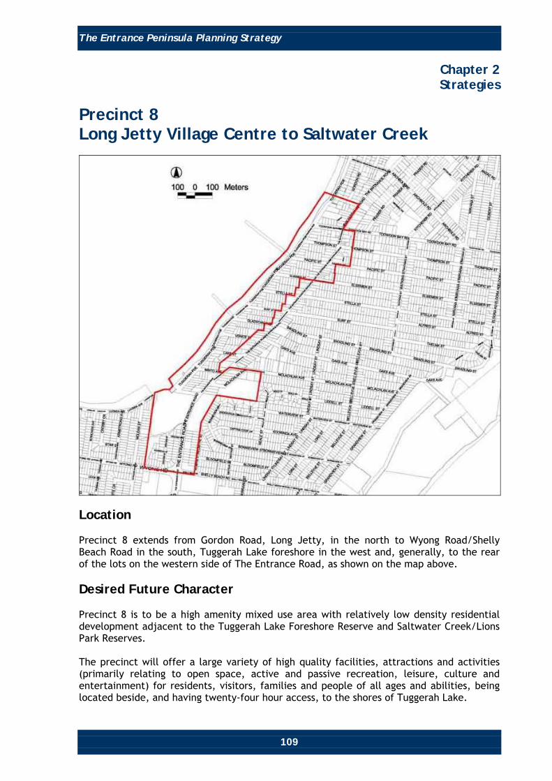
The Entrance Peninsula Planning Strategy
109
Chapter 2 Strategies
Precinct 8 Long Jetty Village Centre to Saltwater Creek
Location Precinct 8 extends from Gordon Road, Long Jetty, in the north to Wyong Road/Shelly Beach Road in the south, Tuggerah Lake foreshore in the west and, generally, to the rear of the lots on the western side of The Entrance Road, as shown on the map above. Desired Future Character Precinct 8 is to be a high amenity mixed use area with relatively low density residential development adjacent to the Tuggerah Lake Foreshore Reserve and Saltwater Creek/Lions Park Reserves. The precinct will offer a large variety of high quality facilities, attractions and activities (primarily relating to open space, active and passive recreation, leisure, culture and entertainment) for residents, visitors, families and people of all ages and abilities, being located beside, and having twenty-four hour access, to the shores of Tuggerah Lake.

The Entrance Peninsula Planning Strategy
110
Chapter 2 Strategies
At its southern end, Saltwater Creek Reserve and Lions Park will provide a high quality landscaped gateway to The Entrance Peninsula that connects to a rejuvenated Tuggerah Lake Foreshore Reserve. There will be a broad range of attractions, activities, restaurants, cafés and kiosks in rejuvenated buildings, scenic and environmental appreciation opportunities for residents and visitors of all ages. The Long Jetty Village Centre will be largely a convenience centre for the local population in neighbouring residential areas, combined with some tourist and speciality retail/commercial development. This Centre will be re-orientated to take advantage of the views, its proximity to and connections with Tuggerah Lake. Objectives • Consolidate and revitalise the Long Jetty retail and commercial centre as a vibrant
and viable village centre, orientated towards Tuggerah Lake, allowing for expansion of 5,000 square metres of retail space, in accordance with the Wyong Shire Retail Centres Strategy.
• Achieve an appropriate mix of uses within the Long Jetty Village Centre, primarily
comprising local convenience retail and commercial development with some speciality retail, residential and community services.
• Facilitate an appropriate mix of activities within the precinct. Ensure the precinct is
supported by the appropriate mix of high quality, relatively low density permanent residential accommodation, viable retail and commercial uses, located in appropriately designed buildings. Emphasis to be placed on attracting more local convenience shopping and complimentary speciality, unique, boutique retail type development to the vicinity.
• Achieve high quality urban design of buildings to achieve a coherent relatively low
scale lakeside character that respects the flood hazard constraints of the area, complements the lakeside setting and provides passive surveillance of parks and lakeside areas.
• Achieve high amenity, low density, residential areas north and south of the Long
Jetty Village Centre, with strong connections to the neighbouring recreation areas alongside Tuggerah Lake and to the Long Jetty Village Centre.
• Facilitate development to take advantage of the natural slope and lakeside location
to obtain views to Tuggerah Lake foreshore and across the Lake. • Achieve an appropriate gateway setting to The Entrance Peninsula at Saltwater Creek
and Lions Park. • Facilitate appropriate and timely rejuvenation of the existing retail/commercial
development along The Entrance Road to achieve improved amenity at an appropriate scale of mixed use (ie. retail, commercial and residential) development.

The Entrance Peninsula Planning Strategy
111
Chapter 2 Strategies
• Improve awareness of connections to the Tuggerah Lake foreshore, adjacent parks
and neighbourhoods via streetscape enhancements, themed directional signage, information areas and various information and promotional materials.
• Maintain and enhance the amenity and variety of facilities, range of attractions and
activities (including recreational, entertainment and educational) within, the Tuggerah Lake Foreshore Reserve. If determined appropriate by further investigation, incorporate elements similar to those found along ‘The Strand’ at Townsville or Cairns Waterfront developments into an appropriate landscaped setting, reflecting the lakeside character of Long Jetty.
• Facilitate improved and high quality urban design for the public domain. • Facilitate the conservation of items of heritage significance, where applicable. • To achieve and maintain sustainable development via social cohesion which
recognises everyone’s needs, effective protection, conservation and management of the ‘natural’ environment, biodiversity and cultural heritage, effective energy management, effective management of hazards, including those associated with sea level rise, ocean processes, flooding, acid sulphate soils and groundwater resources, prudent use of The Entrance Peninsula’s attributes and resources and the achievement and maintenance of stable levels of economic growth and employment.
Strategies and Recommendations The following lists strategies and recommendations that will apply specifically to Precinct 8, contributing to achieving the objectives for the precinct.

The Entrance Peninsula Planning Strategy
112
Chapter 2 Strategies
Building and Development Control Long Jetty Village Centre Map 8: Long Jetty Village Centre Extension Proposals
• Consolidate retail/commercial development at Long Jetty within the existing
retail/commercial strip along The Entrance Road, with expansion of up to an additional 5,000 square metres (as recommended in the Wyong Shire Retail Centres Strategy for Long Jetty) of retail space, consolidated into the area surrounded by The Entrance Road, Thompson Street, Tuggerah Parade and Pacific Street.
This area to be rezoned from 2(a) (Residential) to 3(a) (Business Centre), with appropriate building height and floor space ratio controls applied.
• For the area surrounded by The Entrance Road, Thompson Street, Tuggerah Parade
and Pacific Street, proposed for expansion of retail space, insert height controls that permit mixed use development up to 14.1 metres (approximately four storeys).
• Retain the existing 3(a) (Business Centre) zoning along The Entrance Road and insert
appropriate height controls. • Retain the existing 2(a) (Residential) and 5(a) (Special Uses) zoning for properties
between the rear of the properties along The Entrance Road and Tuggerah Parade, north of Thompson Street and South of Pacific Street.

The Entrance Peninsula Planning Strategy
113
Chapter 2 Strategies
• For the 3(a) zone in the existing retail/commercial strip, along The Entrance Road,
south of Pacific Street and north of Thompson Street, introduce height controls that permit mixed use development of up to 11.1 metres (approximately three storeys).
• For the 3(a) zone in the existing retail/commercial strip, along The Entrance Road,
between Pacific and Thompson Streets, introduce height controls that permit mixed use development up to 14.1 metres (approximately four storeys).
Provide high quality design with active edges along all street frontages, and maximise opportunities for varying and interesting building facades. Buildings are to be designed to reflect the coastal village character of The Entrance Town centre and will also need to take account of needs to minimise potential overshadowing impacts on neighbouring streets and properties, and to provide for a scale of development that gives the impression of a maximum height of two storeys when viewed from street level.
• For the 3(a) zone, from Elsiemer Street to north of Toowoon Bay Road, wherever possible, vehicle parking is to be off-street and accessible only from side streets and laneways. Some vehicle parking will, where absolutely necessary, remain available along The Entrance Road, but will be subject to clearway requirements in peak periods.
• For all of the Long Jetty Village Centre, future development is to be of high quality
design, in keeping with the coastal village character of The Entrance Peninsula, with amenity that is attractive and interesting to viewers from all perspectives. For any future retail/commercial development, the design of building facades is to appear as a number of buildings or modules. This requirement is especially important for elevations fronting The Entrance Road and elevations on the corners of junctions of side streets.
• Buildings in the 3(a) (Business Centre) zone will be located on the front property
boundary. All existing side and rear setback requirements, currently in Council’s planning controls will be maintained.
• Setback requirements will provide adequate solar access to neighbouring streets and
properties and maintain an appropriate scale of development that retains the coastal village character of the precinct, when viewed from street level.
Figure 3
Section of The Entrance Road through the 3(a) Business Centre zone, Long Jetty

The Entrance Peninsula Planning Strategy
114
Chapter 2 Strategies
• A future property boundary line will be established along The Entrance Road, in
consultation with the RTA, to provide sufficient width for future widening of The Entrance Road corridor, to facilitate 4 lanes (2 lanes in both directions). All building setback requirements will relate to this future property boundary line.
• Investigate the inclusion of appropriate maximum floor space ratios for the 3(a)
(Business Centre) zone. Residential Areas Map 9: Long Jetty Residential Area Proposal

The Entrance Peninsula Planning Strategy
115
Chapter 2 Strategies
• Retain the existing 2(a) (Residential), 2(b) (Multiple Dwelling Residential) and 5(a)
(Special Uses) zoning for properties between rear of the properties along The Entrance Road and Tuggerah Parade, and between Pacific Street and Minto Avenue.
• For all of the residential areas, future development is to be high quality design, in
keeping with the coastal character of The Entrance Peninsula, with amenity that is attractive and interesting to viewers from all perspectives. Building design is to ensure adequate solar access to adjoining properties and streets, address the main street, respect the flood hazard and ground water constraints of the area, complement the lakeside setting and provide passive surveillance of lakeside areas.
• For any future development in 2(b) (Multiple Dwelling Residential) or 5(a) (Special
Use) zones, the design of unit block building facades is to appear as a number of buildings or modules. This requirement is especially important for elevations facing main or side streets at junctions with main streets.
Saltwater Creek Park Gateway Map 10: Saltwater Creek and Lions Park Reserves
• Retain the existing 2(a) (Residential) and 2(b) (Multiple Dwelling Residential) zoning
for properties between The Entrance Road and Tuggerah Parade and between Minto Avenue and Saltwater Creek Park.

The Entrance Peninsula Planning Strategy
116
Chapter 2 Strategies
• For all properties zoned 2(a) (Residential) and 2(b) (Multiple Dwelling Residential),
future development is to be high quality design, in keeping with the coastal character of The Entrance Peninsula, with amenity that is attractive and interesting to viewers from all perspectives. Building design is to ensure adequate solar access to adjoining properties and streets, and address the main street.
• For any future unit development in the 2(b) (Multiple Dwelling Residential) zone, the
design of building facades is to appear as a number of buildings or modules. This requirement is especially important for elevations facing The Entrance Road and side streets at junctions with The Entrance Road.
• Retain the existing 3(b) (Centre Support) zoning along The Entrance Road and insert
appropriate height controls. • For the 3(b) (Centre Support) zone between Saltwater Creek/Lions Park and
McLachlan Avenue, introduce height controls that permit mixed use development up to 8.1 metres (approximately two storeys), except for the corner blocks at the Tuggerah Parade/The Entrance Road Junction, for which height controls will be introduced to permit mixed use development to 11.1 metres (approximately three storeys). The purpose of this exception is to provide for and encourage building designs on the corner of the Tuggerah Parade/The Entrance Road Junction to incorporate gateway design elements, either in the form of a ground level corner setback, an additional storey, distinctive landscape treatment and/or public art. Refer to Figure 4.
Figure 4

The Entrance Peninsula Planning Strategy
117
Chapter 2 Strategies
• For the 3(b) (Centre Support) zone between Saltwater Creek/Lions Park and
McLachlan Avenue, all vehicle parking is to be off-street, accessible only from side streets and/or rear lanes, where practicable (refer Map 12). Building design is to ensure adequate solar access to adjoining properties and streets and address The Entrance Road, with high quality designs, in keeping with the coastal character of The Entrance Peninsula, that have amenity and are attractive and interesting to viewers from all perspectives.
• Buildings in the 3(b) (Centre Support) zone will be located on the front property
boundary to a maximum height of 8.1 metres (approximately two storeys). All existing side and rear setback requirements in Council’s planning controls will be maintained.
• A property boundary line will be established along The Entrance Road, in consultation
with the RTA, to provide sufficient width for future widening of The Entrance Road to 4 lanes (2 lanes in both directions). All setback requirements will relate to this future property boundary line.
• Investigate the inclusion of appropriate maximum floor space ratios for the 3(b)
(Centre Support) zone. Streetscape and Public Domain Improvement Long Jetty Village Centre • Prepare and implement a program of streetscape improvements to The Entrance
Road, Pacific Street, Thompson Street, and Tuggerah Parade, including footpath widening, landscaping, installation of themed street furniture, decorative street lighting, themed paving and directional signs, branding elements, such as logos, banners and colour themes that promote the Long Jetty Village Centre and The Entrance Peninsula. Refer Chapter 4 – Landscape and Public Domain Action Plan, for recommendations.
• Widen existing pedestrian footpaths where possible and appropriate, to allow
sufficient space for a variety of potential street activities, including outdoor dining. • Identify clear links to Tuggerah Lakes Foreshore Reserve by upgrading/improving
streetscapes and maintaining important view corridors.
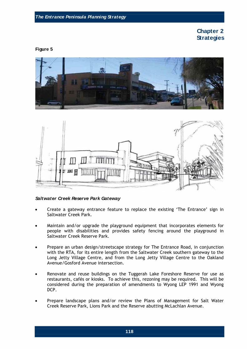
The Entrance Peninsula Planning Strategy
118
Chapter 2 Strategies
Figure 5
Saltwater Creek Reserve Park Gateway • Create a gateway entrance feature to replace the existing ‘The Entrance’ sign in
Saltwater Creek Park. • Maintain and/or upgrade the playground equipment that incorporates elements for
people with disabilities and provides safety fencing around the playground in Saltwater Creek Reserve Park.
• Prepare an urban design/streetscape strategy for The Entrance Road, in conjunction
with the RTA, for its entire length from the Saltwater Creek southern gateway to the Long Jetty Village Centre, and from the Long Jetty Village Centre to the Oakland Avenue/Gosford Avenue intersection.
• Renovate and reuse buildings on the Tuggerah Lake Foreshore Reserve for use as
restaurants, cafés or kiosks. To achieve this, rezoning may be required. This will be considered during the preparation of amendments to Wyong LEP 1991 and Wyong DCP.
• Prepare landscape plans and/or review the Plans of Management for Salt Water
Creek Reserve Park, Lions Park and the Reserve abutting McLachlan Avenue.
The Entrance Peninsula Planning Strategy
119
Chapter 2 Strategies
• These Plans are to address water sensitive urban design and flooding issues and must
incorporate specific works to upgrade the existing buildings along the waterfront for reuse as kiosks, cafés and/or restaurants.
• The plans should also cover the vehicle parking areas with the intent to reduce
vehicle circulation areas, improve landscaping and require more frequent maintenance, provide themed directional signage, provide interpretive information for environmental and heritage elements, and provide themed public area furniture, picnic facilities and shelters.
Residential Areas • Review and, if appropriate, provide additional traffic calming devices and full or
partial closure of some side roads. This review is to be undertaken in association with the RTA.
• Prepare and implement a program of streetscape improvements for all residential
streets, including footpath installation or widening that connects in a logical network, landscaping (including the planting of sufficient street trees) and the installation of themed street furniture, decorative street lighting and themed directional signs.
Pedestrian, Bicycle and Public Transport Facilities • Maintain and improve awareness of the pedestrian and cycle way connections to
Saltwater Creek Reserve Park, Lions Park, the Reserve fronting McLachlan Avenue and the shared pedestrian/bicycle way running through Tuggerah Lake Foreshore Reserve, from the surrounding neighbourhoods.
• Include The Entrance Road and Tuggerah Parade as part of a tourist circulator bus
route (if feasible). Maximise awareness of, and access to such a service, via signage, promotional materials and co-ordination between pedestrians, cyclists and public transport. Provide stops in Saltwater Creek Reserve Park and the Long Jetty Village centre, on this proposed route.
Parks and Reserves • Prepare or review Landscape Plans and/or the Plans of Management for the Tuggerah
Lake Foreshore Reserve, Salt Water Creek Reserve Park, Lions Park and the Reserve fronting McLachlan Avenue.
• These Plans are to address water sensitive urban design measures and flooding issues
and should incorporate specific works to renovate the existing dilapidated buildings along the waterfront for reuse as waterfront kiosks, cafes and/or restaurants.
• The plans are also to cover all vehicle parking areas with the intent to reduce vehicle
circulation areas, improve landscaping and require more frequent management and maintenance, provide themed directional signage, provide interpretive information for environmental and heritage elements and provide themed park furniture, picnic facilities and shelters.

The Entrance Peninsula Planning Strategy
120
Chapter 2 Strategies
Heritage • Recognise, respect and appropriately treat properties and their curtilages that are
identified in Wyong Shire LEP 1991 and Council’s Heritage Studies as items of heritage significance, including the Long Jetty Hotel and the Long Jetty, off Tuggerah Parade.
Climate Change • The foreshore areas of The Entrance and Long Jetty are potentially susceptible to
climate change impacts (eg. sea and lake level rise, increased storm activity and intensity, and coastal erosion). Climate change issues will be addressed by incorporating appropriate planning solutions that address the latest climate change information as it becomes available.
The Entrance Road, Vehicle Access and Parking • To provide four lanes, two lanes in both directions, with some intersection
improvements and the abolition of kerbside parking (at least within a clearway arrangements) and direct access (where possible). Refer to Precinct 11 for more detail on these matters.
• Ensure provision of adequate vehicle parking facilities at strategic locations within
walking distance of all main retail/commercial areas, attractions and activities in the precinct.
• Require all future major developments to provide adequate and appropriate public
parking in line with their likely impact on parking demand. This will include providing parking for all types of vehicles including motor homes, cars and caravans, cars and trailers, tourist buses and standard cars.
• Investigate the need to install time and allocation limitations on parking at strategic
locations in the precinct, to ensure accessibility to retail/commercial premises, attractions and activities.
• Review and revise Council’s planning controls to provide clear directions that
adequately address the investigations required to ascertain the impact of or on developments requiring substantial excavations in regard to flood hazard and groundwater resources, particularly for those developments with large basement components.
• Provide public awareness of all vehicle parking facilities and types of vehicles each
parking facility caters for via themed signage, maps and promotional materials.

The Entrance Peninsula Planning Strategy
121
Chapter 2 Strategies
General (Other Matters) • Recent (2007-2008) traffic modelling, carried out to identify the spread of demand
across the existing and future network for various route options, concludes that the most practicable option is to upgrade The Entrance Road (the Central Coast Highway) to provide four lanes, two lanes in both directions, combined with intersection improvements and the abolition of kerbside parking (at least by introducing a clearway scenario) and direct access (wherever possible).
• Investigate providing a greater variety of (additional) attractions and activities in
Tuggerah Lake Foreshore Reserve to cater for all age groups, including:
o Ecotourism activities, physical fitness activities, and the like.
o Permitting ‘busking’ style entertainment (eg. music, singing, magicians, novelty acts).
o Long running events (eg. weekend long or week, long rather than just a day).
o Investigate potential development options utilising existing jetties, water and
foreshore areas, including the potential of incorporating commercial and/or educational activities.
Masterplanning the Long Jetty Vicinity • Prepare a detailed and integrated masterplan covering the entire Long Jetty area
including the area covered by Precincts 8 and 11. Such masterplanning will include consideration of the appropriate land use mix; location of future development, particularly in relation to the flood hazard constraint and connectivity between land uses and other areas outside Precinct 8; adequate open space areas, appropriate public domain treatments, adequate vehicle parking and location of parking, circulation patterns (vehicle, pedestrian and cyclist) and infrastructure requirements and provision. Some land acquisition may be required to implement effective connectivity.
Changes to Planning Controls Table 7 lists the changes to planning controls that will apply specifically for Precinct 8. Such changes will contribute to achieving the objectives and desired future character of the precinct.

The Entrance Peninsula Planning Strategy
122
Chapter 2 Strategies
Table 7
Item Relevant Planning
Instrument Current Controls Recommendations Justification
Zoning. WLEP 1991. 2(a) (Residential), 2(b) (Multiple Dwelling Residential), 3(a) (Business Centre), 3(b) (Centre Support), 5(a) (Special Uses), 6(a) (Open Space) and Crown land.
Retain all existing zoning except for the area designated for expansion of retail space. Rezone the land bounded by The Entrance Road, Thompson Street, Tuggerah Parade and Pacific Street from 2(a) (Residential) to 3(a) (Business Centre). It may be necessary to rezone part of the 6(a) zoned lands to permit redevelopment of existing dilapidated buildings into restaurants, cafes, kiosks, etc. To be considered during the preparation of WLEP 1991 amendments.
To provide for the expansion of the Long Jetty retail/ commercial area to accommodate an additional maximum 5,000 square metres of retail space, in accordance with the Wyong Shire Retail Centres Strategy. To facilitate redevelopment of existing dilapidated buildings.
Building height.
WLEP 1991. DCP 2005, Chapter 60, Clause 2.3.4. DCP 2005, Chapter 64, Clause 4.2(c).
For 2(a) (Residential) and Residential 2(b) (Multiple Dwelling Residential), two storeys maximum. There are currently no existing height controls in Long Jetty for the zones of 3(a) (Business Centre), 3(b) (Centre Support), 5(a) (Special Uses), 6(a) (Open Space and Recreation) and Crown land.
Retain existing height controls for all residential zones. Introduce height controls for the 3(a) (Business Centre) and 3(b) (Centre Support) zones in Long Jetty, as described in the text above.
To maintain the existing Long Jetty Coastal Village character, while providing incentive to renovate dilapidated properties along The Entrance Road.

The Entrance Peninsula Planning Strategy
123
Chapter 2 Strategies
Item Relevant Planning
Instrument Current Controls Recommendations Justification
Floor Space Ratio (FSR).
WLEP, Clause 42. DCP 2005, Chapter 60, Clause 2.4. DCP 2005, Chapter 64, Clause 6.
For 2(a) (Residential) and 2(b) (Multiple Dwelling Residential) zones, FSRs are 0.5:1 and 0.6:1 respectively. For 3(a) (Business Centre) zones, the FSR is 0.5:1 for retail and commercial components. There are no FSR provisions for 3(b) (Centre Support), 5(a) (Special Uses), 6(a) (Open Space) and Crown land.
Investigate the inclusion of appropriate FSR controls for the 3(a) (Business Centre) and 3(b) (Centre Support) zones in Long Jetty.
The existing FSR 0.5:1 control in 3(a) (Business Centre) zone is considered excessively low and limits the variety of commercial/retail development in the area. The introduction of appropriate FSR controls for the 3(a) zone and 3(b) zone will assist in achieving the vision, objectives and desired future character of the Long Jetty Village Centre.
Building Setbacks.
DCP 2005, Chapter 99.
Details various requirements relating to building line setbacks from front, side and rear property boundaries.
Buildings in the 3(a) (Business Centre) and 3(b) (Centre Support) zones will be located on the front property boundary. All existing side and rear setback requirements will be maintained. All existing front boundary setbacks for 2(a) (Residential) and 2(b) (Multiple Dwelling Residential) zones will be maintained. A new property boundary line to be established along The Entrance Road in consultation with the RTA.
To provide adequate solar access to neighbouring streets and properties and to maintain an appropriate scale of development that retains the coastal village character of the precinct, particularly when viewed from street level. To provide sufficient width for future widening of The Entrance Road.

The Entrance Peninsula Planning Strategy
124
Chapter 2 Strategies
Precinct 9 Low to Medium Density Residential
Location Precinct 9 includes residential areas in The Entrance and Long Jetty and extends from Boondilla Road in the north to the boundaries of Precincts 15 and 16 in the south and east respectively and Precinct 11 in the west. Desired Future Character Precinct 9 will primarily be a residential area accommodating a mix of single dwelling and multiple dwelling housing types. They will be located within a convenient distance to all services and facilities on The Entrance Peninsula, including the Pacific Ocean and Tuggerah Lake foreshore recreation areas, the retail/commercial and community facilities in The Entrance Town, Long Jetty Village and Toowoon Bay Neighbourhood Centres. It will provide an attractive, accessible, convenient and safe environment for residents and visitors, and have strong connections to other areas, attractions and activities on The Entrance Peninsula.

The Entrance Peninsula Planning Strategy
125
Chapter 2 Strategies
Objectives • Maintain the current relatively low density residential character of Precinct 9. • Improve the streetscape of all streets to enhance the amenity of the precinct and
facilitate the safe and efficient movement of pedestrians, bicycles and vehicles. • Enhance the amenity of, improve awareness of and access to, the foreshore areas of
the Pacific Ocean and Tuggerah Lake and the commercial/retail centres of The Entrance, Long Jetty and Toowoon Bay.
• Encourage high quality urban design of buildings that reflect the coastal character of
The Entrance Peninsula. • To achieve and maintain sustainable development via social cohesion which
recognises everyone’s needs, effective protection, conservation and management of the ‘natural’ environment, biodiversity and cultural heritage, effective energy management, effective management of hazards, including those associated with sea level rise, ocean processes, flooding, acid sulphate soils and groundwater resources, prudent use of The Entrance Peninsula’s attributes and resources and the achievement and maintenance of stable levels of economic growth and employment.
Strategies and Recommendations The following lists strategies and recommendations that will apply specifically to Precinct 9, contributing to achieving the objectives for this precinct. Streetscape Improvement • Prepare a streetscape improvement plan to provide a consistent design approach and
program for the provision of footpaths (that connect in a logical network) and/or improvement of existing footpaths, street tree planting, street furniture, street lighting and signage. Such a strategy will include a program of street tree planting that improves the amenity of Toowoon Bay Road, Pacific Street, Stella Street, Swadling Street, McLachlan Avenue, Lindsay Street, Watkins Street, Eloora Road and Bay Road. Refer Chapter 4 - Landscape and Public Domain Action Plan, for recommendations.
Pedestrian/Bicycle and Public Transport Facilities • Investigate the opportunities to provide improved pedestrian/bicycle facilities,
particularly on the eastern side of the precinct, that provides good amenity, efficiency and safety. This may require land acquisition to achieve an effective outcome.
• Improve pedestrian/bicycle connections to Swadling Park Reserve, Saltwater Creek
Reserve Park, Lions Park and the Reserve fronting McLachlan Avenue from the surrounding neighbourhoods. Some land acquisition may be required to facilitate effective connectivity.

The Entrance Peninsula Planning Strategy
126
Chapter 2 Strategies
• Include Bay Road, Koongara Street, Swadling Street, Oak Avenue, Grandview Street
and Shelly Beach Road as part of a tourist circulator bus route (if feasible). Maximise awareness of, and access to such a service, via signage, promotional materials and co-ordination between pedestrians, cyclists and public transport.
• Provide stops at appropriate destinations along this proposed route (eg. at Swadling
Reserve, Toowoon Bay Shopping Centre and the like). Parks and Reserves • Prepare or revise Landscape Plans and/or Plans of Management for the Pacific Ocean
foreshore areas (eg. Swadling Park Reserve) to improve public access and awareness of public access to foreshore areas, vehicle parking, boat ramp, facilities and various attractions and activities via themed directional signage, promotional materials and amenity through improved landscaping and more regular maintenance.
Heritage • Recognise, respect and treat appropriately all properties and their curtilage that are
identified in the Wyong LEP and Council’s Heritage Study as being of heritage significance, including the dwelling at 25 Surf Street.
Climate Change • The foreshore areas of The Entrance and Long Jetty, including parts of Precinct 9,
are potentially susceptible to climate change impacts (eg. sea and lake level rise, increased storm activity and intensity, and coastal erosion). Climate change issues will be addressed by incorporating appropriate planning solutions that address the latest climate change information as it becomes available.
Changes to Planning Controls There are no changes proposed to the planning controls that will apply specifically to Precinct 9.

The Entrance Peninsula Planning Strategy
127
Chapter 2 Strategies
Precinct 10 Taylor/Shore Park Residential Transition
Location Precinct 10 is located to the south-east of The Entrance Town Centre and is generally bounded by the rear of the lots facing the western side of Gosford Avenue and Taylor Street to the west, Dening Street to the north, Ocean Parade to the east, and Boondilla Road to the south. Desired Future Character Precinct 10 will be a medium density residential area surrounding Taylor and Shore Parks with their passive and active recreation facilities and activities. This precinct is conveniently located close to The Entrance Town Centre, The Entrance waterfront and the Pacific Ocean foreshore. It will be an attractive place for residents to live with convenient and safe access to all The Entrance Peninsula’s attributes and attractions. It will have high quality built form and attractively landscaped streetscapes.

The Entrance Peninsula Planning Strategy
128
Chapter 2 Strategies
Objectives • Achieve an effective medium density transition between the higher density
development in The Entrance Town Centre, the neighbouring high density residential areas to the north, and the lower density residential areas to the south and east.
• Achieve high quality medium density residential development surrounding Taylor and
Shore Parks, at an appropriate scale, in a village green setting, orientated towards the park as well as the street, to improve passive surveillance, safety and amenity of these public domain areas.
• Encourage high quality urban design of buildings and streetscapes that reflects the
coastal village character of The Entrance. • Encourage, promote and facilitate recreational, cultural, social and educational
activities in Taylor and Shore Parks. • Ensure that Taylor and Shore Parks meet the diverse needs of potential users, and
are accessible to people of all ages and abilities. • Achieve improved functional streetscapes that facilitate the safe and efficient
movement of pedestrians, bicycles and vehicles. • Facilitate redevelopment of The Greens Bowling Club lands, at an appropriate scale,
as a high quality development and destination. • To achieve and maintain sustainable development via social cohesion which
recognises everyone’s needs, effective protection, conservation and management of the ‘natural’ environment, biodiversity and cultural heritage, effective energy management, effective management of hazards, including those associated with groundwater resources, prudent use of The Entrance Peninsula’s attributes and resources.
Strategies and Recommendations The following lists strategies and recommendations that will apply specifically to Precinct 10, contributing to achieving the objectives for this precinct. Building and Development Controls General Controls • Review Council’s planning controls to ensure all sites within the precinct are zoned
to reflect their existing or most appropriate land use. • Future development is to be of high quality design, in keeping with the coastal
character of The Entrance Peninsula, that is attractive and interesting to viewers from all perspectives.

The Entrance Peninsula Planning Strategy
129
Chapter 2 Strategies
• Future bowling club and residential unit block buildings are to provide attractive
facades to the streets and/or parks that they face. The design of these building facades are to appear as a number of buildings or modules, and be laid out and orientated with living areas facing the streets and/or parks they face, to provide passive surveillance of the streets and/or parks.
Specific Sites • The following strategies and recommendations apply to specific sites in the
Taylor/Shore Park Residential Transition Precinct. They contribute to achieving the objectives and desired future character of Precinct 10.
• The following sites have been identified by Council as having redevelopment
potential, important to the evolution of The Entrance. The appropriate development of these sites would have a significant positive effect on The Entrance Peninsula.
Taylor and Shore Park Environs • Review Council’s planning controls to permit residential buildings up to a maximum
height of 18 metres (approximately six storeys) and maximum 12 metres (approximately four storeys), on parcels of land greater than 1,800 square metres, which have frontage to streets surrounding Taylor and Shore Parks, as shown on Map 11 and Figure 6.
• Provide high quality design with active edges along all street frontages, and
maximise opportunities for varying and interesting building facades. • Buildings are to be designed to reflect the coastal character of The Entrance
Peninsula and will also need to take account of needs to achieve adequate separation from neighbouring developments and streets, to provide for adequate open space and view sharing, to minimise potential overshadowing impacts, and to provide for a scale of development that gives the impression of a maximum height of two storeys when viewed from street level.
• For residential zones, buildings will be located according to existing setback
requirements on the front property boundary. All existing front, side and rear setback requirements in Council’s planning controls will be maintained. Such setback requirements will provide adequate solar access to neighbouring streets and properties and maintain an appropriate scale of development that retains the coastal village character of the precinct, particularly when viewed from street level.
• This will provide for an effective medium density transition between higher buildings
in the Town Centre and high density residential area to the north and the lower density residential areas to the east and south. It will also provide for effective passive surveillance of adjacent parks and streets.

The Entrance Peninsula Planning Strategy
130
Chapter 2 Strategies
Figure 6
The Entrance Bowling Club The Greens The Entrance Bowling Club Site • The Entrance Bowling Club is located on land leased from Council and land owned by
The Greens The Entrance Bowling Club and its buildings provide an important recreation facility close to The Entrance Town Centre and provide passive surveillance of neighbouring Taylor and Shore Parks. The urban design principles shown on Map 11 illustrate the development opportunities for this site.

The Entrance Peninsula Planning Strategy
131
Chapter 2 Strategies
• Reinforce Council’s current planning controls to permit buildings between Park Road
and Taylor Street, on residential zoned lands, to a maximum 18 metres high (approximately six storeys), on a parcel, or parcels, of land greater than 1,800 square metres.
• Buildings are to be laid out and orientated with living areas facing streets and/or
parks to provide passive surveillance. Any part of these buildings above 6 metres (approximately two storeys) is to be adequately set back to permit adequate solar access to streets and neighbouring properties.
• Provide high quality design with active edges along all street frontages, and
maximise opportunities for varying and interesting building facades. • Buildings are to be designed to reflect the coastal character of The Entrance
Peninsula and will also need to take account of needs to achieve adequate separation from neighbouring developments and streets, to provide for adequate open space and view sharing, to minimise potential overshadowing impacts, and to provide for a scale of development that gives the impression of a maximum height of two storeys when viewed from street level.
• Buildings will be located according to existing setback requirements. All existing
front, side and rear setback requirements in Council’s planning controls will be maintained. Such setback requirements will provide adequate solar access to neighbouring streets and properties and maintain an appropriate scale of development that retains the coastal village character of the precinct, particularly when viewed from street level.
• An acceptable (to Council) Master Plan is to be prepared, by the proponent, prior to
consideration of any development or redevelopment for the Bowling Club lands to establish a consistent design approach that relates and connects to Taylor/Shore Parks and adjoining developments, such as Lakeside Plaza.
• Rezone land at 30 Taylor Street, 8A Warrigal Street and 25 Park Road from 2(b)
(Multiple Dwelling Residential) to 5(a) (Special Use – Club), to facilitate redevelopment of the bowling club lands for bowling club purposes.
• Review Council’s planning instruments to ensure any redevelopment of the bowling
club buildings east of Park Road are a maximum of 11.7 metres high (approximately three storeys), with buildings laid out and orientated towards Warrigal and Park Streets and Taylor Park, to encourage passive surveillance.
• New buildings on the bowling green and carpark sites between Taylor Street and Park
Road are to be a maximum of 20.1 metres high (approximately 5 to 6 storeys), with buildings laid out and orientated towards Taylor Street, Warrigal Street and Park Road and Taylor/Shore Parks, to encourage passive surveillance of those public areas.
Provide high quality design with active edges along all street frontages, and maximise opportunities for varying and interesting building facades.

The Entrance Peninsula Planning Strategy
132
Chapter 2 Strategies
Buildings are to be designed to reflect the coastal character of The Entrance Peninsula and will also need to take account of needs to achieve adequate separation from neighbouring developments and streets, to provide for adequate open space and view sharing, to minimise potential overshadowing impacts, and to provide for a scale of development that gives the impression of a maximum height of two storeys when viewed from street level.
• Future buildings will be located according to existing setback requirements. All
existing front, side and rear setback requirements in Council’s planning controls will be maintained. Such setback requirements will provide adequate solar access to neighbouring streets and properties, and maintain an appropriate scale of development that retains the coastal village character of the precinct, particularly when viewed from street level.
• Investigate the inclusion of appropriate maximum floor space ratios for the 5(a)
(Special Use) zone. Adjoining Residential Areas • Future buildings on the remaining residential zoned properties, between Taylor
Street and Park Road, are to be a maximum of 18 metres high (approximately six storeys), on parcels of land greater than 1,800 square metres, with buildings laid out and orientated towards Taylor, Warrigal and Park Streets and Taylor/Shore Parks, to encourage passive surveillance and safety by design.
• Provide high quality design with active edges along all street frontages, and
maximise opportunities for varying and interesting building facades. • Buildings are to be designed to reflect the coastal character of The Entrance
Peninsula and will also need to take account of needs to achieve adequate separation from neighbouring developments and streets, to provide for adequate open space and view sharing, to minimise potential overshadowing impacts, and to provide for a scale of development that gives the impression of a maximum height of two storeys when viewed from street level.
• Buildings will be located according to existing setback requirements. All existing
front, side and rear setback requirements in Council’s planning controls will be maintained. Such setback requirements will provide adequate solar access to neighbouring streets and properties, and maintain an appropriate scale of development that retains the coastal village character of the precinct, particularly when viewed from street level.
• The design of buildings is to ensure adequate solar access to neighbouring sites,
including Taylor/Shore Parks and neighbouring streets and properties. • New or redeveloped buildings are to provide an attractive and active facade to
Taylor Street, Warrigal Street and Park Road, and to be designed to appear as individual buildings or a number of individual buildings that complement the coastal village character of The Entrance.
• Carparking areas are to be integrated with future development.

The Entrance Peninsula Planning Strategy
133
Chapter 2 Strategies
• Investigate closing a portion of Park Road, between the southern boundary of Taylor
Park and Warrigal Street, to vehicular traffic. Streetscape and Public Domain Improvement Taylor Park and Shore Park Environs • Remove or renovate the aging building stock and structures along Park Road, to open
up views of the parks from neighbouring residential areas and streets, and improve passive surveillance and/or visual amenity.
• Provide additional disabled carparking spaces adjacent to Taylor and Shore Parks for
users of the parks. • Provide adequate lighting to ensure public safety and security of the parks and their
environs. • Review the existing Plan of Management for Taylor/Shore Parks to include strategies
for creating an improved visual setting for the parks. Such a plan is to include a landscaping plan which demarcates passive and active recreation areas, and reviews the adequacy of BBQ facilities, kiosk, toilets, seating, signage and picnic facilities, and playground equipment in the parks.
The Greens The Entrance Bowling Club • Future development of the bowling club site is to provide street tree planting and
public domain works along all street frontages, including a lit pedestrian connection between Warrigal Street and Taylor Park.
• Pave the section of Park Road, between the southern boundary of Taylor Park and
Warrigal Street, with decorative paving (that complements the coastal character of The Entrance) to effectively identify the section of road as a shared area (pedestrians and vehicles) or pedestrian only connection between the bowling club lands on either side of Park Road (if this portion of Park Road is closed to vehicular traffic).
Adjoining Residential Areas • Prepare a streetscape strategy to provide a consistent design approach and program
for improving footpaths, landscaping, street furniture, street lighting and signage. See Chapter 4 - Landscape and Public Domain Action Plan, for recommendations.
Pedestrian/Cycle and Public Transport Facilities • Include Dening Street, Ocean Parade and Boondilla Road as part of a tourist
circulator bus route (if feasible). Maximise awareness of, and access to such a service, via signage, promotional materials and co-ordination between pedestrians, cyclists and public transport. Provide stops and adequate facilities at appropriate locations on this proposed route.

The Entrance Peninsula Planning Strategy
134
Chapter 2 Strategies
Changes to Planning Controls Table 8 lists the changes to planning controls that will apply specifically for Precinct 10. Such a change will contribute to achieving the objectives and desired future character of the precinct. Table 8
Item Relevant Planning
Instrument Current Controls Recommendations Justification
Zoning. WLEP 1991.
2(b) (Multiple Dwelling) zone. 5(a) (Special Use – Carpark) zone. 6(a) (Open Space and Recreation) zone. 2(c) (Medium Density Residential) zone.
Rezone properties at 30 Taylor Street, 8A Warrigal Street and 25 Park Road from 2(b) to 5(a) (Special Use – Club).
To facilitate cohesive and viable redevelopment of The Entrance Bowling Club.
Building Height.
WLEP 1991. DCP 2005, Chapters 60 and 64.
2(c) (Medium Density Residential) zone - generally three storeys except for certain sites where heights are permitted up to 12 metres (approx four storeys) or 18 metres (approx six storeys) respectively, on land parcels, greater than 1,800m². 5(a) (Special Use) – no controls. 6(a) (Open Space and Recreation) – no controls.
Permit additional residential properties up to 12 metres high fronting Taylor Park, on land parcels greater than 1,800m², via introducing additional height mapping, as shown on Map 11. Introduce height controls of up to 11.7 metres high maximum on the bowling club site, east of Park Road (zoned 6(a) - (Open Space and Recreation)). Introduce height controls on the Bowling Club lands between Taylor Street and Park Road of up to 21.1 metres high, via alterations to the existing height mapping.
To promote high quality medium density housing surrounding the Taylor and Shore Parks, in a village green setting, with a high quality appearance facing the park as well as streets to provide effective passive surveillance of streets and parks.

The Entrance Peninsula Planning Strategy
135
Chapter 2 Strategies
Item Relevant Planning
Instrument Current Controls Recommendations Justification
Floor Space Ratio.
WLEP 1991. DCP 2005, Chapters 60 and 64.
2(c) (Medium Density Residential) – FSR 0.9:1 5(a) (Special Use) – no controls.
Investigate the inclusion of appropriate FSR controls for the 5(a) (Special Uses - Club) zone.
To assist in achieving the vision, objectives and desired future character of the vicinity.
Building Layout and Orientation around Taylor and Shore Parks.
WLEP 1991. DCP 2005, Chapter 60.
There are no existing requirements
Insert provisions that require future or upgraded residential flat or The Greens Bowling Club buildings to be laid out and orientated with their living areas facing the streets they are on as well as Taylor/Shore Parks.
To provide passive surveillance of streets and Taylor/Shore Parks.
Building Setbacks and Design.
DCP2005, Chapters 64 and 99.
Various front, side and rear setback requirements are specified in Wyong DCP 2005, Chapters 60 and 99 for the 2(c) (Medium Density Residential) zone.
Future buildings in residential zones are to be located according to existing setback requirements. The Greens The Entrance Bowling Club future buildings are to be located according to existing setback requirements. All existing front, side and rear setback requirements in Council’s planning controls will be maintained. Provide for high quality building design with active edges along all street frontages, and maximise opportunities for varying and interesting building facades.
Such setback requirements will provide adequate separation and solar access to neighbouring streets and properties and maintain an appropriate scale of development that retains the coastal village character of the precinct, particularly when viewed from street level.

The Entrance Peninsula Planning Strategy
136
Chapter 2 Strategies
Item Relevant Planning
Instrument Current Controls Recommendations Justification
Building Setbacks and Design. Continued
Investigate and develop building design criteria that reflects the coastal village character of the periphery of The Entrance Town Centre and will also take account of needs to achieve adequate separation from neighbouring developments and streets, to provide for adequate open space and view sharing, to minimise potential overshadowing impacts, and to provide for a scale of development that gives the impression of a maximum height of two storeys when viewed from street level.

The Entrance Peninsula Planning Strategy
137
Chapter 2 Strategies
Precinct 11 The Entrance Road Corridor
Location Precinct 11 is located along both sides of The Entrance Road between Campbell Avenue/Warrigal Street in the north and Minto Avenue/McLachlan Avenue in the south. It excludes part of The Entrance Road Corridor between Elsiemer Street and Toowoon Bay Road, which is covered in Precinct 8. Precinct 11 is divided into two sub-precincts with Precinct 11a located north of Toowoon Bay Road, and Precinct 11b located south of Elsiemer Street. Desired Future Character Precinct 11 comprises the major road corridor through The Entrance Peninsula, The Entrance Road (also known as the Central Coast Highway).

The Entrance Peninsula Planning Strategy
138
Chapter 2 Strategies
At its southern end, between Minto Avenue/McLachlan Avenue and Elsiemer Street, it will accommodate high quality, relatively low scale, mixed use development (generally between two and three storeys high) comprising bulky goods and light industrial type uses at ground level with commercial and/or residential use above. Such development is to be set in an attractive streetscape, characterised by attractive landscaping and high quality built form, that is reflective of The Entrance Peninsula’s coastal character. North of the Long Jetty Village Centre (Toowoon Bay Road), the precinct will remain predominantly high quality low to medium density residential (generally 2 to 3 storeys high). Land uses that occupy relatively large sites (including, the Gosford Avenue industrial area, The Entrance Primary School and the numerous business centre and centre support zoned sites along The Entrance Road) will have enhanced landscaped treatment of their sites, carparks and verges that complements the coastal character of The Entrance Peninsula. Objectives • Improve the condition and quality of buildings and landscape treatments along The
Entrance Road corridor, to create an attractive corridor that welcomes people to The Entrance Peninsula and supports a vibrant and viable Long Jetty Village Centre.
• Encourage redevelopment of the existing retail, commercial, light industrial and
bulky goods properties along The Entrance Road, to improve the visual attractiveness of the area, and support revitalisation of the Long Jetty Village Centre.
• Provide a high quality public domain for the precinct to ensure the safe and
convenient use of streets, footpaths and land uses fronting the streets. • Provide an attractive and functional streetscape that facilitates the safe and
efficient movement of pedestrians, bicycles and vehicles. Some land acquisition may be required to facilitate such movement.
• Improve connections, and awareness of such connections, to the lakefront, adjacent
parks and other attractions with streetscape improvements and themed directional signage and pavements.
• Facilitate improved public transport services and facilities, including provision of a
shuttle/circulator bus service (if feasible). • To achieve and maintain sustainable development via social cohesion which
recognises everyone’s needs, effective protection, conservation and management of the ‘natural’ environment, biodiversity and cultural heritage, effective energy management, effective management of hazards, including those associated with groundwater resources, prudent use of The Entrance Peninsula’s attributes and resources.
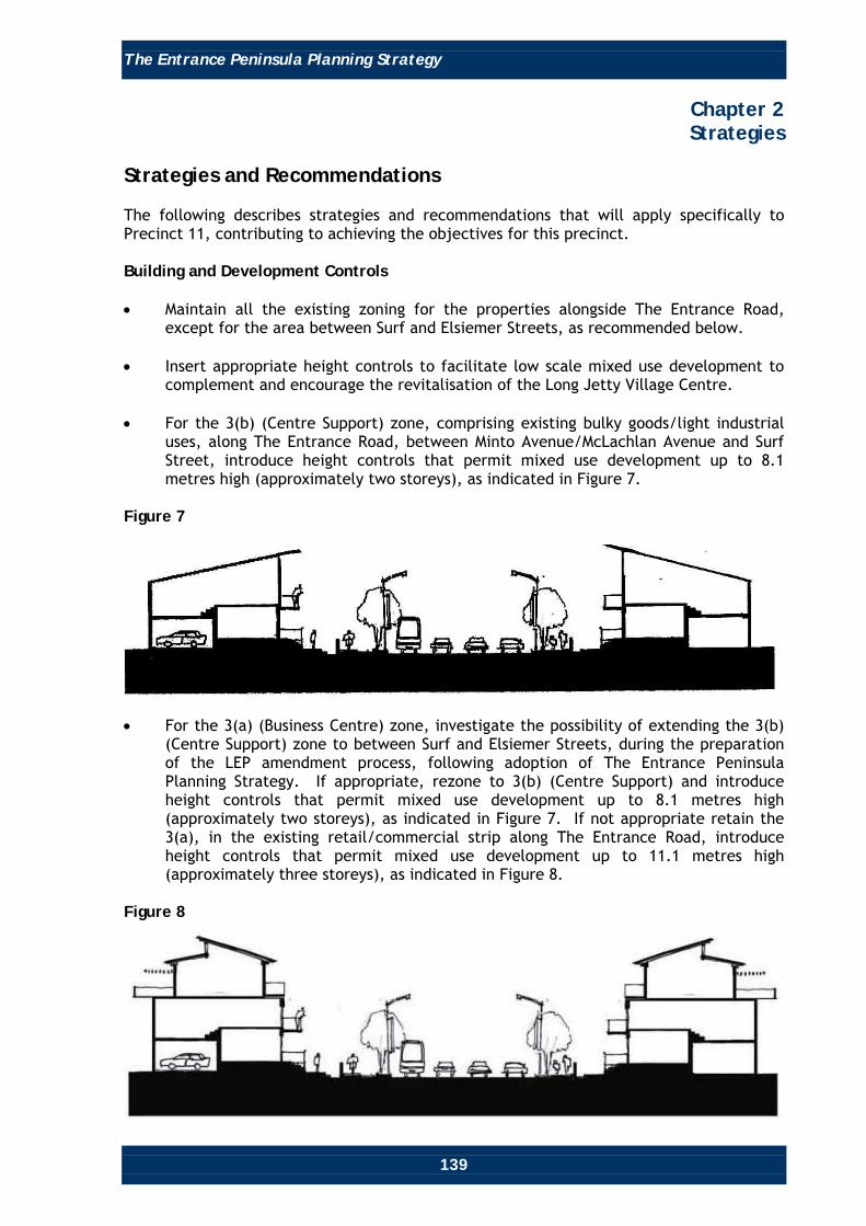
The Entrance Peninsula Planning Strategy
139
Chapter 2 Strategies
Strategies and Recommendations The following describes strategies and recommendations that will apply specifically to Precinct 11, contributing to achieving the objectives for this precinct. Building and Development Controls • Maintain all the existing zoning for the properties alongside The Entrance Road,
except for the area between Surf and Elsiemer Streets, as recommended below. • Insert appropriate height controls to facilitate low scale mixed use development to
complement and encourage the revitalisation of the Long Jetty Village Centre. • For the 3(b) (Centre Support) zone, comprising existing bulky goods/light industrial
uses, along The Entrance Road, between Minto Avenue/McLachlan Avenue and Surf Street, introduce height controls that permit mixed use development up to 8.1 metres high (approximately two storeys), as indicated in Figure 7.
Figure 7
• For the 3(a) (Business Centre) zone, investigate the possibility of extending the 3(b)
(Centre Support) zone to between Surf and Elsiemer Streets, during the preparation of the LEP amendment process, following adoption of The Entrance Peninsula Planning Strategy. If appropriate, rezone to 3(b) (Centre Support) and introduce height controls that permit mixed use development up to 8.1 metres high (approximately two storeys), as indicated in Figure 7. If not appropriate retain the 3(a), in the existing retail/commercial strip along The Entrance Road, introduce height controls that permit mixed use development up to 11.1 metres high (approximately three storeys), as indicated in Figure 8.
Figure 8
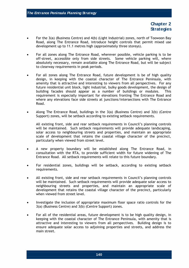
The Entrance Peninsula Planning Strategy
140
Chapter 2 Strategies
• For the 3(a) (Business Centre) and 4(b) (Light Industrial) zones, north of Toowoon Bay
Road, along The Entrance Road, introduce height controls that permit mixed use development up to 11.1 metres high (approximately three storeys).
• For all zones along The Entrance Road, wherever possible, vehicle parking is to be
off-street, accessible only from side streets. Some vehicle parking will, where absolutely necessary, remain available along The Entrance Road, but will be subject to clearway requirements in peak periods.
• For all zones along The Entrance Road, future development is be of high quality
design, in keeping with the coastal character of The Entrance Peninsula, with amenity that is attractive and interesting to viewers from all perspectives. For any future residential unit block, light industrial, bulky goods development, the design of building facades should appear as a number of buildings or modules. This requirement is especially important for elevations fronting The Entrance Road and where any elevations face side streets at junctions/intersections with The Entrance Road.
• Along The Entrance Road, buildings in the 3(a) (Business Centre) and 3(b) (Centre
Support) zones, will be setback according to existing setback requirements.
All existing front, side and rear setback requirements in Council’s planning controls will be maintained. Such setback requirements will provide adequate landscaping, solar access to neighbouring streets and properties, and maintain an appropriate scale of development that retains the coastal village character of the precinct, particularly when viewed from street level.
• A new property boundary will be established along The Entrance Road, in
consultation with the RTA, to provide sufficient width for future widening of The Entrance Road. All setback requirements will relate to this future boundary.
• For residential zones, buildings will be setback, according to existing setback
requirements. • All existing front, side and rear setback requirements in Council’s planning controls
will be maintained. Such setback requirements will provide adequate solar access to neighbouring streets and properties, and maintain an appropriate scale of development that retains the coastal village character of the precinct, particularly when viewed from street level.
• Investigate the inclusion of appropriate maximum floor space ratio controls for the
3(a) (Business Centre) and 3(b) (Centre Support) zones. • For all of the residential areas, future development is to be high quality design, in
keeping with the coastal character of The Entrance Peninsula, with amenity that is attractive and interesting to viewers from all perspectives. Building design is to ensure adequate solar access to adjoining properties and streets, and address the main street.

The Entrance Peninsula Planning Strategy
141
Chapter 2 Strategies
• Review Council’s planning instruments to ensure all sites within the precinct are
zoned to reflect the most appropriate land use. • Review Council’s planning instruments to ensure sites within the precinct are zoned
to reflect the most appropriate land use. An example is rezoning the property at 309 The Entrance Road from Special Use – Club to 2(c) Medium Density Residential, as the property is no longer owned by the Diggers @ The Entrance Club, and has a residential property character.
Streetscape Improvements and the Public Domain • Prepare a streetscape plan for The Entrance Road corridor that satisfies the RTA’s
requirements for additional pedestrian crossings, traffic calming devices, vehicle access to sites and carparking areas, landscaping, and directional and themed decorative signage. This plan is to consider the widening of existing footpaths, where appropriate/possible, to allow sufficient space for street furniture and outdoor dining, street lighting and paving consistent with creating a cohesive and attractive public domain that complements the coastal character of The Entrance Peninsula (refer to Chapter 4, Landscape and Public Domain Action Plan, for recommendations).
• Improve the streetscape of all side streets in the precinct, including additional street
tree planting, themed street paving, street furniture, decorative lighting and themed directional signage to improve the visual appeal and safety of streets, and connections to adjoining residential areas and the Tuggerah Lake foreshore.
• Undertake an audit of signage along The Entrance Road Corridor and implement any
recommendations to remove visual clutter, inappropriate and unauthorised signs, and replace signage with a single group sign, where determined appropriate.
• Investigate the potential to remove unsightly power poles and wires that contribute
to the existing visual clutter along The Entrance Road Corridor, to improve the amenity of the streetscape for road corridor users.
• Promote the image of the precinct by using branding elements such as logos, banners
and colour themes, similar to those promoted in The Entrance Town Centre Management Programs.
Pedestrian/Cycle and Public Transport Facilities • Include The Entrance Road as part of a tourist circulator bus route (if feasible).
Maximise awareness of, and access to such a service, via signage, promotional materials and co-ordination between pedestrians, cyclists and public transport. Provide stops and adequate facilities at appropriate locations along this proposed route (eg. Long Jetty Village Centre).
The Entrance Road, Parking and Access • To provide four lanes, two lanes in both directions, with some intersection
improvements and the abolition of kerbside parking (at least within a clearway arrangements) and direct access (where possible).

The Entrance Peninsula Planning Strategy
142
Chapter 2 Strategies
Recent (2007-2008) traffic modelling, carried out by Council in conjunction with the RTA, to identify the spread of demand across the existing and future network for a number of scenarios (ie. various route options), concludes that the most practicable option is to upgrade The Entrance Road (the Central Coast Highway) as proposed.
• Introduce clearway arrangements along The Entrance Road during peak times (eg.
peak hours, special events, special days, etc). These arrangements are to be monitored/reviewed regularly to ascertain their success, need to be modified, or otherwise.

The Entrance Peninsula Planning Strategy
143
Chapter 2 Strategies
• For all zones along The Entrance Road, wherever possible, vehicle parking is to be
off-street, accessible only from rear lanes accessed via side streets. Refer to Map 12, a conceptual plan showing potential future access and parking arrangements for Long Jetty. Individual developments will be required to, wherever possible, provide adequate on-site parking, accessible form side streets, or accessible from rear lanes, accessed from side streets.
• Some vehicle parking will, where absolutely necessary, remain available along The
Entrance Road, but will be subject to clearway arrangements in peak times. Map 12: Potential Parking and Access along The Entrance Road Corridor

The Entrance Peninsula Planning Strategy
144
Chapter 2 Strategies
General (Other Matters) • While it is recognised that The Entrance Town Centre Management Corporation has a
number of roles, including:
o Promoting The Entrance Peninsula and its attributes, activities, events, etc to markets both within and outside the locality and Wyong Shire;
o Employing event management expertise in The Entrance Town Centre; o Generating ideas for and organising various events, entertainment, attractions,
amenity improvement, business improvement and assistance schemes/programs;
o Improving communication and understanding of established principles and
processes between the various stakeholders; o Maintaining community assets.
It is mooted that, in accordance with Council’s support for ongoing liaison with all relevant stakeholders, that Council investigate facilitating the following additional items:
o Developing comprehensive tourism strategies. o Seeking and obtaining various available grants. o Providing business coaching and/or mentoring expertise. o The effective liaison of the various stakeholders in generating effective
solutions for improving the amenity and function of The Entrance Road Corridor through Long Jetty.
Changes to Planning Controls Table 9 lists the only change to planning controls that will apply specifically for Precinct 11. Such a change will contribute to achieving the objectives and desired future character of the precinct.

The Entrance Peninsula Planning Strategy
145
Chapter 2 Strategies
Table 9
Item Reference Existing Planning Control Proposal Justification
Zoning. WLEP 1991. 2(b) (Multiple Dwelling Residential), 2(c) (Medium Density Residential), 3(a) (Business Centre), 3(b) (Centre Support), 4(b) (Light Industrial), 5(a) (Special Uses – Club).
Maintain all current zoning along The Entrance Road Corridor, unless review of Council’s planning instruments indicates that sites within the precinct are not zoned to reflect the most appropriate land use. For example, rezoning the property at 309 The Entrance Road from Special Use – Club to 2(c) (Medium Density Residential).
The existing zoning provides the necessary framework to maintain and improve the coastal character of The Entrance Peninsula. Initial investigations indicate that some properties may have an inappropriate zoning and need to be reviewed to ensure they are zoned for the most appropriate use.
Floor Space Ratio.
DCP 2005, Chapters 60 and 64.
2(a) (Residential) – FSR 0.5:1. 2(b) (Multiple Dwelling Residential) – FSR 0.6:1. 3(a) (Business Centre) – FSR 0.5:1 for Retail Commercial Components. 3(b) (Centre Support) – No current FSR.
Investigate the inclusion of appropriate FSR controls for the 3(a) (Business Centre) and 3(b) (Centre Support) zones.
To assist in achieving the vision, objectives and desired future character of The Entrance Road corridor.

The Entrance Peninsula Planning Strategy
146
Chapter 2 Strategies
Item Reference Existing Planning Control Proposal Justification
Building Setbacks.
DCP 2005, Chapters 64 and 99.
Various front, side and rear setback requirements are specified in Wyong DCP 2005, Chapters 60 and 99 for the 2(b) (Multiple Dwelling Residential) zone, 3(a) (Business Centre), 3(b) (Centre Support) and 4(b) (Light Industrial) zone.
Future buildings in the 2(b) (Multiple Dwelling Residential) zone are to be located according to existing setback requirements from front, side and rear property boundaries. Future buildings in the 3(a) (Business Centre), 3(b) (Centre Support) and 4(b) (Light Industrial) zones are to be located according to existing setback requirements and future building line.
To create a consistent street edge along The Entrance Road Corridor. Such setback requirements will provide adequate solar access to neighbouring streets and properties and maintain an appropriate scale of development that retains the coastal village character of the precinct, particularly when viewed from street level.
Parking and Access.
WLEP 1991. DCP2005, Chapter 60.
No existing provisions for on-site carparking with access restricted to side streets.
Insert provisions that require adequate on-site parking and access to the rear of sites (along The Entrance Road Corridor) from side streets.
To improve the safety, efficiency and amenity of The Entrance Road Corridor.
Building Height and Design.
DCP 2005, Chapter 64, Cl4.2(c).
There are currently no height requirements for 3(a) (Business Centre), 3(b) (Centre Support), 4(b) (Light Industrial) and 5(a) (Special Use) zones. Current height controls for residential zones are: 2(a) (Residential) = Two storey. 2(b) (Multiple Dwelling Residential) = Two storey. 2(c) (Medium Density Residential) = Three storey.
For the 3(b) (Centre Support) zone in the existing bulky goods/light industrial strip, along The Entrance Road, between Minto Avenue/McLachlan Avenue and Surf Street, introduce height controls that permit development up to, 8.1 metres. For all the 3(a) (Business Centre) and 4(b) (Light Industrial) zones, along The Entrance Road, introduce height controls that permit development up to 11.1 metres.
To ensure an attractive gateway along The Entrance Road Corridor ensuring an appropriate scale of development that will maintain and/or improve the coastal village character of the Long Jetty area.

The Entrance Peninsula Planning Strategy
147
Chapter 2 Strategies
Item Reference Existing Planning Control Proposal Justification
Building Height and Design. Continued
Provide for high quality building design with active edges along all street frontages, and maximise opportunities for varying and interesting building facades. Investigate and develop building design criteria that reflects the coastal village character of The Entrance Town Centre periphery and will also take account of needs to achieve adequate separation from neighbouring developments and streets, to provide for adequate open space and view sharing, to minimise potential overshadowing impacts, and to provide for a scale of development that gives the impression of a maximum height of two storeys when viewed from street level.

The Entrance Peninsula Planning Strategy
148
Chapter 2 Strategies
Precinct 12 Oceanside Residential
Location Precinct 12 is bounded by Narrawa Street to the north, Currawong Street to the west, Beenbah Avenue and Toowoon Bay Road to the south and the Pacific Ocean to the east. Desired Future Character Precinct 12 will be a high quality oceanfront residential neighbourhood, with attractive streetscapes and recreational areas. Public access to Blue Bay’s foreshores and beach will be clearly defined and cater for people of all abilities, where possible. Objectives • To ensure future development responds to the sloping terrain of the area, and
maintain as much view sharing of the Pacific Ocean and its foreshore areas as possible.
• To maintain and improve Blue Bay and Toowoon Bay foreshores and beaches and
public access and awareness of public access to those areas for the enjoyment of residents and visitors.

The Entrance Peninsula Planning Strategy
149
Chapter 2 Strategies
• To achieve and maintain sustainable development via social cohesion which
recognises everyone’s needs, effective protection, conservation and management of the ‘natural’ environment, biodiversity and cultural heritage, effective energy management, effective management of hazards, including those associated with sea level rise, ocean processes, flooding, acid sulphate soils and groundwater resources, prudent use of The Entrance Peninsula’s attributes and resources and the achievement and maintenance of stable levels of economic growth and employment.
Strategies and Recommendations The following describes strategies and recommendations that will apply specifically to Precinct 12, contributing to achieving the objectives for this precinct. Streetscape Improvements and the Public Domain • Improve the streetscapes and the public domain in all streets in the precinct by
implementing a program of street tree planting, consistent kerb and guttering and footpath treatments, where appropriate.
• Upgrade beach access points at Blue Bay and Toowoon Bay, including new themed
decorative directional signage. • Refurbish or replace the existing public toilet facilities at Blue Bay. Climate Change • The foreshore areas of The Entrance are potentially susceptible to climate change
impacts (eg. sea and lake level rise, increased storm activity and intensity, and coastal erosion). Climate change issues will be addressed by incorporating appropriate planning solutions that address the latest climate change information as it becomes available.
Changes to Planning Controls There are no changes proposed to the planning controls that will apply specifically to Precinct 12.

The Entrance Peninsula Planning Strategy
150
Chapter 2 Strategies
Precinct 13 Toowoon Bay Neighbourhood Centre
Location Precinct 13 comprises the Toowoon Bay Neighbourhood Centre and the residential street block to the south of the centre. It is bound by Eloora Road to the west, Pacific Street to the south, Bay Road to the east, and the rear of the lots fronting Toowoon Bay Road (between Eloora and Bay Roads) to the north. Desired Future Character Precinct 13 will retain its traditional coastal neighbourhood retail/commercial centre character and will provide retail and commercial facilities, primarily catering for the needs of local residents. Its traditional coastal neighbourhood centre image will be strengthened by future redevelopment of the precinct and streetscape improvements, including provision of footpath awnings, themed street paving, furniture and signage, lighting and more street trees. Objectives • Promote the precinct as a neighbourhood centre providing for predominantly local
convenience services and a variety of street activities, including outdoor cafés. • Create a street environment that is complementary to the existing low scale nature
of the neighbourhood centre, including appropriate landscaping treatments and consistent themed decorative paving, signage, street furniture and lighting elements.
• Provide an enhanced shared streetscape that facilitates the safe and efficient
movement of pedestrians, bicycles and vehicles, including enhanced pedestrian amenity and bicycle parking facilities.

The Entrance Peninsula Planning Strategy
151
Chapter 2 Strategies
• Provide for the future expansion of the neighbourhood centre within the precinct’s
boundaries, under the existing zoning. • To achieve and maintain sustainable development via social cohesion which
recognises everyone’s needs, effective protection, conservation and management of the ‘natural’ environment, biodiversity and cultural heritage, effective energy management, effective management of hazards, including those associated with groundwater resources, prudent use of The Entrance Peninsula’s attributes and resources.
Strategies and Recommendations The following describes strategies and recommendations that will apply specifically to Precinct 13, contributing to achieving the objectives for this precinct. Building and Development Control • Limit the height of future development within the precinct to a maximum height of
8.1 metres, as indicated in Figure 9. • Require all new development in the area of the precinct zoned 3(a) (Business Centre)
to provide awnings over paved areas, consistent with those provided elsewhere in the precinct.
Figure 9
• Insert appropriate height controls to maintain the low scale (generally two storeys
high) mixed use development that will complement and existing coastal neighbourhood retail/commercial centre character of the Toowoon Bay Neighbourhood Centre.
• Buildings in the 3(a) (Business Centre) zone will be located on the front property
boundary to a maximum height of 8.1 metres (approximately two storeys). All existing side and rear setback requirements in Council’s planning controls will be maintained.
• For residential zones, buildings will be constructed to a maximum height of 6 metres
(approximately two storeys). All existing front, side and rear setback requirements in Council’s planning controls will be maintained. Such setback requirements will provide adequate solar access to neighbouring streets and properties and maintain an appropriate scale of development that retains the coastal neighbourhood character of the precinct, particularly when viewed from street level.
The Entrance Peninsula Planning Strategy
152
Chapter 2 Strategies
• For all zones, future development is to be high quality design, in keeping with the
coastal character of The Entrance Peninsula, with amenity that is attractive and interesting to viewers from all perspectives. Building design is to ensure adequate solar access to adjoining properties and streets and address the main street.
• Any new developments on the corners of Toowoon Bay Road with Bay and Eloora
Roads is to provide a landmark corner element in the design of the building. This could be achieved by increased building setbacks, an extra 3 metres (approximately one storey) height on buildings, installing appropriate public art elements and/or distinctive landscape treatments.
Streetscape Improvement • Prepare a plan for improving the streetscape and the public domain, including the
provision of upgraded and consistent treatments of themed decorative pavements, signage, street furniture, lighting and street tree planting.
• Investigate the possibility of widening existing pedestrian footpaths to allow
sufficient space for outdoor cafes, dining, public art and landscaping. • Provide clear vehicle parking directional and identification signs on roads within the
precinct to improve awareness of future and existing vehicle parking facilities, such as those to the north of Toowoon Bay Road, at the rear of properties fronting Toowoon Bay Road.
Pedestrian/Cycle and Public Transport Facilities • Include Bay Road as part of a tourist circulator bus route (if feasible). Maximise
awareness of, and access to such a service, via signage, promotional materials and co-ordination between pedestrians, cyclists and public transport. Provide stops and adequate facilities at appropriate locations along this proposed route, including one at Toowoon Bay Neighbourhood Centre.
Parking and access • Individual developments will be required to provide adequate on-site parking. • Wherever possible, vehicle access is to be off-street, accessible only from streets
with the lowest street hierarchy rating (ie. Eloora Road and Pacific Street).

The Entrance Peninsula Planning Strategy
153
Chapter 2 Strategies
Summary of Strategy Main Proposals
Changes to Planning Controls Table 10 lists the changes to planning controls that will apply specifically for Precinct 13. Such changes will contribute to achieving the objectives and desired future character of the precinct.

The Entrance Peninsula Planning Strategy
154
Chapter 2 Strategies
Table 10
Item Reference Existing Planning Control Proposal Justification
Building Height.
WLEP. DCP 2005, Chapters 60 and 64.
There are currently no height requirements for the 3(a) (Business Centre) zone. For the 2(b) zone, generally two storey maximum.
For the 3(a) (Business Centre) zone in the existing neighbourhood centre at Toowoon Bay, introduce height controls that permit development up to 8.1 metres.
To maintain an attractive neighbourhood centre ensuring an appropriate scale of development that will maintain and/or improve the coastal character of the precinct.
Building Setbacks.
DCP 2005, Chapters 60 and 99.
Various front, side and rear setback requirements are specified in Wyong DCP 2005, Chapters 60 and 99 for the 2(b) (Multiple Dwelling Residential) zone and 3(a) (Business Centre) zone.
Future buildings in the residential zone are to be located according to the existing front, side and rear setbacks in Council’s planning controls. Future buildings in the 3(a) (Business Centre) zone are to be located on the front property boundaries to a maximum height of 8.1 metres. All existing side and rear setback requirements in Council’s planning controls for the 3(a) (Business Centre) zone are to be maintained.
To create consistent street edges. Such setback requirements will provide adequate solar access to neighbouring streets and properties and maintain an appropriate scale of development that retains the coastal village character of the precinct, particularly when viewed from street level.
Parking and Access.
WLEP 1991. DCP2005, Chapter 60.
No existing provisions. Insert provisions that require adequate on-site parking and access from roads with the lowest hierarchical ranking (eg. Eloora Road and Pacific Street), where possible.
To improve the safety, efficiency and amenity of the road network in the vicinity.
Floor Space Ratio.
WLEP 1991. DCP 2005, Chapter 60.
2(b) (Multiple Dwelling Residential) zone – FSR 0.6:1. 3(a) (Business Centre) zone – 0.5:1.
Investigate the inclusion of appropriate FSR controls for the 3(a) (Business Centre) zone.
To assist in achieving the vision, objectives and desired future character for the Toowoon Bay Neighbourhood Centre.

The Entrance Peninsula Planning Strategy
155
Chapter 2 Strategies
Precinct 14 Jubilee/Baden Powell Parks
Location Precinct 14 is bounded by Anzac Road to the north, the rear of properties abutting Fraser Road to the west, Toowoon Bay Road between Fraser Road and Watkins Street and Thompson Street between Watkins Street and Eloora Road to the south, and Eloora Road to the east. Desired Future Character Precinct 14 is to be a predominantly medium density residential neighbourhood providing high levels of amenity and convenience for its residents. Its proximity to Jubilee and Baden Powell Parks and convenient access to The Entrance Town Centre, Long Jetty Village Centre and Toowoon Bay Neighbourhood Centre, Tuggerah Lake and Pacific Ocean foreshores, and the facilities, attractions and activities that are provided in these places, will make it a desirable place to live and visit. It will have a range of high quality residential buildings, designed and constructed, to complement The Entrance Peninsula’s coastal character. Its public domain will include rejuvenated Jubilee and Baden Powell Parks, providing for the active and passive recreational needs of local residents and visitors, and safe attractive streets, including high quality landscaping, and the consistent design and treatment of public domain, including themed street lighting and signage.

The Entrance Peninsula Planning Strategy
156
Chapter 2 Strategies
Objectives • Improve the design standard for residential development throughout the precinct. • Improve residential amenity and safety in residential areas in and around the edges
of Jubilee and Baden Powell Parks. • Provide enhanced streetscapes that facilitate the safe and efficient movement of
pedestrians, bicycles and vehicles, and improves residential amenity. • Encourage high quality medium density residential development surrounding Jubilee
and Baden Powell Parks, orientated towards the parks, as well as the streets they face, to improve passive surveillance and amenity for these areas.
• Facilitate active and passive recreation opportunities in Jubilee and Baden Powell
Parks. • To achieve and maintain sustainable development via social cohesion which
recognises everyone’s needs, effective protection, conservation and management of the ‘natural’ environment, biodiversity and cultural heritage, effective energy management, effective management of hazards, including those associated with groundwater resources, prudent use of The Entrance Peninsula’s attributes and resources.
Strategies and Recommendations The following describes strategies and recommendations that will apply specifically to Precinct 14, contributing to achieving the objectives for this precinct. Building and development Control • Change Council’s planning controls by rezoning the existing 2(d) (High Density
Residential) zoned land, bounded by Toowoon Bay, Kitchener and Archbold Roads, to 2(c) (Medium Density Residential), to be consistent with the low to medium density residential character of the surrounding vicinity.
• Alter Council’s planning controls to require all new developments facing Jubilee and
Baden Powell Parks, and the adjoining streets, to have a high quality elevation and functional layout that complements the amenity of the area, and ensures passive surveillance of the park and streets, as indicated in Figure 10.
Figure 10

The Entrance Peninsula Planning Strategy
157
Chapter 2 Strategies
• For all zones, future development is be of high quality design and construction, in
keeping with the coastal character of The Entrance Peninsula, with amenity that is attractive and interesting to viewers from all perspectives.
• For any future residential unit block development, the design of building facades is
to appear as a number of buildings or modules that complement the coastal character of The Entrance Peninsula.
• Future and upgraded residential unit block buildings are to provide attractive facades
to the streets they face as well as Jubilee and Baden Powell Parks. The design of these building facades are to be laid out and orientated with their main living areas facing the streets they are on and Jubilee/Baden Powell Parks, to provide passive surveillance of those streets and parks.
• For residential zones, buildings will be located according to the existing setbacks in
Council’s planning controls for the front property boundary to a maximum height of 6 metres (approximately two storeys) for 2(b) zoned lands and 9 metres (approximately three storeys) for 2(c) zoned lands.
• All existing side and rear setback requirements in Council’s existing planning controls
are to be maintained. Streetscape Improvement • Prepare a streetscape strategy to provide a consistent design approach and program
of implementation for footpaths, kerbs and gutters, street tree planting, street lighting and signage. The aim of such a strategy is to improve the amenity of the streetscape in all streets in the precinct. Refer Chapter 4, Landscape and Public Domain Action Plan, for recommendations.
Pedestrian/Cycle and Public Transport Facilities • Include Jubilee/Baden Powell Parks on the tourist circulator bus route (if feasible).
Maximise awareness of, and access to such a service, via signage, promotional materials and co-ordination between pedestrians, cyclists and public transport. Provide stops and adequate facilities at appropriate locations along this proposed route, including one in the vicinity of the junction of Toowoon Bay Road with Archbold Road and Nirvana Street.

The Entrance Peninsula Planning Strategy
158
Chapter 2 Strategies
Summary of Strategy Main Proposals
Changes to Planning Controls Table 11 lists the changes to planning controls that will apply specifically for Precinct 14. Such changes will contribute to achieving the objectives and desired future character of the precinct. Table 11
Item Reference Existing Planning Control Proposal Justification
Zoning. WLEP 1991. DCP 2005, Chapter 60.
2(b) (Multiple Dwelling Residential) zone. 2(c) (Medium Density Residential) zone. 2(d) (High Density Residential) zone. 6(a) (Open Space and Recreation) zone.
Rezone the existing 2(d) (High Density Residential) zoned land, surrounded by Toowoon Bay, Kitchener and Archbold Roads, to 2(c) (Medium Density Residential).
To provide for the appropriate scale of future development, that is consistent with the low to medium density residential character of the surrounding vicinity.

The Entrance Peninsula Planning Strategy
159
Chapter 2 Strategies
Item Reference Existing Planning Control Proposal Justification
Building Design.
DCP 2005, Chapters 60, 64, 99 and 100.
Various requirements relating to building design are included in Council’s DCP 2005.
Provide for high quality building design with active edges along all street frontages, and maximise opportunities for varying and interesting building facades. Investigate and develop building design criteria that reflects the coastal village character of The Entrance Town Centre periphery and will also take account of needs to achieve adequate separation from neighbouring developments and streets, to provide for adequate open space and view sharing, to minimise potential overshadowing impacts, and to provide for a scale of development that gives the impression of a maximum height of two storeys when viewed from street level.
Such setback requirements will provide adequate solar access to neighbouring streets and properties and maintain an appropriate scale of development that retains the coastal village character, particularly when viewed from street level.
Building Layout and Orientation around Jubilee/ Baden Powell Parks.
WLEP 1991. DCP 2005, Chapter 60.
There are no existing requirements.
Insert provisions that require future or upgraded residential buildings, surrounding Jubilee and Baden Powell Parks, to be laid out and orientated with their living areas facing the streets they are on, as well as Jubilee and Baden Powell Parks.
To provide passive surveillance of neighbouring streets and Jubilee and Baden Powell Parks.

The Entrance Peninsula Planning Strategy
160
Chapter 2 Strategies
Precinct 15 Low Density Residential South
Location Precinct 15 is located at the southern end of the study area and is bound by Crown land, including Tuggerah Lakes Golf Course to the east, Shelly Beach Road to the south, Redmyre Street, Lions Park and Lindsay Street to the west and the Public Reserve off McLachlan Avenue, Waterview Street and Oaks Avenue to the north. Desired Future Character Precinct 15 will primarily be a low density residential area providing for family living in an attractive setting, with appropriately landscaped private gardens and landscaped streets. It will provide an attractive, accessible, convenient and safe environment for its residents, and have improved connections to other areas, attractions and activities on The Entrance Peninsula, including the foreshores of Tuggerah Lake and the Pacific Ocean, open space, recreation and community facilities, as well as the retail and commercial facilities in the Long Jetty Village Centre.

The Entrance Peninsula Planning Strategy
161
Chapter 2 Strategies
Objectives • Maintain the low density residential character and improve the amenity of residential
areas. • Achieve improved streetscapes that facilitate the safe and efficient movement of
pedestrians, bicycles and vehicles. • To achieve and maintain sustainable development via social cohesion which
recognises everyone’s needs, effective protection, conservation and management of the ‘natural’ environment, biodiversity and cultural heritage, effective energy management, effective management of hazards, including those associated with groundwater resources, prudent use of The Entrance Peninsula’s attributes and resources.
Strategies and Recommendations The following describes strategies and recommendations that will apply specifically to Precinct 15, contributing to achieving the objectives for this precinct. Building and Development Control • Revise Council’s planning controls to ensure that all future development facing
Tuggerah Lakes Golf Club, between Oaks Avenue and Shelly Beach Road, is laid out and orientated towards Tuggerah Lakes Golf Club, as well as the street they face, to provide passive surveillance of the street and Golf Club.
Streetscape Improvement • Prepare a streetscape strategy to provide a consistent design approach and program
of implementation of footpaths, kerbs and gutters, street tree planting, street lighting and signage. See Chapter 4, Landscape and Public Domain Action Plan, for recommendations.
Pedestrian/Cycle and Public Transport Facilities • Include Grandview Street and Shelly Beach Road as part of a tourist circulator bus
route (if feasible). Maximise awareness of, and access to such a service, via signage, promotional materials and co-ordination between pedestrians, cyclists and public transport. Provide stops and adequate facilities at appropriate locations along this proposed route, including one in the vicinity of the junction of Grandview and Bonnieview Streets (the entrance to Tuggerah Lakes Golf Club).
Changes to Planning Controls Table 12 lists the only change to planning controls that will apply specifically for Precinct 15. Such a change will contribute to achieving the objectives and desired future character of the precinct.

The Entrance Peninsula Planning Strategy
162
Chapter 2 Strategies
Table 12
Item Reference Existing Planning Control Proposal Justification
Building layout and orientation in relation to Tuggerah Lakes Golf Club.
WLEP 1991. DCP 2005, Chapter 60.
There are no existing requirements.
Insert provisions that require future or upgraded residential development to be laid out and orientated with their living areas facing Tuggerah Lakes Golf Club, as well as the streets they are on.
To provide passive surveillance of streets and Tuggerah Lakes Golf Club.

The Entrance Peninsula Planning Strategy
163
Chapter 2 Strategies
Precinct 16 Tuggerah Lakes Golf Club and Crown Lands
Location Precinct 16 comprises the Crown lands along the southeast section of the study area and includes Shelly Beach and the eastern headland of Toowoon Bay. Desired Future Character Precinct 16 will retain its seaside recreation and lifestyle character and role. Objectives • Preserve and enhance the natural features of the precinct, including vegetation and
sand dunes. • Ensure that any future development adjacent to the coastline is not adversely
affected by potential coastal hazards.

The Entrance Peninsula Planning Strategy
164
Chapter 2 Strategies
• Facilitate redevelopment of the Tuggerah Lakes Golf Club facilities to allow the club
and golf course to improve and continue as a viable operation, without adverse impact on natural elements and unreasonable impact on the amenity of neighbouring residential and recreational areas.
• To achieve and maintain sustainable development via social cohesion which
recognises everyone’s needs, effective protection, conservation and management of the ‘natural’ environment, biodiversity and cultural heritage, effective energy management, effective management of hazards, including those associated with sea level rise, ocean processes, flooding, acid sulphate soils and groundwater resources, prudent use of The Entrance Peninsula’s attributes and resources and the achievement and maintenance of stable levels of economic growth and employment.
Strategies and Recommendations The following describes strategies and recommendations that will apply specifically to Precinct 16, contributing to achieving the objectives for this precinct. Building and Development Control • Facilitate redevelopment of the Tuggerah Lakes Golf Club at a scale, and of a design,
that respects its coastal location and permits the Club to improve and continue as a viable operation.
• Council’s planning controls are to be altered to provide suitable zoning (ie. 5(a)
Special Use - Club) with a conservative ‘deemed to comply’ scenario for this site, where buildings are to be a maximum 11.1 metres high with appropriate setback, floor space ratio and open space requirements.
An option is to be investigated to encourage and facilitate innovative building design on the site. The potential for appropriate performance criteria to be inserted into Council’s planning controls is to be investigated. Under such an initiative, applicants would be required to demonstrate, via complying with appropriate performance criteria using masterplanning approaches, that innovative proposals, that do not comply with ‘deemed to comply’ scenarios, will result in comparatively superior outcomes. The performance criteria would need to cover a variety of issues, including the protection of important view corridors and environmental elements, maintaining/improving general amenity, addressing coastal hazards, minimising visual impact, overshadowing and overlooking.
• Revise Council’s planning controls, including rezoning and/or incorporating enabling
clauses in Wyong LEP 1991, to ensure future redevelopment of the Tuggerah Lakes Golf Club facilities can potentially include various uses including golf club facilities, hotel/tourist accommodation, restaurants, conference centres, recreational centres. The use of permanent residential accommodation on this site requires further detailed justification and consideration during future development assessment processes.

The Entrance Peninsula Planning Strategy
165
Chapter 2 Strategies
• Revise Council’s planning controls to require any redevelopment of existing or new
buildings on the Golf Club’s land to present high quality elevations that are interesting when viewed from various perspectives and that facilitate passive surveillance of vehicle parking and the golf course areas.
• Revise Council’s planning controls to require new buildings, in a redeveloped
Tuggerah Lakes Golf Club, to be orientated to maximise views to the Pacific Ocean, and designed as a number of separate, but connected, buildings and not appear as a single block.
• Revise Council’s planning controls to nominate the type of building materials and
colours that are to be used in any redevelopment of the Golf Club. • Relocate the maintenance sheds of the Golf Club to minimise their impact on
adjoining residential development in Grandview Street. Relocate these facilities, if feasible, to areas at the northern end of the golf course.
Climate Change • The foreshore areas of Long Jetty are potentially susceptible to climate change
impacts (eg. sea and lake level rise, increased storm activity and intensity, and coastal erosion). Climate change issues will be addressed by incorporating appropriate planning solutions that address the latest climate change information as it becomes available.
Streetscape Improvement • Prepare and implement a streetscape improvement program, including more street
tree planting, provision of kerb and gutter, footpaths, decorative lights and themed signage in Koongara Street, Swadling Street and Oaks Avenue.
• Enhance the landscape treatment and themed signage at the entrances to Tuggerah
Lakes Golf Club off Grandview Street and Shelly Beach Road. • Prepare a plan of management for the Shelly Beach Surf Club area, and for the Oaks
Avenue and Shelly Beach access roads and vehicle parking areas, to improve the amenity and safety of the area and access arrangements to the beach, including the provision of directional themed signage, decorative lighting and facilities for bicycle parking.

The Entrance Peninsula Planning Strategy
166
Chapter 2 Strategies
Summary of Strategy Main Proposals
Changes to Planning Controls Table 13 lists the changes to planning controls that will apply specifically for Precinct 16. Such changes will contribute to achieving the objectives and desired future character of the precinct.

The Entrance Peninsula Planning Strategy
167
Chapter 2 Strategies
Table 13
Item Reference Existing Planning Control
Proposal Justification
Zoning. WLEP 1991.
6(a) (Open Space and Recreation).
Rezone the Tuggerah Lakes Golf Club owned freehold site to 5(a) (Special Use – Golf Club) to accommodate a high quality mixed use development that caters for various uses, including golf club facilities, hotel/tourist accommodation, restaurants, conference centres, and recreational centres.
Facilitate redevelopment of the Tuggerah lakes Golf Club to permit a range of appropriate uses that will allow the Club to continue as a viable operation.
Height. WLEP 1991. WSC DCP 2005, Chapter 60.
Generally, two storey in the 2(a) (Residential) and 2(b) (Multiple Dwelling Residential) zones. There are currently no height controls for the 6(a) zone.
Include height controls that limit development to a maximum height of 11.1 metres (approximately three storeys) via the introduction of a height control map. This will represent the default (‘deemed to comply’) scenario that could be modified (possibly up to 18 metres) if it can be demonstrated that a higher development is necessary to provide a superior outcome.
To achieve an appropriate scale of development for the site.
Setbacks, Floor Space Ratio, Landscaping and Open Space.
WLEP 1991. DCP 2005, Chapters 60, 64 and 99.
Details various requirements relating to foreshore building lines, development near waterbodies, general building line setbacks, floor space ratios, landscaping and open space requirements.
Review existing setback, floor space ratio, landscaping and open space requirements for the Tuggerah lakes Golf Club Site and revise, as necessary, to facilitate a high quality mixed use development.
To facilitate a high quality mixed use development on the Tuggerah Lakes Golf Club Site. To address visual, environmental factors and potential coastal hazards.

The Entrance Peninsula Planning Strategy
168
Chapter 2 Strategies
Item Reference Existing Planning Control
Proposal Justification
Setbacks, Floor Space Ratio, Landscaping and Open Space. Continued
The outcomes will represent the default (‘deemed to comply’) scenario that could be modified if a superior outcome can be demonstrated.
Alternative Innovative Planning Solutions. Potential Performance Solutions.
WLEP 1991. DCP 2005, Chapter 60.
There is no performance planning criteria currently included in Council’s planning controls in relation to this location.
Investigate the potential for the use of performance based planning provisions to encourage and facilitate innovative building design on the Tuggerah Lakes Golf Club Site. Investigate the potential for the use of performance based planning provisions, whereby applicants would be required to demonstrate that innovative proposals, that do not comply with the ‘deemed to comply’ scenario, will result in comparatively superior outcomes. The performance criteria would need to cover a variety of issues including the protection of important view corridors, general amenity, addressing coastal hazards, visual impact, protection of the natural environment, overshadowing and overlooking.
To facilitate and encourage high quality and superior innovative development solutions for the Tuggerah Lakes Golf Club Site.
The Entrance Peninsula Planning Strategy
169
Chapter 3 Strategy Implementation Introduction To implement the proposals set out in this Strategy, a series of actions will need to take place. The approach put forward here, aims to stage each of the proposals according to priority and funding. It involves both short and long-term actions. The solutions recommended here recognise the economic, social and environmental imperatives to promote retail, employment and tourism growth, provide adequate social services, provide a pleasant place to live and protect the environment. Implementation Method The method for implementing the Strategy addresses the following: Why? - Goals/Objectives: The goals and objectives for The Entrance Peninsula are enunciated throughout Chapter 2. When? - Prioritising: Key actions will commence according to priority. Some actions will commence immediately, while others will take place in the intermediate period and over the long-term. How? – Manage and Fund: A review of all funding mechanisms will be carried out, including an assessment of Council’s Section 94 development contribution plans, the potential for future public/private partnerships and how these will be managed/funded, land sales of Council owned land in the strategy area, obtaining government grants, and the like. The most cost-effective options will be identified, though cost should not always be the prime determining factor, particularly where a project is determined to be essential. Who? - Organisational Structure: There will be a clear organisation of people who will be responsible for the overall implementation of this strategy and each of the individual actions that have been identified. To achieve this, community/government partnerships will be built and utilised to deliver practical and consensual bottom-up planning outcomes.

The Entrance Peninsula Planning Strategy
170
Chapter 3 Strategy Implementation
Implementation Fundamentals For proposals enunciated in The Entrance Peninsula Planning Strategy to move forward there will be a systematic process to implement the range of proposals described in the Strategy. Land Use Planning The land use planning control alterations, nominated in this strategy, will necessarily have to follow the NSW LEP and DCP amendment processes specified in the Environmental Planning and Assessment Act 1979. The processes will include the changes to zoning, building heights, floor space ratios and the introduction of new provisions such as coastal design criteria (replacing the current maritime theme requirements), specified floor to floor heights for different types of development and flexibility by providing an option, on certain sites, for proponents to demonstrate better innovative solutions using masterplanning techniques, as recommended in this strategy. Work on drafting the new land use controls will commence as soon as possible after The Entrance Peninsula Planning Strategy is adopted by Council. The planning control amendment processes are expected to take between 18 to 24 months to complete and will involve community consultation. Economic Development Implementation Economic Development implementation will consist of preparing plans for: • Financing. • Economic and Tourism. The financing plan is aimed at determining the financial constraints and funding opportunities that will affect the timing and prioritisation of identified actions in the delivery of the various identified strategies. The Economic and Tourism plan will identify the economic condition of The Entrance and ways to promote tourism and economic growth. These plans will be completed by Council and/or a specialist consultant. Issue-Based Implementation Issue based implementation focuses on specific elements that affect the function and amenity of The Entrance Peninsula. Issue-based matters include: • Pedestrian and Bicycle Facilities Strategies. • Landscape and Public Domain Strategies. • Coastal Design Strategies. • Public Transport Management Strategies.

The Entrance Peninsula Planning Strategy
171
Chapter 3 Strategy Implementation
Place-Based Implementation A series of place-based action implementation plans will be prepared to facilitate implementation of The Entrance Peninsula General Area and Precinct proposals and recommendations, described in Chapter 2. The following areas require action plans. • The Entrance Peninsula – General. • Precinct 1 - The Entrance North Gateway. • Precinct 2 - The Entrance North Neighbourhood Centre. • Precinct 3 - Picnic Point to Memorial Park Tourist Area. • Precinct 4 - The Entrance Channel Recreation and Residential. • Precinct 5 - High Density Residential. • Precinct 6 - The Entrance Town Centre. • Precinct 7 - Residential Transition (Low to Medium Density). • Precinct 8 - Long Jetty Village Centre to Saltwater Creek Reserve. • Precinct 9 - Low to Medium Density Residential. • Precinct 10 - Taylor/Shore Park Residential Transition. • Precinct 11 - The Entrance Road Corridor. • Precinct 12 - Oceanside Residential. • Precinct 13 - Toowoon Bay Neighbourhood Centre. • Precinct 14 - Jubilee/Baden Powell Parks. • Precinct 15 - Low Density Residential South. • Precinct 16 - Tuggerah Lakes Golf Course and Crown Lands. Prioritising All of The Entrance Peninsula Planning Strategy proposals overlap in a myriad of ways. Proposals highlighted in the strategy will be programmed according to priority. Financing Plan A financing plan will be prepared to determine the costs associated with the works proposed by this strategy, what funds may be available and how they can be accessed (eg. private/public partnerships, government grants, etc). Council will work with all relevant stakeholders to determine available funding options for areas in and around The Entrance Town and Long Jetty Village centres. Commonwealth and State government programs may have grants available. Other options include levy financing and user pays fees. A more complete list of options will be prepared and tailored for the general locality and individual precincts. Economic and Tourism Plan The key drivers for any change on the Peninsula need to incorporate retail, employment and tourism goals, provide for improved employment opportunities and create a defined image for promotion campaigns. The type of image that The Entrance projects as a place for retail/commercial development to locate and as a popular tourist destination is paramount to maintaining the economic vitality of the area.

The Entrance Peninsula Planning Strategy
172
Chapter 3 Strategy Implementation
The aim of such an Economic and Tourism Plan is to determine what key goals and objectives are needed for the Peninsula in the future in order to enhance its retail, commercial, employment and tourism functions. The issues that need to be considered include, but not limited to: • Identify the future business and employment prospects for The Entrance Peninsula,
particularly for all retail/commercial centres, including the appropriate types and location for the next 25 years.
• Identify strategies that will improve business and employment opportunities on The
Entrance Peninsula and particularly those that will increase the percentage of business/employment self-containment (ie. live and work within the Peninsula or close by).
• Identify the future retail and commercial infrastructure needs and how these can
contribute to building a strong economic base for the Peninsula. • Identify the potential future tourism growth in regard to type, location and
infrastructure needs and how these can contribute to enhancing the future image and attraction of the Peninsula.
• Clarify and promote an image of the Peninsula that will attract more office type
development, specialist and boutique type retail development, permanent residents and visitors for longer throughout the year.
• Establish a framework that effectively monitors the provision of adequate land area
and floor space targets, to provide adequate supply of space and employment land over the next 25 years.
• Create and promote a positive image of The Entrance that will attract more visitors
for a longer period throughout the year. • Review Clauses 42B(3), 42C(3) and 68(4) - WSC LEP 1991 and Clauses 2.4(c) and 5.3 -
WSC DCP 2005, Chapter 60, regarding the percentage of private residential development permitted in the Residential Tourist and Tourist Business zones, and for Managed Resort Facilities in The Entrance, to facilitate the viability of future high quality mixed use tourist and/or residential development.
As a component of the economic and tourism plan preparation, investigate all potential methods and/or mechanisms that could be used to encourage the optimal mix of private residential and tourist accommodation development in The Entrance Town Centre. This will include: • Consideration of the social, economic and environmental feasibility of the current
provisions for private residential and tourist accommodation split, in the Wyong Local Environmental Plan 1991.
• Mechanisms that could be used to encourage private provision of tourism land uses.

The Entrance Peninsula Planning Strategy
173
Chapter 3 Strategy Implementation
Master Planning A number of master plans will be prepared to co-ordinate the development of various areas, including the northern side of The Entrance Channel (including Karagi Reserve, Karagi Reserve carpark, Dunleith Tourist Park and the retail area at the junction of Hutton Road and Hargraves Street), The Entrance Town Centre (including all lands in Precincts 3 and 6) and Long Jetty Village Centre (including all lands in Precincts 8 and 11). Masterplanning of a number of specific sites will also be carried out including Tuggerah Lakes Golf Club, Lakeside Plaza, The Greens Bowling Club, the vacant site on the corner of The Entrance Road and Marine Parade, Dunleith Tourist Park, Dening Street Carpark, Ebbtide Mall, Residential Tourist and Manning Street Carpark sites. Pedestrian and Bicycle Facilities The Wyong Bicycle Plan is currently being updated. It would be beneficial to extend the existing shared bicycle/pedestrian way from the northern part of the strategy area to link it with the shared pedestrian/bicycle facilities at Norah Head, with connections to Wyrrabalong National Park, and other attractions along the way. The extension of the shared bicycle/pedestrian facilities from The Entrance Surf Club to the southern boundary of the strategy area, via the eastern side of The Entrance Peninsula, connecting to activities and attractions, such as Blue Bay Beach, Swadling Reserve Park and Toowoon Bay Beach, requires investigation. Current facilities are poorly defined and potentially dangerous to users. Some property acquisition may be required to facilitate the provision of such facilities. Directional signage needs to be improved and secure bicycle parking facilities provided at strategic locations. Landscape and Public Domain Improvements Improvements to landscaping and the public domain will be planned and budgeted for to identify the specific improvements and funding required. A detailed landscape assessment and design will be carried out addressing issues of signage, lighting, street/open space furniture, pedestrian/bicycle facilities provision/improvement, kerb and gutter provision and landscaping (including additional street tree plantings, appropriate paving, and public art provision). Work will need to be co-ordinated with the RTA for The Entrance Road, Oakland Avenue and Wilfred Barrett Drive Corridors. Coastal Design The Entrance Peninsula is a coastal area and future development needs to respond to its topography and setting. The existing requirement for a maritime design theme in DCP 2005, Chapter 60, has experienced difficulties in interpretation and appears to limit the diversity of architectural designs and contextual responses, and promotes repetition in building forms and design elements.

The Entrance Peninsula Planning Strategy
174
Chapter 3 Strategy Implementation
Due to the many unique building types, terrains and contexts throughout The Entrance Peninsula, general design guidelines would not adequately acknowledge the diversity of the area or the need for a range of building types and design solutions. General design criteria is often misunderstood and misconstrued to result in undesirable urban and architectural design outcomes, as has often been the case with the current maritime design theme. DCP 2005, Chapter 60 is to be amended to include a specific and well prepared set of Urban Design Guidelines to guide further development that reflects the coastal character of The Entrance Peninsula. These guidelines are to take into account Coastal Protection SEPP 71 and The Coastal Design Guidelines for New South Wales and cover the key issues of: • Views and Scenic Context. • Landscape. • Materials and Finishes. • Natural Amenity. • Coastal Amenity, Protection, Integration in Design. • Environmentally Sustainable Development. Public Transport Improvement An appropriate public transport improvement plan will be prepared to encourage a more “car free” Peninsula. It will also address providing more efficient connections to major transport nodes and attractions outside the strategy area, such as Tuggerah and Wyong Railway Stations, and the retail/commercial centres of Tuggerah and Bateau Bay. The preparation of a detailed plan will consider the growth patterns of the Peninsula, origin and destination data to areas outside the strategy areas boundaries, and include an estimate of capital and ongoing operational costs. Vehicle Parking Many sites for vehicle parking facilities are under Council ownership and many private sites offer the opportunity to consolidate parking into new multi-storey facilities. Future development on specific privately owned sites, within or close to centres, could potentially incorporate public as well as private parking facilities. This will potentially reduce the demand for on-street parking. A parking study will be conducted to determine shortcomings, parking needs and recommend the best locations for parking facilities. Strategy Review This strategy will be reviewed initially in seven years to allow for the implementation of, and to give time for the various strategies to take effect, and then every 5 years thereafter.

The Entrance Peninsula Planning Strategy
175
Chapter 3 Strategy Implementation
The review will include: • Engagement of the community to receive feedback on how the strategy is performing
in delivering the objectives and outcomes. • Evaluation (review) of the strategy taking account of the feedback received. • Revision of the strategy based on the outcomes of the strategy evaluation.

The Entrance Peninsula Planning Strategy
176
Chapter 4 Strategy Action Plans Introduction A series of broad action plans have be prepared to facilitate implementation of The Entrance Peninsula General Area and Precinct issue-based proposals and recommendations, described in Chapter 2. These actions plans focus on delivering specific elements that will improve the function and amenity of The Entrance Peninsula, following the adoption of The Entrance Peninsula Planning Strategy. The issue-based matters relating to The Entrance Peninsula include: • Pedestrian and Bicycle Facilities Strategies. • Landscape and Public Domain Strategies. • Coastal Design Strategies. • Public Transport Management Strategies.

The Entrance Peninsula Planning Strategy
177
Chapter 4 Strategy Action Plans
Pedestrian and Bicycle Facilities Action Plan Introduction There is need to upgrade existing pedestrian/bicycle facilities and connections on The Entrance Peninsula and between The Entrance Peninsula and other bicycle/pedestrian facilities in areas outside the strategy area. It is intended to include the strategies and recommendations, reflected in this action plan, for consideration in the review and revision of the Wyong Bicycle Plan. Objectives • To provide equitable, safe, accessible and convenient bicycle and pedestrian
facilities that meet the needs of the community to the appropriate standards. • To encourage more people to walk and cycle. • To reduce car usage. • To minimise pedestrians and cyclists exposure to noise and air pollution from passing
vehicles. • To provide integrated facilities with public transport. • To improve the connections and awareness of those connections between the
hinterland, the lakefront and the coastline. Strategies and Recommendations The following describes strategies and recommendations that will apply specifically to the pedestrian and bicycle facilities action plan, contributing to achieving the objectives. • Maintain the continuous network of shared pedestrian and bicycle pathways that
exist on The Entrance Peninsula. For example, investigate improving the shared pedestrian and bicycle pathway through Tuggerah Lakes Foreshore Reserve, to provide a continuous off-road facility, particularly in the vicinity of View Street, between the Long Jetty Sailing Club and Norfolk Street, and between Picnic Point and The Entrance Bridge/Waterfront Mall, which currently have on-road facilities.
• Adopt the relevant solution for management of multiple use of shared pathways,
described in the future Wyong Shire Bicycle and Shared Pathway Strategy. • Provide wider paths (minimum 3 metres wide) along major/popular routes, such as
along the Tuggerah Lake Foreshore Reserve. • Provide/upgrade existing facilities such as providing a network map, signage, toilet
blocks, drinking fountains, secure bicycle parking stations, cover/shelter points, seating, shade trees, lighting and emergency phones in parks and along pathways for the assistance, comfort, enjoyment, safety and the security of path users.

The Entrance Peninsula Planning Strategy
178
Chapter 4 Strategy Action Plans
• Provide clear and direct pedestrian/bicycle routes that are free of barriers and take
cyclists and pedestrians directly to where they want to go. The pedestrian/bicycle route should have attractive paving, lighting and directional, interpretive and informative signage along the way identifying destinations, distances and other connecting pathways.
• Bicycle and Pedestrian routes should be separated from traffic, wherever possible,
and be readily accessible by people of all abilities. • Provide links/connections in roadways, pathways and trails from The Entrance
Peninsula to other areas of the Shire for health, recreation, commuting and tourism. Some property acquisition may be required to facilitate the provision of such facilities.
• Extend the existing Waterfront Pedestrian Mall from The Entrance Town Centre to
Picnic Point with attractive and durable themed paving, decorative lighting and a cohesive signage system.
• Ensure that all pedestrian/bicycle routes are fully integrated with public transport,
particularly to facilitate bicycle use as part of ‘longer’ journeys. • Provide adequate bicycle parking at educational establishments, retail centres,
public transport interchanges, leisure facilities, and tourist attractions. • Clearly identify shared zones/areas where pedestrian/bicycle and vehicular traffic
will conflict by using different coloured pavements, signage, painted road symbols, and the like.

The Entrance Peninsula Planning Strategy
179
Chapter 4 Strategy Action Plans
• Investigate the provision of improved safe bicycle and pedestrian facilities along the
eastern side of The Entrance Peninsula, particularly between The Entrance Surf Club and the southern boundary of the strategy area, including potential connections to attractions along the way (eg. Blue Bay Beach, Toowoon Bay Beach, Swadling Park Reserve and Tuggerah Lake Golf Club) and to other local and regional routes further south. Some property acquisition may be required to achieve the provision of such facilities.

The Entrance Peninsula Planning Strategy
180
Chapter 4 Strategy Action Plans
Landscape and Public Domain Action Plan Introduction The public domain and landscaping are important elements of placemaking. The purpose of the following strategies is to ensure that the quality, diversity and capacity of the public domain will be enhanced. Objectives • To consider the needs of people with access difficulties in the design of the public
domain. • To ensure that new development contributes to enhancing the quality of the public
domain. • To encourage high quality landscape design of public spaces, of the interface
between public spaces and private development, and within new developments. • To utilise innovative design, detailing and materials to capture the coastal character
of The Entrance Peninsula and create memorable street environments. • To provide protection from sun, wind and rain elements. • To facilitate the early involvement of artists and designers to bring about integrated,
innovative and creative solutions in relation to street furniture and public art. • To establish a visual integrity, continuity and amenity in the streetscape and enhance
orientation and movement through spaces. • To create and install ‘way-finding’ and informative signage that is responsive to the
context and coastal character of The Entrance Peninsula. Strategies and Recommendations The following describes strategies and recommendations that will apply specifically to the landscape and public domain action plan, contributing to achieving the objectives. Logo/Branding • Build upon the existing work of The Entrance Town Centre Management Corporation. Public Art • A programme is to be initiated in accordance with Council’s Public Art Policy, to
identify sites for the placement of public art within The Entrance. • This will add to the visual uniqueness of the area with the intent for it to become a
tourist attraction.

The Entrance Peninsula Planning Strategy
181
Chapter 4 Strategy Action Plans
• Investigate the feasibility of requiring development of a certain size or location to
set aside one percent of their construction costs for public art. This type of program has been successfully implemented in places around the world as a place making tool. Public art funding is an element in the Shire wide Section 94 Contribution Plan.
Paving Improvement • Paving is an important element that helps enhance the image and character of
various areas on The Entrance Peninsula. • Parts of The Entrance Town Centre (particularly the waterfront mall and main street,
north of Fairview Avenue) have a consistent paving design which co-ordinates well with the street furniture and plantings. The existing paving design has brought a distinct character to that area. It is recommended that any new paving, installed in other parts of the Peninsula, be consistent with a theme that reflects the coastal character of the area.
• All new paving needs to be safe and durable. It needs to have adequate slip
resistance, weather resistance, wear resistance and ability to support the weights likely to be placed on it.
• There are a number of Australian Standards regarding paving. For slip resistance a
resistance value of R10 is suggested for outdoor pavers (refer AS/NZS4586 1999). Maximum abrasion index regarding wear should be appropriate for an areas level and type of usage (refer AS/NZS4456.9-2003).
Recommendations for Specific Sites Each retail/commercial centre on The Entrance Peninsula has its own unique character. This character can be enhanced through site specific paving design relating to the built form, and reflect community aspirations and sense of place. The following recommendations are provided for each of the retail/commercial centres within the strategy area.

The Entrance Peninsula Planning Strategy
182
Chapter 4 Strategy Action Plans
The Entrance Town Centre and Residential Tourist Zone culminating at Picnic Point Recommendations • Retain and maintain the existing paving on The Entrance Road and Waterfront Mall
area in the Town Centre. • New paving along the proposed extension of the Waterfront Mall to Picnic Point
Reserve is to complement the existing paving pattern and colours in the Waterfront Mall area, in terms of the paving design, pattern and colour.
• All streets, other than The Entrance Road and Waterfront Mall area, close to The
Entrance Town Centre, are to use paving that contrasts to the main Town Centre area.
Long Jetty Village Centre The Long Jetty Village Centre needs revitalising as a vibrant retail/commercial precinct with retention of existing local convenience services, some speciality shops and the introduction of a catalyst development, such as a small supermarket, mainly servicing the surrounding residential neighbourhood. Recommendations • Retail and commercial areas are to be clearly defined with a single paving design
that engages all active frontages. • Paving pattern and colour must relate to the existing urban form, taking into account
the existing building materials, density of development, and topographic context and the area’s lakeside character.
Toowoon Bay Neighbourhood Centre Toowoon Bay Neighbourhood Centre is a vibrant village centre, primarily servicing local residents. Recommendations • The Toowoon Bay Neighbourhood Centre, along Toowoon Bay Road, is to be clearly
defined with a single paving design that engages all active frontages. • The new paving pattern and colour is to complement the existing urban form and
coastal village character of the precinct. Brick or stone paving that relates to existing building materials is likely to be appropriate.
The Entrance North Neighbourhood Centre The Entrance North Neighbourhood Centre is a retail/commercial area, primarily servicing the local neighbourhood. The area has potential, with minimal expansion, to become a small vibrant convenience shopping area with cafés and restaurants, associated with its proximity and views to the water, servicing both residents and tourists.

The Entrance Peninsula Planning Strategy
183
Chapter 4 Strategy Action Plans
Recommendations • The Entrance North Village Centre, located on the corner of Hutton Road and
Hargraves Street, is to be clearly defined with a single paving design to engage all active frontages.
• The paving pattern and colour must relate to the existing urban form and the
precinct’s coastal/lakeside character, take into account existing building materials, density of development, and topographic context, and define the Hutton Road and Hargraves Street Junction, as a shared pedestrian, bicycle and vehicle area.
Banners Expand the current Entrance Town Centre banner program, of The Entrance Town Centre Management Corporation, to other areas of the strategy area such as at the Long Jetty Village Centre, Toowoon Bay Neighbourhood Centre and The Entrance North Neighbourhood Centre, The Entrance Road Corridor, and at gateway locations.
Upgrading Various Other Urban Elements • Urban elements can be used to reinforce the public domain, provide a sense of place
and unifying theme, and enhance community ownership and appreciation. • Urban elements include bicycle parking facilities, rubbish bin enclosures, street
furniture, bus shelters, bollards and fencing, signage and lighting. They must be custom designed to complement The Entrance Peninsula’s coastal character and provide a cohesive identity to the Peninsula as a whole.

The Entrance Peninsula Planning Strategy
184
Chapter 4 Strategy Action Plans
Bicycle Parking • Bicycle parking stands are to be simple and practical in design for easy access, but
provide secure bicycle parking of all sizes. Design must be unobtrusive and fit with the coastal character of the Peninsula.
Rubbish Bin Enclosures • Rubbish bin enclosures are to be custom designed to complement the coastal
character of The Entrance Peninsula, while providing a cohesive identity to the Peninsula, as a whole.
• Rubbish bin enclosures are to be placed near street poles or other features, where
possible, to reduce clutter. Street Furniture • Provide attractive contemporary street furniture, at appropriate locations, that is
consistent with the coastal character of The Entrance Peninsula. Bus Shelters • Provide attractive contemporary bus shelters, at appropriate locations, that are
consistent with the coastal character of The Entrance Peninsula. • Bus shelters must provide facilities for people of all abilities.

The Entrance Peninsula Planning Strategy
185
Chapter 4 Strategy Action Plans
Bollards and Fencing • Bollards are to be provided, at appropriate locations, and carefully selected
according to aesthetic character, durability and functional qualities. • The type of bollards and external finish must be compatible with the character of the
surrounding locality. • Fencing is to be of simple design and be in keeping with the coastal character of the
area. It must provide adequate safety for pedestrians/cyclists. • Fencing material must be resistant to vandalism and have longevity and durability. • Fencing design must not provide havens for criminal activity.
Signage • Pedestrian signage must be located where it is easily seen and provide information or
messages that are easily interpreted. Signage must be of an appropriate scale and style that fits with the coastal character of The Entrance Peninsula and be in context with the surrounding area.
• Provide landmark destination signs/maps at the Saltwater Creek Reserve Gateway
and The Entrance North (Matron Simpson Reserve) Gateway, to enhance a sense of welcoming and arrival. Each sign/map is to be located within an appropriately landscaped area.
• A range of pedestrian-level ‘detailed information’ signs need to be provided
throughout The Entrance Peninsula. These include:
o Maps of the Peninsula. o Transport information identifying the various means of getting around. o Visitor information and tourist attractions. o Key destinations/nodes/transport links. o Toilets and other facilities.
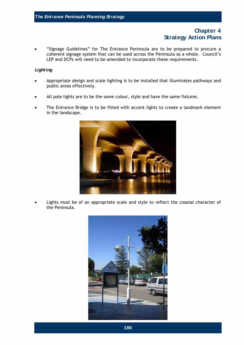
The Entrance Peninsula Planning Strategy
186
Chapter 4 Strategy Action Plans
• “Signage Guidelines” for The Entrance Peninsula are to be prepared to procure a
coherent signage system that can be used across the Peninsula as a whole. Council’s LEP and DCPs will need to be amended to incorporate these requirements.
Lighting • Appropriate design and scale lighting is to be installed that illuminates pathways and
public areas effectively. • All pole lights are to be the same colour, style and have the same fixtures. • The Entrance Bridge is to be fitted with accent lights to create a landmark element
in the landscape.
• Lights must be of an appropriate scale and style to reflect the coastal character of the Peninsula.

The Entrance Peninsula Planning Strategy
187
Chapter 4 Strategy Action Plans
Coastal Design Criteria Action Plan Introduction The Entrance Peninsula is a coastal area and future development is to respond to its unique topography and setting. The existing requirement for a maritime design theme in DCP 2005, Chapter 60, is to be repealed due to difficulties in interpretation and apparent limits in the diversity of architectural designs and contextual responses, and the promotion of repetition in building forms and design elements. Due to the many unique building types, terrains and contexts throughout The Entrance Peninsula, general design guidelines do not adequately acknowledge the diversity of the area or the need for a range of building types and design solutions. General design criteria is often misunderstood and misconstrued to result in undesirable urban and architectural design outcomes, as has often been the case with the current maritime design theme. DCP 2005, Chapter 60 (The Entrance) is to be amended to include a specific and well prepared set of Urban Design Guidelines to guide further development that reflects the coastal character of The Entrance Peninsula. The intent is to provide for high quality building design with active edges along all street frontages, and maximise opportunities for varying and interesting building facades by investigating and developing building design criteria that reflects the coastal village character of The Entrance Peninsula. Such investigations and criteria will be carried out in consultation with the SEPP 65 Panel and will also take account of needs to achieve adequate separation from neighbouring developments and streets, to provide for adequate open space and view sharing, to minimise potential overshadowing impacts, and to provide for the appropriate scale of development. These guidelines are to take into account SEPP 71 (Coastal Protection) and The Coastal Design Guidelines for New South Wales, including the following key issues: Views and Scenic Context • Development should recognise the high scenic value of The Entrance Peninsula,
provide views to the Pacific Ocean and Lake Tuggerah (wherever possible) and observe the principles of view sharing.
• Development is to blend into the surrounding area and relate to the development,
topography, landscape and coastal character of The Entrance Peninsula.

The Entrance Peninsula Planning Strategy
188
Chapter 4 Strategy Action Plans
Landscape • High quality landscape outcomes are integral to the maintenance and character of a
coastal area and will aid in guiding residents and visitors towards views, attributes and strengthening the relationship of the area to the lake and coast.
• Indigenous coastal species and species of cultural landscape significance should be
utilised in any landscape planning. Materials and Finishes • Due to the high levels of moisture and salt content, materials used for development
should be weather and salt resistant. Cement rendered, bagged and/or face brick; timber; colourbond and fibro-cement materials in traditional coastal colours should be used. Development will be encouraged to use a combination of these materials.

The Entrance Peninsula Planning Strategy
189
Chapter 4 Strategy Action Plans
Natural Amenity • Coastal areas are often associated with high wind velocities and roof design should
be sloped, curved and articulated to reduce wind uplift. Large flat roofs are discouraged due to their lack of wind sensitive design.
• Development should encourage outdoor living and priority should be given to the
connectivity between indoor living, balcony or terrace areas. Pergolas and trusses are often used to link indoor and outdoor areas.
• Large balconies can be unsightly and balustrades are to be articulated. Half glazed,
half solid solutions are one way of reducing visual impact.

The Entrance Peninsula Planning Strategy
190
Chapter 4 Strategy Action Plans
Coastal Amenity, Protection, Integration in Design • All development near the coast is to maintain the area’s character. • Development must blend into the topography of the site with minimal physical
impact on the coastline. • Building design is to blend into the natural context, with the use of natural colours,
finishes, textures and materials. • Public access to the coastline is to be appropriately maintained and encouraged,
wherever possible, through urban design, landscaping, zoning regulations and publicly accessible development.
• In regard to aesthetics, the desirable attributes of coastal landscape are to be
integrated into future development. Traditional coastal colours, materials, textures and forms are to be utilised.
Environmentally Sustainable Development (ESD) • Environmentally Sustainable Development (ESD) refers to the integration of
technologies in building design that minimise non-renewable energy consumption and water waste, while ensuring development that integrates with natural contexts and processes to ensure efficiency and sustainability.
• When developing design guidelines for The Entrance Peninsula, priority is to be given
to Environmentally Sustainable Development (ESD) over aesthetic design features, although in most cases both should be able to be achieved.
• An updated DCP 2005, Chapter 60 (The Entrance) with detailed coastal design
guidelines will provide a set of specific design controls and/or reference other Chapters of DCP 2005, to ensure high quality environmental performance for all new development and urban spaces on The Entrance Peninsula.
• The recognition of a coastal character in development also refers to the integration
of the natural elements of the development site. The maintenance of a coastal design theme will work in tandem with a strategy for the promotion of Environmentally Sustainable Development.
ESD Design Principles • Maximise climatic comfort and heat efficiency with window orientation to optimise
solar access for living areas and allow for cross ventilation. • Integrate the surrounding micro-climate (vegetation, landscape and topography) into
building design to ensure efficient water drainage, shading and design response to moisture build up.
• Use of movable shading devices to control internal temperatures. • Use of photovoltaic solar panels to provide power.

The Entrance Peninsula Planning Strategy
191
Chapter 4 Strategy Action Plans
• Collection and re-use of rainwater for toilets, washing and gardening. • Roof windows and glazing on sloped roofs minimises the need for artificial lighting
during the day and can provide cross-ventilation through living spaces. Residential Flat Code and SEPP 65 Design Quality Principles The Residential Flat Design Code and SEPP 65 Design Quality Principles discuss how to approach design elements like roofs and facades to ensure high quality architectural outcomes for residential developments in New South Wales. The Residential Flat Design Code also provides relevant issues to be addressed in a more detailed urban design guidelines study to inform refinement of DCP60. Some key points include: Balconies • Balconies are to be positioned to achieve maximum solar access. • Pergolas, shutters, sun screens and operable walls are to be used to control sunlight
and wind. • Cantilevered, semi-cantilevered and recessed balconies are to be designed to
respond to daylight, wind, acoustic privacy and visual privacy. Daylight Access • Shading devices are to be integrated into building design to maximise comfort. This
is to include horizontal shading for north-facing windows and vertical shading for east or west facing windows.
Facades • Facade design is to respond to the internal layout and residential and streetscape
amenity. Details should be functional and relate to the overall building design as well as the context of the site.
Quality development design within any context should always incorporate in-depth site analysis and the SEPP 65 Design Quality Principles, which outline key design considerations for development. The coastal context of The Entrance Peninsula should play a major role in site analysis, which will influence the final character of development, including aesthetic elements that relate to the public domain like colour, materials, texture and detailing.

The Entrance Peninsula Planning Strategy
192
Chapter 4 Strategy Action Plans
The Residential Flat Design Code provides quality advice in terms of Site Analysis, viz:
“Site Analysis (p.39 of The Residential Flat Design Code – Planning NSW) Site analysis is an important part of the design process. Development proposals need to illustrate design decisions, which are based on careful analysis of site conditions and their relationship to the surrounding context. By describing the physical elements of the locality and the conditions impacting on the site, opportunities and constraints for future residential flat development can be understood and addressed in the design.”
All of the SEPP 65 Design Quality Principles are useful to the promotion of a particular coastal character on The Entrance Peninsula. While they may not specifically or directly address coastal areas or developments other than residential flat buildings, the principles are a useful checklist for any development, to ensure the required high quality design outcomes that relate to the surroundings, and provide an appropriate sense of place in the public domain.
“SEPP 65 Design Quality Principles (p.98, 99 of The Residential Flat Design Code – Planning NSW) Principle 1: Context Good design responds and contributes to its context. Context can be defined as the key natural and built features of an area. Responding to context involves identifying the desirable elements of a location’s current character or, in the case of precincts undergoing a transition, the desired future character as stated in planning and design policies. New buildings will thereby contribute to the quality and identity of the area. Principle 2: Scale Good design provides an appropriate scale in terms of the bulk and height that suits the scale of the street and the surrounding buildings. Establishing an appropriate scale requires a considered response to the scale of existing development. In precincts undergoing a transition, proposed bulk and height needs to achieve the scale identified for the desired future character of the area. Principle 3: Built Form Good design achieves an appropriate built form for a site and the building’s purpose, in terms of building alignments, proportions, building type and the manipulation of building elements. Appropriate built form defines the public domain, contributes to the character of streetscapes and parks, including their views and vistas, and provides internal amenity and outlook.

The Entrance Peninsula Planning Strategy
193
Chapter 4 Strategy Action Plans
Principle 4: Density Good design has a density appropriate for a site and its context, in terms of floor space yields (or number of units or residents). Appropriate densities are sustainable and consistent with the existing density in an area or, in precincts undergoing a transition, are consistent with the stated desired future density. Sustainable densities respond to the regional context, availability of infrastructure, public transport, community facilities and environmental quality. Principle 5: Resource, Energy and Water Efficiency Good design makes efficient use of natural resources, energy and water throughout its full life cycle, including construction. Sustainability is integral to the design process. Aspects include demolition of existing structures, recycling of materials, selection of appropriate and sustainable materials, adaptability and reuse of buildings, layouts and built form, passive solar design principles, efficient appliances and mechanical services, soil zones for vegetation and reuse of water. Principle 6: Landscape Good design recognises that together landscape and buildings operate as an integrated and sustainable system, resulting in greater aesthetic quality and amenity for both occupants and the adjoining public domain. Landscape design builds on the existing site’s natural and cultural features in responsible and creative ways. It enhances the development’s natural environmental performance by co-ordinating water and soil management, solar access, micro-climate, tree canopy and habitat values. It contributes to the positive image and contextual fit of development through respect for streetscape and neighbourhood character, or desired future character. Landscape design should optimise useability, privacy and social opportunity, equitable access and respect for neighbours’ amenity, and provide for practical establishment and long-term management. Principle 7: Amenity Good design provides amenity through the physical, spatial and environmental quality of a development. Optimising amenity requires appropriate room dimensions and shapes, access to sunlight, natural ventilation, visual and acoustic privacy, storage, indoor and outdoor space, efficient layouts and service areas, outlook and ease of access for all age groups and degrees of mobility.

The Entrance Peninsula Planning Strategy
194
Chapter 4 Strategy Action Plans
Principle 8: Safety and Security Good design optimises safety and security, both internal to the development and for the public domain. This is achieved by maximising overlooking of public and communal spaces while maintaining internal privacy, avoiding dark and non-visible areas, maximising activity on streets, providing clear, safe access points, providing quality public spaces that cater for desired recreational uses, providing lighting appropriate to the location and desired activities, and clear definition between public and private spaces. Principle 9: Social Dimensions Good design responds to the social context and needs of the local community in terms of lifestyles, affordability, and access to social facilities. New developments should optimise the provision of housing to suit the social mix and needs in the neighbourhood or, in the case of precincts undergoing transition, provide for the desired future community. Principle 10: Aesthetics Quality aesthetics require the appropriate composition of building elements, textures, materials and colours and reflect the use, internal design and structure of the development. Aesthetics should respond to the environment and context, particularly to desirable elements of the existing streetscape or, in precincts undergoing transition, contribute to the desired future character of the area.”

The Entrance Peninsula Planning Strategy
195
Chapter 4 Strategy Action Plans
Public Transport Action Plan Introduction This strategy presents long-term transport infrastructure recommendations for The Entrance Peninsula. It aims to develop a strategic transportation framework that reduces the amount of private vehicle usage and provides mobility choices. The main goal is to make The Entrance Peninsula more accessible and create a more car-free place. Objectives The strategies and recommendations are prepared under the following five principal objectives: • To reduce the number of private vehicles and ease congestion on major road
corridors. • To improve the public transport network. • To improve reliability of public transport. • To integrate transport access and land use planning. • To improve amenity. Strategies and Recommendations The following describes strategies and recommendations that will apply specifically to the public transport action plan, contributing to achieving the objectives. Reduce the number of private vehicles and ease congestion on major road corridors. Park and Ride Scheme To park and ride, people may walk, cycle or drive to a parking area located near a public transport stop, park their vehicle/bicycle, and continue their journey by bus. On The Entrance Peninsula, this can be achieved by: • Establishing safe park and ride facilities at Salt Water Creek reserve, Long Jetty
Village Centre, The Entrance Town Centre, The Entrance North Gateway Precinct and at other attractions.

The Entrance Peninsula Planning Strategy
196
Chapter 4 Strategy Action Plans
• Providing secure and free carparking, bicycle parking and other amenities to
encourage use. • Providing signage, maps and information materials that make it easy to identify Park
and Ride locations and facilities, including facilities for the disabled. • Developing park and ride ticketing that can be used on local buses, regional express
buses and trains, making transfers easy and providing a smooth transitional connection with other services.
Bicycle Racks on Buses • Attach bicycle racks to buses. Cyclists may then ride part way to their destination,
"park" their bicycles on the bus, then finish their trip aboard a bus, or take the bus one way only. Use of the racks will need to be free of charge with the bus fare.
• A rebate on travel fares could be given to the passengers joining a Rack ‘n’ Ride
Program.

The Entrance Peninsula Planning Strategy
197
Chapter 4 Strategy Action Plans
Improve the Public Transport Network Express Public Transport Service Provide express public transport services to offer quicker service between Wyong and Tuggerah railway stations, Long Jetty Village Centre and The Entrance Town Centre. This could include buses, shuttles and other modes (if feasible). Further study of these concepts would be required to determine feasibility. Local Circulator Bus Service Since The Entrance Peninsula is a tourist precinct, it would benefit from an internal circulator bus that connects attractions and destinations of interest throughout the Peninsula. This service could be operated seasonally to reduce the amount of internal trips within The Entrance, therefore reducing traffic volumes and improving amenity. The map on the following page shows possible routes. These routes would need further testing for feasibility and could be amended, but in concept it would run in a frequent continuous loop stopping at The Entrance’s main attractions and destinations. Bicycle racks on the front of the shuttle buses would be a feature of the service. The bus is to have distinctive painting and a logo consistent with the branding of The Entrance Peninsula. An alternative clean fuel vehicle would add to the environmental benefits and theme. The route could include the following destinations: • Tuggerah Lake Foreshore Area. • Picnic Point. • Residential Areas (Various Parts). • The Entrance North Neighbourhood Centre. • Dunleith Point (at The Entrance North). • Toowoon Bay Neighbourhood Centre. • Beach access points at:
o Toowoon Bay. o Blue Bay. o Shelly Beach.
• Ocean Baths. • Marine Parade Coastal Walk and Surf Club.

The Entrance Peninsula Planning Strategy
198
Chapter 4 Strategy Action Plans
• Memorial Park. • Long Jetty Village Centre. • Saltwater Creek and Lions Park Reserves. • The Entrance Town Centre. • Karagi Reserve (at The Entrance North). • Karagi Point (at The Entrance). • Swadling Park Reserve. • Tuggerah Lakes Golf Course. • The Entrance North Foreshore Reserve. A resident circulator bus could also operate year round connecting to the main retail activity centres of The Entrance Town Centre, Long Jetty Village Centre, Toowoon Bay Neighbourhood Centre and The Entrance North Neighbourhood Centre and any other attractions. The below map indicates a possible route. These circulator routes would need further study to confirm feasibility, fares and costs.

The Entrance Peninsula Planning Strategy
199
Chapter 4 Strategy Action Plans
The Entrance Peninsula Planning Strategy
200
Chapter 4 Strategy Action Plans
Alternative Public Transport Services Restoration of the Historic Ferry Service Historically, there were ferries that went from Wyong to The Entrance Peninsula. This service ended in the 1920’s when the road system improved. With the notion of encouraging tourists to visit The Entrance Peninsula without a car, the possibility of reinstating a ferry service, at least on a seasonal basis, to provide an alternative transport connection from Tuggerah or Wyong Train Stations to The Entrance Peninsula, was investigated. In this way, visitors could experience arriving at The Entrance by water and enjoy a unique experience. Council‘s Transportation Section carried out a study, early in 2008, to identify the viability of a passenger ferry service between The Entrance and Wyong. The study identified that a ferry service between The Entrance and Wyong was not viable for the following reasons: Subsidies: Only regular passenger services attract subsidies from the government. These are minimal and only apply to student and senior concessions. For any surety, operators need to enter into a contract with the Ministry of Transport to provide a regular service for 5 years. This is not favourable with operators due to tight constraints on routes and timetables and heavy fines for not conforming to the timetable. Previous Services: Previous tourist ferry services on the lake have not been successful. The “Trinity Queen” operated from 1986 to 1992 and the “Wanderer” in the late 1990’s. Both ceased operations due to lack of market demand. Insufficient Patronage: Approximately 30 passengers currently catch a bus from The Entrance to Tuggerah or Wyong Railway Stations in the am and pm peak hours. Significantly less use the service outside these peak times. Ferry operators indicated they require somewhere in the order of 30 to 40 passengers on each commuter service to break even. Transport surveys carried out elsewhere have indicated that when a new public transport system is introduced, there is generally only a shift in the passengers from one public transport system to another. Generally, they do not attract new people from the car to the new public transport service. Cost of Infrastructure: If the ferry cannot pass under the rail bridge at Wyong (maximum height 3.2 metres), then a new wharf will be required in the vicinity of Howarth Street. The cost of a new wharf, together with toilets and other facilities is in the order of $400,000. Speed Restrictions: Speed restrictions, including a “No wash” regulatory requirement, along Wyong River significantly increases travel time of the journey. Journey Time: Journey time for a ferry from The Entrance to Wyong is in the order of 65 to 70 minutes (weather dependant). It takes 23 minutes by car and 60 minutes by bus. It takes 50 minutes by bus to Tuggerah Rail Station. Type of Vessel: The type of suitable vessel is restricted because of shallow water. The craft should have a minimum draught of 1 metre and desirably maximum height of 3.0 metres. A hovercraft is not suitable for acoustic reasons.

The Entrance Peninsula Planning Strategy
201
Chapter 4 Strategy Action Plans
Light Rail Similar in concept to introducing a ferry service, the notion of introducing a light rail service between The Entrance Peninsula and major centres and transport nodes (eg. Wyong and Tuggerah) has been considered. Such a service could potentially run along the lake foreshore. Across the lake may also be a possibility. While further detailed investigation would be required to more accurately determine feasibility, the following considerations have indicated that such a service would not be feasible: • Establishing a Light Rail Service: It would be very expensive to establish a light
rail system. The cost of establishing the required infrastructure, in particular, would appear to make it unaffordable.
• Patronage: Lack of the necessary population numbers to patronise the system is
likely to make the system unviable. • Funding: There would be little chance of obtaining funding from the State or
Commonwealth Governments, relying on Council revenue to fund such a light rail operation.
Future Use of The Entrance Channel Future use of The Entrance Channel for greater use by pleasure craft has been mooted by some members of the community. Studies to date indicate that there would be significant environmental and hazard consequences if alterations to the channel entrance and channel were to occur. Future use of The Entrance Channel to permit greater recreational or passive use by boat users needs to be considered in context of the adopted and gazetted Tuggerah Lakes Estuary Management Plan. Any future investigations to determine feasibility of such proposals would involve significant costs and detailed investigations. Improve Reliability of Public Transport In order to ensure a high quality level of bus service in terms of reliability and time accuracy, it will be necessary to provide bus priority measures to give buses the operational priority, particularly during peak hours or in congested traffic. Some practical solutions include exclusive bus lanes and priority traffic signals. Concepts that could be considered are illustrated on the following page. More detailed study would be needed. The Entrance Road corridor would benefit from these improvements to better manage traffic flows.

The Entrance Peninsula Planning Strategy
202
Chapter 4 Strategy Action Plans
Bus Advance Areas Bus advance areas enable buses to go to the front of the queue at traffic lights. An extra set of traffic lights with a special bus signal, is installed about 50 metres before the intersection to hold other traffic back while buses go to the front.
Signal Pre-Emption Signal pre-emption detects when a bus is coming and turns or keeps traffic lights green to let the bus through an intersection. The system consists of detectors in the roads, which are linked to traffic lights. When a bus passes over a detector, a message is sent ahead that a bus is on its way. If the lights are about to turn red, they are instructed to stay green until the bus passes through. If the lights are red, then the green phase is brought forward.
Review the number of bus stops and shelters and, if required, provide more stops and shelters at strategic locations. Provide attractive contemporary facilities, accessible by people of all abilities. Integrate Transport Access and Land Use Planning Provide adequate transit services to new development to promote mobility alternatives. It is recommended that all development applications for non-residential development and residential development over 50 units be supported by a transport impact assessment and that the local bus provider be advised of all such new development and provided the opportunity to contribute. This will help to ensure that the level of transit services keeps pace with changes in land use.