Preferred Option Report - Roads and Maritime Services · Nelligen Bridge Preferred Option Report ....
29
Nelligen Bridge Preferred Option Report September 2015
Transcript of Preferred Option Report - Roads and Maritime Services · Nelligen Bridge Preferred Option Report ....

Nelligen Bridge Preferred Option Report
September 2015

THIS PAGE LEFT INTENTIONALLY BLANK

Nelligen Bridge Preferred Option Report
Executive summary The Kings Highway is the primary east-west route between the ACT/Queanbeyan Region and the Eurobodalla Region. Nelligen and Nelligen Bridge are located towards the eastern end of the 137 kilometre long highway.
The existing Nelligen Bridge is a continuous span concrete girder bridge constructed in 1964 with a single lane in each direction and a footpath on the southern (downstream) side of the bridge. Deterioration of the reinforced concrete piles supporting bridge piers 1-4 was identified during routine inspections. The bridge has been assessed as safe to carry normal highway loads, but will deteriorate in the short to medium term, requiring either significant rehabilitation or replacement of the structure within the next ten years.
Nelligen Bridge and its eastern approach also experience a high crash rate. The existing road environment consists of a downhill grade towards the bridge combined with a substandard curve, and minimal shoulders adjacent to steep cuttings providing an unforgiving road environment. The existing bridge has no shoulders and no barrier separating pedestrians from vehicles.
Options to either repair and replace the bridge have been investigated. While options to repair the bridge have a lower capital cost, they would require lengthy closures (over 100 days) and available all weather detours are in the order of 250-400 kilometres depending on origins and destinations. As these detours are considered unnacceptable, a temporary bridge would need to be constructed which substantially increases the cost of repair options. The costs of a temporary bridge would be avoided through a replacement option which would largely be constructed offline. A brief description of the options is provided below.
Option 1: Repair existing bridge: Construct six new piles and strengthen 10 of 21 piles at piers 1-4. Provide a single lane temporary bridge with traffic control for duration of repair works. Undertake required geotechnical works to stabilise assessed risk level 2 slope on the eastern side of the existing bridge (see section 3.5). Option 2: Repair and strengthen existing bridge: As above but with additional works to strengthen the bridge deck through post tensioning to cater for Higher Mass Limit (HML) B-double freight vehicles.
It should be noted that only the new elements on the bridge would have a 100 year design life and additional works would need to be undertaken to piers 5 and 6 and the bridge deck in order to achieve a full 100 year design life out of a repaired bridge which would further increase the cost of these options.
Option 3: Replace the bridge to the north (upstream): Construct a new bridge to the north (upstream) of the existing bridge and realign the approaches to an 80km/h design standard. A new bridge would cater for HML B-doubles and have a 100 year design life. Option 4: Replace the bridge to the south (downstream): Construct a new bridge to the south (downstream) of the existing bridge and realign the approaches to an 80km/h design standard. A new bridge would cater for HML B-doubles and have a 100 year design life. Option 3 to replace the bridge to the north of the existing bridge has been selected as the preferred option as it provides a value for money solution with better long term benefits than the repair options (Options 1 and 2) and has less impacts on private property and heritage in Nelligen than Option 4. Option 3 was selected by all who attended the Value Management Workshop held in April 2015, which included key external stakeholders and community representatives, as the option to progress for futher development.
Page 1 of 25
Nelligen Bridge Preferred Option Report
Contents Executive summary ........................................................................................................... 1
Contents ............................................................................................................................ 2
Background ....................................................................................................................... 3
Options review .................................................................................................................. 5
Considerations ................................................................................................................ 10 Property ................................................................................................................. 10 Traffic ..................................................................................................................... 10 Road Safety ........................................................................................................... 11 Utilities ................................................................................................................... 12 Environmental ........................................................................................................ 12 Geotechnical .......................................................................................................... 16 Constructability ....................................................................................................... 16 Risks ………………………………………………………………………………………. 18 Economic analysis ................................................................................................. 18 Value Management Workshop ............................................................................... 20
Conclusion and next steps .............................................................................................. 19
Appendix A - Value Management Workshop Assessment….……………………………… 20
Page 2 of 25

Nelligen Bridge Preferred Option Report
Background The Kings Highway is the primary east-west route between the ACT/Queanbeyan Region and the Eurobodalla Region. Nelligen and Nelligen Bridge are located towards the eastern end of the 137 kilometre long highway (Figure 1). The corridor fulfils a number of transport roles, including:
• Regional tourism, particularly for Canberra and Queanbeyan residents travelling to and from the South Coast.
• Regional access for people living on and in the vicinity of the corridor, which provides their only east–west link to access higher order services such as medical facilities located predominantly in Canberra and Queanbeyan. This is particularly important for the ageing population of the South Coast.
• East-west freight route connecting the Eurobodalla Shire with major inter and intra state routes. Freight utilising the corridor largely consists of dairy, forestry, and population servicing industries such as fuel and groceries. There is no rail and very limited air freight into the region.
Figure 1. Nelligen Bridge locality
The existing Nelligen Bridge is a continuous span concrete girder bridge constructed in 1964 with a single lane in each direction and a footpath on the southern (downstream) side of the bridge. Based on data from RMS permanent counter 08.004, which is about 200 metres west of Nelligen Bridge, the 2008 average annual daily traffic volume was 3,667 with an annual growth rate of 1.7%.
Deterioration of the reinforced concrete piles supporting bridge piers 1-4 was identified during routine inspections. The bridge has been assessed as safe to carry normal highway loads, but will deteriorate in the short to medium term, requiring either significant rehabilitation or replacement of the structure within the next ten years. Options to either repair and replace the bridge have been investigated.
Page 3 of 25

Nelligen Bridge Preferred Option Report
Figure 2. Underwater inspection of Nelligen Bridge Piers
While options to repair the bridge have a lower capital cost, they would require lengthy closures (over 100 days) and available all weather detours are in the order of 250-400 kilometres depending on origins and destinations. As these detours are considered unnacceptable, a temporary bridge would need to be constructed which would cost in the order of $5 million. The costs of a temporary bridge would be avoided through a replacement option which would largely be constructed offline.
Options to either repair and replace the bridge have been investigated.
During the five-year period between January 2009 and December 2013, a total of 11 serious crashes, including five ‘casualty crashes’ (crashes resulting in a fatality or a reported injury) were recorded on the bridge or its immediate approaches. The casualty crashes resulted in two deaths and six injuries. There were also six non-casualty crashes.
The key priority for Roads and Maritime Services is to retain a safe and reliable road crossing of the Clyde River at Nelligen without a need to impose load and/or speed restrictions. The Queanbeyan to Batemans Bay Corridor Strategy (September 2009) identifies the Kings Highway as a critical link between the South Coast and services, including specialist medical services located in Canberra, with tourist/recreational activity the predominant movement from west to east. Should action to repair or replace the bridge not occur, the risk of 250 to 400 kilometre detours would increase over time. Roads and Maritime has increased its monitoring program to assess the condition of the bridge.
While the key priority is to retain a safe and reliable crossing of the Clyde River at Nelligen, options to replace the bridge also provide opportunities to realign the approaches addressing the safety issues identified in the study area.
Page 4 of 25

Nelligen Bridge Preferred Option Report
Options review Option 1: Repair existing bridge The options investigation process for the project began with repair options only. Having uncovered the deficiencies associated with the existing piers and recognising that the bridge could deteriorate such that it is unable to carry traffic without targeted repair works, the investigations focussed on developing a cost effective repair solution. Due to the nature of the works, Roads and Maritime sought advice from specialist contractors with experience in the type of underwater pier repair works that would be required for the bridge over the Clyde River at Nelligen.
Repairing the existing bridge structure would involve the construction of six new steel piles at piers 1-4 (four of which would be drilled through the bridge deck and two outside) and strengthening 10 of 21 existing piles at piers 1-4. This option has the smallest footprint and minimal environmental disturbance/risks as assessed in the Preliminary Environmental Investigations (PEI). It is estimated that repairing the bridge would extend the asset lifespan to 2064 unless additional work was undertaken on the remaining bridge elements thus increasing costs. This option would have the lowest short term expenditure, however it would not improve freight efficiency by catering for Higher Mass Limit vehicles, safety on the approach curve, or separate pedestrians from traffic travelling at 80km/h.
The initial and ongoing costs as well as the forecast service life of the asset have been considered in the economic analysis for all options. Given that the loss of a crossing is considered unacceptable, Option 1 has been adopted as the base case.
Figure 1. Bridge repair substructure concept (new piles, pile cap and piers)
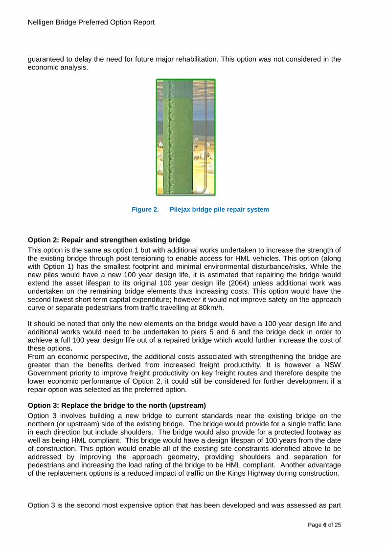
Due to the substantial costs associated with the option to repair the bridge, a lower cost proprietary product Pilejax was investigated as a potential repair option. In this option, Pilejax casings are placed around the bridge piles and pumped with concrete to strengthen the piles. This option however is only a short term option and can only treat the piles to bed level. Below bed level, which can not be inspected, it is likely that the deterioration of concrete cover and steel reinforcement persists and therefore this was not considered a suitable option as it is not
Page 5 of 25
Nelligen Bridge Preferred Option Report
guaranteed to delay the need for future major rehabilitation. This option was not considered in the economic analysis.
Figure 2. Pilejax bridge pile repair system
Option 2: Repair and strengthen existing bridge This option is the same as option 1 but with additional works undertaken to increase the strength of the existing bridge through post tensioning to enable access for HML vehicles. This option (along with Option 1) has the smallest footprint and minimal environmental disturbance/risks. While the new piles would have a new 100 year design life, it is estimated that repairing the bridge would extend the asset lifespan to its original 100 year design life (2064) unless additional work was undertaken on the remaining bridge elements thus increasing costs. This option would have the second lowest short term capital expenditure; however it would not improve safety on the approach curve or separate pedestrians from traffic travelling at 80km/h.
It should be noted that only the new elements on the bridge would have a 100 year design life and additional works would need to be undertaken to piers 5 and 6 and the bridge deck in order to achieve a full 100 year design life out of a repaired bridge which would further increase the cost of these options. From an economic perspective, the additional costs associated with strengthening the bridge are greater than the benefits derived from increased freight productivity. It is however a NSW Government priority to improve freight productivity on key freight routes and therefore despite the lower economic performance of Option 2, it could still be considered for further development if a repair option was selected as the preferred option.
Option 3: Replace the bridge to the north (upstream) Option 3 involves building a new bridge to current standards near the existing bridge on the northern (or upstream) side of the existing bridge. The bridge would provide for a single traffic lane in each direction but include shoulders. The bridge would also provide for a protected footway as well as being HML compliant. This bridge would have a design lifespan of 100 years from the date of construction. This option would enable all of the existing site constraints identified above to be addressed by improving the approach geometry, providing shoulders and separation for pedestrians and increasing the load rating of the bridge to be HML compliant. Another advantage of the replacement options is a reduced impact of traffic on the Kings Highway during construction.
Option 3 is the second most expensive option that has been developed and was assessed as part
Page 6 of 25

Nelligen Bridge Preferred Option Report
of the PEI as the option with the second greatest environmental impact. It is the preferred option of the bridge replacement options.
Figure 3. Bridge cross section for replacement options
Option 4: Replace the bridge to the south (downstream) Option 4 involves building a new bridge to current standards near the existing bridge on the southern (or downstream) side of the existing bridge. Like Option 3, the bridge would provide for a single traffic lane in each direction and include shoulders. The bridge would also provide for a protected footway as well as being HML compliant. This bridge would have a design lifespan of 100 years from the date of construction. This option would enable all of the existing site constraints identified above to be addressed by improving the approach geometry, providing shoulders and separation for pedestrians and increasing the load rating of the bridge to be HML compliant. Another advantage of the replacement options is a reduced impact of traffic on the Kings Highway during construction.
Option 4 was assessed in the PEI as having the greatest environmental impact, especially on the built environment. This option would impact on five properties in east Nelligen requiring total acquisition of each, and impact on heritage items on the west side of the Clyde River. This option is also the most costly and is therefore not the preferred option.
Page 7 of 25

Nelligen Bridge Preferred Option Report
Figure 4. Bridge repair and replacement options
The table below summarises the costs and benefits of each option.
*Design life is about 50 years unless works to the remaining elements of the bridge are undertaken which would further increase the costs of the repair options.
Option 1 (Base) Option 2 Option 3 Option 4
Repair existing bridge
Strengthen existing bridge
Construct new bridge upstream
Construct new bridge downstream
Relative cost of options 1 1.3 1.3 1.4
Design life (years) ~50 years* ~50 years* 100 years 100 years
HML Compliant No Yes Yes Yes
On road shoulders No No Yes Yes
Separated footway No No Yes Yes
Improved approach geometry No No Yes Yes
Page 8 of 25

Nelligen Bridge Preferred Option Report
The preferred option Option 3 to replace the bridge to the north of the existing bridge has been selected as the preferred option as it provides a value for money solution with better long term benefits than the repair options (Options 1 and 2) and has less impacts on private property and heritage in Nelligen than Option 4. Option 3 was selected by all who attended the Value Management (VM) Workshop held in April 2015, which included key external stakeholders and community representatives, as the option to progress for futher development.
Further investigations into improving the alignment of Option 3 to reduce constructability issues are currently being undertaken.
Page 9 of 25

Nelligen Bridge Preferred Option Report
Considerations Property Options 1 and 2 would only require property acquisition if the temporary bridge was located on the northern side of the existing bridge. In this case property acquisition would be similar to that required for Option 3, about 0.5 ha of currently undeveloped rural land.
Option 4 has substantial property impacts and would require total acquisition of five properties on the eastern side of the Clyde River and total acquisition of two heritage buildings on the western side of the river. Depending on the required cut batter designs, partial acquisition of five additional properties on the western side of the Clyde River may also be required. The costs associated in this property acquisition are substantial and have been reflected in the higher cost estimate for Option 4.
Traffic Traffic volumes along the Kings Highway vary, with generally higher traffic volumes evident on the sections west of Bungendore, influenced by the higher populations of Queanbeyan and Canberra.
Nelligen Bridge is located to the eastern end of the highway which has generally lower traffic volumes. Based on data from RMS permanent counter 08.004, which is approximately 200 metres west of Nelligen Bridge, the 2008 average annual daily traffic volume was 3,667 with an annual growth rate of 1.7%.
Figure 5. Average Annual Daily Traffic (AADT) volumes on the Kings Highway at Nelligen
A sample count in March 2011 counted 3,529 vehicles per day with 5.9% of these heavy vehicles however this count did not cover any holiday periods and would likely be lower than the AADT. Eurobodalla Shire Council has conducted more recent surveys that indicated the heavy vehicle proportion on the Kings Highway is 9% westbound and 12.5% eastbound.
Page 10 of 25

Nelligen Bridge Preferred Option Report
Figure 6. Weekly traffic volumes on the Kings Highway at Nelligen
Traffic volumes vary considerably on the Kings Highway between winter and summer, with far higher volumes during the summer months, especially at weekends.
The existing bridge does not restrict general access traffic capacity and there are no known significant land use changes or developments expected to significantly increase the traffic volumes.
The Kings Highway is the major east-west freight route connecting the Eurobodalla Shire with major inter and intra state routes. Freight utilising the corridor largely consists of dairy, forestry, and population servicing industries such as fuel and groceries. There is no rail and extremely limited air freight into the region.
Nelligen Bridge is not currently load limited and has been assessed as suitable to carry 19 metre semi-trailers up to 45 tonnes. The bridge is not HML compliant, however the constrained alignment of the Kings Highway on Clyde Mountain (to the west of Nelligen) prevents higher productivity vehicles (HPV) such as 25/26 metre B-doubles from using the route. There could be some potential for HPV vehicles up to 25/26 metres to operate along the route if limited to specialised vehicles with steerable rear axles. Transport for NSW is considering a trial of such vehicles on Bells Line of Road, where tracking of a standard 25/26 metre B-double would be problematic.
Road Safety Nelligen Bridge and its eastern approach experience a high crash rate. The existing road environment consists of a downhill grade towards the bridge combined with a substandard curve, and minimal shoulders adjacent to steep cuttings providing an unforgiving road environment. The existing bridge has no shoulders and no barrier separating pedestrians from vehicles.
During the five-year period between January 2009 and December 2013, a total of 11 serious crashes, including five ‘casualty crashes’ (crashes resulting in a fatality or a reported injury) were recorded on the bridge or its immediate approaches. The casualty crashes resulted in two deaths and six injuries. There were also six non-casualty crashes.
Page 11 of 25

Nelligen Bridge Preferred Option Report
The average number of casualty crashes during the period was 1.11 per km per year. This is nearly double the average casualty crash rate for ‘Rural Undivided Carriageways’ in Southern Region which is 0.62. There were 77.2 casualty crashes per 100 million vehicle kilometres travelled. This is nearly four times the average of 22.17 for all ‘Rural Undivided Carriageways’ in Southern Region. The Severity Index for crashes along this length of the Kings Highway was 1.50 which is higher than the average Severity Index of 1.15 for all ‘Rural Undivided Carriageways’ in Southern Region.
Figure 7. Nelligen Bridge crash history
In the previous five years (2004-2008), five crashes occurred, four of which were injury crashes resulting in five injuries. Therefore, the casualty crash rate (crashes resulting in a death or injury) if spread over the ten year data period would reduce to 72.5 casualty crashes per 100 million vehicle kilometres travelled.
Utilities The existing bridge contains Telstra copper cable and electrical cable for lighting which would need to be relocated to the new bridge as the existing bridge would be demolished. Five power poles would also need to be relocated.
An optic fibre submarine cable is present on the southern side of the bridge which may be impacted by a southern realignment option but would not be impacted by the preferred northern option.
Dial before you dig surveys indicated that no sewer, water, or gas mains are located within the proposed work area.
Environmental A Preliminary Environmental Investigation (PEI) was completed in September 2014 to identify environmental constraints associated with all options. The PEI investigated a range of design options at varying design speeds however an 80km/h design speed has been adopted for further investigations of realignment options. The PEI has been published on the Roads and Maritime
Page 12 of 25

Nelligen Bridge Preferred Option Report
website.
Page 13 of 25

Nelligen Bridge Preferred Option Report
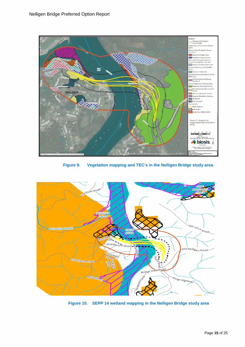
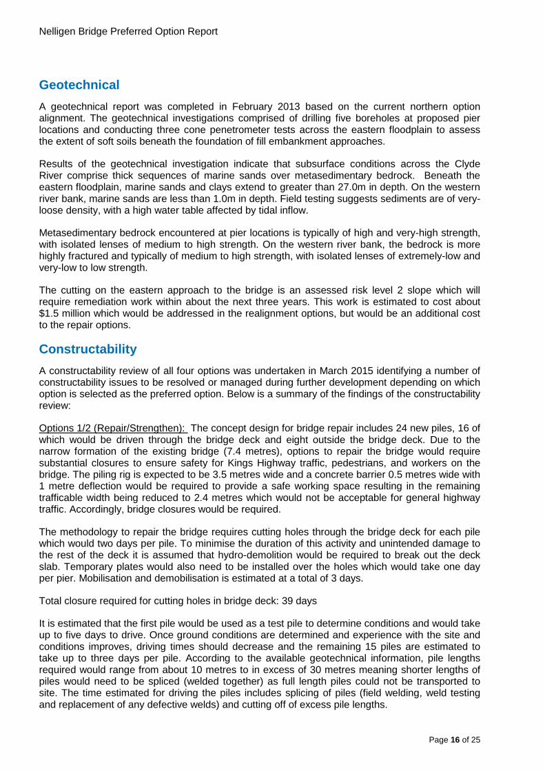
Figures 8 - 10 show the environmental constraints identified within the PEI from a biodiversity and heritage perspective. The primary environmental constraints are greater impacts to Threatened Ecological Communities (TEC’s < 1 hectare) and SEPP 14 wetlands (~ 0.2 hectares) associated with Option 3 (upstream), and greater heritage/socio economic impacts associated with Option 4 (downstream). Option 4 would require total acquisition of five dwellings, directly impact on two locally listed heritage buildings being the Nelligen Mechanics Institute and Former Post Office and potentially impact a number of other locally listed heritage items. It would also reduce the amount of available mooring space on the Clyde River, impact on an Aboriginal Land Claim on the south-western side of the bridge, and impact the northern end of the foreshore area which is highly valued to the community and contains a heritage walk with interpretive signage on Nelligen’s history.
On balance, the PEI considered that options to repair the bridge would have the least environmental impact as all work would be undertaken on the existing bridge structure. Option 4 was assessed to have the greatest environmental impact.
Modifications to the design of Option 3 as the preferred option are currently being investigated to see if impacts to SEPP 14 wetlands can be avoided by shifting the alignment slightly to the south on the western approach to the bridge. This would also have the advantage of winning material that could be used to balance earthworks across the project, reducing the need for imported fill.
There are also mapping irregularities for SEPP 14 wetlands. Roads and Maritime will engage an independent ecologist to ground truth the actual location of SEPP 14 wetlands in the area and seek to refine the mapping in consultation with the Department of Planning and Environment. Ground truthing the location of SEPP 14 wetlands will assist Roads and Maritime in preparing the concept design of the preferred option.
Figure 8. Heritage items in the Nelligen Bridge study area
Page 14 of 25
Nelligen Bridge Preferred Option Report
Figure 9. Vegetation mapping and TEC’s in the Nelligen Bridge study area.
Figure 10. SEPP 14 wetland mapping in the Nelligen Bridge study area
Page 15 of 25
Nelligen Bridge Preferred Option Report
Geotechnical A geotechnical report was completed in February 2013 based on the current northern option alignment. The geotechnical investigations comprised of drilling five boreholes at proposed pier locations and conducting three cone penetrometer tests across the eastern floodplain to assess the extent of soft soils beneath the foundation of fill embankment approaches.
Results of the geotechnical investigation indicate that subsurface conditions across the Clyde River comprise thick sequences of marine sands over metasedimentary bedrock. Beneath the eastern floodplain, marine sands and clays extend to greater than 27.0m in depth. On the western river bank, marine sands are less than 1.0m in depth. Field testing suggests sediments are of very-loose density, with a high water table affected by tidal inflow.
Metasedimentary bedrock encountered at pier locations is typically of high and very-high strength, with isolated lenses of medium to high strength. On the western river bank, the bedrock is more highly fractured and typically of medium to high strength, with isolated lenses of extremely-low and very-low to low strength.
The cutting on the eastern approach to the bridge is an assessed risk level 2 slope which will require remediation work within about the next three years. This work is estimated to cost about $1.5 million which would be addressed in the realignment options, but would be an additional cost to the repair options.
Constructability A constructability review of all four options was undertaken in March 2015 identifying a number of constructability issues to be resolved or managed during further development depending on which option is selected as the preferred option. Below is a summary of the findings of the constructability review:
Options 1/2 (Repair/Strengthen): The concept design for bridge repair includes 24 new piles, 16 of which would be driven through the bridge deck and eight outside the bridge deck. Due to the narrow formation of the existing bridge (7.4 metres), options to repair the bridge would require substantial closures to ensure safety for Kings Highway traffic, pedestrians, and workers on the bridge. The piling rig is expected to be 3.5 metres wide and a concrete barrier 0.5 metres wide with 1 metre deflection would be required to provide a safe working space resulting in the remaining trafficable width being reduced to 2.4 metres which would not be acceptable for general highway traffic. Accordingly, bridge closures would be required.
The methodology to repair the bridge requires cutting holes through the bridge deck for each pile which would two days per pile. To minimise the duration of this activity and unintended damage to the rest of the deck it is assumed that hydro-demolition would be required to break out the deck slab. Temporary plates would also need to be installed over the holes which would take one day per pier. Mobilisation and demobilisation is estimated at a total of 3 days.
Total closure required for cutting holes in bridge deck: 39 days
It is estimated that the first pile would be used as a test pile to determine conditions and would take up to five days to drive. Once ground conditions are determined and experience with the site and conditions improves, driving times should decrease and the remaining 15 piles are estimated to take up to three days per pile. According to the available geotechnical information, pile lengths required would range from about 10 metres to in excess of 30 metres meaning shorter lengths of piles would need to be spliced (welded together) as full length piles could not be transported to site. The time estimated for driving the piles includes splicing of piles (field welding, weld testing and replacement of any defective welds) and cutting off of excess pile lengths.
Page 16 of 25
Nelligen Bridge Preferred Option Report
Total closure required for piling through bridge deck: 51 days
Following completion of driving piles through the bridge deck, the bridge deck would need to be reinstated which would take 13 days per pier. As this work could begin when the first pier is completed the total additional days after piling is complete would be 16 days.
Total closure required for bridge repairs: 106 days
As mentioned above, there are no suitable all weather detours available if Nelligen Bridge were to be closed for a substantial period of time. Detours available in all weather are in the order of 250-400 kilometres depending on origins and destinations. Due to the strategic importance of the Kings Highway as a link between the south coast and Canberra and Queanbeyan, closures would likely need to be divided into blocks of three days at a time as was required for the emergency slip repair works on the Clyde Mountain however this was only for a total for 15 days over five weeks. The closures required to repair the bridge are far more substantial than that, in the order of 106 days over 35 weeks, and would present a significant risk to the project if this option was selected as the preferred option. This timeframe is based on standard working hours and could be reduced by including night works however this would increase costs and impacts on the residents of Nelligen, particularly in terms of noise.
Another option to locate all piles outside of the bridge structure was investigated which would require larger piles of 1200mm to 1500mm diameter. The piles would weigh 22 to 26 tonnes. Using a large crane of the required size to drive piles from the bridge would be impractical and piles of this size would be at the limit of the size of barge crane which can be established on site, considering the fact that there is only five metres headroom under the bridge. Accordingly the option for 762 mm piles driven through the bridge deck was chosen for the repair option.
The additional cost of these closures has not yet been assessed beyond including $5 million in the repair options estimates for the costs of a temporary bridge; however they would only make the preferred option to replace the bridge more attractive as the majority of the work could be undertaken offline with minimal impacts to traffic on the Kings Highway.
Option 3 (upstream/northern): The main constructability issue with this option as currently designed is the work on the eastern approach to the bridge which involves widening the existing alignment then crossing over three metres above the existing alignment. This would require a number of traffic switches and traffic control or the construction of a side track in a very constrained environment. Further investigations are being undertaken to remove the need to cross the existing highway.
The current bridge design also contains reverse curves which is not desirable. In conjunction with the above investigations, options to simplify the bridge structure are being considered.
This option would require about 28,000m³ of imported fill. A suitable source for this material would need to be identified. There is a cutting on the western side of the Clyde River which could be a source for additional material and modifying the alignment to use material from this cutting would also reduce potential impacts on SEPP 14 wetlands.
Option 4 (downstream/southern): The western bridge abutment is immediately adjacent to the existing bridge abutment making piling and construction in general in this area very difficult and high risk.
This option would require about 65,000m³ of imported fill, which is substantially more than Option 3. A suitable source for this material would need to be identified.
Page 17 of 25

Nelligen Bridge Preferred Option Report
Risks A risk workshop was held in November 2013. The workshop considered risks relating to all four options. A total of 257 risks were identified across the range of options.
Of the 257 risks identified 60 were considered extreme, 47 high, 94 medium, 32 low, 24 negligible. Less than half (120) of the identified risks applied to all project options, while the majority related to one or two of the options only.
The workshop participants focused on developing a range of risk treatments for the highest level risks (extreme and high) and, subject to implementation of mitigation measures (risk treatments), determined what the residual risk would be rated. With appropriate mitigation measures, only three risks of the 257 risks initially identified were still considered as potentially high to extreme risks. A summary of the highest rated risks for each option is presented below.
The greatest risks associated with options to repair the bridge (Options 1 and 2) are associated with the lengthy bridge closures required. It was considered that over 100 days of bridge closures would be unacceptable given the lengthy detours required and therefore a single lane temporary bridge estimated to cost in excess of $5 million would need to be constructed as a mitigation measure. The single lane bridge would cause traffic delays, particularly on weekends affecting residents, tourists, freight, and emergency services however a two lane bridge would not be economical to provide. Community opposition to this option could present a significant risk to the project when alternative options are available which, although more costly, have been shown to be comparatively more economically worthwhile.
The greatest risks associated with the southern downstream option (Option 4) are impacts on several private properties, non Aboriginal heritage items, an Aboriginal Land Claim and the Nelligen foreshore area. Community opposition to this option could present a significant risk to the project when alternative options are available which are less costly to construct.
The preferred option to construct a bridge to the north of the existing bridge would have greater impacts on biodiversity than other options however the risks associated with this are considered manageable given the relatively small amount of clearing required. Potential impacts on SEPP 14 wetlands present a risk as Roads and Maritime can not determine the environmental assessment and would have to make an application to Eurobodalla Shire Council and the Director of National Parks and Wildlife Services for these impacts. The Council however are supportive of the preferred option and with due diligence taken to minimise impacts on SEPP 14 wetlands it is considered that this risk is manageable. Roads and Maritime will engage an independent ecologist to ground truth the location of SEPP 14 wetlands which may result in the proposed works avoiding impacts and the need for a separate application.
Economic analysis An economic appraisal was completed in February 2015 based on the strategic design options developed for repair and replacement of Nelligen Bridge. The economic appraisal followed the Principles and Guidelines of Economic Appraisal of Transport Investment and Initiatives and the National Guidelines for Transport System Management in Australia. Economic parameters adopted, such as value of travel time savings, vehicle operating cost and accident cost savings are consistent with TfNSW Guidelines Appendix 4.
The initial focus of options investigations focused on ways to repair the existing bridge. Option 1 was adopted as the base case. In selecting the base case for analysis, it should be noted that:
• Atypically, there is no ‘do nothing’ option as bridge failure is not considered acceptable for such a significant regional route as the Kings Highway, which has no suitable detour. Detours are between 250km and 400km longer than the existing route depending on origins
Page 18 of 25
Nelligen Bridge Preferred Option Report
and destinations.
Page 19 of 25
Nelligen Bridge Preferred Option Report
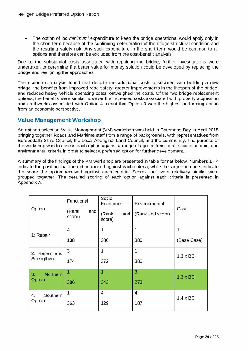
• The option of ‘do minimum’ expenditure to keep the bridge operational would apply only in the short-term because of the continuing deterioration of the bridge structural condition and the resulting safety risk. Any such expenditure in the short term would be common to all options and therefore can be excluded from the cost-benefit analysis.
Due to the substantial costs associated with repairing the bridge, further investigations were undertaken to determine if a better value for money solution could be developed by replacing the bridge and realigning the approaches.
The economic analysis found that despite the additional costs associated with building a new bridge, the benefits from improved road safety, greater improvements in the lifespan of the bridge, and reduced heavy vehicle operating costs, outweighed the costs. Of the two bridge replacement options, the benefits were similar however the increased costs associated with property acquisition and earthworks associated with Option 4 meant that Option 3 was the highest performing option from an economic perspective.
Value Management Workshop An options selection Value Management (VM) workshop was held in Batemans Bay in April 2015 bringing together Roads and Maritime staff from a range of backgrounds, with representatives from Eurobodalla Shire Council, the Local Aboriginal Land Council, and the community. The purpose of the workshop was to assess each option against a range of agreed functional, socioeconomic, and environmental criteria in order to select a preferred option for further development.
A summary of the findings of the VM workshop are presented in table format below. Numbers 1 - 4 indicate the position that the option ranked against each criteria, while the larger numbers indicate the score the option received against each criteria. Scores that were relatively similar were grouped together. The detailed scoring of each option against each criteria is presented in Appendix A.
Option
Functional
(Rank and score)
Socio Economic
(Rank and score)
Environmental
(Rank and score) Cost
1: Repair 4
138
1
386
1
380
1
(Base Case)
2: Repair and Strengthen
3
174
1
372
1
380 1.3 x BC
3: Northern Option
1
386
1
343
3
273 1.3 x BC
4: Southern Option
1
363
4
129
4
187 1.4 x BC
Page 20 of 25

Nelligen Bridge Preferred Option Report
In summary, Option 3 scored the best particularly for functional and socio economic criteria and scored third for environmental impacts. Options to repair the bridge would have minimal environmental impacts as they are working on the existing bridge and therefore don’t require the clearing of any vegetation or impact on any properties or heritage items. Overall Option 3 scored the highest.
The workshop unanimously selected Option 3 to proceed for further development for the following reasons:
• Improved vehicle, pedestrian and cyclist safety;
• Increased asset life;
• Improved freight efficiency;
• Positive impact on Nelligen.
• Lesser impact on heritage in Nelligen;
• Less property acquisition;
• Improvement in moorings.
• It appears that it offers better value for money compared to the other options;
• Whole of life cost may be cheaper;
• Offers more flexibility in further design stages.
• Scored the highest on balance against the three criteria;
• Provides better value for money;
• Provides greater operational benefits;
• Repair options have many risks that have not been adequately addressed;
Subject to: • Resolution of the planning pathway with respect to the SEPP 14 Wetlands;
• Peer review of repair estimate to assess if the quote received provides value for money or if the repair works can be done at a lower cost.
• Resolution of the constructability issues arising from the current design crossing the existing highway three metres above existing levels.
• Clarification of any Aboriginal heritage issues;
• Investigation and satisfactory resolution of the tie in points.
Conclusion and next steps Option 3 to replace the bridge to the north of the existing bridge has been selected as the preferred option as it would provide a value for money solution with better long term benefits than the repair options (Options 1 and 2) and would have less impacts on private property and heritage in Nelligen than Option 4. Option 3 was selected by all who attended the Value Management Workshop held in April 2015, which included key external stakeholders and community representatives, as the option to progress for futher development. Design refinements are currently being investigated to improve the constructability of the northern option and reduce the likelihood of impacts on SEPP 14 wetlands.
Following announcement of the preferred option Roads and Maritime will progress with concept design and undertake an environmental assessment. Key stakeholders including the community will be consulted as the design is refined and during the environmental assessment process. The environmental assessment is expected to be displayed for community comment in 2016.
Page 21 of 25

Nelligen Bridge Preferred Option Report
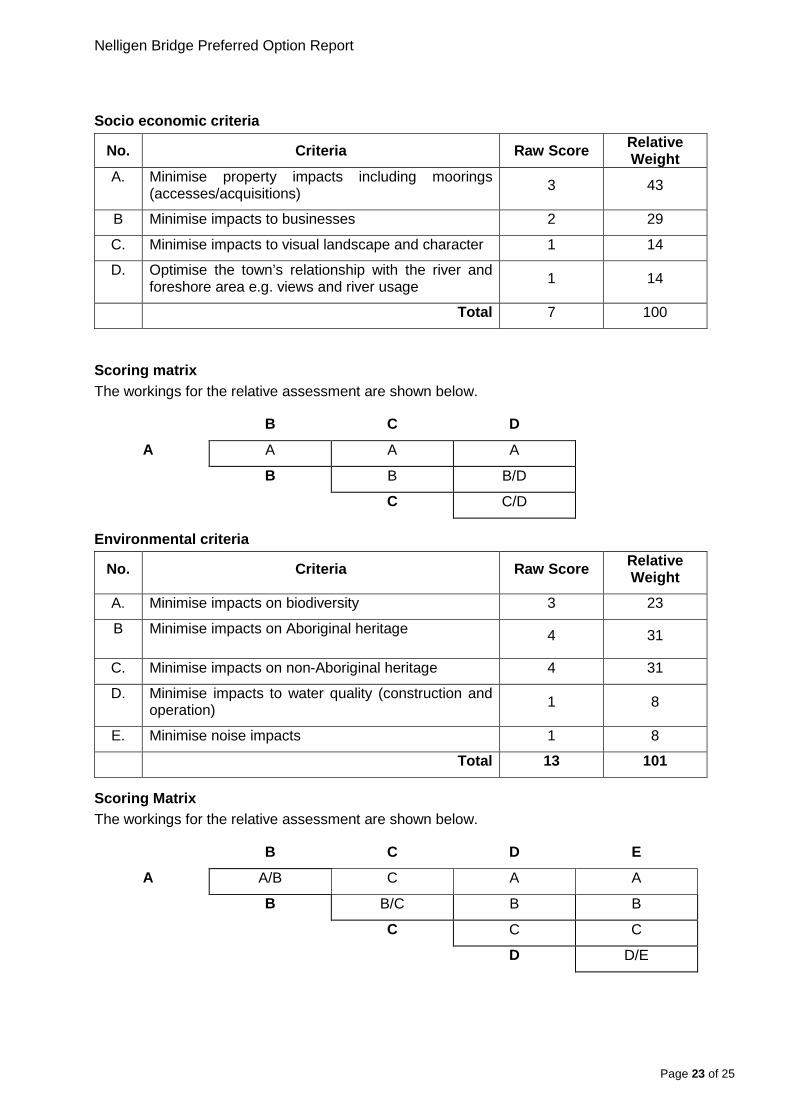
Appendix A – Value Management Workshop Assessment Assessment criteria weighting Relative weighting of assessment criteria was completed by using a paired comparison approach. This process involved assessing the relative importance of the respective criteria by comparing each criterion to every other criterion to determine which is collectively viewed as being the most important.
If the group was unable to differentiate between the two criterions under consideration they are given equal weight.
The group’s workings and their weightings of the assessment criteria for each category are shown below:
Functional criteria
No. Criteria Raw Score Relative Weight
A. Enhance road safety for vehicles (for approaches and the bridge) 4 18
B Improve freight efficiency (catering for HML B doubles) 4 18
C. Enhance cycle/pedestrian links and safety 0 0
D. Minimise constructability risks during construction 6 27
E. Prolong the time required for future major intervention 5 23
F. Minimise traffic impacts during construction 2 9
G Minimise adverse impacts to navigation 1 5
Total 22 100
Scoring matrix The workings for the relative assessment are shown below.
B C D E F G
A A A D E A A
B B D B/E B B
C D E F G
D D D D
E E E
F F
Page 22 of 25
Nelligen Bridge Preferred Option Report
Socio economic criteria
No. Criteria Raw Score Relative Weight
A. Minimise property impacts including moorings (accesses/acquisitions) 3 43
B Minimise impacts to businesses 2 29
C. Minimise impacts to visual landscape and character 1 14
D. Optimise the town’s relationship with the river and foreshore area e.g. views and river usage 1 14
Total 7 100
Scoring matrix The workings for the relative assessment are shown below.
B C D
A A A A
B B B/D
C C/D
Environmental criteria
No. Criteria Raw Score Relative Weight
A. Minimise impacts on biodiversity 3 23
B Minimise impacts on Aboriginal heritage 4 31
C. Minimise impacts on non-Aboriginal heritage 4 31
D. Minimise impacts to water quality (construction and operation) 1 8
E. Minimise noise impacts 1 8
Total 13 101
Scoring Matrix The workings for the relative assessment are shown below.
B C D E
A A/B C A A
B B/C B B
C C C
D D/E
Page 23 of 25
Nelligen Bridge Preferred Option Report
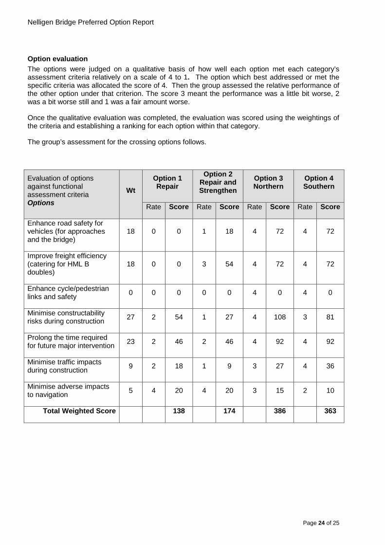
Option evaluation The options were judged on a qualitative basis of how well each option met each category’s assessment criteria relatively on a scale of 4 to 1. The option which best addressed or met the specific criteria was allocated the score of 4. Then the group assessed the relative performance of the other option under that criterion. The score 3 meant the performance was a little bit worse, 2 was a bit worse still and 1 was a fair amount worse.
Once the qualitative evaluation was completed, the evaluation was scored using the weightings of the criteria and establishing a ranking for each option within that category.
The group’s assessment for the crossing options follows.
Evaluation of options against functional assessment criteria Options
Wt Option 1 Repair
Option 2 Repair and Strengthen
Option 3 Northern
Option 4 Southern
Rate Score Rate Score Rate Score Rate Score
Enhance road safety for vehicles (for approaches and the bridge)
18 0 0 1 18 4 72 4 72
Improve freight efficiency (catering for HML B doubles)
18 0 0 3 54 4 72 4 72
Enhance cycle/pedestrian links and safety 0 0 0 0 0 4 0 4 0
Minimise constructability risks during construction 27 2 54 1 27 4 108 3 81
Prolong the time required for future major intervention 23 2 46 2 46 4 92 4 92
Minimise traffic impacts during construction 9 2 18 1 9 3 27 4 36
Minimise adverse impacts to navigation 5 4 20 4 20 3 15 2 10
Total Weighted Score 138 174 386 363
Page 24 of 25
Nelligen Bridge Preferred Option Report
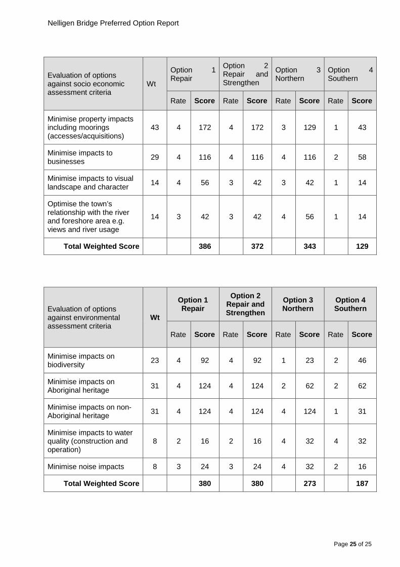
Evaluation of options against socio economic assessment criteria
Wt
Option 1 Repair
Option 2 Repair and Strengthen
Option 3 Northern
Option 4 Southern
Rate Score Rate Score Rate Score Rate Score
Minimise property impacts including moorings (accesses/acquisitions)
43 4 172 4 172 3 129 1 43
Minimise impacts to businesses 29 4 116 4 116 4 116 2 58
Minimise impacts to visual landscape and character 14 4 56 3 42 3 42 1 14
Optimise the town’s relationship with the river and foreshore area e.g. views and river usage
14 3 42 3 42 4 56 1 14
Total Weighted Score 386 372 343 129
Evaluation of options against environmental assessment criteria
Wt
Option 1 Repair
Option 2 Repair and Strengthen
Option 3 Northern
Option 4 Southern
Rate Score Rate Score Rate Score Rate Score
Minimise impacts on biodiversity 23 4 92 4 92 1 23 2 46
Minimise impacts on Aboriginal heritage 31 4 124 4 124 2 62 2 62
Minimise impacts on non-Aboriginal heritage 31 4 124 4 124 4 124 1 31
Minimise impacts to water quality (construction and operation)
8 2 16 2 16 4 32 4 32
Minimise noise impacts 8 3 24 3 24 4 32 2 16
Total Weighted Score 380 380 273 187
Page 25 of 25

Nelligen Bridge Preferred Option Report
Summary of option evaluation
A summary of the options rankings against the various assessment categories together with the ranking of the capital cost estimates appears below. Comparative information was also provided on the order of capital costs.
Option Functional (Rank and
score)
Socio Economic (Rank and
score)
Environmental (Rank and score)
Cost
1: Repair 4
138
1 386
1 380
1 (Base Case)
2: Repair and Strengthen
3 174
1 372
1 380
1.3 x BC
3: Northern Option
1 386
1 343
3 273
1.3 x BC
4: Southern Option
1 363
4 129
4 187
1.4 x BC
Page 26 of 25
Nelligen Bridge Preferred Option Report
rms.nsw.gov.au/projects/southern/nelligenbridge/index.html
13 22 13
Customer feedback Roads and Maritime Locked Bag 928, North Sydney NSW 2059
September 2015 RMS 15.438
ISBN: 978-1-925357-75-2
Page 27 of 25