Preface to draft Preferred Option Report, 2005 to draft Preferred Option Report, 2005 This draft...
106
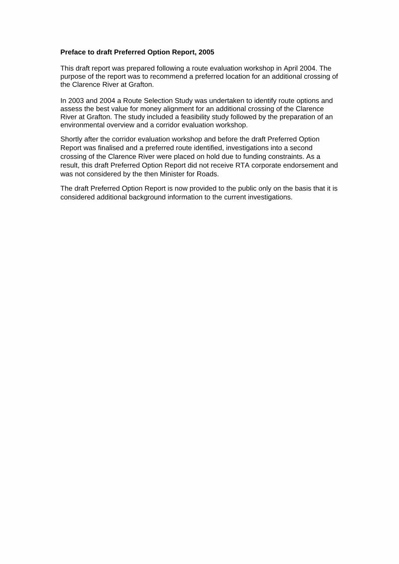
Preface to draft Preferred Option Report, 2005 This draft report was prepared following a route evaluation workshop in April 2004. The purpose of the report was to recommend a preferred location for an additional crossing of the Clarence River at Grafton. In 2003 and 2004 a Route Selection Study was undertaken to identify route options and assess the best value for money alignment for an additional crossing of the Clarence River at Grafton. The study included a feasibility study followed by the preparation of an environmental overview and a corridor evaluation workshop. Shortly after the corridor evaluation workshop and before the draft Preferred Option Report was finalised and a preferred route identified, investigations into a second crossing of the Clarence River were placed on hold due to funding constraints. As a result, this draft Preferred Option Report did not receive RTA corporate endorsement and was not considered by the then Minister for Roads. The draft Preferred Option Report is now provided to the public only on the basis that it is considered additional background information to the current investigations.
Transcript of Preface to draft Preferred Option Report, 2005 to draft Preferred Option Report, 2005 This draft...
Preface to draft Preferred Option Report, 2005 This draft report was prepared following a route evaluation workshop in April 2004. The purpose of the report was to recommend a preferred location for an additional crossing of the Clarence River at Grafton. In 2003 and 2004 a Route Selection Study was undertaken to identify route options and assess the best value for money alignment for an additional crossing of the Clarence River at Grafton. The study included a feasibility study followed by the preparation of an environmental overview and a corridor evaluation workshop.
Shortly after the corridor evaluation workshop and before the draft Preferred Option Report was finalised and a preferred route identified, investigations into a second crossing of the Clarence River were placed on hold due to funding constraints. As a result, this draft Preferred Option Report did not receive RTA corporate endorsement and was not considered by the then Minister for Roads.
The draft Preferred Option Report is now provided to the public only on the basis that it is considered additional background information to the current investigations.

DRAFT
PREFERRED OPTION REPORT
ADDITIONAL CROSSING OF THE CLARENCE RIVER
AT GRAFTON
MR 83 Summerland Way Clarence Valley Council
Prepared for RSTM&D, Northern Region
June 2005
OO PP TT II
OO NNSS
DRAFT
DRAFT
DRAFT
DRAFT

DRAFT
DRAFT
DRAFT
DRAFT
DRAFT
DRAFT
Preferred Option Report Additional Crossing of the Clarence River at Grafton
RTA - Grafton Version 1.1
4
DRAFT
DRAFT
DRAFT
DRAFT

DRAFT
Preferred Option Report Additional Crossing of the Clarence River at Grafton
Locality Map
RTA - Grafton Version 1.1
To Glen Innes
Clarence River
Pacific
Summ
erlan
d
Lawr
ence
Rd
Way
Highway
To Casino To Ballina
To Armidale
5
DRAFT
DRAFT
DRAFT
DRAFT

DRAFT
Preferred Option Report Additional Crossing of the Clarence River at Grafton
Locality Map
RTA - Grafton Version 1.1
6
DRAFT
DRAFT
DRAFT
DRAFT

DRAFT
Preferred Option Report Additional Crossing of the Clarence River at Grafton
Index
RTA - Grafton Version 1.1
7
1. INTRODUCTION ....................................................................................................................... 10
1.1. BACKGROUND ......................................................................................................................... 10 1.2. PURPOSE.................................................................................................................................. 11 1.3. PROJECT OBJECTIVES .............................................................................................................. 11
1.3.1. Primary Objectives:............................................................................................................ 11
1.3.2. Supporting Objectives:....................................................................................................... 11 1.4. ROUTE SELECTION................................................................................................................... 11
2. ROUTE OPTION DEVELOPMENT........................................................................................ 12
2.1. GENERAL................................................................................................................................. 12
3. ROUTE OPTION ANALYSIS .................................................................................................. 13
3.1. ISSUES ..................................................................................................................................... 13 3.1.1. Design ................................................................................................................................ 13
3.1.2. Geotechnical Investigations ............................................................................................... 17
3.1.3. Traffic ................................................................................................................................. 18
3.1.4. Environment....................................................................................................................... 20
3.1.5. Noise and Vibration ........................................................................................................... 21
3.1.6. Hydrology .......................................................................................................................... 23
3.1.7. Social and Economic Impacts ............................................................................................. 24
3.1.8. Planning and Zoning ........................................................................................................... 27
3.1.9. Acquisition ......................................................................................................................... 28
3.1.10. Public Utilities................................................................................................................ 28
3.1.11. Community Involvement............................................................................................... 28
3.1.12. Estimates of Cost .......................................................................................................... 34 3.2. OPTION ADVANTAGES / DISADVANTAGES............................................................................... 34
3.2.1. Option 1............................................................................................................................. 34
3.2.2. Option 2a ........................................................................................................................... 34
3.2.3. Option 2b........................................................................................................................... 35 3.3. ROUTE OPTION SUMMARY ...................................................................................................... 35
4. ROUTE EVALUATION ............................................................................................................. 36
DRAFT
DRAFT
DRAFT
DRAFT
DRAFT
Preferred Option Report Additional Crossing of the Clarence River at Grafton
Index
RTA - Grafton Version 1.1
8
4.1. GENERAL................................................................................................................................. 36 4.2. WORKSHOP OBJECTIVES ......................................................................................................... 36 4.3. WORKSHOP OUTCOMES........................................................................................................... 37 4.4. CONCLUSIONS DRAWN FROM THE WORKSHOP ........................................................................ 38
5. PREFERRED ROUTE OPTION................................................................................................ 39
5.1. OVERVIEW............................................................................................................................... 39 5.2. MEETING OUTCOMES .............................................................................................................. 39 5.3. RECOMMENDATION ................................................................................................................. 44
DRAFT
DRAFT
DRAFT
DRAFT

DRAFT
Preferred Option Report Port Gateway
Attachments
RTA - Grafton Version 1.1
9
Attachment 1 Localities/Route options Plan
Attachment 2 Route Evaluation Workshop
Attachment 3 Noise Assessment
Attachment 4 Community Consultation
Attachment 5 Route Option Display Material
Attachment 6 Statement of Heritage Impacts
Attachment 7 Estimates of Cost
Attachment 8 Lane Configuration Bridge Plans
DRAFT
DRAFT
DRAFT
DRAFT
DRAFT
Preferred Option Report Additional Crossing of the Clarence River at Grafton
RTA - Grafton Version 1.1 10
Introduction
1.1. Background
Approval was given in 1915 for the design and construction of a bridge over the Clarence River, at Grafton (with a moveable span for river navigation clearance) to carry a railway and a footway. In 1922, when design was well advanced, the Minister for Works requested that the design include vehicular traffic in addition to the railway and pedestrian traffic. The new bridge was opened to traffic in 1932.
Grafton City Council initiated correspondence to the Department of Main Roads (DMR) regarding a second bridge in 1960 with investigations commencing in the early 1970’s. In 1977, the DMR advised that a new bridge location had been adopted linking Fitzroy Street, Grafton, to Bent Street, South Grafton. Survey and geotechnical investigations were then undertaken. In 1985, the DMR advised that the new bridge was a long-range Proposal.
In 1999, the RTA examined a number of upgrading options for the existing bridge. They were:
• Do Nothing; • Minor alterations to the kerbs at the ‘kinks’; • Remove the ‘kinks’; • Construct one lane on the existing rail bridge on the lower deck; • Provide two additional travel lanes at the existing rail or road bridge; • Upgrade the southern approach lanes from the Through Street roundabout; and • Upgrade the northern approach lanes from the Villiers Street roundabout.
Construction on the northern and southern approaches to the existing bridge was undertaken in 2000 and 2001. This was a cost-effective short term solution to improve the road capacity at the approaches and reduce the queuing at Villiers Street and Through Street roundabouts.
In 2001, a group of business people formed a committee to campaign for a new bridge at Grafton. In May 2002, the community campaign for an additional crossing of the Clarence River at Grafton commenced. A public meeting held in May 2002 lead the State Government to commission the RTA to undertake a Feasibility Study and determine strategic options for the location of an additional crossing to service Grafton and the surrounding communities. Following the completion of the Feasibility Study in February 2003 a project team was formed to proceed with a Route Selection Study. This study would identify route options and assess the best value for money alignment for the additional crossing to improve road safety, reduce traffic delays and provide improved access for the local and state road network between the north and south of the Clarence River.
DRAFT
DRAFT
DRAFT
DRAFT

DRAFT
Preferred Option Report Additional Crossing of the Clarence River at Grafton
RTA - Grafton Version 1.1 11
1.2. Purpose
The purpose of the project is to provide an additional crossing of the Clarence River at Grafton in order to improve road safety, reduce traffic delays and provide improved access for the local and State road network between north and south of the Clarence River
1.3. Project Objectives
1.3.1. Primary Objectives:
The primary project objectives are;
• Significantly improve traffic efficiency; • Significantly reduce the potential for road accidents and injuries; • Be socially acceptable to the regional and local community • Support economic development • Be managed in accordance with Ecologically Sustainable Development Principles • Achieve maximum effectiveness of expenditure
1.3.2. Supporting Objectives:
• Reduce delays at the existing Grafton Bridge in peak hour to a Level of Service C in 30 years after opening
• Provides adequate vertical clearance for heavy transport on the Summerland Way
• Reduces the volume of through traffic, including heavy vehicles, from the CBD
• Reduce the potential for road accidents and injuries for the bridge and approaches to the additional crossing, including the connecting intersections
• Minimise flooding impacts caused by the project
• Minimise the impacts on the social environment
• Minimise the impacts on access for the community
• Provides improved opportunity for economic and tourist development for Grafton
• Minimise the impacts on the natural environment
• Minimise the impacts on heritage
• Minimise the Impacts of road traffic noise on existing noise sensitive developments
1.4. Route Selection
The first stage of the Route Selection Study was to undertake the Environmental Overview which summarised any likely environmental constraints and/or potential issues that would need to be considered for the broad localities under consideration for an additional crossing of the Clarence River at Grafton.
DRAFT
DRAFT
DRAFT
DRAFT

DRAFT
Preferred Option Report Additional Crossing of the Clarence River at Grafton
RTA - Grafton Version 1.1 12
The purpose of the Environmental Overview was to:
• Identify environmental constraints for the Proposal; • Identify the impacts of these constraints on each of the crossing localities; and • Identify potential issues that may require additional investigations, specialist
studies, or design considerations for route selection.
This Environmental Overview was used as a basis for making a decision on which crossing localities should be further investigated in the route selection stageThe Environmental Overview does not recommend a specific site for an additional crossing.
This Environmental Overview (Volume 1) and Appendices (Volume II) have been completed and preceedes this report. The Preferred Route report now deals with the selection of the preferred route.
2. Route Option Development
2.1. General
As a result of the Environmental Overview and associated work two crossing localities were moved forward for further development.
Within these two crossing localities, three route options were to be investigated. Refer to Attachment 1 for Localities and Route Options plan
• Option 1 – Villiers Street/Abbott Street. The limits of this option are from the Gwydir Highway (Ryan Street) at the southern approach to Victoria Street at the northern approach. The crossing would be 2 lanes, with 2 way flow. Traffic facilities such as roundabouts would need to be provided at Ryan Street and Victoria Street connections (subject to concept design and community consultation)
• Option 2a – At the Existing Bridge (directly upstream). This option is directly upstream of the existing bridge. The level of the bridge would be at (or just below) the roadway of the existing bridge. The new crossing would be 2 lanes, with one way flow and the existing crossing would change to one way flow. This would require modification to the ‘kinks’ on the existing crossing. The limits of this option are from Bent Street at the southern approach to the existing bridge (opposite the Nursing Home), to the northern approach at Craig Street (opposite KFC). On the southern approach, an additional southbound lane would be provided to allow four lanes (two lanes each way) on this approach
• Option 2b – At the Existing Bridge (directly downstream). This option is directly downstream of the existing bridge. The level of the bridge would be at (or just above) the roadway of the existing bridge. The new crossing would be 2 lanes, with one way flow and the existing crossing would change to one way flow. This would require modification to the ‘kinks’ on the existing crossing. The limits of this option are from Bent Street at the southern approach to the existing bridge (opposite the Nursing Home), to the northern approach at Craig Street (opposite
DRAFT
DRAFT
DRAFT
DRAFT

DRAFT
Preferred Option Report Additional Crossing of the Clarence River at Grafton
RTA - Grafton Version 1.1 13
KFC). On the southern approach, an additional southbound lane would be provided to allow four lanes (two lanes each way) on this approach.
3. Route Option Analysis
3.1. Issues
The three route options were analysed to compare how each route performed under varying requirements. These are detailed in the following sections. Refer to Attachment 1 for the Route Options plan
3.1.1. Design
3.1.1.1. Road Design
Option 1
This route is located to the west of the existing bridge with work extending from Ryan Street on the southern side of the Clarence River along Abbott Street to Victoria Street on the northern side along Villers street based on a design speed of 60km/h.
Roundabout are proposed at the both the Victoria/Villiers street and Ryan/Abbott Street intersections.
The carriageway consists of a single 3.5m wide lane in each direction with 3.0m shoulders in areas widened for guardfence. Batters slopes are 2:1 with a maximum a height of 6.0m on the southern approach.
The horizontal alignment consists of a 200m radius at the southern bridge abutment with the remainder of the alignment being straight.
The vertical alignment caters for a 1 in 20 year flood event outside the existing levee wall and has a 1.0m clearance under the bridge to HFL and meets navigational clearances for the river.
Option 2A
This route is located immediately to the west of the existing bridge with work starting on the existing southern approach along Bent Street to Clarence Street on on the northern side with the approach located immediately adjacent on the western side of the existing approach in Craig Street and is based on a design speed of 60km/h.
Left in/left out access is proposed for both legs of Clarence Street.
DRAFT
DRAFT
DRAFT
DRAFT

DRAFT
Preferred Option Report Additional Crossing of the Clarence River at Grafton
RTA - Grafton Version 1.1 14
The road approaches consists of two one way 3.5m wide lanes in northbound direction with 1.0m shoulders with 1.0m widening for guardfence.
The horizontal alignment of the southern approach consists of a 240m radius from Bent street onto the proposed bridge.
No access will be provided to Riverside Drive and a retaining wall would be required between the proposed carriageway and the footpath at Memorial Park.
Two 3.5m lanes would be extended using the existing formation from the existing bridge southbound to the Through Street roundabout to provide dual lanes for both northbound and southbound traffic. This would be further investigated in the concept design.
The horizontal alignment of the northern approach consists of a 200m radius with a length of viaduct matching the existing. Fill batter slopes are 2:1 with a maximum height of 4m.
Property adjustment would be required for the Kentucky Fired Chicken site.
The vertical alignment follows the existing on the southern approach, Kent Street has a clearance to 4m with the northern approach matching the vertical alignment of the existing bridge.
Option 2B
This route is located immediately to the east of the existing bridge commencing on the existing southern approach along Bent Street to Clarence Street on the northern side. The alignment is a design speed of 60km/h.
Left in/left out access is proposed for Clarence street with a left turn lane for northbound traffic exiting on to Clarence street west.
The road approaches consist of two one way 3.5m wide lanes in southbound direction with 1.0m shoulders with 1.0m widening for guardfence.
The horizontal alignment of the northbound carriageway on the southern bridge approach is based on the existing alignment, with left in/left out at Riverside Drive. The southbound carriageway consists of a 180m radius that is also incorporated into the bridge structure. Fill batter slopes are 2:1 with a maximum height of 6m.
Two 3.5m lanes will be extended from the proposed bridge southbound to the Through Street roundabout using the existing formation to provide dual lanes for both northbound and southbound traffic. A retaining wall for the road formation is required adjacent to the southern abutment.
The horizontal alignment of the southbound carriageway for the northern approach consists of a 160m radius with a length of viaduct matching the existing. Fill batter slopes are 2:1 with a maximum height of 5m.
DRAFT
DRAFT
DRAFT
DRAFT

DRAFT
Preferred Option Report Additional Crossing of the Clarence River at Grafton
RTA - Grafton Version 1.1 15
The vertical alignment for the southern and northern approaches matches the existing alignment. The alignment has a clearance of 7.1m to the existing railway line on both the northern and southern overpasses.
3.1.1.2.Bridge Design
The bridge descriptions that follow assumes that two lanes of traffic will be carried by the proposed new bridge and two lanes of traffic will be maintained on the existing bridge.
Option 1
For Route Option 1, the proposed new bridge will have two traffic lanes and an overall width of 13.4m which includes a combined pedestrian/cycleway. The bridge will be 730m long and is straight on a summit vertical alignment.
Two alternative bridge types have been considered
The first bridge type that has been considered is an incrementally launched concrete bridge. This bridge consists of a total of 16 spans comprising of 1/39.5 m long spans at each end of the bridge and 14/46.5 m long internal spans. The estimated cost of construction of this bridge is $24,400,000 at a based date of June 2004.
The second bridge type that has been considered is a Super-T concrete girder bridge. This bridge consists of a total of 21 spans comprising of 1/32.5 m long spans at the end of the bridge and 19/35.0 m long internal spans. The estimated cost of construction of this bridge is $21,400,000 at a based date of June 2004.
Option 2a
For Route Option 2a, the proposed new bridge will have two traffic lanes and an overall width of 10.2m.
The bridge length will be 665m. The horizontal alignment of the bridge is straight over the river and curved on the approach spans. The vertical alignment is level over the river and curved on the approachs.
Four alternative bridge types were considered:
The first bridge type that has been considered is a balanced cantilever concrete bridge with three main spans over the river each 130.0 m long and approach spans consisting of cast-in-place concrete girders of varying span lengths - 1/65.0 m on the southern approach and 1/65.0 m, 2/50.0 m and 1/45.0 m on the northern approach. The estimated cost of construction of this bridge is $17,500,000 at a based date of June 2004.
The second bridge type that has been considered is an incrementally launching concrete bridge with four main spans over the river each 74.5 m long and approach spans of varying lengths - 1/49.0 m and 1/48.0 m on the southern approach and 1/60.0
DRAFT
DRAFT
DRAFT
DRAFT
DRAFT
Preferred Option Report Additional Crossing of the Clarence River at Grafton
RTA - Grafton Version 1.1 16
m, 3/55.0 m and 1/45.0 m on the northern approach. The estimated cost of construction of this bridge is $15,500,000 at a based date of June 2004.
The third bridge type that has been considered is an incrementally launching concrete bridge with nine main spans over the river each 37.25 m long and approach spans of varying lengths – 2/33.5 m and 1/30.0 m on the southern approach and 1/30.0 m, 1/29.5, 4/36.0 m and 1/29.25 m on the northern approach. The estimated cost of construction of this bridge is $15,500,000 at a based date of June 2004
The fourth bridge type that has been considered is a Super-T concrete girder bridge. This bridge consists of 19 spans each 35.0 m long. The estimated cost of construction of this bridge is $14,100,000 at a based date of June 2004
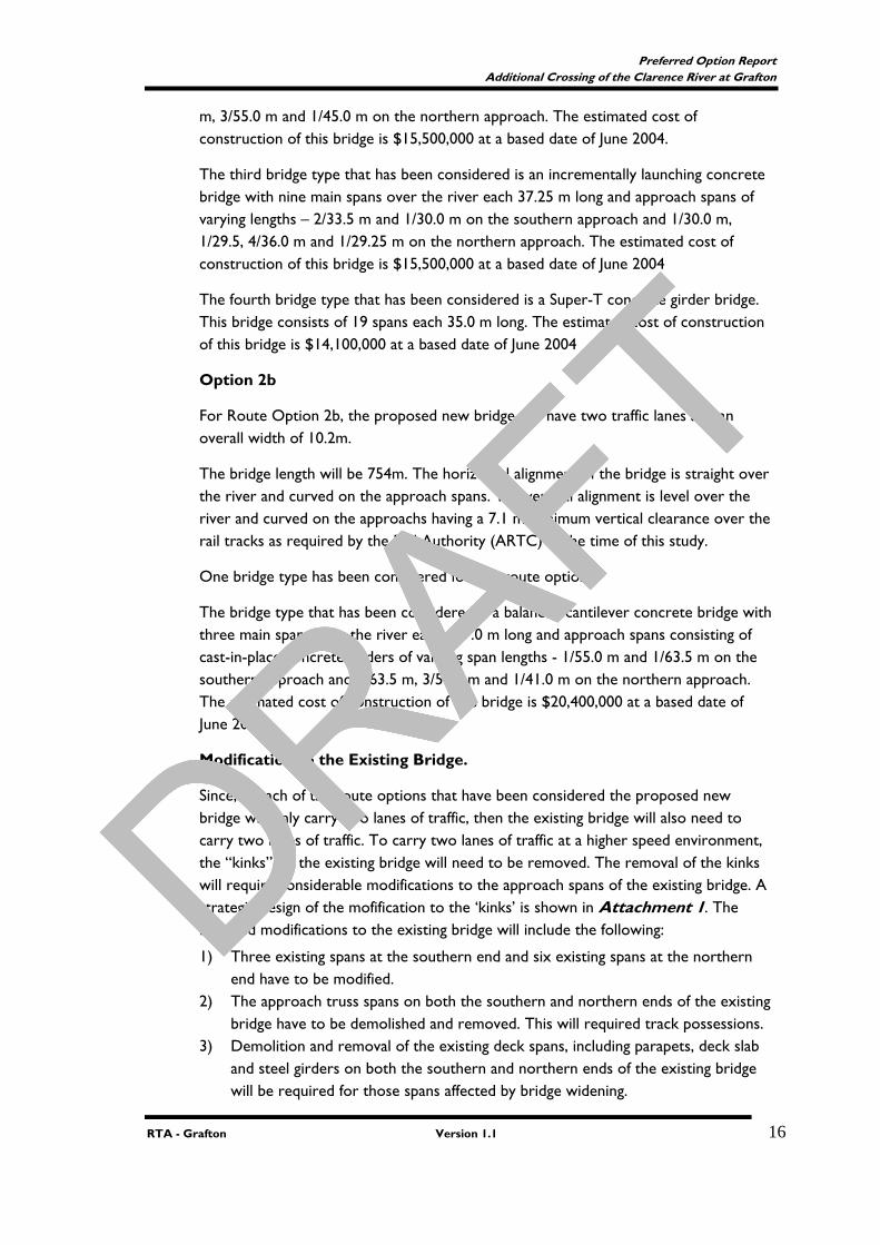
Option 2b
For Route Option 2b, the proposed new bridge will have two traffic lanes and an overall width of 10.2m.
The bridge length will be 754m. The horizontal alignment of the bridge is straight over the river and curved on the approach spans. The vertical alignment is level over the river and curved on the approachs having a 7.1 m minimum vertical clearance over the rail tracks as required by the Rail Authority (ARTC) at the time of this study.
One bridge type has been considered for this route option.
The bridge type that has been considered is a balanced cantilever concrete bridge with three main spans over the river each 127.0 m long and approach spans consisting of cast-in-place concrete girders of varying span lengths - 1/55.0 m and 1/63.5 m on the southern approach and 1/63.5 m, 3/50.0 m and 1/41.0 m on the northern approach. The estimated cost of construction of this bridge is $20,400,000 at a based date of June 2004
Modification to the Existing Bridge.
Since, in each of the route options that have been considered the proposed new bridge will only carry two lanes of traffic, then the existing bridge will also need to carry two lanes of traffic. To carry two lanes of traffic at a higher speed environment, the “kinks” on the existing bridge will need to be removed. The removal of the kinks will require considerable modifications to the approach spans of the existing bridge. A strategic design of the mofification to the ‘kinks’ is shown in Attachment 1. The required modifications to the existing bridge will include the following:
1) Three existing spans at the southern end and six existing spans at the northern end have to be modified.
2) The approach truss spans on both the southern and northern ends of the existing bridge have to be demolished and removed. This will required track possessions.
3) Demolition and removal of the existing deck spans, including parapets, deck slab and steel girders on both the southern and northern ends of the existing bridge will be required for those spans affected by bridge widening.
DRAFT
DRAFT
DRAFT
DRAFT
DRAFT
Preferred Option Report Additional Crossing of the Clarence River at Grafton
RTA - Grafton Version 1.1 17
4) Construction of new pier headstocks and/or widenings of existing bridge piers will be required for those piers affected by bridge widening. This will also required track possessions.
5) Construction of new concrete decks for the new spans on the existing bridge including new parapets. This rectification work may also required some track possessions depending advice from the Rail Authority.
The estimated cost for the modifications associated with the removal of the existing kinks on both the southern and northern ends (including track possession) is $9,000,000 at a based date of June 2004. This cost estimate does not include the whole of life cost associated with the continual maintenance of the existing bridge. Furthermore, it should be noted that only the modified spans will be upgraded to current design standards whilst the remaining part of the existing bridge would not be upgraded to current design standards.
3.1.2. Geotechnical Investigations
The topography of most of the study area consists of the flood plain of the Clarence River, a fairly flat alluvial plain only a few metres above sea level. The eastern river bank along the river to the north of the existing bridge is higher than the land back from the river, sloping away from the river at less than1 degree slope. The southern approach to the existing bridge is along a ridge of soil and rock of the Grafton Formation, forming an island in the flood plain.
The previous investigations undertaken at the existing bridge in 1975 indicated mainly sand and gravels down to weathered rock, and the boreholes on the south side indicated mainly clays down to the weathered rock level. The existing bridge piers were all taken to the sandstone rock level, except for Pier 6, which appears to be founded in boulders and gravel several metres above rock level. The arched piers on the river bank at the ends of the steel skew spans appear to be founded on clay and loam materials.
Scour has occurred around some of the piers. A depth survey in 2001 indicated that up to 7m had scoured out on the downstream side, and up to 5m on the upstream side, leaving the base of the pier exposed at Piers 2 and 3 (Bascule span) and at Pier 4. Inspection by divers revealed a gap under part of a pier. It is not known whether subsequent floods have deposited material or caused additional scour. The large sizes of the existing foundations reduce risk but the scour indicates that the smaller piles of a new bridge will have to be well embedded into the rock.
3.1.2.1. Design Charasterics
Foundation conditions and depths for the three options are indicated to be similar and likewise the embankment conditions should be similar except for the southern approach to Option 2a and Option 2b as it is mostly on weathered rock material rather than alluvium.
DRAFT
DRAFT
DRAFT
DRAFT
DRAFT
Preferred Option Report Additional Crossing of the Clarence River at Grafton
RTA - Grafton Version 1.1 18
3.1.2.2. Bridge Footings
The results of the present drilling program, and past investigations, together with the existing bridge plans, indicate that the all options would need to be founded on rock at approximately AHD –20m. This indicates that a new bridge should be founded on piles socketed into the rock, and thus bored piles are the best option. It is likely that they will have to be cased for the full depth. The presence of boulder or cobble sized gravels may be sufficient to support a bridge, but the site conditions are not very consistent in terms of material above the rock. The material above the rock is mainly sand, which would be more susceptible to scour. Option 2a and 2b would be preferred due to shallower foundation levels on the approaches.
Acid sulphate soils are possibly present and allowance should be made for the protection of the upper portion of the piles.
3.1.2.3. Embankment Batters and Settlement
The approach embankments for the options are proposed to be 3 to 8m in height. The batter cannot be determined until the type of material to be used in the fill is specified, but at this stage a maximum 2:1 slope should be satisfactory, or 3:1 if poor quality fill is used.
It is not expected that the settlement of fill embankments will pose a major construction constraint, as most is likely to occur within the construction time. The immediate abutment fills have some potential to settle, and it would be advisable to construct the approach fill prior to the bridge foundations.
Large settlements are not expected at any of the proposed locations, but it is recommended that some settlement testing be undertaken in the detailed geotechnical investigation
3.1.2.4.Pavement Design
Due to the likely height of the embankment, the pavement design thickness will depend on the quality of the imported fill. All types of pavement may therefore be options. There are no geotechnical factors that will influence pavement design on the options other than the existing pavement structure at Options 2a and 2b.
The geotechnical investigations were undertaken to get a general indication of the geological conditions in the area and the possible foundation depths along the river. Following selection of the preferred route, detailed investigation of the bridge site and the approaches will be necessary.
3.1.3. Traffic
Traffic data collected from the vehicle classification counts and the origin and destination survey has been used to predict future volumes on the route options
DRAFT
DRAFT
DRAFT
DRAFT

DRAFT
Preferred Option Report Additional Crossing of the Clarence River at Grafton
RTA - Grafton Version 1.1 19
localities being considered. For details of the traffic study refer to the Environmental Overview
Option 1 would attract considerable traffic (11,000 vpd) from the existing bridge, due to its proximity to the existing bridge and the Pacific Highway. Much of the South Grafton traffic and the majority of the Gwydir Highway traffic would be attracted to this option. Some traffic would use Victoria Street to disperse prior to entering the Villiers Street / Fitzroy Street roundabout. This would have some benefits for the intersection but the additional traffic in Victoria Street would have impacts on parking and safety. Traffic volumes in Villiers Street to the north of Fitzroy Street would not necessarily increase to any significant degree.
Option 1 would need the Villiers Street southern approach widened to 2 entry lanes into the roundabout at Fitzroy St to achieve a LOS ‘C’ in 30 years. The left turn lane from Clarence Street onto the bridge would need to be retained or queuing would develop in Villiers Street in the afternoon.
There would be less traffic entering the Fitzroy St roundabout compared for Option 1 because some traffic would use Victoria Street. This would mean slightly less congestion at the roundabout in the long term.
Option 2a and 2b would require a second bridge either upstream or downstream of the existing bridge which would provide the highest traffic benefits of the crossings considered due to two travel lanes being available in one direction on the existing and additional crossing. Option 1 would have a single lane flow in each direction on the existing and additional crossing. The differences are shown in the level of service calculations where a 2 lane, one way facility provides better travel conditions, ie, freedom to manoeuvre, ability to pass slower vehicles, extra capacity. However, the impact on existing intersections is greater because Option 2a and 2b centralises traffic flows. Option 1 distributes traffic more widely.
Traffic modelling shows that the Villiers Street / Fitzroy Street intersection would operate up to a LOS ‘C’ under its current configuration within the 30 year period. Additional lanes or a change to traffic signals may ultimately be necessary depending upon traffic growth and operational issues at the intersection.
Retention of the Clarence Street access onto the bridge would be necessary to help relieve traffic congestion in the long term at the Villiers Street / Fitzroy Street intersection. With two lanes in each direction on the bridge, the impact of traffic ‘pushing in’ to travel south in the afternoon would be minor. The left turn lane from Clarence Street onto the bridge needs to be retained or the LOS at the Villiers Street roundabout would drop to ‘F’ in the afternoon peak with queuing in Villiers Street.
Intersections on the southern approach, Bent Street at Through Street and at Ryan Street, are shown to function satisfactorily but may also require traffic management within 30 years. Again, the replacement of the roundabouts with traffic signals would be a long term option.
DRAFT
DRAFT
DRAFT
DRAFT
DRAFT
Preferred Option Report Additional Crossing of the Clarence River at Grafton
RTA - Grafton Version 1.1 20
3.1.4. Environment
This section of the report provides a summary of the findings of the specialist investigations undertaken in the Environmental Overview Report for the route options.
3.1.4.1. Indigenous Heritage
The first types are sites with tangible evidence of past Aboriginal occupation: these include occupation sites (containing material such as stone artefacts, charcoal or shell), modified trees, grinding grooves, burial sites and art sites. The second category is those sites relating to less tangible cultural elements such as ceremonial or dreaming sites. Some ceremonial sites, such as bora rings, may have tangible elements but many are natural landscape features that take on cultural significance through ceremonial or religious association. Tangible, ceremonial, and dreaming sites have been identified in the Grafton region and within the study area.
The potential for Indigenous heritage within option 1 and upstream of the existing bridge is generally low as much of the riverbank and floodplain has been disturbed from flooding, levee construction and landscaping associated with urban development. However, some sub surface material of a disturbed nature may still be present in these areas. In areas of aggrading soil landscapes, it is possible that deeply buried material could also be present.
During the Indigenous assessment, consultation was undertaken with representatives of Grafton Ngerrie LALC and DEC. During the course of discussions it was expressed by representatives that there was some difficulty in assessing the community concerns over such a wide area with no identified specific impacts. The most significant issue raised by representatives was the likely presence of further dreaming and ceremonial sites associated with the Clarence River.
Risks associated with the construction and operation of the route options would include direct and indirect impacts through vegetation clearing, excavation works and modification of the landscape, and through vibration effects.
In conclusion of the assessment undertaken and background investigations, it is considered that based upon information received and known recorded Indigenous sites Option 1 and Option 2a would have the least potential for areas of archaeological sensitivity. Option 2b consist of areas of archaeological sensitivity and of recorded Indigenous sites.
It is planned that further consultation with the Grafton Ngerrie LALC would be undertaken with further detailed assessments conducted following the announcement of the preferred route.
3.1.4.2. Non-Indigenous Heritage
Option 2a and 2b are within the vicinity of Grafton City Railway Station and the Grafton Rail and Road Bridge. There are also four Items of regional significance within Option 2a and Option 2b. All options fall within the Grafton REP Urban Conservation
DRAFT
DRAFT
DRAFT
DRAFT

DRAFT
Preferred Option Report Additional Crossing of the Clarence River at Grafton
RTA - Grafton Version 1.1 21
Area, with Option 1 also situated within the Grafton LEP Civic Precinct Conservation Area.
One of the heritage items identified within Option 2a includes the S.S Induna. The Induna was a rail ferry which sank at mooring on the south bank of the river in 1932. The wreckage is located at South Grafton, 200m upstream from the Clarence River Bridge. The hulk is visible from the bridge or the river.
The REP Grafton Urban Conservation Area encompasses two broad regions, one to the north and one to the south of the Clarence River, consisting of land bounded by Turf Street and the railway line to the river at Grafton, and Minden and Ryan Streets and Christopher Creek in South Grafton. The LEP Conservation Area includes the Grafton Civic Precinct Conservation Area that encompasses areas within Victoria Street and Duke Street (option1). Many items within the Conservation Areas are not necessarily listed individually, but the existence of the conservation area entails further assessment.
Tree plantings within the City of Grafton are also considered a significant element of Grafton’s city character and fabric. Tree species within the genera of Brachychiton, Ficus or Jacaranda located in any road reserve and being more than 3m in height are listed as a heritage item on the former Grafton City Council’s LEP. Tree species within the genera of Brachychiton, Ficus or Jacaranda can be found in each of the route options.
Potential impacts upon the State Heritage listed Clarence River Bridge (option 2a and 2b) would include impacts on the aesthetics of the existing bridge and impacts associated with possible modifications to the existing ‘kinks’ should an additional crossing at these options occur. To determine the level of impact for this locality a Statement of Heritage Impact (SoHI) would be required for the Proposal including the Proposal to modify the existing ‘kinks’ in addition to the requirements for submitting an application to the NSW Heritage Office under Section 60 of the NSW Heritage Act, 1977. Refer to Section 5.2 for discussion on the SoHI and also refer to Attachment 6.
3.1.5. Noise and Vibration
Further investigations have been conducted into operational noise issues associated with Options 1, 2a and 2b. This included further noise monitoring to determine existing background noise levels and noise predictions for each of the Options. The noise report is included in Attachment 3.
Noise Monitoring
Existing background noise levels were measured using two noise data loggers from 15th to 23rd September 2003 and six data loggers from 17th to 30th March 2004 at the closest residences on the northern and southern sides of the Clarence River, upstream and downstream of the existing bridge.
Table 3 represents a summary of the measured assessment background noise levels (ABL) and ambient noise levels for Daytime (LAeq, 15hr) and Nightime (LAeq, 9hr)
DRAFT
DRAFT
DRAFT
DRAFT

DRAFT
Preferred Option Report Additional Crossing of the Clarence River at Grafton
RTA - Grafton Version 1.1 22
Receptor
Measured Daytime
dB(A) (7am to 10pm)
DEC Criteria
for Daytime dB(A)
DEC Criteria
Exceedance
dB
Measured Nightime
dB(A) (10pm to
7am)
DEC Criteria
for Nightim
e dB(A)
Criteria Exceedanc
e dB
North 57.0 60.0 -3.0 51.5 55.0 -3.5 South 57.4 60.0 -2.6 53.3 55.0 -1.7
1 52.5 55.0 -2.5 48.9 50.0 -1.1 2 58.1 60.0 -1.9 47.7 50.0 -2.3 3 61.7 N/a - 51.6 N/a - 4 51.5 50.0 1.5 39.4 50.0 -10.6 5 58.4 N/a - 51.1 N/a - 6 56.3 60.0 -3.7 49.5 55.0 -5.5
Note: Receptor locations include: 1: End of Abbot Street; 2: Outside 43 Abbot Street; 3: Outside music conservatorium; 4: Convent facing Villiers Street; 5 End of Catherine McAuley school oval ; and 6: No. 4 McClymont Place.
Table 3 shows the measured daytime and nightime traffic noise levels at residences North and South to be within the relevant DEC criteria by approximately 2 to 3 dB. All other locations also fall within the relevant DEC criteria except for location No. 4 located at the Convent facing Villiers Street.
Noise Modelling
Table 4 provides a summary of the noise predictions including existing noise levels.
Table 4 Summary of future noise levels modelled using traffic noise contours for (LAeq 15) Day time 7am – 10pm. Predicted Noise Levels
Southern approach
At the Crossing
Northern approach
DEC Noise Criteria - Daytime
Option 1 50 – 60dB(A) 55dB(A) 55 – 65dB(A) 40 – 55dB(A)
Option 2a 50 – 65dB(A) 50 – 60dB(A) 50 – 60dB(A) 60dB(A)
Option 2b 60 –65dB(A) 55 – 60dB(A) 55 – 60dB(A) 60dB(A)
DRAFT
DRAFT
DRAFT
DRAFT
DRAFT
Preferred Option Report Additional Crossing of the Clarence River at Grafton
RTA - Grafton Version 1.1 23
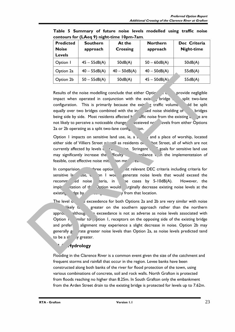
Table 5 Summary of future noise levels modelled using traffic noise contours for (LAeq 9) night-time 10pm-7am. Predicted Noise Levels
Southern approach
At the Crossing
Northern approach
Dec Criteria Night-time
Option 1 45 – 55dB(A) 50dB(A) 50 – 60dB(A) 50dB(A)
Option 2a 40 – 55dB(A) 40 – 50dB(A) 40 – 50dB(A) 55dB(A)
Option 2b 50 – 55dB(A) 50dB(A) 45 – 50dB(A) 55dB(A)
Results of the noise modelling conclude that either Option 2a or 2b provide negligible impact when operated in conjunction with the existing bridge as a split two-lane configuration. This is primarily because the existing traffic volume would be split equally over two bridges combined with the increased noise shielding of both bridges being side by side. Most residents affected by traffic noise from the existing bridge are not likely to perceive a noticeable change in receieved noise levels from either Options 2a or 2b operating as a split two-lane configuration.
Option 1 impacts on sensitive land use, ie, a school and a place of worship, located either side of Villiers Street as well as residents on Abbot Street, all of which are not currently affected by levels of traffic noise. Stringent DEC goals for sensitive land use may significantly increase the difficulty for compliance with the implementetaion of feasible, cost effective noise mitigation measures.
In comparision of all three options against relevant DEC criteria including criteria for sensitive land use, Option 1 would generate noise levels that would exceed the recommended noise citeria, in some cases by 5-10dB(A). However, the implementation of this Option would marginally decrease existing noise levels at the existing bridge by attracting traffic away from that location.
The level of noise exceedence for both Options 2a and 2b are very similar with noise levels likely to be greater on the southern approach rather than the northern approach, although the exceedance is not as adverse as noise levels associated with Option 1. Similar to Option 1, receptors on the opposing side of the existing bridge and preferred alignment may experience a slight decrease in noise. Option 2b may generally generate greater noise levels than Option 2a, as noise levels predicted tend to be a slightly greater.
3.1.6. Hydrology
Flooding in the Clarence River is a common event given the size of the catchment and frequent storms and rainfall that occur in the region. Levee banks have been constructed along both banks of the river for flood protection of the town, using various combinations of concrete, soil and rock walls. North Grafton is protected from floods reaching no higher than 8.25m. In South Grafton only the embankment from the Arden Street drain to the existing bridge is protected for levels up to 7.62m.
DRAFT
DRAFT
DRAFT
DRAFT
DRAFT
Preferred Option Report Additional Crossing of the Clarence River at Grafton
RTA - Grafton Version 1.1 24
West of the Arden Street drain the levee bank protects against levels to 6.09m and downstream of the bridge at Clarenza, the levee provides protection to 5.49m.
The levee bank on the northern side of the river has been designed to withstand a 1 in 100 year flood. Most of South Grafton is more frequently inundated by flooding with the exception of the area approaching Option 1 which is one of the few places in South Grafton high enough to be out of range of most of the common flood levels.
A preliminary assessment was undertaken of flood levels within the Clarence River channel, for bridges constructed at design flood level. Option 2 has an afflux, of approximately 50mm. Option 2a and 2b record intermediate expected affluxes of approximately 60mm and 75mm, respectively.
Options 1, 2a and 2b represent bridges that span the entire flood width. Option 1 creates little afflux and limited effect is expected because the existing levee systems are effectively at the top of bank on both sides of the Clarence River.
Minimal impact is anticipated for Option 2a and 2b as the northern abutment is protected by the Grafton levee and the southern abutment is on flood free ground.
From the perspective of potential flood impacts, the options are expected to result in minimal afflux, with the advantage of spanning the entire flood width of the Clarence River.
3.1.7. Social and Economic Impacts
Social Impacts
Recent investigations undertaken have revealed that there are a number of concerns in the general community about the existing bridge. The community seems generally in agreement that a new crossing is necessary. Key reasons cited are the traffic delays currently experienced at peak hours on weekdays, the need for emergency services to be able to cross the bridge at all times without delays, and safety issues associated with trucks and buses using the existing bridge.
Option 1
Positive social impacts with Option 1 include: • Would alleviate the use of the existing bridge and Bent Street by heavy
vehicles; • Improved access to city centre for residents of Waterview Heights, Coutts
Crossing and South Grafton (particularly those on western side of Bent Street);
• Alternative access for emergency vehicles; • Land along Gwydir Highway and in this western section of South Grafton
generally likely to become more attractive for commercial development; • Likely increase of traffic into the South Grafton business area generally
improving business for proprietors in this location; • Is a direct route to the Summerland Way heavy vehicle detour along Villiers
Street;
DRAFT
DRAFT
DRAFT
DRAFT

DRAFT
Preferred Option Report Additional Crossing of the Clarence River at Grafton
RTA - Grafton Version 1.1 25
• Reduced traffic in Bent Street would provide increased amenity to Bent and Fitzroy Street residents.
Negative social impacts with Option 1 include: • Impact on safety and amenity issues for children attending schools and
conservatorium on the northern approach; • Potential noise impacts for conservatorium; • Potential access problems at Victoria Street; • Increased traffic could result in increased pollution into businesses in this
location; • Increased traffic using Ryan Street to access this Option; • Loss of parking in the section of Villiers Street from the river to Fitzroy Street. • Loss of amenity to residences in Abbott Street; • Access concerns at intersection of Abbott Street with Kennedy Street; • Acquisition of one house may be required; • Impact on river users particularly sailing; • Loss of visual amenity for residents and businesses in Grafton and South
Grafton with views over the river.
Option 2a and 2b
Positive social impacts with option 2a and 2b include: • Better access into the city centre, with likely flow-on effects of increased
spending by tourists and passing trade; • Improved access for emergency vehicles; • Continued high traffic flows along Bent Street and of benefit to proprietors in
this location; • Retains existing traffic on Fitzroy and Bent Streets, and will result in little
adverse strategic impacts on land uses; • Retains existing bridge approaches in Bent and Fitzroy Streets.
Negative social impacts with Option 2a and 2b include: • Uncertainty about impacts and development possibilities, which may manifest
in individual community members through increased stress, anxiety or apathy about the future;
• Changes to personal economic situations through changes to property values; • Land acquisition, including houses, would be affected. Refer to Table 6
showing acquisition impacts for Option 2a and 2b; • Perceptions that individual property owners and residents will suffer because
of decisions made for the benefit of the wider community; • Concerns over reduction in amenity values for residential areas likely to be
affected; • Impact on recreation areas on the northern approach particularly the Sailing
Club (Option 2a); • Potential minor impact on Earle Page Park on the southern approach (Option
2a);
DRAFT
DRAFT
DRAFT
DRAFT

DRAFT
Preferred Option Report Additional Crossing of the Clarence River at Grafton
RTA - Grafton Version 1.1 26
• Perception of changes in existing levels of community cohesion and integration; and
• Concerns over the heritage value of the existing bridge, and how any additional crossing may affect its amenity.
Economic Impact
Results of discussions held to date with members of the business community in the study area conclude that the business and employment sector of the community seems generally in agreement that a new crossing is necessary. Businesses in Grafton cite difficulties of deliveries into the city centre and the fact that the perceived problems with the existing bridge may alter shopping preferences for customers. Many businesses appear to alter their business operations (in terms of trips and/or timing) because of the present level of congestion associated with the existing bridge.
Option 1
Positive economic impacts for Option 1 include: • A potential increase in the number of customers and tourists into the city
centre because of perceived increase in travel safety over bridge; • Quicker travel times for trips to work and making deliveries; • Increased access to regional areas, with flow-on economic benefits; • Ease of access for delivery trucks; • Buses would better able to meet timetables; • Flow on effects of reduced congestion, reduced emissions and noise at existing
bridge; and • Facilitation of urban growth and economic development within Grafton City.
Negative economic impacts for Option 1 include: • Disruption to businesses located at or near the additional crossing; • Changes to economic situations and business profitability through changes to
traffic volumes past existing business in Bent Street; • The potential creation of business and industry development nodes; and
Option 2a and 2b
Positive economic impacts for Option 2a and 2b include: • A potential increase in the number of customers and tourists into the city
centre because of perceived increase in travel safety over bridge; • Quicker travel times for trips to work and making deliveries; • Increased access to regional areas, with flow-on economic benefits; • Ease of access for delivery trucks; • Buses would better able to meet timetables; • Flow on effects of reduced congestion and reduced emissions at the existing
bridge; • Reduced braking noise at the ‘kinks’; and • Facilitation of urban growth and economic development within Grafton City.
DRAFT
DRAFT
DRAFT
DRAFT
DRAFT
Preferred Option Report Additional Crossing of the Clarence River at Grafton
RTA - Grafton Version 1.1 27
Negative economic impacts for Option 2a and 2b include: • Disruption to businesses located at or near the proposed additional crossing;
3.1.8. Planning and Zoning
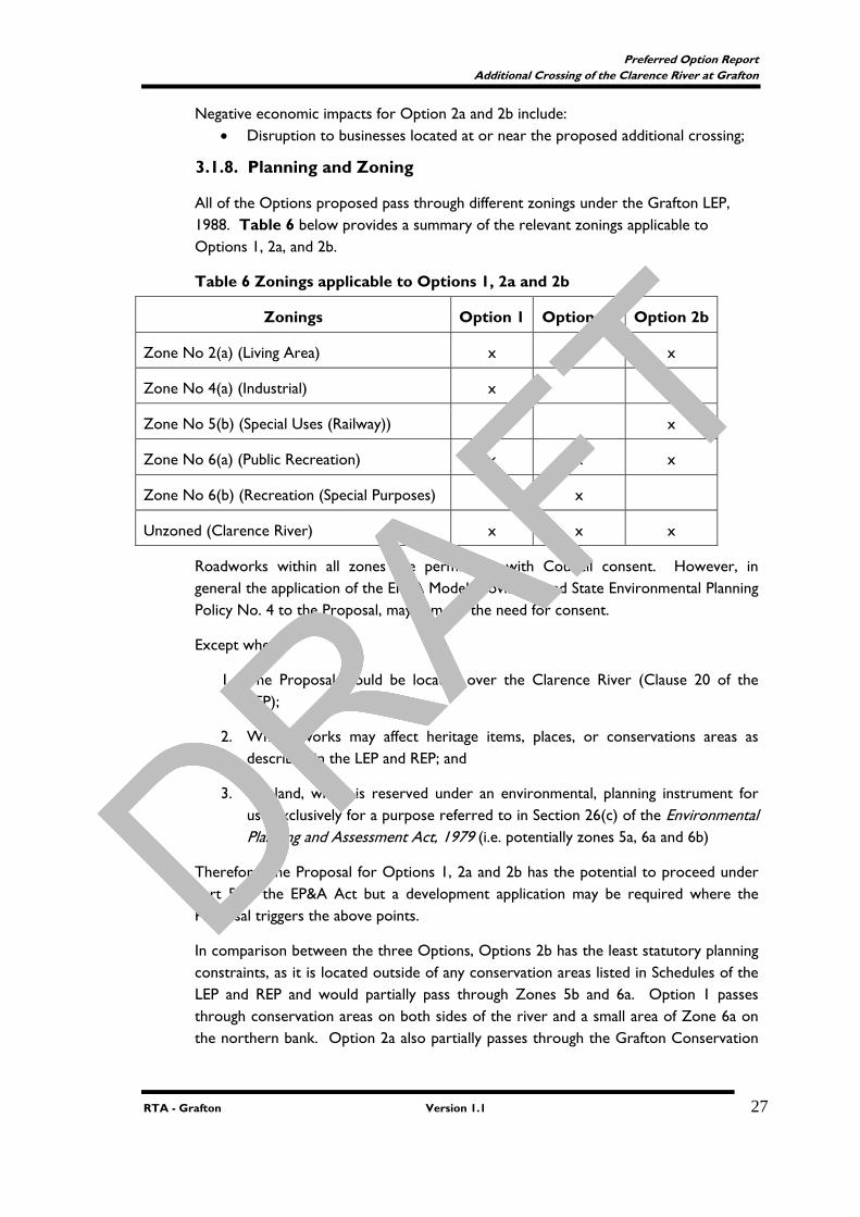
All of the Options proposed pass through different zonings under the Grafton LEP, 1988. Table 6 below provides a summary of the relevant zonings applicable to Options 1, 2a, and 2b.
Table 6 Zonings applicable to Options 1, 2a and 2b
Zonings Option 1 Option 2a Option 2b
Zone No 2(a) (Living Area) x x x
Zone No 4(a) (Industrial) x
Zone No 5(b) (Special Uses (Railway)) x
Zone No 6(a) (Public Recreation) x x x
Zone No 6(b) (Recreation (Special Purposes) x
Unzoned (Clarence River) x x x
Roadworks within all zones are permissible with Council consent. However, in general the application of the EP&A Model Provisions and State Environmental Planning Policy No. 4 to the Proposal, may remove the need for consent.
Except where:
1. The Proposal would be located over the Clarence River (Clause 20 of the LEP);
2. Where works may affect heritage items, places, or conservations areas as described in the LEP and REP; and
3. On land, which is reserved under an environmental, planning instrument for use exclusively for a purpose referred to in Section 26(c) of the Environmental Planning and Assessment Act, 1979 (i.e. potentially zones 5a, 6a and 6b)
Therefore, the Proposal for Options 1, 2a and 2b has the potential to proceed under Part 5 of the EP&A Act but a development application may be required where the Proposal triggers the above points.
In comparison between the three Options, Options 2b has the least statutory planning constraints, as it is located outside of any conservation areas listed in Schedules of the LEP and REP and would partially pass through Zones 5b and 6a. Option 1 passes through conservation areas on both sides of the river and a small area of Zone 6a on the northern bank. Option 2a also partially passes through the Grafton Conservation
DRAFT
DRAFT
DRAFT
DRAFT
DRAFT
Preferred Option Report Additional Crossing of the Clarence River at Grafton
RTA - Grafton Version 1.1 28
Area and Zones 6a, and 6b, partially affecting Crown Land reserved for public recreation.
3.1.9. Acquisition
Acquisition would be required for the three options. Option 1 would require 0.48 ha comprising 0.24ha of residential, 0.21ha of industrial and 0.03ha of recreational land.
Option 2a would require 0.56ha comprising 0.33ha residential and 0.23ha of recreational land.
Option 2b would require 0.31ha comprising 0.23 ha residential and 0.08ha recreational land.
3.1.10. Public Utilities
The following utilities are present in the vicinity of the route options.
A main Telstra cable crosses on the existing bridge. A submarine electric cable crosses from the end of Fitzroy St above the sailing club to near the South Grafton Ex-Services Club, and from Abbott Street to Duke Street.
There are water mains that run across the rail line.
3.1.11.Community Involvement
Community involvement up to and including December 2003 has been detailed in the First Interim Community Participation Report dated January 2004. The initial two Community Focus Group meetings were held during this time. This section of the Preferred Option Report deals with the period January 2004 to June 2005.
The community has been involved in the preferred option selection process via a number of techniques including meetings of the Community Focus Group (CFG), Community Workshops, a Community Update newsletter, a community survey, a Public Information Display, participation by CFG members in the Route Evaluation Workshop, access to a 1800 free call enquiry line, acceptance of submissions to the process and interviews with the Project Manager.
3.1.11.1.Community Focus Group
The 3rd, 4th & 5th Community Focus Group meetings were held during the period on the 4 February 2004, 31 March 2004 and 3 August 2004.
The purpose of the 3rd CFG meeting was to update members on the project information collected since the December 2003 meeting, including a review and discussion of issues related to the short listed localities and the consideration of the Turf Street locality. The 2nd meeting in December had requested the RTA to re-consider including Turf Street as a short-listed option. Turf Street was again excluded after the review of data & feedback from the CFG. The meeting selected members to
DRAFT
DRAFT
DRAFT
DRAFT

DRAFT
Preferred Option Report Additional Crossing of the Clarence River at Grafton
RTA - Grafton Version 1.1 29
attend the Route Evaluation Workshop & the anticipated time for the Public Display was announced.
Between the 3rd and 4th CFG meeting the four general purpose local government councils of the Clarence Valley were amalgamated to form the Clarence Valley Council. A Council Administrator was appointed to replace elected representatives. Consequently three of the four local government representatives who were all previously Councillors were unable to continue as members of the CFG. The fourth local government representative had been appointed as the Council Administrator and was therefore able to continue as a member of the CFG. However by the 5th CFG meeting approval had been gained for the ex-Councillors to re-join as community representatives on behalf of the Clarence Valley Council.
Following the Clarence Valley Council elections in March 2005, the Council endorsed the Mayor Cr Ian Tiley & Deputy Mayor Cr Shirley Adams as nominations to the CFG. Cr Adams resumed her membership of the CFG.
The purpose of the 4th CFG meeting was to further update the members on the route options to be displayed, to view the materials to be used and to answer questions. The dates for the public display at Grafton Shopping World were announced (3 to 24 April 2004) and the holding of a familiarisation meeting on 6 April 2004 for CFG members who were to attend the Route Evaluation Workshop. The aim was to ensure CFG members understood the process so they were not at a disadvantage on the days.
The purpose of the 5th CFG meeting was to convey the status of the investigations required as a result of the outcome of the Route Evaluation Workshop held 28/29 April 2004. Background Papers were provided prior to the meeting and included consideration of the new bridge providing 3 or 4 lanes to provide for the scenario of the Heritage Council not approving modification of the kinks on the existing bridge.
Minutes of each meeting were distributed to the CFG members and a copy of the minutes, including the evaluation of the meetings, is in Attachment 4.
Members of the CFG completed evaluation forms at the conclusion of each meeting. Analysis of the results indicate the majority continue to agree the RTA has provided timely & adequate information to the community & provided timely and adequate opportunity for the community to contribute information.
The majority also agree that the RTA is adhering to the commitment made in the Community Participation Plan (The RTA will look to the community for participation in formulating solutions and will incorporate community comment in decisions to the maximum extent possible).
3.1.11.2.Community Workshops
Two Community Workshops were held (2 – 4 pm & 5 – 7pm) on 5 February 2004 to provide interested community members an opportunity to discuss the short-listed options with the RTA project team. Approximately 57 people attended.
DRAFT
DRAFT
DRAFT
DRAFT

DRAFT
Preferred Option Report Additional Crossing of the Clarence River at Grafton
RTA - Grafton Version 1.1 30
Minutes of the Community Workshops are in Attachment 4.
Press advertisements and written invitations to an extensive list of individuals who had expressed an interest were issued to attend the workshops.
Another letter was sent in August 2004 to individuals who had registered an expression of interest informing them of the current situation including the addition of the 3 and 4 lane configurations for Option 2B. A total of 440 people are registered.
3.1.11.3.Community Update Newsletter No 5
Community Update No 5 was posted during April 2004 to CFG members and all households who had made an enquiry or submission in regard to the additional crossing. It was also made available to the general public via the Public Display during April. A copy of the Community Update is included in Attachment 4.
The Update explained the process to date and the reasons for excluding the localities that were not to be considered further. It also explained the advantages & disadvantages of the three route options that were to undergo additional investigation.
3.1.11.4.Community Survey
To assist in the selection of the preferred option the RTA invited the views of the public on the options via a survey form attached to the Community Update No 5. The surveys could be returned via a supplied reply paid envelope or by placing in a box at the main display at Grafton Shopping World.
It should be noted the survey was an opportunity for those who wished to express an opinion to do so. It is not valid research as the sample is self-selecting and no controls were exercised. The results whilst of interest cannot be extrapolated as an indicator for the whole of the community.
A total of 555 responses were received & analysed with the following results:
o 78% of respondents had visited the Display
o 88% had read the Community Update No 5
o 72% lived in the Grafton/South Grafton area
o 10% accessed Grafton via the Pacific Highway
o 9.5% accessed Grafton via the Gwydir Highway
o 5% lived in Junction Hill
o 17% were local business owners
o 76% of the total responses indicated they would benefit from an additional crossing
o of the 370 who indicated how they would benefit:
32% indicated less congestion
28% indicated easier to cross
DRAFT
DRAFT
DRAFT
DRAFT

DRAFT
Preferred Option Report Additional Crossing of the Clarence River at Grafton
RTA - Grafton Version 1.1 31
24% indicated a saving of time
9% indicated increased safety
5% indicated improved access for emergency crossing
1% indicated they were older people who are afraid to use the current bridge
o of the 66 responses indicating no benefit from an additional crossing at the 3 options 39% indicated they either used the bridge infrequently or only during non-peak times and 35% indicated they believed there was no need for another crossing.
o 64% of respondents used the bridge daily and 27% weekly
o 553 responses provided a preference for the location of the additional crossing:
33% preferred Option 1
22% preferred Option 2B
15% preferred Option 2A
5% preferred either option 2A or 2B
14% preferred a crossing further downstream (by-pass)
4% preferred a crossing at Turf Street
4% preferred no bridge
2% had another preference
o the following issues were rated in order as the top six most important in determining the option choice. A ranked weighting was used:
reduce delays at the existing bridge
provide an alternate emergency access
reduce accidents & injuries
provide another entrance to Grafton
reduce through traffic in the CBD
minimise change to existing traffic movements
3.1.11.5. Information Display
Public information displays were held during the period 3 April – 24 April 2004. A copy of the display material is included in Attachment 5. The main display held at Grafton Shopping World was staffed from 3pm to 7pm on Thursday 8 April and 10am to 4pm on Saturday 17 April. It provided an opportunity for people to ask questions and discuss options in more detail with the RTA project team.
Smaller displays were also located at:
o Clarence Valley Council offices in Prince Street Grafton, Victoria Street Grafton, Through Street South Grafton;
DRAFT
DRAFT
DRAFT
DRAFT

DRAFT
Preferred Option Report Additional Crossing of the Clarence River at Grafton
RTA - Grafton Version 1.1 32
o RTA Motor registry, King Street Grafton; and
o RTA Regional Office, Victoria Street Grafton.
The Community Update No 5 was available from all sites & residents were encouraged to complete the survey form.
3.1.11.6.Statement of Heritage Impacts
Members of the CFG were provided with copies of the final Statement of Heritage Impact (SOHI) in November 2004 and invited to make comment on the Statement for inclusion with the submission of the SOHI to the NSW Heritage Office. Two submissions were received from CFG members and forwarded with the SOHI.
Correspondence was forwarded to CFG members in March 2005 indicating a delay in the decision-making process due to the request by the NSW Heritage Office for additional information. The SOHI was placed on public display for 21 days during April/May 2005 and following is the submissions received.
Name Issue
G Howe • Adverse visual impact • Suggests an alternative route which does not cross
the railway so bridge could be built at a lower height and further from the existing bridge
• Kinks can be widened without affecting trusses
C Purvis • Adverse visual impact • Disputes visual assessment and HIS • Considerable water based recreation occurs
downstream • Inadequate justification for second river crossing • Importance of continued operation of the existing
bridge • Adverse impact on houses near northern
approach
Grafton City Chamber of Commerce and Industry
• Supports proposal due to urgent need for new road crossing
• Urgent need to repaint existing bridge; signs of corrosion
R Bultitude • Adverse visual impact on heritage bridge • Supports alternative locations
M Hillery • Adverse visual impact due to height of bridge and
need to cross rail line
H Roland • Adverse visual impact on existing bridge • Maintenance neglect causing severe rusting • Should consider by-pass for heavy vehicles
National Parks Assoc of NSW
Clarence Valley Branch
• Commends community consultation process • Supports 3/4 lane configurations • Supports downstream location for recreational
and environmental reasons
DRAFT
DRAFT
DRAFT
DRAFT

DRAFT
Preferred Option Report Additional Crossing of the Clarence River at Grafton
RTA - Grafton Version 1.1 33
K Thompson • Adverse visual impact on existing bridge • Lack of community support • Inadequate visual assessment • Adverse impacts by approach roadworks in
conservation area • Adverse impact on viaducts of bridge approaches • Important to continue use of the road/rail bridge
for those purposes • Inadequate economic justification for proposal • Inadequate consideration of downstream views of
the bridge • Loss of public recreation land for bridge
construction
3.1.11.7.Media
Advertisements and media releases were used at relevant points in the process with reports in the Daily Examiner and local radio.
An advertisement and media release on the short-listed options and the provision of community workshops and the free call information line was reported in the Daily Examiner on 24 January and 28 January 2004 respectively. This generated a number of letters to the newspaper disagreeing with the options.
Advertisements promoting the public displays were placed during April 2004. The displays generated numerous letters to the editor both agreeing & disagreeing with the route options.
A media release on the outcomes of the Route Evaluation Workshop was reported in the Daily Examiner on 1 May 2004. This again generated numerous both agreeing & disagreeing with the preferred site. An editorial on 7 May 2004 suggested a downstream site was preferable.
The front page of the Daily Examiner on 18 November reported the change to the preferred site to include a 3 or 4 lane crossing with the existing bridge either with one lane or closed to vehicle traffic. It also reported that a long-term resident who would probably need to relocate vowed to fight the option.
The day’s editorial supported the closing of the existing bridge to vehicular traffic and the exploring of a range of options for future use of the old bridge.
The Daily Examiner’s front page of 22 March 2005 reported concern by the Grafton Chamber of Commerce’s CFG member that the progress in planning for the new crossing had stalled.
The RTA responded the following day indicating that delays had been experienced due to the additional analysis required for the proposed 3 or 4 lane option, negotiations with the Local Aboriginal Land Council and the Australian Rail Track Corporation, and the requirement to gain approval from the NSW Heritage Office for the option.
DRAFT
DRAFT
DRAFT
DRAFT
DRAFT
Preferred Option Report Additional Crossing of the Clarence River at Grafton
RTA - Grafton Version 1.1 34
3.1.11.8. Written Submissions
Written submissions in addition to those relating to the SOHI have been made by approximately seventeen individuals. They range from suggestions about other options to requests for information or challenging data used for the decision making.
3.1.11.9. Free-call Hotline
The free-call hotline was used in the main to register attendance at the CFG and Community Workshops.
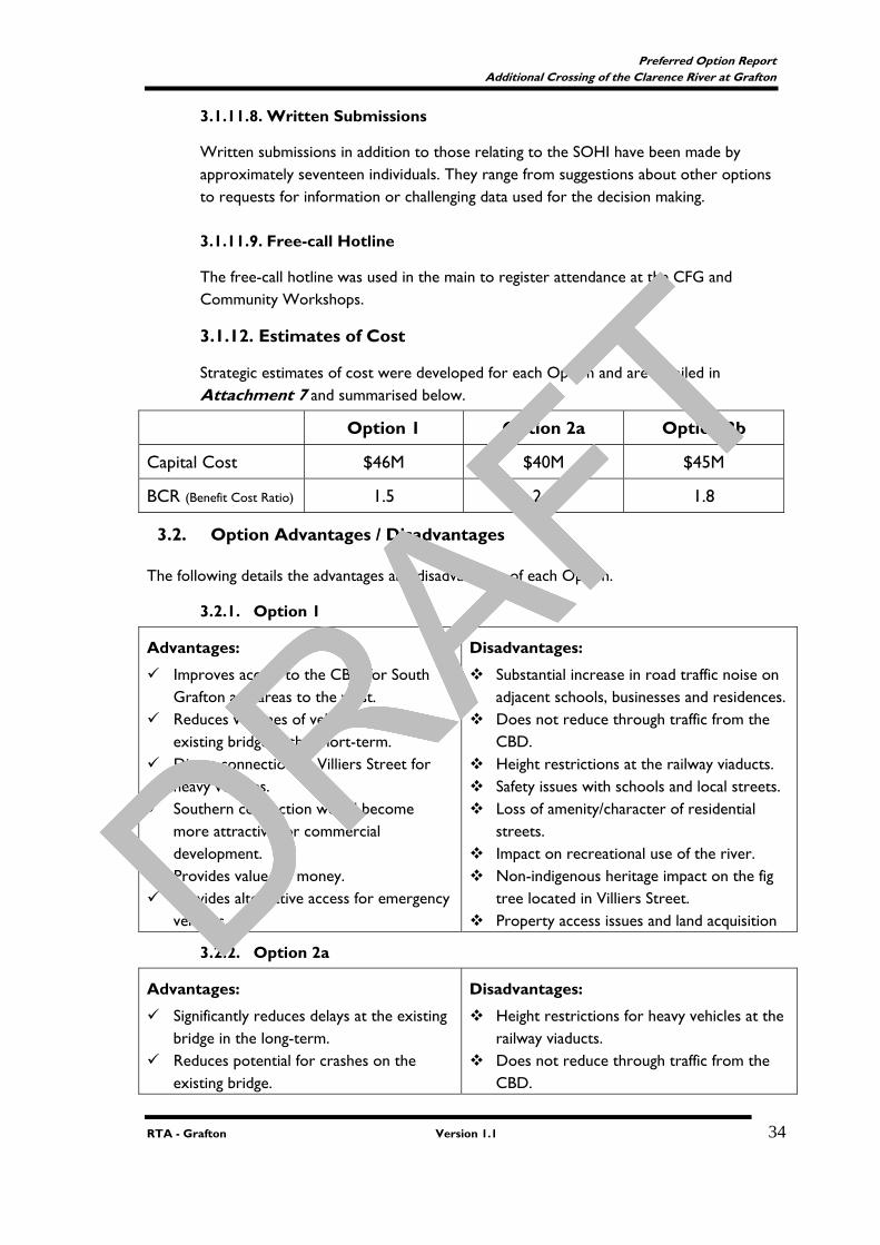
3.1.12. Estimates of Cost
Strategic estimates of cost were developed for each Option and are detailed in Attachment 7 and summarised below.
Option 1 Option 2a Option 2b
Capital Cost $46M $40M $45M
BCR (Benefit Cost Ratio) 1.5 2.0 1.8
3.2. Option Advantages / Disadvantages
The following details the advantages and disadvantages of each Option.
3.2.1. Option 1
Advantages:
Improves access to the CBD for South Grafton and areas to the west.
Reduces volumes of vehicles on the existing bridge in the short-term.
Direct connection to Villiers Street for heavy vehicles.
Southern connection would become more attractive for commercial development.
Provides value for money. Provides alternative access for emergency
vehicles.
Disadvantages:
Substantial increase in road traffic noise on adjacent schools, businesses and residences.
Does not reduce through traffic from the CBD.
Height restrictions at the railway viaducts. Safety issues with schools and local streets. Loss of amenity/character of residential
streets. Impact on recreational use of the river. Non-indigenous heritage impact on the fig
tree located in Villiers Street. Property access issues and land acquisition
3.2.2. Option 2a
Advantages:
Significantly reduces delays at the existing bridge in the long-term.
Reduces potential for crashes on the existing bridge.
Disadvantages:
Height restrictions for heavy vehicles at the railway viaducts.
Does not reduce through traffic from the CBD.
DRAFT
DRAFT
DRAFT
DRAFT

DRAFT
Preferred Option Report Additional Crossing of the Clarence River at Grafton
RTA - Grafton Version 1.1 35
Minimises the potential for increased road traffic noise in comparison to the other localities.
Benefits businesses on the existing approaches.
Minimises flooding impacts. Minimises natural environment impacts. Provides value for money.
Impact on Heritage Conservation Area. Requires upgrade of Fitzroy/Villiers Street
and Bent/Through Street intersections in the long term (20-30 years).
Continued high traffic flow for existing residences.
Property/business access issues. Social impacts including land acquisition.
3.2.3. Option 2b
Advantages:
Significantly reduces delays at the existing bridge in the long-term.
Reduces potential for crashes on the existing bridge.
Minimises the potential for increased road traffic noise in comparison to the other localities.
Benefits businesses on the existing approaches.
Minimises flooding impacts. Minimises natural environment impacts. Provides value for money.
Disadvantages:
Height restrictions for heavy vehicles at the railway viaducts.
Does not reduce through traffic from the CBD.
Requires upgrade of Fitzroy/Villiers Street and Bent/Through Street intersections in the long term (20-30 years).
Continued high traffic flow for existing residences.
Property access issues. Social impacts including land acquisition.
3.3. Route Option Summary
A summary of the main features of the route options is shown in Table 7.
Table 7
Criteria Option 1 Option 2 Option 3
Traffic:
2003 Volumes:
New Bridge
Existing Bridge
Total
11,000
15,000
26,000
13,000
13,000
26,000
13,000
13,000
26,000
2033 Volumes:
New Bridge
Existing Bridge
Total
13,000
21,000
34,000
17,000
17,000
34,000
17,000
17,000
34,000
2033 Peak Hour LOS:
New bridge
Existing Bridge
D
E
C
C
C
C
DRAFT
DRAFT
DRAFT
DRAFT
DRAFT
Preferred Option Report Additional Crossing of the Clarence River at Grafton
RTA - Grafton Version 1.1 36
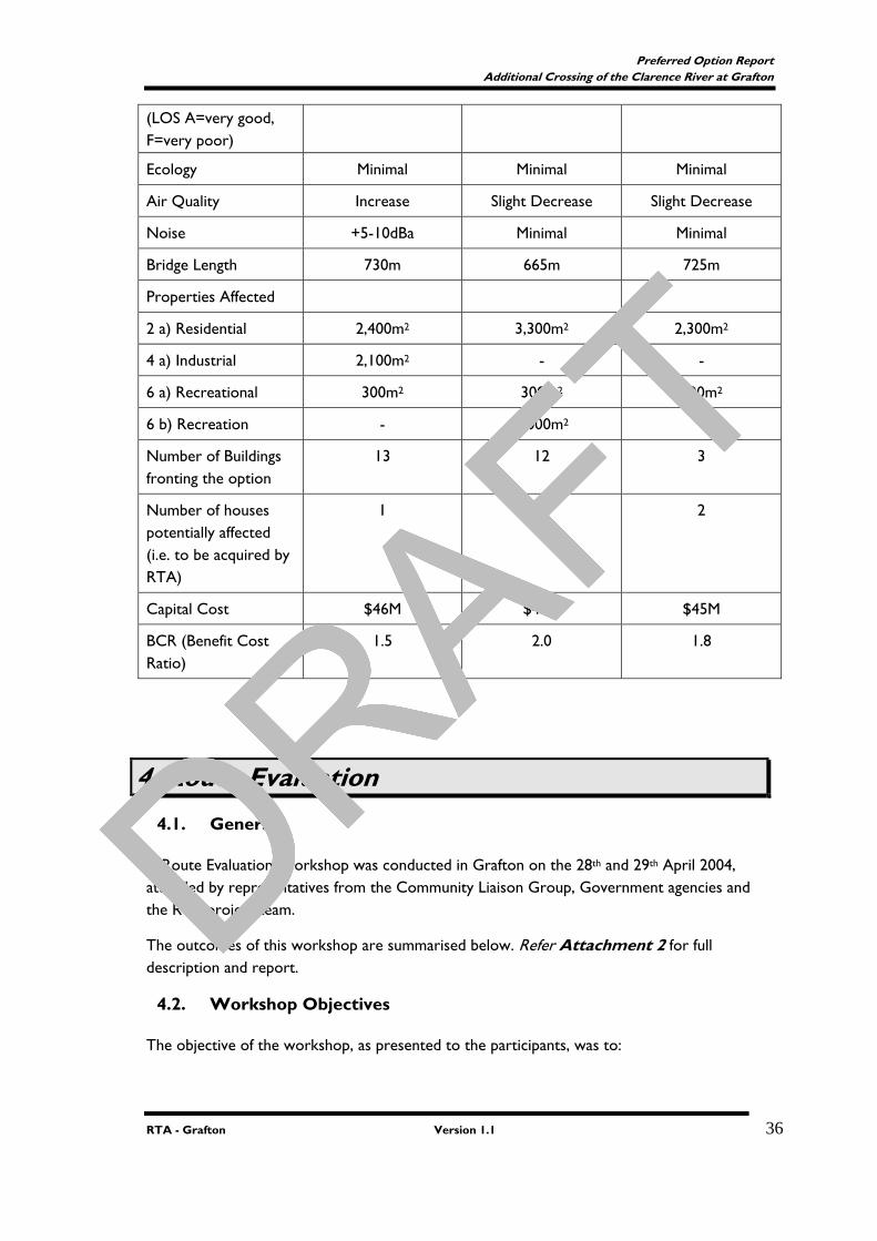
(LOS A=very good, F=very poor)
Ecology Minimal Minimal Minimal
Air Quality Increase Slight Decrease Slight Decrease
Noise +5-10dBa Minimal Minimal
Bridge Length 730m 665m 725m
Properties Affected
2 a) Residential 2,400m2 3,300m2 2,300m2
4 a) Industrial 2,100m2 - -
6 a) Recreational 300m2 300m2 800m2
6 b) Recreation - 2,000m2 -
Number of Buildings fronting the option
13 12 3
Number of houses potentially affected (i.e. to be acquired by RTA)
1 4 2
Capital Cost $46M $40M $45M
BCR (Benefit Cost Ratio)
1.5 2.0 1.8
4. Route Evaluation
4.1. General
A Route Evaluation Workshop was conducted in Grafton on the 28th and 29th April 2004, attended by representatives from the Community Liaison Group, Government agencies and the RTA project team.
The outcomes of this workshop are summarised below. Refer Attachment 2 for full description and report.
4.2. Workshop Objectives
The objective of the workshop, as presented to the participants, was to:
DRAFT
DRAFT
DRAFT
DRAFT

DRAFT
Preferred Option Report Additional Crossing of the Clarence River at Grafton
RTA - Grafton Version 1.1 37
“Obtain a common understanding of the project and its objectives, review the work undertaken to date to ensure it meets the project objectives, and to recommend a preferred direction, if appropriate, to progress the project to the next stage of development”
4.3. Workshop Outcomes
The assessment criteria identified were:
Functional Performance
− Reduce delays at existing bridge in peak hour (Level C in 30years)
− Provide adequate vertical clearance for heavy transport on the Summerland Way
− Reduce through traffic from CBD (including heavy vehicles)
− Reduce potential road accidents and injuries (bridge, approaches and connecting intersections)
− Provision of emergency access
Social Impact
− Minimise impacts on the social environment
− Minimise the impacts on access for the community
− Improve opportunity for economic and tourist development
− Usage of river
− Minimise impact on properties affected (built environment)
− Minimise negative visual impact
Environmental Impact
− Minimise impacts on the natural environment
− Minimise impacts on non-indigenous heritage (including values)
− Minimise impacts of traffic noise on existing noise sensitive developments
− Minimise flooding impacts/river hydrology impacts
− Minimise impacts on indigenous heritage (including values)
− Minimise impacts on air quality
• The workshop participants evaluated the shortlisted options against the three categories of assessment criteria and ranked the performance of each option. The options were also ranked in terms of the estimated cost and their benefit cost ratio (BCR)
A summary of the rankings of the options against the various assessment categories together with the cost estimates and benefit cost ratios (BCR) are shown in Table 8. It should be noted where the difference in score between options was not greater than the highest weighted criteria within that category, the options were equally ranked as the difference in score was not considered significant.
Table 8
Assessment Category
DRAFT
DRAFT
DRAFT
DRAFT
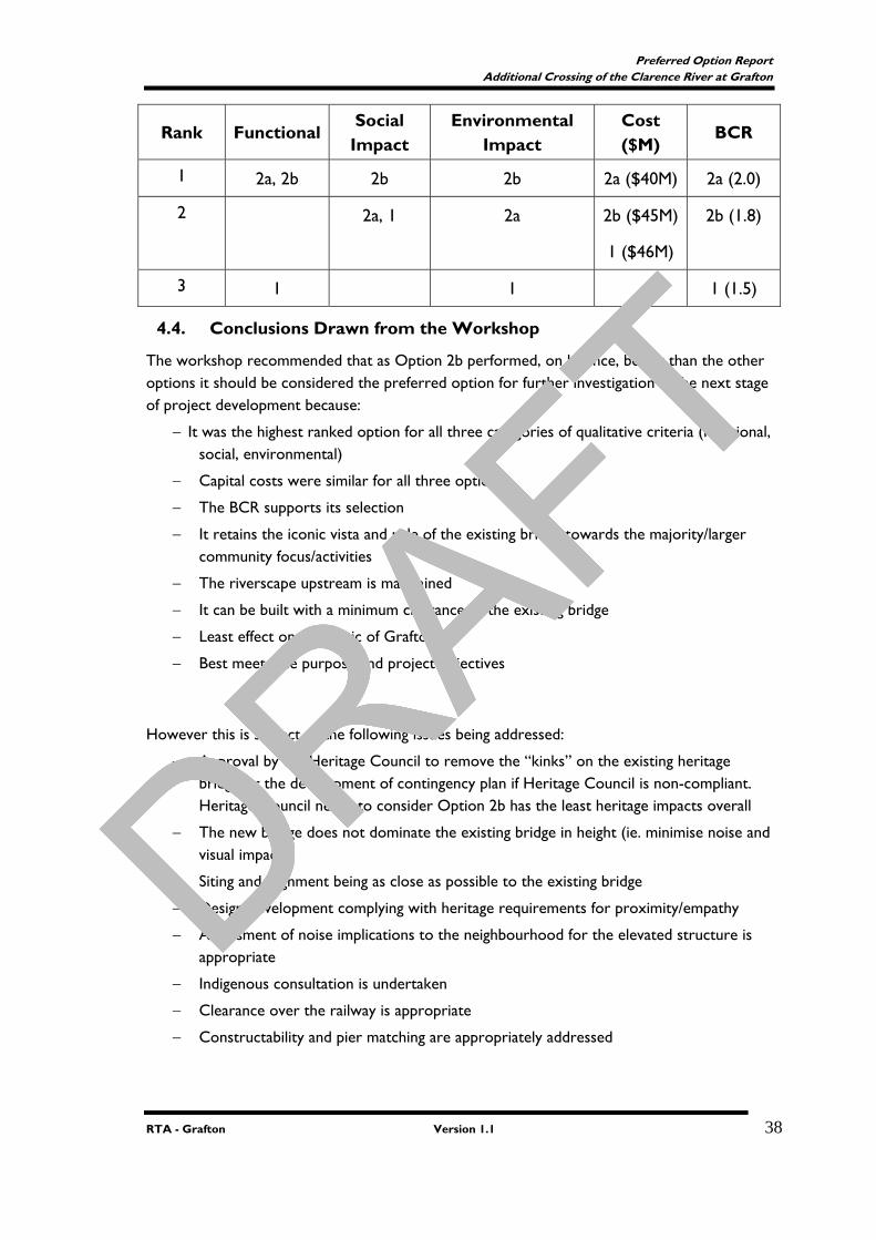
DRAFT
Preferred Option Report Additional Crossing of the Clarence River at Grafton
RTA - Grafton Version 1.1 38
Rank Functional Social Impact
Environmental Impact
Cost ($M)
BCR
1 2a, 2b 2b 2b 2a ($40M) 2a (2.0)
2 2a, 1 2a 2b ($45M)
1 ($46M)
2b (1.8)
3 1 1 1 (1.5)
4.4. Conclusions Drawn from the Workshop
The workshop recommended that as Option 2b performed, on balance, better than the other options it should be considered the preferred option for further investigation in the next stage of project development because:
− It was the highest ranked option for all three categories of qualitative criteria (functional, social, environmental)
− Capital costs were similar for all three options
− The BCR supports its selection
− It retains the iconic vista and role of the existing bridge towards the majority/larger community focus/activities
− The riverscape upstream is maintained
− It can be built with a minimum clearance to the existing bridge
− Least effect on the fabric of Grafton
− Best meets the purpose and project objectives
However this is subject to the following issues being addressed:
− Approval by the Heritage Council to remove the “kinks” on the existing heritage bridge or the development of contingency plan if Heritage Council is non-compliant. Heritage Council needs to consider Option 2b has the least heritage impacts overall
− The new bridge does not dominate the existing bridge in height (ie. minimise noise and visual impact)
− Siting and alignment being as close as possible to the existing bridge
− Design development complying with heritage requirements for proximity/empathy
− Assessment of noise implications to the neighbourhood for the elevated structure is appropriate
− Indigenous consultation is undertaken
− Clearance over the railway is appropriate
− Constructability and pier matching are appropriately addressed
DRAFT
DRAFT
DRAFT
DRAFT

DRAFT
Preferred Option Report Additional Crossing of the Clarence River at Grafton
RTA - Grafton Version 1.1 39
The workshop agreed to a fallback option should the recommended option prove unsuitable after further investigation. The workshop participants favoured Option 2a as the fallback option.
5. Preferred Route Option
5.1. Overview
This section details the further investigations required as a result of the recommendations from the Route Evaluation Workshop
5.2. Meeting Outcomes
Following is the list of recommendations from the Route Evaluation Workshop and the broad strategies agreed to at the meeting to meet these requirements.
1. Approval by the Heritage Council to remove the “kinks” on the existing heritage bridge or the development of contingency plan if Heritage Council is non-compliant. Heritage Council needs to consider Option 2b has the least heritage impacts overall; A Statement of Heritage Impacts (SoHI) was prepared and submitted to the NSW Heritage Office on 4 January 2005. A response was received from NSW Heritage Office on 25 January 2005 requesting further information. A revised SoHI was sent to NSW Heritage Office in March 2005 and a copy is included in Attachment 6. The SoHI requested a two stage approval. Stage 1 was approval for the location of a bridge structure directly downstream of the existing bridge. If approval was gained then a second stage approval for the impacts on the existing bridge would be submitted during the EIA stage. A contingency plan has been developed in the event that Stage 2 approval from NSW Heritage Office would not be given for the 2 lane configuration of the proposed bridge and the modifications of the ‘kinks’ to the existing bridge.
This section provides additional information on the contingency plan for the analysis of the lane configurations for Option 2b. The lane configurations considered are;
• 2 lane new, 2 lane existing
• 3 lane new, 1 lane existing
• 4 lane, decommission existing bridge
The 3 lane and 4 lane configurations include provision for a 1.5m central median. Plans showing the 2 lanes and 3-lane configuration are shown in Attachment 8. The plans for the 4-lane configuration are not shown as they are similar to the 3-lane configuration. A summary is detailed below. The Preliminary Estimates of Cost for the 2, 3 and 4 lane configurations are detailed in Attachment 7.
DRAFT
DRAFT
DRAFT
DRAFT
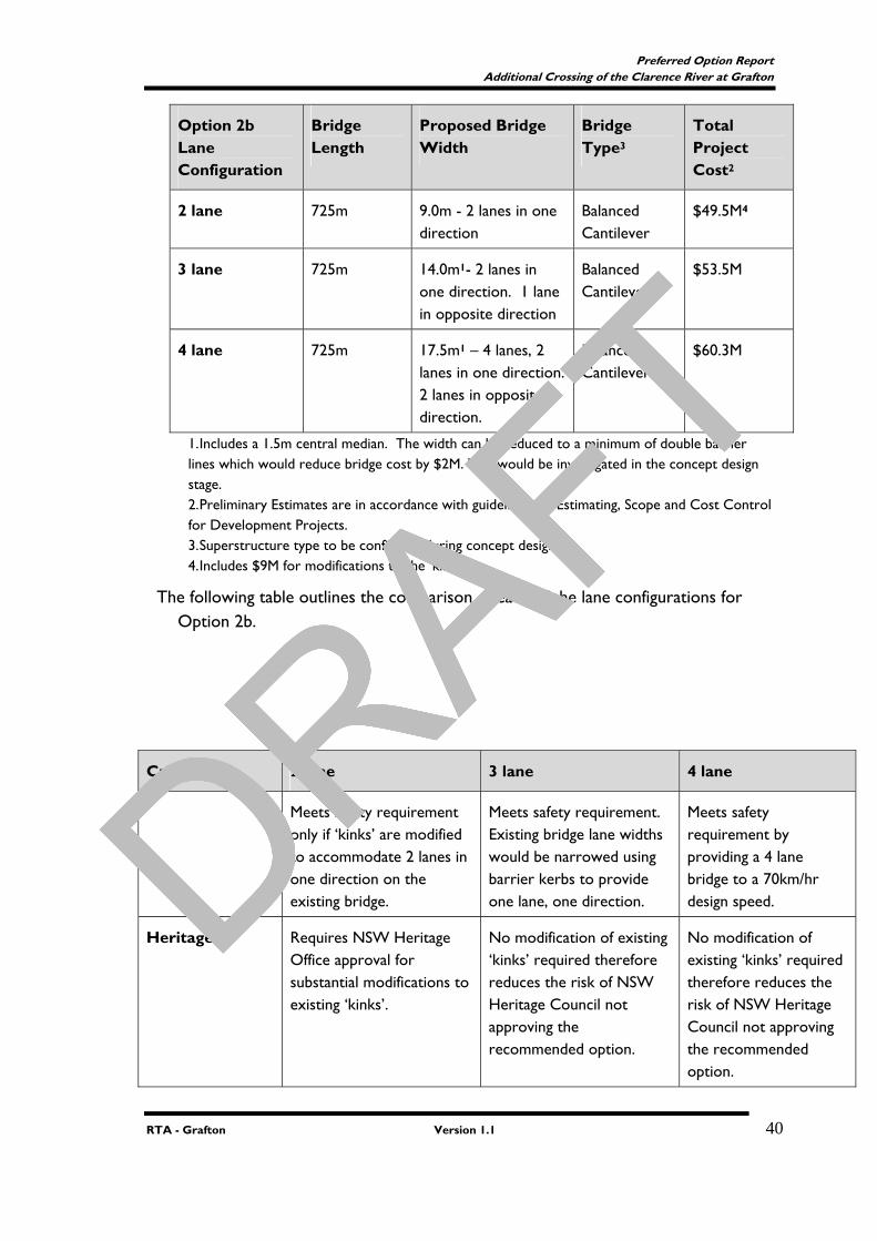
DRAFT
Preferred Option Report Additional Crossing of the Clarence River at Grafton
RTA - Grafton Version 1.1 40
Option 2b Lane Configuration
Bridge Length
Proposed Bridge Width
Bridge Type3
Total Project Cost2
2 lane 725m 9.0m - 2 lanes in one direction
Balanced Cantilever
$49.5M4
3 lane 725m 14.0m1- 2 lanes in one direction. 1 lane in opposite direction
Balanced Cantilever
$53.5M
4 lane 725m 17.5m1 – 4 lanes, 2 lanes in one direction. 2 lanes in opposite direction.
Balanced Cantilever
$60.3M
1. Includes a 1.5m central median. The width can be reduced to a minimum of double barrier lines which would reduce bridge cost by $2M. This would be investigated in the concept design stage. 2. Preliminary Estimates are in accordance with guidelines for Estimating, Scope and Cost Control for Development Projects. 3. Superstructure type to be confirmed during concept design 4. Includes $9M for modifications to the ‘kinks’
The following table outlines the comparison of each of the lane configurations for Option 2b.
Criteria 2 lane 3 lane 4 lane
Meets safety requirement only if ‘kinks’ are modified to accommodate 2 lanes in one direction on the existing bridge.
Meets safety requirement. Existing bridge lane widths would be narrowed using barrier kerbs to provide one lane, one direction.
Meets safety requirement by providing a 4 lane bridge to a 70km/hr design speed.
Heritage Requires NSW Heritage Office approval for substantial modifications to existing ‘kinks’.
No modification of existing ‘kinks’ required therefore reduces the risk of NSW Heritage Council not approving the recommended option.
No modification of existing ‘kinks’ required therefore reduces the risk of NSW Heritage Council not approving the recommended option.
DRAFT
DRAFT
DRAFT
DRAFT

DRAFT
Preferred Option Report Additional Crossing of the Clarence River at Grafton
RTA - Grafton Version 1.1 41
Acquisition Requires acquisition of residential, railway and recreational land.
Requires additional 3.5m strip of acquisition to cater for additional land. One additional residential property potentially affected.
Requires additional 7.0m strip of acquisition to cater for 2 additional lanes. One additional property would be affected.
Noise Road traffic noise level would have a negligible impact. Meets DEC Criteria.
Road traffic noise levels increase 0 to 5dBa. Meets DEC Criteria.
Road traffic noise levels increase by 0 to 5dBa. Meets DEC Criteria.
Clearance over Railway
Achievable. Verbal confirmation of vertical clearance from RIC is 7.1m which is not achievable. Would require substantial future modifications to the existing bridge by RIC to increase existing clearances. Existing clearance is 5.2m.
Achievable. Verbal confirmation of vertical clearance from RIC is 7.1m which is not achievable. Would require substantial future modifications to the existing bridge by RIC to increase existing clearances. Existing clearance is 5.2m.
Achievable. Verbal confirmation of vertical clearance from RIC is 7.1m which is not achievable. Would require substantial future modifications to the existing bridge by RIC to increase existing clearances. Existing clearance is 5.2m.
Constructability No major construction constraints.
No major construction constraints.
No major construction constraints.
Maintenance Long term maintenance costs marginally reduced by transferring 50% of existing traffic to the proposed bridge.
Long term maintenance costs further reduced by transferring 75% of existing traffic to the proposed bridge.
Maintenance costs eliminated by decommissioning the existing road bridge. May be an initial lump sum cost to RIC at decommissioning.
Future Planning Would require a third crossing in the long term (>50 years) if existing road bridge is decommissioned.
Proposed bridge can be designed for widening to 4 lanes in the long term (>50 years) if existing road bridge is to be decommissioned. Utilises the remaining life of the road bridge prior to decommissioning. Bicycle/pedestrian lane can be provided on the existing
Provides ultimate long term planning by providing a 4 lane bridge and decommissioning of the existing bridge.
Does not utilise the remaining life available in the existing road bridge. Opportunities
DRAFT
DRAFT
DRAFT
DRAFT
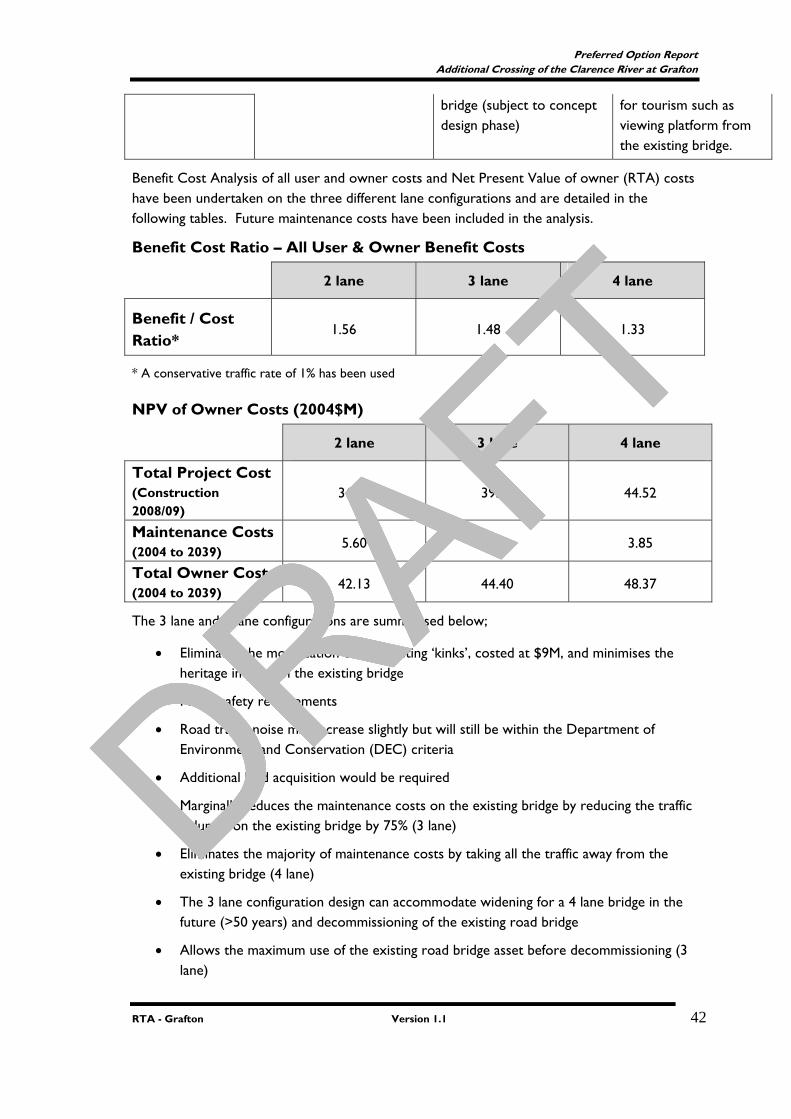
DRAFT
Preferred Option Report Additional Crossing of the Clarence River at Grafton
RTA - Grafton Version 1.1 42
bridge (subject to concept design phase)
for tourism such as viewing platform from the existing bridge.
Benefit Cost Analysis of all user and owner costs and Net Present Value of owner (RTA) costs have been undertaken on the three different lane configurations and are detailed in the following tables. Future maintenance costs have been included in the analysis.
Benefit Cost Ratio – All User & Owner Benefit Costs
2 lane 3 lane 4 lane
Benefit / Cost Ratio*
1.56 1.48 1.33
* A conservative traffic rate of 1% has been used
NPV of Owner Costs (2004$M)
2 lane 3 lane 4 lane
Total Project Cost (Construction 2008/09)
36.53 39.48 44.52
Maintenance Costs (2004 to 2039)
5.60 4.92 3.85
Total Owner Costs (2004 to 2039) 42.13 44.40 48.37
The 3 lane and 4 lane configurations are summarised below;
• Eliminates the modification of the existing ‘kinks’, costed at $9M, and minimises the heritage impact on the existing bridge
• Meets safety requirements
• Road traffic noise may increase slightly but will still be within the Department of Environment and Conservation (DEC) criteria
• Additional land acquisition would be required
• Marginally reduces the maintenance costs on the existing bridge by reducing the traffic volumes on the existing bridge by 75% (3 lane)
• Eliminates the majority of maintenance costs by taking all the traffic away from the existing bridge (4 lane)
• The 3 lane configuration design can accommodate widening for a 4 lane bridge in the future (>50 years) and decommissioning of the existing road bridge
• Allows the maximum use of the existing road bridge asset before decommissioning (3 lane)
DRAFT
DRAFT
DRAFT
DRAFT
DRAFT
Preferred Option Report Additional Crossing of the Clarence River at Grafton
RTA - Grafton Version 1.1 43
• 3 lane configuration has additional $4.0M total project cost above the 2 lane configuration (as it does not require $9M for the cost of modification of the existing bridge ‘kinks’)
• 4 lane configuration has additional $10.8M total project cost above the 2 lane configuration and eliminates future maintenance costs of the existing bridge (built in 1932)
• Total project cost for the 3 and 4 lane configurations can be reduced by $2M by reducing the width of the 1.5m central median for the 3 lane and 4 lane configuration
• 4 lane configuration and decommissioning of the existing bridge has a community benefit by providing a viewing platform from the existing bridge and an opportunity for tourism
• A pedestrian/cycleway could be provided on the existing bridge for the 3 and 4 lane configurations (subject to concept design phase). This could be promoted as a community benefit.
The 3 lane and 4 lane configurations were presented to the Community Focus Group meeting on 3rd August 2004. The majority of responses at this meeting were in favour of the RTA further considering the 3 or 4 lane configurations. 2. The new bridge does not dominate the existing bridge in height (ie. minimise
noise and visual impact); Refer to Section 3.1.5 for the noise assessment and Attachment 3 . A visual impact assessment has been included in the SOHI in Attachment 6.
3. Siting and alignment being as close as possible to the existing bridge; The spacing between the new and existing bridge will be between 5 and 10 metres.
4. Design development complying with heritage requirements for proximity/empathy; A detailed visual assessment was undertaken of the location of Option 2b and was included in the SoHI as part of the approval process with NSW Heritage Office. A copy of the Visual Assessment is included in the SoHI in Attachment 6.
5. Assessment of noise implications to the neighbourhood for the elevated structure is appropriate; A detailed noise assessment, including on site monitoring, was undertaken for the route selection to more accurately determine the noise impacts of the options. The road traffic noise impacts were considered as part of the analysis of options. The noise assessment further considered the road traffic noise impacts of the 2, 3 lane and 4 lane configurations. The noise assessment is detailed in Section 3.1.5 and Attachment 3
6. Indigenous consultation is undertaken;
DRAFT
DRAFT
DRAFT
DRAFT
DRAFT
Preferred Option Report Additional Crossing of the Clarence River at Grafton
RTA - Grafton Version 1.1 44
The Ngerrie LALC has a representative on the Community Focus Group and was invited to the Options Evaluation Workshop. The report from this workshop was tabled at the LALC meeting in May 2004.
7. Clearance over the railway is appropriate;
A letter was sent to Rail Infrastructure Corporation (RIC) on 16 March 2004 requesting a minimum vertical clearance over the railway line of 5.2 metres to match the existing vertical clearance. Further information was emailed to RIC on 24 May 2004. A meeting was held with Frank Boland (RIC) and verbal confirmation was for 7.1m vertical clearances. This clearance was not negotiable until Australian Rail Track Corporation (ARTC) commenced responsibility of the rail corridor and track.
RIC entered a 60 year lease of the NSW interstate and Hunter Valley rail corridors and track on 5 September 2004 with the ARTC. Negotiations for reduction of the vertical clearance will be undertaken in the concept design phase of the projects in consultation with ARTC.
The SoHI assessed the bridge location with a 7.1m vertical clearance
8. Constructability and pier matching are appropriately addressed;
The issue of constructability has been addressed in Section 3.1.1.2 for the bridge design analysis of Option 2b. The matching of piers with the existing piers has also been addressed and will be considered in detail in the concept design.
5.3. Recommendation
Option 2b is considered, on balance, superior to the other corridor options and is recommended as the preferred option.
Option 2b is recommended to be considered for further investigation because:
It is the highest ranked option for all three categories of qualitative criteria (functional, social, environmental)
Capital costs are similar for all three options
The BCR supports its selection
It retains the iconic vista and role of the existing bridge towards the majority/larger community focus/activities
The riverscape upstream is maintained
It can be built with a minimum clearance to the existing bridge
Least effect on the fabric of Grafton
Best meets the purpose and project objectives
It is also recommended that the 2, 3 and 4 lane configurations be further investigated in the concept design and environmental impact assessment stage of the project.
----0000----
DRAFT
DRAFT
DRAFT
DRAFT

DRAFT
Preferred Option Report Additional Crossing of the Clarence River at Grafton
RTA - Grafton Version 1.1 45
DRAFT
DRAFT
DRAFT
DRAFT
DRAFT
Preferred Option Report Additional Crossing of the Clarence River at Grafton
Project Design Services - Grafton Version 1.6 g:\projects\all projects\rstmd\regional dev\d00369 grafton bridge development\previous development2002-2005\project development\design\preferred route report\preferredroutereporv1.2.doc
Attachment 1
Localities/Route options Plan
DRAFT
DRAFT
DRAFT
DRAFT
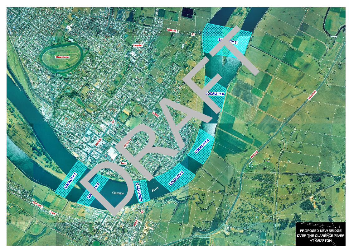
DRAFT
DRAFT
DRAFT
DRAFT
DRAFT

DRAFT
DRAFT
DRAFT
DRAFT
DRAFT

DRAFT
DRAFT
DRAFT
DRAFT
DRAFT
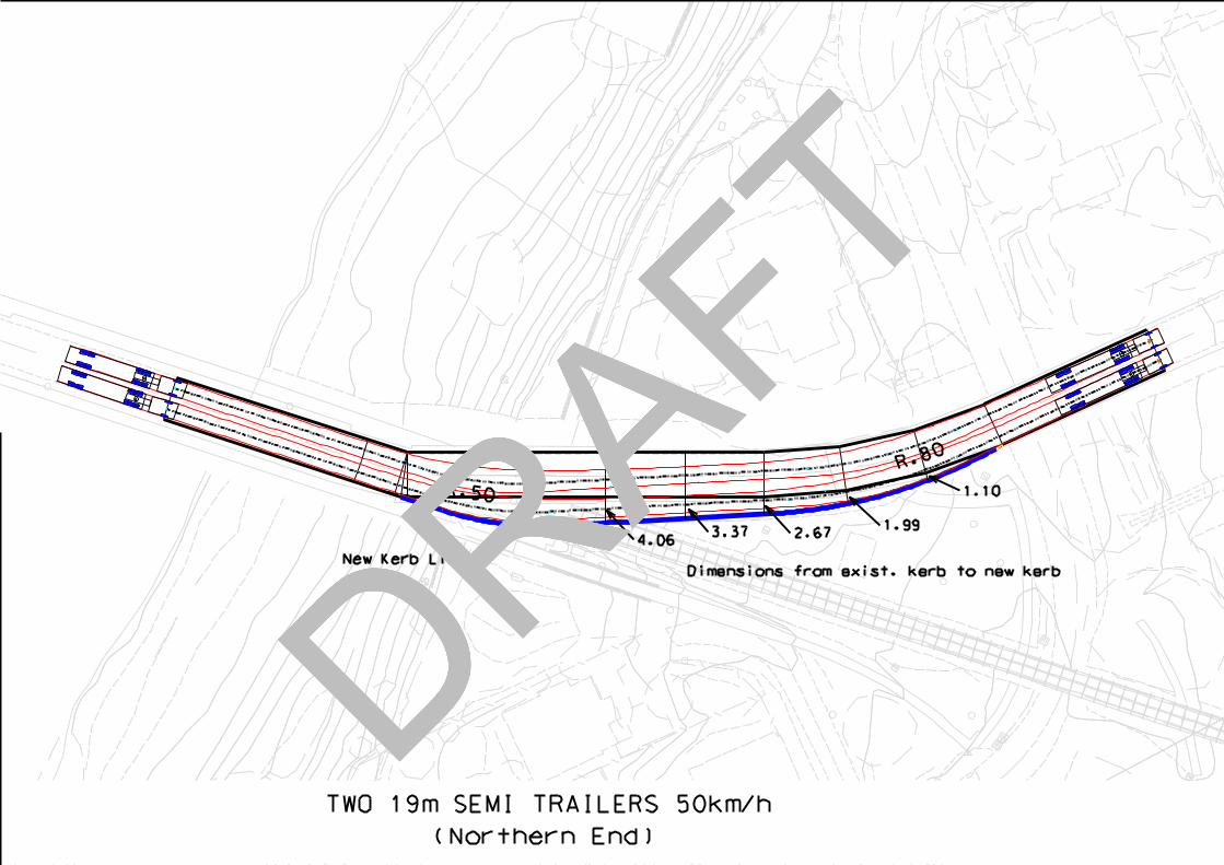
DRAFT
DRAFT
DRAFT
DRAFT
DRAFT

DRAFT
Preferred Option Report Additional Crossing of the Clarence River at Grafton
Project Design Services - Grafton Version 1.6 g:\projects\all projects\rstmd\regional dev\d00369 grafton bridge development\previous development2002-2005\project development\design\preferred route report\preferredroutereporv1.2.doc
Attachment 2
Route Evaluation Workshop
DRAFT
DRAFT
DRAFT
DRAFT

DRAFT
ADDITIONAL CROSSING OF THE
CLARENCE RIVER AT GRAFTON
CORRIDOR EVALUATION WORKSHOP
Workshop Report April 2004
DRAFT
DRAFT
DRAFT
DRAFT
DRAFT
ABN 36 082 506 171
Prepared by:-
The Australian Centre For Value Management
55 Albion Street Surry Hills NSW 2010 Australia
P.O. Box 1598 Strawberry Hills NSW 2012 Australia Tel (61 2) 9211 6488 Fax (61 2) 9211 6499
DRAFT
DRAFT
DRAFT
DRAFT
DRAFTTable of Contents
REPORT ........................................................................................................................................... 1
BACKGROUND ................................................................................................................................. 1
WORKSHOP OBJECTIVES ................................................................................................................. 2
WORKSHOP ACTIVITIES ................................................................................................................... 2
WORKSHOP OUTCOMES .................................................................................................................. 2
APPENDIX 1. LIST OF PARTICIPANTS ........................................................................................ 6
APPENDIX 2. PROJECT INFORMATION AND ANALYSIS .......................................................... 9
THE STRATEGIC CONTEXT OF THE PROJECT .................................................................................. 10
CLARENCE VALLEY COUNCIL PERSPECTIVE ................................................................................... 10
PROJECT OVERVIEW PRESENTATION ............................................................................................. 12
WHAT’S IMPORTANT ABOUT THE ADDITIONAL CROSSING AND ITS ASSOCIATED ROAD WORKS ............ 14
THE PROBLEM SITUATION.............................................................................................................. 15
PROJECT PURPOSE AND OBJECTIVES ............................................................................................ 15
GIVENS AND CONSTRAINTS............................................................................................................ 16
ASSUMPTIONS............................................................................................................................... 16
DEVELOPING THE ASSESSMENT CRITERIA ...................................................................................... 18
WEIGHTING OF ASSESSMENT CRITERIA.......................................................................................... 20
APPENDIX 3. CROSSING OPTION REVIEW, EVALUATION AND RECOMMENDATION ........ 24
CROSSING OPTION PRESENTATIONS.............................................................................................. 25
ADVANTAGES AND DISADVANTAGES OF THE OPTIONS..................................................................... 35
ASSESSMENT OF CORRIDOR OPTIONS ........................................................................................... 37
EVALUATION OF CORRIDOR OPTIONS AGAINST FUNCTIONAL ASSESSMENT CRITERIA....................... 38
EVALUATION OF CORRIDOR OPTIONS AGAINST SOCIAL IMPACT ASSESSMENT CRITERIA................... 39
EVALUATION OF CORRIDOR OPTIONS AGAINST ENVIRONMENTAL IMPACT ASSESSMENT CRITERIA .... 40
SUMMARY OF CROSSING OPTION EVALUATION............................................................................... 41
RECOMMENDING A PREFERRED DIRECTION ................................................................................... 41
CONCLUSIONS DRAWN FROM THE WORKSHOP ............................................................................... 43
WHERE TO FROM HERE?............................................................................................................... 43
DRAFT
DRAFT
DRAFT
DRAFT

DRAFTReport The section summarises the outcomes of the Corridor Evaluation Workshop. The Appendices provide the detail and perceptions by the workshop group regarding the additional crossing of the Clarence River at Grafton. Background The existing vehicular bridge over the Clarence River was completed in 1932 and since that time has served as the major link across the river between Grafton and South Grafton on the Summerland Way which leads from the Pacific Highway to Casino. Traffic volumes including heavy vehicles using the bridge have increased over the years which has led to congestion, delays and conflicts. Also there are “kinks” on the existing bridge which is seen as a safety concern and a significant cause of delays. In 2001 a community campaign for an additional crossing of the Clarence River at Grafton commenced. A public meeting in May 2002 lead the State Government to commission the Roads and Traffic Authority (RTA) to undertake a Feasibility Study and determine strategic locations for an additional crossing to service Grafton and the surrounding communities. As a result of the Feasibility Study, and a commitment by the State Government to proceed with the next stage of planning, the RTA formed a project team to build on the work undertaken in the Feasibility Study. Investigations were undertaken and feasible localities were developed within the study area that would improve road safety, reduce traffic delays and provide improved access for the local and statewide road network. Broad localities were developed between Susan Island and Elizabeth Island for further investigation and then a Shortlisting Workshop (November 2003) determined that two localities were most worthy to proceed to more detailed investigations. As a result, three crossing options have now been developed from the two localities for analysis and evaluation. The crossing options for evaluation (as shown in Figure 1) are: • Option 1 – Villiers Street/Abbott Street. The
limits of this option are from the Gwydir Highway (Ryan Street) at the southern approach to Victoria Street at the northern approach. The crossing would be 2 lanes, with 2 way flow. Traffic facilities such as roundabouts would need to be provided at Ryan Street and Victoria Street connections (subject to concept design and community consultation)
• Option 2a – At the Existing Bridge (directly upstream). This option is directly upstream of the existing bridge. The level of the bridge would be at (or just below) the roadway of the existing bridge. The new crossing would be 2 lanes, with one way flow and the existing crossing would change to one way flow. This would require modification to the ‘kinks’ on the existing crossing. The limits of this option are from Bent Street at the southern approach to the existing bridge (opposite the Nursing Home), to the northern approach at Craig Street (opposite KFC). On the southern approach, an additional southbound lane would be provided to allow four lanes (two lanes each way) on this approach
• Option 2b – At the Existing Bridge (directly downstream). This option is directly downstream of the existing bridge. The level of the bridge would be at (or just above) the roadway of the existing bridge. The new crossing would be 2 lanes, with one way flow and the existing crossing would change to one way flow. This would require modification to the ‘kinks’ on the existing crossing. The limits of this option are from Bent Street at the southern approach to the existing bridge (opposite the Nursing Home), to the northern approach at Craig Street (opposite KFC). On the southern approach, an additional southbound lane would be provided to allow four lanes (two lanes each way) on this approach.
It should be noted that the shortlisting of localities from which the options were developed had been undertaken after an investigation process involving the RTA project team and local government input. As a result no further options were considered in the workshop. However, it was acknowledged that whichever preferred option moved forward for further development, there would be a level of fine tuning and improvement undertaken with mitigation measures employed to address any adverse impacts. A Corridor Evaluation Workshop using a value management approach focussing on evaluating the shortlisted options, was seen as an appropriate tool to bring together a wide range of stakeholder interests and expertise to review the investigations undertaken to date, and on the balance of issues, to assess the options against agreed assessment criteria and determine a preferred direction to progress the project development. The Corridor Evaluation Workshop was seen as one of the major inputs into the process for determining the preferred corridor for the project.
Additional Crossing of the Clarence River at Grafton Corridor Evaluation Workshop Report, April 2004 Page 1
DRAFT
DRAFT
DRAFT
DRAFT

DRAFT The Australian Centre for Value Management (ACVM) was commissioned to facilitate and report on the workshop which was attended by a range of stakeholders on 28th and 29th April 2004. A list of participants who attended the workshop can be found in Appendix 1. Workshop Objectives The objective of the workshop, as presented to the participants, was to: “Obtain a common understanding of the project and its objectives, review the work undertaken to date to ensure it meets the project objectives, and to recommend a preferred direction, if appropriate, to progress the project to the next stage of development” Specifically the participants were to:
• Clarify the objectives of the project • Review the planning parameters for the project • Examine the shortlisted options developed and
identify potential value improvements to meet the project objectives
• Recommend a preferred option(s) to the RTA to progress the project
• Develop an action plan to progress the project This report has been compiled by ACVM and seeks to provide an objective overview of the project aspects discussed and the outcomes formulated by the end of the workshop. Workshop Activities The workshop process builds on the perspectives as well as the detailed and specialist knowledge which resides with the workshop participants then structures the review and option evaluation from a functional base (ie. what are the problems that the project must address and what must the project achieve to be successful). During the workshop, background material was presented (Appendices 2 and 3). What was important about the project from various stakeholder perspectives was identified. The problem situation and the project purpose and objectives were reviewed. Assumptions being made about the project were also identified and challenged from various perspectives (Appendix 2). Assessment criteria were developed and weighted within the “triple bottom line” categories (being functional performance, social impacts and environmental impacts) for later evaluation of the options (Appendix 2).
Using this information, the shortlisted options to meet the project objectives and address the problems identified were reviewed by the group (Appendix 3). The group evaluated the crossing options using the assessment criteria. The result of the evaluation indicated that Option 2b performed, on balance, better than the other options against the functional, social impact and environmental criteria. It also had (on the information presented) the second lowest capital cost estimate and benefit cost ratio (BCR). However it was acknowledged that Option 2b needed to satisfactorily address and mitigate issues raised during the workshop in the next stage of development (Appendix 3). The workshop discussions led the group to conclusions as outlined below. Workshop Outcomes By the end of the workshop, the participants had:
• Identified the problems causing the need for the project being a mix of: − Reducing delays on the existing bridge
and approaches − Significantly reducing road accidents and
injuries − The need to improve economic
development in Grafton − The need to improve access for the local
and State Road network • Confirmed the project purpose and objectives
which reflect what the project must do to be successful and address the problems identified The project purpose is to provide an additional crossing of the Clarence River at Grafton in order to improve road safety, reduce traffic delays and provide improved access for the local and State road network between north and south of the Clarence River The broad project objectives are to: − Significantly improve traffic efficiency − Significantly reduce the potential for road
accidents and injuries − Be socially acceptable to the regional and
local community − Support economic development − Be managed in accordance with
Ecologically Sustainable Development Principles (minimise the impact on the environment)
− Achieve maximum effectiveness of expenditure (value for money)
• Identified and challenged assumptions being made about the project from a range of perspectives (see Appendix 2)
Additional Crossing of the Clarence River at Grafton Corridor Evaluation Workshop Report, April 2004 Page 2
DRAFT
DRAFT
DRAFT
DRAFT
DRAFT• Developed and weighted qualitative
assessment criteria within the three categories of functional performance, social impact and environmental impact. These would be used to evaluate the shortlisted options. The assessment criteria identified were:
Functional Performance − Reduce delays at existing bridge in peak
hour (Level C in 30years) − Provide adequate vertical clearance for
heavy transport on the Summerland Way − Reduce through traffic from CBD (including
heavy vehicles) − Reduce potential road accidents and
injuries (bridge, approaches and connecting intersections)
− Provision of emergency access
Social Impact − Minimise impacts on the social environment − Minimise the impacts on access for the
community − Improve opportunity for economic and
tourist development − Usage of river − Minimise impact on properties affected
(built environment) − Minimise negative visual impact
Environmental Impact − Minimise impacts on the natural
environment − Minimise impacts on non-indigenous
heritage (including values) − Minimise impacts of traffic noise on existing
noise sensitive developments − Minimise flooding impacts/river hydrology
impacts − Minimise impacts on indigenous heritage
(including values) − Minimise impacts on air quality
• Reviewed the shortlisted options tabled for the project and obtained an understanding of their relative advantages and disadvantages (see Appendix 3).
• Evaluated the shortlisted options against the three categories of assessment criteria and ranked the performance of each option. The options were also ranked in terms of the estimated cost and their benefit cost ratio (BCR) (see Appendix 3)
• Recommended that as Option 2b performed, on balance, better than the other options it should be considered the preferred option for further investigation in the next stage of project development because: − It is the highest ranked option for all three
categories of qualitative criteria (functional, social, environmental)
− Capital costs are similar for all three options
− The BCR supports its selection − It retains the iconic vista and role of the
existing bridge towards the majority/larger community focus/activities
− The riverscape upstream is maintained − It can be built with a minimum clearance to
the existing bridge − Least effect on the fabric of Grafton − Best meets the purpose and project
objectives However this is subject to the following issues being addressed:
− Approval by the Heritage Council to remove the “kinks” on the existing heritage bridge or the development of contingency plan if Heritage Council is non-compliant. Heritage Council needs to consider Option 2b has the least heritage impacts overall
− The new bridge does not dominate the existing bridge in height (ie. minimise noise and visual impact)
− Siting and alignment being as close as possible to the existing bridge
− Design development complying with heritage requirements for proximity/empathy
− Assessment of noise implications to the neighbourhood for the elevated structure is appropriate
− Indigenous consultation is undertaken − Clearance over the railway is appropriate − Constructability and pier matching are
appropriately addressed • Agreed to a fallback option should the
recommended option prove unsuitable after further investigation. In most events the participants favoured Option 2a as the fallback option.
Additional Crossing of the Clarence River at Grafton Corridor Evaluation Workshop Report, April 2004 Page 3
DRAFT
DRAFT
DRAFT
DRAFT

DRAFT • Drew the following conclusions: − There was unanimous support within the
workshop for Option 2b to proceed to the next stage of development as the preferred direction subject to:
The design complying with Heritage
Council approval to remove the “kinks” on the existing bridge
Development of a contingency plan if
the heritage Council is non compliant Siting and alignment being as
appropriately close as possible to the existing bridge to minimise noise and visual impacts
Constructability and pier matching are appropriately addressed
Clearance over the railway is appropriate
− There is a need to make Heritage Council aware that Option 2b has the least impact of the options
− There was a genuine disappointment that a Heritage Council representative did not attend the workshop. It was seen to be a wasted opportunity
− The group worked well together to reach census conclusions
− The participants obtained a better understanding of the wider dimensions to the project
− The process undertaken to reach these conclusions was robust and allowed consideration of the various perspectives represented in the workshop
• Were presented at the conclusion of the workshop with an outline of the next steps to progress the project planning from here. These were listed as: − A media announcement will be released to
inform the community about the workshop and its findings
− Finalise the workshop report outlining the findings and conclusions of the group. This will be undertaken by ACVM. A copy of the workshop report will be sent to each participant
− The Project Team will undertake the additional investigations to address the “subject to” statements listed in the workshop for the preferred direction
− Finalise the Preferred Option Report which will incorporate the workshop conclusions
− Obtain the internal RTA client approvals to proceed
− Provide information to the Minister of Roads for the announcement of the preferred route for the crossing
Additional Crossing of the Clarence River at Grafton Corridor Evaluation Workshop Report, April 2004 Page 4
DRAFT
DRAFT
DRAFT
DRAFT
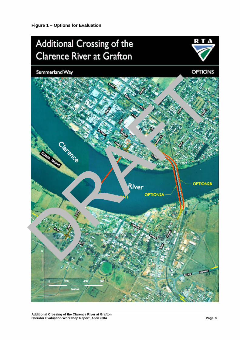
DRAFTFigure 1 – Options for Evaluation
Additional Crossing of the Clarence River at Grafton Corridor Evaluation Workshop Report, April 2004 Page 5
DRAFT
DRAFT
DRAFT
DRAFT
DRAFT
Appendix 1. List of Participants
Additional Crossing of the Clarence River at Grafton Corridor Evaluation Workshop Report, April 2004 Page 6
DRAFT
DRAFT
DRAFT
DRAFT

DRAFT
ADDITIONAL CROSSING OF THE CLARENCE RIVER AT GRAFTON OPTION EVALUATION WORKSHOP
Participants List
Community Stakeholders Shirley Adams Community Focus Group Ron Bell Community Focus Group Robert Blanchard Community Focus Group Greg Hayes Community Focus Group Kel Kearns Community Focus Group Laurie Marchant Community Focus Group Peter Morgan Community Focus Group Bill Noonan Community Focus Group Gordon Poynter Community Focus Group Heather Roland Community Focus Group Amanda Steiner Community Focus Group Karen Thompson Community Focus Group Government Agencies Col Harbidge Engineering, Clarence Valley Council Bob Pavitt Planning, Clarence Valley Council David Andrews Summerland Way Promotional Committee Graeme Budd Environment Protection Authority David Thompson Department of Infrastructure, Planning and Natural Resources John Rowe NSW Waterways Authority Jeff Madden Rail Infrastructure Corporation Project Team Peter Black Project Manager, RTA Peter Collins Regional Manager, RTA Joe Canceri Bridge Design, RTA Sonia Williamson Communications, RTA Simone Garwood Environment, RTA Greg Collins Environment, RTA Peter Mahar Bridge Maintenance, RTA Trevor Smith Road Design, RTA Bruce Parks Client Representative, RTA Stephen Summerell (Day 1 only) Client Representative, RTA
Additional Crossing of the Clarence River at Grafton Corridor Evaluation Workshop Report, April 2004 Page 7
DRAFT
DRAFT
DRAFT
DRAFT
DRAFTADDITIONAL CROSSING OF THE CLARENCE RIVER AT GRAFTON
OPTION EVALUATION WORKSHOP
Participants List (cont)
Project Team (cont) Bill Paterson Hydrology Consultant, Paterson Consultants Brian Kerwick Traffic Consultant, RoadNet Pty Ltd Darren Jurevicious Air Noise Water Consultant, ERM Pty Ltd Vicki St Lawrence Community Participation Consultant, St Lawrence & Associates Kerry Power Planning and Social Consultants, Smythe Maher & Associates Workshop Facilitation Team Ross Prestipino Facilitator, ACVM Mark Neasbey Co-facilitator and reporter
Additional Crossing of the Clarence River at Grafton Corridor Evaluation Workshop Report, April 2004 Page 8
DRAFT
DRAFT
DRAFT
DRAFT

DRAFT
Appendix 2. Project Information and Analysis
Additional Crossing of the Clarence River at Grafton Corridor Evaluation Workshop Report, April 2004 Page 9
DRAFT
DRAFT
DRAFT
DRAFT
DRAFT Project Information and Analysis The information presented in this Appendix is a consolidation of the general outputs and perceptions by the workshop group as they shared information about the additional crossing of the Clarence River at Grafton which allowed them to later make comparisons of options based on the analysis of what the project was required to achieve. The Strategic Context of the Project In order to allow the participants to obtain an understanding of the project’s context, Peter Collins, Northern Regional Manager, RTA outlined the “Big Picture” for the project including the role of RTA and its expectations. Key points raised in his presentation included:
• Why are we looking at an additional crossing of the Clarence River? − Community concern about delays and emergency access as well as the future development of
Grafton and the Clarence Valley − Another crossing of the Clarence River has been discussed since the 1960s. The crossing is
not just for Grafton but for the Clarence River Valley as part of the Summerland Way and the State Road Network
− The existing bridge has served us well but the time is right to plan and determine the best site for an additional crossing because of: Increasing delays, queuing is getting longer in the peaks Level of service of the existing bridge is diminishing Expansion of settlement and growth either side of the Clarence River
− NSW State Government is committed to build the crossing • The State Government allocated $100,000 to enable a Feasibility Study to be undertaken for the
project specifically to confirm its need and to clarify the ‘no-go’ zones. This then generated seven broad localities for a second crossing. These were subject to more detailed analyses as a result of which two localities were shortlisted and three options within those localities are the subject of this workshop. This workshop’s task is to recommend which location, on balance, should be recommended as best meeting the objectives of the project. The State Government has confirmed a commitment to the project and will be making an announcement of a preferred crossing taking into account the findings of the workshop
Clarence Valley Council Perspective A Clarence Valley Council perspective of the project was presented by Col Harbidge, Engineer, Clarence Valley Council on behalf of Neil Payne, General Manager Clarence Valley Council who was unable to attend. His presentation is recorded below.
• This project is of paramount importance to the City of Grafton and to the Clarence Valley. The impacts of any decision coming out of this process will be felt by almost the whole community. There will be positive and negative impacts, no matter what decision is made
• I look forward to everybody's keen participation and I hope that we are all able to leave tomorrow afternoon knowing that we have all had ample opportunity to put forward our points of view and to test the points of view of others. The former Grafton City Council had a long history of pursuing a second bridge over the Clarence River in Grafton. The background papers distributed for the workshop briefly outlines some of that history
• In more recent times, a sub-committee of Grafton City Chamber of Commerce and Industry was appointed to actively pursue a second bridge at Grafton. In May 2002, some 600 people attended a public meeting at Grafton High School Multi-purpose Centre. There appeared to be a high level of public support for the proposal although I note that some reservations were expressed
• Around June and July 2002, the RTA commenced work on the Feasibility Study. In September 2002 the former Grafton City Council was addressed by Mr Peter Collins and Mr Peter Black, RTA. Council also considered a staff report. Council subsequently resolved:- “that it supports a second crossing of the Clarence River at Grafton with the main objective of relieving traffic congestion" and further that on completion of the feasibility study "that Council would also be urging the Feasibility Study progress to the Development Phase"
Additional Crossing of the Clarence River at Grafton Corridor Evaluation Workshop Report, April 2004 Page 10
DRAFT
DRAFT
DRAFT
DRAFT

DRAFT• In January 2003 Council considered the draft Feasibility Study prepared by the RTA and was again
addressed by the RTA. The key outcome of the draft Feasibility Study is described in the following extract from its Executive Summary: − "The most feasible location appears to be in the vicinity of the existing bridge. However,
although this location is feasible an additional crossing would still have significant impacts on the community such as traffic, noise, social and aesthetics. If the project were to proceed to the Development Phase, i.e. selection of a preferred location, more detailed studies would be required. This would include more specific traffic analysis and noise monitoring in the locality. It would also require continuation of close consultation with the community to determine the social impact of an additional crossing
− The locations upstream and downstream of the existing bridge also appear feasible as they meet all the objectives of the project with the exception of economic comparisons of the benefits to cost. These options have a number of adverse impacts particularly social and environmental impacts and traffic noise. However, they do have a number of benefits as detailed in this report. If the project were to proceed to the Development Phase these locations would need to be considered as part of the selection of a preferred location to validate the findings of the Feasibility Study. Further detailed traffic analysis, noise monitoring, environmental investigations and community consultation would be required to determine the viability of an additional crossing in these locations
− The locations at Ulmarra, Cowper and Lawrence do not meet a number of objectives of the project and would not contribute greatly to reducing congestion or providing a significant improvement to safety at the existing Grafton Bridge. Therefore, an additional crossing at these locations does not appear feasible as it does not meet the objectives of this project."
• In consideration of the Draft Feasibility Study, the former Grafton City Council resolved: "1. That Council recognise and support the findings of the Feasibility Study Report 2. That the RTA be requested to include additional information in the Feasibility Study Report dealing with the structural adequacy of the existing bridge and an assessment of the "do-nothing" option 3. That the RTA be requested to finalise a feasibility study report as soon as possible 4.That subject to the finalisation of the Feasibility Study Report in accordance with the above, that the RTA be requested to proceed to the development phase of the project, based on strategic locations 1, 2 and 3."
• For your information in the Feasibility Study Report, Location 1 covered the strategic location for a crossing between the existing Grafton Bridge up to and including Susan Island; Location 2 covered the strategic location for crossing in the vicinity of the existing bridge; Location 3 covered the strategic location for a crossing from the existing Grafton Bridge and downstream to and including Elizabeth Island
• The final Feasibility Study was issued in February 2003. Of particular interest is Section 3.3.6 of the report entitled "Road Capacity". This section provides information on the existing traffic delays in destinations of traffic delays in 2011 and 2021. These delays are such that they would have extreme negative impacts on the Grafton community if not addressed
• The Study states that by the year 2011, the morning and afternoon peak period may extend to 3 hours/day and the intensity currently experienced in the morning peak between 8:15am and 9am may be common for the 3 hour morning and afternoon period. By the year 2021, the morning and afternoon peak period may extend to 4.5 hours and up to nine hours by the year 2031
• In September 2003, the former Grafton City Council appointed Councillors Mrs Shirley Adams and Mr Max Murray to represent the Council at community focus group meetings
• In November 2003, a Shortlisting of Localities Workshop was held. I understand from the background papers that the outcome of this workshop has been presented to community focus group meetings and workshops although no final report has been presented to Council
• The decision to be made in the second crossing of the Clarence River will shape the future of Grafton in many ways. It will impact significantly on the City's physical appearance, its operation and amenity. It will impact on its growth potential and its actual growth, it will have social and environmental effects, it will impact on the Grafton community and the community of the Clarence Valley in many ways. No doubt these, and other impacts, will be identified at this workshop.
Additional Crossing of the Clarence River at Grafton Corridor Evaluation Workshop Report, April 2004 Page 11
DRAFT
DRAFT
DRAFT
DRAFT

DRAFT Project Overview Presentation An overview of the work undertaken to date was presented by Peter Black, Project Manager, RTA. Key points made in his presentation which supplements the background papers distributed to participants prior to the workshop are outlined below. Purpose of the Project
The purpose of the project is to provide an additional crossing of the Clarence River at Grafton in order to improve road safety, reduce traffic delays and provide improved access for the local and State road network between north and south of the Clarence River
Project Objectives The broad project objectives are to:
• Significantly improve traffic efficiency • Significantly reduce the potential for road accidents and injuries • Be socially acceptable to the regional and local community • Support economic development • Be managed in accordance with Ecologically Sustainable Development Principles
(minimise the impact on the environment) • Achieve maximum effectiveness of expenditure (value for money)
Under the broad objectives, there are a range of secondary objectives which assist in determining criteria that options can be evaluated against
Background • Approval was given in 1915 for the design and construction of a bridge over the Clarence River, at
Grafton (with a moveable span for river navigation clearance) to carry a railway and a footway. In 1922, when design was well advanced, the Minister for Works requested that the design include vehicular traffic in addition to the railway and pedestrian traffic. The new bridge was opened to traffic in 1932
• Grafton City Council initiated correspondence to the Department of Main Roads (DMR) regarding a second bridge in 1960 with investigations commencing in the early 1970’s. In 1977, the DMR advised that a new bridge location had been adopted linking Fitzroy Street, Grafton, to Bent Street, South Grafton. Survey and geotechnical investigations were then undertaken. In 1985, the DMR advised that the new bridge was a long-range Proposal
• In 2001, a group of business people formed a committee to campaign for a new bridge at Grafton. In May 2002, the community campaign for an additional crossing of the Clarence River at Grafton commenced. A public meeting held in May 2002 lead the State Government to commission the RTA to undertake a Feasibility Study and determine strategic options for the location of an additional crossing to service Grafton and the surrounding communities. Following the completion of the Feasibility Study in February 2003, a project team was formed to proceed with a Route Selection Study
• The Route Selection Study would identify crossing options and assess the best value for money alignment for the additional crossing to improve road safety, reduce traffic delays and provide improved access for the local and state road network between the north and south of the Clarence River.
Project Issues to be Addressed The following specific issues that need to be addressed by the project include:
• Reduce delays at the existing bridge • Significantly reduce road accidents and injuries • Improve economic development for Grafton • Improve access for the local and State Road network
Additional Crossing of the Clarence River at Grafton Corridor Evaluation Workshop Report, April 2004 Page 12
DRAFT
DRAFT
DRAFT
DRAFT

DRAFT Development of Crossing Options
The activities to progress the development of options and the timeframe to date are shown in the table below and included:
Date Activity July to November 2003 Detailed investigations November 2003 Short Listing of Localities November 2003 to February 2004 Community input to Short Listed Localities April 2004 Pubic display of crossing options
Localities Short Listing Workshop • The initial step in the process of selecting a preferred crossing was to identify localities that most
likely met the project objectives to move forward for further detailed investigations. The information gathered from the specialist studies was used as a basis for decision making on which crossing localities should be further investigated in the route selection stage. As a result, seven localities were identified between Susan Island and Elizabeth Island
• In order to shortlist those localities worthy of further investigation a Localities Shortlisting Workshop was held on 28 November 2003. The Australian Centre for Value Management (ACVM) was commissioned to facilitate and report on the shortlisting workshop
• The shortlisting of localities workshop was a technical workshop seen as the appropriate strategic tool to bring together some of the key stakeholders involved in the project and to review and assess the localities developed in order to discard those that did not (on balance) sufficiently/effectively meet the project objectives and to shortlist those that did, so they could proceed to more detailed investigation. The participants included the RTA project team and representatives from the former Grafton City Council, Copmanhurst Council and Pristine Waters Council. The outcomes of the workshop were that Localities 2 and 3 should proceed to the next stage of development and that the other localities should not proceed (details were shown in the background paper for this workshop)
• Following the presentation of the shortlisted localities to the community in December 2003, it was raised that a Turf Street option (upstream of Locality 1) should also be considered. This was further investigated. The project team analysed the project information for this crossing locality against the project criteria, and using the methodology of the Shortlisting Workshop, determined that this locality did not sufficiently meet the project objectives (on balance) and should not proceed further (reasons stated in the background paper for this workshop)
• As a result, three options were developed within Localities 2 and 3 being Option 1 (Villiers Street/Abbott Street), Option 2 (Directly upstream of the existing bridge) and Option 3 (Directly downstream of the existing bridge) as shown in Figure 1
Involving the Community Community participation and issue identification has been encouraged through a number of activities (as described in the background paper). In summary, these include:
• Community focus group meetings (to convey information to and from community interest groups)
• Agency briefings • Media releases to local newspapers • Community workshops • Letters to residents • Newsletters (community updates) • Free call hotline • Meetings with residents • Consultation with Aboriginal Community • Information Display
Additional Crossing of the Clarence River at Grafton Corridor Evaluation Workshop Report, April 2004 Page 13
DRAFT
DRAFT
DRAFT
DRAFT
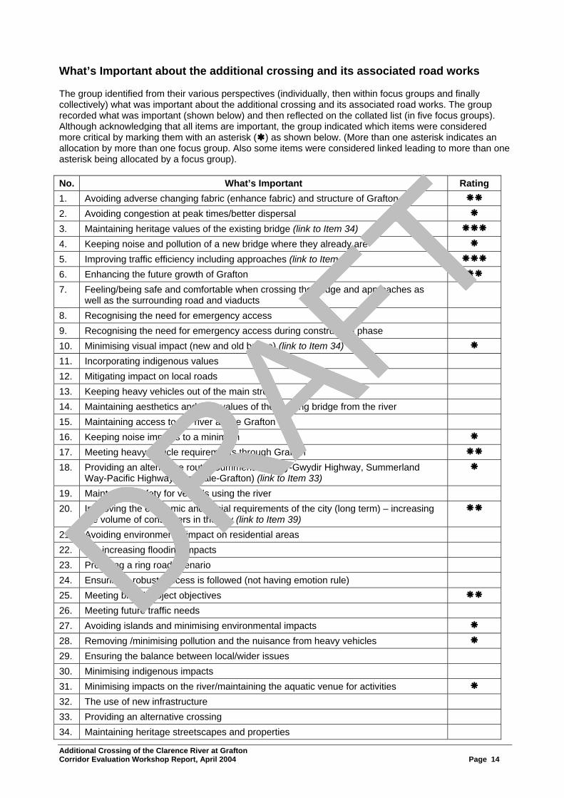
DRAFT What’s Important about the additional crossing and its associated road works The group identified from their various perspectives (individually, then within focus groups and finally collectively) what was important about the additional crossing and its associated road works. The group recorded what was important (shown below) and then reflected on the collated list (in five focus groups). Although acknowledging that all items are important, the group indicated which items were considered more critical by marking them with an asterisk ( ) as shown below. (More than one asterisk indicates an allocation by more than one focus group. Also some items were considered linked leading to more than one asterisk being allocated by a focus group). No. What’s Important Rating 1. Avoiding adverse changing fabric (enhance fabric) and structure of Grafton
2. Avoiding congestion at peak times/better dispersal
3. Maintaining heritage values of the existing bridge (link to Item 34)
4. Keeping noise and pollution of a new bridge where they already are
5. Improving traffic efficiency including approaches (link to Item 2)
6. Enhancing the future growth of Grafton
7. Feeling/being safe and comfortable when crossing the bridge and approaches as well as the surrounding road and viaducts
8. Recognising the need for emergency access 9. Recognising the need for emergency access during construction phase 10. Minimising visual impact (new and old bridge) (link to Item 34)
11. Incorporating indigenous values 12. Mitigating impact on local roads 13. Keeping heavy vehicles out of the main street 14. Maintaining aesthetics and user values of the existing bridge from the river 15. Maintaining access to the river above Grafton 16. Keeping noise impacts to a minimum
17. Meeting heavy vehicle requirements through Grafton
18. Providing an alternative route (Summerland Way-Gwydir Highway, Summerland Way-Pacific Highway, Armidale-Grafton) (link to Item 33)
19. Maintaining safety for vessels using the river 20. Improving the economic and social requirements of the city (long term) – increasing
the volume of consumers in the city (link to Item 39)
21. Avoiding environmental impact on residential areas 22. Not increasing flooding impacts 23. Providing a ring road scenario 24. Ensuring a robust process is followed (not having emotion rule) 25. Meeting broad project objectives
26. Meeting future traffic needs 27. Avoiding islands and minimising environmental impacts
28. Removing /minimising pollution and the nuisance from heavy vehicles
29. Ensuring the balance between local/wider issues 30. Minimising indigenous impacts 31. Minimising impacts on the river/maintaining the aquatic venue for activities
32. The use of new infrastructure 33. Providing an alternative crossing 34. Maintaining heritage streetscapes and properties
Additional Crossing of the Clarence River at Grafton Corridor Evaluation Workshop Report, April 2004 Page 14
DRAFT
DRAFT
DRAFT
DRAFT

DRAFT What’s Important (Cont.) No. What’s Important Rating 35. Maintaining existing bridge as an icon 36. Ensuring least number of residents’ properties are disrupted 37. Providing a vision for the future (long term) 38. Achieving best economic outcome/value for money 39. Reducing unnecessary traffic in CBD 40. Improving accessibility for residents and businesses 41. Minimising impact of bridge on river hydrology 42. Maintaining a reasonable level of access to properties Upon reflection, the workshop group concurred that there was overlap in the list. However, the list reflected the items considered important that the project needs to address as planning proceeds. This “What’s Important” list (as well as other information such as the project objectives) would later be used in the workshop to develop and fine tune assessment criteria to evaluate the options for consideration. The Problem Situation The group reflected on the background paper material as well as from their own perspectives and identified the problems causing the need for a project (ie. the “Problem Situation”). These were recorded as a mix of the following:
• Reducing delays on the existing bridge and approaches • Significantly reducing road accidents and injuries • The need to improve economic development in Grafton • The need to improve access for the local and State Road network
Project Purpose and Objectives Having discussed the problems causing the need to consider a project, the group reviewed the project purpose and objectives (ie. what must the project achieve to be successful) as stated in the presentations and in the background papers distributed prior to the workshop. The group agreed with the purpose and objectives of the project which are restated below. Purpose of the Project
The purpose of the project is to provide an additional crossing of the Clarence River at Grafton in order to improve road safety, reduce traffic delays and provide improved access for the local and State road network between north and south of the Clarence River
Project Objectives The group agreed that the project should:
• Significantly improve traffic efficiency • Significantly reduce the potential for road accidents and injuries • Be socially acceptable to the regional and local community • Support economic development • Be managed in accordance with Ecologically Sustainable Development Principles
(minimise the impact on the environment) • Achieve maximum effectiveness of expenditure (value for money)
Additional Crossing of the Clarence River at Grafton Corridor Evaluation Workshop Report, April 2004 Page 15
DRAFT
DRAFT
DRAFT
DRAFT
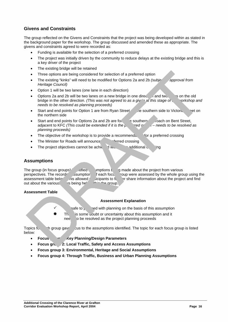
DRAFT Givens and Constraints The group reflected on the Givens and Constraints that the project was being developed within as stated in the background paper for the workshop. The group discussed and amended these as appropriate. The givens and constraints agreed to were recorded as:
• Funding is available for the selection of a preferred crossing • The project was initially driven by the community to reduce delays at the existing bridge and this is
a key driver of the project • The existing bridge will be retained • Three options are being considered for selection of a preferred option • The existing “kinks” will need to be modified for Options 2a and 2b (subject to approval from
Heritage Council) • Option 1 will be two lanes (one lane in each direction) • Options 2a and 2b will be two lanes on a new bridge in one direction and two lanes on the old
bridge in the other direction. (This was not agreed to as a given at this stage of the workshop and needs to be resolved as planning proceeds)
• Start and end points for Option 1 are from Ryan Street on the southern side to Victoria Street on the northern side
• Start and end points for Options 2a and 2b are form the southern approach on Bent Street, adjacent to KFC (This could be extended if it is the preferred option – needs to be resolved as planning proceeds)
• The objective of the workshop is to provide a recommendation for a preferred crossing • The Minister for Roads will announce the preferred crossing • The project objectives cannot be achieved without an additional crossing
Assumptions The group (in focus groups) identified assumptions being made about the project from various perspectives. The recorded assumptions of each focus group were assessed by the whole group using the assessment table below. This allowed participants to further share information about the project and find out about the various views being held within the group. Assessment Table
Key Assessment Explanation
It is safe to proceed with planning on the basis of this assumption There is some doubt or uncertainty about this assumption and it
needs to be resolved as the project planning proceeds Topics for each group gave focus to the assumptions identified. The topic for each focus group is listed below:
• Focus group 1: Key Planning/Design Parameters • Focus group 2: Local Traffic, Safety and Access Assumptions • Focus group 3: Environmental, Heritage and Social Assumptions • Focus group 4: Through Traffic, Business and Urban Planning Assumptions
Additional Crossing of the Clarence River at Grafton Corridor Evaluation Workshop Report, April 2004 Page 16
DRAFT
DRAFT
DRAFT
DRAFT

DRAFTEach focus group’s assumptions and the whole group’s assessment are listed below.
Focus group 1: Key Planning/Design Parameters No. Assumptions Category 1. Built to Australian Standards/best practice both construction and design 2. There are RailCorp height restrictions to comply with for bridge and approaches (on
Option 2b) – to be resolved as planning proceeds
3. Maintain existing heights restriction for Waterway requirements 4. Comply with environmental legislation (Federal, State and Local Government) 5. The bridge design will be aesthetic, pleasing, compliments the area 6. Comply with heritage requirements (Federal and State) 7. Use appropaite pavement standards – surface, widths, minimise noise 8. Design life of materials will consider future maintenance needs 9. Will cope with projected future traffic needs 10. Will undertake works on local road system (ie. road approaches, additional local
roads require upgrading to be effective with the new bridge, redirection of traffic/remove load from existing roads)
11. Planning for mitigation measures (ie. noise, other treatments, etc) 12. Comply with RTA policies and procedures 13. Comply with State and local government policies and guidelines (ie. LEP, Heritage
requirements, EPA, NSW Fisheries, DIPNR requirements, etc)
14. Design will consider constructability issues but still needs to be resolved as planning proceeds
Focus group 2: Local Traffic, Safety and Access Assumptions No. Assumptions Category 1. The existing bridge will be structurally adequate for next 30 years 2. Villiers Street roundabout will be adequate for next 30 years 3. U-turn bay on southern side would be eliminated (Option 2a and 2b) 4. Villiers Street roundabout will require modification after 30 years 5. Left-turn movement from Clarence Street onto the bridge to be retained 6. For Option 1, more traffic will use Victoria Street 7. It will be possible to meet existing ground levels at Victoria Street for Option 1 8. Villiers Street viaduct vertical clearance can be increased 9. 1% pa growth in traffic (using existing bridge) for our 30 year horizon (includes all
traffic)
10. Duke Street viaduct is still available for traffic 11. Heritage Council will approve modifications to existing bridge 12. Should trees be removed on any option, the approval authority is Council 13. Safety will be improved and accidents decreased by undertaking the project 14. Pedestrian movements across the approach roads will be more difficult and
appropriate arrangements will be required
15. B-doubles will remain on restricted time access 16. For Option 2, left-turn into Riverside Drive (northbound traffic) will be possible 17. B-triples will not access either bridge on any option 18. KFC access is available via Fitzroy Street 19. Bent Street residents/business will continue to have access
Additional Crossing of the Clarence River at Grafton Corridor Evaluation Workshop Report, April 2004 Page 17
DRAFT
DRAFT
DRAFT
DRAFT

DRAFT
Focus group 3: Environmental and Heritage Assumptions No. Assumptions Category 1. Environmental impact will be minimised – at least meet environmental legislation
(better if possible) eg. noise, air, water, fauna, floral
2. Impact on indigenous cultural heritage and site/place heritage will be minimised 3. Impact on non-indigenous cultural heritage will be minimised (ie. existing bridge,
streetscapes, heritage houses/buildings, LEP heritage items/areas, etc)
4. Impacts on passive/active use of river and river foreshores will be minimised 5. Adverse hydrological and geometric impacts will be minimised 6. Bridge design will be compatible with heritage/environment 7. Minimise impacts on property and residents 8. Visual/aesthetic impacts on landscape will be minimised 9. Traffic flows will improve 10. The fabric of Grafton will be maintained 11. Amenity and safety in crossing the bridge will be improved 12. The iconic value of existing Grafton Bridge will be maintained 13. Social impact on residents and community (ie. noise; property; access; pollution;
neighbourhood precincts; open space, etc) will be minimised
Focus group 4: Through Traffic, Business and Urban Planning Assumptions No. Assumptions Category 1. Surveys reflect normal traffic conditions (ie. 12 hour count with number plates. 24
hour data for all traffic)
2. Lowering of road at Villiers Street is feasible 3. The local businesses rely on the existing bridge for access 4. Future urban development will be at Junction Hill, Clarenza, Waterview Heights 5. Clarence regional strategy information used for traffic growth projections 6. There is a strong pull between Grafton and South Grafton 7. Shopping Centre developments will remain 8. Sub-divisions in South Grafton will occur as planned
Developing the Assessment Criteria Before reviewing the crossing options, the group established assessment criteria with which to evaluate the options. Firstly as a starting point, the draft assessment criteria as outlined in the background papers were presented to the group and their alignment with the project objectives explained. The draft assessment criteria were categorised under the streams of Functional Performance, Social Impacts and Environmental Impacts (ie. an examination of a “triple bottom line” approach). The criteria as listed in the background papers are listed below: Functional Criteria
• Reduce delays at existing bridge in peak hour (Level C in 30years) • Provide adequate vertical clearance for heavy transport on the Summerland Way • Reduce through traffic from CBD (including heavy vehicles) • Reduce potential road accidents and injuries (bridge, approaches and connecting intersections)
Additional Crossing of the Clarence River at Grafton Corridor Evaluation Workshop Report, April 2004 Page 18
DRAFT
DRAFT
DRAFT
DRAFT

DRAFTSocial Impact Criteria
• Minimise flooding impacts • Minimise impacts on the social environment • Minimise the impacts on access for the community • Improve opportunity for economic and tourist development
Environmental Impact Criteria
• Minimise impacts on the natural environment • Minimise impacts on heritage • Minimise impacts of traffic noise on existing noise sensitive developments
Secondly, a focus group examined the “What’s Important” statements identified earlier including those considered collectively by the whole group as more important. The focus group added to the criteria under the various categories, the relevant “What’s Important” statements which had not been already covered, for consideration by the whole group. Other criteria were also raised but were considered needed to be met by all options and would not be useful as a criteria to differentiate between options There findings are presented below: Functional Criteria All “What’s Important” statements were covered except for:
• Accessibility for emergency services • Access to and from river and up and down river
Social Impact Criteria All “What’s Important” statements were covered except for:
• Feelings of safety and comfort when using the crossing • Inclusion of indigenous values • Iconic value of the existing bridge • The footprint required/No. properties affected
Environmental Impact Criteria All “What’s Important” statements were covered except for:
• Sustainability and accommodating future growth • Controlling pollution • River hydrology • Visual impact/aesthetics of the crossing
Other Criteria
• Road network integration/efficiency/linkages • Robustness of process • Balancing local and regional needs • Contributing to the city’s/region’s vision for the future
The group was now in a position to consider the draft assessment criteria and other criteria developed from the “What’s Important” statements to determine which criteria were most appropriate to be used to evaluate the crossing options.
Additional Crossing of the Clarence River at Grafton Corridor Evaluation Workshop Report, April 2004 Page 19
DRAFT
DRAFT
DRAFT
DRAFT
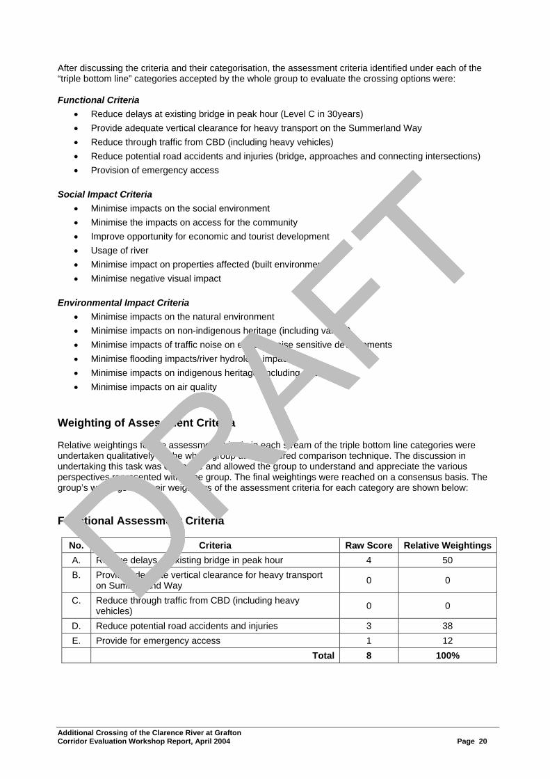
DRAFT After discussing the criteria and their categorisation, the assessment criteria identified under each of the “triple bottom line” categories accepted by the whole group to evaluate the crossing options were: Functional Criteria
• Reduce delays at existing bridge in peak hour (Level C in 30years) • Provide adequate vertical clearance for heavy transport on the Summerland Way • Reduce through traffic from CBD (including heavy vehicles) • Reduce potential road accidents and injuries (bridge, approaches and connecting intersections) • Provision of emergency access
Social Impact Criteria
• Minimise impacts on the social environment • Minimise the impacts on access for the community • Improve opportunity for economic and tourist development • Usage of river • Minimise impact on properties affected (built environment) • Minimise negative visual impact
Environmental Impact Criteria
• Minimise impacts on the natural environment • Minimise impacts on non-indigenous heritage (including values) • Minimise impacts of traffic noise on existing noise sensitive developments • Minimise flooding impacts/river hydrology impacts • Minimise impacts on indigenous heritage (including values) • Minimise impacts on air quality
Weighting of Assessment Criteria Relative weightings for the assessment criteria in each stream of the triple bottom line categories were undertaken qualitatively by the whole group using a paired comparison technique. The discussion in undertaking this task was extensive and allowed the group to understand and appreciate the various perspectives represented within the group. The final weightings were reached on a consensus basis. The group’s workings and their weightings of the assessment criteria for each category are shown below: Functional Assessment Criteria
No. Criteria Raw Score Relative WeightingsA. Reduce delays at existing bridge in peak hour 4 50 B. Provide adequate vertical clearance for heavy transport
on Summerland Way 0 0
C. Reduce through traffic from CBD (including heavy vehicles) 0 0
D. Reduce potential road accidents and injuries 3 38 E. Provide for emergency access 1 12 Total 8 100%
Additional Crossing of the Clarence River at Grafton Corridor Evaluation Workshop Report, April 2004 Page 20
DRAFT
DRAFT
DRAFT
DRAFT

DRAFT
Scoring Matrix
The workings for the relative assessment are shown below.
B C D E
A N/A 2A 1A 1A
B N/A N/A N/A
C 1D 1E
D 2D
E
The extent one criteria was preferred by the group over another was indicated by using the scoring system below:
3. Major Preference 2. Medium Preference
1. Minor Preference Summary The weighting of the assessment criteria for Functional Performance using the paired comparison methodology indicated that the “Reducing delays at the existing bridge in peak hour” was the most important criteria followed by the “Reducing potential road accidents and injuries” on the next level of importance. This was followed by “Provision of emergency access” in importance. “Reducing through traffic from the CBD” although important was not considered as important as the other criteria when compared in pairs and scored zero. Also the criteria, “Providing adequate clearance for heavy vehicles on the Summerland Way” was not compared by the group as they believed although it was required, it could not be used to differentiate between the options. Social Impact Criteria
No. Criteria Raw Score Relative WeightingsA. Minimise impacts on social environment 7 23 B. Minimise impacts on access for the community 1 3 C. Improve opportunity for economic and tourist development 9 29 D. Usage of river 0 0 E. Minimise impact on properties affected (built environment) 3 10 F. Minimise negative visual impact 11 35 Total 31 100%
Scoring Matrix
The workings for the relative assessment are shown below.
B C D E F
A 3A 1C 3A 1A 1F
B 3C 1B 1E 3F
C 3C 2C 1F
D 2E 3F
E 3F
F
Additional Crossing of the Clarence River at Grafton Corridor Evaluation Workshop Report, April 2004 Page 21
DRAFT
DRAFT
DRAFT
DRAFT

DRAFTThe extent one criteria was preferred by the group over another was indicated by using the scoring system below:
3. Major Preference 2. Medium Preference
1. Minor Preference Summary The weighting of the assessment criteria for Social Impacts using the paired comparison methodology indicated that the “Minimising negative visual impacts” was the most important criteria followed by the “Minimising impacts on the social environment” and “Improving opportunity for economic and tourist development” on the next level of importance, then “Minimising impact on properties affected (built environment)” on the next level of importance followed by “Minimising impacts on access for the community” in importance. “Usage of the river” although important was not considered as important as the other criteria when compared in pairs and scored zero. Environmental Impact Criteria
No. Criteria Raw Score Relative WeightingsA. Minimise impacts on natural environment 0.5 2 B Minimise impacts on non-indigenous heritage (including
values) 5.5 18
C. Minimise impacts of traffic noise on existing noise sensitive developments 10.5 35
D. Minimise flooding impacts/river hydrology impacts 8 27 E. Minimise impacts on indigenous heritage (including
values) 0.5 2
F. Minimise impacts on air quality 5 16 Total 30 100%
Scoring Matrix
The workings for the relative assessment are shown below.
B C D E F
A 2B 3C 3D A/E 2F
B B/C 3D 1B 2B
C 1C 3C 3C
D 2D 1F
E 2F
F The extent one criteria was preferred by the group over another was indicated by using the scoring system below:
3. Major Preference 2. Medium Preference
1. Minor Preference Summary
Additional Crossing of the Clarence River at Grafton Corridor Evaluation Workshop Report, April 2004 Page 22
The weighting of the assessment criteria for Environmental Impacts using the paired comparison methodology indicated that the “Minimising impacts on traffic noise on existing noise sensitive developments” was the most important criteria followed by “Minimising flooding impacts/river hydrology impacts” on the next level of importance, then the “Minimising impacts on non-indigenous heritage (including values)” and “Minimising impacts on air quality” on the next level of importance followed by “Minimising impacts on natural environment” and “Minimising impacts on indigenous heritage (including values)”.
DRAFT
DRAFT
DRAFT
DRAFT

DRAFT A summary of the weightings of the assessment criteria within the triple bottom line categories as determined by the group appears below.
Assessment Criteria
Functional Social Impacts Environmental Impacts
Criteria Wt Criteria Wt Criteria Wt Reduce delays at existing bridge in peak hour (Level C in 30yrs)
50% Minimise impacts on the social environment 23% Minimise impacts on the
natural environment 2%
Provide adequate vertical clearance for heavy transport on Summerland Way
Not Used
Minimise the impacts on access for the community 3%
Minimise impacts on non-indigenous heritage (including values)
18%
Reduce through traffic from CBD (including heavy vehicles)
0% Improve opportunity for economic and tourist development
29% Minimise impacts of traffic noise on existing noise sensitive developments
35%
Reduce potential road accidents and injuries (bridge, approaches and connecting intersections)
38% Usage of river 0% Minimise flooding impact/river hydrology 27%
Provision of emergency access 12%
Minimise impact on properties affected (built environment)
10% Minimise impact on indigenous heritage (including values)
2%
Minimise negative visual impact 35% Minimise impact on air
quality 16%
These weighted assessment criteria would later be used to evaluate the various crossing options for the project. Having built a foundation and common understanding of the problems and issues, the objectives (what the project is to achieve), assumptions and the assessment criteria for option evaluation, the group was now in a position to broadly review the crossing options shortlisted for the project.
Additional Crossing of the Clarence River at Grafton Corridor Evaluation Workshop Report, April 2004 Page 23
DRAFT
DRAFT
DRAFT
DRAFT

DRAFT
Appendix 3. Crossing Option Review, Evaluation and Recommendation
Additional Crossing of the Clarence River at Grafton Corridor Evaluation Workshop Report, April 2004 Page 24
DRAFT
DRAFT
DRAFT
DRAFT
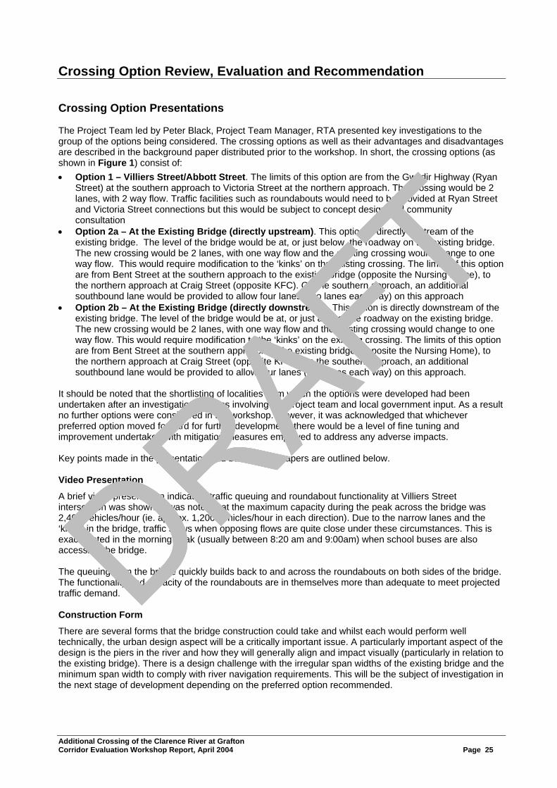
DRAFT Crossing Option Review, Evaluation and Recommendation Crossing Option Presentations The Project Team led by Peter Black, Project Team Manager, RTA presented key investigations to the group of the options being considered. The crossing options as well as their advantages and disadvantages are described in the background paper distributed prior to the workshop. In short, the crossing options (as shown in Figure 1) consist of: • Option 1 – Villiers Street/Abbott Street. The limits of this option are from the Gwydir Highway (Ryan
Street) at the southern approach to Victoria Street at the northern approach. The crossing would be 2 lanes, with 2 way flow. Traffic facilities such as roundabouts would need to be provided at Ryan Street and Victoria Street connections but this would be subject to concept design and community consultation
• Option 2a – At the Existing Bridge (directly upstream). This option is directly upstream of the existing bridge. The level of the bridge would be at, or just below, the roadway on the existing bridge. The new crossing would be 2 lanes, with one way flow and the existing crossing would change to one way flow. This would require modification to the ‘kinks’ on the existing crossing. The limits of this option are from Bent Street at the southern approach to the existing bridge (opposite the Nursing Home), to the northern approach at Craig Street (opposite KFC). On the southern approach, an additional southbound lane would be provided to allow four lanes (two lanes each way) on this approach
• Option 2b – At the Existing Bridge (directly downstream). This option is directly downstream of the existing bridge. The level of the bridge would be at, or just above, the roadway on the existing bridge. The new crossing would be 2 lanes, with one way flow and the existing crossing would change to one way flow. This would require modification to the ‘kinks’ on the existing crossing. The limits of this option are from Bent Street at the southern approach to the existing bridge (opposite the Nursing Home), to the northern approach at Craig Street (opposite KFC). On the southern approach, an additional southbound lane would be provided to allow four lanes (two lanes each way) on this approach.
It should be noted that the shortlisting of localities from which the options were developed had been undertaken after an investigation process involving the project team and local government input. As a result no further options were considered in the workshop. However, it was acknowledged that whichever preferred option moved forward for further development, there would be a level of fine tuning and improvement undertaken with mitigation measures employed to address any adverse impacts. Key points made in the presentation and background papers are outlined below. Video Presentation
A brief video presentation indicating traffic queuing and roundabout functionality at Villiers Street intersection was shown. It was noted that the maximum capacity during the peak across the bridge was 2,400 vehicles/hour (ie. approx. 1,200 vehicles/hour in each direction). Due to the narrow lanes and the ‘kinks’ in the bridge, traffic slows when opposing flows are quite close under these circumstances. This is exacerbated in the morning peak (usually between 8:20 am and 9:00am) when school buses are also accessing the bridge. The queuing from the bridge quickly builds back to and across the roundabouts on both sides of the bridge. The functionality and capacity of the roundabouts are in themselves more than adequate to meet projected traffic demand. Construction Form
There are several forms that the bridge construction could take and whilst each would perform well technically, the urban design aspect will be a critically important issue. A particularly important aspect of the design is the piers in the river and how they will generally align and impact visually (particularly in relation to the existing bridge). There is a design challenge with the irregular span widths of the existing bridge and the minimum span width to comply with river navigation requirements. This will be the subject of investigation in the next stage of development depending on the preferred option recommended.
Additional Crossing of the Clarence River at Grafton Corridor Evaluation Workshop Report, April 2004 Page 25
DRAFT
DRAFT
DRAFT
DRAFT

DRAFT Traffic and Safety
The traffic investigations considered: • Urban growth in the Grafton area and in nearby centres 30 years into the future • Traffic issues raised by the community during the consultation process • Future traffic growth and needs up to 30 years • A review of existing data and collection of additional traffic data • Traffic modeling and analysis • A benefit cost analysis based on traffic modeling outputs and project cost estimates.
The results of the traffic investigations are detailed below.
Vehicle Classification Counts Vehicle classification counts determine the types of light and heavy vehicles that use the road. Vehicle classification counts were conducted for the week ending Sunday 21 September 2003 in various locations on the Summerland Way and residential streets in Grafton. Daily volumes during the survey week progressively increased from 24,000 on Monday to 28,000 on Friday whilst weekend volumes were considerably lower. The figure of 26,000 vehicles per day on the bridge was used for analysis purposes as it reflects typical weekday traffic flows. The traffic volumes recorded for Junction Hill are considerably lower than those at the Clarence River Bridge and give an initial indication that the majority of traffic that use the existing bridge is local traffic rather than through traffic using the Summerland Way. Origin and Destination Survey To determine where traffic was traveling to and from, an Origin and Destination Survey was conducted over a 12 hour period between 7am and 7pm during Thursday 18 September 2003. During the survey, vehicle classification counters were installed at eight specified locations. The number plates of all heavy commercial vehicles (i.e., articulated vehicles Austroads Class 6 and above), and all “red” cars were recorded to track heavy commercial vehicles and the proportion of cars that turned off the Pacific Highway and traveled north through Grafton to the Summerland Way. The daily volumes recorded on that day at the Clarence River Bridge were 13, 440 northbound and 13,335 southbound, totaling 26, 775. Of the 26,775 vehicles that used the bridge on the survey day, less than 1000 (3.7%) of those vehicles also traveled through Junction Hill. Only 70 of the 400 heavy commercial vehicles using the bridge on the survey day were ‘through traffic’. Further investigations were undertaken to determine the number of log trucks that turned off the Summerland Way at Junction Hill to access the timber mills. These were not counted in the original origin and destination survey and there would be another 22 log trucks per day that would be classified as through vehicles bringing the total to 92 out of 400 were ‘through traffic’. Results of the origin and destination survey therefore indicate that the main traffic flows across the Clarence River Bridge are to and from Grafton. A very small percentage is through, or bypass, traffic. Heavy Vehicles
The 2003 survey showed that total heavy vehicles accounted for 5% of total traffic during peak hour traffic.
Road Capacity Previous traffic counts indicate that during 2001 the peak traffic period is 2.5 hours per day, typically comprising 45 minutes in the morning (8:15–9:00 am) and 1 hour 45 minutes in the afternoon (3:30–5:15 pm). Recent traffic counts indicate that afternoon peak hour traffic is busier than the morning peak hour traffic. However, the traffic during the morning peak hour is more concentrated. Similar, pm-peak hour traffic occurs on the bridge between 4:30-5:30 pm but is less intense and queuing is not as extensive as the morning period. It is anticipated, the peak period would extend to 3 hours by 2011 and the delays currently experienced in the morning peak leading up to 9:00am would be common for the whole period, morning and afternoon. This would mean longer traffic delays.
Additional Crossing of the Clarence River at Grafton Corridor Evaluation Workshop Report, April 2004 Page 26
DRAFT
DRAFT
DRAFT
DRAFT

DRAFT Intersection Capacity Previous traffic investigations conducted indicate that the Villiers Street/Fitzroy Street and Through Street/Bent Street roundabouts would continue to operate satisfactorily if the existing bridge were to be duplicated. Traffic modeling indicated that these intersections would be able to accommodate an increase in traffic of up to 30%, which is the predicted growth (1%) for the next 30 years. The Villiers and Fitzroy Street roundabout would reach practical capacity in about 30 years for Options 2a and 2b. The two roundabouts in Bent Street (Options 2a and 2b) on the southern side of the river would function satisfactorily for the 30 year period but may require traffic management for other reasons, eg, pedestrians, turning paths for trucks, and unexpected increased turning volumes for certain movements. Pedestrians
Pedestrians are well catered for on the existing bridge with a footpath on both sides at rail level. No additional pedestrian facilities would be provided for Options 2a and 2b. A pedestrian/cycleway would be considered for Option 1.
Future Traffic Volumes and Associated Impacts Traffic data collected from the vehicle classification counts and the origin and destination survey has been used to predict future volumes on the three options being considered. Option 1: Would attract considerable traffic (11,000 vpd) off the existing bridge, due to its proximity to the existing bridge and the Pacific Highway. Much of the South Grafton traffic and the majority of the Gwydir Highway traffic would be attracted to this Option. Some traffic would use Victoria Street to disperse prior to entering the Villiers Street / Fitzroy Street roundabout. This would have some benefits for the intersection but the additional traffic in Victoria Street would have impacts on parking and safety. Traffic volumes in Villiers Street to the north of Fitzroy Street would not necessarily increase to any significant degree. Option 1 would need the Villiers Street southern approach widened to 2 entry lanes into the roundabout at Fitzroy Street. There would be less traffic entering the Fitzroy St roundabout compared to Options 2a and 2b because some traffic would use Victoria Street. This would mean slightly less congestion at the roundabout in the long term. Option 1 would reduce the delays on the existing bridge in the short term but the existing bridge would reach current volumes in the 30 year analysis period. Option 2a and 2b: Both options would have the same traffic benefits. A second bridge located adjacent to the existing bridge, either directly upstream or directly downstream, provides the highest traffic benefits of the crossings considered due to two travel lanes being available in one direction on the existing and additional crossing. This would require modification of the ‘kinks’. A 2 lane, one way facility provides better travel conditions – freedom to maneuver, ability to pass slower vehicles, extra capacity. However, the impact on existing intersections is greater because Options 2a and 2b centralises traffic flows. Option 1 distributes traffic more widely. Traffic modeling shows that the Villiers Street / Fitzroy Street intersection would operate satisfactorily under its current configuration within the 30 year period. The intersection on the southern approach at Bent Street/Through Street is shown to function satisfactorily but may require traffic management within 30 years. Option 2a and 2b would reduce the delays on the existing bridge in the long term by eliminating the peak hour delays for the 30 year analysis period. Environment
Ecology Potential impacts as a result of an additional crossing in the study area would include the removal of native vegetation, loss of vegetation structure and riparian vegetation, the spread of noxious weeds and new weed propagules to the area. It is anticipated that the level of impact would be minimal in Options 1, 2a and 2b that have previously been disturbed and cleared and consist mainly of rural agricultural pastures or built environments. Option 1 would require the removal of a large fig tree in Villiers Street which is part of the Grafton Conservation Area (National Estate Register). Options 1, 2a and 2b would impact on riverweed bed habitat.
Additional Crossing of the Clarence River at Grafton Corridor Evaluation Workshop Report, April 2004 Page 27
DRAFT
DRAFT
DRAFT
DRAFT
DRAFTThe southern approach to Option 2a would impact on a revegetated area on the southern bank of the Clarence River. In addition the Options also have the potential to impact upon landscape trees located within each of the localities, through widening potential works associated with the Proposal. These trees mainly include species within the genera of Brachychiton, Ficus or Jacaranda that are located throughout the streets of the City of Grafton and are of local heritage significance. It is anticipated that Options 2a and 2b would have the least impact as these Options do not lie close to any remnant vegetation and would be confined to an existing area of wildlife movement obstruction and potential road strike. However, there is the potential that the existing bridge may provide habitat and shelter for micro-chiropteran bat species and some bird species. Option 1 has the potential to affect a large fig tree that is likely habitat for bat species, and may cause a barrier to fauna movement, particularly bat species, due to its closer proximity to Susan Island. During construction, the Options may cause primary impacts such as loss of riparian and sub tidal fish habitat due to disturbance of the foreshore, shading, bed scouring, and accelerated sedimentation. The operation of the Options may result in secondary impacts such as long term barriers to fish movements, changes to habitat in particular aquatic plant communities, increased pollution, and alter the frequency of flooding by altering bank heights. Floodplains provide important food sources and spawning grounds for fish during floods and allow fish to move between rivers, creeks and wetlands (NSW Fisheries, 1999). Option 1 would have a greater impact upon fish habitat than Options 2a and 2b due to the potential disturbance to existing weed beds. It is considered that Options 2a and 2b would have the least potential impact due to the lack of existing habitat. The positioning of bridge piers for Options 2a and 2b is likely to be similar to the existing bridge and require less number of piers than Option 1 due to bridge length. Air Quality The operation of the Options has the potential to alter existing air quality through changes in traffic volumes and travel behaviour. Emissions to the atmosphere during the operational phase would predominantly be emitted from the combustion of fuel used in vehicles. Typical emissions for both phases would include carbon monoxide, nitrogen dioxide, hydrocarbons, particulate matter and carbon dioxide. Option 1 is likely to have the greater increase in emissions due to the increase in traffic volumes (up to 11,000 vpd in Abbott Street), while Options 2a and 2b would have a slight decrease in emissions due to the improvement of traffic flow, including reduction of stoppages at the ‘kinks’. Cultural
Indigenous Heritage The potential for Indigenous heritage within and surrounding Options 1 and Option 2a is generally low as much of the riverbank and floodplain in these areas has been disturbed from flooding, levee construction, agricultural practices and landscaping works associated urban development. However, some sub surface material of disturbed nature may still be present in these areas. The potential for Indigenous heritage within and surrounding Option 2b is relatively high. A place of Aboriginal ceremony and dreaming has been identified downstream of the existing bridge, along the southern bank of the river. The potential for further presence of dreaming and ceremonial sites associated with the Clarence River is also likely. In general, the Indigenous community has recorded all of the study area as a significant Indigenous area for a variety of reasons. Non-Indigenous Heritage Non-Indigenous Heritage items are located within the vicinity of all three Options. Heritage items within the vicinity of Option 1 include items within the Conservation Area of the North Coast REP, Grafton LEP and register of National Estate, and heritage trees as defined by the LEP. Such trees have the potential to be impacted by road widening works associated with the Proposal. Impacts upon items within the Conservations areas would be dependant upon the local significance of such items, such as the local schools and churches.
Additional Crossing of the Clarence River at Grafton Corridor Evaluation Workshop Report, April 2004 Page 28
DRAFT
DRAFT
DRAFT
DRAFT

DRAFTOption 2a would avoid the remains of the S.S Induna located 200m west of the existing bridge on the south bank of the river and the Bow Memorial within Earle Page Park, although may affect a small portion of the Park land. Option 2a also has the potential to impact upon the heritage listed rail viaducts with the modification of the ‘kinks’, State Heritage listed Clarence River Bridge and heritage trees defined by the Grafton LEP. This Option also falls within the Conservation Area of the North Coast REP. Option 2b is likely to have the least impacts in comparison to Options 1 and 2a, however Option 2b still has the potential to impact upon the rail viaducts with the modification of the ‘kinks’ and the State Heritage listed Clarence River Bridge. Option 2b would have the least visual impacts upon the existing Bridge. Note that any modifications to the existing bridge would require approval from NSW State Heritage Office. In addition, approval from the Minister for the Environment and Heritage would be required for any action that takes place, which has, or is likely to have, a significant impact on national heritage values within the Grafton Conservation Area. Hydrology The Clarence River is the largest New South Wales coastal river with a catchment of some 19,820 sq km. The river system has a long history of flooding. The river is essentially confined at Mountain View, 14 km upstream of Grafton, but gradually spreads to an expansive floodplain downstream of Grafton. In response to the disruption of flooding, major levees have been constructed at North Grafton, South Grafton, and along the river banks in the downstream rural areas. The levees at North Grafton notionally provide protection to the one percent AEP flood, but with no freeboard. However, recent floods in 1996 and May 2001 have shown that the grade of the levee crest downstream of the existing bridge may not provide the expected level of protection. A levee failure in Grafton would create a major "disaster" situation within Grafton, with substantial damage to public and private property and an attendant risk of loss of life. The proposed design standards for the assessment were:
• Afflux (increase in flood levels upstream) in the 1% AEP flood should not exceed 100 mm upstream of the existing bridge and 50 mm downstream of the existing bridge
• Afflux created at the road design level should not exceed 200 mm • Road shoulder level to be set at the design flood level plus allowance for 200 mm afflux
The above design considerations are based on maintaining the flood protection provided. Preliminary assessment of affluxes created by the bridges on the three options is shown below (Table 1).
Table 1: Afflux Comparison of Options Option Afflux 1 0.05m 2a 0.075m 2b 0.075m
The Clarence River County Council commissioned an extensive flood study of the Clarence River in 1999. The draft report was publicly released in December 2003 and after the Hydrology Report for the project was completed. The CRCC report has been examined to identify differences that might affect the route and bridge evaluation process. In the evaluation process, the major items of concern are peak flood discharge and peak flood level for the 100 year Average Recurrence Interval (ARI) (1 percent Annual Exceedence Probability, AEP) flood. The design 100 year ARI flood is an important sized flood, given:
− It represents the normal "flood" used for bridge design − The levee system at Grafton was notionally designed to protect against this flood
A comparison of critical items for the design 100 year ARI flood as used in the Hydrology Report for the project and in the CRCC report appears below (Table 2).
Table 2 Comparison of Design Parameters Design Parameter Hydrology Report CRCC Report Peak Flow (cu m/sec) 20,600 19,060 Peak level, Prince Street (m AHD) 8.27 8.36
Additional Crossing of the Clarence River at Grafton Corridor Evaluation Workshop Report, April 2004 Page 29
DRAFT
DRAFT
DRAFT
DRAFT

DRAFT
It is also noted that the 1985 report "South Grafton Levee Augmentation Study" used a peak flow of 20,600 cu m/sec and a predicted level of 8.15 m AHD. Comparison of the information in Table 1 above shows little difference between the information used in the Hydrology Report and that shown in the CRCC Report. It is concluded there is not a need to modify the recommendations of the Hydrology Report. Comparison of the underwater bed profiles is being undertaken for:
− 1910 as per Bridge Design Drawing − 1983 PWD hydro survey − 2001 RTA survey − 2004 RTA survey
Comparison of the surveys shows up to five metres of erosion is evident between the 1910 profile and 2001 profile. Inspection and bed sampling on 1 April 2004 showed that the bed at Piers 2 and 3 scoured to the bedrock with no signs of undercutting and that the bed material generally consisted of fine sand. The proposed bridge is envisaged as using piles socketed into the underlying rock. This construction thus can be designed such that the erodible bed material is not required for structural strength. In terms of restricting the changes to sediment movement that occurs during floods and the impact on the existing bridge, the ranking of the route options would be:
− Rank 1: Option 1 as this structure is the most upstream and furthest from the existing bridge − Rank 2: Option 2b as at this location, the new structure will cause less turbulence and hence
erosion against the existing structure − Rank 3: Option 2a
Noise
Further investigations have been conducted into operational noise issues associated with Options 1, 2a and 2b. This included further noise monitoring to determine existing background noise levels and noise predictions for each of the Options.
Noise Monitoring
Existing background noise levels were measured using two noise data loggers from 15th to 23rd September 2003 and six data loggers from 17th to 30th March 2004 at the closest residences on the northern and southern sides of the Clarence River, upstream and downstream of the existing bridge.
Table 3 represents a summary of the measured assessment background noise levels (ABL) and ambient noise levels for Daytime (LAeq, 15hr) and Nightime (LAeq, 9hr)
Receptor Measured Daytime dB(A) (7am to 10pm)
DEC Criteria for Daytime dB(A)
DEC Criteria ExceedancedB
Measured Nightime dB(A) (10pm to 7am)
DEC Criteria for Nightime dB(A)
Criteria ExceedancedB
North 57.0 60.0 -3.0 51.5 55.0 -3.5 South 57.4 60.0 -2.6 53.3 55.0 -1.7 1 52.5 55.0 -2.5 48.9 50.0 -1.1 2 58.1 60.0 -1.9 47.7 50.0 -2.3 3 61.7 N/a - 51.6 N/a - 4 51.5 50.0 1.5 39.4 50.0 -10.6 5 58.4 N/a - 51.1 N/a - 6 56.3 60.0 -3.7 49.5 55.0 -5.5
Note: Receptor locations include: 1: End of Abbot Street 2: Outside 43 Abbot Street 3: Outside music conservatorium 4: Convent facing Villiers Street 5 End of Catherine McAuley school oval 6: No. 4 McClymont Place
Table 3 shows the measured daytime and nightime traffic noise levels at residences North and South to be within the relevant DEC criteria by approximately 2 to 3 dB. All other locations also fall within the relevant DEC criteria except for location No. 4 located at the Convent facing Villiers Street.
Additional Crossing of the Clarence River at Grafton Corridor Evaluation Workshop Report, April 2004 Page 30
DRAFT
DRAFT
DRAFT
DRAFT

DRAFT
Noise Modelling
Table 4 provides a summary of the noise predictions including existing noise levels.
Table 4 Summary of future noise levels modelled using traffic noise contours for (LAeq 15) Day time 7am – 10pm.
Predicted Noise Levels
Southern approach
At the Crossing
Northern approach
DEC Noise Criteria - Daytime
Option 1 50 – 60dB(A) 55dB(A) 55 – 65dB(A) 40 – 55dB(A) Option 2a 50 – 65dB(A) 50 – 60dB(A) 50 – 60dB(A) 60dB(A) Option 2b 60 –65dB(A) 55 – 60dB(A) 55 – 60dB(A) 60dB(A)
Table 5 Summary of future noise levels modelled using traffic noise contours for (LAeq 9) night-time 10pm-7am.
Predicted Noise Levels
Southern approach
At the Crossing
Northern approach
Dec Criteria Night-time
Option 1 45 – 55dB(A) 50dB(A) 50 – 60dB(A) 50dB(A) Option 2a 40 – 55dB(A) 40 – 50dB(A) 40 – 50dB(A) 55dB(A) Option 2b 50 – 55dB(A) 50dB(A) 45 – 50dB(A) 55dB(A)
Results of the noise modelling conclude that either Option 2a or 2b provide negligible impact when operated in conjunction with the existing bridge as a split two-lane configuration. This is primarily because the existing traffic volume would be split equally over two bridges combined with the increased noise shielding of both bridges being side by side. Most residents affected by traffic noise from the existing bridge are not likely to perceive a noticeable change in received noise levels from either Options 2a or 2b operating as a split two-lane configuration. Option 1 significantly impacts sensitive land use, ie, a school and a place of worship, located either side of Villiers Street as well as residents on Abbot Street, all of which are not currently affected by significant traffic noise. Stringent DEC criteria for sensitive land use may significantly increase the difficulty for compliance with the implementation of feasible, cost effective noise mitigation measures. In comparison of all three options against relevant DEC criteria including criteria for sensitive land use, Option 1 would generate noise levels that would exceed the recommended noise criteria, in some cases by 5-10dB(A). However, the implementation of this Option would marginally decrease existing noise levels at the existing bridge by attracting traffic away from that location. The level of noise exceedence for both Options 2a and 2b are very similar with noise levels likely to be greater on the southern approach rather than the northern approach, although the exceedance is not as significant as noise levels associated with Option 1. Similar to Option 1, receptors on the opposing side of the existing bridge and preferred alignment may experience a slight decrease in noise. Option 2b may generally generate greater noise levels than Option 2a, as noise levels predicted tend to be a slightly greater. Social and Economic Impacts
Social Impacts Recent investigations undertaken have revealed that there are a number of concerns in the general community about the existing bridge. The community seems generally in agreement that a new crossing is necessary. Key reasons cited are the traffic delays currently experienced at peak hours on weekdays, the need for emergency services to be able to cross the bridge at all times without delays, and safety issues associated with trucks and buses using the existing bridge.
Additional Crossing of the Clarence River at Grafton Corridor Evaluation Workshop Report, April 2004 Page 31
DRAFT
DRAFT
DRAFT
DRAFT

DRAFT Option 1 Positive social impacts with Option 1 include:
• Would alleviate the use of the existing bridge and Bent Street by heavy vehicles • Improved access to city centre for residents of Waterview Heights, Coutts Crossing and South
Grafton (particularly those on western side of Bent Street) • Alternative access for emergency vehicles • Land along Gwydir Highway and in this western section of South Grafton generally likely to become
more attractive for commercial development • Likely increase of traffic into the South Grafton business area generally improving business for
proprietors in this location • Is a direct route to the Summerland Way heavy vehicle detour along Villiers Street • Reduced traffic in Bent Street would provide increased amenity to Bent and Fitzroy Street residents
Negative social impacts with Option 1 include:
• Impact on safety and amenity issues for children attending schools and conservatorium on the northern approach
• Potential noise impacts for conservatorium • Potential access problems at Victoria Street • Increased traffic could result in increased pollution into businesses in this location • Increased traffic using Ryan Street to access this Option • Loss of parking in the section of Villiers Street from the river to Fitzroy Street • Loss of amenity to residences in Abbott Street • Access concerns at intersection of Abbott Street with Kennedy Street • Acquisition of one house may be required • Impact on river users particularly sailing • Loss of visual amenity for residents and businesses in Grafton and South Grafton with views over
the river Option 2a and 2b Positive social impacts with option 2a and 2b include:
• Better access into the city centre, with likely flow-on effects of increased spending by tourists and passing trade
• Improved access for emergency vehicles • Continued high traffic flows along Bent Street and of benefit to proprietors in this location • Retains existing traffic on Fitzroy and Bent Streets, and will result in little adverse strategic impacts
on land uses • Retains existing bridge approaches in Bent and Fitzroy Streets
Negative social impacts with Option 2a and 2b include:
• Uncertainty about impacts and development possibilities, which may manifest in individual community members through increased stress, anxiety or apathy about the future
• Changes to personal economic situations through changes to property values • Land acquisition, including houses, would be affected. Refer to Table 6 showing acquisition
impacts for Option 2a and 2b • Perceptions that individual property owners and residents will suffer because of decisions made for
the benefit of the wider community • Concerns over reduction in amenity values for residential areas likely to be affected • Impact on recreation areas on the northern approach particularly the Sailing Club (Option 2a) • Potential minor impact on Earle Page Park on the southern approach (Option 2a) • Perception of changes in existing levels of community cohesion and integration • Concerns over the heritage value of the existing bridge, and how any additional crossing may affect
its amenity Additional Crossing of the Clarence River at Grafton Corridor Evaluation Workshop Report, April 2004 Page 32
DRAFT
DRAFT
DRAFT
DRAFT
DRAFT Economic Impact Results of discussions held to date with members of the business community in the study area conclude that the business and employment sector of the community seems generally in agreement that a new crossing is necessary. Businesses in Grafton cite difficulties of deliveries into the city centre and the fact that the perceived problems with the existing bridge may alter shopping preferences for customers. Many businesses appear to alter their business operations (in terms of trips and/or timing) because of the present level of congestion associated with the existing bridge. Option 1 Positive economic impacts for Option 1 include:
• A potential increase in the number of customers and tourists into the city centre because of perceived increase in travel safety over bridge
• Quicker travel times for trips to work and making deliveries • Increased access to regional areas, with flow-on economic benefits • Ease of access for delivery trucks • Buses would better able to meet timetables • Flow on effects of reduced congestion, reduced emissions and noise at existing bridge • Facilitation of urban growth and economic development within Grafton City
Negative economic impacts for Option 1 include:
• Disruption to businesses located at or near the additional crossing • Changes to economic situations and business profitability through changes to traffic volumes past
existing business in Bent Street • The potential creation of business and industry development nodes
Option 2a and 2b Positive economic impacts for Option 2a and 2b include:
• A potential increase in the number of customers and tourists into the city centre because of perceived increase in travel safety over bridge
• Quicker travel times for trips to work and making deliveries • Increased access to regional areas, with flow-on economic benefits • Ease of access for delivery trucks • Buses would better able to meet timetables • Flow on effects of reduced congestion and reduced emissions at the existing bridge • Reduced braking noise at the ‘kinks’ • Facilitation of urban growth and economic development within Grafton City
Negative economic impacts for Option 2a and 2b include:
• Disruption to businesses located at or near the proposed additional crossing
Additional Crossing of the Clarence River at Grafton Corridor Evaluation Workshop Report, April 2004 Page 33
DRAFT
DRAFT
DRAFT
DRAFT
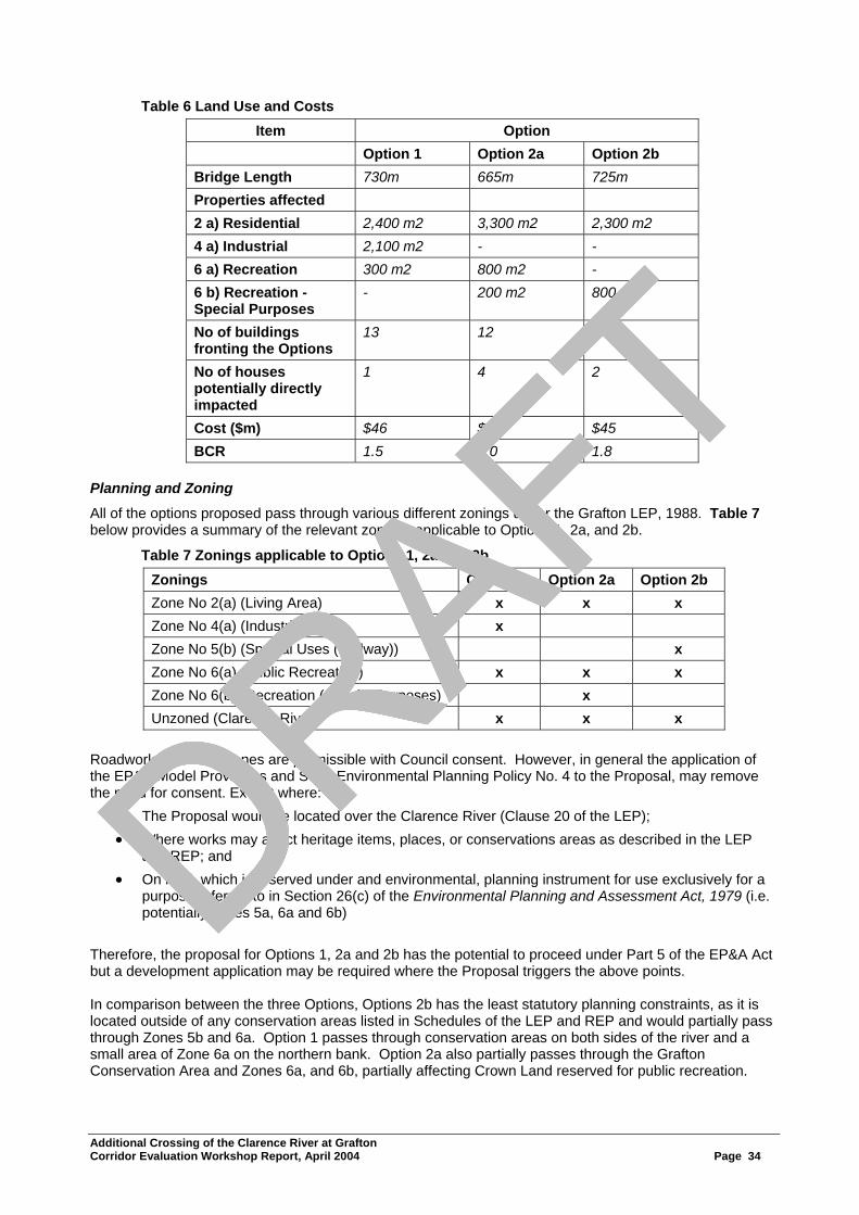
DRAFT
Table 6 Land Use and Costs Item Option
Option 1 Option 2a Option 2b Bridge Length 730m 665m 725m Properties affected 2 a) Residential 2,400 m2 3,300 m2 2,300 m2 4 a) Industrial 2,100 m2 - - 6 a) Recreation 300 m2 800 m2 - 6 b) Recreation -Special Purposes
- 200 m2 800 m2
No of buildings fronting the Options
13 12 3
No of houses potentially directly impacted
1 4 2
Cost ($m) $46 $40 $45 BCR 1.5 2.0 1.8
Planning and Zoning
All of the options proposed pass through various different zonings under the Grafton LEP, 1988. Table 7 below provides a summary of the relevant zonings applicable to Options 1, 2a, and 2b.
Table 7 Zonings applicable to Options 1, 2a and 2b Zonings Option 1 Option 2a Option 2b Zone No 2(a) (Living Area) x x x Zone No 4(a) (Industrial) x Zone No 5(b) (Special Uses (Railway)) x Zone No 6(a) (Public Recreation) x x x Zone No 6(b) (Recreation (Special Purposes) x Unzoned (Clarence River) x x x
Roadworks within all zones are permissible with Council consent. However, in general the application of the EP&A Model Provisions and State Environmental Planning Policy No. 4 to the Proposal, may remove the need for consent. Except where:
• The Proposal would be located over the Clarence River (Clause 20 of the LEP); • Where works may affect heritage items, places, or conservations areas as described in the LEP
and REP; and • On land, which is reserved under and environmental, planning instrument for use exclusively for a
purpose referred to in Section 26(c) of the Environmental Planning and Assessment Act, 1979 (i.e. potentially zones 5a, 6a and 6b)
Therefore, the proposal for Options 1, 2a and 2b has the potential to proceed under Part 5 of the EP&A Act but a development application may be required where the Proposal triggers the above points. In comparison between the three Options, Options 2b has the least statutory planning constraints, as it is located outside of any conservation areas listed in Schedules of the LEP and REP and would partially pass through Zones 5b and 6a. Option 1 passes through conservation areas on both sides of the river and a small area of Zone 6a on the northern bank. Option 2a also partially passes through the Grafton Conservation Area and Zones 6a, and 6b, partially affecting Crown Land reserved for public recreation. Additional Crossing of the Clarence River at Grafton Corridor Evaluation Workshop Report, April 2004 Page 34
DRAFT
DRAFT
DRAFT
DRAFT

DRAFTComparison Table The following updated summary table of comparative parameters was handed out during the workshop:
Criteria Option 1 Option 2 Option 3
Traffic:
2003 Volumes: New Bridge
Existing Bridge Total
11,000 15,000 26,000
13,000 13,000 26,000
13,000 13,000 26,000
2033 Volumes: New Bridge
Existing Bridge Total
13,000 21,000 34,000
17,000 17,000 34,000
17,000 17,000 34,000
2033 Peak Hour LOS: New bridge
Existing Bridge (LOS A=very good, F=very poor)
D E
C C
C C
Ecology Minimal Minimal Minimal
Air Quality Increase Slight Decrease Slight Decrease
Noise +5-10dBa Minimal Minimal
Bridge Length 730m 665m 725m
Properties Affected
2 a) Residential 2,400m2 3,300m2 2,300m2
4 a) Industrial 2,100m2 - -
6 a) Recreational 300m2 300m2 800m2
6 b) Recreation - 2,000m2 -
Number of Buildings fronting the option
13 12 3
Number of houses potentially affected (i.e. to be acquired by RTA)
1 4 2
Capital Cost $46M $40M $45M
BCR (Benefit Cost Ratio) 1.5 2.0 1.8 Advantages and Disadvantages of the Options At the conclusion of the presentation of the options, the group summarised the advantages and disadvantages of each which are recorded below: Option 1 Advantages:
• Improves access to the CBD for South Grafton and areas to the west • Reduces volumes of vehicles on the existing bridge in the short-term • Direct connection to Villiers Street for heavy vehicles. Provides an opportunity to direct traffic away
from CBD • Southern connection would become more attractive for commercial development • Provides value for money • Provides alternative access for emergency vehicles • Provides an additional cycleway/pedestrian way • Removes necessity to take “kinks” out of existing bridge • No visual change at existing bridge
Additional Crossing of the Clarence River at Grafton Corridor Evaluation Workshop Report, April 2004 Page 35
DRAFT
DRAFT
DRAFT
DRAFT
DRAFT Disadvantages:
• Substantial increase in road traffic noise on adjacent schools, businesses and residences (including Victoria Street) causing reduction in amenity
• Other adverse impacts to Victoria Street (ie. potential widening required, etc) • Does not reduce through traffic from the CBD • Height restrictions at the railway viaducts • Safety issues with schools and local streets • Loss of amenity/character of residential streets • Impact on recreational use of the river • Non-indigenous heritage impact on the fig tree located in Villiers Street • Property access issues and land acquisition • Visual impact of noise mitigation walls • Visual impact of view of river looking upstream • Increase traffic in Ryan Street • Impact on river weed beds • Impact on fauna habitat • Impacts on two separate conservation areas • Will not take as much traffic load off existing bridge than Option 2a or 2b
Option 2a Advantages:
• Significantly reduces delays at the existing bridge in the long-term • Reduces potential for crashes on the existing bridge • Minimises the potential for increased road traffic noise in comparison to the other localities • Benefits businesses on the existing approaches • Minimises flooding impacts • Minimises natural environment impacts • Provides value for money • Does not change existing traffic patterns or footprint • Preserves visual amenity of existing bridge downstream • Preserves view of river upstream of bridge • Improves access for emergency services • Preserves character of Victoria Street • Provides a greater option of bridge design than Option 2b • Less visual impact of noise mitigation measures than Option 1
Disadvantages:
• Height restrictions for heavy vehicles at the railway viaducts • Does not reduce through traffic from the CBD • Impact on Heritage Conservation Area (removal of some trees and houses) • Requires upgrade of Fitzroy/Villiers Street and Bent/Through Street intersections in the long term
(20-30 years) • Continued high traffic flow for existing residences • Property/business access issues • Social impacts including land acquisition • Greater impact on recreational areas • Not an alternative route but duplication of existing route • Impacts on riparian vegetation and weed beds (However, less than Option 1) • Visual impact upstream (where there is more populated) • Requires removal of “kinks” on existing bridge • Greater impact on scouring on existing bridge than Option 1 or Option 2b
Additional Crossing of the Clarence River at Grafton Corridor Evaluation Workshop Report, April 2004 Page 36
DRAFT
DRAFT
DRAFT
DRAFT
DRAFT Option 2b Advantages:
• Significantly reduces delays at the existing bridge in the long-term • Reduces potential for crashes on the existing bridge • Minimises the potential for increased road traffic noise in comparison to the other localities • Benefits businesses on the existing approaches • Minimises flooding impacts • Minimises natural environment impacts • Provides value for money • Retains visual amenity upstream • Lesser heritage impact than Option 2a • Retains left turn to Riverside Drive • Lesser visual impact of “kink” removal than Option 2a • Lesser impact on open space and other property acquisition than Option 2a • Does not change existing traffic patterns or footprint • Less visual impact of noise mitigation measures than Option 1 • Preserves visual amenity of existing bridge upstream • Preserves view of river downstream of bridge • Improves access for emergency services • Preserves character of Victoria Street
Disadvantages:
• Height restrictions for heavy vehicles at the railway viaducts • Does not reduce through traffic from the CBD • Requires upgrade of Fitzroy/Villiers Street and Bent/Through Street intersections in the long term
(20-30 years) • Continued high traffic flow for existing residences • Property access issues • Social impacts including land acquisition • Less number of bridge options available than Option 2a • Not an alternative route but duplication of existing route • Requires removal of “kinks” on existing bridge • Larger structures required for this option which could have height and shade impacts • Reduces one of sailing club access sites to river • Visual impact downstream
Assessment of Corridor Options Having reviewed the options and discussed their advantages and disadvantages in relation to the various studies outlined in the presentations as well as the investigations outlined in the background paper, the group was now in a position to evaluate the options against the weighted assessment criteria developed earlier in the workshop. The group (in three focus groups) evaluated the options using the weighted assessment criteria in each of the three categories, separately. One focus group evaluated the options against the functional assessment criteria, whilst a second focus group evaluated the options against the social impact assessment criteria and the third focus group evaluated the options against the environmental impact assessment criteria. The options were judged on a qualitative basis of how well each option met each category’s assessment criteria relatively on a scale of Excellent (E), Very Good (VG), Good (G), Fair (F) or Poor (P). Once the qualitative evaluation was completed, the evaluation was scored using the weightings of the criteria and establishing a ranking for each option within that category. Each focus group discussed their findings and recorded their observations as a result of their deliberations. The findings of each focus group was presented to the whole group for discussion, amendment (if necessary) and finally endorsement (if appropriate) as to an agreed assessment to assist the group move forward. Their findings as presented (together with amendments, if required) and agreed by the whole group are listed below.
Additional Crossing of the Clarence River at Grafton Corridor Evaluation Workshop Report, April 2004 Page 37
DRAFT
DRAFT
DRAFT
DRAFT

DRAFT Evaluation of Corridor Options against Functional Assessment Criteria
54321
SubTotal
EVGGFP
EVGGFP
EVGGFP
EVGGFP
EVGGFP
EVGGFP
EVGGFP
EVGGFP
EVGGFP
RANK
54321
SubTotal
EVGGFP
EVGGFP
EVGGFP
EVGGFP
EVGGFP
EVGGFP
EVGGFP
EVGGFP
EVGGFP
RANK
54321
SubTotal
EVGGFP
EVGGFP
EVGGFP
EVGGFP
EVGGFP
EVGGFP
EVGGFP
EVGGFP
EVGGFP
RANKWTOPTIONS
ASSIGNED WEIGHT
AssessmentCriteria
Functional Criteria
1238
1
2b
2a
4876
36152
36152
1
1
3
224
388
388
50
100
200
200
Red
uced
del
ays
atex
istin
g br
idge
Red
uce
pote
ntia
l roa
dac
cide
nts
& in
jurie
s
Prov
ide
for e
mer
genc
yac
cess
54321
SubTotal
EVGGFP
EVGGFP
EVGGFP
EVGGFP
EVGGFP
EVGGFP
EVGGFP
EVGGFP
EVGGFP
EVGGFP
EVGGFP
EVGGFP
EVGGFP
EVGGFP
EVGGFP
EVGGFP
EVGGFP
EVGGFP
RANK
54321
SubTotal
EVGGFP
EVGGFP
EVGGFP
EVGGFP
EVGGFP
EVGGFP
EVGGFP
EVGGFP
EVGGFP
EVGGFP
EVGGFP
EVGGFP
EVGGFP
EVGGFP
EVGGFP
EVGGFP
EVGGFP
EVGGFP
RANK
54321
SubTotal
EVGGFP
EVGGFP
EVGGFP
EVGGFP
EVGGFP
EVGGFP
EVGGFP
EVGGFP
EVGGFP
RANK54321
SubTotal
EVGGFP
EVGGFP
EVGGFP
EVGGFP
EVGGFP
EVGGFP
EVGGFP
EVGGFP
EVGGFP
EVGGFP
EVGGFP
EVGGFP
EVGGFP
EVGGFP
EVGGFP
EVGGFP
EVGGFP
EVGGFP
RANKWTOPTIONS
ASSIGNED WEIGHT
AssessmentCriteria
Functional Criteria
1238
1
2b
2a
4876
36152
36152
1
1
3
224
388
388
50
100
200
200
Red
uced
del
ays
atex
istin
g br
idge
Red
uce
pote
ntia
l roa
dac
cide
nts
& in
jurie
s
Prov
ide
for e
mer
genc
yac
cess
Key Observations • Constructability issues need to be resolved • Level of service confidence is assumed • Growth assumption could exceed 1% • Emergency management needs to be considered • Pacific Highway traffic detour strategy will be required • Summerland Way route needs resolution and marking
Additional Crossing of the Clarence River at Grafton Corridor Evaluation Workshop Report, April 2004 Page 38
DRAFT
DRAFT
DRAFT
DRAFT
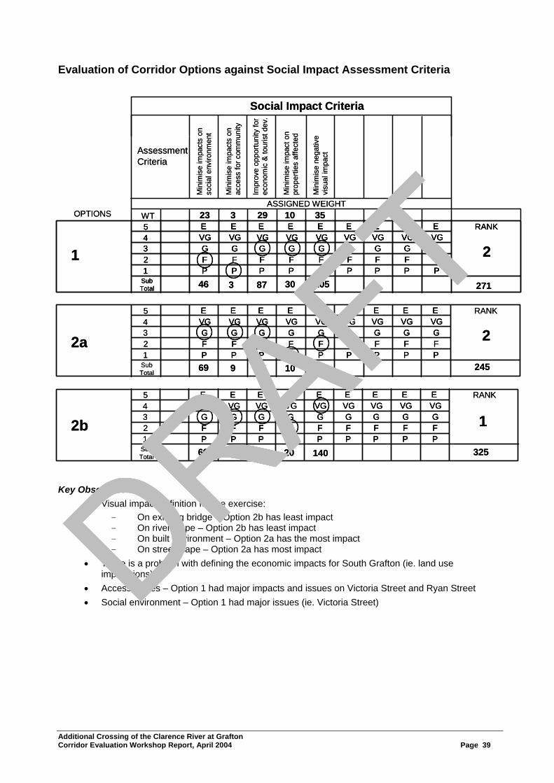
DRAFT
Evaluation of Corridor Options against Social Impact Assessment Criteria
54321
SubTotal
EVGGFP
EVGGFP
EVGGFP
EVGGFP
EVGGFP
EVGGFP
EVGGFP
EVGGFP
EVGGFP
RANK
54321
SubTotal
EVGGFP
EVGGFP
EVGGFP
EVGGFP
EVGGFP
EVGGFP
EVGGFP
EVGGFP
EVGGFP
RANK
54321
SubTotal
EVGGFP
EVGGFP
EVGGFP
EVGGFP
EVGGFP
EVGGFP
EVGGFP
EVGGFP
EVGGFP
RANKWTOPTIONS
ASSIGNED WEIGHT
AssessmentCriteria
Social Impact Criteria
293
1
2b
2a
873
879
879
1
2
2
271
325
245
23
46
69
69
Min
imis
e im
pact
s on
so
cial
env
ironm
ent
10 35
10530
7010
14020
Min
imis
e im
pact
s on
ac
cess
for c
omm
unity
Impr
ove
oppo
rtuni
ty fo
rec
onom
ic &
tour
ist d
ev.
Min
imis
e im
pact
on
prop
ertie
s af
fect
ed
Min
imis
e ne
gativ
evi
sual
impa
ct
54321
SubTotal
EVGGFP
EVGGFP
EVGGFP
EVGGFP
EVGGFP
EVGGFP
EVGGFP
EVGGFP
EVGGFP
EVGGFP
EVGGFP
EVGGFP
EVGGFP
EVGGFP
EVGGFP
EVGGFP
EVGGFP
EVGGFP
RANK
54321
SubTotal
EVGGFP
EVGGFP
EVGGFP
EVGGFP
EVGGFP
EVGGFP
EVGGFP
EVGGFP
EVGGFP
EVGGFP
EVGGFP
EVGGFP
EVGGFP
EVGGFP
EVGGFP
EVGGFP
EVGGFP
EVGGFP
RANK
54321
SubTotal
EVGGFP
EVGGFP
EVGGFP
EVGGFP
EVGGFP
EVGGFP
EVGGFP
EVGGFP
EVGGFP
RANK54321
SubTotal
EVGGFP
EVGGFP
EVGGFP
EVGGFP
EVGGFP
EVGGFP
EVGGFP
EVGGFP
EVGGFP
EVGGFP
EVGGFP
EVGGFP
EVGGFP
EVGGFP
EVGGFP
EVGGFP
EVGGFP
EVGGFP
RANKWTOPTIONS
ASSIGNED WEIGHT
AssessmentCriteria
Social Impact Criteria
293
1
2b
2a
873
879
879
1
2
2
271
325
245
23
46
69
69
Min
imis
e im
pact
s on
so
cial
env
ironm
ent
10 35
10530
7010
14020
Min
imis
e im
pact
s on
ac
cess
for c
omm
unity
Impr
ove
oppo
rtuni
ty fo
rec
onom
ic &
tour
ist d
ev.
Min
imis
e im
pact
on
prop
ertie
s af
fect
ed
Min
imis
e ne
gativ
evi
sual
impa
ct
Key Observations • Visual impact definition for the exercise:
- On existing bridge – Option 2b has least impact - On riverscape – Option 2b has least impact - On built environment – Option 2a has the most impact - On streetscape – Option 2a has most impact
• There is a problem with defining the economic impacts for South Grafton (ie. land use implications)
• Access issues – Option 1 had major impacts and issues on Victoria Street and Ryan Street • Social environment – Option 1 had major issues (ie. Victoria Street)
Additional Crossing of the Clarence River at Grafton Corridor Evaluation Workshop Report, April 2004 Page 39
DRAFT
DRAFT
DRAFT
DRAFT

DRAFT Evaluation of Corridor Options against Environmental Impact Assessment Criteria
54321
SubTotal
EVGGFP
EVGGFP
EVGGFP
EVGGFP
EVGGFP
EVGGFP
EVGGFP
EVGGFP
EVGGFP
RANK
54321
SubTotal
EVGGFP
EVGGFP
EVGGFP
EVGGFP
EVGGFP
EVGGFP
EVGGFP
EVGGFP
EVGGFP
RANK
54321
SubTotal
EVGGFP
EVGGFP
EVGGFP
EVGGFP
EVGGFP
EVGGFP
EVGGFP
EVGGFP
EVGGFP
RANKWTOPTIONS
ASSIGNED WEIGHT
AssessmentCriteria
Environmental Impact Criteria
3518
1
2b
2a
3518
10518
17554
1
2
3
127
399
254
2
2
6
8
Min
imis
e im
pact
s on
natu
ral e
nviro
nmen
t27 2
254
681
6108
16
48
48
16
Min
imis
e im
pact
s on
non-
indi
geno
us h
erita
ge
Min
imis
e im
pact
s of
traffi
c no
ise
on e
xist
ing
nois
e se
nsiti
ve d
ev.
Min
imis
e flo
odin
g/riv
erhy
drol
ogy
impa
cts
Min
imis
e im
pact
s on
indi
geno
us h
erita
ge
Min
imis
e im
pact
s on
air q
ualit
y
54321
SubTotal
EVGGFP
EVGGFP
EVGGFP
EVGGFP
EVGGFP
EVGGFP
EVGGFP
EVGGFP
EVGGFP
EVGGFP
EVGGFP
EVGGFP
EVGGFP
EVGGFP
EVGGFP
EVGGFP
EVGGFP
EVGGFP
RANK
54321
SubTotal
EVGGFP
EVGGFP
EVGGFP
EVGGFP
EVGGFP
EVGGFP
EVGGFP
EVGGFP
EVGGFP
EVGGFP
EVGGFP
EVGGFP
EVGGFP
EVGGFP
EVGGFP
EVGGFP
EVGGFP
EVGGFP
RANK
54321
SubTotal
EVGGFP
EVGGFP
EVGGFP
EVGGFP
EVGGFP
EVGGFP
EVGGFP
EVGGFP
EVGGFP
RANK54321
SubTotal
EVGGFP
EVGGFP
EVGGFP
EVGGFP
EVGGFP
EVGGFP
EVGGFP
EVGGFP
EVGGFP
EVGGFP
EVGGFP
EVGGFP
EVGGFP
EVGGFP
EVGGFP
EVGGFP
EVGGFP
EVGGFP
RANKWTOPTIONS
ASSIGNED WEIGHT
AssessmentCriteria
Environmental Impact Criteria
3518
1
2b
2a
3518
10518
17554
1
2
3
127
399
254
2
2
6
8
Min
imis
e im
pact
s on
natu
ral e
nviro
nmen
t27 2
254
681
6108
16
48
48
16
Min
imis
e im
pact
s on
non-
indi
geno
us h
erita
ge
Min
imis
e im
pact
s of
traffi
c no
ise
on e
xist
ing
nois
e se
nsiti
ve d
ev.
Min
imis
e flo
odin
g/riv
erhy
drol
ogy
impa
cts
Min
imis
e im
pact
s on
indi
geno
us h
erita
ge
Min
imis
e im
pact
s on
air q
ualit
y
Key Observations • Ryan Street - Abbott Street to the river is within the Heritage Conservation Zone in LEP • Villiers Street side/area is also within the Heritage Conservation Zone in LEP • The residence at No. 2 Fitzroy Street is National Trust listed heritage which would need to be
acquired for Option 2a and there are impacts on other conservation items • Noise sensitive developments impacted (ie. nursing home (hospital), church, school rooms and
playgrounds) • Option 2b has less houses, etc close to the noise source • Flood mitigation (ie. topping up the levee upstream will be slightly easier/less costly). Option 2a and
Option 2b better than Option 1 • Known indigenous heritage outside of impacts but there would be cultural/visual implications for a
bridge built closer to Susan Island • Possible impact on significant fig tree(s). Action required to investigate and assess - RTA to consult
with Council
Additional Crossing of the Clarence River at Grafton Corridor Evaluation Workshop Report, April 2004 Page 40
DRAFT
DRAFT
DRAFT
DRAFT

DRAFT Summary of Crossing Option Evaluation A summary of the rankings of the options against the various assessment categories together with the cost estimates and benefit cost ratios (BCR) presented earlier appears below. It should be noted where the difference in score between options was not greater than the highest weighted criteria within that category, the options were equally ranked as the difference in score was not considered significant.
Assessment Category Rank Functional Social Impact Environmental Impact Cost ($M) BCR
1 2a, 2b 2b 2b 2a ($40M) 2a (2.0)
2 2a, 1 2a 2b ($45M)
1 ($46M)
2b (1.8)
3 1 1 1 (1.5) Recommending A Preferred Direction As a result of the work undertaken above, the group (in five focus groups) was asked “Which corridor option would you recommend as the preferred direction to move forward and the reasons why”. However, the preference is “subject to” the issues identified below being addressed. Also a fallback option was to be nominated by each focus group should their recommendation be found to be unsuitable upon further investigation. The focus group conclusions are recorded below. Focus group 1
We recommend Option 2b as the preferred direction to be progressed.
Because: • It generally performs better across the qualitative criteria • It retains the iconic vista and role of the existing bridge towards the majority/larger community
focus/activities • Riverscape upstream is maintained • It can be built with a minimum clearance to the existing bridge
Subject to:
• Design development complies with heritage requirements for proximity/empathy • Assessment of noise implications to the neighbourhood for the elevated structure is appropriate • The ability to remove the “kinks” to the heritage structure • Siting and alignment being as close as possible to the existing bridge
Fallback position:
• Option 2a Focus group 2
We recommend Option 2b as the preferred direction to be progressed.
Because: • Ranks the best option against functional, environmental and social criteria • Least effect on the fabric of Grafton • Best meets the purpose and project objectives
Additional Crossing of the Clarence River at Grafton Corridor Evaluation Workshop Report, April 2004 Page 41
DRAFT
DRAFT
DRAFT
DRAFT
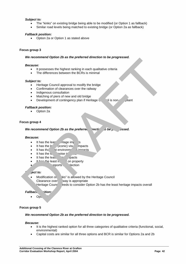
DRAFTSubject to:
• The “kinks” on existing bridge being able to be modified (or Option 1 as fallback) • Similar road levels being matched to existing bridge (or Option 2a as fallback)
Fallback position:
• Option 2a or Option 1 as stated above Focus group 3
We recommend Option 2b as the preferred direction to be progressed.
Because: • It possesses the highest ranking in each qualitative criteria • The differences between the BCRs is minimal
Subject to:
• Heritage Council approval to modify the bridge • Confirmation of clearances over the railway • Indigenous consultation • Matching of piers of new and old bridge • Development of contingency plan if Heritage Council is non-compliant
Fallback position:
• Option 2a Focus group 4
We recommend Option 2b as the preferred direction to be progressed.
Because: • It has the least heritage impacts • It has the least (iconic) visual impacts • It has the least environmental impacts • It has the least noise impacts • It has the least social impacts • It has the least impact on property • The BCR supports its selection
Subject to:
• Modification of “kinks” is allowed by the Heritage Council • Clearance over railway is appropriate • Heritage Council needs to consider Option 2b has the least heritage impacts overall
Fallback position:
• Option 2a Focus group 5
We recommend Option 2b as the preferred direction to be progressed.
Because: • It is the highest ranked option for all three categories of qualitative criteria (functional, social,
environmental) • Capital costs are similar for all three options and BCR is similar for Options 2a and 2b
Additional Crossing of the Clarence River at Grafton Corridor Evaluation Workshop Report, April 2004 Page 42
DRAFT
DRAFT
DRAFT
DRAFT

DRAFT Subject to:
• Heritage approval to remove the “kinks” from the existing bridge • The new bridge not dominating the existing bridge in height (minimise noise and visual impact) • Constructability and pier matching are appropriately addressed
Fallback position:
• Option 2a • Move to three lanes if no heritage approval
Conclusions Drawn from the Workshop As a result of the discussions over the two days of the workshop, the group agreed to the following conclusions:
• There was unanimous support within the workshop for Option 2b to proceed to the next stage of development as the preferred direction subject to: − The design complying with Heritage Council approval to remove the “kinks” on the existing
bridge − Development of a contingency plan if Heritage Council is non compliant − Siting and alignment being as appropriately close as possible to the existing bridge to minimise
noise and visual impacts − Constructability and pier matching are appropriately addressed − Clearance over the railway is appropriate
• There is a need to make Heritage Council aware that Option 2b has the least impact of the options • There was a genuine disappointment that a Heritage Council representative did not attend the
workshop. It was seen to be a wasted opportunity • The group worked well together to reach census conclusions • The participants obtained a better understanding of the wider dimensions to the project • The process undertaken to reach these conclusions was robust and allowed consideration of the
various perspectives represented in the workshop Where to From Here? At the conclusion of the workshop, Peter Black, Project Manager outlined the next steps in the process to progress the project planning from here. These were listed as:
• A media announcement will be released to inform the community about the workshop and its findings
• Finalise the workshop report outlining the findings and conclusions of the group. This will be undertaken by ACVM. A copy of the workshop report will be sent to each participant
• The Project Team will undertake the additional investigations to address the “subject to” statements listed in the workshop for the preferred direction
• Finalise the Preferred Option Report which will incorporate the workshop conclusions • Obtain the internal RTA client approvals to proceed • Provide information to the Minister of Roads for the announcement of the preferred route for the
crossing
Additional Crossing of the Clarence River at Grafton Corridor Evaluation Workshop Report, April 2004 Page 43
DRAFT
DRAFT
DRAFT
DRAFT

DRAFT
Preferred Option Report Additional Crossing of the Clarence River at Grafton
Project Design Services - Grafton Version 1.6 g:\projects\all projects\rstmd\regional dev\d00369 grafton bridge development\previous development2002-2005\project development\design\preferred route report\preferredroutereporv1.2.doc
Attachment 3
Noise Assessment
DRAFT
DRAFT
DRAFT
DRAFT

DRAFT
Delivering sustainable solutions in a more competitive world
Proposed Additional Crossing of theClarence River at Grafton NSWNoise Assessment of Locality Options1, 2A and 2BRoads and Traffic Authority Operations
July 20040010401 R3 - Final
www.erm.com
DRAFT
DRAFT
DRAFT
DRAFT

DRAFT
This report has been prepared in accordance with the scope of services described in the contract or agreement between Environmental Resources ManagementAustralia Pty Ltd ABN 12 002 773 248 (ERM) and the Client. The report relies upon data, surveys, measurements and results taken at or under the particular timesand conditions specified herein. Any findings, conclusions or recommendations only apply to the aforementioned circumstances and no greater reliance should beassumed or drawn by the Client. Furthermore, the report has been prepared solely for use by the Client and ERM accepts no responsibility for its use by otherparties.
Approved by: Darren Jurevicius
Position: Project ManagerSigned:
Date: 26 May, 2004
ManagingPrincipal:
Murray CurtisEnvironmental Resources Management Australia Pty Ltd Quality System
Proposed Additional Crossing of theClarence River at Grafton NSWNoise Assessment of Locality Options1, 2A and 2BRoads and Traffic Authority Operations
July 2004
0010401 R3 - Final
www.erm.comDRAFT
DRAFT
DRAFT
DRAFT

DRAFT
ENVIRONMENTAL RESOURCES MANAGEMENT AUSTRALIA 0010401 R3 /FINAL/2 JULY 2004
i
CONTENTS
EXECUTIVE SUMMARY
1 INTRODUCTION
1.1 BACKGROUND 11.1.1 DESCRIPTION OF LOCALITY OPTIONS 11.2 GLOSSARY 2
2 TRAFFIC NOISE
2.1 CRITERIA 42.1.1 OPTION 1 52.1.2 OPTIONS 2A AND 2B 62.1.3 CRITERIA INTERPRETATION 62.2 AFFECTED RECEPTORS 82.3 EXISTING TRAFFIC NOISE 102.3.1 NOISE MONITORING 102.3.2 TRAFFIC COUNT MONITORING 162.4 PREDICTED TRAFFIC NOISE LEVELS 162.4.1 MODELLING METHOD 162.4.2 MODELLED SCENARIOS 172.4.3 MODELLED TRAFFIC PARAMETERS 182.4.4 PREDICTED RESULTS 192.4.5 SUMMARY OF RESULTS 19
3 CONCLUSION
REFERENCES
ANNEX A TRAFFIC NOISE CONTOURS - LAEQ (15 HOUR)ANNEX B TRAFFIC NOISE CONTOURS - LAEQ (9 HOUR)ANNEX C TRAFFIC NOISE CONTOURS - LAEQ (24 HOUR)ANNEX D TRAFFIC NOISE CONTOURS - LAEQ (1 HOUR)ANNEX E TRAFFIC NOISE CONTOURS - LAMAXANNEX F NOISE LOGGER GRAPHSANNEX G GLOSSARY OF ACOUSTIC TERMINOLOGYDRAFT
DRAFT
DRAFT
DRAFT
DRAFT
ENVIRONMENTAL RESOURCES MANAGEMENT AUSTRALIA 0010401 R3 /FINAL/2 JULY 2004
ii
LIST OF TABLES
TABLE 1.1 DESCRIPTION OF OPTION LOCATIONS 1
TABLE 2.1 OPTION 1 - ROAD TRAFFIC NOISE CRITERIA 5
TABLE 2.2 LOCALITY OPTION 1 - ROAD TRAFFIC NOISE CRITERIA FORSENSITIVE LAND USES 5
TABLE 2.3 OPTIONS 2A AND 2B - ROAD TRAFFIC NOISE CRITERIA 6
TABLE 2.4 NEAREST AFFECTED RECEPTORS COUNTS 8
TABLE 2.5 MEASURED NOISE LEVELS – LOGGER LOCATION 1 11
TABLE 2.6 MEASURED NOISE LEVELS – LOGGER LOCATION 2 11
TABLE 2.7 MEASURED NOISE LEVELS – LOGGER LOCATION 3 12
TABLE 2.8 MEASURED NOISE LEVELS – LOGGER LOCATION 4 12
TABLE 2.9 MEASURED NOISE LEVELS – LOGGER LOCATION 5 (KENT STREETONLY) 13
TABLE 2.10 MEASURED NOISE LEVELS – LOGGER LOCATION 6 13
TABLE 2.11 MEASURED NOISE LEVELS – LOGGER LOCATION 7 14
TABLE 2.12 MEASURED NOISE LEVELS – LOGGER LOCATION 8 14
TABLE 2.13 MEASURED TRAFFIC NOISE LEVELS VERSUS DEC CRITERIA 15
TABLE 2.14 CLARENCE RIVER BRIDGE TRAFFIC COUNTS 16
TABLE 2.15 MODELLED EXISTING, OPTION 2A AND 2B TRAFFIC VOLUMES 18
TABLE 2.16 MODELLED OPTION 1 TRAFFIC VOLUMES 18
LIST OF FIGURES
FIGURE 1.1 AERIAL PHOTOGRAPH SHOWINGOPTION 1 LOCATION 3
FIGURE 1.2 AERIAL PHOTOGRAPH SHOWINGOPTION 2A LOCATION 3
FIGURE 1.3 AERIAL PHOTOGRAPH SHOWINGOPTION 2B LOCATION 3
FIGURE 2.1 LOCATION OF NOISE LOGGERS AND NEAREST RECEPTORS 9
DRAFT
DRAFT
DRAFT
DRAFT

DRAFT
ENVIRONMENTAL RESOURCES MANAGEMENT AUSTRALIA 0010401 R3 /FINAL/2 JULY 2004
iii
EXECUTIVE SUMMARY
Environmental Resources Management Australia Pty Ltd (ERM) wascommissioned by the RTA to investigate in more detail the operational noiseimpacts associated with three Options (1, 2A and 2B) proposed for anadditional crossing of the Clarence River at Grafton. This report follows onfrom ERM’s earlier investigation Proposed Additional Crossing of the ClarenceRiver at Grafton NSW - Noise Assessment of Locality Options (December 2003).Noise impacts associated with construction of an additional crossing would beassessed at a later stage, as construction noise would be influenced by theconcept design and construction techniques likely to be adopted.
Environmental noise levels were measured at the nearest residences to thethree Options on the northern and southern sides of the Clarence River toascertain the current level of traffic noise impacts with respect to relevantDepartment of Environment and Conservation (DEC)1 criteria.
To assess the future likely impact of road traffic noise associated with each ofthe shortlisted Options, traffic noise contours determined by the DECapproved CoRTN modelling algorithm were generated.
Traffic noise contours are provided for each of the following scenarios:
• Existing traffic conditions - one traffic lane north and southbound on theexisting bridge;
• Option 1 – one traffic lane north and southbound on the new bridge inconjunction with one traffic lane north and southbound on the existingbridge;
• Option 2A (upstream) – two traffic lanes northbound on the new bridge inconjunction with two traffic lanes southbound on the existing bridge;
• Option 2A (upstream) – two traffic lanes north and southbound on the newbridge with no traffic on the existing bridge;
• Option 2B (downstream) – two traffic lanes southbound on the new bridgein conjunction with two traffic lanes northbound on the existing bridge;
• Option 2B (downstream) – two traffic lanes southbound and one traffic lanenorthbound on the new bridge in conjunction with one traffic lanenorthbound on the existing bridge; and
• Option 2B (downstream) – two traffic lanes north and southbound on thenew bridge with no traffic on the existing bridge.
1 Incorporates the Environment Protection Authority (EPA).
DRAFT
DRAFT
DRAFT
DRAFT
DRAFT
ENVIRONMENTAL RESOURCES MANAGEMENT AUSTRALIA 0010401 R3 /FINAL/2 JULY 2004
iv
In summary, either Option 2A or 2B (upstream or downstream) providesnegligible impact when operated in conjunction with the existing bridge as asplit two-lane configuration.
As the traffic lanes move from the existing bridge to either of the new Option2A or 2B bridges, traffic noise is marginally increased for those receptorsclosest to the majority of traffic volume. The change in received noise levelswould be in the order of negligible up to five decibels depending uponreceptor location.
In practice however, most residents up and downstream of the bridges are notlikely to notice a significant change in traffic noise levels for either lanescenario. This is because the total traffic volume crossing the Clarence Riverwould be the same as the existing bridge.
The recommended DEC day and night traffic noise criteria for the majority ofresidential receptors exposed to traffic noise, as a result of changes to the rivercrossing with either Option 2A or 2B, would be met.
Option 1 significantly impacts sensitive land use in Villiers Street, as well asresidents on Abbot Street, all of which are exposed to minimal existing trafficnoise. Option 1 would generate noise levels that would exceed therecommended DEC traffic noise criteria, in some cases by 5-10dB(A), whichsignificantly impacts upon the existing quiet local streets, with mandatorymitigation options likely to be intrusive to the area.
In conclusion, Option 1 represents a significant noise impact to all affectedreceptors, while Options 2A or 2B provide minimal impact in comparison tothe existing bridge crossing.
DRAFT
DRAFT
DRAFT
DRAFT

DRAFT
ENVIRONMENTAL RESOURCES MANAGEMENT AUSTRALIA 0010401 R3 /FINAL/2 JULY 2004
1
1 INTRODUCTION
1.1 BACKGROUND
Environmental Resources Management Australia Pty Ltd (ERM) wascommissioned by RTA to investigate in more detail shortlisted Options for aproposed additional crossing of the Clarence River at Grafton, in terms ofoperational noise impacts. This report follows on from ERM’s earlierinvestigation Proposed Additional Crossing of the Clarence River at Grafton NSW -Noise Assessment of Locality Options (December 2003).
This report details the operational noise assessment of three proposed localityOptions for an additional crossing. The objectives of the assessment are to:
• determine relevant traffic noise criteria;
• determine the number of nearest residents and sensitive land uses affected;
• measure the existing noise levels at locations affected by either of theproposed Options; and
• develop noise contours to provide a quantitative comparison of noiseimpacts associated with each proposed Option and operational scenarios.
It should be noted that this assessment is not intended to be a final detailednoise assessment of each shortlisted Option, but rather a more quantitativeanalysis of the likely noise impacts for comparative purposes betweenOptions. Potential mitigation options have not been considered as part of thisassessment.
1.1.1 Description Of Locality Options
Table 1.1 presents descriptions of the proposed Options.
Table 1.1 Description of Option Locations
LocalityOption
South End North End
1 From Gwydir Highway in the vicinity of AbbotStreet crossing Kennedy Street and Bank Street
Direct onto Villiers Street (School andConvent on either side of road)Crossing Victoria StreetMeeting Fitzroy Street
2A or 2B Merge with existing route on Bent Street access Merge with existing Fitzroy Street orCraig Street
DRAFT
DRAFT
DRAFT
DRAFT

DRAFT
ENVIRONMENTAL RESOURCES MANAGEMENT AUSTRALIA 0010401 R3 /FINAL/2 JULY 2004
2
Figures 1.1 to 1.3 also provides a graphical representation of the proposedOptions.
1.2 GLOSSARY
Technical terms used in this report are consistent with the definitions ofAustralian Standard AS1633 and are also defined in the glossary of this reportin Annex G.
DRAFT
DRAFT
DRAFT
DRAFT