PLANNING AND DESIGN OF SURFACE DRAINSncrpb.nic.in/pdf_files/FP on Drainage/Chapter 5 - PLANNING...
14
Functional Plan on Drainage for NCR 37 5. PLANNING AND DESIGN OF SURFACE DRAINS 5.1 Introduction The principal source of water stagnating on the fields and in low-lying areas in the monsoon is rainfall confined mostly to the four months from June to September. Major rivers and rivulets overflow their banks adding to the local drainage congestion. Drainage congestion caused due to natural factors or due to improper planning, affects agricultural production. In flat areas disposal of storm run-off through natural drainage takes considerable time due to adverse topographical features. In some cases such as in flat bowl shaped basins, natural outfalls do not exist. Even when the natural drainage has an outlet to a river, the area is not drained as long as the river continues to be in floods thus denying drainage by gravity. The resulting drainage congestion or accumulation of water on land affects crops, as most crops cannot withstand submergence beyond a particular depth for long duration. Problems of drainage are also created on account of inadequate waterways structures like bridges and culverts. Railway lines and roads constructed across natural drainage lines obstruct free flow of drains. Drains are provided with the objective of quickly relieving excess water from agricultural areas, urban areas and other land areas and disposing off surplus water. Proper disposal of surplus rainwater is essential to avoid its percolation down to the water table and consequent water logging problems. Drains are also constructed for leaching agricultural lands to prevent salt accumulation. It is imperative to plan and design surface water drains appropriately so as to dispose of surplus rain water within minimum time. 5.2 Existing Design Criteria for Drains There is wide variation in design criteria due to factors such as topography, intensity and pattern of rainfall, soil characteristics and nature of crops, intensity of development etc. Some states adopted the empirical formula like Dicken’s, Ryve’s or Boston Society formula and in some states the practice have been evolved after taking into consideration the type of crop, tolerance, submersion and duration, intensity of rainfall and optimum time of disposal while in some other States no scientific basis or rational approach has been adopted. In NCR also the constituent States have adopted different methods for the design of drainage channels. In the design of surface drainage network, the following are the basic elements: i) Design storm rainfall: Duration and frequency of rainfall for which the protection should normally be provided to the agriculture in rural area and to the people in urban area. ii) Tolerance period: Time of submersion to avoid significant damage. iii) Run off factor: Applicable for design storm rainfall of selected duration and frequency. iv) Design of drainage: Design of a channel that is capable of draining out the computed run off within the tolerance period. The design provides the details of cross section, slope, and type of surface.
Transcript of PLANNING AND DESIGN OF SURFACE DRAINSncrpb.nic.in/pdf_files/FP on Drainage/Chapter 5 - PLANNING...

Functional Plan on Drainage for NCR
37
5. PLANNING AND DESIGN OF SURFACE DRAINS
5.1 Introduction
The principal source of water stagnating on the fields and in low-lying areas in the monsoon is
rainfall confined mostly to the four months from June to September. Major rivers and rivulets
overflow their banks adding to the local drainage congestion. Drainage congestion caused due
to natural factors or due to improper planning, affects agricultural production. In flat areas
disposal of storm run-off through natural drainage takes considerable time due to adverse
topographical features. In some cases such as in flat bowl shaped basins, natural outfalls do
not exist. Even when the natural drainage has an outlet to a river, the area is not drained as
long as the river continues to be in floods thus denying drainage by gravity. The resulting
drainage congestion or accumulation of water on land affects crops, as most crops cannot
withstand submergence beyond a particular depth for long duration. Problems of drainage are
also created on account of inadequate waterways structures like bridges and culverts. Railway
lines and roads constructed across natural drainage lines obstruct free flow of drains.
Drains are provided with the objective of quickly relieving excess water from agricultural
areas, urban areas and other land areas and disposing off surplus water. Proper disposal of
surplus rainwater is essential to avoid its percolation down to the water table and consequent
water logging problems. Drains are also constructed for leaching agricultural lands to prevent
salt accumulation. It is imperative to plan and design surface water drains appropriately so as
to dispose of surplus rain water within minimum time.
5.2 Existing Design Criteria for Drains
There is wide variation in design criteria due to factors such as topography, intensity and
pattern of rainfall, soil characteristics and nature of crops, intensity of development etc. Some
states adopted the empirical formula like Dicken’s, Ryve’s or Boston Society formula and in
some states the practice have been evolved after taking into consideration the type of crop,
tolerance, submersion and duration, intensity of rainfall and optimum time of disposal while
in some other States no scientific basis or rational approach has been adopted.
In NCR also the constituent States have adopted different methods for the design of drainage
channels. In the design of surface drainage network, the following are the basic elements:
i) Design storm rainfall: Duration and frequency of rainfall for which the protection
should normally be provided to the agriculture in rural area and to the people in urban
area.
ii) Tolerance period: Time of submersion to avoid significant damage.
iii) Run off factor: Applicable for design storm rainfall of selected duration and frequency.
iv) Design of drainage: Design of a channel that is capable of draining out the computed
run off within the tolerance period. The design provides the details of cross section,
slope, and type of surface.

Functional Plan on Drainage for NCR
38
5.2.1 Existing Design Criteria for Drains in Uttar Pradesh
The Technical Advisory Committee (TAC) of UP State constituted in 1978 recommended the
following design criteria:
i) Three-day rainfall storm with 15 years return period worked out from long-term data
should be taken as the design storm rainfall for the drains.
ii) Runoff should be taken as 15% for Western Zone of UP and 30% for the Eastern zone.
Entire area of UP sub-region of NCR lies in Western Zone.
iii) The allowable period of submergence should be taken as 7 days for areas where the
principal crops grown are paddy and sugarcane and 3 days where the crops are Maize,
Jowar and Bajra etc.
iv) Waterway of masonry works should be provided for 1.5 times the design discharge of
the drains, and foundations be designed for 30% extra discharge over waterway design
discharge.
The TAC suggested that further detailed investigations should be carried out in the field and if
necessary the recommendations be modified suitably. It had also been recommended that the
maximum allowable periods of submergence for the various crops be verified from the
Agriculture Department.
The 3-day maximum rainfall of 15 years return period and the runoff factors recommended by
the TAC for the districts of UP sub-region of NCR are given in Table 5.1.
Table 5.1 Design Criteria for UP sub region
Sl. No. District 3 day maximum rain
fall of 15 yrs. Return
period (mm)
Drainage Factors in Cumec/sq. km.
with submergence of
7 days 3 days
1. Ghaziabad
(30% runoff)
430.96 0.21 0.49
2. Meerut
(15% runoff)
254.06 0.06 0.15
3. Bulandshahr
(15% runoff)
307.61 0.08 0.18
Source: Technical Advisory Committee, UP, 1978
5.2.2 Design Criteria for Drains in Haryana
The existing system of drainage in the Haryana state was designed on the basis of an empirical
Boston Society formula:
Q = C A1/2, where
Q = Discharge in cusecs
A = Catchment area in square miles
C = Coefficient to account for catchment characteristics and its value for Haryana area was taken
as 200.
Functional Plan on Drainage for NCR
39
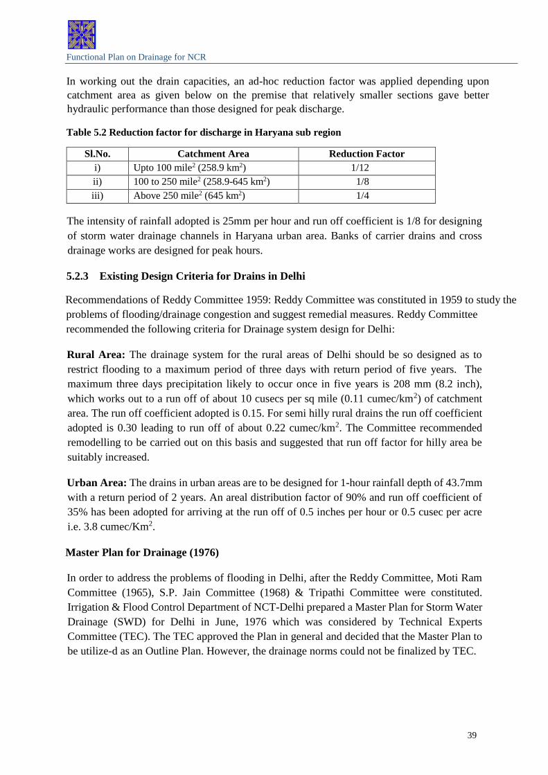
In working out the drain capacities, an ad-hoc reduction factor was applied depending upon
catchment area as given below on the premise that relatively smaller sections gave better
hydraulic performance than those designed for peak discharge.
Table 5.2 Reduction factor for discharge in Haryana sub region
Sl.No. Catchment Area Reduction Factor
i) Upto 100 mile2 (258.9 km2) 1/12
ii) 100 to 250 mile2 (258.9-645 km2) 1/8
iii) Above 250 mile2 (645 km2) 1/4
The intensity of rainfall adopted is 25mm per hour and run off coefficient is 1/8 for designing
of storm water drainage channels in Haryana urban area. Banks of carrier drains and cross
drainage works are designed for peak hours.
5.2.3 Existing Design Criteria for Drains in Delhi
Recommendations of Reddy Committee 1959: Reddy Committee was constituted in 1959 to study the
problems of flooding/drainage congestion and suggest remedial measures. Reddy Committee
recommended the following criteria for Drainage system design for Delhi:
Rural Area: The drainage system for the rural areas of Delhi should be so designed as to
restrict flooding to a maximum period of three days with return period of five years. The
maximum three days precipitation likely to occur once in five years is 208 mm (8.2 inch),
which works out to a run off of about 10 cusecs per sq mile (0.11 cumec/km2) of catchment
area. The run off coefficient adopted is 0.15. For semi hilly rural drains the run off coefficient
adopted is 0.30 leading to run off of about 0.22 cumec/km2. The Committee recommended
remodelling to be carried out on this basis and suggested that run off factor for hilly area be
suitably increased.
Urban Area: The drains in urban areas are to be designed for 1-hour rainfall depth of 43.7mm
with a return period of 2 years. An areal distribution factor of 90% and run off coefficient of
35% has been adopted for arriving at the run off of 0.5 inches per hour or 0.5 cusec per acre
i.e. 3.8 cumec/Km2.
Master Plan for Drainage (1976)
In order to address the problems of flooding in Delhi, after the Reddy Committee, Moti Ram
Committee (1965), S.P. Jain Committee (1968) & Tripathi Committee were constituted.
Irrigation & Flood Control Department of NCT-Delhi prepared a Master Plan for Storm Water
Drainage (SWD) for Delhi in June, 1976 which was considered by Technical Experts
Committee (TEC). The TEC approved the Plan in general and decided that the Master Plan to
be utilize-d as an Outline Plan. However, the drainage norms could not be finalized by TEC.

Functional Plan on Drainage for NCR
40
This Plan was based on following:
Urban Areas
i) Time of Concentration = 0.5 hr
ii) Storm Intensity (2 yr return period) = 63.5 mm (2.5 inch/hr.)
iii) Average run off factor = 0.6
iv) Average run off Q = 2.5x0.6
=1.5 inch/hr (i.e. 1.5 cusec/acre) or
=10.5 Cusecs/Km2
However, flooding of streets for an hour or so may be allowed and drains were designed for 1
cusec/acre.
The intensity of rainfall for one hour-storm duration for various return periods was indicated
as under:
i) 2 Yrs return period : 43.7 mm/hr. (1.72 inch/hr.)
ii) 5 Yrs return period : 58.2 mm/hr. (2.29 inch/hr.)
iii) 10 Yrs return period : 63.2 mm/hr. (2.73 inch/hr.)
iv) 25Yrs return period : 83.8 mm/hr. (3.30 inch/hr.)
It was further stipulated in the above mentioned Report that whenever, Master Plan 2001 is
prepared by DDA, Master Drainage Plan shall be re-considered and updated.
5.3 Planning and Design of Drainage System for Urban Area
The characteristics of urban areas are different from rural areas. Due to high concentration of
population and economic activities in urban area the loss to life and property is much higher
compare to rural area. This necessitates a different approach for design of storm water drains
in urban areas. Various agencies have prepared Design Manuals for Drainage which have been
discussed in subsequent paras.
5.3.1 Design Manuals: National and International
The Central Public Health and Environmental Engineering Organization (CPHEEO), under the
Ministry of Urban Development (MoUD), Govt. of India have published the “Manual on
Sewerage” (1993). This manual has given extensive guidelines for sewer design, but has given
only a small section for storm drainage design. However, even this was not being followed by
many cities in the past. This Manual mentions a uniform design rainfall intensity of 12-20
mm/hour for all cities and does not take into account the spatial distribution of rainfall over
India or within the cities. Systems designed with these values will cause flooding, whenever
rainfall intensity values exceed 20 mm/hour. However, while taking up projects under
JNNURM, rainfall data obtained from Self-Recording Rain Gauge stations is followed, which
takes into account the rainfall pattern of the cities. The Ministry of Urban Development

Functional Plan on Drainage for NCR
41
(MoUD) has constituted an “Expert Committee for the preparation of Urban Storm Drainage
Manual”. The comprehensive Urban Storm Drainage Design Manual is under preparation.
The Indian Roads Congress (IRC) brought out guidelines on urban drainage in 1999 (SP-
501999, IRC). This provides guidance for drainage design for roads, but does not provide
design information on rainfall intensities to be adopted for various cities. For example, it
mentions that Mumbai drains are being designed for 50 mm/h and Chennai for 25 mm/h, but
does not provide guidelines for future planning for other Indian cities. This will take into
account current international practices, the locations specific factors and rainfall pattern of the
cities and future needs.
Most countries have dedicated Codes and Manuals for storm water drainage design. USA has
the “Urban Drainage Design Manual”, published by the Federal Highway Administration of
the US Department of Transportation (2009, Revised in August, 2013 Third Edition).
Moreover, each state/ country has brought out its own Manual and, in many cases, even
individual cities have their own city-specific Manual. These are updated regularly, some of
them are on an annual basis. European countries are now following a common code on
“Drainage and Sewer System Outside Buildings”. In Australia, the “Australian Rainfall and
Runoff Manual” (2008, 4th edition) is used in the various states of Australia, while the north-
eastern state of Queensland, which experiences the monsoon type rainfall, has its own storm
water drainage manual. The national meteorological agencies in most countries have developed
Intensity- Duration-Frequency (IDF) curves from the rainfall records and provide these to the
design engineers for carrying out urban drainage design.
For better urban flood management, many cities like Bangkok, Tokyo, Singapore, etc., have
developed a real-time satellite-radar-rainfall based warning system with adequate number of
radars and ARGs. Regular de silting of drains is also carried out on a time bound schedule in
many important cities.
5.3.2 National Disaster Management Manual
Manual prepared by National Disaster Management Authority for National Disaster
Management has dealt this issue in detail. The same has been discussed below:
i) Catchment as basis for Design: States and cities have political and administrative
boundaries. However, rainfall and runoff processes are independent of these boundaries, and
depend on the watershed delineation. The outline of the drainage divide must follow the actual
watershed boundary rather than the administrative boundaries. Each urban area may consist of
a number of watersheds. A watershed is the geographic region within which water drains into
a stream, river, lake or sea. The watershed may be composed of several sub watersheds and
catchments. The catchment is the area draining surface water to a particular location or outlet
point. Catchment will be the basis for planning and designing the storm water drainage systems
in all Urban Local Bodies (ULBs).
ii) Contour Data: Accurate contours are necessary for determining the boundaries of a
watershed/catchment and for computing directions of flow. Detailed contour maps at required

Functional Plan on Drainage for NCR
42
resolution should be prepared for proper delineation of drainage catchments. Contour mapping
of urban areas will be prepared at 0.2 to 0.5 m contour interval for detailed delineation of the
watershed/catchment for planning drainage systems.
iii) Rainfall Variations: The conventional practice for designing of a drainage system is
to choose an appropriate, statistically relevant design storm to establish the storm water flows
to be conveyed, based on existing national and international practices. Design storms can be
estimated from rainfall data records where available. Rainfall is the main driver of runoff
processes.
Box 5.1 Indian Monsoon is Unique
The frequency and intensity of rainfall in India, not only shows a great variation but the
intensity of rainfall also is generally much higher than in many other countries. There is wide
variation of rainfall amongst the cities and, even within the city, rainfall shows large spatial
and temporal variation; Due to the high variability of rainfall in space and time, rainfall
measurements are required at high temporal and spatial resolution from dense Rain Gauge
networks for the adequate design of new systems and/or renovation of existing drainage
systems. Up to date Intensity Duration frequency (IDF) relationships need to be used to
maintain design standards for new systems and retrofitting/replacement of old urban drainage
systems.
iv) Thunderstorm Rainfall Intensity: Special consideration should be given to rainfall
caused due to thunderstorms, which result in high intensity rainfall in short durations (e.g. 15
mm rainfall in 15 minutes i.e. 60 mm/h). Delhi and many other cities faced severe disruption
due to flooding in 2009 and 2010, caused by thunderstorms embedded in monsoon systems
which overwhelmed the drainage systems, designed for much lesser values of the rainfall
intensity. By the very nature of formation, it is observed that severe thunderstorms result in
rainfall intensities of the order of 50-70 mm/h which cause flash flooding. Hence, the frequency
-

Functional Plan on Drainage for NCR
43
of thunderstorms becomes an additional consideration for planning future urban drainage
systems.
a) IDF curves should be developed for each city, based on extraction of data from the
raw data charts at 15 minutes resolution and from Automatic Weather Stations
(AWS) at 5minutes resolution, and
b) IDF relationships will be adjusted taking into account climate change impacts and
urban heat island effects. At the very least, a trend analysis of short duration rainfall
intensities will be carried out and if an increasing trend in the recent years is shown,
higher intensities than those provided by IDF relationships will be used for resizing
existing systems and design of new systems, especially for critical infrastructure like
airports, major roads and railway tracks.
v) Design Flow: To protect residential, commercial, industrial and institutional buildings
in urban areas, safe management and passage of water, resulting from frequent storm events
(hydrologic design aspects) and adequate capacity (hydraulic design aspects) must be
considered. In the context of urban drainage, the main objectives of hydrologic analysis and
design are to estimate peak flow rates and/or flow hydrographs for the adequate sizing and
design of conveyance and quantity control facilities. To estimate peak flow rates, knowledge
of the rainfall intensity, its duration and frequency is required for preparing satisfactory urban
drainage and storm water management projects. Due to limited data, statistics and probability
concepts are used in hydrologic analysis. Current international practice involves frequency
analysis of rainfall intensities, based on extreme value distributions with adjustments for
climate change effects. Intensity-Duration-Frequency (IDF) curves are required to be
developed for systematic analysis. However, the return period concept has an element of
subjectivity. Increasing rainfall intensities induced by climate change, urban heat islands and
other factors will possibly result in varying return periods for a given intensity of rainfall. The
rainfall intensity to be used for design will also depend on the time of concentration. Higher
the catchment area, higher will be the time of concentration and lower will be the design rainfall
intensity, other factors remaining the same.
Peak flow rates can be estimated using the Rational Method. However, for computation of
water level profiles in the drainage systems or channels/rivers, suitable software for flood
routing should be used. The available public domain software are the HEC-HMS for
hydrologic modelling of the watershed, HEC-RAS for river modelling, both developed by the
US Army Corps of Engineers and SWMM (Storm water Management Model) for sewer/
drainage design, developed by the US Environmental Protection Agency. These software’s are
available on web.
vi) Runoff Coefficient for Long Term Planning: Keeping in view the projected rate of
urbanization, it is imperative to consider a 50-year planning horizon. Due to development that
is bound to take place during this period, it will be difficult to upgrade the underground drains
once they are laid. Therefore, it is recommended that all future drainage plans for urban areas
should be carried out, taking these factors into consideration. All future storm water drainage
systems will be designed taking into consideration a runoff coefficient of up to C = 0.95 for

Functional Plan on Drainage for NCR
44
estimating peak discharge using the rational method, taking into consideration the approved
land use pattern of the city.
5.3.3 Drainage Design as per Manual on Sewerage and Sewage Treatment CPHEEO,
Ministry of Urban Development (1993).
Estimation of Storm Runoff:
Storm runoff is that portion of the precipitation, which drains over the ground surface.
Estimation of such runoff reaching the storm sewers therefore is dependent on intensity and
duration of precipitation, characteristics of the catchment area and the time required for such
flow to reach the sewer is runoff time. The storm water flow for this purpose may be
determined by using the rational method, hydrograph method, rainfall-runoff correlation
studies, digital computer models, inlet method or empirical formulae.
The empirical formulae that are available for estimating the storm water runoff can be used
only when comparable conditions to those for which the equations were derived initially can
be assured.
A rational approach, therefore, demands a study of the existing precipitation data of the area
concerned to permit a suitable forecast. Storm sewers are not designed for the peak flow of
rare occurrence such as once in 10 years or more but it is necessary to provide sufficient
capacity to avoid too frequent flooding of the drainage area. There may be some flooding when
the precipitation exceeds the design value, which has to be permitted. The frequency of such
permissible flooding may vary from place to place, depending on the importance of the area.
Though such flooding causes inconvenience, it may have to be accepted once in a while
considering the economy effected in storm drainage costs.
The maximum runoff, which has to be carried in a sewer section should be computed for a
condition when the entire basin draining at that point becomes contributory to the flow and the
time needed for this is known as the time of concentration (tc) with reference to the concerned
section. Thus estimating the flow to be carried in the storm sewer, the intensity of rainfall that
lasts for the period of time of concentration is the one to be considered contributing to the flow
of storm water in the sewer. The Rational Method is more commonly used for designing
drainage.
i) Rational Method
Runoff - Rainfall Intensity Relationship
The entire precipitation over the drainage district does not reach the sewer. The characteristics
of the drainage district, such as, imperviousness, topography including depressions and water
pockets, shape of the drainage basin and duration of the precipitation determine the fraction of
the total precipitation, which will reach the sewer. This fraction known as the coefficient of
runoff needs to be determined for each drainage district. The runoff reaching the sewer is given
by the expression,

Functional Plan on Drainage for NCR
45
Q = 10 C I A
Where
‘Q’ is the runoff in m3/hr;
'C' is the coefficient of runoff;
'I' is the intensity of rainfall in mm/hr and
'A' is the area of drainage district in hectares.
ii) Storm Frequency
The frequency of storm for which the sewers are to be designed depends on the importance of
the area to be drained. Commercial and industrial areas have to be subjected to less frequent
flooding. The suggested frequency of flooding in the different areas is at Table 5.3.
Table 5.3 Frequency of Storm
Type of Areas Frequency
a) Residential areas
i) Peripheral areas Twice a year
ii) Central and Comparatively high priced areas Once a year
b) Commercial and high Priced areas Once in 2 years
iii) Intensity of Precipitation
The intensity of rainfall decreases with duration. Analysis of the observed data on intensity
duration of rainfall of past records over a period of years in the area is necessary to arrive at a
fair estimate of intensity-duration for given frequencies. The longer the record available, the
more dependable is the forecast. In Indian conditions, intensity of rainfall adopted in design is
usually in the range of 12mm/hr to 20mm/hr.
The rainfall data from automatic rain gauges should be analyzed to develop duration-intensity
curve for design frequency and from it relationship may be expressed by a suitable
mathematical formula, several forms of which are available. The following two equations are
commonly used:
(i) I = a /(t.n)
(ii) I = a/(t + b), where,
I = intensity of rainfall (mm/hr)
t = duration of storm (minutes) and
a, b and n are constants
The available data on I and t are plotted and the values of the intensity (I) can then be
determined for any given time of concentration, (tc).
iv) Time of Concentration
It is the time required for the rain water to flow over the ground surface from the extreme point
of the drainage basin and reach the point under consideration. Time of concentration (tc) is

Functional Plan on Drainage for NCR
46
equal to inlet time (t) plus the time of flow in the sewer (t). The inlet time is dependent on the
distance of the farthest point in the drainage basin to the inlet manhole, the shape,
characteristics and topography of the basin and may generally vary from 5 to 30 minutes. In
highly developed sections, the inlet time may be as low as 3 minutes. The length of the sewer
and the velocity of flow in the sewer determine the time of flow. It is to be computed for each
length of sewer to be designed.
v) Runoff Coefficient
The portion of rainfall, which finds its way to the sewer, is dependent on the imperviousness
and the shape of tributary area apart from the duration of storm.
a) Imperviousness
The percent imperviousness of the drainage area can be obtained from the records of a
particular district. In the absence of such data, the following may serve as a guide.
Table 5.4 Imperviousness of the drainage area
Type of area Imperviousness %
Commercial and Industrial area 70 to 90
Residential area:
i) High density
ii) Low density
60 to 70
35 to 60
Parks & undeveloped areas 10 to 20
The weighted average imperviousness (I) of drainage basin for the flow concentrating at a point
may be estimated as
A1I1 + A2I2.......
A1 + A2 +........
where,
A1, A2 = drainage areas tributary to the section under consideration
I1, I2 = imperviousness of the respective areas and
I = weighted average imperviousness of the total drainage basin.
b) Catchment Area
The drainage areas should be indicated clearly on the map and measured for each length of
storm sewer. The boundaries of each catchment are dependent on topography, land use nature
of development and shape of the drainage basins. The incremental area may be indicated
separately on the compilation sheet and the total area computed.
c) Duration of storm
Continuously long light rain saturates the soil and produces higher coefficient than that due to
heavy but intermittent rain in the same area because of the lesser saturation in the latter case.

Functional Plan on Drainage for NCR
47
Runoff from an area is significantly influenced by the saturation of the surface nearest the point
of concentration, rather than the flow from the distant area. The runoff coefficient of a larger
area has to be adjusted by dividing the area into zones of concentration and by suitably
decreasing the coefficient with the distance of the zones.
d) Computation of Runoff Coefficient
The weighted average runoff coefficient for rectangular areas, of length four times the width
as well as for sector shaped areas with varying percentages of impervious surface for different
times of concentration are given in Table 5.5. Although these are applicable to particular
shapes of areas, they also apply in a general way to the areas which are usually encountered in
practice. Errors due to difference in shape of drainage are within the limits of accuracy of the
rational method and of the assumptions on which it is based.
Table 5.5 Runoff Coefficient
Duration, time,
minutes
10 20 30 45 60 75 90 100 120 135 150 160
Weighted Average coefficient
1) Sector concentrating in stated time
(a) Impervious .525 .588 .642 .700 .740 .771 .795 .813 .828 .840 .850 .865
(b) 60% impervious .365 .427 .477 .531 .569 .598 .622 .641 .656 .670 .682 .701
(c) 40% imperious .285 .346 .395 .446 .482 .512 .532 .554 .571 .585 .597 .618
(d) Pervious .125 .185 .230 .277 .312 .330 .362 .382 .399 .414 .429 .454
2) Rectangle (Length = 4 x width) concentrating in stated time
(a) Impervious .550 .648 .711 .768 .808 .837 .856 .869 .879 .887 .892 .903
(b) 50% Impervious .350 .442 .499 .551 .590 .618 .639 .657 .671 .683 .694 .713
(c) 30% Impervious .269 .360 .414 .464 .502 .530 .552 .572 .558 .601 .614 .636
(d) Impervious .149 .236 .287 .334 .371 .398 .422 .445 .463 .479 .495 .522
Hydraulic Models
The purpose of the hydraulic analysis is to evaluate the adequacy of the existing storm drainage
system (major drains only) and to determine design options for inadequately sized channels.
Channels and storm drains are simulated using the flow data generated in the hydrology model.
Storm drains are simulated using Manning’s equation as below:
V = (R2/3 x S1/2)/n, where,
V = Velocity (m/s); n = Friction Factor;
R = Hydraulic Radius (m); and S = Channel Slope (m/m)
Friction factor (n) is given below:
Cement Concrete with Good finish = 0.013
Concrete channel, wood toweled = 0.015
Earth channel, ordinary condition = 0.025

Functional Plan on Drainage for NCR
48
Earth channel, poor condition = 0.035
Earth channel, partially obstructed with debris or weeds = 0.050
Limitations of Rational Method
Although Rational Method is widely used for designing drainage system it has certain
limitations, which are as under:
Assumptions
i) Peak flow occurs when the entire watershed is contributing to the flow
ii) Rainfall intensity is the same over the entire drainage area
iii) Rainfall intensity is uniform over a time duration equal to the time of concentration
iv) Frequency of the computed peak flow is the same as that of the rainfall intensity, i.e.,
the 10-year rainfall intensity is assumed to produce the 10-year peak flow
v) Coefficient of runoff is the same for all storms of all recurrence probabilities
Limitations:
i) Best suited for estimation of design peak runoff
• Inlet design
• Storm drainage system design
• Area limitation < 200 acres (80 hectares)
ii) Area of drainage needs to be assessed accurately
iii) Has no capability to calculate detention or reservoir routing flows
5.3.4 Intensity Duration Frequency Curve for Delhi
Rainfall data of Delhi for the period 1984 to 2006 (23 years) have been used to develop the
Intensity Duration Frequency (IDF) Curve for Delhi. Data on number of occurrence of rain of
particular duration and intensity as given in Table 5.6 has been used to develop the IDF Curve
for Delhi.
Table 5.6 Rain fall data of Delhi (1984 to 2006) indicating number of occurrences of rain of given
intensity & duration
Time (in min)
Rain fall intensity (in mm/ Hr)
5 10 15 20 25 30 35 40 50 60 75 100 125
15 346 346 344 319 265 229 177 162 79 72 66 63 46
30 256 252 206 151 73 44 44 37 18 17 10 10 7
45 128 95 37 24 24 18 12 8 7 7 3 3 2
60 58 31 16 15 13 13 12 8 4 2 2 2 0
75 38 13 13 12 11 9 6 5 1 0 0 0 0
90 12 4 3 3 2 1 1 1 0 0 0 0 0

Functional Plan on Drainage for NCR
49
From above Table for different frequency find duration for different intensities as given in
Appendix 5.1. The duration and intensity can be expressed by equation for each frequency. The
plot of above is an Intensity Duration Frequency curve. Such curve should be developed for
each city. The IDF Curve developed given in the above for Delhi is given below:
Figure 5-2 Intensity duration curve for Delhi
5.3.5 Refinement in Runoff Estimations
“Urban Drainage Design Manual”, published by the Federal Highway Administration of the US
department of transportation (2013, 3rd Edition) stipulates three representations of rainfall
which can be used to derive flood flows: constant rainfall intensity, dynamic rainfall, and
synthetic rainfall events. Constant Rainfall Intensity method follows Intensity-Duration
Frequency curves.
Dynamic Rainfall (Hyetograph)
In any given storm, the instantaneous intensity is the slope of the mass rainfall curve at a
particular time. The mass rainfall curve is simply the cumulative precipitation, which has fallen
up to a specific time. For hydrologic analysis, it is desirable to divide the storm into convenient
time increments and to determine the average intensity over each of the selected periods. These
results are then plotted as rainfall hyetographs. Hyetographs provide greater precision than
constant rainfall intensity by specifying the precipitation variability over time, and are used in
conjunction with hydrographic (rather than peak flow) methods. Hyetographs allow for
simulation of actual rainfall events, which can provide valuable information on the relative
flood risks of different events and, perhaps, calibration of hydrographic models.

Functional Plan on Drainage for NCR
50
Synthetic Rainfall Events
Drainage design is usually based on synthetic rather than actual rainfall events. The Soil
Conservation Service (SCS) 24-hour rainfall distributions are the most widely used synthetic
hyetographs. These rainfall distributions were developed by the U.S. Department of
Agriculture, Soil Conservation Service (SCS) (13) which is now known as the Natural
Resources Conservation Service (NRCS). The SCS 24-hour distributions incorporate the
intensity-duration relationship for the design return period. This approach is based on the
assumption that the maximum rainfall for any duration within the 24-hour duration should have
the same return period. For example, a 10-year, 24- hour design storm would contain the 10-
year rainfall depths for all durations up to 24 hour as derived from IDF curves.