North Coast Integrated Regional Water Management Plan, July 2007
460
JU L Y 2007 NORTH COAST INTEGRATED REGIONAL WA TER MA NAGEMENT PLAN PHASE 1 Submitted to: State Water Resources Control Board and Department of Water Resources Submitted by: The North Coast Regional Partnership Del Norte, Humboldt, Mendocino, Modoc, Siskiyou, Sonoma and T rinity Counties
-
Upload
mckinleyville-community-services-district -
Category
Documents
-
view
219 -
download
0
Transcript of North Coast Integrated Regional Water Management Plan, July 2007

8/2/2019 North Coast Integrated Regional Water Management Plan, July 2007
http://slidepdf.com/reader/full/north-coast-integrated-regional-water-management-plan-july-2007 1/458
J U LY 2 0 0 7
N O R T H C O A S T I N T E G R A T E D R E G I O N A L
W AT E R M A N A G E M E N T P L A N
P H A S E 1

8/2/2019 North Coast Integrated Regional Water Management Plan, July 2007
http://slidepdf.com/reader/full/north-coast-integrated-regional-water-management-plan-july-2007 2/458
8/2/2019 North Coast Integrated Regional Water Management Plan, July 2007
http://slidepdf.com/reader/full/north-coast-integrated-regional-water-management-plan-july-2007 3/458
North Coast Integrated Regional Water Management Plan, Phase I
NORTH COAST INTEGRATED REGIONAL WATER MANAGEMENT PLAN, Phase I
TABLE OF CONTENTS
LIST OF MAPS
LIST OF ACRONYMS
ACKNOWLEDGEMENTS
SECTION 1.0 INTRODUCTION AND PLANNING APPROACH……………………………………… 11.1 REGIONAL FRAMEWORK FOR INTEGRATED PLANNING IN THE NORTH COAST…..… 3
1.1.1 NCIRWMP PLANNING APPROACH………………………………………… 4
1.1.2 RELATION TO LOCAL PLANNING AND INTEGRATION OF LOCAL, REGIONAL,
STATE AND FEDERAL PRIORITIES………….….…………………………… 4
SECTION 2.0 OBJECTIVES FOR THE NORTH COAST INTEGRATED REGIONAL………………...…… 7
WATER MANAGEMENT PLAN – PHASE 1
SECTION 3.0 NORTH COAST REGIONAL DESCRIPTION…………………….…………………… 11
3.1 REGIONAL PHYSICAL AND BIOLOGICAL FEATURES………………………......…… 11
3.2 SENSITIVE HABITATS & SPECIAL DESIGNATIONS………...……………………..… 12
3.2.1 MARINE AND PROTECTED AREAS: IMPAIRED WATER BODIES…………… 13
3.2.2 THREATENED AND ENDANGERED WILDLIFE………………………...…… 13
3.3 ECOLOGICAL PROCESSES TO SUPPORT ENVIRONMENTAL RESOURCES…………… 14
3.4 INTERNAL BOUNDARIES…………………………………………………….…… 16
3.4.1 JURISDICTIONAL BOUNDARIES……………………………………...…… 16
3.4.2 PHYSICAL BOUNDARIES………………………………………….....…… 183.5 MAJOR WATER RELATED INFRASTRUCTURE ………………………………...…… 27
3.6 WATER QUALITY………...……………………………………………………..… 28
3.6.1 SURFACE WATER QUALITY……………………………………..…...…… 28
3.6.2 GROUND WATER QUALITY……………………………………….....…… 30
3.6.3 RECLAIMED/RECYCLED WATER QUALITY…………………………....…… 30
3.7 WATER QUANTITY……….………………………………………………….…… 31
3.7.1 RELEVANT LEGISLATION…………………………………………....…… 31
3.7.2 SURFACE WATER QUANTITY……….……………………………….…… 313.7.3 GROUNDWATER QUANTITY………………………………………...…… 32
3.7.4 RECLAIMED WATER QUANTITY……………………………...……...…… 33
3.7.5 IMPORTED WATER QUANTITY………………………………….…...…… 33
3.7.6 DESALTED WATER………………………………………………......…… 33
3.8 WATER SUPPLIES AND DEMAND FOR 20-YEAR PLANNING HORIZON ……...…...… 33
3 9 MAJOR LAND USE IN THE REGION 34

8/2/2019 North Coast Integrated Regional Water Management Plan, July 2007
http://slidepdf.com/reader/full/north-coast-integrated-regional-water-management-plan-july-2007 4/458
North Coast Integrated Regional Water Management Plan, Phase I
SECTION 4.0 IDENTIFICATION OF KEY WATER MANAGEMENT ISSUES………………...……….. 50
4.1 REGIONAL ISSUES…………………………………………………………...…… 50
4.1.1 ISSUES RELATED TO SALMONID POPULATION DECLINE………...…...…… 504.1.2 WATER QUANTITY ISSUES…………………………………………......… 51
4.1.3 WATER QUALITY ISSUES…………………………………………....…… 52
4.1.4 PROTECTION OF DRINKING WATER IN DISADVANTAGED
COMMUNITIES……………………………………………………...…… 54
4.2 WATER MANAGEMENT ISSUES AT THE WATERSHED LEVEL……………..…...…… 54
4.3 IMPLEMENTATION AT THE COUNTY LEVEL TO ADDRESS WATER MANAGEMENT
ISSUES……………………………………………………………………....…… 57
SECTION 5.0 NEED FOR NORTH COAST INTEGRATED PLANNING………….…………………… 59
SECTION 6.0 DEVELOPMENT PROCESS FOR THE NCIRWMP…………………..……………..….. 60
6.1 NORTH COAST REGIONAL WATER MANAGEMENT GROUP……………………......…… 60
6.2 NCIRWMP COLLABORATIVE PARTNERSHIP ……………………………………...….… 61
6.2.1 POLICY REVIEW PANEL………...…………………………………………… 61
6.2.2 TECHNICAL PEER REVIEW COMMITTEE……….………………………..…… 62
6.2.3 PROJECT STAFF AND CONSULTANTS………...……………………………… 62
6.2.4 PARTNER ORGANIZATION AND ROLES………...…………………………… 626.3 STAKEHOLDER INVOLVEMENT………...……………………………………………… 63
6.3.1 NCIRWMP WEBSITE…………………………………………………...…… 64
6.3.2 WORKSHOPS………………………………………………………….…… 64
6.3.3 TECHNICAL ASSISTANCE TO PROJECT PROPONENTS…………………...…… 64
6.4 METHODOLOGIES USED IN THE DEVELOPMENT OF THE NCIRWMP…………….....…… 64 6.5 FUTURE STRUCTURES AND PROCESSES: PLAN IMPLEMENTATION, ADAPTIVE
MANAGEMENT AND PLANNING, STAKEHOLDER INVOLVEMENT………...……..… 64
SECTION 7.0 NCIRWMP PROPOSED PROJECTS AND PROJECT PRIORITIES………………...…… 67
7.1 PROJECT SUMMARIES ………...…………………………………………..….… 67
7.2 ENVIRONMENTAL COMPLIANCE…………………………………………...…… 153
SECTION 8.0 PROJECT INTEGRATION AND IMPLEMENTATION:
IMPACTS AND BENEFITS OF PLAN………………………………………………. 157
8.1 PROJECT INTEGRATION WITH NCIRWMP OBJECTIVES……………………....…… 157
8.2
WATER MANAGEMENT ISSUES ADDRESSED BY THE NCIRWMP………….....…… 1628.2.1 MANAGEMENT STRATEGIES THAT ARE NOT APPLICABLE………...…..… 163
8.2.2 ADDED BENEFITS OF INTEGRATION OF MULTIPLE WATER MANAGEMENT
STRATEGIES……….…………………………………………………… 163
8.3 POTENTIAL IMPACTS AND BENEFITS…………………………………..…...…… 164
8.3.1 POTENTIAL IMPACTS TO THE REGION AND ADJACENT
AREAS 164

8/2/2019 North Coast Integrated Regional Water Management Plan, July 2007
http://slidepdf.com/reader/full/north-coast-integrated-regional-water-management-plan-july-2007 5/458
North Coast Integrated Regional Water Management Plan, Phase I
9.0 NCIRWMP EVALUATION AND MEASUREMENT MECHANISMS…………………….…...… 171
9.1 STATUS OF EXISTING MONITORING EFFORTS………...………………………… 1719.1.1 STATE WATER RESOURCES CONTROL BOARD MONITORING
PROGRAMS………...………………………………………………….. 171
9.1.2 CALIFORNIA DEPARTMENT OF FISH AND GAME…………………..…… 172
9.1.3 CALIFORNIA DEPARTMENT OF FORESTRY (CDF)/ BOARD OF
FORESTRY……….……………………………………………….…..… 173
9.1.4 CALIFORNIA DEPARTMENT OF HEALTH SERVICES………….……...…… 173
9.1.5 INTERAGENCY PROGRAMS………...………………………………...… 173
9.2 NCIRWMP PROJECT AND PLAN EVALUATION AND MONITORING……...…...…… 174
LIST OF TABLES
TABLE 1: CALIFORNIA’S CRITICAL COASTAL AREA, NORTH COAST REGION, 2002 LIST…… 15
TABLE 2: NORTH COAST HISTORIC AND PROJECTED POPULATION GROWTH……..……… 37
TABLE 3: NORTH COAST REGION FEDERALLY RECOGNIZED NATIVE AMERICAN TRIBES.… 38
TABLE 4: NORTH COAST REGION MEDIAN HOUSEHOLD INCOME……………..………… 39
TABLE 5: NORTH COAST REGION PER CAPITA INCOME…………………………………. 40
TABLE 6: NORTH COAST REGION UNEMPLOYMENT RATE………………………………. 40
TABLE 7: NORTH COAST REGION POVERTY STATUS…………..………………………… 41
TABLE 8: NCIRWMP PRIORITY PROJECT LIST……………………………….…………… 68
TABLE 9: ENVIRONMENTAL COMPLIANCE SUMMARY………………………………...… 153

8/2/2019 North Coast Integrated Regional Water Management Plan, July 2007
http://slidepdf.com/reader/full/north-coast-integrated-regional-water-management-plan-july-2007 6/458
North Coast Integrated Regional Water Management Plan, Phase I
APPENDICES
APPENDIX A: NCIRWMP PROJECTS INTEGRATION WITH STATEWIDE GOALS
APPENDIX B: EXISTING WATER AND WATERSHED MANAGEMENT PLANS & PROGRAMS
APPENDIX C: MEMORANDUM OF MUTUAL UNDERSTANDINGS
APPENDIX D: NORTH COAST REGION POTENTIAL FEDERAL AND STATE LISTED SPECIES
APPENDIX E: SUMMARY OF CURRENT STATUS OF TMDL DEVELOPMENT AND IMPLEMENTATION IN
THE NORTH COAST REGION
APPENDIX F: CALIFORNIA DEPARTMENT OF FISH AND GAME COHO RECOVERY UNITS IN THE NORTH
COAST REGION
APPENDIX G: GROUNDWATER BASINS IN THE NORTH COAST REGION
APPENDIX H: MATRIX OF EXISTING WATER MANAGEMENT PLANNING EFFORTS
APPENDIX I: AUTHORIZING DOCUMENTATION AND ELIGIBLE APPLICANT DOCUMENTATION
APPENDIX J: NCIRWMP SCORE SHEET
APPENDIX K: NCIRWMP INTERVIEW RESPONSES
APPENDIX L: NCIRWMP PROJECT LIST AND SCORES
APPENDIX M: NCIRWMP PROJECT BUDGETS
APPENDIX N: NCIRWMP PROJECT SCHEDULE
APPENDIX O: NCIRWMP PROJECTS INTEGRATION WITH NCIRWMP OBJECTIVES
APPENDIX P: NCIRWMP PROJECTS WATERSHED ATTRIBUTES

8/2/2019 North Coast Integrated Regional Water Management Plan, July 2007
http://slidepdf.com/reader/full/north-coast-integrated-regional-water-management-plan-july-2007 7/458
North Coast Integrated Regional Water Management Plan, Phase I
LIST OF MAPS
MAP 1 NORTH COAST REGION
MAP 2 IMPORTANT BIOLOGICAL AREAS AND HABITATS
MAP 3 IMPAIRED WATER BODIES
MAP 4 SALMONID EVOLUTIONARILY SIGNIFICANT UNITS
MAP 5 RESOURCE CONSERVATION DISTRICT BOUNDARIES
MAP 6 GROUNDWATER BASINS
MAP 7 REGIONAL WATERSHED MANAGEMENT AREAS
MAP 8 KLAMATH WATERSHED MANAGEMENT AREA
MAP 9 TRINITY RIVER WATERSHED MANAGEMENT AREA
MAP 10 HUMBOLDT BAY WATERSHED MANAGEMENT AREA
MAP 11 EEL RIVER WATERSHED MANAGEMENT AREA
MAP 12 NORTH COAST RIVERS WATERSHED MANAGEMENT AREA
MAP 13 RUSSIAN/BODEGA WATERSHED MANAGEMENT AREA
MAP 14 LAND USE AND LAND COVER
MAP 15 DISADVANTAGED COMMUNITIES
MAP 16 PRIORITY PROJECT LOCATIONS
MAP 17 PRIORITY PROJECT INTEGRATION: KLAMATH WATERSHED MANAGEMENT AREA
MAP 18 PRIORITY PROJECT INTEGRATION: TRINITY RIVER WATERSHED MANAGEMENT AREA
MAP 19 PRIORITY PROJECT INTEGRATION: HUMBOLDT BAY WATERSHED MANAGEMENT AREA

8/2/2019 North Coast Integrated Regional Water Management Plan, July 2007
http://slidepdf.com/reader/full/north-coast-integrated-regional-water-management-plan-july-2007 8/458
North Coast Integrated Regional Water Management Plan, Phase I
LIST OF ACRONYMS
5C Five Counties Salmonid Conservation ProgramAF acre-feetASBS Area of Special Biological SignificanceBLM USDI Bureau of Land ManagementBMPs Best Management PracticesCARCD California Association of Resource Conservation DistrictsCCA Critical Coastal AreaCCC California Coastal CommissionCDF California Department of Forestry
CDFG California Department of Fish and GameCEPA California Environmental Protection AgencyCSD Community Services DistrictDWR Department of Water ResourcesEPA U.S. Environmental Protection AgencyESA Endangered Species ActFS USDA Forest ServiceJPA Joint Powers AuthorityKRBFTF Klamath River Basin Fisheries Task Force
LAFCO Local Agency Formation CommissionMG million gallonsMGD million gallons per dayMMs management measuresMMA Marine Managed AreaMOMU Memorandum of Mutual UnderstandingNCIRWMP North Coast Integrated Regional Water Management PlanNCRWMG North Coast Regional Water Management GroupNCWAP North Coast Watershed Assessment ProgramNOAA National Oceanic and Atmospheric Administration
NMFS National Marine Fisheries ServiceNPDES National Pollutant Discharge Elimination SystemNPS nonpoint sourcesNSO northern spotted owlNWFP Northwest Forest PlanPNAMP Pacific Northwest Aquatic Monitoring PartnershipPOTWs Publicly Owned Treatment WorksRNSP Redwood National and State ParksRWQCB Regional Water Quality Control BoardRWQCBs Regional Water Quality Control BoardsRCD Resource Conservation DistrictRWQMP Rangeland Water Quality Management PlanSCWA Sonoma County Water AgencySONCC Southern Oregon/Northern California CoastSWAMP Surface Water Ambient Monitoring ProgramSWQPA Stormwater Quality Protection AreaSWRCB State Water Resources Control Board

8/2/2019 North Coast Integrated Regional Water Management Plan, July 2007
http://slidepdf.com/reader/full/north-coast-integrated-regional-water-management-plan-july-2007 9/458
North Coast Integrated Regional Water Management Plan, Phase I
ACKNOWLEDGEMENTSSpecial thanks to the Reviewers for all their time and dedication to this project:
Policy Review PanelChair: Supervisor Jimmy Smith, Humboldt CountyVice Chair: Council Member, City of Rohnert Park, Jake Mackenzie, Sonoma CountySupervisor Martha McClure, Del Norte CountySupervisor Gerry Hemmingsen, Del Norte CountySupervisor Jill Geist, Humboldt CountySupervisor Michael Delbar, Mendocino CountySupervisor Kendall Smith, Mendocino CountySupervisor David Bradshaw, Modoc CountySupervisor Marcia Armstrong, Siskiyou CountyBarry Shioshita, County Administrative Officer, Siskiyou CountySupervisor Paul Kelley, Sonoma CountyTom Stokely, Principal Planner, Trinity County
Mark Lancaster, 5 Counties Program, Trinity County
Technical Peer Review CommitteeChair David Lewis, UC Cooperative Extension, Sonoma CountyDamien O’Bid, Sonoma County Water Agency, Sonoma CountySandra Perez, Associate Planner, Trinity CountyDavid Van Denover, Weaverville CSD, Trinity County
Jim Barnts, Director of Public Works, City of Crescent City, Del Norte CountyZack Larson, Smith River Watershed Coordinator, Del Norte CountyKirk Girard, Director of Community Development Services, Humboldt CountyTom Weseloh, CalTrout, Humboldt CountyRoland Sanford, Mendocino County Water Agency, Mendocino CountyPatty Madigan, Mendocino County RCD, Mendocino CountyMike Maxwell, County Administrative Officer, Modoc County
Amy Hoss, The Nature Conservancy, Siskiyou CountyMarilyn Seward, City of Etna, Siskiyou County
Memorandum of Mutual Understandings Signatories
8/2/2019 North Coast Integrated Regional Water Management Plan, July 2007
http://slidepdf.com/reader/full/north-coast-integrated-regional-water-management-plan-july-2007 10/458
North Coast Integrated Regional Water Management Plan, Phase I
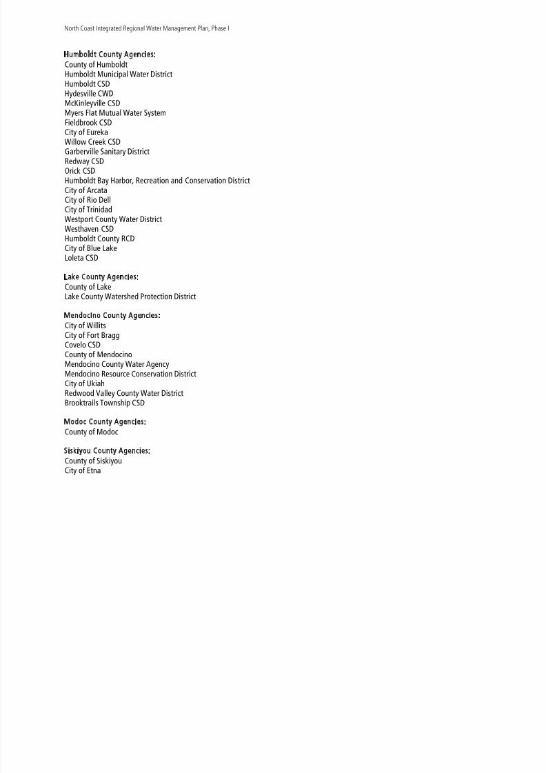
Humboldt County Agencies:County of Humboldt
Humboldt Municipal Water DistrictHumboldt CSDHydesville CWDMcKinleyville CSD Myers Flat Mutual Water SystemFieldbrook CSDCity of EurekaWillow Creek CSDGarberville Sanitary DistrictRedway CSDOrick CSDHumboldt Bay Harbor, Recreation and Conservation DistrictCity of ArcataCity of Rio DellCity of Trinidad
Westport County Water DistrictWesthaven CSDHumboldt County RCDCity of Blue LakeLoleta CSD
Lake County Agencies:County of Lake
Lake County Watershed Protection District
Mendocino County Agencies:City of WillitsCity of Fort BraggCovelo CSDCounty of Mendocino
Mendocino County Water AgencyMendocino Resource Conservation DistrictCity of UkiahRedwood Valley County Water DistrictBrooktrails Township CSD

8/2/2019 North Coast Integrated Regional Water Management Plan, July 2007
http://slidepdf.com/reader/full/north-coast-integrated-regional-water-management-plan-july-2007 11/458
North Coast Integrated Regional Water Management Plan, Phase I
Sonoma County Agencies:County of Sonoma
Town of WindsorCity of CloverdaleCity of Rohnert ParkCity of Santa RosaCity of HealdsburgCity of SebastopolCity of CotatiSonoma County Water AgencyGraton CSDSotoyome Resource Conservation DistrictGold Ridge Resource Conservation DistrictRussian River Watershed Association (group of 10 cities, counties and special districts inSonoma and Mendocino counties)
Trinity County Agencies:
County of TrinityTrinity County Resource Conservation DistrictWeaverville Sanitary DistrictWeaverville CSDTrinity County Water Works District #1
Tribal Representatives:Yurok Tribe
Hoopa Valley Tribal Protection Agency
Other Entities:Trout UnlimitedCommunity Clean Water InstituteThe Watershed Research and Training InstituteRussian River Watershed Council
North Coast Resource Conservation and Development CouncilCircuit Rider Productions, Inc.Gualala River Watershed CouncilPacific Coast Fish, Wildlife and Wetlands Restoration AssociationLandPathsSonoma Ecology Center

8/2/2019 North Coast Integrated Regional Water Management Plan, July 2007
http://slidepdf.com/reader/full/north-coast-integrated-regional-water-management-plan-july-2007 12/458
North Coast Integrated Regional Water Management Plan, Phase I
Dutch Bill Creek Watershed GroupWestminster Woods Environmental Education Program
Botanical DimensionsMattole Restoration CouncilSebastopol Water Information GroupNorth Coast Regional Land TrustThe Conservation FundRedwood Community Action AgencyLaguna de Santa Rosa Foundation
Project Team:Karen Gaffney, Katherine Gledhill, West Coast Watershed, Inc.Lisa Renton, Sonoma County Water AgencyKate Reza Ecological ConsultingCircuit Rider Productions, Inc.Dina J. Moore
Fred Euphrat, Forest, Soil and WaterPamela Swan, Swan and AssociatesMoore Iacofano Goltsman (MIG), Inc.MFG, Inc.Winzler and Kelly Consulting EngineersECONorthwest Economic ConsultantsDowHouse
Second Printing April 2006 Third printing July 2007

8/2/2019 North Coast Integrated Regional Water Management Plan, July 2007
http://slidepdf.com/reader/full/north-coast-integrated-regional-water-management-plan-july-2007 13/458
SECTION 1.0
INTRODUCTION AND PLANNING APPROACH

8/2/2019 North Coast Integrated Regional Water Management Plan, July 2007
http://slidepdf.com/reader/full/north-coast-integrated-regional-water-management-plan-july-2007 14/458

8/2/2019 North Coast Integrated Regional Water Management Plan, July 2007
http://slidepdf.com/reader/full/north-coast-integrated-regional-water-management-plan-july-2007 15/458
North Coast Integrated Regional Water Management Plan, Phase I
SECTION 1.0INTRODUCTION AND PLANNING APPROACH
The North Coastal watersheds of California comprise a unique region – a significant area of greatecological, cultural and socio-economic diversity. Although diverse and encompassing a largegeographic scope, many of the issues and concerns are consistent throughout the North Coast region.The North Coast retains some of the last viable salmonid populations in the State and is a key source of clean drinking water for the region and beyond. Unlike many areas of California, the North Coast
region continues to support natural resource based economies – including commercial fishing, timberharvesting, recreational tourism and agriculture. While some resource-based industry will likely alwaysexist in the region, the economic focus of the region is undergoing transition and becomingincreasingly reliant on service-based rather than natural resource based economies. This transition hasbeen and will continue to be difficult for certain sections of the region due to the fact that economicresources are limited and therefore, the ability to construct needed water infrastructure is limited.Additionally, while certain sub-areas within the region are economically stable, much of the NorthCoast is designated as disadvantaged, and is struggling with legacy environmental challenges. Due tolimited funding at the county and local levels, all of the jurisdictions within the region face seriouschallenges to accomplishing statewide water management objectives as well as meeting requirementsrelated to state and federal environmental regulations.
Impacts to salmonids and the beneficial uses of water often originate locally at a watershed or basinscale yet may affect the entire region. Conversely, decisions regarding salmonid protection and thebeneficial uses of water often take place at the statewide level and need to adequately account forlocal priorities, knowledge, and needs. A flexible and inclusive regional framework is therefore neededto better integrate local and statewide water management efforts.
To effectively coordinate and implement basin scale water management strategies that directlyimprove beneficial uses of water and salmonid habitat across the North Coast region, the sevencounties and over seventy partnering entities within the North Coast region have engaged in thedevelopment of a North Coast Integrated Regional Water Management Plan (NCIRWMP). Theframework for the NCIRWMP will ensure that locally derived, solution-oriented actions are coordinatedat the basin level and at the North Coast region level to collectively address cumulative impacts tosalmonids and the beneficial uses of water throughout the entire North Coast Region.
The major themes of the NCIRWMP are salmonid recovery, the beneficial uses of water, and intra-regional cooperation. Phase I of the NCIRWMP will be submitted to the State Water Resources ControlBoard and the Department of Water Resources for consideration in July 2005. Phase II is proposed forfunding as a Proposition 50 Integrated Regional Water Management Plan Planning Project. TheNCIRWMP, Phase 1 will be the first major milestone in an adaptive management process for the North
h id d i i i l id f l i l i ll b i j i i i i d

8/2/2019 North Coast Integrated Regional Water Management Plan, July 2007
http://slidepdf.com/reader/full/north-coast-integrated-regional-water-management-plan-july-2007 16/458
North Coast Integrated Regional Water Management Plan, Phase I
We anticipate that this framework will support the state in meeting its goals of Integrated RegionalWater Management Planning at both the local and regional scales, help to reduce the volume of disjointed, competing requests for funding submitted to state agencies, and increase the number andquality of local planning efforts that fit within already established statewide frameworks. Additionally,the NCIRWMP identifies and integrates implementation projects at a regional level that contribute tothe broad goals of salmonid recovery and the beneficial uses of water, and to the specific watermanagement strategies and priorities identified by the State of California (see Section 5.0, Proposed Projects and Priorities and Appendix A, Projects Integration with Statewide Goals ).
The planning region for the North Coast Integrated Regional Water Management Plan (NCIRWMP) isconsistent with the RWQCB Region 1 boundary (see Map 1, North Coast Region ). While the planningregion was selected as the planning scale for overall coordination and integration of broad watermanagement objectives throughout the region, the six Watershed Management Areas (WMAs) wereselected as the appropriate scale for more detailed planning in order to address watershed specificissues and to help coordinate planning among the counties using their General Plan authority (see Maps 1, North Coast Region and 2, Regional Watershed Management Areas ). This planning frameworkwas selected for the following reasons:
Impacts to salmonids and the beneficial uses of water may result from individual local land usedecisions and actions, but effects are cumulative across large geographic areas andeffective solutions often require a watershed and ultimately, a regional approach that canbe adopted and implemented by many stakeholders.
Shared socio-economic and natural resources values and issues exist throughout the region,with an emphasis on salmonid recovery and the beneficial uses of water for human andnatural systems.
There are multiple benefits and efficiencies associated with conforming and contributing toexisting, watershed-based frameworks established by the SWRCB, RWQCB, DWR and theResources Agency through the Watershed Management Initiative, the Basin Plan, theCalifornia Water Plan and the North Coast Watershed Assessment Program. This planningframework will help to achieve the goals and objectives of the above listed plans.Additional benefits of coordination at the regional scale include the existence of rigorousscientific information, a consistent geographic scope and associated spatial data, as wellas consistent planning approaches, data management and education of partners and
stakeholders.Key state natural resources agencies – such as the California Department of Fish and Gameand the California State Coastal Conservancy – are utilizing watershed-based naturalresource planning approaches in the North Coast region. The NCIRWMP uses thisinformation-rich, watershed-based framework for guidance and to ensure consistency withstatewide planning efforts and priorities, such as the Recovery Strategy for Coho Salmon(CDFG 2004)

8/2/2019 North Coast Integrated Regional Water Management Plan, July 2007
http://slidepdf.com/reader/full/north-coast-integrated-regional-water-management-plan-july-2007 17/458
North Coast Integrated Regional Water Management Plan, Phase I
The NCIRWMP emphasizes and incorporates applicable federal, state, regional, county, and local waterand watershed management plans (see Appendix B, Existing Water and Watershed Management Plans & Programs ). The participating organizations and stakeholders are committed to collaborativeplanning in order to better manage and conserve the water resources of the North Coast region.
The North Coast Integrated Regional Water Management Plan is a living and evolving document basedon adaptive management principles. Phase I of the NCIRWMP provides an overview of presentconditions in the North Coast Region and the six WMAs, summarizes existing planning efforts,describes goals and objectives for water management in the region and the six WMAs, identifies andprioritizes integrated water management projects, and outlines monitoring for the success of thoseprojects. Phase II will further integrate state priorities with local planning and implementation effortsand improve coordination and project development between entities in the Region.
The NCIRWMP Phase I was developed in accordance with the IRWM Grant Program ProposalSolicitation Package and Guidelines developed by the Department of Water Resources (DWR) and theState Water Resources Control Board (SWRCB), under the oversight and direction of the North CoastRegional Water Management Group (NCRWMG).
1.1 REGIONAL FRAMEWORK FOR INTEGRATED PLANNING IN THE NORTH
COAST
There are many benefits associated with synchronized, regional planning at the North Coast Regionscale as opposed to establishment of myriad county-based or watershed–based efforts for the region.County or watershed-based efforts in the region would be limited and complicated due to boundary
issues and planning approaches. Many watersheds are in multiple counties, and the approaches thathave historically been applied to watershed-based planning are profoundly different than the planningapproaches typical of county-based general plans. With a regional approach to integrated watermanagement planning, the NCIRWMP can provide a framework for melding different spatial scales,
jurisdictional and physical boundaries, and planning methodologies into a cohesive mechanism forefficient attainment of water management goals – both statewide and locally.
While the NCIRWMP is being developed at the North Coast Region scale, the NCIRWMP framework has
a strong inherent emphasis on local planning, data gathering, issues analysis, project identification,prioritization, and implementation. The NCIRWMP approach to planning acknowledges andincorporates the unique issues, information and planning approaches of local areas (both watershedsand counties) within a framework that integrates statewide planning priorities. This flexible andadaptive approach allows the NCIRWMP to accomplish effective planning at a large scale, whileretaining and enhancing high-resolution data and planning at the local scale. We expect that thisapproach will assist the State in efficiently interacting with the North Coast Region avoiding the need

8/2/2019 North Coast Integrated Regional Water Management Plan, July 2007
http://slidepdf.com/reader/full/north-coast-integrated-regional-water-management-plan-july-2007 18/458
North Coast Integrated Regional Water Management Plan, Phase I
From a geographic perspective, the NCIRWMP planning framework is based on watershed designations– ranging from large systems such as the Eel River watershed down to sub-watersheds within thelarger watersheds. Using watershed boundaries as the geographic planning framework allows theNorth Coast to integrate with other regional, state and federal planning, implementation and fundingefforts – including those already in place with California Department of Fish and Game, California StateCoastal Conservancy, State Water Resources Control Board, Regional Boards and Department of WaterResources.
1.1.1 NCIRWMP PLANNING APPROACH
The NCIRWMP relies upon an adaptive management approach – providing for ongoing data gathering,planning, design, implementation and evaluation at a variety of scales in a long-term, iterative,community-based process. The NCIRWMP acts as a nexus between statewide planning efforts and localplanning, helping to synchronize the large, complex planning processes, regulations and priorities atthe state level with the locally specific issues, data, concerns, planning and implementation needs at
the local level. The NCIRWMP will provide for the following:Data gathering and sharing among local, regional and state agency collaboratorsOrganized efficient framework for identifying local and regional issues, evaluating water
management planning objectives and strategies, identifying opportunities for integrationof water management strategies, and evaluating implementation projects.
Educating local planning efforts regarding integrated regional water management planningconsiderations and conveying Statewide Priorities to local planning efforts
Organized, efficient framework for regional project prioritization – reduction in competition
within the regionEnhancement of funding opportunities due to demonstrated integrated planning approach
1.1.2 RELATION TO LOCAL PLANNING AND INTEGRATION OF LOCAL, REGIONAL, STATE AND FEDERAL PRIORITIES
Local Planning and Priorities
Local planning efforts in the North Coast Region have historically been segregated into jurisdictionalplanning and watershed planning. Most jurisdictional planning has been focused on county-basedgeneral plans and city-based planning. Although general plans often have a natural resources element,many do not fully integrate the natural resource-based water management issues in a given area.
Watershed planning in the North Coast Region has predominantly focused on natural resources –

8/2/2019 North Coast Integrated Regional Water Management Plan, July 2007
http://slidepdf.com/reader/full/north-coast-integrated-regional-water-management-plan-july-2007 19/458
North Coast Integrated Regional Water Management Plan, Phase I
to be caused at the local level and are most affected by local planning. It is therefore critical that thetransfer of data and priorities between state and local planning efforts take place in an organizedfashion. Scale issues may also be problematic, as state agencies are addressing broad statewide issuesand priorities, while local planning is high resolution and focused at the county, city or watershedscale.
Many local planning entities do not have the staff or resources to evaluate statewide planning goalsand objectives – the NCIRWMP acts as an information resource for counties, cities, and watershedgroups to learn about, understand and implement statewide objectives within the context of localplanning. NCIRWMP, by operating as a planning and implementation “hub” at the regional scale,synchronizes local planning with statewide planning efforts – making both stronger and more robust.
Integrated Coastal Watershed Management Planning
The NCIRWMP works with and incorporates the Integrated Coastal Watershed Management Plans(ICWMPs) in the North Coast region, including ICWMPs underway in the City of Trinidad, and thewatersheds of the Noyo and Big Rivers, the Mattole River, the Russian River, and Salmon Creek. Thesewatershed planning processes place an emphasis on all of the objectives and themes of the NCIRWMP,with a special focus on Critical Coastal Areas (CCAs) and Areas of Special Biological Significance(ASBS).
Statewide Priorities
In addition to the IRWM PSPs and Guidelines, The State of California has developed several guidance
documents that are applicable to integrated water management planning in the North Coast Region.These include the State Water Resources Control Board’s Watershed Management Initiative (WMI) andthe associated RWQCB Basin Plan, the Department of Water Resource’s recently released CaliforniaWater Plan, and the Department of Fish and Game Recovery Strategy for Coho Salmon. The CaliforniaState Coastal Conservancy is in the process of completing an enhancement plan for the North Coast.Significant research, planning and staff expertise has been invested in these guidance documents, andthey provide technical and jurisdictional direction to the Region in terms of integrated planning toattain water quality objectives and the recovery of endangered salmonids.
Following is a list of Statewide Priorities that the NCIRWMP will meet or contribute to:o TMDL implementation
o Implementation of NCRWQCB WMI Chapter
o Implementation of SWRCB’s NPS Pollution Plan
I l t ti f t t i l

8/2/2019 North Coast Integrated Regional Water Management Plan, July 2007
http://slidepdf.com/reader/full/north-coast-integrated-regional-water-management-plan-july-2007 20/458
North Coast Integrated Regional Water Management Plan, Phase I
o Eliminate or significantly reduce pollution in impaired waters and sensitive habitat areasincluding areas of special biological significance;
o Include safe drinking water and water quality projects that serve disadvantagedcommunities.
The plan development process for NCIRWMP Phase I and II meets statewide process goals as follows:
1. NCIRWMP has an inclusive and transparent development process thatincorporates stakeholders and community members in the plan development
process and in the project prioritization and implementation process.2. NCIRWMP places an emphasis on engagement, planning and project
implementation for disadvantaged communities throughout the Region.
Federal Priorities
The NCIRWMP process identifies and incorporates appropriate federal priorities. These may includespecies recovery plans as outlined by NOAA Fisheries, components of the US Environmental Protection
Agency’s NPS program and other planning information from agencies such as Natural ResourcesConservation Service, U.S. Geological Survey or U.S. Fish and Wildlife Service.
References:
California Department of Fish and Game (CDFG). 2004. Recovery Strategy for Coho Salmon. Species
Recovery Strategy 2004-1. February 2004.
North Coast Regional Water Quality Control Board (NCRWQCB). 1993. Water Quality Control Plan forthe North Coast Region. Approved by the SWRCB March 21, 1994. Santa Rosa, CA.

8/2/2019 North Coast Integrated Regional Water Management Plan, July 2007
http://slidepdf.com/reader/full/north-coast-integrated-regional-water-management-plan-july-2007 21/458

8/2/2019 North Coast Integrated Regional Water Management Plan, July 2007
http://slidepdf.com/reader/full/north-coast-integrated-regional-water-management-plan-july-2007 22/458

8/2/2019 North Coast Integrated Regional Water Management Plan, July 2007
http://slidepdf.com/reader/full/north-coast-integrated-regional-water-management-plan-july-2007 23/458
SECTION 2.0
OBJECTIVES—PHASE 1

8/2/2019 North Coast Integrated Regional Water Management Plan, July 2007
http://slidepdf.com/reader/full/north-coast-integrated-regional-water-management-plan-july-2007 24/458

8/2/2019 North Coast Integrated Regional Water Management Plan, July 2007
http://slidepdf.com/reader/full/north-coast-integrated-regional-water-management-plan-july-2007 25/458
North Coast Integrated Regional Water Management Plan, Phase I
SECTION 2.0OBJECTIVES FOR THE
NORTH COAST INTEGRATED REGIONAL WATER MANAGEMENT PLAN – PHASE 1
Following are the six primary integrated water management objectives for the North Coast region.These objectives were developed with input from the Policy Review Panel, Technical Peer Review
Committee, resources agencies and stakeholders in the North Coast region. These objectives are allinterrelated, and are relevant at both the local and regional scale. The NCIRWMP objectives fullyincorporate the eleven water management strategies that are required to be considered pursuant toCWC §§ 79562.5 and 79564, and include sixteen of the twenty management strategies listed in theGuidelines. Additionally, these NCIRWMP objectives are consistent with State water managementelements, State priorities and objectives and IRWM Program Preferences. Section 8 of this documentincludes a detailed discussion of how these NCIRWMP objectives integrate with state and IRWMprogram objectives, preferences and priorities.
Each of the NCIRWMP objectives is described in more detail in the following section.
1. Conserve and enhance native salmonid populations by protecting and restoringrequired habitats, water quality and watershed processes
2. Protect and enhance drinking water quality to ensure public health3. Ensure adequate water supply while minimizing environmental impacts4. Support implementation of Total Maximum Daily Loads (TMDLs), the North Coast
Regional Water Quality Control Board’s (NCRWQCB) Watershed Management
Initiative, and the Non-Point Source Program Plan.5. Address environmental justice issues as they relate to disadvantaged communities,
drinking water quality and public health6. Provide an ongoing, inclusive framework for efficient intra-regional cooperation,
planning and project implementation
OBJECTIVE 1: CONSERVE AND ENHANCE NATIVE SALMONID POPULATIONS BY PROTECTING AND RESTORING
REQUIRED HABITATS, WATER QUALITY AND WATERSHED PROCESSES
The viability of salmonid populations is a critical environmental and economic issue for the North Coastregion, and has been adopted by the Policy Review Panel as one of three major themes for theNCIRWMP. Salmonids are a strong indicator of watershed health; the positive impacts of salmonidrecovery actions are expected to enhance other beneficial uses of water in the region. The Watershed

8/2/2019 North Coast Integrated Regional Water Management Plan, July 2007
http://slidepdf.com/reader/full/north-coast-integrated-regional-water-management-plan-july-2007 26/458
North Coast Integrated Regional Water Management Plan, Phase I
led by CDFG and NOAA Fisheries at the Evolutionarily Significant Unit (ESU) scale. The NCIRWMPapproach to intra-regional planning and cooperation offers a framework for understanding andprioritizing local water management actions and land use actions in the context of state and federalpriorities and regulations related to salmonid recovery. Historically, there has been a significantdisconnect between water management planning/water infrastructure development, local land use,and watershed restoration/salmonid recovery. The NCIRWMP process has created a mechanism toconvene all of the stakeholders and decision makers to address the integration of these historicallysegregated planning and implementation efforts. All of the priority projects in the NCIRWMP (see Section 5 ) contribute to the recovery of endangered salmonids – either directly or indirectly. Many of
the projects address salmonid issues in watersheds identified as recovery units in the CDFG CohoRecovery Strategy. By protecting salmonids, the NCIRWMP will also achieve protection andenhancement of other beneficial uses, such as improved drinking water quality and reliable watersupply; thus, salmonid protection is considered inclusive of other beneficial uses. Because salmonidpopulation viability requires good management practices at a variety of scales, and because impacts tosalmonids are cumulative throughout the North Coast Region, a series of restoration and conservationprojects distributed throughout the region may be the most effective approach for enhancing andrestoring salmonid populations.
OBJECTIVE 2: PROTECT AND ENHANCE DRINKING WATER QUALITY TO ENSURE PUBLIC HEALTH
The North Coast suffers from a variety of water quality problems that affect public health, includingfailing municipal sanitation and individual septic systems, groundwater contamination, toxic chemicalpollution and a variety of other point and nonpoint source pollution issues. The cumulative regionalimpact of these water quality issues is substantial - affecting a significant portion of the population
(predominantly in disadvantaged communities) and impacting the economic and environmentalviability of the North Coast. Many communities are faced with Cease and Desist Orders from the Statefor water quality violations, yet they lack the resources to address system deficiencies. Failingcommunity wastewater treatment and water supply systems undermine Smart Growth strategies andpromote large lot residential conversion of productive resource lands. The intra-regional cooperationframework established by the NCIRWMP is assisting local communities with resolving these dauntinginfrastructure problems by providing information about state regulations and priorities, facilitating theidentification and prioritization of projects and securing sources of funding. The Policy Review Panelhas indicated that the protection and enhancement of water quality for public health is a key objectiveof the NCIRWMP. Since many rural coastal communities don't have access to water treatment, theyrely upon healthy watersheds to provide clean drinking water. The NCIRWMP addresses watermanagement issues from both a watershed and a jurisdictional perspective – therefore this objectiveincludes a focus on ensuring healthy watersheds as a means to attain water quality objectives for theNorth Coast.
N th C t I t t d R i l W t M t Pl Ph I

8/2/2019 North Coast Integrated Regional Water Management Plan, July 2007
http://slidepdf.com/reader/full/north-coast-integrated-regional-water-management-plan-july-2007 27/458
North Coast Integrated Regional Water Management Plan, Phase I
the other beneficial uses of water – specifically watershed function, aquatic function and public health.To this end, projects prioritized by the Policy Review Panel focus on water conservation, waterrecycling/re-use, and water supply efficiency. Additionally, the Policy Review Panel supports innovativesolutions that demonstrate the successful resolution of water supply and environmental conflicts, whileacting as a model for other areas within the North Coast region. Since many rural coastal communitiesdon't have access to water treatment, they rely upon healthy watersheds to provide water security. TheNCIRWMP addresses water management issues from both a watershed and a jurisdictional perspective– therefore this objective includes a focus on ensuring healthy watersheds as a means to attain watersecurity for the North Coast.
OBJECTIVE 4: SUPPORT IMPLEMENTATION OF TOTAL MAXIMUM DAILY LOADS (TMDLS), THE NORTH
COAST REGIONAL WATER QUALITY CONTROL BOARD’S (NCRWQCB) WATERSHED MANAGEMENT
INITIATIVE, AND THE NONPOINT SOURCE POLLUTION PLAN.
The NCIRWMP prioritizes those projects that address TMDLs and nonpoint source issues for the NorthCoast region, including temperature, sediment, nutrient, pathogen and chemical impairment. The
primary reason for listing of surface waters in the North Coast region as impaired under Section 303(d)of the California Clean Water Act is excessive sediment. The NCIRWMP will support projects thatreduce sediment loads to the region’s streams and rivers. Identified sediment sources include erosionfrom logged lands, erosion from agriculture, erosion from construction sites, and runoff and sedimenttransport from urban and residential areas. Projects focused on reducing erosion and associatedsediment loads are directly related to objectives 1-3, and are expected to substantially benefit waterquality, water supply and salmonid recovery.
OBJECTIVE 5: ADDRESS ENVIRONMENTAL JUSTICE ISSUES AS THEY RELATE TO DISADVANTAGED
COMMUNITIES, DRINKING WATER QUALITY AND PUBLIC HEALTH
The majority of the North Coast region is designated as disadvantaged according to the definitionprovided by the State of California (see Section 3.10 ). The primary environmental justice issueaddressed by the NCIRWMP, Phase I is the preponderance of failing sanitation systems indisadvantaged communities. These failing systems represent a severe human health risk in areas thatlack the financial resources to address them, creating socioeconomic inequity in terms of drinkingwater quality and other beneficial uses of water. Because of this, the NCIRWMP Policy Review Panelhas selected this issue as a primary objective in meeting the water management needs of the NorthCoast region. The NCIRWMP is managed in partnership with these disadvantaged communities in theregion and includes mechanisms for outreach and the identification of future projects to improve waterquality, water supply, quality of life, and economic opportunity for disadvantaged communities of
i i h h h i
North Coast Integrated Regional Water Management Plan Phase I
8/2/2019 North Coast Integrated Regional Water Management Plan, July 2007
http://slidepdf.com/reader/full/north-coast-integrated-regional-water-management-plan-july-2007 28/458
North Coast Integrated Regional Water Management Plan, Phase I
planning and implementation. Therefore, the sixth major objective of the NCIRWMP is to maintain andenhance this existing cooperative framework to address the substantial water management needs of the North Coast, identify and refine planning and implementation priorities, provide for efficient andeffective use of planning and implementation dollars, ensure an adaptive management approach toplanning, and ensure equity for the North Coast region in terms of funding allocation. The NCIRWMPcollaborative partnership includes the following components:
a) Policy Review Panel comprised of members appointed by the Board of Supervisors from each of theseven counties
b) Technical Peer Review Committee comprised of a diversity of technical experts appointed by eachcounty’s representatives on the Policy Review Panelc) Project Team, including consultants and staff of various participating agenciesd) Stakeholders, including agencies, cities, counties, tribal organizations, watershed groups, landownergroups and interested citizens
Over seventy members of the above partnership have signed onto a Memorandum of MutualUnderstandings indicating their support for this approach (see Appendix C, Memorandum of Mutual
Understandings ). All meetings and workshops are open to the public, and all information about theprocess is disseminated via the interactive website for the North Coast Integrated Regional WaterManagement Plan, thereby ensuring maximum transparency, stakeholder inclusion and informationexchange (http://www.northcoastirwmp.net/).
A key benefit of the NCIRWMP intra-regional cooperation framework is its ability to synchronize localplanning efforts with state and federal priorities and regulations. Most municipalities and groups in theregion do not have the resources to respond to the myriad of constantly evolving policy issues and
mandates from a variety of state and federal agencies. The NCIRWMP can act as a centralizing sourcefor this information, assisting small communities and watershed groups in meeting state and federalobjectives and priorities, and conveying local issues and priorities to state and federal agencies.Cooperation and active collaboration between multiple stakeholders will ensure that all relevantviewpoints are addressed, that conflicts are identified and solutions developed, and local and regionalneeds and objectives are integrated in the selected projects to maximize benefits. Additionally, activeintra-regional cooperation ensures the efficient use of limited funds, avoiding the need for each countyor jurisdiction to “reinvent the wheel” when attempting to address statewide planning priorities andstate and federal regulations.
Relationship of Projects to NCIRWMP Objectives
The projects (described in Section 7 ) are linked on a thematic level as defined by the NCIRWMPobjectives Each serves to meet one or more of the regional objectives to: conserve and enhance native

8/2/2019 North Coast Integrated Regional Water Management Plan, July 2007
http://slidepdf.com/reader/full/north-coast-integrated-regional-water-management-plan-july-2007 29/458
SECTION 3.0
NORTH COAST REGIONAL DESCRIPTION

8/2/2019 North Coast Integrated Regional Water Management Plan, July 2007
http://slidepdf.com/reader/full/north-coast-integrated-regional-water-management-plan-july-2007 30/458
North Coast Integrated Regional Water Management Plan, Phase I

8/2/2019 North Coast Integrated Regional Water Management Plan, July 2007
http://slidepdf.com/reader/full/north-coast-integrated-regional-water-management-plan-july-2007 31/458
North Coast Integrated Regional Water Management Plan, Phase I
SECTION 3.0NORTH COAST REGIONAL DESCRIPTION
The North Coast Region as defined by the North Coast Integrated Regional Water Management Plan(NCIRWMP) is consistent with the North Coast Region boundary delineated by the North CoastRegional Water Quality Control Board (NCRWQCB). The North Coast Region is a hydrologic regionmade up of watersheds that drain to the Pacific Ocean from Marin County in the south to the Oregonborder. The North Coast Region includes all of the Counties of Del Norte, Humboldt, Trinity andMendocino, major portions of Siskiyou and Sonoma Counties and small portions of Glenn, Lake, Marin
and Modoc Counties. The region encompasses a total area of approximately 19,390 square miles,including 340 miles of coastline (NCRWQCB 2005). The 2000 population of the entire region wasapproximately 664,000, with most of the population concentrated along the Pacific Coast and in theinland valleys immediately north of the San Francisco Bay Area. (See Map 1, North Coast Region ).
3.1 REGIONAL PHYSICAL AND BIOLOGICAL FEATURES
The region is characterized by sedimentary geology with inclusions of metamorphic, granitic, andvolcanic rock. The presence of NW-SE trending faults and geologic structures largely defines the riversystems located in the Coast Range in the southern, coastal area of the region. Larger metamorphicand intrusive blocks form the Siskiyou Mountains in the northern coastal and interior region. Theeastern extent of the Klamath basin lies within the volcanic Cascade mountain range.
Significant natural freshwater bodies, apart from rivers and estuaries, are scant. The large naturalfreshwater bodies are the remnant Meiss Lake in Siskiyou County, the Laguna de Santa Rosa in
Sonoma County, and historic Tule Lake in Modoc County.
Estuaries and littoral environments are very significant to the region. They provide important habitatfor a variety of organisms and are strongly affected by freshwater outflow. Examples are Lake Earl inDel Norte County, Humboldt Bay and northern lagoons, and Bodega Bay. Also included in thiscategory are the often extensive estuarine environments of many waterways, including the Smith,Klamath, Tenmile, Noyo, Albion, Big, Navarro, Gualala, and Russian Rivers and smaller waterways suchas Redwood Creek.
The estuarine environment along the coast is extremely important to many species of waterfowl andshore birds, both for feeding and nesting and for anadromous salmonids, which use estuaries as astaging area to physiologically adapt to changes in salinity. Marine invertebrates and fish utilize therich resources in tideland areas along the North Coast, and serve as forage for seabirds and marinemammals. Offshore coastal rocks are used for resting and reproduction by marine mammals and as
i b i f bi d
North Coast Integrated Regional Water Management Plan, Phase I

8/2/2019 North Coast Integrated Regional Water Management Plan, July 2007
http://slidepdf.com/reader/full/north-coast-integrated-regional-water-management-plan-july-2007 32/458
g g g
species, and seven federally endangered mammals (see Appendix D, North Coast Region Potential Federal and State Listed Species ). The North Coast region is renowned for its wealth of naturalresources, recreational opportunities, wildlife, and scenic vistas. The region’s mountains, valleys,forests, and grasslands are home to deer (Odocoileus hemionus ), common garter snake (Thamnophis sirtalis ), elk (Cervus elaphus ), Vaux’s swift (Chaetura vauxi ), bear (Ursus americanus ), southern torrentsalamander (Rhyacotrition vareigatus ), mountain lion (Puma concolor ) and many other animal species.The abundant streams and rivers of the region provide essential habitat for anadromous fish and otheraquatic species, and the lakes and reservoirs support both cold and warm water fish. Additionally, theremnant lakes and managed reservoirs of the far northeastern portion of the region are important for
migratory waterfowl, and serve as critical links in the Pacific flyway.
Two temperature zones characterize the North Coast Region. The coastal climate is moderate andfoggy and temperature does not vary greatly by season. Inland parts of the region are less affected bythe moderating coastal influence and experience a more Mediterranean temperature regime. Seasonaltemperatures can range from over 100 degrees Fahrenheit during the summer months to belowfreezing during the winter. The North Coast receives more precipitation than any other part of California. The Mattole watershed in Mendocino County has the highest recorded rainfall and may
receive as much as 120 inches of rain per season. On the other hand, the Modoc Plateau, in Siskiyouand Modoc Counties, is relatively dry, with an annual precipitation of 10 inches and an annual snowfallof 23 inches. Due to the excessive amounts of winter rainfall, damaging floods occur frequently in theNorth Coast Region. Particularly destructive floods occurred in the North Coast region in December1955, December 1964, and February 1986 (NCRWQCB 2005).
3.2 SENSITIVE HABITATS & SPECIAL DESIGNATIONS
The North Coast Region, in addition to the extensive amount of state and federal forests, also contains21 areas designated as Critical Coastal Areas (CCAs). CCAs are areas that are considered to beenvironmentally sensitive and in need of protection or improvement by federal, state, and localgovernments. Table 1: California’s Critical Coastal Areas shows CCAs according to three methods of classification. The 1998 method identified 303 (d) listed water bodies flowing into Marine ManagedAreas (MMAs). Marine Managed Areas are “named, discrete geographic marine and estuarine areasalong the California coast designated using legislative, administrative or voter initiative processes, andintended to protect, conserve or otherwise manage a variety of resources and their uses (Resources
Agency of California 2000).” A second method of classification is Stormwater Quality Protection Areas(SWQPAs), which were formerly Areas of Special Biological Significance (ASBS), and the finalclassification method is the original 1995 list, which consisted of 303(d) listed waterbodies (NCRWQCB2005). Stormwater Quality Protection Areas (SWQPAs), which replace Areas of Special BiologicalSignificance, are displayed on Map 2, Important Biological Areas and Habitats.
North Coast Integrated Regional Water Management Plan, Phase I

8/2/2019 North Coast Integrated Regional Water Management Plan, July 2007
http://slidepdf.com/reader/full/north-coast-integrated-regional-water-management-plan-july-2007 33/458
3.2.1. MARINE AND PROTECTED AREAS: IMPAIRED WATER BODIES
Control and prevention of pollution for the Marine and Protected Areas in the North Coast are set forthin the policies adopted by the State and Regional Water Quality Control Boards. Pollution preventionand management measures are needed to ensure that adequate protection of important habitats andsystems occur. Humboldt Bay is rimmed with multiple historic and abandoned industrial sites thatrequire monitoring to ensure that contaminant plumes do not pollute the important Humboldt Bayoyster beds. The designation of Critical Coastal Zone areas serves to protect water quality and
important ecosystems from further degradation. State legislated protection has been assigned to manyof the North Coast’s significant estuarine, marine and terrestrial coastal resources. Designationsinclude Water Quality Protection Area for the non-terrestrial marine and estuarine resources along thecoastline (SWRCB 2003) and several Critical Coastal Areas, including Redwood Creek for its coastalreach and estuary (CCC 2003).
Many of the streams and rivers throughout coastal Northern California contain excessive amounts of sediment, resulting in a reduction in water quality and impacts to the beneficial uses of those waters.
Water bodies that drain approximately fifty-nine percent of the area in the North Coast Region arelisted as impaired due to sediment under Section 303(d) of the Clean Water Act (NCRWQCB 2004)).Impaired bodies throughout the North Coast are shown in Map 3, Impaired Water Bodies and are listedin Appendix E, Summary of Current Status of TMDL Development and Implementation in the NorthCoast Region.
Some of the most sensitive beneficial uses are impacted by sediment. Those uses are associated withthe migration, spawning, reproduction, and early development of coldwater fish such as coho salmon
(Oncorhynchus kisutch ), chinook salmon (O. tshawytscha ), and steelhead trout (O. mykiss ).
3.2.2 THREATENED AND ENDANGERED WILDLIFE
All of the watersheds within the North Coast Region support plant and animal species considered to berare, threatened, or endangered by state or federal government (see Appendix D, North Coast Region Potential Federal and State Listed Species ). Some of these species are: Northern red-legged frog (Rana
aurora aurora ), Behren’s silverspot butterfly (Speyeria zerene behrensii ), coho salmon (Oncorhynchus kisutch ), steelhead, pink salmon (Oncorhynchus gorbuscha ), Humboldt marten (Marates americana americana humboldtensis ), tidewater goby (Eucyclogobius newberryi ), American peregrine falcon(Falco peregrinus anatum ), bald eagle (Haliaeetus leucocephalus ), Roderick’s fritillary (Fritillaria roderickii ), white sedge (Carex albida ), Hickman’s cinquefoil (Potentilla hickmanii ), and soft bird’s-beak(Cordylanthus mollis ssp. mollis ). Not all species listed occur in every watershed and many threatened
North Coast Integrated Regional Water Management Plan, Phase I
8/2/2019 North Coast Integrated Regional Water Management Plan, July 2007
http://slidepdf.com/reader/full/north-coast-integrated-regional-water-management-plan-july-2007 34/458
1970s, despite a fairly stable rate of hatchery production (CDFG 2004). Recent abundance-trendinformation for several stream systems along the central and north coasts indicates an overall decliningtrend throughout California for coho that is also exhibited by steelhead and chinook. (See Map 4,Salmonid Evolutionarily Significant Units and Appendix F, California Department of Fish and Game Coho Recovery Units in the North Coast Region).
Because their life cycle is intricately tied to conditions that impact water quality and quantity,salmonids are useful indicators of watershed health. Spawning salmon require adequate flows in orderto return to their natal streams and clean, appropriately sized gravel to spawn. Juveniles require intact
complex habitat – pools, riffles, large woody debris, and riparian vegetation - to provide shelter, food,cool water temperatures, and other factors necessary for survival. Smolts require intact, unpollutedestuarine habitat to adjust to salinity prior to outmigration. Sedimentation, increased watertemperature, and chemical and biological pollution negatively affect at least some stages of thesalmonid life cycle. Salmonids, with this complex life cycle that is highly dependent on adequatewatershed conditions, serve as an indicator species for watershed health. For this reason, salmonidshave been chosen by the North Coast Regional Water Management Group (NCRWMG) as a point of focus for improving all beneficial uses – actions and policies that benefit salmonids will improve overall
watershed health.
In addition to providing an indicator of watershed health, salmonids also serve important socio-economic purposes. North Coast fisheries have traditionally supported a commercial and recreationalfishing industry, and have always been an important component in the traditional North Coast NativeAmerican social structure and economy.
3.3 ECOLOGICAL PROCESSES TO SUPPORT ENVIRONMENTAL RESOURCES
With the exception of dammed watersheds, many of the river systems in the North Coast Region stillpossess intact fluvial geomorphic processes and the habitats that form in response to them, althoughmany of the habitats have been impacted by timber harvest, invasion of non-native plant species, orother land uses. Additionally, in some locations, the geomorphic and ecological processes have beennegatively affected by a variety of land use changes including channelization, road development,agriculture, gravel mining, dam construction, and other land uses. The importance of these disruptions
in ecological processes for proper watershed function is exemplified by the decline of salmonidpopulations throughout the Region. Restoration of these processes will be indicated by success of salmonid recovery.
The North Coast Region contains plentiful environmental resources that support a burgeoning tourism
North Coast Integrated Regional Water Management Plan, Phase I

8/2/2019 North Coast Integrated Regional Water Management Plan, July 2007
http://slidepdf.com/reader/full/north-coast-integrated-regional-water-management-plan-july-2007 35/458
Table 1: California’s Critical Coastal Areas, North Coast Region, 2002 List CCA # CCA Name 1998 303(d) listed
waterbodiesflowing intoMMAs
SWQPA 1995CCAlist
Notes andadditionaldesignations
1 Klamath River X X X
2 Redwood Creek X X X3 Redwood NationalPark
X Park includesKlamath andRedwood CCAs withinborders
4 Kelpbeds at TrinidadHead
X
5 Mad River X6 Eel River X
7 Mattole River X X8 King Range National
Conservation AreaX
9 Pudding Creek X10 Noyo River X11 Pygmy Forest Ecological
staircaseX
12 Big River X13 Albion River X
14 Navarro River X15 Garcia River X X16 Kelpbeds at
Saunders Reef X
17 Del Mar LandingEcological Reserve
X
18 Gerstle Cove X19 Bodega Marine Life
RefugeX
20 Estero Americano X X21 Estero de San
AntonioX X
Source: NCRWQCB 2005
Note: Table 1 includes method of CCA classification: 1) 1998 303(d) listed waterbodies flowing into
North Coast Integrated Regional Water Management Plan, Phase I

8/2/2019 North Coast Integrated Regional Water Management Plan, July 2007
http://slidepdf.com/reader/full/north-coast-integrated-regional-water-management-plan-july-2007 36/458
3.4 INTERNAL BOUNDARIES
Internal boundaries to the North Coast Region are delineated in two ways in the NCIRWMP. Theregion is delineated according to county boundaries for jurisdictional planning purposes and accordingto watershed for implementation of projects to meet local, regional, and statewide water managementpriorities. Other internal boundaries in the region include private and federal water districts. Privatewater districts include those representing counties or portions of counties, municipalities, irrigationdistricts, or particular water bodies. The only federal water boundary in the region is the Klamath
Project, which is administered by the US Bureau of Reclamation. These boundary designations will beused both individually and in concert to evaluate issues, data and projects.
3.4.1 JURISDICTIONAL BOUNDARIES
On a state level, the North Coast Region has the same boundaries as Region One – the North CoastRegion – for the California State Water Resources Control Board (SWRCB). According to theDepartment of Water Resources (DWR), the North Coast Region is partially contained within its NorthCoast District and partially contained within its Central District. According to California Department of Fish and Game boundaries, the North Coast Region is partially contained within its North Coast Regionand partially contained within its Central Coast Region. On a federal level, the region is containedwithin the US EPA’s Region Nine, which covers the entire Pacific Southwest. The region also containsseveral tribal boundaries; tribes are recognized as independent, sovereign nations that possess a trustrelationship with the U.S. government.
On a more local level, the North Coast Region is comprised of four entire counties – Del Norte,
Humboldt, Trinity, and Mendocino, major portions of two counties – Siskiyou and Sonoma, and smallerportions of four counties – Modoc, Lake, Glenn, and Marin. The county boundaries are depicted inMap 1, North Coast Region. The region contains many other local jurisdictional boundaries, such ascities, towns, Resource Conservation Districts (RCDs), Resource Conservation and DevelopmentCouncils (RC&D), and Local Agency Formation Commissions. These are described below.
Municipal Boundaries
The boundaries of numerous cities and towns are contained within the North Coast Region. Most of these entities are signatories to the MOMU (see Section 6.0, Development Process for the NCIRWMP and Acknowledgements, Memorandum of Mutual Understanding Signatories ). These municipalities, byparticipating in the NCIRWMP, have an opportunity to present their communities’ unique challenges toothers in the Region and obtain visibility at the state level. They benefit from participation through the
North Coast Integrated Regional Water Management Plan, Phase I

8/2/2019 North Coast Integrated Regional Water Management Plan, July 2007
http://slidepdf.com/reader/full/north-coast-integrated-regional-water-management-plan-july-2007 37/458
County Boundaries
Counties
The North Coast Region covers all of Del Norte, Humboldt, Trinity and Mendocino counties, majorportions of Siskiyou and Sonoma Counties and small portions of Glenn, Lake, Modoc and Marin. (see Map 1, North Coast Region ).
Resource Conservation Districts
The region has multiple Resource Conservation Districts (RCDs), including Lava Beds/Butte Valley RCD,Central Modoc RCD, Gold Ridge RCD, Humboldt County RCD, Marin County RCD, Mendocino CountyRCD, Shasta Valley RCD, Siskiyou RCD, Sotoyome RCD, Southern Sonoma County RCD, Trinity CountyRCD, and West Lake RCD. These RCDs primarily occur within the Region, but those in the Northeasternand Southern portions extend beyond the Region’s boundaries. In most cases, RCD jurisdictionalboundaries are shared with the counties, with the exception of Sonoma, Siskiyou and Modoc counties.(see Map 5, North Coast Region RCD Boundaries ).
Resource Conservation and Development Councils
The region is also made up of several Resource Conservation and Development Councils (RC&D). AnRC&D area covers several counties and is locally defined and directed by a council consisting of publicand private sponsors. Currently, Del Norte and Humboldt counties do not have a RC&D council.
The purpose of an RC&D council is to accelerate the conservation, development, and utilization of natural resources to improve the general level of economic activity, and to enhance the environment
and standard of living in authorized RC&D area. The authorized RC&D areas within the region are asfollows:
Ore-Cal – which includes Siskiyou County and extends into OregonNorth Cal-Neva – which includes Modoc countyTrinity – which is entirely made up of Trinity CountyNorth Coast – which includes Sonoma, Mendocino, Marin and Lake counties
Local Agency Formation Commissions Local Agency Formation Commissions (LAFCO) are independent agencies established by State law. ALADCO is responsible for reviewing, approving or disapproving changes in organization to cities andspecial districts including annexations, detachments, new formations and incorporations. Much of thecurrent authority for LAFCO came from the Cortese-Knox Hertzberg Local Government ReorganizationAct (CKH Act) of 2000. The objectives of LAFCO are to encourage the orderly formation of local
North Coast Integrated Regional Water Management Plan, Phase I

8/2/2019 North Coast Integrated Regional Water Management Plan, July 2007
http://slidepdf.com/reader/full/north-coast-integrated-regional-water-management-plan-july-2007 38/458
3.4.2 PHYSICAL BOUNDARIES
Groundwater Basin Boundaries
The North Coast Region contains numerous groundwater basins identified by the California Departmentof Water Resources (DWR). These basins are listed in Appendix G, Groundwater Basins in the NorthCoast Region and shown in Map 6, Groundwater Basins.
Watershed Boundaries
The Water Quality Control Plan for the North Coast Region divides the region into two natural drainagebasins – the Klamath River Basin and the North Coastal Basin (NCRWQCB 2005). For planningpurposes and to address the statewide goal of protecting water through the Watershed ManagementInitiative (WMI), the NCRWQCB has divided the region into six designated watershed managementareas (WMAs). These areas are the Klamath River, Trinity River, Humboldt, Eel River, Russian/Bodega,and North Coast Rivers.
Each of these WMAs is comprised of numerous CalWater Hydrologic Units. CalWater is a spatialdataset of watersheds in California, developed by the Interagency Watershed Mapping Committee(IWMC), often referred to as the "CalWater Committee”. For many years, State and Federal agencieshave been working through the committee to map the watersheds and hydrologic units in the State of California. The North Coast is defined by CalWater as Hydrologic Region (HR) 1. Each HydrologicRegion is broken up into Hydrologic Units, with each unit indicating an entire major river basin. Largetributaries of major rivers are designated as Hydrologic Areas (HA). In turn, HAs are subdivided intoHydrologic Sub-Areas (HSA).
Following is a summary of the descriptions of each Watershed Management Area as defined by theWatershed Management Initiative (SWRCB), including a range of conditions for each WMA for surfacewater and groundwater. (See Map 7, Regional Watershed Management Areas ).
Klamath Watershed Management Area The Klamath WMA has been divided into three sub-basins: Lower Klamath, Middle Klamath and the
Upper Klamath and includes the hydrologic basins of the Klamath, Lower Klamath, Salmon River,Middle Klamath, Scott River, Shasta River, Upper Klamath, Butte Valley and Lost River. The KlamathRiver and its estuary are designated as a Critical Coastal Area. (See Map 8, Klamath Watershed Management Area ).
The Lower Klamath sub-watershed includes the Klamath River and its tributaries downstream from the
North Coast Integrated Regional Water Management Plan, Phase I

8/2/2019 North Coast Integrated Regional Water Management Plan, July 2007
http://slidepdf.com/reader/full/north-coast-integrated-regional-water-management-plan-july-2007 39/458
The Middle Klamath basin encompasses the portion of the Klamath River and tributaries between the
confluence of the Klamath and Scott Rivers and Iron Gate Dam including the mainstem of the KlamathRiver and the Shasta and Scott River watersheds. The basin covers 2,850 square miles (NCRWQCB2005). Both the Shasta and Scott Rivers receive water from precipitation and snowmelt. The smalltowns in the watershed, including Etna, Fort Jones, and Callahan, have historically had a silviculturaland agricultural economic base. In the 1800’s, the alluvial plains were mined extensively and morerecently, channeling for flood control has altered the morphological characteristics of these systems.Yreka and Weed contain the largest populations in this sub-watershed.
The Upper Klamath basin encompasses the area upstream of the Iron Gate Dam. Only a small part of this area is located in California. The primary sub-watershed in California is the Lost River watershed,which covers approximately 1,689 square miles and includes the Clear Lake Reservoir (NCRWQCB2005). The area around Clear Lake is characterized by high desert streams and is sparsely settled.Land uses in the California portion of the basin are primarily crop agriculture, grazing, and landsadministered for the National Wildlife Refuge. The basin is subject to many complex jurisdictionalissues associated with water delivery and utilization of water infrastructure facilities including issuesrelated to irrigation, hydropower, endangered species, tribal rights and lake level management
demands for the Upper Klamath Lake. In addition, the Irongate fish hatchery has an NPDES permit,which has a stipulated minimum flow requirement.
Trinity River Watershed Management Area The Trinity River basin drains an area of approximately 2,900 square miles of mountainous terrain. TheTrinity River is the largest tributary to the Klamath River; from its headwaters in the Klamath and Coastranges, the river flows 172 miles south and west through Trinity County, then north through HumboldtCounty and the Hoopa Valley and Yurok Indian reservations to its confluence with the Klamath River(NCRWQCB 2005). (See Map 9, Trinity River Watershed Management Area ). Much of the WMA isprone to seismically induced landslides, especially during winter months when soils are saturated.Additionally, inner valley gorges are considered highly unstable. Ground water resources are relativelyplentiful throughout the WMA, but are not well defined. Annual precipitation averages 57 inches/yearwith a low of 37 inches in Weaverville and Hayfork and a higher rainfall of 75 inches in Trinity Centerand 85 inches in the Hoopa Mountains. There are occasional summer thunderstorms that produceextensive runoff and may start wild fires.
The Trinity River watershed is primarily rural with human populations centered near Trinity Center,Weaverville, Lewiston, Hayfork and Hyampom. Timber harvest has traditionally been a large factor inthe economy on both federal and private land. The US Forest Service (USFS) and the Bureau of LandManagement (BLM) manage approximately 80 percent of the land in the Trinity WMA; of theremaining 20 percent about half are industrial timberlands (NCRWQCB 2005)
North Coast Integrated Regional Water Management Plan, Phase I

8/2/2019 North Coast Integrated Regional Water Management Plan, July 2007
http://slidepdf.com/reader/full/north-coast-integrated-regional-water-management-plan-july-2007 40/458
Lewiston. Trinity River downstream of the TRD provides habitat not only for anadromous salmonids
and other native species, but also the non-native brown trout (Salmo trutta ).
Water quality in the basin ranges from the high quality, pristine waters that emerge from the TrinityAlps wilderness to various degrees of impairment in the mainstem and southern tributaries which arecaused in part by human activity. Timber harvest, road construction, and associated activities arerecognized as sources of sedimentation and high summer water temperatures. Mining for gold, bothcurrently and historically, is also a source of impairment. Recreational instream dredging causessedimentation, especially in the mainstem and canyon areas, and legacy effects from historic gold
mining include acid mine drainage and mercury pollution.
Humboldt Bay Watershed Management Area The Humboldt Bay WMA encompasses waterbodies that drain to the Pacific Ocean from Humboldt Baynorth to Redwood Creek. The major river systems in the WMA are the Mad River and Redwood Creek;other waterbodies include Humboldt Bay and Mad River Slough, and coastal lagoons (Big, Stone, andFreshwater Lagoons) and streams (Elk and Little Rivers and Freshwater, Jacoby, and Maple Creeks). In
the east, the terrain is elevated hillslope with coastal plain occurring in the west. Precipitation rangesfrom 32 to 98 inches annually. Redwood Creek, the Kelpbeds at Trinidad Head, and the Mad River arethe Critical Coastal Areas that occur in this WMA (NCRWQCB, 2005). (See Map 10, Humboldt Bay Watershed Management Area ). The streams support production of anadromous salmonids, includingsteelhead and cutthroat trout, coho and chinook salmon.
Mad River
The Mad River watershed has a long history of timber harvest on both USFS and private land. Gravelmining occurs in the lower portions of the watershed. Private landowners conduct grazing and limitedagriculture in the flat areas around the bay. Humboldt Bay is an important commercial and recreationalshellfish growing and harvest area and provides the largest port between San Francisco and Coos Bay,Oregon. Urbanized areas include Trinidad, McKinleyville, Arcata, and Eureka and rural residential areasare scattered throughout the WMA. The majority of the population lives in the Humboldt Bay areacities of Arcata and Eureka.
The Mad River is CWA section 303(d) listed for sediment and temperature impacts. The primary issuesfor water quality are forestry related, with urbanization and associated industrial and public nonpointsources. The drinking water for most of the Humboldt Bay area is supplied by Ranney Collectors in MadRiver with other coastal streams providing drinking water for other communities. Mad River iscontinuously supplied with water via releases from the Ruth Reservoir (with 48,030 acre-foot storagecapacity) although these supplies are dependant on adequate precipitation and flows through the
North Coast Integrated Regional Water Management Plan, Phase I

8/2/2019 North Coast Integrated Regional Water Management Plan, July 2007
http://slidepdf.com/reader/full/north-coast-integrated-regional-water-management-plan-july-2007 41/458
Redwood Creek
Redwood Creek flows into the Pacific Ocean near the town of Orick and is located about 35 miles northof Eureka. Redwood Creek drains a 285-mi2 area and is about 67 miles long. The watershed is locatedentirely within Humboldt County.
Redwood Creek is a basin of mixed ownership and contains a rich blend of industrial and non-industrialtimberlands, coastal and upland agricultural lands, state and federal national parks, other federalproperties, and the unincorporated town of Orick. Redwood Creek supports three federally listed as
threatened salmonids species as well as the non-listed coastal cutthroat trout (O. clarki ) and residentfish species (RNSP 1997). The watershed also provides domestic water supplies to rural communitiesand recreational opportunities. At the coast, Redwood Creek discharges into a designated WaterQuality Protection Area (formerly known as Areas of Special Biological Significance) (SWRCB 2001,SWRCB 2003) and a Critical Coastal Area (CCC 2003).
Redwood Creek is a model watershed where government agencies, private landowners, non-profitorganizations and the local communities are cooperating to restore and protect water quality and the
associated aquatic and riparian resources, and provide economic opportunity to the Orick community.The watershed has a rich history of scientific studies that spans decades and well-establishedcooperation between groups with seemly conflicting interests. The watershed is home to pioneeringwork in watershed restoration and erosion control.
The watershed is a mixed ownership of private (56 percent) and public (44 percent) lands. More than90 percent of the private lands are managed for timber production and ranching by eight privatelandowners. The upper two-thirds of the watershed contain vast expanses of timber and ranch landsmanaged primarily by seven landowners. Timberlands have been maintained in large unbroken tractsof lands, which have slowed rural residential development in upland areas (RNSP 2001). Located alongthe coast, the small town of Orick is the only municipality in the watershed and has a population of about 315 people (HC 2003). Orick is relatively isolated from other north coast communities andqualifies as a “disadvantaged community.” The Orick valley contains the coastal floodplain of Redwood Creek and is one of only two groundwater basins identified in the watershed (DWR 2003).The town of Orick is located in the valley. Orick is the major socioeconomic center in the watershed. Itis located along U.S. Highway 101 and is the southern gateway to Redwood National and State Parks.
Redwood National Park and Prairie Creek Redwoods State Park are located in the lower part of theRedwood Creek basin. This sub basin has been extensively researched and is considered a “referencewatershed” that displays nearly pristine conditions, and is home to significant old growth stands of coast redwood. In 1982 the park received international recognition when it was designated as both aWorld Heritage Site and International Biosphere Reserve. The protection of streamside redwoods alongRedwood Creek was a central issue for the establishment and expansion of Redwood National Park
North Coast Integrated Regional Water Management Plan, Phase I
8/2/2019 North Coast Integrated Regional Water Management Plan, July 2007
http://slidepdf.com/reader/full/north-coast-integrated-regional-water-management-plan-july-2007 42/458
Eel River Watershed Management Area
The Eel River and its tributaries comprise the third largest river system in California, and the largestriver system draining to Humboldt County’s coast. The Eel River WMA encompasses roughly 3,684square miles (NCRWQCB, 2005). The main tributaries to the Eel River are the Van Duzen River, theBear River, Yager, Larabee, Bull and Salmon Creeks. Lake Pillsbury, is located near the headwaters of the mainstem Eel. The upper watershed is mountainous and soils are steep and highly erodible. The EelRiver is designated as a Critical Coastal Area. (See Map 11, Eel River Watershed Management Area ).
In the west, the river meanders on a coastal plain and is joined by the Salt River. Several dairies are
located on the coastal plain, as well as several small towns. Other communities in the watershedinclude Scotia, Garberville, Laytonville, and Willits. In many of the alluvial valleys, surface and groundwater are closely connected, thus surface water withdrawals have a substantial effect on localgroundwater supplies. A Northwestern railroad line following along the Eel River has fallen intodisrepair due to numerous landslides and accidents. Recently, reviving the railroad has been discussed,but the costs may outweigh the benefits (NCRWQCB 2005). The rail line has negatively impacted waterquality. The Eel River WMA is a well-known recreation destination with numerous state and privatecampgrounds along its length; beneficial uses include both water contact and non-contact uses such as
swimming and boating. The river also supports a large recreational fishing industry; it is the thirdlargest producer of salmon and steelhead in the State of California (NCRWQCB 2005). Due to theerodible soils, steep terrain, and land use history, there is significant concern for the viability of thisanadromous fishery resource.
North Coast River Watershed Management Area The North Coast Rivers not included in other WMAs are included in this grouping. The majorwatersheds south of the Oregon border include the Smith River, Bear River, Mattole River, Ten MileRiver, Noyo River, Big River, Albion River, Navarro River, Greenwood, Elk and Alder Creeks, GarciaRiver and Gualala River (NCRWQCB, 2005). (See Map 12, North Coast River Watershed Management Area ). The twelve Critical Coastal Areas in the North Coast WMA are the Mattole River, King RangeNational Conservation Area, Pudding Creek, Noyo River, the Pygmy Forest Ecological Staircase, BigRiver, Albion River, Navarro River, Garcia River, the Kelpbeds at Saunders Reef, Del Mar LandingEcological Reserve, and Gerstle Cove.
Mattole River
The headwaters of the Mattole River begin in Mendocino County, and it flows north 62 river miles,through steep, forested lands in Humboldt County and into the ocean ten miles south of CapeMendocino Trib taries to the Mattole Ri er incl de Mill Sq a Bear Thompson Hone de and
North Coast Integrated Regional Water Management Plan, Phase I

8/2/2019 North Coast Integrated Regional Water Management Plan, July 2007
http://slidepdf.com/reader/full/north-coast-integrated-regional-water-management-plan-july-2007 43/458
harvest, road building, forest conversion, and overgrazing. Fish species known to inhabit the Mattole
River include coho, Chinook, steelhead, rainbow trout (Oncorhynchus mykiss ), and brook lamprey(Ichthyomyzon fossor ); other species include the southern torrent salamander (Rhyacotriton variegatus )and tailed frog (Ascaphus truei ).
Ten Mile River
The Ten Mile River watershed covers approximately 120 square miles (NCRWQCB 2005). It is about
eight miles north of the City of Fort Bragg and shares ridges with Pudding Creek and the North Fork of the Noyo River to the south and Wages Creek and the South Fork of the Eel River to the north.Elevations range between sea level and 3,205 feet (NCRWQCB 2005). Near the coast, the terrain iscomprised of an estuary and a broad river floodplain with more rugged mountainous topography in theeastern portion of the watershed. Most of the basin, except the northeast grasslands, coastal plain, andestuary, is characterized by narrow drainages bordered by steep to moderately steep slopes. Thewatershed has abundant rainfall and cool temperatures during the winter with dry, warm summersinterspersed with breezes and coastal fog. Precipitation in the western part of the watershed is about
70 inches per year while about 40 inches per year occurs in the eastern part of the watershed(NCRWQCB 2005).
The watershed is entirely privately owned. Hawthorne Timber Company, LLC, which is managed byCampbell Timberland Management, LLC, owns about 85 percent of the watershed. Three small non-industrial timber owners and a few residences make up the remainder of the ownership. The watershedhas a long history of timber harvest.
The coldwater fishery that supports coho, chinook, and steelhead is the primary - and most sensitive -beneficial use in the watershed. Protection of these species is considered to protect any of the otherbeneficial uses identified in the watershed that could be impaired due to water quality (NCRWQCB2005).
Noyo River
The Noyo River watershed encompasses the 113 square mile coastal drainage system immediately westof the City of Willits, flowing into the Pacific Ocean at the City of Fort Bragg. The climate consists of moderate temperatures – an annual average of 53 degrees F - and an average annual rainfall of 40 -65 inches.
Silviculture is the primary land use within the watershed. Approximately 50 percent of the watershed
North Coast Integrated Regional Water Management Plan, Phase I

8/2/2019 North Coast Integrated Regional Water Management Plan, July 2007
http://slidepdf.com/reader/full/north-coast-integrated-regional-water-management-plan-july-2007 44/458
and chinook. It is listed as impaired by sediment, due in part to timber harvest, grazing, and related
human activities.
Big River
The Big River watershed drains about 181 square miles (NCRWQCB 2005). The watershed drains fromeast to west, and shares ridges with the Noyo River watershed to the north, the Eel River watershed tothe east, and the Little, Albion and Navarro Rivers watersheds to the south. The Big River estuary is
located immediately south of the town of Mendocino. The climate is characterized by a pattern of low-intensity rainfall in the winter and cool, dry summers with coastal fog. Mean annual precipitation isapproximately 40 inches near the western part of the watershed and about 51 inches at Willits to theeast (NCRWQCB 2005). The Big River is designated a Critical Coastal Area.
The predominant current and historic land use is silviculture with less area used for ranching. Thelargest community is the Town of Mendocino. Together, the five largest property owners –four privatetimber companies and Jackson State Demonstration Forest - own 83 percent of the watershed. Thirty-
one property owners own another 14 percent of the land (parcels from 160 to 3,760 acres), and privateresidences make up the rest of the land use (NCRWQCB 2005).
In 2002, most of the Big River Estuary, and some associated upland areas were added to the CaliforniaState Park System. The Big River Parcel consists of 7,334 acres, which, when added to the surroundingState Park system, creates a 74,000-acre wildlife corridor linking coastal and inland habitats into thelargest piece of connected public land contained entirely within Mendocino County (NCRWQCB 2005).
Coho, steelhead, and chinook currently inhabit the Big River watershed, but population numbers arelow compared to historic levels. The estuary and lower river provide critical habitat for spawning,rearing, and staging for adult, juvenile, and smolting salmonids.
Albion River
The Albion River watershed drains approximately 43 square miles (NCRWQCB 2005). It drains primarilyfrom east to west, and shares ridges with the Big River watershed to the north and northeast and the
Navarro River watershed to the south and southeast. The Albion River estuary is located near the townof Albion, about 16 miles south of the City of Fort Bragg. Elevations range from sea level to 1,566 feetand the watershed is dominated by relatively flat marine terraces that extend several miles inland andare incised by gorges carved by the major river channels and streams (NCRWQCB 2005). The climate inthe watershed is characterized by a pattern of low intensity rainfall in the winter and cool, dry summers
North Coast Integrated Regional Water Management Plan, Phase I

8/2/2019 North Coast Integrated Regional Water Management Plan, July 2007
http://slidepdf.com/reader/full/north-coast-integrated-regional-water-management-plan-july-2007 45/458
comprise the other half (NCRWQCB 2005). The predominant historic and current land use is
silviculture, with some agricultural and recreational uses. The Albion River estuary, which remainsopen to the sea year round, is used as a commercial and sport fishing harbor for small boats. The riverand estuary have historically served as habitat for coho, chinook, and steelhead. Beneficial usesassociated with the coldwater fishery are the most sensitive of the beneficial uses in the watershed;protection of these beneficial uses is thought to serve to protect other beneficial uses harmed byexcessive sediment.
Navarro River
The Navarro River watershed encompasses approximately 315 square miles. The Navarro River flowsthrough the coastal range, Anderson Valley, and into the Pacific Ocean. It is the largest coastal basin inMendocino County. Rainfall averages about 40 inches per year at Philo and mostly occurs betweenDecember and March (NCRWQCB 2005). The Navarro River is a designated Critical Coastal Area.
Land-uses in the watershed include silviculture (70%), rangeland (25%), and agriculture (5%) with a
small percentage devoted to rural residential development (NCRWQCB 2005). Timber production,ranching and other agricultural activities are historic activities that continue to the present day, whilethe fishery has decreased. Anderson Valley today supports orchards and a growing viticulture industry.
Greenwood Creek
The Greenwood Creek Watershed encompasses approximately 25 square miles and is located on the
southern Mendocino Coast with Greenwood Ridge as its northern border, Clift Ridge as its southernborder, and Signal Ridge as its eastern border. Greenwood Creek, is a Class I coastal stream andprovides habitat for steelhead and coho (NCRWQCB 2005).
Land use in the watershed is primarily for timber production, viticulture, fruit orchards, residential andsome cattle ranching. Most of the watershed is privately owned; Mendocino Redwood Company holdsabout 60% as Timber Production Zone (TPZ) land, and approximately 50 smaller landowners own therest of the watershed (NCRWQCB 2005). The only public land in or adjacent to Greenwood Creek isGreenwood State Beach, which contains the Greenwood Creek estuary, and a small parcel owned by
the Elk County Water District.
Garcia River
North Coast Integrated Regional Water Management Plan, Phase I

8/2/2019 North Coast Integrated Regional Water Management Plan, July 2007
http://slidepdf.com/reader/full/north-coast-integrated-regional-water-management-plan-july-2007 46/458
converted to new vineyards. The watershed is completely privately owned by multiple owners
(NCRWQCB 2005). The river and estuary provide habitat for salmonids and identified beneficial usesinclude commercial and sport fishing. The Garcia River has been listed as impaired due to sediment.
Gualala River
The Gualala River watershed encompasses about 300 square miles; the Gualala River flows fromMendocino County to Sonoma County in a north-south direction, reaching the ocean at the town of
Gualala. The watershed contains mostly mountainous terrain; tributaries flow through steep valleyswith narrow floors that contain erodible soil. Most of the annual precipitation occurs between Octoberand April, with the greatest amounts in January. Rainfall averages about 38 inches per year at thecoast and up to 100 inches per year on the inland peaks (NCRWQCB 2005).
The primary historic land uses are silviculture, orchards, and ranching with timber harvest still animportant industry. Timber companies own about one-third of the watershed; Gualala Redwoods Inc.is the largest commercial owner, holding about 30,000 acres (NCRWQCB 2005). Orchards and
ranching are on the decline while the watershed has seen an increase in hillside vineyard development,which threatens to continue to impair water quality with respect to sediment delivery. The GualalaRiver provides the primary source of drinking water for Sea Ranch and Gualala. The watershedsupports an anadromous fishery that includes coho salmon.
Russian/Bodega Watershed Management Area This management area includes the Russian River and Bodega hydrologic units including the BodegaHarbor, Salmon Creek, Americano Creek, and Stemple Creek watersheds. (See Map 13, Russian/Bodega Watershed Management Area ).
Russian River Hydrologic Unit
The Russian River hydrologic unit (HU) encompasses 1,485 square miles in Mendocino and Sonomacounties. It is bounded by the Coast Ranges on both the east and west. The mainstem is about 110miles long and flows from north of Ukiah southward through Redwood Valley to its confluence withMark West Creek, where it turns west, passes through the coast range, and empties into the PacificOcean (NCRWQCB 2005). The summer climate is moist and cool near the coast with temperaturesincreasing in the valley areas, which are isolated from the cooling coastal influence. During winter,average rainfall ranges from 30-80 inches, depending on locale.
North Coast Integrated Regional Water Management Plan, Phase I

8/2/2019 North Coast Integrated Regional Water Management Plan, July 2007
http://slidepdf.com/reader/full/north-coast-integrated-regional-water-management-plan-july-2007 47/458
Bodega Hydrologic Unit
The Bodega HU contains streams with headwaters in the Coast Range that enter the Pacific Oceansouth of the Russian River. Salmon, Americano, and Stemple Creeks and their associated estuaries arethe main waterbodies in this HU. The terrain is relatively steep and erodible and is sensitive todisturbance. Cooler temperatures and relatively high winter rainfall due to coastal influences typify theclimate of the Bodega HU. Because of the Mediterranean climate, summertime flows are often non-existent in Americano and Stemple Creeks, while Salmon Creek flow is low but sustained. Each of thesewatersheds have estuary areas, however, the Estero Americano (Americano Creek) and the Estero de
San Antonio (Stemple Creek) are prized for their resemblance to fjords and the enhanced resourcevalues associated with isolated estuarine environments. Both of these estuaries are designated CriticalCoastal Areas and the Bodega Marine Life Refuge is also a Critical Coastal Area.
3.5 MAJOR WATER-RELATED INFRASTRUCTURE
There are several large water supply projects in the North Coast Region (DWR 2005). These include theU.S. Bureau of Reclamation Klamath Project, the U.S. Army Corps of Engineers Russian River Project,the Humboldt Bay Municipal Water District Ruth Reservoir, and the U.S. Bureau of Reclamation TrinityLake Reservoir as well as several other water supply, power generation, and flood control projects.
The Klamath Project includes water supply facilities in California and Oregon. The California facilitiesinclude Clear Lake Reservoir, which is used to provide potable water; Tule and Lower Klamath Lake,which function as waterfowl refuges; and the Iron Gate Reservoir, which provides energy for a
hydroelectric facility owned by Pacific Power and Light Company (DWR 2005). Three additional power-generating reservoirs are located in Oregon. The reservoirs in Oregon are operated on a peaking basiswhile the Iron Gate Reservoir is operated as a baseload plant (NCRWQCB 2003). The Klamath Projecthas been extremely controversial because to maintain adequate instream fishery flow to ensure thesurvival of endangered salmonid populations, coordination between many jurisdictions is necessary.Water to farms has at times been cut off to prevent harm to the fisheries, resulting in extremecontroversy, and in some cases, violence.
The U.S. Army Corps of Engineers Russian River Project includes both Lake Sonoma and LakeMendocino, which provide water for agriculture and municipal and industrial uses, in addition tomaintaining the minimum stream flows to provide fish passage for salmonids and recreation. LakeSonoma was formed in 1984 with the completion of the Warm Springs Dam and Lake Mendocino wasformed in 1959 by the construction of the Coyote Dam on the East Fork of the Russian River.
North Coast Integrated Regional Water Management Plan, Phase I

8/2/2019 North Coast Integrated Regional Water Management Plan, July 2007
http://slidepdf.com/reader/full/north-coast-integrated-regional-water-management-plan-july-2007 48/458
serves about 60,000 customers in Humboldt County as well as supplying electric power to Pacific Gas &
Electric. The dam serves as a recreational destination and wildlife habitat in addition to supplyingwater and energy resources (California Department of Water Resources 2005).
The Claire Engle Reservoir, known locally as Trinity Lake, is a part of the Central Valley Project. It wasformed by the completion of the Trinity Dam on the Trinity River in 1961. The dam is also used forhydroelectric power generation and the lake provides recreational activities and wildlife habitat.
The Santa Rosa Subregional Reclamation System reclaims water, treats it to a tertiary level, and
distributes it to agricultural users, golf courses, public and private landscaping, and the Geyserssteamfield. It is one of the largest reclaimed water agricultural irrigation systems in the country (City of Santa Rosa undated). For the Geysers Recharge Project, reclaimed water is piped through a 42-milepipeline and injected into underground wells in the Geysers steamfield. Once within the wells, thewater is gradually heated by geothermal activity to produce a steam that is then utilized to produceelectricity at nearby power plants. The Geysers Recharge Project was chosen as a means to dispose of treated wastewater during the winter months, when there is no demand for agricultural irrigation. TheSubregional Reclamation System had previously been discharging the unused water to the RussianRiver, but stricter water quality regulations removed this option. The Subregional Reclamation Systemis currently exploring other means of reusing or disposing of current and future amounts of reclaimedwater in order to best manage water resources. Other water reuse projects exist throughout theregion; however, they are minor compared to the infrastructure described above.
3.6 WATER QUALITY
3.6.1 SURFACE WATER QUALITY
The North Coast Region faces many water quality challenges. The US EPA has listed most of theRegion’s rivers and streams as impaired according to the Clean Water Act Section 303d (See Map 3,Impaired Waters) . The total maximum daily loads (TMDLs) established by the US EPA for sediment andtemperature are the most common listings (see Appendix E, Summary of Current Status of TMDL Development and Implementation in the North Coast Region ). TMDLs for sediment and temperatureare associated with salmonid decline and impairment of beneficial uses (NCRWQCB 2005). Impairment
is mostly due to nonpoint source pollution that is produced by a variety of sources including stormwater runoff, erosion and sedimentation from roads, agriculture, and timber harvest, channelmodification activities, gravel mining and dairy operations, failing septic tanks and MTBE, PCE, anddioxin contamination from gas stations and industrial activities (NCRWQCB 2005).
f h h d h h hl d bl l h
North Coast Integrated Regional Water Management Plan, Phase I
8/2/2019 North Coast Integrated Regional Water Management Plan, July 2007
http://slidepdf.com/reader/full/north-coast-integrated-regional-water-management-plan-july-2007 49/458
channel aggradation (SWRCB 2003, Bundros and others 2003, NCWAP 2005). A sediment Total
Maximum Daily Load (TMDL) for Redwood Creek was developed and promulgated by the U.S.Environmental Protection Agency (USEPA 1998). Erosion from logging roads upstream of the parkswas identified as a major source of sediment in Redwood Creek (RNPS 1997, USEPA 1998). Asediment implementation plan was written, but has not been adopted by either the regional or statewater boards. A stream temperature TMDL for the Redwood Creek watershed has not been written,but other studies provide assessments and recommendations to improve riparian conditions (Bundrosand others 2003, CDFG 2004, NCWAP 2005).
In addition to land use practices, channel modifications for flood control and water diversions for cropirrigation and drinking water supply have radically changed water quality conditions in many waterbodies in the region. Ranney collectors - horizontal wells adjacent to or under the bed of a stream -provide the drinking water for many of the northern communities in the Region. These collectors areactually collecting surface water, which decreases the amount of surface water available for otherbeneficial uses. Reduced natural flows from both Ranney collectors and instream diversions can resultin increased temperature and decreased capacity to dilute contaminant concentrations.
Anadromous fisheries in the region have been adversely affected by a number of water quality factors.The Eel, Mad, Mattole, Trinity, and Russian Rivers, as well as many other rivers and streams includingRedwood Creek, are listed on the Clean Water Act 303(d) list as impacted by excessive sedimentation(see Map 10, Impaired Water Bodies and Appendix E, Summary of Current Status of TMDL Development and Implementation in the North Coast Region ). One of the largest impacts fromsedimentation occurs when salmonid spawning nests – redds – are covered with fine sediment thatprevents oxygen from reaching the eggs and inhibits emergence, effectively smothering the nextgeneration. Timber harvest and floodplain development can decrease the riparian canopy that shadesrivers and streams, causing increased water temperatures to levels that are harmful – or even lethal –
to coldwater fish. Water diversions have resulted in summer temperatures in the Trinity and KlamathRivers that are sub-optimal, or at times, lethal, to salmonids (DWR 2005). The North Coast Region’sbasin plan sets turbidity restrictions and establishes temperature objectives for the Trinity River.Fisheries may also be adversely impacted by the lack of woody debris for pool habitat formation andsediment metering. Flood control measures can also adversely impact salmonid habitat. For example,consider the Redwood Creek estuary, where the summer water quality is poor. Degradation of waterquality in this estuary is directly related to the construction of the Redwood Creek Federal FloodControl Project. While these levees provide beneficial flood protection to Orick, they have significantly
impacted estuary function by drastically altering the physical setting of the estuary and sloughs (RNSP1997, NCWAP 2005. The current condition of the estuary is considered a major limiting factor toanadromous salmonid production in the Redwood Creek watershed (RNSP 1997, CDFG 2004, NCWAP2005). Many such examples exist throughout the North Coast, and while previous efforts such as theNorth Coast Watershed Assessment Program have provided a significant amount of information aboutthese watersheds an integrated regional planning effort such as the NCIRWMP will provide the
North Coast Integrated Regional Water Management Plan, Phase I

8/2/2019 North Coast Integrated Regional Water Management Plan, July 2007
http://slidepdf.com/reader/full/north-coast-integrated-regional-water-management-plan-july-2007 50/458
Impacts of Not Implementing NCIRWMP Projects ). Shellfish harvesting beds in Humboldt Bay have
been closed multiple times due to nonpoint source runoff, most often following large rain events.Mercury, a legacy pollutant from mining and other industrial activities, concentrates in fish tissue andhas been found to be of concern in Lakes Pillsbury, Mendocino, and Sonoma. Additionally, fuelconstituents, such as MTBE, chemicals from wood treatment at lumber mills, silviculture operations,agriculture, and residential applications are region-wide water quality issues.
3.6.2 GROUND WATER QUALITY
Groundwater quality problems in the North Coast Region include seawater intrusion and elevatednutrients in shallow coastal groundwater aquifers; high total dissolved solids (TDS), elevated mineraland heavy metal concentrations and alkalinity in groundwater in the Modoc Plateau basins; and iron,boron, and manganese in the inland groundwater basins of Mendocino and Sonoma counties. Legacypollution from abandoned mines and historical lumber mills and present-day forest and agriculturalherbicide application also pose a potential threat to regional groundwater, as do septic tank failuresthroughout the Region. Additionally, throughout the region, there are numerous small wastewater
treatment plants operating that are violating waste permit discharges due to equipment malfunction,age, or limited capacity, or a combination of these problems. These failing systems threaten humanhealth and drinking water and other beneficial groundwater uses, and they also cause economichardship for the communities in which they operate (see Section 8.3.3, Critical Impacts of Not Implementing NCIRWMP Projects ). For example, groundwater and surface water pollution studies inOrick confirmed effluent from septic tanks was contaminating ground and surface water supplies (OLA1999). Contamination was attributed to old and failing septic systems on small parcels combined withhigh groundwater levels during winter months that can rise to within three feet of the surface. Theinvestigators believe most of the contamination was of human origin and recommended a modern-day
wastewater facility to address the issue and allow for future community growth (OLA 1999).
The City of Willits and other communities and individuals in Humboldt County have found high arsenic,iron, and manganese levels in their well water supplies. Chemical contamination has caused theclosure of municipal wells in Sebastopol and Santa Rosa in Sonoma County. Industrial operationsincluding lumber mills, oil storage, and wrecking and railroad yards have caused both soil and groundwater contamination with heavy metals, petroleum products, and pentachlorophenols (PCPs) inlocations throughout the region. In the City of Eureka, the City, along with corporate partners and
other agencies, is currently undertaking cleanup and redevelopment of the historically contaminatedwaterfront. The Mendocino City Community Services District, which serves the Town of Mendocino inMendocino County, adopted an ordinance in 1990 that regulates new groundwater extraction – forexample, when a new well is built or when the amount extracted from an existing well is increased(California Department of Water Resources 1996).
North Coast Integrated Regional Water Management Plan, Phase I

8/2/2019 North Coast Integrated Regional Water Management Plan, July 2007
http://slidepdf.com/reader/full/north-coast-integrated-regional-water-management-plan-july-2007 51/458
constituents such as boron, while this may not pose a problem in projects such as recharging the
Geysers aquifer in Sonoma and Lake counties.
3.7 WATER QUANTITY
Water quantity to provide drinking water and support other beneficial uses in the North Coast is limited
by water quality in some areas and by the lack of infrastructure for at least part of the year in many of the region’s rural and isolated areas.
3.7.1 RELEVANT LEGISLATION
Senate Bill 1062 by Sen. Charles Poochigian requires that the Department of Water Resources (DWR)include multiple strategies to address the state's water supply needs in California Water Plan updates(DWR 2005). Additionally, it establishes an advisory committee to assist with the Plan update. The Billdescribes California's need to provide water planners with reliable information regarding watersupplies and accurate estimates of expected population growth, and establishes the integral role of water conservation, waste water recycling, conjunctive use, desalination, and water storage ascomponents in meeting those needs. Specifically, the bill states:
Ҥ 1: The Legislature finds and declares all of the following:
(a) A long-term, reliable supply of water is essential to protect the productivity of California’sbusinesses and economic climate.(b) The Department of Finance projects that California’s population will increase to over 47
million persons by 2020, increasing the need for the development of additional safe andreliable water supplies that are critical to the health, safety, and welfare of allCalifornians, including the state’s future generations.
(c) Water-related infrastructure investment needs are growing rapidly as a result of a growingpopulation and economy, environmental and public health requirements, and aging waterdelivery systems.
(d) The Department of Water Resources projects that Californians will experience chronicwater shortages, as early as 2000, unless actions are taken to increase the amount of developed water available for use in California.”
North Coast Integrated Regional Water Management Plan, Phase I

8/2/2019 North Coast Integrated Regional Water Management Plan, July 2007
http://slidepdf.com/reader/full/north-coast-integrated-regional-water-management-plan-july-2007 52/458
managed wetlands, required Delta outflow, instream flow, and Wild and Scenic Rivers flow. When
water supplies fall short, as they did in 2000 and 2001, the Wild and Scenic Rivers and environmentaluses receive the largest reductions (DWR 2005).
The amount of surface water in the North Coast Region is extremely dependent upon precipitation asdescribed above. In very wet years, there may be a surplus, but in drought years, quantity is limitedand can become a source of contention between water users. For example, the Klamath Basin has hadwater shortage problems in recent years that have led to confrontations between farmers andregulators and farmers and environmentalists. As the population of the North Coast Region grows (see
Section 3.10, Demographic, Economic, Social, and Cultural Attributes ), drinking water will continue toexperience increases in demand, making the identification of alternative sources for agricultural andlandscape irrigation a high priority. The NCRWMG provides the framework for regional cooperationand collaboration to determine the optimal strategies to ensure that surface water supply is able tomeet environmental and human-related beneficial uses during both surplus and drought water years.
3.7.3 GROUNDWATER QUANTITY
There are 63 groundwater basins/subbasins delineated in the North Coast region, two of which areshared with Oregon (DWR, Bulletin 118). These basins underlie approximately 1,022 million acres(1,600 square miles) (see Map 11, North Coast Region Ground Water Basins ).
There is limited large-scale groundwater development in the North Coast Region due to the smallnumber of significant coastal aquifers. Most of the groundwater development that has occurred comesfrom shallow wells installed adjacent to rivers. There are, however, significant groundwater basins
underlying the Klamath River valley along the Oregon border and the southern tip of the Regionunderlying Santa Rosa in Sonoma County (DWR 2005) (See Map 11, North Coast Region Groundwater Basins ). Despite the limits on large-scale infrastructure, groundwater is used widely throughout theregion for individual domestic, agricultural, and industrial water supply (NCRWQCB 2005). Many ruralareas rely exclusively on private wells for residential water. There are also an unknown number of small dams, and water-related infrastructure, which may have a large cumulative impact ongroundwater.
In California, regulation of extraction and appropriation of groundwater is the responsibility of localagencies (DWR 2005). As with surface water, recharge to groundwater supply is highly dependent onprecipitation. The amount of groundwater available varies yearly with precipitation, infiltration, andthe amount of withdrawals from groundwater basins. Withdrawals, in turn, are in part dependent onthe amount of surface water available for municipalities that use both surface and ground water for
l d G d t i i ifi t t f ll l iti th t l
North Coast Integrated Regional Water Management Plan, Phase I

8/2/2019 North Coast Integrated Regional Water Management Plan, July 2007
http://slidepdf.com/reader/full/north-coast-integrated-regional-water-management-plan-july-2007 53/458
Redwood Creek in the northern part of town. In the Redwood Creek watershed, there are no water
development projects such as dams and surface water diversions.
3.7.4 RECLAIMED WATER QUANTITY
Water recycling, also known as reclamation or reuse, is an umbrella term encompassing the process of treating wastewater, storing, distributing, and using the recycled water. Recycled water is defined inthe California Water Code to mean “water which, as a result of treatment of waste, is suitable for a
direct beneficial use or a controlled use that would not otherwise occur.”Existing uses of reclaimed water including landscape irrigation and holding tanks for fire suppression,are currently being used by the City of Santa Rosa, the City of Arcata, the Town of Windsor and otherentities within the region. The use of reclaimed water is a positive, proactive method that can increasesurface and groundwater quantity by reducing demand on both sources.
3.7.5 IMPORTED WATER QUANTITY
The North Coast Region does not import water, but water transfers do occur within the region. Forexample, Eel River water is diverted at the Potter Dam into the Russian River. The North Coastgenerally exports more water to other regions – mainly the Central Valley Project and the north SanFrancisco Bay area through the infrastructure described in Section 3.5.1 – than the volume of waterconsumed within the Region for agriculture and urban uses.
3.7.6 DESALTED WATER
Currently the North Coast Region does not possess any desalination plants or have any plans fordevelopment of desalination facilities, although this option may be explored by the NCRWMG in thefuture.
3.8 WATER SUPPLIES AND DEMAND FOR 20-YEAR PLANNING HORIZON
Given that much of the North Coast Region is rural and disadvantaged (see Section 3.10.2, Economic Indicators ), there is a universal challenge for communities in addressing water supply as well as
di l Thi h ll h b id ifi d b h R i l W Q li C l B d d
North Coast Integrated Regional Water Management Plan, Phase I
8/2/2019 North Coast Integrated Regional Water Management Plan, July 2007
http://slidepdf.com/reader/full/north-coast-integrated-regional-water-management-plan-july-2007 54/458
Water supplies will continue to be stressed in the next 20 years. Several communities within the North
Coast are planning to address future water supply and water quality issues via their County GeneralPlan documents. Stream water diversion for accelerating rural residential development is looming as asignificant threat to salmonid recovery efforts. The NCIRWMP provides a framework for addressing thisregional challenge on a watershed and local basis. A consistent theme identified by local planningdocuments throughout the North Coast is the need for maximizing water conservation and maximizingreuse. Sonoma County and Humboldt County have developed some innovative options for wastewaterdisposal systems – such as the world-renowned Arcata Marsh in Humboldt County - that have beendesigned to reclaim and reuse wastewater for irrigation and enhancement of wildlife projects.
Surface water supplies in the North Coast Region are almost completely dependent upon rainwater, soin years that demand remains stable and rainfall is abundant, future water supply will only be limitedby local water quality issues – which the implementation of the NCIRWMP projects will help toalleviate – and the need for water-related infrastructure – which will also be partially addressedthrough implementation of NCIRWMP projects. In years of scarce rainfall, surface water supplies willbe stressed and several years of drought will likely produce more water supply-related conflicts such asthe Klamath Basin conflict that has occurred for the past few years. Greater use of water recycling forirrigation and other compatible uses such as the Geysers project and improvements to water recyclingtechnology may alleviate some of the Region’s reliance on adequate rainfall amounts.
While groundwater development is being considered by some parts of the region as a potential futurewater source, both Sonoma County and Modoc County (despite demographic and cultural differences)share a concern over future groundwater development. The Mendocino City CSD, concerned that thegroundwater basin that supplies the Town of Mendocino with potable water was being overdrafted,has developed a groundwater management plan and put limits on new well development or theincrease in withdrawals of existing wells (Mendocino City CSD undated). Sonoma County has
recognized that groundwater is scarce in large areas of the County where intensive rural developmentand the installation of private wells has led to over drafting. Siskiyou and Modoc counties have voicedconcerns over the large number of deep high output wells that have been recently developed to dealwith the current water quantity challenges of that part of the region. The long-term impacts andconsequences of those wells are unknown. It is the intent of the NCRWMG to determine the extentand condition of the region’s groundwater basins as needed as funding becomes available.
3.9 MAJOR LAND USE IN THE REGION
The major land uses in the Region are resource extraction including timber harvest, fishing and gravelmining, and agriculture including vineyards, orchards, rangeland, and row crops. Forest and rangeland
North Coast Integrated Regional Water Management Plan, Phase I

8/2/2019 North Coast Integrated Regional Water Management Plan, July 2007
http://slidepdf.com/reader/full/north-coast-integrated-regional-water-management-plan-july-2007 55/458
issues, especially when animals are in confined facilities. The trend for agricultural land in the past few
decades has been one of transformation to urban uses. This is in part due to low crop values and thehigh price of surface and developable ground water (DWR 2005), but also can be attributed to anincreased demand for housing in the southern part of the Region, which is close to the San FranciscoBay Metropolitan Area. Although land in agriculture has declined, agricultural water use has not,reflecting the replacement of large tracts of un-irrigated orchards with smaller acreages of irrigatedvineyards (DWR 2005).
Upland rock quarries must be properly managed to prevent sediment discharge. In-stream gravelextraction must be regulated to prevent salmonid habitat degradation and extraction beyond sustained
yield levels. Gravel extraction removes cobble from the river system and can contribute to finesedimentation.
Both large corporations and smaller, family-owned companies conduct timber harvest operations.Environmental regulations regarding timber harvest currently moderate sediment and temperatureimpacts to water bodies, but significant legacy effects from past practices are still present.
Recreational tourism – including camping, hiking, swimming, kayaking, and sport fishing – is animportant component of the regional economy. The region contains about 400 miles of scenicshoreline, more than 40 state parks, the Smith River National Recreation Area and Redwood Nationaland State Parks (DWR 2005).
High-tech industries occur in the southern part of the region due to the proximity to the Bay Area.Additionally, professional consulting agencies specializing in engineering, restoration, geomorphology,and other applied sciences occur throughout the region in response to the regulatory environment,urban growth, and infrastructural development.
3.10 DEMOGRAPHIC, ECONOMIC, SOCIAL AND CULTURAL ATTRIBUTES
3.10.1 DEMOGRAPHICS
Population
The North Coast Region includes all residents of Del Norte, Humboldt, Trinity, and Mendocino counties,the majority of Modoc, Siskiyou, and Sonoma counties, and a small percentage of the populations of
Glenn, Lake and Marin counties. The entire population of the Region was approximately 644,000 in2000 (DWR 2005).
The majority of the North Coast Region’s population is concentrated in the southern portion of theRegion, in Sonoma and Marin counties, with 458,614 and 3,220 residents respectively, orapproximately two thirds of all inhabitants Marin County and part of Sonoma County are also
North Coast Integrated Regional Water Management Plan, Phase I

8/2/2019 North Coast Integrated Regional Water Management Plan, July 2007
http://slidepdf.com/reader/full/north-coast-integrated-regional-water-management-plan-july-2007 56/458
The North Coast Region has experienced steady population growth over the past two decades and is
projected to continue positive growth through the year 2020 (CA Department of Finance (DOF) 2000).Due to the rural nature of much of the region and the fact that there is a lower associated cost of living, many communities within the region are seeing an influx of retirees from larger, more urbanizedsettings. This has placed pressure on existing community services. Additionally, as population densitiesencroach in the more urban settings, some of the more rural communities are becoming bedroomcommunities. There is also a rise in migrant workers within the region. Modoc County has a countyoperated migrant camp. The trend for both Modoc and Siskiyou counties is that many of the migrantworkers are becoming permanent residents, while younger non-migrant residents continue to leave the
area.
Despite the overall growth rates of the Region, population growth rates are not as great as those of therest of the State, reflecting the rural character of the Region. In fact, some of the more remote countiesof the region - Modoc and Siskiyou - are projected to lose overall population in the coming decades.The most populated area of the Region, Sonoma County, experienced a higher growth rate than theState’s average in 1980 and 1990, and is estimated to continue this pattern with population increasesof 15% and 14% by 2010 and 2020, respectively. Table 2 describes the historic and projectedpopulation growth trends for the North Coast Region.
Age
The North Coast Region’s median age is significantly higher than that of the state, according to StateDepartment of Finance projections. While the Region’s overall birthrate continues to fall, estimatespoint toward an increasingly aging population in most of the North Coast Region. The median age forresidents in the region is currently, 39.2 and will rise to approximately 42 over the next 20 years, whileCalifornia’s median age is expected to remain stable at 33-34, due to continued high birthrates
throughout the state (Department of Finance Age Projections, 2001).
Increasingly, retirees are settling in the North Coast Region as they value the area’s rural quality of life.This may lead to an increase in the demand for health-related services and related construction. Thepresent lack and projected decline of population age 25 and younger is indicative of a region that isunable to provide living wage jobs that retain local youth.
The North Coast Region has a significantly higher percentage of Native American residents than that of
the state’s 1%, with 4% of residents identifying as tribal members. The two largest Native Americanreservations are in the North Coast Region, and include the Hoopa Reservation in Humboldt County,and the Round Valley Reservation in Mendocino County. A list of all federally recognized tribes in theNorth Coast Region is included in Table 3.
North Coast Integrated Regional Water Management Plan, Phase I

8/2/2019 North Coast Integrated Regional Water Management Plan, July 2007
http://slidepdf.com/reader/full/north-coast-integrated-regional-water-management-plan-july-2007 57/458
Table 2. North Coast Historic and Projected Population Growth County 1980 1990 2000 2010 2020 80-90
% Change90-00% Change
00-10% Change
10 –20% Change
Del Norte 18,217 23,460 27,507 29,126 30,765 22% 15% 5% 5%Glenn 21,350 24,798 26,453 29,348 31,950 14% 6% 8% 8%Humboldt 108,514 119,118 126,518 133,138 139,518 9% 6% 5% 5%
Lake 36,366 50,631 58,309 69,258 79,676 28% 13% 13% 13%Marin 222,568 230,096 247,289 252,400 251,280 3% 7% 0% 0%Mendocino 66,738 80,345 86,265 94,300 100,664 17% 7% 6% 6%Modoc 9,449 9,678 9,449 9,547 9,285 2% -2% -3% -3%Siskiyou 39,732 43,531 44,301 46,611 45,862 9% 2% -2% -2%Sonoma 299,681 388,222 458,614 515,968 602,783 23% 15% 14% 14%Trinity 11,858 13,063 13,022 13,442 13,402 9% 0% 0% 0%North
CoastRegion*
14% 7% 5% 5%
California 23,667,902 29,760,021 33,871,648 39,246,767 43,851,741 20% 12% 11% 11%Source: Department of Commerce, CA Dept. of Finance
*Note: Aggregated population numbers are not presented, as Region reflects portions of some counties.
North Coast Integrated Regional Water Management Plan, Phase I
Table 3. North Coast Region Federally Recognized Native American Tribes

8/2/2019 North Coast Integrated Regional Water Management Plan, July 2007
http://slidepdf.com/reader/full/north-coast-integrated-regional-water-management-plan-july-2007 58/458
38
Del Norte Glenn Humboldt Lake Marin Mendocino Modoc Siskiyou Sonoma Trinity
Nomlaki/Wintun
Wiyot, Bear River Band,
Mattole Pomo None Pomo Paiute/Shoshone Karuk Tribe Pomo NoneGrindstone Rohnerville Middletown Hopland Cendarville of CA Stewarts Pt.YurokTribeTolowa Rancheria Rancheria Rancheria Reservation Rancheria Shasta/Upper Klamath Rancheria
Yurok Wiyot, Yurok, Hupa Pomo Pomo Paiute Quartz Valley PomoElk Valley Blue Lake Upper Lake Potter Valley Fort Bidwell Reservation Dry Creek
Rancheria Rancheria Rancheria Rancheria Reservation Rancheria
Yurok Yurok, Wiyot, Tolowa Pomo Pomo Pit River Pomo
Resighini Trinidad Dry Creek Manchester/PtArean Lookout Lytton Springs
Rancheria Rancheria Rancheria Rancheria Rancheria Rancheria
Wiyot Pomo PomoPit River/Achomawi
FederatedIndians of
Hoopa Valley Robinson Coyote Valley Alturas Graton
Indian Reservation Rancheria Rancheria Rancheria Rancheria
Wiyot Pomo/Pit River Pomo Pit River
Big Lagoon Big Valley Sherwood Valley X-L
Rancheria Rancheria Rancheria Rancheria
Yurok Tribe Pomo/Wailaki Pomo
Karuk Tribe Scotts Valley Pinoleville
of CA Rancheria Rancheria
Elem Indian Branch Pomo
Pomo Indians Redwood Valley
Sulpher Bank Rancheria
Achomoway, Concow,
Nomalaki, Wailaki, Wintun
Yuki, PomoRound Valley
Rancheria
Pomo
Laytonville
Rancheria
Source: Federal Register, BIA Report of Federally Registered Tribes, 2002
North Coast Integrated Regional Water Management Plan, Phase I

8/2/2019 North Coast Integrated Regional Water Management Plan, July 2007
http://slidepdf.com/reader/full/north-coast-integrated-regional-water-management-plan-july-2007 59/458
Educational AttainmentThe North Coast Region has a relatively high rate of high school graduates and advanced degreerecipients, matching the state’s percentage despite the lack of proximity to major centers of learningand related infrastructure. The North Coast Region includes several state, community, private andvocational colleges which serve to support educational attainment. Further, intellectual capitalmigrates to the Region. Educated professionals are drawn to the area for its high quality of life,natural surroundings and distance from urbanized areas. A recent survey of Willits Chamber of Commerce members identified that over 30% of members established their businesses in the area due
to a positive tourism experience (Willits Chamber of Commerce Membership Survey, 2003).
3.10.2 ECONOMIC INDICATORS
Resident Income
A number of income characteristics indicate that the North Coast Region is economicallydisadvantaged, as compared to the general population of the state (see Map 15, Disadvantaged
Communities) . The 2000 median household income (MHI) of North Coast Region households, $36,774was significantly below that of the state’s, which was $47,493 per year. A breakdown of MHI perhousehold is provided in Table 4 (US CENSUS Bureau 2000). Thirty-six percent of the region’spopulation is disadvantaged according to Median Household Information provided by the US CensusBureau (2000). Eight of the ten counties that are partially or entirely contained within the region qualifyas disadvantaged (US Census Bureau 2000). Disadvantaged status is defined as those having medianhousehold incomes less than 80% of the statewide annual MHI by the DWR and SWRCB. For Census2000 data, this figure is $37,994 (DWR and SWRCB 2004). Per Capita income for the Region is alsolagging behind California’s rate by approximately 8%, as illustrated in Table 4.
The NCIRWMP partnership includes the disadvantaged communities in the region, processes foroutreach and projects to improve quality of life, economic opportunity, and maintenance of autonomyfor disadvantaged communities of varying sizes throughout the region.
Table 4. North Coast Region Median Household Income County Median Household Income
Del Norte $29,642Glenn $32,107
Humboldt $31,226
Lake $29,627
Marin $71,306
North Coast Integrated Regional Water Management Plan, Phase I

8/2/2019 North Coast Integrated Regional Water Management Plan, July 2007
http://slidepdf.com/reader/full/north-coast-integrated-regional-water-management-plan-july-2007 60/458
Table 5. North Coast Region Per Capita Income County Per Capita IncomeDel Norte $14,573Glenn $14,069Humboldt $22,871Lake $16,825Marin $44,962Mendocino $19,443
Modoc $17,285Siskiyou $17,570Sonoma $25,724Trinity $16,868North Coast Region $21,019California $22,711Source: 2000 US Census
Poverty Status and Unemployment
The Region’s poverty status of 16% is notably higher that the rest of the state’s rate of 14% of individuals living in poverty (US Census 2000). Of interest is the parity of the Region’s unemploymentrate with that of California’s, 5%. This parity, along with the income and poverty indicators above,suggests that while similar numbers of inhabitants are employed, North Coast Region employees arepaid less for similar work, or that the work they do, and related industries, are less profitable. Tables 5and 6 describe the unemployment rate and poverty status for the North Coast region.
Table 6. North Coast Region Unemployment Rate County Percentage UnemployedDel Norte 4.9%Glenn 5.5%Humboldt 5.2%Lake 5.5%
Marin 1.9%Mendocino 4.5%Modoc 6.7%Siskiyou 5.2%Sonoma 4.3%T i it 7 0%
North Coast Integrated Regional Water Management Plan, Phase I

8/2/2019 North Coast Integrated Regional Water Management Plan, July 2007
http://slidepdf.com/reader/full/north-coast-integrated-regional-water-management-plan-july-2007 61/458
Table 7. North Coast Region Poverty Status County Poverty in 1999 - Individuals
Del Norte 20%
Glenn 18%
Humboldt 20%
Lake 18%
Marin 7%
Mendocino 16%
Modoc 22%Siskiyou 19%
Sonoma 8%
Trinity 19%
North Coast Region 16%
California 14%Source: 2000 US Census
3.10.3 ECONOMIC TRENDS
The North Coast region’s economy has historically been one of resource extraction and agriculture. Themajority of the region, except Marin and Sonoma Counties, was until the last twenty years, dependentupon the timber, fisheries, and agriculture industries as primary revenue and employment generators.This has proven problematic for many communities reliant upon the timber and fisheries industries,
where harvesting has declined significantly due to increased mechanization, stricter environmentallaws, declines in supply due to over-harvesting and impacted environmental conditions, andincreasingly competitive markets. Field crop agriculture has also suffered given the distance to market,inability to compete with production and lower costs in the Central Valley, and limited infrastructure.The overall decline in living-wage natural resources based jobs over the past twenty years hascontributed greatly to the Region’s overall profile as a high unemployment, low-income area(Mendocino County Joint Agriculture and Tourism Marketing Study 1997).
The status of the North Coast Region’s industries is assessed here utilizing 2000 US Censusemployment data.
• Dominant Service SectorThe service sector includes health, social services, education, government, retail, and tourism
l t d b i d i th l t l f th i ith 62% f l t
North Coast Integrated Regional Water Management Plan, Phase I

8/2/2019 North Coast Integrated Regional Water Management Plan, July 2007
http://slidepdf.com/reader/full/north-coast-integrated-regional-water-management-plan-july-2007 62/458
• Tourism.
Tourism is strong in the region, with arts, entertainment, food service and accommodations at9% of Regional employment, a slightly higher rate than the State’s 8%. Retail trade, a sectorthat is linked to tourism, is also thriving in the Region, and shares the state’s rate of 11% of allemployment.
• AgricultureDespite its overall decline in the regional economy, agriculture continues to be a significantindustry for the North Coast area, providing 8% of employment, much higher than the State’s
2% of all jobs. The agricultural sector includes timber harvesting, crops, and fisheries.Current agricultural strengths include grape growing, almonds, and organic row crops. Whileorganic crops currently represent a small percentage of production, they are growingsignificantly and capture more value per dollar than traditional crops (California Department of Agriculture Crop Report 2003). It should also be noted that the growth in grapes is presentlybeing tempered due to the general perception that there are adequate grape plantings to meetdemand for the foreseeable future. As mentioned above, the timber industry is presently indecline, however production, profits and employment may improve with the growing demandfor building products from sustainable forestry, affordable interest rates, and continued
housing demand.
• Construction.The construction industry, with 7% of jobs, also plays an important role in the Region, andrepresents slightly more jobs proportionately than that of the State’s. The lack of housingsupply and recent low interest rates have spurred housing construction throughout the region.This has led to employment increases in construction, as well as the timber and woodmanufacturing industries in the region. As interest rates go up, housing construction may
stabilize.
• Government EmploymentPublic administration is a significant employer in most of the North Coast Region, and
includes 8% of all employment, excluding government related non-management education jobs (which are included in the education/social services sector discussed above). While noton a major upward swing, public administration is considered stable and unlikely to declinemarkedly in the coming decade. Government employees manage federal lands and programs,
work for local jurisdictions, and manage educational institutions. Public administration is theleading industrial sector in Del Norte County, and accounts for 20% of total employment.
• ManufacturingCompared to the California average of 13%, the North Coast Region has particularly low
North Coast Integrated Regional Water Management Plan, Phase I

8/2/2019 North Coast Integrated Regional Water Management Plan, July 2007
http://slidepdf.com/reader/full/north-coast-integrated-regional-water-management-plan-july-2007 63/458
Economic Opportunities and StrategiesDeveloping a diversified, sustainable economy and filling the gap left with the decline of a resource-dependent economy is a great challenge for the Region. The remote location and lack of infrastructurethroughout much of the region make it difficult to attract large-scale and high wage businesses.Availability of developed water supplies is a clearly recognized limiting condition for economicdevelopment throughout the region.
A review of the General Plans, Overall Economic Development Plans, and other Economic Strategy
Reports from the counties and related jurisdictions and tribal entities that comprise the North CoastRegion identified several shared economic concerns and strategies. These are presented below.
The North Coast Region’s competitive advantage lies in its ability to produce products and services thatserve local communities or are unique to the area and do not attempt to compete with those of moredeveloped areas. Some of these opportunities include:
o Increasing value-added food based manufacturing in order to retain agriculture businesses,expand the manufacturing sector, and capture the agriculture profit leakage that occurs when
bulk crops are exported out of the region;
o Responding to the increasing demand for “green” building products, and the area’s naturaladvantage and experience in the timber industry;
o Building upon the area’s reputation and strength as a center for renewable energy technology.The North Coast Region is a world-recognized center of innovation regarding energyconservation and natural resource protection. The development and manufacturing of these
unique products could lead to the development of higher wage jobs.
o Continuing to develop tourism opportunities and related businesses that build upon the area’snatural assets, including agricultural and eco-tourism, and reinforce the conservation of thearea’s natural resources.
o Expanding production of organic crops, livestock, seeds and food products
o Supporting the development of locally based industries that have historically created andretained the vast majority of North Coast Region jobs.
o Solving water related problems while the solutions are still voluntary - water is a limitingcondition for economic development throughout the West.
North Coast Integrated Regional Water Management Plan, Phase I
8/2/2019 North Coast Integrated Regional Water Management Plan, July 2007
http://slidepdf.com/reader/full/north-coast-integrated-regional-water-management-plan-july-2007 64/458
3.10.4 SOCIAL AND CULTURAL VALUES
Shared Values
The North Coast Region is comprised of counties, jurisdictions, and tribal communities that largelyembrace their cultural and social diversity. Most counties include statements in their General Plansthat reflect their interest in embracing diversity and expanding public awareness. Identified sharedvalues of the North Coast Region include:
o A strong connection to the lando
Interest in retaining a rural quality of life and small town cultureo Scenic beautyo Natural resource protectiono Outdoor recreationo Protecting historic siteso Honoring and encouraging public awareness of diverse cultureso Fostering a vibrant, sustainable economy
Without exception, all of the counties included in the North Coast Region have included statements in
their General Plans and related documents that indicate their commitment to retaining the quality of life in the area. An example is Mendocino County’s Comprehensive Economic Development Strategy,2004, “We believe that economic, environmental, cultural, and social values are inseparably related.The quality of life so valued by Mendocino County residents depends upon economic opportunity forall, while preserving the rural beauty and natural resources, and a thriving, diverse community. Ouradventure is to use our creativity to find the balance.”
Divergent Values
While most residents share the values expressed above, communities and individuals may differ in theirbeliefs about how those values should be implemented, thereby leading to conflicts. One leading areaof conflict is that of resource protection. For example, although both environmentalists and farmershave a deep connection to the land, they have clashed over the proper distribution of water in theKlamath River Basin. Environmentalists strongly believe that environmental uses of water, whichmaintain salmonid fisheries, are the most important beneficial use, while farmers believe thatagricultural uses, which retain a traditional way of life are the most beneficial use. In this case, thefederal government has interceded.
This type of conflict often occurs between different types of resource users when water scarcity orimpairment occurs, whether recreationalists, sport fishermen, commercial timber of fish harvesters, orother interests are involved. Similar conflicts occur between historical preservationists anddevelopment stakeholders when construction projects are proposed in historically sensitive areas.
North Coast Integrated Regional Water Management Plan, Phase I

8/2/2019 North Coast Integrated Regional Water Management Plan, July 2007
http://slidepdf.com/reader/full/north-coast-integrated-regional-water-management-plan-july-2007 65/458
3.10.5 STRATEGIES FOR PURSUING SHARED WATER CONSERVATION VALUES
Finding water to support growth while protecting the associated wildlife, flora, and industries of theregion is a key challenge for the North Coast. The North Coast Region’s population is steadily growing,but environmental and financial concerns make the construction of large new surface storage projectsless feasible now than in the past. In contrast to such projects, the current options for expandingsupply – recycling, desalination, conservation and conjunctive use are primarily local or sub-regional inscope.
The North Coast Region is well poised to take the next step in integrating its water managementefforts. The North Coast Region counties, jurisdictions and tribal communities clearly recognize theneed for collaboration regarding water resource issues (see Acknowledgements, Memorandum of Mutual Understanding signatories ). Many of these entities have long histories of coordinating andbalancing conservation efforts with economic development endeavors. The commitment to innovativestrategies to address water related issues has been repeatedly documented by these entities, andinclude:
o The Water Resources section of the Del Norte General Plan, which was adopted in January of 2003. This section has outlined over twenty new strategies for improving water quality,supply, species, habitat, and safety. These include encouraging the development of localResource Conservation Districts and the coordination with other districts throughout the NorthCoast Region.
o The Hoopa Valley Tribe Water Quality Control Plan expresses the tribe’s willingness tocoordinate with other jurisdictions to assure mutual benefits
o The Mendocino County Comprehensive Economic Strategy, 2005 states, “We want ourgovernment to coordinate effectively in providing services to our citizens and to lead
jurisdictions in the direction of sustainable development. We will seek participation andcollaboration from all segments of our community.”
North Coast Integrated Regional Water Management Plan, Phase I

8/2/2019 North Coast Integrated Regional Water Management Plan, July 2007
http://slidepdf.com/reader/full/north-coast-integrated-regional-water-management-plan-july-2007 66/458
References:
Association of Bay Area Governments (ABAG), Data Center. 2005. Projections and Data, 2005 . [webpage available at www.abag.ca.gov]. Accessed June 2005.
Baldassare, Mark, Hanak, Ellen, California 2005: It’s Your Choice, 4/2005, Public Policy Institute of California, San Francisco, CA. [web page available at www.ppic.org/main/home.asp]. Accessed June2005.
Bundros, G.J.; Short, D.; Barr, B.E.; Hare, V.C. 2003. Upper Redwood Creek watershed roadassessment summary report: Redwood National and State Parks report to the Pacific Coast Fish,Wetlands and Wildlife Restoration Association, unpublished. 137 p.
California Coastal Commission (CCC). 2003. Protecting coastal waters: state of California 2002 criticalcoastal areas draft strategic plan. 27 p.
California Department of Agriculture, California Crop Report, 2003, Sacramento, CA.
California Department of Agriculture. 2003. California Crop Report, 2003 , Sacramento, CA.
California Department of Finance. 2000. California Population Projections, 2000 – 2050 . Sacramento,CA.
California Department of Finance. 2000. California Population Projections by Age, 2000 – 2050 .Sacramento, CA.
California Department of Finance. 2000. California Population Projections by Race, 2000 – 2050 .Sacramento, CA.
California Department of Fish and Game (CDFG). 2004. Recovery strategy for California coho salmon.Report to the California Fish and Game Commission. 594 p.
California Department of Water Resources. 2005. Planning and Local Assistance Northern District.Ruth Reservoir. [web page available at:http://www.nd.water.ca.gov/PPAs/RecPlanning/LakesReservoirs/RuthRes/index.cfm] Accessed July2005.
California Department of Water Resources (DWR). 2003. California's groundwater - Bulletin 118,update 2003 265 p
North Coast Integrated Regional Water Management Plan, Phase I

8/2/2019 North Coast Integrated Regional Water Management Plan, July 2007
http://slidepdf.com/reader/full/north-coast-integrated-regional-water-management-plan-july-2007 67/458
California State Water Resources Control Board (SWRCB). 2001. California ocean plan. 49 p.
California State Water Resources Control Board (SWRCB). 2003. Resolution No. 2003-0009 approvalof 2002 federal clean water act section 303(d) list of water quality limited segments. 199 p.
California State Water Resources Control Board (SWRCB). 2003. Areas of special biologicalsignificance California’s marine state water quality protection areas. 81 p.
Castrillo & Associates. 2002. Siskiyou County General Plan . Siskiyou County, CA.
Center for Economic Development, California State University. 2005. Sonoma County 2005, Economic & Demographic Profile . Chico, CA.
City of Santa Rosa. Undated. Incremental Recycled Water Program Geysers Recharge Project. [website available at: http://www.recycledwaterprogram.com/] Accessed July 2005.
Del Norte County Community Development Department. 2003. Del Norte County General Plan.
Crescent City, CA.
Department of Water Resources. 2005. Draft California Water Plan Update 2005. Volume 3 – RegionalReports Chapter 2. North Coast Hydrologic Region. Available at:http://www.waterplan.water.ca.gov/cwpu2005/index.cfm
Dyett & Bhatia. 2002. Humboldt 2020 General Plan, Building Communities . Eureka, California.
Employment Development Department, Department of Labor, California. 2000. California RegionalEconomic Series. Sacramento, CA. [web page available at www.calmis.ca.gov/FILE/CREE/CREE.htm].Accessed May 2005.
Humboldt County (HC). 2003. Orick community action plan. Prepared by the Humboldt CountyDepartment of Community Development Services. 40 p.
Glenn County Planning Department. 1993. Glenn County General Plan . Willows, CA.
Hahn, Wise & Associates, Inc. 1973. Open Space & Conservation Elements of the General Plan for Trinity County , California, 4/73, San Carlos, CA.
Hoopa Valley Tribe. 2001. Water Quality Control Plan, Hoopa Valley Indian Reservation , 12/6/01,H CA
North Coast Integrated Regional Water Management Plan, Phase I

8/2/2019 North Coast Integrated Regional Water Management Plan, July 2007
http://slidepdf.com/reader/full/north-coast-integrated-regional-water-management-plan-july-2007 68/458
Lucas, Jeff. 2005. Summary of Lake County cultural and social values, general plan, and water relatedpolicies. Phone inteview between Pamela Swan, Swan & Associates, and Jeff Lucas, Principal,Community Development Services, 7/11/05.
Mackun, Paul, 2005. Summary of United States Census tract population numbers for North CoastRegion. Phone discussion between Pamela Swan, Swan & Associates. 5/31/05, and Paul Mackun,Department of the U.S. Census, Demographic Specialist.
Marin County. 2004. Marin County Draft Communitywide Plan, 2004 . Marin County, CA.
Mendocino City Community Service District. Undated. Services. [web site available at:http://www.mccsd.com/] Accessed July 2005.
Mendocino County Economic Development & Finance Corporation. 2004. Comprehensive Economic Development Strategy, 2004. [web page available at www.edfc.org/economic-strategy.html]. AccessedMay 2005.
Mintier, Harnish & Associates. 1988. Modoc County General Plan. Sacramento, CA.
North Coast Regional Water Quality Control Board. 2004. Draft Sediment Waste DischargeProhibitions and Action Plan Staff Report. 77 pages.
North Coast Regional Water Quality Control Board.2005. Watershed Planning Chapter. February 2005
North Coast Regional Water Quality Control Board. 1994. Water Quality Control Plan for the North
Coast Region. Santa Rosa, CA.
North Coast Watershed Assessment Program (NCWAP). 2005. Redwood Creek assessmentimplementation summary. 57 p.
Oscar Larson and Associates (OLA). 1999. On site pollution study final report, Orick, California,Humboldt County. 96 p.
Pacific Municipal Consultants. 2003. Mendocino County General Plan . Ukiah, CA.
Redwood National and State Parks (RNSP). 1997. Redwood creek watershed analysis. RedwoodNational and State Parks. 100 p.
R d d N ti l d St t P k (RNSP) 2001 A l f R d d C k t h d
North Coast Integrated Regional Water Management Plan, Phase I
S C Pl i D 1994 S C G l Pl S R CA

8/2/2019 North Coast Integrated Regional Water Management Plan, July 2007
http://slidepdf.com/reader/full/north-coast-integrated-regional-water-management-plan-july-2007 69/458
Sonoma County Planning Department. 1994. Sonoma County General Plan . Santa Rosa, CA.
Swan & Associates, Applied Development Economics, Sunflower Strategies. 1997. Mendocino County Joint Agriculture and Tourism Marketing Study . Mendocino County.
United States Census, U.S. Department of Commerce. 1850-2000. Historical Census Populations of California Counties. Washington D.C.
United States Department of Commerce, United States Census Bureau. 2000. Profile of General Demographic Characteristics: 2000: Geographic Area, California. Washington D.C.
United States Environmental Protection Agency (EPA). 1998. Total maximum daily load for sedimentRedwood Creek, California. U. S. Environmental Protection Agency Region 9. 60 p.
URS, Mintier & Associates. 2004. Lake County General Plan, Issues and Alternatives Report . Lakeport,CA.
Willits Chamber of Commerce. 2003. Chamber of Commerce 2003 Members Survey . Willits CA.
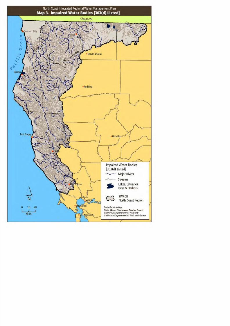
8/2/2019 North Coast Integrated Regional Water Management Plan, July 2007
http://slidepdf.com/reader/full/north-coast-integrated-regional-water-management-plan-july-2007 70/458

8/2/2019 North Coast Integrated Regional Water Management Plan, July 2007
http://slidepdf.com/reader/full/north-coast-integrated-regional-water-management-plan-july-2007 71/458

8/2/2019 North Coast Integrated Regional Water Management Plan, July 2007
http://slidepdf.com/reader/full/north-coast-integrated-regional-water-management-plan-july-2007 72/458
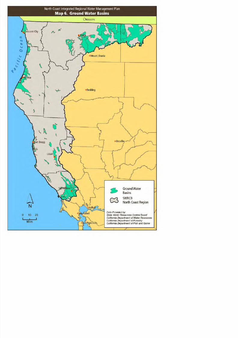
8/2/2019 North Coast Integrated Regional Water Management Plan, July 2007
http://slidepdf.com/reader/full/north-coast-integrated-regional-water-management-plan-july-2007 73/458

8/2/2019 North Coast Integrated Regional Water Management Plan, July 2007
http://slidepdf.com/reader/full/north-coast-integrated-regional-water-management-plan-july-2007 74/458

8/2/2019 North Coast Integrated Regional Water Management Plan, July 2007
http://slidepdf.com/reader/full/north-coast-integrated-regional-water-management-plan-july-2007 75/458

8/2/2019 North Coast Integrated Regional Water Management Plan, July 2007
http://slidepdf.com/reader/full/north-coast-integrated-regional-water-management-plan-july-2007 76/458

8/2/2019 North Coast Integrated Regional Water Management Plan, July 2007
http://slidepdf.com/reader/full/north-coast-integrated-regional-water-management-plan-july-2007 77/458
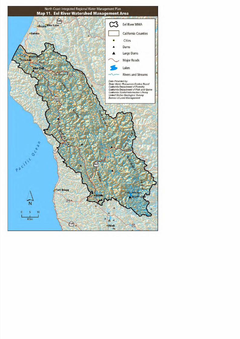
8/2/2019 North Coast Integrated Regional Water Management Plan, July 2007
http://slidepdf.com/reader/full/north-coast-integrated-regional-water-management-plan-july-2007 78/458

8/2/2019 North Coast Integrated Regional Water Management Plan, July 2007
http://slidepdf.com/reader/full/north-coast-integrated-regional-water-management-plan-july-2007 79/458

8/2/2019 North Coast Integrated Regional Water Management Plan, July 2007
http://slidepdf.com/reader/full/north-coast-integrated-regional-water-management-plan-july-2007 80/458

8/2/2019 North Coast Integrated Regional Water Management Plan, July 2007
http://slidepdf.com/reader/full/north-coast-integrated-regional-water-management-plan-july-2007 81/458

8/2/2019 North Coast Integrated Regional Water Management Plan, July 2007
http://slidepdf.com/reader/full/north-coast-integrated-regional-water-management-plan-july-2007 82/458

8/2/2019 North Coast Integrated Regional Water Management Plan, July 2007
http://slidepdf.com/reader/full/north-coast-integrated-regional-water-management-plan-july-2007 83/458
SECTION 4.0
IDENTIFICATION OF KEY
WATER MANAGEMENT ISSUES

8/2/2019 North Coast Integrated Regional Water Management Plan, July 2007
http://slidepdf.com/reader/full/north-coast-integrated-regional-water-management-plan-july-2007 84/458
North Coast Integrated Regional Water Management Plan, Phase I
SECTION 4.0IDENTIFICATION OF KEY WATER MANAGEMENT ISSUES

8/2/2019 North Coast Integrated Regional Water Management Plan, July 2007
http://slidepdf.com/reader/full/north-coast-integrated-regional-water-management-plan-july-2007 85/458
To manage water resources at multiple scales, a variety of key issues must be considered, includingriparian and wetland ecosystem function, point and nonpoint source discharges, groundwater andsurface water interactions, and water quality and quantity. In addition to the independent aspect of each key issue, interaction among issues creates complexity and results in considerable challenges towater management.
4.1 REGIONAL ISSUES
Water management issues at the regional scale cover a range of water quality, watershed health andwater quantity concerns. These issues have motivated state and federal agencies to develop programsto guide, encourage, and support protection and restoration of anadromous fish habitat, and beneficialuses including protection and enhancement of drinking water and pollution prevention. Althoughusually developed at a statewide, regional, or Watershed Management Area (WMA) scale, many of theprograms are implemented at the local scale by local jurisdictions, watershed groups, Joint Powers
Authorities (JPAs) or other cooperative coalitions, Native American tribes, or state or federal agencies.The water management issues faced by the North Coast Region are described below.
4.1.1 ISSUES RELATED TO SALMONID POPULATION DECLINE
Native, naturally spawning salmonid populations in the region have declined in the past five decades.Under the federal Endangered Species Act (ESA), Central Coast ESU and Southern Oregon/Northern
California Coast ESU coho salmon (Oncorhynchus kisutch ), Central California Coast ESU and NorthernCalifornia ESU steelhead trout (O. mykiss irideus ) and California Coastal ESU chinook (O. tshawytscha ),have been listed as threatened; however, as of March 14, 2005, the status of Central California CoastESU coho has been proposed for upgrading to endangered (NOAA 2005). Central California Coast ESUcoho are listed by California as endangered and Southern Oregon/Northern California ESU coho havebeen listed as threatened (CDFG 2005). Extensive research has been conducted regarding salmonidpopulation decline and it is considered to be a result of some combination of the following factors:
o Water quality degradationo Habitat loss and degradationo Stream passage restrictiono Reduced stream flowso Introduced species and hatchery fish
North Coast Integrated Regional Water Management Plan, Phase I
negative impacts, however, timber harvest, road construction, and related activities continue to causehabitat degradation to a more limited extent. Management of timber lands by both industrial and non-

8/2/2019 North Coast Integrated Regional Water Management Plan, July 2007
http://slidepdf.com/reader/full/north-coast-integrated-regional-water-management-plan-july-2007 86/458
industrial landowners has become a highly contentious issue with regard to how logging practices androad building impact watershed resources, sedimentation, and cumulative effects. This issue is centralto the arena of fisheries protection, particularly as it has been identified as contributing to thedegradation of watersheds, including spawning and juvenile rearing habitat (NCRWQCB 2004 ).
Another pressing water management issue concerning salmonids is the availability of instream flows toretain cool water temperatures that ensure salmonid survival. Recovery of listed salmonids in theregion includes large-scale watershed-based recovery efforts that have contributed to conflict over
agricultural water supply. For example, agricultural irrigation withdrawals coupled with a droughtyear in 2001 and 2002 in the Klamath Basin left inadequate surface water for listed salmonids (USFWS2003). The Klamath River Basin has long been the focus of attention by multiple state and federalagencies, tribes, and stakeholders. The Klamath River Basin Fisheries Task Force (KRBFT) wasauthorized by Congress in 1986 and is overseeing a 20-year effort to restore salmonid fishery values tothe Klamath watershed. The KRBFT is headed by a multiple-representative task force that makesfunding, management, and scheduling decisions regarding fishery restoration efforts in the watershed(NCRWQCB 2005).
Additional salmonid recovery efforts are being led by CDFG, which in 2004 released the RecoveryStrategy for Coho Salmon. It also released the Steelhead Restoration and Management Plan in 1996and created the California Salmonid Stream Habitat Restoration Manual (1998), which is used as aguide by restoration practitioners throughout California and will be utilized for the implementation of several of the NCIRWMP prioritized projects (see Section 7 ). NOAA Fisheries is also coordinatingsalmonid recovery. Additionally, local watershed groups and partnerships such as the Five CountiesSalmonid Conservation Program (5C), Fish Friendly Farming and the Shasta-Scott Recovery Team areworking cooperatively with regulatory agencies, landowners, and other stakeholders to implementprojects that benefit salmonid habitat. Numerous local agencies, water districts, and NGOs contributeto salmonid recovery via a diversity of conservation, management and restoration actions.Cumulatively, their contributions to salmonid recovery are significant. Summaries of the abovementioned plans and programs are found in Appendix B, Existing Water And Watershed ManagementPlans & Programs. The North Coast IRWMP provides a unifying framework for need identification andprioritization of these projects, a forum in which local concerns and state and federal requirements maybe exchanged and disseminated, and a regional body for coordination and analysis of monitoringefforts. A matrix that describes how existing North Coast region water management plans address
water management strategies is found in Appendix H, Matrix of Existing Water Management PlanningEfforts.
4 1 2 WATER QUANTITY ISSUES
North Coast Integrated Regional Water Management Plan, Phase I
The Eel River diversion at Potter Valley provides power production and incidental supplemental water
h R i Ri Fl d i i h E l Ri h ib d d i i fi h i
8/2/2019 North Coast Integrated Regional Water Management Plan, July 2007
http://slidepdf.com/reader/full/north-coast-integrated-regional-water-management-plan-july-2007 87/458
to the Russian River. Flow reduction in the Eel River has contributed to reductions in fish spawninghabitat and increased water temperatures (CEED 2002 ).
Flows from the Trinity are integral to the ecosystem health of the Lower Klamath River. The TrinityRiver Division (TRD) of the Central Valley Project (CVP) was completed in 1965 and has receivedattention from the Secretary of Interior, Bureau of Reclamation, Native American tribes, and a broadspectrum of stakeholders. On December 29, 2000 the Secretary of the Interior signed the Trinity RiverRecord of Decision (ROD) to require higher releases to the Trinity River from Lewiston Dam. The
Westlands Water District and others filed suit to have the Trinity ROD set aside through an injunction.There have been multiple rulings from the Federal Court since that time. As of May 10, 2005 theBureau of Reclamation initiated full flows to the Trinity River under the 2000 ROD (CB DA 2003).
In many coastal watersheds throughout the region, significant, localized water withdrawals via riparianright have impacted listed salmonids region-wide, and affected water supply security for rural waterusers, communities, and small municipalities. These watersheds are approaching a populationthreshold where population is high enough to create water supply problems and fisheries impacts, but
too small to create community-scale water systems.
Balancing these water demands while maintaining existing and improving degraded salmonid habitatis an important management challenge for the North Coast Region. By bringing all parties together ina cooperative and collaborative enterprise for the benefit of the entire region, the NCIRWMP is the firststep in developing and implementing creative, efficient, equitable responses to these challenges.
4.1.3 WATER QUALITY ISSUES
Regional water quality problems include contamination of surface and groundwater due to:
o Nonpoint source pollution from storm water runoff, animal feeding operations, and other landmanagement activities
o Erosion and sedimentation originating from roads, agriculture, timber harvest, riparian channelmodification, and gravel mining;
o Chemical pollutants such as MTBE, PCE, and dioxins originating from industrial facilities.o Point source pollution violations by Publicly Owned Treatment Works (POTWs) and other
violations
These issues are compounded by a lack of adequate funding to design and implement a regional waterli i i l d d h i b i l h d h b ild
North Coast Integrated Regional Water Management Plan, Phase I
public outreach and education, and promoting water reuse and recycling programs. Nonpoint sourcewater quality issues are a primary concern and are being addressed through the Total Maximum Daily
L d (TMDL) hi h i d l d d i l t d t t h d l th NCRWQCB W t

8/2/2019 North Coast Integrated Regional Water Management Plan, July 2007
http://slidepdf.com/reader/full/north-coast-integrated-regional-water-management-plan-july-2007 88/458
Load (TMDL) process, which is developed and implemented at a watershed scale, the NCRWQCB WaterQuality Control Plan for the North Coast Region, and the SWRCB Nonpoint Source Program Strategy
and Implementation Plan (Appendix B, Existing Water And Watershed Management Plans & Programs ). A majority of the North Coast Region’s watersheds are impaired by sedimentation thatexceeds the existing water quality objectives established to protect beneficial uses. These sediment-impaired beneficial uses include coldwater fisheries, municipal and domestic water supply, navigation,and water-contact and non-water-contact recreation. Both historic and modern land use practices havecontributed to, and are currently causing, elevated discharges of sediment to waters in the North Coast
Region. The NCRWQCB and the SWRCB have indicated a preference for voluntary compliance withregulations and TMDL implementation, and many groups and programs - such as the Fish FriendlyFarming Program and the Rangeland Water Quality Management Plan - offer landowners the technicalassistance to follow this path. Several projects in the NCIRWMP include cooperative participation byarea landowners in nonpoint source pollution control (see Section 7 ).
Sedimentation is a naturally occurring process, and, when it occurs in naturally generated quantities, itis an important component in the aquatic environment. Sediment levels are naturally elevated during
times of high rainfall and runoff and aquatic organisms possess life history strategies that haveadjusted to the natural timing, duration, and levels of sediment. However, land use activities in theNorth Coast Region have accelerated erosional processes and altered the timing, duration, and amountof sediment delivery to levels significantly outside the natural range.
Excess sediment has led to infilling of streams, which adversely impacts drinking water supplies, andcauses degradation of salmonid habitats. Accelerated rates of erosion from land use practices areimpacting the migration, spawning, reproduction, and early development of these coldwateranadromous fish.
Additional problems associated with excess sediment include:o Decrease in the complexity of aquatic plant communities by decreasing light penetrationo Reduction in oxygen flow to and waste removal from salmon redds, or nestso Decrease in the ability of juvenile fish to avoid predationo Irritation of salmonid and other fish gills and destruction of the protective mucous that covers
eyes and scales making fish more susceptible to infection and diseaseo Unnatural aggradation of stream beds which contributes to creating barriers to migration of
fish, and causes increased floodingo Decrease in the availability of refugia – isolated habitats that retain environmental conditions
that were once widespreado Physical scouring of plants, insects, and other invertebrates from the streambed, thereby
d i f d f fi h
North Coast Integrated Regional Water Management Plan, Phase I
(NCRWQCB 2004). The goals of the TMDL Implementation Policy are to control sediment wastedischarges so that TMDLs are met, sediment water quality objectives are attained, and beneficial uses
are no longer adversely affected by sediment This Resolution has re focused NCRWQCB efforts to rely

8/2/2019 North Coast Integrated Regional Water Management Plan, July 2007
http://slidepdf.com/reader/full/north-coast-integrated-regional-water-management-plan-july-2007 89/458
are no longer adversely affected by sediment. This Resolution has re-focused NCRWQCB efforts to relyon the comprehensive regulatory tools provided by the Porter-Cologne Water Quality Control Act andthe federal Clean Water Act to address anthropogenic sediment waste discharges. The resolution alsodirected the NCRWQCB Executive Officer to develop a work plan describing how and when actions willbe taken to address sediment waste discharges. As the Regional Water Management Group, theNCRIWMG will assist the state with information dissemination and plan implementation and willintegrate state findings, recommendations, and plans into future iterations of the NCIRWMP, allowingthe SWRCB and NCRWQCB to focus resources on better assessing regional groundwater, surface water,
and environmental conditions.
4.1.4 PROTECTION OF DRINKING WATER IN DISADVANTAGED COMMUNITIES
The current trend for a number of rural disadvantaged communities is an increase in the retiredpopulation with its associated needs for health care services and infrastructure. Failing communitytreatment facilities in low income disadvantaged communities pose a threat to public health and impair
water bodies with point source pollution. A number of Publicly Owned Treatment Works in the regionare chronically in violation of permit compliance and currently under enforcement orders. The numberof violations by small treatment facilities in disadvantaged communities in the North Coast isdisproportionate to the state average. Throughout the North Coast, there is great need to replace orupgrade failing, aging systems with current technology and reliable systems.
The Small Community Wastewater Grant (SCWG) Program, funded by Proposition 40 and Proposition50, provides grant assistance for the construction of publicly owned wastewater treatment and
collection facilities for small communities with financial hardships. A challenge faced by many of thesmall treatment facilities in receiving these competitive grant funds include lack of funding to hireengineers or consultants needed to complete the preliminary studies required to qualify for the grantand loan programs. The NCRWMG, as a coalition of regional jurisdictions, may have greater ability toobtain funding for such preliminary studies throughout the region, thus empowering the region’ssmaller communities and obtaining important information for local-, watershed-, and regional-scaleplanning.
4.2 WATER MANAGEMENT ISSUES AT THE WATERSHED LEVEL
Water management issues at the watershed level include water supply for agricultural, municipal, ruralresidential, environmental, industrial, and other beneficial uses. Groundwater withdrawal can impact
North Coast Integrated Regional Water Management Plan, Phase I
At the watershed level, the following urban water management issues are important: water supply to
serve domestic and industrial needs wastewater collection and distribution stormwater management

8/2/2019 North Coast Integrated Regional Water Management Plan, July 2007
http://slidepdf.com/reader/full/north-coast-integrated-regional-water-management-plan-july-2007 90/458
serve domestic and industrial needs, wastewater collection and distribution, stormwater management,infiltration management, industrial return flows, and the role of recycled or reclaimed water.Throughout the region, failing water treatment systems require immediate upgrades or replacement inorder to meet current water quality regulations and provide clean, safe water for residents for drinkingand recreation. In rural areas, domestic well water quality, agricultural withdrawals, and individualseptic tank leakage are pressing issues. Enforcement of regulations involving domestic well watersupplies and septic tank waste varies depending on resources available to public agencies andassociated enforcement priorities.
It is important to coordinate activities to maximize prevention or reduction of many potential impactsto water quality at the watershed scale. Sediment loads derived from agriculture, forestry, roadmanagement, and construction may significantly influence downstream water quality. Agriculture andforestry generate nonpoint source sediment and, in some cases, chemical loads, while stormwatercontributes to episodic point and nonpoint source loads. Animal waste, agricultural runoff, recycledwater, and septic systems contribute nutrient loads and return flow from industrial use of water alsoimpacts receiving water quality. The NCIRWMP is the region’s first step toward effectively
implementing water quality improvement projects to provide benefits at multiple scales. Futureiterations of the Plan will provide greater coordination of planning and implementation efforts,additional data, and improved local stakeholder outreach.
Groundwater quality management issues stem from current and past pollution of groundwater sourcesthat include leaking underground storage tanks, industrial pollution, pesticide application, leakingwastewater treatment facilities (individual and public) and artificial injection. These issues generallydevelop over time; often detection occurs only after the pollution has been occurring for a long periodof time.
Beneficial uses to be protected through water quality and quantity management include recreation,fisheries, aesthetics, riparian and wetland habitats, and endangered species preservation. Fisheryresources are typically most significantly at risk when considering the effects of water quantitywithdrawals on decreased water quality and streamflow. Awareness of the impacts of water quantitymanagement on water quality issues has been increasing and will continue to be considered inplanning and implementation of management at the watershed scale.
Within the Watershed Management Initiative developed by the North Coast Regional Water QualityControl Board, specific issues are identified and discussed for each of the six watershed managementareas (WMAs). Issues associated with these WMAs vary considerably in response to the level of urbanization and activities conducted.
North Coast Integrated Regional Water Management Plan, Phase I
Issues in the Klamath WMA primarily focus on maintaining both coldwater and warm water fisherieswhile maintaining the viability of agricultural and timber uses of the watershed. Addressing the issues
in this watershed is complicated by the fact that approximately half of this WMA is located upstream

8/2/2019 North Coast Integrated Regional Water Management Plan, July 2007
http://slidepdf.com/reader/full/north-coast-integrated-regional-water-management-plan-july-2007 91/458
in this watershed is complicated by the fact that approximately half of this WMA is located upstreamwithin the state of Oregon. Entities involved in the issues of the Klamath include five federal agencies,two states, eleven counties and seven Native American Tribes.
Groundwater extraction is currently not regulated and is emerging as a potential water managementissue in the Klamath basin. A large number of high output wells are being developed in the KlamathRiver basin. An estimated 60,000 acre-feet was extracted from the Klamath River groundwater basin in2001, up from 6,000 acre-feet in 1997 (DWR 2003).
Other issues in the watershed include the dependence of the Klamath Basin Wildlife Refuges onirrigation for the health of the ecosystems and the occurrence of two endangered species of sucker fishin the Klamath Lake that require the maintenance of a minimum lake level. The issues in this WMAcame to a head in 2001 (a drought year) when the Bureau of Reclamation severely restricted flows,which negatively impacted farmers and the Klamath Basin Wildlife Refuges, and again in 2002 whenapproximately 33,000 adult salmon died in the lower part of the Klamath due to poor water qualityand reduced water flows (DWR 2005 ).
The North Coast River WMA includes multiple coastal rivers and watersheds. Primary issues in thisarea include implementation of timber harvest forest management plans to control sedimentation andtemperature, as well as the development of TMDL waste reduction strategies for sedimentation.Following are issues of concern for individual watersheds that fall within this WMA:
o The Mattole River watershed is noted for being prone to excessive landsliding due to slopeinstability, high levels of rainfall, timber harvesting and timber-related roads.
o The harbor at Fort Bragg must be frequently dredged due to large deposits of sediment fromthe Noyo River.
o The Garcia River is the first river on the North Coast to have a TMDL “Action Plan” that hasbeen adopted into the NCRWQCB Basin Plan. This adoption was highly controversial andcostly because of restrictions on timber harvest and forest road building.
Within the Humboldt Bay WMA, the Eureka Waterfront was historically the site of numerous industrialfacilities including lumber mills, bulk oil storage and handling facilities, wrecking yards, and railroadyards. These operations produced both soil and groundwater contamination with heavy metals,petroleum products, and pentachlorophenols (PCPs). The Waterfront is currently undergoing cleanup
and redevelopment. The City of Eureka is coordinating the redevelopment with several responsibleparties including Union Pacific Railroad, Simpson Timber Company, Chevron, Unical, and Tosco oilcompanies, and a few others. The City is also cleaning up two brownfield sites on the Waterfront.
In addition Humboldt Bay supports a significant commercial oyster industry and is a popular area for

8/2/2019 North Coast Integrated Regional Water Management Plan, July 2007
http://slidepdf.com/reader/full/north-coast-integrated-regional-water-management-plan-july-2007 92/458
North Coast Integrated Regional Water Management Plan, Phase I
References:
CA Bay-Delta Authority. 2003. Available at:

8/2/2019 North Coast Integrated Regional Water Management Plan, July 2007
http://slidepdf.com/reader/full/north-coast-integrated-regional-water-management-plan-july-2007 93/458
CA Bay Delta Authority. 2003. Available at:http://calwater.ca.gov/BDPAC/BDPAC_and_Authority_Meeting_Packet_12-11-03.pdf
California Department of Fish and Game. 2005. State and Federally Listed Endangered andThreatened Animals of California. June 2005. Available at:http://www.dfg.ca.gov/whdab/pdfs/TEAnimals.pdf
Department of Water Resources. California Water Plan Update. 2005. Volume 3 – Regional Reports,
Chapter 2. North Coast Hydrologic Region.
NOAA. 2005. Endangered Species Act Status of West Coast Salmon. 2005. Available at:http://www.nwr.noaa.gov/1salmon/salmesa/pubs/1pgr.pdf. Updated March 14, 2005.
North Coast Regional Water Quality Control Board. 2004. Sediment Waste Discharge Prohibitions andAction Plan Staff Report, September 29, 2004.
North Coast Regional Water Quality Control Board. 2004. Available at:http://www.waterboards.ca.gov/northcoast/orders/120204-0087.pdf
North Coast Regional Water Quality Control Board. 2005. Watershed Planning Chapter.The Center for Environmental Economic Development (CEED). 2002. A River in the Balance: Benefitsand Costs of Restoring Natural Flows to the Eel River. Summer 2002.
U.S. Fish and Wildlife Service. 2003. A Review of Caspian Tern Nesting Habitat: A Feasibility
Assessment of Management Opportunities in the U.S. Fish and Wildlife Service Pacific Region.

8/2/2019 North Coast Integrated Regional Water Management Plan, July 2007
http://slidepdf.com/reader/full/north-coast-integrated-regional-water-management-plan-july-2007 94/458

8/2/2019 North Coast Integrated Regional Water Management Plan, July 2007
http://slidepdf.com/reader/full/north-coast-integrated-regional-water-management-plan-july-2007 95/458
SECTION 5.0
NEED FOR NORTH COAST
INTEGRATED PLANNING

8/2/2019 North Coast Integrated Regional Water Management Plan, July 2007
http://slidepdf.com/reader/full/north-coast-integrated-regional-water-management-plan-july-2007 96/458
North Coast Integrated Regional Water Management Plan, Phase I
SECTION 5.0NEED FOR NORTH COAST INTEGRATED PLANNING
The North Coast is in need of a cohesive and collaborative framework for addressing those issues

8/2/2019 North Coast Integrated Regional Water Management Plan, July 2007
http://slidepdf.com/reader/full/north-coast-integrated-regional-water-management-plan-july-2007 97/458
The North Coast is in need of a cohesive and collaborative framework for addressing those issuesoutlined in Section 4 and attaining local, regional and statewide objectives related to integrated watermanagement.
The NCIRWMP planning process synchronizes the planning processes of local land use authorities,tribes, service providers, community groups, landowners and state and federal agencies. This processand the NCIRWMP demonstrate that a large multi-county region can plan and act in concert on water
management issues through a locally based, regionally integrated community and watershed basedplanning process.
The process institutionalizes the regional water management planning framework envisioned by thelegislature and provides a basis for mutual cooperation and implementation among the counties in theNorth Coast Region. NCIRWMP project implementation protects beneficial uses of water and improvessalmon habitat, while at the same time reducing conflicts over water quantity and quality. It alsopromotes sustainable land use activities and patterns that will benefit the environment and economy of
the Region.
The process demonstrates a basin level approach to integrated regional water management planningand implementation. At the basin level, the Plan demonstrates the effectiveness of a policy anddecision making body comprised of elected officials from the region supported by technical staff andconsultants and guided by an integrated regional water management plan. At a watershed level, theproject demonstrates the involvement and cooperation of state agencies and boards, tribes, counties,cities, watershed groups, landowner groups, service providers and the general public within the region.

8/2/2019 North Coast Integrated Regional Water Management Plan, July 2007
http://slidepdf.com/reader/full/north-coast-integrated-regional-water-management-plan-july-2007 98/458

8/2/2019 North Coast Integrated Regional Water Management Plan, July 2007
http://slidepdf.com/reader/full/north-coast-integrated-regional-water-management-plan-july-2007 99/458
SECTION 6.0
DEVELOPMENT PROCESS

8/2/2019 North Coast Integrated Regional Water Management Plan, July 2007
http://slidepdf.com/reader/full/north-coast-integrated-regional-water-management-plan-july-2007 100/458
North Coast Integrated Regional Water Management Plan, Phase I
SECTION 6.0DEVELOPMENT PROCESS FOR THE NCIRWMP

8/2/2019 North Coast Integrated Regional Water Management Plan, July 2007
http://slidepdf.com/reader/full/north-coast-integrated-regional-water-management-plan-july-2007 101/458
Phase I of the North Coast Integrated Regional Water Management Plan represents the combinedeffort of many individuals and groups within the North Coast Region. Oversight for plan developmentand project selection has been provided by the North Coast Regional Water Management Group(represented by the NCIRWMP Policy Review Panel), while project identification and plan review havebeen provided by the Region’s stakeholders, with project and plan technical review performed by the
NCIRWMP Technical Peer Review Committee. All phases of plan development and project selectionhave been completely transparent to the public, and public involvement has been actively solicited andencouraged.
6.1 NORTH COAST REGIONAL WATER MANAGEMENT GROUP DESCRIPTION
Phase I of the North Coast Integrated Regional Water Management Plan was developed under theoversight of the North Coast Regional Water Management Group. The North Coast Regional WaterManagement Group (NCRWMG) is a consortium of counties working together on water managementplanning and project prioritization and implementation for the North Coast region. The NCRWMG hasauthorized Humboldt County to act on their behalf as the regional applicant for the NCIRWMPimplementation grant and Phase II planning grant. Currently the member counties of the NCRWMG areresponsible for implementation of the NCIRWMP, with individual project proponents responsible forproject implementation. The NCRWMG will be discussing the formation of a Joint Powers Agreement orsimilar institutional structure at their next meeting. More information about the authorizing resolutionsfor the existing institutional structure is contained in Appendix I, Authorizing Documentation and
Eligible Applicant Documentation.
The Regional Water Management Group consists of the following entities, each with a unique localrelationship to water management:
Del Norte County
Del Norte County does not directly manage water, however Del Norte County has a number of areas
throughout the unincorporated area that rely on Districts to provide potable water and water for firesuppression. The City of Crescent City manages a municipal water system that provides potable waterand fire suppression to the incorporated area as well as to unincorporated areas of the County that arein the proximity of the City limits and the transmission line serving the City system
North Coast Integrated Regional Water Management Plan, Phase I
Trinity County
The County of Trinity has authority over water quality and floodplain management per its General Planand various ordinances. Through its membership in the Trinity Management Council, as determined bythe Trinity River Record of Decision, Trinity County also has one vote out of 8 in determining annual

8/2/2019 North Coast Integrated Regional Water Management Plan, July 2007
http://slidepdf.com/reader/full/north-coast-integrated-regional-water-management-plan-july-2007 102/458
the Trinity River Record of Decision, Trinity County also has one vote out of 8 in determining annualflow releases into the Trinity River from Lewiston Dam. Trinity County is also the lead agency forimplementation of the Five Counties Salmonid Conservation Program per mutual agreement among thecounties of Siskiyou, Trinity, Humboldt, Del Norte and Mendocino.
Humboldt County
Local MOU signed by all service districts and cities in the county engages all service districts and citiesin collaborative water management. Land Use policies and ordinances also provide statutory control inareas not preempted by State and Federal authority.
Mendocino County
The Mendocino County Water Agency's (MCWA) statutory authority is derived from the enabling
legislation - the "Mendocino County Water Agency Act" - that created the MCWA. Pursuant to theMendocino County Water Agency Act, the MCWA has the authority to provide for the control anddisposition of storm and flood waters, make water available for any beneficial use, and secure title toreal property, water rights and water distribution facilities.
Sonoma County
County of Sonoma has statutory authority over water supply, water quality, flood control and storm
water management as per the County’s general plan and ordinances.In addition to the above-listed counties, the Mendocino County Water Agency and Sonoma CountyWater Agency each have statutory authority over water in their own right.
Each of the counties listed are fully or partially included in a community designated as disadvantaged.
6.2 NCIRWMP COLLABORATIVE PARTNERSHIP
The collaborative partnership that developed the Phase I NCIRWMP consists of the NCIRWMP PolicyReview Panel, the NCIRWMP Technical Peer Review Committee, project staff and consultants, and thestakeholders within the North Coast Region. Each of these entities and their roles in plan development
North Coast Integrated Regional Water Management Plan, Phase I
and ultimate oversight to the NCIRWMP planning process, and with input from the Technical PeerReview Committee, make decisions about priority projects to be included in the NCIRWMP.

8/2/2019 North Coast Integrated Regional Water Management Plan, July 2007
http://slidepdf.com/reader/full/north-coast-integrated-regional-water-management-plan-july-2007 103/458
6.2.2 TECHNICAL PEER REVIEW COMMITTEE
Each County’s Board of Supervisors has appointed two individuals with a technical background relatedto integrated water management to the NCIRWMP Technical Peer Review Committee (TPRC). Membershave experience in the following technical areas: engineering, watershed management, fisheries,
restoration, water and wastewater infrastructure, environmental planning and natural resources policyissues.
The TPRC has two primary areas of responsibility: 1) review of the Phase I NCIRWMP from a technicalperspective, and 2) review and recommended prioritization of identified projects, based on technicalconsiderations and the criteria established by the State and the Policy Review Panel.
The TPRC assisted staff and consultants in the development of equitable review process criteria basedon state IRWM requirements, and provided input into the development of a uniform scoring sheet forproject ranking. The score sheet used to rank projects is shown in Appendix J, NCIRWMP Score Sheet.
The TPRC reviewed and ranked all projects independently using the score sheet, then met to discussthose projects that ranked the highest. TPRC members who had any interest (financial or otherwise) ina project did not rank that project, and recused themselves and left the room during discussion of thatproject. All review was conducted in compliance with the regulations of the Fair Political PracticesCommission, Title 2, Division 6, section 18700.
6.2.3 PROJECT STAFF AND CONSULTANTS
Consultants responsible for the development of the Phase I NCIRWMP included Circuit RiderProductions, Inc. (plan management, public outreach, technical writing, GIS and Mapping, websitecontent), Forest, Soil and Water (technical writing), MIG (website development), Dina Moore (technicalwriting), and Pamela Swan Associates (socio-economic analysis).
Staff members from each of the counties have provided input throughout the planning process.
North Coast Integrated Regional Water Management Plan, Phase I
Interviews were conducted with members of the Policy Review Panel, TPRC and selected natural
resources and water management experts. These interviews provided information that was used in thedevelopment of the Phase I NCIRWMP, and are summarized in Appendix K, NCIRWMP InterviewResponses

8/2/2019 North Coast Integrated Regional Water Management Plan, July 2007
http://slidepdf.com/reader/full/north-coast-integrated-regional-water-management-plan-july-2007 104/458
Responses.
6.3 STAKEHOLDER INVOLVEMENT
The NCIRWMP Phase I was developed with input from a diverse group of stakeholders, includingcounties, cities, watershed and environmental groups, landowner groups, tribes, natural resourcesagencies, and interested citizens. Hundreds of individuals and groups have provided input and directionto the plan. Four main mechanisms were used to solicit input into the development of the NCIRWMP,Phase I including 1) the NCIRWMP website, 2) a series of public workshops held throughout the NorthCoast Region, 3) one-on-one technical assistance to project proponents, and 4) direct phone, e-mailand in person communication with interested agencies and citizens.
We have held over ten workshops in the North Coast Region to inform the community of the IRWMprogram, including statewide goals and objectives, regional planning framework and opportunities forfunding. Additional stakeholder involvement has been accomplished via the NCIRWMP website – ameans for people in a diverse and large geographic region to stay connected and informed, provideinput and upload proposed projects. Finally, the NCIRWMP planning team has engaged in numerousphone calls, one-on-one meetings and presentations to inform people about the process and takeinput. All drafts, meetings, and processes related to the plan are public, and a targeted outreachprogram augments the availability of data via the website. All stakeholders and public are encouragedto propose projects and submit them for review.
The above process has been very successful in informing and engaging stakeholders in the Region, andwe expect to continue and expand it in Phase II, per our Work Plan. The County representatives on thePolicy Review Panel are elected officials (or appointments thereof) and have an inherent framework inplace for taking public input.
Disadvantaged communities within the Region are described in the following section of thisapplication, and have been involved in all aspects of the planning effort from its inception.Representatives of disadvantaged communities are the primary leaders designated by the North Coast
Regional Water Management Group.
Environmental Justice needs have not been identified nor evaluated in Phase I of the NCIRWMP, exceptat a conceptual level. This planning component will be evaluated and developed further for Phase II.
North Coast Integrated Regional Water Management Plan, Phase I
6.3.1 NCIRWMP WEBSITE
The NCIRWMP website (www.northcoastIRWMP.net) provides a mechanism to reach a wide audienceacross a large geographic region. The website – with an automatic e-mail update feature – is used toconvey current information about the state IRWM process local planning efforts and events and

8/2/2019 North Coast Integrated Regional Water Management Plan, July 2007
http://slidepdf.com/reader/full/north-coast-integrated-regional-water-management-plan-july-2007 105/458
convey current information about the state IRWM process, local planning efforts, and events anddeadlines associated with the North Coast IRWMP process. The website also contains a library of information relevant to water issues in the North Coast, as well as an on-line mapping feature thatallows users to view various watershed, natural resources, socio-economic and jurisdictional data aswell as proposed project locations.
In addition to information sharing, the website was used for project upload during Phase I, via an on-line template that prompted users for the key information listed in the state IRWM guidelines and otherprogram documents.
6.3.2 WORKSHOPS
Workshops were held throughout the North Coast region to convey IRWM information to stakeholders,answer questions and assist with project identification and upload.
6.3.3 TECHNICAL ASSISTANCE TO PROJECT PROPONENTS
Project staff and consultants allocated significant time to provide project proponents with assistance inproject development and descriptions. Any project proponent who requested assistance received help.Topics for assistance included eligibility requirements, technical issues, Program Preferences, budgetaryinformation, and permitting issues.
6.4 METHODOLOGIES USED IN THE DEVELOPMENT OF THE NCIRWMP
Multiple methods were used to develop the NCIRWMP – ranging from the collection, review andsynthesis of existing spatial and non-spatial data, to the analysis of these data in support of plandevelopment.
A GIS database was developed for the North Coast region using ESRI ArcGIS 9.0. Available spatial
data were integrated into the database and key data were evaluated, including socio-economicinformation, and the interaction of planning/regulatory efforts with physical and ecological features.Results from these analyses are shown in the maps, tables and appendices associated with thisdocument, as well as in the library on the website and the MapServer internet mapping application onthe ebsite
North Coast Integrated Regional Water Management Plan, Phase I
expects to maintain and enhance the NCIRWMP collaborative framework for ongoing input andoversight from the NCIRWMP Policy Review Panel, technical evaluation by the Technical Peer Review
Committee, and input from stakeholders in the North Coast Region to support the ongoingdevelopment and refinement of the North Coast Integrated Regional Water Management Plan. Thisrefinement is expected to include a) evaluation and updating of planning objectives b) evaluation and

8/2/2019 North Coast Integrated Regional Water Management Plan, July 2007
http://slidepdf.com/reader/full/north-coast-integrated-regional-water-management-plan-july-2007 106/458
refinement is expected to include a) evaluation and updating of planning objectives, b) evaluation andupdating of water management strategies and the integration thereof, c) evaluation and updating of data management and monitoring approaches, d) evaluation and updating of the water quality/watersupply needs of the North Coast communities, and e) identification and prioritization of integratedprojects that have multiple benefits and that respond to community needs and statewide priorities.
Additional structures and processes that will be refined and expanded during Phase II include the
following:
o Continue to convene the NCIRWMP Policy Review Panel and Technical Peer Review Committeeon a monthly or bi-monthly basis for NCIRWMP Phase II plan review, issues and data analysis,project review and prioritization and enhancements to the planning process. These meetingswill be noticed and open to the public.
o Hold quarterly stakeholder meetings/workshops in each county to educate stakeholders
regarding IRWM statewide and regional objectives, to obtain input from partners andinterested public regarding NCIRWMP Phase II revisions/enhancements, issues and projectpriorities
o Provide regular updates and solicit input via the website and e-mail to all interested partiesregarding NCIRWMP Phase II issues, data, revisions/enhancements and project priorities
o Define NCIRWMP planning sub-areas with the specific goal of enhancing understanding andcollaboration among watershed groups and water and wastewater service providers at the
local level.o Hold up to three meetings in each sub-area to engage the community in locally led planning
and to educate them about the role of the NCIRWMP and statewide priorities in local planningand project implementation.
Phase II NCIRWMP will continue to develop an adaptive management framework for North CoastIntegrated Regional Water Management Planning, including detailed information about a process and
tools for ongoing incorporation of statewide and local data at a variety of spatial and temporal scales,and an opportunity to continually refine NCIRWMP content, objectives and strategies. The following isexpected to be accomplished during Phase II:
North Coast Integrated Regional Water Management Plan, Phase I
Phase II NCIRWMP will conduct outreach to identify refined NCIRWMP water management strategiesand implementation alternatives within communities and WMAs.
This project will apply an outreach model at the community and watershed level using a wide variety of approaches and media including:

8/2/2019 North Coast Integrated Regional Water Management Plan, July 2007
http://slidepdf.com/reader/full/north-coast-integrated-regional-water-management-plan-july-2007 107/458
o The existing NCIRWMP website with local features and data relevant to the community/WMAo technical and policy alternative reportso summit meetings between elected representatives of cities and tribeso staff level meetingso town hall public meetingso stakeholders meetings by subject areao outreach to organization to facilitate participationo local, state and federal agency caucuseso NCIRWMP Policy and Technical Committee review
Meetings within community/WMA will be facilitated to allow the participants to actively engage in theplanning process. Written materials will be designed and professionally edited for effectivecommunication. Geographic information systems will be used to convey spatial information. The entireprocess will be structured to provide a framework for education, negotiation and decision-making on
the issues, including those that are controversial and contentious.The input received on the technical reports and presentations will be analyzed and the results reflectedin discussion drafts of Water Resource Elements, and in the North Coast Integrated Regional WaterManagement Plan, Phase II.
Finally, a NCIRWMP Phase II Financing Plan will be developed that outlines a strategy for long-termfunding of the NCIRWMP – both for ongoing adaptive management planning and for theimplementation of projects. The financing plan will include a 20 year planning horizon and identify
diverse funding sources, including state, federal and fee-for-service opportunities. The NCIRWMPFinancing Plan will include the following:
o A list of potential financing options and structures
o A review process to evaluate financing list with NCIRWMP Policy Review Panel, Technical PeerReview Committee, elected officials decision-makers, and relevant stakeholders
o A report summarizing input about the financing list for inclusion in the Financing Plan
o Evaluation of the report by economic experts from throughout the region, state and country
o Summary of input from economic experts, resulting in the development of the Financing Plan

8/2/2019 North Coast Integrated Regional Water Management Plan, July 2007
http://slidepdf.com/reader/full/north-coast-integrated-regional-water-management-plan-july-2007 108/458

8/2/2019 North Coast Integrated Regional Water Management Plan, July 2007
http://slidepdf.com/reader/full/north-coast-integrated-regional-water-management-plan-july-2007 109/458
SECTION 7.0
PROPOSED PROJECTS
AND PROJECT PRIORITIES

8/2/2019 North Coast Integrated Regional Water Management Plan, July 2007
http://slidepdf.com/reader/full/north-coast-integrated-regional-water-management-plan-july-2007 110/458
North Coast Integrated Regional Water Management Plan, Phase I
SECTION 7.0NCIRWMP PROPOSED PROJECTS AND PROJECT PRIORITIES
The North Coast Integrated Regional Water Management Planning Process has identified numerousprojects from throughout the North Coast Region that address state, regional and local objectives and
i iti f t t P j t t id d ith i f ti b t IRWM
8/2/2019 North Coast Integrated Regional Water Management Plan, July 2007
http://slidepdf.com/reader/full/north-coast-integrated-regional-water-management-plan-july-2007 111/458
priorities for water management. Project proponents are provided with information about IRWMguidelines and funding opportunities via the NCIRWMP website, workshops and other media.
During Phase I, 127 projects were identified and uploaded to the website, with proposals totaling acombined funding need of over $317,000,000. Projects were assigned a numeric score using a scoresheet that relied upon state IRWM grant program criteria and individually reviewed by the TechnicalPeer Review Committee (TPRC) (see Appendix J, NCIRWMP Score Sheet ). The TPRC then met andevaluated the top scoring projects and forwarded their recommendations to the Policy Review Panel(PRP). The PRP then met and adopted a slate of high priority projects. These priority projects consistpredominantly of the high scoring projects recommended by the TPRC, with some additional projectsselected to allow for regional equity, to address integrated coastal watershed management priorities,and extremely serious public health problems (see Map 16, Priority Project Locations ). All eligibleprojects are included in the NCIRWMP – those that were not ranked as the highest priority for Phase Iare listed in Appendix L, NCIRWMP Project List and Scores.
7.1 PROJECT SUMMARIES
On the following pages, the prioritized NCIRWMP projects are presented in the proponents’ words.Projects and their benefits are summarized and responsible entities are identified. These projectsrepresent the specific actions, projects, and studies by which the first phase of the NCIRWMP will beimplemented. Monitoring measures are identified and will be used to provide feedback to the
NCRWMG, which will continue to modify the NCIRWMP and project implementation and prioritizationas new information and technology becomes available. Cost estimate information for each of theselected projects can be found in Appendix M, NCIRWMP Project Budgets. Project timelines can befound in Appendix N, NCIRWMP Project Schedule.
The priority list of projects is shown in Table 8, with more detailed descriptions following the summarytable. All submitted projects and scores are listed in Appendix L, NCIRWMP Project List and Scores.
North Coast Integrated Regional Water Management Plan, Phase I
Table 8. NCIRWMP Priority Project List
ProjectID # OrganizationName Project Name CountyLocation Project CityLocation AverageScore Request Revised
7 MattoleRestoration
Mattole IntegratedWater Management
HUMBOLDTMENDOCINO
PetroliaWhitethorn
75 $2,897,690 $1,543,743

8/2/2019 North Coast Integrated Regional Water Management Plan, July 2007
http://slidepdf.com/reader/full/north-coast-integrated-regional-water-management-plan-july-2007 112/458
RestorationCouncil
Water ManagementProgram
MENDOCINO WhitethornEttersburgHoneydew
236-S1 Shasta ValleyResourceConservationDistrict
Shasta WaterAssociation DamRestoration
SISKIYOU LakeShastinaForks of theSalmon
73 $10,902,844 $1,926,350
236-S2 Shasta ValleyResourceConservationDistrict
Araujo DamRestoration
SISKIYOU YrekaLakeShastinaForks of theSalmon
73 $2,675,757 $878,275
236-S3 SiskiyouRCD/Scott RiverWatershedCouncil
Scott River WaterTrust Phase III
SISKIYOU LakeShastinaEtna
73 $470,811 $160,000
236-S5 City of Etna City of Etna WaterSupply
SISKIYOU Etna 73 $382,105 $318,105
78 Sonoma County Monte Rio CommunityWastewater Project
SONOMA Monte Rio 69 $9,487,000 $3,461,727
86 Orick CommunityServices District
Orick CommunityServices DistrictWastewater TreatmentSystem
HUMBOLDT Orick 69 $4,156,225 $2,628,441
ICWMP
- D
Mattole
RestorationCouncil
Mattole Integrated
Coastal WatershedManagement Program
HUMBOLDT Petrolia
WhitethornEttersburgHoneydew
68 $1,235,206 $1,235,206
22 Pacific Coast Fish,Wildlife andWetlandsRestoration Assoc
Redwood CreekErosion Control
HUMBOLDT Orick 67 $1,325,000 $537,971
164 California LandStewardshipInstitute
Fish Friendly FarmingEnvironmentalCertification Program
MENDOCINOSONOMA
YorkvilleUkiah
64 $3,000,000 $210,510
51 Humboldt CountyResourceConservationDistrict
Mid Van Duzen RiverRanch Road SedimentReduction Program
HUMBOLDT BridgevilleKneeland
64 $810,000 $336,817
North Coast Integrated Regional Water Management Plan, Phase I
ProjectID #
OrganizationName
Project Name CountyLocation
Project CityLocation
AverageScore
Request Revised
217 Modoc County Newell Water SystemRenovation MODOC Newell 64 $1,815,127 $1,496,963
38 California StateParks - North
Head Hunter/SmokeHouse Non-point
DEL NORTE Crescent City 64 $871,318 $280,680

8/2/2019 North Coast Integrated Regional Water Management Plan, July 2007
http://slidepdf.com/reader/full/north-coast-integrated-regional-water-management-plan-july-2007 113/458
Parks NorthCoast RedwoodsDistrict
House Non pointSediment ReductionProject
151 Trinity County Trinity Drinking WaterSource SedimentReduction Project
TRINITY WeavervilleDouglas CityLewiston
62 $300,015 $280,695
108 City of Eureka Martin SloughInterceptor Project
HUMBOLDT Eureka 62 $5,598,500 $2,572,905
125 MendocinoCounty RCD
Navarro WatershedRoad SedimentReduction Project
MENDOCINO BoonvillePhilo
61 $1,415,427 $673,633
26 Gualala RiverWatershedCouncil
Sediment Solutions forthe Gualala: Phase III
MENDOCINOSONOMA
Gualala 60 $1,132,445 $159,052
207 Gualala RiverWatershed
Council
Lower Fuller CreekSediment Source
Implementation Plan
SONOMAMENDOCINO
Gualala 60 $171,429 $0
ICWMP- B
MendocinoCounty RCD
Forsythe CreekSediment ControlProject
MENDOCINO Calpella 58 $2,523,651 $2,523,651
39 Trinity CountyWaterworksDistrict #1
Raw & RecoveredWater for IrrigatingPublic Agencies
TRINITY Hayfork 57 $1,350,000 $912,219
74 City of Willits Willits WastewaterTreatment/ Water
Reclamation Project
MENDOCINO Willits 57 $500,000 $0
81 WeavervilleSanitary District
Weaverville SanitaryDistrict WaterReclamation Project
TRINITY Weaverville 57 $225,500 $280,688
ICWMP- A
Gold Ridge RCD Salmon CreekSediment Reductionand WaterConservation Program
SONOMA Bodega 56 $359,995 $359,995
89 Covelo CSD(CommunityServices District)
Covelo WastewaterFacilities ImprovementProject
MENDOCINO Covelo 55 $3,231,700 $1,065,591
ICWMP- C
Mendocino LandTrust
Big River Main HaulRoad Phase IRestoration
MENDOCINO Mendocino 52 $1,876,028 $1,876,028
North Coast Integrated Regional Water Management Plan, Phase I
Project #7 Title: Mattole Integrated Water Management ProgramEntity Responsible for Implementation: Mattole Restoration Council
Contact Name: Chris Larson, Executive Director
County: Humboldt MendocinoDisadvantaged community: Entirely

8/2/2019 North Coast Integrated Regional Water Management Plan, July 2007
http://slidepdf.com/reader/full/north-coast-integrated-regional-water-management-plan-july-2007 114/458
Disadvantaged community: Entirely
NCIRWMP request: $2,897,690NCIRWMP recommended: $1,543,743
NCIRWMP Objectives Addressed: Salmonid conservation and enhancement Ensure adequate water supply Support implementation of State Programs Address environmental justice
Project Summary:
The Mattole Integrated Water Management Program integrates basin-wide efforts to meet watersupply, water quality and salmonid habitat goals for the coastal Mattole River watershed. The Programwill yield increased water supply in drought-prone areas (over 2,500,000 gallons/year of residential andagricultural water storage and 6 demonstration sites), augmented summertime streamflows in criticalsalmon-bearing reaches (up to 28.8 gallons/minute during low-flow period), sediment reduction tomeet TMDL and NCRWQCB Basin Plan goals (over 158,000 cubic yards stabilized), and habitatimprovements (invasive plant eradication, salmon habitat enhancement and riparian restoration at 47sites). A suite of effectiveness monitoring components will determine project performance and future
management measures. By implementing these projects through an existing and robust watershedpartnership, integrated project components will address multiple management goals for habitat andwater supply.
Project Goals:
Integrated projects will address water supply and water quality/habitat protection goals through basin-
wide voluntary efforts: (1) Installation of 700,000 gallons of water storage to prevent summertimewater diversion from critical habitats, (2) Construction of two 290,000 gallon agricultural ponds, (3)Creation of three groundwater recharge basins and one well to triple summertime streamflow in theupper basin, (4) Monitoring streamflow and water quality to evaluate effectiveness, (5) Sediment
d i i bili / 158 000 bi d f di fi h b i
North Coast Integrated Regional Water Management Plan, Phase I
Project Benefits:
The watershed is recognized statewide as a priority for salmonid and water quality protection. Depletedsummertime flows and non-point source pollution threaten recovery efforts. This integrated approachaddresses water supply/conservation, water quality, and habitat goals. Water shortages, particularlyaffecting residential users in the upper basin, will be ameliorated through water storage, groundwater

8/2/2019 North Coast Integrated Regional Water Management Plan, July 2007
http://slidepdf.com/reader/full/north-coast-integrated-regional-water-management-plan-july-2007 115/458
affecting residential users in the upper basin, will be ameliorated through water storage, groundwaterrecharge and water-use efficiency upgrades. Associated agreements restricting summertime waterdiversion will benefit impacted aquatic habitats. Additional habitat benefits will be secured throughriparian restoration, invasive species eradication, and installation of habitat enhancement structures.Effectiveness monitoring of streamflow conservation and habitat restoration efforts will guide futureactions. Demonstration sites at local schools will provide education on water-use efficiency conceptsand provide models of water-wise facility management.
Collaborative Support:
Mattole Salmon Group Sanctuary Forest, Inc. State Coastal Conservancy Bureau of Land Management North Coast Regional Water Quality Control Board/SWRCB
Larger Project to which this Project Contributes:
Mattole River and Range Partnership
Description of Larger Project:
The Mattole River and Range Partnership, a consortium of five Mattole-based conservation groups andstate/federal resource agencies, is undertaking a five-year effort towards multiple watershedmanagement goals. These include sediment control, non-point source pollution control, waterconservation, riparian restoration, salmon habitat enhancement and education/outreach for privatelandowners. The Partnership operates under an MOU between the five organizations. A draft MOU is
proposed to formalize state and federal agency involvement.
Political Support:
North Coast Integrated Regional Water Management Plan, Phase I
Cooperative. A Technical Advisory Committee, consisting of technical representatives and stakeholders,oversees implementation of all project components. A watershed partnership MOU between five local
conservation groups, landowner representatives, two counties and 13 state/federal agencies is beingdrafted.

8/2/2019 North Coast Integrated Regional Water Management Plan, July 2007
http://slidepdf.com/reader/full/north-coast-integrated-regional-water-management-plan-july-2007 116/458
Integration of Nonpoint Source Management Measures:
Numerous project components are named in the NCRWQCB List of Targeted Nonpoint Source PollutionPrevention Projects. The NPS Program Plan emphasizes upslope sediment reduction, landownereducation, fish habitat enhancement, riparian restoration, water quality monitoring, and streamchannel monitoring as means of addressing watershed management issues in the Mattole Riverwatershed.
Monitoring Deliverables:
Monitoring deliverables include Streamflow Augmentation Effectiveness Monitoring Reports (3 years),Long-Term Streamflow Monitoring Reports (3 years), Depleted Streamflow Habitat Effects Monitoring
Reports (3 years), Sediment and Riparian Habitat Restoration Effectiveness Monitoring Reports (2years), associated project implementation monitoring checklists and reports, photographicdocumentation, approved Quality Assurance Project Plans, associated Monitoring Plans, databasepublication.
Performance Measures
Monitoring elements will evaluate project completion and effectiveness. Water quality and habitatprojects are evaluated under DFG/SWRCB protocols to evaluate aquatic habitat response to sedimenttreatments. Flow measurements in paired reaches will assess streamflow augmentation efforts. USGSgauge data will be used to place streamflows within a l ong-term context. Data will be entered intoSWAMP- and GAMA-compatible formats, and will be published on-line for public use and analysis.
Scientific Basis of Project
Prioritization was based on long-term water temperature, streamflow and habitat data sets. Sedimenttreatments are based on field inventories of sediment sources. Streamflow augmentation is based onan assessment that analyzed upper basin water use effects on aquatic habitats. Recharge basins haveb d i d b l i i id ifi d h h b i id i i i i
North Coast Integrated Regional Water Management Plan, Phase I
Project # 236 S-1 Title: Shasta Water Association Dam RestorationEntity Responsible for Implementation: Shasta Valley Resource Conservation District
Contact Name: Amy Hansen
County: SiskiyouDisadvantaged community: Entirely

8/2/2019 North Coast Integrated Regional Water Management Plan, July 2007
http://slidepdf.com/reader/full/north-coast-integrated-regional-water-management-plan-july-2007 117/458
g y y
NCIRWMP request: $10,902,844NCIRWMP recommended: $1,926,350
NCIRWMP Objectives Addressed: Salmonid conservation and enhancement Protect and enhance drinking water quality Ensure adequate water supply Support implementation of State Programs Address environmental justice issues
Project Summary:
The Shasta Water Association Dam Restoration project includes the design and installation of the areplacement diversion facility for the Shasta Water Association (SWA) that would provide continuedagricultural water supply, reduce water quality impairment and provide for complete fish passage.Successful implementation would reduce conflicts among water users by improving agricultural watersupply reliability and improve production of salmon from the Shasta River. Since 1912, flashboards areinstalled each summer in the SWA Dam, raising the water level roughly 4 feet and backing it up into a
pumping bay and pumped into ditches, providing water for irrigating pasture. This project provides forthe replacement of the dam, installation of pipes or ditch lining in leaky earthen ditches, new fishscreens that meet criteria to protect coho, improving on-farm practices to maximize ranch water useefficiency and to minimize tailwater returns. The SWA diversion is identified in the NCWQCB Draft-TMDL for the Shasta River (2006) and the Recovery Strategy for California Coho Salmon (2004) as ahigh priority project.
Project Goals:
Protect and enhance the salmonid fishery of the Shasta and Klamath Rivers. Maintain the viability of agriculture in the Shasta Valley. Improve water quality of the Shasta and Klamath Rivers.
I ffi i f Sh W A i i (SWA)
North Coast Integrated Regional Water Management Plan, Phase I
Project Benefits:
This project has multiple benefits in that it integrates strategies designed to work together to providefor the beneficial use of water throughout the middle Klamath River Basin. Direct benefits of implementing this project are improvements in water quality, fisheries habitat improvement and

8/2/2019 North Coast Integrated Regional Water Management Plan, July 2007
http://slidepdf.com/reader/full/north-coast-integrated-regional-water-management-plan-july-2007 118/458
protection, water supply reliability, water conservation and efficiency measures, safe drinking waterprotection for disadvantaged communities, and support of the local and regional economies basedboth on agriculture and recreation. The water management strategies proposed in this project focus oncreating innovative and incentive-based solutions that will not only have long-term environmentalbenefits, but will help to keep the current agriculture operations of Siskiyou County viable and support
the communities that depend on them.
Collaborative Support:
Shasta-Scott Recovery Team
Larger Project to which this Project Contributes:
Recovery Strategy for California Coho Salmon
Description of Larger Project
Implementation of the State of California recovery strategy for the coho region of California. The
Shasta-Scott portion is the Pilot Program for this larger project.
Political Support:
Since 2002, with the completion of the preliminary engineering study study, the RCD has workedclosely with the Araujo Diversion users, NRCS, CA Dept. of Fish and Game, U.S. Fish & Wildlife Serviceand other agencies in assuring that the project’s goals and objectives were well defined and consistent
with meeting both the needs of the Araujo diverters and the various relevant regulatory and ESArequirements. The Araujo working group meets periodically to discuss the project’s progress, keep allparties informed on project progress, track milestones, and make sure that all loose-ends are accountedfor. Members on the working group include the Araujo water users, Shasta Valley RCD, Shasta RiverCRMP NRCS d U S Fi h & Wildlif N f h A j ki i il bl
North Coast Integrated Regional Water Management Plan, Phase I
and notes are also available through the Shasta Valley RCD. The Shasta Valley RCD will continue tocoordinate this project through the various partnering agencies and organizations.
Integration of Nonpoint Source Management Measures:
This proposed project directly addresses the following management measures (MM) identified byd h h ’ l dd

8/2/2019 North Coast Integrated Regional Water Management Plan, July 2007
http://slidepdf.com/reader/full/north-coast-integrated-regional-water-management-plan-july-2007 119/458
SWRCB, CCC, and other State agencies in the SWRCB’s Non-Point Source Program Plan to addressNPSs of pollution that affect State waters. Agriculture: MM 1E, 1F Forestry: MM 2G Urban Areas:MM 3.1A, 3.1C, 3.3A, 3.5F Hydromodification: MM 5.2A, 5.2B, 5.2C Wetland and Riparian: MM 6A,6B
Performance Measures:
Water quality will be monitored for TMDLs on the parameters of temperature, dissolved oxygen, andsediment in the Scott and Shasta Rivers, in concert with the RCDs and the NCRWQCB. Habitatrestoration will be measured by (1) the number of dams made passable by improvements funded in thisproject, (2) the water quality improvements made on the parameters of temperature, dissolved oxygen,and sediment; (3) the improved flow of streams in the Scott and Shasta Basins measured by the
quantity of water purchased by the Scott River Water Trust; (4) acreas of improved habitat. Waterconservation improvements will be measured by the amount of water diverted from surface watersources per capita for municipal purposes, and the amount of water diverted per acre for agriculturalpurposes. Monitoring will be performed in a partnership among the local RCDs, DWR, DFG, and theScott River Management Council.
Scientific Basis of Project:
Individual project managers have baseline datasets that range from near-term to nearly 20 years of information. They have, in most cases, accumulated technical knowledge with staff or with contractorsand have a base of scientific knowledge from consultants used in past projects. They are able todetermine what additional baseline data, monitoring and analysis will be needed to manage theindividual projects. It is the intention of Siskiyou County to participate in the administration of Prop. 50funds, if received, for proposed projects within its jurisdiction through a JPA or other agreement withthose in the North Coast Region. Under this agreement Siskiyou County will work with projectmanagers to ensure adequate information on each project is utilized.
North Coast Integrated Regional Water Management Plan, Phase I
Project # 236 S-2 Title: Araujo Dam RestorationEntity Responsible for Implementation: Shasta Valley Resource Conservation District
Contact Name: Amy Hansen
County: SiskiyouDisadvantaged community: Entirely

8/2/2019 North Coast Integrated Regional Water Management Plan, July 2007
http://slidepdf.com/reader/full/north-coast-integrated-regional-water-management-plan-july-2007 120/458
NCIRWMP request: $2,675,757NCIRWMP recommended: $878,275
NCIRWMP Objectives Addressed: Salmonid conservation and enhancement Protect and enhance drinking water quality Ensure adequate water supply Support implementation of State Programs Address environmental justice issues
Project Summary:
This capital project provides for the replacement of an existing water diversion structure with one thatwill more reliable agricultural water supply, provide fish passage, install modern fish screens andimprove water quality in the Shasta River. Since 1856 flashboards are installed each summer to raisethe water level roughly 5 feet, and allowing the water to flow by gravity down irrigation ditches fromwhich it is applied to fields via flood irrigation. Activities include the replacement of the existingleaking earthen ditches with pipelines, replacement of the dam with pumps, new fish screens that meet
current criteria, and initiation of needed on-farm improvements to maximize water use efficiency andminimize the tailwater returns that diminish water quality. This project will completely eliminate abarrier to fish passage and improve water quality in the river. It will reduce conflicts through reducedwater demand and improved conditions for aquatic species.
Project Goals:
Protect and enhance the salmonid fishery of the Shasta and Klamath Rivers. Maintain the viability of agriculture in the Shasta Valley.
Improve water quality of the Shasta and Klamath Rivers. Improve water use efficiency of Araujo Dam users.
l i h Sh i h l l id if hi i d i
North Coast Integrated Regional Water Management Plan, Phase I
Project Benefits:
This project has multiple benefits in that it integrates strategies designed to work together to providefor the beneficial use of water throughout the middle Klamath River Basin. Direct benefits of implementing this project are improvements in water quality, fisheries habitat improvement andprotection, water supply reliability, water conservation and efficiency measures, safe drinking waterprotection for disadvantaged communities and support of the local and regional economies based

8/2/2019 North Coast Integrated Regional Water Management Plan, July 2007
http://slidepdf.com/reader/full/north-coast-integrated-regional-water-management-plan-july-2007 121/458
protection for disadvantaged communities, and support of the local and regional economies basedboth on agriculture and recreation. The water management strategies proposed in this project focus oncreating innovative and incentive-based solutions that will not only have long-term environmentalbenefits, but will help to keep the current agriculture operations of Siskiyou County viable and supportthe communities that depend on them.
Collaborative Support:
Shasta-Scott Recovery Team
Larger Project to which this Project Contributes:
Recovery Strategy for California Coho Salmon
Description of Larger Project
Implementation of the State of California recovery strategy for the coho region of California. TheShasta-Scott portion is the Pilot Program for this larger project.
Political Support:
Since 2002, with the completion of the preliminary engineering study study, the RCD has workedclosely with the Araujo Diversion users, NRCS, CA Dept. of Fish and Game, U.S. Fish & Wildlife Serviceand other agencies in assuring that the project’s goals and objectives were well defined and consistentwith meeting both the needs of the Araujo diverters and the various relevant regulatory and ESArequirements. The Araujo working group meets periodically to discuss the project’s progress, keep allparties informed on project progress, track milestones, and make sure that all loose-ends are accountedfor. Members on the working group include the Araujo water users, Shasta Valley RCD, Shasta RiverCRMP, NRCS and U.S. Fish & Wildlife. Notes for the Araujo working group meetings are availableth h th Sh t V ll RCD f i F th th Sh t V ll RCD h t d P itti
North Coast Integrated Regional Water Management Plan, Phase I
Integration of Nonpoint Source Management Measures:
This proposed project directly addresses the following management measures (MM) identified bySWRCB, CCC, and other State agencies in the SWRCB’s Non-Point Source Program Plan to addressNPSs of pollution that affect State waters. Agriculture: MM 1E, 1F Forestry: MM 2G Urban Areas:MM 3 1A 3 1C 3 3A 3 5F Hydromodification: MM 5 2A 5 2B 5 2C Wetland and Riparian: MM 6A

8/2/2019 North Coast Integrated Regional Water Management Plan, July 2007
http://slidepdf.com/reader/full/north-coast-integrated-regional-water-management-plan-july-2007 122/458
MM 3.1A, 3.1C, 3.3A, 3.5F Hydromodification: MM 5.2A, 5.2B, 5.2C Wetland and Riparian: MM 6A,6B
Performance Measures:
Water quality will be monitored for TMDLs on the parameters of temperature, dissolved oxygen, andsediment in the Scott and Shasta Rivers, in concert with the RCDs and the NCRWQCB. Habitatrestoration will be measured by (1) the number of dams made passable by improvements funded in thisproject, (2) the water quality improvements made on the parameters of temperature, dissolved oxygen,and sediment; (3) the improved flow of streams in the Scott and Shasta Basins measured by thequantity of water purchased by the Scott River Water Trust; (4) acreas of improved habitat. Waterconservation improvements will be measured by the amount of water diverted from surface water
sources per capita for municipal purposes, and the amount of water diverted per acre for agriculturalpurposes. Monitoring will be performed in a partnership among the local RCDs, DWR, DFG, and theScott River Management Council.
Scientific Basis of Project:
Individual project managers have baseline datasets that range from near-term to nearly 20 years of
information. They have, in most cases, accumulated technical knowledge with staff or with contractorsand have a base of scientific knowledge from consultants used in past projects. They are able todetermine what additional baseline data, monitoring and analysis will be needed to manage theindividual projects. It is the intention of Siskiyou County to participate in the administration of Prop. 50funds, if received, for proposed projects within its jurisdiction through a JPA or other agreement withthose in the North Coast Region. Under this agreement Siskiyou County will work with projectmanagers to ensure adequate information on each project is utilized.
North Coast Integrated Regional Water Management Plan, Phase I
Project # 236 S-3 Title: Scott River Water Trust Phase IIIEntity Responsible for Implementation: Siskiyou RCD/Scott River Watershed CouncilContact Name: Gary Black, Senior Project Coordinator
County: SiskiyouDisadvantaged community: Entirely

8/2/2019 North Coast Integrated Regional Water Management Plan, July 2007
http://slidepdf.com/reader/full/north-coast-integrated-regional-water-management-plan-july-2007 123/458
NCIRWMP request: $470,811NCIRWMP recommended: $160,000
NCIRWMP Objectives Addressed: Salmonid conservation and enhancement Protect and enhance drinking water quality Ensure adequate water supply Support implementation of State Programs Address environmental justice issues
Project Summary:
The Scott River is an inland watershed (Klamath Tributary) where flows are driven by snow pack. Flowsare low in the summer/fall as part of the natural cycle. An active agricultural economy diverts waterfrom the streams and groundwater. Competition for the limited flows in the summer/fall betweensalmon habitat needs and agricultural needs has been a contentious issue for decades in Scott Valley.The preferred method of resolve is a locally developed and operated Water Trust, focusing on providinginstream benefit through making transactions with willing agricultural diverters. Phase I and II have
created the legal determination, economic valuation, and developed the structure of the Water Trust(under CDFG funding), while Phase III will enact transactions providing increased instream flows. ThePhase III project proposed under IRWMP funding is for the actual leasing or purchasing of water rightsin several tributaries and the mainstem of the Scott River during the summer and fall months of 2007and 2008.
Project Goals:
This application is to help with the first two years of phase III of the Scott River Water Trust -Implementation (activating the Water Trust) during 2007 and 2008. The goal of Phase Three is tosecure and implement water lease/purchase transactions where water diverted for irrigation will
i i b fi h li d i h bi i hi h S i h d
North Coast Integrated Regional Water Management Plan, Phase I
Project Benefits:
The Scott River Water Trust program developed to resolve the agricultural/instream needs competition,focusing on providing instream benefit through making transactions with willing agricultural diverters.Development of the Water Trust has been in process since 2002 (Scott River Watershed Council 2004)and is a priority of the State Coho Recovery Plan (CDFG) . Phase I and II have created the water rightsassessment and developed the structure of the Water Trust (both funded under CDFG grants), while

8/2/2019 North Coast Integrated Regional Water Management Plan, July 2007
http://slidepdf.com/reader/full/north-coast-integrated-regional-water-management-plan-july-2007 124/458
assessment and developed the structure of the Water Trust (both funded under CDFG grants), whilePhase III (to be initially funded with IRWMP funds) will enact and fund transactions providing increasedinstream flows intended to provide increased habitat, improve water quality (Scott River is listed animpaired for excessive water temperatures) and provided for migration of anadromous fish for the twoyear period of 2007-2008. Implementation of the Scott River Water Trust – Phase III is the point where
transactions are made to improve instream flow and water quality. Phase I, the water rightsassessment, was completed in 2004 (Ellison, Schneider & Harris 2004)) and phase II (economic andinstitutional phases) will be completed in March 2007 (WestWater Research 2007).
Collaborative Support:
Shasta-Scott Recovery Team Siskiyou Resource Conservation District (RCD)
Scott River Water Trust DWR Bureau of Reclamation NRCS USFS CDFG NCRWQCB SWRCB
Larger Project to which this Project Contributes:
Recovery Strategy for California Coho Salmon
Description of Larger Project
Implementation of the State of California recovery strategy for the coho region of California. TheShasta-Scott portion is the Pilot Program for this larger project.
North Coast Integrated Regional Water Management Plan, Phase I
activities and agricultural water use in the Shasta and Scott Valleys. The SSRT represents a diversity of stakeholders including local landowners, local government, State and Federal agencies, environmentalgroups, and recreational anglers. The California Fish and Game Commission approved the SSRTrecommendations in February, 2004 (contingent upon the SSRT’s condition that a programmaticIncidental Take Permit be approved). The ability of the SSRT to get this far indicates incredible localand political support for this Pilot Program. There has been political support from all levels thatcontinues as team members finish the process and start to implement recovery and regulatory

8/2/2019 North Coast Integrated Regional Water Management Plan, July 2007
http://slidepdf.com/reader/full/north-coast-integrated-regional-water-management-plan-july-2007 125/458
p p y g yrequirements.
Integration of Nonpoint Source Management Measures:
This proposed project directly addresses the following management measures (MM) identified bySWRCB, CCC, and other State agencies in the SWRCB’s Non-Point Source Program Plan to addressNPSs of pollution that affect State waters. Agriculture: MM 1E, 1F Forestry: MM 2G Urban Areas:MM 3.1A, 3.1C, 3.3A, 3.5F Hydromodification: MM 5.2A, 5.2B, 5.2C Wetland and Riparian: MM 6A,6B
Performance Measures:
Water quality will be monitored for TMDLs on the parameters of temperature, dissolved oxygen, andsediment in the Scott and Shasta Rivers, in concert with the RCDs and the NCRWQCB. Habitatrestoration will be measured by (1) the number of dams made passable by improvements funded in thisproject, (2) the water quality improvements made on the parameters of temperature, dissolved oxygen,and sediment; (3) the improved flow of streams in the Scott and Shasta Basins measured by thequantity of water purchased by the Scott River Water Trust; (4) acreas of improved habitat. Water
conservation improvements will be measured by the amount of water diverted from surface watersources per capita for municipal purposes, and the amount of water diverted per acre for agriculturalpurposes. Monitoring will be performed in a partnership among the local RCDs, DWR, DFG, and theScott River Management Council.
Scientific Basis of Project:
Individual project managers have baseline datasets that range from near-term to nearly 20 years of information. They have, in most cases, accumulated technical knowledge with staff or with contractorsand have a base of scientific knowledge from consultants used in past projects. They are able todetermine what additional baseline data, monitoring and analysis will be needed to manage thei di id l j t It i th i t ti f Si ki C t t ti i t i th d i i t ti f P 50
North Coast Integrated Regional Water Management Plan, Phase I
Project # 236 S-5 Title: City of EtnaEntity Responsible for Implementation: City of Etna Water SupplyContact Name: Marilyn Seward
County: SiskiyouDisadvantaged community: Entirely

8/2/2019 North Coast Integrated Regional Water Management Plan, July 2007
http://slidepdf.com/reader/full/north-coast-integrated-regional-water-management-plan-july-2007 126/458
NCIRWMP request: $382,105NCIRWMP recommended: $318,105
NCIRWMP Objectives Addressed: Salmonid conservation and enhancement Protect and enhance drinking water quality Ensure adequate water supply Support implementation of State Programs Address environmental justice issues
Project Summary:
The City of Etna Water Supply project was developed to improve the water supply reliability for the Cityof Etna and to improve fish passage around the Etna Diversion Dam to allow Coho juvenile and adultsalmonids and other anadromous fish to use the 4.8 miles of habitat above the diversion dam. Theproject incorporates improvements and repairs to the diversion dam structure and Etna water diversion,construction of a new fishway, enlargement of the sediment basin below the dam, replacement of thefish/debris screen, installation of a sluice gate on the 12” bypass pipe, installation of streamflow gages,
and new security features for the dam fishway area (fencing). Also included in the project is a survey of the land surrounding the diversion dam and legal services for Etna to obtain clear title to the land.
Project Goals:
Improve the City of Etna’s water supply reliability. Provide for upstream passage of Coho salmon and other anadromous fish above the diversion
dam.
Project Benefits:
North Coast Integrated Regional Water Management Plan, Phase I
Collaborative Support:
Shasta-Scott Recovery Team
Larger Project to which this Project Contributes:

8/2/2019 North Coast Integrated Regional Water Management Plan, July 2007
http://slidepdf.com/reader/full/north-coast-integrated-regional-water-management-plan-july-2007 127/458
Recovery Strategy for California Coho Salmon
Description of Larger Project
Implementation of the State of California recovery strategy for the coho region of California. TheShasta-Scott portion is the Pilot Program for this larger project.
Political Support:
The City of Etna has been working with the Siskiyou RCD and the Scott River Watershed Council to
support their goals and those of the Shasta Scott Recovery Team. Construction of the fishway at thediversion dam site in Etna Creek opens up 4.8 miles of Coho habitat above the dam, which meets oneof their goals.
Integration of Nonpoint Source Management Measures:
This proposed project directly addresses the following management measures (MM) identified by
SWRCB, CCC, and other State agencies in the SWRCB’s Non-Point Source Program Plan to addressNPSs of pollution that affect State waters.
Performance Measures:
Water quality will be monitored for TMDLs on the parameters of temperature, dissolved oxygen, andsediment in the Scott and Shasta Rivers, in concert with the RCDs and the NCRWQCB. Habitatrestoration will be measured by (1) the number of dams made passable by improvements funded in thisproject, (2) the water quality improvements made on the parameters of temperature, dissolved oxygen,and sediment; (3) the improved flow of streams in the Scott and Shasta Basins measured by thequantity of water purchased by the Scott River Water Trust; (4) acreas of improved habitat. Water
i i ill b d b h f di d f f
North Coast Integrated Regional Water Management Plan, Phase I
Scientific Basis of Project:
Individual project managers have baseline datasets that range from near-term to nearly 20 years of information. They have, in most cases, accumulated technical knowledge with staff or with contractorsand have a base of scientific knowledge from consultants used in past projects. They are able todetermine what additional baseline data, monitoring and analysis will be needed to manage theindividual projects. It is the intention of Siskiyou County to participate in the administration of Prop. 50f d if i d f d j t ithi it j i di ti th h JPA th t ith

8/2/2019 North Coast Integrated Regional Water Management Plan, July 2007
http://slidepdf.com/reader/full/north-coast-integrated-regional-water-management-plan-july-2007 128/458
funds, if received, for proposed projects within its jurisdiction through a JPA or other agreement withthose in the North Coast Region. Under this agreement Siskiyou County will work with projectmanagers to ensure adequate information on each project is utilized.
North Coast Integrated Regional Water Management Plan, Phase I
Project # 78 Title: Monte Rio Community Wastewater ProjectEntity Responsible for Implementation: Sonoma County Permit and Resource Management DepartmentContact name: Ted Walker, Project Coordinator
County: SonomaDisadvantaged community: Entirely
NCIRWMP req est $9 487 000

8/2/2019 North Coast Integrated Regional Water Management Plan, July 2007
http://slidepdf.com/reader/full/north-coast-integrated-regional-water-management-plan-july-2007 129/458
NCIRWMP request: $9,487,000NCIRWMP recommended: $3,461,727
NCIRWMP Objectives Addressed: Salmonid conservation and enhancement Protect and enhance drinking water quality Ensure adequate water supply Support implementation of State Programs Address environmental justice issues
Project Summary:
The Monte Rio Community Wastewater Project will protect and enhance groundwater quality throughthe elimination of existing impacts from substandard septic system discharges. Sonoma County, Permitand Resource Management Department will implement the project on behalf of Sonoma County andthe Board of Supervisors.
Project Goals:
a) Improve water system reliability - removal of non-code compliant septic systems within the Zone A,bacteriological time of travel to existing public water wells (determined by CDHS). b) Improve waterquality, remove significant source of bacteriological/nutrient degradation of ground and surface waters,including Lower Russian River and local tributaries; c) Collect, treat, disperse and reclaim treatedwastewater for irrigation of pasture and riparian vegetation enhancement area; d) Treat wastewaterto tertiary levels, eliminate current bacteriological impacts and reduce nitrate loadings to the RussianRiver and groundwater by more than 70%; e) Protect/conserve the use of water in the Sweet WaterSprings and Camp Meeker community water systems; improve water use efficiency; f) Replaceunmanaged septic systems, with a community system that is operated, maintained, monitored andmanaged under Waste Discharge Requirements issued by the North Coast Regional Water QualityControl Board.
North Coast Integrated Regional Water Management Plan, Phase I
of the Russian River. Basin Plan pathogen standards for REC-1 beneficial uses are frequently violated.Implementation removes a major source of pathogens -septic system from areas adjacent to theRussian River, improves ability to meet REC-1 receiving water standards, preserving/enhancing
recreational uses of the River. Protect/implement water supply reliability. Septic systems locatedwithin the Zone A, 2-year time of travel, for community water supply wells. Poses high risk/ constantpublic health threat to drinking water wells for Sweet Water Springs Water District and Camp Meeker.

8/2/2019 North Coast Integrated Regional Water Management Plan, July 2007
http://slidepdf.com/reader/full/north-coast-integrated-regional-water-management-plan-july-2007 130/458
Collaborative Support:
Rural Community Assistance Corporation
California State Coastal Conservancy California State Department of Health Services United States Department of Agriculture California Conference of Directors of Environmental Health California Onsite Wastewater Association California Environmental Health Association North Coast Regional Water Quality Control Board Sonoma County Water Agency Other
Impact of not implementing the project:
A public health hazard will continue to exist in the community. The drinking water wells are subject todirect and indirect contamination from numerous individual noncompliant septic system discharges.Pathogens from failing septic systems will continue to migrate into the Russian River and Dutch BillCreek. The recreational standard (REC-1) will continue to be in violation of the North Coast RegionalWater Board Basin Plan. And non-point sources (septic systems) will continue to degrade the waterquality within the community.
Political Support:
The Monte Rio Community Wastewater Project has the benefit of community and public involvementthroughout the planning/feasibility and project selection phase, as well as in the design phase. TheSonoma County Board of Supervisors selected a Citizens Advisory Committee (CAC) to work with
PRMD staff and the consultants throughout the planning, feasibly and design phase. Public meetingsand workshops were held regularly with the CAC. The project has received input, comments, anddirection from: the North Coast Regional Water Quality Control Board, Sonoma County PlanningC i i d D i R i B d St t D t t f H lth S i St t W t R
North Coast Integrated Regional Water Management Plan, Phase I
Integration of Nonpoint Source Management Measures:
Existing septic systems (nonpoint systems) within Monte Rio do not meet the Regional Boards
Individual Septic Systems Policy or Basin Plan. Implementation of the project will meet the SWRCB's,Nonpoint Source Program Plan, Management Measure Title: 3.4 - Onsite disposal, 3.4A – New Onsitedisposal systems and 3.4B – Operating Onsite disposal Systems. The Process Element targets grants forsuch projects.

8/2/2019 North Coast Integrated Regional Water Management Plan, July 2007
http://slidepdf.com/reader/full/north-coast-integrated-regional-water-management-plan-july-2007 131/458
Monitoring Deliverables:
The project facilities will be monitored in accordance with the Monitoring/Reporting Programprescribed by Regional Board in the adopted WDRs. Monitoring includes influent, effluent andreceiving water sampling to verify conformance with performance standards. Monthly monitoringresults will continue throughout the life of the project. Sonoma County will conduct additionalbacteriological monitoring at local beaches for the life of the project verifying water quality objectives.
Performance Measures:
The project will be operated, maintained and monitored in accordance with provisions/requirementscontained in Waste Discharge Requirements adopted by the Regional Water Quality Control Board.This includes a monitoring and reporting program with specifications for routine monitoring/reportingof influent, effluent and receiving water quality. The facility monitoring will document conformancewith discharge requirements, Basin Plan water quality objectives, and overall system performance.
Scientific Basis of Project:
The project is a community wastewater collection, treatment and disposal system developed underreview of a local stakeholders group, approved by the Regional Water Quality Control Board. It will beoperated, manintained, and montoried in acordance with standards and performance requirmentsspecified by the Regional Board - which includes effluent monitoring and receiving water sampling andanalysis.
North Coast Integrated Regional Water Management Plan, Phase I
Project # 86 Title: Orick Community Services District Wastewater Treatment Sys.Entity Responsible for Implementation: Orick Community Services DistrictContact name: Ronald L Barlow, Chairman
County: HumboldtDisadvantaged community: Entirely
NCIRWMP request: $4,156,225

8/2/2019 North Coast Integrated Regional Water Management Plan, July 2007
http://slidepdf.com/reader/full/north-coast-integrated-regional-water-management-plan-july-2007 132/458
NCIRWMP request: $4,156,225NCIRWMP recommended: $2,628,441
NCIRWMP Objectives Addressed:
Salmonid conservation and enhancement Protect and enhance drinking water quality Support implementation of State Programs Address environmental justice issues
Project Summary:
Orick Community Services District (OCSD) proposes to construct a community wastewater collection,treatment and disposal system to replace the existing on-site systems comprised of septic tanks,leachfields and leach pits. The existing systems are malfunctioning, contributing to surface andgroundwater contamination (Oscar Larson & Assoc. 1999 – reference to be provided in final draft) andare impeding economic development in the Orick community and surrounding area. This projectproposal consists of completing the permitting (including EIR), design, and construction phases. Aninitial feasibility study (SHN 2004 – reference to be provided in final draft) recommended a low-pressure grinder pump for the collection system and a septage receiving station, pre-treatment
screening, a double oxidation ditch for secondary treatment, composting facilities for sludge treatment,hypochlorite disinfection and storage ponds. OCSD is cooperating with several agencies andorganizations to ensure the proposed system achieves environmental and sustainable developmentobjectives.
Project Goals:
Goal: Establish a wastewater collection, treatment and disposal system in Orick that will protect
human health and the environment and contribute to a prosperous, sustainable future for thecommunity. Objectives: Incorporate sound scientific analysis into all phases of the project. Obtaingrant funds to implement the project in order to reduce the financial burden on low-income community
b U ili hi i h l i l i i i d i b
North Coast Integrated Regional Water Management Plan, Phase I
Project Benefits:
This project will provide several environmental and socio-economic benefits: a. Protect ground and
surface water quality from bacterial contamination which is currently posing a risk to human healthand the environment including sensitive resources near the Redwood Creek estuary. b. Provideneeded infrastructure to facilitate further economic development opportunities in and around thedisadvantaged community of Orick. c. Improve the visitor experience for over 500,000 annual visitorswho travel through and visit Orick, which serves as a gateway community to Redwood National and

8/2/2019 North Coast Integrated Regional Water Management Plan, July 2007
http://slidepdf.com/reader/full/north-coast-integrated-regional-water-management-plan-july-2007 133/458
g , g y yState Parks.
Collaborative Support:
State of CA, Housing & Comm. Develop Block Redwood Reg. Watershed Center Humboldt State University Orick Economic Develop. Corp. Redwood National and State Parks Orick School District
County of Humboldt Orick Chamber of Commerce
Larger Project to which this Project Contributes:
Integrated Watershed Strategy for Redwood Ck
Description of Larger Project:
The overall goal of the Integrated Watershed Strategy for Redwood Creek is to integrate severalelements of watershed management into a cohesive and coordinated effort to improve water qualityand associated beneficial uses as well as provide for sustainable socio-economic development for thecommunity.
Political Support:
This project is well-supported because it provides multiple benefits to several local and regionali i O i k C i S i Di i (OCSD) i h l l ibl d h
North Coast Integrated Regional Water Management Plan, Phase I
park resources around the Redwood Creek estuary and potential improvements to touristaccommodations.
Integration of Nonpoint Source Management Measures:
This project complies with the two primary strategies of the SWRCB’s NPS Program Plan for controllingurban NPS pollution: (1) the prevention of pollutant loadings and (2) the treatment of unavoidable
8/2/2019 North Coast Integrated Regional Water Management Plan, July 2007
http://slidepdf.com/reader/full/north-coast-integrated-regional-water-management-plan-july-2007 134/458
p p p gloadings. The construction of Orick’s wastewater treatment system will remedy the NPS pollutionproblems associated with the existing onsite systems. Moreover, this project is following a “Tier I” andcollaborative, community-based watershed approach, as recommended in the SWRCB’s NPS Plan.
Monitoring Deliverables:
Follow monitoring plan as set forth in the O&M Manual.
Performance Measures:
The Operations and Maintenance (O&M) Manual will describe in detail all performance measures andmonitoring procedures that OCSD will follow to ensure the project is operating effectively and attainingall statewide and local compliance standards associated with effluent limitations, waste dischargerequirements as set forth in the NPDES permit, sludge management, public health, wetlands and waterreclamation.
Scientific Basis of Project:
The NCWQCB has established a surface water ambient monitoring program (SWAMP) station in Orick,which will provide baseline and contribute long-term effectiveness data for this project. OCSD will hireexperienced technical consultants to implement the three phases of this project: permitting, designand construction. Baseline data regarding contamination problems and malfunctions of the existingsystems were documented in the Pollution Study in 1999. (1999).
North Coast Integrated Regional Water Management Plan, Phase I
Project #ICWMP - D Title: Mattole Integrated Coastal Watershed Management Program Entity Responsible for Implementation: Mattole Restoration CouncilContact Name: F. Jeremy Wheeler, Executive Director
County: HumboldtDisadvantaged community: Entirely
NCIRWMP request: $1,235,206

8/2/2019 North Coast Integrated Regional Water Management Plan, July 2007
http://slidepdf.com/reader/full/north-coast-integrated-regional-water-management-plan-july-2007 135/458
NCIRWMP recommended: $1,235,206
NCIRWMP Objectives Addressed:
Salmonid conservation and enhancement Ensure adequate water supply Support implementation of State Programs Address environmental justice
Project Summary:
The Mattole Integrated Coastal Watershed Management Program (MICWMP) integrates efforts to meetwater supply, water quality and salmonid habitat goals for the coastal Mattole River watershed, theMattole River estuary, and the King Range Area of Special Biological Significance (King Range ASBS), alarge, offshore state water quality protection area.
The MICWMP effort is guided by a tiered set of watershed management plans that have been createdby the Mattole Restoration Council, the Mattole Salmon Group, and cooperating local non-profitorganizations, private landowners, county/state/federal agencies, and the interested public.
The lower Mattole River and Mattole River estuary (“project area”) are impaired by excessive sedimentproduction in surrounding tributary watersheds. Excessive sediment production is closely linked withhigh summertime water temperatures, low dissolved oxygen levels, and other biological water qualitylimitations. Significant sediment is released from the Mattole River estuary during major storm events,which is discharged into the King Range ASBS, damaging tidal and near-shore habitats.
A secondary issue within the Mattole estuary complex is the lack of reliable water supply for salmonidhabitat needs. While temperature impairments limit the viability of oversummering Chinook salmon
habitat, there is a unique opportunity to create sustainable refugia habitat by returning Bear Creek, amajor estuary tributary, to its historic stream channel. Other habitat improvement needs identifiedinclude invasive species eradication and vegetation management.
North Coast Integrated Regional Water Management Plan, Phase I
Reconfiguration of approximately 0.4 miles of the Lower Bear Creek channel to improvesummertime water supply to an important Chinook salmon refugia in the Mattole estuary.
Complete eradication of Japanese Knotweed at 7 sites within the Mattole estuary, re-
treatment of approximately 35 Scotch and French broom control sites thoughout the lowerMattole River watershed, and vegetation management activities related to water qualityobjectives.
Water quality monitoring to determine restoration effectiveness in the Mattole estuary andaffected project-area tributaries, including turbidity sampling, reach-level geomorphic
i i d h bi ili i i i

8/2/2019 North Coast Integrated Regional Water Management Plan, July 2007
http://slidepdf.com/reader/full/north-coast-integrated-regional-water-management-plan-july-2007 136/458
measurements, temperature monitoring, and habitat utilization monitoring.
Project Benefits:
The watershed is recognized statewide as a priority for salmonid and water quality protection. Depletedsummertime flows and non-point source pollution threaten recovery efforts. MICWMP seeks to addresskey water quality and water supply factors through an integrated set of watershed managementactivities that are designed to provide long-standing benefits: (1) the reduction of sediment within thelower Mattole River and estuary, (2) improvement of water quality and water supply (particularlyrelated to summertime water temperature and sediment), (3) improvement of the Mattole estuary’s
riparian, freshwater and brackish habitats, and (4) monitoring of restoration efforts to determineeffectiveness.
Collaborative Support:
Mattole Salmon Group Sanctuary Forest, Inc. State Coastal Conservancy North Coast Regional Water Quality Control Board/SWRCB
Larger Project to which this Project Contributes:
Mattole Watershed Plan
Description of Larger Project:
MICWMP implements site-specific projects developed pursuant to the Mattole Watershed Plan (MRC,2005) a fi e ear plan to restore the Mattole Ri er atershed The Plan contains technical chapters on
North Coast Integrated Regional Water Management Plan, Phase I
Political Support:
MICWMP is a collaborative effort between the Mattole Restoration Council (MRC), the Mattole Salmon
Group, private landowners, and numerous county, state and federal agencies represented on theMattole Technical Advisory Committee. This consortium operates under a Steering Committee, and iscurrently drafting an operational MOU. The Mattole Restoration Council has enjoyed long-termcollaboration with numerous state agencies within Resources Agency and Cal/EPA, as well asHumboldt and Mendocino Counties, the North Coast Regional Water Management Group, and
f d l i

8/2/2019 North Coast Integrated Regional Water Management Plan, July 2007
http://slidepdf.com/reader/full/north-coast-integrated-regional-water-management-plan-july-2007 137/458
numerous federal agencies.
Integration of Nonpoint Source Management Measures:
The MICWMP project addresses coastal NPS issues within Critical Coastal Area #7 (Mattole Riverestuary) and Critical Coastal Area #8 (King Range Area of Special Biological Significance). The MattoleRestoration Council has coordinated NPS implementation activities with local Coastal Commissionstaff.
Monitoring Deliverables:
MRC will complete a suite of restoration effectiveness monitoring measures throughout sedimentreduction project areas. Parameters will include turbidity (grab and automated sample), channelmorphology, photo-documentation and qualitative evaluation.
The Mattole Salmon Group’s Lower Mattole River Temperature and Population Monitoring Programwill measure water quality in the lower Mattole River in coordination with underwater observation of salmonids. These data provide an index of adult and juvenile salmonid relative abundance, distributionand habitat utilization in relation to Mattole Rive water quality, restoration effectiveness, andrestoration planning.
Performance Measures
Pre- and post-project monitoring will be conducted to evaluate the effectiveness of sediment reductionactivities at the site, reach, and watershed scale. This intensive monitoring effort will help evaluate the
effectiveness of project activities, increase our understanding of sedimentation and erosion processesin the watershed, and provide information to improve and guide future sediment reduction efforts.Water quality and habitat projects are evaluated under DFG/SWRCB protocols to evaluate aquatich bi di Fl i i d h ill fl
North Coast Integrated Regional Water Management Plan, Phase I
Scientific Basis of Project
The Mattole Integrated Coastal Watershed Management Program is based on a robust technical and
scientific understanding of water quality stressors and water supply limitations within the Mattole Riverwatershed, and proposes implementation and monitoring efforts that are consistent with regionallyand nationally accepted protocols for watershed and fisheries restoration. The Mattole TAC, DFG andNCRWQCB were consulted on monitoring study design.

8/2/2019 North Coast Integrated Regional Water Management Plan, July 2007
http://slidepdf.com/reader/full/north-coast-integrated-regional-water-management-plan-july-2007 138/458
North Coast Integrated Regional Water Management Plan, Phase I
Project # 22 Title: Redwood Creek Erosion ControlEntity Responsible for Implementation: Pacific Coast Fish, Wildlife and Wetlands RestorationAssociation
Contact name: Mitch Farro, Projects Manager
County: HumboldtDisadvantaged community: Entirely
NCIRWMP request: $1 325 000

8/2/2019 North Coast Integrated Regional Water Management Plan, July 2007
http://slidepdf.com/reader/full/north-coast-integrated-regional-water-management-plan-july-2007 139/458
NCIRWMP request: $1,325,000NCIRWMP recommended: $537,971
NCIRWMP Objectives Addressed: Salmonid conservation and enhancement Support implementation of State Programs
Project Summary:
This project is part of an ongoing effort that will improve and protect water quality and aquatic habitat
in Redwood Creek. The project will decommission high-priority roads to minimize the adverse effectsof roads on natural watershed processes. It will implement cost-effective erosion control and erosionprevention on high priority roads, based on the analysis of a basin-wide sediment source inventory, allof which are described in “Upper Redwood Creek Watershed Road Assessment: Updated SummaryReport” (Bundros, et al. 2004 – reference to be provided in final draft). A small number of roads wouldalso be upgraded. All road treatments will prevent fill failures, stream crossing washouts and streamdiversions, and further degradation of water quality and aquatic and riparian habitat in the RedwoodCreek watershed. Exact work location and site specifications will be determined based upon the mostcost-effective suite of roads that can be assembled as a discrete project.
Project Goals:
The goal of this proposed project is to improve and protect the beneficial uses of water and associatedresources in the Redwood Creek watershed by reducing the potential for accelerated erosion fromlogging roads in the upper basin. Erosion and sedimentation will be reduced mostly bydecommissioning high priority roads. Completed basin-wide inventories and data analyses (Bundros, et
al. 2004) will ensure high priority roads are treated first. Riparian conditions will also improve byreduced erosion rates.
North Coast Integrated Regional Water Management Plan, Phase I
communities will also benefit from the continued growth of the restoration industry which commonlyemploys workers from the timber and fishing industries.
Collaborative Support:
Redwood National and State Parks Funder Department of Fish and Game U S Fish and Wildlife Service

8/2/2019 North Coast Integrated Regional Water Management Plan, July 2007
http://slidepdf.com/reader/full/north-coast-integrated-regional-water-management-plan-july-2007 140/458
U.S. Fish and Wildlife Service NCRWQCB Redwood Creek Landowners Association
Larger Project to which this Project Continues:
Integrated Watershed Strategy for Redwood Creek
Description of Larger Project:
The proposed project is part of the Integrated Watershed Strategy (IWS) for Redwood Creek. The IWSis being developed collaboratively by agencies, the Orick community and landowners who own andmanage 90 percent of the watershed. The overall goal of the IWS is to integrate several elements of watershed management into a cohesive and coordinated effort that improves and protects waterquality and associated beneficial uses and provide for sustainable socio-economic development for thecommunity.
Political Support:
In the legislation expanding Redwood National Park, Congress authorized the park to implementerosion-control efforts on lands upstream of the park in the Redwood Creek watershed. Since then, thepark and landowners have developed a collaborative relationship regarding erosion control, timberharvesting and road management in the upper basin. The park and landowners signed formalagreements to “…voluntarily cooperate to identify, prioritize and correct, where economically feasible,potential sediment sources within the Redwood Creek basin.” The sediment source inventory for
roads, completed in 2004, has further strengthened the cooperative relationship between landowners,agencies and organizations. PCFWWA has served as an unofficial watershed coordinator by facilitatingcommunication between these entities to ensure that the assessment and implementation activities are
l t d Thi j t ill id th t it t ti b ildi th ti
North Coast Integrated Regional Water Management Plan, Phase I
and are utilizing funding incentives and technical assistance to promote resource stewardship andwater quality benefits. The project is also addressing TMDL load allocations and is part of a larger,interagency effort to monitor effectiveness of management measures, as called for in the NPS Plan.
Monitoring Deliverables:
Conduct photo point monitoring of the site. Establish and document locations, take photos before andafter treatment. Include photos in final report and keep as a record for comparison in future years.

8/2/2019 North Coast Integrated Regional Water Management Plan, July 2007
http://slidepdf.com/reader/full/north-coast-integrated-regional-water-management-plan-july-2007 141/458
t t t t p t p t p p t yFollow accepted protocols for documenting erosion processes, estimate approximate volumes and anypotential sediment delivery to stream channels following the first winter after treatments have been
completed.
Performance Measures:
The effectiveness of this project will be measured by: a) Calculating the volume of sediment (yds3)prevented from entering the stream system; b) Evaluating on-site conditions using photo-points andqualitative review; and c) Continuing to monitor the physical (suspended sediment and bedload) and
biological condition of the Redwood Creek watershed, as part of a long-term monitoring effort by theUSGS, RNSP, local landowners and state agencies.
Scientific Basis of Project:
The Sediment TMDL (USEPA 1999), draft NCWAP report (State 2002), Watershed Analysis (RNSP 1997)and “Road Assessment” Report (Bundros et al 2004) describe an abundance of baseline watersheddata for Redwood. The Road Assessment describes and quantifies each erosion site including potentialfor erosion, future sediment yield, corrective treatments and associated costs. All data forms, mapsand air photos are entered into a database and GIS and will be used to track project implementation.
North Coast Integrated Regional Water Management Plan, Phase I
Project # 164 Title: Fish Friendly Farming Environmental Certification ProgramEntity Responsible for Implementation: California Land Stewardship InstituteContact name: Laurel Marcus, Executive Director
County: Mendocino Napa Sonoma LakeDisadvantaged community: Partially
NCIRWMP request: $3,000,000NCIRWMP recommended: $210,510

8/2/2019 North Coast Integrated Regional Water Management Plan, July 2007
http://slidepdf.com/reader/full/north-coast-integrated-regional-water-management-plan-july-2007 142/458
$ ,
NCIRWMP Objectives Addressed:
Salmonid conservation and enhancement Protect and enhance drinking water quality Ensure adequate water supply Support implementation of State Programs
Project Summary:
The Fish Friendly Farming (FFF) program implements water quality improvements, includingcomprehensive sediment source control and road assessment and repair, as well as water conservationand water use efficiency, enhancement of riparian corridors through removal of invasive species andrevegetation, and widening of riparian corridors through direct actions with property owners. The FFFprogram began in 1999 and has implemented improvements on over 30,000 acres in three counties inconjunction with private property owners. This proposal would provide program implementation on anadditional 20,000 acres in the Russian, Gualala and Navarro River watersheds and introduce theprogram in Lake County.
Project Goals:
The goals of the FFF program include: •Voluntary compliance by private landowners with TMDLs,Endangered Species Act and other water quality regulations. •Implementation of water conservationmeasures. •Implementation of sediment source control measures through improved land managementpractices, road repairs and major erosion site repairs. •Implementation of water quality improvementmeasures through revisions to pesticide use. •Implementation of riparian habitat improvements
including long-term eradication and control of invasive plants and increasing the extent and quality of riparian corridors. •Certifying conservation action plans for farms through review by staff from NOAA-Fisheries, Regional Water Quality Control Board and the CA Department of Fish and Game.
North Coast Integrated Regional Water Management Plan, Phase I
technical assistance to landowners to produce a broad range of environmental benefits. Over 90percent of the land in the Russian, Gualala and Navarro River watersheds is in private ownership andimplementation of TMDLs for these sediment-impaired waterways requires private landowners
implement improved land management measures. Similarly, participation by landowners is required toachieve recovery of endangered Coho salmon and steelhead trout and to implement waterconservation measures.
Collaborative Support:

8/2/2019 North Coast Integrated Regional Water Management Plan, July 2007
http://slidepdf.com/reader/full/north-coast-integrated-regional-water-management-plan-july-2007 143/458
Circuit Rider Productions
NOAA-Fisheries North Coast Regional Water Quality Control Board Ca Dept. Of Fish and Game Sotoyome RCD
Larger Project to which this Project Contributes:
Fish Friendly Farming Env. Certification program
Description of Larger Project:
The FFF program began in 1999 as a public/private collaboration between Laurel Marcus & Associates,the authors of the program, and the Sotoyome Resource Conservation District, the administrator of theprogram. The FFF program has since expanded to several additional watersheds and enrollment hasmore than tripled. The California Land Stewardship Institute (CLSI) was created to provide a regional
organization to operate the FFF program. Your start date sections do not allow us to list the actual startdate which is January 1999 and the fact that the program in ongoing. The cost listed below is forfunding received up to 12/05.
Political Support:
The FFF program is supported by a range of agricultural organizations including the Mendocino County
Farm Bureau, Sonoma County Grapegrowers Association and Mendocino County WinegrowersAlliance, and environmental groups including Friends of the Russian River, CalTrout and TroutUnlimited. Congressman Mike Thompson, State Senator Wes Chesbro and Assemblywoman Patty Bergh t d th b i ti i f di t d ti tifi t f it t
North Coast Integrated Regional Water Management Plan, Phase I
Integration of Nonpoint Source Management Measures:
The FFF program will implement the following NPS Management Measures: 1. Agriculture – A.
Erosion & Sediment control, D. Pesticide Management, F. Irrigation Water Management, G. Education& Outreach. 2. Forestry – C. Road Construction /Reconstruction, D. Road Management. 5. Hydromodification – 5.1A. Physical Characteristics of Surface Water, 5.1B. Instream and Riparian HabitatRestoration, 5.2A. Dam Erosion, 5.2C. Sediment Control Protection of Instream Riparian Habitat, 5.3A.Streambank Erosion. 6. Wetland, Riparian Areas and Vegetated Treatment System – A. Protection, B.Restoration of Wetlands & Riparian Areas.

8/2/2019 North Coast Integrated Regional Water Management Plan, July 2007
http://slidepdf.com/reader/full/north-coast-integrated-regional-water-management-plan-july-2007 144/458
Monitoring Deliverables:
Photomonitoring is completed for each enrolled property. Effectiveness monitoring is completed forsites with grant funded projects. The start and end dates reflect the ongoing nature of the FFF programand the best estimate of 7/2006 as a start date and a four year timeframe for grants under thisapplication
Performance Measures:
As part of the FFF program, each owner/manager delineates permanent photo-monitoring pointsthroughout the property to document BMPs implementation and changing natural conditions. Inaddition, CLSI works with many owners to install water temperature monitoring instruments andcompletes channel surveys, pebble counts and embeddedness measurements. The monitoring usestechniques similar to the SWAMP program.
Scientific Basis of Project:
The FFF program documents scientific methods used to create the BMPs. Since the program iscomprehensive in scope, the technical background includes the Universal Soil Loss Equation and itsupdated version, the TR-55 model for stormwater erosion effects, road inventory and assessmentprocedures, toxicology information from five academic databases for the effects of agriculturalchemicals on fish and wildlife, an analysis of channel cross-sectional data to determine watershed areato bankfull channel width, NOAA fish migration barriers and water supply facilities publications, and
NRCS soil conservation practices
North Coast Integrated Regional Water Management Plan, Phase I
Project # 51 Title: Mid Van Duzen River Ranch Road Sediment ReductionProgram
Entity Responsible for Implementation: Humboldt County Resource Conservation DistrictContact name: Dina J. Moore, YES Grants Coordinator
County: HumboldtDisadvantaged community: Entirely
NCIRWMP t $810 000

8/2/2019 North Coast Integrated Regional Water Management Plan, July 2007
http://slidepdf.com/reader/full/north-coast-integrated-regional-water-management-plan-july-2007 145/458
NCIRWMP request: $810,000NCIRWMP recommended: $336,817
NCIRWMP Objectives Addressed: Salmonid conservation and enhancement Protect and enhance drinking water quality Support implementation of State Programs
Project Summary:
In December 1999, EPA completed the load allocations portion of the Van Duzen River TMDL forSediment (EPA 1999). The Mid Domain of the watershed was identified as yielding the largest amountof sediment with roads being one of the largest management related contributors. This projectinvolves implementing prevention and restoration measures as outlined in the “Summary Report forthe Watershed Assessment and Erosion Prevention Planning Project for the Middle Van Duzen River”(PWA 2003), completed on the properties of the landowner members of the Yager/Van DuzenEnvironmental Stewards (YES), to reduce sediment delivery to streams from roads. The membership of YES encompasses approximately 78% of the land base in the middle third of the basin. The membersof YES, a working watershed group formed in 1998 in response to the need for landownerrepresentation and participation in cooperatively and collaboratively working with the multiple Stateand Federal agencies involved with the ongoing protection and regulation of water quality within theunique Mid Domain of the Van Duzen River basin.
Project Goals:
The goal of this project is a reduction of the sediment delivery contribution from roads: this project waspreceded by and will be followed by more phases of implementing sediment source treatments.h h i l i f h di f h i d b hi j
North Coast Integrated Regional Water Management Plan, Phase I
the road, accessibility for implementation. Sediment source treatments will be assigned to the selectedsites based on site-specific conditions and standard practices.
Project Benefits:
This project initiates implementation of management measures to address the problem of road relatedsediment sources as defined in the Van Duzen River TMDL for Sediment (EPA 1999), which indicatedthat the middle portion of the watershed has the highest rate of sediment delivery at 3,319 tons/mi2/yr(based on the unit conversion [EPA 1999] of 1 76 tons per cubic yard) 84% of this total is

8/2/2019 North Coast Integrated Regional Water Management Plan, July 2007
http://slidepdf.com/reader/full/north-coast-integrated-regional-water-management-plan-july-2007 146/458
(based on the unit conversion [EPA 1999] of 1.76 tons per cubic yard). 84% of this total ischaracterized as natural or background sediment yield (2,803 tons/mi2/yr), approximately 516
tons/mi2/yr is believed to be associated with land management activities with a major portion fromroads. One of the Water Quality Concerns identified by EPA in the Van Duzen River TMDL for Sedimentwas “The challenge for resource managers is to reduce the risk of management-associated sedimentdelivery, particularly in the event of large storms, through implementing a prevention and restorationstrategy, which will result in protection of these critical habitat values” (EPA 1999). This reduction insediment delivery to the Van Duzen River and tributaries is an integral part of improving aquatichabitat, which supports cold-water dependant fish, primarily anadromous salmon and steelhead.
Collaborative Support:
Humboldt County Resource Conservation District California Department of Fish and Game California State Water Resources Control Board
Larger Project to which this Project Contributes:
Mid Van Duzen River Ranch Roads Sediment Reduction
Description of Larger Project:
This project is intended to implement management measures to address the problem of road relatedsediment sources as defined in the "Van Duzen River TMDL for Sediment" (EPA 1999). Furthermore
this project is the follow up course of action that is intended to remediate erosion contributions asidentified in the planning document cited above by Pacific Watershed Associates for the members of the Yager/Van Duzen Environmental Stewards.
North Coast Integrated Regional Water Management Plan, Phase I
it is the hope by many that it can serve as a model to demonstrate not only to other landowners withinRegion 1, as well as throughout the state, that a positive approach is available for implementing on-the-ground measures through partnerships with governmental agencies in a non-regulatory, self-
determined manner to address the challenging issue of sedimentation. The policy makers at a county,state and federal level are highly supportive of efforts such as this project that initiate voluntary effortsat protecting and enhancing watershed systems.
Integration of Nonpoint Source Management Measures:

8/2/2019 North Coast Integrated Regional Water Management Plan, July 2007
http://slidepdf.com/reader/full/north-coast-integrated-regional-water-management-plan-july-2007 147/458
The Mid Van Duzen Sediment Reduction Plan will consistently implement the goals and direction of the
Plan for California’s Nonpoint Source Pollution Control Program by implementing measures outlined inthe plan. Furthermore watershed management strategies for this project have been developed givingconsideration to local environmental and economic conditions.
Monitoring Deliverables:
Photographs (i.e., photo-monitoring) to document pre- and post-construction conditions will be takenat each treatment site. The volume of sediment source reduction will be calculated based on thevolume of fill/sediment removed and/or the volume of potential erosion reduced or eliminated at eachtreatment site. This monitoring can be considered effective if the site treatments can be measured, andpre-construction conditions can be identified and used as a baseline by clear photographs andidentifiable survey monuments. Final report will summarize monitoring findings.
Performance Measures:
Performance measures used to determine effectiveness of the project will be measured by anevaluation of the volume of sediment source reduction will be calculated based on the volume of fill/sediment removed and/or the volume of potential erosion reduced or eliminated at each treatmentsite. A photo monitoring plan to document pre- and post- construction conditions at each site, basedon the SWRCB guidelines, will allow this project to be integrated into statewide monitoring efforts.
Scientific Basis of Project:
The baseline data for this project was established by the “Erosion Prevention Planning Project for theMiddle Van Duzen River” prepared by the firm of Pacific Watershed Associates, a geologic/hyrdologic
lti fi T h i l k l d d l i ill b id d b th H b ldt C R
North Coast Integrated Regional Water Management Plan, Phase I
Project # 121 Title: Salt River Restoration ProjectEntity Responsible for Implementation: Humboldt County Resource Conservation DistrictContact name: Curtis Ihle, District Manager, Humboldt County Resource Conservation Dist
County: HumboldtDisadvantaged community: Entirely
NCIRWMP request: $5,950,000NCIRWMP recommended: $1,169,502

8/2/2019 North Coast Integrated Regional Water Management Plan, July 2007
http://slidepdf.com/reader/full/north-coast-integrated-regional-water-management-plan-july-2007 148/458
NCIRWMP Objectives Addressed:
Salmonid conservation and enhancement Protect and enhance drinking water quality Support implementation of State Programs Address environmental justice issues
Project Summary:
The impacts of riparian deforestation, urban development, grazing, channelization and historic land usehave resulted in increased sediment to the mainstem and prolific instream vegetation growth in theonce navigable Salt River. Rapid siltation and resultant flooding of the mainstem causes damage topublic and private infrastructure and has created a situation where the Ferndale Wastewater Plant is nolonger in compliance with effluent dilution requirements resulting in a cease and desist order issued bythe NCRWQCB. Project will improve channel conditions in the Salt River by removing sediment fromthe channel. Nuisance instream vegetation will be removed and replaced with an appropriatecomposition of managed riparian vegetation. Setback levees will be used on the tributaries to promotenatural sediment deposition trends on the alluvial fan. Sediment detention basins will be used to
reduce suspended sediment levels. Erosion sources in the upper watershed will also be treated.
Project Goals:
The mission of the project is to restore natural hydrologic function to the Salt River for theimprovement of water quality, waste water treatment, flood control, wetlands enhancement,ecosystem restoration and other benefits to local economic and environmental resources. The project
will increase water quality by treating identified stream bank and road related erosion sources.Sediment contributions to the mainstem Salt River will be reduced further by utilizing setback levees onthe trans-delta reaches of the tributaries to allow sediment deposition to occur within a set-back levee
T di b i ill b d di f l l Th S l
North Coast Integrated Regional Water Management Plan, Phase I
Project Benefits:
The multiple benefits of restoring the Salt River include improved water quality, ecosystem restoration,
and increased agricultural viability. By opening the Salt River: flood conveyance will be improved andflooding will be decreased; Ferndale wastewater plant will be able to meet waste dischargerequirements and be less susceptible to flooding and the affects of siltation in lower Francis Creek; andfish will once again have safe passage to an additional 4 miles of mainstem and 8 miles of tributary.By treating upslope erosion hazards and by allowing sediment to deposit on the alluvial fan; suspendedsediment contributions to the mainstem Salt River will be decreased, ensuring the long-termattainment of a functional river system. The project will also have benefits beyond the project

8/2/2019 North Coast Integrated Regional Water Management Plan, July 2007
http://slidepdf.com/reader/full/north-coast-integrated-regional-water-management-plan-july-2007 149/458
attainment of a functional river system. The project will also have benefits beyond the projectboundaries by providing necessary estuarine rearing habitat to listed anadromous salmonids.
Collaborative Support:
Natural Resource Conservation Service- Eureka District California Department of Fish and Game California Coastal Conservancy Funder City of Ferndale County of Humboldt NRCS PL566 Small Watershed Planning Program
Larger Project to which this Project Contributes:
Salt River Cooperative Conservation Program
Description of Larger Project:
The Salt River Cooperative Conservation Program (SRCCP) is comprised of representatives from variouslocal, county, state, and federal agencies as well as numerous landowners and concerned citizens. Theobjective of the SRCCP is to work toward a balance of viable working landscapes, sustainably managednatural resources and the promotion of diverse economic opportunities within the Salt River Basin.
Political Support:
The Project was initiated in 2003 by the USACE Section 206 program after pressure was applied byH b ld C i Ci f F d l d C Mik Th A i h
North Coast Integrated Regional Water Management Plan, Phase I
the guiding local entity. SRAG is composed of 15 landowners and representatives from CDFG, NRCS-small watershed planning program, Coastal Conservancy, City of Ferndale, Humboldt County
Integration of Nonpoint Source Management Measures:
The Project will reduce non-point source pollution by: 1.) Utilizing riparian exclusion fencing to keeplivestock from accelerating bank erosion. 2.) Restoring degraded stream banks; 3.) Upgrading anderosion proofing necessary roads; 4.) Decommissioning unnecessary roads; 5.) reduce non-point sourcedairy waste pollution by alleviating persistent nuisance flooding in the Salt River;

8/2/2019 North Coast Integrated Regional Water Management Plan, July 2007
http://slidepdf.com/reader/full/north-coast-integrated-regional-water-management-plan-july-2007 150/458
y p y g p g ;
Monitoring Deliverables:
Vegetation transect monitoring, standardized channel cross section monitoring, monumented photo-point monitoring of vegetation composition, Land-use control measures, erosion hazard reductionmeasures.
Performance Measures:
Monitoring procedures will include both qualitative and quantitative measures as prescribed in thesoon-to be published CDFG Coastal Monitoring Protocol. Qualitative measures will include photo-monitoring of vegetation composition of the mainstem and tributaries. Quantitative measures willinclude: standardized channel cross-sectional monitoring; land use control measures, vegetationtransects, water temperature monitoring and erosion hazard reduction measures.
Scientific Basis of Project:
The 2005 CDFG Salt River Watershed Assessment provides an up to date report of watershedconditions specific to salmonids and their habitat needs. The report identifies data gaps, synthesizesinformation and makes recommendations. Other analysis is currently underway including: an upslopeerosion hazard inventory, a hydrological analysis and a topographic elevation survey. Technical supportwill be provided through the NRCS PL 566 small watershed planning program and the SRAG.
North Coast Integrated Regional Water Management Plan, Phase I
Project # 23 Title: Graton Wastewater Treatment Upgrade and Reclamation ProjectEntity Responsible for Implementation: Graton Community Service DistrictContact name: Bob Rawson, General Manager
County: SonomaDisadvantaged community: Partially
NCIRWMP request: $1,332,400NCIRWMP recommended: $654,921

8/2/2019 North Coast Integrated Regional Water Management Plan, July 2007
http://slidepdf.com/reader/full/north-coast-integrated-regional-water-management-plan-july-2007 151/458
NCIRWMP Objectives Addressed:
Salmonid conservation and enhancement Protect and enhance drinking water quality Support implementation of State Programs Address environmental justice issues
Project Summary:
The Graton CSD owns Graton’s wastewater treatment facility. The system was constructed in 1976and treats an ave. daily flow of up to 0.85 mgd. The current facility provides secondary treatment priorto discharge to Atascadero Creek. In order to comply with the Regional Water Quality Control BasinPlan, the facility will be upgraded to provide advanced wastewater treatment that meets Title 22requirements for all reuse purposes. The project goal is to achieve zero discharge to Atascadero Creekand provide tertiary treatment. Reclaimed water will be used to irrigate approx. 100 acres of vineyard,redwoods, native grasses and woodlands. Irrigated plants will uptake and treat effluent and treat non-point source runoff from up-gradient livestock operations. Treated effluent in excess of evapotranspiration will filter through forest soil and recharge groundwater and enhance riparian
vegetation. Wildlife habitat will thus be improved in riparian areas. Influent will be reduced via waterconservation programs and reduction of storm water infiltration. Phytoremediation, filtration and otherinnovative technologies will be used to provide tertiary treatment.
Project Goals:
1. Eliminate secondary wastewater discharge, reduce total discharge to Atascadero Creek, and improve
surface water quality in Atascadero Creek and the Russian River; 2. Comply with the Regional WaterQuality Control Basin Plan and NPDES permit requirements; 3. Reduce life-cycle costs of wastewatertreatment by providing sustainable, ecological, energy-efficient and profitable treatment of
4 U ili l i d ffl f i i i l l d h d
North Coast Integrated Regional Water Management Plan, Phase I
Project Benefits:
The project will improve water quality in Atascadero Creek, Green Valley Creek and the Russian Riverby eliminating secondary effluent discharges and reducing non-point source pollution from agriculturalchemicals and nutrients. Surface water quality improvements and reduction in water temperature fromincreased riparian vegetation will benefit salmonids and other endangered aquatic species. Terrestrialwildlife habitat will be improved. Groundwater, the local water supply, will be secured throughreduction in domestic and agricultural withdrawals. Consumers will become increasingly aware of thebenefits of conservation and will take appropriate actions. Net groundwater removal from the regional

8/2/2019 North Coast Integrated Regional Water Management Plan, July 2007
http://slidepdf.com/reader/full/north-coast-integrated-regional-water-management-plan-july-2007 152/458
aquifer will be reduced. Wastewater treatment facilities will be protected from flooding thus preventing
downstream water quality impacts. Public health and environmental benefits will incur by replacingchlorination as the disinfection method. The project will be a model for small communities seekingeconomic, ecological solutions to wastewater problems. Benefits will be multiplied through publiceducation regarding native plants.
Collaborative Support:
Atascadero/Green Valley Watershed Council Russian River Watershed Council Graton Community Services Project West County Rural Alliance Central Laboral-Graton Labor Center Forrestville Citizens for Sensible Growth Oak Grove Elementary School Graton Day
Political Support:
Local residents in the Graton Community Service District voted for the local control and implementationof ecological, economic and sustainable treatment technologies when the District was formed. TheCommunity Implementation Committee was formed to provide input and oversight using a consensusprocess. The Sonoma County Water Agency continues to operate the plant and is assisting thetransition to local management of the facility. Conceptual designs for the upgrade were developed
with Atascadero/Green Valley Watershed Council input. Management of the project is collaboratingwith the Russian River Watershed Council and the upgrade conforms to that group’s Watershed ActiveManagement Plan and Plan of Action which were written with US Corp of Engineers assistance. Thef ll i id d i t d t d ill ti i t i th j t C t l L b l
North Coast Integrated Regional Water Management Plan, Phase I
Integration of Nonpoint Source Management Measures:
Yes. Non-point source sediment and nutrient pollution due to livestock and agricultural sources will be
reduced through phytoremediation components of the project that rely on native grasses andredwoods.
Monitoring Deliverables:
1) Effluent and operational monitoring as prescribed in NPDES permit no. CA0023639; 2) Wastewaterd b h di i f l d d i 3) N i ff i i f

8/2/2019 North Coast Integrated Regional Water Management Plan, July 2007
http://slidepdf.com/reader/full/north-coast-integrated-regional-water-management-plan-july-2007 153/458
treated by phytoremediation for copper, lead and zinc; 3) Non-point source runoff monitoring for
nitrogen, solids, turbidity; 4) Sediment erosion monitoring; 5) Groundwater will be monitored in theirrigation fields; 6) Surface water in Atascadero Creek and upstream in the Pitkin ditch will bemonitored to ensure compliance with surface water standards; 7) Soils in the irrigation field will bemonitored to ensure adequate filtration of recharged reclamation water.
Performance Measures:
Sampling and analyses will be conducted to measure results. Results will be submitted to the RegionalWater Quality Control Board and become public record. Sampling of Atascadero Creek up and downstream from the project area will measure improvements resulting from the project. Data will beprovided to First Flush Monitoring efforts conducted by the Atascadero/Green Valley WatershedCouncil, the Regional Water Quality Control Board, and the California Fish and Game Departments.
Scientific Basis of Project:
The District has operating records dating back to 1977, including rainfall, discharges and stream flow inAtascadero and Green Valley Creeks. District staff are competent, qualified professionals certified inthe field of wastewater treatment. Lab analyses will be conducted using Standard Methods forAnalysis of Water and Wastewater. A certified laboratory will be used for reportable data.
North Coast Integrated Regional Water Management Plan, Phase I
Project # 128 Title: Sonoma County Water Recycling and Habitat Preservation ProjectEntity Responsible for Implementation: City of Santa RosaContact name: Virginia I. Porter, Deputy Director Water Resources
County: SonomaDisadvantaged community: Partially
NCIRWMP request: $50,000,000NCIRWMP recommended: $1,004,603
NCIRWMP Obj ti Add d

8/2/2019 North Coast Integrated Regional Water Management Plan, July 2007
http://slidepdf.com/reader/full/north-coast-integrated-regional-water-management-plan-july-2007 154/458
NCIRWMP Objectives Addressed:
Salmonid conservation and enhancement Protect and enhance drinking water quality Ensure adequate water supply Support implementation of State Programs
Project Summary:
The Project involves: expanding existing recycled water project (tertiary treatment plant, transmissionand storage) by constructing additional facilities to deliver 780 AF recycled water for urban irrigationand 1985 AF for agricultural irrigation; and restoring/enhancing habitat to benefit 7 federally-protectedspecies: 3 salmonids in the Russian River – Coho and Chinook salmon and steelhead; California TigerSalamander (CTS); and 3 plants - Sonoma sunshine, Sebastopol meadowfoam, Burke's goldfields. TheProject would benefit protected CTS and plant species by removing irrigation from and restoring 70acres of Santa Rosa Plain lands owned by the City and then using that recycled water supply foragricultural and urban lands. These agricultural lands currently rely on diversions from the RussianRiver and tributaries which host 3 protected salmonid species; this would eliminate the need for these
diversions. Irrigation to urban lands reduces the dependence on water supply diversions from theRussian River. The Project has a water quality benefit because some of the recycled water for irrigationis now discharged to impaired water bodies.
Project Goals:
The Project has two primary goals: 1) to restore and enhance habitat for environmental benefit in
general and 7 protected species in particular; 2) to expand the use of recycled water for agriculturaland urban irrigation to add water supply diversity and reliability to the region. The first goal isaccomplished by: removing irrigation from and restoring 70 acres of habitat for CTS and 3 plant
i d i i l l di i i i i f h R i Ri d i ib i b
North Coast Integrated Regional Water Management Plan, Phase I
Project Benefits:
The Project would decrease reliance on Russian River and local groundwater supply by Sonoma County
urban and agricultural water users by providing 2765 AF of recycled water each year to sites currentlyusing potable or raw water supplies. The Project would also reduce recycled water discharge toimpaired waters. Habitat for 7 federally-protected species would be restored or enhanced. For example,the Project would increase dedicated CTS habitat by 10% (from 738 acres to 808 acres).
Collaborative Support:

8/2/2019 North Coast Integrated Regional Water Management Plan, July 2007
http://slidepdf.com/reader/full/north-coast-integrated-regional-water-management-plan-july-2007 155/458
City of Rohnert Park SCWA
Larger Project to which this Project Contributes:
Incremental Recycled Water Program
Description of Larger Project:
The Incremental Recycled Water Program Master Plan includes reuse of 6,750 AF annually by 2020. Theproposed Project represents the first two phases of the Program. Subsequent phases involvesexpansion of the urban and agricultural water recycling systems and expansion of the Geyserssteamfield injection project from current level of 12,200 AF per year. The Santa Rosa Plain element of the proposed Project is consistent with the Santa Rosa Plain Conservation Strategy, which has beenestablished by resource agencies to provide a strategy for habitat conservation and enhancement of
listed species on the Santa Rosa Plain. The Strategy is a coordinated mechanism for processing permitsfor projects that are in the potential range of listed species on the Santa Rosa Plain. The Strategyestablishes the mitigation that will be required in areas of potential impact, and designatesconservation areas where mitigation should occur. The cost of Strategy implementation could be ashigh as $400 million.
Political Support:
The City of Santa Rosa is the managing partner for regional water treatment and recycling authority(Santa Rosa Subregional Water Reclamation System), and the City of Rohnert Park, City of Cotati, Cityf S b l d h C f S i hi d h P j Th
North Coast Integrated Regional Water Management Plan, Phase I
support the Project because it provides a reliable water supply. Resource agencies support the Projectbecause of the 7-species benefit.
Integration of Nonpoint Source Management Measures:
Normal landscape irrigation results in dry season discharge that conveys pollutants on streets to localwaterways. Urban water recycling projects are managed much more strictly such that runoff isincidental. This reduces conveyance of NPS pollution. Ag irrigation in Sonoma County vineyards occuresvia drip systems so runoff is not an issue. Recycled water will not be used for frost protection, whererunoff is more likely than from irrigation
8/2/2019 North Coast Integrated Regional Water Management Plan, July 2007
http://slidepdf.com/reader/full/north-coast-integrated-regional-water-management-plan-july-2007 156/458
runoff is more likely than from irrigation.
Monitoring Deliverables:
Irrigation project monitoring will be conducted, and results will be reported consistent with RegionalWater Qulaity Control Board permit requirements. Monitoring and reporting associated with habitatrestoration sites will include the following: a. Annual vegetation, hydrology, erosion, and wildlifemonitoring. b. Annual reports to agencies. c. Annual remedial actions. d. Final report to agencies.
Performance Measures:
Effectiveness of water recycling Project elements will be assessed by the number of recycled waterusers, how much water they use, and whether water is used in compliance with permits andregulations. The City of Santa Rosa evaluates existing water recycling projects for these parameterswith established monitoring, reporting and enforcement infrastructure. Effectiveness of habitatrestoration Project elements will be assessed by acres created and utilization by the 7 target species.
Scientific Basis of Project:
The proponent currently manages one of the largest water recycling programs in the nation; it currentlyrecycles more than 18,000 AF each year. More than 75 percent of the water it produces is currentlyrecycled in urban, agricultural and industrial settings. The proponent has restored and maintainedmany acres of vernal pool and riparian habitat successfully. The City has the necessary expertise to
manage the Project.
North Coast Integrated Regional Water Management Plan, Phase I
Project # 217 Title: Newell Water System RenovationEntity Responsible for Implementation: Modoc CountyContact name: Michael Maxwell, County Administrative Officer
County: ModocDisadvantaged community: Entirely
NCIRWMP request: $1,815,127NCIRWMP recommended: $1,496,963
NCIRWMP Objectives Addressed:

8/2/2019 North Coast Integrated Regional Water Management Plan, July 2007
http://slidepdf.com/reader/full/north-coast-integrated-regional-water-management-plan-july-2007 157/458
NCIRWMP Objectives Addressed:
Protect and enhance drinking water quality Ensure adequate water supply Support implementation of State Programs Address environmental justice issues
Project Summary:
The town of Newell including its water system was originally constructed more than 60 years ago as
temporary facilities for up to 20,000 people in the Japanese internment camps of Modoc County duringWorld War II. The system intended to be temporary when constructed continues to serve theagricultural community. The water system consists of three welts, two storage tanks (25,000 and100,000 gallons), and approximately 35,000 lf of distribution and lateral service lines. Leaking approx.94,000 gallons of water per day, elevated levels of bacteria from groundwater infiltration and ironoxides in the pipes, the system is close to catastrophic failure. Hammond Engineering, having reviewedthe condition of the system, finds that the following repairs are necessary to maintain this critical pieceof community infrastructure in a usable condition. The proposed project includes the following
components: 1. Replace the 25,000-ga1lon-water storage tank (installed around 1940) with a new100,000-gallon tank. 2. Install new water main and appurtenances (hydrants, valves, etc.).
Project Goals:
It is the goal of this project to provide a safe, dependable and low maintenance drinking water systemfor the community of Newell while conserving approx. 100 acre ft. per year of ground water currently
being lost through leakage of the current system. Project will also reduce the current risk of contamination of sensitive wild life habitat of the Clear Lake and Tule Lake National Wildlife Refugeswhich are in the close proximity of Newell and its 100 acre-ft. per year water leak.
North Coast Integrated Regional Water Management Plan, Phase I
necessary to protect the community's investment. When complete the project will conserve 100 acre ft.of ground water currently being pumped, treated, contaminated by ancent iron and lead pipes andpossible sewer then expelled into the surrounding envirornment.
Collaborative Support:
Modoc County Newell Water District Great Northern Corp. ( Non Profit.)

8/2/2019 North Coast Integrated Regional Water Management Plan, July 2007
http://slidepdf.com/reader/full/north-coast-integrated-regional-water-management-plan-july-2007 158/458
Political Support:
For several years the condition of the water system has been frequently discussed at District meetingswith the community as well as various community development and economic development meetingsboth formal and informal. The project has strong support from the community, the agricultural citizensurrounding the community and the Modoc County Board of Supervisors.
Monitoring Deliverables:
The water system is currently monitored by the Newell County Water District for operation andmaintenance and by County Environment Health for contamination and bacteria levels and willcontinue to do so. It is intent of the County and the District that Hammond Engineering will assumeconstruction management and inspection duties when the project construction commences. Anengineer inspector representing the District will be on the job daily during this time to monitor allconstruction activities.
Performance Measures:
Base line data of system leakage and past water system evaluation reports by the State of CaliforniaDepartment of Health Services, which includes water quality monitoring, will be used to evaluate theeffectiveness of the project. Testing of both leakage and water quality will follow the completion of theproject and will continue there after.
Scientific Basis of Project:
Th C ill i h G N h C fi h i li i h
North Coast Integrated Regional Water Management Plan, Phase I
Project # 38 Title: Head Hunter/Smoke House Non-point Sediment Reduction ProjectEntity Responsible for Implementation: California State Parks - North Coast Redwoods DistrictContact name: Brian R. Merrill, Engineering Geologist
County: Del NorteDisadvantaged community: Entirely
NCIRWMP request: $871,318NCIRWMP recommended: $280,680
NCIRWMP Objectives Addressed:

8/2/2019 North Coast Integrated Regional Water Management Plan, July 2007
http://slidepdf.com/reader/full/north-coast-integrated-regional-water-management-plan-july-2007 159/458
j Salmonid conservation and enhancement Protect and enhance drinking water quality Ensure adequate water supply Support implementation of State Programs
Project Summary:
This project will decommission 20 miles of critically unstable abandoned logging roads in the Mill Creek
watershed, a tributary to the Smith River. The Project is within Del Norte Coast Redwoods State Park'sMill Creek Acquisition (MCA). The project includes removal of 76 stream crossings and 60 logginglandings. The expected reduction in non-point source sediment directly deliverable to streams isapproximately 108,000 cubic yards. Potential mass wasting attributed to poor drainage alongproposed treatment roads is approximately 12,000 cubic yards. Sediment savings will be realized byremoving actively failing stream crossings and large perched landing fills. Widespread failure of unstable road fillslopes will be eliminated by recovering fill and stabilizing it locally along the roads.Chronic roadbed and ditch erosion will be eliminated by recontouring the road cutbench and
eliminating road ditches. The project will use widely accepted techniques for road decommissioningand stream crossing removal described in the California Dept. of Fish and Game Salmonid StreamHabitat Restoration Manual, Chapter 10.
Project Goals:
This project will eliminate non-point source sediment pollution from 76 failing stream crossings (75,200
cu.yds.) by removing them and stabilizing the fill on nearby road benches. The project will alsostabilized 20 miles of critically unstable road (16,700 cu.yds.) by recovering potentially unstablefillslopes and using the material to eliminate road surface erosion and drainage ditches (2,000 cu.yds.).Si l d l di i h i ll bl fill (13 900 d ) ill l b bili d b
North Coast Integrated Regional Water Management Plan, Phase I
Project Benefits:
This project will provide direct benefits to water quality and habitat quality within the Mill Creek
watershed and Lower Smith River. The project will reduce chronic non-point source sediment pollutionby eliminating active and potential sources of erosion, and conduits for sediment delivery to streams.The project will also maintain the high water quality and exceptional habitat quality within the MCA byeliminating the potential for widespread catastrophic failure of stream crossings, landings and roads inthe event of a large storm. In addition, decommissioned roads corridors will provide improved habitatfor native tree species displaced by road building and logging operations, which will improvewatershed quality. The removal of these roads will also eliminate the wildlife habitat fragmentationand terrestrial migration problems associated with these roads. Revegetation activities at the stream

8/2/2019 North Coast Integrated Regional Water Management Plan, July 2007
http://slidepdf.com/reader/full/north-coast-integrated-regional-water-management-plan-july-2007 160/458
crossings will provide protection of the soil adjacent to streams, shade to maintain water temperatureand eventually large woody debris as trees mature and fall. The project will also benefit localcommunities by employing local construction contractors for the heavy equipment work and treeplanting crews for revegetation work.
Collaborative Support:
Smith River Alliance Funder California Dept of Fish and Game Funder Rural Human Services Funder Save-The-Redwoods-League California Conservation Corps California Wildlife Conservation Board State Costal Conservancy Del Norte County Board of Supervisors Redwood National Park
College of the Redwoods Del Norte County Unified School District Regional Water Quality Control Board
Larger Project to which this Project Contributes:
Landscape Stabilization & Erosion Prevention Plan
Description of Larger Project:
North Coast Integrated Regional Water Management Plan, Phase I
Political Support:
This project has broad local and regional support. The Del Norte County Board of Supervisors has an
active member on the Mill Creek Advisory committee. The Smith River Alliance and the Save-The-Redwoods-League are active participants in the resource management of the property. The CaliforniaDepartment of Fish and Game and the California Coastal Conservancy have provided technical andfinancial assistance for restoration. Rural Human Services has funded a program to train heavyequipment operators to work on sensitive watershed restoration projects, increasing local capacity forrestoration. Del Norte County Schools and College of the Redwoods will be actively involved in nurseryoperations to raise trees for revegetation of road treatment sites. The California Conservation Corpshas been actively participating in forest restoration work and will be used to construct instream habitati f d d d j S S W l Ch b d A bl

8/2/2019 North Coast Integrated Regional Water Management Plan, July 2007
http://slidepdf.com/reader/full/north-coast-integrated-regional-water-management-plan-july-2007 161/458
improvements funded under a separate project. State Senator Wesley Chesbro and AssemblywomanPatty Berg have both endorsed this project
Integration of Nonpoint Source Management Measures:
This project is consistent with Tier 1 objectives as defined by the Non-Point Source Program where:"Self-determined implementation of management practices where landowner and resource managersdevelop and implement workable solutions to NPS pollution". Road decommissioning is widelyrecognized as an effective management strategy for permanent reductions in non-point source
sediment.
Monitoring Deliverables:
During construction work, site inspectors will establish photo points at stream crossing sites. Photopoints will be land-marked with stakes or tree tags and labeled. Photos will be taken prior to majorexcavation, immediately following excavation and during site visits conducted two years followingtreatment. Photo points will linked to the GIS devkloped for the MCA. Incorporate photos into GIS
Performance Measures:
Following excavation of unstable and erodable material, annual field visits will be conducted once eachspring for two years following treatment. Treatment sites will be evaluated for post-treatment erosionand significant erosion will be quantified using cavity measurements and channel cross sections. Posttreatment erosion will be compared to predicted erosion had no treatment occurred. A percenteffectiveness will be determined for each crossing site as the ratio of unrealized potential erosion and
actual post-treatment erosion.
Scientific Basis of Project:
North Coast Integrated Regional Water Management Plan, Phase I
Project # 151 Title: Trinity Drinking Water Source Sediment Reduction ProjectEntity Responsible for Implementation: Trinity CountyContact name: Sandra Pérez, Associate Planner
County: TrinityDisadvantaged community: Entirely
NCIRWMP request: $300,015NCIRWMP recommended: $280,695
NCIRWMP Objectives Addressed: S l id i d h

8/2/2019 North Coast Integrated Regional Water Management Plan, July 2007
http://slidepdf.com/reader/full/north-coast-integrated-regional-water-management-plan-july-2007 162/458
Salmonid conservation and enhancement Protect and enhance drinking water quality Support implementation of State Programs Address environmental justice issues
Project Summary:
This project proposes to improve the drinking water quality of major communities within Trinity County
by treating sources of erosion on county roads that yield sediment upstream of each community’swater intakes. The communities targeted, Weaverville and Lewiston, were surveyed in county roaderosion inventories that calculated total potential erosion volumes and prescribed treatments for eachsource. Sources above major water intakes were prioritized based on their likelihood to deliversediment, total potential sediment delivery volume over a ten year period, complexity of prescribedtreatments, and cost effectiveness of prescribed treatments. Treatments are intended to return thesecounty road sites to as hydrologically neutral a state as is practical and economical. Typical treatmentsinclude upgrading stream crossings, outsloping the road and installing rolling dips where safe and
suitable, installing ditch relief culverts, and rocking unsurfaced roads. In both communities combined,this project proposes to treat/eliminate approximately 66,000 yd3 of total potential sediment.
Project Goals:
This project implements the Water Board's Basin Plan and Sediment Amendment and the CA CohoRecovery Plan including: "TR-HU-10- Support continued State and Federal funding fo...sediment
reduction programs for DIRT-prioritized sediment source sites..on County roads." Treatments includedin this proposal to improve drinking water quality through the reduction of approximately 66,000 yd3of sediment delivery upstream of water intakes are as follow: upgrade ~30 stream crossings, installing3 fl l i lli 3 d i l d 1 fl d i l l i 0 7 il f d
North Coast Integrated Regional Water Management Plan, Phase I
Project Benefits:
All together, implementation of the treatments proposed will reduce sediment delivery upstream of
major Trinity County community water intakes by 74,000 yd3. The work proposed is in the Trinity Riverwatershed and will help achieve TMDL allocations for sediment. All of the sediment sources includedin this proposal deliver to streams that host at least one species of anadromous fish (i.e., steelheadtrout, listed Coho salmon, Chinook salmon). The proposed reduction in sediment will also improve thequality of anadromous fish habitat. Completion of the project would help to implement many of therange–wide and watershed specific recommendations of the CA Coho Recovery Strategy. Many of thetreatment sites deliver into the Trinity River, a recreational and cultural resource that would alsobenefit from a reduction in sediment. This project takes advantage of various funding sources todistribute the cost share

8/2/2019 North Coast Integrated Regional Water Management Plan, July 2007
http://slidepdf.com/reader/full/north-coast-integrated-regional-water-management-plan-july-2007 163/458
distribute the cost share.
Collaborative Support:
Five Counties Salmonid Conservation Program (5C)
Political Support:
Trinity County is the project proponent and either owns or has rights-of-way to all work sites. Thisproject proposal was specifically identified and approved via county resolution #2005-012. It wasincluded on the list of recommended priority projects proposed to the County Board of Supervisors byan ad hoc committee of local water supply providers, sewer district managers, watershed restorationgroups, and county staff. Trinity County is a signatory to the North Coast Integrated Regional WaterManagement Memorandum of Mutual Understanding. Funding support for this project is alsoanticipated from US Forest Service Secure Rural Schools and Community Self-Determination Act Title II
funds and CA Department of Fish and Game Fisheries Restoration Grant Program. Work proposed isbased on inventories developed and managed by the Five Counties Salmonid Conservation Program(5C). This program along with implementation of this kind of sediment reduction project is identifiedand included in the CA Coho Recovery Strategy recommendations.
Integration of Nonpoint Source Management Measures:
This project will treat approximately 66,000 yd3 of non-point sediment from county roads in the TrinityRiver watershed below Lewiston Dam.
North Coast Integrated Regional Water Management Plan, Phase I
completion of all treatments, post project road conditions will be photographed and combined withpre-project photos into one project log for comparison.
Performance Measures:
Project effectiveness will be determined by whether proposed treatments were installed as prescribedand by how sites respond during storm events. This response will be visually evaluated (observationfor erosion and visual impacts to streams) and documented via photographic monitoring. Existing sitesand the overall road condition with respect to erosion will be documented in early 2006. Uponcompletion of all treatments, post project road conditions will be photographed and combined withpre-project photos into one project log for comparison

8/2/2019 North Coast Integrated Regional Water Management Plan, July 2007
http://slidepdf.com/reader/full/north-coast-integrated-regional-water-management-plan-july-2007 164/458
pre-project photos into one project log for comparison.
Scientific Basis of Project:
Proposed work is based on Pacific Watershed Associates (PWA) widely accepted road erosion inventoryand treatment prescription protocols modified for use on county roads (Direct Inventory of Roads andTreatments – DIRT). DIRT incorporates formulas for quantifying erosion volumes along withtreatments and immediacy ratings into a database that allows direct field input of physical site
measurements for improved accuracy. The database also facilitates data management and siteprioritization.
North Coast Integrated Regional Water Management Plan, Phase I
Project # 108 Title: Martin Slough Interceptor ProjectEntity Responsible for Implementation: City of EurekaContact name: Michael Knight, Public Works Director/Building Official
County: HumboldtDisadvantaged community: Entirely
NCIRWMP request: $5,598,500NCIRWMP recommended: $2,572,905
NCIRWMP Objectives Addressed: Support implementation of State Programs

8/2/2019 North Coast Integrated Regional Water Management Plan, July 2007
http://slidepdf.com/reader/full/north-coast-integrated-regional-water-management-plan-july-2007 165/458
Support implementation of State Programs Address environmental justice issues
Project Summary:
The Martin Slough Interceptor Project is a collaborative wastewater collection system project betweenthe City of Eureka and Humboldt Community Services District. The project includes a combination of new elements and alterations in some existing elements that will increase the reliability of the existing
wastewater collection system avoiding wastewater overflows in the project area. The project willconsist of approximately 16,500’ of collector piping, 11,300’ of interceptor piping, 13 MGD pumpstation, and 9,000’ of dual force main piping. The project will eliminate up to 16 existing wastewaterlift stations, and will reroute wastewater in a direct route to the Wastewater Treatment Plant, therebyimproving the capacity and safety of the existing collection system and eliminating the lengthy,circuitous routing that generates odors due to extended travel time. The project will be sized tohandle current and future peak wet weather wastewater flows for the full development condition of the 1,700 acre Martin Slough Basin for the 25-year return period storm, based on currently adopted
planning documents and land use zoning.
Project Goals:
The main project goals are to improve the environment and water quality of the Martin Slough andHumboldt Bay watersheds by: •Reducing the incidents of sanitary sewer overflows (SSO’s)•Reducing the current odor problem •Improving system reliability and safety •Improving pumping
efficiency, thereby reducing pollution and cost. •Accommodating wastewater flows for ultimatedevelopment in conformance with the Humboldt County and Eureka general plan
North Coast Integrated Regional Water Management Plan, Phase I
•Improved basin air quality by improving the efficiency of pumps and reducing odors •Improvedsystem reliability by having state-of-the-art controls and maintenance components•Creating capacity for future planned growth in terms of wastewater CMOM *Reduce shellfish closure
of bay due to SSO's.
Collaborative Support:
Humboldt Community Services District
Political Support:
8/2/2019 North Coast Integrated Regional Water Management Plan, July 2007
http://slidepdf.com/reader/full/north-coast-integrated-regional-water-management-plan-july-2007 166/458
Political Support:
The Martin Slough Interceptor Project has local, regional and federal support. The City of Eureka andHumboldt Community Services District have long recognized the need to construct this project. Theproject will help to protect the environment, improve collection system reliability and efficiency, andprovide additional system capacity to help enable future growth in the unincorporated areas of Humboldt County southeast of Eureka consistent with the Humboldt County general plan. For thisreason, the project enjoys the support of County representatives. The EPA supports this project andunderstands the need to protect one of the most sensitive ecological areas in Northern California. The
EPA has provided a total of 1.7 mil. in three separate State and Tribal Assistance Grant Programfunding cycles. The Regional Water Quality Control Board supports the project due to improvementsin collection system reliability and reduction of incidences of sanitary sewer overflows. The project issupported by Assembly Member Patty Berg, U. S. Senator Dianne Feinstein, Congress Member MikeThompson, and Senator Wesley Chesbro (letters of support attached).
Integration of Nonpoint Source Management Measures:
This project is not designed to reduce non-point source pollution. It will reduce the contamination of runoff from non-point sources by eliminating sanitary sewer overflows due to extreme wet weatherevents.
Monitoring Deliverables:
Monitoring Deliverables: Daily, Weekly, Monthly, Annual Reports on: Water Quality, SystemPerformance & Energy Usage , Odor Control – Air Quality Management
North Coast Integrated Regional Water Management Plan, Phase I
studies. An economic benefit will be a reduction in collection system operation costs and can beprepared to pre-project cost.
Scientific Basis of Project:
The baseline information and data generated during the projects environmental phase will be used as amanagement tool to plan and implement the project. After project completion, this data will be use toevaluate its beneficial effect. The EIR for the project has been certified by the City and the NEPA willbe completed shortly.
8/2/2019 North Coast Integrated Regional Water Management Plan, July 2007
http://slidepdf.com/reader/full/north-coast-integrated-regional-water-management-plan-july-2007 167/458
North Coast Integrated Regional Water Management Plan, Phase I
Project # 125 Title: Navarro Watershed Road Sediment Reduction ProjectEntity Responsible for Implementation: Mendocino County RCDContact name: Jan Olave, Executive Director
County: MendocinoDisadvantaged community: Entirely
NCIRWMP request: $1,415,427NCIRWMP recommended: $673,633
NCIRWMP Objectives Addressed: Salmonid conservation and enhancement

8/2/2019 North Coast Integrated Regional Water Management Plan, July 2007
http://slidepdf.com/reader/full/north-coast-integrated-regional-water-management-plan-july-2007 168/458
Support implementation of State Programs
Project Summary:
The purpose of the Navarro Watershed Road Sediment Reduction Project is to upgrade 61 miles of unimproved forest and ranch road systems, upgrading 293 road segments to save 71,887 cubic yards of sediment (over a 10 year period) from entering the river system. These road segments were identified
by road assessments (using DFG approved PWA and Star* Worksheet methodologies) and prioritizedfor their potential to deliver sediment, impacting water quality and fisheries habitat. This project willfully implement the highest priority road-sediment reduction treatments, as recommended in theNavarro Watershed Restoration Plan (1998) and the Navarro Watershed TMDL Technical SupportDocument (200).
Project Goals:
Project goals include, upgrade stream crossings-primarily sizing culverts for 100-year storm events--tomanage flows and debris in transport, remove unstable sidecast material from steep slopes, and applydrainage techniques to disperse road surface run-off. These techniques will include removing outboardberm material, outsloping roads,rolling dip construction and/or ditch relief culvert installation. Toimprove road drainage and prevent sediment delivery into the Navarro River watershed, the projectwill: A. Replace, install,reinstal and/or minimize diversion potential and erosion at 293 streamcrossings with culverts sized for 100-year storm events; B. Outslope roads and remove berms, fill
inboard ditches, and install rolling dips along 424 road segments; C.Outslope roads and removeoutboard berms, clean culverts, and install trash racks (culver plugging prevention) where applicable.
North Coast Integrated Regional Water Management Plan, Phase I
Collaborative Support:
Natural Resources Conservation Service CA Department of Parks and Recreation Navarro Watershed Working Group
Larger Project to which this Project Contributes:
Navarro Watershed Road Sediment Reduction Project
8/2/2019 North Coast Integrated Regional Water Management Plan, July 2007
http://slidepdf.com/reader/full/north-coast-integrated-regional-water-management-plan-july-2007 169/458
Description of Larger Project:
This project will implement individual road sediment reduction inventories completed with Departmentof Fish and Game and State Coastal Conservancy funding, theough the RCD. The road sedimentreduction strategies follow the recommendations of the Navarro TMDL and Navarro Restoration Plans.
Political Support:
The project is supported by the Mendocino County Board of Supervisors, the Mendocino County WaterAgency, the Anderson Valley Land Trust, the Farm Bureau, and the Navarro Watershed Working Group.The Mill Creek Watershed Road Sediment Reduction Projects have, to date, been the site of tours,workshops, and training sessions for heavy equipment operator and landowner technical education
Integration of Nonpoint Source Management Measures:
Yes. The project is consistent with Tier 1 objectives as defiend by the Non-Point Source Program wheredetermined implementation of management practices where landowner and resources develop andimplement workable solutions to NPS pollution. Road decommissioning is recognized as an effectivemanagement strategy for permanent reductions in non-point source sediment.
Scientific Basis of Project:
The project design will reflect the recommendations for road sediment reduction as described in theindividual road inventories funded throgu the CA department of Fish and Game and State CoastalC Th i i d d b l i d h d l i i d fl h
North Coast Integrated Regional Water Management Plan, Phase I
Project # 26 Title: Sediment Solutions for the Gualala: Phase IIIEntity Responsible for Implementation: Gualala River Watershed CouncilContact name: Kathleen L. Morgan, Program Coordinator
County: Mendocino SonomaDisadvantaged community: No
NCIRWMP request: $1,132,445NCIRWMP recommended: $159,052
NCIRWMP Objectives Addressed: Salmonid conservation and enhancement
8/2/2019 North Coast Integrated Regional Water Management Plan, July 2007
http://slidepdf.com/reader/full/north-coast-integrated-regional-water-management-plan-july-2007 170/458
Protect and enhance drinking water quality Support implementation of State Programs
Project Summary:
This project will reduce non-point sediment sources within two sub-watersheds of the Gualala River,consistent with sediment TMDL findings in Gualala River Technical Support Document for Sediment
(TSD), (NCRWQCB, 2000) and the North Coast Region Basin Plan (NCRWQCB, 1993). Non-pointsediment source reductions will improve water quality and benefit and protect public and private watersupplies and instream aquatic habitat for endangered anadromous fish. A Sediment SourceImplementation Program will be implemented in the Little Creek (5858 ac) and Robinson Creek, (8792ac) planning watersheds. The project builds on Gualala River Watershed Council (GRWC) experiencewith prior projects. Anticipated work will focus on reducing erosion from existing road networksthrough drainage improvements, removal of at-risk sidecast fill slopes and removal and repair of at riskstream crossings, and treatment of erosion sites. This proposal will integrate inventory,
implementation, monitoring, and education projects in the Gualala River watershed based onrecommendations made in the TSD, the North Coast Regional Basin Plan, and the Gualala SynthesisReport.
Project Goals:
Specific project goals include three major elements: reduction of non-point sediment sourcesconsistent with Gualala TMDL TSD, effectiveness monitoring, and stakeholder education. Non-pointsediment source reduction will result in improved water quality in targeted high risk sub-basins and theGualala River. Erosion sites on existing road systems within the 9 sq. mi. Little Creek sub-basin and the14 i R bi C k b l i h d ill b i i i d f Th ff i
North Coast Integrated Regional Water Management Plan, Phase I
Creek project area includes multiple parcels and ownerships, providing expanded opportunity for directparticipation of landowners in GRWC programs.
Project Benefits:
Project benefits include both broad and specific improvements in water quality, watershedmanagement, and stakeholder participation. TMDL strategies will be implemented. Specific beneficialuses of water as defined by the North Coast Region Basin Plan will be protected, improved orenhanced. Both planning watersheds within this proposal have either municipal water diversions(MUN) or individual water supply systems for drinking water downstream. Reduction of non-pointsediment sources will potentially reduce turbidity in the Gualala estuary (Gualala Estuary Study,
K 2003) l i i i d i h bi (EST) I d d i ill id i h

8/2/2019 North Coast Integrated Regional Water Management Plan, July 2007
http://slidepdf.com/reader/full/north-coast-integrated-regional-water-management-plan-july-2007 171/458
Keegan, 2003), resulting in improved estuarine habitat (EST). Improved drainage systems will aid in thefreshwater replenishment (FRSH) for both sub-watersheds. The reduction of sediment will provide forless turbid receiving waters which will specifically enhance recreational fishing (REC-1). The Gualalalacks abundant cold water refugia for salmonids (COLD); reducing sediment loads will aide in therecovery of thermal refugia (deep pools). Fine sediment can impact the ability to spawn and thequantity of suitable spawning gravels for salmonids (SPWN); the project will reduce fine sedimentinputs to spawning streams.
Collaborative Support:
California Department of Fish & Game Road committee for the Brushy Ridge Loop, Flournoy Road and Little Creek Road System Gualala Redwoods, Inc. Preservation Ranch Pacific Watersheds and Associates
Sotoyome Resource Conservation District Redwood Coast Land Conservancy Kashia Band of Pomo Indians Stewarts Point Rancheria North Coast Regional Control Board U S Geological Survey, WRD Mendocino Redwoods Company
Political Support:
The GRWC has support from, and works collaboratively with a wide variety of agencies, locali ti d i di id l l d NCRWQCB CDF&G SCC CDF S t RCD M d i
North Coast Integrated Regional Water Management Plan, Phase I
Outreach & Education Program, a comprehensive two year study of the Gualala River Estuary, thedevelopment and implementation of a SWRCB and CalEPA approved Watershed Monitoring Program, aSediment Source Assessment and Implementation Program that includes implementation of roadimprovement projects on industrial timber lands and rural private roads, and an In-stream RestorationProgram that includes a state recognized LWD program.
Integration of Nonpoint Source Management Measures:
SWRCB/RWQCBs program of outreach, education, technical assistance and financial incentives issupplemented by collaborative efforts with non-governmental organizations (NGOs) to helpimplement/coordinate programs that contribute to NPS control. GRWC is such an NGO coordinating a
thi d t NPS i l t ti i t t ith th d t fi k l t f NPS
8/2/2019 North Coast Integrated Regional Water Management Plan, July 2007
http://slidepdf.com/reader/full/north-coast-integrated-regional-water-management-plan-july-2007 172/458
third party NPS implementation program consistent with the mandatory five key elements of an NPSimplementation program. The project describes MPs to ensure attainments NPS objectives, providesquantifiable milestones, and provides feedback mechanisms to demonstrate effectiveness.
Monitoring Deliverables:
Two types of monitoring are planned. First, 2 or 3 GRWC aquatic habitat monitoring sites will be
established (some already exist in the Robinson Creek project area) in each of the project watersheds.The GRWC monitoring protocol has an approved QAPP. Second, implementation and effectivenessmonitoring will be conducted by observations and photo monitoring of specific erosion control sites,aided by GRWC GIS data. Site specific monitoring of a random sample of sites will extend two yearsbeyond project completion to observe site stabilization and revegetation.
Performance Measures:
Existing instream monitoring protocols implemented by GRWC will be used to assess long-term aquatichabitat improvement in the subject watersheds. If implemented, the project will provide turbiditymonitoring stations designed by the USDA Redwood Sciences Lab will be installed to measure long-term trends in sediment yield and water quality in the subject watersheds. Effectiveness of erosioncontrol treatments will also be monitored at the site level, with the aid of GRWC GIS and photomonitoring to document improvement of conditions and site stabilization and revegetation.
Scientific Basis of Project:
W t h d di t h b i l l d i th NCWAP G l l Ri t d
North Coast Integrated Regional Water Management Plan, Phase I
Project # 207 Title: Lower Fuller Creek Sediment Source Implementation PlanEntity Responsible for Implementation: Gualala River Watershed CouncilContact name: Kathleen Morgan, Program Coordinator
County: Sonoma MendocinoDisadvantaged community: No
NCIRWMP request: $171,429NCIRWMP recommended: $0
NCIRWMP Objectives Addressed: Salmonid conservation and enhancement Protect and enhance drinking water quality

8/2/2019 North Coast Integrated Regional Water Management Plan, July 2007
http://slidepdf.com/reader/full/north-coast-integrated-regional-water-management-plan-july-2007 173/458
Protect and enhance drinking water quality Support implementation of State Programs
Project Summary:
This project will complete the reduction of non-point sediment sources within the Fuller Creekwatershed of the Gualala River, consistent with sediment TMDL findings in Gualala River Technical
Support Document for Sediment (TSD), (NCRWQCB, 2000) and the North Coast Region Basin Plan(NCRWQCB, 1993). Non-point sediment source reductions will improve water quality and benefit andprotect public and private water supplies and instream aquatic habitat for endangered anadromousfish. This project is the final phase of a project to implement road improvements throughout the FullerCreek watershed and builds on 4 years of past funding from the SWRCB and DFG. Anticipated workwill focus on reducing erosion from existing road networks through drainage improvements, removal of at-risk sidecast fill slopes, removal and repair of at risk stream crossings, and treatment of erosionsites. This proposal will integrate implementation, monitoring, and education projects in the Gualala
River watershed based on recommendations made in the TSD, the North Coast Regional Basin Plan,and the Gualala Synthesis Report.
Project Goals:
Project goals include three major elements: reduction of non-point sediment sources consistent withGualala TMDL TSD, effectiveness monitoring, and stakeholder education. Non-point sediment sourcereduction will result in improved water quality in a targeted high risk sub-basin and the Gualala River.This project will achieve the GRWC goal of completing non-point sediment source reduction for theremaining untreated 3.5 miles of road within the 7,000 acre Fuller Creek sub-basin. 40 miles of road
h b l d d h DFG & SWRCB Th ff i f h
North Coast Integrated Regional Water Management Plan, Phase I
Project Benefits:
Project benefits include both broad and specific improvements in water quality, watershedmanagement, and stakeholder participation. TMDL strategies will be implemented. Specific beneficialuses of water as defined by the North Coast Region Basin Plan will be protected, improved orenhanced. The Fuller Creek watershed is upstream from a municipal water diversions (MUN) andcontains individual water supply systems for drinking water. Reduction of non-point sediment sourceswill potentially reduce turbidity in the Gualala estuary (Gualala Estuary Study, Keegan, 2003), resultingin improved estuarine habitat (EST). Improved drainage systems will aid in the freshwaterreplenishment (FRSH) for both sub-watersheds. The reduction of sediment will provide for less turbidreceiving waters which will specifically enhance recreational fishing (REC-1). The Gualala lacksabundant cold water refugia for salmonids (COLD); reducing sediment loads will aide in the recovery of
thermal refugia (deep pools) Fine sediment can impact the ability to spawn and the quantity of

8/2/2019 North Coast Integrated Regional Water Management Plan, July 2007
http://slidepdf.com/reader/full/north-coast-integrated-regional-water-management-plan-july-2007 174/458
thermal refugia (deep pools). Fine sediment can impact the ability to spawn and the quantity of suitable spawning gravels for salmonids (SPWN); the project will reduce fine sediment inputs tospawning streams.
Collaborative Support:
California Department of Fish & Game
North Coast Regional Quality Control Board Mendocino Redwood Company Gualala Redwoods, Inc. Pacific Watershed Associates Sotoyome Resource Conservation District Kashia Band of Pomo Indians Stewarts Point Rancheria Redwood Coast Land Conservancy Preservation Ranch
US Geological Survey, WRD
Political Support:
The GRWC has support from, and works collaboratively with a wide variety of agencies, localorganizations, and individual landowners. NCRWQCB, CDF&G, SCC, CDF, Sotoyome RCD, MendocinoCWA, Gualala Redwoods, Inc. (30,000 acres), Preservation Ranch (20,000 acres), Coastal Ridges(14,000 acres), Soper Wheeler (13,000 acres), Mendocino Redwood Company (5,000 acres), KendallJackson (700 acres), Redwood Coast Land Conservancy, members of Friends of the Gualala River,Gualala River Steelhead Project, Matrix of Change, Sea Ranch Water Company, and others. The GRWCh t f it i d t ti k f i t l 70% f th 289 il
North Coast Integrated Regional Water Management Plan, Phase I
Integration of Nonpoint Source Management Measures:
SWRCB/RWQCBs program of outreach, education, technical assistance and financial incentives issupplemented by collaborative efforts with non-governmental organizations (NGOs) to helpimplement/coordinate programs that contribute to NPS control. GRWC is such an NGO coordinating athird party NPS implementation program consistent with the mandatory five key elements of an NPSimplementation program. The project describes MPs to ensure attainments NPS objectives, providesquantifiable milestones, and provides feedback mechanisms to demonstrate effectiveness.
Monitoring Deliverables:

8/2/2019 North Coast Integrated Regional Water Management Plan, July 2007
http://slidepdf.com/reader/full/north-coast-integrated-regional-water-management-plan-july-2007 175/458
Two types of monitoring are planned. First, 2 or 3 GRWC aquatic habitat monitoring sites will beestablished (some already exist in the lower Fuller Creek project area and pre-project data collection isan on-going process) in the project watershed. The GRWC monitoring protocol has an approved QAPP.Second, implementation and effectiveness monitoring will be conducted by observations and photomonitoring of specific erosion control sites, aided by GRWC GIS data. Site specific monitoring of arandom sample of sites will extend two years beyond project completion to observe site stabilizationand revegetation.
Performance Measures:
Existing instream monitoring protocols implemented by GRWC will be used to assess long-term aquatichabitat improvement in the subject watersheds. If implemented, the project will provide turbiditymonitoring stations designed by the USDA Redwood Sciences Lab will be installed to measure long-term trends in sediment yield and water quality in the subject watersheds. Effectiveness of erosion
control treatments will also be monitored at the site level, with the aid of GRWC GIS and photomonitoring to document improvement of conditions and site stabilization and revegetation.
Scientific Basis of Project:
Watershed sediment sources have been previously analyzed in the NCWAP Gualala River report andthe TMDL TSD. NCWAP data are in GIS used by GRWC, and the TSD identified the primary erosionprocesses to be treated by this project. Site specific sediment sources have been inventoried andanalyzed in three prior GRWC sediment source control projects will help guide the implementation of this project. Existing GIS, to be expanded in this project, will be used to track project implementation
d d ti i i i l ti t l df d l i f t
North Coast Integrated Regional Water Management Plan, Phase I
Project # ICWMP - B Title: Forsythe Creek Sediment Control Project Entity Responsible for Implementation: Mendocino County RCDContact name: Jan Olave, Executive Director
County: MendocinoDisadvantaged community: Partially
NCIRWMP request: $2,523,651NCIRWMP recommended: $2,523,651
NCIRWMP Objectives Addressed: Salmonid conservation and enhancement Support implementation of State Programs

8/2/2019 North Coast Integrated Regional Water Management Plan, July 2007
http://slidepdf.com/reader/full/north-coast-integrated-regional-water-management-plan-july-2007 176/458
Support implementation of State Programs
Project Summary:
The Forsythe Creek Sediment Control Project will implement the recommended road sedimentreduction strategies from the Forsythe Creek Watershed Assessment on five subwatersheds in theForsythe Creek watershed. The Mendocino County Resource Conservation District (MCRCD) will
implement prioritized road upgrades with California Department of Fish and Game (CDFG)recommended methods on approximately 50 miles of roads, preventing 139,423 cubic yards of sediment from entering the Russian River system. The cost effectiveness is $18.10 per cubic yard.MCRCD will cooperate with landowners, other agencies, and contractors to maximize the benefits of the sediment control methods used throughout the watershed. This project meets the goals of theNorth Coast Integrated Regional Water Management Plan (NCIRWMP), has been approved by thelocally led Russian River Watershed Adaptive Management Plan Technical Review Committee, and isfully supported by landowners and CDFG.
Project Goals:
The MCRCD will implement approximately 50 miles of prioritized road upgrades in five subwatershedswith CA DFG recommended methods preventing 139,423 cubic yards of sediment from entering theRussian River system. This project meets the goals of the North Coast IRWMP including conservation,collaboration, and environmental habitat protection and improvement.
Project Benefits:
North Coast Integrated Regional Water Management Plan, Phase I
Collaborative Support:
California Department of Fish & Game North Coast Regional Quality Control Board Natural Resources Conservation Service Mendocino County Department of Transportation CalTrans Bureau of Indian Affairs Bioengineering Institute Navarro Watershed Working Group
Larger Project to which this Project Contributes:

8/2/2019 North Coast Integrated Regional Water Management Plan, July 2007
http://slidepdf.com/reader/full/north-coast-integrated-regional-water-management-plan-july-2007 177/458
The Forsythe Creek Watershed Assessment (Bioengineering Institute)
Description of Larger Project:
The Bioengineering Institute submitted a proposal under the guidance and recommendation of CDFG inSpring 2007 to restore riparian habitat along Forsythe Creek that will provide shelter for migrating
salmonids; establish pools for rearing salmonids; provide shade to lower water temps and improvehabitat, reduce erosion to prevent sediment from entering stream, and improve water quality andfisheries habitat. Additionally, USDA-NRCS EQIP projects in Forsythe Creek currently includestreambank stabilization, tree planting, livestock water development for livestock rotations, roadupgrades, and cover cropping to control erosion. The Forsythe Creek Sediment Control Project willenhance and complement both organizations’ restoration efforts and will demonstrate recommendedland management practices to a minimum of 100 area residents.
Political Support:
This project meets the goals of the North Coast Integrated Regional Water Management Plan(NCIRWMP), has been approved by the locally led Russian River Watershed Adaptive Management PlanTechnical Review Committee, and is fully supported by landowners and CDFG.
Integration of Nonpoint Source Management Measures:
The project is consistent with objectives as defined by the Non-Point Source Program. Forsythe Creek isj b b i f th R i Ri t h d hi h i i i d d S ti 303 (d) f th
North Coast Integrated Regional Water Management Plan, Phase I
Bodega Marine Life Refuge), as well as the following State Critical Coastal Areas: #18 Gerstle Cove,#19 Bodega Marine Life Refuge, #20 Estero Americano and #21 Estero de San Antonio
Scientific Basis of Project:
The project design will reflect the recommendations for road sediment reduction as described in theindividual road inventories funded through the CA Department of Fish and Game. These inventorieswere conducted by geologists and hydrologists on site, and reflect the best available science fordeveloping road restoration strategies.

8/2/2019 North Coast Integrated Regional Water Management Plan, July 2007
http://slidepdf.com/reader/full/north-coast-integrated-regional-water-management-plan-july-2007 178/458
North Coast Integrated Regional Water Management Plan, Phase I
Project # 39 Title: Raw & Recovered Water for Irrigating Public AgenciesEntity Responsible for Implementation: Trinity County Waterworks District #1Contact name: Craig Hair, District Manager
County: TrinityDisadvantaged community: Entirely
NCIRWMP request: $1,350,000NCIRWMP recommended: $912,219
NCIRWMP Objectives Addressed: Salmonid conservation and enhancement Ensure adequate water supply
S t i l t ti f St t P

8/2/2019 North Coast Integrated Regional Water Management Plan, July 2007
http://slidepdf.com/reader/full/north-coast-integrated-regional-water-management-plan-july-2007 179/458
Support implementation of State Programs Address environmental justice issues
Project Summary:
The proposed project is to create a new irrigation water resource for Hayfork’s High School, Elementary
School, Cemetery, Fairgrounds, and Park which currently use Hayfork Creek and treated water to meettheir needs. Average peak use of treated water for irrigation use is 176,000 gallons per day (gpd) at theFairgrounds, 90,000 gpd at the High School, 31,000 gpd at the Cemetery, 19,000 gpd at theElementary School, and 3,000 gpd at the Park. The park, elementary school, and fairgrounds also usewater acquired from Hayfork Creek through the use of riparian and appropriative water rights. Duringsummer when peak use occurs, the elementary school and fairgrounds use treated water because thepark has superior rights to the well that it shares with the school, and the fairgrounds does not utilizetheir right during low flow periods because of a required minimum bypass flow. The park is estimated
to divert a maximum of 150 gpm from Hayfork Creek for use at the park and Elementary School.Hayfork Park and Hayfork Elementary School are estimated to utilize approximately 50 AF/year fromHayfork Creek direct diversions. The solution to switching these users from treated and creek water isto provide to them a reliable and cost effective alternative source for their needs. The proposed projectwill lessen the impacts these irrigators have upon Hayfork Creek, and to reduce the demand for treatedwater, thereby extending the life of the current treatment plant’s capacity. The new source of waterwould come from a tie-in to the plant’s raw water source at the Ewing Reservoir Pipeline, RegulationReservoir outlet, and the treatment plant’s backwash system. Backwash water is available for this usein the amount of 50,000 gpd which goes to waste during peak periods. The backwash system would tie
into the raw water pipe via a distribution tank, and would be conveyed to the irrigators via meteredpipe. Such a conveyance system would increase the amount of treated water available for domestic
d i hil l i i t t th t t t l t d H f k C k
North Coast Integrated Regional Water Management Plan, Phase I
treatment plant to provide water for domestic and business use so the plant does not have to besubstantially upgraded to meet the growing needs for water within Hayfork.
Project Benefits:
Benefits provided by this project would be numerous. Increased summer flows within Hayfork Creekfor fisheries will improve habitat conditions for steelhead and possibly coho and spring Chinookdownstream. Increased stream flow would be very beneficial during the summer months when peakirrigation use is greatest and water temperatures are highest. Also a desired benefit to the Districtwould be higher carryover capacity for treated water use that would lessen operational costs duringpeak periods and the make available water to meet the needs for growth within Hayfork without
having to make major improvements to the treatment plant. The untreated water source will alsoprovide additional fire protection water supplies within TCWD#1

8/2/2019 North Coast Integrated Regional Water Management Plan, July 2007
http://slidepdf.com/reader/full/north-coast-integrated-regional-water-management-plan-july-2007 180/458
provide additional fire protection water supplies within TCWD#1.
Political Support::
Political support for this project is high and has been supported by the Board of Supervisors throughthe signing of the Memorandum of Mutual Understanding, involvement in the project identification
process, and placing this project (in it’s unrevised form) at the top of the priority list. Local support hasbeen provided by the Trinity County Planning Department through meetings, updates, e-mailings,helping in the formation of project identification, refining project proposals, and uploading theproposal onto the IRWMP website. Within Hayfork, support is high for this project because it willbenefit the community by creating a highly efficient distribution system that can meet the needs of irrigators, business, fire protection, and to conserve treated water for domestic uses.
Monitoring Deliverables:
Monitoring deliverables will be based upon past historical use which has been compiled and comparedwith the current use to determine how efficient the system is functioning.
Performance Measures:
Flow meters placed at the treatment plant and at each turnout will gauge daily usage. The information
gathered from this source will be compared against historical use to ensure that the system isperforming effectively.

8/2/2019 North Coast Integrated Regional Water Management Plan, July 2007
http://slidepdf.com/reader/full/north-coast-integrated-regional-water-management-plan-july-2007 181/458
North Coast Integrated Regional Water Management Plan, Phase I
Environmental benefitis in changing disinfection system from chlorination-dechlorination to the use of ulta-violet light. 5. Increased high quality water for in-stream beneficial uses through storage. 6.Lowered staffing costs due to lowered number and grade level of operators. 7. Recreational andEducational benefits. The wetlands will have have hiking trails and interpretive stops within them.
Political Support:
Senator Mike Thompson has given us his support and was very helpful in helping the City get a grantof $303,600 from the EPA. We have had the support of the Mendocino County Board of Supervisors allthrough the Proposition 50 process and of course the support of our own City Council
Monitoring Deliverables:

8/2/2019 North Coast Integrated Regional Water Management Plan, July 2007
http://slidepdf.com/reader/full/north-coast-integrated-regional-water-management-plan-july-2007 182/458
Monitoring Deliverables:
Design and coordinate the mitigation monitoring plan for the special status botanical species for theCalifornia Department of Fish and Game
Performance Measures:
Much of the monitoring that will be done is that which would be done for an NPDES permit; BOD, NFR,Temperature, Dissolved Oxygen, Coliform. All of these measurements are reported to the RegionalBoard on a monthly basis.
Scientific Basis of Project:
The technical knowledge for the project is based on the system built in Arcata. It is the brainchild of Dr. Robert Gearheart and has been functioning well for over 25 years. Baseline data was aquiredseveral years ago when the City conducted instream monitring for pH, conductivity, temperature,dissolved oxygen, and nutrients. Scientific analysis will be an ongoing thing, as it is in Arcata. Theknowledge gained in that project will show us how we can do it better, without some of the landconstraints that Arcata had.
North Coast Integrated Regional Water Management Plan, Phase I
Project # 81 Title: Weaverville Sanitary District Water Reclamation ProjectEntity Responsible for Implementation: Weaverville Sanitary DistrictContact name: Jim Cloud, General Manager
County: TrinityDisadvantaged community: Entirely
NCIRWMP request: $225,500NCIRWMP recommended: $280,688
NCIRWMP Objectives Addressed: Salmonid conservation and enhancement
Ensure adequate water supply Support implementation of State Programs

8/2/2019 North Coast Integrated Regional Water Management Plan, July 2007
http://slidepdf.com/reader/full/north-coast-integrated-regional-water-management-plan-july-2007 183/458
Support implementation of State Programs Address environmental justice issues
Project Summary:
This project will recycle waste water for industrial uses while reducing water diversion from Weaver
Creek, a coho salmon stream. It includes a feasibility and design study for extending recycled water forfuture irrigation uses This phase includes: installation of a 100,000 gallon tank and fencing onWeaverville Sanitary District (WSD) property; construction of 1,000 feet of 6” water main, valves andmeters from the storage tank to industrial users; extension of the water main to the boundary of theTrinity Alps Golf Course (which would be served in Phase 2); and complete a Feasibility and PreliminaryDesign study for Phase 2. The use of the WSD waste water for gravel washing and concrete batchmixing will not require modification of WSD’s waste discharge permit. The feasibility and preliminarydesign study will determine the cost and design necessary to treat and deliver WSD reclaimed water forincidental human contact uses (irrigation).
Project Goals:
The objective of this project is to reduce the diversion of surface water from Weaver Creek and replaceit with reclaimed water from the WSD wastewater treatment plant. The reclaimed water will reducelate summer mortality to fish as well as provide the water purchasers with reliable and less expensivewater (compared to purchasing treated water). The project is consistent with the Weaverville
Community Plan (WCP) and CA Coho Recovery Plan as follows: “As the community grows, additionaldiversion..may occur. The reduction of flows in the creeks in the summer increases the water
d l i d i i ildlif ll d h ’
North Coast Integrated Regional Water Management Plan, Phase I
Project Benefits:
This project would increase summer water flow in Weaver Creek benefiting the State and Federallylisted coho salmon and other fisheries. Direct benefits to the creek would be higher summer flows,
lower water temperatures, and better biological conditions. It would also reduce demand on theWeaverville Community Services Districts treated water supplies. It would provide economic benefitsto the reclaimed water users by providing reliable water (compared to summer flow levels in thecreeks) at a lower price compared to purchasing treated water. This project would also demonstratethe potential for use of reclaimed water and set up opportunities to develop additional uses.
Collaborative Support:
Five Counties Salmonid Conservation Program

8/2/2019 North Coast Integrated Regional Water Management Plan, July 2007
http://slidepdf.com/reader/full/north-coast-integrated-regional-water-management-plan-july-2007 184/458
g
Political Support:
Both Trinity County Board of Supervisors (BoS) and Weaverville Sanitary District Board of Directorssigned on to the North Coast Integrated Regional Water Management Plan (IRWMP) Memorandum of Mutual Understanding. The BoS adopted a resolution designating WSD’s water reclamation project as
the 3rd highest priority project within Trinity County. The Weaverville-Douglas City Park andRecreation District has authorized the installation of reclaimed water irrigation lines and sprinklers inits park irrigation construction plan in anticipation of Phase 2 completion. Concrete AggregateProducts, a prospective industrial water purchaser, has committed in kind services to the project. TheTrinity County Resource Conservation District has prepared a preliminary design to provide water toTrinity Alps Golf Course. The Trinity County Planning Department’s Natural Resource Division hascommitted funding to assist in permitting, design, CEQA and overall project administration.
Monitoring Deliverables:
The District has a water quality lab currently and performs water sampling for numerous other specialdistricts and the public. The addition of reclaimed water system will be integrated into the currentmonitoring requirements of the District. Reclaimed water flow monitoring will be done as well.
Performance Measures:
Water meters will be used to guage water use.
S i tifi B i f P j t
North Coast Integrated Regional Water Management Plan, Phase I
Project # ICWMP - A Title: Salmon Creek Sediment Reduction and Water Conservation ProgramEntity Responsible for Implementation: Gold Ridge Resource Conservation District (RCD)Contact name: Lisa Hulette, Executive Director
County: SonomaDisadvantaged community: No
NCIRWMP request: $359,995NCIRWMP recommended: $359,995
NCIRWMP Objectives Addressed: Salmonid conservation and enhancement
Protect and enhance drinking water quality Provide adequate water supply with minimal water quality impacts

8/2/2019 North Coast Integrated Regional Water Management Plan, July 2007
http://slidepdf.com/reader/full/north-coast-integrated-regional-water-management-plan-july-2007 185/458
Support implementation of State Programs
Project Summary:
The Gold Ridge RCD will work with local contractors and stakeholders to implement the Salmon Creek
Sediment Reduction and Water Conservation Program that is focused on sediment reduction and waterconservation throughout the Salmon Creek watershed. This project is a comprehensive program thataddresses non-point source pollution reduction, storm water capture, water conservation, and wateruse efficiency. The proposed project will not only provide valuable information to help guide the 303(d) listing and TMDL process in the Salmon Creek Watershed, but will also provide landowners with theinformation they need to manage water for long-term water supply security in an already water scarcearea.
The first component of this project is to develop and give a series of public educational workshops onpractical water conservation methods (including both evening educational lectures and 1/2 day fieldtours at local demonstration sites), produce and distribute an educational brochure on waterconservation strategies and their importance in coastal areas for long-term water security and waterquality conservation. Following the education program a community-based program to reducedependence on instream flows during critical low-flow period will be implemented. The town of Bodega will serve as the model community to develop, design, and install appropriate off channelwater storage projects that will support the retention of winter runoff and augmentation of dry seasonbase flows in selected critical reaches of the watershed.
A second component of this project is to implement high priority road erosion sites as assessed byP ifi W t h d A i t i 2006/07 (PWA R t APWA R t N 07067001 A il 2007)
North Coast Integrated Regional Water Management Plan, Phase I
Ensure adequate and reliable water supply while minimizing environmental impactsSupport implementation of Total Maximum Daily Loads (TMDLs), the North Coast Regional WaterQuality Control Board’s (NCRWQCB) WatershedManagement Initiative, the Non- Point Source Program Plan and State species recovery plans
Project Benefits:
Project benefits include both broad and specific improvements in water quality, watershedmanagement, and stakeholder participation. Through the education program and community waterconversation practices, conceptual ideas and relationships will be developed to move forward withimplementation projects to reduce the community’s dependence on instream water and significantly
improve critical summer habitat.
di h ifi h d i i d di i f h d

8/2/2019 North Coast Integrated Regional Water Management Plan, July 2007
http://slidepdf.com/reader/full/north-coast-integrated-regional-water-management-plan-july-2007 186/458
According to the Pacific Watershed Associates report, estimated sediment savings from the proposedroad work on high and high-moderate priority treatments sites is approximately 8,065 cubic yards. Theroad remediation component of the project is aimed at treating high and high moderate treatmentimmediacy sites and their connected road reaches, as well as moderate stream crossing sites. Themajority of these sites are located on old logging and ranch roads within riparian, lower hillslope,streamside, and inner gorge areas. These roads have been identified as the most common and
important human-caused sources of sediment in the watershed assessment area. Roads are also themost easily and cost-effectively treated sediment source.
Both the road erosion implementation and the water conservation strategies will work towardsestablished quantitative, numeric target values for the defined beneficial uses (COLD, RARE, MIGR,SPWN, and EST). The Project will reduce sediment-related impacts to two Areas of Special BiologicalSignificance (Gerstle Cove and Bodega Marine Life Refuge), as well as the following State CriticalCoastal Areas: #18 Gerstle Cove, #19 Bodega Marine Life Refuge, #20 Estero Americano and #21Estero de San Antonio
Collaborative Support:
State Coastal Conservancy Occidental Arts and Ecology Center Salmon Creek Watershed Council Prunuske Chatham, Inc
Political Support:
North Coast Integrated Regional Water Management Plan, Phase I
both higher landowner buy-in for future restoration projects, and our current water quality monitoringprogram will be able to pick up what is sure to be a drastic change both in total suspended solids andturbidity measurements.
Integration of Nonpoint Source Management Measures:
This project is a comprehensive program that addresses non-point source pollution reduction, stormwater capture, water conservation, and water use efficiency. The proposed project will not only providevaluable information to help guide the 303 (d) listing and TMDL process in the Salmon CreekWatershed. The Project will reduce sediment-related impacts to two Areas of Special BiologicalSignificance (Gerstle Cove and Bodega Marine Life Refuge), as well as the following State Critical
Coastal Areas: #18 Gerstle Cove, #19 Bodega Marine Life Refuge, #20 Estero Americano and #21Estero de San Antonio

8/2/2019 North Coast Integrated Regional Water Management Plan, July 2007
http://slidepdf.com/reader/full/north-coast-integrated-regional-water-management-plan-july-2007 187/458
Monitoring Deliverables:
Two types of monitoring are planned. First, volunteer water quality monitoring data from 14 sitesthroughout the watershed. Includes temperature, DO, conductivity, pH, nitrates, phosphates, chlorine:
compiled and analyzed based on beneficial use requirements (salmonid habitat and health). Second,implementation and effectiveness monitoring will be conducted by observations and photo monitoringof specific erosion control sites.
Performance Measures:
Effectiveness of erosion control treatments will be monitored at the site level, with the aid of photomonitoring to document improvement of conditions and site stabilization and revegetation.
Scientific Basis of Project:
Visual observations and baseline monitoring of Salmon Creek and its tributaries suggest that sediment-related and water quantity issues are the primary limiting factors for beneficial uses in the watershed.Multiple studies and assessments have been performed in the Salmon Creek watershed in to quantifythe natural resource conditions in preparation for developing the proposed Integrated Watershed
Management Plan.
S l t h b f d d d l t d h d l d f l ti i th S l
North Coast Integrated Regional Water Management Plan, Phase I
Project # 89 Title: Covelo Wastewater Facilities Improvement ProjectEntity Responsible for Implementation: Covelo CSD (Community Services District)Contact name: George J. Bennett, District Manager
County: MendocinoDisadvantaged community: Entirely
NCIRWMP request: $3,231,700NCIRWMP recommended: $1,065,591
NCIRWMP Objectives Addressed: Protect and enhance drinking water quality
Support implementation of State Programs Address environmental justice issues

8/2/2019 North Coast Integrated Regional Water Management Plan, July 2007
http://slidepdf.com/reader/full/north-coast-integrated-regional-water-management-plan-july-2007 188/458
Project Summary:
The overall project includes collection system upgrades, influent pump station and headworksmodifications, primary pond improvements, secondary and holding pond improvements, sand filter
rehabilitation, electrical and control system upgrades, construction of a new control and operationsbuilding, and a construction of a septage receiving station. This project would use a combination of ground infiltration and surface water discharge (describe below) to solve current treated effluentdisposal issues facing the Covelo Community Services District. Both primary treatment ponds wouldbe lined to prevent percolation of untreated influent. The first of two existing holding ponds would belined to prevent percolation and would therefore provide additional detention time and treatment. Thesecond holding pond would be used as a percolation basin. Flow in excess of the allowed percolationdischarge and the available storage capacity of the system would be discharged to Grist Creek throughthe existing outfall. The treated effluent would be routed through the sand filters and into thedisinfection process, followed by dechlorination in the manhole located just upstream of the outfall,prior to discharge.
Project Goals:
Covelo CSD is currently working under a Consent Decree and Order issued by United States MagistrateJudge Joseph C. Spero of the United States District Court, Northern District of California, Case No. C 01
3737 JCS filed October 3, 2001 by Jack Silver, Esq. (SBN 160575) Attorneys for Plaintiff, NorthernCalifornia River Watch. The project goals are to address and correct the unpermitted discharges
i f h ll i d d ifi d i h C D O d
North Coast Integrated Regional Water Management Plan, Phase I
Project Benefits:
This project will restore and protect the quality of the water in the unconfined Covelo aquifer that suppliesmany of the older shallow wells in this small rural community in an economically depressed area; and it will
restore and protect the quality of water in the Upper Eel River Watershed. The beneficial uses of areagroundwater include: a. domestic water supply b. agricultural water supply c. industrial service supply d.industrial process supply The beneficial uses of the Eel River inclued: a. municipal and domestic supply b.agricultural supply c. industrial supply d. migration of aquatic organisms e. groundwater recharge f.marine habitat g. estuarine habitat h. water contact recreation i. non-water contact recreation j.commercial and sport fishing k. rare, threatened, or endangered species l. spawning, reproduction, and/orearly development m. wildlife habitat.
Performance Measures:

8/2/2019 North Coast Integrated Regional Water Management Plan, July 2007
http://slidepdf.com/reader/full/north-coast-integrated-regional-water-management-plan-july-2007 189/458
The Wastewater Plant/Collection System improvement project will restore the ability of the CoveloCommunity Services District to operate the plant as designed and permitted, and in compliance withthe Water Quality Control Plan for the North Coast Region (Basin Plan). The Project will enable theCovelo Community Services District to comply with the Discharge Prohibitions, Effluent Limitations,Receiving Water Limitations, and Solids Disposal requirements of our NPDES permit.
Scientific Basis of Project:
The Wastewater Plant/Collection System improvement project will restore the ability of the CoveloCommunity Services District to operate the plant as designed and permitted, and in compliance withthe Water Quality Control Plan for the North Coast Region (Basin Plan). The Project will enable theCovelo Community Services District to comply with the Discharge Prohibitions, Effluent Limitations,Receiving Water Limitations, and Solids Disposal requirements of our NPDES permit.
North Coast Integrated Regional Water Management Plan, Phase I
Project # ICWMP - C Title: Big River Main Haul Road Phase I Restoration
Entity Responsible for Implementation: Mendocino Land TrustContact name: Michael B. Miller, Big River Program Manager
County: MendocinoDisadvantaged community: No
NCIRWMP request: $1,876,028NCIRWMP recommended: $1,876,028
NCIRWMP Objectives Addressed: Salmonid conservation and enhancement Protect and enhance drinking water quality

8/2/2019 North Coast Integrated Regional Water Management Plan, July 2007
http://slidepdf.com/reader/full/north-coast-integrated-regional-water-management-plan-july-2007 190/458
Protect and enhance drinking water quality Support implementation of State Programs
Project Summary:
The Big River Main Haul Road Phase I Restoration project proposes to: Remove ecological obstructions (crossing fills, culverts, and stored sediment) at 5 locations
that threaten water quality in the lower Big River watershed. Restore sections of Class II tributary channels. Construct bridges high above the restored channels to maintain access for on-going
restoration, compatible recreational use, and scientific study. Remove invasive weeds that threaten wetland, riparian, and forest habitats in both the Big
River and watershed.
Remove ecological obstructions (crossing fills, culverts, and stored sediment) at 5 locations that threatenwater quality in the lower Big River watershed.Restore sections of Class II tributary channels.Construct bridges high above the restored channels to maintain access for on-going restoration, compatiblerecreational use, and scientific study.Remove invasive weeds that threaten wetland, riparian, and forest habitats in both the Big River andwatershed.
Four roadway watercourse crossings and one fillslope failure along the main access road of the park arecomposed of significant volumes of fill, are actively eroding, and have trapped substantial volumes of
di t ( 14 000 d ) C l t i t th h th fill i t t d hi h
North Coast Integrated Regional Water Management Plan, Phase I
Project Goals:
The goals and objectives of this project are to: Reduce sedimentation and improve water quality by removing fill material at crossings and
stored sediment within four tributaries, and re-establishing the ecological connectivitybetween forested uplands and the Big River estuary and floodplain.
Restore sensitive habitats by removing invasive plants and re-establishing native vegetation inareas where the recovery of wetland, riparian, and redwood forest communities is threatened.
Facilitate access into the interior of the watershed to continue ongoing restoration activitiesand community involved scientific investigations, and access for equestrians, pedestrians, andbicyclists by constructing bridges high above the tributary channels.
Project Benefits:

8/2/2019 North Coast Integrated Regional Water Management Plan, July 2007
http://slidepdf.com/reader/full/north-coast-integrated-regional-water-management-plan-july-2007 191/458
The primary project benefits will include: Facilitation of water quality restoration measures and objectives addressed in the Big River
TMDL report by removing approximately 14,000 cubic yards of stored filled materials (achronic source of sediment discharge to Big River) and reconnecting both terrestrial andaquatic habitat areas between four forested subwatersheds and the Big River floodplain andestuary.
Recovery and restoration of sensitive habitats that support listed species, including coho andsteelhead, by reducing sediment discharge from anthropogenic sources, and re-establishingnative vegetation in impacted areas.
Collaboration between public and private regional, scientific, and local community basedentities involved in ecological restoration and protection activities.
Reduction of potentially catastrophic road and crossing failures that result in costly roadmaintenance and repair.
Collaborative Support:
California State Parks California Geological Survey Mendocino Land Trust’s Big River Stewards California Department of Fish and Game California Coastal Conservancy
Jackson Demonstration Forest The Conservation Fund
North Coast Integrated Regional Water Management Plan, Phase I
Integration of Nonpoint Source Management Measures:
Big River is a 303(d) listed stream for sediment. This project will not only address sediment loading into thebasin, but will provide restoration to the main haul road, one of the primary arteries necessary to accessother potential restoration sites. The Project is expected to reduce sediment impacts to the following Areasof Special Biological Significance and Critical Coastal Areas: #9 Pudding Creek; #10 Noyo River; #11 PygmyForest Ecological Staircase; #12 Big River; #13 Albion River.
Monitoring Deliverables:
Mendocino Land Trust’s Big River Stewards volunteers will continue photo monitoring of existing culverts,and invasive exotic vegetation removal sites. In addition the Big River Stewards will conduct snorkeling and

8/2/2019 North Coast Integrated Regional Water Management Plan, July 2007
http://slidepdf.com/reader/full/north-coast-integrated-regional-water-management-plan-july-2007 192/458
g g gbirding surveys throughout the watershed.
The California Geological Survey (CGS) will conclude road baseline assessments within the Big River StatePark. The final assessments will allow Mendocino Land Trust and CA Parks Mendocino District to prioritizefuture restoration projects.
Performance Measures:
State Parks has an Inventory, Monitoring & Assessment Program (IMAP) that provides goals, guidance, andstandards to systematically evaluate the vegetation, wildlife, and physical natural resources of Parks. IMAPis used to determine what should be monitored and which field methods are appropriate. Data is used todetect changes so that corrective management actions can be taken. IMAP coordinates with governmentagencies, including Fish & Game and Water Resources, to learn how information may be shared.
Scientific Basis of Project:
The Big River Main Haul Road Phase I Restoration project is an integral component of ongoing and futurerestoration efforts within the Big River Watershed. Legacy roads have been identified by numerous agencies(EPA, CDFG) as the primary cause of sediment loading within the basin. Sediment has been identified as alimiting factor in coho salmon and steelhead trout reproduction. Coho salmon are a federally and state
listed endangered species, steelhead trout are federally listed as threatened.
North Coast Integrated Regional Water Management Plan, Phase I
Project # 55 Title: Crescent City Wastewater Treatment Plant RenovationEntity Responsible for Implementation: City of Crescent CityContact name: David M. Wells, City Manager
County: Del NorteDisadvantaged community: Entirely
NCIRWMP request: $7,000,000NCIRWMP recommended: $935,602
NCIRWMP Objectives Addressed: Salmonid conservation and enhancement
Ensure adequate water supply Support implementation of State Programs Address environmental justice issues

8/2/2019 North Coast Integrated Regional Water Management Plan, July 2007
http://slidepdf.com/reader/full/north-coast-integrated-regional-water-management-plan-july-2007 193/458
j
Project Summary:
Renovation and expansion of the City of Crescent City wastewater treatment plant. The current facility
is operating under a cease and desist order from the California Water Quality Control Board because itcan no longer adequately meet the service area’s need for safe and efficient treatment of wastewater.A new facility is critical to both current needs and anticipated growth for the next 20 years. Acomponent of the project will install Membrane Bioreactor technology to treat wastewater to standardssuitable for reuse in agricultural irrigation. This technology will allow a reduction in the potable watersupply use for irrigation. The potable water supply is currently taken from the Smith River, a Federallydesignated Wild & Scenic river with critical salmon and steelhead trout habitat.
Project Goals:
Improve the capacity of the Crescent City wastewater treatment system to adequately treat wastewaterto meet pollution control standards for water discharged into the Pacific Ocean habitat. Reduce thedependance on potable water taken from the Smith River habitat for agricultural irrigation.
Project Benefits:
Reduced pollution risk to the Pacific Ocean habitat, increased flow of water in the Smith River habitatd f l d f i i i
North Coast Integrated Regional Water Management Plan, Phase I
Performance Measures:
Performance measures to be used will include the testing and monitoring proceedures required by the
state for wastewater treatment plant discharge according to the terms of the City's permit.
Scientific Basis of Project:
Water quality and shellfish data were collected near the City's outfall, and wastewater collectionsystem I/I testing and lateral/main rehabilitation were completed before construction of this project.These actions generated baseline data for analytical comparisons to ongoing wastewater effluent
monitoring and reporting. Resulting information will assist in managing and gauging the project'simpacts on both water quality and operating performance.

8/2/2019 North Coast Integrated Regional Water Management Plan, July 2007
http://slidepdf.com/reader/full/north-coast-integrated-regional-water-management-plan-july-2007 194/458
North Coast Integrated Regional Water Management Plan, Phase I
Project # 153 Title: Water Supply Reliability ProjectEntity Responsible for Implementation: Westport County Water DistrictContact name: Steve McHaney, District Engineer Westport County Water District
County: MendocinoDisadvantaged community: Entirely
NCIRWMP request: $553,500NCIRWMP recommended: $374,241
NCIRWMP Objectives Addressed: Salmonid conservation and enhancement
Ensure adequate water supply Support implementation of State Programs Address environmental justice issues

8/2/2019 North Coast Integrated Regional Water Management Plan, July 2007
http://slidepdf.com/reader/full/north-coast-integrated-regional-water-management-plan-july-2007 195/458
Project Summary:
This project proposes to install a 100,000 gallon water storage tank and an ozone manganesetreatment system for groundwater. The project would include surveying, geotechnical, site preparation,foundation construction, installation of the tank and water treatment system, and connections to theexisting system. Water from the District’s existing groundwater well exceeds the State’s secondaryMCL for manganese (50 ug/L), and recent sampling has show concentrations as high as 330 ug/L. TheDistrict uses the well as a back up source when they cannot meet their water right bypass flows in theirwater source Wages Creek. The additional water storage is needed to assure a reliable supply whenthe District cannot divert water. The new storage would increase the total storage to 200,000 gallons,providing enough storage for over 10 days. The additional storage is also important to provide waterduring emergencies, and for fire protection. Temporary water conservation is not a reliable option for
addressing water shortages because the events cannot always be predicted, the duration is unknown,and notifying customers is costly and reduces customer confidence.
Project Goals:
The goals of this project are to improve the reliability of the Westport water system, assure Californiasafe drinking water standards are being met, assure water right bypass flows are met and fisheries are
protected, and to increase fire protection. Low creek flows can create water supply difficulties when theDistrict cannot divert water. Treating the District’s groundwater provides a safe back up water sourceh i li bili Th id h i i h Di i ’
North Coast Integrated Regional Water Management Plan, Phase I
Project Benefits:
This project has multiple benefits. First this project provides a more reliable water supply for theWestport County Water District. Second it provides a safer water supply, by giving the District the
treatment equipment it needs to meet California safe drinking water standards for Manganese. Third,this project enhances Wages Creek by allowing the District to use stored water and groundwater whenthe creek flows fall below the District’s bypass flow requirements. Finally it increases the District’s firefighting capabilities, which benefits Westport and nearby area, who also use Westport’s stored waterfor fire protection.
Monitoring Deliverables:
MONITORING AND REPORTING: This task involves monitoring the project through photos taken of theproject as it progresses. Once the project is complete a write up including the photo monitoring will bedeveloped describing the improvements resulting from the project REPORTING AND

8/2/2019 North Coast Integrated Regional Water Management Plan, July 2007
http://slidepdf.com/reader/full/north-coast-integrated-regional-water-management-plan-july-2007 196/458
developed describing the improvements resulting from the project. REPORTING ANDADMINISTRATION: Periodic progress reports shall be generated and submitted based on a scheduleprovided by the funding organization. The District of Westport as the applicant will oversee thecompletion of the work and shall review and submit monthly reimbursement requests.
Performance Measures:
The Westport County Water District records flow as part of its daily operation. This information is partof the District’s annual report to the Department of Water Resources. Manganese sampling data is sentto the Department of Health Services, and tracked in their records. The State Water Resources ControlBoard conducts a periodic evaluation of the District water right permit. Information from the District'swater production records will be included in that evaluation.
Scientific Basis of Project:
The baseline data used to determine the improvement the project would make for the Westport CountyWater District would come from sampling at the groundwater well, in stream flow monitoring, andwater plant records. The District water treatment plant operator is well trained to use this data to trackthe improvement in drinking water, in water supply reliability, and in meeting by-pass flowrequirements.
North Coast Integrated Regional Water Management Plan, Phase I
7.1 ENVIRONMENTAL COMPLIANCE
The NCIRWMP Implementation grant proposal is exempt from the California Environmental Quality Act(CEQA) Guidelines §15262 (Feasibility and Planning Studies) and §15306 (Information Collection)
because it consists of basic data collection and resource evaluation activities which would not result inthe disturbance of any environmental resource and because it involves planning studies for possiblefuture actions which the participating agencies have not yet approved. Potential environmental impactsof all individual projects listed in the North Coast IRWM Plan have been or will be evaluated inaccordance with CEQA by the project proponents. This Plan does not legally bind participants to carryout projects listed in the plan.
The following table contains CEQA/NEPA status and other permitting required for each project as
submitted by the project proponents.

8/2/2019 North Coast Integrated Regional Water Management Plan, July 2007
http://slidepdf.com/reader/full/north-coast-integrated-regional-water-management-plan-july-2007 197/458
Table 9: Environmental Compliance SummaryID Project Name CEQA/NEPA Status Other Permitting Requirements7 Mattole Integrated
Water ManagementProgram
CEQA to be completedby 6/15/2006.NEPA review to becompleted by 6/15/2006.
Section 1600/1603 StreambedAlteration AgreementCWA Section 404 Certification
236 S1 Shasta WaterAssociation DamRestoration
CEQA to be completedby 1/1/2008.
DFG 1600 PermitACOE 404 PermitNMFSRWQ 401 PermitCounty Building Permit
236 S2 Aruja DamRestoration
CEQA to be completedby 12/1/2007.
DFG 1600 PermitACOE 404 Permit
NMFSRWQ 401 PermitCounty Building Permit
236 S3 Scott River WaterTrust
CEQA to be completedby 6/15/2007.
SWRCB Beneficial use
236 S5 City of Etna WaterSupply
CEQA to be completedby 12/1/2007
US Army Corps of Engineers 404 PermitStreambed Alteration Ag, 1601NCRWQCB 401 Permit,
Landowner Access Ag78 Monte Rio Community CEQA was completed Waste Discharge Permit, NCRWQCB
North Coast Integrated Regional Water Management Plan, Phase I
Table 9: Environmental Compliance SummaryID Project Name CEQA/NEPA Status Other Permitting Requirements86 Orick Community
Services DistrictWastewater TreatmentSys.
CEQA to be completed
by 12/31/2006.NEPA to be completedby 12/31/2006
National Pollutant Discharge
Elimination System (NPDES - WaterBoard)Grading, Building Permits, HumboldtCountyStormwater Permits Humboldt CountyEncroachment Permit (CA Dept. of Transportation)CWA 404 wetlands permit (ACOE)
National Park Service Special Use OrEasementICWMP
DMattole IntegratedCoastal Watershed
CEQA to be completedby 5/01/2008
DFG 1600 Streambed AlterationAgreement

8/2/2019 North Coast Integrated Regional Water Management Plan, July 2007
http://slidepdf.com/reader/full/north-coast-integrated-regional-water-management-plan-july-2007 198/458
- D Coastal WatershedManagement Program
by 5/01/2008 Agreement
22 Redwood Creek ErosionControl
CEQA to be completedby 5/15/2006
Landowner Access AgreementDFG 1600 Streambed AlterationAgreement
Water Quality 401 CertificationDFG Regional General Permit forSection 404 Permit
164 Fish Friendly FarmingEnvironmentalCertification Program
CEQA was completed1/15/2001
DFG 1600 Streambed AlterationAgreement
51 Mid Van Duzen RiverRanch Road SedimentReduction Program
CEQA will be completedby 6/1/2006.
Water Board 401 PermitCA DFG 1600 Streambed Permit
121 Salt River RestorationProject
CEQA will be completedby 6/1/2007.NEPA will be completedby 6/1/2007
Streambed Alteration AgreementUS Army Corps of Engineers 404PermitSection 401 of the Clean Water ActCoastal Development Permit StatesLands Commission
23 Graton WastewaterTreatment and Upgrade
Reclamation Project
CEQA, as required;mitigated negative
declaration expected
Revised NPDESGrading Permit
128 Sonoma County Water CEQA will be completed Grading Permit
North Coast Integrated Regional Water Management Plan, Phase I
Table 9: Environmental Compliance SummaryID Project Name CEQA/NEPA Status Other Permitting Requirements38 Head Hunter/Smoke
House Non-PointSediment ReductionProject
CEQA was completed by
4/29/2005
Dept. of Fish and Game
Stream Alteration Agreement
151 Trinity Drinking WaterSource SedimentReduction Project
CEQA will be completedby 6/15/2006
CDFG Streambed AlterationAgreement
108 Martin SloughInterceptor
CEQA was completed10/51/2004.
NEPA was completed3/15/2005.
Coastal Development Permit, City of Eureka and Humboldt County
Department of TransportationEncroachment PermitU.S. Army Corps of Engineers 404/10Permit

8/2/2019 North Coast Integrated Regional Water Management Plan, July 2007
http://slidepdf.com/reader/full/north-coast-integrated-regional-water-management-plan-july-2007 199/458
PermitNorth Coast Regional Water QualityControl Board 401 Approval
125 Navarro WatershedRoad Sediment
Reduction Project
CEQA will be completedby 7/15/2005.
Streambed Alteration Permit (1602)Army Corps of Engineers (404)
Waste Discharge Permit (401)26 Sediment Solutions forthe Gualala: Phase III
CEQA will be completedby 1/1/2006.
1603 Streambed Alteration
ICWMP- B
Forsythe Creek SedimentControl Project
CEQA to be completedby 5/01/2008
CA DFG regional programmatic permit
39 Raw & Recovered Waterfor Irrigating PublicAgencies
CEQA will be completedby 8/1/2005.
Trinity County Encroachment Permit,PipesCA DFG 1602 Stream AlterationPermitArmy Corp Of Engineers 404 PermitCal-Trans Encroachment Permit, Pipes
81 Weaverville SanitaryDistrict WaterReclamation Project
CEQA was completed by6/30/2005
RWQCB Discharge Permitmodification Engineering Report
ICWMP- A
Salmon Creek SedimentReduction and Water
Conservation Program
CEQA to be completedby 12/01/2008
North Coast Regional Water QualityControl Board 401 Approval
Army Corp Of Engineers 404 PermitStreambed Alteration Permit (1602)
North Coast Integrated Regional Water Management Plan, Phase I
Table 9: Environmental Compliance SummaryID Project Name CEQA/NEPA Status Other Permitting Requirements89 Covelo Wastewater
Facilities Improvement
Project
CEQA was completed by6/30/2005.
NEPA was completed by6/30/2005.
NPDES PermitMendocino County DOT
Encroachment PermitCA DOT Encroachment Permit
ICWMP- C
Big River Main HaulRoad Phase IRestoration
CEQA is complete North Coast Regional Water QualityControl Board 401 ApprovalArmy Corp Of Engineers 404 Permit
55 Crescent CityWastewater TreatmentPlant Renovation
CEQA was completed2/22/2005.NEPA was completed
2/22/2005.NOAA Fisheries NEPAReview/USACOE PermitUSFWS NEPA
City Encroachment PermitCity Coastal PermitCounty Encroachment Permit
County Coastal PermitAuthority to Construct Permit toOperateCIWMB/LEA Tier Determination

8/2/2019 North Coast Integrated Regional Water Management Plan, July 2007
http://slidepdf.com/reader/full/north-coast-integrated-regional-water-management-plan-july-2007 200/458
USFWS NEPAReview/USACOE Permit
CIWMB/LEA Tier DeterminationCIWMB/LEA Solid Waste FacilityPermitRWQCB NPDES StormwaterRWQCB Construction PermitRWQCB NPDES WastewaterRWQCB Discharge PermitRWQCB Clean Water Act Section 401RWQCB CertificationSLC Land Use LeaseCCC Coastal Development PermitDFG Agency AgreementCalTrans Encroachment PermitOHP ADEIR Review & Comment
NAHC ADEIR Review & CommentUSACOE Individual PermitUSACOE Nation-Wide Permit
153 Westport Water SupplyReliability Project
CEQA will be completedby 4/30/2006.
Encroachment PermitCoastal Development PermitNPDES SWPPP

8/2/2019 North Coast Integrated Regional Water Management Plan, July 2007
http://slidepdf.com/reader/full/north-coast-integrated-regional-water-management-plan-july-2007 201/458

8/2/2019 North Coast Integrated Regional Water Management Plan, July 2007
http://slidepdf.com/reader/full/north-coast-integrated-regional-water-management-plan-july-2007 202/458

8/2/2019 North Coast Integrated Regional Water Management Plan, July 2007
http://slidepdf.com/reader/full/north-coast-integrated-regional-water-management-plan-july-2007 203/458
SECTION 8.0
PROJECT INTEGRATION AND
IMPLEMENTATION BEN EFITS

8/2/2019 North Coast Integrated Regional Water Management Plan, July 2007
http://slidepdf.com/reader/full/north-coast-integrated-regional-water-management-plan-july-2007 204/458
North Coast Integrated Regional Water Management Plan, Phase I
SECTION 8.0PROJECT INTEGRATION AND IMPLEMENTATION: IMPACTS AND BENEFITS OF PLAN
8.1 PROJECT INTEGRATION WITH NCIRWMP OBJECTIVES
The NCIRWMP project prioritization process was designed to select those projects within the regionthat meet local needs while addressing NCIRWMP objectives and state priorities (see Section 6,Development Process for the NCIRWMP ). This section describes how DWR and SWRCB watermanagement strategies, when implemented, will achieve NCIRWMP objectives and how specificprioritized projects execute the management strategies. Appendix O, NCIRWMP Project Integrationwith NCIRWMP Objectives and Appendix A, NCIRWMP Projects Integration with Statewide Goals
describes the NCIRWMP objectives and state priorities that each prioritized project addresses.Throughout this section, it will be shown that each project provides multiple benefits and addressesmultiple NCIRWMP objectives and state priorities. Collectively, these projects represent a first steptowards regional integration and the provision of multiple benefits at the project site, local, and
i l l ( M 17 22 P d P j t I t ti f h WMA) I t l b tt

8/2/2019 North Coast Integrated Regional Water Management Plan, July 2007
http://slidepdf.com/reader/full/north-coast-integrated-regional-water-management-plan-july-2007 205/458
regional scales (see Maps 17-22, Proposed Project Integration for each WMA) . In a truly bottom-upmanner, these projects were proposed because of local need and have been identified as addressingregional goals through the NCIRWMP regional watershed planning process. They will be implementedat the basin scale by local entities in accordance with local jurisdictional planning.
NCIRWMP OBJECTIVE 1: CONSERVE AND ENHANCE NATIVE SALMONID POPULATIONS BYPROTECTING AND RESTORING REQUIRED HABITATS, WATER QUALITY AND WATERSHEDPROCESSES
This objective will be met by projects that employ one or more of the following water managementstrategies:
o Ecosystem restorationo Environmental and habitat protection and improvemento Water supply reliabilityo Storm water capture and managemento Water conservationo Water quality protection and improvemento Water recyclingo Wetlands enhancement and creationo Land use planning
o NPS pollution controlo Surface storage
W h d l i
North Coast Integrated Regional Water Management Plan, Phase I
which may remain at cooler temperatures during the summer - and providing for greater dilution of pollutants. Protection and improvement of water quality, NPS pollution control, and water andwastewater treatment improve the quality of surface water, which also improves salmonid habitat.NPS pollution control that addresses sediment reduction is particularly important for salmonid habitat
restoration. Land use planning and watershed planning that factor these strategies into an integratedmanagement framework will serve to protect and improve important habitat. Many of the prioritizedprojects implement these management strategies to the benefit of salmonids and other identifiedbeneficial uses in the North Coast Region (see Appendix P, NCIRWMP Projects Watershed Attributes ).
NCIRWMP OBJECTIVE 2: PROTECT AND ENHANCE DRINKING WATER QUALITY TO ENSUREPUBLIC HEALTH
This objective will be met by projects that employ one or more of the following water managementstrategies:
o Ecosystem restoration
8/2/2019 North Coast Integrated Regional Water Management Plan, July 2007
http://slidepdf.com/reader/full/north-coast-integrated-regional-water-management-plan-july-2007 206/458
o Ecosystem restorationo Environmental and habitat protection and improvemento Flood managemento Storm water capture and managemento Water quality protection and improvemento Wetlands enhancement and creationo Land use planningo NPS pollution controlo Watershed planningo Water and wastewater treatment projects
Through the implementation of ecosystem, habitat, and wetlands enhancement, restoration, andprotection projects, water quality throughout the region will be enhanced due to increased
environmental capacity to filter pollutants and sediment before they reach surface or groundwatersupplies. Flood management and storm water capture and management will enhance water quality bylimiting the amount of pollutants that reach surface or groundwater during storm events. Water qualityprotection and improvement, NPS pollution control, and water and wastewater treatment projects willdirectly improve surface and groundwater quality in the Region. Since the Region currently has severalwastewater treatment plants operating under Cease and Desist orders from the NCRWQCB,implementation of wastewater treatment projects in those areas will greatly improve water quality andprotect human health. Land use planning and watershed planning that factor these strategies into an
integrated management framework will improve regional water quality and ensure that human healthis protected throughout the region, especially in disadvantaged communities, which presentlyexperience the worst of the water quality problems associated with bacterial pollution (see Map 3
North Coast Integrated Regional Water Management Plan, Phase I
NCIRWMP OBJECTIVE 3: ENSURE ADEQUATE WATER SUPPLY WHILE MINIMIZINGENVIRONMENTAL IMPACTS
This objective will be met by projects that employ one or more of the following water management
strategies:o Water supply reliabilityo Storm water capture and managemento Water conservationo Water recyclingo Land use planningo Surface storageo Watershed planning
Water supply reliability projects provide for adequate water supply and minimize environmentalimpacts by ensuring the wise utilization of water. Storm water capture and management, waterrecycling, and surface storage projects provide alternative water supplies to ground and surface water,thus ensuring that more water is available for environmental beneficial uses and in times of water

8/2/2019 North Coast Integrated Regional Water Management Plan, July 2007
http://slidepdf.com/reader/full/north-coast-integrated-regional-water-management-plan-july-2007 207/458
thus ensuring that more water is available for environmental beneficial uses and in times of watershortage. Water conservation projects help to reduce demand, lessening the amount of waterwithdrawn from ground and surface water and leaving more water available for environmental andother beneficial uses. Land use planning and watershed planning projects help to ensure adequatewater supply while minimizing environmental impacts through the integration of local, landscape level,
projects that meet local and regional needs for water supply. The prioritized projects that implementthese water management strategies are provided in Appendix O, NCIRWMP Projects Integration withNCIRWMP Objectives.
NCIRWMP OBJECTIVE 4: SUPPORT IMPLEMENTATION OF TMDLS, THE NCRWQCB WMI, AND
THE NONPOINT SOURCE PROGRAM PLAN
This objective will be met by projects that employ one or more of the following water managementstrategies:
o Ecosystem restorationo Environmental and habitat protection and improvemento Water supply reliabilityo Flood managemento Recreation and public accesso
Storm water capture and managemento Water conservation
Water q alit protection and impro ement
North Coast Integrated Regional Water Management Plan, Phase I
Each of these strategies directly or indirectly supports goals of state agencies by reducing the amountof pollution reaching water bodies (ecosystem restoration, environmental and habitat protection andimprovement, flood management, storm water capture and management, water quality protection and
improvement, wetlands enhancement and creation, land use planning, NPS pollution control, waterand wastewater treatment and watershed planning projects), increasing the available water supply(water supply reliability, storm water capture and management, water conservation, water recycling,land use planning, surface storage, and watershed planning), improving ecosystem function andhabitat for threatened and endangered species (ecosystem restoration, environmental and habitatprotection and improvement, and wetlands enhancement and creation) and promoting environmental
justice (water supply reliability, water quality protection and improvement, recreation and publicaccess, land use planning and watershed planning).
These strategies, as implemented by the projects listed in Appendix O, NCIRWMP Projects Integrationwith NCIRWMP Objectives, act synergistically to achieve multiple goals and provide multiple benefitson both a local and regional basis. For example, water and wastewater treatment projects improvewater quality, which improves habitat for threatened and endangered species – including anadromous

8/2/2019 North Coast Integrated Regional Water Management Plan, July 2007
http://slidepdf.com/reader/full/north-coast-integrated-regional-water-management-plan-july-2007 208/458
q y, p g p gsalmonids – which provide nourishment and the basis for the social structure of some of thedisadvantaged communities in the northern part of the region. Additionally, water and wastewatertreatment projects directly benefit disadvantaged communities throughout the region through theprovision of clean drinking water and the availability of surface waters for recreation that do not
threaten human health. Finally, the implementation of these water and wastewater treatment projectsdirectly supports implementation of TMDLs and the goals of the NCRWQCB WMI by reducing bacterialand other pollutants in impacted waterways. Likewise, NPS pollution control strategies for sedimentand flood management, which also reduce sedimentation, can be seen to benefit the environment andsalmonids, disadvantaged communities, and support implementation of the NPS Program Plan. Manyof the NCIRWMP projects include integration of several management strategies, however, even theprojects that employ only one water management strategy provide multiple benefits at multiple scales,as described above.
NCIRWMP OBJECTIVE 5: ADDRESS ENVIRONMENTAL JUSTICE ISSUES AS THEY RELATE TO
DISADVANTAGED COMMUNITIES, DRINKING WATER QUALITY AND PUBLIC HEALTH
This objective will be met by projects that employ one or more of the following water managementstrategies in or near disadvantaged communities:
o Ecosystem restorationo Environmental and habitat protection and improvementWater supply reliability
North Coast Integrated Regional Water Management Plan, Phase I
o Land use planningo NPS pollution controlo Surface storageo Watershed planningo
Water and wastewater treatment
By implementing water quality and water supply improvement projects, better quality water will bemore readily available for the disadvantaged communities throughout the region that are currentlyexperiencing supply and/or water quality problems (see Section 3 – Existing Conditions ). Additionally,flood management, storm water capture and management, NPS pollution control, and water andwastewater treatment will improve water quality in areas of disadvantaged communities. Floodmanagement will also protect low-lying communities from the danger of floods. Water conservation,water recycling, and surface storage will improve water supply reliability, which is a problem in someof the more remote areas of the region where the costs associated with providing a stable supply of clean water pose an economic hardship for residents. Ecosystem restoration and habitat and wetlandsenhancement and protection will protect threatened and endangered species that support traditionalsubsistence and resource-based economies and may provide for new economic opportunities in the

8/2/2019 North Coast Integrated Regional Water Management Plan, July 2007
http://slidepdf.com/reader/full/north-coast-integrated-regional-water-management-plan-july-2007 209/458
y p ppform of eco-tourism and recreational tourism. Recreation and public access provide opportunities fordisadvantaged residents to enjoy the region’s natural beauty. Land use planning and watershedplanning, when conducted through a framework that emphasizes environmental justice, will enable theNCRWMG to effectively strategize for equitable future growth while minimizing negative
environmental impacts.
NCIRWMP OBJECTIVE 6: PROVIDE AN ONGOING, INCLUSIVE FRAMEWORK FOR EFFICIENT
INTRA-REGIONAL COOPERATION, PLANNING AND PROJECT IMPLEMENTATION
This objective will be met by the NCIRWMP itself, implemented with the cooperation and participation
of NCRWMG members, and through projects that employ one or more of the following watermanagement strategies:
o Land use planningo Watershed planning
As mentioned in Section 3, the North Coast Region consists of jurisdictional boundaries for localregulatory purposes and watershed boundaries for assessment and project implementation purposes.Decisions made at the local level regarding land use planning will have a watershed focus under the
NCIRWMP framework to account for problems that cross jurisdictional boundaries such assedimentation, nonpoint source pollution, and water diversions. This framework will allow for differentj risdictions to e al ate needs conditions and challenges at the atershed basin scale and to
North Coast Integrated Regional Water Management Plan, Phase I
in the North Coast Region of California and the members of the North Coast Regional WaterManagement Group (NCRWMG) and collaborating entities are committed to making it succeed. Thisgroup will soon serve as a model for successful cooperative regional water management planning forother RWQCB regions in California and for inter-jurisdictional watershed-based planning for the entire
west coast of the U.S.
8.2 WATER MANAGEMENT ISSUES ADDRESSED BY THE NCIRWMP
As shown in Appendix A, NCIRWMP Projects Integration with Statewide Goals, implementation of NCIRWMP projects will address multiple DWR/SWRCB Program Preferences and Statewide Priorities,including integrated projects with multiple benefits, projects that improve water supply and quality,pollution reduction and implementation of TMDLs in impaired water bodies, reduction in conflictbetween water users, and the promotion of environmental justice throughout the region. Many of theprojects serve to implement the Watershed Management Chapter written by the NCRWQCB for theWMI, which has as its primary goals to protect and enhance surface waters, groundwater quality and

8/2/2019 North Coast Integrated Regional Water Management Plan, July 2007
http://slidepdf.com/reader/full/north-coast-integrated-regional-water-management-plan-july-2007 210/458
quantity, and fisheries.
The NCIRWMP contains several projects that provide NPS pollution control. These include sedimentreduction projects, restoration and revegetation projects, and the implementation of best management
practices for agricultural lands. NPS management measures defined by SWRCB that are implementedby these projects include: agricultural erosion and sediment control; nutrient management; pesticidemanagement; irrigation water management and education and outreach; forestry road managementand forest regeneration; urban areas; new and operating on-site disposal systems and road, highway,and ridge runoff systems; hydromodification; instream and riparian habitat restoration; physical andchemical characteristics of surface waters and educational programs; wetlands, riparian areas, andvegetated treatment systems protection and restoration; and vegetated treatment systems. Many of the projects build on existing NPS and TMDL projects or previous watershed or roads assessments (see
Section 7 ) in order to most efficiently reduce sediment delivery to waterways.
Groundwater management is a strategy that is employed within the region by the Mendocino CityCommunity Services District, which has a groundwater management plan used primarily to protect theTown of Mendocino’s groundwater from overdraft (Mendocino City Community Services District 2003).Additionally, within the NCIRWMP, two project proponents – the Mattole Restoration Council and thePacific Coast Fish, Wildlife and Wetlands Restoration Association – have expressed the intent todevelop groundwater management plans by July 14, 2006 to support their project implementation.Regional prioritization of groundwater management plan development and implementation of localgroundwater management planning – where applicable – is a goal of the NCRWMG.
North Coast Integrated Regional Water Management Plan, Phase I
8.2.1 MANAGEMENT STRATEGIES THAT ARE NOT APPLICABLE
The following management strategies were considered for inclusion in the Plan, but found to be not
applicable at this time:o Conjunctive useo Desalinationo Imported watero Water transfers
Conjunctive use is not currently applicable for most of the Region due to the lack of sizeablegroundwater basins except in the northeast and southern parts of the Region (see Section 3 ).Conjunctive use is a strategy that will likely be utilized in the future when groundwater assessmentsand capacity have been more accurately determined for these areas. Since the North Coast has a highincidence of rainfall and generally exports more water than is consumptively used (DWR 2005),desalination, imported water, and water transfers are not applicable water management strategies forwater supply at this time.

8/2/2019 North Coast Integrated Regional Water Management Plan, July 2007
http://slidepdf.com/reader/full/north-coast-integrated-regional-water-management-plan-july-2007 211/458
8.2.2 ADDED BENEFITS OF INTEGRATION OF MULTIPLE WATER MANAGEMENT
STRATEGIES
The integration of multiple water management strategies through implementation of projectsdistributed throughout the region will provide long-term benefits to the environment anddisadvantaged communities, and will protect and restore beneficial uses in the entire region. Byevaluating local projects within a regional framework, the NCRWMG will be able to prioritize projectsthat address the most pressing water quality, environmental, human health, and water supply issues.
The twenty-three projects chosen as priorities for the NCIRWMP work on both local and regional scalesto meet local needs and assist the achievement of statewide objectives. For example, the MattoleIntegrated Water Management Program improves salmonid habitat, water supply, and water qualitylocally through NPS reduction, water storage and conservation, education, invasive species removal,and habitat restoration while implementing CDFG recommendations for the Cape MendocinoHydrologic Unit to meet regional coho recovery goals. Other projects (see Section 7 ) improve waterquality through wastewater treatment plant repair and renovation, road repair and decommissioning,NPS pollution prevention, and upgrading or replacing water storage tanks. These projects, while
improving local water quality, also act synergistically to improve regional habitat for salmonidsthroughout NOAA-designated ESUs (see Map 4, Salmonid Evolutionarily Significant Units ) and CDFG-d i d h i ( 17 22) Addi i ll l
North Coast Integrated Regional Water Management Plan, Phase I
8.3 POTENTIAL IMPACTS AND BENEFITS
8.3.1 POTENTIAL IMPACTS TO THE REGION AND ADJACENT AREAS
Potential impacts to the region of not implementing the Plan (see below) are far greater than negativeimpacts that may occur due to implementation. However, since most of the prioritized projects involvesome physical change to the environment, there is potential for unintended negative environmentaleffects. Because all of the prioritized projects must comply with the California Environmental QualityAct (CEQA) and must undergo CEQA review (See Section 7 ), which involves evaluation of alternativesand mitigation of impacts, potential negative impacts to the Region are expected to be minimal. Someof the prioritized projects will increase infrastructural capacity, allowing for increased development,which, if not well managed, could negatively impact water and air quality and cause increasedsedimentation and other environmental degradation. Increased development can also increasedemand for water, which could exacerbate existing tensions over supply in certain parts of the region.Awareness of these issues and strong support from the NCRWMG regarding land use planning (whichis the intended result of receipt of any IRWM planning grant funds) will enable local jurisdictions to
d h bl

8/2/2019 North Coast Integrated Regional Water Management Plan, July 2007
http://slidepdf.com/reader/full/north-coast-integrated-regional-water-management-plan-july-2007 212/458
avoid such problems.
Due to the watershed nature of the region’s boundaries, adjacent areas will most likely not experiencenegative environmental impacts from project implementation. However, in improving salmonid
habitat in one part of a salmonid ESU, adjacent areas which are contained within the same ESU mayreceive some benefit in the form of genetic exchange from the occasional straying that occurs whensalmonids return to other than their natal streams. Additionally, since portions of several countiesparticipating in the NCIRWMP also occur outside of the region, those counties may choose to forgesimilar partnerships with adjacent jurisdictions in nearby regions, thereby benefiting adjacent areas.
8.3.2 ADVANTAGES OF A REGIONAL PLAN AS OPPOSED TO INDIVIDUAL LOCAL EFFORTS
The regional plan provides added benefits not achieved by multiple local efforts because the regionalframework provides the ability to view projects at a basin (sub watershed) scale, link them to thewatershed scale, and finally, to consider them in a cooperative regional context. An example of thiscooperative spirit was in evidence during the project prioritization process, when some members of thePolicy Review Panel and Technical Peer Review Committee advocated for projects from different
jurisdictions that had greater need and greater regional benefit than those from their own jurisdiction.
By working cooperatively to improve the areas in greatest need, the NCRWMG will eventually achieveequity and an improved quality of life for all residents.
North Coast Integrated Regional Water Management Plan, Phase I
coordination of efforts within and across local scales to build the necessary prioritizationand implementation of projects and plans to accomplish state goals, and it will be strategically adaptedto better serve local and state needs as the process moves forward.
8.3.3 CRITICAL IMPACTS OF NOT IMPLEMENTING THE IRWMP PROJECTS
Collectively, the NCIRWMP projects contribute toward NCRWMG and state agency salmonid recovery,environmental justice, water quality, and water supply goals for the North Coast Region. Individually,each project, whether it contains single or multiple water management strategies, serves to addressone or more pressing local needs. The impacts of not implementing these projects would be severeand result in greater need and more serious problems in the future. These negative impacts fall intofour general categories: salmonid restoration, water quantity, water quality, and impacts todisadvantaged communities and are presented in greater detail below.
Salmonid Restoration
P i f f h b i i hi h i f h b d b d h

8/2/2019 North Coast Integrated Regional Water Management Plan, July 2007
http://slidepdf.com/reader/full/north-coast-integrated-regional-water-management-plan-july-2007 213/458
Portions of many of the basins within the region face water shortages exacerbated by recent droughtconditions. Three listed salmonid species – coho, steelhead, and chinook – are harmed by waterwithdrawals from streams to alleviate drought conditions. Additionally, historic and present land-usepractices throughout the region have resulted in degradation of water quality and aquatic habitats.
Most of the region’s rivers are on the CWA §303(d) list for excessive sedimentation and highsummertime water temperatures (See Appendix E, Summary of Current Status of TMDL Development and Implementation in the North Coast Region ). Without remedial action to improve water quality andhabitat conditions, viable salmonid populations will not recover. Many roads in the Redwood Creekarea, if not treated, have a high potential for failure during storm events and should an extremelystormy season occur, there is a potential for failures to “overwhelm” the system with road andhillslope failures. If the Siskiyou County project is not implemented, many water users in the Shastaand Scott Valleys could be in violation of the ESA for takings of coho salmon and all hopes for effective
recovery could be taken out of local hands and voluntary compliance to rest with the federalgovernment. In addition, streams such as Hayfork Creek, which becomes extremely warm and low dueto water diversions, would see continued degradation of its available habitat for fish and wildlife,particularly steelhead.
Water Quality
The impacts of not implementing the NCIRWMP projects would lead to a significant delay in addressing
the water quality impairments identified in the TMDLs. SWRCB and DWR supported implementation of the NCIRWMP projects offers an incentive based assurance of compliance with current water quality
North Coast Integrated Regional Water Management Plan, Phase I
Water Quantity
Impacts of not implementing the NCIRWMP projects include potential drastic effects on the region’s
water supply reliability. Urban athletic fields, municipalities, and industrial areas would not haveirrigation during droughts, causing potential damage to landscaping, which would incur financialhardship on county governments, municipalities, and local businesses. Additionally, local watersupplies throughout the region would not be diversified, diminishing future supply reliability, andimpeding carefully planned economic development.
Environmental Justice – Impacts to Disadvantaged Communities
Because most of the region is considered a disadvantaged community, not implementing theNCIRWMP projects will have environmental justice consequences for much of the region. Conflicts willdeepen if water shortages remain un-addressed, public health hazards will continue, water quality andrecreational standards will continue to be in violation of the North Coast Regional Water Board BasinPlan in several waterways, and economic development will be curtailed. The next several paragraphs
id ifi i f i l i i di id l j i d i hi h NCIRWMP l

8/2/2019 North Coast Integrated Regional Water Management Plan, July 2007
http://slidepdf.com/reader/full/north-coast-integrated-regional-water-management-plan-july-2007 214/458
provide specific impacts of not implementing individual projects contained within the NCIRWMP plan.
If the Westport water storage and treatment project is not implemented, the Westport CommunityService District’s (CSD) water supply will continue to have reliability problems and the Westport CSDwould continue to be in violation of California safe drinking water standards. The Westport CSD wouldalso continue to experience periodic water shortages during low flow periods. Impacts to WeaverCreek due to not implementing the Weaver project would be continued low flows in the creek andimpairment during the summer. When irrigators or industrial users have a problem extracting waterfrom the creek, they then use treated water supplied by the Weaverville CSD to supplement their need.Use of treated drinking water from the Weaverville CSD tends to be expensive for businesses andreduces the reliable secure amount of treated water available to residents. The Hayfork communitywould continue to experience water distribution problems during peak summer months when demand
is the highest and the amount of water available is limited. In Newell, the community faces theprospect that its water system will fail and become unusable, either due to unacceptable levels of contamination and operating costs or because of catastrophic failure.
If wastewater treatment plant upgrades contained within the IRWMP are not implemented, drinkingwater wells in the Russian River watershed will continue to be subject to direct and indirectcontamination from numerous individual noncompliant septic system discharges. Pathogens fromfailing septic systems will continue to migrate into the Russian River and Dutch Bill Creek, making
these waterways unsafe for recreational surface uses as well as posing a danger to drinking water. Incommunities such as Covelo, Graton, and Willits, existing on-site waste disposal systems will continue
North Coast Integrated Regional Water Management Plan, Phase I
The City of Crescent City must implement its project in order to comply with Cease and Desist Ordersissued by the State Water Quality Control Board. Not implementing the City of Crescent City projectwould result in continued violations of discharge permits and continued pollution of the Pacific Ocean,which provides habitat, seafood harvesting, and recreation. Surface water will continue to be at risk of contamination from secondary effluent excursions and non-point source pollution. In Westport, if theCSD continues to use groundwater without treatment, it could endanger human health and incur finesfrom the California Department of Health Services. Without assistance in repairing the existing systems,several of the region’s communities face the prospect that their water systems will fail or becomeunusable. Civil penalties could result, causing economic hardship and ultimately higher rates and lackof potable tap water. Alternative solutions would likewise cause additional economic hardship to thecommunities. For example, should valuable reclaimed wastewater be discharged out of a local basin –as could occur if the Graton project is not implemented – economic, hydrologic and ecological benefitswill be lost.
If the Martin Slough project is not implemented, a building moratorium may need to be placed ondevelopment in the southeasterly Eureka area. The cost of upgrading the existing facilities to handlecurrent and future flow conditions far exceeds the cost of the Martin Slough Interceptor project and willnot relieve the current odor problems In Hayfork the limited capacity of the current treatment plant

8/2/2019 North Coast Integrated Regional Water Management Plan, July 2007
http://slidepdf.com/reader/full/north-coast-integrated-regional-water-management-plan-july-2007 215/458
not relieve the current odor problems. In Hayfork, the limited capacity of the current treatment plantis the limiting factor for growth within Hayfork. Without this project, operational costs will remainhigh, and the amount of water available for domestic use will not increase to reflect increased demandand growth. In Westport, without increased water for fire protection, personal and property damage
could escalate during a wildfire emergency. Finally, the impact of not implementing the Salt Riverproject will result in continued Salt River siltation, causing increased flooding of farmland andinfrastructure.
Additional Impacts Of Not Implementing The NCIRWMP ProjectsFunding opportunities that make up a significant portion of the matching funds for several of theproposed projects may not be available or may not fully finance the project during future funding
cycles. Currently, the NCRWMG has obtained matching funds of 75% to implement the prioritizedprojects in spite of its mostly disadvantaged status, indicating the merit of the proposed projects. Topotentially lose these funding commitments would be a significant economic loss to the region. Also,areas where salmonid habitat restoration, NPS pollution control, or other water quality or water supplyprojects have begun will experience a loss of momentum and potential loss of landowner goodwill thatfulfill the participatory goals of TMDL implementation and other state goals and priorities.Additionally, without at least some financial support, the incentive for landowners to voluntarilyimplement pollution reduction projects not required by regulations is minimal. For example, the FishFriendly Farming Program is widely accepted by regional landowners, who share the cost of theprogram. Without the incentives and technical and financial assistance provided by the program,landowners are less likely to implement coordinated water quality and habitat improvements on a
North Coast Integrated Regional Water Management Plan, Phase I
8.3.4 IMPACTS AND BENEFITS TO DISADVANTAGED COMMUNITIES
Impacts to disadvantaged communities from not implementing the NCIRWMP projects are far greaterand more detrimental than those that may occur from implementing the projects (see above). Potential
impacts to disadvantaged communities due to project implementation are environmental impacts andsocial or economic impacts. Any potential negative environmental impacts are expected to beaddressed through the CEQA/NEPA process, which is required for all projects that cause direct orforeseeable indirect changes in the local environment (California Resources Agency 2002). Social oreconomic impacts may occur if unplanned or poorly planned economic development occurs as a resultof increased water treatment or delivery infrastructure. Often, such development may occur at theexpense of disadvantaged communities. However, because the NCIRWMP has such a strong focus onenvironmental justice and the NCRWMG has a strong commitment to empowering and improvingdisadvantaged communities, it is far more likely that planning will integrate improvements to andopportunities for disadvantaged communities.
Potential benefits to disadvantaged communities from NCIRWMP project implementation arenumerous. Improvements to salmonid fisheries, water quality, water supply, and compliance with stateand federal regulations will directly and indirectly contribute toward the NCIRWMP goal of promoting
8/2/2019 North Coast Integrated Regional Water Management Plan, July 2007
http://slidepdf.com/reader/full/north-coast-integrated-regional-water-management-plan-july-2007 216/458
and federal regulations will directly and indirectly contribute toward the NCIRWMP goal of promotingenvironmental justice throughout the region.
Improvements to salmonid fisheries will increase recreational fishing tourism, invigorate and sustain
historic social and economic structures related to fisheries – particularly Native American communities– and reduce the potential for conflict in the Klamath Basin. The provision of increased employmentopportunities due to increases in recreational and commercial fishing will indirectly benefitdisadvantaged communities, which are currently experiencing attrition in natural resource related jobs(see Section 3 ). Increases in fisheries will directly benefit Native American communities, which havetraditionally relied on salmon for the majority of their nutritional needs and developed complex socialstructures based on salmon harvest. The recovery of salmonid fisheries in the Klamath watershedwould dramatically reduce conflict between farmers and the federal government, which is responsible
for enforcing the Endangered Species Act. Additionally, conflict would be reduced between farmersand tribes, which rely on salmon for a healthy diet, and those who endorse environmental beneficialuses of water. Some of the projects that support recovery of salmonid fisheries in the Klamath Riverand its tributaries would provide water from alternative sources for crop irrigation, thus ensuring asustainable livelihood for farmers.
Improvements to surface and ground water quality that result from NCIRWMP project implementationwould directly benefit disadvantaged communities. These benefits would include safe, clean drinkingwater with an acceptable taste provided at the tap, safe, clean water for recreational activities, andaffordable water rates from water suppliers that are compliant with state regulations. Improvementst f t lit ld l i di tl b fit di d t d iti th h th
North Coast Integrated Regional Water Management Plan, Phase I
benefits from reliable water supplies include increased employment and other economic opportunitiesthat may arise from improvements to water supply infrastructure capacity. As mentioned above,counties and other jurisdictions must employ comprehensive, long-term planning with anenvironmental justice focus to ensure that disadvantaged communities benefit from, rather than sufferbecause of, economic development.
In addition to benefits from the completed projects, implementation of the NCIRWMP projects willprovide employment for a variety of local people with differing professions and skill levels. Heavyequipment operators will be solicited for road removal work and construction projects, andconstruction and maintenance crews will be recruited from local job service rolls. Support services suchas fuel and maintenance services for utilized equipment will be supplied from local vendors. Overnightlodging for any non-resident specialists – such as geologists, engineers, or biologists – during the workseason will provide additional business for local proprietors. Additionally, improvements in fisheries
and local water quality and quantity will raise community values and increase individual propertyvalues throughout the region.
A stated objective of the NCIRWMP is to “address environmental justice issues as they relate todisadvantaged communities, drinking water quality and public health”(see Section 2 ). This objective, as

8/2/2019 North Coast Integrated Regional Water Management Plan, July 2007
http://slidepdf.com/reader/full/north-coast-integrated-regional-water-management-plan-july-2007 217/458
g g q y p ja guiding principle behind regional planning and project implementation, will ensure thatdisadvantaged communities continue to benefit from the NCIRWMP planning process long after anyinitial grant funds are exhausted. The cooperative, inclusive, multi-stakeholder structure of the
regional group provides a forum in which the region’s most pressing needs relating to watermanagement are prioritized and a framework for adaptively adjusting management as new informationbecomes available. The NCRWMG, in its sincere efforts to provide information to the public throughworkshops and the NCIRWMP website and the public and transparent nature of the prioritizationprocess, has demonstrated its cooperative spirit and intent to improve the quality of life in the regionfor all residents. The final objective of the Plan, to “provide an ongoing, inclusive framework forefficient intra-regional cooperation, planning and project implementation (see Section 2 )” indicates thelong-term vision of the NCRWMG and its intent to remain transparent and work together to achieve its
goals for the benefit of the entire region and, in so doing, benefit the State of California.
8.3.5 IMPACTS AND BENEFITS TO OTHER RESOURCES
Impacts to other resources from NCIRWMP project implementation include a potential decline in airquality, and potential decline in energy provision capabilities. If improvements to surface waters andfisheries generate substantial increases in vehicle traffic, air quality could be negatively impacted. Theexpected benefits to water quality, quantity, salmonid fisheries, and disadvantaged communities are
t d t t i h th t ti l i t h d t il d l i ill b d t d i
North Coast Integrated Regional Water Management Plan, Phase I
greatly benefit from plan implementation, particularly those that inhabit or utilize streams, rivers, orother waterways improved by project implementation. A list of state and federally listed plant andanimal species that may occur in the North Coast Region are provided in Appendix D, North CoastRegion Potential Federal and State Listed Species. Riparian and wetland communities, which providehabitat, shelter, and forage for many migratory and local animals will also benefit from implementationof the NCIRWMP projects. When implemented, the NCIRWMP projects will not only meet objectivesand goals for water management of the NCRWMG, the state, and the federal government, but also willalso enhance aesthetics and recreational opportunities and improve quality of life for all residents andvisitors to the region.
References:
California Resources Agency. 2002. California Environmental Quality Act CEQA Frequently AskedQuestions About CEQA. [web page available at:http://ceres.ca.gov/topic/env_law/ceqa/more/faq.html].

8/2/2019 North Coast Integrated Regional Water Management Plan, July 2007
http://slidepdf.com/reader/full/north-coast-integrated-regional-water-management-plan-july-2007 218/458
Department of Water Resources (DWR). 2005. California Water Plan Update 2005 Public Review Draft.April 2005.
Mendocino Community Services District. 2003. Mendocino Community Services District Services. [webpage available at: http://www.mccsd.com/] Accessed July 2005.

8/2/2019 North Coast Integrated Regional Water Management Plan, July 2007
http://slidepdf.com/reader/full/north-coast-integrated-regional-water-management-plan-july-2007 219/458

8/2/2019 North Coast Integrated Regional Water Management Plan, July 2007
http://slidepdf.com/reader/full/north-coast-integrated-regional-water-management-plan-july-2007 220/458
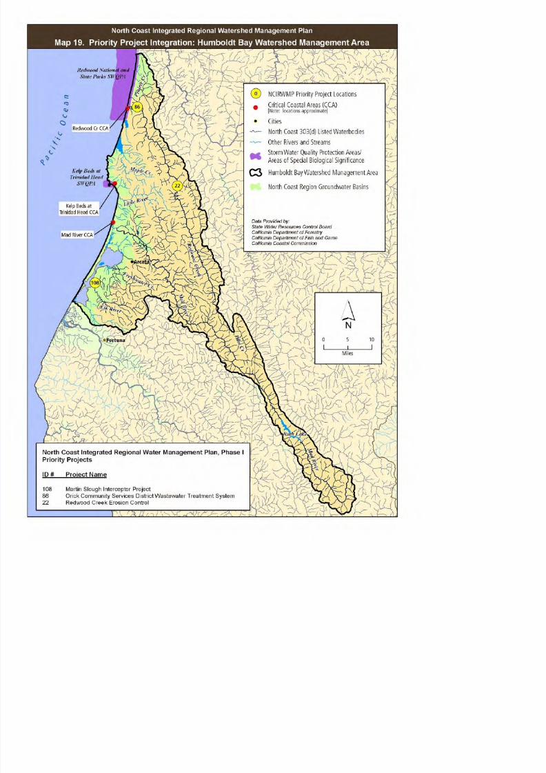
8/2/2019 North Coast Integrated Regional Water Management Plan, July 2007
http://slidepdf.com/reader/full/north-coast-integrated-regional-water-management-plan-july-2007 221/458

8/2/2019 North Coast Integrated Regional Water Management Plan, July 2007
http://slidepdf.com/reader/full/north-coast-integrated-regional-water-management-plan-july-2007 222/458
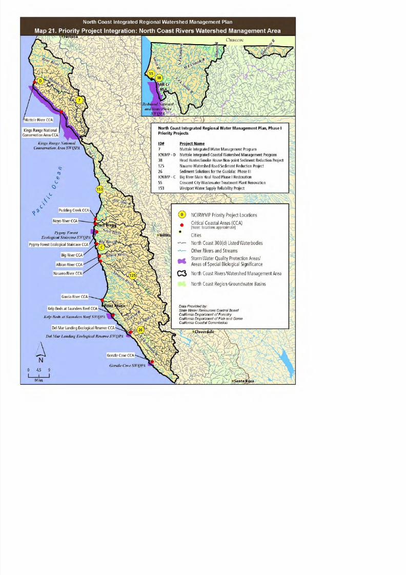
8/2/2019 North Coast Integrated Regional Water Management Plan, July 2007
http://slidepdf.com/reader/full/north-coast-integrated-regional-water-management-plan-july-2007 223/458

8/2/2019 North Coast Integrated Regional Water Management Plan, July 2007
http://slidepdf.com/reader/full/north-coast-integrated-regional-water-management-plan-july-2007 224/458

8/2/2019 North Coast Integrated Regional Water Management Plan, July 2007
http://slidepdf.com/reader/full/north-coast-integrated-regional-water-management-plan-july-2007 225/458
SECTION 9.0
EVALUATION AND
MEASUREMENT MECHANISMS

8/2/2019 North Coast Integrated Regional Water Management Plan, July 2007
http://slidepdf.com/reader/full/north-coast-integrated-regional-water-management-plan-july-2007 226/458
North Coast Integrated Regional Water Management Plan, Phase I
9.0 NCIRWMP EVALUATION AND MEASUREMENT MECHANISMS
This section describes existing statewide monitoring efforts, as well as the methods used to evaluateand measure the success of the prioritized water management projects at both the programmatic andproject level.
9.1 STATUS OF EXISTING MONITORING EFFORTS
Watershed and water quality monitoring is currently conducted by a number of state agencies, eachwith its programmatic mission to fulfill. Watershed and water quality monitoring in the North Coast isvital for evaluation of the effectiveness of sediment reduction programs, instream habitat restorationprograms, fish passage projects and other watershed enhancement projects. On-going monitoring is
critical to understanding how land use practices such as road building, timber harvest, irrigatedagriculture, and land conversion impact the aquatic resources and habitats of the North Coast Region.Equally important is the compliance monitoring of public wastewater treatment facilities to ensure thehealth and safety of water quality for beneficial uses. The NCRWMG intends to use existing andproposed monitoring efforts to inform management decisions and guide changes to management,policy, and decision-making in the North Coast Region.

8/2/2019 North Coast Integrated Regional Water Management Plan, July 2007
http://slidepdf.com/reader/full/north-coast-integrated-regional-water-management-plan-july-2007 227/458
9.1.1 STATE WATER RESOURCES CONTROL BOARD MONITORING PROGRAMS
Surface Water Ambient Monitoring Program (SWAMP)Trends in surface water quality and habitat, the effectiveness of control strategies, TMDLimplementation, and nonpoint source pollution are monitored as part of the statewide Surface WaterAmbient Monitoring Program (SWAMP), which is administered by the SWRCB. The goals of theprogram include statewide monitoring that is consistent and objective through the development of data quality assurance protocols and centralized data management. The SWAMP database is currently
being developed and will be designed to feed the U.S. EPA STORET water quality data managementsystem. Other surface water monitoring programs that are managed as part of the SWAMP programinclude State Mussel Watch, Toxic Substance Monitoring Program, Toxicity Testing Program, andCoastal Fish Contamination Program.
The nine Regional Water Quality Control Boards implement monitoring activities through contractswith CDFG, U.S. Geologic Survey (USGS) and USEPA. The SWAMP monitoring approach utilized by theNCRWQCB incorporates both long-term trend monitoring at permanent monitoring stations androtating site-specific monitoring closely related to the TMDL development and implementation
schedule (NCRWQCB 2005).
North Coast Integrated Regional Water Management Plan, Phase I
differences at station locations, among different reaches in a given watershed, and betweenwatersheds.
Site-specific monitoring in the North Coast Region rotates among the NCRWQCB designatedWatershed Management Areas (WMA) on a planned schedule to support remedial actions, develop
TMDLs and collect information towards the potential listing or delisting of waterbodies under the CleanWater Act Section 303(d). Water quality parameters measured in each basin are based on specificwatershed characteristics and water quality objectives identified in the individual WMA sections in theNCRWQCB Watershed Planning Chapter (NCRWQCB 2005). Water quality objectives for each WMAare provided in Appendix B, Existing Water and Watershed Management Plans & Programs.
Clean Water Team Citizen Monitoring ProgramThrough a partnership with many local Resource Conservation Districts, the SWRCB is actively
promoting volunteer monitoring among landowners, farmers, ranchers, and community members. The“Clean Water Team Citizen Monitoring Program” is a statewide program developed by the SWRCBNonpoint Source Pollution Control Program to offer suggestions, guidelines and protocols for volunteermonitoring efforts. This program is increasingly being incorporated into the SWAMP monitoringprogram to complete site-specific monitoring in the North Coast Region.
N i l P ll Di h Eli i i S

8/2/2019 North Coast Integrated Regional Water Management Plan, July 2007
http://slidepdf.com/reader/full/north-coast-integrated-regional-water-management-plan-july-2007 228/458
National Pollutant Discharge Elimination SystemThe National Pollutant Discharge Elimination System (NPDES) program is a federal program that is
currently administered by the SWRCB to regulate wastewater discharge to surface waters, stormwaterdrains and groundwater. All wastewater discharges in the North Coast Region are regulated throughNPDES permitting which requires self-monitoring of relevant water quality data to be submitted to theNCRWQCB for compliance evaluation in accordance to the “Waste Discharge Requirement, GeneralMonitoring and Reporting Program”. (SWRCB 1997)
9.1.2 CALIFORNIA DEPARTMENT OF FISH AND GAME
California Salmonid Habitat Restoration ManualProject evaluation and monitoring is outlined in the California Department of Fish and Game (DFG)California Salmonid Habitat Restoration Manual to measure whether specific restoration goals havebeen achieved through project implementation including upslope and road remediation monitoring.Several project proponents intend to use this manual to implement and monitor NCIRWMP salmonidhabitat restoration projects.
Restoration Effectiveness MonitoringI 2003 th CDFG i d t titl d th “I t i R t ti Eff ti d V lid ti
North Coast Integrated Regional Water Management Plan, Phase I
9.1.3 CALIFORNIA DEPARTMENT OF FORESTRY (CDF)/ BOARD OF FORESTRY
In 1990 the Board of Forestry established the Monitoring Study Group (MSG) to evaluate the ForestPractice Rules protection of beneficial uses and water quality. Membership of the MSG is made up of representatives from agencies, CDF, the public and the timber industry. The long-term monitoring
program includes hillslope monitoring of Timber Harvest Plan (THP) lands, Forest Practice Ruleimplementation and effectiveness monitoring, and the development of scientifically valid monitoringplans for 303(d) listed waterbodies.
9.1.4 CALIFORNIA DEPARTMENT OF HEALTH SERVICES
California Department of Health Services is the lead agency responsible for developing andimplementing the Drinking Water Source Assessment and Protection Program. The purpose of thisprogram is to monitor and assess drinking water sources, both at surface water and groundwater level.
9 1 5 INTERAGENCY PROGRAMS

8/2/2019 North Coast Integrated Regional Water Management Plan, July 2007
http://slidepdf.com/reader/full/north-coast-integrated-regional-water-management-plan-july-2007 229/458
9.1.5 INTERAGENCY PROGRAMS
Ground-Water Ambient Monitoring and AssessmentThe Ground-Water Ambient Monitoring and Assessment program (GAMA) was developed throughinteragency cooperation to evaluate and monitor the quality of groundwater resources in California.Participating agencies include USGS, SWRCB, RWQCB, DWR, Department of Health Services, LawrenceLivermore National Laboratory, counties, and local water agencies.
The GAMA program goals include the establishment of baseline groundwater conditions, creation of asecure database to archive assessment data, provision of trend analysis for long-term groundwatermanagement and assistance in the development of groundwater objectives at the regional or basinscale.
Natural Resources Project InventoryThrough a partnership of the California Biodiversity Council and the University of California at Davis,Information Center for the Environment, data is collected about restoration efforts occurring statewide.This information is available in a comprehensive electronic database titled the Natural ResourcesProject Inventory and accessed on the Internet.
Pacific Northwest Aquatic Monitoring Partnership Th t t d f th P ifi N th t A ti M it i P t hi (PNAMP) i “t id
North Coast Integrated Regional Water Management Plan, Phase I
The PNAMP provides an opportunity for local and regional planners to utilize monitoring protocols anddata collection and storage techniques that are compatible with other agencies and that haveundergone extensive scientific review specific to Pacific Northwest environmental conditions. TheNCRWMG may consider joining the Partnership in addition to participating in SWRCB and DWRmonitoring efforts in order to more fully engage the Northern California region in cooperative interstate
monitoring efforts and to enable the group to bring the results of the partnerships’ efforts to bear inlocal and regional monitoring planning activities.
9.2 NCIRWMP PROJECT AND PLAN EVALUATION AND MONITORING
Evaluation and measurement mechanisms of the NCIRWMP will be based on an adaptive management
approach. The short- and long-term needs within the North Coast Region are expected to change asfunded projects have an impact on addressing needs and as new unexpected needs arise. Thisapproach is flexible and iterative and provides the opportunity to introduce change as needed toaccomplish the goals identified for each objective. Many of the performance measures data will becollected by projects that are implemented as part of the NCIWRMP. See Section 7 for a summary of NCIRWMP project monitoring activities.

8/2/2019 North Coast Integrated Regional Water Management Plan, July 2007
http://slidepdf.com/reader/full/north-coast-integrated-regional-water-management-plan-july-2007 230/458
The North Coast IRWMP project and plan performance evaluation process will include:o
Evaluation of project completenesso Effectiveness monitoring of restoration projectso Stream flow monitoringo Temperature monitoringo Sediment reduction assessmento NPDES water quality monitoringo Bioassessment monitoringo Stream cross sectional monitoringo Suspended sediment and bedload monitoringo Site condition photo documentationo GIS data compilation and analysis of benefited waterbodies and habitato Monitoring of TMDL parameters including temperature, sediment and dissolved oxygeno Approved Quality Assurance Project Planso Internet publishing of restoration project data to the Natural Resources Project Inventoryo Internet publication of monitoring data into SWAMP databases for public review and analysis
Plan performance will be measured by:o Number of improved habitat acres
Length of 303 (d) listed stream enhanced
North Coast Integrated Regional Water Management Plan, Phase I
o Number of failing septic systems removed from the project areao Number of new private property owners that incorporate Best Management Practices and
adopted conservation action plans
The use of adaptive management for the North Coast Region will allow projects and planning efforts
implemented under the Plan to fluctuate as needed to meet goals while producing beneficial outcomes.
Data gaps exist throughout the North Coast Region. Although numerous assessment efforts, such asthe North Coast Watershed Assessment Program (NCWAP) and individual watershed assessments havebeen conducted, and the SWRCB, DWR, and NCRWQCB conduct monitoring on several waterways,most of the watersheds, rivers, and streams in the region have not been adequately assessed ormonitored using standardized, scientifically accepted protocol. It is a goal of the NCRWMP to furtheridentify these watersheds, rivers and streams and to prioritize them for future assessment and
monitoring programs.
Challenges associated with the adaptive management approach for the North Coast Region include thedifficulty of assessing cumulative impacts across the region, difficulty of assessment on a regional scaleand the lack of sufficient data and the system complexity, which make it extremely difficult to integrateresearch results into a useful model. These limitations can be counter-acted by the implementation of adaptive management across the individual projects funded under the NCIRWMP Phase 1 and the

8/2/2019 North Coast Integrated Regional Water Management Plan, July 2007
http://slidepdf.com/reader/full/north-coast-integrated-regional-water-management-plan-july-2007 231/458
adaptive management across the individual projects funded under the NCIRWMP Phase 1 and theongoing refinement of the NCIRWMP, which is intended to be a “living document” that incorporates
new information and monitoring feedback to reprioritize project needs, reanalyze policy, and makeother changes to NCRWMG structure and function as necessary. The NCIRWMP projects will functionas models for other projects and as a process for obtaining feedback. The feedback, information anddata acquired during this process will be integrated into database management outlets andincorporated into geographic information systems that will serve not only the North Coast Region, butalso the State of California and the Pacific Northwest.
North Coast Integrated Regional Water Management Plan, Phase I
References:
California Department of Fish and Game (CDFG). 2003. Interim Restoration Effectiveness andValidation Monitoring Protocols, California Coastal Salmonid Restoration Monitoring and Evaluation
Program.
California State Board of Forestry and Fire Protection (BOF), California Department of Forestry and FireProtection (CDF). 2002. Monitoring Study Group, Monitoring Program, Strategic Plan, January 2002.[web site http://www.bof.fire.ca.gov/board/msg_intro.html accessed 7/7/05].
North Coast Regional Water Quality Control Board (NCRWQCB). 2005. Watershed Planning Chapter.
North Coast Regional Water Quality Control Board (NCRWQCB). 2005. [web sitehttp://www.waterboards.ca.gov/northcoast/programs/swamp.html accessed 7/7/05].
North Coast Regional Water Quality Control Board (NCRWQCB). 2005. [web sitehttp://www.waterboards.ca.gov/northcoast/programs/npdes.html accessed 7/7/05].
North Coast Regional Water Quality Control Board (NCRWQCB) 2005 Surface Water Ambient

8/2/2019 North Coast Integrated Regional Water Management Plan, July 2007
http://slidepdf.com/reader/full/north-coast-integrated-regional-water-management-plan-july-2007 232/458
North Coast Regional Water Quality Control Board (NCRWQCB). 2005. Surface Water AmbientMonitoring Program (SWAMP), Draft Workplans.
Regional Ecosystem Office (REO). 2005b. Pacific Northwest Aquatic Monitoring Partnership. [webpage available at: http://www.reo.gov/PNAMP/index.htm] Accessed June 2005.
State Water Resources Control Board (SWRCB). “Clean Water Team Guidance Compendium forWatershed Monitoring and Assessment” [web site http://www.swrcb.ca.gov/nps/volunteer.htmlaccessed 7/7/05].
State Water Resources Control Board. 1997.Water Quality Order No. 97-10-Dwq, General Waste Discharge Requirements For Discharges To LandBy Small Domestic Wastewater Treatment Systems. [web sitehttp://www.swrcb.ca.gov/resdec/wqorders/1997/wqo97-10.htm accessed 7/7/05].

8/2/2019 North Coast Integrated Regional Water Management Plan, July 2007
http://slidepdf.com/reader/full/north-coast-integrated-regional-water-management-plan-july-2007 233/458
APPENDICES

8/2/2019 North Coast Integrated Regional Water Management Plan, July 2007
http://slidepdf.com/reader/full/north-coast-integrated-regional-water-management-plan-july-2007 234/458
N O R T H C O A S T I N T E G R A T E D R E G I O N A LW A T E R M A N A G E M E N T P L A N

8/2/2019 North Coast Integrated Regional Water Management Plan, July 2007
http://slidepdf.com/reader/full/north-coast-integrated-regional-water-management-plan-july-2007 235/458
P H A S E 1
J u l y 2 0 0 7
APPENDIX A: PROJECTS INTEGRATION WITH STATEWIDE GOALS\\

8/2/2019 North Coast Integrated Regional Water Management Plan, July 2007
http://slidepdf.com/reader/full/north-coast-integrated-regional-water-management-plan-july-2007 236/458
North Coast Integrated Regional Water Management Plan, Phase 1Appendix A: NCIRWMP Projects Integration with Statewide Goals
CWC Program Preferences DWR & SWRCB Statewide Priorities
Project ID Project Name I n t e g r a t e d p r o j e c t w i t h m u
l t i p l e
b e n e f i t s
S u p p o r t a n d i m p r o v e l o c a l
a n d
r e g
i o n a l w a t e r s u p p l y r e l i a
b i l i t y
C o n t r i b u t e t o l o n g - t e r m
a t t
a i n m e n t a n d m a i n t e n a n
c e o f
w a
t e r q u a l i t y
E l i m i n a t e o r r e d u c e p o l l u t i
o n i n
i m p a i r e d w a t e r s a n d s e n s i t i v e
h a b i t a t
S a f e d r i n k i n g a n d w a t e r q u
a l i t y
p r o
j e c t s t h a t s e r v e
d i s
a d v a n t a g e d c o m m u n i t i e
s
R e d u c e c o n f l i c t b e t w e e n w
a t e r
u s e
r s
I m p l e m e n t a t i o n o f T M D L S
I m p l e m e n t a t i o n o f R W Q C B
W M I
C h a p t e r s , P l a n s , P o l i c i e s
I m p l e m e n t a t i o n o f S W R C B ' s N P S
P o l l u t i o n P l a n
I m p l e m e n t a t i o n o f
r e c
o m m e n d a t i o n s o f f l o o d p a l i n
m a
n a g e m e n t t a s k f o r c e , r e
c y c l i n g
t a s
k f o r c e o r s t a t e s p e c i e s
r e c
o v e r y p l a n
A d d r e s s e n v i r o n m e n t a l j u s t i c e
c o n
c e r n s
7
Mattole Integrated
Water Management
Program
X X X X X X X X X
236
Siskiyou County
Integrated Water
Management/CohoX X X X X X X X X X
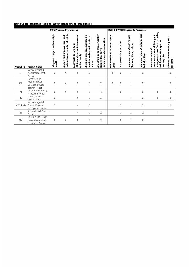
8/2/2019 North Coast Integrated Regional Water Management Plan, July 2007
http://slidepdf.com/reader/full/north-coast-integrated-regional-water-management-plan-july-2007 237/458
g
Recovery Project
78 Monte Rio CommunityWastewater Project
X X X X X X X X X X
86Orick Community
Services DistrictX X X X X X X X
ICWMP - D
Mattole Integrated
Coastal Watershed
Management Program
X X X X X X X
22Redwood Creek Erosion
ControlX X X X X X X
164California Fish FriendlyFarming Environmental
Certification Program
X X X X X X X X
North Coast Integrated Regional Water Management Plan, Phase 1Appendix A: NCIRWMP Projects Integration with Statewide Goals
CWC Program Preferences DWR & SWRCB Statewide Priorities
Project ID Project Name I n t e g r a t e d p r o j e c t w i t h m u
l t i p l e
b e n e f i t s
S u p p o r t a n d i m p r o v e l o c a l
a n d
r e g
i o n a l w a t e r s u p p l y r e l i a
b i l i t y
C o n t r i b u t e t o l o n g - t e r m
a t t
a i n m e n t a n d m a i n t e n a n
c e o f
w a
t e r q u a l i t y
E l i m i n a t e o r r e d u c e p o l l u t i
o n i n
i m p a i r e d w a t e r s a n d s e n s i t i v e
h a b i t a t
S a f e d r i n k i n g a n d w a t e r q u
a l i t y
p r o
j e c t s t h a t s e r v e
d i s
a d v a n t a g e d c o m m u n i t i e
s
R e d u c e c o n f l i c t b e t w e e n w
a t e r
u s e
r s
I m p l e m e n t a t i o n o f T M D L S
I m p l e m e n t a t i o n o f R W Q C B
W M I
C h a p t e r s , P l a n s , P o l i c i e s
I m p l e m e n t a t i o n o f S W R C B ' s N P S
P o l l u t i o n P l a n
I m p l e m e n t a t i o n o f
r e c
o m m e n d a t i o n s o f f l o o d p a l i n
m a
n a g e m e n t t a s k f o r c e , r e
c y c l i n g
t a s
k f o r c e o r s t a t e s p e c i e s
r e c
o v e r y p l a n
A d d r e s s e n v i r o n m e n t a l j u s t i c e
c o n
c e r n s
51
Mid Van Duzen River
Ranch Road Sediment
Reduction Program
X X X X X X X X
121Salt River Restoration
ProjectX X X X X X X X
Graton Wastewater

8/2/2019 North Coast Integrated Regional Water Management Plan, July 2007
http://slidepdf.com/reader/full/north-coast-integrated-regional-water-management-plan-july-2007 238/458
23
Graton Wastewater
Treatment Upgrade and
Reclamation Project
X X X X X X X X X X
128
Sonoma County Water
Recycling and Habitat
Preservation Project
X X X X X X X X X X
217Newell Water System
RenovationX X X X X X
38
Head Hunter/Smoke
House Nonpoint
Sediment ReductionProject
X X X X X X X
North Coast Integrated Regional Water Management Plan, Phase 1Appendix A: NCIRWMP Projects Integration with Statewide Goals
CWC Program Preferences DWR & SWRCB Statewide Priorities
Project ID Project Name I n t e g r a t e d p r o j e c t w i t h m u
l t i p l e
b e n e f i t s
S u p p o r t a n d i m p r o v e l o c a l
a n d
r e g
i o n a l w a t e r s u p p l y r e l i a
b i l i t y
C o n t r i b u t e t o l o n g - t e r m
a t t
a i n m e n t a n d m a i n t e n a n
c e o f
w a
t e r q u a l i t y
E l i m i n a t e o r r e d u c e p o l l u t i o n i n
i m p a i r e d w a t e r s a n d s e n s i t i v e
h a b i t a t
S a f e d r i n k i n g a n d w a t e r q u a l i t y
p r o
j e c t s t h a t s e r v e
d i s
a d v a n t a g e d c o m m u n i t i e
s
R e d u c e c o n f l i c t b e t w e e n w
a t e r
u s e
r s
I m p l e m e n t a t i o n o f T M D L S
I m p l e m e n t a t i o n o f R W Q C B
W M I
C h a p t e r s , P l a n s , P o l i c i e s
I m p l e m e n t a t i o n o f S W R C B ' s N P S
P o l l u t i o n P l a n
I m p l e m e n t a t i o n o f
r e c
o m m e n d a t i o n s o f f l o o d
p a l i n
m a
n a g e m e n t t a s k f o r c e , r e
c y c l i n g
t a s
k f o r c e o r s t a t e s p e c i e s
r e c
o v e r y p l a n
A d d r e s s e n v i r o n m e n t a l j u s
t i c e
c o n c e r n s
151
Trinity Drinking Water
Source Sediment
Reduction Project
X X X X X X
108Martin Slough
Interceptor ProjectX X X X X X
Navarro Watershed

8/2/2019 North Coast Integrated Regional Water Management Plan, July 2007
http://slidepdf.com/reader/full/north-coast-integrated-regional-water-management-plan-july-2007 239/458
125 Road Sediment
Reduction Project
X X X X X X
26Sediment Solutions for
the Gualala: Phase IIIX X X X X
207
Lower Fuller Creek
Sediment Source
Implementation Plan
X X X X X
ICWMP - BForsythe Creek Sediment
Control ProjectX X X X X
39Raw and RecoveredWater for Irrigating
Public Agencies
X X X X X X
North Coast Integrated Regional Water Management Plan, Phase 1Appendix A: NCIRWMP Projects Integration with Statewide Goals
CWC Program Preferences DWR & SWRCB Statewide Priorities
Project ID Project Name I n t
e g r a t e d p r o j e c t w i t h m u
l t i p l e
b e n e f i t s
S u p p o r t a n d i m p r o v e l o c a l
a n d
r e g
i o n a l w a t e r s u p p l y r e l i a
b i l i t y
C o n t r i b u t e t o l o n g - t e r m
a t t
a i n m e n t a n d m a i n t e n a n
c e o f
w a
t e r q u a l i t y
E l i m i n a t e o r r e d u c e p o l l u t i o n i n
i m p a i r e d w a t e r s a n d s e n s i t i v e
h a b i t a t
S a f e d r i n k i n g a n d w a t e r q u a l i t y
p r o
j e c t s t h a t s e r v e
d i s
a d v a n t a g e d c o m m u n i t i e s
R e d u c e c o n f l i c t b e t w e e n w
a t e r
u s e r s
I m p l e m e n t a t i o n o f T M D L S
I m p l e m e n t a t i o n o f R W Q C B
W M I
C h a p t e r s , P l a n s , P o l i c i e s
I m p l e m e n t a t i o n o f S W R C B ' s N P S
P o l l u t i o n P l a n
I m p l e m e n t a t i o n o f
r e c
o m m e n d a t i o n s o f f l o o d
p a l i n
m a
n a g e m e n t t a s k f o r c e , r e
c y c l i n g
t a s
k f o r c e o r s t a t e s p e c i e s
r e c
o v e r y p l a n
A d
d r e s s e n v i r o n m e n t a l j u s
t i c e
c o n c e r n s
74
Willits Wastewater
Treatment/Water
Reclamation Project
X X X X X
81
Weaverville Sanitary
District Water
Reclamation Project
X X X X X X X

8/2/2019 North Coast Integrated Regional Water Management Plan, July 2007
http://slidepdf.com/reader/full/north-coast-integrated-regional-water-management-plan-july-2007 240/458
ICWMP - A
Salmon Creek Sediment
Reduction and WaterConservation Program
X X X X X X X
89
Covelo Wastewater
Facilities Improvement
Project
X X X X X
ICWMP - CBig River Main Haul
Road Phase I RestorationX X X X X X
North Coast Integrated Regional Water Management Plan, Phase 1Appendix A: NCIRWMP Projects Integration with Statewide Goals
CWC Program Preferences DWR & SWRCB Statewide Priorities
Project ID Project Name I n t
e g r a t e d p r o j e c t w i t h m u
l t i p l e
b e n e f i t s
S u p p o r t a n d i m p r o v e l o c a l
a n d
r e g
i o n a l w a t e r s u p p l y r e l i a
b i l i t y
C o n t r i b u t e t o l o n g - t e r m
a t t
a i n m e n t a n d m a i n t e n a n
c e o f
w a
t e r q u a l i t y
E l i m i n a t e o r r e d u c e p o l l u t i o n i n
i m p a i r e d w a t e r s a n d s e n s i t i v e
h a b i t a t
S a f e d r i n k i n g a n d w a t e r q u a l i t y
p r o j e c t s t h a t s e r v e
d i s
a d v a n t a g e d c o m m u n i t i e s
R e d u c e c o n f l i c t b e t w e e n w
a t e r
u s e r s
I m p l e m e n t a t i o n o f T M D L S
I m p l e m e n t a t i o n o f R W Q C B
W M I
C h a p t e r s , P l a n s , P o l i c i e s
I m p l e m e n t a t i o n o f S W R C B ' s N P S
P o l l u t i o n P l a n
I m p l e m e n t a t i o n o f
r e c
o m m e n d a t i o n s o f f l o o d
p a l i n
m a
n a g e m e n t t a s k f o r c e , r e
c y c l i n g
t a s
k f o r c e o r s t a t e s p e c i e s
r e c
o v e r y p l a n
A d
d r e s s e n v i r o n m e n t a l j u s
t i c e
c o n c e r n s
55
Crescent City
Wastewater Treatment
Plant Renovation
X X X X X X X
153Water Supply Reliability
ProjectX X X X X

8/2/2019 North Coast Integrated Regional Water Management Plan, July 2007
http://slidepdf.com/reader/full/north-coast-integrated-regional-water-management-plan-july-2007 241/458

8/2/2019 North Coast Integrated Regional Water Management Plan, July 2007
http://slidepdf.com/reader/full/north-coast-integrated-regional-water-management-plan-july-2007 242/458
N O R T H C O A S T I N T E G R A T E D R E G I O N A LW A T E R M A N A G E M E N T P L A NP H A S E 1

8/2/2019 North Coast Integrated Regional Water Management Plan, July 2007
http://slidepdf.com/reader/full/north-coast-integrated-regional-water-management-plan-july-2007 243/458
J u l y 2 0 0 7
APPENDIX B: EXISTING WATER & WATERSHED MANAGEMENT PLANS

8/2/2019 North Coast Integrated Regional Water Management Plan, July 2007
http://slidepdf.com/reader/full/north-coast-integrated-regional-water-management-plan-july-2007 244/458
North Coast Integrated Regional Water Management PlanPhase I
APPENDIX B: EXISTING WATER AND WATERSHED MANAGEMENT PLANS & PROGRAMS
1.0 EXISTING WATER AND WATERSHED MANAGEMENT PLANS & PROGRAMS
There are numerous high quality planning efforts underway or completed in the North Coast region,ranging from federal, state and local agency plans, to efforts by tribal organizations, ResourceConservation Districts (RCDs), watershed groups and landowner groups. A summary of these efforts is
included in Appendix F: Matrix of Existing Water Management Planning Efforts, and selected efforts aredescribed below.
1.1 FEDERAL PLANS AND PROGRAMS
1.1.1 Clean Water Act § 303(d)
Section 303(d) of the federal Clean Water Act requires that all states in the U.S. identify waterbodiesthat do not meet specified water quality standards and that do not support intended beneficial uses.Identified waters are placed on the Section 303(d) List of Impaired Waterbodies. Once placed on thislist, states are required to develop a water quality control plan - called a Total Maximum Daily Load(TMDL) - for each waterbody and each associated pollutant/stressor. For example, the Big River in theMendocino Coast Hydrologic Unit (HU) and Big River Hydrologic Area (HA) has been listed as impairedbecause it exceeds thresholds set for temperature and sediment. Thus, two TMDLs are required for theBig River – one for temperature and one for sediment.

8/2/2019 North Coast Integrated Regional Water Management Plan, July 2007
http://slidepdf.com/reader/full/north-coast-integrated-regional-water-management-plan-july-2007 245/458
Within California, the Regional Water Quality Control Boards (RWQCB) generally prepares TMDLs forthe impaired water bodies under its jurisdiction. Implementation of the TMDL is accomplished throughamendments to the RWQCB Basin Plans, which are reviewed and if necessary, modified or amendedtriennially.
A TMDL is a calculation of the maximum amount of a given pollutant that a waterbody can receive andstill meet water quality standards. TMDLs must be set at levels that achieve applicable waterstandards and must include a safety margin. After the state has determined the TMDL, it must allocate
a portion of the TMDL – the “loading capacity” - to each source of that pollutant within eachwatershed. The “waste load allocation” is the portion allocated to point sources and the “loadallocation” is allocated to nonpoint sources and naturally occurring background sources. Thus, a TMDLis federally defined as “the sum of the individual waste load allocations for point sources and loadallocations for nonpoint sources and natural background such that the capacity of the waterbody toassimilate pollutants (the Loading Capacity) is not exceeded (Orange County, 2005).”
The most current 303(d) List of Impaired Waterbodies for the North Coast Region California is the 2002
Section 303(d) List of Water Quality Limited Segments developed by the North Coast Regional WaterQ alit C nt l B a d and a ailabl at (http // b a /tmdl/303d li t html) Map 10
North Coast Integrated Regional Water Management PlanPhase I
APPENDIX B: EXISTING WATER AND WATERSHED MANAGEMENT PLANS & PROGRAMS
1.1.2 National Oceanic and Atmospheric Administration (NOAA) Fisheries Service
Prior to 2003, NOAA Fisheries Service was known as the National Marine Fisheries Service. NOAAFisheries is “dedicated to the stewardship of living marine resources through science-basedconservation and management, and the promotion of healthy ecosystems” (NOAA Fisheries Service
2004). NOAA Fisheries Service actively conserves, protects, and manages living marine resources toensure that marine ecosystems continue to properly function, to enable economic opportunity, and toenhance the American public’s quality of life.
Salmon Recovery Plan: Southern Oregon/Northern California Coast
In 1991, NOAA Fisheries Service completed a comprehensive review of the status of salmonidpopulations in California, Washington, Oregon, and Idaho. As a result, 52 evolutionary significant units
(ESUs) of salmonids were identified (NOAA Fisheries 1999). "An ESU is defined as a population that 1)is substantially reproductively isolated from conspecific populations and 2) represents an importantcomponent in the evolutionary legacy of the species (Johnson et al. 1994)." These ESUs are distributedthroughout the Western U.S. and so to better address the regional needs of recovery planning, NOAAFisheries created Recovery Planning Domains. There are nine regional Recovery Planning Domains inthe western U.S. and NOAA Fisheries has appointed a Technical Recovery Team (TRT) for each recoverydomain.
Of the 52 ESUs identified by NOAA the North Coast region contains five ESUs that are listed as

8/2/2019 North Coast Integrated Regional Water Management Plan, July 2007
http://slidepdf.com/reader/full/north-coast-integrated-regional-water-management-plan-july-2007 246/458
Of the 52 ESUs identified by NOAA, the North Coast region contains five ESUs that are listed as
threatened or endangered by state and federal government (see Map 13, Salmonid EvolutionarySignificant Units Map). These five ESUs are under the jurisdiction of two Technical Recovery Teams(TRTs) – the Oregon/Northern California Coast TRT and the North – Central California Coast TRT (seeTable 1 TRTs and ESUs in the North Coast Region).
Table 1. TRTs and ESUs in the North Coast Region
TRT ESU FederalStatus
State Status
Oregon/Northern California CoastTRT
Southern Oregon/Northern CaliforniaCoasts (SONCC) Coho Salmon ESU
threatened threatened
North-Central California Coast TRT Central California Coast Coho SalmonESU
threatened endangered
California Coastal Chinook Salmon
ESU
threatened threatened
North Coast Integrated Regional Water Management PlanPhase I
APPENDIX B: EXISTING WATER AND WATERSHED MANAGEMENT PLANS & PROGRAMS
The Southern Oregon/Northern California Coast (SONCC)Workgroup is the committee of theOregon/Northern California Coast TRT responsible for overseeing the recovery of the SONCC Coho ESU.The SONCC Workgroup is currently editing a draft of the population structure report for SONCC cohosalmon. This document is scheduled to be available in August 2005 (NOAA/NMFS 1996).
The North-Central California Coast Technical Recovery Team has released a draft report on thehistorical population structure of all four listed ESUs in North-Central California Coast recovery domain.The draft report is available at: http://santacruz.nmfs.noaa.gov/esa/salmonids/trt/nccc.php and giveslife history, historical population structure, and genetic information for all four species. A month longcomment period on the draft ended on June 3, 2005 (NOAA 2005).
1.1.3 Environmental Protection Agency
EPA Underground Injection Control (UIC) Program
The UIC Program works with state and local governments to regulate the underground injection of waste to prevent the contamination of underground drinking water resources. The EPA regulatesinjection wells by authority provided in Part C of the Safe Drinking Act and according to regulationslocated in the Code of Federal Regulations parts 144 –147. In California, the EPA and the state shareprimary responsibility for the UIC program for all classes of wells except oil and gas related wells. InCalifornia, some of the types of injection wells include stormwater wells, carwash wells, sewagetreatment effluent wells, spent brine wells, aquaculture wells, aquifer remediation wells, geothermalelectric power wells (such as the Geysers in Sonoma County) salt water intrusion barrier wells and

8/2/2019 North Coast Integrated Regional Water Management Plan, July 2007
http://slidepdf.com/reader/full/north-coast-integrated-regional-water-management-plan-july-2007 247/458
electric power wells (such as the Geysers in Sonoma County), salt water intrusion barrier wells, and
aquifer recharge wells (EPA 1999).
1.2 STATE PLANS
1.2.1 State Water Resources Control Board (SWRCB)
Water Management Initiative
The Water Management Initiative (WMI) uses watershed management principals to provide anintegrated approach to water resource protection, enhancement and restoration while balancingenvironmental and economic impacts. The proposed watershed management approach differs fromearlier water management efforts as follows:Water resource issues are identified and prioritized on the basis of water quality within individualwatersheds. Local conditions are taken into account and local stakeholders are included in the process.Nonpoint sources of pollution will be addressed at the watershed scale.The Regional Board will cooperate with local stakeholder groups to achieve improved coordination of
overlapping federal, state, and local activities and programs, especially with regard to funding and
North Coast Integrated Regional Water Management PlanPhase I
APPENDIX B: EXISTING WATER AND WATERSHED MANAGEMENT PLANS & PROGRAMS
The initial focus of the WMI was on development of watershed management strategies for each of thenine RWQCB regions. Each RWQCB provides a chapter for the WMI Integrated Plan that containsstrategies developed for the unique conditions in each priority watershed. Each RWQCB chapteridentifies priorities, where baseline funding will be spent, and where additional resources arenecessary. The plan is updated annually.
Ten WMI coordinators have been employed to carry out the WMI, one for the SWRCB and one for eachof the nine RWQCBs. The WMI coordinators’ major responsibility is to work with local stakeholders toimprove public access to the Water Boards. Additionally, a WMI Workgroup, comprised of representatives from SWRCB, the nine RWQCBs, and EPA has been convened to plan and supportimplementation of the WMI.
The WMI supports goals in the SWRCB’s 1997 Strategic Plan and the 2001 Strategic Plan. Inimplementing the WMI, the goals of both plans are addressed. These goals include:
• Preservation, enhancement and restoration of water resources while balancing environmentaland economic impacts
• Promotion of cooperative relationships to improve support for the regulated community andpublic
• Encouragement of balanced and efficient water use• Establishment of a stable, flexible pool of funding sources• Responsive, effective and innovation management• Promotion of safe surface and groundwater for drinking recreation ecosystem function and

8/2/2019 North Coast Integrated Regional Water Management Plan, July 2007
http://slidepdf.com/reader/full/north-coast-integrated-regional-water-management-plan-july-2007 248/458
• Promotion of safe surface and groundwater for drinking, recreation, ecosystem function, andother beneficial uses
• Education and outreach to stakeholders to obtain support for the WMI and understandingregarding individual roles in water quality
• Comprehensive measurement of water quality to evaluate effectiveness of implementedprojects and programs (SWRCB and RWQCBs 2001).
The WMI for the North Coast has identified the following high priority activities (NC RWQCB 2005):• Implementing TMDLs for sediment in 16 coastal watersheds• Completing all Klamath Basin TMDLs by December 2005• Maintaining the core regulatory program for regulated dischargers, including stormwater• Developing a monitoring strategy for the region and integrating SWAMP with TMDL
monitoring• Regulating vineyards and timber activities• Developing policies for runoff from roads• Maintaining the ground water cleanup programs for high priority sites• Improving outreach and community involvement in decisions• Fostering watershed groups and citizen monitoring
North Coast Integrated Regional Water Management PlanPhase I
APPENDIX B: EXISTING WATER AND WATERSHED MANAGEMENT PLANS & PROGRAMS
Water Quality Control Plan for the Ocean Waters of California
In 2001, the SWRCB updated the Ocean Plan to provide for control of discharge of waste to oceanwaters and to set water quality objectives for ocean waters. Beneficial uses of ocean waters includeindustrial water supply, recreation, navigation, commercial and sport fishing, mariculture, preservationand enhancement of Areas of Special Biological Significance, marine habitat, fish migration and
spawning and shellfish harvesting.
Guiding principles of the Ocean Plan include coordination between statewide water quality controlplans and policies, attainment and maintenance of water quality standards, and a policy of applyingthe more stringent provision when two or more plans or policies conflict. The Ocean Plan also providesa program for implementation that provides general requirements for management of waste dischargeto the ocean and specific effluent limitations. The Plan is applicable to point source discharges to theocean only (SWRCB and CEPA 2001).
Plan for California’s Nonpoint Source Pollution Control Program
Completed in 2000, the Plan for California’s Nonpoint Source (NPS) Pollution Control Program is thefirst major revision of the program since it began in 1988. The NPS Control Program is required toconform to § 6217 of the Coastal Zone Act Reauthorization Amendments of 1990 (CZARA) and theClean Water Act (CWA). The EPA and NOAA have final approval of the Program Plan. The lead Stateagencies are SWRCB, the nine RWQCBs, and the California Coastal Commission (SWRCB and CCC2000a) In May 2004 the SWRCB adopted the NPS Implementation and Enforcement Policy The

8/2/2019 North Coast Integrated Regional Water Management Plan, July 2007
http://slidepdf.com/reader/full/north-coast-integrated-regional-water-management-plan-july-2007 249/458
2000a). In May 2004, the SWRCB adopted the NPS Implementation and Enforcement Policy. ThePolicy requires the RWQCBs to regulate all nonpoint sources of pollution using authority provided bythe Porter-Cologne Act. The permitting authorities available to the regional boards include Basin Planprohibitions, Waste Discharge Requirements (WDRs), and waivers of WDRs.
The Plan adopts as goals 61 NPS management measures (MMs). It commits the state to implementingthese MMs consistent with guidance from NOAA and the EPA, the “Three-Tiered Approach” adoptedby the Program in 1988, and priorities identified by the RWQCBs in the WMI chapters by 2014. TheseMMs include erosion control, channelization, wetlands protection, storm water runoff, timber harvest,
fuel station design, and waste management facilities. The Plan provides the first of three five-yearimplementation plans identifying activities for specific MMs consistent with State and regionalpriorities in specific watersheds and establishes mechanisms for coordination between agencies, publicparticipation, technical and financial assistance, program reporting and effectiveness monitoring, and if necessary, adoption of additional MMs. The Plan also promotes long-term state, federal, and localinteragency coordination and identifies back-up authorities and enforceable policies and mechanismsfor implementing the 61 adopted MMs (SWRCB and CCC 2000b).
W t Q lit C t l Pl f th C t l f T t i th C t l d I t t t
North Coast Integrated Regional Water Management PlanPhase I
APPENDIX B: EXISTING WATER AND WATERSHED MANAGEMENT PLANS & PROGRAMS
Water Quality Control Policy for the Enclosed Bays and Estuaries of California
The current Water Quality Control Policy for the Enclosed Bays and Estuaries of California was adoptedby the SWRCB in 1995. It provides water quality guidelines to prevent water quality degradation andprotect beneficial water uses in enclosed bays and estuaries in California. The SWRCB’s policy is tophase out the discharge of municipal and industrial process wastewaters to enclosed bays and
estuaries with the exception of the San Francisco Bay-Delta system, which has its own set of rules.The Plan stipulates that persistent or cumulative toxic substances must be removed from waste to themaximum practicable extent prior to discharge, that bay or estuarine outfall systems shall be designedfor rapid initial dilution, waste must not be discharged into or next to areas “where the protection of beneficial uses requires spatial separation from waste fields (SWRCB 1995),” discharges must not blockanadromous fish migratory passage, and nonpoint sources must be controlled as much as practicable.The Plan further sets water quality requirements for waste discharge to meet the limitations specifiedin the “Porter-Cologne Water Quality Control Act,” the “Water Quality Control Plan for Control of Temperature in the Coastal and Interstate Waters and Enclosed Bays and Estuaries of California, ”specific standards set by Regional Boards, and other applicable state and federal regulations.Discharge prohibitions as set forth by the plan address disposal of sludge, rubbish, silt, sand, and soil inlarge quantities, petroleum industry products, radiological, chemical, or biological warfare agents, anduntreated waste. The Plan also addresses administration of the Clean Water Grants Program, waterrights, and effectiveness monitoring programs (SWRCB 1995a).
Rangeland Water Quality Management Plan (RWQMP)

8/2/2019 North Coast Integrated Regional Water Management Plan, July 2007
http://slidepdf.com/reader/full/north-coast-integrated-regional-water-management-plan-july-2007 250/458
g y g
The primary goal of this Plan is to maintain and improve the quality and associated beneficial uses of surface water as it passes through and out of rangeland resources in the state. Approved by theSWRCB in July of 1995, the plan was developed cooperatively by industry, conservation organizations,and state and federal agencies. It is a “Tier 1” voluntary effort at the local level for compliance withthe Plan for California’s Nonpoint Source Pollution Control Program. The plan also describes voluntarycompliance with the Clean Water Act, the Coastal Zone Management Act, and the Porter-Cologne Act(SWRCB 1995b). The RWQMP could serve as an example of bringing stakeholders to the table fordevelopment of plans to address TMDL implementation prior to regulatory action. Where appropriate,
efforts such as this could be incorporated by the Regional Board as a Certification of Compliance.
California Pesticide Management Plan for Water Quality
The Department of Pesticide Regulation (DPR) and the SWRCB cooperatively developed the CaliforniaPesticide Management Plan. The Plan aims to protect water quality from the potential negative effectsof pesticides. The Plan explicitly recognizes the importance of water quality throughout the state andthe importance of pesticides to a strong economy and potential impacts to public health. The Plan
provides for outreach programs (education training and public information) water quality standards
North Coast Integrated Regional Water Management PlanPhase I
APPENDIX B: EXISTING WATER AND WATERSHED MANAGEMENT PLANS & PROGRAMS
1.2.2 North Coast Regional Water Quality Control Board
Water Quality Control Plan for the North Coast Region
Adopted by the NCRWQCB in 1993, the goal of the Water Quality Control Plan is to “provide adefinitive program of actions designed to preserve and enhance water quality and to protect beneficial
uses of water in the North Coast Region (NCRWQCB 1993).” The Plan describes water quality andquantity problems in the two natural drainage basins in the North Coast – the Klamath River Basin andthe North Coastal Basin (see maps 3 and 7, Klamath Watershed Management Area and North CoastRivers Watershed Management Area).
The Plan describes present and potential beneficial uses of surface and ground waters. In addition tobeneficial uses identified by the state, the North Coast RWQCB has identified additional beneficial uses:
• Three wetland beneficial uses: 1) Wetland habitat; 2) Water quality enhancement; and 3)Flood peak attenuation/flood water storage
• Native American cultural use• Modification of the commercial and sport fishing use to include subsistence fishing (NCRWQCB
2003).
Implementation plans that include prohibitions, action plans, and policies by which the NCRWQCBintends to achieve water quality objectives to protect beneficial uses are provided in detail for specificindustries or geographic areas. For example, some of the action plans address regulation of miningwastes, accidental spills, fish hatcheries and rearing facilities, and logging, construction, and related

8/2/2019 North Coast Integrated Regional Water Management Plan, July 2007
http://slidepdf.com/reader/full/north-coast-integrated-regional-water-management-plan-july-2007 251/458
, p , g , gg g, ,activities. Other action plans include the Action Plan for the Humboldt Bay Area, the Action Plan forthe Santa Rosa Area, and the Action Plan for the Garcia River Watershed Sediment TMDL. The GarciaRiver Watershed Sediment TMDL is currently the only TMDL that has been implemented by adoption asan Action Plan in the Basin Plan. The other TMDLs are in varying states of completion as described inAppendix A. TMDL implementation is discussed below.
Adopted on October 6, 2004 by the NCRWQCB, the Triennial Review of the Basin Plan containssuggestions and prioritizations for action items to be included or updated in the Basin Plan. The
Triennial Review goes through a public comment process. The highest priority issues are identified inorder to direct staff planning efforts until the next review. Prioritization is based on many criteriaincluding cost/benefit analysis, legal authority, public preferences, conformance to the Regional WaterBoard mission statement, and geographic scale (NCRWQCB 2004a). The priority issues are:
• Development of a region-wide sediment amendment• Clarification of Anti-degradation Policy language• Clarification of Seasonal Waste Discharge Prohibition for Incidental Runoff of Recycled Water
and Potentially “Low Threat” Discharges
• Completion of an amendment to protect cold water salmonid habitat including dissolved
North Coast Integrated Regional Water Management PlanPhase I
APPENDIX B: EXISTING WATER AND WATERSHED MANAGEMENT PLANS & PROGRAMS
• Consideration of site specific objectives for nutrients• Consideration of policy describing implementation of narrative water quality objectives for
surface and groundwater• Completion of editorial revisions and minor clarifications or corrections to text including new
laws, plans, and regulations•
Updating the water quality objectives for groundwater.
Should these prioritized issues be addressed prior to 2007, when the next Triennial Review will becompleted, the staff will address the other issues in the order of their prioritization (NCRWQB 2004a).
Monitoring is considered an important part of any project and detailed descriptions of differentmonitoring programs are provided in the Basin Plan. Opportunities for public participation andconformance with CEQA and other environmental regulations are considered key elements in the Plan.
Relation of Water Quality Control Plan for the North Coast Region to Local Water Management Efforts The Plan serves as a framework for identifying water quality and quantity problems, objectives, andimplementation activities for specific geographic areas in the North Coast Region. Local planningagencies can use the specific implementation activities proposed in the Plan as guidelines for theirregulatory and planning activities. Additionally, the Plan identifies problem areas – these areas can beused as a starting point by local agencies for their water management implementation activities.
8/2/2019 North Coast Integrated Regional Water Management Plan, July 2007
http://slidepdf.com/reader/full/north-coast-integrated-regional-water-management-plan-july-2007 252/458
North Coast Regional Water Quality Control Board Watershed Planning Chapter The North Coast Regional Water Quality Control Board Regional Planning Chapter is a part of the StateWater Resources Control Board’s Watershed Management Initiative (Section 4.2.2.1.1). In order tomore effectively address point and nonpoint sources of pollution, a watershed management strategyhas been implemented. To achieve this goal, the North Coast Region is divided into six majorwatershed management areas (WMAs):
• Russian River/Bodega Bay• Klamath River• North Coast Rivers• Humboldt Bay• Eel River• Trinity River
The WMI process consists of first assessing and identifying problems, issues and concerns for eachWMA. The next phase consists of designating goals for each WMA and then developing a strategy to
address goal objectives and activities The implementation phase comes next followed by an
North Coast Integrated Regional Water Management PlanPhase I
APPENDIX B: EXISTING WATER AND WATERSHED MANAGEMENT PLANS & PROGRAMS
species, maintenance of agricultural timber and recreational uses, and protection of groundwater uses.
• Primary goals for the North Coast Rivers WMA include inspection of timber harvest plans anddevelopment of a Basin Plan amendment for TMDL reduction strategies for sediment.
• Primary goals for the Humboldt Bay WMA include improvement of coordination, education,outreach, assessment, and monitoring, protection of surface and ground water uses, andprotection and enhancement of anadromous salmonid resources.
• Primary issues of the Eel River WMA include beneficial uses of the drinking water supply,recreation, and the salmonid fishery, temperature and sedimentation, and ground and surfacewater contamination.
• Primary goals of the Trinity River WMA include improvement of the anadromous fishery andmaintenance of beneficial uses of surface and ground water.
The WMI Watershed Planning Chapter for the North Coast identifies the following as the highestpriority activities for the North Coast:
• Implementation of TMDLs for sediment in 16 coastal watersheds• Completion of all Klamath Basin TMDLs by December 2005

8/2/2019 North Coast Integrated Regional Water Management Plan, July 2007
http://slidepdf.com/reader/full/north-coast-integrated-regional-water-management-plan-july-2007 253/458
• Maintenance of the core regulatory program for regulated dischargers, including stormwater• Development of a monitoring strategy for the region and integration of SWAMP with TMDL
monitoring• Regulation of vineyards and timber activities• Development of policies to address road runoff • Maintenance of ground water cleanup programs for high priority sites• Improvement of outreach and community involvement in decision-making• Encouragement of watershed groups and citizen monitoring• Protection of Critical Coastal Areas• Promotion of water recycling activities• Collaborative development of a freshwater beach program with the Sonoma County Health
Department for the Russian River (NCRWQCB 2005).
Relation of the North Coast Watershed Planning Chapter to Local Water Management Efforts Local and regional planners can incorporate the specific implementation recommendations for eachWMA into their planning activities. These regional assessments provide guidance to local assessment,prioritization and funding efforts
North Coast Integrated Regional Water Management PlanPhase I
APPENDIX B: EXISTING WATER AND WATERSHED MANAGEMENT PLANS & PROGRAMS
In November 2004, the NCRWQCB adopted Resolution Number R1-2004-0087, a policy statementapplicable to all sediment impaired water bodies for implementation of sediment TMDLs. The goals areto meet TMDLs, water quality objectives and protect beneficial uses through reduction of sedimentwaste discharges to the impaired waterbodies. Numeric targets for sediment related to cold waterfisheries are provided in Salmonid Freshwater Habitat Targets for Sediment-Related Parameters(NCRWQCB 2004b). These targets are intended to serve as numeric surrogates for the mostly narrativewater quality objectives relating to sediment and turbidity with respect to coldwater fisheries. Targetsare provide for benthic macroinvertebrate assemblages, cobble embeddedness, large woody debris,pool distribution, substrate composition, thalweg profile, and V*, a measure of the fraction of a pool’svolume filled by fine sediment. Types of monitoring are briefly defined.
Relation of TMDL implementation to Local Water Management Efforts The Plan serves as a framework for identifying specific water quality problems, objectives, target
parameters and implementation activities for specific geographic areas in the North Coast Region.
1.2.3 Department of Water Resources
California Water Plan
The California Water Plan guides control, protection, conservation, development, management, anduse of water resources of California. The first California Water Plan was published in 1957, and an

8/2/2019 North Coast Integrated Regional Water Management Plan, July 2007
http://slidepdf.com/reader/full/north-coast-integrated-regional-water-management-plan-july-2007 254/458
update has been published approximately every five years. The California Water Plan Update 2005Public Review Draft was released in April 2005; the public comment period lasts though July 22, 2005.Publication of the final Plan is expected in fall 2005.
As part of the water plan update, the DWR established an advisory committee composed of stakeholders, is conducting an open process with the opportunity for public review, has reported ondevelopment of local and regional water projects, and developed a new framework to planningCalifornia’s water future. The purpose of the Plan is to provide policy makers, resource managers,
water suppliers, and water users with a strategic plan for the next twenty-five years.
The Plan Update contains water data and regional descriptions, presents current challenges in watermanagement, presents benefits and costs of 25 selected resource management strategies, and presentsan approach to improve data management and analytical tools.
Recommended resource management strategy topics in the Plan Update include reduction in demandfor water, improvement of operational efficiency and transfers, improvements to water quality,increases in water supply, and active practice of resource stewardship. By state statute, the CaliforniaWater Plan cannot mandate actions nor authorize spending for its recommendations (DWR 2005)
North Coast Integrated Regional Water Management PlanPhase I
APPENDIX B: EXISTING WATER AND WATERSHED MANAGEMENT PLANS & PROGRAMS
resources to conduct regional planning at the level of funding federal agencies provide. Countiesgenerally conduct planning in the central and southern part of the region with Sonoma County, thesouthernmost county in the region conducting planning that is at times closely associated with SanFrancisco Bay Area planning efforts.
Relation of California Water Plan Update to Local Water Management Efforts The California Water Plan provides recommended resource strategies and a framework to promoteregional planning efforts to enhance interagency cooperation and support local planning and intra-regional cooperation.
1.2.4 California Department of Fish and Game
The mission of the California Department of Fish and Game (DFG) is to manage California’s wildlife and
plants and their habitats for ecological value and for use and enjoyment by the public. Relevant DFGplanning documents focus on the recovery of coho salmon and steelhead populations and therestoration of their habitat (DFG 2005).
Recovery Strategy for Coho Salmon
The California Department of Fish and Game (CDFG) created the Recovery Strategy for California CohoSalmon (Recovery Strategy) in 2004 to guide the process of recovering coho salmon on California’snorth and central coasts. The Strategy emphasizes cooperation and collaboration between multiple
l l f d i i di id l bj i i h l l i

8/2/2019 North Coast Integrated Regional Water Management Plan, July 2007
http://slidepdf.com/reader/full/north-coast-integrated-regional-water-management-plan-july-2007 255/458
levels of government and private individuals. Its objective is to return coho salmon populations tosustained viability while protecting the genetic integrity of two distinct Evolutionarily Significant Units(ESUs). (see Map 13, Salmonid ESUs). It is DFGs intent to improve the populations to levels that areself-sustaining so that they can be delisted and regulations or other protections under the CaliforniaEndangered Species Act will not be necessary. Secondarily, DFG intends to achieve harvestablepopulations of coho for tribal, recreational, and commercial uses in order to protect the culturalheritage and enhance economic benefits for all Californians.
Six recovery goals were identified to achieve delisting:1. Maintain and improve the number of key populations and increase the number of populations
and cohorts2. Maintain and increase the number spawning salmon3. Maintain the range and within the range, maintain and increase coho distribution4. Maintain existing essential habitat5. Enhance and restore habitat with the range6. Reach and maintain sustainable population levels to allow resumption of tribal, recreational,
and commercial coho fisheries in California.
North Coast Integrated Regional Water Management PlanPhase I
APPENDIX B: EXISTING WATER AND WATERSHED MANAGEMENT PLANS & PROGRAMS
Relation of Recovery Strategy for California Coho Salmon to Local Planning Efforts Many of the projects proposed by the North Coast IRWMP will, when implemented, provide benefits tocoho in the form of habitat restoration, reduction of sedimentation or pollutants, or an increase ininstream flows. Because they will recover regionally with the successful implementation of localprojects - as long as ocean conditions do not drastically deteriorate - coho, along with steelhead, havebeen chosen to serve as an indicator of watershed health for the North Coast Region. Projects thatmeet statewide priorities and serve local needs such as improvements to water quality, reduction inwater withdrawals and riparian and instream habitat restoration, will benefit salmonid populations. Asthe salmon populations recover, disadvantaged communities, especially tribes, will directly benefit.Coho harvest is important economically and culturally to communities in Northern California. The multi-stakeholder focus of the IRWMP will incorporate stakeholder groups identified and formed in thedevelopment of the Recovery Strategy. These stakeholder groups will be invaluable partners inplanning and project implementation to benefit local communities, and, regionally, to aid in recovery of
coho fisheries.
Steelhead Restoration and Management Plan for California
Developed in 1996, the Steelhead Restoration and Management Plan for California focuses onrestoration of native and naturally produced steelhead. Goals of the plan include increasing naturalproduction to produce self-sustaining populations and enhancing fishing opportunities and other non-consumptive uses. Strategies to accomplish the goals are habitat restoration, restoration of historic
fi h i f fi hi l ti t t i bl h t i t d

8/2/2019 North Coast Integrated Regional Water Management Plan, July 2007
http://slidepdf.com/reader/full/north-coast-integrated-regional-water-management-plan-july-2007 256/458
fish passage, review of fishing regulations to ensure sustainable harvest, maintenance andimprovement of hatchery runs where appropriate, and development and facilitation of research toaddress data gaps surrounding steelhead biology and ecology. The North Coast management strategyfocuses on maintaining and increasing populations with an emphasis on natural stock, minimizingimpacts from disturbance in the watershed, and restoring instream habitat. Recommendations forindividual rivers in the North Coast include stream and watershed restoration, improving flows,biological and environmental assessments, policy suggestions, regulation suggests, and invasivespecies removal.
Relation of Steelhead Restoration and Management Plan for California to NCIRWMP As with coho, local planning efforts to enhance water quality and quantity will improve steelheadhabitat and assist in the recovery of steelhead populations. Steelhead and coho have been chosen bythe Policy Review Panel to serve as indicators of success in the IRWMP planning process. Inimplementing projects that meet local needs and meet statewide priorities, salmonid habitatthroughout the region will be improved, supporting population recovery.
As steelhead populations recover, the recreational and commercial fishing industries and tribal fishingare expected to improve Salmon are an important part of the culture of North Coast Native American
North Coast Integrated Regional Water Management PlanPhase I
APPENDIX B: EXISTING WATER AND WATERSHED MANAGEMENT PLANS & PROGRAMS
1.2.5 California State Coastal Conservancy
The California State Coastal Conservancy is in the process of finalizing a North Coast EnhancementPlan that will address coastal access and enhancement issues in the North Coast region.
1.2.6 California Department of Human Services Division of Drinking Water andEnvironmental Management Drinking Water Program
The Department of Human Services Drinking Water Program consists of three branches. Two FieldOperations Branches (FOBs) enforce state and federal safe drinking water regulations and the TechnicalPrograms Branch maintains the scientific expertise and administers the Safe Drinking Water StateRevolving Fund and the Small Water System Program.
The North Coast Region falls within the Northern California Field Operations Branch and contains partsof the following Drinking Water Program District Offices: Districts 01, 02, 03, 18, and 21. The DrinkingWater FOBs work with the EPA, the SWRCB, and the RWQCBs and other agencies to ensure thatdrinking water supplies are safe. Locally, Drinking Water FOBs work with county health and planningdepartments and supervisory boards by providing oversight and technical assistance.
The Technical Programs Branch contains a Technical Operations Section, a fund administration section,and a Monitoring and Evaluation Unit. The Technical Operations Section administers certification
programs that ensure that operators and water treatment devices meet state standards develops

8/2/2019 North Coast Integrated Regional Water Management Plan, July 2007
http://slidepdf.com/reader/full/north-coast-integrated-regional-water-management-plan-july-2007 257/458
programs that ensure that operators and water treatment devices meet state standards, developswater quality regulations and monitoring protocol, and reviews technological advancements.Additionally the Technical Operations Section administers the Drinking Water Treatment and ResearchFund Program, and other programs and efforts that provide technical assistance with drinking watertreatment and information regarding approved technology. It also publishes yearly reports andcoordinates the Drinking Water Source Assessment and Protection Program, a Proposition 50 Program.
The Monitoring and Evaluation Unit of the Technical Operations Branch collects data regarding
drinking water quality for public water systems and publishes reports, findings, and evaluations basedon the analysis of the collected data (California Department of Health Services 2005).Relation of Drinking Water Program to Local Planning EffortsThe Technical Programs Branch may provide funding to improve water quality in local communities andcan provide technical assistance to local water supply operators regarding optimal technology,management, and monitoring techniques.
1.2.7 California Resources Agency
North Coast Integrated Regional Water Management PlanPhase I
APPENDIX B: EXISTING WATER AND WATERSHED MANAGEMENT PLANS & PROGRAMS
Goals of the plan are to:• Increase abundance and diversity of aquatic life in the ocean, bays, estuaries, and coastal
wetlands of California• Improve water quality• Provide a safe marine and estuarine environment for productive and recreational uses•
Support ocean-dependent economic activities
The Action Plan gives an overview of ongoing and recommended actions such as signing the CaliforniaOcean Policy Act into law, eliminating adverse impacts of offshore petroleum activities, implementingthe Marine Life Protection Act Initiative, and developing an Ocean and Coastal Stewardship Campaign. It also provides a summary of important ocean and coastal issues such as offshore petroleum activities,fisheries activities, tourism and recreation, and water quality.
California Coastal Salmon and Watersheds Program
The goal of the California Coastal Salmon and Watersheds Program is to recover harvestable salmonand steelhead populations and restore watersheds, and by so doing, to contribute to healthycommunities. Program priority actions include science-based watershed assessments, informationdissemination to the public, expanding partnerships with local agencies, consistent rule enforcement,and continued support of ongoing restoration and assessment efforts.
California Coastal Sediment Management Master Plan

8/2/2019 North Coast Integrated Regional Water Management Plan, July 2007
http://slidepdf.com/reader/full/north-coast-integrated-regional-water-management-plan-july-2007 258/458
California Coastal Sediment Management Master Plan
The Coastal Sediment Management Workgroup, a collaborative effort between federal, state, and localagencies and non-governmental organizations developed the California Coastal Sediment ManagementMaster Plan. The purpose of the plan is to evaluate California's coastal sediment management needson a regional, system-wide basis. Partners of the effort include the Army Corps, California ResourcesAgency, and the California Department of Boating and Waterways. This integrated approach willcombine financial and intellectual resources.
The Plan consists of a series of independent projects that have been developed to streamline state,federal, and local management activities related to the California coast (U.S. Army Corps of Engineers2003). It provides coastal managers with information that may assist with the identification andprioritization of sediment-related projects, regulatory review, development of beach nourishmentprograms, developing Environmental Impact Statements and Assessments, and assessing benefits andimpacts of sediment-related projects. Sediment management issues may include coastal erosion,recreation, dredging, and sediment transport in coastal watersheds.
North Coast Integrated Regional Water Management PlanPhase I
APPENDIX B: EXISTING WATER AND WATERSHED MANAGEMENT PLANS & PROGRAMS
divisions of land, and activities that change the intensity of use of land or public access to coastalwaters, require a coastal permit from either the Coastal Commission or the local government.
Local Coastal Programs
Implementation of Coastal Act policies is accomplished primarily through the preparation of localcoastal programs (LCPs), required for each of the 15 counties and 59 cities located in whole or in partin the coastal zone. These plans contain the rules for future development and coastal resources,specifying appropriate location, type, and scale of new or changed uses of land or water on the coast.LCPs include a detailed chronological history, a land use plan, and measures – such as zoning orordinances – to implement the plan.
Jurisdictions may submit LCPs in separate geographic units – called segments - or for the entire jurisdictional area. Completed LCPs must be submitted to the Commission for review and approval;
once approved, jurisdictions possess regulatory authority as granted by the Coastal Commission. TheCoastal Commission periodically updates its report on the status of each LCP in the state. The mostcurrent LCPs can be obtained on the Coastal Commission website at:http://www.coastal.ca.gov/la/lcpstatus.html. The CCC’s North Coast District and the northern portionof the North Central Coast District encompass the North Coast IRWMP Region.
LCPs in the North Coast occur in the following jurisdictions: County of Del Norte (4 segments),Crescent City (2 segments), County of Humboldt (6 segments), City of Trinidad, City of Arcata, City of
Eureka County of Mendocino (3 segments) City of Fort Bragg City of Point Arena County of Sonoma

8/2/2019 North Coast Integrated Regional Water Management Plan, July 2007
http://slidepdf.com/reader/full/north-coast-integrated-regional-water-management-plan-july-2007 259/458
Eureka, County of Mendocino (3 segments), City of Fort Bragg, City of Point Arena, County of Sonoma,and County of Marin (2 segments, only Unit II (Northern Marin) is within the North Coast Region) (CCC2004).
California Coastal Access Action Plan
The goal of the Coastal Access Action Plan is to maximize public access along the California coast andmaximize public recreational opportunities in the coastal zone consistent with natural resource
conservation private property rights.. The State Coastal Conservancy, State Lands Commission, andDepartment of Parks and Recreation are partners in providing access, while California’s coastal citiesand counties are local partners participating through the development and implementation of LocalCoastal Programs (LCPs).
The top three priorities of the Coastal Access Action Plan are:1. The Offer to Dedicate (OTD) Public Access Easement Program. OTDs are offers from private
property owners to allow for future open access across their property. The Commission does
not have the authority to accept or operate the easements and so must find an acceptingf h ff d it A f 1999 l 36% f OTD h d b t d M f th
North Coast Integrated Regional Water Management PlanPhase I
APPENDIX B: EXISTING WATER AND WATERSHED MANAGEMENT PLANS & PROGRAMS
historic trails and public use areas, prioritize those areas for studies to document the level of public use, and to work with the Attorney General’s Office to preserve any existing publicaccess rights.
Other priorities in the Coastal Access Action Plan include shoreline armoring, providing publicinformation, identification and removal of cumulative impacts to public access, provision of adequateparking, and improvements to water quality.
California’s Critical Coastal Areas Program
The purpose of California’s Critical Coastal Areas (CCA) Program is “to foster collaboration amonglocal stakeholders and government agencies and better coordinate resources and efforts in coastal-zone watershed areas critically in need of protection from polluted runoff (CCC undated).” The NorthCoast is one of four regional pilot CCAs in which the CCA Program will form teams comprised of local
stakeholders and state, federal, and local agencies to develop community-based action plans to reducepolluted runoff in coastal zone watershed areas. Public workshops were conducted in Humboldt Countyand Mendocino County in March 2005 to initiate the process.
Table 2. North Coast Region Critical Coastal Areas.CCAs marked with an asterisk(*) have been designated as Priority CCAs (CCC 2005). The numbersrefer to the classification type:
1. 1998 303(d) listed waterbodies flowing into Marine Managed Areas
2 Stormwater Quality Protection Areas

8/2/2019 North Coast Integrated Regional Water Management Plan, July 2007
http://slidepdf.com/reader/full/north-coast-integrated-regional-water-management-plan-july-2007 260/458
2. Stormwater Quality Protection Areas3. Original 1995 CCA list consisting of 303(d) listed waterbodies
Waterbody Classification type
Klamath River 1,2,3Redwood Creek 1,2,3Redwood National Park* 2Kelpbeds at Trinidad Head 2Mad River* 3
Eel River* 3Mattole River* 1,3King Range National Conservation Area* 2Pudding Creek 1Noyo River* 3Pygmy Forest Ecological Staircase 2
Big River 3Albion River 3Navarro River* 3
North Coast Integrated Regional Water Management PlanPhase I
APPENDIX B: EXISTING WATER AND WATERSHED MANAGEMENT PLANS & PROGRAMS
California’s Ocean and Coastal Resources Coastal Impact Assistance Program
The Coastal Impact Assistance Program was authorized in Congress during fiscal year 2001 to helpstates mitigate the impacts associated with oil and gas production on the outer continental shelf.California received a one-time disbursement of approximately $15.5 million. Sixty-five percent of themoney was distributed to the state for planning and management expenses and the remaining 35%
was distributed to local coastal political jurisdictions and counties. Authorized uses of the fundsincluded wetlands protection, conservation, and restoration, implementation of federally approvedmanagement plans, mitigation of impacts from offshore drilling and transport, administrative costs, oilspill removal and contingency planning, and other uses such as research, assessment, water qualityenhancement activities, erosion control, and watershed protection. The monies were allocated amongthe 20 eligible counties in April 2002.
1.3 INTER-REGIONAL AND MULTI-WATERSHED MANAGEMENT AREA PLANS
1.3.1 Forest Land And Resource Management Plans
Northwest Forest Plan
Adopted in 1994, the Northwest Forest Plan (NWFP) has as its mission to adopt coordinated directionfor USDA Forest Service (FS) and USDI Bureau of Land Management (BLM) lands and complimentarydirection for other federal agencies within the range of the northern spotted owl (NSO). The five keyprinciples of the NWFP are:Remember human and economic dimensions of issues

8/2/2019 North Coast Integrated Regional Water Management Plan, July 2007
http://slidepdf.com/reader/full/north-coast-integrated-regional-water-management-plan-july-2007 261/458
Remember human and economic dimensions of issuesProtect long-term health of forests, wildlife, and water bodiesFocus on scientifically sound and legally responsible strategies and implementationProduce a predictable and sustainable level of timber and non-timber resourcesEnsure cooperation and coordination between federal agencies (REO 2005a).The NWFP focuses on the achievement of two goals: cooperative planning, improved decision-making,and coordinated implementation of forest ecosystem management within the range of NSO on federallands, and improved coordination and collaboration with state, tribal, and local governments which
implement management strategies that support or complement NWFP goals.
Since its inception, the NWFP has conducted interagency regional monitoring focused on regionalquestions about vegetation change, NSO and marbled murrelet populations, aquatic and riparianconditions, federal agency-tribal relationships, and socio-economic conditions in communities nearfederal lands. Implementation, effectiveness, and validation monitoring have been conducted.Recommendations from a ten-year draft review of the monitoring program include improvements toimplementation monitoring, development of an activities database to track accomplishment,
improvements in follow up and distribution of compliance monitoring results increased monitoring
North Coast Integrated Regional Water Management PlanPhase I
APPENDIX B: EXISTING WATER AND WATERSHED MANAGEMENT PLANS & PROGRAMS
providing a unified vision and cooperative effort from the local communities. Additionally, the NCRegional Water Management Group may be able to utilize the already existing professional network toadvance priority projects and goals of the NCIRWMP.
There is also a potential opportunity to maximize aquatic monitoring efforts by coordinating samplingevents, protocol, and data capture and storage. Data already collected by the NWFP, if available, could
serve as an indicator of existing conditions of subwatersheds within the Region. Additionally,information about NSO and marbled murrelet locations and populations could inform county planningand zoning decisions.
Pacific Northwest Aquatic Monitoring Partnership
The stated purpose of the Pacific Northwest Aquatic Monitoring Partnership (PNAMP) is “to provide aforum for coordinating state, federal, and tribal aquatic habitat and salmonid monitoring programs
(REO 2005b).” The intent of the partnership is to improve communication, share resources and data,and use compatible monitoring protocols to increase scientific credibility and provide greateraccountability to local stakeholders. PNAMP has developed five working groups:
1. Watershed condition monitoring2. Effectiveness monitoring3. Fish population monitoring4. Estuary monitoring5. Data management (REO 2005b).
In the PNAMP strategy which was finalized in February 2005 development of a regional framework

8/2/2019 North Coast Integrated Regional Water Management Plan, July 2007
http://slidepdf.com/reader/full/north-coast-integrated-regional-water-management-plan-july-2007 262/458
In the PNAMP strategy, which was finalized in February 2005, development of a regional frameworkfor determining effective habitat projects is supported. The strategy provides explicit goals for thePNAMP, identifies the five types of monitoring encompassed by the Strategy (implementation, projectscale effectiveness, validation, status and trends, and compliance), and actions necessary to achieveStrategy objectives. The California Department of Fish and Game is currently the only California Stateagency within the partnership.
Relation of PNAMP to Local Planning Efforts The PNAMP provides an opportunity for local and regional planners to utilize monitoring protocols anddata collection and storage techniques that are compatible with other agencies and that haveundergone extensive scientific review. Additionally, the NC Regional Water Management Group maywant to consider joining the Partnership if given the option in order to more fully engage the NorthernCalifornia community and to bring the byproducts of the partnerships’ efforts into local and regionalmonitoring planning efforts.
Five Counties Salmonid Conservation Program
North Coast Integrated Regional Water Management PlanPhase I
APPENDIX B: EXISTING WATER AND WATERSHED MANAGEMENT PLANS & PROGRAMS
The Program has been very effective and all five counties have participated since its inception.Completed projects include an assessment of the effects of county land use regulations andmanagement on salmonids and salmonid habitat, the completion of a roads maintenance manual, aninventory of selected watersheds for road erosion, a migration barrier inventory and 30 migrationbarrier removal projects, and development of a draft road grading ordinance which has been used bythree counties. Ongoing programs include a sediment reduction program and policy and planning
development. In 2003, 5C received the Governor’s Economic and Environmental Leadership Award forWatershed and Ecosystem Restoration and the Clean Water Partnership Award from the EPA.
Relation of 5C to Local Planning Efforts 5C is comprised of five of the seven counties making up the membership of the NC Regional WaterManagement Group. Its demonstrated success in cooperative salmonid recovery planning andcoordinated policy planning and implementation will enhance state, tribal, and federal agencies’perception of the NC Regional Water Management Group. Additionally, 5C has faced many of the
“growing pains” associated with inter-jurisdictional cooperative and coordination efforts and it canbring its expertise and problem-solving skills to bear on challenges faced by the NC Regional WaterManagement Group. Many of the existing programs, projects, and publications developed by 5C canbe distributed to a larger area or, when appropriate, expanded upon to address issues facing otherlocals.
Mendocino National Forest Land and Resource Management Plan
The Mendocino National Forest Plan was completed in 1996. The plan specifies guiding policy foractivities within the forest Project level decisions require environmental review and further public

8/2/2019 North Coast Integrated Regional Water Management Plan, July 2007
http://slidepdf.com/reader/full/north-coast-integrated-regional-water-management-plan-july-2007 263/458
activities within the forest. Project-level decisions require environmental review and further publiccomment, but the National Forest Management Act requires that all plans and projects subsequent tothe Forest Plan be consistent with it.
The Mendocino National Forest or adjacent areas contain seventeen known or suspected threatened orendangered plant species. It also contains several rivers that have been designated as Wild and Scenicwhich are governed by guidelines for the management of Wild and Scenic Rivers.
With respect to water quality, the Plan imposes limitations on activities within designated riparianreserves and key watersheds. These limitations include exclusion of regularly scheduled timber harvest.Overall conditions in the watershed and riparian and aquatic ecosystems are expected to improve dueto direct watershed improvement projects and reduction in timber harvest and road construction. BestManagement Practices (BMPs), the adoption of nine aquatic conservation strategy objectives, and thedesignation of riparian reserves are additional tools for improving and maintaining water quality. Theprimary surface water quality problem in the Forest is sediment. These loads are high during winterbecause of geologic instability, past management practices, and large storm events (USDA Forest
Service 1996)
North Coast Integrated Regional Water Management PlanPhase I
APPENDIX B: EXISTING WATER AND WATERSHED MANAGEMENT PLANS & PROGRAMS
Within the Forest, sport fisheries are a major recreational activity and expansion of the fishery wasidentified as a goal to enhance recreation. Protection, maintenance, and restoration, of steelhead andchinook habitat are management activities that support this goal.
Specific project implementation is to be accomplished through the development of watershed orecosystem analysis in compliance with relevant federal regulations. These analyses must take local
conditions and the landscape scale into account in order to ensure consideration of regional impactssuch as cumulative effects, connectivity, and fragmentation. Site-specific project analysis is to includecollaboration with other agencies and inclusion of the public (USDA Forest Service 1995a).
Klamath National Forest Land and Resource Management Plan
The Klamath Forest Plan takes an ecosystem and adaptive management approach to Forestmanagement. This includes setting aside reserves of late-successional forest, an aquatic conservation
strategy that sets aside riparian reserves, and a continual process of planning, monitoring, evaluating,and adjusting to ensure that activities are meeting Plan objectives.
Several threatened or endangered birds inhabit all stages of successional forest and management willensure such habitat exists through the designation of Special Habitat Management Areas. Big game isa recreational resource for which Big Game and Forage Management Areas have been established.Fisheries management will encompass all aquatic species and ecosystem health.
The Plan includes a Rural Development Program to offset any adverse effects to local communities fromreductions in timber harvest Specific activities and projects to carry out the Forest Plan objectives will

8/2/2019 North Coast Integrated Regional Water Management Plan, July 2007
http://slidepdf.com/reader/full/north-coast-integrated-regional-water-management-plan-july-2007 264/458
reductions in timber harvest. Specific activities and projects to carry out the Forest Plan objectives willundergo environmental analysis as required by federal regulations. Proposed activities that are notconsistent with the Plan will be voided, revised, or will result in an amendment to the Plan in order toallow for them (USDA Forest Service 1995b).
Land and Resource Management Plan Six Rivers National Forest
Six Rivers National Forest is located within Del Norte, Humboldt, Siskiyou, and Trinity Counties. ThePlan states that the forest will be managed “to maintain ecosystem components, structure andprocesses (USDA 1995c).” Connectivity for dispersal, disturbance, and preservation of late-successional forest are maintained through the designation of Managed Habitat and Special HabitatManagement Areas. The Plan also seeks to provide a sustainable, long-term timber supply to supportlocal economies.
The Plan includes an aquatic conservation strategy that designates riparian reserves, establishes keywatersheds, requires watershed analysis prior to management activities in specified watersheds, and
id f t ti f t h d h lth d ti t Th f k t h d i
North Coast Integrated Regional Water Management PlanPhase I
APPENDIX B: EXISTING WATER AND WATERSHED MANAGEMENT PLANS & PROGRAMS
Redwood National and State Parks Strategic Plan
Redwood National and State Parks (RNSP) is the result of the integration of Redwood National Parkwith three California State Parks – Prairie Creek Redwoods, Jedediah Smith Redwoods, and Del NorteRedwoods State Parks - in 1994. The RNSP Strategic Plan is a precursor to a series of annualperformance plans that will serve as increments to the RNSP Strategic Plan. Each annual work plandescribes specific activities to be carried out to achieve long-term goals.
Although more than one third of the land within the Parks has been logged, the RNSP contains thelargest contiguous section of old-growth redwood forest remaining, and plans are in place to restorethe impacted timber harvest lands. Water quality and aquatic resources have been adversely affectedby erosion and sedimentation from past timber harvest management practices. Redwood Creek islisted as impaired under 303 (d) of the CWA for sediment that originates within and outside of theParks. Additionally, the Redwood Creek estuary has been adversely impacted from upstream andadjacent land uses and the construction of flood control structures that protect the town of Orick. The
NPS and the public have identified the estuary as a high priority for restoration of ecological function(RNSP 2001).
Results measurement tools include data inventories, site inspections, and biological and ecologicalassessments, but no formal monitoring program is in place. Goals for RNSP include preservation of park resources, provision of accessibility, recreational opportunities, and quality services for a diverserange of visitors, and attainment of organizational effectiveness (RNSP 2001).
1 3 2 Resource Conservation District (RCD) Long-Range Plans

8/2/2019 North Coast Integrated Regional Water Management Plan, July 2007
http://slidepdf.com/reader/full/north-coast-integrated-regional-water-management-plan-july-2007 265/458
1.3.2 Resource Conservation District (RCD) Long Range Plans
The North Coast Region contains all or a portion of fourteen RCDs. The six RCDs entirely within theRegion include the Siskiyou RCD, Humboldt County RCD, Trinity County RCD, Mendocino County RCD,Sotoyome RCD, and Gold Ridge RCD. Large portions of Shasta Valley RCD and Lava Beds-Butte ValleyRCD are contained within the Region. Additionally, the Region contains small portions of six RCDs;these are Central Modoc RCD, Goose Lake RCD, Glenn RCD, West Lake RCD, Southern Sonoma County
RCD, and Marin County RCD. Del Norte County and a small portion of Mendocino County are notserved by an RCD (See Map 9, Resource Conservation District Boundaries).
Each RCD creates five-year plans called Long Range Plans. These LRPs differ in content, but usuallycontain a mission statement, goals, and actions by which goals will be accomplished. The LRP for eachof the fourteen RCDs is briefly summarized below (CARCD 2002).
Gold Ridge RCD
Th i i f h G ld Rid RCD i i l d dd i l b i
North Coast Integrated Regional Water Management PlanPhase I
APPENDIX B: EXISTING WATER AND WATERSHED MANAGEMENT PLANS & PROGRAMS
Laguna de Santa Rosa, and Russian River Watersheds. The District has extensive experience working inpartnership with other groups and agencies.
Humboldt County RCD
The Humboldt County RCD Long Range Plan 1999 contains five goals. These are:1. Maintain a local Soil Survey Office to complete a soil survey of Humboldt and Del Norte
Counties by 20082. Provide soil and water conservation and management practice technical assistance to local
landowners3. Maintain Sustainable Agriculture Committee to identify resource issues on range forest and
farmland including nonpoint source pollution and fisheries habitat issues4. Work with University of California Cooperative Extension to research and identify deficiencies
in Humboldt County range, forest, and farmland and develop and deliver a long-term soil
nutrient education program for landowners5. Cultivate community interest and involvement in soil and water resource conservation
programs by highlighting public information, education and communication.
Mendocino County RCD
The mission of the Mendocino County RCD is to “provide local leadership in the conservation of soil,water, and related natural resources through programs and partnerships (CARCD 2002).” Goals to
support this mission include improving coordination in river basins, improving resource conservationand road management education and implementing cost-effective erosion control measures

8/2/2019 North Coast Integrated Regional Water Management Plan, July 2007
http://slidepdf.com/reader/full/north-coast-integrated-regional-water-management-plan-july-2007 266/458
and road management education, and implementing cost effective erosion control measures.Activities to support the goals include funding River Basin Coordinators for each river system,promotion of Fish Friendly Farming techniques (see Sotoyome RCD description), revising and upgradingthe RCD website, improving road drainage, implement riparian restoration and revegetation, andimprove instream fish habitat, developing an erosion control video, increasing partnering with otherorganizations, and increasing political activity.
Shasta Valley RCD
The mission of the Shasta Valley RCD is “to enhance the conservation and economic stability of naturalresources by coordinating and supporting landowner activities (CARCD 2005),” and by providinginformation and project implementation assistance to all residents in the District. Goals to support thismission include obtaining adequate funding, continuing to act as the lead agency for conservationpartnerships, enhancing education activities, developing and disseminating technical assistance,promotion of stewardship compatible with agricultural productivity, promotion of the efficient use and
imp d at alit f nd and fa at and p m ti n f th t ati n n ati n
North Coast Integrated Regional Water Management PlanPhase I
APPENDIX B: EXISTING WATER AND WATERSHED MANAGEMENT PLANS & PROGRAMS
awareness of resource conservation issues. Some of the projects that have been promoted includepromoting NRCS irrigation systems, implementing fencing and revegetation, water quality monitoring,encouraging appropriate forestry practices and road improvements and maintenance, installing fishscreens, providing administrative support for the Scott River Watershed Council and presentation of public workshops.
Sotoyome RCD
The mission of the Sotoyome RCD is to improve the sustainability of natural resources through thedevelopment of leadership, information exchange, provision of technical assistance, andimplementation of projects that balance the environment with economics. Objectives to support themission include expanding educational outreach regarding watershed issues, becoming a clearinghousefor natural resource information, developing and securing funding for partnerships with otherorganizations and agencies, and increasing public awareness about RCD activities. Strategies to
achieve these objectives include obtaining additional funding, expanding outreach and solicitingfeedback, developing and maintaining a resource library, increasing collaboration with otherorganizations with regards to obtaining funding and issues identification, and increase outreach to themedia.
Existing programs of the District that support improvements to water quality and water supply includethe Arundo donax Removal Program, the Environmental Quality Incentives Program, the CreekStewardship Program, and the Fish Friendly Farming Program. The Fish Friendly Farming Program was
developed cooperatively with local vineyards, government agencies, and environmental organizationsby the District and Laurel Marcus & Associates. It is a certification program that educates farmers and

8/2/2019 North Coast Integrated Regional Water Management Plan, July 2007
http://slidepdf.com/reader/full/north-coast-integrated-regional-water-management-plan-july-2007 267/458
y p gprovides funding for implementing BMPs to improve fish habitat (Southern Sonoma County RCD 2005).
Trinity County RCD
The mission of the Trinity County RCD is to provide information, education, and assistance that enablepeople to protect, manage, conserve, and restore the natural resources of Trinity County. Goals to
achieve this mission include obtaining adequate funding, developing partnerships, increasing publicawareness of RCD programs, implementing stream restoration and erosion control projects, promotingthe use of native plants, facilitating a county-wide strategic plan for fuel reduction on private lands,promoting voluntary application of Best Management Practices (BMPs), and sponsoring District-widetrail systems. Action items to accomplish these goals include public outreach, participation in theTrinity River Restoration Program, provision of technical assistance to agencies implementing TMDLs,participation in the implementation of 5C programs, developing a native plant nursery, creating nativeplant landscaping demonstration sites, coordinating with the County to develop joint projectsaddressing integrated pest management and invasive plant species, developing timber managementl ith l d f ilit ti i hb h d ti t l f l d ti j t d
North Coast Integrated Regional Water Management PlanPhase I
APPENDIX B: EXISTING WATER AND WATERSHED MANAGEMENT PLANS & PROGRAMS
stakeholder outreach (CACRCD 2002). These RCDs could be powerful partners in the NC RegionalWater Management Group in assisting with stakeholder outreach and local implementation of regionaland statewide priorities.
1.4 REGIONAL PLANS
1.4.1 Watershed Management Areas
Russian/Bodega Water Management Area
North Coast RWQCB The nine goals identified by the NCRWQCB (2005) for the Russian/Bodega WMA are:
1. Protect municipal, recreational uses
2. Protect and maintain ground water quality and quantity for domestic, municipal, agricultural,and industrial uses
3. Protect and enhance cold water fisheries4. Protect and enhance warm water fisheries5. Protect aquatic life and public health in Bodega Harbor6. Attain objectives for the Laguna de Santa Rosa7. Americano and Stemple Creek waste reduction strategies8. Coordinate water rights
9. Assess Salmon Creek and other tributaries (NCRWQCB 2005).

8/2/2019 North Coast Integrated Regional Water Management Plan, July 2007
http://slidepdf.com/reader/full/north-coast-integrated-regional-water-management-plan-july-2007 268/458
Watershed Plans Several plans have been developed for the Russian River that address the need for salmonid habitatrecovery. They describe the need and provide specific steps by which habitat restoration may proceed.A partial list is provided below.
• Russian River Basin Fisheries Restoration Plan, DFG 2002•
Russian River Action Plan, SCWA, 2003In this plan, the Sonoma County Water Agency responds to the recent listing of coho asthreatened under the federal Endangered Species Act (ESC). In this action plan, specificprojects that have been accomplished to support salmonid recovery are described andadditional projects needed to further improve habitat are identified and summarized.
• Russian River Plan of Action, Russian River Watershed Council, 2004
Stakeholder Group Plans
•
Al d V ll M t Pl R i Ri P t O
North Coast Integrated Regional Water Management PlanPhase I
APPENDIX B: EXISTING WATER AND WATERSHED MANAGEMENT PLANS & PROGRAMS
Restoration Plans
• Laguna de Santa Rosa Ecosystem Restoration and Management Plan, Laguna de Santa RosaFoundation, in progress expected in 2006.
The Laguna Foundation is developing a comprehensive plan for restoring and managingresources with funding from California Coastal Conservancy, Sonoma County WaterAgency, City of Santa Rosa, and the Community Foundation of Sonoma.
• Ludwigia hexapetala Management Plan for the Laguna de Santa Rosa, Laguna de Santa RosaFoundation, February 2005
This plan addresses public health and standing water. Its intent is to reduce risk of WestNile virus and other mosquito-borne diseases. It sets priorities to sharply reduce Luwigiapopulations, alleviate negative impacts on the Laguna ecosystem, provide measurablewater quality improvement, and reduce sedimentation and local flooding
• Laguna de Santa Rosa Weed Management Plan, Laguna de Santa Rosa Foundation (inprogress in 2005)
• Bridge Upper Mill and Anderson Creeks Restoration Plan
Preservation Plans
• Laguna de Santa Rosa Resource Atlas and Protection Plan• Santa Rosa Plain Vernal Pool Ecosystem Preservation Plan
http://www.spn.usace.army.mil/regulatory/srp.htm
Creek and River Plans • Santa Rosa Creek Master Plan

8/2/2019 North Coast Integrated Regional Water Management Plan, July 2007
http://slidepdf.com/reader/full/north-coast-integrated-regional-water-management-plan-july-2007 269/458
• Santa Rosa Headwaters Assessment and Planning Report• Santa Rosa Waterways Plan• Draft Willow Creek Watershed Management Plan January 2005
(http://www.stewardsofthecoastandredwoods.org/Draft%20WCWMP%202.1.05.pdf )This plan sets goals for watershed health, function, and enhancement projects. It containsa long-term vision, considering public access, recreation, and agricultural uses over the
next 50 years. It contains programs for volunteers, education, and monitoring.
Klamath Watershed Management Area
NCRWQCB The primary water quality goals identified by the NCRWQCB (2005) for the Klamath WMA are listedbelow.
• P t t d h th l id fi h
North Coast Integrated Regional Water Management PlanPhase I
APPENDIX B: EXISTING WATER AND WATERSHED MANAGEMENT PLANS & PROGRAMS
Watershed Plans
• The Klamath River Basin Fisheries Restoration Programhttp://ipl.unm.edu/cwl/fedbook/klamfish.html
• Natural Resource Conservation Service Work Plan for Adaptive Management of Klamath RiverBasin Oregon and California
• The Work Plan for Adaptive Management of the Klamath River BasinThe Plan was developed in response to the regional drought in 2001 that impactedseveral endangered species and caused US Bureau of Reclamation agents to temporarilydiscontinue irrigation water to farms and ranches in the basin so that water flows wouldbe adequate for survival of the threatened wildlife. Resource Conservation Districts havepartnered with local stakeholders in the basin to focus on four resource concerns thathave been identified to alleviate the effects of drought on agriculture. These focus areasare:
• Decrease agricultural demand for water• Increase water storage• Improve water quality• Develop fish and wildlife habitat (NRCS 2004)
The Plan has implemented Rapid Sub-basin Assessments and preliminarily identified basinneeds. It calls for cooperation between local RCDs and NRCS and other agencies andstakeholder groups.
• Lower Klamath River Sub-basin Watershed Restoration Plan 2003• Long Range Plan for Klamath River 1991

8/2/2019 North Coast Integrated Regional Water Management Plan, July 2007
http://slidepdf.com/reader/full/north-coast-integrated-regional-water-management-plan-july-2007 270/458
North Coast Rivers Watershed Management Area
Smith River Watershed
Watershed Plans
• Lake Earl Management Plan, DFG http://www.dfg.ca.gov/lewa/ • Point Saint George Draft Management Plan http://copia2.copia.net/cgi-
bin/Bulletin.mcgi?UF.profile=georgeplan • Smith River Action Plan 2002
Mattole River Watershed
NCRWQCB
P i t lit l i th M tt l Ri W t h d h b id tifi d b th NCRWQCB
North Coast Integrated Regional Water Management PlanPhase I
APPENDIX B: EXISTING WATER AND WATERSHED MANAGEMENT PLANS & PROGRAMS
Watershed Plans
• Draft Mattole Watershed Plan 2004This plan was developed by an alliance of Mattole watershed groups. It contains a 30-year planning framework including a 5-year implementation plan that includes riparianplanting, instream enhancement, sediment reduction, removal of exotic invasives, fuelload reduction, channel monitoring, salmonid rearing and watershed restoration.
http://www.treesfoundation.org/publications/article-135
Ten Mile River Watershed
NCRWQCB The NCRWQCB (2005) has identified several important water quality goals in the Ten Mile RiverWatershed. They are listed below.
1. Protect surface and ground water municipal, domestic, and recreational beneficial uses2. Protect and enhance beneficial uses associated with anadromous fish
Watershed Plans No watershed plans have been identified for this watershed.
Noyo River Watershed
NCRWQCB The NCRWQCB (2005) has identified several important water quality goals in the Noyo River
8/2/2019 North Coast Integrated Regional Water Management Plan, July 2007
http://slidepdf.com/reader/full/north-coast-integrated-regional-water-management-plan-july-2007 271/458
The NCRWQCB (2005) has identified several important water quality goals in the Noyo RiverWatershed. They are listed below.
1. Protect surface and ground water municipal, domestic, and recreational beneficial uses2. Protect and enhance beneficial uses associated with anadromous fish
Watershed Plans No watershed plans have been identified for this watershed.
Big River Watershed
NCRWQCB The NCRWQCB (2005) has identified several important water quality goals in the Big River Watershed.They are listed below.
1. Protect surface and ground water municipal, domestic, and recreational beneficial uses
2 P t t d h b fi i l i t d ith d fi h
North Coast Integrated Regional Water Management PlanPhase I
APPENDIX B: EXISTING WATER AND WATERSHED MANAGEMENT PLANS & PROGRAMS
Albion River Watershed
NCRWQCB The NCRWQCB (2005) has identified several important water quality goals in the Albion RiverWatershed. They are listed below.
1. Protect surface and ground water municipal, domestic, and recreational beneficial uses
2. Protect and enhance beneficial uses associated with anadromous fish
Watershed Plans No watershed plans have been identified for this watershed.
Greenwood Creek Watershed
Watershed Plans No watershed plans have been identified for this watershed.
Navarro River Watershed
NCRWQCB The NCRWQCB (2005) has identified several important water quality goals in the Navarro RiverWatershed. They are listed below.
1. Protect surface and ground water municipal, domestic, and recreational beneficial uses2. Protect and enhance beneficial uses associated with anadromous fish
8/2/2019 North Coast Integrated Regional Water Management Plan, July 2007
http://slidepdf.com/reader/full/north-coast-integrated-regional-water-management-plan-july-2007 272/458
2. Protect and enhance beneficial uses associated with anadromous fish
Watershed Plans
• Navarro Watershed Restoration Plan 1998This plan describes State water quality standards and their applicability to salmonids,sediment and temperature. http://www.andersonvalleychamber.com/services.html
Garcia River Watershed
NCRWQCB The NCRWQCB (2005) has identified several important water quality goals in the Garcia RiverWatershed. They are listed below.
1. Protect and enhance salmonid resources2. Protect and enhance ground water resources and other high beneficial uses
3 P ll h f
North Coast Integrated Regional Water Management PlanPhase I
APPENDIX B: EXISTING WATER AND WATERSHED MANAGEMENT PLANS & PROGRAMS
reproduction, and early development of salmonids. The analysis of sediment sources isdivided into three parts: mass wasting, fluvial erosion, and surface erosion. Primary goalsfor the Garcia River Watershed include protection and enhancement of salmonidresources, protection and enhancement of ground water resources, and protection of allother surface water uses (NCRWQCB 2005).
• Garcia River Watershed Enhancement Plan, Mendocino RCD
http://endeavor.des.ucdavis.edu/cerpi/ProjectDescription.asp?ProjectPK=4441 The objectives of this project are to implement streambank stabilization and erosioncontrol treatments, install fish habitat improvement structures, provide education,training and technical assistance for fish habitat improvement structure installation andbest management practices for road construction and maintenance on lands not subjectto the Forest Practice Rules, and to strengthen public outreach and citizen monitoringactivities through the local Adopt-A-Watershed program.
• Garcia River Watershed Assessment and Monitoring Plan/Watershed Assessment and
Cooperative Instream Monitoring Plan for the Garcia River 1998http://www.krisweb.com/biblio/garcia_mcrcd_euphratetal_1998_wa.pdf
This is an instream monitoring plan, which estimates sediment sources, synthesizesimpact and sensitivity data, evaluates present information and data collection needs,proposes data collection protocols, an implementation plan and budget and suggestssites for conjunctive hillslope-instream monitoring.
• Garcia River Watershed Enhancement Plan 1992, Mendocino County RCDhttp://www.krisweb.com/biblio/garcia_mcrcd_monschkeetal_1992_wep.pdf
Gualala River Watershed

8/2/2019 North Coast Integrated Regional Water Management Plan, July 2007
http://slidepdf.com/reader/full/north-coast-integrated-regional-water-management-plan-july-2007 273/458
Gualala River Watershed
NCRWQCB
• Gualala River Total Maximum Daily Load for Sediment, USEPAThe Gualala River Total Maximum Daily Load (TMDL) for sediment needs to beestablished, however it has been determined that the water quality standards for theGualala River are exceeded due to excessive sediment. The TMDL summarizes howsediment is affecting the beneficial uses associated with the decline of the cold watersalmonid fishery in the Gualala River and its tributaries. It includes a description of thewater quality standards and salmonid habitat requirements related to sediment, and aqualitative assessment of existing instream and watershed conditions in the Gualala Riverbasin.
• Primary goals of the NCRWQCB for the Gualala are to protect the surface and groundwater fordomestic and recreational beneficial uses and to protect and enhance beneficial usesassociated with anadromous fisheries (NCRWQCB 2005).
North Coast Integrated Regional Water Management PlanPhase I
APPENDIX B: EXISTING WATER AND WATERSHED MANAGEMENT PLANS & PROGRAMS
Watershed Plans
• Gualala River Watershed Management Plan, Gualala River Watershed Council, completionexpected 5/06
• Gualala River Watershed Assessment Report, NCWAP, 2003http://www.ncwatershed.ca.gov/gualala/gualala_river.html
The report provides the following information:• Stream flow condition is mixed, additional study is required• Fish Passage is favorable• Water temperature is primarily unfavorable for anadromous salmonids, although
riparian cover conditions have been improving 1964-2001• In-stream sediment conditions are mixed or indeterminate for salmonids, but
there has been a positive trend 1984-2000• Escape cover and pool conditions are not suitable for anadromous salmonids,
implementation recommendations apply
Humboldt Bay Watershed Management Area
NCRWQCB The NCRWQCB (2005) has multiple goals for the Humboldt Bay WMA. They are listed below.
1. Protect multiple beneficial surface water uses2. Protect multiple beneficial groundwater uses
3. Increase and continue monitoring4. Protect and enhance cold water fisheries5 P t t i l d ti l h llfi h

8/2/2019 North Coast Integrated Regional Water Management Plan, July 2007
http://slidepdf.com/reader/full/north-coast-integrated-regional-water-management-plan-july-2007 274/458
5. Protect commercial and recreational shellfish uses
Watershed Plans
• Humboldt Bay Watershed Action Plan and Enhancement PlanThe focus of this citizen-led plan is on salmonid and other fisheries. DFG providestechnical assistance and the project has received two consecutive 319 (h) grants
• Humboldt Bay Water Quality Improvement Program(HBWQIP)Several cooperating agencies participate in this program. They ar:e the City of Arcata,City of Eureka, Salmon Forever, the Humboldt Bay Watershed Advisory Committee, andthe Institute for Riverine Ecosystems. The goal of the HBWQIP is “to protect and improvethe water quality and environment of the Humboldt Bay and its tributaries through: (1)coordinated monitoring of nonpoint source pollution; and (2) conducting publiceducation, outreach, and participation program to reduce pollution from urban runoff andseptic systems.”
North Coast Integrated Regional Water Management PlanPhase I
APPENDIX B: EXISTING WATER AND WATERSHED MANAGEMENT PLANS & PROGRAMS
NRS will engage the public in hands-on nonpoint source pollution reduction projects.Planned activities include, First Flush water quality monitoring, restoration work days,and stream cleanup days.”
• Humboldt Bay Coordinated Research and Monitoring Plan – Draft• Humboldt Bay Watershed Salmon and Steelhead Conservation Plan, SSC• Integrated Watershed Strategy for Redwood Creek, in progress• Upper Redwood Creek Watershed Road Assessment Summary Report, 2003• Upper Redwood Creek Watershed Road Assessment: Updated Summary Report, 2004
Eel River Watershed Management Area
NCRWQCB The NCRWQCB (2005) has multiple goals for the Eel River WMA. They are listed below.
1. Protect and enhance salmonid resources2. Protect other beneficial surface water uses3. Protect beneficial groundwater uses4. Protect warm water fishery resources
Watershed Plans
• Eel River Restoration (Action) Plan, DFG• South Fork Eel River (Resource Conservation Strategy) Plan, Humboldt County RCD• Eel River Salmon and Steelhead Restoration Action Plan, CDFG Inland Fisheries Division

8/2/2019 North Coast Integrated Regional Water Management Plan, July 2007
http://slidepdf.com/reader/full/north-coast-integrated-regional-water-management-plan-july-2007 275/458
Trinity River Watershed Management Area
NCRWQCB The NCRWQCB (2005) has multiple goals for the Trinity River WMA. They are listed below.
1. Protect and enhance salmonid resources
2. Protect and enhance groundwater resources and beneficial uses3. Protect all other surface water uses
Watershed Plans
• South Fork Trinity Restoration Action Plan 1994A restoration plan for the watershed and fisheries. Goals include compiling andcataloging existing watershed documents, analyzing data to determine limiting factors tofisheries recovery, and recommending strategies for watershed and fisheries restoration
North Coast Integrated Regional Water Management PlanPhase I
APPENDIX B: EXISTING WATER AND WATERSHED MANAGEMENT PLANS & PROGRAMS
1.4.2 Advocacy, Research, and Outreach Plans
Conservation Vision and Blueprint for the Klamath River http://www.onrc.org/programs/klamath/klamathupdate.html
Institute for Fisheries Resources Pacific Salmon Restoration Program The Institute for Fisheries Resources Pacific Salmon Restoration Program advocates for reforms in landuse practices that have negative impacts on salmonid habitat. The Program was responsible for thecreation of the Klamath Resource Information System (KRIS), which integrates fishery and watershedinformation and is available online.
Institute for Fisheries Resources Sustainable Fisheries Program
The Institute for Fisheries Resources Sustainable Fisheries Program was developed to involve fishery
stakeholders in the process that manages state, federal, and international fisheries. The Programprovides support for working fishers and serves as a networking center to enable collaborationbetween fishermen, scientists, policy makers, and consumers.
The Water Bond Coalition
The Water Bond Coalition is a network of more than 200 cities, counties, and special districts inNorthern and Coastal California that was created in response to the need for equity in water-relatedfunding decisions and the need to maximize benefits from limited financial resources. The Coalition
was initiated in 2002 and has identified high-priority projects for immediate implementation. Priorityprojects and funding needs are listed by county and projects advocated by the Coalition have stronglocal support and meet local and regional needs

8/2/2019 North Coast Integrated Regional Water Management Plan, July 2007
http://slidepdf.com/reader/full/north-coast-integrated-regional-water-management-plan-july-2007 276/458
local support and meet local and regional needs.
Pacific Coast Joint Venture Strategic Plan
The Master Plan for the Redwoods, Save-the-Redwoods League, in draft 2/05 ( http://www.savetheredwoods.org/protecting/masterplan.shtml)
The goal of this plan is to provide a science-based conservation strategy for the redwood ecosystemsalong the coastal redwood belt. Its intent is to set priorities for land acquisition, stewardship andrestoration and to integrate planning.
Multi-species Conservation Plans
• Southern Pacific Shorebird Conservation Plan(http://shorebirdplan.fws.gov/RegionalShorebird/RegionalPlans.htm)
• Joint Venture Implementation Plans Klamath Basin 3/01 (http://www.ohjv.org/plans.html)
•
North Coast Integrated Regional Water Management PlanPhase I
APPENDIX B: EXISTING WATER AND WATERSHED MANAGEMENT PLANS & PROGRAMS
1.5 MUNICIPAL PLANS
1.5.1 County General Plans
Del Norte County
The Del Norte County Board of Supervisors adopted the General Plan on January 28, 2004. Water
management issues which the plan addresses are Water Supply and Delivery; Wastewater Treatment,Collection, and Disposal; Solid Waste Disposal, and Storm and Surface Drainage.
The goal for water supply and delivery is to ensure an adequate and safe high quality water supply. Toaccomplish this, the County plans to restrict public water services in resource land use areas and in thecoastal zone except for special circumstances, to consider provision of a public water system todesignated urban areas, and to encourage public water providers to plan for development inaccordance with the General Plan.
The goal for wastewater treatment is to ensure adequate wastewater collection, treatment anddisposal. The County plans to promote efficient water and reduced wastewater system use, investigateestablishing or updating satellite wastewater treatment facilities, consider sewer system improvementsin the Crescent City urban area, and to plan for additional sewage facilities and upgrades toaccommodate future growth.
The goal for solid waste disposal is to ensure safe and efficient disposal or recycling of solid waste. To
this end, the County will ensure that solid waste facilities do not contaminate ground or surface water,investigate options for waste disposal after the Crescent City Landfill is full, and promote wastereduction, recycling, composting and environmentally responsible waste transformation.

8/2/2019 North Coast Integrated Regional Water Management Plan, July 2007
http://slidepdf.com/reader/full/north-coast-integrated-regional-water-management-plan-july-2007 277/458
The goal for storm and surface drainage is to ensure provision of effective, efficient, storm and surfacedrainage systems for new and existing development. The County will continue the requirement forstorm and surface drainage plans for all development, will utilize natural drainage rather thanchannelization, will require new development to occur outside of 100 year storm drainage flow andretention areas (except road crossings), and will continue to maintain natural and manmade stormdrainage courses.
Humboldt County
The Humboldt County Board of Supervisors adopted the Humboldt County General Plan in 1984. ThePlan is currently under revision to reflect changed issues and conditions over the past two decades(Humboldt County 2005). In the 1984 Plan, water resources are identified and addressed as theypertain to quantity and quality of domestic, agricultural and industrial supply, provision of wildlife
North Coast Integrated Regional Water Management PlanPhase I
APPENDIX B: EXISTING WATER AND WATERSHED MANAGEMENT PLANS & PROGRAMS
conservation techniques, participation in state, regional, or local water resource planning, andencouraging further research into County water resources by state and federal agencies.
To enhance and protect wildlife habitat, the County will enact policies supporting reservoir flowreleases to maintain or enhance fisheries, supporting development of fisheries enhancement projectson small streams, and ensure that projects located within designated Wild and Scenic or recreation
river basins are consistent with state guidelines. To protect against hazards associated with flooding,the County will regulate land use in flood zones.
In addition to the General Plan, Humboldt County has several community plans with more specific anddetailed analyses and recommendations. There are Community Plans for the communities of Eureka;Fortuna; Garberville, Redway, Benbow and Alderpoint; Hydesville-Carlotta; Jacoby Creek; McKinleyville;Orick; Willow Creek; Avenue of the Giants, and Freshwater. Copies of each of these plans are availableon the County Website at: http://www.co.humboldt.ca.us/planning/Genplan/Freshwt/index.htm.
Mendocino County
The Mendocino County General Plan was approved by the Mendocino County Board of Supervisors in1981. The Plan is currently being updated to reflect changing conditions, and the current desireddirection for the future through 2025 (Mendocino County 2005). In the 1981 Plan, water resourcesgoals and policies to support those goals concern water quality, flooding, and water supply. Additionalgoals and policies that involve water management can be found in the Natural Areas, Vegetation and
Wildlife, and Public Services Elements (Mendocino County 1981).
The first goal regarding water quality is to ensure that wastewater disposal will not contaminated f t P li i t t thi l i l d th i t f t t

8/2/2019 North Coast Integrated Regional Water Management Plan, July 2007
http://slidepdf.com/reader/full/north-coast-integrated-regional-water-management-plan-july-2007 278/458
ground or surface water. Policies to support this goal include the requirement of wastewatermanagement districts where warranted, the promotion of alternative wastewater disposal methods forrural development, ensuring that local ordinances are compatible with NCRWQCB waste treatmentpolicy, coordinated review of septic tanks between Environmental Health and Planning Departments,and proof of adequate waste disposal system prior to approval of development permits. The secondgoal for water quality is to enact those land management practices that will most effectively reduce
water pollution. Policies that support this goal include engaging with the Mendocino County ResourceConservation District, the US Natural Resource Conservation Service, and other entities that providetechnical assistance and seeking financial assistance from state and federal agencies that providefunding for water quality improvement. Additionally, the County intends to adopt an effective gradingordinance, will prohibit aerial application of phenoxy herbicides or any substance containing dioxin,and supporting regular monitoring of pesticides and other permitted agricultural chemicals. The thirdwater quality goal is protection of ground and surface waters from contamination by industrial waste.To achieve this goal, the County intends to require Environmental Impact Reports for industrial site

8/2/2019 North Coast Integrated Regional Water Management Plan, July 2007
http://slidepdf.com/reader/full/north-coast-integrated-regional-water-management-plan-july-2007 279/458
North Coast Integrated Regional Water Management PlanPhase I
APPENDIX B: EXISTING WATER AND WATERSHED MANAGEMENT PLANS & PROGRAMS
Modoc County
The Modoc County Board of Supervisors adopted the Modoc County General Plan in September 1988.The County’s water policy is addressed in the Conservation and Open Space Element of the Plan. Therivers, streams, lakes, and reservoirs within the County are recognized as providing substantial fisheriesresources, which enhance recreational tourism. The most important water issue for the county is the
need for increased surface water storage capacity to provide irrigation for agriculture during the drysummer months. Another water issue identified in the Plan is declining groundwater levels in SurpriseValley due to installation of high-capacity irrigation wells and the channelization of streams, which hasreduced recharge. Water quality problems occur in some of the wells in Surprise and Goose Valleys,which have high boron concentrations, and from septic systems. Policies to address these concernsinclude encouraging the increased development and use of surface water, cooperating with otheragencies to solve water quality problems associated with septic tanks, working with the agriculturalcommunity to resolve groundwater overdraft, adopting the designation of Groundwater Recharge
Protection Areas in Surprise Valley, and to require that rural subdivisions acquire adequate domesticwater supply.
Modoc County recognizes that information contained in the 1988 General Plan is not current and isworking to update that information.
Siskiyou County
The Siskiyou County General Plan Elements were adopted by the County Board of Supervisors in June1974. The plan elements that relate to water include the Energy Element (March 1993), theConservation Element, and the Housing Element Update (May 2004).

8/2/2019 North Coast Integrated Regional Water Management Plan, July 2007
http://slidepdf.com/reader/full/north-coast-integrated-regional-water-management-plan-july-2007 280/458
The Energy Element advocates small and moderate-sized facilities as viable energy sources for remoteagricultural or residential needs. In 1993, there were four moderate sized hydroelectric facilities andabout 100 small and micro-sized facilities (ranging from on megawatt to 20 watts). The moderate-sized facilities can impact instream conditions including stream flow, thermal regime, sediment load,and fish passage. Additionally, multiple hydroelectric facilities in a watershed may have cumulativeeffects.
According to the Housing Element, most residential development in the County relies on private waterwells although housing developments require water from Community Service Districts, Water Districts,and public water system. This limits the development of rural subdivisions. Additionally, the HousingElement Update lists septic tank limitations and water quality as environmental constraints for housingdevelopment. In some areas, the soil is not suitable for septic drain fields due to impermeablesurfaces, high groundwater levels, or steeps slopes. Development in these areas would not be
North Coast Integrated Regional Water Management PlanPhase I
APPENDIX B: EXISTING WATER AND WATERSHED MANAGEMENT PLANS & PROGRAMS
of Supervisors in 1989 and contains specific goals and policies regarding water resources in the LandUse, Resources Conservation and Public Facilities Elements.
In the Land Use Element, water is considered as it constrains development potential. Natural resourceconstraints are addressed by an objective that restricts development in areas constrained by limitationssuch as flood, fire, groundwater availability and suitability for septic. To address the constraints due to
water, policies are presented that stipulate avoidance of any additional development in flood plains,wetland, or the floodway. Only low intensity, non-permanent structures should be constructed in theseareas and any development within the flood plain must be raised above the 100-year flood elevation.
The Resource Conservation Element describes the importance of water quality and quantity to theCounty and several objectives are provided that support the goal of conserving, enhancing, andmanaging water resources to protect water quality and ensure an adequate supply long-term. Theseobjectives include preserving groundwater recharge areas by preventing placement of pollution sources
in such areas, developing standards for development in recharge areas, preserving and enhancingwater quality, and ensuring that rural land use is consistent with available groundwater. Severalpolicies to attain these objectives are set forth. They include ensuring that construction activities donot reduce or divert streamflow that contributes to groundwater recharge, requiring groundwatermonitoring programs for large scale commercial and industrial wells, encouraging research regardingwater resources, encouraging the construction of water recycling projects where appropriate,encouraging wastewater disposal methods that minimize reliance on discharges into waterways,reviewing subdivision septic systems and considering wastewater management districts where septiccauses problems, and pursuing the abatement of failing septic systems near waterways.
In the Public Facilities and Services Element, the importance of an adequate water supply is stressed forthe County’s continued prosperity. The primary goal is to ensure that water supply and wastewater

8/2/2019 North Coast Integrated Regional Water Management Plan, July 2007
http://slidepdf.com/reader/full/north-coast-integrated-regional-water-management-plan-july-2007 281/458
t ty t p p ty p y g t t t t pp y t tfacilities are adequate for present and future needs and that they are provided in a way that preservesenvironmental quality. Policies to support this goal including planning and designing water services toaccommodate projected growth, ensuring that development of facilities for water supply andwastewater occur in accordance with local planning and while protecting services to existing residents,requiring certification that discretionary projects occur where existing services are available, avoiding
extension of waste or domestic water service outside of urban service areas except in cases wherepublic health is already at risk, encourage water conservation through requirements for newdevelopment and education and incentive programs, monitoring groundwater, and encouragingpretreatment of commercial and industrial wastes that enter sewage systems.
In addition to the General Plan, Sonoma County has also developed the Sonoma County AgriculturalPreservation and Open Space District Acquisition Plan 2000.
North Coast Integrated Regional Water Management PlanPhase I
APPENDIX B: EXISTING WATER AND WATERSHED MANAGEMENT PLANS & PROGRAMS
In the Land Use Element, hydroelectric power is addressed and the County identifies a goal to protectand enhance the environment with respect to hydropower. To this end, it plans to ensure that onlyenvironmentally acceptable hydroelectric facilities are developed through active participation in FederalEnergy Regulatory Commission and SWRCB proceedings, especially those which occur in designatedwilderness areas which would adversely impact anadromous fisheries, or that would impact significantarchaeological or historic sites. The Land Use Element generally discourages residential growth in
remote regions while resource production is encouraged. Along the state highway near the TrinityRiver, the Trinity River, the North Lake Area, and the Mad and Van Duzen Rivers, residential growth isencouraged, especially recreational growth that is consistent with the land capacity. To supportgrowth near the Trinity River, water supply services may be improved in the down-river area. The Planstipulates that no development should interfere with the restoration, enhancement, or protection of theTrinity River fishery. In the North Lake Area, septic tanks need to be monitored for failure and theCounty plans to investigate alternatives to septic.
In the Housing Element (2003), the County identifies geologic hazards, soils with low permeability,excessive slopes, and water quality as limitations to development. Wet season landslides can occur,especially where human activities occur. Septic systems cannot be supported where soils are notpermeable and when slopes are greater than 20 percent, accessibility, site preparation, and sewagedisposal are very difficult. In some areas, there is insufficient water and in others where water supplyis sufficient, heavy metals or toxic minerals such as arsenic, mercury, sodium, chloride, or boroncontaminate it. Additionally, flood and fire limit the areas where homes can be safely built. Manyareas of the county lack reliable water supply and some residents must haul water for domestic useduring part of the year. Some communities have Community Service Districts or private companies that
provide water. Most of Trinity County is served by individual sewage disposal systems; however, thecommunities of Weaverville, Hayfork, and Lewiston are served by sewer systems. The County, throughits permit review process, will limit development to land that can support the development.

8/2/2019 North Coast Integrated Regional Water Management Plan, July 2007
http://slidepdf.com/reader/full/north-coast-integrated-regional-water-management-plan-july-2007 282/458
p p p pp p
In the Safety Element, the County identifies ensuring water quality as an objective. To meet thisobjective, it will implement the following policies: maintain the underground storage tank program,implement a water quality monitoring program, and annual review of the Emergency Action Plan forhazardous material incidents. The Plan also identifies dam failure as a risk to safety and has policies to
discourage high-density development in areas at risk from failure for any of the five dams in theCounty: Lewiston, Buckhorn, Trinity, Matthews, and Ewing.
The Conservation Element has as an objective to preserve the quantity and quality of the water supplyand to plan for the expansion of retention of valuable water supplies. To this end, the County proposesto conduct investigation to determine amount of water to reserve for present and future County use,screen all sewage disposal facilities to maintain water quality, and to disapprove of developments thatmay adversely impact water quality. Another objective is the conservation and maintenance of
North Coast Integrated Regional Water Management PlanPhase I
APPENDIX B: EXISTING WATER AND WATERSHED MANAGEMENT PLANS & PROGRAMS
water supply is also limited in the Hayfork Valley and some of those that exist contain high levels of mineral contaminants. Sewage waste is treated on-site in septic systems and the County HealthDepartment has identified several suspected problem areas, mostly due to high groundwater levels andslow draining soils. The County conducts water quality sampling in Hayfork Creek to monitor thispotential health risk. Additionally, the Plan stipulates that the County should provide for developmentdensities and land uses that are consistent with the availability of community services. The Plan also
recommends efforts to improve water quality in Hayfork Creek to provide for recreational uses, safedrinking water and to protect wildlife habitat and fisheries.
In the Douglas Community Plan and Junction City Plan, goals that increase recreational use whileprotecting wildlife habitat and fisheries are presented. In order to protect the River’s quality, the Plancalls for the requirement to develop and maintain sanitary services at river, utilization of foot trailsinstead of additional public roads, and to continue to monitor recreation use of the river. The Plan alsoseeks to maintain and enhance the area’s natural resources through development consistent with soil
capability to accommodate septic, to make sure that growth does not over-use surface and groundwaters, to encourage the implementation of stream restoration projects in the area and to make surethat future growth does not exceed the carrying capacity of the area.
Like the Douglas Community and Junction City Plans, the Lewiston Community Plan recommendsdeveloping recreational use of the Trinity River while protecting wildlife and fisheries as an objective.In addition, the Plan seeks to identify and protect special habitat areas that support Bald Eagle, GreatBlue Heron, and other wildlife including fish. Recommendations to support this goal include retentionof riparian habitat, clustering development, and the development and implementation of stream
restoration projects and watershed management plans. The Plan also discourages development onsteep, erosion-prone hill slopes and recommends incorporation of flood hazard zoning.
8/2/2019 North Coast Integrated Regional Water Management Plan, July 2007
http://slidepdf.com/reader/full/north-coast-integrated-regional-water-management-plan-july-2007 283/458
The Weaverville Community Plan makes distribution of services to existing vacant lots and service-deficient areas a priority over the distribution of services to undivided tracts. The Plan alsorecommends support for the Weaverville Community Services District in its effort to develop a majorwater supply project. To preserve open space, riparian zones, enhancement of wildlife habitat throughmanagement efforts, homesite clustering, and fencing are recommended. To provide wildlife and
fisheries habitat, the Plan recommends considering any projects that will alter the environment on thebasis of protecting fish, wildlife, and habitat. It also recommends non-motorized public accessdevelopment and retention of wetlands and riparian corridors. To preserve water quality and quantityfor future needs, the Plan recommends implementation of land use regulations, sewage disposal facilityscreens, and support for federal and private actions to prevent water quality degradation in thewatersheds that provide Weaverville’s domestic water.
North Coast Integrated Regional Water Management PlanPhase I
APPENDIX B: EXISTING WATER AND WATERSHED MANAGEMENT PLANS & PROGRAMS
Management Plans and instructs urban water suppliers how to adopt and implement them. The StateWater Resources Control Board provides assistance to urban water suppliers developing Urban WaterManagement Plans (UWMPs).
City of Arcata Urban Water Management Plan 2000
The City of Arcata UWMP was amended in 2005 to clarify sections of the 2000 UWMP. Theamendment updates information on water supply, wastewater and recycled water, the supply anddemand comparison, the water shortage contingency plan, and demand management measures. Thecity currently doesn’t reuse water from wastewater treatment operations, because potential users of recycled water are located away from and at higher elevations than the treatment plant. The City isdesigning a brackish water marsh estuary project to reuse discharge wastewater for habitat andrecreational use enhancement that is scheduled for completion in 2007. The 2005 supply and demandcomparison indicates that there is sufficient water to supply demand through 2020. Although supplies
are sufficient to meet current demand, water conservation is an important part of City managementstrategies to reduce greenhouse gas emissions. Pumping water produces large amounts of greenhousegas through the use of electricity. The City hasn’t pursued any projects to increase water supplybecause it has ample supply for projected water use.
City of Crescent City Urban Water Management Plan
The City of Crescent City UWMP describes the service area, its water source and past, current, and
projected use and a supply and demand analysis. Management strategies for ensuring a reliable watersupply, water demand management, water shortages, and water recycling are also provided in thePlan.

8/2/2019 North Coast Integrated Regional Water Management Plan, July 2007
http://slidepdf.com/reader/full/north-coast-integrated-regional-water-management-plan-july-2007 284/458
With regard to water supply, the City maintains and periodically updates an emergency response plandescribing how the City would respond if the water supply were interrupted due to an unforeseencatastrophe. In the event of power outages, system pumps are equipped with emergency generatorsand in the event of localized disaster, the City maintains repair supplies such as pipe or valves in stock.
To conserve water, the City has enacted water demand management measures that include a low-flowtoilet rebate program, leak detection and repair service, metered service, and public informationprograms.
In the event of a water shortage, the City has developed a four stage rationing plan that includesvoluntary and mandatory rationing. Stages are determined by water levels in the City’s two storagefacilities. Stage one involves voluntary conservation measures, stage two invokes mandatoryconservation measures, stage three is considered a serious water shortage and brings on mandatory
North Coast Integrated Regional Water Management PlanPhase I
APPENDIX B: EXISTING WATER AND WATERSHED MANAGEMENT PLANS & PROGRAMS
City of Eureka Urban Water Management Plan
In the UWMP, the City of Eureka expresses an interest in coordinating future UWMP development withall Humboldt Bay area water purveyors to produce one single document that addresses the needs of the entire region (City of Eureka 2000). The Plan describes the service area, water supply reliability,water use, and conducts an analysis of reliability and a comparison of supply and demand. It alsopresents management strategies for water demand management, water shortage, and water recycling.
To conserve water, the City has implemented water demand management measures includingmetering, providing informational inserts with bills, and encouraging the use of water efficientlandscapes. The City is a member of the voluntary organization of municipal users of the HumboldtBay Water District formed to address problems arising from potential water shortages. Theorganization developed a five-stage contingency plan that is implemented according to water levels inthe Ruth Lake reservoir. Stage one is in effect at all times, stage two initiates voluntary waterconservation, and stage three requires customers to reduce usage by at least 10% of the previous two-
year average. Stages four and five involve increasingly stringent rations reaching up to 50% reductionin use during stage five. Priorities for use have been established with health and safety of citizens andcare facilities within City limits being the first priority, commercial, industrial and governmentoperations being second priority, and large landscaped areas and new connections being third andfourth priorities respectively. The City uses reclaimed water in some of the processes at thewastewater treatment plant and for landscaping the wastewater treatment facility.
City of Fortuna Urban Water Management Plan
The City of Fortuna Urban Water Management Plan provides a history and description of the servicearea, potable water facilities, and wastewater treatment. The Plan provides past and current water useand gives projections for future use, and analyzes supply and demand. Management strategies for

8/2/2019 North Coast Integrated Regional Water Management Plan, July 2007
http://slidepdf.com/reader/full/north-coast-integrated-regional-water-management-plan-july-2007 285/458
g p j , y pp y g gwater conservation and water shortage are presented.
To conserve water, the City has implemented water management measures including a comprehensiveleak detection survey in 1986, and distribution of water conservation information to the public. In theevent of a water shortage, the City has a water shortage contingency plan based upon the amount of water left in storage. If a disaster were to occur in which the water supply was in question, watersupply would be terminated. In any other event, City staff would determine the amount of wateravailable and institute rationing measures to conserve the supply. The City plans to upgrade the watersystem in the future to meet projected growth demands.
Humboldt Bay Municipal Water District Urban Water Management Plan
The Humboldt Bay Municipal Water District (HBMWD) supplies water to several suppliers in the

8/2/2019 North Coast Integrated Regional Water Management Plan, July 2007
http://slidepdf.com/reader/full/north-coast-integrated-regional-water-management-plan-july-2007 286/458
North Coast Integrated Regional Water Management PlanPhase I
APPENDIX B: EXISTING WATER AND WATERSHED MANAGEMENT PLANS & PROGRAMS
Sonoma County Water Agency Urban Water Management Plan
The Sonoma County Water Agency (SCWA) 2000 Urban Water Management Plan (UWMP) serves asthe UWMP for the SCWA and its eight primary water contractors: the cities of Santa Rosa, RohnertPark, Petaluma, Cotati, and Sonoma, and the North Marin, Valley of the Moon, and Forestville WaterDistricts. Of these contractors, all except the Valley of the Moon Water District are contained partiallyor entirely within the North Coast Region. The UWMP is updated every 5 years according to California
State law and describes water sources and projected supply and demand; planning strategies forreliability and water shortages; and water conservation and recycling management plans and practices.
A reliability analysis showed that no water shortages are expected in the next 20 years given nochanges in the regulatory or physical landscape. Water exchange and transfer opportunities are notnecessary for the SCWA, but they do occur among the contractors to improve supply reliability tocontractor service areas. These exchanges are coordinated and cooperative. The SCWA has notidentified its source of water as inconsistent, but some of the water contractors may consider the
SCWA transmission system an inconsistent source during months of peak demand. To alleviate thisproblem, the SCWA requested that the contractors locate additional water supply to reduce demand onthe SCWA transmission system during peak demand.
In the event of a water shortage, the SCWA has prepared a water shortage contingency plan. Shouldunpredicted catastrophic events occur that impact water delivery, the SCWA and each of its contractorshas prepared Emergency Operation Plans. In response to a regional water shortage, the contractorsand SCWA cooperatively developed a Model Water Shortage Emergency Ordinance that is flexible andaddresses the different needs of the contractors. Each contractor adopted all or part of the modelordinance. The implementation of the ordinance occurs in stages with the first calling for voluntaryreduction, the second involving mandatory rationing, and the third requiring mandatory rationing withpenalties. During shortages, water waste prohibitions may go into effect that prohibit certain activities
h hi id lk d i ki l t i i ti th t lt i i ff hi l

8/2/2019 North Coast Integrated Regional Water Management Plan, July 2007
http://slidepdf.com/reader/full/north-coast-integrated-regional-water-management-plan-july-2007 287/458
such as washing sidewalks, driveways, or parking lots, irrigation that results in excessive runoff, vehiclewashing without a hose with a shutoff nozzle, and using water in decorative, non-recycling waterfountains. Reductions in water use will be implemented in stages with new connections to watersupply restricted in stages two and three.
The UWMP identifies wastewater as having the potential to reduce demand in peak summer monthsfor potable water. There are currently several wastewater recycling projects in the area and theopportunity for greater use of wastewater exists. Urban and commercial landscaping offers greatopportunity for recycled wastewater and SCWA has identified the potential for recycled water to besupplied for wildlife and wetlands enhancement in the Nap-Sonoma Marsh Wildlife Area. Althoughthis Wildlife Area is not in the North Coast Region, if it is successful, it may have applications fornatural areas within the Region.
North Coast Integrated Regional Water Management PlanPhase I
APPENDIX B: EXISTING WATER AND WATERSHED MANAGEMENT PLANS & PROGRAMS
Town of Windsor Urban Water Management Plan
The Town of Windsor Water District is subsidiary district operated by the Town of Windsor that supplieswater supply, wastewater collection, treatment, and reclamation services to area customers. TheUWMP gives background information about the District and past and projected water demand, andprovides management strategies and a water shortage contingency plan.
The District has implemented several water conservation efforts, including metering, a conservation-oriented rate structure, leak detection and repair, ultra-low flush toilet installations, public educationprograms including school programs, and wastewater reclamation. Additionally, in 1990, the Districtinstalled an irrigation information management station at a site southwest of the wastewaterreclamation plant that is used to develop daily wastewater irrigation plans.
Demand management programs meet BMP criteria. These include water survey programs forresidential customers who experience unexplained increases in water use, providing residential
plumbing retrofits, providing leak detection and repair, and large landscape conservation programs andincentives. The District also began a high-efficiency washing machine rebate program in 2000, has anon-going public information program to educate school children and other citizens about local waterissues and encourage conservation, and engages in conservation programs for commercial, industrialand institutional customers.
The wastewater reclamation plant underwent expansion in 2000 and further expansion was in theplanning stages to ensure that the plant will have the capacity to serve the “build-out” population of Windsor (Town of Windsor 2000). The Town has established priorities with regard to wastewater use:the first priority is to reuse water within the Town or its sphere of influence, the second is to provide foragricultural uses outside of Windsor or to Santa Rosa’s Geysers pipeline, the third priority is reuse inthe steam fields at the Geysers, and the fourth priority is discharge to Mark West Creek. In the future,all feasible opportunities for water reuse will be considered especially those uses that would lower

8/2/2019 North Coast Integrated Regional Water Management Plan, July 2007
http://slidepdf.com/reader/full/north-coast-integrated-regional-water-management-plan-july-2007 288/458
all feasible opportunities for water reuse will be considered, especially those uses that would lowerdemand for potable water.
The water shortage contingency plan provides a staged response for water supply shortages. TheDistrict has dealt with supply shortages in the past and in the future will implement water conservation
measures that result in use restrictions that are proportional to the amount of reduction necessary.Currently, the District has a three stage plan that implements increasingly stringent measures withstage one being voluntary, stage two involving mandatory rationing and stage three involvingmandatory rationing and penalties.
Ukiah Urban Water Management Plan
The Ukiah Urban Water Management Plan describes the service area, water supply and supply
North Coast Integrated Regional Water Management PlanPhase I
APPENDIX B: EXISTING WATER AND WATERSHED MANAGEMENT PLANS & PROGRAMS
In the event of a water shortage, the City will implement its Water Shortage Emergency Plan, which isdivided into three stages. The first stage involves voluntary reductions; the second stage involvesmandatory water conservation measures and prohibitions of certain nonessential water use such asexterior irrigation, and washing of sidewalks. The third stage involves water use restrictions with dailyrations for residences and 50% reductions for all other uses. The City has prioritized uses for waterdemands during water shortages with health and safety uses having the highest priority and new
customers receiving the lowest prioritization. During shortages, excessive use penalties may beimplemented.
1.5.3 City Plans
Santa Rosa 2020 General Plan
The City of Santa Rosa has worked to expand its water supply, sewer treatment, and solid waste
collection systems to meet growth demands. Additionally, the City has incorporated conservationmeasures. Where appropriate, new developments use natural drainage systems, and when possible,capacity of the storm water system has been increased to avoid flooding potential.
The City’s potable water supply comes from the Russian River watershed and is delivered by theSonoma County Water Agency (SCWA). Anticipated population and employment growth are projectedto result in an average-day peak month demand reaching 50 mgd (West Yost & Associates, 2001 inCity of Santa Rosa 2002). In the long-term, the water supply from SCWA will not be sufficient to meetthis projected demand, so additional sources will need to be developed. These could include usinggroundwater and/or securing additional water supply from the SCWA.
City sewage is transported to the Laguna Subregional Wastewater Treatment Plant (WTP) for treatmentand disposal Approximately half of the wastewater treated at the Laguna WTP is reused for urban and

8/2/2019 North Coast Integrated Regional Water Management Plan, July 2007
http://slidepdf.com/reader/full/north-coast-integrated-regional-water-management-plan-july-2007 289/458
and disposal. Approximately half of the wastewater treated at the Laguna WTP is reused for urban andagricultural irrigation. Growth projections indicate that City will need to develop and implement anexpansion strategy that will meet future wastewater needs.
Stormwater discharge and maintenance activities are regulated and monitored under a National
Pollutant Discharge Elimination System (NPDES) permit. Reduced discharge of nonpoint sourcepollutants into the storm drain system is essential to the City’s surface water quality.
Goals for waterways include encouraging multiple use of waterways, including flood control, wildlifehabitat, pedestrian and bicycle trails, and other compatible outdoor uses. Water supply goals includeensuring an adequate supply for present and future needs, ensuring that water capacity is in place priorto new development, developing groundwater resources to serve as an emergency supply, preservingand improving existing infrastructure, avoiding extending services beyond the Urban Growth Boundary,
North Coast Integrated Regional Water Management PlanPhase I
APPENDIX B: EXISTING WATER AND WATERSHED MANAGEMENT PLANS & PROGRAMS
requiring erosion and sedimentation control measures, conducting regular assessment of drainagefacilities, raising public awareness about the need to reduce nonpoint source pollutants in the drainagesystem, and requiring implementation of Best Management Practices to reduce nonpoint sourcepollutants.
To protect biological resources, policies have been developed to conserve wetlands, vernal pools, and
waterways or use existing regulations to achieve no net loss of wetlands. The City plans to preserveand restore wildlife habitats and corridors and wetlands by continuing to consult with DFG to identifypriority land for acquisition and preservation and with NCRWQCB staff to identify wetland and vernalpool habitat that has potential for restoration or protection and to aid in determining appropriatelocations for mitigation banking. Educational programs, rehabilitation and restoration are additionalpolicies set forth to protect and enhance wildlife habitat. Other policies include ensuring constructionadjacent to creek channels is does not damage the natural environment or disrupt or pollute thewaterway, and ensuring that new development along channelized waterways provides an ecologicalbuffer, and ensuring that new development along channelized waterways meets the 100-year floodelevation.
To conserve and maintain water quality, the City provides policies that include monitoring, requiringnon-residential projects to provide water-efficient landscaping, promoting water conservation througheducation and information services, and considering water conservation requirements for newdevelopments.
Additional plans that involve water quality and quantity in the City include the City of Santa Rosa Kelly
Farm Ranch Plan and the City of Santa Rosa Stone Farm Ranch Plan.
City of Petaluma General Plan

8/2/2019 North Coast Integrated Regional Water Management Plan, July 2007
http://slidepdf.com/reader/full/north-coast-integrated-regional-water-management-plan-july-2007 290/458
y
The general plan for the City of Petaluma is available on the web at:http://cityofpetaluma.net/genplan/reports.html. It provides an overview of current status, challenges,and opportunities related to water resource management.
City of Rohnert Park General Plan
http://www.rpcity.org/cityhall/generalplan.cfm
Town of Windsor General Plan
http://www.ci.windsor.ca.us/3102-GeneralPlan.pdf
North Coast Integrated Regional Water Management PlanPhase I
APPENDIX B: EXISTING WATER AND WATERSHED MANAGEMENT PLANS & PROGRAMS
References:
California Association of Resource Conservation Districts (CARCD). 2002. RCD Watershed InformationSharing Project Districts by County. [web page available at:http://www.carcd.org/wisp/countyframe.htm] Accessed June 2005.
California Coastal Commission (CCC). 2005. 2005 CCA Pilot Workshops. Brochure. Available at:http://www.coastal.ca.gov/nps/cca-nps.html. Accessed June 2005.
California Coastal Commission (CCC). 2004. Local Coastal Planning Program Annual Report DetailedLCP History as of June 30, 2004. [web page available at: http://www.coastal.ca.gov/la/lcpstatus.html]Accessed May 2005.
California Coastal Commission (CCC). 1999. Public Access Action Plan. June 1999.
California Coastal Commission (CCC). Undated. Water Quality Program California’s Critical CoastalAreas Program. [web page available at: http://www.coastal.ca.gov/nps/cca-nps.html] Accessed June2005.
California Department of Fish and Game (DFG). 2005. Department of Fish and Game MissionStatement. [web page available at: http://www.dfg.ca.gov//html/dfgmiss.html] Accessed June 2005.
California Department of Fish and Game (DFG). 2004. Recovery Strategy for California Coho Salmon.
Report to the California Fish and Game Commission. Species Recovery Strategy 2004-1. February2004.
California Department of Fish and Game (DFG). 1996. Steelhead Restoration and Management Plan

8/2/2019 North Coast Integrated Regional Water Management Plan, July 2007
http://slidepdf.com/reader/full/north-coast-integrated-regional-water-management-plan-july-2007 291/458
p gfor California.
California Department of Health Services. 2005. Drinking Water Program. [web page available at:http://www.dhs.ca.gov/ps/ddwem/technical/dwp/dwpindex.htm] Accessed June 2005.
California Environmental Protection Agency (CEPA). 1997. California Pesticide Management Plan forWater Quality An Implementation Plan for the Management Agency Agreement between TheDepartment of Pesticide Regulation and The State Water Resources Control Board. Sacramento,California.
City of Arcata. 2005. City of Arcata Urban Water Management Plan 2000 Addendum A.
North Coast Integrated Regional Water Management PlanPhase I
APPENDIX B: EXISTING WATER AND WATERSHED MANAGEMENT PLANS & PROGRAMS
Environmental Protection Agency (EPA). 1999. The Class V Underground Injection Control Study.Volume 1 Study Approach and General Findings. Report No. EPA/816-R-99-014a. Office of Groundand Drinking Water.
Five Counties Salmonid Conservation Program (5C). Undated. 5C Mission. 5C Program Statement.
[web page available at: http://www.5counties.org/Main/FinalPages/Homepage800.htm] Accessed June2005.
Humboldt Bay Municipal Water District. 2000. Humboldt Bay Municipal Water District Urban WaterManagement Plan. October, 2000.
Humboldt Community Services District. 2000. Humboldt Community Services District 2000 UrbanWater Management Plan Update.
Humboldt County. 2005. Humboldt County 21st Century Humboldt County General Plan Update. [webpage available at: http://www.planupdate.org/] Accessed June 2005.
Humboldt County. 1984. Humboldt County General Plan Volume I Framework Plan. Available on theweb at: http://www.co.humboldt.ca.us/planning/Genplan/Framewk/index.htm. Accessed June 2005.
Johnson, O.W., R.S. Waples, T.C. Wainwright, K.G. Neely, F.W. Waknitz, and L.T. Parker. 1994. "StatusReview for Oregon's Umpqua River Sea-Run Cutthroat Trout." U.S. Department of Commerce. NOAA
Technical Memorandum NMFS-VWFSC-15.
McKinleyville Community Services District. 2000. Urban Water Management Plan. December 2000.McKinleyville, CA.

8/2/2019 North Coast Integrated Regional Water Management Plan, July 2007
http://slidepdf.com/reader/full/north-coast-integrated-regional-water-management-plan-july-2007 292/458
Mendocino County. 2005. General Plan Update Purpose of the Mendocino General Plan Update.[web page available at: http://www.co.mendocino.ca.us/planning/gpupdate/Purpose.htm] AccessedJune 2005.
Mendocino County. 1985. Mendocino County Coastal Element. Available on the web at:http://www.co.mendocino.ca.us/planning/CoastPlan/ContentIndexFrame.htm. Accessed June 2005.
Mendocino County. 1981. Mendocino County General Plan. Available on the web at:http://www.co.mendocino.ca.us/planning/PlansOrdIndex.htm. Accessed June 2005.
National Resource Conservation Service (NRCS). 2004. Work Plan for Adaptive Management KlamathBasin Oregon and California May 19 2004
North Coast Integrated Regional Water Management PlanPhase I
APPENDIX B: EXISTING WATER AND WATERSHED MANAGEMENT PLANS & PROGRAMS
NOAA Fisheries Service. 1999. Recovery Planning for West Coast Salmon [Web page]. NOAA Fisheries,August 2000 [cited November 24, 2003]. http://www.nwfsc.noaa.gov/trt/overview.htm.
NOAA/NMFS. 1996. Northwest Salmon Recovery Planning. Oregon/Northern California Coast. [webpage available at: http://www.nwfsc.noaa.gov/trt/trt_oregonncal.htm] Accessed June 2005.
North Coast Regional Water Quality Control Board (NCRWQCB). 2005. Watershed Planning Chapter.Santa Rosa, CA. February, 2005.
North Coast Regional Water Quality Control Board (NCRWQCB). 2004a. Triennial Review Staff Report& Workplan. August 19, 2004. Adopted October 6, 2004 - modified from staff proposal.
North Coast Regional Water Quality Control Board (NCRWQCB). 2004b. Salmonid Freshwater HabitatTargets for Sediment-Related Parameters. State Water Resources Control Board North Coast Region.Santa Rosa, CA.
North Coast Regional Water Quality Control Board (NCRWQCB). 2004. Exhibit A. Beneficial UseAmendment. Amendment to Water Quality Control Plan. June 2004.
North Coast Regional Water Quality Control Board (NCRWQCB). 1994. Water Quality Control Plan forthe North Coast Region. Santa Rosa, CA.
Orange County California. 2004. Watershed and Coastal Resources Division. [web page available at:http://www.ocwatersheds.com/watersheds/tmdls.asp] Accessed May 2005.
Redwood National and State Parks (RNSP). 2001. Strategic Plan for Redwood National and StateP k [ b il bl h // / d / i l h l] A d J 2005

8/2/2019 North Coast Integrated Regional Water Management Plan, July 2007
http://slidepdf.com/reader/full/north-coast-integrated-regional-water-management-plan-july-2007 293/458
Parks. [web page available at: http://www.nps.gov/redw/strategic_plan.html] Accessed June 2005.
Regional Ecosystem Office (REO). 2005a. Northwest Forest Plan. [web site available at:http://www.reo.gov/] Accessed June 2005.
Regional Ecosystem Office (REO). 2005b. Pacific Northwest Aquatic Monitoring Partnership. [webpage available at: http://www.reo.gov/PNAMP/index.htm] Accessed June 2005.
Sonoma County. 2005. Welcome to GP 2020. [web page available at: http://www.sonoma-county.org/prmd/gp2020/index.html] Accessed June 2005.
Sonoma County. Index to the 1989 Sonoma County General Plan. Available at: http://www.sonoma-county.org/prmd/docs/gp/. Accessed June 2005.
North Coast Integrated Regional Water Management PlanPhase I
APPENDIX B: EXISTING WATER AND WATERSHED MANAGEMENT PLANS & PROGRAMS
State Water Resources Control Board (SWRCB) and California Environmental Protection Agency (CEPA).2001. Water Quality Control Plan, Ocean Waters of California, California Ocean Plan. Sacramento,California.
State Water Resources Control Board (SWRCB) and Regional Water Quality Control Boards (RWQCBs).2001. Watershed Management Initiative Overview.
State Water Resources Control Board (SWRCB) and California Coastal Commission (CCC). 2000a. Planfor California’s Nonpoint Source Pollution Control Program. First Addendum to Five-YearImplementation Plan for 1998 – 2004.
State Water Resources Control Board (SWRCB) and California Coastal Commission (CCC). 2000b.Nonpoint source Program Strategy and Implementation Plan, 1998 – 2013 (PROSIP).
State Water Resources Control Board (SWRCB). 1995a. Water Quality Control Policy for the EnclosedBays and Estuaries of California As Adopted By Resolution No. 95-84 On November 16, 1995.
State Water Resources Control Board (SWRCB) 1995. California Rangeland Water Quality ManagementPlan. July 1995.
State Water Resources Control Board (SWRCB). Undated. Water Quality Control Plan for the Controlof Temperature in the Coastal and Interstate Waters and Enclosed Bays and Estuaries of California.
Town of Windsor Water District. 2000. Urban Water Management Plan. Windsor, CA.
Trinity County Resource Conservation District (RD). 2005. RCD Watershed Restoration Projects. [webpage available at: http://www.tcrcd.net/] Accessed June 2005.
8/2/2019 North Coast Integrated Regional Water Management Plan, July 2007
http://slidepdf.com/reader/full/north-coast-integrated-regional-water-management-plan-july-2007 294/458
Ukiah Utilities. 2002. Urban Water Management Plan 2002 Update.
U.S. Army Corps of Engineers. 2004. California Coastal Sediment Master Plan 905(b) Reconnaissance
Report. Los Angeles District, November 2004.
USDA Forest Service. 1996. Land and Resource Management Plan Mendocino National Forest.Willows, California.
USDA Forest Service. 1995a. Shasta-Trinity National Forest Land and Resource Management Plan.
USDA Forest Service. 1995b. Klamath National Forest Land and Resource Management Plan.
N O R T H C O A S T I N T E G R A T E D R E G I O N A LW A T E R M A N A G E M E N T P L A NP H A S E 1
J u l y 2 0 0 7

8/2/2019 North Coast Integrated Regional Water Management Plan, July 2007
http://slidepdf.com/reader/full/north-coast-integrated-regional-water-management-plan-july-2007 295/458
APPENDIX C: MEMORANDUM OF MUTUAL UNDERSTANDINGS

8/2/2019 North Coast Integrated Regional Water Management Plan, July 2007
http://slidepdf.com/reader/full/north-coast-integrated-regional-water-management-plan-july-2007 296/458
North Coast Integrated Regional Water Management Plan, Phase 1Appendix C
Integrated Regional Water Management PlanMemorandum of Mutual Understandings
1. PURPOSE The purpose of this document is to establish the mutual understandings of
North Coast area agencies with respect to their joint efforts towards developing aNorth Coast Integrated Regional Water Management Plan (IRWMP) that will increaseregional coordination, collaboration and communication and help in obtaining fundingfor water-related projects.
2. GOALS The goals of the IRWMP are: 2.1. To develop a comprehensive plan tofacilitate regional cooperation in providing water supply reliability, water recycling,water conservation, water quality improvement, storm water capture andmanagement, flood management, wetlands enhancement and creation, and
environmental and habitat protection and improvement. 2.2. To foster coordination,collaboration and communication between North Coast agencies responsible forwater-related issues and interested stakeholders, to achieve greater efficiencies,enhance public services, and build public support for vital projects. 2.3. To improveregional competitiveness for State and Federal grant funding.
3. DEFINITIONS3.1. Integrated Regional Water Management Plan. The plan envisioned by
state legislators and state resource agencies that integrates the projects andmanagement plans of all water-related agencies and stakeholders in a region, inthis case the North Coast Region, in order to foster coordination, collaboration andcommunication among those entities and to assist decision-makers in awardinggrants and other funding. The plan will address water supply, water quality,

8/2/2019 North Coast Integrated Regional Water Management Plan, July 2007
http://slidepdf.com/reader/full/north-coast-integrated-regional-water-management-plan-july-2007 297/458
g a ts a d ot e u d g e p a add ess ate supp y, ate qua ty,wastewater, stormwater/flood control, watershed planning and aquatic habitatprotection and restoration.3.2. Agency. A public entity, be it a special district, city or other governmental
entity, responsible for providing one or more services in the areas of water supply,water quality, wastewater, recycled water, water conservation, stormwater/floodcontrol, watershed planning and aquatic habitat protection and restoration.3.3. Service function. A water-related individual service function provided by anagency, i.e. water supply, water quality, wastewater, recycled water, waterconservation, stormwater/flood control, watershed planning, and aquatic habitatprotection and restoration. 3.4. Project. A comprehensive list of resource projectsor programs in need of funding that addresses: water supply water quality
stormwater/flood control, watershed planning or aquatic habitat protection andrestoration.3.6. Integration. Assembling into one document the water-related managementstrategies, projects and plans in the North Coast Region. The first phase would beto identify water management strategies for the region and the priority projectsthat work together to demonstrate how these strategies work together to providereliable water supply, protect or improve water quality, provide watershedprotection and planning, and provide environmental restoration and fisheriesprotection. Projects and plans would be categorized and opportunities to identifyregional benefits of linkages between multiple water management strategiesamong projects and plans of separate service functions and to see where projectsand plans of separate service functions may further interrelate, e.g. wastewatertreatment and water recycling or habitat restoration.3.7. North Coast Technical Review Panel. The panel comprised of representatives from each North Coast County appointed by IRWMP participants in
the North Coast Region to compile and integrate projects and management plansof the North Coast region. Review panel members will define the process of compilation and integration including format, schedules and ground rules toensure process consistency and uniformity.
4. IRWMP PROJECT PARTICIPANTS4.1. Public agencies. Public agencies, which have developed projects andmanagement plans, are responsible to their respective electorates, and aredevoting staff to the process, will take the lead as described in “Approach to
developing the IRWMP” below. These agencies will be the signatories to thismemorandum of mutual understandings.4.2. Contributing entities. Other entities, such as business and environmentalgroups, are considered valuable contributors and will continue to be invited and
d i i d ill b i i d b i i hi
8/2/2019 North Coast Integrated Regional Water Management Plan, July 2007
http://slidepdf.com/reader/full/north-coast-integrated-regional-water-management-plan-july-2007 298/458
encouraged to participate and will be invited to be signatories to thismemorandum of mutual understandings.4.3. Regulatory agencies. These agencies, such as the North Coast Regional
Water Quality Control Board, Coastal Conservancy, and Department of Fish andGame, will be invited to participate. If they cannot participate in work meetings,representatives of the technical review panel will keep them advised of project andplan progress and seek guidance as needed.
5. MUTUAL UNDERSTANDINGS5.1. Need for a North Coast IRWMP
5.1.1. To foster increased coordination, collaboration and communicationbetween North Coast water-related agencies and interested stakeholders that may
5.2. Subject matter scope of the IRWMP. The IRWMP will include, but maynot necessarily be limited to, water supply, water quality, wastewater, recycledwater, water conservation, stormwater/flood control, watershed planning andaquatic habitat protection and restoration. It is acknowledged that themanagement plans of each individual public agency are based, in part, on theland-use plans within an agency’s jurisdiction. Therefore, the resultant IRWMP willby design have incorporated the land-use plans and assumptions intrinsic to therespective water-related service function.
5.3. Geographical scope of the IRWMP. The North Coast Region for thisMemorandum is defined as the seven North Coast counties – Del Norte, Siskiyou,Humboldt, Trinity, Lake, Mendocino and Sonoma – even though some areas of some counties and individual agencies may lay outside the North Coast hydrologicregion.5.4. Approach to developing the IRWMP
5.4.1. A reasonable approach towards developing the IRWMP is first for the
participants involved to create a technical review panel whose members worktogether to compile their individual projects and management plans to see wherecooperative efforts could be employed. The panel would also work to identifyneeds and list projects that may qualify for funding under various state and federalgrant and loan programs.
5.4.2. The proposed forum for this regional planning effort is through theassociations, coalitions, or other entities to which the majority belong, invitingothers agencies and entities to participate in the effort.
5.4.3. The technical review panel should refer to any already completed andongoing compilation efforts for information and input.
5.4.4. Once there has been a compilation of projects and plans for theseparate, service function areas, the North Coast technical review panel will placeall the projects and plans into one integrated document As stated above in

8/2/2019 North Coast Integrated Regional Water Management Plan, July 2007
http://slidepdf.com/reader/full/north-coast-integrated-regional-water-management-plan-july-2007 299/458
all the projects and plans into one integrated document. As stated above in“definitions,” the first phase would be to identify water management strategiesfor the region and the priority projects that work together to demonstrate how
these strategies work together to provide reliable water supply, protect or improvewater quality, provide watershed protection and planning, and provideenvironmental restoration and fisheries protection. Projects and plans would becategorized and opportunities to identify regional benefits of linkages betweenmultiple water management strategies among projects and plans of separateservice functions and to see where projects and plans of separate service functionsmay further interrelate, e.g. wastewater treatment and water recycling or habitatrestoration. 5.5. Decision-making. Consensus will be sought in the event the
5.8. Personnel and financial resources. It is expected that agencies andorganizations will contribute the personnel and financial resources necessary todevelop the IRWMP.5.9. Other on-going regional efforts. Development of the IRWMP is separatefrom efforts of other organizations to develop water-related plans on a regionalbasis. These other plans include, but are not limited to, Pacific Coastal SalmonRecovery Program, Eel Russian River Commission, and Department of WaterResources (DWR) Bulletin 160 development. As the IRWMP is developed, work
products can be shared with these separate efforts to provide them with currentinformation.5.10. Reports and communications. The North Coast technical review panelwill regularly report on their progress to the agencies and stakeholders theyrepresent and the associations or organizations to which they belong that areinvolved in the IRWMP process.5.11. Termination. Because the IRWMP will require periodic review and
updating for use into the future, it is envisioned that the joint efforts of thoseinvolved will be ongoing in maintaining a living document. Thus this documentwill remain as a reflection of the understandings of the participants. As indicated,individual signatories of this Memorandum may terminate their involvement at anytime.
6. SIGNATORIES TO THE MEMORANDUM OF MUTUAL UNDERSTANDINGSWe, the undersigned representatives of our respective agencies, acknowledge the aboveas our understanding of how the North Coast Integrated Regional Water Management
Plan will be developed. ________________________ signature________________________ printed name________________________ agency________________________ date

8/2/2019 North Coast Integrated Regional Water Management Plan, July 2007
http://slidepdf.com/reader/full/north-coast-integrated-regional-water-management-plan-july-2007 300/458
N O R T H C O A S T I N T E G R A T E D R E G I O N A LW A T E R M A N A G E M E N T P L A NP H A S E 1
J u l y 2 0 0 7

8/2/2019 North Coast Integrated Regional Water Management Plan, July 2007
http://slidepdf.com/reader/full/north-coast-integrated-regional-water-management-plan-july-2007 301/458
APPENDIX D: POTENTIAL FEDERAL & STATE LISTED SPECIES

8/2/2019 North Coast Integrated Regional Water Management Plan, July 2007
http://slidepdf.com/reader/full/north-coast-integrated-regional-water-management-plan-july-2007 302/458
North Coast Integrated Regional Water Management Plan, Phase 1
Appendix D
Scientific Name Common Name Fed Status State Status
Plants
Alopecurus aequalis var. sonomensis Sonoma Alopecurus EndangeredArabis macdonaldiana Mcdonald's Rock Cress Endangered Endangered
Arctostaphylos bakeri ssp.bakeri Bakers Manzanita RareArctostaphylos bakeri ssp. Sublaevis The Cedars Manzanita RareArctostaphylos densiflora Vine Hill Manzanita Endangered
Astragalus agnicidus Humboldt Milk-vetch EndangeredAstragalus claranus Clara Hunt's Milk-vetch Endangered ThreatenedBensoniella oregona Bensoniella Rare
Blennosperma bakeri Sonoma Sunshine Endangered EndangeredBlennosperma nanum var. robustum Point Reyes Blennosperma Rare
Calochortus persistens Siskiyou Mariposa Lily RareCarex albida White Sedge Endangered EndangeredCastilleja uliginosa Pitkin Marsh Indian Paintbrush EndangeredCatostomus microps Modoc Sucker Endangered Endangered
Chorizanthe howellii Howell's Spineflower Endangered ThreatenedChorizanthe valida Sonoma Spineflower Endangered EndangeredCirsium ciliolatum Ashland Thistle Endangered
Clarkia imbricata Vine Hill Clarkia Endangered EndangeredCordylanthus mollis ssp. mollis Soft Bird's-beak Endangered RareCordylanthus tenuis ssp. capillaris Pennell's Bird's-beak Endangered Rare
Delphinium bakeri Baker's Larkspur Endangered RareDelphinium luteum Yellow Larkspur Endangered Rare
Dichanthelium lanuginosum var. thermale Geysers Dichanthelium EndangeredEriastrum tracyi Tracy's Eriastrum Rare
Eriogonum alpinum Trinity Buckwheat EndangeredEriogonum kelloggii Kellogg's Buckwheat Candidate EndangeredEryngium constancei Loch Lomond Button-celery Endangered Endangered
Erysimum menziesii ssp.eurekense Humboldt Bay Wallflower Endangered EndangeredErysimum menziesii ssp.menziesii Menzies's Wallflower Endangered EndangeredFritillaria gentneri Gentner's Fritillary Endangered
Fritillaria roderickii Roderick's Fritillary EndangeredGratiola heterosepala Boggs Lake Hedge-hyssop EndangeredHowellia aquatilis Water Howellia Threatened
Lasthenia burkei Burke's Goldfields Endangered Endangered
Lasthenia conjugens Contra Costa Goldfields EndangeredLayia carnosa Beach Layia Endangered Endangered
Lilium occidentale Western Lily Endangered EndangeredLilium pardalinum ssp.pitkinense Pitkin Marsh Lily Endangered EndangeredLimnathes bakeri Baker's Meadowfoam Rare
Limnanthes vinculans Sebastopol Meadowfoam Endangered EndangeredLupinus milo-bakeri Milo Baker's Lupine ThreatenedLupinus tidestromii Tidestrom's Lupine Endangered Endangered
North Coast Region Potential Federally and State Listed Species

8/2/2019 North Coast Integrated Regional Water Management Plan, July 2007
http://slidepdf.com/reader/full/north-coast-integrated-regional-water-management-plan-july-2007 303/458
Lupinus tidestromii Tidestrom s Lupine Endangered Endangered
Navarretia leucocephala ssp.plieantha Many-flowered Navarretia Endangered EndangeredOrcuttia tenuis Slender Orcutt Grass Threatened EndangeredPhlox hirsuta Yreka Phlox Endangered Endangered
Pleuropogon hooverianus North Coast Semaphore Grass Threatened
Potentilla hickmanii Hickman's Cinquefoil Endangered EndangeredSidalcea oregana ssp. Valida Kenwood Marsh Checkerbloom Endangered Endangered
Thlaspi californicum Kneeland Prairie Pennycress EndangeredTrifolium amoenum Showy Indian Clover Endangered
Totals All Plants 30 Endangered 29 Endangered
2 Threatened 4 Threatened11 Rare
Invertebrates
Lepidurus packardi Vernal Pool Tadpole Shrimp EndangeredMonadenia setosa Trinity Bristle Snail ThreatenedSyncaris pacifica California Freshwater Shrimp Endangered Endangered
North Coast Integrated Regional Water Management Plan, Phase 1
Appendix D
Scientific Name Common Name Fed Status State Status
North Coast Region Potential Federally and State Listed Species
FishCatostomus microps Modoc Sucker Endangered EndangeredChasmistes brevirostris Shortnose Sucker Endangered Endangered
Deltistes luxatus Lost River Sucker Endangered EndangeredOncorhynchus kisutch Coho Salmon-S.Or/N. CA ESU Threatened ThreatenedOncorhynchus kisutch Coho Salmon-Central CA Coast ESU Endangered Threatened
Oncorhynchus mykiss Steelhead-Northern CA ESU ThreatenedOncorhynchus mykiss Steelhead-Central CA Coast ESU ThreatenedOncorhynchus tshawytscha Chinook Salmon-Central CA ESU Threatened
Salvelinus confluentus Bull Trout Threatened Endangered
Totals All Fish 4 Endangered 4 Endangered
2 Threatened 5 ThreatenedAmphibiansAmbystoma californiense California Tiger Salamander Threatened SSCAmbystoma macrodactylum Long-toed Salamander Endangered Endangered
Ascaphus truei Tailed Frog SSCEnsatina eschscholtzii Ensatina SSCPlethodon elongatus Del Norte Salamander SSC
Plethodon stormi Siskiyou Mountains Salamander ThreatenedRana aurora draytonii California Red-legged Frog Threatened SSCRana boylii Foothill Yellow-legged Frog SSCRana cascadae Cascades Frog SSC
Rana pipiens Northern Leopard Frog SSC
Rana pretiosa Spotted Frog SSCRhyacotriton variegatus Southern Seep Salamander SSC
Taricha torosa California Newt SSC
Totals All Amphibians 1 Endangered 1 Endangered2 Threatened 1 Threatened
11 SSC
ReptilesCharina bottae Rubber Boa Threatened
Clemmys marmorata Western Pond Turtle SSCEumeces skiltonianus Western Skink SSCLampropeltis zonata California Mountain Kingsnake SSC
Masticophis lateralis Striped Racer Threatened ThreatenedThamnophis sirtalis Common Garter Snake Endangerd Endangered
Totals All Reptiles 1 Endangered 1 Endangered1 Threatened 2 Threatened
3 SSC

8/2/2019 North Coast Integrated Regional Water Management Plan, July 2007
http://slidepdf.com/reader/full/north-coast-integrated-regional-water-management-plan-july-2007 304/458
North Coast Integrated Regional Water Management Plan, Phase 1
Appendix D
Scientific Name Common Name Fed Status State Status
North Coast Region Potential Federally and State Listed Species
BirdsAccipiter cooperii Cooper's Hawk SSCAccipiter gentilis Northern Goshawk SSC
Accipiter striatus Sharp-shinned Hawk SSCAgelaius tricolor Tricolored Blackbird SSCAimophila ruficeps Rufous-crowned Sparrow SSC
Amphispiza belli Sage Sparrow Threatened SSCAphelocoma californica Western Scrub-Jay SSCAquila chrysaetos Golden Eagle SSC
Asio flammeus Short-eared Owl SSCAsio otus Long-eared Owl SSCAthene cunicularia Burrowing Owl SSC
Bonasa umbellus Ruffed Grouse SSCBrachyramphus marmoratus Marbled Murrelet Threatened EndangeredBucephala islandica Barrow's Goldeneye SSC
Buteo regalis Ferruginous Hawk SSCButeo swainsoni Swainson's Hawk ThreatenedCalidris bairdii Baird's Sandpiper SSC
Centrocercus urophasianus Sage Grouse SSCCerorhinca monocerata Rhinoceros Auklet SSCChaetura vauxi Vaux's Swift SSCCharadrius alexandrinus nivosus Western Snowy Plover Threatened
Chlidonias niger Black Tern SSCCircus lyaneus Northern Harrier SSCCoccyzus americanus occidentalis Western Yellow-billed Cuckoo Candidate Endangered
Colaptes auratus Northern Flicker EndangeredCypseloides niger Black Swift SSCDendroica petechia Yellow Warbler SSC
Elanus leucurus White-tailed Kite Threatened EndangeredEmpidonax traillii Willow Flycatcher Endangered EndangeredEremophila alpestris Horned Lark SSC
Falco columbarius Merlin SSCFalco mexicanus Prairie Falcon SSCFalco peregrinus anatum American Peregrine Falcon Delisted Endangered
Gavia immer Common Loon SSC
Geothlypis trichas Common Yellowthroat SSCGrus canadensis tabida Greater Sandhill Crane Threatened
Haliaeetus leucocephalus Bald Eagle Threatened EndangeredHistrionicus histrionicus Harlequin Duck SSCIcteria virens Yellow-breasted Chat SSC
Ixobrychus exilis Least Bittern SSCJunco hyemalis Dark-eyed Junco SSCLanius ludovicianus Loggerhead Shrike Endangered SSC

8/2/2019 North Coast Integrated Regional Water Management Plan, July 2007
http://slidepdf.com/reader/full/north-coast-integrated-regional-water-management-plan-july-2007 305/458
Larus californicus California Gull SSCLaterallus jamaicensis jamaicensis Black Rail ThreatenedLaterallus jamaicensis coturniculus California Black Rail Threatened
Melospiza melodia Song Sparrow SSC
Mycteria americana Wood Stork SSCNumenius americanus Long-Billed Curlew SSC
Oceanodroma furcata Fork-tailed Storm-Petrel SSCOceanodroma homochroa Ashy Storm-Petrel SSCOceanodroma melania Black Storm-Petrel SSC
Pandion haliaetus Osprey SSCPasserculus sandwichensis Savannah Sparrow EndangeredPelecanus erythrorhynchos American White Pelican SSCPelecanus occidentalis Brown Pelican Endangered Endangered
Phalacrocorax auritus Double-crested Cormorant SSCPipilo crissalis California Towhee Threatened EndangeredPipilo maculatus Spotted Towhee SSC
North Coast Integrated Regional Water Management Plan, Phase 1
Appendix D
Scientific Name Common Name Fed Status State Status
North Coast Region Potential Federally and State Listed Species
MammalsAntrozous pallidus Pallid Bat SSCAplodontia rufa nigra Point Arena Mountain Beaver Endangered SSC
Arborimus albipes White-footed Vole SSCArborimus pomo California Red Tree Vole SSCDipodomys deserti California Kangaroo Rat SSC
Euderma maculatum Spotted Bat SSCEumops perotis Western Mastiff Bat SSCGlaucomys sabrinus Northern Flying Squirrel SSC
Gulo gulo California Wolverine ThreatenedLepus americanus Snowshoe Hare SSC
Lepus californicus Black-tailed Jackrabbit SSCLepus townsendii White-tailed Jackrabbit SSCLutra candensis Northern River Otter SSCMartes americana American Marten SSC
Martes pennanti Fisher SSCMicrotus californicus California Vole Endangered EndangeredNeotoma fuscipes Dusky-footed Woodrat Endangered SSC
Neotoma lepida Desert Woodrat SSCOvis canadensis californiana California Bighorn Sheep Endangered EndangeredPanthera concolor Mountain Lion SSCPerognathus longimembris Little Pocket Mouse Endangered SSC
Peromyscus maniculatus Deer Mouse SSC
Plecotus townsendii Townsend's Big-eared Bat SSCReithrodontomys raviventris Salt-marsh Harvest Mouse Endangered Endangered
Scapanus latimanus Broad-footed Mole SSCSorex ornatus Ornate Shrew SSCSorex vagrans Vagrant Shrew SSC
Spilogale gracilis Western Spotted Skunk SSCSylvilagus bachmani Brush Rabbit Endangered EndangeredSylvilagus idahoensis Pygmy Rabbit SSC
Zapus trinotatus Pacific Jumping Mouse SSC
Totals All Mammals: 7 Endangered 4 Endangered
1 Threatened
SSC=California Species of Special Concern 26 SSC
Totals All Species 53 Endangered 51 Endangered16 Threatened 19 Threatened
88 SSC11 Rare
References

8/2/2019 North Coast Integrated Regional Water Management Plan, July 2007
http://slidepdf.com/reader/full/north-coast-integrated-regional-water-management-plan-july-2007 306/458
California Natural Diversity DatabaseCalifornia Wildlife Habitats Relationship Database
Peterson R.T., 1990. Western Birds. Houghton Mifflin Co. Boston, NY
E.W. Jameson, Jr. and Peeters H.J., 2004. Mammals of California. University of California Press. Berkeley and Los Angeles, CA
N O R T H C O A S T I N T E G R A T E D R E G I O N A LW A T E R M A N A G E M E N T P L A NP H A S E 1
J u l y 2 0 0 7

8/2/2019 North Coast Integrated Regional Water Management Plan, July 2007
http://slidepdf.com/reader/full/north-coast-integrated-regional-water-management-plan-july-2007 307/458
APPENDIX E: SUMMARY OF CURRENT STATUS OF TMDL
DEVELOPMENT AND IMPLEMENTATION

8/2/2019 North Coast Integrated Regional Water Management Plan, July 2007
http://slidepdf.com/reader/full/north-coast-integrated-regional-water-management-plan-july-2007 308/458
North Coast Integrated Regional Water Management Plan, Phase 1
Waterbody TMDL Status
Date TMDL
Completed or
Scheduled for
Completion
Date
Implementation Plan
Completed
TMDL/Target Potential Sources
Albion River Sediment Complete 2001 2004 1 412 tons/mi2/yr 2 Silviculture, Logging, Nonpoint Source
Albion River Temperature Not Started 2019 - Source Unknown
Americano Creek Nutrients Not Started 2019 - Pasture Grazing - Riparian and/or Upland, Range Grazing -Riparian, Range Grazing - Upland, Intensive Animal
Feeding Operations Manure Lagoons, Dairies
Big River Sediment Complete 2001 20041
393 tons/mi2/yr
2
Silviculture, Logging, Road Construction/Maintenance,
Road Construction, Disturbed Sites (Land Develop.),
Nonpoint Source, Habitat Modification, Removal of
Riparian Vegetation, Streambank
Modification/Destabilization, Drainage/Filling Of Wetlands,
Erosion/Siltation
Big River Temperature Not Started 2019 -
Habitat Modification, Removal of Riparian Vegetation,
Streambank Modification/Destabilization, Drainage/Filling
of Wetlands, Erosion/Siltation, Nonpoint Source
Big Sulphur Creek Specific conductivity Not Started Unknown -
Big Sulphur Creek Sediment Not Started Unknown -
Big Sulphur Creek Temperature Not Started Unknown -
Bodega Harbor Exotic Species (crab) Not Started 2019 - Source Unknown
Butte Valley Nutrients Not Started Unknown -
Butte Valley Temperature Not Started Unknown -
Eel River, Lower Mainstem Sediment In progress 2019 -Range Grazing-Riparian and/or Upland, Siviculture,
Nonpoint Source
Eel River, Lower Mainstem Temperature In progress 2019 - Removal of Riparian Vegetation, Nonpoint Source
Appendix E: Summary of Current Status of TMDL Development and Implementation in the North Coast Region.

8/2/2019 North Coast Integrated Regional Water Management Plan, July 2007
http://slidepdf.com/reader/full/north-coast-integrated-regional-water-management-plan-july-2007 309/458
Eel River (North Fork) Sediment Complete 2002 2004 1 1038 tons/mi2/yr 2 Silviculture, Logging, Erosion, Nonpoint Source
Eel River (North Fork) Temperature Complete 2002 409 langley(ly)/dayHabitat Modification, Removal of Riparian Vegetation,
Streambank Modification/Destabilization, Nonpoint Source
Eel River (Middle Fork) Middle Fork Eel
basin tributaries3 Temperature Complete 2003 109 ly/day Removal of Riparian Vegetation, Nonpoint Source
1
North Coast Integrated Regional Water Management Plan, Phase 1
Waterbody TMDL Status
Date TMDL
Completed or
Scheduled for
Completion
Date
Implementation Plan
Completed
TMDL/Target Potential Sources
Appendix E: Summary of Current Status of TMDL Development and Implementation in the North Coast Region.
Eel River (Middle Fork) Upper Black
Butte subareaTemperature Complete 2003 100 ly/day Removal of Riparian Vegetation, Nonpoint Source
Eel River (Middle Fork) North Fork
Middle Fork subarea
Temperature Complete 2003 118 ly/day Removal of Riparian Vegetation, Nonpoint Source
Eel River (Middle Fork) Upper Middle
Fork Eel River and its tributariesSediment Complete 2003 2004 1 420 tons/mi2/yr Erosion/Siltation
Eel River (Middle Fork) Black Butte
subwatershedSediment Complete 2003 2004 1 740 tons/mi2/yr Erosion/Siltation
Eel River (Middle Fork) Elk Creek
subwatershedSediment Complete 2003 2004
11,112 tons/mi
2/yr Erosion/Siltation
Eel River (Middle Fork) Round Valley
subwatershedSediment Complete 2003 2004 1 393 tons/mi2/yr Erosion/Siltation
Eel River (Middle Fork)
Williams/Thatcher subwatershedSediment Complete 2003 2004
1438 tons/mi
2/yr Erosion/Siltation
Eel River (Middle Main) Sediment Complete 2005 20041
645 tons/mi2/yr
Range Grazing-Riparian, Range Grazing-Upland,
Silviculture, Harvesting, Restoration, Residue Management,
Logging Road Construction/Maintenance,
Construction/Land Development, Land Development,
Hydromodification, Habitat Modification, Removal of
Riparian Vegetation, Streambank
Modification/Destabilization, Erosion/Siltation
Eel River (Middle Main) Temperature Complete 2005 645 tons/mi2/yr
Upstream Impoundment, Habitat Modification, Removal of
Riparian Vegetation, Streambank
Modification/Destabilization, Drainage/Filling Of Wetlands,
Channel Erosion, Erosion/Siltation
Range Grazing-Riparian and/or Upland, Silviculture,

8/2/2019 North Coast Integrated Regional Water Management Plan, July 2007
http://slidepdf.com/reader/full/north-coast-integrated-regional-water-management-plan-july-2007 310/458
Eel River (South Fork) Sediment Complete 1999 20041
473 tons/km2/yr
g g p p
Logging Road Construction/Maintenance, Resource
Extraction, Hydromodification, Flow
Regulation/Modification, Removal of Riparian Vegetation,
Erosion/Siltation, Nonpoint Source
2
North Coast Integrated Regional Water Management Plan, Phase 1
Waterbody TMDL Status
Date TMDL
Completed or
Scheduled for
Completion
Date
Implementation Plan
Completed
TMDL/Target Potential Sources
Appendix E: Summary of Current Status of TMDL Development and Implementation in the North Coast Region.
Eel River (South Fork) Temperature Complete 1999
Expressed as percent
effective shade for
individual stream
segments 4
Hydromodification, Flow Regulation/Modification, Removal
of Riparian Vegetation, Erosion/Siltation, Nonpoint Source
Eel River, Upper Mainstem Temperature Complete 2004 289 ly/day 5
Channelization, Habitat Modification, Removal of Riparian
Vegetation, Streambank Modification/Destabilization,
Drainage/Filling Of Wetlands, Nonpoint Source
Eel River, Upper Mainstem Sediment Complete 2004 2004
1
388 tons/mi
2
/yr
Agriculture-grazing, Silviculture, Harvesting, Restoration,
Residue Management Logging Road
Construction/Maintenance, Silvicultural Point Sources
Construction/Land Development, Highway/Road/BridgeConstruction, Removal of Riparian Vegetation, Streambank
Modification/Destabilization, Erosion/Siltation
Elk River Sediment In progress 2005 -
Silviculture, Harvesting, Restoration, Residue Management,
Logging Road Construction/Maintenance, Removal of
Riparian Vegetation Streambank
Modification/Destabilization, Erosion/Siltation, Natural
Sources, Nonpoint Source
Estero Americano Sediment Not Started Unknown -
Estero Americano Mitroemts Not Started Unknown -
Freshwater Creek Sediment In progress 2019 -
Silviculture, Harvesting, Restoration, Residue Management,
Logging Road Construction/Maintenance, Removal of
Riparian Vegetation Streambank
Modification/Destabilization Erosion/Siltation Natural
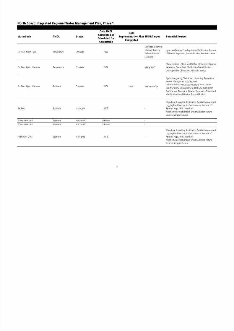
8/2/2019 North Coast Integrated Regional Water Management Plan, July 2007
http://slidepdf.com/reader/full/north-coast-integrated-regional-water-management-plan-july-2007 311/458
Modification/Destabilization, Erosion/Siltation, Natural
Sources, Nonpoint Source
3
North Coast Integrated Regional Water Management Plan, Phase 1
Waterbody TMDL Status
Date TMDL
Completed or
Scheduled for
Completion
Date
Implementation Plan
Completed
TMDL/Target Potential Sources
Appendix E: Summary of Current Status of TMDL Development and Implementation in the North Coast Region.
Garcia River Sediment Complete 1998 2001
Target for mean
particle size diameter is
≥ 69 mm with a
minimum of ≥ 37 mm
NA
Garcia River Temperature Not Started 2019 -Habitat Modification, Removal of Riparian Vegetation,
Streambank Modification/Destabilization, Nonpoint Source
Gualala River Sediment Complete 2001 20041
475 tons/mi2/yr
Specialty Crop Production, Silviculture, Harvesting,
Restoration, Residue Management, Logging Road
Construction/Maintenance, Highway/Road/Bridge
Construction, Land Development, Disturbed Sites (LandDevelop.), Erosion/Siltation, Nonpoint Source
Gualala River Temperature Not Started 2019 -
Removal of Riparian Vegetation, Streambank
Modification/Destabilization, Channel Erosion,
Erosion/Siltation, Nonpoint Source
Humboldt Bay PCBs Not Started 2019 - Source Unknown
Humboldt Bay Dioxin Toxics Not Started 2019 - Source Unknown
Jacoby Creek Sediment Not Started 2019 -
Silviculture, Road Construction, Land Development,
Disturbed Sites (Land Develop.), Urban Runoff/StormSewers, Hydromodification, Channelization, Removal of
Riparian Vegetation, Streambank
Modification/Destabilization, Drainage/Filling Of Wetlands,
Channel Erosion, Erosion/Siltation, Sediment Resuspension,
Natural Sources, Nonpoint Source

8/2/2019 North Coast Integrated Regional Water Management Plan, July 2007
http://slidepdf.com/reader/full/north-coast-integrated-regional-water-management-plan-july-2007 312/458
4
North Coast Integrated Regional Water Management Plan, Phase 1
Waterbody TMDL Status
Date TMDL
Completed or
Scheduled for
Completion
Date
Implementation Plan
Completed
TMDL/Target Potential Sources
Appendix E: Summary of Current Status of TMDL Development and Implementation in the North Coast Region.
Klamath River Nutrients In progress 2019 -
Nonpoint Source, Hydromodification, Agriculture, Specialty
Crop Production, Habitat Modification, Removal of
Riparian Vegetation Drainage/Filling Of Wetlands,
Industrial Point Sources, Municipal Point Sources, Irrigated
Crop Production, Specialty Crop Production, Pasture
Grazing-Riparian and/or Upland, Range Grazing-Riparian,
Intensive Animal Feeding Operations, Out-of-state source
Nonpoint/Point Source, Industrial Point Sources, Municipal
Point Sources, Specialty Crop Production, Internal Nutrient
Cycling (primarily lakes), Natural Sources, Nonpoint Source,
Wastewater - land disposal, Upstream Impoundment,
Natural Sources, Nonpoint Source, Out-of-state source
Klamath River Temperature In progress 2019 -
Nonpoint Source, Hydromodification, Dam Construction,
Upstream Impoundment, Flow Regulation/Modification,
Water Diversions, Channelization, Flow
Regulation/Modification, Water Diversions, Habitat
Modification, Removal of Riparian Vegetation,
Drainage/Filling Of Wetlands, Nonpoint Source,
Hydromodification, Dam Construction, Habitat
Modification, Channel Erosion, Hydromodification,
Upstream Impoundment, Dam Construction, Streambank
Modification/Destabilization, Drainage/Filling Of Wetlands,Natural Sources
Klamath River Dissolved Oxygen In progress 2006 -
Industrial Point Sources, Municipal Point Sources,
Agriculture, Irrigated Crop Production, Specialty Crop
Production, Range Grazing-Riparian, Agriculture-storm
runoff, Agriculture-subsurface drainage, Agriculture-
irrigation tailwater, Agriculture-animal, Upstream
Impoundment Flow Regulation/Modification Out-of-state
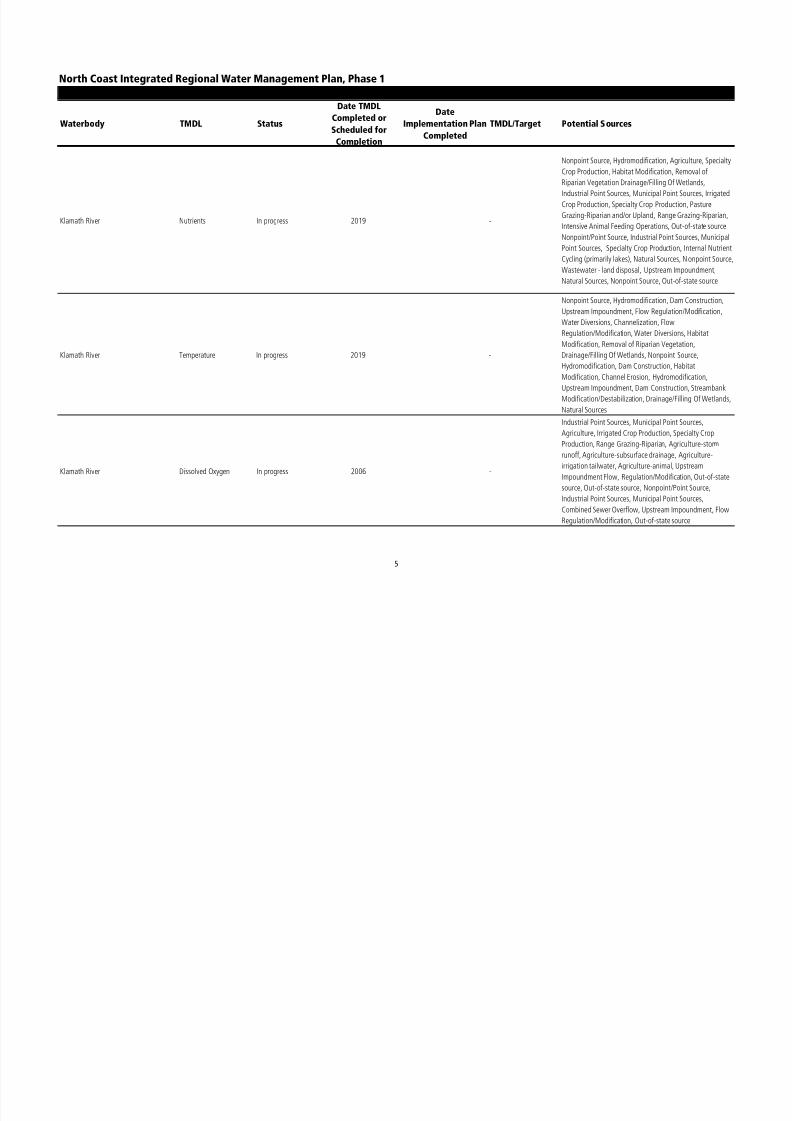
8/2/2019 North Coast Integrated Regional Water Management Plan, July 2007
http://slidepdf.com/reader/full/north-coast-integrated-regional-water-management-plan-july-2007 313/458
Impoundment Flow, Regulation/Modification, Out-of-state
source, Out-of-state source, Nonpoint/Point Source,
Industrial Point Sources, Municipal Point Sources,
Combined Sewer Overflow, Upstream Impoundment, FlowRegulation/Modification, Out-of-state source
5
North Coast Integrated Regional Water Management Plan, Phase 1
Waterbody TMDL Status
Date TMDL
Completed or
Scheduled for
Completion
Date
Implementation Plan
Completed
TMDL/Target Potential Sources
Appendix E: Summary of Current Status of TMDL Development and Implementation in the North Coast Region.
Klamath River, downstream of
WeitchpecNutrients Not Started 2006 -
Industrial Point Sources, Major Industrial Point Source,
Minor Industrial Point Source, Municipal Point Sources,
Major Municipal Point Source - dry and/or wet weatherdischarge, Agriculture, Irrigated Crop Production, Specialty
Crop Production, Pasture Grazing - Riparian and/or Upland,
Range Grazing - Riparian, Intensive Animal Feeding
Operations, Agriculture - storm runoff, Agriculture -
Subsurface drainage, Agriculture - irrigation tailwater
Klamath River, downstream of
WeitchpecTemperature Not Started 2006 -
Hydromodification, Dam Construction, Upstream
Impoundment, Flow Regulation/Modification, Water
Diversions, Habitat Modification, Removal of Riparian
Vegetation, Channel Erosion
Klamath River, downstream of
WeitchpecDissolved Oxygen Not Started 2006 -
Industrial Point Sources, Municipal Point Sources,
Agriculture, Irrigated Crop Production, Specialty Crop
Production, Range Grazing - Riparian, Agriculture-storm
runoff, Agriculture-irrigation tailwater, Agriculture-animal,
Upstream Impoundment, Flow Regulation/Modification,
Out-of-state sourceamat ver, ownstream o
Weitch ecSediment Not Started 2019 - Source Unknown

8/2/2019 North Coast Integrated Regional Water Management Plan, July 2007
http://slidepdf.com/reader/full/north-coast-integrated-regional-water-management-plan-july-2007 314/458
6
North Coast Integrated Regional Water Management Plan, Phase 1
Waterbody TMDL Status
Date TMDL
Completed or
Scheduled for
Completion
Date
Implementation Plan
Completed
TMDL/Target Potential Sources
Appendix E: Summary of Current Status of TMDL Development and Implementation in the North Coast Region.
Laguna de Santa Rosa Sediment Complete 1995 / 2019 6 1995 7 -
Silviculture, Agriculture, Agriculture-grazing, Agriculture-
storm runoff, Bridge Construction, Channel Erosion,
Channelization, Construction/Land Development, Dam
Construction, Drainage/Filling Of Wetlands,
Erosion/Siltation, Flow Regulation/Modification,
Geothermal Development, Habitat Modification,
Harvesting, Restoration, Residue Management, Highway
Maintenance and Runoff, Hydromodification, Intensive
Animal Feeding Operations, Irrigated Crop Production,
Logging Road Construction/Maintenance, Natural Sources,
Nonirrigated Crop Production, Nonpoint Source, Other
Urban Runoff, Range Grazing-Riparian and/or Upland,
Removal of Riparian Vegetation, Resource Extraction,
Specialty Crop Production, Streambank
Modification/Destabilization, Surface Runoff, Upstream
Impoundment
Laguna de Santa Rosa Nitrogen 1995 / 2019 6, 8 1995 7 -Internal Nutrient Cycling (primarily lakes), Nonpoint
Source, Point Source
Laguna de Santa Rosa Phosphorous 2019 -Internal Nutrient Cycling (primarily lakes), Nonpoint
Source, Point Source
Laguna de Santa Rosa Dissolved Oxygen In progress 2008 -Internal Nutrient Cycling (primarily lakes), Nonpoint
Source, Point Source
Laguna de Santa Rosa Temperature In progress 2008 -
Hydromodification, Upstream Impoundment Removal of
Riparian Vegetation, Streambank
Modification/Destabilization Nonpoint Source
Laguna de Santa Rosa Mercury In progress 2019 - Source Unknown
Lake Mendocino Mercury In progress 2019 - Resource Extraction, Nonpoint Source
Lake Pillsbury Mercury In progress 2019 - Inactive Mining, Natural Sources, Nonpoint Source

8/2/2019 North Coast Integrated Regional Water Management Plan, July 2007
http://slidepdf.com/reader/full/north-coast-integrated-regional-water-management-plan-july-2007 315/458
Lake Sonoma Mercury In progress 2019 - Resource Extraction, Nonpoint Source
Lower Lost River Nutrients In progress Unknown - NA
Mad River Sediment/Turbidity In progress 2019 - Silviculture, Resource Extraction, Nonpoint Source
7
North Coast Integrated Regional Water Management Plan, Phase 1
Waterbody TMDL Status
Date TMDL
Completed or
Scheduled for
Completion
Date
Implementation Plan
Completed
TMDL/Target Potential Sources
Appendix E: Summary of Current Status of TMDL Development and Implementation in the North Coast Region.
Mad River Temperature Not Started 2019 -
Upstream Impoundment, Flow Regulation/Modification,
Habitat Modification, Removal of Riparian Vegetation,
Nonpoint Source, Unknown Nonpoint Source
Mattole River Sediment Complete 2003 2004 1 3600 tons/mi2/yr
Specialty Crop Production, Range Grazing-Riparian and/or
Upland, Range Grazing-Riparian, Silviculture, Road
Construction, Hydromodification, Habitat Modification,
Removal of Riparian Vegetation, Streambank
Modification/Destabilization, Erosion/Siltation
Mattole River Temperature Complete 2003 See note 9
Range Grazing-Riparian and/or Upland, Silviculture, Road
Construction, Habitat Modification, Removal of Riparian
Vegetation, Natural Sources, Nonpoint Source
Navarro River Temperature Complete 200011 See note 10
Agriculture, Agricultural Return Flows Resource Extraction,
Flow Regulation/Modification, Water Diversions, Habitat
Modification, Removal of Riparian Vegetation, Streambank
Modification/Destabilization, Drainage/Filling Of Wetlands,
Nonpoint Source
Navarro River Sediment Complete 2000 20041 1463 tons/mi2/yr for
sediment
Agriculture, Nonirrigated Crop Production, Irrigated Crop
Production, Specialty Crop Production, Range Grazing-Riparian and/or Upland, Range Grazing-Riparian, Range
Grazing-Upland, Agriculture-grazing
Silviculture, Harvesting, Restoration, Residue Management,
Logging Road Construction/Maintenance, Silvicultural Point
Sources, Construction/Land Development,
Highway/Road/Bridge Construction, Land Development,
Disturbed Sites (Land Develop.), Resource Extraction, Flow

8/2/2019 North Coast Integrated Regional Water Management Plan, July 2007
http://slidepdf.com/reader/full/north-coast-integrated-regional-water-management-plan-july-2007 316/458
( p ), ,
Regulation/Modification, Water Diversions, Habitat
Modification, Removal of Riparian Vegetation,
Streambank, Modification/Destabilization, Drainage/FillingOf Wetlands, Channel Erosion, Erosion/Siltation, Nonpoint
Source
8
North Coast Integrated Regional Water Management Plan, Phase 1
Waterbody TMDL Status
Date TMDL
Completed or
Scheduled for
Completion
Date
Implementation Plan
Completed
TMDL/Target Potential Sources
Appendix E: Summary of Current Status of TMDL Development and Implementation in the North Coast Region.
Noyo River Sediment Complete 1999 2004 1 470 tons/mi2/yr 12 Silviculture, Nonpoint Source
Noyo River Temperature Not Started 2019 - Source Unknown
Pudding Creek Temperature Not Started 2019 - Source Unknown
Pocket Canyon Creek pH Not Started Unknown -
Pocket Canyon Creek Sediment Not Started Unknown -
Pocket Canyon Creek Temperature Not Started Unknown -
Redwood Creek Sediment Complete 1998 2004 1 1900 tons/mi2/yr 13
Range Grazing-Riparian, Silviculture, Harvesting,
Restoration, Residue Management, Logging Road
Construction/Maintenance, Construction/Land
Development, Disturbed Sites (Land Develop.), Removal of
Riparian Vegetation, Streambank
Modification/Destabilization, Erosion/Siltation, Natural
Sources
Redwood Creek Temperature Not Started 2019 -
Logging Road Construction/Maintenance, Removal of
Riparian Vegetation, Streambank
Modification/Destabilization, Erosion/Siltation, Natural
Sources, Nonpoint Source
Russian River Sediment Not Started 2019 -
Silviculture, Agriculture, Agriculture-grazing, Agriculture-
storm runoff, Bridge Construction, Channel Erosion,
Channelization, Construction/Land Development, Dam
Construction, Drainage/Filling Of Wetlands,Erosion/Siltation, Flow Regulation/Modification,
Geothermal Development, Habitat Modification,
Harvesting, Restoration, Residue Management, Highway
Maintenance and Runoff, Hydromodification, Intensive
Animal Feeding Operations, Irrigated Crop Production,
Logging Road Construction/Maintenance, Natural Sources,
Nonirrigated Crop Production, Nonpoint Source, Other

8/2/2019 North Coast Integrated Regional Water Management Plan, July 2007
http://slidepdf.com/reader/full/north-coast-integrated-regional-water-management-plan-july-2007 317/458
Urban Runoff, Range Grazing-Riparian and/or Upland,
Removal of Riparian Vegetation, Resource Extraction,
Specialty Crop Production, StreambankModification/Destabilization, Surface Runoff, Upstream
Impoundment
9
North Coast Integrated Regional Water Management Plan, Phase 1
Waterbody TMDL Status
Date TMDL
Completed or
Scheduled for
Completion
Date
Implementation Plan
Completed
TMDL/Target Potential Sources
Appendix E: Summary of Current Status of TMDL Development and Implementation in the North Coast Region.
Russian River Temperature Not Started 2019 -
Flow Regulation/Modification, Habitat Modification,
Hydromodification, Nonpoint Source, Removal of Riparian
Vegetation, Streambank Modification/Destabilization,
Upstream Impoundment
Russian River (Monte Rio and
Healdsburg Memorial Beach)Pathogens In progress 2008 - Nonpoint/Point Source
Salmon River Temperature Complete 2005 2005 See note 9 NA
Santa Rosa Creek Pathogens In progress 2008 - Nonpoint Source, Point Source
Santa Rosa Creek Sediment Not Started 2019 -
Agriculture, Nonirrigated Crop Production, Irrigated Crop
Production, Specialty Crop Production, Pasture Grazing-
Riparian and/or Upland, Range Grazing-Riparian, Range
Grazing-Upland, Dairies, Construction/Land Development,Highway/Road/Bridge Construction, Land Development,
Urban Runoff/Storm Sewers, Urban Runoff--Non-industrial
Permitted, Other Urban Runoff, Surface Runoff,
Hydromodification, Channelization, Bridge Construction,
Habitat Modification, Removal of Riparian Vegetation,
Streambank Modification/Destabilization, Drainage/Filling
of Wetlands, Channel Erosion, Erosion/Siltation, Natural
Sources, Nonpoint Source
Santa Rosa Creek Temperature Not Started Unknown -
Scott River Sediment Complete 2006 2006 -
Irrigated Crop Production, Pasture Grazing-Riparian and/or
Upland, Silviculture, Resource Extraction, Mill
TailingsNatural Sources, Nonpoint Source
Irrigated Crop Production, Pasture Grazing-Riparian and/or
Upland Agricultural Return Flows Silviculture Flow

8/2/2019 North Coast Integrated Regional Water Management Plan, July 2007
http://slidepdf.com/reader/full/north-coast-integrated-regional-water-management-plan-july-2007 318/458
Scott River Temperature Complete 2006 2006 -
Upland, Agricultural Return Flows, Silviculture, Flow
Regulation/Modification, Water Diversions, Habitat
Modification Removal of Riparian Vegetation, StreambankModification/Destabilization, Drainage/Filling Of Wetlands
10
North Coast Integrated Regional Water Management Plan, Phase 1
Waterbody TMDL Status
Date TMDL
Completed or
Scheduled for
Completion
Date
Implementation Plan
Completed
TMDL/Target Potential Sources
Appendix E: Summary of Current Status of TMDL Development and Implementation in the North Coast Region.
Shasta River Dissolved Oxygen Complete 2007 2007 -
Minor Municipal Point Source-dry and/or wet weather
discharge, Agriculture-storm runoff, Agriculture-irrigation
tailwater, Dairies, Hydromodification, Dam Construction,
Flow Regulation/Modification, Habitat Modification
Shasta River Temperature Complete 2007 2007 See note 14
Agriculture-irrigation tailwater, Flow
Regulation/Modification, Habitat Modification, Removal of
Riparian Vegetation, Drainage/Filling Of Wetlands
Stemple Creek & Estero de San Antonio Sediment Complete 1997 199714
Target for sediment is
12,760 tons per year by
the year 2004
Agriculture, Grazing-Related Sources, Land Development,
Erosion/Siltation, Nonpoint Source
Stemple Creek & Estero de San Antonio Nutrients Complete 1997 1997 14
The target for un-
ionized ammonia is
0.025 mg/L as NH315
Agriculture, Irrigated Crop Production, Pasture Grazing-
Riparian and/or Upland, Range Grazing-Riparian,
Concentrated Animal Feeding Operations (permitted, point
source), Land Development, Hydromodification,
Channelization, Removal of Riparian Vegetation,
Streambank Modification/Destabilization, Drainage/Filling
Of Wetlands, Channel Erosion, Natural Sources
Ten Mile River Sediment Complete 2000 20041
390 tons/mi2/yr
16 Silviculture, Harvesting, Restoration, Residue Management,
Logging Road Construction/Maintenance
Ten Mile River Temperature Not Started 2019 -Habitat Modification, Removal of Riparian Vegetation,
Streambank Modification/Destabilization, Nonpoint Source
Trinity Lake Mercury Not Started 2019 - Source Unknown

8/2/2019 North Coast Integrated Regional Water Management Plan, July 2007
http://slidepdf.com/reader/full/north-coast-integrated-regional-water-management-plan-july-2007 319/458
11
North Coast Integrated Regional Water Management Plan, Phase 1
Waterbody TMDL Status
Date TMDL
Completed or
Scheduled for
Completion
Date
Implementation Plan
Completed
TMDL/Target Potential Sources
Appendix E: Summary of Current Status of TMDL Development and Implementation in the North Coast Region.
Trinity River Upper area reference
subwatershedsSediment Complete 2001 2004 1 1406 tons/mi2/yr
Channel Erosion, Dam Construction, Drainage/Filling Of
Wetlands, Erosion/Siltation, Flow Regulation/Modification,
Habitat Modification, Harvesting, Restoration, Residue
Management, Hydromodification, Logging Road
Construction/Maintenance, Mine Tailings, Natural Sources,
Nonpoint Source, Placer Mining, Removal of Riparian
Vegetation, Resource Extraction, Silvicultural Point
Sources, Silviculture, Streambank
Modification/Destabilization, Surface Mining, Upstream
Impoundment
Trinity River Westside Tributaries
subwatershedSediment Complete 2001 2004 1 526 tons/mi2/yr Same as Trinity River Upper area reference subwatershed
Trinity River Upper Trinity subwatershed Sediment Complete 2001 20041
3449 tons/mi2
/yr Same as Trinity River Upper area reference subwatershed
Trinity River East Fork Tributaries
subwatershedSediment Complete 2001 2004 1 323 tons/mi2/yr Same as Trinity River Upper area reference subwatershed
Trinity River East Side Tributaries
subwatershedSediment Complete 2001 2004
1301 tons/mi
2/yr Same as Trinity River Upper area reference subwatershed
Trinity River Weaver and Rush Creeks
subwatershedSediment Complete 2001 2004
1844 tons/mi
2/yr Same as Trinity River Upper area reference subwatershed
Trinity River Deadwood Creek, Hoadley
Gulch and Poker Bar Area
subwatershed
Sediment Complete 2001 2004 1 341 tons/mi2/yr Same as Trinity River Upper area reference subwatershed
Trinity River Lewiston Lake Area
subwatershedSediment Complete 2001 2004
1244 tons/mi
2/yr Same as Trinity River Upper area reference subwatershed
Trinity River Grass Valley Creek
subwatershedSediment Complete 2001 2004 1 219 tons/mi2/yr Same as Trinity River Upper area reference subwatershed
Trinity River Indian Creek subwatershed Sediment Complete 2001 20041
405 tons/mi2/yr Same as Trinity River Upper area reference subwatershed

8/2/2019 North Coast Integrated Regional Water Management Plan, July 2007
http://slidepdf.com/reader/full/north-coast-integrated-regional-water-management-plan-july-2007 320/458
Trinity River Reading and Browns Creek
subwatershed
Sediment Complete 2001 20041
329 tons/mi2/yr Same as Trinity River Upper area reference subwatershed
Trinity River Lower Middle area
subwatershedSediment Complete 2001 2004
11592 tons/mi
2/yr Same as Trinity River Upper area reference subwatershed
12
North Coast Integrated Regional Water Management Plan, Phase 1
Waterbody TMDL Status
Date TMDL
Completed or
Scheduled for
Completion
Date
Implementation Plan
Completed
TMDL/Target Potential Sources
Appendix E: Summary of Current Status of TMDL Development and Implementation in the North Coast Region.
Trinity River Canyon Creek
subwatershedSediment Complete 2001 2004
11628 tons/mi
2/yr Same as Trinity River Upper area reference subwatershed
Trinity River Upper tributaries of lower
middle area subwatershed
Sediment Complete 2001 20041
335 tons/mi2/yr Same as Trinity River Upper area reference subwatershed
Trinity River Middle tributaries of lower
middle area subwatershedSediment Complete 2001 2004 1 263 tons/mi2/yr Same as Trinity River Upper area reference subwatershed
Trinity River Lower tributaries of lower
middle area subwatershedSediment Complete 2001 2004 1 276 tons/mi2/yr Same as Trinity River Upper area reference subwatershed
Trinity River Lower area reference
subwatershedSediment Complete 2001 2004
12638 tons/mi
2/yr Same as Trinity River Upper area reference subwatershed
Trinity River Mill Creek and Tish Tang
subwatershedSediment Complete 2001 2004
11049 tons/mi
2/yr Same as Trinity River Upper area reference subwatershed
Trinity River Willow Creek subwatershed Sediment Complete 2001 2004 1 468 tons/mi2/yr Same as Trinity River Upper area reference subwatershed
Trinity River Campbell Creek and Supply
Creek subwatershedSediment Complete 2001 2004 1 9806 tons/mi2/yr Same as Trinity River Upper area reference subwatershed
Trinity River Lower mainstem area and
Coon Creek subwatershedSediment Complete 2001 2004
1315 tons/mi
2/yr Same as Trinity River Upper area reference subwatershed
Trinity River (South Fork) Sediment Complete 1998 20041
737 tons/mi2/yr Range Grazing-Riparian, Silviculture, Nonpoint Source
Trinity River (South Fork) Temperature Not Started 2019 -Range Grazing-Riparian, Water Diversions, HabitatModification, Removal of Riparian Vegetation, Streambank
Modification/Destabilization
Trinity River, East Fork Mercury Not Started 2019 - Source Unknown
Tule Lake & Lower Klamath National
Wildlife RefugepH Not Started 2006 - Internal Nutrient Cycling (primarily lakes), Nonpoint Source

8/2/2019 North Coast Integrated Regional Water Management Plan, July 2007
http://slidepdf.com/reader/full/north-coast-integrated-regional-water-management-plan-july-2007 321/458
13

8/2/2019 North Coast Integrated Regional Water Management Plan, July 2007
http://slidepdf.com/reader/full/north-coast-integrated-regional-water-management-plan-july-2007 322/458
North Coast Integrated Regional Water Management Plan, Phase 1
Waterbody TMDL Status
Date TMDL
Completed or
Scheduled for
Completion
Date
Implementation Plan
Completed
TMDL/Target Potential Sources
Appendix E: Summary of Current Status of TMDL Development and Implementation in the North Coast Region.
Table developed with using information compiled from:
NCRWQCB. 2006. TMDL Project List [web page available at: http://www.waterboards.ca.gov/northcoast/programs/tmdl/Status.html]
NCRWQCB. 2006. Proposed CWA Section 303(d) List of Water Quality Limited Segments.
NCRWQCB. 2003. 2002 CWA Section 303(d) List of Water Quality Limited Segment

8/2/2019 North Coast Integrated Regional Water Management Plan, July 2007
http://slidepdf.com/reader/full/north-coast-integrated-regional-water-management-plan-july-2007 323/458
15

8/2/2019 North Coast Integrated Regional Water Management Plan, July 2007
http://slidepdf.com/reader/full/north-coast-integrated-regional-water-management-plan-july-2007 324/458
N O R T H C O A S T I N T E G R A T E D R E G I O N A LW A T E R M A N A G E M E N T P L A NP H A S E 1
J u l y 2 0 0 7
APPENDIX F CALIFORNIA DEPARTMENT OF FISH AND GAME COHO RECOVERY

8/2/2019 North Coast Integrated Regional Water Management Plan, July 2007
http://slidepdf.com/reader/full/north-coast-integrated-regional-water-management-plan-july-2007 325/458
APPENDIX F: CALIFORNIA DEPARTMENT OF FISH AND GAME COHO RECOVERY
UNITS IN THE NORTH COAST REGION

8/2/2019 North Coast Integrated Regional Water Management Plan, July 2007
http://slidepdf.com/reader/full/north-coast-integrated-regional-water-management-plan-july-2007 326/458
Recovery Units in the Southern Oregon/Northern California Coast Coho ESURogue River and Winchuck River Hydrologic Units
Illinois River HSAWinchuck River HSA
Smith River Hydrologic UnitMill Creek HSAWilson Creek HSA
Klamath River Hydrologic UnitKlamath Glen HSAOrleans HSAUkonom HSAHappy Camp HSASeiad Valley HSABeaver Creek HSAHornbrook HSAIron Gate HSA
Copco Lake HSASalmon River Hydrologic Area
Lower Salmon HSAWooley Creek HSASawyers Bar HSACecilville HSA
Shasta Valley Hydrologic AreaScott River Hydrologic Area
Trinity River Hydrologic UnitDouglas City HSAGrouse Creek HSAHyampom HSAHayfork HSA
Mad River Hydrologic UnitRedwood Creek Hydrologic UnitTrinidad Hydrologic Unit
Bi L HSA
Appendix F: California Department of Fish and Game Coho Recovery Units in the North
Coast Region

8/2/2019 North Coast Integrated Regional Water Management Plan, July 2007
http://slidepdf.com/reader/full/north-coast-integrated-regional-water-management-plan-july-2007 327/458
Big Lagoon HSA
Little River HSAEureka Plain Hydrologic UnitEel River Hydrologic Unit
Ferndale HSAScotia HSASouth Fork Eel River HAWeott HSABenbow HSA
Appendix F: California Department of Fish and Game Coho Recovery Units in the North
Coast RegionRecovery Units in the Central California Coast Coho ESU
Mendocino Coast Hydrologic UnitAlbion River HSABig River HSAGarcia River HSANavarro River HSANoyo River HSA
Ten Mile River HSAGualala River HSA
Russian River Hydrologic UnitRussian River MainstemGuerneville HSAAustin Creek HSAWarm Springs HSAMark West Creek HSASanta Rosa Creek HSA
Forsythe Creek HSAGeyserville HSA
Bodega and Marin Coastal Hydrologic UnitsSalmon Creek HSAWalker Creek HSALagunitas Creek HSABolinas HSA

8/2/2019 North Coast Integrated Regional Water Management Plan, July 2007
http://slidepdf.com/reader/full/north-coast-integrated-regional-water-management-plan-july-2007 328/458
N O R T H C O A S T I N T E G R A T E D R E G I O N A LW A T E R M A N A G E M E N T P L A NP H A S E 1
J u l y 2 0 0 7
APPENDIX G GROUNDWATER BASINS

8/2/2019 North Coast Integrated Regional Water Management Plan, July 2007
http://slidepdf.com/reader/full/north-coast-integrated-regional-water-management-plan-july-2007 329/458
APPENDIX G: GROUNDWATER BASINS

8/2/2019 North Coast Integrated Regional Water Management Plan, July 2007
http://slidepdf.com/reader/full/north-coast-integrated-regional-water-management-plan-july-2007 330/458
North Coast Integrated Regional Water Management PlanPhase I
APPENDIX G: Groundwater Basins in the North Coast Region
These tables are a Word document from:http://www.groundwater.water.ca.gov/bulletin118/basin_desc/basins Go to the above link to get an interactive table.
Del Norte Top of
Page
Groundwater Basin Subbasin Number Updated
Smith River Plain (167K) 1-1 2/27/04
Lower Klamath River Valley* (139K)
1-14 2/27/04
Prairie Creek Area* (121K) 1-25 2/27/04
Glenn
Top of
Page
Groundwater Basin Subbasin Number Updated
Sacramento Valley Corning* (172K)
5-21.51 2/27/04
Sacramento Valley Colusa* (182K) 5-21.52 2/27/04
Sacramento Valley West Butte* (155K)
5-21.58 2/27/04
Chrome Town Area (96K) 5-61 2/27/04
Elk Creek Area 5-62 2/27/04
Stonyford Town Area* (114K)
5-63 2/27/04
Stony Gorge Reservoir (97K)
5-88 2/27/04
Squaw Flat (95K)
5-89 2/27/04
Funks Creek* (96K) 5-90 2/27/04
HumboldtTop of
Page
Groundwater Basin Subbasin Number Updated
Hoopa Valley (138K)
1-7 2/27/04
Mad River Valley Mad River Lowland (167K) 1-8.01 2/27/04

8/2/2019 North Coast Integrated Regional Water Management Plan, July 2007
http://slidepdf.com/reader/full/north-coast-integrated-regional-water-management-plan-july-2007 331/458
Mad River Valley Dows Prairie School Area (158K) 1-8.02 2/27/04
Eureka Plain (161K) 1-9 2/27/04
Eel River Valley (163K) 1-10 2/27/04
Lower Klamath River Valley* (139K) 1-14 2/27/04
Prairie Creek Area* (121K) 1-25 2/27/04
Redwood Creek Area (147K) 1-26 2/27/04
Big Lagoon Area (142K) 1-27 2/27/04
North Coast Integrated Regional Water Management PlanPhase I
APPENDIX G: Groundwater Basins in the North Coast Region
These tables are a Word document from:http://www.groundwater.water.ca.gov/bulletin118/basin_desc/basins Go to the above link to get an interactive table.
Lake Top of
Page
Groundwater Basin Subbasin Number Updated
Gravelly Valley (122K)
1-48 2/27/04
Upper Lake Valley (161K)
5-13 2/27/04
Scotts Valley (163K)
5-14 2/27/04
Big Valley (165K)
5-15 2/27/04
High Valley (157K)
5-16 2/27/04
Burns Valley (143K)
5-17 2/27/04
Coyote Valley (159K)
5-18 2/27/04
Collayomi Valley (158K)
5-19 2/27/04
Lower Lake Valley (137K)
5-30 2/27/04
Long Valley (106K)
5-31 2/27/04
Little Indian Valley (122K)
5-65 2/27/04
Clear Lake Cache Formation (117K) 5-66 2/27/04
North Fork Cache Creek (95K) 5-93 2/27/04
Middle Creek (101K) 5-94 2/27/04

8/2/2019 North Coast Integrated Regional Water Management Plan, July 2007
http://slidepdf.com/reader/full/north-coast-integrated-regional-water-management-plan-july-2007 332/458
North Coast Integrated Regional Water Management PlanPhase I
APPENDIX G: Groundwater Basins in the North Coast Region
These tables are a Word document from:http://www.groundwater.water.ca.gov/bulletin118/basin_desc/basins Go to the above link to get an interactive table.
Mendocino Top of
Page
Groundwater Basin Subbasin Number Updated
Covelo Round Valley (157K)
1-11
2/27/04
Laytonville Valley (156K)
1-12
2/27/04
Little Lake Valley (144K)
1-13
2/27/04
Anderson Valley (155K)
1-19
2/27/04
Garcia River Valley (138K)
1-20
2/27/04
Fort Bragg Terrace Area (162K)
1-21
2/27/04
Cottoneva Creek Valley (133K)
1-37
2/27/04
Lower Laytonville Valley (134K)
1-38
2/27/04
Branscomb Town Area (133K) 1-39
2/27/04
Ten Mile River Valley (133K)
1-40
2/27/04
Little Valley (131K)
1-41
2/27/04
Sherwood Valley (131K)
1-42
2/27/04
Williams Valley (135K)
1-43
2/27/04
Eden Valley (131K)
1-44
2/27/04Big River Valley (134K)
1-45
2/27/04
Navarro River Valley (133K)
1-46
2/27/04
Annapolis Ohlson Ranch Formation Highlands*
(158K)1-49
2/27/04
Potter Valley (154K)
1-51
2/27/04
Ukiah Valley (169K)
1-52
2/27/04
Sanel Valley (157K)
1-53
2/27/04

8/2/2019 North Coast Integrated Regional Water Management Plan, July 2007
http://slidepdf.com/reader/full/north-coast-integrated-regional-water-management-plan-july-2007 333/458
McDowell Valley (137K) 1-56 2/27/04
Fort Ross Terrace Deposits* (162K) 1-61 2/27/04
North Coast Integrated Regional Water Management PlanPhase I
APPENDIX G: Groundwater Basins in the North Coast Region
These tables are a Word document from:http://www.groundwater.water.ca.gov/bulletin118/basin_desc/basins Go to the above link to get an interactive table.
Modoc Top of
Page
Groundwater Basin Subbasin Number Updated
Fairchild Swamp Area (112K)
1-22
2/27/04
Goose Lake Valley Lower Goose Lake Valley (151K)
5-1.01 2/27/04
Goose Lake Valley Fandango Valley (142K)
5-1.02 2/27/04
Alturas Area
South Fork Pitt River* (145K) 5-2.01 2/27/04
Alturas Area
Warm Springs Valley (144K)
5-2.02 2/27/04
Jess Valley (112K)
5-3 2/27/04
Big Valley* (158K)
5-4 2/27/04
Round Valley (124K)
5-36 2/27/04
Hot Springs Valley* (105K)
5-40 2/27/04
Egg Lake Valley (109K)
5-41 2/27/04
Rock Prairie Valley (94K)
5-43 2/27/04
Long Valley* (102K)
5-44 2/27/04
Joseph Creek (96K)
5-86 2/27/04
Surprise Valley* (144K)
6-1
2/27/04Cow Head Lake Valley (104K)
6-91
2/27/04

8/2/2019 North Coast Integrated Regional Water Management Plan, July 2007
http://slidepdf.com/reader/full/north-coast-integrated-regional-water-management-plan-july-2007 334/458
North Coast Integrated Regional Water Management PlanPhase I
APPENDIX G: Groundwater Basins in the North Coast Region
These tables are a Word document from:http://www.groundwater.water.ca.gov/bulletin118/basin_desc/basins Go to the above link to get an interactive table.
Shasta
Top of Page
Groundwater Basin Subbasin Number Updated
Fall River Valley* (169K)
5-5 2/27/04
Redding Anderson (165K)
5-6.03 2/27/04
Redding Enterprise (162K)
5-6.04 2/27/04
Redding Millville (165K) 5-6.05 2/27/04
Pondosa Town Area* 5-38 2/27/04
Hot Springs Valley* (105K)
5-40 2/27/04
Cayton Valley (105K)
5-45 2/27/04
Lake Britton Area (96K) 5-46 2/27/04
Goose Valley (95K)
5-47 2/27/04
Burney Creek Valley (113K)
5-48 2/27/04
Dry Burney Creek Valley (93K)
5-49 2/27/04
North Fork Battle Creek (127K) 5-50 2/27/04
Siskiyou
Top of Page
Groundwater Basin Subbasin Number Updated
Klamath River Valley Tule Lake (155K)
1-2.01
2/27/04
Klamath River Valley Lower Klamath (154K) 1-2.02
2/27/04

8/2/2019 North Coast Integrated Regional Water Management Plan, July 2007
http://slidepdf.com/reader/full/north-coast-integrated-regional-water-management-plan-july-2007 335/458
Butte Valley (169K) 1-3 2/27/04Shasta Valley (164K) 1-4 2/27/04
Scott River Valley (161K) 1-5 2/27/04
Happy Camp Town Area (117K) 1-15 2/27/04
Seiad Valley (141K) 1-16 2/27/04
Bray Town Area (122K) 1-17 2/27/04
Red Rock Valley (123K) 1-18 2/27/04
North Coast Integrated Regional Water Management PlanPhase I
APPENDIX G: Groundwater Basins in the North Coast Region
These tables are a Word document from:http://www.groundwater.water.ca.gov/bulletin118/basin_desc/basins Go to the above link to get an interactive table.
Sonoma
Top of Page
Groundwater Basin Subbasin Number Updated
Annapolis Ohlson Ranch Formation
Highlands* (158K)
1-49
2/27/04
Knights Valley (136K)
1-50
2/27/04
Alexander Valley
Alexander Area (158K)
1-54.01
2/27/04
Alexander Valley
Cloverdale Area (158K) 1-54.02
2/27/04
Santa Rosa Valley Santa Rosa Plain (160K) 1-55.01
2/27/04
Santa Rosa Valley Healdsburg Area (156K)
1-55.02
2/27/04
Santa Rosa Valley Rincon Valley (155K)
1-55.03
2/27/04
Bodega Bay Area (158K)
1-57
2/27/04
Wilson Grove Formation Highlands*
1-59
2/27/04
Lower Russian River Valley (153K)
1-60
2/27/04
Fort Ross Terrace Deposits* (162K)
1-61
2/27/04
Petaluma Valley* (17K)
2-1 2/27/04
Napa-Sonoma Valley Sonoma Valley (129K)
2-2.02 2/27/04
Napa-Sonoma Valley Napa-Sonoma Lowlands* (12K)
2-2.03 2/27/04Kenwood Valley (12K)
2-19 2/27/04
Trinity
Top of Page
Groundwater Basin Subbasin Number Updated
Hayfork Valley 136(K)
1-6
2/27/04
Dinsmores Town Area* (124K) 1-34
2/27/04

8/2/2019 North Coast Integrated Regional Water Management Plan, July 2007
http://slidepdf.com/reader/full/north-coast-integrated-regional-water-management-plan-july-2007 336/458
Hyampom Valley (140K) 1-35 2/27/04Hettenshaw Valley (124K) 1-36 2/27/04
Wilson Point Area (123K) 1-62 2/27/04
N O R T H C O A S T I N T E G R A T E D R E G I O N A LW A T E R M A N A G E M E N T P L A NP H A S E 1
J u l y 2 0 0 7
APPENDIX H: MATRIX OF WATER MANAGEMENT PLANNING EFFORTS

8/2/2019 North Coast Integrated Regional Water Management Plan, July 2007
http://slidepdf.com/reader/full/north-coast-integrated-regional-water-management-plan-july-2007 337/458

8/2/2019 North Coast Integrated Regional Water Management Plan, July 2007
http://slidepdf.com/reader/full/north-coast-integrated-regional-water-management-plan-july-2007 338/458
North Coast Integrated Regional Water Management Plan, Phase 1
Appendix H
Matrix of Existing Water Management Planning Efforts
Environmental
Restoration and
Fisheries Protection Watershed Protection and Planning
Water Supply
Reliability
Clean water and water
recycling (as defined by the
Water Bond Coalition)
W e t l a n d s
F i s h e r i e s E n h a n c e m e n
t
H a b i t a t R e s t o r a t i o n
W a t e r U s e E f f i c i e n c y
W a t e r C o n s e r v a t i o n
W a t e r M a n a g e m e n t
S t o r m w a t e r M a n a g e m
e n t
W a t e r s h e d P l a n n i n g
N P S P o l l u t i o n C o n t r o l
F l o o d P r o t e c t i o n
W a t e r s h e d E d u c a t i o n /
O u t r e a c h
U r b a n S t r e a m R e s t o r a t i o n
P u b l i c A c c e s s
M o n i t o r i n g
D r i n k i n g W a t e r - W a t e
r T r e a t m e n t
G r o u n d w a t e r M a n a g e
m e n t
W a t e r S u p p l y
D e s a l i n a t i o n
W a t e r Q u a l i t y
S a n i t a t i o n - W a s t e w a t e r
T r e a t m e n t
W a t e r R e u s e
Federal Plans
NOAA Fisheries Salmon Recovery PlansSouthern Oregon/Northern California
Coast & North-Central California Coast
TRTs
x x
Environmental Protection AgencyEPA Underground Injection Control
Programx x x
State Plans
State Water Resources Control Board
Watershed Management Initiative (WMI) x x x x x x x x
Water Quality Control Plan for the Ocean
Waters of Californiax
Nonpoint Source Program Strategy and
Implementation Planx x x x x x x x
Water Quality Control Plan for the Control
of Temperature in the Coastal and
Interstate Waters and Enclosed Bays and
Estuaries of California
x x x x
Water Quality Control Policy for the
Enclosed Bays and Estuaries of Californiax x x x x x x x x x x
Rangeland Water Quality Management
Pl

8/2/2019 North Coast Integrated Regional Water Management Plan, July 2007
http://slidepdf.com/reader/full/north-coast-integrated-regional-water-management-plan-july-2007 339/458
Plan x x x x x
1
North Coast Integrated Regional Water Management Plan, Phase 1
Appendix HMatrix of Existing Water Management Planning Efforts
Environmental
Restoration and
Fisheries Protection Watershed Protection and Planning
Water Supply
Reliability
Clean water and water
recycling (as defined by the
Water Bond Coalition)
W e t l a n d s
F i s h e r i e s E n h a n c e m e n
t
H a b i t a t R e s t o r a t i o n
W a t e r U s e E f f i c i e n c y
W a t e r C o n s e r v a t i o n
W a t e r M a n a g e m e n t
S t o r m w a t e r M a n a g e m
e n t
W a t e r s h e d P l a n n i n g
N P S P o l l u t i o n C o n t r o l
F l o o d P r o t e c t i o n
W a t e r s h e d E d u c a t i o n / O u t r e a c h
U r b a n S t r e a m R e s t o r a
t i o n
P u b l i c A c c e s s
M o n i t o r i n g
D r i n k i n g W a t e r - W a t e r T r e a t m e n t
G r o u n d w a t e r M a n a g e
m e n t
W a t e r S u p p l y
D e s a l i n a t i o n
W a t e r Q u a l i t y
S a n i t a t i o n - W a s t e w a t e r
T r e a t m e n t
W a t e r R e u s e
State Water Resources Control Board
California Pesticide Management Plan for
Water Qualityx x x x x x
North Coast Regional Water Quality Control BoardWater Quality Control Plan for the North
Coast Regionx x x x x x x x x x x x x x
TMDLs x x x x x x x x x x x
Department of Water Resources
California Water Plan x x x x x x x x x x x x x x x x x x x x
Fish Passage Improvement Program x x
California Coastal Commission
Local Coastal Programs x x x x x x x x x x x x x x x x
California’s Critical Coastal Areas Program x x x x x x x x xCoastal Access Action Plan x x
California’s Ocean and Coastal Resources
Coastal Impact Assistance Programx x x x x x x
California Department of Fish and GameRecovery Strategy for California Coho
Salmonx x x x x x
Steelhead Restoration and Management
Plan for Californiax x x x x x

8/2/2019 North Coast Integrated Regional Water Management Plan, July 2007
http://slidepdf.com/reader/full/north-coast-integrated-regional-water-management-plan-july-2007 340/458
2
North Coast Integrated Regional Water Management Plan, Phase 1
Appendix HMatrix of Existing Water Management Planning Efforts
Environmental
Restoration and
Fisheries Protection Watershed Protection and Planning
Water Supply
Reliability
Clean water and water
recycling (as defined by the
Water Bond Coalition)
W e t l a n d s
F i s h e r i e s E n h a n c e m e n
t
H a b i t a t R e s t o r a t i o n
W a t e r U s e E f f i c i e n c y
W a t e r C o n s e r v a t i o n
W a t e r M a n a g e m e n t
S t o r m w a t e r M a n a g e m
e n t
W a t e r s h e d P l a n n i n g
N P S P o l l u t i o n C o n t r o l
F l o o d P r o t e c t i o n
W a t e r s h e d E d u c a t i o n / O u t r e a c h
U r b a n S t r e a m R e s t o r a
t i o n
P u b l i c A c c e s s
M o n i t o r i n g
D r i n k i n g W a t e r - W a t e r T r e a t m e n t
G r o u n d w a t e r M a n a g e
m e n t
W a t e r S u p p l y
D e s a l i n a t i o n
W a t e r Q u a l i t y
S a n i t a t i o n - W a s t e w a t e r
T r e a t m e n t
W a t e r R e u s e
California Resources AgencyProtecting Our Ocean California’s Action
Strategyx x x x x x x x
California Coastal Salmon and Watersheds
Program x x x x x x x
Sediment Master Plan x x x x x x
Regional Plans
Forest Plans
Northwest Forest Plan x x x
Klamath National Forest x x x x
Mendocino National Forest x x x
Shasta-Trinity National Forest x x x
Six Rivers National Forest x x x xPacific Northwest Aquatic Monitoring
Partnershipx
Redwood National and State Park General
Management Plan 1999x x x x
Resource Conservation District PlansGold Ridge RCD Long Range Plan 1999 –
2005x x x
Humboldt County RCD Long Range Plan
1999 x x
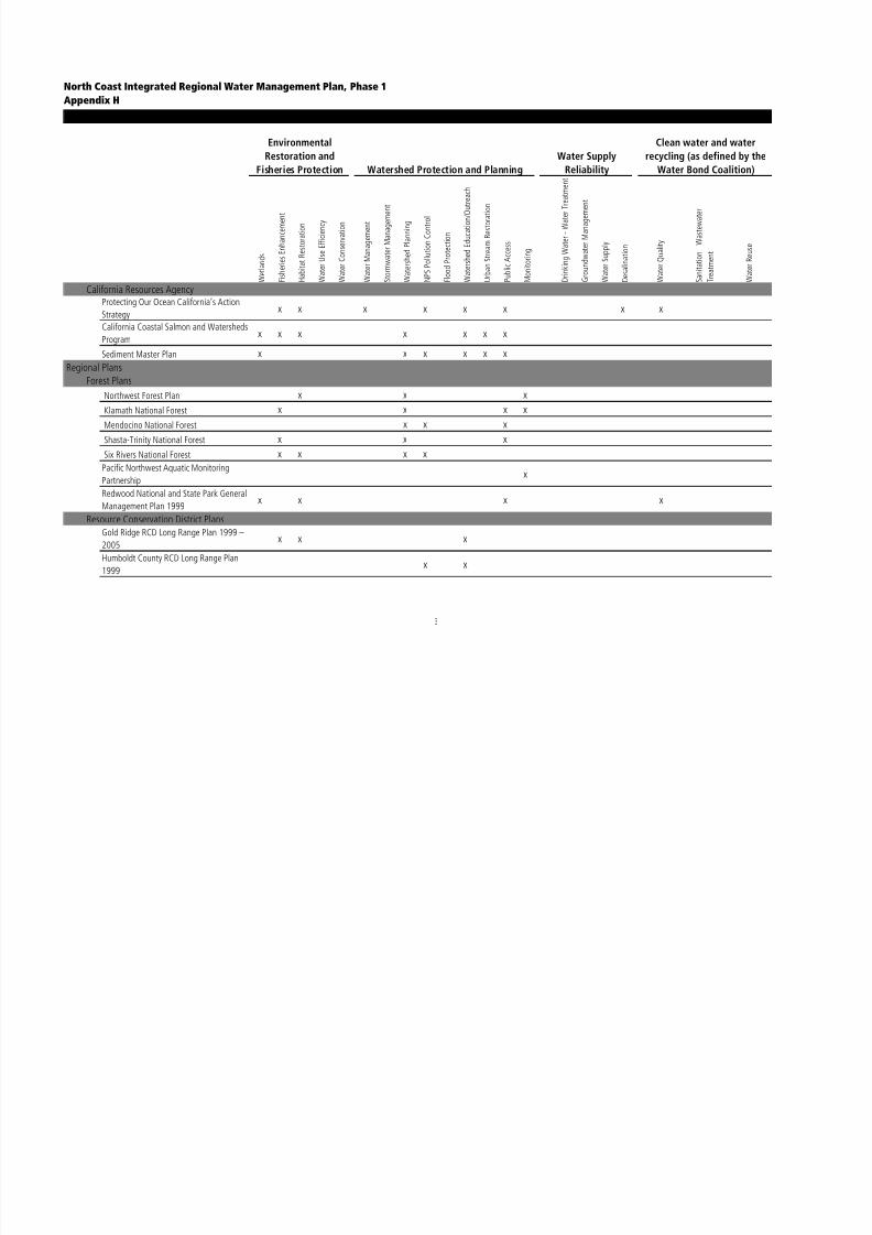
8/2/2019 North Coast Integrated Regional Water Management Plan, July 2007
http://slidepdf.com/reader/full/north-coast-integrated-regional-water-management-plan-july-2007 341/458
1999 x x
3
North Coast Integrated Regional Water Management Plan, Phase 1
Appendix HMatrix of Existing Water Management Planning Efforts
Environmental
Restoration and
Fisheries Protection Watershed Protection and Planning
Water Supply
Reliability
Clean water and water
recycling (as defined by the
Water Bond Coalition)
W e t l a n d s
F i s h e r i e s E n h a n c e m e n
t
H a b i t a t R e s t o r a t i o n
W a t e r U s e E f f i c i e n c y
W a t e r C o n s e r v a t i o n
W a t e r M a n a g e m e n t
S t o r m w a t e r M a n a g e m
e n t
W a t e r s h e d P l a n n i n g
N P S P o l l u t i o n C o n t r o l
F l o o d P r o t e c t i o n
W a t e r s h e d E d u c a t i o n / O u t r e a c h
U r b a n S t r e a m R e s t o r a
t i o n
P u b l i c A c c e s s
M o n i t o r i n g
D r i n k i n g W a t e r - W a t e r T r e a t m e n t
G r o u n d w a t e r M a n a g e
m e n t
W a t e r S u p p l y
D e s a l i n a t i o n
W a t e r Q u a l i t y
S a n i t a t i o n - W a s t e w a t e r
T r e a t m e n t
W a t e r R e u s e
Resource Conservation District Plans (continued)
Mendocino County RCD Long Range Plan
2001 - 2005x x x x
Shasta Valley RCD Long Range Plan 2001– 2005
x x x x
Siskiyou County RCD Long Range Plan
2001 – 2004x x x x
Sotoyome RCD Long Range Plan 2000 –
2005x x x x
Trinity County RCD Long Range Plan x x x
Natural Resource Conservation ServiceWork Plan for Adaptive Management
Klamath River Basin Oregon & Californiax x x x x x
Other Regional PlansFive Counties Salmonid Conservation
Programx x x x
Klamath Project 2005 Operations Plan x
Tribal/Reservation Plans
Hoopa Valley Indian Reservation Water
Quality Control Plan 2001x x x x x x x

8/2/2019 North Coast Integrated Regional Water Management Plan, July 2007
http://slidepdf.com/reader/full/north-coast-integrated-regional-water-management-plan-july-2007 342/458
4
North Coast Integrated Regional Water Management Plan, Phase 1
Appendix HMatrix of Existing Water Management Planning Efforts
Environmental
Restoration and
Fisheries Protection Watershed Protection and Planning
Water Supply
Reliability
Clean water and water
recycling (as defined by the
Water Bond Coalition)
W e t l a n d s
F i s h e r i e s E n h a n c e m e n
t
H a b i t a t R e s t o r a t i o n
W a t e r U s e E f f i c i e n c y
W a t e r C o n s e r v a t i o n
W a t e r M a n a g e m e n t
S t o r m w a t e r M a n a g e m
e n t
W a t e r s h e d P l a n n i n g
N P S P o l l u t i o n C o n t r o l
F l o o d P r o t e c t i o n
W a t e r s h e d E d u c a t i o n / O u t r e a c h
U r b a n S t r e a m R e s t o r a
t i o n
P u b l i c A c c e s s
M o n i t o r i n g
D r i n k i n g W a t e r - W a t e r T r e a t m e n t
G r o u n d w a t e r M a n a g e
m e n t
W a t e r S u p p l y
D e s a l i n a t i o n
W a t e r Q u a l i t y
S a n i t a t i o n - W a s t e w a t e r
T r e a t m e n t
W a t e r R e u s e
Local PlansCity of Arcata Urban Water Management
Plan 2000x x x x x
City of Crescent City Urban WaterManagement Plan
x x x x x x
City of Eureka Urban Water Management
Planx x x x x x
City of Fortuna Urban Water Management
Planx x x
Del Norte County General Plan 2003 x x x x x
Del Norte County Local Coastal Plan x x
Gerber Irrigation District Plan x
Hayfork Community Plan 1996, TrinityCounty Planning Dept
x x x
Horsefly Irrigation District Plan x
Humboldt County General Plan 1984 x x x x x
Humboldt Bay Watershed Action Plan and
Enhancement Planx x x
Humboldt Bay Municipal Water District
Urban Water Management Planx x

8/2/2019 North Coast Integrated Regional Water Management Plan, July 2007
http://slidepdf.com/reader/full/north-coast-integrated-regional-water-management-plan-july-2007 343/458
5
North Coast Integrated Regional Water Management Plan, Phase 1
Appendix HMatrix of Existing Water Management Planning Efforts
Environmental
Restoration and
Fisheries Protection Watershed Protection and Planning
Water Supply
Reliability
Clean water and water
recycling (as defined by the
Water Bond Coalition)
W e t l a n d s
F i s h e r i e s E n h a n c e m e n
t
H a b i t a t R e s t o r a t i o n
W a t e r U s e E f f i c i e n c y
W a t e r C o n s e r v a t i o n
W a t e r M a n a g e m e n t
S t o r m w a t e r M a n a g e m
e n t
W a t e r s h e d P l a n n i n g
N P S P o l l u t i o n C o n t r o l
F l o o d P r o t e c t i o n
W a t e r s h e d E d u c a t i o n / O u t r e a c h
U r b a n S t r e a m R e s t o r a
t i o n
P u b l i c A c c e s s
M o n i t o r i n g
D r i n k i n g W a t e r - W a t e r T r e a t m e n t
G r o u n d w a t e r M a n a g e
m e n t
W a t e r S u p p l y
D e s a l i n a t i o n
W a t e r Q u a l i t y
S a n i t a t i o n - W a s t e w a t e r
T r e a t m e n t
W a t e r R e u s e
Local Plans (continued)
Humboldt Community Services District
2000 Urban Water Management Plan
Update
x x x x
Hydesville County Water District Drinking
Water Source Assessment and Protection
Plan
x x x
Klamath Irrigation District Plan x
McKinleyvilled Community Services District
Urban Water Management Planx x x x x x
Mendocino County General Plan 1981 x x x x x x x x x x x x x x x x
Modoc County General Plan 1988 x x x x
Orick Community Plan xSanta Rosa 2020 General Plan x x x x x x x x x x x
Tule Lake Irrigation District Plan x
Siskiyou County General Plan 1973 xSonoma County Agricultural Preservation
and Open Space District Acquisition Plan
2000
x
Sonoma County General Plan 1989 x x x x x x x x x
Sonoma County Water Agency Action Planx x

8/2/2019 North Coast Integrated Regional Water Management Plan, July 2007
http://slidepdf.com/reader/full/north-coast-integrated-regional-water-management-plan-july-2007 344/458
y g y
6
North Coast Integrated Regional Water Management Plan, Phase 1
Appendix HMatrix of Existing Water Management Planning Efforts
Environmental
Restoration and
Fisheries Protection Watershed Protection and Planning
Water Supply
Reliability
Clean water and water
recycling (as defined by the
Water Bond Coalition)
W e t l a n d s
F i s h e r i e s E n h a n c e m e n
t
H a b i t a t R e s t o r a t i o n
W a t e r U s e E f f i c i e n c y
W a t e r C o n s e r v a t i o n
W a t e r M a n a g e m e n t
S t o r m w a t e r M a n a g e m
e n t
W a t e r s h e d P l a n n i n g
N P S P o l l u t i o n C o n t r o l
F l o o d P r o t e c t i o n
W a t e r s h e d E d u c a t i o n / O u t r e a c h
U r b a n S t r e a m R e s t o r a
t i o n
P u b l i c A c c e s s
M o n i t o r i n g
D r i n k i n g W a t e r - W a t e r T r e a t m e n t
G r o u n d w a t e r M a n a g e m e n t
W a t e r S u p p l y
D e s a l i n a t i o n
W a t e r Q u a l i t y
S a n i t a t i o n - W a s t e w a
t e r
T r e a t m e n t
W a t e r R e u s e
Local Plans (continued)
Sonoma County Water Agency Urban
Water Management Planx x x x x x x
Town of Windsor Urban WaterManagement Plan
x x x x x x
Trinity County General Plan x x x x x
Ukiah Urban Water Management Plan x x x x x x
Weaverville Community Plan 1990 x x x x
Weaverville Community Services District
Master Planx x x
Watershed Plans
Garcia River Watershed Assessment and
Monitoring Plan 1998 x x xGarcia River Watershed Enhancement Plan x x x
Gualala River Watershed Management
Plan, GRWC, completion expected 5/06x
Humboldt Bay Water Quality Improvement
Programx x x x x x
Lower Klamath River Sub-basin Watershed
Restoration Plan (draft) 2003x x x
Mattole Watershed Plan 2004 (draft) x x x x x
Navarro Watershed Restoration Plan 1998 x x

8/2/2019 North Coast Integrated Regional Water Management Plan, July 2007
http://slidepdf.com/reader/full/north-coast-integrated-regional-water-management-plan-july-2007 345/458
7
North Coast Integrated Regional Water Management Plan, Phase 1
Appendix HMatrix of Existing Water Management Planning Efforts
Environmental
Restoration and
Fisheries Protection Watershed Protection and Planning
Water Supply
Reliability
Clean water and water
recycling (as defined by the
Water Bond Coalition)
W e t l a n d s
F i s h e r i e s E n h a n c e m e n
t
H a b i t a t R e s t o r a t i o n
W a t e r U s e E f f i c i e n c y
W a t e r C o n s e r v a t i o n
W a t e r M a n a g e m e n t
S t o r m w a t e r M a n a g e m
e n t
W a t e r s h e d P l a n n i n g
N P S P o l l u t i o n C o n t r o l
F l o o d P r o t e c t i o n
W a t e r s h e d E d u c a t i o n
/ O u t r e a c h
U r b a n S t r e a m R e s t o r a t i o n
P u b l i c A c c e s s
M o n i t o r i n g
D r i n k i n g W a t e r - W a t
e r T r e a t m e n t
G r o u n d w a t e r M a n a g e m e n t
W a t e r S u p p l y
D e s a l i n a t i o n
W a t e r Q u a l i t y
S a n i t a t i o n - W a s t e w a
t e r
T r e a t m e n t
W a t e r R e u s e
Watershed Plans (continued)
Russian River Basin Plan 2002, CDFG x x x x x
Scott Watershed Strategic Action Plan x x x x x x x
Willow Creek Watershed ManagementPlan 2005 (draft)
x x x x
Alexander Valley Management Plan,
Russian River Property OwnersWaters e Assessment an Erosion
Prevention Plan for the South Fork Big
Riverx x
Bridge Upper Mill and Anderson Creeks
Restoration Planx x
River/Creek Restoration/Management Plans
City of Santa Rosa Kelly Farm Ranch Plan x x x
City of Santa Rosa Stone Farm Ranch Plan x x x
City of Sebastopol Laguna Park Master
Planx x x
Conservation Vision and Blueprint for the
Klamath River x x x x
Eel River Restoration (Action) Plan, DFG x x x xErosion Prevention Planning Project for the
Middle Van Duzen River 2003 x x

8/2/2019 North Coast Integrated Regional Water Management Plan, July 2007
http://slidepdf.com/reader/full/north-coast-integrated-regional-water-management-plan-july-2007 346/458
8
North Coast Integrated Regional Water Management Plan, Phase 1
Appendix HMatrix of Existing Water Management Planning Efforts
Environmental
Restoration and
Fisheries Protection Watershed Protection and Planning
Water Supply
Reliability
Clean water and water
recycling (as defined by the
Water Bond Coalition)
W e t l a n d s
F i s h e r i e s E n h a n c e m e n t
H a b i t a t R e s t o r a t i o n
W a t e r U s e E f f i c i e n c y
W a t e r C o n s e r v a t i o n
W a t e r M a n a g e m e n t
S t o r m w a t e r M a n a g e m
e n t
W a t e r s h e d P l a n n i n g
N P S P o l l u t i o n C o n t r o l
F l o o d P r o t e c t i o n
W a t e r s h e d E d u c a t i o n
/ O u t r e a c h
U r b a n S t r e a m R e s t o r a t i o n
P u b l i c A c c e s s
M o n i t o r i n g
D r i n k i n g W a t e r - W a t
e r T r e a t m e n t
G r o u n d w a t e r M a n a g e m e n t
W a t e r S u p p l y
D e s a l i n a t i o n
W a t e r Q u a l i t y
S a n i t a t i o n - W a s t e w a
t e r
T r e a t m e n t
W a t e r R e u s e
River/Creek Restoration/Management Plans (continued)
Humboldt Bay Coordinated Research and
Monitoring Plan – Draftx x x
French Creek Fire and Fuel Management
Plan x x
French Creek Monitoring Plan x x x
French Creek Road Management Plan x x x
Garcia River Watershed Enhancement Plan
1992, Mendocino County RCDx x x
Long Range Plan for Klamath River 1991 x x x xLaguna de Santa Rosa Ecosystem
Restoration and Management Plan (in
progress)
x x x
Laguna de Santa Rosa Resource Atlas and
Protection Planx x x
Laguna de Santa Rosa Weed Management
Plan (in progress)x x x
Ludwigia hexapetala Management Plan
for the Laguna de Santa Rosax x x
Lake Earl Management Plan, DFG x x x x x x
Draft Mill Creek Community Management
Plan 2004
x x x x

8/2/2019 North Coast Integrated Regional Water Management Plan, July 2007
http://slidepdf.com/reader/full/north-coast-integrated-regional-water-management-plan-july-2007 347/458
9
North Coast Integrated Regional Water Management Plan, Phase 1
Appendix HMatrix of Existing Water Management Planning Efforts
Environmental
Restoration and
Fisheries Protection Watershed Protection and Planning
Water Supply
Reliability
Clean water and water
recycling (as defined by the
Water Bond Coalition)
W e t l a n d s
F i s h e r i e s E n h a n c e m e n t
H a b i t a t R e s t o r a t i o n
W a t e r U s e E f f i c i e n c y
W a t e r C o n s e r v a t i o n
W a t e r M a n a g e m e n t
S t o r m w a t e r M a n a g e m
e n t
W a t e r s h e d P l a n n i n g
N P S P o l l u t i o n C o n t r o
l
F l o o d P r o t e c t i o n
W a t e r s h e d E d u c a t i o n
/ O u t r e a c h
U r b a n S t r e a m R e s t o r a t i o n
P u b l i c A c c e s s
M o n i t o r i n g
D r i n k i n g W a t e r - W a t e r T r e a t m e n t
G r o u n d w a t e r M a n a g e m e n t
W a t e r S u p p l y
D e s a l i n a t i o n
W a t e r Q u a l i t y
S a n i t a t i o n - W a s t e w a
t e r
T r e a t m e n t
W a t e r R e u s e
River/Creek Restoration/Management Plans (continued)
Point Saint George Draft Management
Planx x
Prince Memorial Greenway Pierson Reach
Concept Plan x x x x xDraft Redwood Creek Water Quality
Attainment Strategy for Sediment 1998,
NCRWQCB
x x x
Upper Redwood Creek Watershed
Updated Summary Report 2004, Redwood
National Park
x x x x x
Russian River Enhancement Plan, SCC x x x
Russian River Plan of Action 2004, RRWC x x x x x x x
Salmon River Restoration Plan 2002 x xSouth Fork Eel River (Resource
Conservation Strategy) Plan Humboldt
County RCD
x x x
Salt River Enhancement Plan x
Salt River Local Implementation Plan
(USDA)x x x
Santa Rosa Creek Master Plan x x x x x
Santa Rosa Headwaters Assessment andPlanning Report x x

8/2/2019 North Coast Integrated Regional Water Management Plan, July 2007
http://slidepdf.com/reader/full/north-coast-integrated-regional-water-management-plan-july-2007 348/458
10
North Coast Integrated Regional Water Management Plan, Phase 1
Appendix HMatrix of Existing Water Management Planning Efforts
Environmental
Restoration and
Fisheries Protection Watershed Protection and Planning
Water Supply
Reliability
Clean water and water
recycling (as defined by the
Water Bond Coalition)
W e t l a n d s
F i s h e r i e s E n h a n c e m e n t
H a b i t a t R e s t o r a t i o n
W a t e r U s e E f f i c i e n c y
W a t e r C o n s e r v a t i o n
W a t e r M a n a g e m e n t
S t o r m w a t e r M a n a g e m
e n t
W a t e r s h e d P l a n n i n g
N P S P o l l u t i o n C o n t r o
l
F l o o d P r o t e c t i o n
W a t e r s h e d E d u c a t i o n
/ O u t r e a c h
U r b a n S t r e a m R e s t o r a t i o n
P u b l i c A c c e s s
M o n i t o r i n g
D r i n k i n g W a t e r - W a t e r T r e a t m e n t
G r o u n d w a t e r M a n a g e m e n t
W a t e r S u p p l y
D e s a l i n a t i o n
W a t e r Q u a l i t y
S a n i t a t i o n - W a s t e w a
t e r
T r e a t m e n t
W a t e r R e u s e
River/Creek Restoration/Management Plans (continued)
Santa Rosa Plain Vernal Pool Ecosystem
Preservation Planx x x x
Santa Rosa Waterways Plan x x x x
South Fork Trinity Restoration Action Plan
1994x x x x x x
Smith River Action Plan 2002 x x x x
Stone Lagoon Draft Management Plan
1997
Tomales Bay Watershed Stewardship Plan:
A framework for actionx x x x x
Upper Lagunitas Management Plan x x x x x
Van Duzen River Resource Conservation
Strategy 2002, HCRCDx x x x
Erosion Prevention Planning Project for the
Middle Van Duzen River 2003x x x
Categorical Plans
Habitat Conservation PlansSimpson Timber Aquatic Habitat
Conservation Planx x x x
Simpson Timber Company HCP x x x xPacific Lumber Company HCP x

8/2/2019 North Coast Integrated Regional Water Management Plan, July 2007
http://slidepdf.com/reader/full/north-coast-integrated-regional-water-management-plan-july-2007 349/458
p y
11
North Coast Integrated Regional Water Management Plan, Phase 1
Appendix HMatrix of Existing Water Management Planning Efforts
Environmental
Restoration and
Fisheries Protection Watershed Protection and Planning
Water Supply
Reliability
Clean water and water
recycling (as defined by the
Water Bond Coalition)
W e t l a n d s
F i s h e r i e s E n h a n c e m e n t
H a b i t a t R e s t o r a t i o n
W a t e r U s e E f f i c i e n c y
W a t e r C o n s e r v a t i o n
W a t e r M a n a g e m e n t
S t o r m w a t e r M a n a g e m e n t
W a t e r s h e d P l a n n i n g
N P S P o l l u t i o n C o n t r o
l
F l o o d P r o t e c t i o n
W a t e r s h e d E d u c a t i o n
/ O u t r e a c h
U r b a n S t r e a m R e s t o r a t i o n
P u b l i c A c c e s s
M o n i t o r i n g
D r i n k i n g W a t e r - W a t e r T r e a t m e n t
G r o u n d w a t e r M a n a g e m e n t
W a t e r S u p p l y
D e s a l i n a t i o n
W a t e r Q u a l i t y
S a n i t a t i o n - W a s t e w a
t e r
T r e a t m e n t
W a t e r R e u s e
Multi-species Conservation Plans
Southern Pacific Shorebird Conservation
Planx
Joint Venture Implementation Plans
Klamath Basin 3/01x x x x
Salmon and Steelhead Conservation Plan
2004x x x x x x x
Russian River Basin Fisheries Restoration
Plan 2002 CDFGx x x x x x x
Humboldt Bay Watershed Salmon and
Steelhead Conservation Plan, SSCx x x x x x x
PRBO Oak Woodland Bird Conservation
Plan x xPRBO Riparian Bird Conservation Plan x xEel River Salmon and Steelhead
Restoration Action Plan, CDFG Inland
Fisheries Division
x x x x x x x
Stormwater Management PlansCity of Eureka Stormwater Management
Planx x
City of Arcata Stormwater
Management/Master Plan x xArcata Drainage Master Plan x x

8/2/2019 North Coast Integrated Regional Water Management Plan, July 2007
http://slidepdf.com/reader/full/north-coast-integrated-regional-water-management-plan-july-2007 350/458
Arcata Drainage Master Plan x x
12
North Coast Integrated Regional Water Management Plan, Phase 1
Appendix HMatrix of Existing Water Management Planning Efforts
Environmental
Restoration and
Fisheries Protection Watershed Protection and Planning
Water Supply
Reliability
Clean water and water
recycling (as defined by the
Water Bond Coalition)
W e t l a n d s
F i s h e r i e s E n h a n c e m e n t
H a b i t a t R e s t o r a t i o n
W a t e r U s e E f f i c i e n c y
W a t e r C o n s e r v a t i o n
W a t e r M a n a g e m e n t
S t o r m w a t e r M a n a g e m e n t
W a t e r s h e d P l a n n i n g
N P S P o l l u t i o n C o n t r o
l
F l o o d P r o t e c t i o n
W a t e r s h e d E d u c a t i o n
/ O u t r e a c h
U r b a n S t r e a m R e s t o r a t i o n
P u b l i c A c c e s s
M o n i t o r i n g
D r i n k i n g W a t e r - W a t e r T r e a t m e n t
G r o u n d w a t e r M a n a g
e m e n t
W a t e r S u p p l y
D e s a l i n a t i o n
W a t e r Q u a l i t y
S a n i t a t i o n - W a s t e w a
t e r
T r e a t m e n t
W a t e r R e u s e
Advocacy, Research, and Outreach PlansInstitute for Fisheries Resources Pacific
Salmon Restoration Programx x x x x
Institute for Fisheries Resources
Sustainable Fisheries Program x
The Water Bond Coalition x x x x x x x x x x x x x x x x
Pacific Coast Joint Venture Strategic Plan x x
The Master Plan for the Redwoods x
California North Coast Ecoregional Plan,
TNCx

8/2/2019 North Coast Integrated Regional Water Management Plan, July 2007
http://slidepdf.com/reader/full/north-coast-integrated-regional-water-management-plan-july-2007 351/458
13

8/2/2019 North Coast Integrated Regional Water Management Plan, July 2007
http://slidepdf.com/reader/full/north-coast-integrated-regional-water-management-plan-july-2007 352/458
N O R T H C O A S T I N T E G R A T E D R E G I O N A LW A T E R M A N A G E M E N T P L A NP H A S E 1
J u l y 2 0 0 7
APPENDIX I: AUTHORIZING DOCUMENTATIONAND ELIGIBLE APPLICANT DOCUMENTATION

8/2/2019 North Coast Integrated Regional Water Management Plan, July 2007
http://slidepdf.com/reader/full/north-coast-integrated-regional-water-management-plan-july-2007 353/458

8/2/2019 North Coast Integrated Regional Water Management Plan, July 2007
http://slidepdf.com/reader/full/north-coast-integrated-regional-water-management-plan-july-2007 354/458
Appendix I: Authorizing Documentation and Eligible Applicant Documentation
Below is the eligible applicant documentation for the County of Humboldt. On the following page theauthorizing documentation from the Board of Supervisors of the County of Humboldt can be found. Thisdocumentation describes the institutional structure with which the NCIRWMP will be implemented.
1. Is the applicant a public agency as defined in Section III of the Guidelines? Please explain.
Response: The applicant is the Regional Water Management Group comprised of Humboldt,Siskiyou, Modoc, Del Norte, and Sonoma Counties. The Group includes at least three publicagencies, Humboldt and Sonoma Counties, and Sonoma County Water Agency, two of which
(County of Humboldt and Sonoma County Water Agency) have statutory authority over watermanagement as defined in Section III of the Guidelines.
2. What is the statutory or other legal authority under which the applicant was formed and is authorizedto operate?
Response: The Regional Water Management Group was formed from mutual interest and benefitand by County Board Resolutions, Modoc County Authorizing Resolution No. 05-26,HumboldtCounty Authorizing Resolution No. 05-45, Siskiyou County Authorizing Resolution No. 05-94,
Sonoma County Authorizing Resolution No.05650 Del Norte County Authorizing Resolution No.05- See Attachment 1: Authorizing Documentation.
3. Does the applicant have legal authority to enter into a grant agreement with the State of California,DWR or State Water Board?
Response: Yes. The Applicant was designated by the RWM Group to enter into grant agreementwith the State of California DWR and State Water Board. The County of Humboldt has legalstanding to enter into contractual relationships with the State of California, DWR and the StateWater Board. On July 5, 2005 the County of Humboldt Board of Supervisors adopted the
authorizing Resolution No. 05-45 giving explicit authority to submit this Implementation Grant,Step 1 application and enter into and implement the grant agreement on behalf of the IntegratedRegional Water Management Plan for Counties of Humboldt, Sonoma, Lake, Mendocino, Trinity,Del Norte, Siskiyou Glenn and Modoc. See Attachment 1: Authorizing Documentation.
4. Describe any legal agreements among partner agencies and/or organizations that ensure performanceof the proposal and tracking of funds.
Response: If state awards grant for implementation of projects, the RWM Group will negotiate
subsequent agreement with the County of Humboldt with participating entities for administrationof the grant to ensure performance of the proposal and tracking of funds. . All work conducted
d th t t ith t i d i ti ill b t d b t t

8/2/2019 North Coast Integrated Regional Water Management Plan, July 2007
http://slidepdf.com/reader/full/north-coast-integrated-regional-water-management-plan-july-2007 355/458
under the grant agreement with partner agencies and organizations will be executed by contractwith the County of Humboldt. Contract agreements with partner agencies contracts will includeDWR and State Water Board required provisions and be consistent with the grant agreement. SeeAttachment 1: Authorizing Documentation.

8/2/2019 North Coast Integrated Regional Water Management Plan, July 2007
http://slidepdf.com/reader/full/north-coast-integrated-regional-water-management-plan-july-2007 356/458
N O R T H C O A S T I N T E G R A T E D R E G I O N A LW A T E R M A N A G E M E N T P L A NP H A S E 1
J u l y 2 0 0 7
APPENDIX J: NCIRWMP SCORE SHEET

8/2/2019 North Coast Integrated Regional Water Management Plan, July 2007
http://slidepdf.com/reader/full/north-coast-integrated-regional-water-management-plan-july-2007 357/458

8/2/2019 North Coast Integrated Regional Water Management Plan, July 2007
http://slidepdf.com/reader/full/north-coast-integrated-regional-water-management-plan-july-2007 358/458
Scoring Permit CP DAC State Guidelines - Statewide Priorities Project Score
Pro_ID PI_1_ProName
Score the
columns
ranking as
1 = lowest
agreement
5 = highest
agreement D
i d t h e p r o j e c t i n c l u d e a g o o d d e s c
r i p t i o n o f
t h e p r o p o s a l f o r w h i c h f u n d i n g i s r e q u e s t e d ?
H
o w w e l l w e r e t h e g o a l s a n d o b j e c t
i v e s o f t h e
p
r o p o s a l i d e n t i f i e d ?
T
o w h a t d e g r e e a r e t h e r e c r i t i c a l n e
g a t i v e
i m
p a c t s t h a t w o u l d r e s u l t f r o m n o t c o m p l e t i n g
t h e p r o j e c t ?
D
o e s t h e p r o p o s a l i n c l u d e a p l a n f o
r
c
o m p l i a n c e w i t h a l l a p p l i c a b l e e n v i r o n m e n t a l
r e v i e w r e q u i r e m e n t s ?
D
o e s t h e p r o j e c t s h o w C o l l a b r a t i v e
P
a r t n e r s h i p s ?
H
o w w e l l d o e s t h e p r o j e c t s h o w i n t e g r a t i o n o f
m
a n a g e m e n t p r i o r i t i e s w i t h m u l t i p l e b e n e f i t s ?
H
o w w e l l d o e s t h e p r o j e c t s u p p o r t a n d i m p r o v e
l o
c a l a n d r e g i o n a l w a t e r s u p p l y r e l i a b l i l i t y ?
H
o w w e l l d o e s p r o j e c t c o n t r i b u t e e x p e d i t i o u s l y
a
n d m e a s u r a b l y t o t h e l o n g - t e r m a t t a i n m e n t
a
n d m a i n t e n a n c e o f w a t e r q u a l i t y s t a n d a r d s ?
H
o w w e l l d o e s t h e p r o j e c t e l i m i n a t e
o r
s
i g n i f i c a n t l y r e d u c e p o l l u t i o n i n i m p a i r e d
w
a t e r s a n d s e n s i t i v e h a b i t a t a r e a s , i n c l u d i n g
A
S B S ?
H
o w w e l l d o e s t h e p r o j e c t u s e s o u n
d s c i e n t i f i c
b
a s i s f o r d a t a a c q u i s i t i o n & p r o j e c t
m
a n a g e m e n t ?
H
o w w e l l d o e s t h e p r o p o s a l s h o w d
i r e c t b e n e f i t
t o a d i s a d v a n t a g e d c o m m u n i t y ?
I s
t h e p r o p o s a l l o c a t e d i n a d i s a d v a
n t a g e d
c
o m m u n i t y ?
H
o w w e l l d o e s t h e p r o j e c t a d d r e s s c o n f l i c t
b
e t w e e n w a t e r u s e r s o r r e s o l v e w a t e r r i g h t s
d
i s p u t e s ?
H
o w w e l l d o e s t h e p r o j e c t a d d r e s s
i m
p l e m e n t a l t i o n o f T M D L s t h a t a r e e s t a b l i s h e d
o
r u n d e r d e v e l o p m e n t ?
H
o w w e l l d o e s t h e p r o j e c t a d d r e s s
i m
p l e m e n t a l t i o n o f R W Q C B W M I C h
a p t e r s ,
P
l a n s a n d p o l i c i e s ?
H
o w w e l l d o e s t h e p r o j e c t a d d r e s s
i m
p l e m e n t a t i o n o f t h e S W R C B N P S
P o l l u t i o n
P
l a n ?
H
o w w e l l d o e s t h e p r o j e c t a d d r e s s
i m
p l e m e n t a t i o n o f r e c o m m e n d a t i o n
s o f t h e
f l o o d p l a i n m a n a g e m e n t t a s k f o r c e , d e s a l i n a t i o n
t a s k f o r c e , r e c y c l i n g t a s k f o r c e , o r s
t a t e s p e c i e s
r e c o v e r y p l a n ?
H
o w w e l l d o e s t h e p r o j e c t a d d r e s s
e
n v i r o n m e n t a l j u s t i c e c o n c e r n s ?
Sub-
Total
Funding
Score
Maximum
Total Score
100 TOTAL
SCORE1 Loleta I&I
2 Hayfork Forest Health
Phase II
7 Mattole Integrated
Water Management
Program
12 Laguna de Santa Rosa
Riparian and Wetland
Restoration
13 Dutch Bill Watershed
Literacy Project: No
Coho Left Behind15 California Forest
Improvement Program
17 BMPs for Invasive Plant
Control in Coastal
Watersheds
19 Camp Meeker-
Occidental Joint
Wastewater
Reclamation Project
22 Redwood Creek Erosion
Control
23 Graton Wastewater
Treatment Upgrade andReclamation Project
24 Hollow Tree Road
Improvement Project
26 Sediment Solutions for
the Gualala: Phase III
27 Dam Failure Prevention
& Sediment Reduction
Santa Rosa Creek
28 Cloverdale River Park,
Russian River Bank
Restoration29 Citywide Creek Master
Plan
Project Info &
Supporting Docs
Management Strategies & Statewide Evaluation
Criteria

8/2/2019 North Coast Integrated Regional Water Management Plan, July 2007
http://slidepdf.com/reader/full/north-coast-integrated-regional-water-management-plan-july-2007 359/458
Scoring Sheet - Technical Peer Review Committee
North Coast Integrated Regional Water Management Plan, Phase I 1
Scoring Permit CP DAC State Guidelines - Statewide Priorities Project Score
Pro_ID PI_1_ProName
Score the
columns
ranking as
1 = lowest
agreement
5 = highest
agreement D
i d t h e p r o j e c t i n c l u d e a g o o d d e s c
r i p t i o n o f
t h e p r o p o s a l f o r w h i c h f u n d i n g i s r e q u e s t e d ?
H
o w w e l l w e r e t h e g o a l s a n d o b j e c t
i v e s o f t h e
p
r o p o s a l i d e n t i f i e d ?
T
o w h a t d e g r e e a r e t h e r e c r i t i c a l n e
g a t i v e
i m p a c t s t h a t w o u l d r e s u l t f r o m n o t c o m p l e t i n g
t h e p r o j e c t ?
D
o e s t h e p r o p o s a l i n c l u d e a p l a n f o
r
c
o m p l i a n c e w i t h a l l a p p l i c a b l e e n v i r o n m e n t a l
r e v i e w r e q u i r e m e n t s ?
D
o e s t h e p r o j e c t s h o w C o l l a b r a t i v e
P
a r t n e r s h i p s ?
H
o w w e l l d o e s t h e p r o j e c t s h o w i n t e g r a t i o n o f
m
a n a g e m e n t p r i o r i t i e s w i t h m u l t i p l e b e n e f i t s ?
H
o w w e l l d o e s t h e p r o j e c t s u p p o r t a n d i m p r o v e
l o c a l a n d r e g i o n a l w a t e r s u p p l y r e l i
a b l i l i t y ?
H
o w w e l l d o e s p r o j e c t c o n t r i b u t e e x p e d i t i o u s l y
a
n d m e a s u r a b l y t o t h e l o n g - t e r m a t t a i n m e n t
a
n d m a i n t e n a n c e o f w a t e r q u a l i t y s t a n d a r d s ?
H
o w w e l l d o e s t h e p r o j e c t e l i m i n a t e
o r
s
i g n i f i c a n t l y r e d u c e p o l l u t i o n i n i m p a i r e d
w
a t e r s a n d s e n s i t i v e h a b i t a t a r e a s , i n c l u d i n g
A
S B S ?
H
o w w e l l d o e s t h e p r o j e c t u s e s o u n
d s c i e n t i f i c
b
a s i s f o r d a t a a c q u i s i t i o n & p r o j e c t
m
a n a g e m e n t ?
H
o w w e l l d o e s t h e p r o p o s a l s h o w d
i r e c t b e n e f i t
t o a d i s a d v a n t a g e d c o m m u n i t y ?
I s t h e p r o p o s a l l o c a t e d i n a d i s a d v a
n t a g e d
c
o m m u n i t y ?
H
o w w e l l d o e s t h e p r o j e c t a d d r e s s c o n f l i c t
b
e t w e e n w a t e r u s e r s o r r e s o l v e w a t
e r r i g h t s
d
i s p u t e s ?
H
o w w e l l d o e s t h e p r o j e c t a d d r e s s
i m p l e m e n t a l t i o n o f T M D L s t h a t a r e e s t a b l i s h e d
o
r u n d e r d e v e l o p m e n t ?
H
o w w e l l d o e s t h e p r o j e c t a d d r e s s
i m p l e m e n t a l t i o n o f R W Q C B W M I C h
a p t e r s ,
P
l a n s a n d p o l i c i e s ?
H
o w w e l l d o e s t h e p r o j e c t a d d r e s s
i m p l e m e n t a t i o n o f t h e S W R C B N P S
P o l l u t i o n
P
l a n ?
H
o w w e l l d o e s t h e p r o j e c t a d d r e s s
i m p l e m e n t a t i o n o f r e c o m m e n d a t i o n
s o f t h e
f l o o d p l a i n m a n a g e m e n t t a s k f o r c e ,
d e s a l i n a t i o n
t a s k f o r c e , r e c y c l i n g t a s k f o r c e , o r s t a t e s p e c i e s
r e c o v e r y p l a n ?
H
o w w e l l d o e s t h e p r o j e c t a d d r e s s
e
n v i r o n m e n t a l j u s t i c e c o n c e r n s ?
Sub-
Total
Funding
Score
Maximum
Total Score
100 TOTAL
SCORE
Project Info &
Supporting Docs
Management Strategies & Statewide Evaluation
Criteria
30 Colgan Creek
Restoration
33 Dutch Bill Creek Coho
Habitat Enhancement
35 Salmon Creek
Watershed Assessment
and Implementation
38 Head Hunter/Smoke
House Non-point
Sediment Reduction
Project
39 Raw & RecoveredWater for Irrigating
Public Agencies
41 Mendocino County
Water Quality/Supply
Database (KRIS)
42 Wastewater Secondary
Treatment Upgrade
49 Water Filtration Plant
50 Ranney Collectors
Rehabilitation/Upgrade
51 Mid Van Duzen River
Ranch Road SedimentReduction Program
55 Crescent City
Wastewater Treatment
Plant Renovation
56 East Weaver Creek
Booster Pump Station
59 Water Storage
improvement Project
61 Samoa Peninsula
Pipeline Replacements
64 Middle Reach RussianRiver Citizen Monitoring
Project

8/2/2019 North Coast Integrated Regional Water Management Plan, July 2007
http://slidepdf.com/reader/full/north-coast-integrated-regional-water-management-plan-july-2007 360/458
Scoring Sheet - Technical Peer Review Committee
North Coast Integrated Regional Water Management Plan, Phase I 2
Scoring Permit CP DAC State Guidelines - Statewide Priorities Project Score
Pro_ID PI_1_ProName
Score the
columns
ranking as
1 = lowest
agreement
5 = highest
agreement D
i d t h e p r o j e c t i n c l u d e a g o o d d e s c
r i p t i o n o f
t h e p r o p o s a l f o r w h i c h f u n d i n g i s r e q u e s t e d ?
H
o w w e l l w e r e t h e g o a l s a n d o b j e c t i v e s o f t h e
p
r o p o s a l i d e n t i f i e d ?
T
o w h a t d e g r e e a r e t h e r e c r i t i c a l n e
g a t i v e
i m p a c t s t h a t w o u l d r e s u l t f r o m n o t c o m p l e t i n g
t h e p r o j e c t ?
D
o e s t h e p r o p o s a l i n c l u d e a p l a n f o
r
c
o m p l i a n c e w i t h a l l a p p l i c a b l e e n v i r o n m e n t a l
r e v i e w r e q u i r e m e n t s ?
D
o e s t h e p r o j e c t s h o w C o l l a b r a t i v e
P
a r t n e r s h i p s ?
H
o w w e l l d o e s t h e p r o j e c t s h o w i n t e g r a t i o n o f
m
a n a g e m e n t p r i o r i t i e s w i t h m u l t i p l e b e n e f i t s ?
H
o w w e l l d o e s t h e p r o j e c t s u p p o r t a n d i m p r o v e
l o c a l a n d r e g i o n a l w a t e r s u p p l y r e l i a b l i l i t y ?
H
o w w e l l d o e s p r o j e c t c o n t r i b u t e e x p e d i t i o u s l y
a
n d m e a s u r a b l y t o t h e l o n g - t e r m a t t a i n m e n t
a
n d m a i n t e n a n c e o f w a t e r q u a l i t y s t a n d a r d s ?
H
o w w e l l d o e s t h e p r o j e c t e l i m i n a t e
o r
s
i g n i f i c a n t l y r e d u c e p o l l u t i o n i n i m p a i r e d
w
a t e r s a n d s e n s i t i v e h a b i t a t a r e a s ,
i n c l u d i n g
A
S B S ?
H
o w w e l l d o e s t h e p r o j e c t u s e s o u n
d s c i e n t i f i c
b
a s i s f o r d a t a a c q u i s i t i o n & p r o j e c t
m
a n a g e m e n t ?
H
o w w e l l d o e s t h e p r o p o s a l s h o w d
i r e c t b e n e f i t
t o a d i s a d v a n t a g e d c o m m u n i t y ?
I s t h e p r o p o s a l l o c a t e d i n a d i s a d v a
n t a g e d
c
o m m u n i t y ?
H
o w w e l l d o e s t h e p r o j e c t a d d r e s s c o n f l i c t
b
e t w e e n w a t e r u s e r s o r r e s o l v e w a t
e r r i g h t s
d
i s p u t e s ?
H
o w w e l l d o e s t h e p r o j e c t a d d r e s s
i m p l e m e n t a l t i o n o f T M D L s t h a t a r e e s t a b l i s h e d
o
r u n d e r d e v e l o p m e n t ?
H
o w w e l l d o e s t h e p r o j e c t a d d r e s s
i m p l e m e n t a l t i o n o f R W Q C B W M I C h
a p t e r s ,
P
l a n s a n d p o l i c i e s ?
H
o w w e l l d o e s t h e p r o j e c t a d d r e s s
i m p l e m e n t a t i o n o f t h e S W R C B N P S
P o l l u t i o n
P
l a n ?
H
o w w e l l d o e s t h e p r o j e c t a d d r e s s
i m p l e m e n t a t i o n o f r e c o m m e n d a t i o n
s o f t h e
f l o o d p l a i n m a n a g e m e n t t a s k f o r c e ,
d e s a l i n a t i o n
t a s k f o r c e , r e c y c l i n g t a s k f o r c e , o r s t a t e s p e c i e s
r e c o v e r y p l a n ?
H
o w w e l l d o e s t h e p r o j e c t a d d r e s s
e
n v i r o n m e n t a l j u s t i c e c o n c e r n s ?
Sub-
Total
Funding
Score
Maximum
Total Score
100 TOTAL
SCORE
Project Info &
Supporting Docs
Management Strategies & Statewide Evaluation
Criteria
66 Water Supply Interties
68 Infrastructure Upgrade
70 Prince Memorial
Greenway Pierson
Reach Restoration
72 Rohnert Park/Cotati
Urban Recycled Water
System Expansion
74 Willits Wastewater
Treatment/ Water
Reclamation Project
75 Reclaimed Water
System
77 Eel River Cooperative
Sediment Reduction
Program
78 Monte Rio Community
Wastewater Project
81 Weaverville Sanitary
District Water
Reclamation Project
82 Laguna de Santa Rosa
Restoration Program
83 Russian River ArundoRemoval and Habitat
Restoration Project
86 Orick Community
Services District
Wastewater Treatment
Sys.
87 Hwy 96 Stormceptor
89 Covelo Wastewater
Facilities Improvement
Project
90 Arcata Storm Water
Master Plan Elements
91 Jolly Giant Dam Retrofit

8/2/2019 North Coast Integrated Regional Water Management Plan, July 2007
http://slidepdf.com/reader/full/north-coast-integrated-regional-water-management-plan-july-2007 361/458
Scoring Sheet - Technical Peer Review Committee
North Coast Integrated Regional Water Management Plan, Phase I 3
Scoring Permit CP DAC State Guidelines - Statewide Priorities Project Score
Pro_ID PI_1_ProName
Score the
columns
ranking as
1 = lowest
agreement
5 = highest
agreement D
i d t h e p r o j e c t i n c l u d e a g o o d d e s c r i p t i o n o f
t h e p r o p o s a l f o r w h i c h f u n d i n g i s r e q u e s t e d ?
H
o w w e l l w e r e t h e g o a l s a n d o b j e c t i v e s o f t h e
p
r o p o s a l i d e n t i f i e d ?
T
o w h a t d e g r e e a r e t h e r e c r i t i c a l n e
g a t i v e
i m p a c t s t h a t w o u l d r e s u l t f r o m n o t
c o m p l e t i n g
t h e p r o j e c t ?
D
o e s t h e p r o p o s a l i n c l u d e a p l a n f o
r
c
o m p l i a n c e w i t h a l l a p p l i c a b l e e n v i r o n m e n t a l
r e v i e w r e q u i r e m e n t s ?
D
o e s t h e p r o j e c t s h o w C o l l a b r a t i v e
P
a r t n e r s h i p s ?
H
o w w e l l d o e s t h e p r o j e c t s h o w i n t e g r a t i o n o f
m
a n a g e m e n t p r i o r i t i e s w i t h m u l t i p l e b e n e f i t s ?
H
o w w e l l d o e s t h e p r o j e c t s u p p o r t a n d i m p r o v e
l o c a l a n d r e g i o n a l w a t e r s u p p l y r e l i a b l i l i t y ?
H
o w w e l l d o e s p r o j e c t c o n t r i b u t e e x p e d i t i o u s l y
a
n d m e a s u r a b l y t o t h e l o n g - t e r m a t t a i n m e n t
a
n d m a i n t e n a n c e o f w a t e r q u a l i t y s t a n d a r d s ?
H
o w w e l l d o e s t h e p r o j e c t e l i m i n a t e
o r
s
i g n i f i c a n t l y r e d u c e p o l l u t i o n i n i m p a i r e d
w
a t e r s a n d s e n s i t i v e h a b i t a t a r e a s ,
i n c l u d i n g
A
S B S ?
H
o w w e l l d o e s t h e p r o j e c t u s e s o u n
d s c i e n t i f i c
b
a s i s f o r d a t a a c q u i s i t i o n & p r o j e c t
m
a n a g e m e n t ?
H
o w w e l l d o e s t h e p r o p o s a l s h o w d
i r e c t b e n e f i t
t o a d i s a d v a n t a g e d c o m m u n i t y ?
I s t h e p r o p o s a l l o c a t e d i n a d i s a d v a
n t a g e d
c
o m m u n i t y ?
H
o w w e l l d o e s t h e p r o j e c t a d d r e s s
c o n f l i c t
b
e t w e e n w a t e r u s e r s o r r e s o l v e w a t e r r i g h t s
d
i s p u t e s ?
H
o w w e l l d o e s t h e p r o j e c t a d d r e s s
i m p l e m e n t a l t i o n o f T M D L s t h a t a r e
e s t a b l i s h e d
o
r u n d e r d e v e l o p m e n t ?
H
o w w e l l d o e s t h e p r o j e c t a d d r e s s
i m p l e m e n t a l t i o n o f R W Q C B W M I C h a p t e r s ,
P
l a n s a n d p o l i c i e s ?
H
o w w e l l d o e s t h e p r o j e c t a d d r e s s
i m p l e m e n t a t i o n o f t h e S W R C B N P S
P o l l u t i o n
P
l a n ?
H
o w w e l l d o e s t h e p r o j e c t a d d r e s s
i m p l e m e n t a t i o n o f r e c o m m e n d a t i o n
s o f t h e
f l o o d p l a i n m a n a g e m e n t t a s k f o r c e ,
d e s a l i n a t i o n
t a s k f o r c e , r e c y c l i n g t a s k f o r c e , o r s t a t e s p e c i e s
r e c o v e r y p l a n ?
H
o w w e l l d o e s t h e p r o j e c t a d d r e s s
e
n v i r o n m e n t a l j u s t i c e c o n c e r n s ?
Sub-
Total
Funding
Score
Maximum
Total Score
100 TOTAL
SCORE
Project Info &
Supporting Docs
Management Strategies & Statewide Evaluation
Criteria
94 Wages Creek Source
Water Protection
95 Implementing an
Effective Storm Water
Management Program
98 Gasquet Community
Services District Water
System Upgrade
99 Development of Standby
Water Supply Wells
102 Water Storage
Improvement Project
104 Sensitive Watershed
Monitoring and Mapping
Resource
106 KRIS Humboldt Bay
108 Martin Slough
Interceptor Project
113 Water Supply
114 Garcia Effectiveness
Monitoring
118 KRIS Mad River
121 Salt River Restoration
Project
123 Sinkyone Road
Restoration Project
124 2005 River Clean-up
and River Education in
Schools
125 Navarro Watershed
Road Sediment
Reduction Project
126 Laguna de Santa Rosa
Cotati Reach
Restoration
127 Sonoma County AirportArea Recycled Water
Irrigation-Phase 1

8/2/2019 North Coast Integrated Regional Water Management Plan, July 2007
http://slidepdf.com/reader/full/north-coast-integrated-regional-water-management-plan-july-2007 362/458
Scoring Sheet - Technical Peer Review Committee
North Coast Integrated Regional Water Management Plan, Phase I 4
Scoring Permit CP DAC State Guidelines - Statewide Priorities Project Score
Pro_ID PI_1_ProName
Score the
columns
ranking as
1 = lowest
agreement
5 = highest
agreement D
i d t h e p r o j e c t i n c l u d e a g o o d d e s c r i p t i o n o f
t h e p r o p o s a l f o r w h i c h f u n d i n g i s r e q u e s t e d ?
H
o w w e l l w e r e t h e g o a l s a n d o b j e c t i v e s o f t h e
p
r o p o s a l i d e n t i f i e d ?
T
o w h a t d e g r e e a r e t h e r e c r i t i c a l n e
g a t i v e
i m p a c t s t h a t w o u l d r e s u l t f r o m n o t
c o m p l e t i n g
t h e p r o j e c t ?
D
o e s t h e p r o p o s a l i n c l u d e a p l a n f o
r
c
o m p l i a n c e w i t h a l l a p p l i c a b l e e n v i
r o n m e n t a l
r
e v i e w r e q u i r e m e n t s ?
D
o e s t h e p r o j e c t s h o w C o l l a b r a t i v e
P
a r t n e r s h i p s ?
H
o w w e l l d o e s t h e p r o j e c t s h o w i n t
e g r a t i o n o f
m
a n a g e m e n t p r i o r i t i e s w i t h m u l t i p l e b e n e f i t s ?
H
o w w e l l d o e s t h e p r o j e c t s u p p o r t a n d i m p r o v e
l o c a l a n d r e g i o n a l w a t e r s u p p l y r e l i a b l i l i t y ?
H
o w w e l l d o e s p r o j e c t c o n t r i b u t e e x p e d i t i o u s l y
a
n d m e a s u r a b l y t o t h e l o n g - t e r m a t
t a i n m e n t
a
n d m a i n t e n a n c e o f w a t e r q u a l i t y s t a n d a r d s ?
H
o w w e l l d o e s t h e p r o j e c t e l i m i n a t e
o r
s
i g n i f i c a n t l y r e d u c e p o l l u t i o n i n i m p a i r e d
w
a t e r s a n d s e n s i t i v e h a b i t a t a r e a s ,
i n c l u d i n g
A
S B S ?
H
o w w e l l d o e s t h e p r o j e c t u s e s o u n
d s c i e n t i f i c
b
a s i s f o r d a t a a c q u i s i t i o n & p r o j e c t
m
a n a g e m e n t ?
H
o w w e l l d o e s t h e p r o p o s a l s h o w d
i r e c t b e n e f i t
t o a d i s a d v a n t a g e d c o m m u n i t y ?
I s t h e p r o p o s a l l o c a t e d i n a d i s a d v a n t a g e d
c
o m m u n i t y ?
H
o w w e l l d o e s t h e p r o j e c t a d d r e s s
c o n f l i c t
b
e t w e e n w a t e r u s e r s o r r e s o l v e w a t e r r i g h t s
d
i s p u t e s ?
H
o w w e l l d o e s t h e p r o j e c t a d d r e s s
i m p l e m e n t a l t i o n o f T M D L s t h a t a r e
e s t a b l i s h e d
o
r u n d e r d e v e l o p m e n t ?
H
o w w e l l d o e s t h e p r o j e c t a d d r e s s
i m p l e m e n t a l t i o n o f R W Q C B W M I C h a p t e r s ,
P
l a n s a n d p o l i c i e s ?
H
o w w e l l d o e s t h e p r o j e c t a d d r e s s
i m p l e m e n t a t i o n o f t h e S W R C B N P S
P o l l u t i o n
P
l a n ?
H
o w w e l l d o e s t h e p r o j e c t a d d r e s s
i m p l e m e n t a t i o n o f r e c o m m e n d a t i o n
s o f t h e
f l o o d p l a i n m a n a g e m e n t t a s k f o r c e ,
d e s a l i n a t i o n
t a s k f o r c e , r e c y c l i n g t a s k f o r c e , o r s t a t e s p e c i e s
r
e c o v e r y p l a n ?
H
o w w e l l d o e s t h e p r o j e c t a d d r e s s
e
n v i r o n m e n t a l j u s t i c e c o n c e r n s ?
Sub-
Total
Funding
Score
Maximum
Total Score
100 TOTAL
SCORE
Project Info &
Supporting Docs
Management Strategies & Statewide Evaluation
Criteria
128 Sonoma County Water
Recycling and Habitat
Preservation Proj
131 Arcata Watershed
Enhancement through I
& I Reduction
133 Wastewater Disposal
Project
134 Networked Watershed
Library for the North
Coast Region
137 Walker Creek
Restoration Project139 East Branch Irrigation
Ditch Piping Project
140 Santa Rosa Creek B
Street Outfall Retrofit
Project
141 Ferndale Wastewater
Treatment Plant
Improvements
147 Water Storage
improvement Project
148 Upper Rancheria Creek
Riparian Enhancement
Project
149 Ferndale Infiltration &
Inflow Reduction
151 Trinity Drinking Water
Source Sediment
Reduction Project
152 Ten Mile Creek
Watershed Outreach
and Organizing Project
153 Water Supply Reliability
Project
155 Development of
Mendocino CountyGrading Ordinance

8/2/2019 North Coast Integrated Regional Water Management Plan, July 2007
http://slidepdf.com/reader/full/north-coast-integrated-regional-water-management-plan-july-2007 363/458
Scoring Sheet - Technical Peer Review Committee
North Coast Integrated Regional Water Management Plan, Phase I 5
Scoring Permit CP DAC State Guidelines - Statewide Priorities Project Score
Pro_ID PI_1_ProName
Score the
columns
ranking as
1 = lowest
agreement
5 = highest
agreement D
i d t h e p r o j e c t i n c l u d e a g o o d d e s c r i p t i o n o f
t h e p r o p o s a l f o r w h i c h f u n d i n g i s r e q u e s t e d ?
H
o w w e l l w e r e t h e g o a l s a n d o b j e c t i v e s o f t h e
p
r o p o s a l i d e n t i f i e d ?
T
o w h a t d e g r e e a r e t h e r e c r i t i c a l n e
g a t i v e
i m p a c t s t h a t w o u l d r e s u l t f r o m n o t
c o m p l e t i n g
t h e p r o j e c t ?
D
o e s t h e p r o p o s a l i n c l u d e a p l a n f o r
c
o m p l i a n c e w i t h a l l a p p l i c a b l e e n v i r o n m e n t a l
r
e v i e w r e q u i r e m e n t s ?
D
o e s t h e p r o j e c t s h o w C o l l a b r a t i v e
P
a r t n e r s h i p s ?
H
o w w e l l d o e s t h e p r o j e c t s h o w i n t
e g r a t i o n o f
m
a n a g e m e n t p r i o r i t i e s w i t h m u l t i p l e b e n e f i t s ?
H
o w w e l l d o e s t h e p r o j e c t s u p p o r t
a n d i m p r o v e
l o c a l a n d r e g i o n a l w a t e r s u p p l y r e l i a b l i l i t y ?
H
o w w e l l d o e s p r o j e c t c o n t r i b u t e e x p e d i t i o u s l y
a
n d m e a s u r a b l y t o t h e l o n g - t e r m a t
t a i n m e n t
a
n d m a i n t e n a n c e o f w a t e r q u a l i t y s t a n d a r d s ?
H
o w w e l l d o e s t h e p r o j e c t e l i m i n a t e o r
s
i g n i f i c a n t l y r e d u c e p o l l u t i o n i n i m
p a i r e d
w
a t e r s a n d s e n s i t i v e h a b i t a t a r e a s ,
i n c l u d i n g
A
S B S ?
H
o w w e l l d o e s t h e p r o j e c t u s e s o u n d s c i e n t i f i c
b
a s i s f o r d a t a a c q u i s i t i o n & p r o j e c t
m
a n a g e m e n t ?
H
o w w e l l d o e s t h e p r o p o s a l s h o w d
i r e c t b e n e f i t
t o a d i s a d v a n t a g e d c o m m u n i t y ?
I s t h e p r o p o s a l l o c a t e d i n a d i s a d v a n t a g e d
c
o m m u n i t y ?
H
o w w e l l d o e s t h e p r o j e c t a d d r e s s
c o n f l i c t
b
e t w e e n w a t e r u s e r s o r r e s o l v e w a t e r r i g h t s
d
i s p u t e s ?
H
o w w e l l d o e s t h e p r o j e c t a d d r e s s
i m p l e m e n t a l t i o n o f T M D L s t h a t a r e
e s t a b l i s h e d
o
r u n d e r d e v e l o p m e n t ?
H
o w w e l l d o e s t h e p r o j e c t a d d r e s s
i m p l e m e n t a l t i o n o f R W Q C B W M I C h a p t e r s ,
P
l a n s a n d p o l i c i e s ?
H
o w w e l l d o e s t h e p r o j e c t a d d r e s s
i m p l e m e n t a t i o n o f t h e S W R C B N P S
P o l l u t i o n
P
l a n ?
H
o w w e l l d o e s t h e p r o j e c t a d d r e s s
i m p l e m e n t a t i o n o f r e c o m m e n d a t i o n
s o f t h e
f l o o d p l a i n m a n a g e m e n t t a s k f o r c e ,
d e s a l i n a t i o n
t a s k f o r c e , r e c y c l i n g t a s k f o r c e , o r s t a t e s p e c i e s
r
e c o v e r y p l a n ?
H
o w w e l l d o e s t h e p r o j e c t a d d r e s s
e
n v i r o n m e n t a l j u s t i c e c o n c e r n s ?
Sub-
Total
Funding
Score
Maximum
Total Score
100 TOTAL
SCORE
Project Info &
Supporting Docs
Management Strategies & Statewide Evaluation
Criteria
158 Rural Municipal Service
Provider Techincal
Assistance Progrm
159 Ferndale Drainage
Improvements
160 Navarro Watershed
Upslope Road Inventory
Project
161 Klamath-Trinity Water
Quality and Water
Supply Database and
164 Fish Friendly Farming
EnvironmentalCertification Program
165 Humboldt Bay Regional
Water Quality
Monitoring Project
166 Cook Creek Restoration
Project
168 Humboldt Bay
Watershed Plan
Implementation
173 Mad River Pipeline
Improvements
174Water Treatment PlantImprovement Project
175 Low Water Use
Demonstration Program
176 Sewer Main
Construction
180 Soda Creek Riparian
Improvement
181 Sludge Disposal and
Handling Improvement
Project
182 Water Treatment
System Improvements

8/2/2019 North Coast Integrated Regional Water Management Plan, July 2007
http://slidepdf.com/reader/full/north-coast-integrated-regional-water-management-plan-july-2007 364/458
Scoring Sheet - Technical Peer Review Committee
North Coast Integrated Regional Water Management Plan, Phase I 6
Scoring Permit CP DAC State Guidelines - Statewide Priorities Project Score
Pro_ID PI_1_ProName
Score the
columns
ranking as
1 = lowest
agreement
5 = highest
agreement D
i d t h e p r o j e c t i n c l u d e a g o o d d e s c r i p t i o n o f
t
h e p r o p o s a l f o r w h i c h f u n d i n g i s r
e q u e s t e d ?
H
o w w e l l w e r e t h e g o a l s a n d o b j e c t i v e s o f t h e
p
r o p o s a l i d e n t i f i e d ?
T
o w h a t d e g r e e a r e t h e r e c r i t i c a l n e
g a t i v e
i m p a c t s t h a t w o u l d r e s u l t f r o m n o t
c o m p l e t i n g
t
h e p r o j e c t ?
D
o e s t h e p r o p o s a l i n c l u d e a p l a n f o r
c
o m p l i a n c e w i t h a l l a p p l i c a b l e e n v i r o n m e n t a l
r
e v i e w r e q u i r e m e n t s ?
D
o e s t h e p r o j e c t s h o w C o l l a b r a t i v e
P
a r t n e r s h i p s ?
H
o w w e l l d o e s t h e p r o j e c t s h o w i n t e g r a t i o n o f
m
a n a g e m e n t p r i o r i t i e s w i t h m u l t i p l
e b e n e f i t s ?
H
o w w e l l d o e s t h e p r o j e c t s u p p o r t
a n d i m p r o v e
l o c a l a n d r e g i o n a l w a t e r s u p p l y r e l i a b l i l i t y ?
H
o w w e l l d o e s p r o j e c t c o n t r i b u t e e
x p e d i t i o u s l y
a
n d m e a s u r a b l y t o t h e l o n g - t e r m a t t a i n m e n t
a
n d m a i n t e n a n c e o f w a t e r q u a l i t y s
t a n d a r d s ?
H
o w w e l l d o e s t h e p r o j e c t e l i m i n a t e o r
s
i g n i f i c a n t l y r e d u c e p o l l u t i o n i n i m
p a i r e d
w
a t e r s a n d s e n s i t i v e h a b i t a t a r e a s ,
i n c l u d i n g
A
S B S ?
H
o w w e l l d o e s t h e p r o j e c t u s e s o u n d s c i e n t i f i c
b
a s i s f o r d a t a a c q u i s i t i o n & p r o j e c t
m
a n a g e m e n t ?
H
o w w e l l d o e s t h e p r o p o s a l s h o w d i r e c t b e n e f i t
t
o a d i s a d v a n t a g e d c o m m u n i t y ?
I s t h e p r o p o s a l l o c a t e d i n a d i s a d v a n t a g e d
c
o m m u n i t y ?
H
o w w e l l d o e s t h e p r o j e c t a d d r e s s
c o n f l i c t
b
e t w e e n w a t e r u s e r s o r r e s o l v e w a t e r r i g h t s
d
i s p u t e s ?
H
o w w e l l d o e s t h e p r o j e c t a d d r e s s
i m p l e m e n t a l t i o n o f T M D L s t h a t a r e
e s t a b l i s h e d
o
r u n d e r d e v e l o p m e n t ?
H
o w w e l l d o e s t h e p r o j e c t a d d r e s s
i m p l e m e n t a l t i o n o f R W Q C B W M I C h a p t e r s ,
P
l a n s a n d p o l i c i e s ?
H
o w w e l l d o e s t h e p r o j e c t a d d r e s s
i m p l e m e n t a t i o n o f t h e S W R C B N P S
P o l l u t i o n
P
l a n ?
H
o w w e l l d o e s t h e p r o j e c t a d d r e s s
i m p l e m e n t a t i o n o f r e c o m m e n d a t i o n
s o f t h e
f
l o o d p l a i n m a n a g e m e n t t a s k f o r c e ,
d e s a l i n a t i o n
t
a s k f o r c e , r e c y c l i n g t a s k f o r c e , o r s t a t e s p e c i e s
r
e c o v e r y p l a n ?
H
o w w e l l d o e s t h e p r o j e c t a d d r e s s
e
n v i r o n m e n t a l j u s t i c e c o n c e r n s ?
Sub-
Total
Funding
Score
Maximum
Total Score
100 TOTAL
SCORE
Project Info &
Supporting Docs
Management Strategies & Statewide Evaluation
Criteria
183 Storm Water System
and Natural Resource
Inventory
184 Valve and Fire Hydrant
Replacement Project
185 Wastewater Master Plan
and Inflow and
Infiltration Study
186 Groundwater Studies in
the Sebastopol Area
187 Sediment Reduction and
Habitat Improvements -
4 RRiver tribs
188 Reading Creek Water
Conservation Project
189 Robinson Creek
Restoration
Demonstration Project
190 Klamath-Trinity Water
Quality and Water
Supply Database and
191 Eureka Inflow and
Infiltration Reduction
Project
192 Stormwater Master Plan
193 U. S. Army Corps
Coyote Valley Dam
Feasibility Study
194 Humboldt Bay Water
Quality Improvement
Program
196 Inflow and Infiltration
Reduction Project
197 Eel River Basin KRIS
database
200 Luffenholtz CreekBarrier Modification
Designs and Sediment

8/2/2019 North Coast Integrated Regional Water Management Plan, July 2007
http://slidepdf.com/reader/full/north-coast-integrated-regional-water-management-plan-july-2007 365/458
Scoring Sheet - Technical Peer Review Committee
North Coast Integrated Regional Water Management Plan, Phase I 7
Scoring Permit CP DAC State Guidelines - Statewide Priorities Project Score
Pro_ID PI_1_ProName
Score the
columns
ranking as
1 = lowest
agreement
5 = highest
agreement D
i d t h e p r o j e c t i n c l u d e a g o o d d e s c r i p t i o n o f
t
h e p r o p o s a l f o r w h i c h f u n d i n g i s r
e q u e s t e d ?
H
o w w e l l w e r e t h e g o a l s a n d o b j e c t i v e s o f t h e
p
r o p o s a l i d e n t i f i e d ?
T
o w h a t d e g r e e a r e t h e r e c r i t i c a l n e g a t i v e
i
m p a c t s t h a t w o u l d r e s u l t f r o m n o t
c o m p l e t i n g
t
h e p r o j e c t ?
D
o e s t h e p r o p o s a l i n c l u d e a p l a n f o r
c
o m p l i a n c e w i t h a l l a p p l i c a b l e e n v i r o n m e n t a l
r
e v i e w r e q u i r e m e n t s ?
D
o e s t h e p r o j e c t s h o w C o l l a b r a t i v e
P
a r t n e r s h i p s ?
H
o w w e l l d o e s t h e p r o j e c t s h o w i n t e g r a t i o n o f
m
a n a g e m e n t p r i o r i t i e s w i t h m u l t i p l e b e n e f i t s ?
H
o w w e l l d o e s t h e p r o j e c t s u p p o r t
a n d i m p r o v e
l
o c a l a n d r e g i o n a l w a t e r s u p p l y r e l i a b l i l i t y ?
H
o w w e l l d o e s p r o j e c t c o n t r i b u t e e
x p e d i t i o u s l y
a
n d m e a s u r a b l y t o t h e l o n g - t e r m a t t a i n m e n t
a
n d m a i n t e n a n c e o f w a t e r q u a l i t y s
t a n d a r d s ?
H
o w w e l l d o e s t h e p r o j e c t e l i m i n a t e o r
s
i g n i f i c a n t l y r e d u c e p o l l u t i o n i n i m
p a i r e d
w
a t e r s a n d s e n s i t i v e h a b i t a t a r e a s ,
i n c l u d i n g
A
S B S ?
H
o w w e l l d o e s t h e p r o j e c t u s e s o u n d s c i e n t i f i c
b
a s i s f o r d a t a a c q u i s i t i o n & p r o j e c t
m
a n a g e m e n t ?
H
o w w e l l d o e s t h e p r o p o s a l s h o w d i r e c t b e n e f i t
t
o a d i s a d v a n t a g e d c o m m u n i t y ?
I
s t h e p r o p o s a l l o c a t e d i n a d i s a d v a n t a g e d
c
o m m u n i t y ?
H
o w w e l l d o e s t h e p r o j e c t a d d r e s s
c o n f l i c t
b
e t w e e n w a t e r u s e r s o r r e s o l v e w a t e r r i g h t s
d
i s p u t e s ?
H
o w w e l l d o e s t h e p r o j e c t a d d r e s s
i
m p l e m e n t a l t i o n o f T M D L s t h a t a r e
e s t a b l i s h e d
o
r u n d e r d e v e l o p m e n t ?
H
o w w e l l d o e s t h e p r o j e c t a d d r e s s
i
m p l e m e n t a l t i o n o f R W Q C B W M I C h a p t e r s ,
P
l a n s a n d p o l i c i e s ?
H
o w w e l l d o e s t h e p r o j e c t a d d r e s s
i
m p l e m e n t a t i o n o f t h e S W R C B N P S
P o l l u t i o n
P
l a n ?
H
o w w e l l d o e s t h e p r o j e c t a d d r e s s
i
m p l e m e n t a t i o n o f r e c o m m e n d a t i o n s o f t h e
f
l o o d p l a i n m a n a g e m e n t t a s k f o r c e ,
d e s a l i n a t i o n
t
a s k f o r c e , r e c y c l i n g t a s k f o r c e , o r
s t a t e s p e c i e s
r
e c o v e r y p l a n ?
H
o w w e l l d o e s t h e p r o j e c t a d d r e s s
e
n v i r o n m e n t a l j u s t i c e c o n c e r n s ?
Sub-
Total
Funding
Score
Maximum
Total Score
100 TOTAL
SCORE
Project Info &
Supporting Docs
Management Strategies & Statewide Evaluation
Criteria
201 Russian River Basin
KRIS Database
203 Shiloh Ranch & Foothill
Regional Parks Erosion
Prevention
205 Six Rivers to the Sea
206 BMP for Control of
Invasive Plants in
Northcoast Watersheds
207 Lower Fuller Creek
Sediment Source
Implementation Plan212 CR Transmission Main
213 Steel Water Main
Replacement
216 Big River/Salmon Creek
Watershed Restoration
Project
217 Newell Water System
Renovation
226 Big River Focused
Landform and Habitat
Restorations
231 Wastewater TreatmentPlant Improvements
232 Garbervillle Water
Supply Reliability Project
236-S1 Shasta Water
Association Dam
Restoration
236-S2 Araujo Dam Restoration
236-S3 Scott River Water Trust
Phase III
236-S5 City of Etna WaterSupply
S i Sh t T h i l P R i C itt

8/2/2019 North Coast Integrated Regional Water Management Plan, July 2007
http://slidepdf.com/reader/full/north-coast-integrated-regional-water-management-plan-july-2007 366/458
Scoring Sheet - Technical Peer Review Committee
North Coast Integrated Regional Water Management Plan, Phase I 8
Scoring Permit CP DAC State Guidelines - Statewide Priorities Project Score
Pro_ID PI_1_ProName
Score the
columns
ranking as
1 = lowest
agreement
5 = highest
agreement D i d t h e p r o j e c t i n c l u d e a g o o d d e s c r i p t i o n o f
t h e p r o p o s a l f o r w h i c h f u n d i n g i s r
e q u e s t e d ?
H o w w e l l w e r e t h e g o a l s a n d o b j e c
t i v e s o f t h e
p r o p o s a l i d e n t i f i e d ?
T o w h a t d e g r e e a r e t h e r e c r i t i c a l n e g a t i v e
i m p a c t s t h a t w o u l d r e s u l t f r o m n o t
c o m p l e t i n g
t h e p r o j e c t ?
D o e s t h e p r o p o s a l i n c l u d e a p l a n f o r
c o m p l i a n c e w i t h a l l a p p l i c a b l e e n v i r o n m e n t a l
r e v i e w r e q u i r e m e n t s ?
D o e s t h e p r o j e c t s h o w C o l l a b r a t i v e
P a r t n e r s h i p s ?
H o w w e l l d o e s t h e p r o j e c t s h o w i n t e g r a t i o n o f
m a n a g e m e n t p r i o r i t i e s w i t h m u l t i p l e b e n e f i t s ?
H o w w e l l d o e s t h e p r o j e c t s u p p o r t
a n d i m p r o v e
l o c a l a n d r e g i o n a l w a t e r s u p p l y r e l
i a b l i l i t y ?
H o w w e l l d o e s p r o j e c t c o n t r i b u t e e
x p e d i t i o u s l y
a n d m e a s u r a b l y t o t h e l o n g - t e r m a t t a i n m e n t
a n d m a i n t e n a n c e o f w a t e r q u a l i t y s
t a n d a r d s ?
H o w w e l l d o e s t h e p r o j e c t e l i m i n a t e o r
s i g n i f i c a n t l y r e d u c e p o l l u t i o n i n i m
p a i r e d
w a t e r s a n d s e n s i t i v e h a b i t a t a r e a s ,
i n c l u d i n g
A S B S ?
H o w w e l l d o e s t h e p r o j e c t u s e s o u n d s c i e n t i f i c
b a s i s f o r d a t a a c q u i s i t i o n & p r o j e c t
m a n a g e m e n t ?
H o w w e l l d o e s t h e p r o p o s a l s h o w d i r e c t b e n e f i t
t o a d i s a d v a n t a g e d c o m m u n i t y ?
I s t h e p r o p o s a l l o c a t e d i n a d i s a d v a n t a g e d
c o m m u n i t y ?
H o w w e l l d o e s t h e p r o j e c t a d d r e s s
c o n f l i c t
b e t w e e n w a t e r u s e r s o r r e s o l v e w a t e r r i g h t s
d i s p u t e s ?
H o w w e l l d o e s t h e p r o j e c t a d d r e s s
i m p l e m e n t a l t i o n o f T M D L s t h a t a r e
e s t a b l i s h e d
o r u n d e r d e v e l o p m e n t ?
H o w w e l l d o e s t h e p r o j e c t a d d r e s s
i m p l e m e n t a l t i o n o f R W Q C B W M I C h a p t e r s ,
P l a n s a n d p o l i c i e s ?
H o w w e l l d o e s t h e p r o j e c t a d d r e s s
i m p l e m e n t a t i o n o f t h e S W R C B N P S
P o l l u t i o n
P l a n ?
H o w w e l l d o e s t h e p r o j e c t a d d r e s s
i m p l e m e n t a t i o n o f r e c o m m e n d a t i o n s o f t h e
f l o o d p l a i n m a n a g e m e n t t a s k f o r c e ,
d e s a l i n a t i o n
t a s k f o r c e , r e c y c l i n g t a s k f o r c e , o r
s t a t e s p e c i e s
r e c o v e r y p l a n ?
H o w w e l l d o e s t h e p r o j e c t a d d r e s s
e n v i r o n m e n t a l j u s t i c e c o n c e r n s ?
Sub-
Total
Funding
Score
Maximum
Total Score
100 TOTAL
SCORE
Project Info &
Supporting Docs
Management Strategies & Statewide Evaluation
Criteria
238 Sebastopol MWS
Groundwater
Management Program
239 Blue Lake Wastewater
Treatment Plant
ICWMP -
A
Salmon Creek Sediment
Reduction and Water
Conservation Program
ICWMP -
B
Forsythe Creek
Sediment Control
Project
ICWMP -C
Big River Main HaulRoad Phase I
Restoration
ICWMP -
D
Mattole Integrated
Coastal Watershed
Management Program
Scoring Sheet - Technical Peer Review Committee

8/2/2019 North Coast Integrated Regional Water Management Plan, July 2007
http://slidepdf.com/reader/full/north-coast-integrated-regional-water-management-plan-july-2007 367/458
Scoring Sheet - Technical Peer Review Committee
North Coast Integrated Regional Water Management Plan, Phase I 9

8/2/2019 North Coast Integrated Regional Water Management Plan, July 2007
http://slidepdf.com/reader/full/north-coast-integrated-regional-water-management-plan-july-2007 368/458
N O R T H C O A S T I N T E G R A T E D R E G I O N A LW A T E R M A N A G E M E N T P L A NP H A S E 1
J u l y 2 0 0 7
APPENDIX K: NCIRWMP INTERVIEW RESPONSES

8/2/2019 North Coast Integrated Regional Water Management Plan, July 2007
http://slidepdf.com/reader/full/north-coast-integrated-regional-water-management-plan-july-2007 369/458

8/2/2019 North Coast Integrated Regional Water Management Plan, July 2007
http://slidepdf.com/reader/full/north-coast-integrated-regional-water-management-plan-july-2007 370/458
North Coast Integrated Regional Water Management Plan, Phase 1Appendix K
Public Review Panel and Technical Peer Review Panel Interview SummaryJune 6-22, 2005
1. What are the major water resource and water management issues in your area?
1.1. Setting aside the issue of the Trinity River Diversion to the Central Valley Project, the majorissues of concern are quantity. Some streams are overdrawn from development and run dry
especially in the summer. This leads to conflicts between human consumptive uses, wildlifeuses, and fire protection needs. Because of the very rural nature of the county, the vastmajority of the areas outside of the major towns are not served by water districts and manywater users tend to rely on individual wells or surface water diversions. Consequently,streams are over tapped with riparian diversions.
1.2. Water shortage, for all needs in the area. Whether it is community needs, Ag needs ornaturally related it all ties back to a water storage issue. Part of the solution could be the
development of offsite storage. Water adjudication and distribution. Is water overadjudicated within Klamath? What are the end uses? There are old water quality issues fordomestic water use such as contamination by lead and manganese. There is a big problemwith infrastructure for water delivery systems. For one community in particular for everygallon that is used a gallon is lost.
1.3. No major resource issues. County is not a water purveyor. City provides water. Tiny Systemonly at 75% capacity. Special districts no problem.
1.4. The Newell Water Project is the project that has moved forward from Modoc County. NorthCounty area that is encompassed by this region in the Tule Lake area. Service water deliveryout of Klamath Lake is an issue. There has been conflict, but it is currently shifting to anongoing work in process. Resolution is a concern of the constituents who want to see aresolution to the Klamath issue. This is a very large issue from standpoint on the Agcommunity who have relied on Klamath Lake water. Endangered species have made theirhomes in those waterways that are man made and that service Ag. Many issues with regardto Federal agencies as it relates to downstream. Many issues with regard to water users
particularly as it impacts ag. irrigation. When the irrigation district were cut off there was anemphasis and funding directed towards development of many high output wells. There iscurrent concern about the impact of those wells to the groundwater aquifer. The amount of information available and study of those impacts is limited The long term impacts and

8/2/2019 North Coast Integrated Regional Water Management Plan, July 2007
http://slidepdf.com/reader/full/north-coast-integrated-regional-water-management-plan-july-2007 371/458
information available and study of those impacts is limited. The long-term impacts andconsequences to the resources are still unknown.
1 5 Regional concepts are not well accepted by folks in Siskiyou There were problems at meeting
North Coast Integrated Regional Water Management Plan, Phase 1Appendix K
Currently involved with Siskiyou and Klamath: 2 state governments, 11 counties, 5 federalagencies, 7 tribes who don’t like each other, but for this issue they will join the fight. Not
getting any better really worse.
Issues are primarly ag related, not related to small water districts. Lake Shastina owned byirrigation District 1,000 homes being built around lake, some worth at least worth 1.5 mill.Issue is removal of dam for fish passage. Homes would become worthless.If Lionell dam were removed all the farm land south Granda to Montague will go dry. 50 –70,000 acres of farmland. Impacts on county huge. Ag and homeowners are drivers.
Focus is not on failing water and sewer systems. Failing septics not of as much concern at acounty level. Locally on a different plain.
1.6. The major water resource and water management issues are:• Diversion of the Trinity River to the CVP and its impacts on local economies and fisheries• Adequate water supplies for community growth, and conflicts with fish and wildlife
habitat
1.7. From my perspective, the primary challenges facing this region are protecting source waterquality from degradation and developing our water resources to support the regional economyin a sustainable way while protecting the beneficial uses.
Protection of source water quality involves reducing or eliminating point and non-pointsources of pollution into the water sources that humans and wildlife share. The challenge of water resource management is developing water sources to sustain economic growth andsupport the growing regional population, while at the same time ensuring that these needs are
balanced in a sustainable way with the other beneficial uses such as irrigation, recreation andfisheries.
Groundwater management is also becoming more important as more demands are put on ourgroundwater resources and water tables are dropping.
1.8. Compliance with new state and federal water quality regulations mandated by the US EPA andCalifornia Department of Health Services and US Forest Service Plan, Endangered Species Act.
1.9. Water resource issues:• State water diversion policies
Water management issues:

8/2/2019 North Coast Integrated Regional Water Management Plan, July 2007
http://slidepdf.com/reader/full/north-coast-integrated-regional-water-management-plan-july-2007 372/458
Water management issues:• Ground water use and water draw-down• Water transportation
E i f t i f t t f t t ti d l ti
North Coast Integrated Regional Water Management Plan, Phase 1Appendix K
the Siskiyou (Scott River) and Shasta Valley RCDs have taken on additional responsibilitiesin helping landowners comply with regulatory requirements that accompany the listing.
For the past year and a half, the RCD’s have been working with the Department of Fishand Game in the development of a watershed-wide Incidental Take Permit (ITP).
• Streambed Alteration Agreements: (1602): Now that the SONC coho has been listed, boththe Incidental Take Permit and 1602-Streambed Alteration Notification are required fromall those substantially diverting water from coho inhabited streams. Currently the Siskiyouand Shasta Valley RCD’s aredeveloping an MOU between the Districts and the Departmentof Fish and Game to assist landowners in submitting 1602 Streambed AlterationNotifications.
• Validity of Streambed Alteration Agreements (1603): It is uncertain at this time how theDepartment of Fish and Game wil,l view the validity of the existing 1603 permits.
1.11. The major water resource and water management issues are:• Availability of water and a growing population• Wildlife and fisheries protection for future generations• Water conservation management• Water quality: temperature, nutrients, sediment
1.12. The major water resource and water management issues are:• Water supply• Lack of water supply storage facilities• Coastal drainages TMDLs as the result of the timber industry• Potter Valley/FERC decision impact to water supply• Coyote Dam, Section 7 consultation between SCWA and NMFS
1.13. Three regional boards split Modoc County, for this conversation answers will be gearedtowards North Coast area. All 3 boards are uniquely different. Lahontan focused on LakeTahoe. Central Valley on Irrigated ag/waiver. The North Coast for granting process isrefreshing. Last round of Prop 50 water board staff contacted Modoc.
Water issues in basin are quantity and quality w/regards to management. Is there enough andis it of the quality that is needed. Agriculture; wild life both with regards to instream flow forsalmon as well as the wildlife refuges. Quantity as related to ag and wildlife. Farmers have a
quantity that they need which is interrelated to stream flow (Salmonid habitat) and lake levels,which affect the two species of endangered sucker.
Storage facilities have endangered suckers that require minimum levels and warmer

8/2/2019 North Coast Integrated Regional Water Management Plan, July 2007
http://slidepdf.com/reader/full/north-coast-integrated-regional-water-management-plan-july-2007 373/458
temperatures. However, instream flows have water quality issues with regards to temperaturebeing too high for salmon.
North Coast Integrated Regional Water Management Plan, Phase 1Appendix K
More storage of cold water for fish is needed. There are areas where additional supply couldbe provided. Example: Long valley project; during winter hi flow water could be pumped and
stored without dams. Deep and narrow valley would be able to release downstream, coldwater at the appropriate time. Warm water that is currently being released could be used forirrigation as well as the refuge. Involves expense but has potential for a real solution, but notpopular with some environmental groups because it doesn’t revert the basin back to awetlands. In the long-term the Bureau of reclamation is doing a feasibility study. The onlyproposals that have been implemented are in Oregon and just involve buying more land andtaking it out of production. The Klamath Project is 97% efficient. In reality, taking land out of production will save not much water.
2. What are the major water related problems and conflicts in your region?
2.1. Aside from the huge issue of the Trinity River Diversion, the local issues and conflicts largelyarise from a lack of water supply planning and infrastructure. When many of the smallercommunities first formed, the tools and procedures were not in place to allow planning toproperly accommodate growth within available resources. In many towns, there is no
adequate water supply infrastructure to serve the needs of the entire community. Thecommunity of Lewiston is one example. There are numerous small water providers and sewerdistricts that serve specific, discrete areas. Many of these have deficient and deterioratinginfrastructure. It would be ideal to have all of the small subdivisions under one district toprovide existing users with better service and the infrastructure necessary to accommodatefuture growth. However, the local coordination and interest required to achieve that is not yetin place. When that planning has occurred, financial resources would then have to bepursued.
A lack of adequate water use budgets in nearly all streams within the county makes it moredifficult to manage water resources and plan growth.
2.2. Due to demand, and distribution, there have been increased demands placed on groundwater.Water bank created by Bureau of Reclamation that banks 20,000-acre ft. was actually replacedwith ground water – could be conflict down road with regard to use and recharge of groundwater. Water bank with fallowing land 20,000-acre ft. Could be conflict there it wasdocument that when the water got cut off – there was a loss of wildlife habit. Conflict to put
more water down river. Directly for fish or farming. Conflict also for Modoc sucker in lake andhabitat locally. Cold water is needed by the salmonids downstream, and when the lake isreleased that water is too warm water. Furthermore the lake needs to be full t provide habitatfor the sucker. There is an effort to try to hold lake level high all year long. Fallowing ground

8/2/2019 North Coast Integrated Regional Water Management Plan, July 2007
http://slidepdf.com/reader/full/north-coast-integrated-regional-water-management-plan-july-2007 374/458
y g y g g ghas lead to an economic job loss to community which is a related problem.
2 3 Some systems may work off of wells that affect surface water streams Limitation on
North Coast Integrated Regional Water Management Plan, Phase 1Appendix K
regard to development in outlaying areas, again due to necessary community services that areneeded.
2.4. There is realization from all sides, tribes, fisherman, ag folks etc. who's views and solutionscan all be considered radical by the other at times, that the solutions require finding themiddle ground. There is a growing environment of recognizing differing view points andacknowledging that the problems of all of the stakeholders must be addressed if a solution isto be reached. This has led, I believe, to the stakeholders coming to the table searching forthat middle ground. Don’t know if all realistic solutions have come forth yet.
2.5. Don’t know if there are any clear cut answers. Up until a couple of years ago they could dealwith it. Too many outside driving forces.
Siskiyou is a frontier County, with those values, deal better with issues internally too muchexternal input recently. That’s where regional planning takes a beating. Generational familieswho fought the last Indian wars in 1870s. Siskiyou county claim to fame. All the army unitcame out of Yreka to fight. Still wild and wooly.
2.6. Same as above and also water withdrawals for summer dust abatement is causing somestreams to dry up.
2.7. Non-point source pollution of sediment in many watersheds. Continued development requireswater, and balancing that need with the needs of threatened and endangered species is amajor challenge. This has made illegal diversions, especially on the Russian River, increasinglycontentious as you have more competing demands for a finite amount of water. It has alsomade recycling and reuse a much higher priority, to offset the need for more potable water innon-potable uses (landscaping, etc.). Another major issue in the Santa Rosa area is thedrawing down of groundwater levels beyond the natural ability of the aquifer to recharge.
2.8. Compliance with new state and federal water quality regulations mandated by the US EPA andCalifornia Department of Health Services and US Forest Service Plan, Endangered Species Act.
2.9. Major water related problems and conflicts include:• Fisheries habitat vs. agricultural, industrial and municipal use of water through water
diversion policies• At the local level – effective water use management vs. population growth
2.10. Major water related problems and conflicts include:• Agricultural water rights and their resulting uses vs. the biological needs of salmonids
8/2/2019 North Coast Integrated Regional Water Management Plan, July 2007
http://slidepdf.com/reader/full/north-coast-integrated-regional-water-management-plan-july-2007 375/458
g g g g(especially coho salmon listed as threatened by the State and NOAA).
• Conflicting codes and regulations: Private water rights vs. listed species regulations.Hi h t f t ti h bit t i t id i i i ti d iti ti
North Coast Integrated Regional Water Management Plan, Phase 1Appendix K 2.12. Major water related problems and conflicts include:
• Numerous tiny community service districts that have inadequate monetary resources to
plan and maintain resources/facilities• Pending decision by SWRCB regarding ground water determination (percolated ground
water or under-ground flow) in the Ukiah Valley. Currently the ground water in UkiahValley is considered percolated ground water, which does not require a water rightspermit.
• Numerous illegal water diversions (stock ponds, dams)• Limited resources available to the SWRCB for enforcement• Lack of water supply analysis and water management plan for Mendocino County
2.13. Some animosity caused by formation of the refuge system. Only refuge in the Nation that hasirrigation mandated as part of the system. When the refuge was formed there was adiscussion as to whether or not it should open to homesteading, with 20,000 acres farmedevery year. It was stipulated that the farming need not be to just wildlife friendly crops suchas grain. 25% would be row crops. There has been many efforts to overturn that mandate.Directly by environmental groups, and indirectly by Fish and wildlife service, by mandatingfarming practices that aren’t practical. None have been successful. Not a major issue but
continues to fuel fire. To have any farming on refuge is abhorrent to some – this was theKeigel act of early 1960’s. To the county the farming is a valuable part of refuge. County getspart of paid leases. In addition lots of farmers can start farming – like internship.
When dam was built on lower Klamath 50 yrs ago. The natural geological landscape includeda natural reef did not allow lake to go below naturally. The dam was built in front of the reef,and then the reef was dynamited out. The purpose was so that water could be held higherand taken out lower. Also put in a power plant. The exchange gave water users an incredible
power use contract. Got irrigation power at 10% of rate. That contract is up. PowerCompany now wants rate to go to what they could get on open market. Water users believethat contract should be renegotiated as it is. Looking at 1,000% increase in cost.Environmental groups use this as opposition, and jump on side of the power company. Mayberesolved legislatively through mandating the power rates. Goes back to social economy.Power rates affect profitability of agriculture.From government standpoint, 2 branches of Fish and Wildlife Service are fighting. The futureof the Refuge and water flow is tied to farmers and irrigation. On the other hand theendangered species side of the service is zealous in its approach to endangered species. Those2 branches are in conflict. Not well integrated.
Lots of conflict between the upstream and the downstream. Trend is towards improvementand understanding. The upstream is the not sole answer or cause of problem; it should be

8/2/2019 North Coast Integrated Regional Water Management Plan, July 2007
http://slidepdf.com/reader/full/north-coast-integrated-regional-water-management-plan-july-2007 376/458
t g p t t t p ; tapproached by looking at a rivershed solution. 3
rdparty folks continue debate without
solutions offered. Some have an entirely different agenda. Not true of all, but of some whoti W t ll th t th F d ff t t d l d h l f
North Coast Integrated Regional Water Management Plan, Phase 1Appendix K
contains policies to retain streams for fisheries and wildlife benefits. The South Fork TrinityRiver TMDLs also relate to water temperatures, which are directly related to flows,
impoundments, and diversions. Department of Fish & Game local stream reports have alsobeen used for water management and planning. With the exception of the TRROD, thesedocuments are largely underutilized.
3.2. Managed by Bureau of Reclamation, historical data stream flows used by county.
3.3. From County Del Norte Co. Local Coastal Plan and General Plan. The city may have ownpolicies re: water management.
3.4. The County has no legal authority over water. However we have adopted an ordinance havingto do with the control of ground water. If this ordinance were contested, we have been told itwould not hold up in court. The purpose is to regulate the export of ground water. IE: Thepurchase of property, drill well pump the ground water to the tributaries and sell to outsidethe county users. The county does not have a ground water management plan. Red BandTrout document by special commission for Clear Lake County was one of stakeholder. Neveradopted as county document.
3.5. The holy Bible - the Adjudicated water rights. Scott Valley has its own plan.
3.6. Trinity River Record of Decision and associated documents; Trinity County General Plan andZoning Ordinance
3.7. Urban watershed management plans. North Coast Regional Quality Control Board Basin Plan.County General Plans to project growth, and therefore future water needs.
3.8. Weaverville Community Services District Master Plan
3.9. Documents include:• State water appropriation, extraction and water use plans (DWR, SWQCB)• Federal energy regulatory plans• Local community planning documents and Humboldt County General Plan (in the process
of being updated)
3.10. Documents include:• Ground water management is Siskiyou County’s area of jurisdiction.• Scott Watershed Strategic Action Plan (submitted with the proposals).• Siskiyou RCD Long Range Plan 2005-2009.

8/2/2019 North Coast Integrated Regional Water Management Plan, July 2007
http://slidepdf.com/reader/full/north-coast-integrated-regional-water-management-plan-july-2007 377/458
y g g• Water Balance Model for the Scott River Watershed. The Scott River Watershed Council
(SRWC) has committed to developing a Water Balance Model for the Scott River Watershed.h l f h d i b d d h h d l i h ki
North Coast Integrated Regional Water Management Plan, Phase 1Appendix K 3.12. Mendocino County General Plan and local watershed plans
3.13. Primary document is the Bureau of Reclamations Klamath Project Plan. This plan encompassesthe entire system of reservoirs and delivery, including lower lake level and downstream. Takesinto account other documents such as the biological opinions on Salmon and on endangeredsuckers.
Tiered under that plan are the irrigation District plans. There are 2 big ones Tule Lake, andKlamath, then upstream in the basin 3 small districts: Horse fly Gerber, Rancho Valley. All
have smaller storage facilities with an intermix water rights. 95% of the water delivery comesfrom surface water. All are dependant on storage and delivery system such as canals etc.Fallowing ground, drilling of wells that, development of water banking play an important rolein management of water resources.
To a certain extent use of County general plans with land use plan for fed management plans,allows county to work with FED agencies= BR and Forest Service.
4. How would you describe the social and cultural makeup of the community in yourregion?
4.1. Communities are closely knit. There is a mix of long-term residents with an influx of newresidents. The population of the county was declining between 1980 and 2000 but over thepast five years growth has resulted at levels similar to those in 1980. The communities are, ingeneral, low income and culturally homogeneous. Aside from the typical community service,educational, and retail workers there are many artists, government employees, and those whomake their living from natural resource extraction. As a result of the mixture of these types of people, the region is socially diverse. Many communities have been affected by the decline of natural resource intensive industries upon which their economic base largely depended. Thetown of Hayfork is one example where the closure of a mill led to a depressed local economy.Because no other economies were developed in the region, many families felt they had nochoice but to move away. Hayfork and surrounding communities are currently trying todevelop other economic bases such as vineyards and tourism but still struggle with the loss of the resource extraction income that built that community.
4.2. Tule lake basin primarily Ag based. Most farms still family farms that go back tohomesteaders. Hispanic population is increasing in the summer. Provide labor in fields.County does administer a migrant labor housing camp that serves the migrant population well
d id d h i

8/2/2019 North Coast Integrated Regional Water Management Plan, July 2007
http://slidepdf.com/reader/full/north-coast-integrated-regional-water-management-plan-july-2007 378/458
and provides good housing.
4 3 Quite diverse Rural County all development is in a strip by hwy 101 the rest is park Many
North Coast Integrated Regional Water Management Plan, Phase 1Appendix K 4.5. Extremely wealthy, extremely poor and a wide stripe between. Wide diversity of European,
large Asian, African, Hispanic, Native American population.
4.6. Diverse- conservative and liberal. Generally very poor, with some major exceptions. MostlyCaucasian.
4.7. I would describe this region as primarily rural, and underprivileged with the exception of largepopulation centers in the Santa Rosa area, and to a lesser extent Eureka and Ukiah. The“culture” of the region is mostly rural with a historical economy geared towards fishing and
production of lumber and wood products. Due to the geographic isolation of much of theregion, it seems that people in this region are generally very independent and small-government. More recently (probably post Vietnam), it seems various parts of the region havebecome more culturally “progressive”.
4.8. The economy is changing from being resource based to recreation and service based. This willnot have any impact on water supply/quality.
4.9. Humboldt County is made up of a diverse population along a wide spectrum between twoextremes. At one extreme are no growth supporters and at the other extreme are supporters of rapid growth/development. Rural residents often want to preserve the agricultural heritage,while residents in the urban areas tend to support some growth and natural resourceprotection.
4.10. The social and cultural makeup of the community can be summarized as:• The entire area qualifies as disadvantaged. The Scott Valley area has lost almost 50% of
its school (K-12) population in the past few years since the spotted owl and otherenvironmental issues almost closed down the lumber industry. Families moved away, andare being replaced by well-to-do retired people from Southern CA/Bay Area. Real estateprices have escalated enormously, and an average family can’t afford decent housing.Because of the high costs that new regulations have placed on agriculture, some ranchershave seriously considered working through the process of changing from agriculture todividing the ranch for development. Shasta Valley faces some of the same problems, butis experiencing even more of a population change due to some very large developmentcommunities in that area. There is an amazing spirit of “We will make this work, no
matter how tough” in the entire agricultural community in the Shasta/Scott area. There isa strong Native American presence in the Scott/Klamath region who are demanding their‘rights’ to water quality as related to fish.
• The agricultural restrictions have had an noticeable effect on businesses in the smalltowns

8/2/2019 North Coast Integrated Regional Water Management Plan, July 2007
http://slidepdf.com/reader/full/north-coast-integrated-regional-water-management-plan-july-2007 379/458
towns.
4 11 The social and cultural makeup of the community can be summarized as:
North Coast Integrated Regional Water Management Plan, Phase 1Appendix K
working outside of the county, resulting in a growth in the service industry and increaseddevelopment pressure.
4.13. In Tule lake basin the Siskiyou/Modoc county line runs through the middle. There are 2 smallcommunities in this part of Modoc county; they are Tule Lake and Newell. Both are lowincome. Entirely dependant on agriculture in the basin for economy. Newell has a Countyoperated migrant camp. Both incredibly hard hit by water cutoff in 2001. Neither haverecovered, even though Feds have pumped in $. High Hispanic population, most of which arefarm workers, many are residents.
5. What socioeconomic trends are taking place in your region? How will this trendimpact water supply and water quality in the future?
5.1. The growing rural subdivision development has led to an increased need for and demand of surface water. Consequently, there are more stream withdrawals and diversions. As growthoccurs in nearby areas such as Redding, some areas of Trinity County are being looked to as
bedroom communities. Lewiston, for example (discussed above), because of its proximity toRedding and available private land, is an example of a community that will have large growthrates in the near future. However, it lacks the infrastructure and services to properlyaccommodate that growth.
5.2. More permanent housing. Migrants are becoming permanent. This will increase the need fordomestic water use. Hispanics have assimilated well into the community. Many localcommunity events have Hispanic themes. Is there a need to preserve Ag use of land because of the increase in labor force? Tough for the county to balance. County does want to preserveAg. No trends for industry to come into the County.
5.3. Del Norte County is growing rapidly. Significant real estate sales over the last 4 – 5 years.Development is growing. Puts stress on water supply. Couple of subdivisions don’t havecommunity water systems. Given the park and its ownership, availability for land to bedeveloped is limited. Biggest subdivision is 100 parcels, generally around 4-parcels/persubdivisions.
5.4. Economic trends remain flat. Depressed area job market wise. Social wise same as forever,great if you like outdoor activities. Good area to raise kids. Don't see any impact to watersupply or quality.
5 5 Dramatic change from blue collar work both ag and timber to 50% is retirees Has led to a

8/2/2019 North Coast Integrated Regional Water Management Plan, July 2007
http://slidepdf.com/reader/full/north-coast-integrated-regional-water-management-plan-july-2007 380/458
5.5. Dramatic change from blue collar work both ag and timber to 50% is retirees. Has led to atremendous draw on public services and not real input back in. Want quite communities.Most who oppose growth are primarily “smoke stack” folks who worked in industries School
North Coast Integrated Regional Water Management Plan, Phase 1Appendix K 5.7. Like all regions of California, this region will continue to add population which will challenge
our ability to provide water for all of the competing needs. This will be particularly true in the
Russian River watershed. As the urban areas become more densely populated (with smallerlots), the per capita water use is decreasing, but the overall water use continues to increase.Balancing this demand with the other needs will continue to become more difficult. It will alsochallenge our ability to maintain the quality of source waters, both surface and groundwater.
5.8. The economy is changing from being resource based to recreation and service based. This willnot have any impact on water supply/quality.
5.9. Actual economic growth is small. Lumber and pulp mills are either closing or consolidating.This reduces the water usage by industry and provides more water to the municipalities. As thepopulation grows, there is increased pressure for development in alluvial floodplains,impacting the quality of riparian habitat.
5.10. The social and cultural makeup of the community can be summarized as:• The entire area qualifies as disadvantaged. The Scott Valley area has lost almost 50% of
its school (K-12) population in the past few years since the spotted owl and other
environmental issues almost closed down the lumber industry. Families moved away, andare being replaced by well-to-do retired people from Southern CA/Bay Area. Real estateprices have escalated enormously, and an average family can’t afford decent housing.Because of the high costs that new regulations have placed on agriculture, some ranchershave seriously considered working through the process of changing from agriculture todividing the ranch for development. Shasta Valley faces some of the same problems, butis experiencing even more of a population change due to some very large developmentcommunities in that area. There is an amazing spirit of “We will make this work, nomatter how tough” in the entire agricultural community in the Shasta/Scott area. There isa strong Native American presence in the Scott/Klamath region who are demanding their‘rights’ to water quality as related to fish.
• The agricultural restrictions have had an noticeable effect on businesses in the smalltowns.
5.11. Trends include:• Need for ‘smart growth’ planning -not enough planning is occurring in relation to the
development pressures of a growing population• No control of ranchette development• Need for affordable housing• Need for conservation of large tracts of land• Need for management of large tracts of land using ‘best management practices’
R d i f i i f d l h l d d d li

8/2/2019 North Coast Integrated Regional Water Management Plan, July 2007
http://slidepdf.com/reader/full/north-coast-integrated-regional-water-management-plan-july-2007 381/458
• Reduction of impervious surface development that leads to reduced water quality.
North Coast Integrated Regional Water Management Plan, Phase 1Appendix K
intermittent wetlands of pre 1900. They see conflict as a way to push that agenda. There isan agenda towards not solving problems this impacts supply.
6. What do you see as effective water related opportunities for integration in yourregion? What beneficial uses would result from this integration?
6.1. Addressing the concerns for proper infrastructure and planning discussed above is one largeopportunity. Focusing growth in areas with adequate services for water and sewer is key.
Water conservation, recycling, and reuse are others. All of these efforts will result in betterwater management, especially in critical dry months, and will minimize the adverse effects onthe wildlife and riparian water uses. The end result would be a balance between humanconsumptive uses and other beneficial uses.
6.2. There is an opportunity for integration, for management of Klamath River from the origin tothe ocean. There would be an advantage if all agencies integrated into plan, would makemore sense. The Klamath Collaborative group that has made some inroads.
6.3. Any funding that may allow folks to expand a water system would be effective. On sightsewage disposal systems work for most of the small subdivisions, however there is a need todevelop water supplies that come from a different site than wells on same property whereseptic sites are located. Maintenance of projects that need upgrades, as well as inclusion of existing projects.
6.4. The integration that was developed through the IRWMP, specifically as it pertained to thework of the Technical Peer Review Committee.
6.5. “We will let that one fly”
6.6. Water recycling and use of untreated water for irrigation within our water districts could helpreduce summer demands on creeks, while also providing a reliable and affordable source of water. More use of Trinity River water under county of origin statutes would also reduceimpacts on tributary streams.
6.7. Increasing water conservation, recycling and reuse or groundwater recharge to minimize thedemand that a growing population is putting on our finite water resources. This would alsoreduce or eliminate discharges of treated effluent from the wastewater treatment plants intowaterways.

8/2/2019 North Coast Integrated Regional Water Management Plan, July 2007
http://slidepdf.com/reader/full/north-coast-integrated-regional-water-management-plan-july-2007 382/458
Reducing sanitary sewer overflows protects humans, and reduces bacterial and nutrientpollution in waterways if the sanitary sewer overflows go into water ways directly or via
North Coast Integrated Regional Water Management Plan, Phase 1Appendix K 6.8. Market forces – High water rates charged to customers result in lower water use.
6.9. Improvement of water quality in adjacent counties (Trinity, Del Norte, Siskiyou) throughincreased water treatment and water re-use.
Improvement of water quantity in the Upper Eel (Mendocino County) through waterconservation and better winter storage.
Enhancement of marine resources and protection through energy efficient and improved waste
water systems and water transportation systems.
6.10. I see a cooperative effort among agricultural users, Fish and Game, Native American groupsand (recently) the business community to work together for beneficial water uses for allparties, but the frustration level is high because of the enormous costs in money, time, andenergy.
6.11. Effective water related opportunities for integration include:•
Water-based curriculum for local youth• Incentive based cooperative programs to allow local residents to have a voice and carry
the responsibility of decisions• Utilize innovative and progressive models for grey water usage (permaculture)
6.12. Effective water related opportunities for integration include:• Redesigning the operation of Coyote Dam to change the flow regime.• New approaches to water supply and storage•
Implementation of water conservation and water recycling/reclamation program in theUkiah Valley to reduce the need for Russian River surface waters and ground waterextraction.
• Potential ground water development in sparsely populated areas
6.13. Well organized at basin level across spectrum of folk, not all farmers. Klamath falls rightacross state line – there are folks who are adamant that refuges accomplish mission and thatplenty of water is supplied to the refuge.
Agreement between water users and fisherman have developed over the last several months.There is improvement in spawning streams in watershed particularly above the larger storageareas due to improved grazing on forest service lands. Sucker population up due to improvedgrazing. Lots of cooperative work.

8/2/2019 North Coast Integrated Regional Water Management Plan, July 2007
http://slidepdf.com/reader/full/north-coast-integrated-regional-water-management-plan-july-2007 383/458
h d ff i i i l i l
North Coast Integrated Regional Water Management Plan, Phase 1Appendix K
can use the critical water overlay zones to redirect development away from those areas and/orrequire developers to make special provisions for water supply.
7.2. Need to integrate Trinity River into system. That would assure the system of cold water. Thatneeds to be part of a whole integrated plan. If we had collaboration and integration we couldwork on a single purpose rather than at cross-purposes.
Solutions:• More storage would help. Environmentally very touchy subject is that the Long Lake could
serve as cold-water storage, private land. Bureau of Reclamation has paid to fallow land
and pump water. Storage could be more balanced with times of need for more water.• Basis for decision-making must be good science. There must be agreement by all the
agencies that will do that – all the water management agencies.• Water conservation needed because there is waste in all areas. Framing, urban,
landscape, wetlands. Good water conservation is needed at critical times.• True Cause of ESA problems. Not sure we have found true cause many assumptions have
been made.
7.3. Real integration has been between the city and county with regard to water systems, becauseof the city providing service to unincorporated small subdivision areas outside of cityboundaries. This has developed into a win win situation for both the city and the county. Thecity has initiated service areas that traditionally haven’t had city water. Allowing developmentwhere it wasn’t allowed in first place. Full development around urban areas has beeneffective.
7.4. The integration that was developed through the IRWMP, specifically as it pertained to thework of the Technical Peer Review Committee.
Regarding work on the Technical Peer Review Committee:• Diversity of the group led to a broad exchange of viewpoints.• When evaluating projects with regard to environmental justice, although some of the
specific projects may not have addressed that goal as the State Board envisionsenvironmental justice the process set up by North Coast IRWMP played right into thatstate goal. Many of the members of the Tech. Peer Review Committee were very involvedwith their communities and participated in multiple community meetings. As a result they
were able to bringing forth concerns that had come at town meetings where projects hadbeen locally developed. If nothing else comes out of it that was very worthwhile.
• Modoc County has in the past experienced frustration in dealing with Fed agencies notconsidering meaningful input in the process of developing policy. This process gave agood forum for bringing meaningful input to regulatory agencies from those they regulate

8/2/2019 North Coast Integrated Regional Water Management Plan, July 2007
http://slidepdf.com/reader/full/north-coast-integrated-regional-water-management-plan-july-2007 384/458
good forum for bringing meaningful input to regulatory agencies from those they regulate.The input was not of a process/procedural nature, but rather ideas about areas of
d/ j / d i h i f l l i i
North Coast Integrated Regional Water Management Plan, Phase 1Appendix K
those failures are impacting natural resources. The technical review committee hadmembers with skills and expertise in the natural resource arena as well as water and
waste water infrastructure. When many of the public works projects were developed theybuilt to standards that are different than they are today. As a result with today’s higherstandards and age of those plants, they can’t meet the needs of today.
• The issue of failing infrastructure and the challenges faced by small public works anddistricts was recognized by the committee as being one of the areas needing help withthis IRWMP process.
7.5. none
7.6. Providing for water recycling and/or use of untreated water for irrigation are plans we have,but no real integration has occurred yet due to funding constraints. Prop 50 could really helpwith that.
7.7. More recently, restoration has been occurring with the larger watershed perspective. Prior tothat, it seemed that restoration projects largely happen in a vacuum. For effective restoration,the watershed as a whole should be first assessed (to the degree that landowners participate),areas for restoration prioritized, and then funding (with partial funding by the landowners) andrestoration systematically target the highest to lowest priority areas.
7.8. Questions the cost benefit of current salmon recovery and habitat restoration efforts.
7.9. The Humboldt Bay Management Plan is a model for comprehensive planning that provides aframework for local economic needs of the local community, future water supply andconservation/protection of natural resources.
The increased flow in the Trinity River mandated through Federal/Tribal agreements, improvedthe local economy, natural resources and fisheries.
Agricultural wastewater containment facilities constructed on private property on the Eel andTrinity rivers have provided an alternative model for dealing with wastewater management.Information exchange regarding the permitting and construction of these facilities, by the UCExtension, RCD, NRCS and the dairy industry have facilitated the education and outreach toagricultural landowners.
7.10. I see a cooperative effort among agricultural users, Fish and Game, Native American groupsand (recently) the business community to work together for beneficial water uses for allparties, but the frustration level is high because of the enormous costs in money, time, andenergy.

8/2/2019 North Coast Integrated Regional Water Management Plan, July 2007
http://slidepdf.com/reader/full/north-coast-integrated-regional-water-management-plan-july-2007 385/458
7 11 The Navarro River Watershed Management Plan provides a model for stream education and
North Coast Integrated Regional Water Management Plan, Phase 1Appendix K 7.13. No way to solve individual problem individually. All intertwined with universal solution.
Without the Klamath Project there would be no water to send downstream when fisheries
need it. The largest quality issue is temperature. No one solution that fits everything.Solutions are going to involve rational people with rational discussions and bettercommunication.
Improved Klamath Project management. Option for water banking so that water is availablefor other irrigators, downstream of the refuge. Some ground water wells perhaps onlytemporary. Recharge may be issue in future supply. Bureau of Reclamation needs to workwith Fish and Wildlife Service who in turn need to work with irrigators as well as work with
tribes. The issue the California Oregon state line is complex. Toss into all downstream:commercial fishermen, tribes, Trinity County to CVP when naturally ran into Klamath – shouldit come back. Conflicting endangered species need, water in lake for suckers when maybe itshould go downstream.
8. What are specific water management strategies or actions that would contribute tothe recovery of endangered and threatened salmonids in the North Coast Region?
8.1. Many of the strategies described above will also benefit salmonid populations and othernatural resources. This includes: directing new development and human consumption so thatit doesn’t adversely impact salmonid habitat; providing for off stream water development; andcontinuing watershed restoration with regard to water quality (e.g., reducing sedimentimpairment and restoring impacted urban streams).
8.2. none
8.3. IRWMP serving needs of Community: Involvement we can help other entities for futureprojects that need to be developed and funded. The IRWMP could help others who have notas of yet brought projects forward. Community development projects that could be used fordevelopment in a positive manner that helps Del Norte County.
8.4. none
8.5. none
8.6. Reduction of diversions from streams by expansion of water districts/water companies toprovide water from winter storage; providing places for water trucks to fill up withoutdewatering small tributaries; riparian setback ordinances; no creation of new riparian wateri ht

8/2/2019 North Coast Integrated Regional Water Management Plan, July 2007
http://slidepdf.com/reader/full/north-coast-integrated-regional-water-management-plan-july-2007 386/458
rights.
North Coast Integrated Regional Water Management Plan, Phase 1Appendix K
Educate landowners on sustainable land management, and create design standards for
outsloped roads, stream crossings, etc. to assist in long term land management.
Of course, the other side of it is sustainable fishing so that a sufficient number of salmonidsreturn to spawn….
8.8. none
8.9. These strategies include:•
Consolidated planning• Reuse of agricultural tail waters• Improved septic systems• Larger winter storage tanks/facilities• Stream-lined permitting for wastewater containment facilities• Long-term reduction of water diversions• Effective planning and working relations with tribes, NOAA and local agencies on Trinity
and Eel river issues
• Enhancement of the tidal prism for Redwood Creek and Eel River estuaries
8.10. These strategies include:• Fully fund: Fund for Scott River Water Trust• Fund: Verification of Scott River Water Rights• Scott River Watershed Monitoring Program• Improvement of Scott River Spawning Habitat
8.11. Purchase water rights and create incentive-based water quality compliance programs (TMDLprogram is punitive)
8.12. Implementation of TMDLs, re-operation of Coyote Dam, and implementation of site specificrecommendations from the Coho Recovery Plan.
8.13. IRWMP to serve community:Directly community needs stable supply of irrigation that in turn will drive the economy.
Refuge also important as well for huntingCommunity acknowledges environmental contributions. Locals find that winter habitat forBald Eagles is important to the community. Stable environment to deal with issues andchallenges in a logical manner, without the presence of undo influence from the outside. Theanswers will involve additional storage, some realization that there won’t be an ideal situationfor everything Ideal sucker habitat will negatively impact salmon habitat Ideal salmon

8/2/2019 North Coast Integrated Regional Water Management Plan, July 2007
http://slidepdf.com/reader/full/north-coast-integrated-regional-water-management-plan-july-2007 387/458
for everything. Ideal sucker habitat will negatively impact salmon habitat. Ideal salmonimpacts farmers. Getting there will be a money issue. New storage is not free. Probably

8/2/2019 North Coast Integrated Regional Water Management Plan, July 2007
http://slidepdf.com/reader/full/north-coast-integrated-regional-water-management-plan-july-2007 388/458
N O R T H C O A S T I N T E G R A T E D R E G I O N A LW A T E R M A N A G E M E N T P L A NP H A S E 1
J u l y 2 0 0 7
APPENDIX L: NCIRWMP PROJECT LIST AND SCORES
8/2/2019 North Coast Integrated Regional Water Management Plan, July 2007
http://slidepdf.com/reader/full/north-coast-integrated-regional-water-management-plan-july-2007 389/458

8/2/2019 North Coast Integrated Regional Water Management Plan, July 2007
http://slidepdf.com/reader/full/north-coast-integrated-regional-water-management-plan-july-2007 390/458
North Coast Integrated Regional Water Management Plan, Phase 1
Appendix L: NCIRWMP Project List and Scores
Project ID # Organization N Project Name
Project County
Location
Avg
Score Max Min
Standard
Deviation
Prop 50 Fund
Request
7 Mattole
RestorationCouncil
Mattole Integrated Water
Management Program
HUMBOLDT
MENDOCINO75 86 64 8 $2,897,690
236 Siskiyou County Siskiyou Co. Integrated Water
Mgt/Coho Recovery Project
SISKIYOU73 91 54 11 $14,431,517
78 Sonoma County Monte Rio Community Wastewater
Project
SONOMA
69 88 51 15 $9,487,00086 Orick Community
Services District
Orick Community Services District
Wastewater Treatment Sys.
HUMBOLDT
69 81 54 9 $4,156,225
ICWMP-D Mattole
Restoration
Council
Mattole Integrated Coastal
Watershed Management Program
HUMBOLDT
68 80 53 10 $1,235,206
22 Pacific Coast Fish,Wildlife and
Wetlands
Restoration
Association
Redwood Creek Erosion Control HUMBOLDT
67 77 50 10 $1,325,000
164 California Land
Stewardship
Institue
Fish Friendly Farming Environmental
Certification Program
MENDOCINO NAPA
SONOMA LAKE65 82.5 50.5 11 $3,000,000
51 Humboldt County
Resource
Conservation
District
Mid Van Duzen River Ranch Road
Sediment Reduction Program
HUMBOLDT
64 75 49.5 9 $810,000121 Humboldt County
Resource
Conservation
District
Salt Ri ver Restoration Project HUMBOLDT
64 75 54 7 $5,950,000
23 Graton
Community
Service District
Graton Wastewater Treatment
Upgrade and Reclamation Project
SONOMA
64 84 46 11 $1,332,400
128 City of Santa
Rosa
Sonoma County Water Recycling and
Habitat Preservation Proj
SONOMA64 80 48 11 $50,000,000
217 Modoc County Newel l Water System Renovation MODOC 64 79 37 13 $1,815,127
38 California State
Parks - NorthCoast Redwoods
District
Head Hunter/Smoke House Non-
point Sediment Reduction Project
DEL NORTE
64 74 50 8 $871,318151 Trinity County Trinity Drinking Water Source
Sediment Reduction Project
TRINITY62 76 46 10 $300,015
108 City of Eureka Martin Slough Interceptor Projec HUMBOLDT 62 74 42 11 $5,598,50077 Humboldt County
Resource
Conservation
Eel River Cooperative Sediment
Reduction Program
HUMBOLDT
62 68 50.5 6 $1,655,000123 Mendocino
County RCD
Sinkyone Road Restoration Project MENDOCINO
HUMBOLDT withdrawn-other funding rcv'd $654,316
125 Mendocino
County RCD
Navarro Watershed Road Sediment
Reduction Project
MENDOCINO
61 76 50 9 $1,415,42726 Gualala River
Watershed
Council
Sediment Solutions for the Gualala:
Phase III
MENDOCINO
SONOMA60 76 39.5 11 $1,132,445
42 City of Ukiah Wastewater Secondary Treatment
Upgrade
MENDOCINO
60 76 46 10 $9,227,08975 City of Ukiah Reclaimed Water System MENDOCINO 59 77 41 12 $7,290,00019 Occidental County
Sanitation District
Camp Meeker-Occidental Joint
Wastewater Reclamation Project
SONOMA

8/2/2019 North Coast Integrated Regional Water Management Plan, July 2007
http://slidepdf.com/reader/full/north-coast-integrated-regional-water-management-plan-july-2007 391/458
Sanitation District Wastewater Reclamation Project
North Coast Integrated Regional Water Management Plan, Phase 1
Appendix L: NCIRWMP Project List and Scores
Project ID # Organization N Project Name
Project County
Location
Avg
Score Max Min
Standard
Deviation
Prop 50 Fund
Request
148 Mendocino
County ResourceConservation
District
Upper Rancheria Creek Riparian
Enhancement Project
MENDOCINO
58 80 41.5 13 $82,440207 Gualala River
Watershed
Lower Fuller Creek Sediment Source
Implementation Plan
SONOMA
MENDOCINO 58 75 35.5 13 $171,429ICWMP-B Mendocino
County RCD
Forsythe Creek Sediment Control
Project
MENDOCINO58 75 46 11 $2,523,651
83 Sotoyome
Resource
Conservation
District
Russian River Arundo Removal and
Habitat Restoration Project
MENDOCINO
SONOMA
58 76 41.5 11 $2,800,000
74 City of Will its Willits Wastewater Treatment/Water Reclamation Project
MENDOCINO57 66 45 9 $500,000
33 Gold Ridge
Resource
Conservation
District
Dutch Bill Creek Coho Habitat
Enhancement
SONOMA
57 72 42.5 11 $155,000
39 Trinity County
Waterworks
Raw & Recovered Water for
Irrigating Public Agencies
TRINITY
57 76 45 9 $1,350,000
81 Weaverville
Sanitary District
Weaverville Sanitary District Water
Reclamation Project
TRINITY
57 73 42 10 $225,500168 Redwood
Community
Action Agency
Humboldt Bay Watershed Plan
Implementation
HUMBOLDT
57 73 32 14 $240,000188 Trinity County
Resource
Conservation
District
Reading Creek Water Conservation
Project
TRINITY
57 69 41.5 9 $46,000ICWMP-A Gold Ridge RCD Salmon Creek Sediment Reduction
and Water Conservation Program
SONOMA
56 72 39 11 $359,995139 Trinity County
Resource
Conservation
District
East Branch Irrigation Ditch Piping
Project
TRINITY
56 69 38.5 9 $38,650
174 City of Ukiah Water Treatment Plant Improvement
Pro ject
MENDOCINO
56 74 43 9 $8,581,90894 Westport County
Water District
Wages Creek Source Water
Protection
MENDOCINO
56 69 37.5 11 $166,500131 City of Arcata
Environmental
Services
Department
Arcata Watershed Enhancement
through I & I Reduction
HUMBOLDT
56 72 34 12 $495,000
189 Mendocino
County Resource
Conservation
District
Robinson Creek Restoration
Demonstration Project
MENDOCINO
56 74 39.5 11 $244,43690 City of Arcata
Environmental
Services
Department
Arcata Storm Water Master Plan
Elements
HUMBOLDT
56 69 38 11 $500,000
15 California
Department of
Forestry
California Forest Improvement
Program
SISKIYOU TRINITY
HUMBOLDT
SONOMA
MENDOCINO NAPA

8/2/2019 North Coast Integrated Regional Water Management Plan, July 2007
http://slidepdf.com/reader/full/north-coast-integrated-regional-water-management-plan-july-2007 392/458
MENDOCINO NAPA56 69 47 5 7 $873 230
North Coast Integrated Regional Water Management Plan, Phase 1
Appendix L: NCIRWMP Project List and Scores
Project ID # Organization N Project Name
Project County
Location
Avg
Score Max Min
Standard
Deviation
Prop 50 Fund
Request
226 California State
Parks MendocinoDistrict
Big River Focused Landform and
Habitat Restorations
MENDOCINO
55 77 39.5 10 $1,510,00030 City of Santa
Rosa
Colgan Creek Restoration SONOMA55 69 39 11 $1,000,000
89 Covelo CSD
(Community
Services District)
Covelo Wastewater Facilities
Improvement Project
MENDOCINO
55 69 38 11 $3,231,700
140 City of Santa
Rosa
Santa Rosa Creek B Street Outfall
Retrofit Project
SONOMA
55 68 37 10 $396,00012 Laguna de Santa
Rosa Foundation
Laguna de Santa Rosa Riparian and
Wetland Restoration
SONOMA
54 71 40 9 $488,000
205 North CoastRegional Land
Trust
Six Rivers to the Sea HUMBOLDT
54 78 37.5 13 $11,681,500
28 Sonoma County
Regional Parks
Cloverdale River Park, Russian River
Bank Restoration
SONOMA54 65 42.5 7 $500,000
29 City of Santa
Rosa
Citywide Creek Master Plan SONOMA
53 69 27 15 $745,720196 City of Ukiah Inflow and Infiltration Reduction
Project
MENDOCINO
53 73 36 11 $20,925,000
24 E Center,
Mendocino
Fisheries Program
Hollow Tree Road Improvement
Project
MENDOCINO
53 69 33 12 $294,923194 Redwood
Community
Humboldt Bay Water Quality
Improvement Program
HUMBOLDT
53 78 32.5 15 $210,000133 Ci ty o f Rio De ll Wastewater Di sposal P ro ject HUMBOLDT
53 65 39 10 $2,430,000
ICWMP-C Mendocino Land Big River Main Haul Road Phase I MENDOCINO52 69 39 11 $1,876,028
200 Redwood
Community
Action Agency
Luffenholtz Creek Barrier
Modification Designs and Sediment
HUMBOLDT
52 76 37 12 $103,375
187 California Land
Stewardship
Institue
Sediment Reduction and Habitat
Improvements - 4 RRiver tribs
MENDOCINO
SONOMA52 76 32.5 12 $620,000
98 Gasquet
CommunityServices District
Gasquet Community Services District
Water System Upgrade
DEL NORTE
52 63 37 8 $966,420
191 City of Eureka Eureka Inflow and Infiltration
Reduction Project
HUMBOLDT52 68 34 11 $7,240,500
55 City of Crescent
City
Crescent City Wastewater Treatment
Plant Renovation
DEL NORTE
52 70 5 18 $7,000,000161 Hoopa Valley
Tribal Protection
Agency
Klamath-Trinity Water Quality and
Water Supply Database and
HUMBOLDT DEL
NORTE MODOC
SISKIYOU TRINITY 52 75 30 16 $350,000106 Redwood
Community
Action Agency
KRIS Humboldt Bay HUMBOLDT
52 73 24 16 $362,250
153 Westport CountyWater District Water Supply Reliability Project MENDOCINO
52 68 37 12 $553,50095 Sonoma County Implementing an Effective Storm
Water Management Program
SONOMA51 69 21 16 $125,000
137 Bioengineering
Institute
Walker Creek Restoration Project MENDOCINO51 76 33 13 $283,976
160 Mendocino
County Resource
Navarro Watershed Upslope Road
Inventory Project
MENDOCINO

8/2/2019 North Coast Integrated Regional Water Management Plan, July 2007
http://slidepdf.com/reader/full/north-coast-integrated-regional-water-management-plan-july-2007 393/458
y
Conservation
y j
North Coast Integrated Regional Water Management Plan, Phase 1
Appendix L: NCIRWMP Project List and Scores
Project ID # Organization N Project Name
Project County
Location
Avg
Score Max Min
Standard
Deviation
Prop 50 Fund
Request
134 Institute for
FisheriesResources
Networked Watershed Library for the
North Coast Region
DEL NORTE GLENN
HUMBOLDT LAKEMENDOCINO
MODOC SISKIYOU
SONOMA TRINITY50 72 26 14 $280,000
127 Town of Windsor Sonoma County Airport Area
Recycled Water Irrigation-Phase 1
SONOMA
50 61 34 10 $1,494,000
201 Mendocino
County Water
Agency
Russian River Basin KRIS Database MENDOCINO
SONOMA50 74 24 16 $108,000
104 California
Department ofForestry
Sensitive Watershed Monitoring and
Mapping Resource
COLUSA DEL NORTE
GLENN HUMBOLDTLAKE MARIN
MENDOCINO
MODOC NAPA
SHASTA SISKIYOU
SONOMA TEHAMA
TRINITY50 75 30 14 $300,000
50 Humboldt Bay
Municipal Water
District
Ranney Collectors
Rehabilitation/Upgrade
HUMBOLDT
50 60 39 7 $3,802,500
87 Willow Creek
Community
Services District
Hwy 96 Stormceptor HUMBOLDT
50 69 34 12 $69,00082 Gold Ridge
Resource
Conservation
District
Laguna de Santa Rosa Restoration
Program
SONOMA
50 64 37 10 $370,000
118 Redwood
Community
Action Agency
KRIS Mad River HUMBOLDT
50 73 24 16 $205,000
232 Garberville
Sanitary District
(Garberville Water
Company)
Garbervillle Water Supply Reliability
Project
HUMBOLDT
50 64 38 10 $268,237
238 City of Sebastopol Sebastopol MWS GroundwaterManagement Program
SONOMA49 59 38 6 $1,864,000
41 Mendocino
County Water
Agency
Mendocino County Water
Quality/Supply Database (KRIS)
MENDOCINO
49 70 24 15 $195,000
216 The Conservation
Fund
Big River/Salmon Creek Watershed
Restoration Project
MENDOCINO
49 72 35 13 $35,000,000
197 Mendocino
County Water
Agency
Eel River Basin KRIS database GLENN HUMBOLDT
LAKE MENDOCINO
SONOMA TRINITY49 69 24 15 $250,000
61 Humboldt Bay
Municipal Water
District
Samoa Peninsula Pipeline
Replacements
HUMBOLDT
48 66 37 9 $10,530,00066 Humboldt Bay
Municipal Water
District
Water Supply Interties HUMBOLDT
48 61 36 8 $1,495,000149 City of Ferndale Ferndale Infiltration & Inflow
Reduction
HUMBOLDT48 66 32 12 $160,500
159 City of Ferndale Ferndale Drainage Improvements HUMBOLDT 48 60 33 10 $981,400173 Cit f E k M d Ri Pi l i I t HUMBOLDT 48 63 33 5 11 $7 200 000
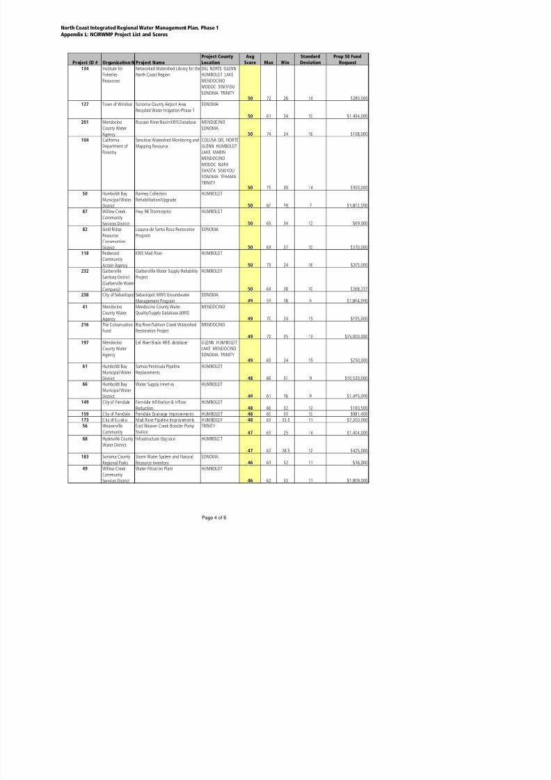
8/2/2019 North Coast Integrated Regional Water Management Plan, July 2007
http://slidepdf.com/reader/full/north-coast-integrated-regional-water-management-plan-july-2007 394/458
173 City of Eureka Mad River Pipel ine Improvements HUMBOLDT 48 63 33.5 11 $7,200,000
North Coast Integrated Regional Water Management Plan, Phase 1
Appendix L: NCIRWMP Project List and Scores
Project ID # Organization N Project Name
Project County
Location
Avg
Score Max Min
Standard
Deviation
Prop 50 Fund
Request
165 Community Clean
Water Institute
Humboldt Bay Regional Water
Quality Monitoring Project
HUMBOLDT
46 64 31 10 $216,000
206 Humboldt County
Department of
Agriculture
BMP for Control of Invasive Plants in
Northcoast Watersheds
DEL NORTE
HUMBOLDT
46 57 27 11 $30,000
190 Hoopa Valley
Tribal Protection
Agency
Klamath-Trinity Water Quality and
Water Supply Database and
DEL NORTE
HUMBOLDT MODOC
SISKIYOU TRINITY46 68 5 22 $350,000
99 City of Santa
Rosa
Development of Standby Water
Supply Wells
SONOMA
45 55 34 8 $4,620,000
13 Occidental Artsand Ecology
Center's WATER
Institute
Dutch Bill Watershed LiteracyProject: No Coho Left Behind
SONOMA
45 65 27 14 $18,000166 Sonoma County
Water Agency
Cook Creek Restoration Project SONOMA
44 57 29.5 11 $2,855,000
59 City of Trinidad Water Storage improvement Project HUMBOLDT44 62 26 11 $930,319
158 North Coast
Resource
Conservation &
Development
Council
Rural Municipal Service Provider
Techincal Assistance Progrm
LAKE MARIN
MENDOCINO
SONOMA
44 77 16 18 $160,000
35 Gold RidgeResource
Conservation
District
Salmon Creek WatershedAssessment and Implementation
SONOMA
44 60 28.5 11 $235,000
102 Westhaven
Community
Water Storage Improvement Project HUMBOLDT
44 64 27 12 $100,000
180 Mendocino
National Forest
Soda Creek Riparian Improvement LAKE
44 68 19 14 $55,000
182 City of Rio Dell Water Treatment System
Improvements
HUMBOLDT43 64 24 14 $3,146,850
64 Community Clean
Water Institute
Middle Reach Russian River Citizen
Monitoring Project
SONOMA
42 58 25 11 $99,0001 Loleta Community
Services District
Loleta I&I HUMBOLDT
42 74 21 20 $150,000124 Russian River
Unlimited
2005 River Clean-up and River
Education in Schools
MENDOCINO
42 60 19 13 $0213 Humboldt
Community
Services District
Steel Water Main Replacement HUMBOLDT
41 59 21.5 12 $2,220,000152 Bioengineering
Institute
Ten Mile Creek Watershed Outreach
and Organizing Project
MENDOCINO41 67 22 12 $129,241
212 Humboldt
CommunityServices District
CR Transmission Main HUMBOLDT
41 56 24.5 10 $525,000
155 Mendocino
County
Development of Mendocino County
Grading Ordinance
MENDOCINO40 60 19 14 $200,000
113 Loleta Community
Services District
Water Supply HUMBOLDT
40 63 22 13 $1,300,000239 City of Blue Lake Blue Lake Wastewater Treatment
Plant
HUMBOLDT
39 69 17 18 $600,000
186 S b l W G d S di i h SONOMA

8/2/2019 North Coast Integrated Regional Water Management Plan, July 2007
http://slidepdf.com/reader/full/north-coast-integrated-regional-water-management-plan-july-2007 395/458
186 Sebastopol Water Groundwater Studies in the SONOMA
North Coast Integrated Regional Water Management Plan, Phase 1
Appendix L: NCIRWMP Project List and Scores
Project ID # Organization N Project Name
Project County
Location
Avg
Score Max Min
Standard
Deviation
Prop 50 Fund
Request
184 City of Rio Dell Valve and Fire Hydrant Replacement
Project
HUMBOLDT
38 61 21 13 $900,000175 City of Cotati Low Water Use Demonstration
Program
SONOMA
37 60 23 12 $195,000181 City of Rio Dell Sludge Disposal and Handling
Improvement Project
HUMBOLDT37 57 21 13 $450,000
185 City of Rio Dell Wastewater Master Plan and Inflow
and Infiltration Study
HUMBOLDT36 62 18 14 $315,000
193 Mendocino
County Water
U. S. Army Corps Coyote Valley Dam
Feasibility Study
MENDOCINO
35 63 21 13 $2,000,000
192 City of Rio Dell Stormwater Master Plan HUMBOLDT 34 60 19 14 $202,500203 Sonoma County
Regional Parks
Shiloh Ranch & Foothill Regional
Parks Erosion Prevention
SONOMA
34 46 14 12 $107,000
TOTAL REQUESTED FUNDS $317,123,977

8/2/2019 North Coast Integrated Regional Water Management Plan, July 2007
http://slidepdf.com/reader/full/north-coast-integrated-regional-water-management-plan-july-2007 396/458
N O R T H C O A S T I N T E G R A T E D R E G I O N A LW A T E R M A N A G E M E N T P L A NP H A S E 1
J u l y 2 0 0 7
APPENDIX M: NCIRWMP PROJECT BUDGETS

8/2/2019 North Coast Integrated Regional Water Management Plan, July 2007
http://slidepdf.com/reader/full/north-coast-integrated-regional-water-management-plan-july-2007 397/458

8/2/2019 North Coast Integrated Regional Water Management Plan, July 2007
http://slidepdf.com/reader/full/north-coast-integrated-regional-water-management-plan-july-2007 398/458
Other StateFunds
1)Non-State Share(Funding Match)
Requested GrantFunding
Total % Funding Match
(a) Direct Project Administration Costs$288,600.00 $907,873.25 $478,155.25 $1,674,628.50
(b) Land Purchase/Easement$335,000.00 $1,180,000.00 $0.00 $1,515,000.00
(c)Planning/Design/Engineering/EnvironmentalDocumentation $127,738.00 $4,527,010.65 $948,079.85 $5,602,828.50
(d) Construction/Implementation$6,209,679.00 $22,250,100.04 $10,698,651.25 $39,158,430.29
(e)Environmental Compliance/
Mitigation/Enhancement $12,344.00 $1,008,270.02 $508,799.60 $1,529,413.62
(f) Construction Administration$48,810.00 $2,788,318.55 $454,004.05 $3,291,132.60
(g) Other Costs$41,266.00 $429,874.00 $301,212.00 $772,352.00
(h) Construction/Implementation Contingency $481,697.00 $5,003,044.97 $689,503.00 $6,174,244.97
(i)
Grand Total(Sum rows (a) through (h) for each column)
$7,545,134.00 $38,094,491.48 $14,078,405.00 $59,718,030.48
(j)
Calculation of Funding Match % (Used in Funding
Match Scoring Criterion)Optional for individual component projects . $38,094,491.48 $59,718,030.48 64%
1) “Other State Funds” may be presented in Table B-1 to demonstrate the full funding picture for the Proposal and, if presented, must be included in the total costs of the Proposal, which will be used to determine the percentage for the
Funding Match Scoring Criterion.
Table B-1 – Budget
Budget Category
See individual project budgets below Sources of Funds for Non-State Share (Funding Match)and Other State Funds
Project Title: North Coast Integrated Regional Water Management Plan, Phase I
Project Title: Summary Budget B-1 #1 of 3

8/2/2019 North Coast Integrated Regional Water Management Plan, July 2007
http://slidepdf.com/reader/full/north-coast-integrated-regional-water-management-plan-july-2007 399/458
Other StateFunds
1)Non-State Share(Funding Match)
Requested GrantFunding
Total % Funding Match
(a) Direct Project Administration Costs$5,000.00 $5,000.00
(b) Land Purchase/Easement$0.00 $0.00
(c)Planning/Design/Engineering/ EnvironmentalDocumentation $53,000.00 $53,000.00
(d.1) Construction/Implementation : Labor$21,000.00 $58,000.00 $79,000.00
(d.2) Construction/Implementation : Materials$55,510.00 $55,510.00
(e.1)Environmental Compliance/ Mitigation/Enhancement : Labor $0.00 $0.00
(e.2)Environmental Compliance/ Mitigation/Enhancement : Materials $0.00 $0.00
(f) Construction Administration $14,000.00 $14,000.00
(g.1) Other Costs: Labor$22,000.00 $22,000.00
(g.2) Other Costs: Materials$3,000.00 $3,000.00
(h) Construction/Implementation Contingency$0.00 $0.00
(i)
Grand Total(Sum rows (a) through (h) for each column)
$0.00 $21,000.00 $210,510.00 $231,510.00
(j)
Calculation of Funding Match % (Used in Funding
Match Scoring Criterion)Optional for individual component projects .
Table B-1 – Budget
Project Title: North Coast Integrated Regional Water Management Plan, Phase I
Project Title: Project 164 – Fish Friendly Farming Environmental Certification Program
Budget Category
Sources of Funds for Non-State Share (Funding Match)
and Other State FundsLandowner funded designs and implementation of several revegetation projects
1) “Other State Funds” may be presented in Table B-1 to demonstrate the full funding picture for the Proposal and, if presented, must be included in the total costs of the Proposal, which will be used to determine the percentage for the
Funding Match Scoring Criterion.
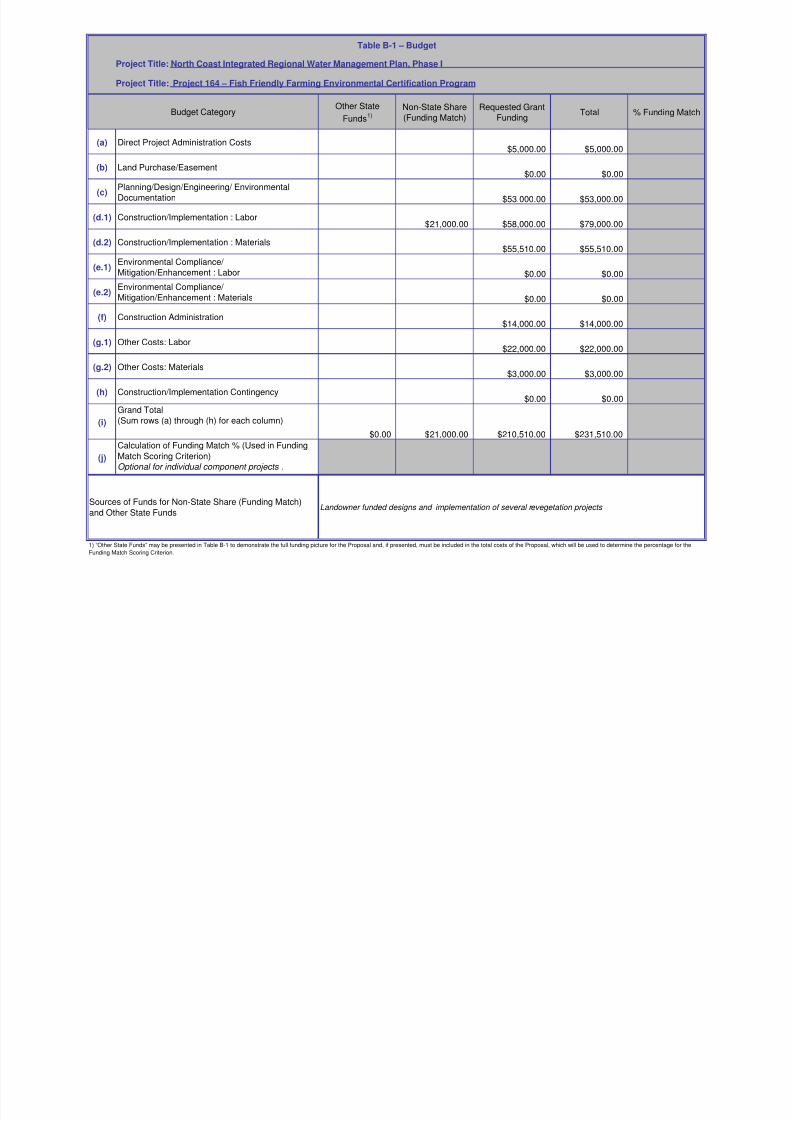
8/2/2019 North Coast Integrated Regional Water Management Plan, July 2007
http://slidepdf.com/reader/full/north-coast-integrated-regional-water-management-plan-july-2007 400/458
Other StateFunds
1)Non-State Share(Funding Match)
Requested GrantFunding
Total % Funding Match
(a) Direct Project Administration Costs$88,881.00 $32,500.00 $121,381.00
(b) Land Purchase/Easement$0.00 $0.00 $0.00
(c)Planning/Design/Engineering/ Environmental
Documentation $392,722.00 $143,500.00 $536,222.00
(d.1) Construction/Implementation : Labor$292,900.00 $107,100.00 $400,000.00
(d.2) Construction/Implementation : Materials$585,800.00 $214,200.00 $800,000.00
(e.1)Environmental Compliance/
Mitigation/Enhancement : Labor $86,540.00 $31,700.00 $118,240.00
(e.2)Environmental Compliance/
Mitigation/Enhancement : Materials $110,187.00 $40,221.00 $150,408.00
(f) Construction Administration $73,200.00 $26,800.00 $100,000.00
(g.1) Other Costs: Labor$0.00 $0.00 $0.00
(g.2) Other Costs: Materials$0.00 $0.00 $0.00
(h) Construction/Implementation Contingency$161,249.00 $58,900.00 $220,149.00
(i)
Grand Total
(Sum rows (a) through (h) for each column)$0.00 $1,791,479.00 $654,921.00 $2,446,400.00
(j)
Calculation of Funding Match % (Used in Funding
Match Scoring Criterion)Optional for individual component projects .
Table B-1 – Budget
Project Title: North Coast Integrated Regional Water Management Plan, Phase I
Project Title: Project 23 – Graton Wastewater Treatment Upgrade and Reclamation Project
Budget Category
Sources of Funds for Non-State Share (Funding Match)and Other State Funds
Federal Emergency Management Act (FEMA)
20-year Capital Improvements Loan to the GCSD
Annual sewer use and connection fees
PGE Energy-by-Design Grant
Other incidental grants compatible to the project 1) “Other State Funds” may be presented in Table B-1 to demonstrate the full funding picture for the Proposal and, if presented, must be included in the total costs of the Proposal, which will be used to determine the percentage for the
Funding Match Scoring Criterion.

8/2/2019 North Coast Integrated Regional Water Management Plan, July 2007
http://slidepdf.com/reader/full/north-coast-integrated-regional-water-management-plan-july-2007 401/458
Other State
Funds1)
Non-State Share
(Funding Match)
Requested Grant
Funding Total % Funding Match
(a) Direct Project Administration Costs$186,346.00 $243,654.00 $170,000.00 $600,000.00
(b) Land Purchase/Easement$335,000.00 $1,165,000.00 $0.00 $1,500,000.00
(c)Planning/Design/Engineering/ Environmental
Documentation $0.00 $250,000.00 $0.00 $250,000.00
(d.1) Construction/Implementation : Labor $3,845,670.00 $4,219,124.00 $2,997,177.00 $11,061,971.00
(d.2) Construction/Implementation : Materials$0.00
(e.1)Environmental Compliance/ Mitigation/Enhancement : Labor $120,000.00 $204,870.00 $324,870.00
(e.2)Environmental Compliance/
Mitigation/Enhancement : Materials $0.00
(f) Construction Administration
$1,220,000.00 $0.00 $1,220,000.00
(g.1) Other Costs: Labor$0.00 $217,994.00 $0.00 $217,994.00
(g.2) Other Costs: Materials$12,006.00 $0.00 $12,006.00
(h) Construction/Implementation Contingency$1,618,346.00 $89,680.00 $1,708,026.00
(i)
Grand Total(Sum rows (a) through (h) for each column)
$4,379,022.00 $9,054,118.00 $3,461,727.00 $16,894,867.00
(j)
Calculation of Funding Match % (Used in Funding
Match Scoring Criterion)Optional for individual component projects .
Table B-1 – Budget
Project Title: North Coast Integrated Regional Water Management Plan, Phase I
Project Title: Project 78 – Monte Rio Community Wastewater Project
Budget Category
Sources of Funds for Non-State Share (Funding Match)
and Other State Funds
1) Monte Rio Community Wastewater District Sewer Assessment ($3.0M)
2) USDA-RUS ($1M) grant
3) USDA-RUS Loan ($3,188,167)
4) EPA Grant ($192,400)
5) SWRCB Coastal Nonpoint Grant ($1M)
6) SWRCB Grant Agreement ($1,780,000)7) Small Community Grant ($1,595,750)
1) “Other State Funds” may be presented in Table B-1 to demonstrate the full funding picture for the Proposal and, if presented, must be included in the total costs of the Proposal, which will be used to determine the percentage for the
Funding Match Scoring Criterion.
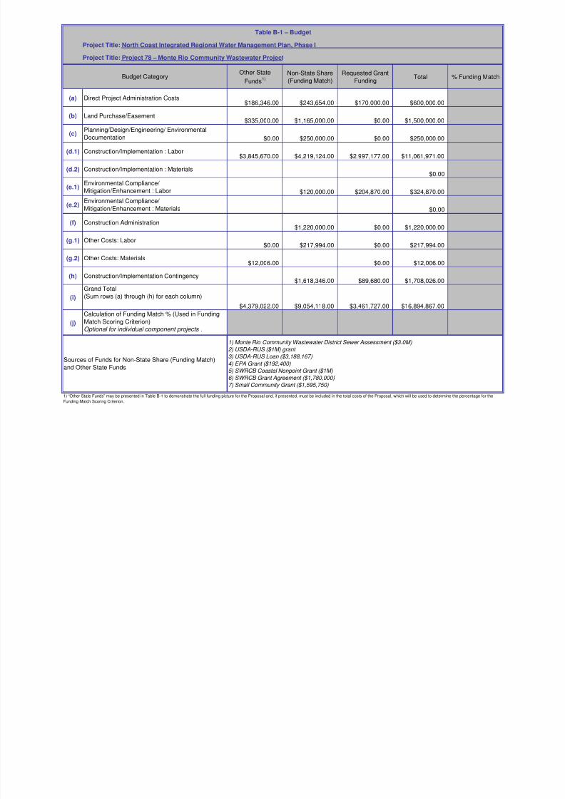
8/2/2019 North Coast Integrated Regional Water Management Plan, July 2007
http://slidepdf.com/reader/full/north-coast-integrated-regional-water-management-plan-july-2007 402/458
Other StateFunds
1)Non-State Share(Funding Match)
Requested GrantFunding
Total % Funding Match
(a) Direct Project Administration Costs$0.00 $153,000.00 $0.00 $153,000.00
(b) Land Purchase/Easement$0.00 $0.00 $0.00 $0.00
(c)Planning/Design/Engineering/ EnvironmentalDocumentation $0.00 $213,000.00 $0.00 $213,000.00
(d.1) Construction/Implementation : Labor$354,997.00 $954,603.00 $1,309,600.00
(d.2) Construction/Implementation : Materials$0.00 $50,000.00 $50,000.00
(e.1)Environmental Compliance/
Mitigation/Enhancement : Labor $400,000.00 $0.00 $400,000.00
(e.2)Environmental Compliance/ Mitigation/Enhancement : Materials $0.00 $50,000.00 $0.00 $50,000.00
(f) Construction Administration $0.00 $213,000.00 $0.00 $213,000.00
(g.1) Other Costs: Labor$0.00 $0.00 $0.00
(g.2) Other Costs: Materials$0.00 $0.00 $0.00 $0.00
(h) Construction/Implementation Contingency$0.00 $339,750.00 $0.00 $339,750.00
(i)
Grand Total
(Sum rows (a) through (h) for each column)
$0.00 $1,723,747.00 $1,004,603.00 $2,728,350.00
(j)
Calculation of Funding Match % (Used in FundingMatch Scoring Criterion)Optional for individual component projects .
Table B-1 – Budget
Project Title: North Coast Integrated Regional Water Management Plan, Phase I
Project Title: Project 128 – Sonoma County Water Recycling and Habitat Preservation Project
Budget Category
Sources of Funds for Non-State Share (Funding Match)
and Other State FundsUse this space to list all sources of the Non-State Share and Other State Funds (expand this cell or add
cells as necessary)
1) “Other State Funds” may be presented in Table B-1 to demonstrate the full funding picture for the Proposal and, if presented, must be included in the total costs of the Proposal, which will be used to determine the percentage for the
Funding Match Scoring Criterion.

8/2/2019 North Coast Integrated Regional Water Management Plan, July 2007
http://slidepdf.com/reader/full/north-coast-integrated-regional-water-management-plan-july-2007 403/458
Other State
Funds1) see note below
Non-State Share
(Funding Match)
Requested Grant
Funding Total % Funding Match
(a) Direct Project Administration Costs$45,232.00 $41,949.00 $41,779.00 $128,960.00
(b) Land Purchase/Easement$0.00 $0.00
(c)Planning/Design/Engineering/ Environmental
Documentation $7,273.00 $74,941.00 $107,016.00 $189,230.00
(d.1) Construction/Implementation : Labor $525,531.00 $86,136.00 $192,975.00 $804,642.00
(d.2) Construction/Implementation : Materials$457,124.00 $258,409.00 $288,792.00 $1,004,325.00
(e.1)Environmental Compliance/ Mitigation/Enhancement : Labor $7,286.00 $32,214.00 $39,500.00
(e.2)Environmental Compliance/
Mitigation/Enhancement : Materials $5,058.00 $26,537.00 $31,595.00
(f) Construction Administration
$48,810.00 $40,182.00 $88,992.00
(g.1) Other Costs: Labor$0.00 $6,600.00 $6,600.00
(g.2) Other Costs: Materials$0.00 $20,121.00 $20,121.00
(h) Construction/Implementation Contingency$239,734.00 $122,059.00 $361,793.00
(i)
Grand Total(Sum rows (a) through (h) for each column)
$1,336,048.00 $461,435.00 $878,275.00 $2,675,758.00
(j)
Calculation of Funding Match % (Used in Funding
Match Scoring Criterion)Optional for individual component projects .
Table B-1 – Budget
Project Title: North Coast Integrated Regional Water Management Plan, Phase I
Project Title: Project 236 – S2 – Araujo Dam Restoration
Budget Category
Sources of Funds for Non-State Share (Funding Match)and Other State Funds
(Non-state) Natural Resources Conservation Service (NRCS)= $379,000
(Non-state) Natural Resources Conservation Service (NRCS) in-kind= $40,435
(Non-state) U.S. Fish and Wildlife = $34,000
Other (Non-state) funds are pending
Other State Funds: $8,000 is 'in-hand', the remainder is pending
1) “Other State Funds” may be presented in Table B-1 to demonstrate the full funding picture for the Proposal and, if presented, must be included in the total costs of the Proposal, which will be used to determine the percentage for the
Funding Match Scoring Criterion.

8/2/2019 North Coast Integrated Regional Water Management Plan, July 2007
http://slidepdf.com/reader/full/north-coast-integrated-regional-water-management-plan-july-2007 404/458
Other State
Funds1)
Non-State Share
(Funding Match)
Requested Grant
Funding Total % Funding Match
(a) Direct Project Administration Costs$2,000.00 $1,000.00 $3,000.00
(b) Land Purchase/Easement$15,000.00 $15,000.00
(c)Planning/Design/Engineering/ Environmental
Documentation $35,000.00 $30,000.00 $65,000.00
(d.1) Construction/Implementation : Labor $4,000.00 $104,000.00 $108,000.00
(d.2) Construction/Implementation : Materials$6,000.00 $135,000.00 $141,000.00
(e.1)Environmental Compliance/ Mitigation/Enhancement : Labor $4,000.00 $4,000.00
(e.2)Environmental Compliance/
Mitigation/Enhancement : Materials $4,000.00 $4,000.00
(f) Construction Administration
$2,000.00 $8,000.00 $10,000.00
(g.1) Other Costs: Labor$0.00
(g.2) Other Costs: Materials$8,105.00 $8,105.00
(h) Construction/Implementation Contingency$24,000.00 $24,000.00
(i)
Grand Total(Sum rows (a) through (h) for each column)
$0.00 $64,000.00 $318,105.00 $382,105.00
(j)
Calculation of Funding Match % (Used in Funding
Match Scoring Criterion)Optional for individual component projects .
Table B-1 – Budget
Project Title: North Coast Integrated Regional Water Management Plan, Phase I
Project Title: Project 236 – S5 – City of Etna Water Supply
Budget Category
Sources of Funds for Non-State Share (Funding Match)and Other State Funds
$35,000 toward Feasibility Study from CDBG funds
$29,000 City of Etna funds and in-kind staff labor
1) “Other State Funds” may be presented in Table B-1 to demonstrate the full funding picture for the Proposal and, if presented, must be included in the total costs of the Proposal, which will be used to determine the percentage for the
Funding Match Scoring Criterion.

8/2/2019 North Coast Integrated Regional Water Management Plan, July 2007
http://slidepdf.com/reader/full/north-coast-integrated-regional-water-management-plan-july-2007 405/458
Other State
Funds1)
Non-State Share
(Funding Match)
Requested Grant
Funding Total % Funding Match
(a) Direct Project Administration Costs$22,154.00 $51,032.00 $73,186.00
(b) Land Purchase/Easement$0.00
(c)Planning/Design/Engineering/ Environmental
Documentation $315,109.00 $315,109.00
(d.1) Construction/Implementation : Labor $499,054.00 $499,054.00
(d.2) Construction/Implementation : Materials$423,216.00 $423,216.00
(e.1)Environmental Compliance/ Mitigation/Enhancement : Labor $7,500.00 $7,500.00
(e.2)Environmental Compliance/
Mitigation/Enhancement : Materials $0.00
(f) Construction Administration
$116,325.00 $116,325.00
(g.1) Other Costs: Labor$0.00
(g.2) Other Costs: Materials$0.00
(h) Construction/Implementation Contingency$92,227.00 $92,227.00
(i)
Grand Total(Sum rows (a) through (h) for each column)
$0.00 $29,654.00 $1,496,963.00 $1,526,617.00
(j)
Calculation of Funding Match % (Used in Funding
Match Scoring Criterion)Optional for individual component projects .
Table B-1 – Budget
Project Title: North Coast Integrated Regional Water Management Plan, Phase I
Project Title: Project 217 – Newell Water System Renovation
Budget Category
Sources of Funds for Non-State Share (Funding Match)and Other State Funds
In Kind local contribution in labor
1) “Other State Funds” may be presented in Table B-1 to demonstrate the full funding picture for the Proposal and, if presented, must be included in the total costs of the Proposal, which will be used to determine the percentage for the
Funding Match Scoring Criterion.

8/2/2019 North Coast Integrated Regional Water Management Plan, July 2007
http://slidepdf.com/reader/full/north-coast-integrated-regional-water-management-plan-july-2007 406/458
Other State
Funds1)
Non-State Share
(Funding Match)
Requested Grant
Funding Total % Funding Match
(a) Direct Project Administration Costs$0.00 $0.00 $20,061.00 $20,061.00
(b) Land Purchase/Easement$0.00 $0.00 $0.00 $0.00
(c)Planning/Design/Engineering/ Environmental
Documentation $3,200.00 $7,040.00 $29,600.00 $39,840.00
(d.1) Construction/Implementation : Labor $4,250.00 $0.00 $5,000.00 $9,250.00
(d.2) Construction/Implementation : Materials$0.00 $0.00 $28,339.00 $28,339.00
(e.1)Environmental Compliance/ Mitigation/Enhancement : Labor $0.00 $0.00 $0.00 $0.00
(e.2)Environmental Compliance/
Mitigation/Enhancement : Materials $0.00 $0.00 $0.00 $0.00
(f) Construction Administration
$0.00 $0.00 $11,500.00 $11,500.00
(g.1) Other Costs: Labor$29,260.00 $93,600.00 $34,000.00 $156,860.00
(g.2) Other Costs: Materials$0.00 $6,000.00 $31,500.00 $37,500.00
(h) Construction/Implementation Contingency$0.00 $0.00 $0.00 $0.00
(i)
Grand Total(Sum rows (a) through (h) for each column)
$36,710.00 $106,640.00 $160,000.00 $303,350.00
(j)Calculation of Funding Match % (Used in Funding
Match Scoring Criterion)
Table B-1 – Budget
Project Title: North Coast Integrated Regional Water Management Plan, Phase I
Project Title: Project 236 – S3 – Scott River Water Trust Phase III
Budget Category
Sources of Funds for Non-State Share (Funding Match)and Other State Funds
Bureau of Reclamation (USDI funds) – grant to Siskiyou RCD and to DWR for gage operations
Local Advisory Board to Scott River Water Trust – donated labor
Natural Resources Conservation Service (USDA funds) – labor contribution
US Forest Service (USDA funds) – equipment contribution & fish population surveys
California Dept. of Water Resources – Watermaster Service
California Dept. of Fish and Game – fish population surveys
1) “Other State Funds” may be presented in Table B-1 to demonstrate the full funding picture for the Proposal and, if presented, must be included in the total costs of the Proposal, which will be used to determine the percentage for the
Funding Match Scoring Criterion.

8/2/2019 North Coast Integrated Regional Water Management Plan, July 2007
http://slidepdf.com/reader/full/north-coast-integrated-regional-water-management-plan-july-2007 407/458
Other State
Funds1)
Non-State Share
(Funding Match)
Requested Grant
Funding Total % Funding Match
(a) Direct Project Administration Costs$57,022.00 $74,196.00 $86,017.00 $217,235.00
(b) Land Purchase/Easement$0.00 $0.00
(c)Planning/Design/Engineering/ Environmental
Documentation $117,265.00 $232,364.00 $104,453.00 $454,082.00
(d.1) Construction/Implementation : Labor $431,381.00 $243,675.00 $280,072.00 $955,128.00
(d.2) Construction/Implementation : Materials$945,723.00 $191,723.00 $990,381.00 $2,127,827.00
(e.1)Environmental Compliance/ Mitigation/Enhancement : Labor $0.00 $0.00 $67,120.00 $67,120.00
(e.2)Environmental Compliance/
Mitigation/Enhancement : Materials $0.00 $0.00 $16,500.00 $16,500.00
(f) Construction Administration
$0.00 $0.00 $119,856.00 $119,856.00
(g.1) Other Costs: Labor$0.00 $0.00 $16,200.00 $16,200.00
(g.2) Other Costs: Materials$0.00 $0.00 $21,071.00 $21,071.00
(h) Construction/Implementation Contingency$241,963.00 $0.00 $224,680.00 $466,643.00
(i)
Grand Total(Sum rows (a) through (h) for each column)
$1,793,354.00 $741,958.00 $1,926,350.00 $4,461,662.00
(j)
Calculation of Funding Match % (Used in Funding
Match Scoring Criterion)Optional for individual component projects .
(Non-state) Natural Resources Conservation Service (NRCS)= $362,832
(Non-state) Shasta Water Association in-kind = $120,944
(Non-state) U.S. Fish and Wildlife = $168,182
(Non-state funds not yet in hand) = $635,000
Other funds pending
1) “Other State Funds” may be presented in Table B-1 to demonstrate the full funding picture for the Proposal and, if presented, must be included in the total costs of the Proposal, which will be used to determine the percentage for the
Funding Match Scoring Criterion.
Table B-1 – Budget
Project Title: North Coast Integrated Regional Water Management Plan, Phase I
Project Title: Project 236 – S1 – Shasta Water Association Dam Restoration
Budget Category
Sources of Funds for Non-State Share (Funding Match)and Other State Funds

8/2/2019 North Coast Integrated Regional Water Management Plan, July 2007
http://slidepdf.com/reader/full/north-coast-integrated-regional-water-management-plan-july-2007 408/458
Other State
Funds1)
Non-State Share(Funding Match)
Requested GrantFunding
Total % Funding Match
(a) Direct Project Administration Costs$0.00 $254,500.00 $0.00 $254,500.00
(b) Land Purchase/Easement$0.00 $0.00 $0.00 $0.00
(c)Planning/Design/Engineering/ Environmental
Documentation $0.00 $3,256,700.00 $0.00 $3,256,700.00
(d.1) Construction/Implementation : Labor$0.00 $5,002,500.00 $500,000.00 $5,502,500.00
(d.2) Construction/Implementation : Materials$0.00 $8,104,198.00 $435,602.00 $8,539,800.00
(e.1)Environmental Compliance/
Mitigation/Enhancement : Labor $0.00 $100,200.00 $0.00 $100,200.00
(e.2)Environmental Compliance/
Mitigation/Enhancement : Materials $0.00 $50,000.00 $0.00 $50,000.00
(f) Construction Administration$0.00 $1,200,000.00 $0.00 $1,200,000.00
(g.1) Other Costs: Labor$0.00 $0.00 $0.00 $0.00
(g.2) Other Costs: Materials$0.00 $0.00 $0.00 $0.00
(h) Construction/Implementation Contingency$0.00 $2,835,555.00 $0.00 $2,835,555.00
(i)
Grand Total
(Sum rows (a) through (h) for each column)$0.00 $20,803,653.00 $935,602.00 $21,739,255.00
(j)
Calculation of Funding Match % (Used in Funding
Match Scoring Criterion)Optional for individual component projects .
Sources of Funds for Non-State Share (Funding Match)and Other State Funds
Local funding/Rate payers
1) “Other State Funds” may be presented in Table B-1 to demonstrate the full funding picture for the Proposal and, if presented, must be included in the total costs of the Proposal, which will be used to determine the percentage for the
Funding Match Scoring Criterion.
Table B-1 – Budget
Project Title: North Coast Integrated Regional Water Management Plan, Phase I
Project Title: Project 55 – Crescent City Wastewater Treatment Plant Renovation
Budget Category
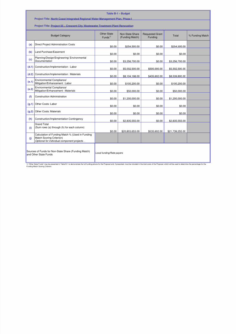
8/2/2019 North Coast Integrated Regional Water Management Plan, July 2007
http://slidepdf.com/reader/full/north-coast-integrated-regional-water-management-plan-july-2007 409/458
Other StateFunds
1)Non-State Share(Funding Match)
Requested GrantFunding
Total % Funding Match
(a) Direct Project Administration Costs$9,539.25 $9,539.25 $19,078.50
(b) Land Purchase/Easement$0.00 $0.00 $0.00
(c)Planning/Design/Engineering/ EnvironmentalDocumentation $631.65 $7,838.85 $8,470.50
(d.1) Construction/Implementation : Labor$60,084.16 $23,411.37 $83,495.53
(d.2) Construction/Implementation : Materials$623,111.38 $181,424.38 $804,535.76
(e.1)Environmental Compliance/ Mitigation/Enhancement : Labor $50,217.52 $33,639.10 $83,856.62
(e.2)Environmental Compliance/ Mitigation/Enhancement : Materials $1,174.50 $1,174.50 $2,349.00
(f) Construction Administration $11,646.55 $11,646.55 $23,293.10
(g.1) Other Costs: Labor$0.00 $0.00 $0.00
(g.2) Other Costs: Materials$12,450.00 $7,050.00 $19,500.00
(h) Construction/Implementation Contingency$14,869.97 $4,956.00 $19,825.97
(i)
Grand Total(Sum rows (a) through (h) for each column)
$0.00 $783,724.98 $280,680.00 $1,064,404.98
(j)
Calculation of Funding Match % (Used in FundingMatch Scoring Criterion)Optional for individual component projects .
Table B-1 – Budget
Project Title: North Coast Integrated Regional Water Management Plan, Phase I
Project Title: Project 38 – Head Hunter/Smoke House Non-point Sediment Reduction Project
Budget Category
Sources of Funds for Non-State Share (Funding Match)
and Other State FundsSource of funding match comes through a grant to the Smith River Alliance from the California Wildlife
Conservation Board for treatment of LSEP roads for the fiscal years 2005/06 through 2007/08.
1) “Other State Funds” may be presented in Table B-1 to demonstrate the full funding picture for the Proposal and, if presented, must be included in the total costs of the Proposal, which will be used to determine the percentage for the
Funding Match Scoring Criterion.

8/2/2019 North Coast Integrated Regional Water Management Plan, July 2007
http://slidepdf.com/reader/full/north-coast-integrated-regional-water-management-plan-july-2007 410/458
Other State
Funds1)
Non-State Share
(Funding Match)
Requested Grant
Funding Total % Funding Match
(a) Direct Project Administration Costs$0.00
(b) Land Purchase/Easement$0.00
(c)Planning/Design/Engineering/ Environmental
Documentation $42,112.00 $47,343.00 $89,455.00
(d.1) Construction/Implementation : Labor $353,514.00 $392,897.00 $746,411.00
(d.2) Construction/Implementation : Materials$1,490,233.00 $993,887.00 $2,484,120.00
(e.1)Environmental Compliance/ Mitigation/Enhancement : Labor $32,451.00 $40,804.00 $73,255.00
(e.2)Environmental Compliance/
Mitigation/Enhancement : Materials $0.00
(f) Construction Administration
$59,722.00 $68,812.00 $128,534.00
(g.1) Other Costs: Labor$0.00
(g.2) Other Costs: Materials$0.00
(h) Construction/Implementation Contingency$0.00
(i)
Grand Total(Sum rows (a) through (h) for each column)
$0.00 $1,978,032.00 $1,543,743.00 $3,521,775.00
(j)
Calculation of Funding Match % (Used in Funding
Match Scoring Criterion)Optional for individual component projects .
Table B-1 – Budget
Project Title: North Coast Integrated Regional Water Management Plan, Phase I
Project Title: Project 7 – Mattole Integrated Water Management Program
Budget Category

8/2/2019 North Coast Integrated Regional Water Management Plan, July 2007
http://slidepdf.com/reader/full/north-coast-integrated-regional-water-management-plan-july-2007 411/458
Sources of Funds for Non-State Share (Funding Match)and Other State Funds
Bureau of Land Management
NOAA Fisheries—National Marine Fisheries Service
US Fish and Wildlife Service
National Fish and Wildlife Foundation
US Environmental Protection Agency
Pacific States Marine Fisheries Commission
Private Foundations Landowner Cost-Share
County of Humboldt
County of Mendocino
1) “Other State Funds” may be presented in Table B-1 to demonstrate the full funding picture for the Proposal and, if presented, must be included in the total costs of the Proposal, which will be used to determine the percentage for the
Funding Match Scoring Criterion.

8/2/2019 North Coast Integrated Regional Water Management Plan, July 2007
http://slidepdf.com/reader/full/north-coast-integrated-regional-water-management-plan-july-2007 412/458
Other StateFunds
1)Non-State Share(Funding Match)
Requested GrantFunding
Total % Funding Match
(a) Direct Project Administration Costs$18,000.00 $34,997.00 $52,997.00
(b) Land Purchase/Easement$0.00 $0.00 $0.00
(c)Planning/Design/Engineering/ EnvironmentalDocumentation $22,500.00 $43,550.00 $66,050.00
(d.1) Construction/Implementation : Labor$24,750.00 $24,750.00 $49,500.00
(d.2) Construction/Implementation : Materials$287,800.00 $444,450.00 $732,250.00
(e.1)Environmental Compliance/ Mitigation/Enhancement : Labor $0.00 $0.00 $0.00
(e.2)Environmental Compliance/ Mitigation/Enhancement : Materials $0.00 $0.00 $0.00
(f) Construction Administration $3,750.00 $28,275.00 $32,025.00
(g.1) Other Costs: Labor$1,100.00 $29,250.00 $30,350.00
(g.2) Other Costs: Materials$0.00 $15,701.00 $15,701.00
(h) Construction/Implementation Contingency$33,275.00 $52,660.00 $85,935.00
(i)
Grand Total(Sum rows (a) through (h) for each column)
$0.00 $391,175.00 $673,633.00 $1,064,808.00
(j)
Calculation of Funding Match % (Used in FundingMatch Scoring Criterion)Optional for individual component projects .
Table B-1 – Budget
Project Title: North Coast Integrated Regional Water Management Plan, Phase I
Project Title: Project 125 – Navarro Watershed Road Sediment Reduction Project
Budget Category
Sources of Funds for Non-State Share (Funding Match)
and Other State Funds
MCRCD is applying for $996,000 in funding from SWRCB 319(h) funds for sediment reduction projects in the
Navarro watershed. Of that, $320,000 is related to road sediment reduction implementation and will be used
as funding for additional miles of road restoration.
1) “Other State Funds” may be presented in Table B-1 to demonstrate the full funding picture for the Proposal and, if presented, must be included in the total costs of the Proposal, which will be used to determine the percentage for the
Funding Match Scoring Criterion.

8/2/2019 North Coast Integrated Regional Water Management Plan, July 2007
http://slidepdf.com/reader/full/north-coast-integrated-regional-water-management-plan-july-2007 413/458
Other State
Funds1)
Non-State Share
(Funding Match)
Requested Grant
Funding Total % Funding Match
(a) Direct Project Administration Costs$9,890.00 $9,890.00
(b) Land Purchase/Easement$0.00
(c)Planning/Design/Engineering/ Environmental
Documentation $5,000.00 $5,000.00
(d.1) Construction/Implementation : Labor $30,000.00 $41,260.00 $71,260.00
(d.2) Construction/Implementation : Materials$10,145.50 $15,230.50 $25,376.00
(e.1)Environmental Compliance/ Mitigation/Enhancement : Labor $0.00
(e.2)Environmental Compliance/
Mitigation/Enhancement : Materials $0.00
(f) Construction Administration
$5,000.00 $5,447.50 $10,447.50(g.1) Other Costs: Labor
$53,760.00 $53,760.00 $107,520.00
(g.2) Other Costs: Materials$44,970.00 $28,464.00 $73,434.00
(h) Construction/Implementation Contingency$0.00
(i)
Grand Total(Sum rows (a) through (h) for each column)
$0.00 $143,875.50 $159,052.00 $302,927.50
(j)
Calculation of Funding Match % (Used in Funding
Match Scoring Criterion)Optional for individual component projects .
Table B-1 – Budget
Project Title: North Coast Integrated Regional Water Management Plan, Phase I
Project Title: Project 207/26 – Sediment Solutions for the Gualala
Budget Category
Sources of Funds for Non-State Share (Funding Match)and Other State Funds
Local funding from Landowners: Gualala Redwoods, Mendocino Redwood Company and Gualala River
Watershed Council and 50% matching gage funding from USGS.
1) “Other State Funds” may be presented in Table B-1 to demonstrate the full funding picture for the Proposal and, if presented, must be included in the total costs of the Proposal, which will be used to determine the percentage for the
Funding Match Scoring Criterion.

8/2/2019 North Coast Integrated Regional Water Management Plan, July 2007
http://slidepdf.com/reader/full/north-coast-integrated-regional-water-management-plan-july-2007 414/458
Other StateFunds
1)Non-State Share(Funding Match)
Requested GrantFunding
Total % Funding Match
(a) Direct Project Administration Costs$0.00 $0.00 $16,340.00 $16,340.00
(b) Land Purchase/Easement$0.00 $0.00 $0.00 $0.00
(c)Planning/Design/Engineering/ Environmental
Documentation $0.00 $0.00 $61,670.00 $61,670.00
(d.1) Construction/Implementation : Labor$0.00 $0.00 $58,820.00 $58,820.00
(d.2) Construction/Implementation : Materials$0.00 $0.00 $203,500.00 $203,500.00
(e.1)Environmental Compliance/
Mitigation/Enhancement : Labor $0.00 $0.00 $6,020.00 $6,020.00
(e.2)Environmental Compliance/
Mitigation/Enhancement : Materials $0.00 $0.00 $0.00 $0.00
(f) Construction Administration $0.00 $0.00 $3,160.00 $3,160.00
(g.1) Other Costs: Labor$0.00 $0.00 $3,790.00 $3,790.00
(g.2) Other Costs: Materials$0.00 $0.00 $600.00 $600.00
(h) Construction/Implementation Contingency$0.00 $0.00 $20,341.00 $20,341.00
(i)
Grand Total
(Sum rows (a) through (h) for each column)
$0.00 $0.00 $374,241.00 $374,241.00
(j)
Calculation of Funding Match % (Used in Funding
Match Scoring Criterion)Optional for individual component projects .
Table B-1 – Budget
1) “Other State Funds” may be presented in Table B-1 to demonstrate the full funding picture for the Proposal and, if presented, must be included in the total costs of the Proposal, which will be used to determine the percentage for the
Funding Match Scoring Criterion.
Project Title: North Coast Integrated Regional Water Management Plan, Phase I
Project Title: Project 153 – Westport County Water District Water Supply Reliability Project
Budget Category
Sources of Funds for Non-State Share (Funding Match)and Other State Funds
none

8/2/2019 North Coast Integrated Regional Water Management Plan, July 2007
http://slidepdf.com/reader/full/north-coast-integrated-regional-water-management-plan-july-2007 415/458
Other State
Funds1)
Non-State Share(Funding Match)
Requested GrantFunding
Total % FundingMatch
(a) Direct Project Administration Costs $108,533.00 $140,128.00 $248,661.00
(b) Land Purchase/Easement $700,450.00 $700,450.00
(c) Planning/Design/Engineering/ Environmental Documentation
$3,523,830.00 $3,523,830.00
(d.1) Construction/Implementation : Labor $625,800.00 $625,800.00
(d.2) Construction/Implementation : Materials $600,800.00 $600,800.00
(e.1) Environmental Compliance/ Mitigation/Enhancement : Labor $168,150.00 $168,150.00
(e.2) Environmental Compliance/ Mitigation/Enhancement : Materials
$8,850.00 $8,850.00
(f) Construction Administration $130,500.00 $130,500.00
(g.1) Other Costs: Labor $12,267.00 $12,267.00
(g.2) Other Costs: Materials $1,840.00 $1,840.00
(h) Construction/Implementation
Contingency
$184,120.00 $184,120.00
(i) Grand Total(Sum rows (a) through (h) for eachcolumn)
$0.00 $3,632,363.00 $2,572,905.00 $6,205,268.00
(j) Calculation of Funding Match % (Usedin Funding Match Scoring Criterion)Optional for individual component
projects .
Table B-1 – Budget
Project Title: North Coast Integrated Regional Water Management Plan, Phase IProject Title: Project 108 – Martin Slough Interceptor Project - Phase 1 Construction
Budget Category
Sources of Funds for Non-State Share(Funding Match) and Other State Funds
Note: Planning, Design, Engineering, and Environmental Documentation work was completed prior to project Implementation, and is therefore not included in the above budget. EPA Grant funds for this work total $2,001,300, and City of Eureka matching funds total $1,634,663,making the total budget expenditure for this work $3,635,963. EPA Special Appropriations Grants of $1,997,700, and City of Eureka matching funds of $1,634,663, make the total budget expenditure for Planning/Design/Engineering/ Environmental Documentation
$3,632,363.1) “Other State Funds” may be presented in Table B-1 to demonstrate the full funding picture for the Proposal and, if presented, must be included in the total costs of the Proposal, which will be used to
determine the percentage for the Funding Match Scoring Criterion.

8/2/2019 North Coast Integrated Regional Water Management Plan, July 2007
http://slidepdf.com/reader/full/north-coast-integrated-regional-water-management-plan-july-2007 416/458
Other State
Funds1)
Non-State Share(Funding Match)
Requested GrantFunding
Total % FundingMatch
(a) Direct Project Administration Costs $115,525.00 $115,525.00
(b) Land Purchase/Easement $0.00
(c) Planning/Design/Engineering/ Environmental Documentation
$390,500.00 $281,426.00 $671,926.00
(d.1) Construction/Implementation : Labor $696,190.00 $696,190.00
(d.2) Construction/Implementation : Materials $250,000.00 $1,527,784.00 $515,569.00 $2,293,353.00
(e.1) Environmental Compliance/ Mitigation/Enhancement : Labor $190,800.00 $190,800.00
(e.2) Environmental Compliance/ Mitigation/Enhancement : Materials
$128,500.00 $128,500.00
(f) Construction Administration $252,000.00 $252,000.00
(g.1) Other Costs: Labor $0.00 $0.00
(g.2) Other Costs: Materials $0.00 $0.00
(h) Construction/Implementation
Contingency
$448,431.00 $448,431.00
(i) Grand Total(Sum rows (a) through (h) for eachcolumn)
$250,000.00 $1,918,284.00 $2,628,441.00 $4,796,725.00
(j) Calculation of Funding Match % (Usedin Funding Match Scoring Criterion)Optional for individual component
projects .
Table B-1 – Budget
Project Title: North Coast Integrated Regional Water Management Plan, Phase IProject Title: Project 86 – Orick Community Services District Wastewater Treatment
Budget Category

8/2/2019 North Coast Integrated Regional Water Management Plan, July 2007
http://slidepdf.com/reader/full/north-coast-integrated-regional-water-management-plan-july-2007 417/458
Sources of Funds for Non-State Share(Funding Match) and Other State Funds
Donated funds to date (NOT INCLUDED IN TABLE B1): $7,500. Redwood National and State Parks (Feasibility)$1,000. Resident donation (Feasibility)$86,000 Housing & Comm. Devl Block Grant (to SHN) Feasibility $35,000 Comm. Devl Block Grant (to Oscar Larson) Pollution Study $2,500 Pre-application assistance
In-kind: HSU graduate students, under supervision of Professor Bob Gearheart, are involved in wastewater system planning Other funds that MAY become available : We are seeking the balance of funds needed from the Headwaters Fund (a local fund for Humboldt County). We have been assured that these funds will be made available and will inform both the NCRP and the Prop 50 funding agency as soon as the funds are secured. $1,100,000. Humboldt County Redevelopment- Redevelopment for Humboldt County is being reviewed by the county Board of Supervisors. Orick is one of the communities that will receive Redevelopment funding and has been allocated $1,100,000 that will likely all go toward the WWTF. We will inform both the NCRP and the
Prop 50 funding agency as soon as the funds are secured.
1) “Other State Funds” may be presented in Table B-1 to demonstrate the full funding picture for the Proposal and, if presented, must be included in the total costs of the Proposal, which will be used to
determine the percentage for the Funding Match Scoring Criterion.

8/2/2019 North Coast Integrated Regional Water Management Plan, July 2007
http://slidepdf.com/reader/full/north-coast-integrated-regional-water-management-plan-july-2007 418/458
Other State
Funds1)
Non-State Share(Funding Match)
Requested GrantFunding
Total % FundingMatch
(a) Direct Project Administration Costs $20,000.00 $26,630.00 $46,630.00(b) Land Purchase/Easement $0.00
(c) Planning/Design/Engineering/ Environmental Documentation
$18,000.00 $28,100.00 $46,100.00
(d.1) Construction/Implementation : Labor $32,500.00 $32,500.00
(d.2) Construction/Implementation : Materials $236,000.00 $354,016.00 $590,016.00
(e.1) Environmental Compliance/ Mitigation/Enhancement : Labor $2,000.00 $2,000.00
(e.2) Environmental Compliance/ Mitigation/Enhancement : Materials
$0.00
(f) Construction Administration $8,500.00 $51,250.00 $59,750.00
(g.1) Other Costs: Labor $17,500.00 $34,900.00 $52,400.00
(g.2) Other Costs: Materials $8,575.00 $8,575.00
(h) Construction/Implementation
Contingency
$0.00 $0.00
(i) Grand Total(Sum rows (a) through (h) for eachcolumn)
$0.00 $300,000.00 $537,971.00 $837,971.00
(j) Calculation of Funding Match % (Usedin Funding Match Scoring Criterion)Optional for individual component
projects .
Table B-1 – Budget
Project Title: North Coast Integrated Regional Water Management Plan, Phase IProject Title: Project 22 – Redwood Creek Erosion Control
Budget Category
Sources of Funds for Non-State Share(Funding Match) and Other State Funds
$250,000 in matching funding from the EPA is provided through a 319(h) project, SWRCB Agreement No. 04-062-551-0 $50,000 in matching funds is being provided by Green Diamond Resources Company, a major landowner in the Redwood Creek watershed for contracted heavy equipment, project labor and materials.
1) “Other State Funds” may be presented in Table B-1 to demonstrate the full funding picture for the Proposal and, if presented, must be included in the total costs of the Proposal, which will be used to
determine the percentage for the Funding Match Scoring Criterion.

8/2/2019 North Coast Integrated Regional Water Management Plan, July 2007
http://slidepdf.com/reader/full/north-coast-integrated-regional-water-management-plan-july-2007 419/458

8/2/2019 North Coast Integrated Regional Water Management Plan, July 2007
http://slidepdf.com/reader/full/north-coast-integrated-regional-water-management-plan-july-2007 420/458
Other State
Funds1)
Non-State Share(Funding Match)
Requested GrantFunding
Total % FundingMatch
(a) Direct Project Administration Costs $40,000.00 $40,000.00(b) Land Purchase/Easement $0.00
(c) Planning/Design/Engineering/ Environmental Documentation
$60,000.00 $272,302.00 $38,898.00 $371,200.00
(d.1) Construction/Implementation : Labor $806,688.00 $646,012.00 $1,452,700.00
(d.2) Construction/Implementation : Materials $775,850.00 $380,681.00 $1,156,531.00
(e.1) Environmental Compliance/ Mitigation/Enhancement : Labor $9,000.00 $9,000.00
(e.2) Environmental Compliance/ Mitigation/Enhancement : Materials
$900.00 $900.00
(f) Construction Administration $210,000.00 $210,000.00
(g.1) Other Costs: Labor $29,900.00 $29,900.00
(g.2) Other Costs: Materials $30,000.00 $30,000.00
(h) Construction/Implementation
Contingency
$465,700.00 $465,700.00
(i) Grand Total(Sum rows (a) through (h) for eachcolumn)
$60,000.00 $2,640,340.00 $1,065,591.00 $3,765,931.00
(j) Calculation of Funding Match % (Usedin Funding Match Scoring Criterion)Optional for individual component
projects .
Table B-1 – Budget
Project Title: North Coast Integrated Regional Water Management Plan, Phase IProject Title: Project 89 – Covelo Wastewater Facilities Improvement Project
Budget Category
Sources of Funds for Non-State Share(Funding Match) and Other State Funds
USDA Rural Utilities Program, $750,000 Grant, $750,000 Loan.HUD Community Development Block Grant $755,000 Mendocino County, State Tobacco Grants $60,000
1) “Other State Funds” may be presented in Table B-1 to demonstrate the full funding picture for the Proposal and, if presented, must be included in the total costs of the Proposal, which will be used to
determine the percentage for the Funding Match Scoring Criterion.

8/2/2019 North Coast Integrated Regional Water Management Plan, July 2007
http://slidepdf.com/reader/full/north-coast-integrated-regional-water-management-plan-july-2007 421/458
Other State
Funds1)
Non-State Share(Funding Match)
Requested GrantFunding
Total % FundingMatch
(a) Direct Project Administration Costs $0.00 $3,000.00 $40,000.00 $43,000.00(b) Land Purchase/Easement $0.00 $0.00 $0.00 $0.00
(c) Planning/Design/Engineering/ Environmental Documentation
$0.00 $4,000.00 $39,480.00 $43,480.00
(d.1) Construction/Implementation : Labor $0.00 $2,000.00 $150,600.00 $152,600.00
(d.2) Construction/Implementation : Materials $0.00 $28,000.00 $79,400.00 $107,400.00
(e.1) Environmental Compliance/ Mitigation/Enhancement : Labor $0.00 $0.00 $0.00 $0.00
(e.2) Environmental Compliance/ Mitigation/Enhancement : Materials
$0.00 $0.00 $0.00 $0.00
(f) Construction Administration $0.00 $2,000.00 $18,000.00 $20,000.00
(g.1) Other Costs: Labor $0.00 $0.00 $9,000.00 $9,000.00
(g.2) Other Costs: Materials $0.00 $0.00 $337.00 $337.00
(h) Construction/Implementation
Contingency
$0.00 $0.00 $0.00 $0.00
(i) Grand Total(Sum rows (a) through (h) for eachcolumn)
$0.00 $39,000.00 $336,817.00 $375,817.00
(j) Calculation of Funding Match % (Usedin Funding Match Scoring Criterion)Optional for individual component
projects .
Table B-1 – Budget
Project Title: North Coast Integrated Regional Water Management Plan, Phase IProject Title: Project 51 – Mid Van Duzen River Ranch Road Sediment Reduction Program
Budget Category
Sources of Funds for Non-State Share(Funding Match) and Other State Funds
Local funding from landowner contributions will constitute the match.
1) “Other State Funds” may be presented in Table B-1 to demonstrate the full funding picture for the Proposal and, if presented, must be included in the total costs of the Proposal, which will be used to
determine the percentage for the Funding Match Scoring Criterion.

8/2/2019 North Coast Integrated Regional Water Management Plan, July 2007
http://slidepdf.com/reader/full/north-coast-integrated-regional-water-management-plan-july-2007 422/458
Other State
Funds1)
Non-State Share(Funding Match)
Requested GrantFunding
Total % FundingMatch
(a) Direct Project Administration Costs $0.00 $0.00 $53,100.00 $53,100.00(b) Land Purchase/Easement $0.00 $0.00 $0.00 $0.00
(c) Planning/Design/Engineering/ Environmental Documentation
$11,000.00 $0.00 $47,110.00 $58,110.00
(d.1) Construction/Implementation : Labor $415,192.00 $1,501,916.00 $497,492.00 $2,414,600.00
(d.2) Construction/Implementation : Materials $204,498.00 $1,835,675.00 $407,500.00 $2,447,673.00
(e.1)Environmental Compliance/ Mitigation/Enhancement : Labor
$55,000.00 $60,000.00 $59,520.00 $174,520.00
(e.2) Environmental Compliance/ Mitigation/Enhancement : Materials
$0.00 $0.00 $30,480.00 $30,480.00
(f) Construction Administration $0.00 $0.00 $54,300.00 $54,300.00
(g.1) Other Costs: Labor $22,400.00 $0.00 $12,333.00 $34,733.00
(g.2) Other Costs: Materials $17,600.00 $0.00 $7,667.00 $25,267.00
(h) Construction/Implementation
Contingency
$0.00 $0.00 $0.00 $0.00
(i) Grand Total(Sum rows (a) through (h) for eachcolumn)
$725,690.00 $3,397,591.00 $1,169,502.00 $5,292,783.00
(j) Calculation of Funding Match % (Usedin Funding Match Scoring Criterion)Optional for individual component
projects .
Table B-1 – Budget
Project Title: North Coast Integrated Regional Water Management Plan, Phase IProject Title: Project 121 – Salt River Restoration Project
Budget Category
S f F d f N St t Sh L l l d t ib ti ( i ifi t)

8/2/2019 North Coast Integrated Regional Water Management Plan, July 2007
http://slidepdf.com/reader/full/north-coast-integrated-regional-water-management-plan-july-2007 423/458
Sources of Funds for Non-State Share(Funding Match) and Other State Funds
Local landowner contributions (significant).Local non-profit organizations.Local foundations (e.g., Humboldt Area Foundation, McClean Foundation, Bertha Russ Lytel Foundation, etc.)Local business community contributions.Headwaters Fund.State Coastal Conservancy.Wildlife Conservation Board.Department of Fish and Game, Fisheries Restoration Grants Program.U.S. Fish and Wildlife Service, Coastal Wetlands Grants Program.Federal Emergency Management Agency (FEMA).U.S. Army Corps of Engineers.National Oceanic and Atmospheric Administration (NOAA).U.S. Environmental Protection Agency (EPA).
Consolidated Grant Program.1) “Other State Funds” may be presented in Table B-1 to demonstrate the full funding picture for the Proposal and, if presented, must be included in the total costs of the Proposal, which will be used to
determine the percentage for the Funding Match Scoring Criterion.
T bl B 1 B d t

8/2/2019 North Coast Integrated Regional Water Management Plan, July 2007
http://slidepdf.com/reader/full/north-coast-integrated-regional-water-management-plan-july-2007 424/458
Other State
Funds1)
Non-State Share(Funding Match)
Requested GrantFunding
Total % FundingMatch
(a) Direct Project Administration Costs $27,000.00 $27,000.00(b) Land Purchase/Easement $50,000.00 $50,000.00
(c) Planning/Design/Engineering/ Environmental Documentation
$75,000.00 $75,000.00
(d.1) Construction/Implementation : Labor $78,128.00 $335,219.00 $413,347.00
(d.2) Construction/Implementation : Materials $300,000.00 $300,000.00
(e.1) Environmental Compliance/ Mitigation/Enhancement : Labor
$10,000.00 $10,000.00
(e.2) Environmental Compliance/ Mitigation/Enhancement : Materials
$5,000.00 $5,000.00
(f) Construction Administration $20,000.00 $20,000.00
(g.1) Other Costs: Labor $5,000.00 $5,000.00
(g.2) Other Costs: Materials $10,000.00 $10,000.00
(h) Construction/Implementation
Contingency
$75,000.00 $75,000.00
(i) Grand Total(Sum rows (a) through (h) for eachcolumn)
$0.00 $78,128.00 $912,219.00 $990,347.00
(j) Calculation of Funding Match % (Usedin Funding Match Scoring Criterion)Optional for individual component
projects .
Table B-1 – Budget
Project Title: North Coast Integrated Regional Water Management Plan, Phase IProject Title: Project Title: Project 39 – Raw and Recovered Water for Irrigating Public
Budget Category
Sources of Funds for Non-State Share(Funding Match) and Other State Funds
Local funds from Trinity Co. Waterworks
1) “Other State Funds” may be presented in Table B-1 to demonstrate the full funding picture for the Proposal and, if presented, must be included in the total costs of the Proposal, which will be used to
determine the percentage for the Funding Match Scoring Criterion.
Table B 1 Budget

8/2/2019 North Coast Integrated Regional Water Management Plan, July 2007
http://slidepdf.com/reader/full/north-coast-integrated-regional-water-management-plan-july-2007 425/458
Other State
Funds1)
Non-State Share(Funding Match)
Requested GrantFunding
Total % FundingMatch
(a) Direct Project Administration Costs $0.00 $2,270.00 $3,400.00 $5,670.00(b) Land Purchase/Easement $0.00 $0.00 $0.00 $0.00
(c) Planning/Design/Engineering/ Environmental Documentation
$520.00 $360.28 $1,180.00 $2,060.28
(d.1) Construction/Implementation : Labor $25,000.00 $150,264.00 $0.00 $175,264.00
(d.2) Construction/Implementation : Materials $0.00 $10,666.02 $268,165.00 $278,831.02
(e.1) Environmental Compliance/ Mitigation/Enhancement : Labor
$0.00 $0.00 $0.00 $0.00
(e.2) Environmental Compliance/ Mitigation/Enhancement : Materials
$0.00 $0.00 $0.00 $0.00
(f) Construction Administration $884.00 $1,620.00 $0.00 $2,504.00
(g.1) Other Costs: Labor $3,136.00 $8,148.78 $4,619.22 $15,904.00
(g.2) Other Costs: Materials $0.00 $0.00 $1,830.78 $1,830.78
(h) Construction/Implementation
Contingency
$0.00 $0.00 $1,500.00 $1,500.00
(i) Grand Total(Sum rows (a) through (h) for eachcolumn)
$29,540.00 $173,329.08 $280,695.00 $483,564.08
(j) Calculation of Funding Match % (Usedin Funding Match Scoring Criterion)Optional for individual component
projects .
Table B-1 – Budget
Project Title: North Coast Integrated Regional Water Management Plan, Phase IProject Title: Project 151 – Trinity Drinking Water Source Sediment Reduction Project
Budget Category
Sources of Funds for Non-State Share(Funding Match) and Other State Funds
Direct Project Admin Costs- Trinity River Restoration Program (TRRP)Planning/Design/Engineering/Environmental Documentation: TRRP, Trinity County (TCPD),CDFG Fisheries Restoration Grant Program (CDFG)Construction/Implementation: TRRP, Trinity County Dept of Transportation (TCDoT); FEMA/OES Disaster (FEMA)Construction Administration: TCDoT, CDFG, FEMA, TRRP
Other Costs: TRRP, CDFG 1) “Other State Funds” may be presented in Table B-1 to demonstrate the full funding picture for the Proposal and, if presented, must be included in the total costs of the Proposal, which will be used to
determine the percentage for the Funding Match Scoring Criterion.
Table B-1 Budget

8/2/2019 North Coast Integrated Regional Water Management Plan, July 2007
http://slidepdf.com/reader/full/north-coast-integrated-regional-water-management-plan-july-2007 426/458
Other State
Funds1)
Non-State Share(Funding Match)
Requested GrantFunding
Total % FundingMatch
(a) Direct Project Administration Costs $5,000.00 $1,000.00 $4,000.00 $10,000.00(b) Land Purchase/Easement $0.00 $6,000.00 $0.00 $6,000.00
(c) Planning/Design/Engineering/ Environmental Documentation
$0.00 $14,000.00 $31,000.00 $45,000.00
(d.1) Construction/Implementation : Labor $14,000.00 $0.00 $153,598.00 $167,598.00
(d.2) Construction/Implementation : Materials $44,660.00 $2,000.00 $81,090.00 $127,750.00
(e.1) Environmental Compliance/ Mitigation/Enhancement : Labor
$0.00 $1,000.00 $0.00 $1,000.00
(e.2) Environmental Compliance/ Mitigation/Enhancement : Materials
$0.00 $0.00 $0.00 $0.00
(f) Construction Administration $8,000.00 $2,000.00 $6,000.00 $16,000.00
(g.1) Other Costs: Labor $0.00 $0.00 $0.00 $0.00
(g.2) Other Costs: Materials $0.00 $0.00 $0.00 $0.00
(h) Construction/Implementation
Contingency
$12,500.00 $0.00 $5,000.00 $17,500.00
(i) Grand Total(Sum rows (a) through (h) for eachcolumn)
$84,160.00 $26,000.00 $280,688.00 $390,848.00
(j) Calculation of Funding Match % (Usedin Funding Match Scoring Criterion)Optional for individual component
projects .
Table B-1 – Budget
Project Title: North Coast Integrated Regional Water Management Plan, Phase IProject Title: Project 81 – Weaverville Sanitary District Water Reclamation Project
Budget Category
Sources of Funds for Non-State Share(Funding Match) and Other State Funds
Sources of funding match are provided in monetary and in-kind services from the Weaverville Sanitary District, Concrete Aggregate, and the Trinity County Planning Department – Natural Resources Division.
1) “Other State Funds” may be presented in Table B-1 to demonstrate the full funding picture for the Proposal and, if presented, must be included in the total costs of the Proposal, which will be used to
determine the percentage for the Funding Match Scoring Criterion.
Table B-1 – Budget

8/2/2019 North Coast Integrated Regional Water Management Plan, July 2007
http://slidepdf.com/reader/full/north-coast-integrated-regional-water-management-plan-july-2007 427/458
Other State
Funds1)
Non-State Share(Funding Match)
Requested GrantFunding
Total % FundingMatch
(a) Direct Project Administration Costs $14,300 $19,280 $33,580(b) Land Purchase/Easement $0 $0 $0
(c) Planning/Design/Engineering/Environmental Documentation
$5,000 $3,600 $8,600
(d) Construction/Implementation $235,000 $312,000 $547,000
(e) EnvironmentalCompliance/Mitigation/Enhancement
$6,000 $8,000 $14,000
(f) Project Summary [Sum (a) through (e)for each column]
$260,300 $342,880 $603,180
(g) Construction Administration $18,800 $24,960 $43,760
(h) Other (Explain): $40,000 $62,000 $102,000
(i) Construction/ImplementationContingency
$0 $0
(j) Grand Total [Sum (f) through (i) for eachcolumn]
$0.00 $319,100 $429,840 $748,940
(j) Calculation of Funding Match %Optional for individual component
Table B 1 Budget
Project Title: North Coast Integrated Regional Water Management Plan, Phase IProject Title: Project ICWMP D - Mattole Integrated Coastal Watershed Management
Budget Category
Sources of Funds for Non-State Share(Funding Match) and Other State Funds
US Environmental Protection Agency NOAA Fisheries US Fish and Wildlife Service Bureau of Land Management
1) “Other State Funds” may be presented in Table B-1 to demonstrate the full funding picture for the Proposal and, if presented, must be included in the total costs of the Proposal, which will be used to
determine the percentage for the Funding Match Scoring Criterion.
Table B-1 – Budget

8/2/2019 North Coast Integrated Regional Water Management Plan, July 2007
http://slidepdf.com/reader/full/north-coast-integrated-regional-water-management-plan-july-2007 428/458
Other State
Funds1)
Non-State Share(Funding Match)
Requested GrantFunding
Total % FundingMatch
(a) Direct Project Administration Costs $44,564 $133,100 177,664(b) Land Purchase/Easement $0 $0 $0
(c) Planning/Design/Engineering/Environmental Documentation
$16,596 $59,500 76,096
(d) Construction/Implementation $867,130 $2,080,984 $2,948,114
(e) EnvironmentalCompliance/Mitigation/Enhancement
$0 $0 $0
(f) Project Summary [Sum (a) through (e)for each column]
$928,290 $2,273,584 $3,201,874
(g) Construction Administration $46,909 $114,000 160,909
(h) Other (Explain): $16,914 15,893 $32,807
(i) Construction/ImplementationContingency
$120,174 120,174
(j) Grand Total [Sum (f) through (i) for eachcolumn]
$0.00 $992,113 $2,523,651 $3,515,764
(j) Calculation of Funding Match %
Table B 1 Budget
Project Title: North Coast Integrated Regional Water Management Plan, Phase IProject Title: Project ICWMP B - Forsythe Creek Sediment Control Project
Budget Category
Sources of Funds for Non-State Share(Funding Match) and Other State Funds
NRCS - EQIP/Landowner Match $307,157 CADFG Programmatic Permitting: $15,000 CA DFG 2007 proposal: $269,966 CADFG Walker Creek Restoration Grant $80000 BIA 2007 Proposal $180,000 CalTrans: estimated $80,000 Landowner Contribution: $10000 MCDOT: $50,000
Table B-1 – Budget

8/2/2019 North Coast Integrated Regional Water Management Plan, July 2007
http://slidepdf.com/reader/full/north-coast-integrated-regional-water-management-plan-july-2007 429/458
Other StateFunds
1) Non-State Share(Funding Match) Requested GrantFunding Total % FundingMatch
(a) Direct Project Administration Costs $15,000 $25,000 40,000
(b) Land Purchase/Easement $0 $0 0
(c) Planning/Design/Engineering/Environmental Documentation
$141,204 $19,393 160,597
(d) Construction/Implementation $214,398 $285,602 500,000
(e) EnvironmentalCompliance/Mitigation/Enhancement
$0 $0 0
(f) Project Summary [Sum (a) through (e)for each column]
$370,602 $329,995 700,597
(g) Construction Administration $15,000 $30,000 45,000
(h) Other (Explain): $0 $0 $0
(i) Construction/ImplementationContingency
$0 $0 $0
(j) Grand Total [Sum (f) through (i) for eachcolumn]
$385,602 $359,995 745,597
(j) Calculation of Funding Match %
1) “Other State Funds” may be presented in Table B-1 to demonstrate the full funding picture for the Proposal and, if presented, must be included in the total costs of the Proposal, which will be used to
determine the percentage for the Funding Match Scoring Criterion.
g
Project Title: North Coast Integrated Regional Water Management Plan, Phase IProject Title: Project ICWMP A - Salmon Creek Sediment Reduction and Water
Budget Category
Sources of Funds for Non-State Share(Funding Match) and Other State Funds
Department of Fish and Game: $185,602 State Coastal Conservancy: $200,000
1) “Other State Funds” may be presented in Table B-1 to demonstrate the full funding picture for the Proposal and, if presented, must be included in the total costs of the Proposal, which will be used to
determine the percentage for the Funding Match Scoring Criterion.
Table B-1 – Budget

8/2/2019 North Coast Integrated Regional Water Management Plan, July 2007
http://slidepdf.com/reader/full/north-coast-integrated-regional-water-management-plan-july-2007 430/458
Other State
Funds1)
Non-State Share(Funding Match)
Requested GrantFunding
Total % FundingMatch
(a) Direct Project Administration Costs $0 $249,852 249,852(b) Land Purchase/Easement $0 $0 0
(c) Planning/Design/Engineering/Environmental Documentation
$0 $158,312 158,312
(d) Construction/Implementation $187,602 $1,220,640 1,408,242
(e) EnvironmentalCompliance/Mitigation/Enhancement
$0 $86,352 86,352
(f) Project Summary [Sum (a) through (e)for each column]
$187,602 $1,715,156 1,902,758
(g) Construction Administration $0 $62,250 62,250
(h) Other (Explain): $0 $0 $0
(i) Construction/ImplementationContingency
$0 $98,622 $0
(j) Grand Total [Sum (f) through (i) for eachcolumn]
$187,602 $1,876,028 2,063,630
(j) Calculation of Funding Match %
Project Title: North Coast Integrated Regional Water Management Plan, Phase IProject Title: Project ICWMP C - Big River Main Haul Road Phase I Restoration
Budget Category
Sources of Funds for Non-State Share Mendocino Land Trust 1) “Other State Funds” may be presented in Table B-1 to demonstrate the full funding picture for the Proposal and, if presented, must be included in the total costs of the Proposal, which will be used to
determine the percentage for the Funding Match Scoring Criterion.
Table B-1 – Budget

8/2/2019 North Coast Integrated Regional Water Management Plan, July 2007
http://slidepdf.com/reader/full/north-coast-integrated-regional-water-management-plan-july-2007 431/458
Other State
Funds1)
Non-State Share(Funding Match)
Requested GrantFunding
Total % FundingMatch
(a) Direct Project Administration Costs $1,250,000.00 $1,250,000.00(b) Land Purchase/Easement $0.00
(c) Planning/Design/Engineering/ Environmental Documentation
$0.00
(d.1) Construction/Implementation : Labor $0.00
(d.2) Construction/Implementation : Materials $0.00
(e.1) Environmental Compliance/ Mitigation/Enhancement : Labor
$0.00
(e.2) Environmental Compliance/ Mitigation/Enhancement : Materials
$0.00
(f) Construction Administration $0.00
(g.1) Other Costs: Labor $0.00
(g.2) Other Costs: Materials $0.00
(h) Construction/Implementation
Contingency
$0.00
(i) Grand Total(Sum rows (a) through (h) for eachcolumn)
$0.00 $0.00 $1,250,000.00 $1,250,000.00
(j) Calculation of Funding Match % (Usedin Funding Match Scoring Criterion)Optional for individual component
projects .
Project Title: North Coast Integrated Regional Water Management Plan, Phase IProject Title: Regional Administration
Budget Category
Sources of Funds for Non-State Share Use this space to list all sources of the Non-State Share and Other State Funds (expand this

8/2/2019 North Coast Integrated Regional Water Management Plan, July 2007
http://slidepdf.com/reader/full/north-coast-integrated-regional-water-management-plan-july-2007 432/458
N O R T H C O A S T I N T E G R A T E D R E G I O N A LW A T E R M A N A G E M E N T P L A NP H A S E 1
J u l y 2 0 0 7
APPENDIX N: NCIRWMP PROJECT SCHEDULES

8/2/2019 North Coast Integrated Regional Water Management Plan, July 2007
http://slidepdf.com/reader/full/north-coast-integrated-regional-water-management-plan-july-2007 433/458

8/2/2019 North Coast Integrated Regional Water Management Plan, July 2007
http://slidepdf.com/reader/full/north-coast-integrated-regional-water-management-plan-july-2007 434/458
Year2006
Year2007
Year2008
Year2009
Year2010
Year2011
Year2012
ID Project Name Start End
Pre
2006 1 s t
2 n d
3 r d
4 t h
1 s t
2 n d
3 r d
4 t h
1 s t
2 n d
3 r d
4 t h
1 s t
2 n d
3 r d
4 t h
1 s t
2 n d
3 r d
4 t h
1 s t
2 n d
3 r d
4 t h
1 s t
2 n d
3 r d
4 t h
7
Mattole Intergrated Water
Management Program
Larger Project 1/1/2003 12/31/2008
Feasibility 1/1/2004 3/1/2005
Design and Bid Solicitation 1/1/2004 1/1/2005
PermittingCEQA 6/15/2006NEPA 6/15/2006
Other Permits:* 1/1/2005 6/15/2006Implementation 7/1/2006 10/15/2008Mitigation & Environmental Enhancement 7/1/2006 10/15/2008Maintenance 1/1/2006 1/1/2009Monitoring 9/1/2005 12/31/2008
236Siskiyou Co. Integrated WaterMgt/Coho Recovery Project
Larger Project 3/30/2005 12/31/2010
S - 1Shasta Water Association Dam
RestorationFeasibility 5/1/2002 4/1/2004
Design and Bid Solicitation 51/2002 6/1/2006
PermittingCEQA 1/1/2008
NEPAOther Permits:* 5/1/2006 1/1/2008Implementation 11/1/2006 3/1/2011Mitigation & Environmental Enhancement 11/1/2006 3/1/2011Maintenance N/AMonitoring 11/1/2006 3/1/2011
Project Timeline
N/A
Schedule/Project Timeline
Project Timeline
North Coast Integrated Regional Water Management Plan, Phase I1

8/2/2019 North Coast Integrated Regional Water Management Plan, July 2007
http://slidepdf.com/reader/full/north-coast-integrated-regional-water-management-plan-july-2007 435/458
Year
2006
Year
2007
Year
2008
Year
2009
Year
2010
Year
2011
Year
2012
ID Project Name Start End
Pre
2006 1 s t
2 n d
3 r d
4 t h
1 s t
2 n d
3 r d
4 t h
1 s t
2 n d
3 r d
4 t h
1 s t
2 n d
3 r d
4 t h
1 s t
2 n d
3 r d
4 t h
1 s t
2 n d
3 r d
4 t h
1 s t
2 n d
3 r d
4 t h
Project Timeline
Schedule/Project Timeline
Project Timeline
S - 2 Aruja Dam Restoration
Feasibility 5/1/2002 4/1/2002
Design and Bid Solicitation 5/1/2002 6/1/2006Permitting
CEQA 12/1/2007NEPA
Other Permits:* 6/1/2006 12/1/2007Implementation 11/1/2006 3/1/2011Mitigation & Environmental Enhancement 11/1/2006 3/1/2011Maintenance N/AMonitoring 11/1/2006 3/1/2011
S - 3 Scott River Water Trust
Feasibility 7/1/2002 12/1/2004
Design and Bid Solicitation 7/1/2002 12/1/2004
PermittingCEQA 6/15/2007NEPA
Other Permits:* 4/1/2005 12/1/2005Implementation 7/1/2006 7/1/2009Mitigation & Environmental Enhancement 7/1/2006 7/1/2009Maintenance N/AMonitoring 7/1/2006 7/1/2009
N/A
N/A
North Coast Integrated Regional Water Management Plan, Phase I2

8/2/2019 North Coast Integrated Regional Water Management Plan, July 2007
http://slidepdf.com/reader/full/north-coast-integrated-regional-water-management-plan-july-2007 436/458
Year
2006
Year
2007
Year
2008
Year
2009
Year
2010
Year
2011
Year
2012
ID Project Name Start End
Pre
2006 1 s t
2 n d
3 r d
4 t h
1 s t
2 n d
3 r d
4 t h
1 s t
2 n d
3 r d
4 t h
1 s t
2 n d
3 r d
4 t h
1 s t
2 n d
3 r d
4 t h
1 s t
2 n d
3 r d
4 t h
1 s t
2 n d
3 r d
4 t h
Project Timeline
Schedule/Project TimelineProject Timeline
S - 5 City of Etna Water Supply
Feasibility 6/1/2006 12/1/2006
Design and Bid Solicitation 6/1/2006 12/1/2006
PermittingCEQA 12/1/2007NEPA
Other Permits:* 1/1/2007 12/1/2007Implementation 8/1/2007 10/1/2007Mitigation & Environmental Enhancement 8/1/2007 10/1/2007Maintenance 8/1/2006 8/1/2007Monitoring 8/1/2007 10/1/2007
78Monte Rio Community WastewaterProject
Larger ProjectFeasibility 1/1/2001 6/7/2002
Design and Bid Solicitation 5/10/2002 4/22/2004
PermittingCEQA 6/7/2001NEPA 4/15/2005
Other Permits:* 4/23/2004 10/3/2005
Implementation 7/1/2006 3/7/2007Mitigation & Environmental EnhancementMaintenance 1/7/2007 6/6/2007Monitoring 1/7/2005 9/6/2008
N/A
N/A
North Coast Integrated Regional Water Management Plan, Phase I3

8/2/2019 North Coast Integrated Regional Water Management Plan, July 2007
http://slidepdf.com/reader/full/north-coast-integrated-regional-water-management-plan-july-2007 437/458
Year
2006
Year
2007
Year
2008
Year
2009
Year
2010
Year
2011
Year
2012
ID Project Name Start End
Pre
2006 1 s t
2 n d
3 r d
4 t h
1 s t
2 n d
3 r d
4 t h
1 s t
2 n d
3 r d
4 t h
1 s t
2 n d
3 r d
4 t h
1 s t
2 n d
3 r d
4 t h
1 s t
2 n d
3 r d
4 t h
1 s t
2 n d
3 r d
4 t h
Project Timeline
Schedule/Project Timeline
Project Timeline
ICWMP
D
Mattole Integrated Coastal
Watershed Management Program
Larger Project 1/1/2005 12/29/2011
Feasibility 1/1/2007 12/10/2008
Design and Bid Solicitation 1/1/2007 12/10/2008
PermittingCEQA 5/5/2008NEPA
Other Permits:* 1/1/2007 11/1/2009Implementation 1/1/2009 11/1/2011Mitigation & EnvironmentalMaintenance 6/1/2010 12/31/2011Monitoring 1/1/2008 12/31/2011
86 Orick Community Services District
Larger Project 1/1/2001 12/29/2010
Feasibility 1/5/2004 9/23/2004
Design and Bid Solicitation 1/1/2006 12/10/2006
PermittingCEQA 12/31/2006NEPA 12/31/2006
Other Permits:* 6/1/2005 1/1/2007
Implementation 7/1/2006 12/10/2008Mitigation & Environmental Enhancement 7/1/2006 12/10/2008Maintenance 6/1/2008 12/31/2010Monitoring 6/1/2008 12/31/2010
N/A
North Coast Integrated Regional Water Management Plan, Phase I4

8/2/2019 North Coast Integrated Regional Water Management Plan, July 2007
http://slidepdf.com/reader/full/north-coast-integrated-regional-water-management-plan-july-2007 438/458
Year
2006
Year
2007
Year
2008
Year
2009
Year
2010
Year
2011
Year
2012
ID Project Name Start End
Pre
2006 1 s t
2 n d
3 r d
4 t h
1 s t
2 n d
3 r d
4 t h
1 s t
2 n d
3 r d
4 t h
1 s t
2 n d
3 r d
4 t h
1 s t
2 n d
3 r d
4 t h
1 s t
2 n d
3 r d
4 t h
1 s t
2 n d
3 r d
4 t h
Project Timeline
Schedule/Project Timeline
Project Timeline
22 Redwood Creek Erosion Control
Larger Project 1/1/2001 12/29/2010
Feasibility 1/1/2002 3/10/2004
Design and Bid Solicitation 1/1/2001 3/15/2006
PermittingCEQA 5/15/2006NEPA
Other Permits:* 1/1/2006 5/15/2006Implementation 7/1/2006 11/30/2008Mitigation & Environmental Enhancement 7/1/2006 11/30/2008Maintenance 5/16/2006 11/30/2008Monitoring 5/16/2006 11/30/2010
164
Fish Friendly Farming Environmental
Certification Program
Larger Project 1/2/2001 7/1/2010
FeasibilityDesign and Bid Solicitation 1/1//2005 1/1/2007
PermittingCEQA 1/15/2001NEPA
Other Permits:* 7/1/2006 7/1/2007
Implementation 7/1/2006 7/1/2010Mitigation & Environmental Enhancement 7/1/2006 7/1/2010Maintenance 7/1/2006 7/1/2010Monitoring 7/1/2006 7/1/2010
N/A
N/A
N/A
North Coast Integrated Regional Water Management Plan, Phase I5

8/2/2019 North Coast Integrated Regional Water Management Plan, July 2007
http://slidepdf.com/reader/full/north-coast-integrated-regional-water-management-plan-july-2007 439/458
Year
2006
Year
2007
Year
2008
Year
2009
Year
2010
Year
2011
Year
2012
ID Project Name Start End
Pre
2006 1 s t
2 n d
3 r d
4 t h
1 s t
2 n d
3 r d
4 t h
1 s t
2 n d
3 r d
4 t h
1 s t
2 n d
3 r d
4 t h
1 s t
2 n d
3 r d
4 t h
1 s t
2 n d
3 r d
4 t h
1 s t
2 n d
3 r d
4 t h
Project Timeline
Schedule/Project Timeline
Project Timeline
51 Mid Van Duzen River
Larger Project 10/1/2004 12/31/2010
Feasibility
Design and Bid Solicitation 1/1/2007 6/1/2008Permitting
CEQA 6/1/2006NEPA
Other Permits:* 1/1/2006 6/1/2008Implementation 7/1/2006 10/15/2008Mitigation & Environmental Enhancement 7/1/2006 10/15/2008Maintenance 10/15/2008 12/31/2010Monitoring 7/1/2006 10/15/2008
121 Salt River Restoration Project
Larger Project 1/1/2001 4/1/2010
Feasibility 2/28/2005 3/2/2005
Design and Bid Solicitation 6/1/2006 6/1/2007
PermittingCEQA 6/1/2007NEPA 6/1/2007
Other Permits:* 7/1/2006 6/1/2007
Implementation 7/1/2006 9/29/2010Mitigation & Environmental Enhancement 7/1/2006 9/29/2010Maintenance 11/1/2007 12/31/2010Monitoring 6/1/2006 12/31/2010
N/A
N/A
North Coast Integrated Regional Water Management Plan, Phase I6

8/2/2019 North Coast Integrated Regional Water Management Plan, July 2007
http://slidepdf.com/reader/full/north-coast-integrated-regional-water-management-plan-july-2007 440/458
Year
2006
Year
2007
Year
2008
Year
2009
Year
2010
Year
2011
Year
2012
ID Project Name Start End
Pre
2006 1 s t
2 n d
3 r d
4 t h
1 s t
2 n d
3 r d
4 t h
1 s t
2 n d
3 r d
4 t h
1 s t
2 n d
3 r d
4 t h
1 s t
2 n d
3 r d
4 t h
1 s t
2 n d
3 r d
4 t h
1 s t
2 n d
3 r d
4 t h
Project Timeline
Schedule/Project Timeline
Project Timeline
23
Graton Wastewater Treatment
Upgrade and Reclamation Project
Larger ProjectFeasibility 12/1/2004 4/15/2005
Design and Bid Solicitation 5/1/2005 11/1/2005Permitting
CEQANEPA
Other Permits:* 3/15/2005 10/7/2007Implementation 7/1/2006 10/1/2007Mitigation & Environmental Enhancement 7/1/2006 10/1/2007MaintenanceMonitoring 1/1/2006 10/7/2007
128
Sonoma County Water Recycling and
Habitat Preservation Proj
Larger ProjectFeasibility 1/1/2001 3/4/2004
Design and Bid Solicitation 4/21/2005 3/1/2006
PermittingCEQA 6/1/2006NEPA
Other Permits:* 7/1/2005 6/1/2006Implementation 7/1/2006 10/31/2008Mitigation & Environmental Enhancement 7/1/2006 10/31/2008Maintenance 10/31/2008 12/31/2010Monitoring 10/31/2008 12/31/2010
N/A
N/A
N/A
N/A
N/A
N/A
North Coast Integrated Regional Water Management Plan, Phase I7

8/2/2019 North Coast Integrated Regional Water Management Plan, July 2007
http://slidepdf.com/reader/full/north-coast-integrated-regional-water-management-plan-july-2007 441/458
Year
2006
Year
2007
Year
2008
Year
2009
Year
2010
Year
2011
Year
2012
ID Project Name Start End
Pre
2006 1 s t
2 n d
3 r d
4 t h
1 s t
2 n d
3 r d
4 t h
1 s t
2 n d
3 r d
4 t h
1 s t
2 n d
3 r d
4 t h
1 s t
2 n d
3 r d
4 t h
1 s t
2 n d
3 r d
4 t h
1 s t
2 n d
3 r d
4 t h
Project Timeline
Schedule/Project Timeline
Project Timeline
217 Newell Water System Renovation
Larger Project 1/1/2001 12/31/2010
Feasibility 1/1/2001 3/4/2004
Design and Bid Solicitation 4/21/2005 3/1/2006
PermittingCEQA 6/1/2006NEPA
Other Permits:* 7/1/2005 6/1/2006Implementation 7/1/2006 10/31/2008Mitigation & Environmental Enhancement 7/1/2006 10/31/2008Maintenance 10/31/2008 12/31/2010Monitoring 10/31/2008 12/31/2010
38
Head Hunter/Smoke House Non-Point
Sediment Reduction Project
Larger Project 6/15/2004 11/15/2010
FeasibilityDesign and Bid Solicitation 7/1/2002 11/5/2004
PermittingCEQA 4/29/2005NEPA
Other Permits:* 11/12/2004 6/1/2006
Implementation 7/1/2006 10/15/2008Mitigation & Environmental Enhancement 7/1/2006 10/15/2008MaintenanceMonitoring 6/5/2006 10/15/2008
N/A
N/A/
N/A
N/A
North Coast Integrated Regional Water Management Plan, Phase I8

8/2/2019 North Coast Integrated Regional Water Management Plan, July 2007
http://slidepdf.com/reader/full/north-coast-integrated-regional-water-management-plan-july-2007 442/458
Year
2006
Year
2007
Year
2008
Year
2009
Year
2010
Year
2011
Year
2012
ID Project Name Start End
Pre
2006 1 s t
2 n d
3 r d
4 t h
1 s t
2 n d
3 r d
4 t h
1 s t
2 n d
3 r d
4 t h
1 s t
2 n d
3 r d
4 t h
1 s t
2 n d
3 r d
4 t h
1 s t
2 n d
3 r d
4 t h
1 s t
2 n d
3 r d
4 t h
Project Timeline
Schedule/Project Timeline
Project Timeline
151
Trinity Drinking Water Source
Sediment Reduction Project
Larger ProjectFeasibility
Design and Bid Solicitation 3/15/2006 5/30/2006Permitting
CEQA 6/15/2006NEPA
Other Permits:* 3/1/2006 6/15/2006Implementation 7/1/2006 10/31/2007Mitigation & Environmental Enhancement 7/1/2006 10/31/2007MaintenanceMonitoring 3/1/2006 3/15/2008
108 Martin Slough Interceptor Project
Larger ProjectFeasibility 3/6/2006 7/15/2006
Design and Bid Solicitation 2/1/2002 6/1/2006
PermittingCEQA 10/5/2004NEPA 3/15/2005
Other Permits:* 9/1/2005 9/1/2006
Implementation 7/1/2006 11/1/2008Mitigation & Environmental Enhancement 7/1/2006 11/1/2008Maintenance 11/1/2008 11/1/2009Monitoring 11/1/2008 11/1/2010
N/A
N/A
N/AN/A
N/A
North Coast Integrated Regional Water Management Plan, Phase I9

8/2/2019 North Coast Integrated Regional Water Management Plan, July 2007
http://slidepdf.com/reader/full/north-coast-integrated-regional-water-management-plan-july-2007 443/458
Year
2006
Year
2007
Year
2008
Year
2009
Year
2010
Year
2011
Year
2012
ID Project Name Start End
Pre
2006 1 s t
2 n d
3 r d
4 t h
1 s t
2 n d
3 r d
4 t h
1 s t
2 n d
3 r d
4 t h
1 s t
2 n d
3 r d
4 t h
1 s t
2 n d
3 r d
4 t h
1 s t
2 n d
3 r d
4 t h
1 s t
2 n d
3 r d
4 t h
Project Timeline
Schedule/Project Timeline
Project Timeline
125
Navarro Watershed Road Sediment
Reduction Project
Larger Project 6/15/2005 12/31/2007
Feasibility
Design and Bid SolicitationPermittingCEQA 7/15/2005NEPA
Other Permits:* 6/1/2005 12/31/2007Implementation 7/1/2006 12/31/2007Mitigation & Environmental Enhancement 7/1/2006 12/31/2007Maintenance 6/15/2005 12/15/2010Monitoring N/A N/A
26
Sediment Solutions for the Gualala:
Phase III
Larger ProjectFeasibility 9/1/2004 5/1/2005
Design and Bid Solicitation 9/1/2004 5/1/2005
PermittingCEQA 1/1/2006NEPA
Other Permits:* 1/1/2005 1/1/2006Implementation 7/1/2006 12/31/2008Mitigation & Environmental Enhancement 7/1/2006 12/31/2008Maintenance 1/4/2006 12/31/2010Monitoring 5/1/2006 12/31/2010
N/A
N/A
N/A
N/A
N/A
North Coast Integrated Regional Water Management Plan, Phase I10

8/2/2019 North Coast Integrated Regional Water Management Plan, July 2007
http://slidepdf.com/reader/full/north-coast-integrated-regional-water-management-plan-july-2007 444/458
Year
2006
Year
2007
Year
2008
Year
2009
Year
2010
Year
2011
Year
2012
ID Project Name Start End
Pre
2006 1 s t
2 n d
3 r d
4 t h
1 s t
2 n d
3 r d
4 t h
1 s t
2 n d
3 r d
4 t h
1 s t
2 n d
3 r d
4 t h
1 s t
2 n d
3 r d
4 t h
1 s t
2 n d
3 r d
4 t h
1 s t
2 n d
3 r d
4 t h
Project Timeline
Schedule/Project Timeline
Project Timeline
ICWMP
B
Forsythe Creek Sediment Control
Project
Larger ProjectFeasibility 1/1/2006 5/1/2012
Design and Bid Solicitation 1/1/2008 5/1/2008Permitting
CEQA 5/1/2008NEPA
Other Permits:* 1/1/2009 6/1/2009Implementation 1/1/2009 10/1/2010Mitigation & Environmental Enhancement 7/1/2006 10/1/2006Maintenance 1/1/2010 12/31/2011Monitoring 6/1/2009 12/31/2011
39Raw & Recovered Water for
Irrigating Public AgenciesLarger Project
Feasibility 1/1/2001 7/31/2004
Design and Bid Solicitation 5/1/2005 10/1/2005
PermittingCEQA 8/1/2005NEPA
Other Permits:* 9/1/2005 11/30/2005Implementation 7/1/2006 4/30/2008Mitigation & Environmental Enhancement 7/1/2006 4/30/2008Maintenance 4/30/2008 12/31/2010Monitoring 4/30/2008 12/31/2010
ongoing
N/A
N/A
N/A
North Coast Integrated Regional Water Management Plan, Phase I11

8/2/2019 North Coast Integrated Regional Water Management Plan, July 2007
http://slidepdf.com/reader/full/north-coast-integrated-regional-water-management-plan-july-2007 445/458
Year2006
Year2007
Year2008
Year2009
Year2010
Year2011
Year2012
ID Project Name Start End
Pre
2006 1 s t
2 n d
3 r d
4 t h
1 s t
2 n d
3 r d
4 t h
1 s t
2 n d
3 r d
4 t h
1 s t
2 n d
3 r d
4 t h
1 s t
2 n d
3 r d
4 t h
1 s t
2 n d
3 r d
4 t h
1 s t
2 n d
3 r d
4 t h
Project Timeline
Schedule/Project Timeline
Project Timeline
81
Weaverville Sanitary District Water
Reclamation Project
Larger Project 1/1/2001 12/31/2010
Feasibility 3/1/2006 6/1/2006
Design and Bid Solicitation 6/1/2006 12/31/2006PermittingCEQA 5/1/2008NEPA
Other Permits:* 1/1/2008 4/1/2009Implementation 7/1/2009 9/30/2010Mitigation & Environmental EnhancementMaintenance 1/1/2010 12/30/2011Monitoring 4/1/2009 12/31/2011
ICWMP
A
Salmon Creek Sediment Reduction
and Water Conservation Program
Larger ProjectFeasibility 1/1/2006 12/31/2007
Design and Bid Solicitation 2/1/2005 1/31/2006
PermittingCEQA 6/30/2005NEPA 6/30/2005
Other Permits:* 7/1/2005 8/31/2005Implementation 7/1/2006 2/28/2007Mitigation & Environmental Enhancement 7/1/2006 2/28/2007MaintenanceMonitoring
N/A
N/AN/A
N/A
North Coast Integrated Regional Water Management Plan, Phase I12

8/2/2019 North Coast Integrated Regional Water Management Plan, July 2007
http://slidepdf.com/reader/full/north-coast-integrated-regional-water-management-plan-july-2007 446/458
Year
2006
Year
2007
Year
2008
Year
2009
Year
2010
Year
2011
Year
2012
ID Project Name Start End
Pre
2006 1 s t
2 n d
3 r d
4 t h
1 s t
2 n d
3 r d
4 t h
1 s t
2 n d
3 r d
4 t h
1 s t
2 n d
3 r d
4 t h
1 s t
2 n d
3 r d
4 t h
1 s t
2 n d
3 r d
4 t h
1 s t
2 n d
3 r d
4 t h
Project Timeline
Schedule/Project Timeline
Project Timeline
89
Covelo Wastewater Facilities
Improvement Project
Larger ProjectFeasibility 12/15/2002 2/28/2005
Design and Bid Solicitation 2/1/2005 1/31/2006
PermittingCEQA 6/30/2005NEPA 6/30/2005
Other Permits:* 7/1/2005 8/31/2005Implementation 7/1/2006 2/28/2007Mitigation & Environmental Enhancement 7/1/2006 2/28/2007MaintenanceMonitoring
ICWMP
C
Big River Main Haul Road, Phase I
Restoration
Larger ProjectFeasibility 1/1/2005 12/31/2011
Design and Bid Solicitation 3/1/2006 12/1/2007
Permitting 3/1/2009 12/31/2009
CEQANEPA
Other Permits:* 3/1/2009 12/30/2009
Implementation 4/1/2010 12/30/2010Mitigation & Environmental EnhancementMaintenance 4/1/2009 12/31/2011Monitoring
N/A
N/AN/A
N/A
completeN/A
N/A
North Coast Integrated Regional Water Management Plan, Phase I13

8/2/2019 North Coast Integrated Regional Water Management Plan, July 2007
http://slidepdf.com/reader/full/north-coast-integrated-regional-water-management-plan-july-2007 447/458
Year
2006
Year
2007
Year
2008
Year
2009
Year
2010
Year
2011
Year
2012
ID Project Name Start End
Pre
2006 1 s t
2 n d
3 r d
4 t h
1 s t
2 n d
3 r d
4 t h
1 s t
2 n d
3 r d
4 t h
1 s t
2 n d
3 r d
4 t h
1 s t
2 n d
3 r d
4 t h
1 s t
2 n d
3 r d
4 t h
1 s t
2 n d
3 r d
4 t h
Project Timeline
Schedule/Project Timeline
Project Timeline
55Crescent City Wastewater Treatment
Plant RenovationLarger Project
FeasibilityDesign and Bid Solicitation 11/1/2003 8/1/2005
Permitting
CEQA 2/22/2005NEPA 2/22/2005
Other Permits:* 1/1/2005 8/30/2005Implementation 7/1/2006 6/30/2009Mitigation & Environmental Enhancement 7/1/2006 6/30/2009MaintenanceMonitoring
153
Westport Water Supply Reliability
Pro jectLarger Project
Feasibility
Design and Bid Solicitation 1/1/2006 5/31/2006
Permitting
CEQA 4/30/2006
NEPA N/A
Other Permits:* 2/1/2006 7/31/2006
Implementation 7/1/2006 11/30/2006
Mitigation & Environmental Enhancement 7/1/2006 11/30/2006MaintenanceMonitoring 6/1/2006 10/31/2006* See Table 9, Environmental Compliance
Summary for permit list
N/A
N/A
N/A
N/A
N/AN/A
N/A
North Coast Integrated Regional Water Management Plan, Phase I14

8/2/2019 North Coast Integrated Regional Water Management Plan, July 2007
http://slidepdf.com/reader/full/north-coast-integrated-regional-water-management-plan-july-2007 448/458
N O R T H C O A S T I N T E G R A T E D R E G I O N A LW A T E R M A N A G E M E N T P L A NP H A S E 1
J u l y 2 0 0 7
APPENDIX O: PROJECTS INTEGRATION WITH NCIRWMP OBJECTIVES

8/2/2019 North Coast Integrated Regional Water Management Plan, July 2007
http://slidepdf.com/reader/full/north-coast-integrated-regional-water-management-plan-july-2007 449/458

8/2/2019 North Coast Integrated Regional Water Management Plan, July 2007
http://slidepdf.com/reader/full/north-coast-integrated-regional-water-management-plan-july-2007 450/458

8/2/2019 North Coast Integrated Regional Water Management Plan, July 2007
http://slidepdf.com/reader/full/north-coast-integrated-regional-water-management-plan-july-2007 451/458
North Coast Integrated Regional Water Management Plan, Phase 1
Project ID Project Name C o n s e r v
e a n d e n h a n c e
s a l m o n i d p o p u l a t i o n s
P r o t e c t a n d e n h a n c e d r i n k i n g
w a t e r q u a l i t y
E n s u r e a
d e q u a t e w a t e r s u p p l y
I m p l e m e n t a t i o n o f T o t a l
M a x i m u
m D a i l y L o a d s
I m p l e m e n t a t i o n o f R e g i o n a l
W a t e r Q
u a l i t y C o n t r o l B o a r d
W M I C h a p t e r s , P l a n s , &
P o l i c i e s
I m p l e m e n t a t i o n o f t h e
S W R C B ' s N o n - p o i n t S o u r c e
P r o g r a m
P l a n
I m p l e m e n t a t i o n o f f l o o d p l a i n
m a n a g e
m e n t t a s k f o r c e o r
r e c y c l i n g t a s k f o r c e
r e c o m m
e n d a t i o n s
S u p p o r t
i m p l e m e n t a t i o n o f
S t a t e P r
o g r a m s
A d d r e s s
e n v i r o n m e n t a l j u s t i c e
c o n c e r n s
Appendix O: NCIRWMP Projects Integration with NCIRWMP Objectives
23Graton Wastewater Treatment Upgrade
and Reclamation ProjectX X X X X X X X
128Sonoma county Water Recycling and
Habitat Preservation ProjectX X X X X X X X
217 Newell Water System Renovation X X X X X X
38Head Hunter/Smoke House Nonpoint
Sediment Reduction ProjectX X X X X X
151Trinity Drinking Water Source Sediment
Reduction ProjectX X X X X X
108 Martin Slough Interceptor Project X X X
125Navarro Watershed Road Sediment
Reduction Project X X X X X
26Sediment Solutions for the Gualala:
Phase IIIX X X X X X
207Lower Fuller Creek Sediment Source
Implementation PlanX X X X X X

8/2/2019 North Coast Integrated Regional Water Management Plan, July 2007
http://slidepdf.com/reader/full/north-coast-integrated-regional-water-management-plan-july-2007 452/458
North Coast Integrated Regional Water Management Plan, Phase 1
Project ID Project Name C o n s e r v
e a n d e n h a n c e
s a l m o n i d p o p u l a t i o n s
P r o t e c t
a n d e n h a n c e d r i n k i n g
w a t e r q u a l i t y
E n s u r e a
d e q u a t e w a t e r s u p p l y
I m p l e m e n t a t i o n o f T o t a l
M a x i m u
m D a i l y L o a d s
I m p l e m e n t a t i o n o f R e g i o n a l
W a t e r Q
u a l i t y C o n t r o l B o a r d
W M I C h a p t e r s , P l a n s , &
P o l i c i e s
I m p l e m e n t a t i o n o f t h e
S W R C B ' s N o n - p o i n t S o u r c e
P r o g r a m
P l a n
I m p l e m e n t a t i o n o f f l o o d p l a i n
m a n a g e
m e n t t a s k f o r c e o r
r e c y c l i n g t a s k f o r c e
r e c o m m
e n d a t i o n s
S u p p o r t
i m p l e m e n t a t i o n o f
S t a t e P r
o g r a m s
A d d r e s s
e n v i r o n m e n t a l j u s t i c e
c o n c e r n s
Appendix O: NCIRWMP Projects Integration with NCIRWMP Objectives
ICWMP-B Forsythe Creek Sediment Control Project X X X X X X X
39Raw and Recovered Water for Irrigating
Public AgenciesX X X X X X
74
Willits Wastewater Treatment/Water
Reclamation Project X X X X
81Weaverville Sanitary District Water
Reclamation ProjectX X X X X
ICWMP-ASalmon Creek Sediment Reduction and
Water Conservation ProgramX X X X X X X
89Covelo Wastewater Facilities
Improvement ProjectX X X X
ICWMP-CBig River Main Haul Road Phase I
Restoration X X X X X
55Crescent City Wastewater Treatment
Plant RenovationX X X X X
153 Water Supply Reliability Project X X X X X X

8/2/2019 North Coast Integrated Regional Water Management Plan, July 2007
http://slidepdf.com/reader/full/north-coast-integrated-regional-water-management-plan-july-2007 453/458

8/2/2019 North Coast Integrated Regional Water Management Plan, July 2007
http://slidepdf.com/reader/full/north-coast-integrated-regional-water-management-plan-july-2007 454/458
N O R T H C O A S T I N T E G R A T E D R E G I O N A LW A T E R M A N A G E M E N T P L A NP H A S E 1
J u l y 2 0 0 7
APPENDIX P: NCIRWMP PROJECTS WATERSHED ATTRIBUTES

8/2/2019 North Coast Integrated Regional Water Management Plan, July 2007
http://slidepdf.com/reader/full/north-coast-integrated-regional-water-management-plan-july-2007 455/458

8/2/2019 North Coast Integrated Regional Water Management Plan, July 2007
http://slidepdf.com/reader/full/north-coast-integrated-regional-water-management-plan-july-2007 456/458
North Coast Integrated Regional Water Management Plan, Phase 1
Project ID Project NameGroundwaterBasins 303(d) Listed Waterbodies
Critical Coastal Areas/Areas ofBiological Significance
DFG Coho RecoveryUnit(s)
7Mattole Integrated Water
Management Program
Mattole River
Valley
Mattole River, Cape Mendocino HU, Mattole River
HA
Gilham Butte Area of Critical
Environmental Concern, Mill Creek
Forest Area of Critical Environmental
Concern, King Range ASBS, Mattole
River ASBS
Cape Mendocino HU
236 Siskiyou County IntegratedWater Management/Coho
Recovery Project
Shasta Valley, Scott
River Valley, ButteValley, Happy
Camp Town Area
Scott River, Klamath River HU, Scott River HA,Shasta River HA, Klamath River, Middle HA, Iron
Gate Dam to Scott River, Salmon River HA
Redwood National and State ParksASBS
Klamath River HU
78Monte Rio Community
Wastewater Project
Lower Russian
River Valley
Russian River, Russian River HU, Lower Russian
River HA, Guerneville HSA
Russian River HU;
Guerneville HSA
86Orick Community Services
District
Redwood Creek
AreaRedwood Creek, Redwood Creek HU Redwood Creek HU
ICWMP-DMattole Integrated CoastalWatershed Management
Program
Mattole River
Valley
Mattole River, Cape Mendocino HU, Mattole River
HA
Gilham Butte Area of Critical
Environmental Concern, Mill CreekForest Area of Critical Environmental
Concern, King Range ASBS, Mattole
River ASBS
Cape Mendocino HU
22Redwood Creek Erosion
ControlN/A Redwood Creek, Redwood Creek HU
Redwood National and State Parks
ASBSRedwood Creek HU
164
California Fish Friendly
Farming Environmental
Certification Program
Alexander Valley,
Ukiah Valley,
Navarro River
Valley, Lower
Russian River
Valley
Navarro River Delta, Mendocino Coast HU,
Navarro River HA, Gualala River, Gualala River
HA, Laguna de Santa Rosa, Russian River HU,Middle Russian River HA, Navarro River, Santa
Rosa Creek, Russian River, Lower Russian River
HA, Austin Creek HSA, Guerneville HSA, Big
Sulphur Creek HSA, Dry Creek HSA, Mark West
Creek HSA, Upper Russian River HA, Forsythe
Creek HSA, Ukiah HSA
Mendocino Coast HU;
Russian River HU;Guerneville HSA; Austin
Creek HSA; Guerneville
HSA, Mark West Creek
HSAA, Forsythe Creek
HSA
Appendix P: NCIRWMP Projects Watershed Attributes

8/2/2019 North Coast Integrated Regional Water Management Plan, July 2007
http://slidepdf.com/reader/full/north-coast-integrated-regional-water-management-plan-july-2007 457/458
North Coast Integrated Regional Water Management Plan, Phase 1
Project ID Project NameGroundwaterBasins 303(d) Listed Waterbodies
Critical Coastal Areas/Areas ofBiological Significance
DFG Coho RecoveryUnit(s)
Appendix P: NCIRWMP Projects Watershed Attributes
51
Mid Van Duzen River Ranch
Road Sediment Reduction
Program
N/AEel River Delta, Eel River HU, Lower Eel river HA,
Van duzen River, Eel river HU, Van Duzen River HA
121Salt River Restoration
ProjectEel River Valley Eel River Delta, Eel River HU, Lower Eel River HA Eel River HU
23
Graton Wastewater
Treatment Upgrade andReclamation Project
Wilson Grove
Formation Hi
Russian River, Russian River HU, Lower Russian
River HA, Guerneville HSA, Austin Creek HSA
Russian River HU;
Guerneville HSA, AustinCreek HSA
128
Sonoma county Water
Recycling and Habitat
Preservation Project
Santa Rosa Valley,
Lower Russian
River Valley,
Alexander Valley
Laguna de Santa Rosa, Russian River HU, Middle
Russian River HA, Santa Rosa Creek, Russian
River, Mark West Creek HA, Lower Russian River
HA, Guerneville HSA, Dry Creek HSA, Geyserville
HSA
Russian River HU;
Guerneville HSA,
Geyserville HSA
217Newell Water System
RenovationN/A
Klamath River, Klamath River HU, Lost River HA,
Tule Lake and Mt. Dome HSAs
38
Head Hunter/Smoke House
Nonpoint Sediment
Reduction Project
Smith River Plain
151
Trinity Drinking Water
Source Sediment Reduction
Project
N/A Trinity River, Trinity River HU, Middle HA
108Martin Slough Interceptor
ProjectEureka Plain Humboldt Bay, Eureka Plain HU Eureka Plain HU
125Navarro Watershed Road
Sediment Reduction Project
Anderson Valley,
Navarro River
Valley
Navarro River HSA
26Sediment Solutions for the
Gualala: Phase III
Anapolis Ohlsen
Ranch
Gualala River, Mendocino Coast HU, Gualala River
HA
Del Mar Landing Ecological Reserve
ASBS, Gerstle Cove ASBS
Mendocino Coast HU;
Gualala River HSA

8/2/2019 North Coast Integrated Regional Water Management Plan, July 2007
http://slidepdf.com/reader/full/north-coast-integrated-regional-water-management-plan-july-2007 458/458
North Coast Integrated Regional Water Management Plan, Phase 1
Project ID Project NameGroundwaterBasins 303(d) Listed Waterbodies
Critical Coastal Areas/Areas ofBiological Significance
DFG Coho RecoveryUnit(s)
Appendix P: NCIRWMP Projects Watershed Attributes
207
Lower Fuller Creek
Sediment Source
Implementation Plan
Anapolis Ohlsen
Ranch
Gualala River, Mendocino Coast HU, Gualala River
HA
Del Mar Landing Ecological Reserve
ASBS, Gerstle Cove ASBS
Mendocino Coast HU;
Gualala River HSA
ICWMP-BForsythe Creek Sediment
Control ProjectN/A
Russian River HU, Upper Russian River HA,
Forsythe Creek HSA
Russian River HU;
Forsythe Creek HSA
39
Raw and Recovered Water
for Irrigating PublicAgencies
Hayfork Valley
Trinity River, Trinity River HU, Lower Trinity HA,
South Fork, South Fork HA, Klamath River,Klamath River HU, Lower HA, Klamath Glen HSA
Trinity River HU; Klamath
River HU; Klamath GlenHSA
74
Willits Wastewater
Treatment/Water
Reclamation Project
Little Lake Valley Eel River, South Fork, Eel River HU, South Fork HA Eel River HU
81Weaverville Sanitary District
Water Reclamation Project
Trinity River, Trinity River HU, Lower Trinity HA,
Middle HA, Upper HA, Klamath River, Klamath
River HU, Lower HA, Klamath Glen HSA
Trinity River HU; Klamath
River HU; Klamath Glen
HSA
ICWMP-A
Salmon Creek Sediment
Reduction and Water
Conservation Program
Bodega Bay AreaBodega Marine Life Refuge CCA,
Bodega Marine Life Refuge ASBS
Bodega HU; Salmon
Creek HSA
89
Covelo Wastewater
Facilities Improvement
Project
Round ValleyEel River, Middle Fork, Eel River HU, Middle Fork
HA
ICWMP-CBig River Main Haul Road
Phase I Restoration
Fort Bragg Terrace
AreaMendocino Coast HU, Big River HA, Big River Big River CCA
Mendocino Coast HU, Big
River HA, Big River
55Crescent City Wastewater
Treatment Plant Renovation
Lower Klamath
River Valley, Prairie
Creek Area, Smith
River Plain
Redwood National and State Parks
ASBS
153Water Supply Reliability
Project
Fort Bragg Terrace
Area