NATURA IMPACT STATEYMENT PROVISION OF INFORMATION …
28
Scott Cawley, 27 Lower Baggot Street, Dublin 2, Ireland Tel+353(1)676-9815 Fax +353(1) 676-9816 NATURA IMPACT STATEYMENT PROVISION OF INFORMATION FOR AN APPROPRIATE ASSESSMENT FOR A MAINTENANCE DREDGING PLAN FOR THE DROGHEDA PORT COMPANY, CO. LOUTH Rev. Status Author Reviewed By Approved By Issue Date D01 Draft AC AC AC 6 th Dec 2011 D02 Final AC AC AC 30 th March 2012
Transcript of NATURA IMPACT STATEYMENT PROVISION OF INFORMATION …

Scott Cawley, 27 Lower Baggot Street, Dublin 2, Ireland
Tel+353(1)676-9815 Fax +353(1) 676-9816
NATURA IMPACT STATEYMENT
PROVISION OF INFORMATION FOR AN APPROPRIATE ASSESSMENT
FOR A MAINTENANCE DREDGING PLAN
FOR THE DROGHEDA PORT COMPANY, CO. LOUTH
Rev. Status Author Reviewed By Approved By Issue Date
D01 Draft AC AC AC 6th
Dec 2011
D02 Final AC AC AC 30th
March 2012

Annual Maintenance Dredging 2 Natura Impact Statement Drogheda Port, Co. Meath
TABLE OF CONTENTS
1 Introduction .......................................................................................................................................................... 3 2 Methodology ......................................................................................................................................................... 3
2.1 Guidance on Appropriate Assessment ......................................................................................................... 3 2.2 Stage 1: Screening ........................................................................................................................................ 3 2.3 Stage 2: Provision of Information for an Appropriate Assessment .............................................................. 4 2.4 Approach to Assessing Impacts in this Natura Impact Statement ............................................................... 5
3 Overview of Receiving Environment and the Proposed Activity .......................................................................... 6 3.1 Site Description and Context ........................................................................................................................ 6 3.2 From the late 1960’s the Drogheda Harbour Commissioners and latterly the Drogheda Port Company has carried out several detailed physical and mathematical modelling studies of the coastal cell from Clogherhead in the north to Bremore in the south and has a detailed understanding of the coastal processes and sediment transport regime (see report by Kirk McClure Morton enclosed at Attachment B1 to this Dumping at Sea Permit application). It has been established that circa 120,000m3 of sediment is moving annually from south to north, accelerated in the south east gales and spring tides.River, Channel & Berth Description ............. 7 3.3 History of Maintenance Dredging in Drogheda Port .................................................................................... 7 3.4 Sedimentation and Accretion of Material .................................................................................................... 8 3.5 Future Maintenance Dredging Requirements .............................................................................................. 8 3.6 Disposal of Dredged Materials ..................................................................................................................... 9 3.7 Proposed Dredging Plant .............................................................................................................................. 9 3.8 Brief Description of the Other Plans/Projects Which Could Give Rise to In-combination Effects .............10 3.9 Description of Designated sites in the Area ...............................................................................................10
4 Assessment of Potential Impacts on Natura 2000 Sites .....................................................................................19 4.1 River Boyne and River Blackwater cSAC 2299 ............................................................................................19 4.2 Boyne Coast and Estuary cSAC 1957 ..........................................................................................................20 4.3 Boyne Estuary SPA 4080 .............................................................................................................................21 4.4 River Boyne and River Blackwater SPA 4232 ..............................................................................................21 4.5 River Nanny and Estuary SPA 4158 ............................................................................................................21
5 Proposed Mitigation ...........................................................................................................................................22 6 Conclusions of Assessment Process ....................................................................................................................26 7 References ..........................................................................................................................................................28

Annual Maintenance Dredging 3 Natura Impact Statement Drogheda Port, Co. Meath
1 Introduction
The information in this report, required for a competent authority to undertake an “Appropriate Assessment” (or AA), has been prepared by Scott Cawley Ltd, on behalf of Drogheda Port Company (‘the applicant’). It provides information on and assesses the potential for the proposal to impact on Natura 2000 sites.
It is necessary that the proposal has regard to Article 6 of the Council Directive 92/43/EEC of 21 May 1992 on the Conservation of Natural Habitats and of Wild Fauna and Flora (as amended) (hereafter referred to as the Habitats Directive). This is transposed in Ireland primarily by S.I. No. 477 of 2011, European Communities (Birds and Natural Habitats) Regulations 2011 (hereafter referred to as the Birds and Habitats Regulations) and by the Planning and Development (Amendment) Act 2010, as amended (hereafter referred to as the Planning Acts).
It is the responsibility of the competent authority, in this case the Environmental Protection Agency, to make a decision as to whether or not the proposed development is likely to have significant effects, either individually or in combination with other plans or projects, on Natura 2000 sites.
The information in this report which will assist the competent authority in undertaking an Appropriate Assessment, forms part of and should be read in conjunction with all documentation associated with the application for the proposal.
2 Methodology
2.1 Guidance on Appropriate Assessment
This Natura Impact Statement (NIS) has been prepared with regard to the following guidance documents where relevant:
Appropriate Assessment of Plans and Projects in Ireland - Guidance for Planning Authorities. (Department of Environment, Heritage and Local Government, 2010 revision).
Appropriate Assessment under Article 6 of the Habitats Directive: Guidance for Planning Authorities. Circular NPW 1/10 & PSSP 2/10.
Assessment of Plans and Projects Significantly Affecting Natura 2000 sites: Methodological Guidance on the Provisions of Article 6(3) and (4) of the Habitats Directive 92/43/EEC (European Commission Environment Directorate-General, 2001); hereinafter referred to as the “EC Article 6 Guidance Document”. The guidance within this document provides a non-mandatory methodology for carrying out assessments required under Article 6(3) and (4) of the Habitats Directive.
Managing Natura 2000 sites: The Provisions of Article 6 of the Habitat’s Directive 92/43/EEC (EC Environment Directorate-General, 2000); hereinafter referred to as “MN2000”.
Guidance document on Article 6(4) of the 'Habitats Directive' 92/43/EEC. Clarification of the Concepts of Alternative Solutions, Imperative Reasons of Overriding Public Interest, Compensatory Measures, Overall Coherence. Opinion of the European Commission, January 2007.
2.2 Stage 1: Screening
The relevant guidance documents for Appropriate Assessment set out a staged process for carrying out Appropriate Assessment, the first of which is referred to as screening. The screening stage identifies the likely impacts on Natura 2000 sites, if any, which would arise from a proposed plan or project, either alone or in combination with other plans and projects, and further considers whether these impacts are likely to be significant.
If it can be concluded during the screening exercise that there is no likelihood of significant impacts occurring on any Natura 2000 sites, as a result of the proposed development either alone or in combination with other plans and projects, then there is no requirement to proceed to subsequent stages of Appropriate Assessment.

Annual Maintenance Dredging 4 Natura Impact Statement Drogheda Port, Co. Meath
If it is not possible to conclusively rule out significant impacts upon Natura 2000 sites, the assessment should proceed to Stage Two: Appropriate Assessment for which a NIS must be prepared.
The proposed development was screened for Appropriate Assessment and applying the precautionary principle, it was found that a likelihood of significant negative effects on Natura 2000 sites in the absence of mitigation could not be objectively ruled out.
This was on the basis that the proposed dredging activities fall within three Natura 2000 sites and therefore the likelihood of significant negative impacts arising from works occurring within these Natura 2000 sites cannot be ruled out. Furthermore, the likelihood of significant negative impacts on one additional Natura 2000 site as a result of indirect impacts, could not be ruled out.
On this basis the need for an Appropriate Assessment of the proposal has been screened in.
2.3 Stage 2: Provision of Information for an Appropriate Assessment
Once the screening stage has demonstrated that an Appropriate Assessment is required, then the current normal practice is that the proponent of the plan or project prepares and submits information necessary to undertake the Appropriate Assessment to the competent authority in the form of a NIS. The competent authority then uses this information to undertake the Appropriate Assessment and to inform its decision as to whether the plan or project may be permitted.
The Appropriate Assessment is focused on the potential impact of the proposed plan or project to impact on the conservation objectives of Natura 2000 sites, and furthermore, on whether the proposed plan or project would impact on the integrity of Natura 2000 sites. Therefore this stage involves the collection of information which is specifically relevant to determining this, including:-
A description of the proposed plan or project (outlined in Section 3).
The conservation objectives of the Natura 2000 sites and an understanding of current factors which either maintain or threaten those conservation objectives (included in Table 2).
An assessment of aspects of the proposed plan or project which could negatively impact the conservation objectives of the Natura 2000 sites, both in the absence of and with mitigation measures (outlined in Tables 3).
Desktop sources of information relied upon in this NIS include the following:
Online data available on Natura 2000 sites as held by the National Parks and Wildlife Service (NPWS) from www.npws.ie.
Information on water quality in the area available from www.epa.ie
Information on the Eastern River Basin District from www.wfdireland.ie
Information on soils, geology and hydrogeology in the area available from www.gsi.ie
Information on the location, nature and design of the proposed development supplied by the applicant’s design team.
Other key information sources1:
The Status of EU Protected Habitats in Ireland – Backing Documents Volumes 1 to 3. (National Parks & Wildlife Service, 2007)
The Status of Birds in Ireland: An Analysis of Conservation Concern 2008-2013 (Lynas et al., 2007);
Eastern River Basin District Management Plan 2010
Louth County Development Plan 2009 – 2015
1 There are no conservation management plans available for any of the Natura 2000 sites relevant to this NIS.

Annual Maintenance Dredging 5 Natura Impact Statement Drogheda Port, Co. Meath
Guidance which has been followed in determining magnitude and significance of impacts as well as in proposing mitigation measures include:
Guidelines for Ecological Impact Assessment in the Britain and Ireland – Marine and Coastal (Institute of Ecology and Environmental Assessment, 2010)
Guidelines for Ecological Impact Assessment in the United Kingdom (Institute of Ecology and Environmental Assessment, 2006)
Environmental Construction Guidelines Series (National Roads Authority 2005-2009)
2.4 Approach to Assessing Impacts in this Natura Impact Statement
Impact assessment requires the identification of the type and magnitude of potential impacts. In this NIS impacts are characterised according to the criteria in Table 1 as per IEEM guidance (IEEM, 2006).
Table 1 Characterisation of impacts
Parameter Categories
Type of impact Positive/ Negative
Magnitude of impact ‘Size’ or ‘amount’ of impact e.g. number of Otters likely to be displaced or total area of particular habitat to be removed.
Extent Area over which impact occurs (may be the same as magnitude if whole habitat impacted)
Duration & Reversibility Time over which impact is expected to last, and the capacity of the receptor to recover to its baseline state. Duration is quantified as follows (EPA, 2002):
Temporary: up to 1 year,
Short-term: from 1-7 years,
Medium-term: 7-15 years,
Long-term: 15-60 years,
Permanent: over 60 years
Timing and frequency Timing of impacts in relation to relevant life-stages or seasons (e.g. Salmon spawning or migration periods), The frequency of an activity and hence the resulting impact should also be considered. E.g. a single person walking a dog may have limited effect on nearby waders using wetland habitat, however, many walkers on repeated occasions are likely to subject the waders to a higher level of impact.
Based on EC (2000) and IEEM Guidelines for Ecological Impact Assessment (IEEM, 2006), impacts are listed as significant if impacts have the potential to have a significant impact on the ecological integrity on the conservation objectives (i.e. the habitats and species for which the site is designated), or on the overall integrity of the Natura 2000 site itself.
The approach to assessing the significance of impacts in the IEEM guidelines (2006) states that the significance of an impact “is defined as an impact (negative or positive) on the integrity of a defined site or ecosystem and/or the conservation status of habitats or species within a given geographical area.” Definitions of ‘integrity’ and ‘conservation status’ are provided in the IEEM guidelines.
If an ecological feature is likely to experience a significant negative impact, the consequences of that impact will depend on the level at which the ecological feature is valued. Typically in Appropriate Assessment only features of international importance are considered as it is these features (Annex I habitats and Annex II species under the Habitats Directive and Annex I bird species under the Birds Directive) that Natura 2000 sites are designed for.
Once an impact is deemed to be significant on the basis of effects on integrity and/or conservation status, then the value of the ecological feature that will be significantly affected is used to identify the geographical scale at which the impact is significant. Impacts are not always significant at the level at which the ecological feature

Annual Maintenance Dredging 6 Natura Impact Statement Drogheda Port, Co. Meath
has been valued and may be significant at a lower geographical frame of reference. For example, a particular impact may not be considered likely to have a negative effect on the overall integrity or conservation status of a species which is considered to be internationally important. However it may be considered that there would be an impact at the local population scale on this internationally important species. In this case the impact on an internationally important species is considered to be significant at only a local scale, rather than an international scale.
With respect to determining the geographical frame of reference for impacts on species, wherever possible, the assessment is based on quantitative assessments of population size. For example the Guidelines for Assessment of Ecological Impacts of National Road Schemes (National Roads Authority, 2009) suggest that, in general, where a population of certain species of conservation concern/interest represents 1% of the national population of that species, this would qualify as an internationally important population. However, smaller populations may also still qualify as internationally important where the population forms a critical part of a wider population or the species is at a critical phase of its life cycle. A similar approach is used for habitats by considering their geographic range and distribution.
Finally, when discussing significant impacts the likelihood of the significant impact occurring has been considered. Some impacts will be certain to occur (e.g. hedgerow removal), while some will be unlikely to occur (e.g. oil tanker overturning during operation of a road scheme leading to large oil spill). The IEEM guidelines (2006) have been followed for determining likelihood of impacts occurring. This provides the following four categories, based on the fact that the 5% confidence level is conventionally chosen as the lowest limit for acceptable statistical significance:
Certain/near-Certain: probability estimated at 95% chance or higher.
Probable: probability estimated 50% to 95%.
Unlikely: probability estimated 5% to 50%.
Extremely Unlikely: probability estimated at less than 5%.
3 Overview of Receiving Environment and the Proposed Activity
3.1 Site Description and Context
The River Boyne rises in the north midlands and exits to the sea at Mornington Co. Meath. The river flows through the towns of Kells, Trim, Navan, Slane and finally Drogheda where commercial shipping traffic use the river to serve Drogheda Port (see Figure 2 enclosed at Attachment B3 to this Dumping at Sea Permit application).
From Drogheda town to the sea at Mornington the river has been trained by means of training walls constructed around the 1850s by the then Drogheda Harbour Commissioners. This captured the main river flow with estuarine polders being created north and south of the training walls. This work had two effects in that it increased the tidal exit velocity and thereby produced a scouring effect and created a reserve of water from the estuarine polders to supplement the falling tide. The fresh water flows and tidal exit velocities from the River Boyne were further enhanced in the late 1960s by the Boyne drainage scheme of the upper reaches between Kells, Trim and Navan.
The river maintains high ebb tide exit velocities during winter fresh flows supplemented with spring tides, however these exit velocities quickly fall off at the river mouth. The high velocities experience allows the Boyne to carry a substantial quantity of sediment out to the river mouth providing a natural scour to the estuary. However, within the river this does not totally eliminate the need for maintenance dredging particularly on the berths, ship turning basins and river bends.
Furthermore the high velocities have little effect at the river mouth and maintenance dredging is required at the approaches to the port. The entrance to the port is particularly vulnerable to gales from the northeast through to the southeast which deposit mobile sediments from the shallow gradient shoreline north and south into the deeper dredged port approach navigation channel.

Annual Maintenance Dredging 7 Natura Impact Statement Drogheda Port, Co. Meath
From the late 1960’s the Drogheda Harbour Commissioners and latterly the Drogheda Port Company has carried out several detailed physical and mathematical modelling studies of the coastal cell from Clogherhead in the north to Bremore in the south and has a detailed understanding of the coastal processes and sediment transport regime (see report by Kirk McClure Morton enclosed at Attachment B1 to this Dumping at Sea Permit application). It has been established that circa 120,000m3 of sediment is moving annually from south to north, accelerated in the south east gales and spring tides.
3.2 River, Channel & Berth Description
The river under the jurisdiction of the Drogheda Port Company is approximately 7km in length from St. Mary Bridge in the town of Drogheda to the river mouth at Mornington. There are five working berths in the town which are maintained at depths of approximately -1.6mtrs Chart Datum. At low water vessels on these berths take the bottom in soft mud.
From the town at Drogheda the river narrows to the point of Donors Green. Immediately east of this point on the south side of the river is the Maxol Hydrocarbon terminal and Flogas LPG terminal who jointly share the single berth. Here the berth is maintained at -3.0mtrs Chart Datum within a dredged pocket of 100mtrs x 25mtrs. Vessels at this berth are required to remain afloat at low water.
From this location the river is wider and deeper the channel being maintained at -2.2mtrs Chart Datum over the full length of the navigation to the sea at Mornington.
The berths of Premier Periclase Ltd. are found on the north shore. Depths are maintained at - 1.0mtrs Chart Datum over the 180m quay immediately adjacent to the deeper navigation channel at -2.2mtrs Chart Datum. At low water vessels on this berth take the bottom in soft sand/gravels.
The Tom Roe's Point berths to the north side of the channel lie within a deep-water dredged pocket of a length of 210mtrs, width 25mtrs excluding side slopes, maintained to a depth of -6.Omtrs Chart Datum. This dredged pocket is essential as vessels nominated to these berths are required to remain always afloat.
To the east of this facility, 2km from the sea is the Fish Meal Quay. This berth is used primarily for local fishing vessels and the discharge of Class 1 cargoes, classified under the International Maritime Dangerous Goods Code. The berth has a depth of -2.5mtrs Chart Datum.
From the Maxol Hydrocarbon terminal the channel has been dredged to a uniform width of 50mtrs with side slopes of 1:5. At the South Point beacon the channel width increases to 60mtrs to the Carrick beacon. From this point the channel width is maintained at 50mtrs to the Bull beacon where the channel width is increased to 100mtrs with side slopes 1:10, and extends to a point 700mtrs east of Lyons Light.
There are three ship turning areas at the town quays that can accommodate vessels of lengths 90mtrs, 95mtrs and 105mtrs; and at Tom Roe’s Point ships of up to 130mtrs. For locations of all berths and ship turning areas (see Figure 2 enclosed at Attachment B3 to this Dumping at Sea Permit application).
3.3 History of Maintenance Dredging in Drogheda Port
The port of Drogheda has had a long history of dredging. In the last century small timber dredgers carried out work and gradually channel depths were increased. With the passage of time the Drogheda Harbour Commissioners built steel mechanized dredgers and on occasions contracted these vessels to other adjacent ports. Dredging methods varied from suction to grab, grab being the more successful for the hard ground conditions.
The Drogheda Port Company withdrew from in-house dredging in August 1999, with the sale of its grab dredger as it was deemed more economic and efficient for the maintenance of the new port and channel to contract the maintenance dredging requirements to specialists in the field.
Full details of all maintenance dredging undertaken to date are provided in the main application for this proposal. All previous maintenance-dredged material has been disposed of at licensed sea disposal sites.

Annual Maintenance Dredging 8 Natura Impact Statement Drogheda Port, Co. Meath
3.4 Sedimentation and Accretion of Material
Sediments within the Drogheda Port jurisdiction originate from three sources; (a) the fluvial material in suspension from the upriver flood plain, (b) sediments carried in from sea, and (c) coastal process by-pass material (i.e. material brought in at the mouth of the estuary as it is moving south to north).
Mud and silts are carried down in the fresh water flows and while the river is in general self cleaning, deposition of sediments takes place along the berths, ship swinging areas, river bends and in areas where the river widens and the flow exit velocities are reduced. Localized effects are attributed to propeller and bow thrusters wash and municipal discharges.
The incoming tide accounts for sediments brought in from the shallow sloping adjacent beaches to the north and south of the east Irish Sea. This material is of fine and coarse grain sands.
The approach channel is particularly susceptible to gales from the northeast through to the southeast. The sediments are agitated and the localized currents coupled with the sea and swell generated by the gales make for a very dynamic and unstable sediment transport regime. These storms also disturb the dredged channel side slopes causing slumping of the slopes and coupled with the general storm transport regime, narrow the channel and reduce the warranted depths.
Within the coastal cell from Bremore Point to Clogherhead there is a net movement of sediment from south to north. Over the years, the constructed breakwaters at Drogheda Port (1970) created a groin effect trapping much of this material. The reservoir of the breakwaters or storage capacity has now been exhausted resulting in full bypassing of material from south to north thereby affecting the port approach channel warranted depths and navigational safety. This is particularly prevalent in gales from the northeast to the southeast.
3.5 Future Maintenance Dredging Requirements
Dredging at the river mouth and approaches generally takes place twice yearly, although in some years over the previous decade there have been three annual campaigns. The dredging at this location is generally in response to weather events. The time of year for dredging is dictated by the weather and weather events. A typical campaign takes about three weeks, working each tide, twice daily, generally from three hours before the high water to about 1 hour after the highwater.
Over the previous maintenance licence periods the port has accumulated a good deal of data and experience on the performance of the river and bar and the effects of weather. This coupled with mathematical modelling see reports by Kirk McClure Morton and RPS enclosed at Attachments B1 and D6 to this Dumping at Sea Permit application). allow realistic figures of annual maintenance dredging predictions . Monitoring of the bar/river month and the most sensitive area of the river in dredging requirement terms is now carried out by the port internal hydrographic unit, thereby maintaining a good check on depths particularly after easterly wind storm events.
The estimated annual quantity of maintenance dredging for the commercial channel, berths & swing basins from Drogheda town quays to the sea at Mornington is 30,000m3 or 48,000tonnes, for the seaward approaches 90,000m
3 or 144, 000 tonnes, with an additional annual contingency of 100,000m3 to allow for the
unexpected and unplanned events that may impede the navigation channel. This contingency is to allow for the unexpected and unplanned events that may impede the navigation channel. This is to cover an unexpected weather event or where the river retaining walls that created the estuarine polders collapse (as occurred in 2000) and the material contained within a polder flows out into the main navigation channel. This can occur due to a differential in the water pressure between the retained waters in the polder and the river falling tide levels. The river walls were constructed in the 1850s and their construction and current condition leave them susceptible to the effects of ship wash and hydrodynamic action. The contingency also allows for unexpected weather events at the river mouth and seaward approaches.
A detailed breakdown of historic figures upon which this annual estimate is based on is provided in the main application. The majority of the material will come from the bar mouth and approach channel with much smaller quantities arising from the channel from the town to sea including all berths and ship turning areas.

Annual Maintenance Dredging 9 Natura Impact Statement Drogheda Port, Co. Meath
3.6 Disposal of Dredged Materials
The OSPAR Convention has published guidelines for the management of dredged material (Revised OSPAR Guidelines for the Management of Dredged Material, 2004). The guidelines are designed to assist Contracting Parties in the management of dredged material in ways that will prevent and eliminate pollution in accordance with Annex II of the 1992 OSPAR Convention, and protect marine species and habitats in the OSPAR maritime area in accordance with Annex V. The OSPAR 2004 guidelines state that where physical/chemical/biological characterisation of the dredged material indicates that it is suitable, in principle, for disposal at sea, it is nonetheless important to consider the availability of beneficial uses for the material over dumping at sea.
Various alternative disposal means have been examined by the Drogheda Port Company and rejected primarily on environmental and economic grounds, as is detailed in the main application for this proposal. However following detailed investigation and in line with the requirements of condition ‘R’ of the existing Dumping at Sea Permit No. 387 (see Attachment A7 to this Dumping at Sea Permit applicatoin), over the past 24 months in conjunction with an aggregate company, Drogheda Port has been trialling beneficial re-use of the material from the river mouth and seaward approaches, with a proportion of this dredge material going into the construction industry. Since July 2010, 94,470m3 of material has been taken ashore as part of this beneficial re-use trial. This is only a portion of the total material dredged from the river mouth and seaward approaches, the balance going to the seaward dumpsite. The river mouth and seaward approaches dredging and beneficial re-use project trial are tied together, generally in response to weather events. If this beneficial trial was not being operated then all the material from the river mouth and seaward approaches would be destined for sea disposal. The Environmental Protection Agency has been appraised of this trial which is still on-going.
For all materials which are not destined for beneficial re-use the disposal site sought for material disposal from the town to the sea, including all berths and ship turning areas, bar mouth and port approach is Dump Site A1 as indicated on Figure 1 enclosed at Attachment E1.1 to this application. The disposal sites sought for the material from the bar mouth and approach channel, when tides and weather conditions are suitable, are the north near shore Dump Site A2 and the south near shore Dump Site A3, also indicated on Figure 1 enclosed at Attachment E1.1 to this application.
3.7 Proposed Dredging Plant
A range of dredging plant is suitable for maintenance dredging in the river Boyne. A contractor's selection of preferred plant utilization will be dependant on plant availability, location of dredging (i.e. bar, channel, berths or ship swinging areas) and unit rate. For this Maintenance Dredging application, typical plant to include for utilisation on the river Boyne estuary, berths, swing basins and bar area/approach channel are:
Trailer suction dredger: This is where the dredging vessel drags a pipe on the river bed and material is sucked up into the hold of the vessel. The material settles in the hold and excess water from the suction operation is returned to the sea as the hold reaches capacity. Once the hold is full the vessel proceeds to the approved spoil dump site and discharges the material through bottom doors in her hull that open to release the hold contents. The vessel continuously passes over the area to the dredged gradually increasing the depths to the required levels.
Bachhoe dredger: This is a stationary dredger similar to a flat to barge with an excavator attached. The vessel is maintained in position by spud legs that anchor it to the ground and the excavator digs the area to be dredger. The material is loaded into a self-propelled barges that moors alongside the backhoe. As each area is dredged to the required depth, the spud legs are raised, the backhoe re-positions itself and the anchoring/digging process is repeated.
Split barge: this is a purpose built barge for receiving dredged material from a dredging vessel such as the backhoe. Once the hold of the vessel is filled, she sails to the approved dumpsite and through bottom doors in her hull that open, releases the material.

Annual Maintenance Dredging 10 Natura Impact Statement Drogheda Port, Co. Meath
Grab dredger: This is a vessel with a grabbing crane on board and dredges using a cam shell bucket. The material is generally deposited into the vessels hold for later sea disposal via bottom doors. This is a coarse dredger method, dredging holes to create the required depth. On occasions bed levelling may be required following the dredging where the material does not naturally slump.
Bed levelling: this is where a small tug or similar vessel tows a cage or plough and removes material to the required level. It is particularly useful after the work of the trailer suction dredger or backhoe to level out high spots remaining to obtain the required dredge level.
Plough: Similar to the bed levelling, this is where a cage or plough is towed behind a small tug or similar vessel. The water is agitated the material being placed in suspension and than carried away by strong currents to be recovered by the trailer suction dredger some distance downstream of the plough operations where the sediments settle out. Such plant would be used where larger vessels due to the size and manoeuvring characteristics cannot operate.
3.8 Brief Description of the Other Plans/Projects Which Could Give Rise to In-combination Effects
In the Eastern River Basin District Management Plan, the River Boyne catchment is located within the Baltray Water Management Unit Action (WMU). The objective within the programme of measures is to achieve good water status by 2027. The major threats/pressures to water quality are agriculture (80%) and wastewater (20%), while physical modifications and abstractions are separately listed as significant threats. The Drogheda Wastewater Treatment Works (WwTW) is the only WwTW in Co. Louth. The current discharge quality is moderate (secondary treatment facilities are present following upgrades in 2000-2007), and there are no proposed upgrades detailed in the ERBD. The WMU is relatively understudied and there is currently little data available on macroinvertebrate status, fish status or morphology. There are a number of industrial developments in the vicinity of Drogheda including the EPA licensed Premier Periclase facility.
3.9 Description of Designated sites in the Area
Designated sites within 1km, 5km and 15km of the proposed development site are shown in Figure 1 below and include.
The River Boyne and River Blackwater candidate Special Area of Conservation (cSAC) 2299
The Boyne Coast and Estuary cSAC 1957
The Boyne Estuary Special Protection Area (SPA) 4080
The River Boyne and River Blackwater SPA 4232
The River Nanny and Estuary SPA 4158
A brief description of each of these sites is provided below and full details of the reasons for their designation (i.e. their qualifying interests), conservation status, objectives and threats are provided in Table 2. This information has been compiled from data available from www.npws.ie.
The proposed dredging activities fall within the first three of these Natura 2000 sites. The remaining Natura 2000, the River Nanny and Estuary SPA 4158, is a separate estuary and freshwater system to the Boyne river and estuary and there are no hydrological connections between them. However as the bird species for which this SPA is designated move between these two estuaries, there would be potential for indirect impacts on this SPA, if its bird populations were impacted by dredging activities while making use of the Boyne estuary. Therefore this site has additionally been screened in as requiring Appropriate Assessment.
The River Boyne and River Blackwater cSAC 2299
This site comprises the freshwater element of the River Boyne as far as the Boyne Viaduct This cSAC site therefore falls mainly to the west, upstream and outside of the sections of the River Boyne in which the dredging works are proposed at the town quays . As the river is tidal in this area upstream sections of the cSAC could additionally be affected indirectly by proposed dredging works.
The cSAC has been selected for Alkaline fens [7230] and *Alluvial forests with Alnus glutinosa and Fraxinus excelsior (Alno‐Padion, Alnion incanae, Salicion albae) [91E0], both habitats listed on Annex I of the Habitats Directive, with the latter being a priority habitat as indicated by a *.

Annual Maintenance Dredging 11 Natura Impact Statement Drogheda Port, Co. Meath
The main areas of alkaline fen are concentrated in the vicinity of Lough Shesk, Freehan Lough and Newtown Lough which are not located in the vicinity of the sections of the River Boyne in which the proposed dredging works are proposed. Wet woodland, made up of willows and alder, fringes many stretches of the River Boyne, some of which conforms to the Annex I priority habitat type Alluvial forests [91E0]. The Boyne River Islands, a small chain of three islands which were formed by the build up of alluvial sediment in this part of the river where water movement is sluggish, are covered by dense thickets of wet willow woodland with smaller areas of wet alder woodland. There is no wet woodland along the stretch of the River Boyne within which the dredging works are proposed, which is largely estuarine and brackish/marine in nature and where the river has been highly modified over time by quay walls, estuary training walls and infill for urban development. The closest area of wet woodland habitat is at the Boyne River Islands approximately 3km west and upstream of the proposed dredging works.
A number of other semi-natural habitats of ecological interest occur within this cSAC (e.g. mature woodland strips, marsh and wet grasslands along the river banks) however these habitats are not directly relevant to Appropriate Assessment as they are not listed as qualifying interests for this cSAC.
This cSAC is also selected for three species listed on Annex II of the Habitats Directive; Atlantic Salmon Salmo salar (only in fresh water) [1106], River Lamprey Lampetra fluviatilis [1099] and Otter Lutra lutra [1355]. The cSAC is important for its populations of River Lamprey which is present in the lower reaches of the Boyne River and Otter can be found throughout the cSAC.
A survey of juvenile lamprey populations in the Boyne catchment was undertaken on behalf of the National Parks and Wildlife Service in the summer of 2005 (O’Connor 2006). The surveys confirmed “that significant populations of river/brook lampreys occur throughout the River Boyne catchment”.
Otter are likely to feed and travel throughout the Boyne catchment and estuary. There is no published information available on locations of Otter holts within the estuary. However work undertaken by Scott Cawley associated with the ecological restoration of Stagrennan Polder, directly opposite Tom Roe’s Point, frequently noted Otter activity on Stagrennan polder.
The River Boyne is a designated Salmonid Water under the EU Freshwater Fish Directive. It is one of Ireland’s premier game fisheries and it offers a wide range of angling from fishing for spring salmon and grilse to seatrout fishing and extensive brown trout fishing. The Boyne catchment is the most important river for Atlantic Salmon on the east coast of Ireland, and the current population is said to be large and healthy (Malone O’Regan, 2006). Atlantic Salmon use the tributaries and headwaters as spawning grounds. Salmon is considered to be endangered or locally threatened elsewhere in Europe. Atlantic Salmon run the Boyne almost every month of the year. The Boyne is most important as it represents an eastern river which holds large three-sea-winter fish from 20 –30 lb. These fish generally arrive in February with smaller spring fish (10 lb) arriving in April/May. The grilse come in July, water permitting. The river gets a further run of fish in late August and this run would appear to last well after the fishing season. The salmon fishing season lasts from 1st March to 30th September.
The cSAC additionally supports many other fauna species occurring in Ireland including species listed in the Irish Red Data Book (e.g. Pine Marten, Badger, Irish Hare and Common Frog) and others offered protection under the Wildlife Acts (1976, as amended in 2000) e.g. Stoat and Red Squirrel. However these species are not directly relevant to Appropriate Assessment as they are not listed as qualifying interests for this cSAC.
The Boyne Coast and Estuary cSAC 1957
This cSAC is a coastal site which includes most of the tidal sections of the River Boyne, intertidal sand and mud flats, salt marshes, marginal grassland, and the stretch of coast from Bettystown to Termonfeckin that includes the Mornington and Baltray sand dune systems.
The Boyne River channel, which is navigable and dredged, is defined by training walls, these being breached in places. Intertidal flats occur behind the training walls on the sides of the channelled river. The sediments vary from fine muds in the sheltered areas to sandy muds or sands towards the river mouth. The linear stretches of intertidal flats to the north and south of the river mouth are mainly composed of sand. Parts of the intertidal areas are fringed by Atlantic salt marsh.
The cSAC has been selected for the following Annex I Habitats Directive habitats:

Annual Maintenance Dredging 12 Natura Impact Statement Drogheda Port, Co. Meath
Estuaries [1130],
Mudflats and sandflats not covered by seawater at low tide [1140],
Salicornia and other annuals colonizing mud and sand [1310],
Spartina swards (Spartinion maritimae) [1320],
Atlantic salt meadows (Glauco-Puccinellietalia maritimae) [1330],
Mediterranean salt meadows (Juncetalia maritimi) [1410],
Embryonic shifting dunes [2110],
Shifting dunes along the shoreline with Ammophila arenaria (white dunes) [2120] and
*Fixed coastal dunes with herbaceous vegetation (grey dunes) [2130].
Dredging will only occur within the main navigation channel as defined by the training walls with no dredging occurring within polders in the Boyne Estuary. Therefore only one of these habitat types (Estuaries [1130] occurs directly within the area where the dredging is proposed.
There are two sand dune systems within this cSAC, at Baltray and Mornington. These are of conservation value, despite the restricted distribution of the intact areas and the high recreational pressure to which they are subjected. A gradient from embryonic dunes to Marram dunes and then fixed dunes is shown at both systems. The embryonic dunes are particularly well-developed at Baltray where there is active accretion. The embryonic dunes grade into a narrow band of shifting Marram dunes. Some dune slacks may still occur at this cSAC. A number of scarce plants such as Viper’s-bugloss (Echium vulgare), Adder’s tongue (Ophioglossum vulgatum), Variegated Horsetail (Equisetum variegatum) and Wild Sage (Salvia verbenaca) have been recorded from this cSAC in the past. The last named species is of particular note as it is a Red Data Book species at its most northerly known Irish station. The cSCA supports a population of the rare snail, Helix pisana, in Ireland known only from the coast between counties Louth and Dublin.
The Boyne Estuary Special Protection Area SPA 4080
This SPA comprises most of the estuary of the Boyne River and part of the estuary is a Wildfowl Sanctuary. Apart from one section which is over 1 km wide, its width is mostly less than 500 m. The river channel, which is navigable and dredged, is defined by training walls, these being breached in places. Intertidal flats occur along the sides of the channelled river. The sediments vary from fine muds in the sheltered areas to sandy muds or sands towards the river mouth. The linear stretches of intertidal flats to the north and south of the river mouth are mainly composed of sand. One or more species of Eelgrass (Zostera spp.) occur in the estuary. Parts of the intertidal areas are fringed by salt marshes, most of which are of the Atlantic type. Common Cord-grass (Spartina anglica) occurs frequently on the flats and salt marshes.
The Boyne Estuary is the second most important estuary for wintering birds on the Louth-Meath coastline. It has a total of ten species with populations of national importance; Shelduck, Oystercatcher, Golden Plover, Grey Plover, Lapwing, Knot, Sanderling, Black-tailed Godwit, Redshank and Turnstone. Of particular note is that the site supports 7% of the national population of Knot and 4% of the total for Golden Plover.
Other species which occur, some of regional or local importance, include Bar-tailed Godwit, Cormorant, Brent Goose, Wigeon, Teal, Dunlin, Curlew, Mallard, Red-breasted Merganser, Greenshank, Ringed Plover and Mute Swan. The site provides both feeding and high-tide roost areas for the birds. The estuary also attracts large numbers of gulls in winter, including Black-headed Gull, Common Gull, Herring Gull and Great Black-backed Gull.
An area of shingle at Baltray Dunes is also an important breeding site for Little Tern, with 14 pairs recorded in
1995. After 1996 successful breeding had not occurred since 1996 until recent years.2 Little Tern is the rarest Irish tern species.
Of particular significance is that two of the wintering species, Golden Plover and Bar-tailed Godwit are listed on Annex I of the Birds Directive. Little Tern is also listed on Annex I of this directive.
The SPA has been designated specifically for the following species:
2 This information available from www.npws.ie on Little Terns dates from 2005. Since then Little Terns have successfully
bred due to the efforts of local conservation volunteers.

Annual Maintenance Dredging 13 Natura Impact Statement Drogheda Port, Co. Meath
[wintering] Shelduck Tadorna tadorna
[wintering] Oystercatcher Haematopus ostralegus
[wintering] Grey Plover Pluvialis squatarola
[wintering] Lapwing Vanellus vanellus
[wintering] Knot Calidris canutus
[wintering] Sanderling Calidris alba
[wintering] Black-tailed Godwit Limosa limosa
[wintering] Redshank Tringa totanus
[wintering] Turnstone Arenaria interpres
[breeding ] Little Tern Sterna albifrons
Wetlands & Waterbirds
The River Boyne and River Blackwater SPA 4232
The River Boyne and River Blackwater SPA is a long, linear site that comprises stretches of the River Boyne and several of its tributaries; most of the site is in Co. Meath, but it extends also into Cos Cavan, Louth and Westmeath. The site includes the river channel and marginal vegetation. The site is a SPA under the E.U. Birds Directive of special conservation interest for Kingfisher.
A survey in 2010 recorded 19 pairs of Kingfisher (based on 15 probable and 4 possible territories) in the River Boyne and River Blackwater SPA. A survey conducted in 2008 recorded 20-22 Kingfisher territories within the SPA. Other species which occur within the site include Mute Swan (90), Teal (166), Mallard (219), Cormorant (36), Grey Heron (44), Moorhen (84), Snipe (32) and Sand Martin
(553).
The River Nanny and Estuary SPA 4158
The site comprises the estuary of the River Nanny and sections of the shoreline to the north and south of the estuary (c. 3 km in length). The estuarine channel, which extends inland for almost 2 km, is narrow and well sheltered. Sediments are muddy in character and edged by saltmarsh and freshwater marsh/wet grassland. The saltmarsh is best developed in the eastern portion of the estuarine channel. The shoreline, which is approximately 500 m in width to the low tide mark, comprises beach and intertidal habitats. It is a well-exposed shore, with coarse sand sediments. The well-developed beaches, which are backed in places by clay cliffs, provide high tide roosts for the birds. The village of Laytown occurs at the northern side of the River Nanny estuary.
This is an important site for wintering waders, with nationally important populations of Golden Plover, Oystercatcher, Ringed Plover, Knot and Sanderling present. The populations of Knot and Sanderling are of particular note as they represent approximately 4% of their respective national totals. Black-headed Gull and Herring Gull also occur here in significant numbers. A range of other waterbirds also occurs, including Cormorant, Brent Goose, Mallard, Grey Plover, Lapwing, Dunlin, Bar-tailed Godwit, Curlew, Redshank, Turnstone, Common Gull and Great Black-backed Gull.
The site is of most importance as a roost area for the birds but the intertidal flats also provide feeding habitat. Many of the birds also utilise the intertidal areas and beaches further to the north and south, and also the fields above the shore. Two species using the site, Golden Plover and Bar-tailed Godwit, are listed on Annex I of the Birds Directive.
This SPA is designated specifically for:
[wintering] Oystercatcher Haematopus ostralegus
[wintering] Ringed Plover Charadrius hiaticula
[wintering] Knot Calidris canutus
[wintering] Sanderling Calidris alba
Wetlands & Waterbirds

Annual Maintenance Dredging 14 Natura Impact Statement Drogheda Port, Co. Meath

Annual Maintenance Dredging 15 Natura Impact Statement Drogheda Port, Co. Meath
Table 2 Natura 2000 Site Qualifying Interests, Conservation Status, Conservation Management Objectives, and Threats
candidate Special Areas of Conservation
Site Name and Code
Qualifying Interests3 Conservation Status
4 Conservation Management
Objectives Threats
5
River Boyne and River Blackwater cSAC 2299
Habitats Directive Annex I habitats for which the site is designated:
Alkaline fens [7230]
*Alluvial forests with Alnus glutinosa and Fraxinus excelsior (Alno‐Padion, Alnion incanae, Salicion albae) [91E0]
Habitats Directive Annex II species for which the sites is designated:
Atlantic Salmon Salmo salar (only in fresh water) [1106]
River Lamprey Lampetra fluviatilis [1099]
Otter Lutra lutra [1355]
Of the two Annex I habitats, both are considered to be of ‘bad’ conservation status. Of the Annex II species, one is of ‘bad’ status, one of ‘poor’ status, and one of ‘good’ status.
Habitats
Alkaline fens - Bad
*Alluvial forests - Bad
Species
Atlantic Salmon - Bad
River Lamprey - Good
Otter– Poor
Generic Conservation Objective for the cSAC dated 18
th July 2011:
To maintain or restore the favourable conservation condition of the Annex I habitat(s) and /or the Annex II species for which the SAC has been selected (i.e. the qualifying interests)
Known Threats
Drainage
Water pollution – including eutrophication from agriculture
Dredging
Boyne Coast and Estuary cSAC 1957
Habitats Directive Annex I habitats for which the sites is designated:
Estuaries [1130]
Mudflats and sandflats not covered by seawater at low tide [1140]
Of the eight Annex I habitats, two are considered to be of ‘bad’ conservation status, six of ‘poor’ status, and none of ‘good’ status.
Habitats
Estuaries - Poor
Tidal mudflats and sandflats - Poor
Generic Conservation Objective for the cSAC dated 18
th July 2011:
To maintain or restore the favourable conservation condition of the Annex I habitat(s) and /or the Annex II species for which the SAC has been selecte
Known Threats
Water pollution – including industrial and sewage
Dredging
Recreational pressure
Infilling
3 Specific reasons for the designation of the Natura 2000 site – information from www.npws.ie dated 18
th July 2011.
4 The status of the relevant Annex I habitats and Annex II species has been taken from a report on The Status of EU Protected Habitats and Species in Ireland (NPWS 2008). Each
habitat or species is given a conservation status of Good (Favourable Status) or Poor / Bad (Unfavourable status).. 5 Information on threats taken from NPWS Site Synopses and Natura 2000 Standard Data Forms accessed at www.npws.ie November 2011.

Annual Maintenance Dredging 16 Natura Impact Statement Drogheda Port, Co. Meath
Table 2 Natura 2000 Site Qualifying Interests, Conservation Status, Conservation Management Objectives, and Threats
Salicornia and other annuals colonizing mud and sand [1310]
Spartina swards (Spartinion maritimae) [1320]
Atlantic salt meadows (Glauco-Puccinellietalia maritimae) [1330]
Mediterranean salt meadows (Juncetalia maritimi) [1410]
Embryonic shifting dunes [2110]
Shifting dunes along the shoreline with Ammophila arenaria (white dunes) [2120]
*Fixed coastal dunes with herbaceous vegetation (grey dunes) [2130]
Salicornia muds - Poor
Atlantic salt meadows - Poor
Mediterranean salt meadows - Poor
Embryonic shifting dunes - Poor
Marram dunes (white dunes) - Bad
Fixed dunes (grey dunes) - Bad
d (i.e. the qualifying interests)
Special Protection Areas
Site Name and Code
Special Conservation Interests6 Conservation Status
7 Conservation Management
Objectives Threats
8
Boyne Estuary SPA
This SPA is designated specifically for:
Of the ten bird species, three are red listed, five are amber listed, and two are green
Generic Conservation Objective for the SPA dated 18
th July 2011:
Known Threats
Water pollution – including
6 Specific reasons for the designation of the Natura 2000 site – information from www.npws.ie dated 18
th July 2011.
7 The conservation status of bird populations in Ireland is taken from the following two sources:
BirdLife International (2012) Species factsheet: Alcedo atthis. Downloaded from http://www.birdlife.org on 02/04/2012. The Status of Birds in Ireland: An Analysis of Conservation Concern 2008-2013 (Lynas et al 2007). Species are assigned to the red list (high conservation concern), amber list (moderate conservation concern) or green list (no conservation concern), based on a range of categories relating to breeding populations, non-breeding/wintering populations and international importance. It is important to note that some species may have entirely discrete breeding and non-breeding/wintering populations, and therefore conservation concern may apply primarily to only one of their populations. 8 Information on threats taken from NPWS Site Synopses and Natura 2000 Standard Data Forms accessed at www.npws.ie November 2011 as well as from
http://www.birdlife.org/datazon accessed 11/2/2011.

Annual Maintenance Dredging 17 Natura Impact Statement Drogheda Port, Co. Meath
Table 2 Natura 2000 Site Qualifying Interests, Conservation Status, Conservation Management Objectives, and Threats
4080 [wintering] Shelduck Tadorna tadorna
[wintering] Oystercatcher Haematopus ostralegus
[wintering] Grey Plover Pluvialis squatarola
[wintering] Lapwing Vanellus vanellus
[wintering] Knot Calidris canutus
[wintering] Sanderling Calidris alba
[wintering] Black-tailed Godwit Limosa limosa
[wintering] Redshank Tringa totanus
[wintering] Turnstone Arenaria interpres
[breeding ] Little Tern Sterna albifrons
Wetlands & Waterbirds
listed. The Boyne Estuary SPA has been designated primarily for wintering populations. The red-list status of most species is related to their breeding populations; the only species suffering declines in its wintering populations is Knot. Little Tern is the only species with a breeding population in the SPA.
Shelduck – Amber, localised non-breeding population
Oystercatcher - Amber, localised non-breeding population
Grey Plover – Amber, localised non-breeding population
Lapwing - Red, decline in breeding population
Knot - Red, decline in population during winter season
Sanderling – Green list, no conservation concern
Black-tailed Godwit - Amber, localised non-breeding population
Redshank - Red, decline in breeding population
Turnstone – Green list, no conservation concern
Little Tern – Amber, decline in breeding population and localised breeding population
To maintain or restore the favourable conservation condition of the bird species listed as Special Conservation Interests for this SPA.
industrial and sewage
Dredging
Human disturbance
Infilling
Future port expansion
Known Threats (Birdlife International
Human disturbance
Nest predation (only relevant to Little Tern)
Pesticide pollution
Artificial changes in saltmarsh water levels
Habitat loss
River Boyne and River Blackwater SPA 4232
This SPA is designated specifically for:
Kingfisher Alcedo atthis
Least Concern (current IUCN Red List category)Amber listed in Ireland.
To maintain or restore the favourable conservation condition of the bird species listed as Special Conservation Interests for this SPA (Kingfisher).
Known Threats
Disturbance from riverside recreation
Lossof nest sites due to bankside interference

Annual Maintenance Dredging 18 Natura Impact Statement Drogheda Port, Co. Meath
Table 2 Natura 2000 Site Qualifying Interests, Conservation Status, Conservation Management Objectives, and Threats
Loss of riparian scrub and woodland
River Nanny and Estuary SPA 4158
This SPA is designated specifically for:
[wintering] Oystercatcher Haematopus ostralegus
[wintering] Ringed Plover Charadrius hiaticula
[wintering] Knot Calidris canutus
[wintering] Sanderling Calidris alba
Wetlands & Waterbirds
Of the four bird species, one is red listed, two are amber listed, and one is green listed. The River Nanny and Estuary SPA has been designated for wintering populations. The only species suffering declines in its wintering populations is Knot.
Oystercatcher - Amber, localised non-breeding population
Ringed Plover - Amber, localised non-breeding population
Knot - Red, decline in population during winter season
Sanderling – Green list, no conservation
concern
Generic Conservation Objective for the SPA dated 18
th July 2011:
To maintain or restore the favourable conservation condition of the bird species listed as Special Conservation Interests for this SPA.
Known Threats
Recreational pressure – disturbance due to beach users (walkers & dogs)
Known Threats (Birdlife International
Human disturbance
Pesticide pollution
Artificial changes in saltmarsh water levels
Habitat loss

Annual Maintenance Dredging 19 Natura Impact Statement Drogheda Port, Co. Meath
4 Assessment of Potential Impacts on Natura 2000 Sites
4.1 River Boyne and River Blackwater cSAC 2299
Water Quality
The proposed dredging works have the potential to impact on surface water quality through increasing the concentration of suspended sediment in the water column within the length of the channel to be dredged. Dredging works will result in increased localised concentrations of suspended solids in the water column, however the works will take place over a short time period and will have no lasting impact on water quality. The mobilisation of contaminants is not expected at concentrations likely to cause significant impacts given that most are at typical or expected background levels within the sediment (Malone O’Regan, 2006).
There is also potential for oil or fuel spills during the operation of the dredging machinery. Although a spill event is extremely unlikely (i.e. probability estimated at less than 5%), should an accidental spill occur it could have significant negative impacts on water quality and therefore indirectly on fauna species for which this SAC is designated. This could have an indirect impact on the fauna species listed below.
Impact Prediction: No significant impact from sediment disturbance.
Extremely unlikely, medium term locally to internationally significant impact from oil or fuel spills depending on the level of impact.
Atlantic Salmon and River Lamprey
The proposed dredge site is part of a migratory route for Atlantic Salmon and River Lamprey. Both spawn in the headwaters of river catchments, and therefore are unlikely to spawn in the vicinity of the proposed dredging activities. However, as they are anadromous species, they migrate between the sea and the river to spawn and therefore at certain times of year pass through the area in which the dredging will take place.
Impacts on Salmon and lamprey are not assessed as being significant for the following reasons. Maintenance dredging at Drogheda Port is primarily trailer suction dredging. As part of an EIS prepared in 1997 for a capital dredging scheme, a comprehensive study was conducted in respect of run off from the dredging vessel (see Attachment D1 – Sediment Plume Analysis, extract from 1997 EIS, enclosed with this Dumping at Sea Permit application) which found that there is minimal release with low sediment in suspension. Often when the river is in full spate, background material levels in suspension exceeds the dredging vessels run off. Maintenance dredging is considerably less intensive than capital dredging (for which the 1997 study was conducted). Maintenance dredging is tidal, twice daily, usually commencing three hours before high water to one hour after high water, generally of three weeks duration. Campaigns are typically twice yearly depending on weather. Run-off from the dredger will only occur in the latter stages of the loading operation when the dredger’s hold is almost at capacity and generally on the ebb tide. Given that the channel at the primary dredge site is 100mtrs in width (channel toe to toe, actual channel width breakwater to breakwater is considerably greater including the open sea outside of the breakwaters). A typical dredger’s beam is only 12/14 metres, therefore extent of and spread of run-off is minimal considering the scale of the dredge, the dredge timing duration, site location and the duration of the run off. Given that dredging takes place in shallow water, within a defined channel, from a vessel with a draft of 3-5mtrs, where the flows are either flood or ebb, in a river that has a high fluvial material in suspension content there is minimal release with low sediment in suspension (see Sediment Plume Analysis study, extract from 1997 EIS, enclosed at Attachment D1 of this Dumping at Sea Permit application).
With regard to fishing and nursery habitats, an extensive amount of environmental assessment work has been commissioned for previous dredging projects (see also Aquatic Ecological Study, ASU, June 2006 enclosed at Attachment D3 of this Dumping at Sea Permit application). These studies demonstrated that there is minimal release of dredge material and that dredging is not expected to have any significant negative impact on protected fisheries. This information while applicable to a capital scheme where new depths were being created, can also be applied to this maintenance scheme, however, it is important to

Annual Maintenance Dredging 20 Natura Impact Statement Drogheda Port, Co. Meath
appreciate that the impacts are considerably less by virtue of the fact that the dredging is only maintaining current depths, less concentrated in terms of activity levels and plant involved, carried out over a much shorter time scale (generally 2/3 weeks as opposed to 24/7 capital dredging methodology), mostly concentrated at the river mouth and seaward approaches.
Additionally it is known that lamprey present in rivers such as the Suir migrate through the high turbidity zones of these rivers, where suspended solids levels, especially at low water can be more than 100mg/l in concentration (Malone O’Regan, 2006). For the proposed dredging activity, turbidity is only likely to be comparable to this level in the immediate proximity of the dredging operation. During monitoring of a capital dredging scheme in 1997, levels of suspended solids in the dredging plume for most of the tidal cycle were 25mg/l or less. The likelihood is that the concentrations across the dredged plume will allow lamprey to travel through less turbid areas of the channel. Impacts on lamprey are therefore not considered to be significant.
Impact Prediction: No significant impact.
Otter
Otters are known to occur within the Boyne estuary and are likely to have breeding sites within it. However holts would not be located either within or immediately adjacent to the proposed dredging activity due to the lack of suitable habitat for holts along the river channel which is enclosed by training walls. Therefore there will be no direct significant impacts to Otter.
Given that the existing Otter population currently tolerates a high volume of shipping through the area, it is considered highly unlikely that the additional barges, which will be in operation for 2 – 3 weeks at a time on a number of occasions during the year, associated with the disposal of the dredged sediments will have any significant impact on Otter.
As it is not anticipated that there would be any significant negative impact on Salmon, it is not expected that there would be any significant indirect impact on Otter as a result of a reduction in one of their food sources.
Impact Prediction: No significant impact.
4.2 Boyne Coast and Estuary cSAC 1957
Disturbance to Habitat
The only qualifying interest habitat which will be directly impacted on is Estuaries [1130]. The proposed activity will take place entirely within this habitat type in the Boyne Estuary. The impact will not result in the loss of this habitat but will result in disturbance to it, as well as its benthic fauna communities. This habitat is already highly modified, having been subject to regular maintenance and capital dredging for many years.
Benthic fauna was surveyed within the dredging area in 2006, and all sites surveyed were characterised by low species diversity typical of upper estuarine environments. All species identified are of widespread occurrence in Irish waters.
Two biotope/community types were recorded by Aquatic Services Unit (Malone O’Regan, 2006). The more common which was recorded from most sampling stations was SS.SMu.CSaMu.AfilMysAnit (Amphiura filiformis, Mysella bidentata and Abra nitida in circalittoral sandy mud), is characteristic of cohesive sandy mud off wave exposed coasts with weak tidal streams. At one sampling station the community was dominated by Turritellidae, and appeared to be a transitional community from SS.SMu.CSaMu.AfilMysAnit (Amphiura filiformis, Mysella bidentata and Abra nitida in circalittoral sandy mud) but the low species diversity and limited abundances found at this station prevented further classification.
Changes that will occur in the benthic fauna community structure after dredging is likely to be medium-term and locally significant, as it will cause the temporary but complete removal of all communities present within the area of the proposed dredging works. The benthic community removed or damaged during the operation should begin to re-establish itself almost immediately after the cessation of the

Annual Maintenance Dredging 21 Natura Impact Statement Drogheda Port, Co. Meath
dredging, by inward migration from adjoining areas (both upstream and downstream) and by larvae from the plankton. In addition, the dominant species present in the proposed dredge area are opportunistic species and can rapidly colonise from resident populations present in unaffected areas upstream and downstream of the site. There is evidence to verify this assessment as the survey work in 2006 determined that the benthic fauna communities present in area subject to annual maintenance dredging were similar to that located in un-dredged areas (Malone O’Regan, 2006).
Potential impacts of the loading and dumping operations on coastal processes and the sediment regime within the coastal sub-cell within which the operations are located have been examined (refer to the RPS report Boyne Entrance Channel Dredging Impact on Sediment Cell included as Attachment D6 to this Dumping at Sea Permit application). This study examines the issue and concludes that the quantities of materials which it is proposed to dredge and either dump or remove for beneficial re-use are sustainable in terms of the coastal processes and sediment regime. This study concluded that, in order to ensure there are no impacts on the overall coastal cell from the dredging operations, not more than an annual average quantity of 60,000m3 of dredged sand should be brought ashore for beneficial reuse. The remaining 30,000m3 of material that is required on average to be dredged from the Boyne Estuary entrance is equivalent to about 0.6mm sand depth over the active beach area which is considered to be minor and insignificant. Nonetheless, the Drogheda Port Company has given a commitment that the 30,000m3 (average) of additional material to be dredged will be retained within the coastal cell, either within the active system (dumped at Dump Sites A2 and A3, depending on operational conditions) or placed in the offshore dump site.
Impact Prediction: Medium term locally significant impact.
4.3 Boyne Estuary SPA 4080
Disturbance to birds
Little Terns are breeding on the beach at Baltray. The dredging activities will be remote from this location and will have no impact on this species.
The wintering bird populations in this SPA use the polders which are behind the training walls that define the river channel. These polders become exposed at low tide and are used for feeding and roosting by wintering bird species which the SPA is designated for. There will be no dredging activity within the polders and so there will be no direct impact on wintering birds.
Given that the waterfowl populations in the Boyne estuary currently tolerate a high volume of shipping through the SPA, it is considered highly unlikely that the additional barges, which will be in operation for 2 – 3 weeks at a time on a number of occasions during the year, associated with the disposal of the dredged sediments will have any significant impact on waterfowl populations for which the SPA is designated.
Impact Prediction: No significant impact.
4.4 River Boyne and River Blackwater SPA 4232
This SPA lies approximately 3km west of the proposed dredging area. There will be no direct impact therefore to this SPA. No ex-situ or indirect impacts are predicted in Kingfisher as the dredging activities are all located within the existing training walls and will not directly affect any habitat suitable for breeding use by Kingrisher. It is likely that Kingfisher move up and down the Boyne river and estuary but any potential disturbance to birds caused by the dredging activities will be temporary and minor with birds able to readily re-located to other undisturbed parts of the estuary.
Impact Prediction: No significant impact.
4.5 River Nanny and Estuary SPA 4158
Disturbance to birds
The wintering bird populations in this SPA move between this site and the Boyne Estuary SPA which is located approximately 6km to the north west. The River Nanny and Estuary SPA, is a separate estuary and freshwater system to the Boyne river and estuary and there are no hydrological connections between them. However as the bird species for which this SPA is designated move between these two estuaries,

Annual Maintenance Dredging 22 Natura Impact Statement Drogheda Port, Co. Meath
there would be potential for indirect impacts on this SPA, if its bird populations were impacted by dredging activities while making use of the Boyne estuary. Therefore this site has additionally been assessed. However as it discussed above there will be no significant impacts to bird populations in the Boyne estuary and therefore there will be no indirect significant impacts to bird populations in the Nanny estuary.
Impact Prediction: No significant impact.
5 Proposed Mitigation
In order to avoid and reduce impacts on water quality the following mitigation is proposed:
A good dredging regime prepared with due regard to recognised guidance notes for same will be employed in order to minimise the release of suspended particulate matter within the water column.
With regard to potential oil spills during dredging operations, an emergency spill kit and oil spill containment equipment will be held on board by the dredging operator.
Drogheda Port Company will maintain its Tier 1 pollution response unit and equipment for immediate deployment. Drogheda Port Company as part of its pollution plan has a contract call up facility for additional resources and expertise.
Drogheda Port will carry out a five yearly sediment analysis programme, consistent with the timing of previous sediment programmes and to the guidance of the Marine Institute.
A daily log will be maintained of the dredging and dumping locations and times.

Annual Maintenance Dredging 23 Natura Impact Statement Drogheda Port, Co. Meath
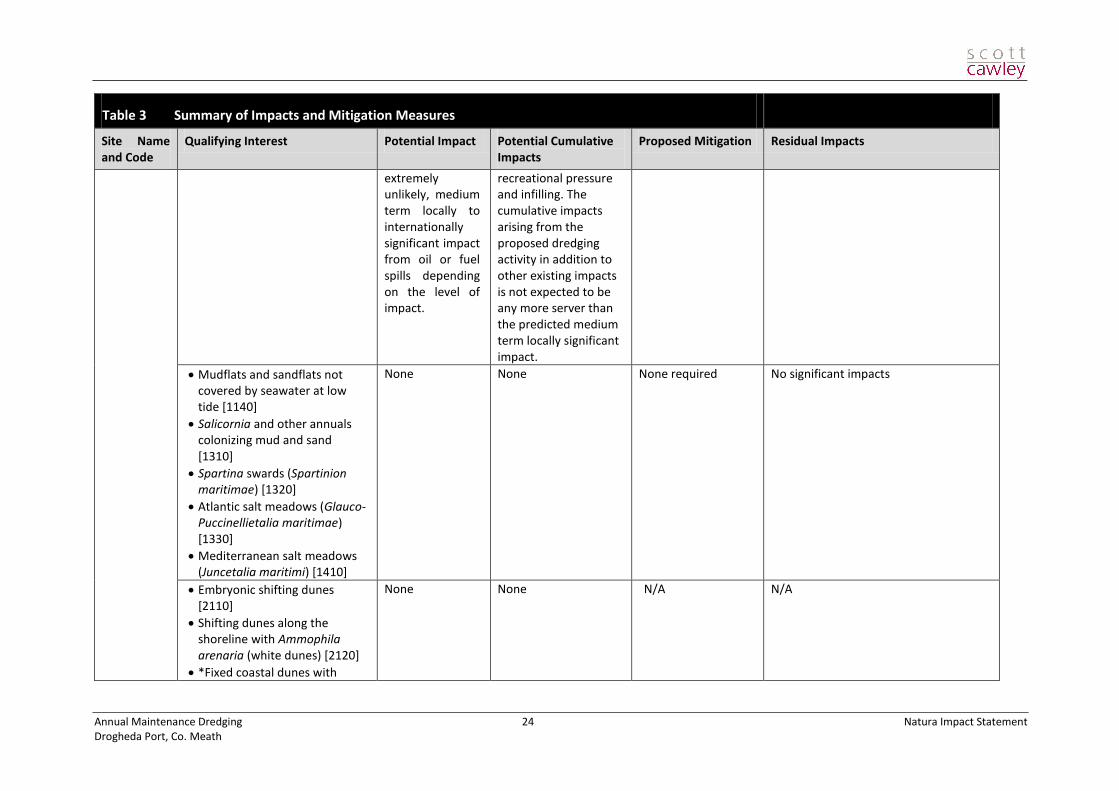
Table 3 Summary of Impacts and Mitigation Measures
Site Name and Code
Qualifying Interest Potential Impact Potential Cumulative Impacts
Proposed Mitigation Residual Impacts
candidate Special Areas of Conservation
River Boyne and River Blackwater cSAC 2299
Alkaline fens [7230] None None None required No significant impacts
*Alluvial forests with Alnus glutinosa and Fraxinus excelsior (Alno‐Padion, Alnion incanae, Salicion albae) [91E0]
None None None required No significant impacts
Atlantic Salmon Salmo salar (only in fresh water) [1106]
No significant impacts but potential for extremely unlikely, medium term locally to internationally significant impact from oil or fuel spills depending on the level of impact.
There are current pressures on water quality arising from drainage and water pollution but as the impacts arising from the proposal are not significant (other than in the extremely unlikely case of a spill accident) the proposed development is not expected to have any significant cumulative impact in addition to current impacts.
The dredging regime will employ measures to minimise the release of suspended particulate matter within the water column.
No significant impacts
River Lamprey Lampetra fluviatilis [1099]
Emergency spill kit and oil spill containment equipment will be held on board by the dredging operator.
Otter Lutra lutra [1355] The Drogheda Port Company will ensure there is pollution response capability and will implement an emergency response plan in the event of an incident.
Boyne Coast and Estuary cSAC 1957
Estuaries [1130]
Medium term locally significant impact and potential for
There are current pressures on water quality arising from water pollution,
None possible. No significant impacts
Annual Maintenance Dredging 24 Natura Impact Statement Drogheda Port, Co. Meath
Table 3 Summary of Impacts and Mitigation Measures
Site Name and Code
Qualifying Interest Potential Impact Potential Cumulative Impacts
Proposed Mitigation Residual Impacts
extremely unlikely, medium term locally to internationally significant impact from oil or fuel spills depending on the level of impact.
recreational pressure and infilling. The cumulative impacts arising from the proposed dredging activity in addition to other existing impacts is not expected to be any more server than the predicted medium term locally significant impact.
Mudflats and sandflats not covered by seawater at low tide [1140]
Salicornia and other annuals colonizing mud and sand [1310]
Spartina swards (Spartinion maritimae) [1320]
Atlantic salt meadows (Glauco-Puccinellietalia maritimae) [1330]
Mediterranean salt meadows (Juncetalia maritimi) [1410]
None None None required No significant impacts
Embryonic shifting dunes [2110]
Shifting dunes along the shoreline with Ammophila arenaria (white dunes) [2120]
*Fixed coastal dunes with
None None N/A N/A

Annual Maintenance Dredging 25 Natura Impact Statement Drogheda Port, Co. Meath
Table 3 Summary of Impacts and Mitigation Measures
Site Name and Code
Qualifying Interest Potential Impact Potential Cumulative Impacts
Proposed Mitigation Residual Impacts
herbaceous vegetation (grey dunes) [2130]
Special Protection Areas
Boyne Estuary SPA 4080
[wintering] Shelduck
[wintering] Oystercatcher
[wintering] Grey Plover
[wintering] Lapwing
[wintering] Knot
[wintering] Sanderling
[wintering] Black-tailed Godwit
[wintering] Redshank
[wintering] Turnstone
None None None required No significant impacts
[breeding ] Little Tern None None None required No significant impacts
Wetlands & Waterbirds None None None required No significant impacts
River Boyne and River Blackwater SPA 4232
Kingfisher None None None required No significant impacts
River Nanny and Estuary SPA 4158
[wintering] Oystercatcher
[wintering] Ringed Plover
[wintering] Knot
[wintering] Sanderling
None None None required No significant impacts
Wetlands & Waterbirds None None N/A N/A

Annual Maintenance Dredging 26 Natura Impact Statement Drogheda Port, Co. Meath
6 Conclusions of Assessment Process
As confirmed in the checklist in Table 4 below, all of the potential impacts identified will be avoided with the correct implementation of the proposed mitigation measures. As there are no significant residual negative
impacts on any of the conservation objectives of any Natura 2000 sites, it is concluded that the proposals will not have a significant negative impact on any Natura 2000 site.
Table 4 Integrity of Site in Relation to Residual Impacts
Does the project have the potential to: Yes or No
Details
cause delays in progress towards achieving the conservation objectives of the site?
No No significant residual negative impacts
interrupt progress towards achieving the conservation objectives of the site?
No No significant residual negative impacts
disrupt those factors that help to maintain the favourable conditions of the site?
No No significant residual negative impacts
interfere with the balance, distribution and density of key species that are the indicators of the favourable condition of the site?
No No significant residual negative impacts
cause changes to the vital defining aspects (e.g. nutrient balance) that determine how the site functions as a habitat or ecosystem?
No No significant residual negative impacts
change the dynamics of the relationships (between, for example, soil and water or plants and animals) that define the structure and/or function of the site?
No No significant residual negative impacts
interfere with predicted or expected natural changes to the site (such as water dynamics or chemical composition)?
No No significant residual negative impacts
reduce the area of key habitats? No No significant residual negative impacts
reduce the population of key species? No No significant residual negative impacts
change the balance between key species? No No significant residual negative impacts
reduce diversity of the site? No No significant residual negative impacts
result in disturbance that could affect population size or density or the balance between key species?
No No significant residual negative impacts
result in fragmentation? No No significant residual negative impacts
result in loss or reduction of key features (e.g. tree cover, tidal exposure, annual flooding, etc.)?
No No significant residual negative impacts

Annual Maintenance Dredging 27 Natura Impact Statement Drogheda Port, Co. Meath
Due to the location of the proposed dredging activities within Natura 2000 sites in the Boyne estuary, and close to other Natura 2000 sites, it is necessary that the proposal be subject to an Appropriate Assessment of the potential for impacts upon these sites.
This report has been prepared for the purpose of providing the competent authority with adequate information to undertake the Appropriate Assessment.
As a result of the appropriate design of the proposed activities and the proposed mitigation measures, this report concludes that the proposed development will have no significant residual impacts on the integrity of the Natura 2000 sites.

Annual Maintenance Dredging 28 Natura Impact Statement Drogheda Port, Co. Meath
7 References
Aquatic Services Unit (2006). Drogheda Port development, proposed capital dredging scheme: Aquatic ecology impact assessment.
DoEHLG (2010) Appropriate Assessment of Plans and Projects in Ireland - Guidance for Planning Authorities (Department of Environment, Heritage and Local Government, Rev Feb 2010)
Eastern River Basin District (2009) Eastern River Basin District Management Plan 2010.
European Commission (2000). Communication from the Commission on the precautionary principle
European Commission (2001) Assessment of Plans and Projects Significantly Affecting Natura 2000 sites: Methodological Guidance on the Provisions of Article 6(3) and (4) of the Habitats Directive 92/43/EEC (European Commission Environment Directorate-General,);
European Commission (2000) Managing Natura 2000 sites: The Provisions of Article 6 of the Habitat’s Directive 92/43/EEC (EC Environment Directorate-General, 2000); hereinafter referred to as “MN2000”
Environmental Protection Agency (2002). Guidelines on the information to be contained in Environmental Impact Statement. Wexford: Environmental Protection Agency. Available at: http://www.epa.ie/downloads/advice/ea/guidelines/epa_guidelines_eis_2002.pdf
Environmental Protection Agency (2011). EPA ENVision Service (internet-based environmental information portal). Available online at: http://maps.epa.ie/internetmapviewer/mapviewer.aspx [Accessed 14th February 2011]
Geological Survey of Ireland (2011). GSI Datasets Public Viewer. Available online at http://www.gsi.ie/Mapping.htm [Accessed 14th February 2011]
Institute of Ecology and Environmental Management (2006). Guidelines for Ecological Impact Assessment. Institute of Ecology and Environmental Management
Malone O’Regan (2006). EIS of Proposed Capital Dredging Scheme at River Boyne, Drogheda Port, Drogheda, Co. Louth.
National Parks & Wildlife Service (2008). Status of EU Protected Habitats in Ireland
NPWS Circular NPW 1/10 & PSSP 2/10 Appropriate Assessment under Article 6 of the Habitats Directive: Guidance for Planning Authorities. (Department of Environment, Heritage and Local Government, March 2010);
National Roads Authority (NRA) 2009. Guidelines for Assessment of Ecological Impacts of National Road Schemes.
NRA 2005-2009. Environmental Construction Guidelines Series, available online at
http://www.nra.ie/Publications/Environment/#d.en.3463 [Accessed December 2010]
O’Connor W. (2006) A survey of juvenile lamprey populations in the Boyne Catchment. Irish Wildlife Manuals, No. 24 National Parks and Wildlife Service, Department of Environment, Heritage and Local Government, Dublin, Ireland.