Appropriate Assessment Natura Impact Statement · Charlestown / Bellaghy Sewerage Scheme Natura...
54
Appropriate Assessment Natura Impact Statement On the Charlestown / Bellaghy Sewerage Scheme ______________________________________________________ In accordance with Article 6(3) and 6(4) of the Council Directive 92/43/EEC on the conservation of natural habitats and of wild flora and fauna (Habitats Directive) Mayo County Council December 2013 For inspection purposes only. Consent of copyright owner required for any other use. EPA Export 30-09-2014:23:33:36
Transcript of Appropriate Assessment Natura Impact Statement · Charlestown / Bellaghy Sewerage Scheme Natura...

Appropriate Assessment
Natura Impact Statement
On the
Charlestown / Bellaghy Sewerage Scheme
______________________________________________________
In accordance with Article 6(3) and 6(4) of the Council Directive 92/43/EEC on the conservation of natural habitats and of wild flora and
fauna (Habitats Directive)
Mayo County Council December 2013
For
insp
ectio
n pur
pose
s only
.
Conse
nt of
copy
right
owne
r req
uired
for a
ny ot
her u
se.
EPA Export 30-09-2014:23:33:36
Includes Ordnance Survey Ireland data reproduced under OSi Licence number 2013/17 CCMA / Mayo County Council.
Unauthorised reproduction infringes Ordnance Survey Ireland and Government of Ireland
copyright.
© Ordnance Survey Ireland, 2013
For
insp
ectio
n pur
pose
s only
.
Conse
nt of
copy
right
owne
r req
uired
for a
ny ot
her u
se.
EPA Export 30-09-2014:23:33:36

Table of Contents
1 Introduction 1
1.1 Background 1
1.2 Legislation and biodiversity impact assessment 1
1.3 Appropriate Assessment 2
2 Appropriate Assessment Screening 4
2.1 Stages of screening 4
2.2 Is the proposed project directly connected to the Natura 2000 site(s) 4
2.3 Description of proposed project and ‘alone & in-combination’ plans and
projects
4
2.4 Identification of Potential Effects on the Natura 2000 Network 6
2.5 Significance of Effects on Natura 2000 site 12
2.6 Screening Conclusion 14
3 Appropriate Assessment 15
3.1 Introduction 15
3.2 Consultation 15
3.3 Existing Ecological Baseline Data 15
3.3.1 Detailed Examination of the River Moy cSAC 16
3.3.2 Other Protected Species in Proximity to the Proposed Project 17
3.3.3 Field Survey 17
3.4 Conservation Objectives 22
3.5 Impact Prediction 25
3.6 Mitigation Measures 33
4 Conclusion of NIS 39
References 40
Appendix I
Appendix II
Appendix III
Appendix IV
I
VI
VII
VIII
For
insp
ectio
n pur
pose
s only
.
Conse
nt of
copy
right
owne
r req
uired
for a
ny ot
her u
se.
EPA Export 30-09-2014:23:33:36

For
insp
ectio
n pur
pose
s only
.
Conse
nt of
copy
right
owne
r req
uired
for a
ny ot
her u
se.
EPA Export 30-09-2014:23:33:36

Glossary and acronyms
GIS: Geographical Information System
HDA: Habitats Directive Assessment, an assessment undertaken in accordance with Article 6(3) and
6(4) of the Habitats Directive (Council Directive 92/43/EEC of 21 May 1992 on the conservation of
natural habitats and of wild fauna and flora) of the implications of a plan or project, either on its own
or in combination with other plans or projects, on the integrity of a Natura 2000 site in view of the
conservation objectives of that site
LBA: Local Biodiversity Areas
Natura 2000 Network: The assemblage of sites which are identified as Special Areas of Conservation
(SAC) under the Habitats Directive or classified as Special Protection Areas (SPAs) under the Birds
Directive 79/409/EEC, or a Site of Community Importance (SCI)
NHA: Natural heritage area(s); an area which has been designated as such by way of a Natural
Heritage Order under Section 18 of the Wildlife (Amendment) Act 2000, or that, pending a decision
by the Minister under section 17 or 18 of the Act, is subject of a notice under Section 16 of that Act
NIR: Natura Impact Report; the report prepared following Appropriate Assessment of Natura 2000
sites as required under the Habitats Directive which presents information on the assessment and the
process of collating data on a plan and its potential significant impacts on Natura 2000 site(s).
NIS: Natura Impact Statement; the statement prepared following Appropriate Assessment of Natura
2000 sites as required under the Habitats Directive which presents information on the assessment
and the process of collating data on a project and its potential significant impacts on Natura 2000
site(s).
SEA: Strategic environmental assessment; a systematic process of predicting and evaluating the likely
environmental effects of implementing a plan, or other strategic action, in order to ensure that these
effects are appropriately addressed at the earliest appropriate stage of decision-making on a par with
economic and social considerations
WFD: Directive 2000/60/EC of the European Parliament and of the Council of 23 October 2000
establishing a framework for Community action in the field of water policy (the Water Framework
Directive)
WRBD: Western River Basin District; one of eight River Basin Districts which have been designated
as hydrological or geographical units for Ireland (Ecoregion 17) using a spatial management system.
For
insp
ectio
n pur
pose
s only
.
Conse
nt of
copy
right
owne
r req
uired
for a
ny ot
her u
se.
EPA Export 30-09-2014:23:33:36

List of figures and maps
Figure 1.1 Appropriate Assessment Stages
Figure 2.1 Location of Charlestown / Bellaghy Wastewater Treatment Plant, the proposed
discharge outfall, recorded protected species and the River Moy cSAC
Figure 2.2 Proposed project (Charlestown / Bellaghy WWTP and new primary outfall), 15
km buffer zone and relevant Natura 2000 sites
Figure 3.1 Surface water status in the vicinity of the proposed project
Figure 3.2 Habitat map identifying land use within the study area
List of Tables
Table 2.1 Information pertaining to the Natura 2000 sites within 15 km of the proposed
project
Table 2.2 Potential effects on the integrity of Natura 2000 site(s) arising from the proposed
project
Table 2.3 Likely changes to the integrity of Natura 2000 site(s) by virtue of the proposed
project
Table 2.4 Indicators of significance of effects from the proposed project
Table 3.1 Rare and Protected bird species within 10 km of proposed project
Table 3.2 Conservation status of River Moy cSAC qualifying interests and their national
status
Table 3.3 Prediction of impacts on each qualifying interest of the River Moy cSAC as a
consequence of the proposed project
Table 3.4 Mitigation Measures prescribed for the offset, reduction or negation of significant
effects on the River Moy cSAC
For
insp
ectio
n pur
pose
s only
.
Conse
nt of
copy
right
owne
r req
uired
for a
ny ot
her u
se.
EPA Export 30-09-2014:23:33:36
Charlestown / Bellaghy Sewerage Scheme Natura Impact Statement
______________________________________________________________________
Page 1 of 54
1 Introduction
1.1 Background
This Natura Impact Statement pertains to the upgrade of the existing Charlestown / Bellaghy sewerage scheme to treat a capacity of 3000 population equivalent (PE). Charlestown (Co. Mayo) and Bellaghy (Co. Sligo) are currently served by a partially combined wastewater treatment collection system and wastewater treatment plant (WWTP) with secondary treatment. The WWTP, discharging final effluent to the Mullaghanoe River, is located in Bellaghy, while much of the existing infrastructure is located in Charlestown. The partially-combined sewers incorporate a number of stormwater overflows that spill to local watercourses, including the Mullaghanoe River. The existing WWTP is considered to be over capacity and cannot cater sufficiently for the existing population. This, in addition to its environmentally-sensitive location (adjacent to a tributary of the River Moy), indicates that the WWTP upgrade is an essential project. The final effluent of the WWTP is proposed to be of 20:30 quality standard, with an aim to achieve ELVs for nutrients of 1.5 mg/L NH3 and 0.9 mg/L ortho-P respectively and with the proposed outfall to be relocated north of the existing one, at a confluence of the Mullaghanoe and Black Rivers.
1.2 Legislation and biodiversity impact assessment
An assessment in accordance with Articles 6(3) and 6(4) EU Habitats Directive 92/43/EEC was undertaken. This Natura Impact Statement is prepared to ensure that the proposed project and particulars, alone or in-combination with other plans or projects, will not have significant impacts on the integrity of the Natura 2000 sites within or adjacent to the proposed project area, in view of the sites’ conservation objectives. From a legislative viewpoint, the Council Directive 92/43/EEC of 21 May 1992 on the conservation of natural habitats and of wild fauna and flora (henceforth referred to as the Habitats Directive) was introduced, primarily, to promote sustainable development within EU member states while concurrently maintaining, or whenever necessary, restoring the favourable conservation status of natural habitats and species as defined within the legislation. The Habitats Directive was transposed into Irish legislation by the European Communities (Natural Habitats) Regulations, 1997 (S.I. No. 94/1997) and subsequently amended in 1998 and 2005. However, in order to address transposition issues raised in judgements of the ECJ against Ireland in 2008 and to clarify the obligations of planning authorities under the Birds and Habitats Directives, the European Communities (Birds and Natural Habitats) Regulations, 2011 were introduced and now provide the legislative framework in Ireland on the protection of designated habitats and species. The designation or classification of sites are done so under the provision of the Natura 2000 network; essentially a list of sites which are deemed of particular importance in terms of rare, endangered or vulnerable habitats and / or species. In Ireland, Natura 2000 sites include candidate Special Areas of Conservation (cSAC)1, Special Protection Areas (SPA), and proposed Special Protection Areas (pSPA). cSACs pertain to qualifying interests which are habitats in Annex I and species listed in Annex II of the Habitats Directive, while SPAs are selected for special conservation interests including regularly occurring migratory bird species and Annex I bird species and their habitats. The conservation objectives of particular Natura 2000 sites have been assigned by the National Parks and Wildlife Service (NPWS) of the Department of Arts, Heritage and the Gaeltacht; these are the objectives or aims which have been put in place in order to maintain or restore the favourable conservation status or condition of the Annex I habitat or Annex I or II species for which the designated or classified site has been selected.
1 It should be stated at this point that all SACs in Ireland are currently candidate SACs but this does not alter or influence the sites’ full protection by law
For
insp
ectio
n pur
pose
s only
.
Conse
nt of
copy
right
owne
r req
uired
for a
ny ot
her u
se.
EPA Export 30-09-2014:23:33:36

Charlestown / Bellaghy Sewerage Scheme Natura Impact Statement
______________________________________________________________________
Page 2 of 54
From the viewpoint of appropriate assessment, Articles 6(3) and 6(4) of the Habitats Directive subsumes assessment responsibility for the Birds Directive (2009/147/EC) under the umbrella of Natura 2000 sites (European sites or sites within the Natura 2000 network), which include both Special Areas of Conservation (SACs) and Special Protection Areas (SPAs), while nationally, appropriate assessment is dealt with in Part 5 of the European Communities (Birds and Natural Habitats) Regulations, 2011.
1.3 Appropriate Assessment
The Habitats Directive introduced the concept of appropriate assessment which is essentially the assessment of the implications of a plan or project, either on its own or in combination with other plans or projects, on the integrity of a Natura 2000 site in view of the conservation objectives of that site. Specifically Article 6(3) and 6(4) of the aforementioned directive govern the particulars of the concepts and terminology of appropriate assessments as follows: Article 6(3) – Any plan or project not directly connected with or necessary to the management of the site but likely to have a significant effect thereon, either individually or in combination with other plans or projects, shall be subject to appropriate assessment of its implications for the site in view of the site's conservation objectives. In the light of the conclusions of the assessment of the implications for the site and subject to the provisions of paragraph 4, the competent national authorities shall agree to the plan or project only after having ascertained that it will not adversely affect the integrity of the site concerned and, if appropriate, after having obtained the opinion of the general public. Article 6(4) - If, in spite of a negative assessment of the implications for the site and in the absence of alternative solutions, a plan or project must nevertheless be carried out for imperative reasons of overriding public interest, including those of a social or economic nature, the Member State shall take all compensatory measures necessary to ensure that the overall coherence of Natura 2000 is protected. It shall inform the Commission of the compensatory measures adopted. Where the site concerned hosts a priority natural habitat type and/or a priority species, the only considerations which may be raised are those relating to human health or public safety, to beneficial consequences of primary importance for the environment or, further to an opinion from the Commission, to other imperative reasons of overriding public interest. This Natura Impact Statement was prepared for the proposed upgrade to the Charlestown / Bellaghy Wastewater Treatment Plant and associated relocation of the primary outfall with reference to the following European, national and DEHLG guidance documents on Appropriate Assessment:
o Appropriate Assessment of Plans and Projects in Ireland, Guidance for Planning Authorities. DoEHLG, 2009;
o Assessment of plans and projects significantly affecting Natura 2000 sites; Methodological Guidance on the provisions of Articles 6(3) and (4) of the Habits Directive 92/43/EEC. European Commission, 2002;
o Department of Environment, Heritage and Local Government Circular Letter PD 2/07 and NPWS 1/07, 2007;
o Department of Environment, Heritage and Local Government Circular Letter SEA 1/08 and NPWS 1/08, February 2008;
o Department of Environment, Heritage and Local Government Circular NPW 1/10 & PSSP 2/10, 2010;
o EPA, 2010. Integrated Biodiversity Impact Assessment; Streamlining AA, SEA and EIA process. Best Practice Guidance 2010-B-DS-4 STRIVE Report;
o EPA, 2012. Waste Water Discharge Licensing Appropriate Assessment (Version 2.2) Environmental Protection Agency; and
For
insp
ectio
n pur
pose
s only
.
Conse
nt of
copy
right
owne
r req
uired
for a
ny ot
her u
se.
EPA Export 30-09-2014:23:33:36

Charlestown / Bellaghy Sewerage Scheme Natura Impact Statement
______________________________________________________________________
Page 3 of 54
o Managing Natura 2000 Sites, The provisions of Article 6 of the ‘Habitats’ Directive 92/43/EEC. European Commission, 2000.
The following flow diagram summarises the principle stages involved in the Appropriate Assessment (AA) process and follows the commission’s methodical guidance which promotes a four-stage process:
Figure 1.1 Appropriate Assessment Stages
Essentially, the AA process is an iterative one and the outcome at each successive stage determines whether a further stage in the process is required. To summarise, while the first two stages (1 and 2) focus on the proposed project and its potential adverse effects on the conservation objectives of the Natura 2000 Network, Stage 3 examines alternative solutions to prevent adverse impacts on the integrity of Natura 2000 sites. Stage 4 of the AA, also deemed a derogation process, is employed when it has been established that the draft plan or project will have adverse impacts on the Natura 2000 sites, but no less damaging alternative solution exists.
Examine whether a plan / project can be excluded from AA requirements because the site is directly connected with or necessary to the management of the Natura 2000 site, or; Examine the potential effects of a plan / project (alone or in combination) on a Natura 2000 site in view of its conservation objectives and determine whether or not these will be significant, applying the precautionary principle
Preparation of Natura Impact Statement (NIS) and determination whether the project will adversely affect the integrity of the Natura 2000 sites, alone or in combination with other plans and projects; Detailed description of proposed project, Natura 2000 site(s), sites’ qualifying interests and conservation objectives, and appropriate mitigation measures to offset adverse effects on the integrity of the site(s) are included
Examine any / all alternative solutions which will enable project to proceed without adverse impacts on the integrity of the Natura 2000 site. (Alternative options will need to be returned to Stage 2). The least damaging option, once all alternatives have been considered, must be examined under Stage 4
Stage 1 Screening for Appropriate
Assessment
Stage 4 Imperative Reasons for Overriding Public Interest
Stage 2 Appropriate Assessment
Stage 3 Alternative Solutions
The derogation process under Article 6(4) which examines whether there are imperative reasons for overriding public interest (IROPI) for a project to
proceed when no less damaging alternatives exist
For
insp
ectio
n pur
pose
s only
.
Conse
nt of
copy
right
owne
r req
uired
for a
ny ot
her u
se.
EPA Export 30-09-2014:23:33:36
Charlestown / Bellaghy Sewerage Scheme Natura Impact Statement
______________________________________________________________________
Page 4 of 54
2 Appropriate Assessment Screening
2.1 Stages of screening
Forming the basis of AA, screening is the introductory stage which yields important information regarding the project in question and whether it, on its own or in combination with other plans or projects has implications for Natura 2000 site(s) in view of the sites’ conservation objectives. Screening, then, is an integral part of the AA process since it, applying the precautionary principle and utilising existing information, in addition to advice from relevant statutory bodies, is the decision stage for continuation with a full appropriate assessment and Natura Impact Statement (NIS) due to the likelihood, uncertainty or certainty of significant effects or termination of the process at the screening stage due to a finding of no significant effects. The screening process in this document consists of four separate steps, with each step following into the next. The steps include:
1. A determination of whether the project or plan is directly connected with or necessary to the management of the site;
2. Description of the proposed project and the description and characterisation of other projects or plans that in combination have the potential for having significant effects on the Natura 2000 site(s);
3. Identification of the potential effects on the Natura 2000 site(s); and 4. Assessment of the significance of effects on the Natura 2000 site(s).
2.2 Is the proposed project directly connected to the Natura 2000 site(s)
The proposed project is not deemed to be directly connected with or necessary to the management of the Natura 2000 site(s) it will not include management measures specifically for conservation purposes that are solely conceived for the conservation management of a Natura 2000 site(s) and not direct or indirect consequences of other activities. As a consequence of this conclusion, this screening assessment advances to Step 2.
2.3 Description of proposed project and ‘alone and in combination’ plans and projects The proposed project is an essential upgrade of the existing Charlestown / Bellaghy sewerage scheme to treat a capacity of 3000 PE with the relocation of the primary outfall downstream of the confluence of the Mullaghanoe and Black Rivers. Currently, storm overflows and treated effluent is discharged to the Mullaghanoe River, a tributary of the River Moy and part of the River Moy cSAC in addition to a salmonid river in accordance with the First Schedule of European Communities (Quality of Salmonid Waters) Regulations, 1988 (S.I No. 293/1988). The proposed development, with inclusion of storm water facilities, is anticipated to enhance the quality of the effluent as a consequence of this upgrade. However, the relocation of the primary outfall has potential for effects on the Natura 2000 network during its construction and also operation, simply due to the discharge of treated effluent at a new location within the River Moy cSAC. Therefore, for the purpose of the current report, there are three elements to the proposed project which must be examined for their potential effects on the Natura 2000 network during construction and / or operation; the upgrade to the Charlestown / Bellaghy WWTP, the construction of a primary outfall at a new location and the discharge of treated effluent at a new location (operation).
For
insp
ectio
n pur
pose
s only
.
Conse
nt of
copy
right
owne
r req
uired
for a
ny ot
her u
se.
EPA Export 30-09-2014:23:33:36

Charlestown / Bellaghy Sewerage Scheme Natura Impact Statement
______________________________________________________________________
Page 5 of 54
Figure 2.1 Location of Charlestown / Bellaghy Wastewater Treatment Plant, the proposed discharge
outfall, recorded protected species and the River Moy cSAC
In-combination effects from other plans and projects were also addressed.
Existing plans and projects which were examined include:
o Mayo County Development Plan 2008 – 2014 and Variations No. 2 and No. 3 to the Mayo County Development Plan 2008 – 2014;
o Draft Mayo County Development Plan 2014-2020; o Charlestown Area Plan 2014-2020 (integrated into draft Mayo County Development Plan
2014-2020); o Western River Basin Management Plan 2009 – 2015; o Moy Water Management Unit Action Plan; o Biodiversity Action Plan 2010 – 2015; o Existing Charlestown / Bellaghy Wastewater Treatment Plant; and o Individual Planning Applications
The above plans have been assessed in accordance with Article 6(3) of the Habitats Directive and Part XAB of the Planning and Development Act, 2000 and are not envisaged to result in significant effects on the integrity of the Natura 2000 network. In accordance with legislative requirements and the objectives of the County Mayo Development Plan, all local planning applications are assessed on a case-by-case basis for their potential to result in significant effects on the environment and the integrity of the Natura 2000 network and whenever necessary, mitigation measures are proposed to prevent / offset significant effects. Their assessment also examined in-combination effects from other plans or projects on one or more Natura 2000
For
insp
ectio
n pur
pose
s only
.
Conse
nt of
copy
right
owne
r req
uired
for a
ny ot
her u
se.
EPA Export 30-09-2014:23:33:36

Charlestown / Bellaghy Sewerage Scheme Natura Impact Statement
______________________________________________________________________
Page 6 of 54
site(s) and projects included proposed infrastructural projects, residential housing and other small-scale projects / works. The existing Charlestown / Bellaghy Wastewater Treatment Plant (WWTP) is identified as a project whose effects, in-combination with the proposed project may contribute to significant effects, in that the WWTP, while in operation, is discharging treated effluent to the Mullaghanoe River, in addition to six storm overflows. Consequently, there is potential for adverse in-combination effects as a consequence of the operating WWTP in addition to the proposed construction works at the WWTP, construction of the new primary outfall and proposed treated effluent discharge from the new primary outfall.
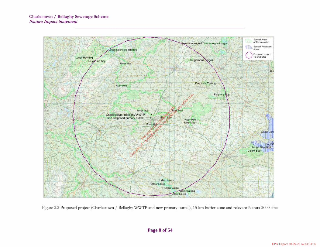
2.4 Identification of Potential Effects on the Natura 2000 Network Assigning a 15 km buffer / zone of influence around the Charlestown / Belleghy WWTP and proposed new primary outfall in consideration of the 2009 DoEHLG guidelines on Appropriate Assessment of Plans and Projects in Ireland, Guidance for Planning Authorities and expert judgement2, a total of eight Natura 2000 sites are identified within the 15 km zone of influence. These have been designated in consideration of the EU Habitats Directive Annex I habitats and Annex II species. The following table illustrates the Natura 2000 sites considered for the purpose of this assessment and also provides data on their qualifying interests which may be potentially affected by the proposed project. The eight candidate Special Areas of Conservation (cSAC) within the proposed project 15 km buffer zone are also shown in Figure 2.2.
Table 2.1 Information pertaining to the Natura 2000 sites within 15 km of the proposed project
Site code Natura 2000
Site Name
Date of designation
(as SCI)
Qualifying interests (qualifying interest code in square brackets [ ], *
denotes priority habitat)
002298 River Moy cSAC April 2003 [1092] Austropotamobius pallipes [1095] Petromyzon marinus [1096] Lampetra planeri [1106] Salmo salar (only in fresh water) [1355] Lutra lutra [7110] * Active raised bogs [7120] Degraded raised bogs still capable of natural regeneration [7150] Depressions on peat substrates of the Rhynchosporion [7230] Alkaline fens [91A0] Old sessile oak woods with Ilex and Blechnum in the British Isles [91E0] * Alluvial forests with Alnus glutinosa and Fraxinus excelsior
(Alno‐Padion, Alnion incanae, Salicion albae)
000492 Doocastle Turlough cSAC
November 1997 [3180] * Turloughs
2 A distance of 15 km is currently recommended in the case of plans, derived from UK guidance and general methodology.
For
insp
ectio
n pur
pose
s only
.
Conse
nt of
copy
right
owne
r req
uired
for a
ny ot
her u
se.
EPA Export 30-09-2014:23:33:36

Charlestown / Bellaghy Sewerage Scheme Natura Impact Statement
______________________________________________________________________
Page 7 of 54
000497
Flughany Bog cSAC
May 1998 [7110] * Active raised bogs [7120] Degraded raised bogs still capable of natural regeneration [7150] Depressions on peat substrates of the Rhynchosporion
000633 Lough Hoe Bog cSAC
May 1998 [1013] Vertigo geyeri [1092] Austropotamobius pallipes [3110] Oligotrophic waters containing very few minerals of sandy plains (Littorelletalia uniflorae) [7130] Blanket bogs (* if active only)
001571 Urlaur Lakes cSAC
May 1998 [3140] Hard oligo‐mesotrophic waters with benthic vegetation of Chara spp.
000634 Lough Nabrickkeagh Bog cSAC
November 1997 [7130] Blanket bogs (* if active only)
000637 Turloughmore (Sligo) cSAC
November 1997 [3180] * Turloughs
000604 Derrinea Bog cSAC
November 1997 [7110] * Active raised bogs [7120] Degraded raised bogs still capable of natural regeneration [7150] Depressions on peat substrates of the Rhynchosporion
For
insp
ectio
n pur
pose
s only
.
Conse
nt of
copy
right
owne
r req
uired
for a
ny ot
her u
se.
EPA Export 30-09-2014:23:33:36
Charlestown / Bellaghy Sewerage Scheme Natura Impact Statement
______________________________________________________________________
Page 8 of 54
Figure 2.2 Proposed project (Charlestown / Bellaghy WWTP and new primary outfall), 15 km buffer zone and relevant Natura 2000 sites
For
insp
ectio
n pur
pose
s only
.
Conse
nt of
copy
right
owne
r req
uired
for a
ny ot
her u
se.
EPA Export 30-09-2014:23:33:36

Charlestown / Bellaghy Sewerage Scheme Natura Impact Statement
______________________________________________________________________
Page 9 of 54
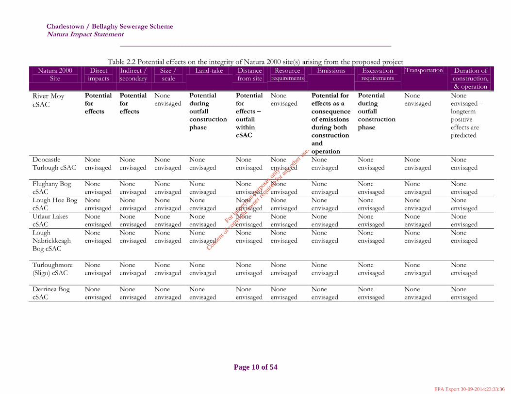
As shown in Table 2.1, a number of Annex I habitats and Annex II species which may be adversely impacted by environmental change or deterioration as a consequence of the proposed project are identified in this assessment. From an ecological perspective, the identification of effects on Natura 2000 sites from a proposed project is conducted using a source-pathway-receptor model, where in order for an effect to occur, there must be a risk enabled by a source and receptor – and a pathway between them. The absence or removal of one of the elements of the model is sufficient to conclude that an effect is not likely to occur. The following screening matrices have been completed with reference to the format of Figure 1, Annex 2 of Assessment of plans and projects significantly affecting Natura 2000 sites; Methodological Guidance on the provisions of Articles 6(3) and (4) of the Habits Directive 92/43/EEC (EC, 2002) to illustrate the assessment of potential effects on the integrity of Natura 2000 sites by virtue of the proposed project. Table 2.2 describes the effects on the integrity of each of the Natura 2000 sites as a consequence of the proposed project, at all stages and Table 2.3 describes the likely changes to the integrity of the Natura 2000 sites, by virtue of the proposed project.
For
insp
ectio
n pur
pose
s only
.
Conse
nt of
copy
right
owne
r req
uired
for a
ny ot
her u
se.
EPA Export 30-09-2014:23:33:36
Charlestown / Bellaghy Sewerage Scheme Natura Impact Statement
______________________________________________________________________
Page 10 of 54
Table 2.2 Potential effects on the integrity of Natura 2000 site(s) arising from the proposed project Natura 2000
Site Direct
impacts Indirect / secondary
Size / scale
Land-take Distance from site
Resource requirements
Emissions Excavation requirements
Transportation Duration of construction, & operation
River Moy cSAC
PPootteennttiiaall
ffoorr
eeffffeeccttss
PPootteennttiiaall
ffoorr
eeffffeeccttss
None envisaged
Potential during outfall construction phase
Potential for effects – outfall within cSAC
None envisaged
PPootteennttiiaall ffoorr
eeffffeeccttss aass aa
ccoonnsseeqquueennccee
ooff eemmiissssiioonnss
dduurriinngg bbootthh
ccoonnssttrruuccttiioonn
aanndd
ooppeerraattiioonn
Potential during outfall construction phase
None envisaged
None envisaged – longterm positive effects are predicted
Doocastle Turlough cSAC
None envisaged
None envisaged
None envisaged
None envisaged
None envisaged
None envisaged
None envisaged
None envisaged
None envisaged
None envisaged
Flughany Bog cSAC
None envisaged
None envisaged
None envisaged
None envisaged
None envisaged
None envisaged
None envisaged
None envisaged
None envisaged
None envisaged
Lough Hoe Bog cSAC
None envisaged
None envisaged
None envisaged
None envisaged
None envisaged
None envisaged
None envisaged
None envisaged
None envisaged
None envisaged
Urlaur Lakes cSAC
None envisaged
None envisaged
None envisaged
None envisaged
None envisaged
None envisaged
None envisaged
None envisaged
None envisaged
None envisaged
Lough Nabrickkeagh Bog cSAC
None envisaged
None envisaged
None envisaged
None envisaged
None envisaged
None envisaged
None envisaged
None envisaged
None envisaged
None envisaged
Turloughmore (Sligo) cSAC
None envisaged
None envisaged
None envisaged
None envisaged
None envisaged
None envisaged
None envisaged
None envisaged
None envisaged
None envisaged
Derrinea Bog cSAC
None envisaged
None envisaged
None envisaged
None envisaged
None envisaged
None envisaged
None envisaged
None envisaged
None envisaged
None envisaged
For
insp
ectio
n pur
pose
s only
.
Conse
nt of
copy
right
owne
r req
uired
for a
ny ot
her u
se.
EPA Export 30-09-2014:23:33:36

Charlestown / Bellaghy Sewerage Scheme Natura Impact Statement
______________________________________________________________________
Page 11 of 54
Table 2.3 Likely changes to the integrity of Natura 2000 site(s) by virtue of the proposed project Site name Reduction of
habitat area Disturbance to key
species Habitat or species
fragmentation Reduction in
species density Changes in key indicators
of conservation value Climate change
River Moy cSAC Potential for habitat reduction along new outfall route
PPootteennttiiaall ffoorr
ddiissttuurrbbaannccee ttoo
kkeeyy ssppeecciieess
dduurriinngg
ccoonnssttrruuccttiioonn aanndd
ooppeerraattiioonn ((aatt
rreellooccaatteedd pprriimmaarryy
oouuttffaallll))
Potential for fragmentation
dduurriinngg
ccoonnssttrruuccttiioonn aanndd
ooppeerraattiioonn ((aatt
rreellooccaatteedd pprriimmaarryy
oouuttffaallll))
PPootteennttiiaall aatt
rreellooccaatteedd pprriimmaarryy
oouuttffaallll,, sshhoouulldd
AAnnnneexx IIII ssppeecciieess
bbee pprreesseenntt
PPootteennttiiaall ffoorr cchhaannggeess
dduurriinngg ccoonnssttrruuccttiioonn
pphhaassee;; ooppeerraattiioonn pphhaassee
iiss eennvviissaaggeedd ttoo rreessuulltt
iinn iimmpprroovveemmeenntt ttoo kkeeyy
iinnddiiccaattoorrss ooff
ccoonnsseerrvvaattiioonn vvaalluuee ee..gg..
wwaatteerr qquuaalliittyy
None envisaged
Doocastle Turlough cSAC
None envisaged None envisaged None envisaged None envisaged None envisaged None envisaged
Flughany Bog cSAC
None envisaged None envisaged None envisaged None envisaged None envisaged None envisaged
Lough Hoe Bog cSAC
None envisaged None envisaged None envisaged None envisaged None envisaged None envisaged
Urlaur Lakes cSAC None envisaged None envisaged None envisaged None envisaged None envisaged None envisaged Lough Nabrickkeagh Bog cSAC
None envisaged None envisaged None envisaged None envisaged None envisaged None envisaged
Turloughmore (Sligo) cSAC
None envisaged None envisaged None envisaged None envisaged None envisaged None envisaged
Derrinea Bog cSAC
None envisaged None envisaged None envisaged None envisaged None envisaged None envisaged
For
insp
ectio
n pur
pose
s only
.
Conse
nt of
copy
right
owne
r req
uired
for a
ny ot
her u
se.
EPA Export 30-09-2014:23:33:36

Charlestown / Bellaghy Sewerage Scheme Natura Impact Statement
______________________________________________________________________
Page 12 of 54
From the analysis of effects on all eight Natura 2000 sites in addition to an examination of likely changes as a consequence of the proposed project, it was concluded that there is no conceivable likelihood that the proposed project will impact upon the integrity of the Doocastle Turlough cSAC, Flughany Bog cSAC, Lough Hoe Bog cSAC, Urlaur Lakes cSAC, Lough Nabrickkeagh Bog cSAC, Turloughmore (Sligo) cSAC or Derrinea Bog cSAC, in view of the sites’ conservation objectives. This is largely due to the absence of a pathway or hydrological link between the proposed project location and these Natura 2000 sites in addition to the distance involved and the conservative scale of the proposed project. Hence, the only identified ecological receptor for the purpose of this assessment is the River Moy cSAC, of which the Mullaghanoe River is a part. The Charlestown / Bellaghy WWTP currently discharges treated effluent to the Mullaghanoe River and the proposed new outfall will be downstream of the confluence of the Black and Mullaghanoe Rivers, within the River Moy cSAC. Additionally, the WWTP itself, where works are proposed to take place, is just outside Charlestown, adjacent to the main branch of the Mullaghanoe River. It is not certain whether the conservation status of the Annex I habitats for which the River Moy cSAC has been designated will be affected by the proposed project, or is it certain that Annex II species populations will be disturbed, fragmented or reduced as a consequence of the proposed project. However, it should be stated that the Annex II species for which the River Moy cSAC was designated are all aquatic or water-dependant so changes to the water quality of the Mullaghanoe in the vicinity of the WWTP or in the vicinity of the proposed new outfall (Mullaghanoe / Black River confluence) during construction or operation may directly, indirectly, or in a cumulative fashion affect the conservation status or condition of these species and / or their habitats. Additionally, while no priority Annex II species have been designated in Ireland, there are a number of priority Annex I habitats, two of which are within the River Moy cSAC.
2.5 Significance of effects on Natura 2000 sites
The effects on the five Annex II species and six Annex I habitats and their conservation statuses as a consequence of the proposed project were examined in order to determine if, based on the uncertainty, likelihood or certainty of significant effects, the assessment of this proposed project should proceed to a full Appropriate Assessment. A significant effect of a project on a Natura 2000 site according to national guidance on Appropriate Assessment (DoEHLG, 2009) has been described as one which is likely to undermine any of the site’s conservation objectives and typical examples of significant impacts include:
o Loss of Annex I habitat area; o Disturbance to species population density; o Direct / indirect damage to the physical quality of the environment; o Causing serious / ongoing disturbance to habitats for which the Natura 2000 site was
selected; and o Reduction / fragmentation of the habitat area.
The proposed project, as indicated previously and shown in Tables 2.2 and 2.3 has potential to directly, indirectly and cumulatively impact on the integrity of the River Moy cSAC during construction of the upgraded WWTP, construction of and release of treated effluent from the proposed new outfall, during the operation phase, in view of the site’s conservation objectives. This was hypothesised by the presence of a source-pathway-receptor model and the potential for loss, reduction or fragmentation of Annex I habitat area, potential disturbance, loss or fragmentation or reduction of Annex II species density and / or their habitats from noise, emissions and excavation works which are elements of the proposed project.
For
insp
ectio
n pur
pose
s only
.
Conse
nt of
copy
right
owne
r req
uired
for a
ny ot
her u
se.
EPA Export 30-09-2014:23:33:36

Charlestown / Bellaghy Sewerage Scheme Natura Impact Statement
______________________________________________________________________
Page 13 of 54
From an examination of NPWS records of protected species from the MapInfo database of Mayo County Council, in addition to mapping data of the Biodiversity Data Centre (Department of Arts, Heritage and the Gaeltacht), it was concluded that the presence of Austropotamobius pallipes and Lutra lutra have previously been recorded up- and downstream of the proposed project. Their locations are shown in Figure 2.1 in addition to Appendix III. Additionally, since one element of the proposed works will involve the laying of an effluent pipe between the WWTP and the new outfall, there is potential for loss of Annex I habitat, should this habitat be present on the left bank of the Mullaghanoe River. Indirect effects from a deterioration of water quality may occur as a consequence of a new emission at the Mullaghanoe / Black River confluence, in addition to accidental discharges during the construction phase of the proposed project; the upgrade of the Plant and the laying of new outfall pipe. Though the existing Wastewater Treatment Plant site is envisaged to contain the upgraded Plant, there is a necessity to explore the type of habitat present in the vicinity of the Plant, in addition to that where the outfall pipe is to be located.
Table 2.4 Indicators of significance of effects from the proposed project
Indicator of Significance
Elements of Proposed Project – potential significant effects
Likelihood of significance
Loss
River Moy cSAC habitat loss along Mullaghanoe River for the purpose of laying of outfall pipe
Loss of Annex II species at the primary outfall location
Not likely – no Annex I habitat at outfall pipe location
Lutra lutra were recorded at outfall location – species loss is unlikely
Fragmentation
Fragmentation of habitats at location of outfall pipe excavation
Not likely – no Annex I habitat at outfall pipe location
Disruption
Disruption of Annex II species during construction works at WWTP, between Plant and outfall, and during operation (discharge of treated effluent within River Moy cSAC)
Annex II species adjacent to Charlestown / Bellaghy WWTP have likely habituated to noise, disturbance and associated disruption from WWTP; significance from disruption during excavation for pipe-laying in addition to new effluent within cSAC not known
Disturbance
Disturbance of species populations during construction works from machinery, noise, human presence and water quality deterioration during construction and operation
Unknown, dependant on presence of Annex II species and their habitats – holts, couches, spawning beds
Change to key elements of the site e.g. water quality
Siltation of water adjacent to WWTP, discharge of other pollutants to Mullaghanoe along outfall pipe route and discharge of treated effluent at new location downstream of Mullaghanoe / Black River confluence
Significant effects on aquatic and water-dependant Annex II species and their conservation status are probable due to deterioration of water quality during construction and / or operation phases of the proposed project, in the absence of suitable mitigation measures
For
insp
ectio
n pur
pose
s only
.
Conse
nt of
copy
right
owne
r req
uired
for a
ny ot
her u
se.
EPA Export 30-09-2014:23:33:36

Charlestown / Bellaghy Sewerage Scheme Natura Impact Statement
______________________________________________________________________
Page 14 of 54
2.6 Screening Conclusion
It has been demonstrated that the proposed project has a direct hydrological link to one Special Area of Conservation – the River Moy SAC, an ecological receptor. No other SACs are predicted to be affected by the proposed project, due to the lack of a hydrological link, distance from the Natura 2000 sites, size and scale of the proposal or the type of qualifying interests associated with each site. The River Moy SAC, occupying a large area of Mayo and Sligo 154 km2 has been designated in consideration of five Annex II species and six Annex I habitats. As a consequence of the proposed project; to upgrade the Charlestown / Bellaghy WWTP and to relocate the existing primary outfall to a location downstream of the confluence of the Mullaghanoe and Black Rivers, it is concluded that there is uncertainty regarding the likelihood of significant effects on the integrity of the River Moy cSAC in view of the site’s conservation objectives, and, therefore, adopting the precautionary principle, it is deemed necessary to proceed to a full Appropriate Assessment and the examination of the implications for the site in view of its conservation objectives.
For
insp
ectio
n pur
pose
s only
.
Conse
nt of
copy
right
owne
r req
uired
for a
ny ot
her u
se.
EPA Export 30-09-2014:23:33:36

Charlestown / Bellaghy Sewerage Scheme Natura Impact Statement
______________________________________________________________________
Page 15 of 54
3 Appropriate Assessment
3.1 Introduction At Stage 2 Appropriate Assessment, the impact of a project alone and in combination with other projects or plans on the integrity of the Natura 2000 site is considered with respect to the conservation objectives of the site and to its structure and function. Essentially then, the appropriate assessment examines the implications for the site in view of the site’s conservation objectives, once it has been concluded that the potential for significant effects are certain, likely or uncertain. Adopting the precautionary principle in this case, significant effects have been described as uncertain.
Article 6(3) – Any plan or project not directly connected with or necessary to the management of the site but likely to have a significant effect thereon, either individually or in combination with other plans or projects, shall be subject to appropriate assessment of its implications for the site in view of the site's conservation objectives. In the light of the conclusions of the assessment of the implications for the site and subject to the provisions of paragraph 4, the competent national authorities shall agree to the plan or project only after having ascertained that it will not adversely affect the integrity of the site concerned and, if appropriate, after having obtained the opinion of the general public.
3.2 Consultation
Communication was made with both the Western and Northern Regions of the National Parks and Wildlife Service (NPWS) in addition to Inland Fisheries Ireland, the Office of Public Works (OPW) and Sligo County Council. The Western Region District Conservation Officers of the NPWS concurred that, in particular, due to the relocation of the primary outfall, full Appropriate Assessment was considered necessary. Additionally, it was advised that previous works by the Office of Public Works (OPW) along the Mullaghanoe River may have included some ecological surveys which may benefit the current assessment. Since the outfall now falls outside of their jurisdiction in the Northern Region of the NPWS contact was made with Mr. Tim Roderick and Mr. William Cormacan. Advice given was centred on a sighting of Lutra lutra at G477027 (stream north of Charlestown) in November 1980. A data request form was submitted to the NPWS and information pertaining to rare and protected species for the use in a planning application was received. These data have been incorporated into the succeeding section 3.3. The OPW, when contact was made, conceded that works along the Mullaghanoe River (as part of the River Moy) had included a preliminary ecological review and preparation of Natura Impact Statement for the Moy Arterial Drainage Scheme, 2013. The report included records of L. planeri in the Mullaghanoe (in Charlestown and upstream of the town) which concurred with the opinion of the IFI. Sligo County Council was contacted on 25th October 2013 and a discussion with a representative of the IFI in October 2013 provided informative data on recent surveys on lamprey, in addition the their comments on the inclusion of a sampling point at the outfall their preferred option for trenchless techniques for crossing the Mullaghanoe River, where feasible, in lieu of undertaking of in stream works. Additionally, a number of mitigation measures for the protection of all three fish species (S. salar, P. marinus and L. planeri) as well as Salmo trutta (trout) were proposed and are included in Table 3.3.
3.3 Existing Ecological Baseline Data
Much of the proposed project occupies a part of the River Moy cSAC hence a thorough knowledge of the existing ecological baseline of the area was required in order to predict more clearly, the impacts of the proposed project on the surrounding environment. The following data were collated during a desk study and supplemented by a field study undertaken on 18th October 2013.
For
insp
ectio
n pur
pose
s only
.
Conse
nt of
copy
right
owne
r req
uired
for a
ny ot
her u
se.
EPA Export 30-09-2014:23:33:36

Charlestown / Bellaghy Sewerage Scheme Natura Impact Statement
______________________________________________________________________
Page 16 of 54
3.3.1 Detailed Examination of the River Moy cSAC
The River Moy cSAC was designated as eligible as a SCI in April 2003 and occupies a total area of 15396.45 ha (154 km2). Essentially, the cSAC was designated in consideration of five Annex II species and six Annex I habitats, two of which are priority habitats. The River Moy cSAC is in Mayo, Sligo and Roscommon and comprises the entire freshwater element of the River Moy, in addition to a number of tributaries, many of which are designated sensitive areas in accordance with the First Schedule of the EC (Quality of Salmonid Waters) Regulations, 1998 (S.I. No. 293/1988). Currently, the surface water status of the River Moy cSAC in the vicinity of the proposed project can be described as poor. The following map illustrates the proposed project location and the current water body status as described by the Western River Basin District monitoring. Upon examination of the LavyBeg Water Body Report, a number of diffuse and point risk sources have been identified, in addition to the pressure / risk from morphology, as identified in the Moy Water Management Unit Action Plan (IE_WE_34_2464). The risk sources include diffuse sources - morphological (channelisation) and point sources – wastewater treatment plants. The River Moy Water Management Unit (WMU) Action Plan detailed that the Charlestown / Bellaghy WWTP presents a risk to water quality relating to insufficient WWTP capacity, insufficient assimilative capacity and deterioration of Q value downstream of the discharge. It is anticipated that the upgrade of the Charlestown / Bellaghy WWTP with its predicted superior quality effluent will contribute to the long-term improvement of ambient water quality at the location of the WWTP, in addition to producing as good a quality of effluent for discharge at the new outfall.
Figure 3.1 Surface water status in the vicinity of the proposed project
For
insp
ectio
n pur
pose
s only
.
Conse
nt of
copy
right
owne
r req
uired
for a
ny ot
her u
se.
EPA Export 30-09-2014:23:33:36
Charlestown / Bellaghy Sewerage Scheme Natura Impact Statement
______________________________________________________________________
Page 17 of 54
3.3.2 Other Protected Species in Proximity to the Proposed Project
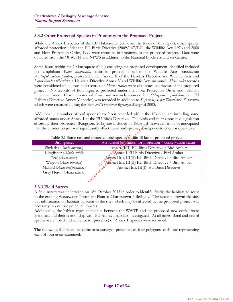
While the Annex II species of the EU Habitats Directive are the focus of this report, other species afforded protection under the EU Birds Directive (2009/147/EC), the Wildlife Acts 1976 and 2000 and Flora Protection Order, 1999 were recorded in proximity to the proposed project. Data were obtained from the OPW, IFI and NPWS in addition to the National Biodiversity Data Centre. Some fauna within the 10 km square (G40) enclosing the proposed development identified included the amphibian Rana temporaria, afforded protection under the Wildlife Acts, crustacean Austropotamobius pallipes, protected under Annex II of the Habitats Directive and Wildlife Acts and Lepus timidus hibernicus, a Habitats Directive Annex V and Wildlife Acts mammal. Meles meles records were considered ubiquitous and records of Martes martes were also notes southwest of the proposed project. No records of floral species protected under the Flora Protection Order and Habitats Directive Annex II were observed from any research sources, but Sphagnum capillifolium (an EU Habitats Directive Annex V species) was recorded in addition to S. fuscum, S. papillosum and S. tenellum which were recorded during the Rare and Threatened Bryophyte Survey of 2003. Additionally, a number of bird species have been recorded within the 10km square including some afforded status under Annex I at the EU Birds Directive. The birds and their associated legislation affording their protection (Kingston, 2012) are included in Table 3.1, however, it is not anticipated that the current project will significantly affect these bird species, during construction or operation.
Table 3.1 Some rare and protected bird species within 10 km of proposed project
Bird species Associated legislation for protection / conservation status
Skylark (Alauda arvensis) Annex II(II) EU Birds Directive / Bird Amber
Kingfisher (Alcedo atthis) Annex I EU Birds Directive / Bird Amber
Teal (Anas crecca) Annex II(I), III(II) EU Birds Directive / Bird Amber
Wigeon (Anas penelope) Annex II(I), III(II) EU Birds Directive / Bird Amber
Mallard (Anas platyrhynchos) Annex II(I), III(I) EU Birds Directive
Grey Heron (Ardea cinerea) -
3.3.3 Field Survey A field survey was undertaken on 18th October 2013 in order to identify, firstly, the habitats adjacent to the existing Wastewater Treatment Plant at Charlestown / Bellaghy. The site is a brownfield site, but information on habitats adjacent to the sites which may be affected by the proposed project was necessary to evaluate potential impacts. Additionally, the habitat types at the site between the WWTP and the proposed new outfall were identified and their relationship with EU Annex I habitats investigated. At all times, floral and faunal species were noted and evidence (or presence) of Annex II species were recorded. The following illustrates the entire area surveyed presented as four polygons, each one representing each of four areas examined.
For
insp
ectio
n pur
pose
s only
.
Conse
nt of
copy
right
owne
r req
uired
for a
ny ot
her u
se.
EPA Export 30-09-2014:23:33:36

Charlestown / Bellaghy Sewerage Scheme Natura Impact Statement
______________________________________________________________________
Page 18 of 54
Figure 3.2 Habitat map identifying land use within study area
Polygon 1 Firstly the site in the vicinity of the existing Wastewater Treatment Plant was surveyed. Occupying a relatively small site, the WWTP discharges effluent to the right bank of the River Mullaghanoe at this location. The river at this point is moderately fast-flowing, 3 m wide, unshaded and with a cobble / gravel substrate. Some macrophytes inhabited the site (Ranunculus spp., Potamogeton sp. and Hydrocotyle spp.), with no filamentous algae observed.
For
insp
ectio
n pur
pose
s only
.
Conse
nt of
copy
right
owne
r req
uired
for a
ny ot
her u
se.
EPA Export 30-09-2014:23:33:36

Charlestown / Bellaghy Sewerage Scheme Natura Impact Statement
______________________________________________________________________
Page 19 of 54
River Mullaghanoe at WWTP Outfall
Bankside vegetation was varied and included bramble (Rubus fructicosus), ivy (Hedera helix), ferns, vetch and common grass species. Alder (Alnus glutinosa.), Salix ccinerea and birch (Betula pubescens) formed the tree canopy species. Adjacent to the WWTP site was habitat typical of recolonising bare ground (ED3) and not corresponding with any EU Habitats Directive Annex I habitats. Species observed at this location included heron (Ardea cinerea), robin (Erithacus rubecula) Corvus corvus and blackbird. Also, the area was inhabited by floral species Rubus fructicosus, thistle (Cirsium vulgare), couchgrass, dock (Rumex obtusifolius), gorse (Ulex spp), wild strawberry (Fragaria vesca), ivy (Hedera helix), Alnus glutinosa, groundsel (Senecio vulgaris), ferns, Plantago major and Ranunculus spp. Further downstream on the right bank was an area of dense vegetation, likely developed due to anthropogenic interference and was possibly used to pile soil in the past. Vegetation at this small site was dominated by bramble (Rubus fructicosus) but also present was gorse (Ulex spp.) and tress such as willow (Salix spp.) and hazel (Corylus avellana). This habitat was classified as scrub (WS1), but due to the absence of Juniperus communis formations, did not correspond with an EU Annex I habitat. The left banks of the river were almost entirely occupied by plots of improved agricultural grassland, classified as GA1 by Fossitt (2000). The grassland plots were separated by hedgerows comprising indigenous hawthorn and ash (Fraxinus excelsior). Cattle were grazing in all fields. Finally, upstream of the WWTP outflow, a mature coniferous plantation (WD4) was observed. Polygon 2 Assess to this stretch of the river was through a new housing development on the right bank, some houses of which were unfinished. A fenced-off area was observed adjacent to the housing development and this area appears to have been utilised previously for storage; some disposed equipment was present. This habitat was classified as buildings and artificial surfaces (BL3). Due to the raised bank on this side in contrast to the left bank, it was concluded that bank works were undertaken in the past. Floral species included grasses, rushes (Juncus spp.), bramble (Rubus fructicosus) and trees such as alder (Alnus glutinosa). Additionally, the invasive montbretia (Crocosmia x crocosmiiflora) were observed at this location.
For
insp
ectio
n pur
pose
s only
.
Conse
nt of
copy
right
owne
r req
uired
for a
ny ot
her u
se.
EPA Export 30-09-2014:23:33:36

Charlestown / Bellaghy Sewerage Scheme Natura Impact Statement
______________________________________________________________________
Page 20 of 54
Right bank downstream of WWTP outfall; showing some disposed items and a lower left river bank
Similar to upstream, the left bank of the river comprised plots of improved agricultural grassland (GA1) separated by hedgerows (WL1) consisting of hawthorn (Crataegus monogyna) and ash (Fraxinus excelsior), with some climbing plants including Rubus fructicosus and Hedera helix with lower plants including a variety of ferns. Occasional areas of wet grassland were evident by the presence of rushes (Juncus effuses).
Left bank downstream of WWTP outfall showing improved agricultural grassland with some wet
grassland consisting of Juncus effuses Polygon 3 Continuing downstream, this site contained a bridge crossing (147500, 302510) and the characteristics of the left river bank were observed to alter little from upstream sites, continuing to be dominated by improved agricultural grassland and grazing animals (horses at this location). Some land drainage works by landowners were noted. Bird species observed were Pica pica and Corvus
For
insp
ectio
n pur
pose
s only
.
Conse
nt of
copy
right
owne
r req
uired
for a
ny ot
her u
se.
EPA Export 30-09-2014:23:33:36

Charlestown / Bellaghy Sewerage Scheme Natura Impact Statement
______________________________________________________________________
Page 21 of 54
corvus. Bankside vegetation was similar to sites upstream and the river was partially shaded with a moderate flow and a cobble / gravel substrate. The right bank was dotted with one-off housing developments, in addition to a coniferous plantation (WD4) downstream of the bridge.
River Mullaghanoe at bridge (facing upstream) showing improved grassland on left bank and housing
on right Polygon 4 This section of the cSAC was the point where the Black River flows in a westerly direction to converge with the Mullaghanoe River, flowing from the south; the confluence where the new outfall is proposed. The Black River was observed to be fast-flowing with a substrate similar to the Mullaghanoe. Being a narrower river, it was more shaded by the presence of Alnus glutinosa, Salix cinerea and sycamore (Acer pseudoplatanus). Bankside vegetation was dominated by ferns and thick bramble and improved agricultural grassland dominated the habitats draining to the river.
For
insp
ectio
n pur
pose
s only
.
Conse
nt of
copy
right
owne
r req
uired
for a
ny ot
her u
se.
EPA Export 30-09-2014:23:33:36

Charlestown / Bellaghy Sewerage Scheme Natura Impact Statement
______________________________________________________________________
Page 22 of 54
Black River upstream of Mullaghanoe-Black Rivers confluence
The confluence of the two rivers, the proposed outfall location was not accessible due to the presence of landowners. However, the habitats adjacent to this site were once again observed to consist of improved agricultural grassland with grazing animals including sheep and cattle noted. No other species were observed at this point, but otter have previously been recorded. No habitats identified within the area from the Charlestown / Bellaghy WWTP and the proposed outfall correspond with habitats at Annex I of the EU Habitats Directive and consequently, there is no potential for direct loss, fragmentation or reduction of Annex I habitat during either construction or operation phases of the proposed project.
3.4 Conservation Objectives The assessment of the River Moy cSAC and impacts thereon as a consequence of the proposed project necessitated examination of the qualifying interests for which the Natura 2000 site has been designated and their conservation objectives. The generic conservation objectives for the River Moy cSAC are to maintain or restore the favourable conservation condition of the Annex I habitat(s) and/or the Annex II species for which the cSAC (qualifying interests) has been selected (listed in Table 2.1). The favourable conservation status of a habitat is achieved when: o Its natural range, and area it covers within that range, are stable or increasing, and o The specific structure and functions which are necessary for its long-term maintenance exist and
are likely to continue to exist for the foreseeable future, and o The conservation status of its typical species is favourable.
For
insp
ectio
n pur
pose
s only
.
Conse
nt of
copy
right
owne
r req
uired
for a
ny ot
her u
se.
EPA Export 30-09-2014:23:33:36

Charlestown / Bellaghy Sewerage Scheme Natura Impact Statement
______________________________________________________________________
Page 23 of 54
The favourable conservation status of a species if achieved when: o Population dynamics data on the species concerned indicate that it is maintaining itself on a long-
term basis as a viable component of its natural habitats, and o The natural range of the species is neither being reduced nor is it likely to be reduced for the
foreseeable future, and o There is, and will probably continue to be, a sufficiently large habitat to maintain its populations
on a long-term basis. To further inform this assessment, site-specific conservation objectives (SSCOs) of a number of other cSACs were referred to in order to ascertain key attributes, measures and targets for some of the qualifying interests of the River Moy cSAC. While not prepared specifically for the River Moy, these detailed SSCOs served to demonstrate some issues associated with the Annex I habitats and Annex II species and identified the key attributes and targets for each qualifying interest. Therefore, their use served to predict in more detail, the impact from the proposed project on the integrity of the River Moy cSAC, in view of the site’s conservation objectives. Firstly, the conservation status of Annex I priority habitat alluvial forests with Alnus glutinosa and Fraxinus excelsior [91E0] is defined by its attributes habitat area and distribution, woodland size and structure, hydrological regime and volume of dead wood. Its targets relate to areas which are stable or increasing with a diverse structure and relatively closed canopy. The woodland structure and diversity should be maintained, an appropriate hydrological regime should be maintained and the volume of dead wood should be considered an integral part of the woodland ecosystem. The second priority Annex I habitat is active raised bogs* [7110] and the attributes of this habitat are not currently compiled for any cSAC. Reference was made to a report by the DoAHG (2012) which proposes a Raised Bog cSAC Management Plan, which undoubtedly will lead to research which will define attributes and targets for this habitat type. Annex I habitats [7120] Degraded raised bogs still capable of natural regeneration, [7150] Depressions on peat substrates of the Rhynchosporion and [7230] Alkaline fens currently do not have habitat-specific attributes and / or targets. Annex I habitat [91A0] Old sessile oak woods with Ilex and Blechnum in the British Isles is defined by attributes and targets which are virtually identical to those of the previously described woodland (91E0). Annex II species for which the River Moy cSAC was designated include otter (Lutra lutra). The site-specific conservation objective of Lutra lutra within the River Barrow and River Nore cSAC is to restore the favourable conservation status and also includes reference to attributes including species distribution, extent of terrestrial, marine, lake and freshwater habitats, couching sites and biomass of fish / prey. Essentially targets include no significant decline of the aforementioned attributes in order to ensure that otter populations are restored to favourable conservation status. Secondly, brook lamprey (Lampetra planeri) attributes deal with distribution of specimens, population structure and density in fine sediment of juveniles, in addition to extent of spawning habitat and availability of juvenile habitat. Targets identified for the restoration of favourable conservation status include access to all water courses, down to first order streams, three age/size groups of lamprey present and no decline of spawning beds. Sea lampreys (Petromyzon marinus) are anadromous and extent of anadromy is a key attribute, as well as population structure of juveniles, spawning habitat and juvenile habitat. In relation to the species distribution, this is defined by the target ‘greater than 75% of main stem length of rivers should be accessible from the estuary’. Additionally, there should be no decline in extent of spawning beds. In relation to Austropotamobius pallipes, white-clawed crayfish, the conservation objective is to maintain or restore this species’ favourable conservation status. With reference to the River Barrow and River Nore cSAC, key attributes for achieving this objective include distribution, population structure, negative indicator species, disease, water quality and habitat quality. For A. pallipes to be successful
For
insp
ectio
n pur
pose
s only
.
Conse
nt of
copy
right
owne
r req
uired
for a
ny ot
her u
se.
EPA Export 30-09-2014:23:33:36

Charlestown / Bellaghy Sewerage Scheme Natura Impact Statement
______________________________________________________________________
Page 24 of 54
there should be a heterogeneous habitat, water quality of at least Q3-4, no incidence of disease and no alien crayfish. Additionally, juveniles and/or females with eggs should be detected in at least 50% of positive samples obtained. Finally, the last Annex II species for which the River Moy cSAC was designated is Salmo salar (Atlantic salmon). Atlantic salmon is an Annex II species in freshwater only and is defined by the attributes distribution (extent of anadromy), adult spawning fish, salmon fry abundance, out-migrating smolt abundance, number and distribution of redds and the water quality. Associated targets for the aforementioned attributes include 100% or river accessibility to estuary, consistent exceedance of conservation limit, maintenance or exceedance of 0+ fry mean catchment-wide abundance threshold value, no decline in out-migrating smolt abundance, no decline in number and distribution of redds and water quality of at least Q4 at all sites, respectively. With reference to the River Moy cSAC Natura 2000 Standard Data form, the conservation status of the Annex I habitats and Annex II species are shown in Table 3.1 and compared / contrasted with national data.
Table 3.2 Conservation status of River Moy qualifying interests and their national status
Qualifying Interest Conservation Status (River Moy cSAC)
National conservation Status (NPWS, 2013)
[1092] Austropotamobius pallipes
A: conservation excellent Favourable conservation status
[1095] Petromyzon marinus
A: conservation excellent Bad conservation status
[1096] Lampetra planeri
C: average or reduced conservation
Favourable conservation status
[1106] Salmo salar (only in fresh water)
A: conservation excellent Unfavourable / inadequate conservation
status
[1355] Lutra lutra
A: conservation excellent Good conservation status
[7110] * Active raised bogs
C: average or reduced conservation
Unfavourable - Bad
[7120] Degraded raised bogs still capable of natural regeneration
C: average or reduced conservation
Unfavourable - Bad
[7150] Depressions on peat substrates of the Rhynchosporion
C: average or reduced conservation
Unfavourable - Bad
[7230] Alkaline fens
- Unfavourable - Bad
[91A0] Old sessile oak woods with Ilex and Blechnum in the British Isles
B: good conservation Unfavourable - Bad
[91E0] * Alluvial forests with Alnus glutinosa and Fraxinus excelsior
(Alno‐Padion, Alnion incanae, Salicion albae)
C: average or reduced conservation
Unfavourable – Bad
For
insp
ectio
n pur
pose
s only
.
Conse
nt of
copy
right
owne
r req
uired
for a
ny ot
her u
se.
EPA Export 30-09-2014:23:33:36

Charlestown / Bellaghy Sewerage Scheme Natura Impact Statement
______________________________________________________________________
Page 25 of 54
3.5 Impact Prediction
It was concluded in previous sections that the main threats on the maintenance or restoration of the favourable conservation status of the qualifying interests of the River Moy cSAC are from the construction and operation phases of the WWTP upgrade and proposed new outfall – on Annex I habitats and Annex II species along the length of outfall pipe from WWTP to the Mullaghanoe / Black Rivers confluence, in addition to impacts from the treated effluent during operation of the Plant at this location. There is potential for disturbance to key species, loss, reduction and / or fragmentation of habitats and species populations as a result of water quality changes and direct habitat loss form laying of primary outfall pipe. Additionally, there is potential for fugitive emissions from the WWTP during the construction phase where existing emissions from the operating Plant will, cumulatively give rise to a deterioration of water quality at the site of the WWTP. The following table summarises the impacts predicted as a consequence of all of the elements of the proposed project on the qualifying interests of the River Moy cSAC, using data from field work, the site’s conservation objectives and site-specific conservation objectives (SSCOs) of the site’s qualifying interests, from a number of other cSACs in the Member State (River Barrow and River Nore SAC, (site code 002162), Lower River Shannon cSAC (site code 002165) and the Blackwater River (Cork / Waterford) cSAC (site code 002170). The latter cSACs provided information on attributes, measures and targets which define the maintenance or restoration of the favourable conservation condition of qualifying interests in other cSACs in Ireland, where SSCOs have not been prepared for the River Moy cSAC. The following table details the predicted impacts on each qualifying interest of the River Moy cSAC, in addition to whether or not mitigation is deemed necessary to offset, reduce or negate such impacts.
For
insp
ectio
n pur
pose
s only
.
Conse
nt of
copy
right
owne
r req
uired
for a
ny ot
her u
se.
EPA Export 30-09-2014:23:33:36

Charlestown / Bellaghy Sewerage Scheme Natura Impact Statement
______________________________________________________________________
Page 26 of 54
Table 3.3 Prediction of impacts on each qualifying interest of the River Moy cSAC as a consequence of the proposed project
Qualifying Interest Element of proposed project Impact Prediction Mitigation required (Y/N)
[1092] Austropotamobius pallipes
Upgrade of Charlestown / Bellaghy WWTP (construction phase) Excavation and laying of outfall pipe (construction phase) Treated effluent discharge at Mullaghanoe / Black River confluence (operation phase)
It is unlikely that A. pallipes will be directly impacted by the construction phase of Charlestown / Bellaghy WWTP upgrade, the excavation and laying of new outfall pipe and the discharge of treated effluent at a new location, since populations of A. pallipes were not recorded in the vicinity of the Plant or proposed works. However, since there is a possibility that short-term changes in water quality may occur as a consequence of this proposed project, mitigation measures to negate / reduce / offset negative effects on the favourable conservation status of A. pallipes., by virtue of water quality deterioration should be adhered to restore / maintain the favourable conservation status of any A. pallipes, should there be any individuals present within the study location. In addition, the heterogeneous nature of habitat required by these crustaceans may be impacted by the excavation work for new outfall pipe (A. pallipes have a preference for a gravel / cobble substrate where suitable refuges exist), in the absence of mitigation measures.
Yes
[1095] Petromyzon marinus
Upgrade of Charlestown / Bellaghy WWTP (construction phase) Excavation and laying of outfall pipe (construction phase) Treated effluent discharge at Mullaghanoe / Black River confluence (operation phase)
It is envisaged that no impacts on Petromyzon marinus are likely as a consequence of any element of the proposed project since, firstly, sea lamprey have never been recorded at such a distance upstream of the Moy Estuary within the River Moy cSAC (typically encountered around the lower stretches of the Moy, around Ballina). Accessibility of habitat from estuary to main stem length of rivers will not be impeded as a consequence of the proposed project, should some lamprey
Yes
For
insp
ectio
n pur
pose
s only
.
Conse
nt of
copy
right
owne
r req
uired
for a
ny ot
her u
se.
EPA Export 30-09-2014:23:33:36

Charlestown / Bellaghy Sewerage Scheme Natura Impact Statement
______________________________________________________________________
Page 27 of 54
populations migrate further upstream than historical records indicate. Additionally, no decline in the extent of spawning beds is envisaged by any element of the proposed project as limited or no in-stream works are proposed, with the exception of one confined area at the main bridge in Charlestown, where limited works in the Mullaghanoe may be necessary (not definite at time of writing). While there may be a slight deterioration in water quality in the vicinity of the WWTP during the construction phase, there is an anticipated improvement to the overall water quality of the Mullaghanoe River as a consequence of a superior treatment of effluent and a consequential better quality final effluent. Mitigation measures to reduce, offset or negate localised deterioration of water quality during construction phase of the proposed project will be adhered to.
[1096] Lampetra planeri
Upgrade of Charlestown / Bellaghy WWTP (construction phase) Excavation and laying of outfall pipe (construction phase) Treated effluent discharge at Mullaghanoe / Black River confluence (operation phase)
Data acquired from the OPW confirmed that Lampetra planeri have been recorded at the bridge in Charlestown in addition to a location approximately 1m upstream. The IFI concurred with this finding and it was advised that there is lamprey potential along the main course of the River Mullaghanoe. Targets for the maintenance / restoration of favourable conservation status of L. planeri include access to all water courses (down to first order streams), three age/size groups of lamprey present and no decline of spawning beds. Pertaining to all three elements of this proposed project, there are no barriers / weirs / dams proposed which may impact on species migration and all water
Yes
For
insp
ectio
n pur
pose
s only
.
Conse
nt of
copy
right
owne
r req
uired
for a
ny ot
her u
se.
EPA Export 30-09-2014:23:33:36
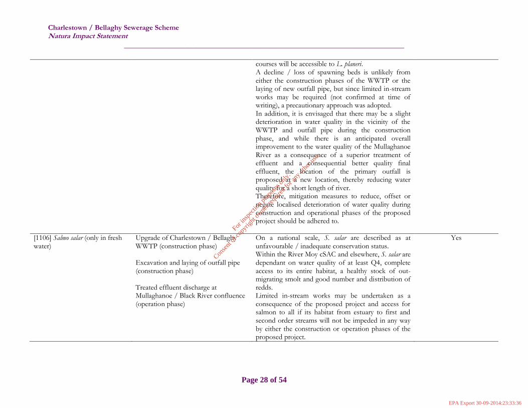
Charlestown / Bellaghy Sewerage Scheme Natura Impact Statement
______________________________________________________________________
Page 28 of 54
courses will be accessible to L. planeri. A decline / loss of spawning beds is unlikely from either the construction phases of the WWTP or the laying of new outfall pipe, but since limited in-stream works may be required (not confirmed at time of writing), a precautionary approach was adopted. In addition, it is envisaged that there may be a slight deterioration in water quality in the vicinity of the WWTP and outfall pipe during the construction phase, and while there is an anticipated overall improvement to the water quality of the Mullaghanoe River as a consequence of a superior treatment of effluent and a consequential better quality final effluent, the location of the primary outfall is proposed at a new location, thereby reducing water quality for a short length of river. Therefore, mitigation measures to reduce, offset or negate localised deterioration of water quality during construction and operational phases of the proposed project should be adhered to.
[1106] Salmo salar (only in fresh water)
Upgrade of Charlestown / Bellaghy WWTP (construction phase) Excavation and laying of outfall pipe (construction phase) Treated effluent discharge at Mullaghanoe / Black River confluence (operation phase)
On a national scale, S. salar are described as at unfavourable / inadequate conservation status. Within the River Moy cSAC and elsewhere, S. salar are dependant on water quality of at least Q4, complete access to its entire habitat, a healthy stock of out-migrating smolt and good number and distribution of redds. Limited in-stream works may be undertaken as a consequence of the proposed project and access for salmon to all if its habitat from estuary to first and second order streams will not be impeded in any way by either the construction or operation phases of the proposed project.
Yes
For
insp
ectio
n pur
pose
s only
.
Conse
nt of
copy
right
owne
r req
uired
for a
ny ot
her u
se.
EPA Export 30-09-2014:23:33:36

Charlestown / Bellaghy Sewerage Scheme Natura Impact Statement
______________________________________________________________________
Page 29 of 54
There is a likely short-term deterioration of water quality at the Charlestown / Bellaghy WWTP site envisaged, in addition to some potential for accidental emissions to the Mullaghanoe River along the route of the new outfall. Additionally, water quality at the confluence, where the primary effluent will be discharged may deteriorate at this point, though the water course is deemed capable of accepting the treated effluent without exceeding the river’s assimilative capacity (see WAC detail in Appendix IV). Mitigation measures for the construction and operation phases of this proposed project are deemed necessary for the protection of water quality and the restoration of the favourable status of S. salar.
[1355] Lutra lutra
Upgrade of Charlestown / Bellaghy WWTP (construction phase) Excavation and laying of outfall pipe (construction phase) Treated effluent discharge at Mullaghanoe / Black River confluence (operation phase)
Otter are water-dependant (fresh and marine) species which generally prey on fish, amphibians and occasionally crustaceans. Their favourable conservation status is defined by extent of marine, lake and freshwater habitats, availability of couching sites and biomass of fish / prey. Lutra lutra have been recorded at the location of the proposed new outfall. While good water quality is not a strict prerequisite for the favourable conservation status of otter, a deterioration of water quality may impact on prey species (salmon and crayfish) so measures to maintain / protect water quality is advantageous to the maintenance / restoration of favourable conservation status of otter. Additionally, disturbance of this nocturnal species is a likely impact in particular during the construction phase of the proposed project. Females, which give birth once a year (no specified time, but peaking between May and August) generally do so in natal
Yes
For
insp
ectio
n pur
pose
s only
.
Conse
nt of
copy
right
owne
r req
uired
for a
ny ot
her u
se.
EPA Export 30-09-2014:23:33:36
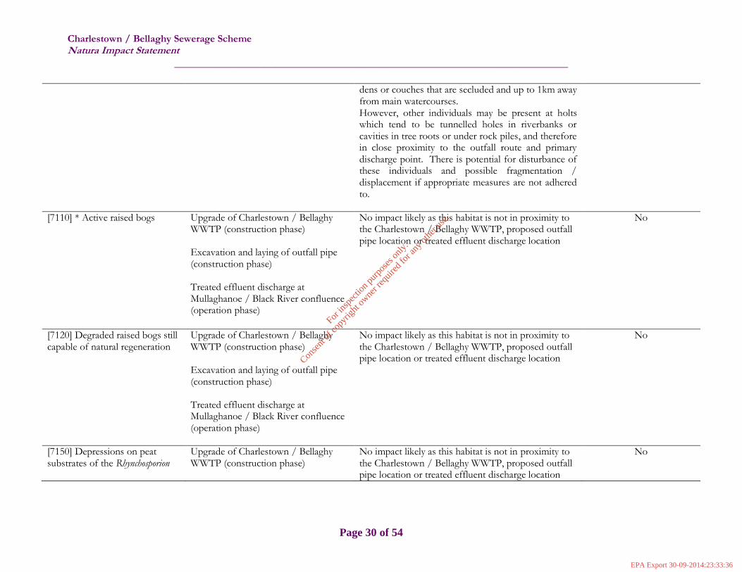
Charlestown / Bellaghy Sewerage Scheme Natura Impact Statement
______________________________________________________________________
Page 30 of 54
dens or couches that are secluded and up to 1km away from main watercourses. However, other individuals may be present at holts which tend to be tunnelled holes in riverbanks or cavities in tree roots or under rock piles, and therefore in close proximity to the outfall route and primary discharge point. There is potential for disturbance of these individuals and possible fragmentation / displacement if appropriate measures are not adhered to.
[7110] * Active raised bogs
Upgrade of Charlestown / Bellaghy WWTP (construction phase) Excavation and laying of outfall pipe (construction phase) Treated effluent discharge at Mullaghanoe / Black River confluence (operation phase)
No impact likely as this habitat is not in proximity to the Charlestown / Bellaghy WWTP, proposed outfall pipe location or treated effluent discharge location
No
[7120] Degraded raised bogs still capable of natural regeneration
Upgrade of Charlestown / Bellaghy WWTP (construction phase) Excavation and laying of outfall pipe (construction phase) Treated effluent discharge at Mullaghanoe / Black River confluence (operation phase)
No impact likely as this habitat is not in proximity to the Charlestown / Bellaghy WWTP, proposed outfall pipe location or treated effluent discharge location
No
[7150] Depressions on peat substrates of the Rhynchosporion
Upgrade of Charlestown / Bellaghy WWTP (construction phase)
No impact likely as this habitat is not in proximity to the Charlestown / Bellaghy WWTP, proposed outfall pipe location or treated effluent discharge location
No
For
insp
ectio
n pur
pose
s only
.
Conse
nt of
copy
right
owne
r req
uired
for a
ny ot
her u
se.
EPA Export 30-09-2014:23:33:36

Charlestown / Bellaghy Sewerage Scheme Natura Impact Statement
______________________________________________________________________
Page 31 of 54
Excavation and laying of outfall pipe (construction phase) Treated effluent discharge at Mullaghanoe / Black River confluence (operation phase)
[7230] Alkaline fens
Upgrade of Charlestown / Bellaghy WWTP (construction phase) Excavation and laying of outfall pipe (construction phase) Treated effluent discharge at Mullaghanoe / Black River confluence (operation phase)
No impact likely as this habitat is not in proximity to the Charlestown / Bellaghy WWTP, proposed outfall pipe location or treated effluent discharge location
No
[91A0] Old sessile oak woods with Ilex and Blechnum in the British Isles
Upgrade of Charlestown / Bellaghy WWTP (construction phase) Excavation and laying of outfall pipe (construction phase) Treated effluent discharge at Mullaghanoe / Black River confluence (operation phase)
No impact likely as this habitat is not in proximity to the Charlestown / Bellaghy WWTP, proposed outfall pipe location or treated effluent discharge location
No
[91E0] * Alluvial forests with Alnus glutinosa and Fraxinus
excelsior (Alno‐Padion, Alnion incanae, Salicion albae)
Upgrade of Charlestown / Bellaghy WWTP (construction phase) Excavation and laying of outfall pipe (construction phase) Treated effluent discharge at
No impact likely as this habitat is not in proximity to the Charlestown / Bellaghy WWTP, proposed outfall pipe location or treated effluent discharge location
No
For
insp
ectio
n pur
pose
s only
.
Conse
nt of
copy
right
owne
r req
uired
for a
ny ot
her u
se.
EPA Export 30-09-2014:23:33:36

Charlestown / Bellaghy Sewerage Scheme Natura Impact Statement
______________________________________________________________________
Page 32 of 54
Mullaghanoe / Black River confluence (operation phase)
For
insp
ectio
n pur
pose
s only
.
Conse
nt of
copy
right
owne
r req
uired
for a
ny ot
her u
se.
EPA Export 30-09-2014:23:33:36

Charlestown / Bellaghy Sewerage Scheme Natura Impact Statement
______________________________________________________________________
Page 33 of 54
3.6 Mitigation Measures
The preceding sections highlighted that three main elements of the proposed project may impact adversely on a number of Annex II species and consequently, mitigation measures are essential to offset, reduce or negate such impacts. It was concluded that deterioration in water quality may occur during the construction and operation phases of the proposed project and consequently this may impede the restoration / maintenance of the favourable conservation status of some qualifying interests of the River Moy cSAC. The three main elements of the proposed project which may produce significant effects on the River Moy cSAC include –
Charlestown / Bellaghy WWTP upgrade and ancillary works (during construction);
Re-located outfall pipe from Charlestown / Bellaghy WWTP to River Mullaghanoe / Black River confluence (during construction); and
Discharge of treated effluent from re-located primary outfall (during operation).
Mitigation measures, then, are necessary for the protection of water quality during both construction and operational phases of the proposed project, in addition to some specific measures to ensure the restoration / maintenance of the favourable conservation status of some particular Annex II species. The following table illustrates the mitigation measures which should be implemented to offset, reduce or negate any significant effects as a consequence of the proposed project, alone or in-combination, so as to ensure that the integrity of the River Moy cSAC is not adversely affected by all of the elements of the proposed project.
For
insp
ectio
n pur
pose
s only
.
Conse
nt of
copy
right
owne
r req
uired
for a
ny ot
her u
se.
EPA Export 30-09-2014:23:33:36
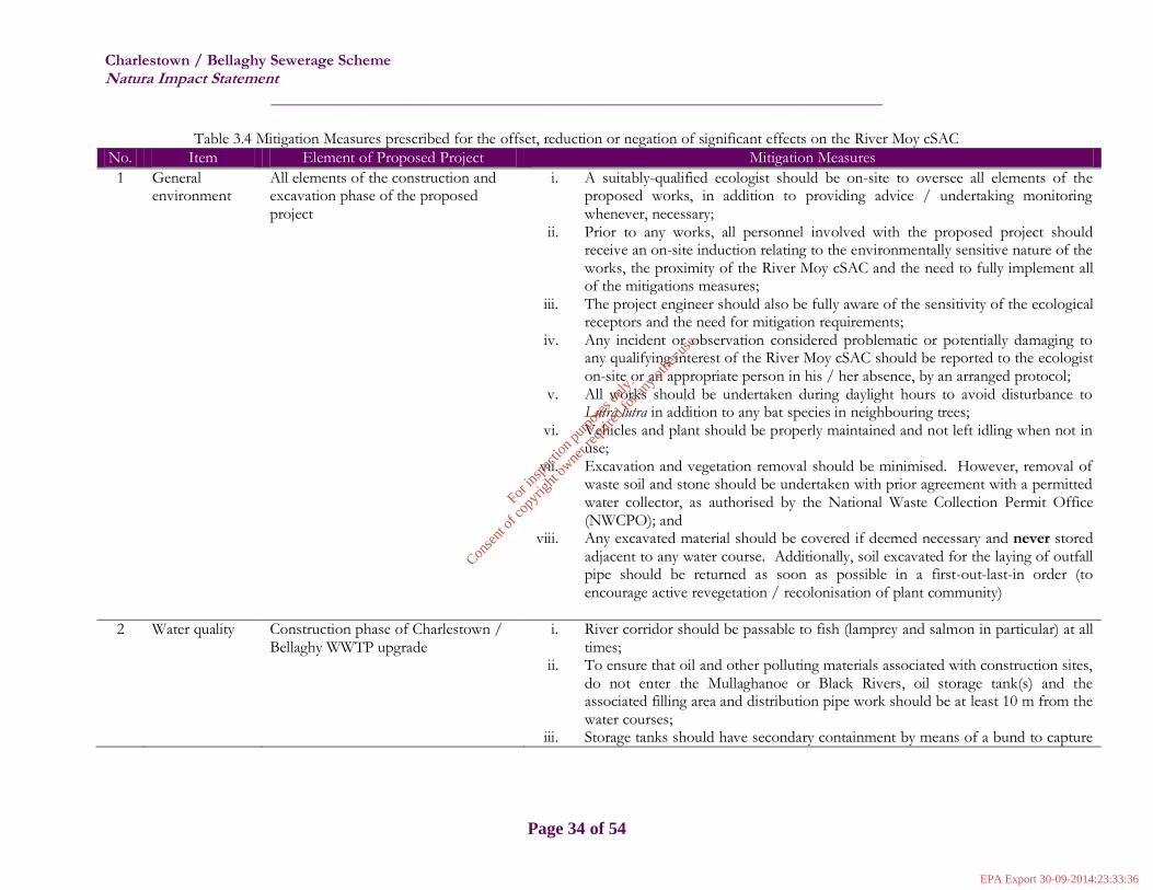
Charlestown / Bellaghy Sewerage Scheme Natura Impact Statement
______________________________________________________________________
Page 34 of 54
Table 3.4 Mitigation Measures prescribed for the offset, reduction or negation of significant effects on the River Moy cSAC
No. Item Element of Proposed Project Mitigation Measures
1 General environment
All elements of the construction and excavation phase of the proposed project
i. A suitably-qualified ecologist should be on-site to oversee all elements of the proposed works, in addition to providing advice / undertaking monitoring whenever, necessary;
ii. Prior to any works, all personnel involved with the proposed project should receive an on-site induction relating to the environmentally sensitive nature of the works, the proximity of the River Moy cSAC and the need to fully implement all of the mitigations measures;
iii. The project engineer should also be fully aware of the sensitivity of the ecological receptors and the need for mitigation requirements;
iv. Any incident or observation considered problematic or potentially damaging to any qualifying interest of the River Moy cSAC should be reported to the ecologist on-site or an appropriate person in his / her absence, by an arranged protocol;
v. All works should be undertaken during daylight hours to avoid disturbance to Lutra lutra in addition to any bat species in neighbouring trees;
vi. Vehicles and plant should be properly maintained and not left idling when not in use;
vii. Excavation and vegetation removal should be minimised. However, removal of waste soil and stone should be undertaken with prior agreement with a permitted water collector, as authorised by the National Waste Collection Permit Office (NWCPO); and
viii. Any excavated material should be covered if deemed necessary and never stored adjacent to any water course. Additionally, soil excavated for the laying of outfall pipe should be returned as soon as possible in a first-out-last-in order (to encourage active revegetation / recolonisation of plant community)
2 Water quality Construction phase of Charlestown / Bellaghy WWTP upgrade
i. River corridor should be passable to fish (lamprey and salmon in particular) at all times;
ii. To ensure that oil and other polluting materials associated with construction sites, do not enter the Mullaghanoe or Black Rivers, oil storage tank(s) and the associated filling area and distribution pipe work should be at least 10 m from the water courses;
iii. Storage tanks should have secondary containment by means of a bund to capture
For
insp
ectio
n pur
pose
s only
.
Conse
nt of
copy
right
owne
r req
uired
for a
ny ot
her u
se.
EPA Export 30-09-2014:23:33:36

Charlestown / Bellaghy Sewerage Scheme Natura Impact Statement
______________________________________________________________________
Page 35 of 54
oil leakage from the tank or associated equipment; iv. Oil booms and / or soakage pads should be held and maintained on-site to
enable an effective response to any accidental spillage(s); v. Tools or equipment should not be cleaned in any surface water; if necessary,
items can be cleaned within the existing WWTP site; vi. Any chemicals used for the purpose of the proposed project should be applied
with due care and caution, so as to prevent accidental spillages and chemicals should be stored in sealed containers and held in a vehicle / within WWTP site prior to use;
vii. To prevent any silting or erosion of either water course which will adversely affect the appearance and / or quality of the water, any runoff from the working site or areas of exposed soil should be channeled and intercepted for discharge to silt-traps or lagoons;
viii. Emergency spill kits should be available on-site; ix. IFI guidance on working adjacent / in water should be followed as best practice.
3 Water quality Construction / excavation phase of re-located outfall pipe
i. River corridor should be passable to fish (lamprey and salmon in particular) at all times
ii. All excavated material should be covered if deemed necessary and never stored adjacent to either water course (or drainage ditches whenever present). Soil excavated for the laying of outfall pipe should be returned as soon as possible in a first-out-last-in order (to encourage active revegetation / recolonisation of plant community)
iii. To prevent any silting or erosion of the Mullaghanoe / Black Rivers which will adversely affect the quality of the water, any runoff from the working site or areas of exposed soil should be channeled and intercepted for discharge to silt-traps or lagoons.
iv. A suitably-qualified ecologist should be on-site to monitor these works and determine the frequency and optimum location of water quality monitoring, with particular emphasis on suspended solids;
v. Emergency spill kits should be available on-site; vi. IFI guidance on working adjacent / in water should be followed as best practice; vii. In-stream works should be avoided and ‘directional drilling’ should be employed
as the preferred option for the laying of the outfall pipe between WWTP and new
For
insp
ectio
n pur
pose
s only
.
Conse
nt of
copy
right
owne
r req
uired
for a
ny ot
her u
se.
EPA Export 30-09-2014:23:33:36

Charlestown / Bellaghy Sewerage Scheme Natura Impact Statement
______________________________________________________________________
Page 36 of 54
primary discharge location; viii. Should in-stream works be essential, the IFI should be consulted so that a review
of the project Method Statement be undertaken
4 Water quality Treated effluent discharge point
i. Emission Limit Values as conditioned by the EPA in D0214-01 should be strictly adhered to at all times, with Environmental Report (ER) compiled and submitted to the EPA annually. It is envisaged that acute toxicity will be monitored as a key parameter.
ii. The ecologist should be cognisant that the current water quality at this location equates to poor (corresponding to Q3 / Q2-3). This is considered to be the case due to point risk sources including the existing WWTP. For some Annex II species this must be improved to Q3-4 (A. pallipes) and Q 4 (S. salar) and it is endeavoured that the improved quality of the final effluent and removal of a number of storm overflows will contribute to the improvement of water body status;
iii. Telemetry (e.g. SCADA) should be utilised with remote connection and real-time information available to the Plant manager’s phone / alternative should system failures occur, in order to prevent accidental discharges
5 Invasive species All elements of the construction and excavation phase of the proposed project which has potential to disturb, spread or introduce existing or new aquatic and terrestrial invasive species
i. Avoid Fallopia japonica, montbretia and other terrestrial invasive species whenever possible. If this is not practical, individual plants should be controlled in an acceptable manner such as spot-spraying with an approved herbicide (Roundup©). The requirements for control of invasive plant species should be determined and monitored by the ecologist, in consultation with the National Parks and Wildlife Service (NPWS)
ii. All key staff working in the proposed project area should be familiar with ‘common’ invasive species and potential newly-introduced species – it is suggested that a non-native invasive species picture log be circulated at the on-site induction;
iii. Sightings of any suspected invasive species should be reported; iv. Where feasible, vehicles and staff designated for working in the proposed project
area should be used for the duration of works and not shared between a number of projects; and
v. The amount of bare ground created by excavation and vegetation removal should
For
insp
ectio
n pur
pose
s only
.
Conse
nt of
copy
right
owne
r req
uired
for a
ny ot
her u
se.
EPA Export 30-09-2014:23:33:36

Charlestown / Bellaghy Sewerage Scheme Natura Impact Statement
______________________________________________________________________
Page 37 of 54
be minimised to prevent erosion and spread of terrestrial invasive species.
6 Austropotamobius pallipes
All elements of the proposed project which have potential for water quality and habitat quality deterioration
General environment and water quality mitigation measures numbers 1 to 4 above, and; i. The presence of A. pallipes should be determined and monitored by the ecologist,
in consultation with the NPWS; ii. Timing of works should, if possible, not correspond with end-May to July when
females carrying young are most susceptible to disturbance.
7 Petromyzon marinus
All elements of the proposed project which have potential for water quality deterioration and / or disturbance of spawning beds
General environment and water quality mitigation measures numbers 1 to 4 above, and; i. The presence of P. marinus should be determined and monitored by the ecologist,
in consultation with the NPWS and the IFI.
8 Lampetra planeri
All elements of the proposed project which have potential for water quality deterioration and / or disturbance of spawning beds
General environment and water quality mitigation measures numbers 1 to 4 above, and; ii. The presence of L. planeri should be determined and monitored by the ecologist,
in consultation with the NPWS and the IFI.
9 Salmo salar
All elements of the proposed project which have potential for water quality deterioration and / or disturbance of spawning beds
General environment and water quality mitigation measures numbers 1 to 4 above, and; i. Should limited in-stream works be necessary the presence of spawning beds for S.
salar at these / this location(s) should be determined by the ecologist, and the IFI should be consulted so that a review of the project Method Statement can be undertaken;
ii. Timing of works should be scheduled, if possible between May and end-September to avoid spawning season and in any case, when works are due to commence, the IFI should be notified.
10 Lutra lutra
All elements of the proposed project but particularly the excavation and laying of new outfall pipe and the discharge point of treated effluent (confluence of Mullaghanoe / Black Rivers)
General environment and water quality mitigation measures numbers 1 to 4 above, and; i. The presence of L. lutra and otter holts should be determined and monitored by
the ecologist, in consultation with the NPWS; ii. No works should be undertaken within 150m of any holts at which breeding
females or cubs are present. Following consultation with NPWS, works closer to such breeding holts may take place – with screening and/or restricted working hours on site;
For
insp
ectio
n pur
pose
s only
.
Conse
nt of
copy
right
owne
r req
uired
for a
ny ot
her u
se.
EPA Export 30-09-2014:23:33:36

Charlestown / Bellaghy Sewerage Scheme Natura Impact Statement
______________________________________________________________________
Page 38 of 54
iii. No wheeled or tracked vehicles (of any kind) should be used within 20m of active, but non-breeding, otter holts. Light work, such as digging by hand or scrub clearance should also not take place within 15m of such holts, except under licence;
iv. The prohibited working area associated with otter holts should, where appropriate, be fenced with temporary fencing prior to any possibly invasive works. Standard / type of fencing should be discussed with and approved by the NPWS. Appropriate awareness of the purpose of the enclosure should be conveyed through notification to site staff and sufficient signage which should be placed on each exclusion fence. All contractors or operators on site should be made fully aware of the procedures pertaining to any / each affected holt;
v. Where holts are present in close proximity to invasive construction works but are determined not to require destruction, construction works may commence once recommended alternative mitigation measures to address otters have been complied with (liaison with NPWS essential);
vi. An application for a derogation licence should be made if L. lutra are detected and cannot be avoided and "provided there is no satisfactory alternative and the derogation is not detrimental to the maintenance of the populations of the species concerned at a favourable conservation status".
For
insp
ectio
n pur
pose
s only
.
Conse
nt of
copy
right
owne
r req
uired
for a
ny ot
her u
se.
EPA Export 30-09-2014:23:33:36
Charlestown / Bellaghy Sewerage Scheme Natura Impact Statement
______________________________________________________________________
Page 39 of 54
4 Conclusion of NIS
It should be emphasised that the upgrade to the Charlestown / Bellaghy Sewerage Scheme will result in an improvement in the final effluent quality and essentially the consequential improvement of the water body which is currently ‘poor’. When the above mitigation measures are implemented in full, it is envisaged that there will be no significant adverse effects on the integrity of the River Moy cSAC in view of the site’s conservation objectives and that the conservation status of the Annex I habitats and Annex II species will not be compromised by this proposed project either directly, indirectly or cumulatively.
The wastewater effluent will be treated to comply with the requirements of the Urban Waste Water Treatment Regulations, 2001 (as amended) prior to discharge and the receiving water has been demonstrated to be sufficient assimilate the proposed discharge (Appendix IV). Additionally, with strict adherence to EPA Discharge Licence D0214-01 conditions, and continued implementation of the policies and objectives of the Mayo County Development Plan 2008-2014 (and Mayo County Development Plan 2014-2020, when adopted), the maintenance and / or restoration of the favourable conservation status of the qualifying interests of the River Moy cSAC should be ensured with no significant impacts on the integrity of the cSAC as a whole (either alone or in combination with other projects and plans), in view of the site’s conservation objectives envisaged. It is therefore concluded that the proposed project, alone or in-combination with other plans and / or projects will not give rise to significant effects on the integrity of the River Moy cSAC, as long as the mitigation measures as listed in Table 3.4 are implemented in full. Stage 2 concludes the Appropriate Assessment process of the Charlestown / Bellaghy Sewerage Scheme.
For
insp
ectio
n pur
pose
s only
.
Conse
nt of
copy
right
owne
r req
uired
for a
ny ot
her u
se.
EPA Export 30-09-2014:23:33:36

Charlestown / Bellaghy Sewerage Scheme Natura Impact Statement
______________________________________________________________________
Page 40 of 54
References Department of Arts, Heritage and the Gaeltacht, 2012. National Raised Bog SAC Management Plan
Proposed Approach. EPA, 1998. Waste Water Treatment Manuals: Characterisation of Industrial Wastewaters. Published by the
Environmental Protection Agency, Ireland. EPA, 2012. Waste Water Discharge Licensing Appropriate Assessment (Version 2.2). Published by the
Environmental Protection Agency, Ireland. Fossitt, J.A., 2000. A Guide to Habitats in Ireland. The Heritage Council Kingston, N., 2012. Checklist of protected and rare species in Ireland. Unpublished National Parks &
Wildlife Service Report. NPWS, 2008. The Status of EU-protected Habitats and Species in Ireland; Conservation Status in Ireland of
Habitats and Species listed in the European Council Directive on the Conservation of Habitats, Flora and Fauna 92/43/EEC
NPWS, 2010. River Moy cSAC (002298) Site Synopsis NPWS, 2011. Conservation Objectives: River Barrow and River Nore SAC 002162. Version 1.0.
National Parks and Wildlife Service, Department of Arts, Heritage and the Gaeltacht. NPWS, 2012. Conservation Objectives: Blackwater River (Cork/Waterford) SAC 002170. Version
1.0. National Parks and Wildlife Service, Department of Arts, Heritage and the Gaeltacht. NPWS, 2012. Conservation Objectives: Lower River Shannon SAC 002165. Version 1.0. National
Parks and Wildlife Service, Department of Arts, Heritage and the Gaeltacht. NPWS (2013) The Status of EU Protected Habitats and Species in Ireland. Habitat Assessments Volume 2.
Version 1.0. Unpublished Report, National Parks & Wildlife Services. Department of Arts, Heritage and the Gaeltacht, Dublin, Ireland.
NPWS (2013) The Status of EU Protected Habitats and Species in Ireland. Species Assessments Volume 3, Version 1.0. Unpublished Report, National Parks & Wildlife Services. Department of Arts, Heritage and the Gaeltacht, Dublin, Ireland.
NRA, 2006b. Guidelines for the Treatment of Otters prior to the Construction of National Road Schemes. Dublin: National Roads Authority.
NRA, 2008b. Ecological Surveying Techniques for Protected Flora & Fauna during the Planning of National Road Schemes. Dublin: National Roads Authority.
OPW, 2013. The Office of Public Works Arterial Drainage Maintenance Activities 2013: Moy Arterial Drainage Scheme Natura Impact Statement (NIS)
O’Connor, W. (2007) A Survey of Juvenile Lamprey Populations in the Corrib and Suir Catchments. Irish Wildlife Manuals No. 26. National Parks and Wildlife Service, Department of Environment, Heritage and Local Government, Dublin, Ireland.
SEPA, 2009 Engineering in the Water Environment Good Practice Guide:Temporary Construction Methods First edition, March 2009. Scottish Environmental Protection Agency, (Document reference: WAT-SG-29)
For
insp
ectio
n pur
pose
s only
.
Conse
nt of
copy
right
owne
r req
uired
for a
ny ot
her u
se.
EPA Export 30-09-2014:23:33:36

Appendices Charlestown / Bellaghy Sewerage Scheme Natura Impact Statement
______________________________________________________________________
I
Appendix I Site Synopsis – River Moy cSAC
SITE NAME: RIVER MOY
SITE CODE: 002298 This site comprises almost the entire freshwater element of the Moy and its tributaries
including both Loughs Conn and Cullin. The system drains a catchment area of 805 sq.
km. Most of the site is in Co. Mayo though parts are in west Sligo and north Roscommon.
Apart from the Moy itself, other rivers included within the site are the Deel, Bar Deela,
Castlehill, Addergoole, Clydagh and Manulla on the west side and the Glenree, Yellow,
Strade, Gweestion, Trimogue, Sonnagh, Mullaghanoe, Owengarve, Eighnagh and
Owenaher on the east side. The underlying geology is Carboniferous Limestone for the
most part though Carboniferous Sandstone is present at the extreme west of the site with
Dalradian Quartzites and schists at the south west. Some of the tributaries at the east, the
south of Lough Conn and all Lough Cullin are underlain by granite. There are many
towns adjacent to but not within the site. These include Ballina, Crossmolina, Foxford,
Swinford, Kiltimagh and Charlestown.
The site is a candidate SAC selected for alluvial wet woodlands and raised bog, both
priority habitats on Annex I of the E.U. Habitats Directive. The site is also a candidate
SAC selected for old oak woodlands, alkaline fens, degraded raised bog and
Rhynchosporion, all habitats listed on Annex I of the E.U. Habitats Directive. The site is
also selected for the following species listed on Annex II of the same directive – Atlantic
Salmon, Otter, Sea and Brook Lamprey and White-clawed Crayfish.
On the slopes and rising ground around the southern shores of Loughs Conn and Cullin,
Oak woodlands are seen. Sessile Oak (Quercus petraea) is the dominant tree with an
understorey of Holly (Ilex aquifolium), Hazel (Corylus avellana) and Birch (Betula
pubescens) with some Ash (Fraxinus excelsior). Additional species are associated with
the lakeshore such as the whitebeam (Sorbus rupicola), Aspen (Populus tremula), Silver
Birch (B. pendula) and the shrubs Guelder Rose (Viburnum opulus), Buckthorn (Rhamnus
catharticus) and Spindle Tree (Euonymus europaeus). The ground flora is usually
composed of Bilberry (Vaccinium myrtillus), Wood Rush (Luzula sylvatica), Wood Sorrel
(Oxalis acetosella), Buckler Ferns (Dryopteris aemula and D. dilatata), Hard Fern
(Blechnum spicant), Cow-wheat (Melampyrum spp.) and Bracken (Pteridium aquilinum).
The rare Narrow-leaved Helleborine (Cephalanthera longifolia), protected under the Flora
Protection Order, 1999, occurs in association with the woodlands. Also found in these
woodlands is the snail (Acanthinula lamellata), associated with old natural woodlands.
Alluvial woodland occurs at several locations along the shores of the lakes but is
particularly well developed along the river at Coryosla Bridge. Principal tree species are
Willows (Salix cinerea) and Alder (Alnus glutinosa). Herbaceous species include Royal
Fern (Osmunda regalis), Meadowsweet (Filipendula ulmaria) and Reed Canary-grass
(Phalaris arundinacea). The woods are flooded by seasonal fluctuations in lake level.
On higher ground adjacent to the woodlands is blanket bog with scattered shrubs and trees
on the drier areas. The rocky knolls often bear Juniper (Juniperus communis) or Gorse
(Ulex europaeus), with some unusual rare herb species such as Intermediate Wintergreen
(Pyrola media) and Lesser Twayblade (Listera cordata).
For
insp
ectio
n pur
pose
s only
.
Conse
nt of
copy
right
owne
r req
uired
for a
ny ot
her u
se.
EPA Export 30-09-2014:23:33:36

Appendices Charlestown / Bellaghy Sewerage Scheme Natura Impact Statement
______________________________________________________________________
II
Within the site are a number of raised bogs including those at Kilgarriff, Gowlaun,
Derrynabrock, Tawnaghbeg and Cloongoonagh. These are examples of raised bogs at the
north-western edge of the spectrum and possesses many of the species typical of such in
Ireland, including an abundance of Bog Asphodel (Narthecium ossifragum), Carnation
Sedge (Carex panicea) and the moss Campylopus atrovirens. Some of the bogs include
significant areas of active raised bog habitat. Well developed pool and hummock systems
with quaking mats of bog mosses (Sphagnum spp.), Bog Asphodel (Narthecium
ossifragum) and White Beaked-sedge (Rhynchospora alba) are present. Many of the pools
contain a diversity of plant species, including Bogbean (Menyanthes trifoliata), the bog
moss Sphagnum cuspidatum, Campylopus atrovirens, Common Cottongrass (Eriophorum
angustifolium), Great Sundew (Drosera anglica) and occasional Lesser Bladderwort
(Utricularia minor). Several of the hummock-forming mosses (Sphagnum fuscum and S.
imbricatum) which occur here are quite rare in this region and add to the scientific interest
of the bogs within the overall site.
Depressions on the bogs, pool edges and erosion channels, where the vegetation is
dominated by White Beaked-sedge (Rhynchospora alba) comprise the habitat
Rhynchosporion. Associated species in this habitat at the site include Bog Asphodel,
Sundews, Deergrass (Scirpus cespitosus) and Carnation Sedge.
Degraded raised bog is present where the hydrology of the uncut bogs, has been affected
by peat cutting and other land use activities in the surrounding area such as afforestation
and associated drainage and also by the Moy arterial drainage. Species typical of the
active raised bog habitat are still present but the relative abundance of them is different. A
typical example of the degraded habitat, where drying has occurred at the edge of the high
bog, contains an abundance and more uniform cover of Ling Heather (Calluna vulgaris),
Carnation Sedge, Deergrass and sometimes Bog-myrtle (Myrica gale). Occurring in
association with the uncut high bog are areas of wet regenerating cutover bog with species
such as Common Cottongrass, bog mosses and Sundew, while on the drier areas, the
vegetation is mostly dominated by Purple Moor-grass (Molinia caerulea). Natural
regeneration with peat-forming capability will be possible over time with some restorative
measures.
Alkaline fen is considered to be well developed within the site. An extensive stand occurs
as part of a wetland complex at Mannin and Island Lakes on the Glore River. Key
diagnostic species of the Schoenus association characteristic of rich fens include the
bryophytes Campylium stellatum, Aneura pinguis, Scorpidium scorpioides, and the
herbaceous species Long-stalked Yellow-sedge (Carex lepidocarpa), Grass-of-Parnassus
(Parnassia palustris) and Common Butterwort (Pinguicula vulgaris). Other fen species
include Black Bog-rush (Schoenus nigricans), Purple Moor-grass (Molinia caerulea),
Marsh Helleborine (Epipactis palustris), Meadow Thistle (Cirsium dissectum) and Blunt-
flowered Rush (Juncus subnodulosus). The rare moss Bryum uliginosum occurs on
exposed marl at a ditch to the east of Island Lake.
The open water of Loughs Conn and Cullin is moderately hard with relatively low colour
and good transparency. The phytpoplankton of the lake is dominated by diatoms and blue-
green algae and there is evidence that the latter group is more common now than in
former years. This indicates that nutrient inflow is occurring. Arctic Charr (Salvelinus
For
insp
ectio
n pur
pose
s only
.
Conse
nt of
copy
right
owne
r req
uired
for a
ny ot
her u
se.
EPA Export 30-09-2014:23:33:36

Appendices Charlestown / Bellaghy Sewerage Scheme Natura Impact Statement
______________________________________________________________________
III
alpinus) appear to have disappeared from the lake over the same period of time. The
changes in Lough Conn appear to represent an early phase in the eutrification process.
Stoneworts still present include Chara aspera, C. delicatula and Nitella cf. opaca. Other
plant species found in the shallower portions are the pondweeds. Where there is a peat
influence Intermediate Bladderwort (Utricularia intermedia) is characteristic while Water
Lobelia (Lobelia dortmanna) often grows in sand. Narrow reedbeds and patches of
Yellow Water-lily (Nuphar lutea) occur in some of the bays.
Drainage of the Moy in the 60s lowered the level of the lakes, exposing wide areas of
stony shoreline and wet grassland, which are liable to flooding in winter. This increased
the habitat diversity of the shoreline and created a number of marginal wetlands, including
fens and marshes. Plant species of note in the lake-margin include Heath Cudweed
(Omalotheca sylvatica), Great Burnet (Sanguisorba officinalis) and Irish Lady’s-tresses
(Spiranthes romanzoffiana). These three species are listed on the Irish Red Data list and
are protected under the Flora Protection Order 1999.
Other habitats present within the site include wet grassland dominated by Rushes (Juncus
spp.) grading into species-rich marsh in which sedges are common. Among the other
species found in this habitat are Yellow Iris (Iris pseudacorus), Water Mint (Mentha
aquatica), Purple Loosestrife (Lythrum salicaria) and Soft Rush (Juncus effusus).
Grey Willow (Salix cinerea) scrub and pockets of wet woodland dominated by Alder
(Alnus glutinosa) have become established in places throughout the site. Ash (Fraxinus
excelsior) and Birch (Betula pubescens) are common in the latter and the ground flora is
typical of wet woodland with Meadowsweet (Filipendula ulmaria), Angelica (Angelica
sylvestris), Yellow Iris, Horsetail (Equisetum spp.) and occasional tussocks of Greater
Tussock-sedge (Carex paniculata).
Small pockets of conifer plantation, close to the lakes and along the strip both sides of the
rivers, are included in the site.
The Moy system is one of Ireland’s premier salmon waters and it also encompasses two of
Ireland’s best lake trout fisheries in Loughs Conn and Cullin. Although the Atlantic
Salmon (Salmo salar) is still fished commercially in Ireland, it is considered to be
endangered or locally threatened elsewhere in Europe and is listed on Annex II of the
Habitats Directive. The Moy is a most productive catchment in salmon terms and this can
be attributed to its being a fingered system with a multiplicity of 1st
to 5th
order tributaries
which are large enough to support salmonids < 2 years of age while at the same time
being too small to support significant adult trout numbers and are therefore highly
productive in salmonid nursery terms.
Salmon run the Moy every month of the year. Both multi-sea-winter fish and grilse are
present. The salmon fishing season is 1st
February to 30th
September. The peak of the
spring fishing is in April and the grilse begin running in early May. The average
weight of the spring fish is 9 lb and the grilse range from about 3-7 lb. In general spring
fish are found more frequently in the rivers at the western extent of the Moy system.
The Arctic Char (Salvelinus alpinus), an interesting relict species from the last ice age,
which is listed as threatened in the Irish Red Data Book has been recorded from Lough
Conn and in only a few other lakes in Ireland. The latest reports suggest that it may now
have disappeared from the site.
For
insp
ectio
n pur
pose
s only
.
Conse
nt of
copy
right
owne
r req
uired
for a
ny ot
her u
se.
EPA Export 30-09-2014:23:33:36

Appendices Charlestown / Bellaghy Sewerage Scheme Natura Impact Statement
______________________________________________________________________
IV
The site is also important for the presence of three other species listed on Annex II of the
E.U. Habitats Directive, namely Sea Lamprey (Petromyzon marinus), Otter (Lutra lutra)
and White-clawed Crayfish (Austropotamobius pallipes). The Sea Lamprey is regularly
encountered in the lower stretches of the river around Ballina, while the otter and crayfish
are widespread throughout the system. In addition, the site also supports many more of the
mammal species occurring in Ireland. Those which are listed in the Irish Red Data Book
include Pine Marten, Badger, Irish Hare and Daubenton’s Bat. Common Frog, another
Red Data Book species, also occurs within the site.
Loughs Conn and Cullin support important concentrations of wintering waterfowl and
both are designated Special Protection Areas. A nationally important population of the
Annex I species Greenland White-fronted Geese (average 113 over 6 winters 1994/95 to
1999/00) is centred on Lough Conn. Whooper Swans also occur (numbers range between
25 to 50), along with nationally important populations of Tufted Duck 635, Goldeneye
189 and Coot 464. A range of other species occur on the lakes in regionally important
concentrations, notably Wigeon 303, teal 154, Mallard 225, Pochard 182, Lapwing
(>1,000) and Curlew 464. Golden Plover also frequent the lakes, with numbers ranging
between 700 and 1,000.
Loughs Conn and Cullin are one of the few breeding sites for Common Scoter in Ireland.
Breeding has occurred on Lough Conn since about the 1940s when about 20-30 pairs
were known. A census in 1983 recorded 29 pairs. Breeding was first proved on Lough
Cullin in 1983 when 24 pairs were recorded. In 1995, 24-26 pairs were recorded at Lough
Conn and 5 pairs at Lough Cullin. The latest survey in 1999 gives a total of 30 birds for
both lakes, comprising only 5 pairs, 18 unpaired males and 2 unpaired females. The
reason for the decline is not known but may be due to predation by mink, possible
changes in food supply and/or redistribution to other sites. The Common Scoter is a Red
listed species.
Agriculture, with particular emphasis on grazing, is the main landuse along the Moy.
Much of the grassland is unimproved but improved grassland and silage are also present.
The spreading of slurry and fertiliser poses a threat to the water quality of this salmonid
river and to the large lakes. Fishing is a main tourist attraction on the Moy and there are a
large number of Angler Associations, some with a number of beats. Fishing stands and
styles have been erected in places. The North Western Regional Fishery Board have
erected fencing along selected stretches of the river as part of their salmonid enhancement
programme. Other aspects of tourism are concentrated around Loughs Conn and Cullin.
Afforestation has occurred in the past around the shores of Loughs Conn and Cullin. The
coniferous trees are due for harvesting shortly. It is proposed to replant with
For
insp
ectio
n pur
pose
s only
.
Conse
nt of
copy
right
owne
r req
uired
for a
ny ot
her u
se.
EPA Export 30-09-2014:23:33:36

Appendices Charlestown / Bellaghy Sewerage Scheme Natura Impact Statement
______________________________________________________________________
V
native tree species in this area. Forestry is also present along many of the tributaries and in
particular along the headwaters of the Deel. Forestry poses a threat in that sedimentation
and acidification occurs. Sedimentation can cover the gravel beds resulting in a loss of
suitable spawning grounds. The Moy has been arterially dredged in the 60s. Water levels
have been reduced since that time. This is particularly evident along the shores of Loughs
Conn and Cullin and in the canal-like appearance of some river stretches. Ongoing
maintenance dredging is carried out along stretches of the river system where the gradient
is low. This is extremely destructive to salmonid habitat in the area.
The site supports populations of several species listed on Annex II of the EU Habitats
Directive, and habitats listed on Annex I of this directive, as well as examples of other
important habitats. The presence of a fine example of broad-leaved woodland in this part
of the country increases the overall habitat diversity and adds to the ecological value of
the site as does the presence of the range of nationally rare and Red Data Book Plant and
animal species.
29.9.2010
For
insp
ectio
n pur
pose
s only
.
Conse
nt of
copy
right
owne
r req
uired
for a
ny ot
her u
se.
EPA Export 30-09-2014:23:33:36

Appendices Charlestown / Bellaghy Sewerage Scheme Natura Impact Statement
______________________________________________________________________
VI
Appendix II River Moy cSAC Conservation Objectives
For
insp
ectio
n pur
pose
s only
.
Conse
nt of
copy
right
owne
r req
uired
for a
ny ot
her u
se.
EPA Export 30-09-2014:23:33:36

Appendices Charlestown / Bellaghy Sewerage Scheme Natura Impact Statement
______________________________________________________________________
VII
Appendix III EU Habitats Directive Annex II species recorded in vicinity of proposed project
Lutra lutra Austropotamobius pallipes Both species
For
insp
ectio
n pur
pose
s only
.
Conse
nt of
copy
right
owne
r req
uired
for a
ny ot
her u
se.
EPA Export 30-09-2014:23:33:36

Appendices Charlestown / Bellaghy Sewerage Scheme Natura Impact Statement
______________________________________________________________________
VIII
Appendix IV Waste Assimilative Capacity, treated effluent standards and loadings for a discharge to the Mullaghanoe River downstream of the confluence with the Black River
Parameter BOD Ammonia Orthophosphate
Cmax mg/L) 2.6 0.14 0.075 Cback (mg/L) <1 0.05 0.03 Q95 (m3/s) 0.15 0.15 0.15 WAC (kg/day) 20.74 1.17 0.58 PE 3000 3000 3000 Proposed ELV (mg/L) 20 1.5 0.9 DWF (m3/s) 0.0078 0.0078 0.0078 Dilution 19.20 19.20 19.20 Treated effluent loading (kg/day) 13.5 1.013 0.61 New watercourse concentration (mg/L) 1.94 0.12 0.073 Less than WACmax yes yes yes
For
insp
ectio
n pur
pose
s only
.
Conse
nt of
copy
right
owne
r req
uired
for a
ny ot
her u
se.
EPA Export 30-09-2014:23:33:36


![Attachment F.1 (c) Natura Impact Statement · [Natura 2000] site but likely to have a significant effect thereon, either individually or in combination with other plans or projects,](https://static.fdocuments.in/doc/165x107/6056a54d84e5065b1c1fe957/attachment-f1-c-natura-impact-natura-2000-site-but-likely-to-have-a-significant.jpg)