Matanuska-Susitna Borough PORT MACKENZIE MASTER … · Matanuska-Susitna Borough PORT MACKENZIE...
66
Matanuska-Susitna Borough PORT MACKENZIE MASTER PLAN Adopted April 6, 2016
Transcript of Matanuska-Susitna Borough PORT MACKENZIE MASTER … · Matanuska-Susitna Borough PORT MACKENZIE...

Matanuska-Susitna Borough
PORT MACKENZIE MASTER PLAN
Adopted April 6, 2016


Port MacKenzie Master Plan 2016 Update
By
Matanuska-Susitna Borough

Port MacKenzie Master Plan Update – Adopted April 5, 2016 – Ordinance 16-012 i
NOTICE This plan and the information contained herein does not constitute, nor shall it be construed as, a waiver of any right, title or interest, including sovereign interest, in any lands owned by or under the jurisdiction of the Matanuska-Susitna Borough or any grantee in trust of Borough lands. The maps included in the report are for illustrative purposes only and are not intended to accurately depict ownership boundaries. It is important to recognize that the estimates referenced and utilized in this Update are based on studies and data from experts in various disciplines and are based on the information available at the specific date. It is not possible or feasible to include estimates of the port through-put or business activity that coincide exactly with the completion of this Update. The uncertainties surrounding potential gas lines, mineral commodities, a bridge across Knik Arm, completion of the railroad, and other business developments are all subject to change. The key issue in this Update is the Vision statement found in Section 1.4. Projections of through-put and business activity will change constantly but the key is that the actions of the Port and Borough follow and conform to the Vision as defined in Section 1.4.
ACKNOWLEDGEMENTS The Borough owes a debt of gratitude to the Port Commissioners, professionals, and interested parties for their insight, dedication and helpful comments on this update of the Port MacKenzie Master Plan. In particular, the Borough would like to acknowledge the following people for their contributions of time, energy, and support toward the success of this update:
The Borough Port Commission
o Greg Bell
o Christopher Gates
o Steven Borell
o Noel Woods
o Helga Larson
o Claudia Roberts
Marc Van Dongen, Director, Port MacKenzie
Patrick Kelly, University of Alaska Land Management
Rick Hoggan, P.E., Millcreek Engineering
Port MacKenzie Master Plan Update – Adopted April 5, 2016 – Ordinance 16-012 ii
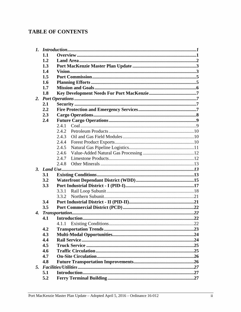
TABLE OF CONTENTS
1. Introduction .............................................................................................................1
1.1 Overview .....................................................................................................1 1.2 Land Area ...................................................................................................2 1.3 Port MacKenzie Master Plan Update ......................................................3 1.4 Vision ...........................................................................................................3 1.5 Port Commission ........................................................................................5 1.6 Planning Efforts .........................................................................................5 1.7 Mission and Goals ......................................................................................6 1.8 Key Development Needs For Port MacKenzie ........................................7
2. Port Operations .......................................................................................................7 2.1 Security .......................................................................................................7 2.2 Fire Protection and Emergency Services .................................................7 2.3 Cargo Operations .......................................................................................8 2.4 Future Cargo Operations ..........................................................................9
2.4.1 Coal ..................................................................................................9 2.4.2 Petroleum Products ........................................................................10 2.4.3 Oil and Gas Field Modules ............................................................10 2.4.4 Forest Product Exports ...................................................................10 2.4.5 Natural Gas Pipeline Logistics.......................................................11 2.4.6 Value-Added Natural Gas Processing ...........................................12 2.4.7 Limestone Products ........................................................................12 2.4.8 Other Minerals ...............................................................................13
3. Land Use ................................................................................................................13 3.1 Existing Conditions ..................................................................................13 3.2 Waterfront Dependant District (WDD) .................................................15 3.3 Port Industrial District - I (PID-I) ..........................................................17
3.3.1 Rail Loop Subunit ..........................................................................18 3.3.2 Northern Subunit ............................................................................21
3.4 Port Industrial District - II (PID-II).......................................................21 3.5 Port Commercial District (PCD) ............................................................22
4. Transportation .......................................................................................................22 4.1 Introduction ..............................................................................................22
4.1.1 Existing Conditions ........................................................................22 4.2 Transportation Trends ............................................................................23 4.3 Multi-Modal Opportunities.....................................................................24 4.4 Rail Service ...............................................................................................24 4.5 Truck Service ...........................................................................................25 4.6 Traffic Circulation ...................................................................................25 4.7 On-Site Circulation ..................................................................................26 4.8 Future Transportation Improvements ...................................................26
5. Facilities/Utilities ..................................................................................................27 5.1 Introduction ..............................................................................................27 5.2 Ferry Terminal Building .........................................................................27

Port MacKenzie Master Plan Update – Adopted April 5, 2016 – Ordinance 16-012 iii
5.3 Security Posts ...........................................................................................27 5.4 Deep-Draft Dock ......................................................................................28 5.5 Barge Dock ...............................................................................................28 5.6 Conveyors .................................................................................................28 5.7 Pipelines ....................................................................................................28 5.8 Potable Water ...........................................................................................28 5.9 Wastewater Management ........................................................................29 5.10 Storm Water Management ......................................................................30 5.11 Electric ......................................................................................................32 5.12 Natural Gas...............................................................................................33 5.13 Communications ......................................................................................33
6. Recommendations .................................................................................................33 6.1 Administrative ..........................................................................................33 6.2 Infrastructure ...........................................................................................34 6.3 Environmental Studies ............................................................................35 6.4 Port Land Management ..........................................................................35
7. Bibliography ..........................................................................................................36
Appendix A: Port MacKenzie Layout Drawings Appendix B: Previous Studies and Reports Appendix C: History of Port MacKenzie Appendix D: Port MacKenzie Emergency Services 20-year Plan Appendix E: Port MacKenzie Driveway Standards

Port MacK
1. In
1 Port Macacross frowned anDistrict i
Port Macproviding
1 Latitude:
Kenzie Master P
ntroductio
.1 Over
cKenzie is lorom the Munnd operated is the Unive
cKenzie is idg critical tid
: 61° 16' 6" N
Plan Update –
on
rview
ocated in Sounicipality ofby the Mata
ersity of Ala
Figur
deally suiteddewater acce
N Longitude: 14
Adopted April
uth Central Af Anchorageanuska-Susi
aska.
re 1. Port
d for handlinss to the inte
49° 54' 52" W
l 5, 2016 – Ord
Alaska at the (see Figuretna Borough
MacKenz
ng bulk mateerior of Alas
dinance 16-012
e head of Coe 1 below).1
h. The other
zie Locatio
erials, servinska. Port Ma
2
ook Inlet alo The Port r key landow
on
ng the local acKenzie ca
P
ong the Knikis located inwner in the
communitie
an easily faci
Page 1
k Arm n and e Port
s and ilitate

Port MacKenzie Master Plan Update – Adopted April 5, 2016 – Ordinance 16-012 Page 2
substantial growth in Alaskan export capacity to complement existing port operations that may be limited by local land, capacity or public restrictions. The Port District includes large upland areas of currently undeveloped land in close proximity to the existing deep-draft dock and barge dock. As such, bulk materials can be offloaded, stored, reclaimed and shipped via rail, truck, pipeline, barge and ship without prohibitive constraints or growth limitations. The Borough is constructing a rail link to connect the Port to the Alaska Railroad System. When complete, the rail line will provide the gateway tidewater access to Interior Alaska via the existing rail corridor. The Port will provide the ability to efficiently move materials between ship, rail, truck and barge as needed. An existing bulk material handling conveyor, ship loader and deep water mooring system provide the ability to load any size ship with wood chips, coal, limestone, mineral concentrates and other commodities. This master plan includes utility corridors with additional conveyor, piping, rail and truck access between the docks and upland areas. This plan accommodates mineral, petrochemical, forest products, fabrication, power generation and manufacturing industries in a productive and economic manner. The Matanuska-Susitna Borough (Borough) has prepared this master plan as an update to the 2011 Port MacKenzie Master Plan. The plan updates land use designations for future land development and use. It also provides guidelines for future port improvements and development to meet cargo demand, community acceptance and environmental compatibility that will complement other modes of local, state and international transportation through 2035.
1.2 Land Area
The Port District is comprised of approximately 8,940 acres of uplands and 1,238 acres of tidelands. The uplands include 7,621 acres of land, and 1,319 acres of waterbodies and wetlands (see Figure 2). The other landowner in the Port District is the University of Alaska which owns about 830 acres of land within the District. Public Access to the Shoreline The Borough has been granted approximately 1.9 square miles of tidelands with a shoreline frontage approaching 2.2 linear miles. This master plan makes provision for physical and visual access to the shoreline in a manner that is consistent with the activities being conducted on the land and water areas involved, and the proprietary interests of the private land owners, lessees and public rights and needs. Restricted access to the shoreline within the Port District is necessary for security and public safety factors.
Port MacKenzie Master Plan Update – Adopted April 5, 2016 – Ordinance 16-012 Page 3
1.3 Port MacKenzie Master Plan Update An overall master planning study of Port facilities was completed in 2011. This document provides updates to that framework to guide the orderly growth and development of the Port over the next 20 years. This plan contains three primary sections: a land use section, a transportation section and a facilities/utilities section. This document is intended to provide the layout for the physical development and use of the land, waterbodies and wetlands, tidelands and submerged lands within the Port District. The usefulness of this plan relates directly to its status as an official statement of public policy adopted by the Matanuska-Susitna Borough Assembly. It serves a number of useful purposes which include use by the Port Commission as a reference indicating needed policy changes and as a guide for policy decisions; by the Port staff as a basis for land use decisions, capital improvements programming and for rendering services; by other governmental agencies as necessary information leading to coordinated efforts; and to individuals as an accurate source of information regarding public land use opportunities for private use and investment, and as a basis for protecting existing development.
1.4 Vision
VISION
To develop and maintain waterfront assets in a manner that generates long-term economic benefits for the residents of the Borough, without permanently depleting the usefulness of these assets. Port MacKenzie is envisioned to be an economic engine for resource development throughout Alaska.
This Master Plan is structured to implement this vision in a timely and organized manner and policies and regulations must be developed to ensure that the integrity of the strategic vision is never compromised. Port MacKenzie will clearly define its development and investment objectives, publish policies and guidelines for activities and investments that are to be permitted in the Port District and entertain only those proposals that are consistent with its development objectives, guidelines, Master Plan and vision:
Create new employment opportunities; Stimulate economic development in the Port District, Borough and State through capital
investment for industrial facilities by private enterprises; and Establish a transportation link for exporting natural resources from the State of Alaska.

Port MacK
Kenzie Master PPlan Update –
Adopted April
Figure 2
l 5, 2016 – Ord
2. Port Dis
dinance 16-012
strict
2 PPage 4

Port MacKenzie Master Plan Update – Adopted April 5, 2016 – Ordinance 16-012 Page 5
1.5 Port Commission The Port Commission serves as an advisory body to the assembly and the manager on Port development matters and provides advisory input to the Port District’s operational and administrative staff. The Port Commission was involved in the update process through their consideration of draft components of the update to the plan.
1.6 Planning Efforts This Port MacKenzie Master Plan Update was developed as a stand-alone master plan superseding the Point MacKenzie Port Master Plan, as amended (2011). This Master Plan is a living document and should be updated again following significant Port development or significant changes to the economy. This plan was prepared with input from the Borough Port Commission, Port Director, Economic Development Director, planning staff, land owners, potential users, neighbors and various stake holders. The intent of this Plan is to provide a flexible guide for present use, short-term infrastructure needs, and near, intermediate and long-term future use of the Port. While fully aware that it is impossible to predict the future, the Master Plan must anticipate the future and provide a plan that will best prepare the Port to maximize the use of the land and current facilities, promote sensible and desired growth and facilitate presentation and marketing of the Port’s potential. Due to the amount of activity that is happening within the Port District and the many different forms of inquiry and information, a Port Development Team was established. The team includes borough staff from the departments involved with Port development. The team is tasked with reviewing applications for leases and other forms of use in the Port District. Input for the update was solicited from current and potential future users of the Port, along with the landowners within and adjacent to the Port, in an effort to identify anticipated future development of the Port and associated industrial complex as well as the siting constraints for each development. Previous studies and reports on the Port were reviewed for background information (listed in Appendix B). A consultant was engaged to assist with updating the infrastructure layout and future operations to ensure functionality, efficiency, compatibility and safety. A mechanical and mining engineer specializing in bulk material handling projects including Port facilities, mining, power generation, cement and various industrial mineral, petroleum and chemical plants provided input to the plan and assisted with interviewing Port Commissioners, Borough staff and potential future Port users. The layout drawings are primarily based on the engineer’s experience and knowledge, Port Commission review and previous studies. The layout drawings have been further refined through ongoing discussions with future port industries. The Port Master Plan Update was developed in three phases. The first phase, known as the observations phase, included the collection of data and the assembly of outreach meetings to gather input from external and internal Port constituents. The second phase involved the review and documentation of the information gathered in phase one to identify siting and infrastructure constraints for existing and future uses. Based on this review, and the input and data collected in

Port MacKenzie Master Plan Update – Adopted April 6, 2016 – Ordinance 16-012 Page 6
the observations phase, recommended updates to the master plan were developed and presented to the Port Commission for feedback. In the final phase of the process, that feedback was incorporated into a draft of the final Master Plan Update which was then presented for public review, planning commission review and assembly approval. Industry sectors projected to have the greatest growth potential, and which Port MacKenzie could attract by virtue of its geographical location and facilities, were short listed as the most likely to locate at Port MacKenzie. The nature and growth potential of current business activities at Port MacKenzie were confirmed through discussions with current tenants of the Port, Borough staff, the Port Commission and Administration. In addition, potential business leads provided by the Borough were investigated through personal and telephone interviews. Cargo projections are based on the most recent studies, information provided by current and potential Port MacKenzie tenants and from expected future project and construction activity in the region.
1.7 Mission and Goals
MISSION
To develop a premier deep-water port capable of safely and efficiently transporting bulk commodities and project cargoes into and out of Southcentral Alaska. To develop an analysis that prioritizes resource development targets.
GOALS
1) To complete utilities (natural gas, wastewater treatment) to service the Port.
2) To complete docks (barge dock expansion, deep-draft dock expansion).
3) To complete road improvements (Lake Lorraine Loop, Burma Road, Knik Arm Bridge).
4) To complete a rail line from the existing Alaska Railroad to the Port.
5) To construct rail, truck and vessel loading/unloading facilities at the Port.
6) To construct petroleum product storage and processing facilities including a connection to Anchorage via pipeline.
7) To promote the creation of a natural gas liquids (NGL) processing facility, petrochemical facility, refinery, power plant, LNG plant, or other value-added gas processing facility at Port MacKenzie.
8) As Port development continues, ensure the public trust and maintain the system of transparency, accountability, public participation, and collaboration.
Port MacKenzie Master Plan Update – Adopted April 5, 2016 – Ordinance 16-012 Page 7
1.8 Key Development Needs For Port MacKenzie The following are some of the major needs of the Port for successful operations: Road connection to Parks Highway Upgrading Point MacKenzie Road and Burma Road to controlled access, four-lane arterials as well as construction of a Big Lake bypass will provide the level of service necessary for the commercial and industrial activities of the Port. Rail connection to Alaska Railroad A connection to the railbelt is the essential component to facilitate natural resource exports. The Port is about 32 miles from the railbelt. The efficiency of transporting bulk commodities to tidewater over a rail extension will lead to new natural resource extraction activities. Natural gas supply Distribution and high pressure transmission natural gas pipelines must be extended to the Port District for domestic and industrial use. Natural gas has been extended to Alsop Road, nine miles to the north to service the Goose Creek Correctional Center and surrounding area. Deep-draft dock expansion, adding a second trestle A second trestle connecting the barge dock to the deep-draft dock will increase the efficiency of loading and unloading vessels. Eventually, the deep-draft dock will need to be expanded to accommodate two vessels. 2. Port Operations
2.1 Security The Port Physical Security Plan was updated in 2015 and approved by the Coast Guard. Port security inquiries should be forwarded to the Port Director.
2.2 Fire Protection and Emergency Services The Borough’s 20-year plan for Port Emergency Services is in Appendix D. Fire protection within the Port District is currently a responsibility of the existing lessees. Fire protection consists of a fire hydrant at the barge dock connected to two 20,000-gallon water tanks located up the bluff. The Port District is not within a designated fire service area. The closest fire service area to the Port is the Wasilla-Lakes Fire Service Area No. 130 with Fire Station 6-4 at Mile 3.2 Point MacKenzie Road about 18 miles away. The Central Mat-Su Fire Department (CMSFD) will provide fire and rescue, to protect the critical infrastructure of the Mat-Su Borough. The Port is currently within the response area of Emergency Services District 1 for EMS and rescue responses. A realistic response time, as long as responders are not assigned to a major incident, would be 40 to 50 minutes for a chief officer and 45 to 60 minutes for fire apparatus, a rescue or an ambulance. A Borough-owned 32-foot airboat was

Port MacKenzie Master Plan Update – Adopted April 5, 2016 – Ordinance 16-012 Page 8
acquired to assist with water rescue operations; however, a boat house is required in order to stage it near the barge dock. For management and timeliness, an Emergency Services District covering the Port District should be established with costs shared by tenants. In the near term, lessees should install adequate fire suppression systems to control the fire hazards associated with their operations (i.e., natural resource storage with adequate water delivery systems). Structures should have sprinkler systems and fire hose connections at a minimum. In the mid-term, a 20-acre parcel north of Point MacKenzie Road, illustrated on the layout drawings in Appendix A, should be developed to include a three-bay fire station that will house an aerial rig, a hazardous materials response vehicle, a heavy rescue vehicle and three command vehicles. This facility should be collocated with a five to ten bed emergency medical clinic, an Alaska State Troopers substation, general administrative offices and a FAA-certified helipad.
2.3 Cargo Operations Port MacKenzie is currently developing the berths and infrastructure for handling commercial cargo for export. The Port presently has three tenants:
- Alutiiq Manufacturing Contractors (AMC) constructs modular buildings and transports these buildings to the North Slope and rural communities in Alaska, both by road and across Port MacKenzie’s docks. AMC is expected to continue to manufacture and ship buildings for the next five years and its growth beyond five years is anticipated to be consistent with the rate of growth of the projected economic and construction activity in Alaska (Kane, 2010).
- NPI leases land primarily for bulk commodity export operations at the Port, exporting wood chips and saw logs to Asia.
- Central Alaska Energy is a bulk fuel transport company with plans to construct a tank farm, pipeline and truck load out facility as illustrated in the Port Layout Drawings in Appendix A.
In 2008, the Port exported 451,000 tons of construction-quality gravel for the Port of Anchorage expansion project. Additional material is available for export to projects at the Ted Stevens Anchorage International Airport and for the Knik Arm Bridge causeways. Importation of cement began in 2009 with two vessels each carrying 17,000 short tons. The cement was bagged and warehoused. About 3,700 pounds of rebar were also imported on vessels. Additional vessels brought more cement in 2011. Scrap metal export also began in 2009. The last shipment of scrap metal (2012) included about 8,000 tons that was sent directly to South Korea. Coal export began in 2010 with a test run of a Super Panamax vessel, loaded with 76,000 metric tons of coal in Seward. The vessel docked at Port MacKenzie to be topped off with coal trucked down from Healy.

Port MacKenzie Master Plan Update – Adopted April 5, 2016 – Ordinance 16-012 Page 9
Approximately 16-miles of concrete-coated pipe was staged on the barge dock in 2014 awaiting trans-shipment in 2015. The pipe was moved to a new underwater natural gas pipeline in Upper Cook Inlet. There has been a significant increase in the number of local and national business entities expressing interest in establishing various business operations in the Port District but not necessarily using the Port’s docks. These proposals include a bulk fuel storage facility, a timber curing facility, a power generation and solid waste disposal plant, natural gas liquefaction plants, a sewage treatment plant, peat processing and ore reprocessing facilities.
2.4 Future Cargo Operations Future cargo operations at the Port were evaluated based on a two-phase economic analysis completed by Dr. Paul Metz, a registered professional geologist (Metz, 2007a&b) as well as information provided by local entrepreneurs, the Port Director, and other Borough staff. Port MacKenzie is being developed as a bulk commodities export and import center. The type of bulk natural resources and other cargo expected to be part of the future operations include coal, petroleum products, oil and gas field modules, natural gas pipeline construction, forest products, limestone products and other minerals. Completion of the rail extension linking Port MacKenzie to the Railbelt will result in a dramatic increase in bulk commodity exports. The following potential commodities are listed in order of priority for Port development based on if the commodity is anticipated in the next five years and the duration the commodity is expected to be handled at the Port:
2.4.1 Coal Port MacKenzie is well-positioned to provide rail transport and Port facilities for the export of coal from the Usibelli Coal Mine in Healy. The Usibelli Coal Mine is the only active coal mine and current source of coal for export from Alaska. The exports from the mine have fluctuated significantly in recent years, with a peak market of approximately one million tons to approximately 400,000 tons, with an intermediate term annual average of 750,000 tons (Denton, 2010). Currently, up to one million tons of coal is exported through the Port of Seward using a coal loading facility owned by the Alaska Railroad Corporation and operated by Usibelli Coal Mines, Inc. The Usibelli Mine at Healy alone has over 250 million short tons of proven coal reserves. In addition, the Chulitna Basin in the Upper Susitna Valley contains several billion tons of coal that are also provided access to tidewater by the rail extension. Usibelli Coal Mine, Inc. is currently exploring alternatives to mine coal at Wishbone Hill near Sutton and ship it out of Port MacKenzie. If successful, this venture may ship up to 500,000 tons of coal per year out of Port MacKenzie. The market for the sub-bituminous and low sulfur coals from Alaska is primarily for the power generation industries in South America and Asia (Brown, 2010). In addition, the construction of a coal fired power plant at the Port could lead to the need for an additional million tons per year of
Port MacKenzie Master Plan Update – Adopted April 5, 2016 – Ordinance 16-012 Page 10
coal. Due to transportation savings associated with the rail extension and Port MacKenzie, it is expected that it will be economic to export a significantly greater amount. During the first five years, after completion of the rail extension, it is possible that an additional one million tons of coal could be transported annually over the rail extension and exported through Port MacKenzie. Due to the design of this relatively high speed freight rail extension, and the inherent transportation cost savings, the amount of coal transported over the extension during the second five years could be up to four million tons (Metz, 2007a).
2.4.2 Petroleum Products The development of petroleum storage facilities at Port MacKenzie to accommodate both the export and import of petroleum products will add additional transportation and storage capacity to the Cook Inlet area, as well as facilitate the transfer of fuels to and from Southwest, Interior and Northern Alaska. There is a growing demand for low sulfur diesel fuel in Interior and Southwest Alaska as a function of mineral and energy development. This demand is associated with federally mandated low sulfur fuel specifications that went into effect in 2009. The new regulations require off-road equipment (i.e. mining operations) to only use low sulfur fuel. Alaskan refineries do not produce low sulfur diesel fuel. Low sulfur fuel will need to be imported. It is expected that the rail extension will be used to transport low sulfur diesel fuel to meet Interior and North Slope demands. Fuel suppliers have discussed the possibilities of establishing tank farms at Port MacKenzie and then shipping the fuel north by rail and truck. It is estimated that at least 60,000 tons of low sulfur diesel fuel will be transported north from Port MacKenzie to Interior Alaska and a similar amount to Southwest Alaska, for a total of 120,000 tons of low sulfur fuel each year. This will begin during the first five years of operations and will continue to grow as more and more diesel fuel is sent north. In addition, fuel suppliers are considering setting up tank farms at Port MacKenzie and annually transporting 80,000 to 90,000 tons of fuel via the rail extension to North Slope markets.
2.4.3 Oil and Gas Field Modules Several corporations have discussed using Port MacKenzie to build oil and gas industry modules, specifically sea-lift modules. These corporations include oil companies and oilfield service industries. For example, one oilfield service company expects to supply about 24 8,000-ton gas compression modules for the gas pipeline project over a period of 5 years commencing around 2020. According to the company, these modules will be manufactured at several locations around the world as no single location has the resources to build all of them. The company would like to complete assembly and ship about six of these modules out of Port MacKenzie over a period of three to four years.
2.4.4 Forest Product Exports Forest product exports have been a major business activity at Port MacKenzie. The primary product has been wood chips for Japanese, Korean and Taiwanese markets. This low unit value

Port MacK
commodfacility. Tregion. Land NatiCorporateconomicavailablefeet withminimumfollowing
The natualong thecompressconstructway to trand thencomparatline projeconcludematerialssections a
The propconventiogas in th
Kenzie Master P
ity is very sTransport haLarge timber ive Corporation (FEDC)c for export
e resources fh an estimatem of 60,000 g rail extens
2.4.5
ural gas pipele Parks Highsor station cotion camps aransport thesn by truck tive study thect (Burden,ed that Port s. Accordingand material
posed naturonal natural he region ex
Plan Update –
sensitive to as been by tru
resources oate lands in) Prospectusthrough Po
for harvest ined sustainabtons per yeaion completi
Natural G
line project hway to the onstruction mand camp supe constructiothe rest of
hat assessed t, 2007). AssMacKenzie
gly, Port Macls north.
Figure
al gas pipegas on the A
xceed 200 T
Por
Adopted April
the cost of uck with ecoccur on Statn the Tanans, March 20
ort MacKenzn the Susitn
ble yield of 3ar of forest pion (Metz, 2
Gas Pipeline
under considCook Inlet (materials, copplies from ton materialsthe way. I
the ability ofuming the Pwould be th
cKenzie and
e 3. Alaska
line is predAlaska North
TCF. Unconv
rt MacKenzie
l 5, 2016 – Ord
f transportatinomic haulate of Alaska na Basin (s007). These
zie by rail ona Valley and30 million bproducts cou2007b).
e Logistics
deration is a(see Figure 3ompressor cotidewater to to the constn March 20f SouthcentrPort MacKenhe most costhe rail exte
a Natural
dicated on 3h Slope. Estventional na
dinance 16-012
ion from theage distances
lands, Alasksee Fairbane Tanana Bnce the rail d Tanana Ba
board feet peuld be export
a 800-mile p3). It will beomponents, cinland locat
truction area007, Northeral ports to trnzie rail extest effective pension would
Gas Pipel
35 trillion ctimated convatural gas re
2
e standing fs limited to thka Mental H
nks EconomBasin resourc
extension isasin exceed er year. It isted during th
pipeline frome necessary constructiontions. The m
as is by rail, aern Economransport pipeension is comport for trand be used to t
line
cubic feet (ventional resesources are
Pa
forest to thehe Susitna V
Health Trust mic Develop
ces will bes complete. 1.6 billion b
s estimated the first five
m the North Sto transport
n equipment,most cost effe
as far as posmics complete for a naturamplete, the
nsporting piptransport pip
(TCF) of prsources of nae estimated
age 11
e Port Valley
lands pment come Total board that a years
Slope pipe,
, fuel, ective sible, ted a al gas study
peline peline
roven atural to be
Port MacKenzie Master Plan Update – Adopted April 5, 2016 – Ordinance 16-012 Page 12
several times greater (Metz, 2007b). A study determined that 122,760 forty-foot long segments of pipe (joints), weighing 12.3 tons per joint, would need to be transported through Port MacKenzie during a two-year period. In addition, appropriate support materials, structures, fuel and supplies would also be transported on this route.
2.4.6 Value-Added Natural Gas Processing There has been discussion of a gas liquefaction plant at port MacKenzie once a natural gas transmission pipeline to the Port has been built. This would provide an anchor industry for the Port. Natural gas would be exported from the Port to foreign markets as well as used in Alaska. It is also possible that petrochemical facilities could be built at Port MacKenzie. The products from a world-class petrochemical complex could include methanol, ethylene, polyethylene, ethylbenzene, ethylene glycol, Styrofoam, alpha olefins, ethylene dichloride, ammonia, urea and caustic soda. Meeting the energy requirements for petrochemical production would necessitate a large power generation plant. Production rates of a liquefaction plant or a petrochemical plant would depend on the volume of natural gas transported via pipeline. A proposed 4.5 billion cubic feet per day pipeline would result in about 13 million tons of petrochemical products requiring 450 export vessels a year. (Metz, et. al., 2004).
2.4.7 Limestone Products The Globe Creek limestone deposit, located approximately 38 miles north of Fairbanks, is the largest known high-quality limestone deposit in Alaska and contains an estimated 1.6 billion tons of high-purity limestone. Limestone contains the essential materials for the production of lime (calcium oxide) and Portland cement (hydrated calcium and aluminum silicates). The economy of scale of lime production is as small as 100 tons per day, while the economy of scale of Portland cement is at least 10 times larger. Neither of these products is produced in Alaska, thus local needs are met with imports from either the contiguous states or other countries. Current markets for lime in Alaska include: metal mining, water and wastewater treatment and oil well completions. Lime transported by rail from north of Fairbanks could be more economical to barge from Port MacKenzie to Southwest and Northwest Alaska than lime currently imported from British Columbia. It is possible that lime will be produced in kilns 10 miles north of Fairbanks and transported through Port MacKenzie during the first five years of rail operations. It is expected that eventually cement will also be manufactured at the limestone site and exported through Port MacKenzie. The export of cement would involve the transport of much larger tonnages. Limestone products are used to help maintain water quality for waters associated with mining operations. Limestone products will be exported across the rail extension through Port MacKenzie for use in Southwest Alaska, in villages and cities, and major mining operations such

Port MacKenzie Master Plan Update – Adopted April 5, 2016 – Ordinance 16-012 Page 13
as Pebble, Red Dog or Donlin (Metz, 2007a). Though the current market for Portland cement in Alaska is small compared to the minimum economic sized operation, Alaskan produced cement would primarily be for export.
2.4.8 Other Minerals The rail corridor from Port MacKenzie to the Fairbanks area transects several mining districts and metal-rich geologic provinces (Metz, 2007a). Mineral deposits and mineral occurrences are found as clusters of mineralization referred to as mining districts. These mineralized clusters include copper, molybdenum, antimony and lead that are generally transported as mineral concentrates rather than as intermediately refined metals such as dore bars of gold. Metallic mineral concentrates that will likely be transported by rail through Port MacKenzie include antimony, copper, lead, molybdenum, silver, tin, tungsten and zinc. The 2007 Economic Analysis of Rail Link (Metz), includes estimates of the freight associated with the future mines. The annual expected rail freight load ranges from 9 to 21 million tons. Thus, it is expected that mineral concentrates will eventually be the largest commodity export. 3. Land Use
3.1 Existing Conditions Port MacKenzie is divided by the east-west trending Point MacKenzie Road. This division has generally been used to separate heavy industrial uses to the south from the commercial and light industrial uses that will locate north of the road. The Knik Arm Bluff runs north-south along the waterfront with average bluff elevations over 100 feet above mean sea level as illustrated in Figure 4 below. West of the bluff is a ridge that runs north-northwest. Lu Young Lane is on the east side of the ridge at the top of the bluff. Rail service will be available south of Point MacKenzie Road west of the ridge and docks. Land at the top of the bluff, closest to the docks, is reserved for marine/rail industrial uses including bulk material processing, storage and transfer. Given the proximity to tidewater and the loading conveyor, the disposal of waste soils/materials within the area of the pond or anywhere within the valuable area between Lu Young Lane and Don Young Road is prohibited. An organic material storage area west of Lake Lorraine has been designated disposal of organics and waste soils. If an embankment is constructed in this area, fill must be composed of compacted mineral soils. To maximize future use of the area, any existing organics should be removed prior to placing compacted fill. If it is desired to leave the organics in place, an engineering analysis of subsurface soils should be performed to determine the likely effect on the future uses of the embankment. Marine/rail-related industries require sites within close proximity to waterbodies due to functional dependencies on the industrial activity for direct access or for linkages to waterborne products or processes. A major ridge system occurs north, east and west of Lake Lorraine.

Port MacK
The Port
W P P P
The distrsome of within th WDD ocPID-I incMacKenzand the rrail or doLake Loreach land
Kenzie Master P
District is c
Waterfront Dort Industriaort Industriaort Commer
ricts are illuswhich are fu
he Port Distri
ccupies the scludes the upzie Road resrailway and iocks that stillrraine and ind use district
Plan Update –
F
omprised of
Dependent Dial District-I (al District-II rcial District
strated on Fiurther divideict are descri
southeast coplands closeerved for futincludes landl benefit fromncludes landt are describe
Adopted April
Figure 4. P
f four zoning
istrict (WDD(PID-I); (PID-II); an
t (PCD).
gure 5. The ed into subuibed below.
orner of the est to the doture heavy ind identified m the proximd north and eed below.
l 5, 2016 – Ord
Port Topo
g districts pe
D);
nd the
Port Districtunits. The lo
Port Districcks, the land
ndustrial usefor industria
mity to tideweast of the la
dinance 16-012
ography
er MSB 17.2
t encompasscations of th
ct and includd along rail s. PID-II liesal activities n
water and theake. Existing
2
3:
ses land use he different
des tidelandand two ares back from tnot directly
e railroad. PCg and future
Pa
districts (zoland use dis
ds and the deas north of the existing rdependent o
CD occurs ar land uses w
age 14
oning) stricts
docks. Point roads
on the round within

Port MacK
3 The Wateby the Bo The plancommercand requi Land Us This distr1,200-fooavailableof modulthe limiteutility. Amust be r
Kenzie Master P
.2 Wate
erfront Depeorough.
n for this acial/industriaire navigable
se
rict includesot trestle piee for temporales. The deeped space ava
A transportatireserved for
Plan Update –
Figur
erfront De
endent Distri
area is to lal port. Lande channels a
s the 16-acreer deep-draft ary uses suchp-draft dockailable this aion route frotruck traffic
Adopted April
re 5. Futur
ependent D
ict includes
locate thosed activities inand specializ
open-cell badock extend
h as staging k can accommsset must be
om the deep-c transporting
l 5, 2016 – Ord
re Land U
District (W
1,239 acres
e waterfrontn this area shed facilities
arge dock wding offshoreof material d
modate both e managed ca-draft dock ag freight on
dinance 16-012
Use Distric
WDD)
of tidelands
t uses that hall be direcat the land-w
with a 500-fooe (see Figureduring impo
h Panamax anarefully to macross the baand off vess
2
cts
s and submer
are necessactly related towater interfa
ot bulkhead e 4 below). T
ort or export nd cape-size
maximize its arge dock tosels.
Pa
rged lands ow
ary to opero a water acace.
barge dock The barge door final asse
ed vessels. D water-depen
o Lu Young
age 15
wned
ate a ctivity
and a ock is embly Due to ndent Lane

Port MacK
Dock De Plans aretrestles. Acurrent ddocks wi Small Sh The additexisting dHowevermodules
The figurthe existi
Kenzie Master P
esign and Ex
e in place forAdditional t
dock designs ill be necessa
hip Repair a
tion of a futudock areas. r, the south onto barges
re above shoing deep-dra
Plan Update –
xpansion
r constructionrestles will and plans fo
ary as use in
and Inspect
ure ship repa A single beside of the .
Figu
ows two addiaft dock. The
Adopted April
n of additionallow for mor expansionncreases.
ion
air and inspeerth dry dockbarge dock
ure 6a. Do
itional trestle new docks
l 5, 2016 – Ord
nal deep-drafmore rapid tran are illustrat
ction facilityk rack can behas been id
ck Expan
e docks and are shown a
dinance 16-012
ft docks thatansport of cted on Figure
y can easily be added soutdentified as
sion North
an expansioat -60 MLLW
2
t include as margo on ande 6a and 6b.
be added as th or north oessential fo
h
on of the barW.
Pa
many as fourd off vessels
Expansion o
an addition tof the barge dor loading se
rge dock nor
age 16
r new . The of the
to the dock. ea-lift
rth of

Port MacK
The figurMLLW t
3 The Portimportanprotect thplan contavailableassured, r The Portmarine te
Port Ind
The Port continue uses, porFigure 7:
R
N
Kenzie Master P
re above illuto accommod
.3 Port
t Industrial Dnce to the rehis unique cotinues the ex
e vacant landreasonable l
t Industrial Derminal and
dustrial Dist
Industrial Dmarine/rail-
rtions of this :
Rail Loop Su
Northern Sub
Plan Update –
Figu
ustrates the pdate the dem
Industria
District – I igion’s econooastal resourxisting marin
d with similarong-term gr
District – I irailroad.
trict – I Plan
District – I co-related induplanning di
ubunit; and th
bunit.
Adopted April
ure 6b. Do
plan for trestlmand for LNG
al District
is a largely uomic base. Trce by limitinne/rail-orienr uses in ordeowth potenti
s reserved f
nning Distri
onsists of 3,0ustrial uses. strict have b
he
l 5, 2016 – Ord
ock Expan
le docks builG export.
- I (PID-I)
undevelopedThis Port Mng uses to strnted industrier to provideial.
for industrial
ict Subunits
47 acres of lTo facilitat
been divided
dinance 16-012
nsion South
lt to the sout
)
d rail and mMaster Plan U
rictly marineal uses and
e a homogen
l uses that re
s
land. The plate descriptiointo the foll
2
h
th of the exis
marine industUpdate seekse/rail-orientesupports the
nous industria
equire close
an for this aron of the exlowing subun
Pa
sting docks a
trial area of s to preserveed industrial.e developmeal climate wi
proximity t
rea is to retaixisting and fnits illustrat
age 17
at -60
great e and . This ent of ith an
to the
n and future ed on

Port MacK
This subuindustrie A 30-acrincludes loading aconveyor A sevenCommod A modulMacKenzconstruct
Kenzie Master P
3.3.1
unit is comps that relate
re area has btwo 20,000-
area, and a 6r system exte
-acre pad hdity Circle.
lar facility czie Road action plant ha
Plan Update –
Rail Loop
prised of 1,5to the rail lo
been cleared -square foot 0-inch wide,ends from th
has been co
construction cross from as been clear
Adopted April
Figure 7.
p Subunit
573 acres aroop and mari
at the end ostorage ware, 3,000-foot he bulk mate
nstructed at
plant is locLake Lorrai
red and used
l 5, 2016 – Ord
PID-I Sub
round a futuine terminal
of S. Lu Youehouses, a plong private
erial stockpil
t the northw
cated on a sine. Approxas a sand an
dinance 16-012
bunits
ure rail loop (see Figure
ung Lane, uppaved, five-aely owned cole area down
western corn
sixteen-acre ximately 30nd gravel sou
2
and will co8).
phill from thacre bulk maonveyor systn to the dock
ner of Lu Y
cleared areaacres west
urce.
Pa
ontain the va
he dock. Theaterial storagtem. The elevks.
Young Lane
a, south of t of the mo
age 18
arious
e area ge and vated
e and
Point odular

Port MacK
The rail ltrain wilunloader prepares handlingprocessinloaded anaccommo The Portland uses Cargo opstaging elocated inoted bel
Kenzie Master P
loop is beingl fit betweeand the turto leave. Th. Expanded ng and storagnd stored wiodate a varie
t MacKenzies, utilities an
perations in texports and n this subunlow:
Plan Update –
Figur
g constructedn the loop trnout. A lohe interior of
rail facilitiege, and otheithin and adjety of comm
e Layout Drand the surfac
this subunit aproviding f
nit along the
Adopted April
re 8. PID-
d to handle turnout and aded train wf the rail looes are antic
er future indudjacent to the
modities.
awings in Ae transportat
are expectedfor importede material h
l 5, 2016 – Ord
-I: Rail Lo
110-car unitthe unloade
will be able op contains aipated to seustrial uses ie rail loop. M
Appendix A ition network
d to continued commodityhandling corr
dinance 16-012
oop Subun
t trains haulier and a secto enter the
about 78 acrerve bulk fuin the area. BMultiple car
illustrate thek.
e and expandy storage. Wridor or roa
2
nit
ing bulk matcond such te loop whilres reserved uel storage, Bulk commor unloaders a
e anticipated
d with additioWater linkedd system. E
Pa
terials. A 11train betweee an empty for bulk mavalue added
odities will bare anticipat
d future layo
onal area used uses shou
Expected use
age 19
0-car en the
train aterial d gas be off ted to
out of
ed for uld be es are

Port MacKenzie Master Plan Update – Adopted April 5, 2016 – Ordinance 16-012 Page 20
Coal An area suitable for the projected volume of coal delivered via truck has been identified adjacent to the rail loop nearest the marine terminal. A similar area within the rail loop has been identified for the projected volume of coal to arrive by train. The size and location of both areas were developed based on discussions with several representatives from Usibelli Coal (Denton, 2010) and the recommendations of an engineer specializing in bulk material movement (Hoggan, 2010). Expansion of the conveyor corridor to service the interior of the rail loop as well as the area identified for truck coal will include additional conveyor belts. Mineral Concentrates and Other Bulk Commodities Multiple commodities can be off-loaded from trains and stored inside the rail loop. Area within the rail loop has also been identified as future stockpiling areas for coal, wood chips, limestone products, construction aggregate or other bulk commodities yet to be identified. Land immediately northeast of the rail loop has been identified for additional bulk package/material storage to serve the existing and anticipated mines in Interior Alaska (see Appendix A). This area can also be used for expanded petrochemical product handling and storage, truck coal, cement, gravel or other products that are associated with truck or rail. Petroleum Products Tank farm area has been identified for bulk petroleum product storage immediately north of the rail loop.2 Locations for pipeline, valve yards, truck, rail and vessel loading racks are illustrated on the Port MacKenzie Layout Drawings in Appendix A. It is anticipated that both deep-draft vessels and barges will be loaded and unloaded with petroleum products and the location is close enough to meet this need. The proximity of the tank farm to the rail loop also allows for the loading or unloading of a unit train with petroleum products. A development plan for the area identified for future tank farms is necessary to maximize efficient land use due to topographic constraints.
Two areas are identified for future value-added natural gas processing facilities. One is north and east of the tank farm area. This area is suitable for a natural gas processing and liquefaction plant and would require about 60 acres. A large petrochemical complex, which could process the natural gas into a host of industrial chemicals, would require about 100 acres. This area has been identified at the western edge of this planning subunit.
Pipeline Logistics
Several lease areas have been identified as suitable for import and processing of the pipe and associated materials required to construct a natural gas pipeline. The lease area labeled fabrication on the Port MacKenzie Layout Drawings in Appendix A is tentatively identified as the
2 Tank farm location was based on interviews with potential future port users as well as an evaluation of the Port of Anchorage operations.

Port MacK
location could be Transpo
The area as suitabl A parkinLake as wof the rai
This subu(inset to tabout oneRoad. Th(~100 acRoad andeasementfor a powand light direct acA rail sparea. ThBridge pthis subsubunit processes
3D
The Port 4,836 acrAbout 2northern Port Distthe Knikthat do nowithin thfacility, dPoint Mabuffer alothis land
Kenzie Master P
for pipelineused for init
ortation and
adjacent to tle for transp
ng lot south owell as privailroad to redu
3.3.2
unit is compthe right). The third of a mhe southern pcres) north d south of tt has been
wer generatioindustrial ucess to dockpur may be
he easementasses throug
bunit. Theis suitable s.
.4 Port District - II
Industrial Dres of land in2,280 acresboundary of
trict. About 1Arm Bridge
ot require clohis district hadirectly westacKenzie Roong the insiduse district.
Plan Update –
e logistical stial sea-lift m
d Logistical
the eastern bortation and
of Point Macate property suce potentia
Northern
prised of 356he only devemile west of portion of thof Point M
the Knik Aridentified aon plant. Othses that do nks should loe developed t for the Kgh the northee remainder
for other
IndustriaI (PID-II)
District – II cn three separs occur af the Port Di140 acres of te Road. Theose proximitas been identt of the rail looad just insidde of the nor
Adopted April
support. Priomodule fabri
Support
boundary of td logistical su
cKenzie Roasouth of the
al conflicts w
Subunit
6 acres and ielopment hasf Lake Lorraihe subunit
MacKenzie rm Bridge s suitable her heavy
not require cate here. into this
Knik Arm ern half of r of this industrial
al
consists of rate areas.
along the istrict. Abouthis district c
e plan for thety to the docktified as suitaoop. Transiede the Port Drthern and no
l 5, 2016 – Ord
or to pipelinication befor
the potentialupport.
ad is currentPort District
with the mari
is bisected bs been constrine and one
ut 2,390 acrecontain the inese areas is ks or railroaable for a lar
ent commodiDistrict Bouorthwestern
dinance 16-012
ne constructre final assem
l pipeline log
tly used for wt. The parkinine/rail-indu
by high-tensruction of anthird of a mi
es encompasntersection oto locate co
ad such as gerge petrocheity storage is
undary. A quboundaries o
2
tion use, thembly on the
gistics site ha
winter accesng lot is beinstrial uses of
sion power trn organic matile north of P
ss the southwof Point Macommercial aneneral manufemical storags anticipateduarter-mile nof the Port is
Pa
e fabricationbarge dock.
as been iden
ss to Figure ng relocated f the Port.
ransmission terial storagePoint MacK
west corner ocKenzie Roand industrialfacturing. Ange and proce
d to occur sounoise and ligs also includ
age 21
n area
ntified
Eight south
lines e area
Kenzie
of the ad and l uses n area essing uth of ghting ded in

Port MacKenzie Master Plan Update – Adopted April 5, 2016 – Ordinance 16-012 Page 22
3.5 Port Commercial District (PCD) The Port Commercial District includes about 1,021 acres around Lake Lorraine, extending to the northeast. The plan for this area is to locate commercial and light industrial uses not reliant on the marine terminal or railroad, incineration or transient storage. The boundaries of this district are shown on Figure 5. Land in this district is primarily undeveloped. A loop road is planned around Lake Lorraine to service the commercial district. Land use within the loop will be restricted those uses commonly found in a business/industrial park. Commercial and light industrial uses are allowed within this district. Commercial Offices Commercial office uses are tentatively planned for the land surrounding Lake Lorraine. Lake Lorraine is an ideal area for employee open space to be incorporated with offices. Corporate and general lease office space will serve as a picturesque setting for Port related businesses. The construction of the Knik Arm Bridge will further enhance the value of the Port Commercial District. Though this is set aside for Port-related commercial business and office uses, it is openly acknowledged that it is in close proximity to heavy industrial activities and that off-site effects of the industrial activities such as noise are an accepted component of the area. A 200-foot, no development buffer zone around the circumference of the entire lake ensures that the water’s edge will be maintained in its natural state. A non-invasive pedestrian pathway and a series of pocket-parks should be designed and constructed around the lake. Foreign Trade Zone A tax free industrial and manufacturing area is identified northeast of Lake Lorraine to provide a secure area that businesses can bring materials into the ‘Free Port,’ provide assembly and value added services, and then export the finished items through the Port without incurring value added taxes. The Point MacKenzie Freeport Center would provide manufacturing, warehousing, and distributing facilities to serve the Pacific Rim. As a separately controlled security area, the Freeport Center will meet all necessary customs and quarantine requirements. 4. Transportation
4.1 Introduction This chapter addresses the existing and future transportation facilities and traffic to integrate the transportation needs of the Port District into a regional context. The Port, as an intermodal facility, requires unimpeded access to the surface transportation system beyond the Port District. Port traffic is largely industrial with a subset of public traffic utilizing the Cook Inlet Ferry System or accessing nearby private property.
4.1.1 Existing Conditions West Point MacKenzie Road, as a major arterial, is the primary access road for the Port entering the Port District from the west and heading east for about three miles. The route becomes Don Young Road at a three-way intersection and continues 1.5 miles to the docks.

Port MacKenzie Master Plan Update – Adopted April 5, 2016 – Ordinance 16-012 Page 23
South Lu Young Lane, a minor collector, provides access to lease lots on the land above the docks. The roadway is about one mile long and heads south from the three-way intersection terminating at the east-west to the south of the NPI lease area. This roadway is currently used by industrial truck traffic to transport bulk materials to a 22-acre bulk material storage area. South Grain Terminal Access Road, a minor collector, extends about three-quarters of a mile northeast from the three-way intersection ending just outside the Port District at the Knik Dock, a privately owned parcel. The Bi-Modal Bulk Facility (BMBF) was renamed John Riggs Memorial Way in 2014. This road is a minor collector, located approximately one mile northwest of the docks. This facility includes a one-mile long roadway and an adjacent bulk material storage pad of approximately 82 acres inside the area designated for the future rail loop.
4.2 Transportation Trends Significant growth and development are anticipated over the next ten years in the Point MacKenzie community. About 2,026 people are currently estimated to live in the community (20143). Opening of the Goose Creek Correctional Center and construction of the rail connection between the Port to the Alaska Railroad is continuing to create and sustain jobs leading to a local population boom. A conservative annual population growth rate used in the MSB density and build-out study for the Point MacKenzie community is four percent. The primary mode of travel in Point MacKenzie is by road. In the next five to ten years, bus and share-a-ride van pools will be used for transit services to and from the Port and area businesses. Traffic count data was available for two points along Point MacKenzie Road: one at the beginning of Point MacKenzie Road at the intersection with Knik Goose Bay Road, the other at the intersection with Ayrshire Road at Mile 7.4. Table 4.1 lists the annual average daily trips for Point MacKenzie Road. The significant decreases in traffic volume are related to completion of development projects at the Port and Correctional Center.
Table 4.1. Traffic Count Data
Pt MacKenzie Road AADT Location 2010 2011 2012 DVMT Mile 0 1157 904 656 4864 Mile 7.4 Ayrshire Road 220 232 235 3242
ADOT&PF 2010-12 Traffic Volume Report
3 Alaska Department of Labor Population Estimate
Port MacKenzie Master Plan Update – Adopted April 5, 2016 – Ordinance 16-012 Page 24
Increasing local population, increasing industrial traffic, and operation of the correctional center are increasing the number of vehicles using Point MacKenzie Road. Insufficient data exists to project traffic growth rates on Point MacKenzie Road. Anticipating significant and steady increases in traffic along Lu Young, the initial subsurface explorations, laboratory testing and geotechnical engineering studies were conducted in support of the required Lu Young Lane improvements. A study was conducted to evaluate the subsurface conditions along the existing road and to provide geotechnical engineering recommendations for the required widening and structural section improvements to meet the Port road standards (Shannon and Wilson, 2014). Additional data is required to determine the average daily traffic count for the Port District. Currently the roads in the Port are maintained through road service area funds. As development expands, the method of maintenance funding should be reviewed.
4.3 Multi-Modal Opportunities The Port MacKenzie transportation network is designed to incorporate multiple modes of travel and freight/bulk material transportation. Upgrades to existing conditions, an understanding of regional transportation trends, and infrastructure requirements of future industrial activities assist in facilitating multi-modal transportation opportunities. The transportation system is designed to be multi-modal, containing roads, rail, marine, and pipeline/conveyor transportation elements. The Bi-Modal Bulk Facility (BMBF), renamed John Riggs Memorial Way in 2015, is critical in providing multi-modal transportation opportunities to aid the development of Port MacKenzie as a major exporter of bulk commodities. The BMBF includes 82 acres of bulk material storage. Aggregate storage pads will be serviced primarily by truck during the initial stages of operation. The facility has one mile of roadway that provides connectivity to South Lu Young Lane. As a world-class export facility, shipping operations are more dependent on rail as the principal bulk materials delivery method. The element of the Port MacKenzie transportation system that stitches together multi-modal opportunities are the intermodal transfer connections. These intermodal transfer connections consist of internal roadways, rail lines, pipelines and conveyor systems for bulk commodities and liquid products, a barge dock, and a deep-draft dock to import and export materials from Port MacKenzie. A fully developed multi-modal port will serve as a key transportation asset for the State of Alaska and positions the Port District to attract significant new private investment and employment opportunities.
4.4 Rail Service The forthcoming Port MacKenzie Rail Extension connects the Port District to the Alaska Railroad Corporation mainline system. With about 32 miles of new rail, the rail extension will terminate in a loop enclosing approximately 78 acres for storage of bulk commodities, such as coal, limestone, aggregates, and other minerals resulting in greatly increased industrial activity.

Port MacKenzie Master Plan Update – Adopted April 5, 2016 – Ordinance 16-012 Page 25
The loop was designed to accommodate storage of multiple bulk commodities. At least two bulk material car unloaders will be needed: one for coal and one for limestone and other minerals. A location for a bulk fuel loading and unloading system has been identified adjacent to the tank farm located along the rail loop. This facility will provide piping, pumps, and discharge equipment to fill rolling stock tank cars for fuel delivery. The location is designed to supply a 110-car train with bulk fuel without having to split the train load. Parcels ideal for industrial manufacturing and fabrication operations which are not dependant on proximity to tidelands will be serviced by a combination of rail and roadway elements. As the Port develops, various rail spurs will be constructed as offshoots of the rail extension project. These spurs are anticipated to service industries largely dependent on rail as a primary mode of transporting material and products. Areas identified as fabrication, modular fabrication, bulk aggregate storage, tank farm, and gas-derived products can be served with multiple rail spur extensions. A second rail loop is shown on the long-term layout. The long-term rail configuration includes a larger, second rail loop to the north of the initial teardrop loop. Future rail configuration may be a combination of both spurs and a second loop.
4.5 Truck Service In the near term, trucking will serve as the primary method for moving bulk commodities and other materials in and out of the Port District. The Port offers various routes to facilitate efficient transport. Heavy industrial vehicle trips are distributed depending on the type of material being transported and the delivery schedules of such materials. Shipments scheduled to be directly loaded on a barge or staged on the barge dock access the docks by traveling on Don Young Lane. An additional 22 acres has been identified as suitable for coal storage transported by trucks that are accessed by South Lu Young Lane. This route will offer direct access to bulk commodity storage areas where material will be stored and delivered to ships by conveyor.
4.6 Traffic Circulation Efficient and safe traffic circulation is predicated on an understanding of the trips generated from overall Port activities. The Bi-Modal Bulk Facility serves as an initial conduit for distributing bulk commodity truck traffic from other industrial material shipments accessing the docks. While some industrial traffic will continue to utilize Point MacKenzie Road as a means to access the docks, industrial traffic will be controlled to mitigate conflict between private vehicles and heavy industrial traffic. This Master Plan recognizes the existing section line easements that occur in the Port District as legal access to privately owned land in and around the district. Any vacations of section line easement will require provision of adequate alternate access and Borough support. As land around Lake Lorraine develops as a commercial district, traffic generated from various professional, commercial and office-related land uses will also be distributed prior to entering the industrial districts. A road network is designed to surround Lake Lorraine which will be accessed

Port MacKenzie Master Plan Update – Adopted April 5, 2016 – Ordinance 16-012 Page 26
from Point MacKenzie Road. This second-tier road network will provide on-site circulation to individual lease lots within the Port District. The Knik Arm Crossing easement is designated for a roadway that conveniently and efficiently bypasses the commercial and industrial districts of the Port. Although heavy industrial, light commercial and recreational traffic will access Point MacKenzie Road, trips generated from the Kink Arm Bridge will be redirected prior to entering both the commercial and industrial boundaries of the Port (Frazier, 2010).
4.7 On-Site Circulation On-site circulation focuses on the design of access connections serving site development and the relationship between site circulation and access to the abutting roadway. Roadway functions, access hierarchy and the principles of safe and efficient access should be considered to promote well-organized transportation development of the Port District. Level of Service (LOS) classifications for the road network will determine the right-of-way required to design a circulation system capable of establishing safe and efficient on-site circulation patterns. Guidelines should be drafted to include driveway operations for various commercial and industrial activities, including ingress/egress maneuverability and speed, throat length and driveway geometrics. Proper on-site circulation design is achieved when three major elements – access location and design, site circulation and parking, building footprint and location – are integrated into the overall development plan. Site circulation directly affects the safety, traffic operations and the assigned LOS function of the street system. Good site circulation is necessary to protect the integrity of the public streets. Driveways should allow for sufficient stacking distances to meet the needs of tenant operators. Lessees shall provide adequate on-site parking and adequate space for loading and unloading at all times.
4.8 Future Transportation Improvements Future transportation improvements will be necessary to facilitate efficient and safe multi-modal surface transportation of vehicles, people, and commodities. The Borough will pursue geometric roadway improvements such as widening for anticipated roadway and utility expansion, potentially adding roundabouts or signals to high volume intersections, acceleration and deceleration lanes, and/or adding turning lanes. These improvements will be required to mitigate the traffic impacts from homogenizing industrial, commercial, and recreational traffic usage and maintain required LOS grades for Port MacKenzie roadways. Roadway LOS is a measure of roadway congestion ranging from LOS A (least congested) to LOS F (most congested). The LOS grading structure is a qualitative assessment heavily based on rate of speed and travel distances. LOS is one of the most common terms used to describe how "good" or how "bad" traffic is projected to be along a particular roadway in a defined geographical area. LOS serves as a benchmark to determine whether transportation improvements for Port MacKenzie will comply with existing LOS grades. Industrial and commercial driveway standards were adopted by the Port Commission

Port MacKenzie Master Plan Update – Adopted April 5, 2016 – Ordinance 16-012 Page 27
Future transportation improvements should also consider Volume to Capacity (V/C) ratio in conjunction with LOS grades to develop an appropriate and proficient surface transportation system. The V/C ratio is a measure of traffic demand on a facility (expressed as volume) compared to its traffic-carrying capacity. Traffic volumes of a particular roadway are generally expressed as average daily traffic (ADT) or vehicle per hour (VPH) for a specific street segment. Potential choke points due to future rail service, transportation of modular products via heavy trucks, and peak ferry traffic may indicate that a roadway facility is operating at or near capacity. Port traffic moving at an acceptable rate of speed will perform at suitable LOS grades. However, segments of the transportation system may indicate the facility is operating at or near capacity despite acceptable LOS grades. In-road traffic counting loops should be installed to provide long-term data for use in determining need for future improvements. 5. Facilities/Utilities
5.1 Introduction This chapter addresses the existing and future facility and utility needs for development of Port MacKenzie. Utilities, as a group, include emergency/fire suppression, potable water, wastewater, storm water systems, electrical service, pipelines, conveyors, and natural gas. The availability of such utilities and facilities will encourage the development of Port MacKenzie for large-scaled industrial, manufacturing and commercial uses. Utility layout is shown in the Port MacKenzie Layout Drawings in Appendix A. All utilities should be buried when crossing public roads and railways to allow for unfettered movement of tall freight. An important consideration for future utility and facility requirements is the estimation of potential industrial, manufacturing and commercial activity. Utility and facility needs can be estimated by the overall utility usage of certain land uses and the distribution and intensity of these uses. Identification of locations/routes of major infrastructure and utilities in the Port needs to be a priority. When parcels are leased for development, it needs to occur in a manner that ensures Port infrastructure needs are not compromised.
5.2 Terminal Building A 7,000-square foot terminal building was constructed in 2006 at the southeast end of the barge dock. It was originally intended to act as the terminal for the proposed ferry, however, since the ferry is no longer being considered, the building is currently being used for Port activities. The terminal building includes office space, storage, and restroom areas. There are seven office spaces, three of which are currently being used by the borough, and 4 which are being leased out.
5.3 Security Posts Two security posts have been installed. One is at the end of Don Young Road at the beginning of the barge dock. The other is at the intersection of Point MacKenzie Road and Lu Young Lane. The general public will be directed by signage to a security post at the beginning of Don Young Road.

Port MacKenzie Master Plan Update – Adopted April 5, 2016 – Ordinance 16-012 Page 28
The Security Gate will control traffic proceeding along Don Young Road to and from the dock. Locations for future security posts are illustrated on the Port layout drawings in Appendix A.
5.4 Deep-Draft Dock Port MacKenzie contains a fully integrated and operational deep-water marine port with a 1,200-foot deep-draft dock. The deep-draft dock, with -60 feet Mean Low Low Water (MLLW), is capable of handling the world’s largest vessels. The deep-draft dock is equipped with a conveyor system capable of loading bulk commodities at up to 2,000 tons/hour. An additional trestle will allow for more rapid transport of cargo on and off vessels. The design will also allow for roll-on/roll-off containers. Future development of the deep-draft dock must accommodate fuel and cement loading and unloading.
5.5 Barge Dock The 14.7-acre open-cell barge dock has a 500-foot bulkhead barge dock with a depth to MLLW of -20 feet. Improvement of the barge dock with a bulkhead landing on the south side should occur to assist with loading large modules. Space for loading and unloading racks for liquid petroleum and liquefied natural gas should be established in the near term.
5.6 Conveyors A 3,000-foot long, 5-foot wide, privately owned elevated conveyor system extends from the 22-acre bulk material stockpile area down to the deep-draft dock. Expansion of the conveyor corridor to service the interior of the rail loop as well as the area identified for truck coal will require additional conveyor belts. This expansion will allow bulk commodities to be loaded at a higher volume per hour. The existing conveyor was designed to accommodate a second conveyor on the same support structures. Additional conveyors are anticipated to be necessary to service the expanded deep-draft dock.
5.7 Pipelines Pipelines are a necessary component of Port infrastructure. Pipelines will be constructed on the east and south sides of the tank farm to facilitate the loading and unloading of bulk fuel shipments onto both rail tankers and tanker trucks. The pipeline corridor is illustrated in the port layout drawings in Appendix A. A portion of the pipeline corridor has been surveyed and monumented from the southern end of the tank farm to the waterside of the barge dock. Multiple pipelines will be constructed to permit the loading and unloading of not only bulk liquid products but also bulk cement, liquefied natural gas, and other liquid petroleum products. Additional pipeline corridor must be engineered and surveyed from the tank farm to the Knik Arm Crossing.
5.8 Potable Water In the near term, incremental development of industrial land uses will require the construction of on-site well systems for potable water. As the Port develops into a world class export facility, placement of storage tanks, treatment facilities, pumping stations and piping need to be carefully

Port MacK
considereevaluatedconsumpindustriawell wasPort Comwastewat
5
Developmmanagemconstructtreatmenttertiary tr
Kenzie Master P
ed in the ovd based on ption of eachl density, so
s constructedmmercial Diter evaluatio
5.9 Wast
ment of inment. Contintion of larget plants, pureatment stan
Plan Update –
verall facilitythe compos
h type of useil compositi
d and tested istrict. The lon are shown
Fig
tewater M
ndustrial lannuous devele-scale treat
umping statindards) mus
Adopted April
y and utilitysition of com. Placement
ion and the tto determin
locations of n on Figure 9
ure 9. Wa
Managemen
nd uses willopment of tment facilitons and po
st be identifi
l 5, 2016 – Ord
y evaluationmmercial anof potable wopographica
ne the availaf the two tes9 as well as t
ater Well
nt
ll utilize oindustrial
ties to efficssibly irrigaed and plann
dinance 16-012
. The demannd industrialwater systemal features ofability and sust wells drilthe service a
Locations
on-site septiand comme
ciently manaation land (ned to meet
2
nd for potabl land uses
ms will be evf the Port Diuitability of led as part
area limits.
s
ic facilities ercial uses age wastewa(to meet fedlocal deman
Pa
ble water wcompared t
valuated baseistrict. A six
f water withiof the water
for wastewwill require
ater. Locatioderally mannd.
age 29
ill be to the ed on
x-inch in the r and
water e the on of dated

An area has been designated to be served by piped sewer and water service to achieve maximumdevelopment density. Because of the uncertainty and flow limitations with large subsurfacedischarges, this Master Plan includes a Waste Water Treatment Plant (WWTP) that will surfacedischarge into the Knik Arm. The future WWTP must be capable of treating the expected flow atfull build-out. A WWTP is typically sized to treat the design flow rate for a 20 to 30-year planninghorizon, plus additional space to at least double the plant size should forecasts underestimategrowth. The shaded region in Figure 10 identifies an approximate 70-acre area that is suitable for afuture WWTP. The preferred WWTF location within the available area is also shown. Thislocation is ideal because it is inside of the Port's secure perimeter and is situated lower than thesurrounding areas.
Figure 10. Wastewater Treatment Plant Location
PROPOSEDKNIK ARM
BRIDGE
AREA AVAILABLE
FOR WWTF
DEVELOPMENT
PREFERRED WWTFLOCATION
(10 ACRES)
5.10 Storm Water Management
Storm water is the surface runoff that results from rain and snowmelt that flows over land or
impervious surfaces. Development at Port MacKenzie will alter the land's natural retention andabsorption capabilities. An increase in industrial and commercial activity will introduce a host ofpollutants (i.e., sediment, oil, grease, metals, salt, pathogens and/or other toxins). These pollutantscan accumulate on impervious surfaces such as rooftops, roads, storage areas, and parking lots
Port MacKenzie Master Plan Update - Adopted April 6, 2016 - Ordinance 16-012 Page 30
Port MacKenzie Master Plan Update – Adopted April 5, 2016 – Ordinance 16-012 Page 31
which can be picked up by storm water runoff as it moves across these surfaces. Uncontrolled storm water discharges from Port activities can negatively affect water quality, elevate pollutant concentrations and change natural hydrologic patterns. The state’s approved program is called the Alaska Pollutant Discharge Elimination System (APDES) Program. The APDES storm water permit requirements are based largely on a pollution-prevention approach. The most effective storm water management techniques emphasize preventing rain and snowmelt from coming into contact with pollutants and preventing discharges directly to nearby receiving waters. APDES storm water permits require operators of permitted activities or systems to use best management practices (BMPs) designed to effectively protect water quality for their particular site conditions and activity. BMPs include ditches, curbs, gutters, man-made channels, storm drains, storm sewers and similar means of collecting or conveying runoff that do not connect with a wastewater collection system or treatment plant. Development of the Port District shall utilize BMPs for the facilitation of storm water management systems. Two efforts have occurred documenting various storm water challenges at Port MacKenzie (USKH, 2012 and PND, 2013). Both studies include similar recommendations. In general, a Drainage Plan should be prepared to address the long-range development at the Port to provide a phased approach for installation of storm drainage collection, conveyance, treatment and disposal infrastructure to support development of industry and ongoing Port operations. An alternative is to develop an Area-Wide Drainage Plan for approval from the Alaska Department of Environmental Conservation (ADEC) in addition to an Area-Wide Storm Water Pollution Prevention Plan (SWPPP). The Drainage Plan should display drainage basins and where they will drain in addition to the proper treatment of the discharge while the Area-Wide SWPPP will set minimum standards for temporary and permanent erosion and sediment control within the Port District. Future developers in the Port District will need to conform to the Area-Wide plans, and developers would be able to utilize the SWPPP and amend their individual project into the document. Allowing lessees to individually determine how best to manage on-site storm water runoff is unlikely to result in an overall coordinated, efficient and functional storm water management system at Port MacKenzie. Some near-term storm water management issues were identified in these reports and should be addressed in the next five years. The highest priority is engineering and constructing a storm water management system for the Knik Arm Bluff along Don Young Road and above the barge dock. Finally, the groundwater movement within the Port District is not well understood but has clearly contributed to erosion of the bluff, cut slopes, roadway saturation, winter icing and generally increased the cost of constructing and maintaining facilities in this area. Additional site investigations and studies should be conducted to determine the location, extent, and nature or the groundwater near the bluff face and within Elmendorf Moraine where it will have the greatest effect on future development and operation of the Port.
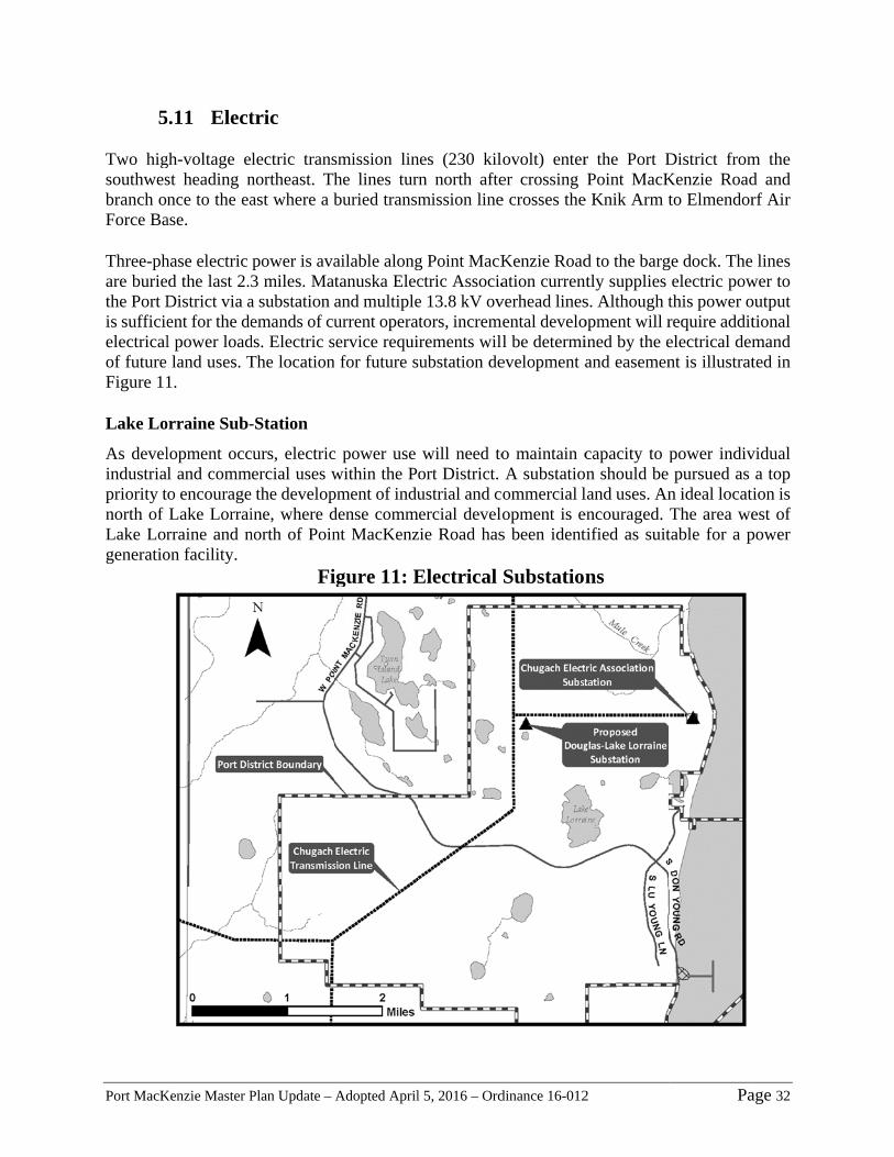
Port MacK
5 Two higsouthwesbranch onForce Ba Three-phare buriethe Port Dis sufficieelectricalof future Figure 11 Lake Lo
As develindustriapriority tnorth of Lake Lorgeneratio
Kenzie Master P
5.11 Elect
gh-voltage est heading nnce to the ea
ase.
hase electric d the last 2.District via aent for the del power loadland uses. T
1.
orraine Sub-
lopment occl and commo encourageLake Lorrairraine and non facility.
Plan Update –
tric
lectric transnortheast. Thast where a b
power is ava3 miles. Mata substation emands of cu
ds. Electric sThe location
-Station
curs, electricmercial uses we the developine, where dnorth of Poin
Fi
Adopted April
smission linhe lines turburied transm
ailable alongtanuska Elecand multipleurrent opera
service requin for future s
c power use within the Ppment of indudense commnt MacKenz
igure 11: E
l 5, 2016 – Ord
nes (230 kilrn north aftemission line
g Point MacKctric Associae 13.8 kV ovators, incremirements wilsubstation de
will need toort District. ustrial and c
mercial develzie Road has
Electrical
dinance 16-012
lovolt) enterer crossing e crosses the
Kenzie Roadation current
verhead linesmental develo
l be determievelopment a
o maintain cA substatioommercial lopment is es been ident
Substation
2
r the Port DPoint MacK
e Knik Arm t
d to the bargntly supplies s. Although topment will rined by the eand easemen
capacity to pn should be
land uses. Anencouraged. tified as suit
ns
Pa
District fromKenzie Roadto Elmendor
ge dock. Theelectric powthis power orequire additelectrical demnt is illustrat
power indivpursued as
n ideal locatThe area wetable for a p
age 32
m the d and rf Air
lines wer to output tional mand ted in
vidual a top ion is est of power

Port MacKenzie Master Plan Update – Adopted April 5, 2016 – Ordinance 16-012 Page 33
5.12 Natural Gas Planning for a Port MacKenzie power plant is prudent given the anticipated capacity of industrial, manufacturing and commercial uses. Natural gas delivery will be developed to sustain large-scale industrial and commercial activity at Port MacKenzie. Currently plans call for a 10-inch, high-pressure gas transmission line to be extended from Mile 39 Beluga pipeline located approximately 14 miles away for near-term natural gas usage. Distribution lines within the Port District will be developed in multiple grid patterns.
5.13 Communications A telephone-microwave-relay facility was constructed by Matanuska Telephone Association to receive signals from another tower in Eagle River. Telephone lines are also buried within the utility easement. Internet service was upgraded to high speed DSL in 2007. Fiber optic lines were installed later. 6. Recommendations The following recommendations are the result of issues that arose during the Master Plan development that were not addressed in depth in the plan because of timing or other appropriate reasons. They include suggestions of future assessments, reviews and studies to meet or enhance specific actions to support the business of a successful Port District. The recommendations are not listed in priority order.
6.1 Administrative
1) The Master Plan should continue to be a living document with updates after significant Port development activities or every three to five years.
2) A Port Management Code should be developed to serve as guidance for items such as: administrative operating procedures leasing procedures and requirements, including timing of environmental audits
before, during and after leasing; standards and special permit and lease stipulations unique to the Port tenant responsibilities
3) Review of Borough Code 17.23, Point Mackenzie Port Special Use District, 18, the Port and others to offer changes which will make management of the Port District more efficient.
4) Create a more informative, interactive web presence both as a marketing tool and as a means for public access to information about the Port.
5) Develop a forward-thinking marketing plan for the Port that examines potential positioning strategies best suited for the Port.
6) Develop a Port Business Plan that guides future infrastructure maintenance and investment.
7) Develop options for leasing practices. Evaluate if competition for leases, rights or franchises will be effective in sustaining competition and maintaining incentives for Port improvements. The evaluation should include consideration of:
Port MacKenzie Master Plan Update – Adopted April 5, 2016 – Ordinance 16-012 Page 34
Availability of private funding for investment in the Port Which categories of Port assets should private investors be at risk for providing,
maintaining and repairing versus those for which the public sector will be responsible
On what basis should user fees or subsidies be used to cover the cost of long-lived Port assets?
8) Designate the Port District as a Fire Service District. 9) When necessary, provide for special subdivision regulations within the Port district, to
accommodate the unique road construction situations.
6.2 Infrastructure
1) Develop a Transportation Plan for the Port District which in part considers
and addresses the following:
a. Guidelines for driveway operations for various commercial and industrial activities, including ingress/egress maneuverability and speed, throat length and driveway geometrics, etc.
b. Increasing the load capacity and width of the roads within the Port c. A Road Corridor Access strategy for Point MacKenzie Road
through Burma Road to the Parks Highway d. Relocating the parking lot south of Point MacKenzie Road used to
access Figure Eight Lake and private property south of the Port District so it does not conflict with the marine/rail industrial uses of the Port
e. Assessing the need and location of permanent access through the Port District to property south of the Port District
f. Water flowing along Don Young Road suggests that a perched aquifer surfaces along the bluff above the road; develop a bluff slope stability strategy that recommends appropriate dewatering and water control methods.
g. Evaluate and design the basic material handling infrastructure layout common to a majority of the commodities anticipated to be moved between the rail loop and the docks, ensuring the necessary easements are reserved for this essential connection.
2) The Port Commission should determine what additional facilities will be necessary to accommodate and support Port tenants and users. Evaluate the need for facilities such as transient housing (motel/hotel/temporary trailer, etc.), office space, commercial space for restaurants, gas stations, office space, ATV sales and maintenance, etc.
3) Develop a utilities plan that identifies sources and corridors for water, sewer, power, communication and gas utilities to meet Port and tenant needs. The plan should include designation of the water and wastewater treatment facilities.

Port MacKenzie Master Plan Update – Adopted April 5, 2016 – Ordinance 16-012 Page 35
6.3 Environmental Studies
1) A study on the Hydrology and Hydraulic Environment of Knik Arm
included information on the sedimentation effects of the proposed Knik Arm Bridge embankments on sediment deposition, but no details about how far to the south that sedimentation extends (i.e., how it would affect the Port). Additional analysis is necessary to determine the effects of the proposed Knik Arm Bridge on Port operations. Extent and magnitude of sedimentation resulting from the proposed causeways should be a focus of the analysis.
2) A hydrologic study of the Port District should be conducted to determine where future potable and industrial water supplies should be developed.
3) A regional wetland assessment was conducted in 2006. The assessment did not include a classification of the wetlands. Additional wetland mapping and classification should be completed for the Port District.
4) Conduct a noise study as the port develops. Include a description of the buffering necessary to mitigate identified potential negative effects of noise.
5) Conduct a baseline wind analysis to determine predominate wind directions and speeds throughout the year. Document ambient air quality.
6.4 Port Land Management
1) Additional cultural resource inventory transects must be conducted in
advance of Port development. Inventories should be conducted according to the anticipated development schedule illustrated in Appendix A. Cultural resource inventory transects that have been completed, and that need to be completed, are shown in Appendix B.
2) Develop a landscaping plan for the Port District that utilizes the benefits of vegetative cover in buffering roadside views, or providing small rest and outdoor lunch areas, etc.
3) Develop an erosion control and stabilization plan for the Knik Arm Bluff above the docks and S. Don Young Road.

Port MacKenzie Master Plan Update – Adopted April 5, 2016 – Ordinance 16-012 Page 36
7. Bibliography
Bell, Greg. 2010. Port Commissioner. Personal Interview.
Bowman, Chris, P.E., 2014. Port MacKenzie Industrial Park Water and Sewer Feasibility Study.
Hattenburg, Dilley, and Linnell
Brown, Rob. 2010. Project Manager, Usibelli Coal Mine Inc. Personal Interview.
Buckle, Bish. 2010. Port Commissioner. Personal Interview.
Burden, P. and others, 2007. Comparative Port Use Study For Gas Line Pipe Materials. Northern
Economics Inc.
Campbell, Paul. 2010. Port Commissioner. Personal Interview.
Cruz, Dave. 2010. Port Commissioner. Personal Interview.
Flores, R.M., Striker, G.D., and Kinney, S.A., 2003, Alaska Coal Resources And Coalbed
Methane Potential. U.S. Geol. Survey Bull. 2198, 4 p.
Denton, Steve. 2010. Vice President, Business Development, Usibelli Coal Mine, Inc. Personal Interview.
DuClos, Paul. 2010. Port Commissioner. Personal Interview.
Hoggan, Rick. 2010. Professional Engineer, Millcreek Engineering. Personal Interview.
Kane, William. 2010. Plant Manager. Alutiiq Manufacturing Contractors. Personal Interview
Lacher, Robert. 2010. VP Business Development Energy & Chemicals, CH2M Hill. Personal Interview.
Metz, Paul, and others, 2004. Petrochemical Industry Would Have Big Economic Impact On Alaska.
Petroleum News, Vol. 9, No. 29. July 18.
Metz, Paul. 2007a. Economic Analysis of Rail Link Port MacKenzie to Willow, Alaska.
Metz, Paul. 2007b. Economic Analysis of Rail Link Port MacKenzie to Willow, Alaska Phase II - Possible
Rail Extension Users Analysis.
Nolfi, Jay. 2010. Port Commissioner. Personal Interview.
Riggs, John. 2010. Port Commissioner. Personal Interview.
Shannon and Wilson, 2014. Geotechnical Engineering Report Port MacKenzie Transportation
Improvements Lu Young Lane.
USKH, 2012. Port MacKenzie Compliance Audit. Technical Memorandum.
VanDongen, Marc. 2015. Port Director. Personal Interviews.
World Bank. 2007. Port Reform Toolkit. Accessed at the following website September 2010:
http://www.ppiaf.org/ppiaf/sites/ppiaf.org/files/documents/toolkits/Portoolkit/.

Port MacKenzie Master Plan Update – Adopted April 5, 2016 – Ordinance 16-012 Page 37
APPENDICIES
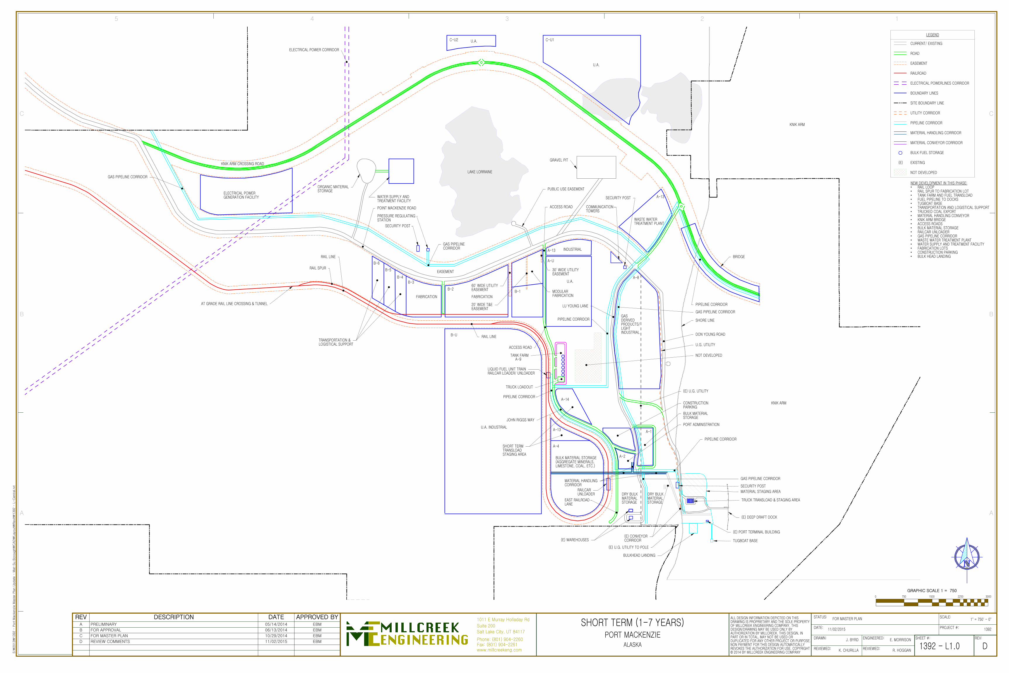
GRAVEL PIT
LAKE LORRAINE
EASEMENT
INDUSTRIAL
FABRICATIONFABRICATION
PIPELINE CORRIDOR
BRIDGE
BULK MATERIAL STORAGE(AGGREGATE MINERALS,LIMESTONE, COAL, ETC.)
MATERIAL HANDLINGCORRIDOR
DRY BULKMATERIALSTORAGE
TRUCK TRANSLOAD & STAGING AREA
TUGBOAT BASE
SECURITY POSTRAILCARUNLOADER
A-13
A-2
A-1
A-13
B-2
B-3B-4
B-5
B-6
AT GRADE RAIL LINE CROSSING & TUNNEL
DON YOUNG ROAD
U.G. UTILITY
RAIL SPUR
RAIL LINE
RAIL LINE
BULKHEAD LANDING
MATERIAL STAGING AREA
ACCESS ROAD
EAST RAILROADLANE
KNIK ARM
ELECTRICAL POWER CORRIDOR
SHORE LINE
B-U
C-U2 C-U1U.A.
U.A.
U.A. INDUSTRIAL
A-U
U.A.
BULK MATERIALSTORAGE
CONSTRUCTIONPARKING
PIPELINE CORRIDOR
LIQUID FUEL UNIT TRAINRAILCAR LOADER/ UNLOADER
TRUCK LOADOUT
30' WIDE UTILITYEASEMENT
SECURITY POST
POINT MACKENZIE ROAD
TRANSPORTATION &LOGISTICAL SUPPORT
SECURITY POST
COMMUNICATIONTOWERS
MODULARFABRICATION
B-1
PIPELINE CORRIDOR
PIPELINE CORRIDOR
(E) WAREHOUSES(E) CONVEYORCORRIDOR
(E) U.G. UTILITY TO POLE
KNIK ARM
(E) DEEP DRAFT DOCK
(E) U.G. UTILITY
DRY BULKMATERIALSTORAGE
GAS PIPELINECORRIDOR
KNIK ARM CROSSING ROAD
SHORT TERMTRANSLOADSTAGING AREA
(E) PORT TERMINAL BUILDING
PUBLIC USE EASEMENT
A-4
A-14
WASTE WATERTREATMENT PLANT
A-13
ORGANIC MATERIALSTORAGE
WATER SUPPLY ANDTREATMENT FACILITY
LU YOUNG LANE
JOHN RIGGS WAY
TANK FARMA-9
ACCESS ROAD
NOT DEVELOPED
PRESSURE REGULATINGSTATION
GAS PIPELINE CORRIDOR
ELECTRICAL POWERGENERATION FACILITY
A-8
GASDERIVEDPRODUCTS/LIGHTINDUSTRIAL
GAS PIPELINE CORRIDOR
PORT ADMINISTRATION
GAS PIPELINE CORRIDOR
60' WIDE UTILITYEASEMENT
20' WIDE T&EEASEMENT
CURRENT/ EXISTING
EASEMENT
RAILROAD
ELECTRICAL POWERLINES CORRIDOR
BOUNDARY LINES
SITE BOUNDARY LINE
UTILITY CORRIDOR
PIPELINE CORRIDOR
MATERIAL HANDLING CORRIDOR
MATERIAL CONVEYOR CORRIDOR
LEGEND
BULK FUEL STORAGE
ROAD
EXISTING(E)
NOT DEVELOPED
NEW DEVELOPMENT IN THIS PHASE:• RAIL LOOP• RAIL SPUR TO FABRICATION LOT• TANK FARM AND FUEL TRANSLOAD• FUEL PIPELINE TO DOCKS• TUGBOAT BASE• TRANSPORTATION AND LOGISTICAL SUPPORT• TRUCKED COAL EXPORT• MATERIAL HANDLING CONVEYOR• KNIK ARM BRIDGE• ACCESS ROADS• BULK MATERIAL STORAGE• RAILCAR UNLOADER• GAS PIPELINE CORRIDOR• WASTE WATER TREATMENT PLANT• WATER SUPPLY AND TREATMENT FACILITY• FABRICATION LOTS• CONSTRUCTION PARKING• BULK HEAD LANDING
Suite 200
1011 E Murray Holladay Rd
Phone: (801) 904-2260Fax: (801) 904-2261www.millcreekeng.com
Salt Lake City, UT 84117
B
A
5 4 3 2 1
C
B
A
C
DRAWN:
DATE: PROJECT #:
SCALE:
REVIEWED:
REV:SHEET #:
STATUS:
ENGINEERED:
REVIEWED:
ALL DESIGN INFORMATION DEPICTED ON THISDRAWING IS PROPRIETARY AND THE SOLE PROPERTYOF MILLCREEK ENGINEERING COMPANY. THISDESIGN/DRAWING MAY BE USED ONLY BYAUTHORIZATION BY MILLCREEK. THIS DESIGN, INPART OR IN TOTAL, MAY NOT BE USED ORDUPLICATED FOR ANY OTHER PROJECT OR PURPOSE.NON PAYMENT FOR THIS DESIGN AUTOMATICALLYREVOKES THE AUTHORIZATION FOR USE. COPYRIGHT© 2014 BY MILLCREEK ENGINEERING COMPANY
11/02/2015
ALASKA D
S:₩
2013₩
1392 -
Port M
acke
nzi
e M
aste
r Pla
n U
pdate
- M
at-
Su B
oro
ugh₩
CAD
₩Layo
ut₩
Revi
t₩1392 -
L-C
entral.rv
t
1392 -
SHORT TERM (1-7 YEARS)PORT MACKENZIE
K. CHURILLA
J. BYRD
1392
R. HOGGAN
E. MORRISON
FOR MASTER PLAN
L1.0
1" = 750' - 0"
0 1500 2250 3000750
GRAPHIC SCALE 1 = 750
REV DESCRIPTION DATE APPROVED BYA PRELIMINARY 05/14/2014 EBM
B FOR APPROVAL 06/13/2014 EBM
C FOR MASTER PLAN 10/29/2014 EBM
D REVIEW COMMENTS 11/02/2015 EBM
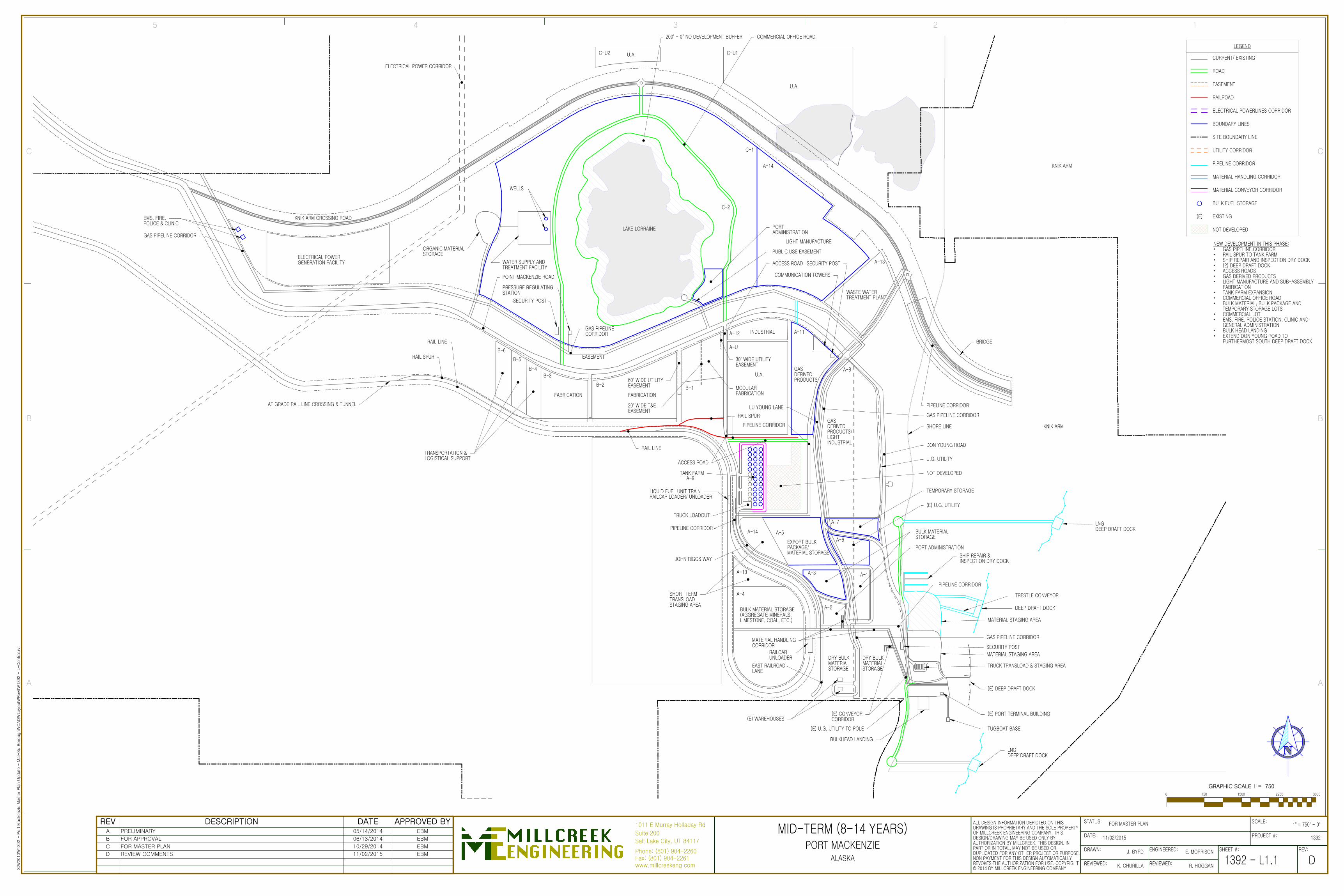
WASTE WATERTREATMENT PLANT
GASDERIVEDPRODUCTS
MATERIAL STAGING AREA
ORGANIC MATERIALSTORAGE
LAKE LORRAINE
EASEMENT
INDUSTRIAL
FABRICATIONFABRICATION
TRANSPORTATION &LOGISTICAL SUPPORT
BRIDGE
BULK MATERIAL STORAGE(AGGREGATE MINERALS,LIMESTONE, COAL, ETC.)
TRUCK TRANSLOAD & STAGING AREA
TUGBOAT BASE
SECURITY POST
A-1
B-2
B-3B-4
B-5
B-6RAIL SPUR
RAIL LINE
RAIL LINE
SHIP REPAIR &INSPECTION DRY DOCK
KNIK ARM
RAIL SPUR
DEEP DRAFT DOCK
ELECTRICAL POWER CORRIDOR
A-11
A-13
A-12
AT GRADE RAIL LINE CROSSING & TUNNEL
DRY BULKMATERIALSTORAGE
JOHN RIGGS WAY
PIPELINE CORRIDOR
MATERIAL STAGING AREA
LIQUID FUEL UNIT TRAINRAILCAR LOADER/ UNLOADER
KNIK ARM CROSSING ROAD
30' WIDE UTILITYEASEMENT
TRESTLE CONVEYOR
SECURITY POST
POINT MACKENZIE ROAD
SECURITY POST
COMMUNICATION TOWERS
C-U2 C-U1U.A.
U.A.
A-U
U.A.
A-2
DON YOUNG ROAD
U.G. UTILITY
MODULARFABRICATION
B-1
PIPELINE CORRIDOR
(E) DEEP DRAFT DOCK
RAILCARUNLOADER
EAST RAILROADLANE
DRY BULKMATERIALSTORAGE
MATERIAL HANDLINGCORRIDOR
PIPELINE CORRIDOR
TRUCK LOADOUT
(E) PORT TERMINAL BUILDING
A-13
SHORT TERMTRANSLOADSTAGING AREA
A-4
A-14
WATER SUPPLY ANDTREATMENT FACILITY
PRESSURE REGULATINGSTATION
LIGHT MANUFACTURE
C-2
C-1
A-14
COMMERCIAL OFFICE ROAD200' - 0" NO DEVELOPMENT BUFFER
ACCESS ROAD
PUBLIC USE EASEMENTELECTRICAL POWERGENERATION FACILITY
A-6
A-7
EXPORT BULKPACKAGE/MATERIAL STORAGE
A-3
BULK MATERIALSTORAGE
A-5
LU YOUNG LANE
BULKHEAD LANDING
(E) WAREHOUSES(E) CONVEYORCORRIDOR
(E) U.G. UTILITY TO POLE
TANK FARMA-9
ACCESS ROAD
NOT DEVELOPED
GAS PIPELINECORRIDOR
TEMPORARY STORAGE
(E) U.G. UTILITY
EMS, FIRE,POLICE & CLINIC
GAS PIPELINE CORRIDOR
SHORE LINE
PIPELINE CORRIDOR
A-8
GASDERIVEDPRODUCTS/LIGHTINDUSTRIAL
GAS PIPELINE CORRIDOR
PORT ADMINISTRATION
GAS PIPELINE CORRIDOR
WELLS
PORTADMINISTRATION
LNGDEEP DRAFT DOCK
LNGDEEP DRAFT DOCK
60' WIDE UTILITYEASEMENT
20' WIDE T&EEASEMENT
KNIK ARM
CURRENT/ EXISTING
EASEMENT
RAILROAD
ELECTRICAL POWERLINES CORRIDOR
BOUNDARY LINES
SITE BOUNDARY LINE
UTILITY CORRIDOR
PIPELINE CORRIDOR
MATERIAL HANDLING CORRIDOR
MATERIAL CONVEYOR CORRIDOR
LEGEND
BULK FUEL STORAGE
ROAD
EXISTING(E)
NOT DEVELOPED
NEW DEVELOPMENT IN THIS PHASE:• GAS PIPELINE CORRIDOR• RAIL SPUR TO TANK FARM• SHIP REPAIR AND INSPECTION DRY DOCK• (2) DEEP DRAFT DOCK• ACCESS ROADS• GAS DERIVED PRODUCTS• LIGHT MANUFACTURE AND SUB-ASSEMBLY
FABRICATION• TANK FARM EXPANSION• COMMERCIAL OFFICE ROAD• BULK MATERIAL, BULK PACKAGE AND
TEMPORARY STORAGE LOTS• COMMERCIAL LOT• EMS, FIRE, POLICE STATION, CLINIC AND
GENERAL ADMINISTRATION• BULK HEAD LANDING• EXTEND DON YOUNG ROAD TO
FURTHERMOST SOUTH DEEP DRAFT DOCK
Suite 200
1011 E Murray Holladay Rd
Phone: (801) 904-2260Fax: (801) 904-2261www.millcreekeng.com
Salt Lake City, UT 84117
B
A
5 4 3 2 1
C
B
A
C
DRAWN:
DATE: PROJECT #:
SCALE:
REVIEWED:
REV:SHEET #:
STATUS:
ENGINEERED:
REVIEWED:
ALL DESIGN INFORMATION DEPICTED ON THISDRAWING IS PROPRIETARY AND THE SOLE PROPERTYOF MILLCREEK ENGINEERING COMPANY. THISDESIGN/DRAWING MAY BE USED ONLY BYAUTHORIZATION BY MILLCREEK. THIS DESIGN, INPART OR IN TOTAL, MAY NOT BE USED ORDUPLICATED FOR ANY OTHER PROJECT OR PURPOSE.NON PAYMENT FOR THIS DESIGN AUTOMATICALLYREVOKES THE AUTHORIZATION FOR USE. COPYRIGHT© 2014 BY MILLCREEK ENGINEERING COMPANY
11/02/2015
ALASKA D
S:₩
2013₩
1392 -
Port M
acke
nzi
e M
aste
r Pla
n U
pdate
- M
at-
Su B
oro
ugh₩
CAD
₩Layo
ut₩
Revi
t₩1392 -
L-C
entral.rv
t
1392 -
MID-TERM (8-14 YEARS)PORT MACKENZIE
K. CHURILLA
J. BYRD
1392
R. HOGGAN
E. MORRISON
FOR MASTER PLAN
L1.1
1" = 750' - 0"
0 1500 2250 3000750
GRAPHIC SCALE 1 = 750
REV DESCRIPTION DATE APPROVED BYA PRELIMINARY 05/14/2014 EBM
B FOR APPROVAL 06/13/2014 EBM
C FOR MASTER PLAN 10/29/2014 EBM
D REVIEW COMMENTS 11/02/2015 EBM

B-7B-9
B-10B-8
B-11 B-U
C-3
C-7 C-6 C-U2 C-5 C-U1 C-4U.A.
U.A. MANUFACTURE
INDUSTRIAL INDUSTRIAL
INDUSTRIAL INDUSTRIAL
LARGE LOT INDUSTRIAL U.A. INDUSTRIAL
A-U
A-6
A-7
COMMERCIAL OFFICE ROAD
A-14
LIGHT MANUFACTURE
C-2
C-1
A-11
A-8
A-13
A-10
WASTE WATERTREATMENT PLANT
FREE TRADEZONE
LAKE LORRAINE
EASEMENT
INDUSTRIAL
FABRICATIONFABRICATION
TANK FARM
BRIDGE
BULK MATERIAL STORAGE(AGGREGATE MINERALS,LIMESTONE, COAL, ETC.)
TRUCK TRANSLOAD & STAGING AREA
SECURITY POST
A-1
A-12
B-2
B-3B-4
B-5
B-6RAIL SPUR RAIL LINE
RAIL LINE
ELECTRICAL POWER CORRIDOR
A-9
SHIP REPAIR &INSPECTION DRY DOCK
INDUSTRIAL
ACCESS ROAD
KNIK ARM
U.A.
200' - 0" NO DEVELOPMENT BUFFER
DEEP DRAFT DOCK
RAIL SIDING
AT GRADE RAIL LINE CROSSING & TUNNEL
DRY BULKMATERIALSTORAGE
PIPELINE CORRIDOR
MATERIAL STAGING AREA
MATERIAL STAGING AREA
LIQUID FUEL UNIT TRAINRAILCAR LOADER/ UNLOADER
30' WIDE UTILITYEASEMENT
PRESSURE REGULATINGSTATION
SECURITY POST
POINT MACKENZIE ROAD
TRANSPORTATION &LOGISTICAL SUPPORT
SOUTH ACCESSPORT ROAD
A-3
DON YOUNG ROAD
U.G. UTILITY
RAIL SPUR
MODULARFABRICATION
B-1
LU YOUNG LANE
PIPELINE CORRIDORGASDERIVEDPRODUCTS/LIGHTINDUSTRIAL
(E) DEEP DRAFT DOCK
RAILCARUNLOADER
EAST RAILROADLANE
DRY BULKMATERIALSTORAGE
MATERIAL HANDLINGCORRIDOR
PIPELINE CORRIDOR
TRUCK LOADOUT
B-12
ACCESS ROAD
B-13
TRESTLE CONVEYOR
ACCESS ROAD
LARGE LOTINDUSTRIAL
A-2
GASDERIVEDPRODUCTS
KNIK ARM CROSSING ROAD
INDUSTRIAL
POWER GENERATION FACILITY
PUBLIC USE EASEMENT
EXPORT BULKPACKAGE/MATERIALSTORAGE
A-5
A-13
A-4
A-14
WATER SUPPLY ANDTREATMENT FACILITY
JOHN RIGGS WAY
TANK FARM
BULKHEAD LANDING
(E) WAREHOUSES(E) CONVEYORCORRIDOR
(E) U.G. UTILITY TO POLE TUGBOAT BASE
(E) PORT TERMINAL BUILDING
LNGDEEP DRAFT DOCK
NOT DEVELOPED
SHORT TERMTRANSLOADSTAGING AREA
EMS, FIRE,POLICE & CLINIC
GAS PIPELINE CORRIDOR
ELECTRICAL POWERGENERATION FACILITY
GAS PIPELINECORRIDOR
SECURITY POST
COMMUNICATION TOWERS
SHORE LINE
PIPELINE CORRIDOR
GAS PIPELINE CORRIDOR
BULK MATERIALSTORAGE
PORT ADMINISTRATION
GAS PIPELINE CORRIDOR
WELLS
PORTADMINISTRATION
MATCHLINE
ACCESS ROAD
60' WIDE UTILITYEASEMENT
20' WIDE T&EEASEMENT
LNGDEEP DRAFT DOCK
KNIK ARM
TEMPORARY STORAGE
(E) U.G. UTILITY
CURRENT/ EXISTING
EASEMENT
RAILROAD
ELECTRICAL POWERLINES CORRIDOR
BOUNDARY LINES
SITE BOUNDARY LINE
UTILITY CORRIDOR
PIPELINE CORRIDOR
MATERIAL HANDLING CORRIDOR
MATERIAL CONVEYOR CORRIDOR
LEGEND
BULK FUEL STORAGE
ROAD
EXISTING(E)
NOT DEVELOPED
NEW DEVELOPMENT IN THIS PHASE:• LARGE LOT INDUSTRIAL• FREE TRADE ZONE• ADDITIONAL INDUSTRIAL AND SUB-
ASSEMBLY FABRICATION• TANK FARM EXPANSION• SOUTHPORT ACCESS ROAD CONSTRUCTED• POWER GENERATION FACILITY• MANUFACTURE• COMMERCIAL LOTS
LNGDEEP DRAFT DOCK
LNGDEEP DRAFT DOCK
MATCHLINE
Suite 200
1011 E Murray Holladay Rd
Phone: (801) 904-2260Fax: (801) 904-2261www.millcreekeng.com
Salt Lake City, UT 84117
B
A
5 4 3 2 1
C
B
A
C
DRAWN:
DATE: PROJECT #:
SCALE:
REVIEWED:
REV:SHEET #:
STATUS:
ENGINEERED:
REVIEWED:
ALL DESIGN INFORMATION DEPICTED ON THISDRAWING IS PROPRIETARY AND THE SOLE PROPERTYOF MILLCREEK ENGINEERING COMPANY. THISDESIGN/DRAWING MAY BE USED ONLY BYAUTHORIZATION BY MILLCREEK. THIS DESIGN, INPART OR IN TOTAL, MAY NOT BE USED ORDUPLICATED FOR ANY OTHER PROJECT OR PURPOSE.NON PAYMENT FOR THIS DESIGN AUTOMATICALLYREVOKES THE AUTHORIZATION FOR USE. COPYRIGHT© 2014 BY MILLCREEK ENGINEERING COMPANY
11/02/2015
ALASKA D
S:₩
2013₩
1392 -
Port M
acke
nzi
e M
aste
r Pla
n U
pdate
- M
at-
Su B
oro
ugh₩
CAD
₩Layo
ut₩
Revi
t₩1392 -
L-C
entral.rv
t
1392 -
LONG TERM (15+ YEARS)PORT MACKENZIE
K. CHURILLA
J. BYRD
1392
R. HOGGAN
E. MORRISON
FOR MASTER PLAN
L1.2
1" = 750' - 0"
0 1500 2250 3000750
GRAPHIC SCALE 1 = 750
MATCHLINE - LNG DEEP DRAFT DOCKS
REV DESCRIPTION DATE APPROVED BYA PRELIMINARY 05/14/2014 EBM
B FOR APPROVAL 06/13/2014 EBM
C FOR MASTER PLAN 10/29/2014 EBM
D REVIEW COMMENTS 11/02/2015 EBM

B-7B-9
B-10 B-8
B-12 B-11 B-U
C-3
C-7 C-6 C-U2 C-5 C-U1 C-4
POWERGENERATIONFACILITY
U.A.MANUFACTURE
INDUSTRIAL
LARGE LOT INDUSTRIAL
INDUSTRIAL U.A. INDUSTRIAL
A-U
A-6
A-7A-5
EXPORT BULK PACKAGE/MATERIAL STORAGE
TEMPORARY STORAGE
A-14
MANUFACTURE
C-2
C-1
A-11A-8
A-13
A-10
WASTE WATERTREATMENT PLANT
FREE TRADEZONE
GAS DERIVEDPRODUCTS
LAKE LORRAINE
EASEMENT
INDUSTRIAL
MODULARFABRICATIONFABRICATION
TRANSPORTATION &LOGISTICAL SUPPORT
POINT MACKENZIEROAD
TANK FARM
ROAD
BULK MATERIAL STORAGE(AGGREGATE MINERALS,LIMESTONE, COAL, ETC.) (E) PORT TERMINAL BUILDINGGAS PIPELINE
CORRIDOR
A-4
A-3
A-2A-1
A-12
B-1B-2B-3B-4B-
5B-6
KNIK ARMCROSSING ROAD
DON YOUNG ROAD
SOUTH ACCESSPORT ROAD
ELECTRICAL POWER CORRIDOR
A-9 LU YOUNG LANE
JOHN RIGGSWAY
BULK MATERIAL STORAGE
SHIP REPAIR &INSPECTION DRY DOCK
GAS DERIVED PRODUCTS/LIGHT INDUSTRIAL
ELECTRICAL POWERGENERATION FACILITY
EAST RAILROADLANE
KNIK ARM
KNIK ARM
U.A.
DEEP DRAFT DOCK
RAIL SIDING
200' - 0" NO DEVELOPMENT BUFFER
BOUNDARY LINE
(E) DEEP DRAFT DOCK
COMMUNICATIONTOWERS
BRIDGE
B-13
DRY BULK MATERIAL STORAGE
POINT MACKENZIEROAD
ELECTRICAL POWER CORRIDOR
SHORT TERMTRANSLOADSTAGING AREA
A-13
TANK FARM A-14
WATER SUPPLY ANDTREATMENT FACILITY
LNG DEEP DRAFT DOCKBULK HEAD LANDING
NOT DEVELOPED
PORTADMINISTRATION
LIGHT
PORT ADMINISTRATION
LNG DEEP DRAFT DOCK
LNG DEEP DRAFT DOCK
ROAD
RAILROAD
ELECTRICAL POWERLINES CORRIDOR
BOUNDARY LINES
SITE BOUNDARY LINE
UTILITY CORRIDOR
PIPELINE CORRIDOR
MATERIAL HANDLING CORRIDOR
LEGEND
BULK FUEL STORAGE
LEASE LOTS
EASEMENT
COMMUNICATION TOWERS
NOT DEVELOPED
Suite 200
1011 E Murray Holladay Rd
Phone: (801) 904-2260Fax: (801) 904-2261www.millcreekeng.com
Salt Lake City, UT 84117
B
A
5 4 3 2 1
C
B
A
C
DRAWN:
DATE: PROJECT #:
SCALE:
REVIEWED:
REV:SHEET #:
STATUS:
ENGINEERED:
REVIEWED:
ALL DESIGN INFORMATION DEPICTED ON THISDRAWING IS PROPRIETARY AND THE SOLE PROPERTYOF MILLCREEK ENGINEERING COMPANY. THISDESIGN/DRAWING MAY BE USED ONLY BYAUTHORIZATION BY MILLCREEK. THIS DESIGN, INPART OR IN TOTAL, MAY NOT BE USED ORDUPLICATED FOR ANY OTHER PROJECT OR PURPOSE.NON PAYMENT FOR THIS DESIGN AUTOMATICALLYREVOKES THE AUTHORIZATION FOR USE. COPYRIGHT© 2014 BY MILLCREEK ENGINEERING COMPANY
11/02/2015
ALASKA D
S:₩
2013₩
1392 -
Port M
acke
nzi
e M
aste
r Pla
n U
pdate
- M
at-
Su B
oro
ugh₩
CAD
₩Layo
ut₩
Revi
t₩1392 -
L-C
entral.rv
t
1392 -
MASTER PLAN - OVERVIEWPORT MACKENZIE
K. CHURILLA
J. BYRD
1392
R. HOGGAN
E. MORRISON
FOR MASTER PLAN
MP
1" = 1200' - 0"
0 2400 3600 48001200
GRAPHIC SCALE 1 = 1200
REV DESCRIPTION DATE APPROVED BYA PRELIMINARY 05/14/2014 EBM
B FOR APPROVAL 06/13/2014 EBM
C FOR MASTER PLAN 10/29/2014 EBM
D REVIEW COMMENTS 11/02/2015 EBM

B-7B-9
B-10B-8
B-11 B-U
C-7 C-6 C-U2 C-5 C-U1
U.A. MANUFACTURE
INDUSTRIAL INDUSTRIAL
INDUSTRIAL INDUSTRIAL
UA INDUSTRIAL
A-U
200' - 0" NO DEVELOPMENT BUFFER COMMERCIAL OFFICE ROAD
LIGHT MANUFACTURE
C-2
C-1
WASTE WATERTREATMENT PLANT
FREE TRADEZONE
LAKE LORRAINE
EASEMENT
LIQUID FUEL UNIT TRAINRAILCAR LOADER/ UNLOADER
INDUSTRIAL
FABRICATIONFABRICATION
TANK FARM
BRIDGE
BULK MATERIAL STORAGE(AGGREGATE MINERALS,LIMESTONE, COAL, ETC.)
TRUCK TRANSLOAD & STAGING AREA
SECURITY POST
A-1
B-2
B-3B-4
B-5
B-6RAIL SPUR RAIL LINE
RAIL LINE
SHIP REPAIR &INSPECTION DRY DOCK
INDUSTRIAL
ACCESS ROAD
KNIK ARM
U.A.
U.A.
DEEP DRAFT DOCK
ELECTRICAL POWER CORRIDOR
A-14
A-11
A-8
A-13
A-10
A-12
A-9
AT GRADE RAIL LINE CROSSING & TUNNEL
DRY BULKMATERIALSTORAGE
PIPELINE CORRIDOR
MATERIAL STAGING AREA
MATERIAL STAGING AREA
30' WIDE UTILITYEASEMENT
60' WIDE UTILITYEASEMENT
PRESSURE REGULATINGSTATION
SECURITY POST
POINT MACKENZIE ROAD
TRANSPORTATION &LOGISTICAL SUPPORT
TEMPORARY STORAGE
DON YOUNG ROAD
U.G. UTILITY
RAIL SPUR
MODULARFABRICATION
B-1
PIPELINE CORRIDOR
20' WIDE T&EEASEMENT
GASDERIVEDPRODUCTS/LIGHTINDUSTRIAL
(E) DEEP DRAFT DOCK
(E) U.G. UTILITY
RAILCARUNLOADER
EAST RAILROADLANE
DRY BULKMATERIALSTORAGE
MATERIAL HANDLINGCORRIDOR
LARGE LOT INDUSTRIAL
B-12 B-13
TRESTLE CONVEYOR
ACCESS ROAD
LARGE LOTINDUSTRIAL A-3
A-2
GASDERIVEDPRODUCTS
KNIK ARM CROSSING ROAD
INDUSTRIAL
PUBLIC USE EASEMENT
EXPORT BULKPACKAGE/MATERIALSTORAGE
A-13
A-4
C-4
POWER GENERATION FACILITY
WATER SUPPLY ANDTREATMENT FACILITY
LU YOUNG LANE
JOHN RIGGS WAY
BULK HEAD LANDING
(E) WAREHOUSES(E) CONVEYORCORRIDOR
(E) U.G. UTILITY TO POLE TUGBOAT BASE
(E) PORT TERMINAL BUILDING
PIPELINE CORRIDOR
TRUCK LOADOUT
A-14TANK FARM
SHORT TERMTRANSLOADSTAGING AREA
NOT DEVELOPED
RAIL SIDING
ACCESS ROAD
EMS, FIRE,POLICE & CLINIC
GAS PIPELINE CORRIDOR
ELECTRICAL POWERGENERATION FACILITY
GAS PIPELINECORRIDOR
SHORE LINE
PIPELINE CORRIDOR
GAS PIPELINE CORRIDOR
PORT ADMINISTRATION
PORTADMINISTRATION
ACCESS ROAD
SECURITY POST
COMMUNICATION TOWERS
BULK MATERIALSTORAGE
WELLS
C-3
A-6
A-7A-5
SOUTH ACCESSPORT ROAD
MATCHLINE
KNIK ARM
LNGDEEP DRAFT DOCK
LNGDEEP DRAFT DOCK
GAS PIPELINE CORRIDOR
CURRENT/ EXISTING
EASEMENT
RAILROAD
ELECTRICAL POWERLINES CORRIDOR
BOUNDARY LINES
SITE BOUNDARY LINE
UTILITY CORRIDOR
PIPELINE CORRIDOR
MATERIAL HANDLING CORRIDOR
MATERIAL CONVEYOR CORRIDOR
LEGEND
BULK FUEL STORAGE
ROAD
EXISTING(E)
NOT DEVELOPED
LNGDEEP DRAFT DOCK
LNGDEEP DRAFT DOCK
MATCHLINE
Suite 200
1011 E Murray Holladay Rd
Phone: (801) 904-2260Fax: (801) 904-2261www.millcreekeng.com
Salt Lake City, UT 84117
B
A
5 4 3 2 1
C
B
A
C
DRAWN:
DATE: PROJECT #:
SCALE:
REVIEWED:
REV:SHEET #:
STATUS:
ENGINEERED:
REVIEWED:
ALL DESIGN INFORMATION DEPICTED ON THISDRAWING IS PROPRIETARY AND THE SOLE PROPERTYOF MILLCREEK ENGINEERING COMPANY. THISDESIGN/DRAWING MAY BE USED ONLY BYAUTHORIZATION BY MILLCREEK. THIS DESIGN, INPART OR IN TOTAL, MAY NOT BE USED ORDUPLICATED FOR ANY OTHER PROJECT OR PURPOSE.NON PAYMENT FOR THIS DESIGN AUTOMATICALLYREVOKES THE AUTHORIZATION FOR USE. COPYRIGHT© 2014 BY MILLCREEK ENGINEERING COMPANY
11/02/2015
ALASKA D
S:₩
2013₩
1392 -
Port M
acke
nzi
e M
aste
r Pla
n U
pdate
- M
at-
Su B
oro
ugh₩
CAD
₩Layo
ut₩
Revi
t₩1392 -
L-C
entral.rv
t
1392 -
MASTER PLANPORT MACKENZIE
K. CHURILLA
J. BYRD
1392
R. HOGGAN
E. MORRISON
FOR MASTER PLAN
MP1.4
1" = 750' - 0"
0 1500 2250 3000750
GRAPHIC SCALE 1 = 750
MATCHLINE - LNG DEEP DRAFT DOCKS
REV DESCRIPTION DATE APPROVED BYA PRELIMINARY 05/14/2014 EBM
B FOR APPROVAL 06/13/2014 EBM
C FOR MASTER PLAN 10/29/2014 EBM
D REVIEW COMMENTS 11/02/2015 EBM

B-7B-9
B-10B-8
B-11 B-U
C-7 C-6 C-U2 C-5 C-U1
U.A. MANUFACTURE
INDUSTRIAL INDUSTRIAL
INDUSTRIALINDUSTRIAL
U.A. INDUSTRIAL
A-U
200' - 0" NO DEVELOPMENT BUFFER COMMERCIAL OFFICE ROAD
LIGHT MANUFACTURE
C-2
C-1
FREE TRADEZONE
LAKE LORRAINE
EASEMENT
INDUSTRIAL
FABRICATION
FABRICATION
TANK FARM
BRIDGE
BULK MATERIAL STORAGE(AGGREGATE MINERALS,LIMESTONE, COAL, ETC.)
TRUCK TRANSLOAD & STAGING AREA
SECURITY POST
A-1
B-2
B-3B-4
B-5
B-6RAIL SPUR RAIL LINE
RAIL LINE
SHIP REPAIR &INSPECTION DRY DOCK
INDUSTRIAL
20' UTILITY CORRIDOR ON EITHERSIDE OF ROAD, TYPICAL
20' UTILITY CORRIDOR ON EITHERSIDE OF ROAD, TYPICAL
20' UTILITY CORRIDOR ON EITHERSIDE OF ROAD, TYPICAL
ACCESS ROAD
KNIK ARM
U.A.
U.A.
DEEP DRAFT DOCK
ELECTRICAL POWER CORRIDOR
A-14
A-11
A-8
A-13
A-10
A-12
A-9
AT GRADE RAIL LINE CROSSING & TUNNEL
DRY BULKMATERIALSTORAGE
PIPELINE CORRIDOR
MATERIAL STAGING AREA
MATERIAL STAGING AREA
LIQUID FUEL UNIT TRAINRAILCAR LOADER/ UNLOADER
30' WIDE UTILITYEASEMENT
PRESSURE REGULATINGSTATION
SECURITY POST
POINT MACKENZIE ROAD
TRANSPORTATION &LOGISTICAL SUPPORT
DON YOUNG ROAD
U.G. UTILITY
RAIL SPUR
MODULARFABRICATION
B-1
PIPELINE CORRIDORGASDERIVEDPRODUCTS/LIGHTINDUSTRIAL
(E) DEEP DRAFT DOCK
RAILCARUNLOADER
EAST RAILROADLANE
DRY BULKMATERIALSTORAGE
MATERIAL HANDLINGCORRIDOR
PIPELINE CORRIDOR
TRUCK LOADOUT
LARGE LOT INDUSTRIAL
B-12 B-13
TRESTLE CONVEYOR
ACCESS ROAD
LARGE LOTINDUSTRIAL A-3
A-2
GASDERIVEDPRODUCTS
KNIK ARM CROSSING ROAD
INDUSTRIAL
PUBLIC USE EASEMENT
EXPORTBULKPACKAGE/MATERIALSTORAGE
A-13
A-4
C-4
POWER GENERATION FACILITY
WASTE WATERTREATMENT PLANT
WATER SUPPLY ANDTREATMENT FACILITY
LU YOUNG LANE
JOHN RIGGS WAY
BULK HEAD LANDING
(E) WAREHOUSES(E) CONVEYORCORRIDOR
(E) U.G. UTILITY TO POLE TUGBOAT BASE
(E) PORT TERMINAL BUILDING
A-14TANK FARM
SHORT TERMTRANSLOADSTAGING AREA
NOT DEVELOPED
RAIL SIDING
C-3
A-6
A-7
SOUTH ACCESSPORT ROAD
A-5
LNGDEEP DRAFT DOCK
EMS, FIRE,POLICE & CLINIC
GAS PIPELINE CORRIDOR
ELECTRICAL POWERGENERATION FACILITY
GAS PIPELINECORRIDOR
SECURITY POST
COMMUNICATION TOWERS
SHORE LINE
PIPELINE CORRIDOR
GAS PIPELINE CORRIDOR
BULK MATERIALSTORAGE
PORT ADMINISTRATION
MATCHLINE
60' WIDE UTILITYEASEMENT
20' WIDE T&EEASEMENT
LNGDEEP DRAFT DOCK
WELLS
TEMPORARY STORAGE
(E) U.G. UTILITY
KNIK ARM
GAS PIPELINE CORRIDOR
CURRENT/ EXISTING
EASEMENT
RAILROAD
ELECTRICAL POWERLINES CORRIDOR
BOUNDARY LINES
SITE BOUNDARY LINE
UTILITY CORRIDOR
PIPELINE CORRIDOR
MATERIAL HANDLING CORRIDOR
MATERIAL CONVEYOR CORRIDOR
LEGEND
BULK FUEL STORAGE
ROAD
EXISTING(E)
NOT DEVELOPED
LNGDEEP DRAFT DOCK
LNGDEEP DRAFT DOCK
MATCHLINE
Suite 200
1011 E Murray Holladay Rd
Phone: (801) 904-2260Fax: (801) 904-2261www.millcreekeng.com
Salt Lake City, UT 84117
B
A
5 4 3 2 1
C
B
A
C
DRAWN:
DATE: PROJECT #:
SCALE:
REVIEWED:
REV:SHEET #:
STATUS:
ENGINEERED:
REVIEWED:
ALL DESIGN INFORMATION DEPICTED ON THISDRAWING IS PROPRIETARY AND THE SOLE PROPERTYOF MILLCREEK ENGINEERING COMPANY. THISDESIGN/DRAWING MAY BE USED ONLY BYAUTHORIZATION BY MILLCREEK. THIS DESIGN, INPART OR IN TOTAL, MAY NOT BE USED ORDUPLICATED FOR ANY OTHER PROJECT OR PURPOSE.NON PAYMENT FOR THIS DESIGN AUTOMATICALLYREVOKES THE AUTHORIZATION FOR USE. COPYRIGHT© 2014 BY MILLCREEK ENGINEERING COMPANY
11/02/2015
ALASKA D
S:₩
2013₩
1392 -
Port M
acke
nzi
e M
aste
r Pla
n U
pdate
- M
at-
Su B
oro
ugh₩
CAD
₩Layo
ut₩
Revi
t₩1392 -
L-C
entral.rv
t
1392 -
MASTER PLAN - UTILITY CORRIDORPORT MACKENZIE
K. CHURILLA
J. BYRD
1392
R. HOGGAN
E. MORRISON
FOR MASTER PLAN
U1.0
1" = 750' - 0"
0 1500 2250 3000750
GRAPHIC SCALE 1 = 750
REV DESCRIPTION DATE APPROVED BYA PRELIMINARY 05/14/2014 EBM
B FOR APPROVAL 06/13/2014 EBM
C FOR MASTER PLAN 10/29/2014 EBM
D REVIEW COMMENTS 11/02/2015 EBM
MATCHLINE - LNG DEEP DRAFT DOCKS

Appendix B – Previous Studies and Reports
Port MacKenzie Master Plan Update – Adopted April 5, 2016 – Ordinance 16-012 B1 of B1
Preliminary Feasibility Report, Point MacKenzie Seaport. Planning Department, MSB. April 1972.
Point MacKenzie Marine Port Development Plan. Development Services Department, MSB.
January 1988. Point MacKenzie Transportation Corridor Study. Peratrovich, Nottingham & Drange, Inc. March
1992. Southcentral Ports Development Projects, Peratrovich, Nottingham & Drange, Inc. January 1993. Point MacKenzie Area Which Merits Special Attention Plan. Alaska Department of Community
and Regional Affairs, Municipal and Regional Assistance Division. May 1993. Point MacKenzie Port Development, Overview of Planning and Permitting Requirements. Jon
Issacs and Linda Perry Dwight. June 1993. Port MacKenzie Development Project Prefeasibility Study. Peratrovich, Nottingham & Drange,
Inc. Northern Economics. May 1998. Concepts to Maximize Development Potential of Port MacKenzie and Upland Areas. The
Cornell Group, Inc. August 2001. Geotechnical Report, Knik Arm Ferry. Shannon and Wilson, Inc. February 2003. Sand and Gravel Assessment: Elmendorf Moraine, Port MacKenzie. Shannon and Wilson, Inc.
October 2003. Geotechnical Engineering Report, Knik Arm Ferry, Terminal Building. Shannon and Wilson.
September 2005. Point MacKenzie Regional Wetland Assessment. Critical Habitats, Inc. January 2006. Point MacKenzie Road Borrow Source Evaluations, Shannon and Wilson Inc. February 2008. Geotechnical Engineering Report. Port MacKenzie Bi-Modal Bulk Facility. Shannon and Wilson
Inc. May 2009. Port MacKenzie Drainage Study. PND Engineers, Inc. October 2013 Geotechnical Engineering Report. Port MacKenzie Transportation Improvements. Lu Young
Lane. February 2014 Maritime Navigation Risk Assessment of Port MacKenzie. Safeguard Marine. May 2014 Port MacKenzie Industrial Park Water and Sewer Feasibility Study. Hattenburg, Dilley, and
Linnel. December, 2014.

Port MacK
Append
Port Mac
developm
Construc
MacKenz
1993 and
The Boro
that woul
Matanusk
and subm
submerge
2010).
Initial co
took plac
resulted i
with 500
at -20 fee
buildings
the Alyes
Kenzie Master P
dix C - His
cKenzie bega
ment. A port
ction of the p
zie Area wh
d adopted by
ough applied
ld lie under
ka - Susitna
merged lands
ed lands are
onstruction o
ce from 1999
in an eight-a
feet of bulk
et mean lowe
s for the mili
ska ski area.
Plan Update –
story of Po
an in 1983 w
t developme
port access ro
ich Merits S
y the Boroug
d to the Alas
and extend f
Borough on
s adjacent to
necessary fo
f the barge d
9 to 2003 an
acre staging a
khead barge d
er low water
itary, prefab
Adopted April
ort MacK
when a comm
ent district an
oad was acco
Special Atten
h (Nolfi, 20
ka Departme
from the doc
n August 8, 1
tidelands ac
or future mo
dock
d
area
dock
r.
ricated hous
l 6, 2016 – Ord
Kenzie
mittee was fo
nd port comm
omplished in
ntion Plan (A
10).
ent of Natur
cks. Title to t
1996. In 199
cquired in 19
oorage, berth
A plant
facilities
2000. M
began be
2001. Th
construc
destined
plant has
ses that are tr
dinance 16-012
ormed to beg
mission wer
n phases from
AMSA) was
ral Resource
the land was
99 the boroug
996. These a
hing areas an
specializing
s was constru
Modular hom
eing shipped
he plant was
cting pump a
d for the Nor
s also constr
rucked to the
2
gin planning
re established
m 1990 to 1
approved by
s for title to
s transferred
gh selected a
additional tid
nd dock expa
g in building
ucted on a 1
es, construct
d on barges t
s used in 200
and electrica
rth Slope (Ki
ructed bunke
e Interior, an
C1
g port
d in 1988.
991. The Po
y the State in
the tideland
d to the
additional tid
de and
ansion (Rigg
manufacture
5-acre lease
ted at the pla
to rural Alas
05 for
al modules
ing, 2010). T
ers and range
nd a building
of C2
oint
n
ds
de
gs,
ed
e in
ant,
ska in
The
e
g for

Port MacK
In 2004,
dock.
Three-ph
gas servi
complete
Construc
deep-dra
of a 3,00
took plac
2005, the
vessel wa
million p
A storage
begins. In
451,000 t
Arm in th
Approxim
and pave
Young R
Reports o
Kenzie Master P
construction
hase electrica
ce has also b
ed.
ction of a 1,2
ft dock and i
0-foot conve
ce in 2004. In
e first major
as loaded wi
pounds of wo
e warehouse
n 2009, the w
tons of sand
he Port of A
mately 13 m
ed from 2008
Road hill redu
on and studie
Plan Update –
n of woodchi
al power was
been
200-foot long
installation
eyor system
n January of
export
ith 84
ood chips.
e was constru
warehouse w
d and gravel w
nchorage Ex
miles of the P
8 to 2009. Th
uction projec
es of the Por
Adopted April
ip handling
s extended to
g
f
ucted from 2
was used to s
were loaded
xpansion Pro
oint MacKen
he remaining
ct in 2011.
rt MacKenzi
l 6, 2016 – Ord
facilities beg
o the Port in
2007-2008 w
store importe
d onto barges
oject (Van D
nzie Road, w
g two miles t
ie area are li
dinance 16-012
gan on the b
n 2003. A de
within the lea
ed super sac
s by the conv
Dongen, 2010
which leads
to the docks
sted in Appe
2
luff directly
esign for exte
ase area whe
cks of cemen
veyor for use
0).
to the Port, w
s was paved
endix B.
C2
y above the b
ension of nat
ere the conve
nt. In 2008, a
e across the
was improve
after the Do
2 of C2
barge
tural
eyor
about
Knik
ed
n
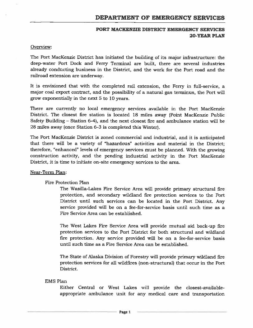
ek04396
Typewritten Text
ek04396
Typewritten Text
Appendix D