MARITIME BUOYAGE SYSTEM - Commissioners of Irish · PDF fileis a light flashing at either 60...
24
MARITIME BUOYAGE SYSTEM and Other Aids to Navigation
Transcript of MARITIME BUOYAGE SYSTEM - Commissioners of Irish · PDF fileis a light flashing at either 60...

MARITIME BUOYAGE SYSTEMand Other Aids to Navigation
Maritime Buoyage SystemHistorical Background 02
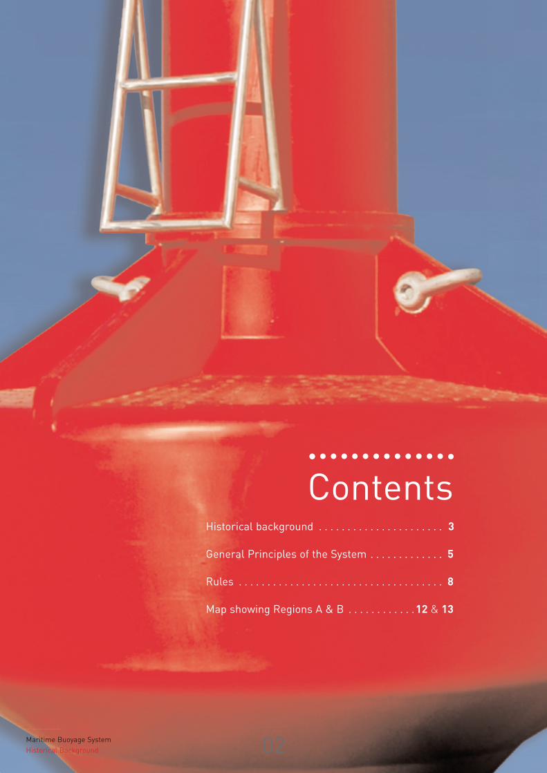
ContentsHistorical background . . . . . . . . . . . . . . . . . . . . . . 3
General Principles of the System . . . . . . . . . . . . . 5
Rules . . . . . . . . . . . . . . . . . . . . . . . . . . . . . . . . . . . . 8
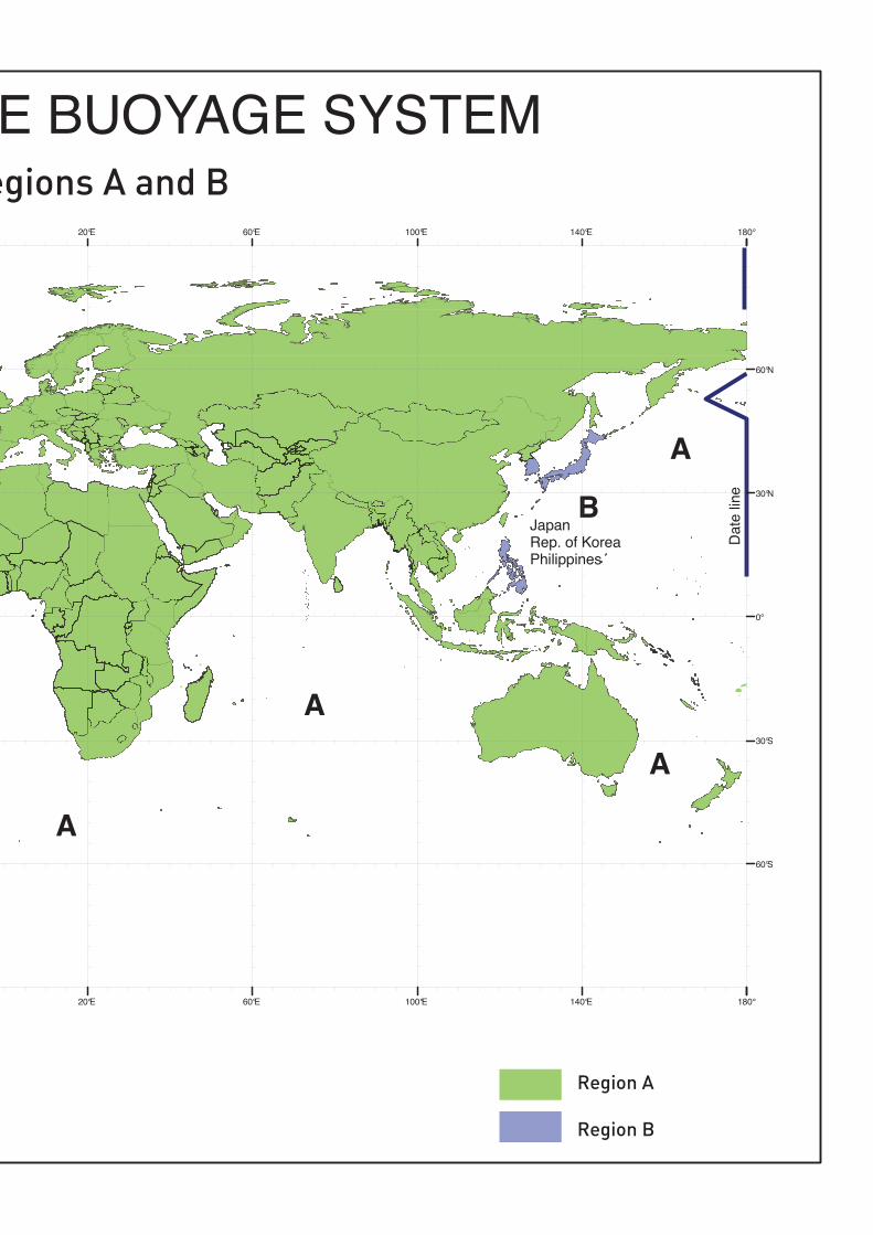
Map showing Regions A & B . . . . . . . . . . . .12 & 13
MBS
03 International Associationof Marine Aids to Navigation and Lighthouse Authorities
PRIOR TO 1976
There was once more than thirty different buoyagesystems in use world-wide, many of these systemshaving rules in complete conflict with one another.
There has long been disagreement over the way inwhich buoy lights should be used since they firstappeared towards the end of the 19th century. In particular, some countries favoured using red lights to mark the port hand side of channels and othersfavoured them for marking the starboard hand.
Another major difference of opinion revolved around theprinciples to be applied when laying out marks to assistthe mariner. Most countries adopted the principle ofthe Lateral system whereby marks indicate the port andstarboard sides of the route to be followed according tosome agreed direction. However, several countries alsofavoured using the principle of Cardinal marks wherebydangers are marked by one or more buoys or beaconslaid out in the quadrants of the compass to indicatewhere the danger lies in relation to the mark, this system being particularly useful in the open sea wherethe Lateral buoyage direction may not be apparent.
The nearest approach to international agreement on aunified system of buoyage was reached at Geneva in1936. This Agreement, drawn up under the auspices ofthe League of Nations, was never ratified due to theoutbreak of World War II. The Agreement proposedthe use of either Cardinal marks or Lateral marks butseparated them into two different systems. It providedfor the use of the colour red on port hand marks andlargely reserved the colour green for wreck marking.
At the end of World War II many countries found their aids to navigation destroyed and the process ofrestoration had to be undertaken urgently. In theabsence of anything better, the Geneva rules wereadopted with or without variation to suit local conditions and the equipment available. This led towide and sometimes conflicting differences particularlyin the crowded waters of North Western Europe.
In 1957 the, then, International Association ofLighthouse Authorities (IALA) was formed in order to support the goals of the technical lighthouse conferences which had been convening since 1929.
Attempts to bring complete unity had little success.Fresh impetus was given to the task of the IALA
Historical Background
MARITIME BUOYAGE SYSTEMand Other Aids to Navigation
International Association of Marine Aids to Navigation and Lighthouse Authorities
MBS
Maritime Buoyage SystemHistorical Background 04
Technical Committee, by a series of disastrous wrecks in the Dover Strait area in 1971. These wrecks,situated in one lane of a traffic separation scheme,defied all attempts to mark them in a way that could bereadily understood by mariners.
There were three basic issues to address:i) the need to retain existing equipment as far as
possible to avoid undue expenseii) the need to define how the colours green and red
were to be used when marking channelsiii) the need to combine Lateral and Cardinal rules.
To meet the conflicting requirements, it was thoughtnecessary as a first step to formulate two systems, oneusing the colour red to mark the port hand side of thechannels and the other using the colour red to markthe starboard hand side of channels. These were called System A and System B, respectively.
The rules for System A, which included both cardinaland lateral marks, were completed in 1976 and agreedby the International Maritime Organization (IMO). TheSystem was introduced in 1977 and its use has gradually spread throughout Europe, Australia, NewZealand, Africa, the Gulf and some Asian Countries.
FROM 1980
The rules for System B were completed in early 1980.These were considered to be suitable for application inNorth, Central and South America, Japan, Republic ofKorea and Philippines.
The rules for the two Systems were so similar that theIALA Executive Committee was able to combine thetwo sets of rules into one, known as “The IALAMaritime Buoyage System”. This single set of rulesallows Lighthouse Authorities the choice of using redto port or red to starboard, on a regional basis; the tworegions being known as Region A and Region B.
At a Conference convened by IALA in November 1980with the assistance of IMO and the InternationalHydrographic Organization (IHO), LighthouseAuthorities from 50 countries and the representativesof nine International Organisations concerned withaids to navigation met and agreed to adopt the rules ofthe new combined System. The boundaries of thebuoyage regions were also decided and illustrated on amap annexed to the rules. The Conference underlined
the need for cooperation between neighbouring countriesand with Hydrographic Services in the introduction ofthe new System.
FROM 2010
Although the maritime buoyage system (MBS) has served the maritime community well since its inceptionin the 1970s, after the 2006 IALA Conference inShanghai, China, it was decided to review the system inlight of changes in the navigation environment and thefurther development of electronic aids to navigation.
Worldwide consultation revealed that the fundamentalprinciples of the MBS should be retained. However,due to changes in navigation practices and patterns, aswell as innovations and technological developments,some enhancements to the MBS were needed.
Ideally, a unified marking arrangement would, in principle, be desirable for Regions A and B. All IALAMembers view this change as impractical, detrimentalto safety, and probably unachievable. However, withthe aim of improving navigational safety, advancestowards a global unified system can be achievedthrough adoption of common characteristics, such asconsistent lighting rhythms, on port and starboardhand marks regardless of region.
The most significant changes in the 2010 revision arethe inclusion of aids to navigation used for markingrecommended by IALA that are additional to the floating buoyage system previously included. This isaimed at providing a more complete description of aidsto navigation that may be used. It includes theEmergency Wreck Marking Buoy, descriptions of otheraids to navigation specifically excluded from the original MBS, and the integration of electronic marks viaradio transmission. With regards to aids to navigation,the changes provided by this revision will allow theemerging e-Navigation concept to be based upon themarks provided by this booklet.
Thus, the IALA Maritime Buoyage System will continueto help all Mariners, navigating anywhere in the world,to fix their position and avoid dangers without fear ofambiguity, now and for the years to come.
Continuity and harmonization of Aids to NavigationMarking is to be encouraged by all competent maritimeauthorities.
MBS
05 International Associationof Marine Aids to Navigation and Lighthouse Authorities
LATERAL MARKS
Following the sense of a ‘conventional direction ofbuoyage’, lateral marks in Region A utilize red andgreen colours (refer to section 2.4) by day and night todenote the port and starboard sides of channels respectively. However, in Region B (refer to section 2.5)these colours are reversed with red to starboard andgreen to port.
A modified lateral mark may be used at the point where a channel divides to distinguish the pre-ferred channel, that is to say the primary route orchannel that is so designated by the competentauthority.
CARDINAL MARKS
Cardinal marks indicate that the deepest water in thearea lies to the named side of the mark. This conventionis necessary even though for example, a North markmay have navigable water not only to the North butalso East and West of it. The mariner will know it issafe to the North, but shall consult the chart for further guidance.
Cardinal marks do not have a distinctive shape but arenormally pillar or spar. They are always painted in yellow and black horizontal bands and their distinctivedouble cone top-marks are always black.
An aide-memoire to their colouring is provided byregarding the top-marks as pointers to the positions ofthe black band(s):
North:Top-marks pointing upward: black band above yellow band;
South:Top-marks pointing downward: black band below yellow band;
East:Top-marks pointing away from each other: black bands above and below a yellow band;
West:Top-marks pointing towards each other: black band with yellow bands above and below.
Cardinal marks also have a special system of flashingwhite lights. The rhythms are basically all “veryquick” (VQ) or “quick” (Q) flashing but broken intovarying lengths of the flashing phase. “Very quickflashing” is defined as a light flashing at a rate ofeither 120 or 100 flashes per minute, “quick flashing”is a light flashing at either 60 or 50 flashes perminute.
General principles of the SystemThe responsibility for safe navigation resides with the mariner, through the appropriate use of aids tonavigation in conjunction with official nautical documents and prudent seamanship, including voyageplanning as defined in IMO Resolutions. This booklet provides guidance on the Maritime Buoyage System and other aids to navigation for all users.
The IALA Aids to Navigation system has two components: The Maritime Buoyage System and other aidsto navigation comprised of fixed and floating devices. This is primarily a physical system, however allof the marks may be complemented by electronic means.
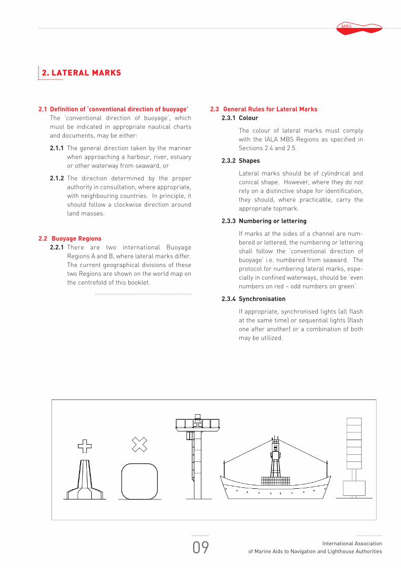
Within the Maritime Buoyage System there are six types of marks, which may be used alone or in combination. The mariner can distinguish between these marks by identifiable characteristics. Lateral marks differ between Buoyage Regions A and B, as described below, whereas the other fivetypes of marks are common to both regions.
These marks are described below:
Cardinal Marks (continued)

MBS
Maritime Buoyage SystemMarks 06
The characters used for Cardinal marks will be seen tobe as follows:
North:Continuous very quick flashing or quick flashing;East:Three “very quick” or “quick” flashes followed bydarkness;South:Six “very quick” or “quick” flashes followed immediately by a long flash, then darkness;West:Nine “very quick” or “quick” flashes followed bydarkness.
The concept of three, six, nine is easily rememberedwhen one associates it with a clock face. The longflash, defined as a light appearance of not less than2 seconds, is merely a device to ensure that threeor nine “very quick” or “quick” flashes cannot be
mistaken for six.
It will be observed that two other marks use white lights;Isolated Danger marks and Safe Water marks. Each hasa distinctive light rhythm that cannot be confused with thevery quick or quick flashing light of the Cardinal marks.
ISOLATED DANGER MARK
The Isolated Danger mark is placed on, or near to adanger that has navigable water all around it. Becausethe extent of the danger and the safe passing distancecannot be specified for all circumstances in which thismark may be used, the mariner shall consult the chartand nautical publications for guidance. Distinctivedouble black spherical top-marks and Group flashing(2) white lights, serve to distinguish Isolated Dangermarks from Cardinal marks.
SAFE WATER MARKS
The Safe Water mark has navigable water all around it, butdoes not mark a danger. Safe Water marks can be used,for example, as fairway, mid-channel or landfall marks.
Safe Water marks have an appearance different from danger marking buoys. They are spherical, oralternatively pillar or spar with red and white verticalstripes and a single red spherical top-mark. Theirlights, if any, are white using isophase, occulting, onelong flash or Morse “A” (● -) rhythms.
SPECIAL MARKS
Special marks are used to indicate a special area or feature whose nature may be apparent from reference to a chart or other nautical publication.They are not generally intended to mark channels orobstructions where the MBS provides suitable alternatives.
Special marks are yellow. They may carry a yellow“X” top-mark, and any light used is also yellow. Toavoid the possibility of confusion between yellow andwhite in poor visibility, the yellow lights of Specialmarks do not have any of the rhythms used for whitelights.
Their shape will not conflict with that of navigationalmarks. This means, for example, that a specialbuoy located on the port hand side of a channelmay be cylindrical but will not be conical. Specialmarks may be lettered or numbered, and may also include the use of a pictogram to indicate their purpose using the IHO symbology whereappropriate.
MARKING NEW DANGERS
“New Dangers” are newly discovered hazards, natural or man-made, that may not yet be shown innautical documents and publications, and until theinformation is sufficiently promulgated, should beindicated by:
marking a new danger using appropriate markssuch as; Lateral, Cardinal, Isolated Danger marks,or equally
using the Emergency Wreck Marking Buoy (EWMB)
If the competent authority considers the risk to navigationto be especially high at least one of the marks shouldbe duplicated.
The Emergency Wreck Marking Buoy has blue and yellow vertical stripes in equal number, with a vertical/perpendicular yellow cross top-mark, anddisplays a blue and yellow alternating light.
Marking of a new danger may include use of a Raconcoded Morse “D” (- ●●) or other radio transmittingdevice such as automatic identification systems as anAid to Navigation (AIS as an AtoN).
MBS
07 International Associationof Marine Aids to Navigation and Lighthouse Authorities
Marking of a new danger may be discontinued when theappropriate competent Authority is satisfied thatinformation concerning the “New Danger” has been suf-ficiently promulgated or the danger has been resolved.
OTHER MARKS
Other Marks include lighthouses, beacons, sectorlights, leading lines, major floating aids, and auxiliarymarks. These visual marks are intended to aid navigation as information to mariners, not necessarilyregarding channel limits or obstructions.
Lighthouses, beacons and other aids of lesserranges are fixed aids to navigation that may displaydifferent colours and/or rhythms over designatedarcs. Beacons may also be unlighted.
Sector lights display different colours and/orrhythms over designated arcs.
The colour of the light provides directional informationto the mariner.
Leading lines / Ranges allow ships to be guidedwith precision along a portion of a straight routeusing the alignment of fixed lights (leading lights)or marks (leading marks), in some cases a singledirectional light may used.
Major floating aids include lightvessels, light floatsand large navigational buoys intended to markapproaches from off shore.
Auxiliary Marks are those other marks used toassist navigation or provide information. Theseinclude aids of non-lateral significance that areusually of defined channels and otherwise do notindicate the port and starboard sides of the routeto be followed as well as those used to conveyinformation for navigational safety.
Port or Harbour Marks such as breakwater,quay/jetty lights, traffic signals, bridge markingand inland waterways aids to navigation (furtherdescribed in section 8.7).
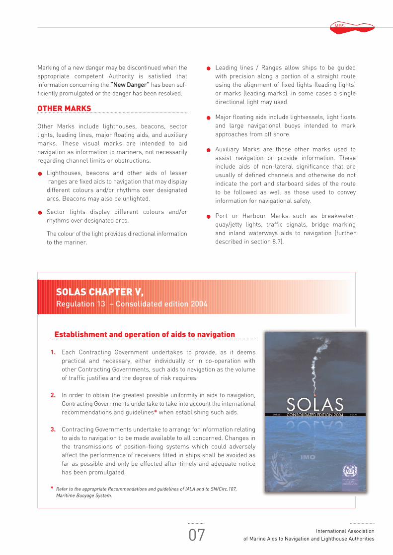
Establishment and operation of aids to navigation
1. Each Contracting Government undertakes to provide, as it deemspractical and necessary, either individually or in co-operation withother Contracting Governments, such aids to navigation as the volumeof traffic justifies and the degree of risk requires.
2. In order to obtain the greatest possible uniformity in aids to navigation,Contracting Governments undertake to take into account the internationalrecommendations and guidelines* when establishing such aids.
3. Contracting Governments undertake to arrange for information relatingto aids to navigation to be made available to all concerned. Changes inthe transmissions of position-fixing systems which could adverselyaffect the performance of receivers fitted in ships shall be avoided asfar as possible and only be effected after timely and adequate noticehas been promulgated.
* Refer to the appropriate Recommendations and guidelines of IALA and to SN/Circ.107,Maritime Buoyage System.
SOLAS CHAPTER V, Regulation 13 – Consolidated edition 2004

MBS
Maritime Buoyage SystemRules 08
1. GENERAL
RULES
1.1 ScopeThe Maritime Buoyage System and other aids tonavigation provide rules that apply to all fixed,floating and electronic marks serving to indicate:
1.1.1 The lateral limits of navigable channels.
1.1.2 Natural dangers and other obstructionssuch as wrecks.
1.1.3 Landfall, course to steer, and other areas orfeatures of importance to the mariner.
1.1.4 New dangers.
1.2 Types of marksA Mark is defined as a signal available to the Mariner to convey guidance in safe navigation.The Maritime Buoyage System and other aids tonavigation provide the following types of marksthat may be used in combination:
1.2.1 Lateral marks, used in conjunction with a“conventional direction of buoyage”,generally employed for well defined channels. These marks indicate the portand starboard sides of the route to be followed. Where a channel divides, a modified lateral mark may be used to indicate the preferred route. Lateral marksdiffer between Buoyage Regions A and B asdescribed in MBS Sections 2 and 8.
1.2.2 Cardinal marks, used in conjunction with themariner's compass, to indicate where themariner may find navigable water.
1.2.3 Isolated Danger marks to indicate isolateddangers of limited size that have navigablewater all around them.
1.2.4 Safe Water marks to indicate that there isnavigable water all around their position,e.g. mid-channel marks.
1.2.5 Special marks to indicate an area or featurereferred to in nautical documents, not generally intended to mark channels or obstructions.
1.2.6 Other marks used to provide information toassist navigation.
1.3 Method of characterising marksThe significance of the mark depends upon one ormore of the following features:
1.3.1 By night, colour and rhythm of light and/orillumination enhancement.
1.3.2 By day, colour, shape, top-mark, and/or light(including colour and rhythm).
1.3.3 By electronic (digital) symbology, e.g. as acomplement to physical marks.
1.3.4 By electronic (digital) symbology solely.
MBS
09 International Associationof Marine Aids to Navigation and Lighthouse Authorities
2. LATERAL MARKS
2.1 Definition of ‘conventional direction of buoyage’The ‘conventional direction of buoyage’, whichmust be indicated in appropriate nautical chartsand documents, may be either:
2.1.1 The general direction taken by the marinerwhen approaching a harbour, river, estuaryor other waterway from seaward, or
2.1.2 The direction determined by the properauthority in consultation, where appropriate,with neighbouring countries. In principle, itshould follow a clockwise direction aroundland masses.
2.2 Buoyage Regions2.2.1 There are two international Buoyage
Regions A and B, where lateral marks differ.The current geographical divisions of thesetwo Regions are shown on the world map onthe centrefold of this booklet.
2.3 General Rules for Lateral Marks2.3.1 Colour
The colour of lateral marks must complywith the IALA MBS Regions as specified inSections 2.4 and 2.5.
2.3.2 Shapes
Lateral marks should be of cylindrical andconical shape. However, where they do notrely on a distinctive shape for identification,they should, where practicable, carry theappropriate topmark.
2.3.3 Numbering or lettering
If marks at the sides of a channel are num-bered or lettered, the numbering or letteringshall follow the ‘conventional direction ofbuoyage’ i.e. numbered from seaward. Theprotocol for numbering lateral marks, espe-cially in confined waterways, should be ‘evennumbers on red ~ odd numbers on green’.
2.3.4 Synchronisation
If appropriate, synchronised lights (all flashat the same time) or sequential lights (flashone after another) or a combination of bothmay be utilized.

MBS
Maritime Buoyage SystemMarks 10
BU
OY
AG
ED
IRE
CT
ION
2.4 Description of Lateral Marks used in Region A
2.4.1 Port hand Marks 2.4.2 Starboard hand Marks
Colour Red Green
Shape of buoy Cylindrical (can), pillar or spar Conical, pillar or spar
Topmark (if any) Single red cylinder (can) Single green cone, point upward
Light (when fitted)
Colour Red Green
Rhythm Any, other than that described Any, other than that described in section 2.4.3. in section 2.4.3.
BU
OY
AG
ED
IRE
CT
ION
2.4.3 At the point where a channel divides, when proceeding in the “conventional direction of buoyage,”a preferred channel may be indicated by a modified Port or Starboard lateral mark as follows:
2.4.3.1 Preferred channel to Starboard 2.4.3.2 Preferred channel to Port
Colour Red with one broad green horizontal band Green with one broad red horizontal band
Shape of buoy Cylindrical (can), pillar or spar Conical, pillar or spar
Topmark (if any) Single red cylinder (can) Single green cone, point upward
Light (when fitted)
Colour Red Green
Rhythm Composite group flashing (2 + 1) Composite group flashing (2 + 1)

MBS
11 International Associationof Marine Aids to Navigation and Lighthouse Authorities
BU
OY
AG
ED
IRE
CT
ION
2.5 Description of Lateral Marks used in Region B
2.5.1 Port hand Marks 2.5.2 Starboard hand Marks
Colour Green Red
Shape of buoy Cylindrical (can), pillar or spar Conical, pillar or spar
Topmark (if any) Single green cylinder (can) Single red cone, point upward
Light (when fitted)
Colour Green Red
Rhythm Any, other than that described Any, other than that described in section 2.5.3. In section 2.5.3.
BU
OY
AG
ED
IRE
CT
ION
2.5.3 At the point where a channel divides, when proceeding in the “conventional direction of buoyage,” a preferred channel may be indicated by a modified Port or Starboard lateral mark as follows:
2.5.3.1 Preferred channel to Starboard 2.5.3.2 Preferred channel to Port
Colour Green with one broad red horizontal band Red with one broad green horizontal band
Shape of buoy Cylindrical (can), pillar or spar Conical, pillar or spar
Topmark (if any) Single green cylinder (can) Single red cone, point upward
Light (when fitted)
Colour Green Red
Rhythm Composite group flashing (2 + 1) Composite group flashing (2 + 1)

Buoyage Re
Region A
egions A and B
Region B

MBS
Maritime Buoyage SystemMarks 14
3. CARDINAL MARKS
3.1 Definition of Cardinal quadrants and marks
The four quadrants (North, East, South and West) are bounded by the true bearings NW-NE, NE-SE, SE-SW, andSW-NW, taken from the point of interest.
3.1.1 A Cardinal mark is named after the quadrant in which it is placed
3.1.2 The name of a Cardinal mark indicates that it should be passed to the named side of the mark.
3.1.3 The Cardinal marks in Region A and Region B, and their use, are the same.
3.2 Use of Cardinal Marks
A Cardinal mark may be used, for example:
3.2.1 To indicate that the deepest water in that area is on the named side of the mark.
3.2.2 To indicate the safe side on which to pass a danger.
3.2.3 To draw attention to a feature in a channel such as a bend, a junction, a bifurcation or the end of a shoal.
3.2.4 Competent authorities should consider carefully before establishing too many cardinal marks in a water-way or area as this can lead to confusion, given their white lights of similar characteristics.
3.3 Description of Cardinal Marks
3.3.1 North Cardinal Mark 3.3.2 East Cardinal Mark
Topmark (a) 2 black cones, one above the other, 2 black cones, one above the other, points upward base to base
Colour Black above yellowBlack with a single broad horizontal yellow band
Shape of buoys Pillar or spar Pillar or spar
Light (when fitted)
Colour White White
Rhythm VQ(3) or Q VQ(3) every 10s or Q(3) every 15sLong flash every 15s
Note (a) : The double cone top-mark is a very important feature of every Cardinal mark by day, and should be used wherever practicable and be as large as possible with a clear separation between the cones.
3.3.3 South Cardinal Mark 3.3.4 West Cardinal Mark
Topmark (a) 2 black cones, one above the other, 2 black cones, one above the other, points downward point to point
Colour Yellow above blackYellow with a single broad horizontal black band
Shape of buoys Pillar or spar Pillar or spar
Light (when fitted)
Colour White White
Rhythm VQ(6) + Long flash every 10s or Q(6) + VQ(9) every 10s or Q(9) every 15sLong flash every 15s

MBS
15 International Associationof Marine Aids to Navigation and Lighthouse Authorities
POINTOF
INTEREST
N
E
S
W
NE
SE
NW
SW

MBS
Maritime Buoyage SystemMarks 16
4. ISOLATED DANGER MARKS
4.1 Definition of Isolated Danger MarksAn isolated Danger mark is a mark erected on, ormoored on or above, an isolated danger which hasnavigable water all around it.
4.2 Description of Isolated Danger Marks
Description
Top-mark (b) Two black spheres,one above the other
Colour Black with one or more broad horizontal red bands
Optional, but not conflicting Shape of buoy with lateral marks; pillar or
spar preferred
Light (when fitted)
Colour White
Rhythm Group flashing (2)
5. SAFE WATER MARKS
5.1 Definition of Safe Water MarksSafe Water marks serve to indicate that there isnavigable water all round the mark. These includecentre line marks and mid-channel marks. Such amark may also be used to indicate channelentrance, port or estuary approach, or landfall.The light rhythm may also be used to indicate bestpoint of passage under bridges.
5.2 Description of Safe Water Marks
Description
Colour Red and whitevertical stripes
Shape of buoy Spherical; pillar or spar with spherical topmark
Top-mark (if any) Single red sphere
Light (when fitted)
Colour White
Rhythm Isophase, occulting, one longflash every 10s or Morse “A”
Note (b) : The double sphere topmark is a very important feature of every Isolated Danger mark by day, and should be used whereverpracticable and be as large as possible with a clear separation between the spheres.

MBS
17 International Associationof Marine Aids to Navigation and Lighthouse Authorities
6. SPECIAL MARKS
SHAPEOPTIONAL
USE OF PICTOGRAMSAUTHORISED
6.1 Definition of Special MarksMarks used to indicate a special area or featurewhose nature may be apparent from referenceto a chart or other nautical publication. They are not generally intended to mark channelsor obstructions where other marks are moresuitable.
Some examples of uses of Special Marks 6.1.2 Ocean Data Acquisition Systems (ODAS)
marks.
6.1.2 Traffic separation marks where use ofconventional channel marking may causeconfusion.
6.1.3 Spoil Ground marks.
6.1.4 Military exercise zone marks.
6.1.5 Cable or pipeline marks.
6.1.6 Recreation zone marks.
6.1.7 Boundaries of anchorage areas
6.1.8 Structures such as offshore renewableenergy installations
6.1.9 Aquaculture
6.2 Description of Special Marks
Description
Colour Yellow
Shape of buoy Optional, but not conflicting with lateral marks
Top-mark (if any) Single yellow “X” shape
Light (when fitted)
Colour Yellow
RhythmAny, other than those reserved for cardinal, isolated danger and safe water marks.
PictogramThe use of pictograms is authorized, as defined by a competent authority.

MBS
Maritime Buoyage SystemMarks 18
7.2 Marking of New Dangers7.2.1 ‘New Dangers’ should be appropriately marked
using Lateral, Cardinal, Isolated Danger marksor by using the Emergency Wreck MarkingBuoy. If the Authority considers the risk tonavigation to be especially high, at least one ofthe marks should be duplicated.
7.2.2 If using a Lateral lighted mark for this purpose aVQ or Q light character shall be used.
7.2.3 Any duplicate mark shall be identical to itspartner in all respects.
7.2.4 In addition it may be marked by a Racon, codedMorse “D”(- ● ●)
7.2.5 In addition it may be marked by other electronicmeans, such as automatic identification system(AIS as an AtoN).
7.2.6 Virtual Aids to Navigation may be deployed solelyor in addition to physical Aids to Navigation.
7.2.7 The marking of the new danger may be removedwhen the competent Authority is satisfied thatinformation concerning the “New Danger”has been sufficiently promulgated or the dangerotherwise resolved.
7. MARKING NEW DANGERS
7.1 Definition of New DangersThe term “New Danger” is used to describe newlydiscovered hazards not yet shown in nauticaldocuments. ‘New Dangers’ include naturallyoccurring obstructions such as sandbanks orrocks or man-made dangers such as wrecks.
7.3 Description of New Dangers Marks
Description
Blue/Yellow vertical stripes
Colour in equal number dimensions (minimum 4 stripes and maximum 8)
Shape of buoy Pillar or spar
Top-mark (if any) Vertical/perpendicular Yellow cross
Light
Colour Yellow/blue alternating
One second of blue light and
Rhythm one second of yellow light with 0.5 sec. of darkness between

MBS
19 International Associationof Marine Aids to Navigation and Lighthouse Authorities
8. OTHER MARKS
8.1.1 Definition of Leading Lines/Ranges
A group of two or more marks or lights, in the same vertical plane such that the navigator can follow the leading line on thesame bearing.
8.1.2 Description of Leading Lines
Leading Line structures can be any colouror shape that provides a distinctive markthat cannot be confused with adjacentstructures.
8.2.1 Definition of Sector Lights
A sector light is a fixed aid to navigationthat displays a light of different coloursand/or rhythms over designated arcs. Thecolour of the light provides directional information to the mariner.
8.2.2 Description of Sector Lights
A sector light may be used:To provide directional information in a fairway;To indicate a turning point, a junction withother channels, a hazard or other items ofnavigational importance;To provide information on hazard areasthat should be avoided;In some cases a single directional lightmay be used.
Description
Colour
No colour significance. Competentauthority determines the optimumcolours to contrast with the domi-nant background colour at thelocation
ShapeNo shape significance. Rectangular or triangular figuresare recommended.
Light (when fitted)
Colour
Any colour. Competent authority determines the optimum colour to contrast with the dominant background colour at the location.
Rhytm
Any, however fixed characteristics should be used sparingly and the use of synchronisation can assist inthe overcoming background light.
Description
Colour Not applicable
Shape None, light only
Light
ColourIf using to mark channel limits follow convention for IALA region indicated in Section 2. Lights may have oscillating boundaries
Rhythm As appropriate
8.1 Leading Lines/Ranges 8.2 Sector Lights
MBS
Maritime Buoyage SystemMarks 20
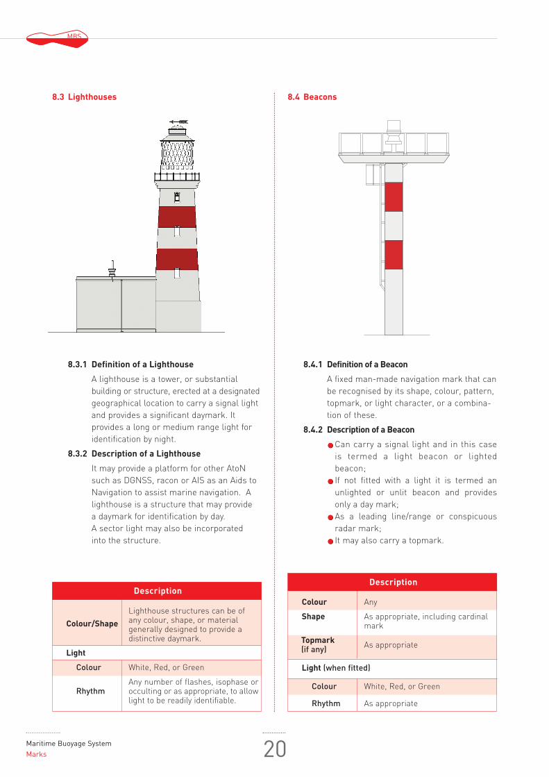
8.3.1 Definition of a Lighthouse
A lighthouse is a tower, or substantial building or structure, erected at a designatedgeographical location to carry a signal lightand provides a significant daymark. It provides a long or medium range light foridentification by night.
8.3.2 Description of a Lighthouse
It may provide a platform for other AtoNsuch as DGNSS, racon or AIS as an Aids toNavigation to assist marine navigation. Alighthouse is a structure that may provide a daymark for identification by day. A sector light may also be incorporated into the structure.
8.4.1 Definition of a Beacon
A fixed man-made navigation mark that canbe recognised by its shape, colour, pattern,topmark, or light character, or a combina-tion of these.
8.4.2 Description of a Beacon
Can carry a signal light and in this caseis termed a light beacon or lighted beacon;If not fitted with a light it is termed anunlighted or unlit beacon and providesonly a day mark;As a leading line/range or conspicuousradar mark;It may also carry a topmark.
Description
Colour/Shape
Lighthouse structures can be ofany colour, shape, or materialgenerally designed to provide adistinctive daymark.
Light
Colour White, Red, or Green
RhythmAny number of flashes, isophase orocculting or as appropriate, to allowlight to be readily identifiable.
8.3 Lighthouses 8.4 Beacons
Description
Colour Any
Shape As appropriate, including cardinalmark
Topmark As appropriate(if any)
Light (when fitted)
Colour White, Red, or Green
Rhythm As appropriate
MBS
21 International Associationof Marine Aids to Navigation and Lighthouse Authorities
INFORMATIONOPTIONAL
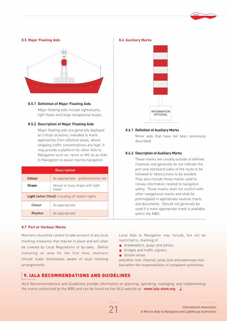
8.5.1 Definition of Major Floating Aids
Major floating aids include lightvessels,light floats and large navigational buoys.
8.5.2 Description of Major Floating Aids
Major floating aids are generally deployedat critical locations, intended to markapproaches from offshore areas, whereshipping traffic concentrations are high. Itmay provide a platform for other Aids toNavigation such as, racon or AIS as an Aidsto Navigation to assist marine navigation.
8.6.1 Definition of Auxiliary Marks
Minor aids that have not been previouslydescribed.
8.6.2 Description of Auxiliary Marks
These marks are usually outside of definedchannels and generally do not indicate theport and starboard sides of the route to befollowed or obstructions to be avoided.They also include those marks used toconvey information related to navigationsafety. These marks shall not conflict withother navigational marks and shall be promulgated in appropriate nautical chartsand documents. Should not generally beused if a more appropriate mark is availablewithin the MBS.
Description
Colour As appropriate - predominantly red
Shape Vessel or buoy shape with lighttower
Light (when fitted) including off station lights
Colour As appropriate
Rhythm As appropriate
8.5 Major Floating Aids
8.7 Port or Harbour Marks
8.6 Auxiliary Marks
Mariners should be careful to take account of any local
marking measures that may be in place and will often
be covered by Local Regulations or by-laws. Before
transiting an area for the first time, mariners
should make themselves aware of local marking
arrangements.
IALA Recommendations and Guidelines provide information on planning, operating, managing, and implementingthe marks authorized by the MBS and can be found via the IALA website at: www.iala-aism.org.
Local Aids to Navigation may include, but not be restricted to, marking of:
breakwaters, quays and jetties;bridges and traffic signals;leisure areas.
and other river, channel, canal, lock and waterways mar-ked within the responsibilities of competent authorities.
9. IALA RECOMMENDATIONS AND GUIDELINES

Maritime Buoyage SystemRegion A 22
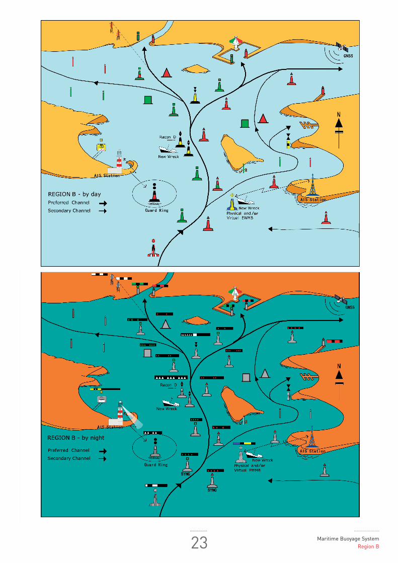
23 Maritime Buoyage SystemRegion B

INTERNATIONAL ASSOCIATION
OF MARINE AIDS TO NAVIGATION AND LIGHTHOUSE AUTHORITIES
ASSOCIATION INTERNATIONALE DE SIGNALISATION MARITIME
20 ter rue Schnapper, 78100 Saint Germain en Laye, France
Phone: 33 1 34 51 70 01 / Fax: 33 1 34 51 82 05 e-mail: [email protected]
web: iala-aism.org