LEEDS SITE ALLOCATIONS DEVELOPMENT PLAN DOCUMENT ...
88
www.leeds.gov.uk/yourcity Publication Draft Leeds Local Development Framework Development Plan Document September 2015 Site Allocations Plan Section 3: Area Proposals: 5. North
Transcript of LEEDS SITE ALLOCATIONS DEVELOPMENT PLAN DOCUMENT ...
www.leeds.gov.uk/yourcity
Publication DraftLeeds Local Development Framework
Development Plan DocumentSeptember 2015
Site Allocations PlanSection 3: Area Proposals: 5. North
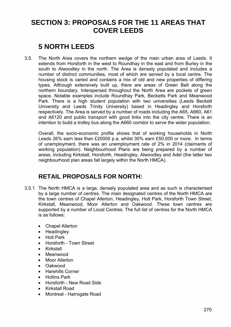
SECTION 3: PROPOSALS FOR THE 11 AREAS THAT COVER LEEDS
5 NORTH LEEDS
3.5. The North Area covers the northern wedge of the main urban area of Leeds. It extends from Horsforth in the west to Roundhay in the east and from Burley in the south to Alwoodley in the north. The Area is densely populated and includes a number of distinct communities, most of which are served by a local centre. The housing stock is varied and contains a mix of old and new properties of differing types. Although extensively built up, there are areas of Green Belt along the northern boundary. Interspersed throughout the North Area are pockets of green space. Notable examples include Roundhay Park, Becketts Park and Meanwood Park. There is a high student population with two universities (Leeds Beckett University and Leeds Trinity University) based in Headingley and Horsforth respectively. The Area is served by a number of roads including the A65, A660, A61 and A6120 and public transport with good links into the city centre. There is an intention to build a trolley bus along the A660 corridor to serve the wider population.
Overall, the socio-economic profile shows that of working households in North Leeds 26% earn less than £20000 p.a. whilst 30% earn £50,000 or more. In terms of unemployment, there was an unemployment rate of 2% in 2014 (claimants of working population). Neighbourhood Plans are being prepared by a number of areas, including Kirkstall, Horsforth, Headingley, Alwoodley and Adel (the latter two neighbourhood plan areas fall largely within the North HMCA).
RETAIL PROPOSALS FOR NORTH: 3.5.1 The North HMCA is a large, densely populated area and as such is characterised
by a large number of centres. The main designated centres of the North HMCA are the town centres of Chapel Allerton, Headingley, Holt Park, Horsforth Town Street, Kirkstall, Meanwood, Moor Allerton and Oakwood. These town centres are supported by a number of Local Centres. The full list of centres for the North HMCA is as follows:
• Chapel Allerton • Headingley • Holt Park • Horsforth - Town Street • Kirkstall • Meanwood • Moor Allerton • Oakwood • Harehills Corner • Hollins Park • Horsforth - New Road Side • Kirkstall Road • Montreal - Harrogate Road
270
• Moortown Corner • Street Lane – Roundhay • Butcher Hill • Cardigan Road • Hawksworth Estates Centre • Horsforth – Station Road • Slaid Hill • Weetwood – Far Headingley
3.5.2 For each centre a review of the centre boundary and survey of current uses has
been undertaken. The Council is not allocating sites for retail in these centres but has made boundary changes which may provide scope to accommodate additional retailing. The survey of uses has been used to determine the primary shopping area and frontages (primary and secondary).
3.5.3 For policies and guidance referring to centre boundaries, primary shopping areas
and proposals within protected shopping frontages, please refer to section 2 of this document. These policies must also be read in conjunction with the Retail and Town Centres section of the Core Strategy.
271
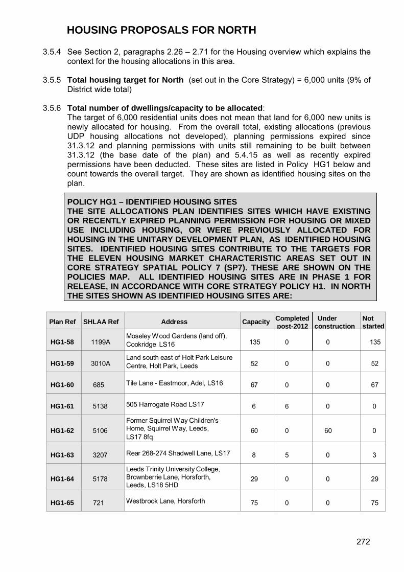
HOUSING PROPOSALS FOR NORTH 3.5.4 See Section 2, paragraphs 2.26 – 2.71 for the Housing overview which explains the
context for the housing allocations in this area. 3.5.5 Total housing target for North (set out in the Core Strategy) = 6,000 units (9% of
District wide total) 3.5.6 Total number of dwellings/capacity to be allocated:
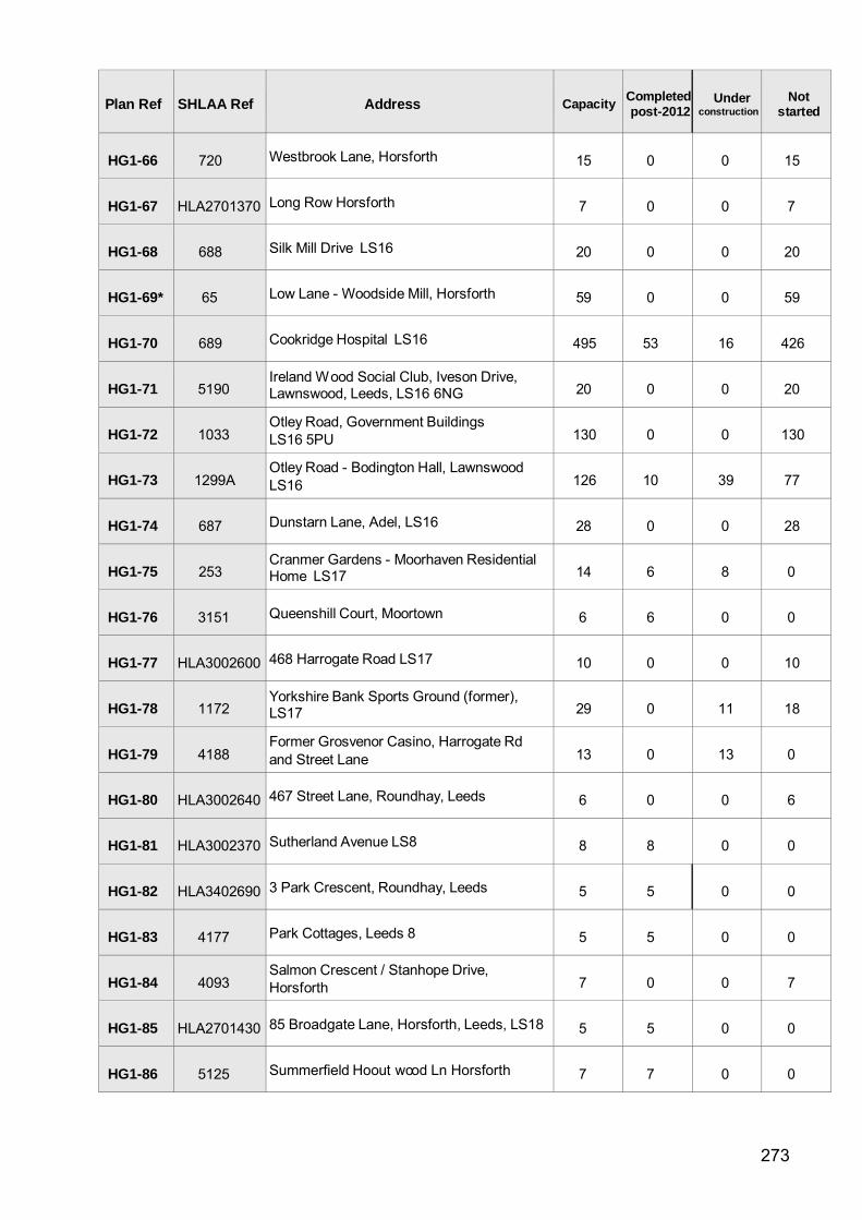
The target of 6,000 residential units does not mean that land for 6,000 new units is newly allocated for housing. From the overall total, existing allocations (previous UDP housing allocations not developed), planning permissions expired since 31.3.12 and planning permissions with units still remaining to be built between 31.3.12 (the base date of the plan) and 5.4.15 as well as recently expired permissions have been deducted. These sites are listed in Policy HG1 below and count towards the overall target. They are shown as identified housing sites on the plan. POLICY HG1 – IDENTIFIED HOUSING SITES THE SITE ALLOCATIONS PLAN IDENTIFIES SITES WHICH HAVE EXISTING OR RECENTLY EXPIRED PLANNING PERMISSION FOR HOUSING OR MIXED USE INCLUDING HOUSING, OR WERE PREVIOUSLY ALLOCATED FOR HOUSING IN THE UNITARY DEVELOPMENT PLAN, AS IDENTIFIED HOUSING SITES. IDENTIFIED HOUSING SITES CONTRIBUTE TO THE TARGETS FOR THE ELEVEN HOUSING MARKET CHARACTERISTIC AREAS SET OUT IN CORE STRATEGY SPATIAL POLICY 7 (SP7). THESE ARE SHOWN ON THE POLICIES MAP. ALL IDENTIFIED HOUSING SITES ARE IN PHASE 1 FOR RELEASE, IN ACCORDANCE WITH CORE STRATEGY POLICY H1. IN NORTH THE SITES SHOWN AS IDENTIFIED HOUSING SITES ARE:
Plan Ref SHLAA Ref Address Capacity Completed post-2012
Under construction
Not started
HG1-58
1199A
Moseley W ood Gardens (land off), Cookridge LS16
135
0
0
135
HG1-59
3010A
Land south east of Holt Park Leisure Centre, Holt Park, Leeds
52
0
0
52
HG1-60
685 Tile Lane - Eastmoor, Adel, LS16
67
0
0
67
HG1-61
5138 505 Harrogate Road LS17
6
6
0
0
HG1-62
5106
Former Squirrel W ay Children's Home, Squirrel W ay, Leeds, LS17 8fq
60
0
60
0
HG1-63
3207 Rear 268-274 Shadwell Lane, LS17
8
5
0
3
HG1-64
5178
Leeds Trinity University College, Brownberrie Lane, Horsforth, Leeds, LS18 5HD
29
0
0
29
HG1-65
721 Westbrook Lane, Horsforth
75
0
0
75
272
Plan Ref SHLAA Ref Address Capacity Completed post-2012
Under construction
Not started
HG1-66
720 Westbrook Lane, Horsforth
15
0
0
15
HG1-67
HLA2701370 Long Row Horsforth
7
0
0
7
HG1-68
688 Silk Mill Drive LS16
20
0
0
20
HG1-69*
65 Low Lane - Woodside Mill, Horsforth
59
0
0
59
HG1-70
689 Cookridge Hospital LS16
495
53
16
426
HG1-71
5190
Ireland W ood Social Club, Iveson Drive, Lawnswood, Leeds, LS16 6NG
20
0
0
20
HG1-72
1033
Otley Road, Government Buildings LS16 5PU
130
0
0
130
HG1-73
1299A
Otley Road - Bodington Hall, Lawnswood LS16
126
10
39
77
HG1-74
687 Dunstarn Lane, Adel, LS16
28
0
0
28
HG1-75
253
Cranmer Gardens - Moorhaven Residential Home LS17
14
6
8
0
HG1-76
3151 Queenshill Court, Moortown
6
6
0
0
HG1-77
HLA3002600 468 Harrogate Road LS17
10
0
0
10
HG1-78
1172
Yorkshire Bank Sports Ground (former), LS17
29
0
11
18
HG1-79
4188
Former Grosvenor Casino, Harrogate Rd and Street Lane
13
0
13
0
HG1-80
HLA3002640 467 Street Lane, Roundhay, Leeds
6
0
0
6
HG1-81
HLA3002370 Sutherland Avenue LS8
8
8
0
0
HG1-82
HLA3402690 3 Park Crescent, Roundhay, Leeds
5
5
0
0
HG1-83
4177 Park Cottages, Leeds 8
5
5
0
0
HG1-84
4093
Salmon Crescent / Stanhope Drive, Horsforth
7
0
0
7
HG1-85
HLA2701430 85 Broadgate Lane, Horsforth, Leeds, LS18
5
5
0
0
HG1-86
5125 Summerfield Hoout wood Ln Horsforth
7
7
0
0
273
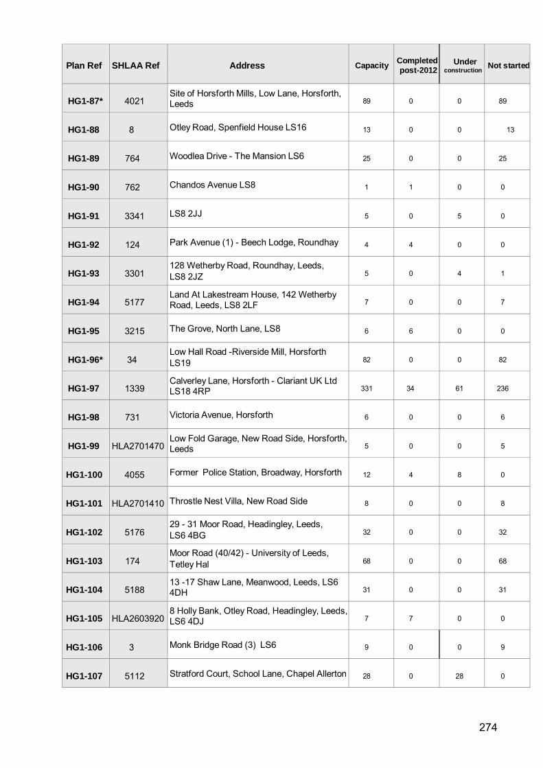
Plan Ref SHLAA Ref Address Capacity Completed post-2012
Under construction Not started
HG1-87*
4021
Site of Horsforth Mills, Low Lane, Horsforth, Leeds
89
0
0
89
HG1-88
8 Otley Road, Spenfield House LS16
13
0
0
13
HG1-89
764 Woodlea Drive - The Mansion LS6
25
0
0
25
HG1-90
762 Chandos Avenue LS8
1
1
0
0
HG1-91
3341 LS8 2JJ
5
0
5
0
HG1-92
124 Park Avenue (1) - Beech Lodge, Roundhay
4
4
0
0
HG1-93
3301
128 Wetherby Road, Roundhay, Leeds, LS8 2JZ
5
0
4
1
HG1-94
5177
Land At Lakestream House, 142 Wetherby Road, Leeds, LS8 2LF
7
0
0
7
HG1-95
3215 The Grove, North Lane, LS8
6
6
0
0
HG1-96*
34
Low Hall Road -Riverside Mill, Horsforth LS19
82
0
0
82
HG1-97
1339
Calverley Lane, Horsforth - Clariant UK Ltd LS18 4RP
331
34
61
236
HG1-98
731 Victoria Avenue, Horsforth
6
0
0
6
HG1-99
HLA2701470
Low Fold Garage, New Road Side, Horsforth, Leeds
5
0
0
5
HG1-100
4055 Former Police Station, Broadway, Horsforth
12
4
8
0
HG1-101
HLA2701410 Throstle Nest Villa, New Road Side
8
0
0
8
HG1-102
5176
29 - 31 Moor Road, Headingley, Leeds, LS6 4BG
32
0
0
32
HG1-103
174
Moor Road (40/42) - University of Leeds, Tetley Hal
68
0
0
68
HG1-104
5188
13 -17 Shaw Lane, Meanwood, Leeds, LS6 4DH
31
0
0
31
HG1-105
HLA2603920
8 Holly Bank, Otley Road, Headingley, Leeds, LS6 4DJ
7
7
0
0
HG1-106
3 Monk Bridge Road (3) LS6
9
0
0
9
HG1-107
5112 Stratford Court, School Lane, Chapel Allerton 28
0
28
0
274
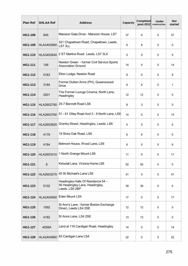
Plan Ref SHLAA Ref Address Capacity Completed post-2012
Under construction
Not started
HG1-108
845 Mansion Gate Drive - Mansion House LS7
37
0
0
37
HG1-109
HLA3402660
321 Chapeltown Road, Chapeltown, Leeds, LS7 3LL
6
6
0
0
HG1-110
HLA3402640 2 ST Martins Road Leeds, LS7 3LX
5
0
0
5
HG1-111
106
Newton Green - former Civil Service Sports Association Ground
14
0
0
14
HG1-112
5183 Elton Lodge, Newton Road
9
0
0
9
HG1-113
3184
Former Dutton Arms (PH), Queenswood Drive
9
8
0
1
HG1-114
3201
The Former Lounge Cinema, North Lane, Headingley
12
12
0
0
HG1-115
HLA2602780 25-7 Bennett Road LS6
8
3
5
0
HG1-116
HLA2603760 51 - 61 Otley Road And 3 - 9 North Lane, LS6
14
0
0
14
HG1-117
HLA2603820 Granby Street, Headingley, Leeds, LS6
5
0
0
5
HG1-118
4179 19 Shire Oak Road, LS6
6
6
0
0
HG1-119
4184 Belmont House, W ood Lane, LS6
6
0
0
6
HG1-120
HLA2603310 1 North Grange Mount LS6
11
0
0
11
HG1-121
6 Kirkstall Lane, Victoria Home LS6
50
50
0
0
HG1-122
HLA2603270 45 St Michael's Lane LS6
41
0
0
41
HG1-123
5102
Headingley Halls Of Residence 54 - 56 Headingley Lane, Headingley, Leeds, LS6 2BP
39
39
0
0
HG1-124
HLA2404950 Eden Mount LS4
17
0
0
17
HG1-125
1092
St Ann's Lane - former Boston Exchange Diner), Leeds LS4 2SE
12
12
0
0
HG1-126
4182 St Anns Lane, LS4 2SE
13
13
0
0
HG1-127
4058A Land at 116 Cardigan Road, Headingley
14
0
0
14
HG1-128
HLA2404860 83 Cardigan Lane LS4
22
0
0
22
275
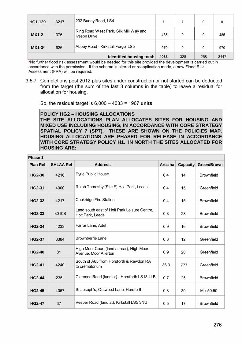
HG1-129
3217 232 Burley Road, LS4
7
7
0
0
MX1-2
376
Ring Road W est Park, Silk Mill W ay and Iveson Drive
485
0
0
485
MX1-3*
626 Abbey Road - Kirkstall Forge LS5
970
0
0
970
Identified housing total: 4033 328 258 3447 *No further flood risk assessment would be needed for this site provided the development is carried out in accordance with the permission. If the scheme is altered or reapplication made, a new Flood Risk Assessment (FRA) will be required.
3.5.7 Completions post 2012 plus sites under construction or not started can be deducted from the target (the sum of the last 3 columns in the table) to leave a residual for allocation for housing.
So, the residual target is 6,000 – 4033 = 1967 units
POLICY HG2 – HOUSING ALLOCATIONS
THE SITE ALLOCATIONS PLAN ALLOCATES SITES FOR HOUSING AND MIXED USE INCLUDING HOUSING, IN ACCORDANCE WITH CORE STRATEGY SPATIAL POLICY 7 (SP7). THESE ARE SHOWN ON THE POLICIES MAP. HOUSING ALLOCATIONS ARE PHASED FOR RELEASE IN ACCORDANCE WITH CORE STRATEGY POLICY H1. IN NORTH THE SITES ALLOCATED FOR HOUSING ARE:
Phase 1
Plan Ref SHLAA Ref Address Area ha Capacity Green/Brown
HG2-30
4216 Eyrie Public House
0.4
14
Brownfield
HG2-31
4000 Ralph Thoresby (Site F) Holt Park, Leeds
0.4
15
Greenfield
HG2-32
4217 Cookridge Fire Station
0.4
15
Brownfield
HG2-33
3010B
Land south east of Holt Park Leisure Centre, Holt Park, Leeds
0.8
28
Brownfield
HG2-34
4233 Farrar Lane, Adel
0.9
16
Brownfield
HG2-37
3384 Brownberrie Lane
0.8
12
Greenfield
HG2-40
81
High Moor Court (land at rear), High Moor Avenue, Moor Allerton
0.9
20
Greenfield
HG2-41
4240
South of A65 from Horsforth & Rawdon RA to crematorium
36.3
777
Greenfield
HG2-44
235 Clarence Road (land at) - Horsforth LS18 4LB
0.7
25
Brownfield
HG2-45
4057 St Joseph's, Outwood Lane, Horsforth
0.8
30
Mix 50:50
HG2-47
37 Vesper Road (land at), Kirkstall LS5 3NU
0.5
17
Brownfield
276
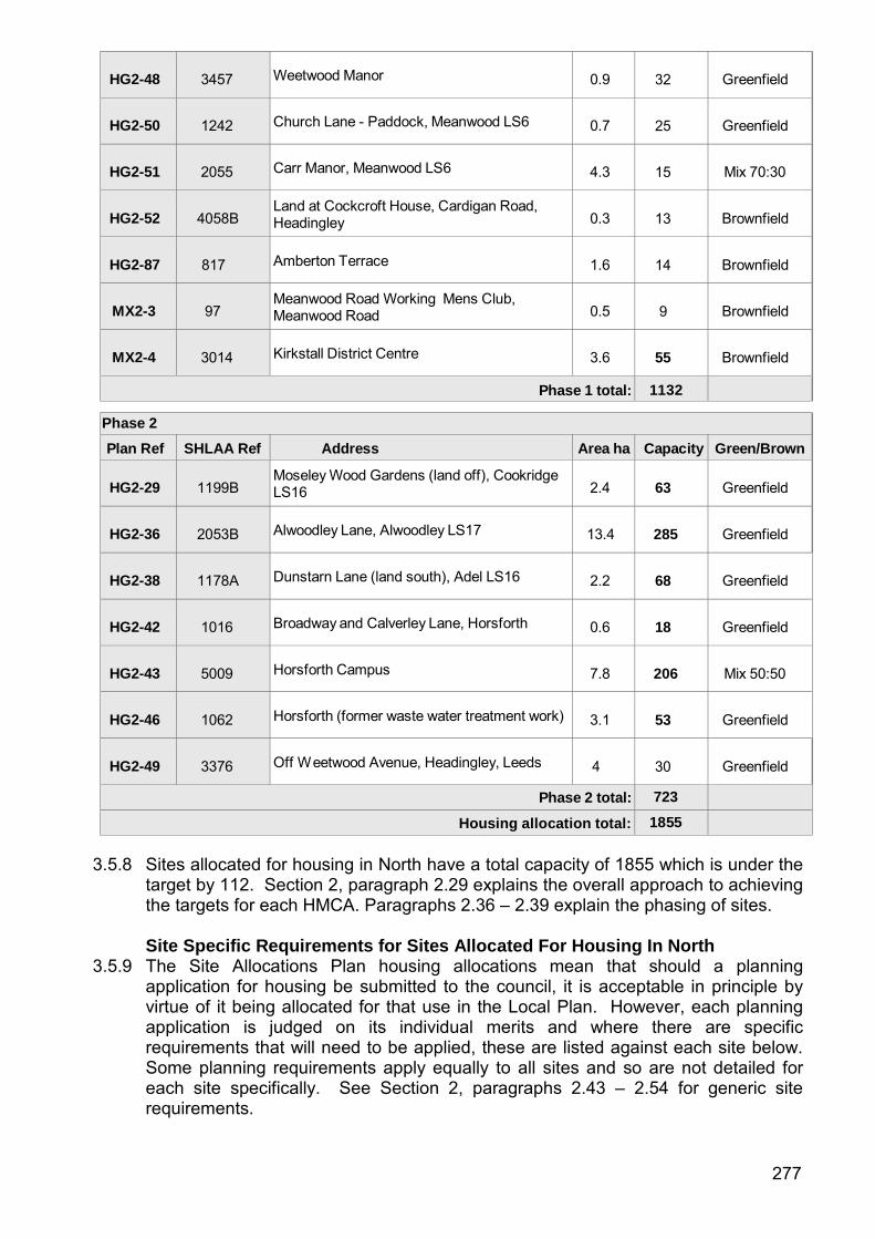
HG2-48
3457 Weetwood Manor
0.9
32
Greenfield
HG2-50
1242 Church Lane - Paddock, Meanwood LS6
0.7
25
Greenfield
HG2-51
2055 Carr Manor, Meanwood LS6
4.3
15
Mix 70:30
HG2-52
4058B
Land at Cockcroft House, Cardigan Road, Headingley
0.3
13
Brownfield
HG2-87
817 Amberton Terrace
1.6
14
Brownfield
MX2-3
97
Meanwood Road Working Mens Club, Meanwood Road
0.5
9
Brownfield
MX2-4
3014 Kirkstall District Centre
3.6
55
Brownfield
Phase 1 total: 1132
Phase 2
Plan Ref SHLAA Ref Address Area ha Capacity Green/Brown
HG2-29
1199B Moseley Wood Gardens (land off), Cookridge LS16
2.4
63
Greenfield
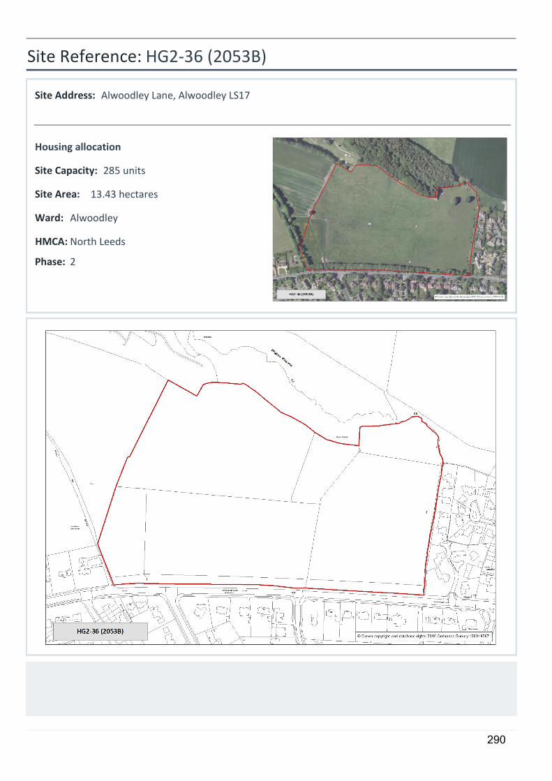
HG2-36
2053B Alwoodley Lane, Alwoodley LS17
13.4
285
Greenfield
HG2-38
1178A Dunstarn Lane (land south), Adel LS16
2.2
68
Greenfield
HG2-42
1016 Broadway and Calverley Lane, Horsforth
0.6
18
Greenfield
HG2-43
5009 Horsforth Campus
7.8
206
Mix 50:50
HG2-46
1062 Horsforth (former waste water treatment work)
3.1
53
Greenfield
HG2-49
3376 Off W eetwood Avenue, Headingley, Leeds
4
30
Greenfield
Phase 2 total: 723
Housing allocation total: 1855
3.5.8 Sites allocated for housing in North have a total capacity of 1855 which is under the
target by 112. Section 2, paragraph 2.29 explains the overall approach to achieving the targets for each HMCA. Paragraphs 2.36 – 2.39 explain the phasing of sites.
Site Specific Requirements for Sites Allocated For Housing In North 3.5.9 The Site Allocations Plan housing allocations mean that should a planning
application for housing be submitted to the council, it is acceptable in principle by virtue of it being allocated for that use in the Local Plan. However, each planning application is judged on its individual merits and where there are specific requirements that will need to be applied, these are listed against each site below. Some planning requirements apply equally to all sites and so are not detailed for each site specifically. See Section 2, paragraphs 2.43 – 2.54 for generic site requirements.
277
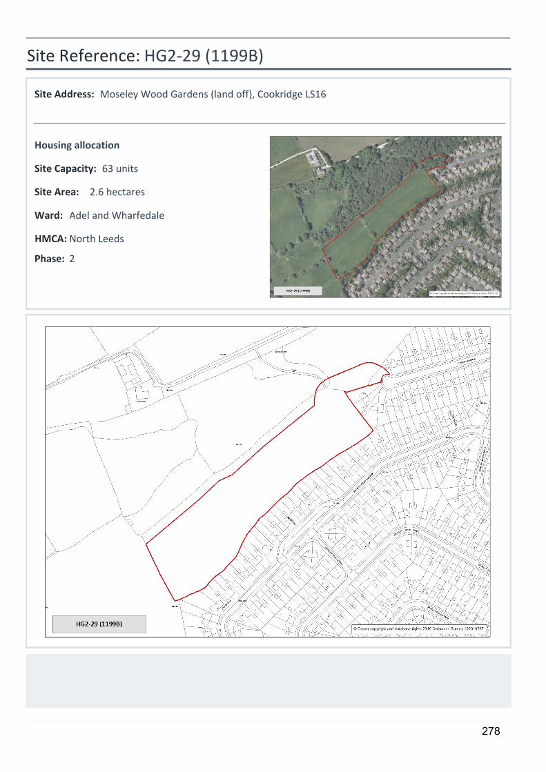
5
HG2-29 (1199B)
Moseley Wood Gardens (land off), Cookridge LS16
2.6 hectares
63 units
Housing allocation
2
Site Reference:
Site Address:
Site Area:
Site Capacity:
Phase:
Adel and WharfedaleWard:
North LeedsHMCA:
278
Site Requirements - HG2-29:
• Ecology:
An Ecological Assessment of the site is required and where appropriate, mitigation measures will need to be provided.
• Listed Buildings:
The site is in the setting of a Listed Building. Any development should preserve the special architectural or historic interest of Listed Buildings and their setting. There is a potential impact on the setting of the Moseley Wood Farm complex to the north. This impact should be mitigated, for example, through landscape screening within the site.
• Scheduled Ancient Monuments (I & II):
The site is in the setting of a Scheduled Monument. Any development should preserve the significance of the Monument and its setting. To achieve this a significant buffer zone would be required to protect the rural setting of two scheduled cup-and-ring marked boulders to the north.
279
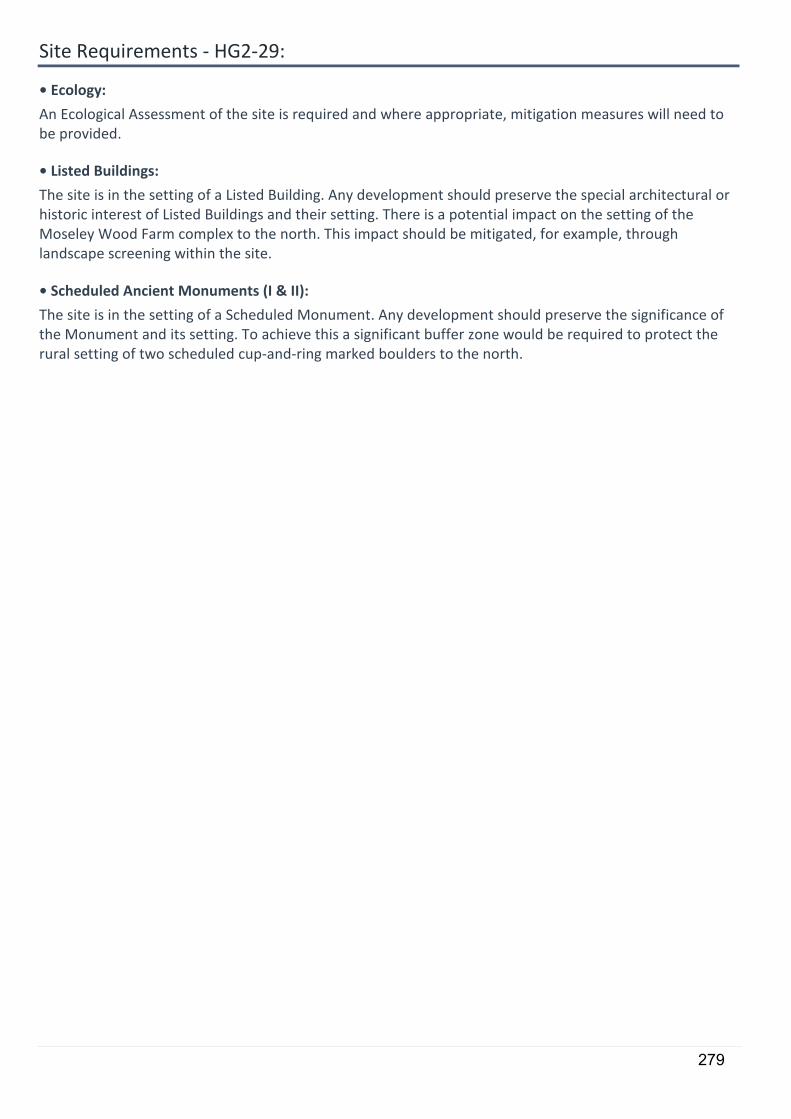
5
HG2-30 (4216)
Eyrie Public House
0.4 hectares
14 units
Housing allocation
1
Site Reference:
Site Address:
Site Area:
Site Capacity:
Phase:
Adel and WharfedaleWard:
North LeedsHMCA:
280

Site Requirements - HG2-30:
• Older persons housing/independent living:
The site is suitable for older persons housing/independent living in accordance with Policy HG4
• Ecology:
An Ecological Assessment of the site is required and where appropriate, mitigation measures will need to be provided, including provision of a biodiversity buffer (not private garden space) adjacent to Otley Old Road.
281
5
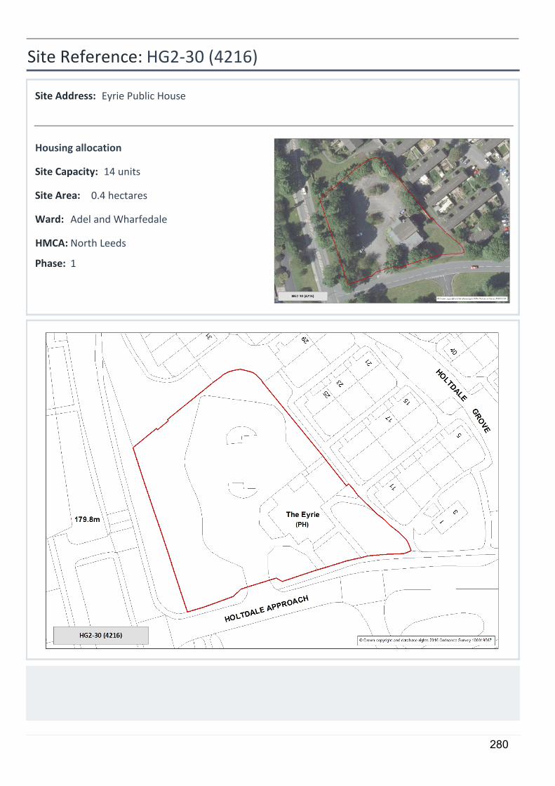
HG2-31 (4000)
Ralph Thoresby (Site F) Holt Park, Leeds
0.37 hectares
15 units
Housing allocation
1
Site Reference:
Site Address:
Site Area:
Site Capacity:
Phase:
Adel and WharfedaleWard:
North LeedsHMCA:
282

Site Requirements - HG2-31:
This site is included in the Holt Park Planning Framework. Part of the site maybe required as a site compound for NGT. However, this does not preclude development for housing.
• Older persons housing/independent living:
The site is suitable for older persons housing/independent living in accordance with Policy HG4
283
5
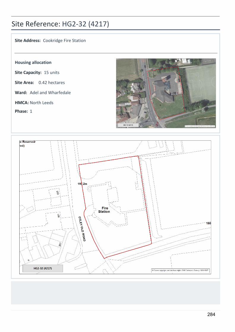
HG2-32 (4217)
Cookridge Fire Station
0.42 hectares
15 units
Housing allocation
1
Site Reference:
Site Address:
Site Area:
Site Capacity:
Phase:
Adel and WharfedaleWard:
North LeedsHMCA:
284
Site Requirements - HG2-32:
This site is included in the Holt Park Planning Framework.
• Older persons housing/independent living:
The site is suitable for older persons housing/independent living in accordance with Policy HG4
285
5
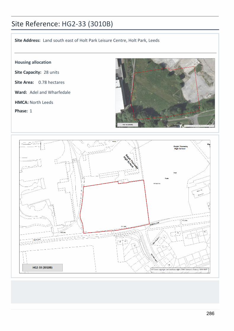
HG2-33 (3010B)
Land south east of Holt Park Leisure Centre, Holt Park, Leeds
0.78 hectares
28 units
Housing allocation
1
Site Reference:
Site Address:
Site Area:
Site Capacity:
Phase:
Adel and WharfedaleWard:
North LeedsHMCA:
286
Site Requirements - HG2-33:
This site is included in the Holt Park Planning Framework.
• Older persons housing/independent living:
The site is suitable for older persons housing/independent living in accordance with Policy HG4
• Listed Buildings:
The site is in the setting of a Listed Building. Any development should preserve the special architectural or historic interest of Listed Buildings and their setting.
287

5
HG2-34 (4233)
Farrar Lane, Adel
0.86 hectares
16 units
Housing allocation
1
Site Reference:
Site Address:
Site Area:
Site Capacity:
Phase:
Adel and WharfedaleWard:
North LeedsHMCA:
288
Site Requirements - HG2-34:
An area will need to be retained for parking spaces to serve the town centre and adjoining green space. The existing bus stop should also be retained. This site is included in the Holt Park Planning Framework.
• Older persons housing/independent living:
The site is suitable for older persons housing/independent living in accordance with Policy HG4
• Listed Buildings:
The site is in the setting of a Listed Building. Any development should preserve the special architectural or historic interest of Listed Buildings and their setting. This may require a significant buffer to the north of the site to protect the setting of the listed The High Farm Public House and adjacent listed cottage.
289
5
HG2-36 (2053B)
Alwoodley Lane, Alwoodley LS17
13.43 hectares
285 units
Housing allocation
2
Site Reference:
Site Address:
Site Area:
Site Capacity:
Phase:
AlwoodleyWard:
North LeedsHMCA:
290
Site Requirements - HG2-36:
• Highway Access to Site:
Suitable access should be achieved on Alwoodley Lane, a footway should be provided on the northern side of Alwoodley Lane between Sovereign Court and the existing footway termination point to the east of the site, and a suitable arrangement for pedestrians to cross Alwoodley Lane.
• Local Highway Network:
The development will have a significant impact on the operation of the Alwoodley Lane/A61 junction. There will also be a cumulative impact on the junction of the Outer Ring Road and A61. The required transport assessment should include these junctions and include for appropriate mitigation measures to offset the impacts.
• Ecology:
An Ecological Assessment of the site is required and where appropriate, mitigation measures will need to be provided to ensure consideration of Eccup Reservoir SSSI to the north of the site. Consultation with Natural England required. Provide biodiversity buffer (not private garden space) adjacent to northern boundary with woodland.
• Education Provision:
Part of the site should be retained for provision of a school
291
5
HG2-37 (3384)
Brownberrie Lane
0.84 hectares
12 units
Housing allocation
1
Site Reference:
Site Address:
Site Area:
Site Capacity:
Phase:
HorsforthWard:
North LeedsHMCA:
292
Site Requirements - HG2-37:
Consideration should be given at the planning application stage to aircraft noise mitigation (particularly in bedrooms), for example by means of enhanced glazing for habitable rooms, alternative means of ventilation, and an enhanced roof specification as appropriate, such that the internal noise standards of BS 8233 can be achieved.
• Culverts and Canalised Water Courses:
The site contains a culvert or canalised watercourse. Development proposals should consider re-opening or restoration in accordance with saved UDP Policy N39B
• Conservation Area:
The site is in the setting of a group of Victorian villas that are viewed as non-designated heritage assets. Consideration should be given to their setting in any future development.
293
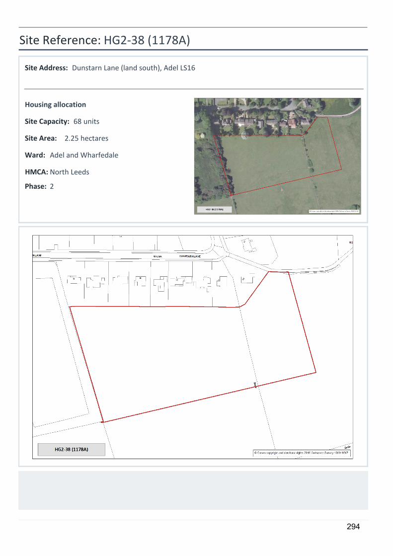
5
HG2-38 (1178A)
Dunstarn Lane (land south), Adel LS16
2.25 hectares
68 units
Housing allocation
2
Site Reference:
Site Address:
Site Area:
Site Capacity:
Phase:
Adel and WharfedaleWard:
North LeedsHMCA:
294
Site Requirements - HG2-38:
• Highway Access to Site:
Access either through site HG1-74 or property needs to be aquired. The existing farm track off Dunstarn Drive is unsuitable.
• Local Highway Network:
There is likely to be a cumulative impact on the Weetwood Lane/A6120 junction. The development would be required to contribute to measures to mitigate the cumulative impact of this and other allocated sites affecting the junction.
295
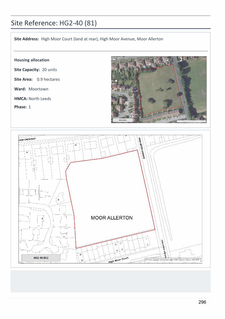
5
HG2-40 (81)
High Moor Court (land at rear), High Moor Avenue, Moor Allerton
0.9 hectares
20 units
Housing allocation
1
Site Reference:
Site Address:
Site Area:
Site Capacity:
Phase:
MoortownWard:
North LeedsHMCA:
296

Site Requirements - HG2-40:
• Culverts and Canalised Water Courses:
The site contains a culvert or canalised watercourse. Development proposals should consider re-opening or restoration in accordance with saved UDP Policy N39B
• Greenspace:
Half the site to remain as green space
297
5
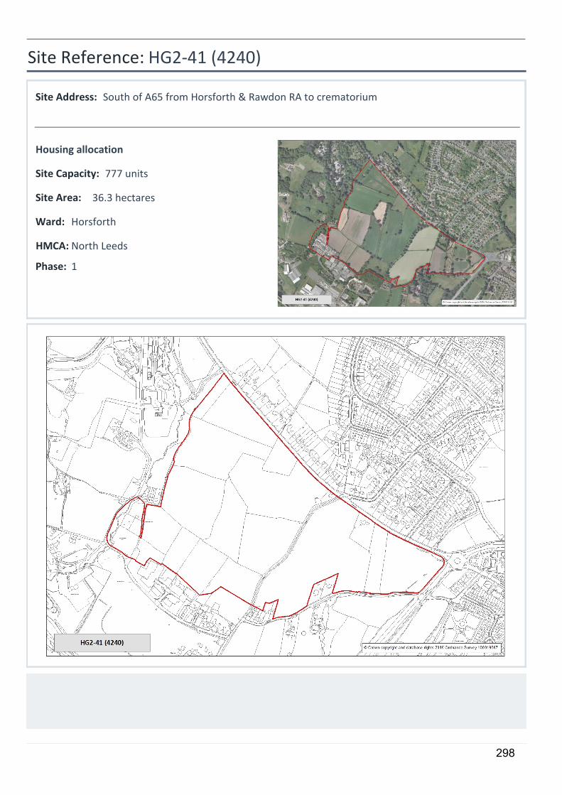
HG2-41 (4240)
South of A65 from Horsforth & Rawdon RA to crematorium
36.3 hectares
777 units
Housing allocation
1
Site Reference:
Site Address:
Site Area:
Site Capacity:
Phase:
HorsforthWard:
North LeedsHMCA:
298
Site Requirements - HG2-41:
• Highway Access to Site:
The A65 should be widened to provide an inbound bus lane and a suitable access to the site. The Horsforth Roundabout, A6120/AA65 junction will require improvement including land take from within the site. The delivery of the works will be controlled through planning obligations.
• Local Highway Network:
The development will have a significant impact on the operation of the A65 / Outer Ring Road 'Horsforth roundabout' and implementation of the proposed Airport Link Road. Contributions will be sought towards: improvements at Horsforth roundabout; widening of the A65 along the full site frontage to facilitate additional capacity and bus priority measures; and provision of land and detailing of design to a A65 / Airport Link road junction. The details of the above, including timescales and phasing, shall be submitted and agreed prior to any planning approval.
• Ecology:
An Ecological Assessment of the site is required and where appropriate, mitigation measures will need to be provided
• Culverts and Canalised Water Courses:
The site contains a culvert or canalised watercourse. Development proposals should consider re-opening or restoration in accordance with saved UDP Policy N39B
• Listed Buildings:
The site is in the setting of a Listed Building. Any development should preserve the special architectural or historic interest of Listed Buildings and their setting.
• Conservation Area:
The site is in the setting of two Conservation Areas. Rawdon - Crag Wood CA to the west and Horsforth CA to the north. Any development should preserve or enhance the character or appearance of the Conservation Areas.
• Education Provision:
Part of the site should be retained for provision of a school. This should contain a through school with 2 form entry primary and 4 form entry secondary.
299
5
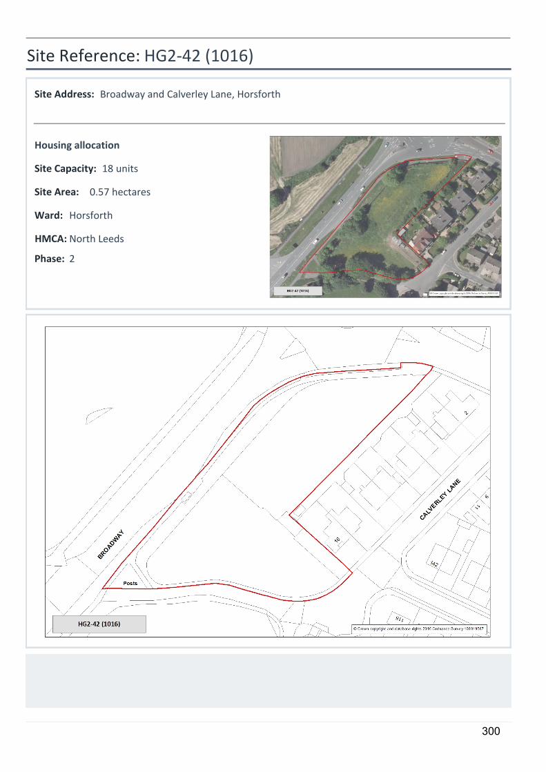
HG2-42 (1016)
Broadway and Calverley Lane, Horsforth
0.57 hectares
18 units
Housing allocation
2
Site Reference:
Site Address:
Site Area:
Site Capacity:
Phase:
HorsforthWard:
North LeedsHMCA:
300
Site Requirements - HG2-42:
• Highway Access to Site:
Access should be taken from Calverley Lane, no direct access onto A6120 Broadway.
• Local Highway Network:
There may be a need for a portion of the development site to be reserved for the proposed improvements to capacity at Horsforth roundabout.
• Conservation Area:
The site is in the setting of Horsforth Conservation Area. Any development should preserve or enhance the character or appearance of the Conservation Area.
301

5
HG2-43 (5009)
Horsforth Campus
7.85 hectares
206 units
Housing allocation
2
Site Reference:
Site Address:
Site Area:
Site Capacity:
Phase:
HorsforthWard:
North LeedsHMCA:
302
Site Requirements - HG2-43:
• Highway Access to Site:
Horsforth roundabout will require alteration to accommodate additional traffic as a result of housing growth. The development will be expected to contribute to the alterations.
• Local Highway Network:
The development will have a cumulative impact on the operation of the A65 / Outer Ring Road 'Horsforth roundabout' and implementation of the proposed Airport Link Road. Contributions will be sought towards improvements at Horsforth roundabout.
• Ecology:
Significant ecological impact identified on parts of the site. An Ecological Assessment of the site is required and where appropriate, mitigation measures will need to be provided, including protection of great crested newts which are present on site.
303
5
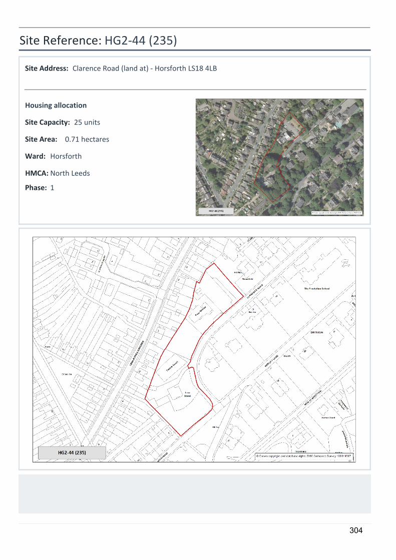
HG2-44 (235)
Clarence Road (land at) - Horsforth LS18 4LB
0.71 hectares
25 units
Housing allocation
1
Site Reference:
Site Address:
Site Area:
Site Capacity:
Phase:
HorsforthWard:
North LeedsHMCA:
304
Site Requirements - HG2-44:
• Older persons housing/independent living:
The site is suitable for older persons housing/independent living in accordance with Policy HG4
• Conservation Area:
The site is within Newlay Conservation Area. Any development should preserve or enhance the character or appearance of the Conservation Area.
305
5
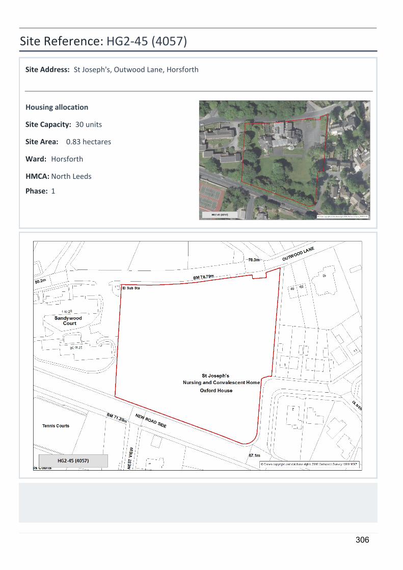
HG2-45 (4057)
St Joseph's, Outwood Lane, Horsforth
0.83 hectares
30 units
Housing allocation
1
Site Reference:
Site Address:
Site Area:
Site Capacity:
Phase:
HorsforthWard:
North LeedsHMCA:
306
Site Requirements - HG2-45:
• Older persons housing/independent living:
The site is suitable for older persons housing/independent living in accordance with Policy HG4
• Conservation Area:
The site is within Horsforth Crag Hill and Woodside Conservation Area. Any development should preserve or enhance the character or appearance of the Conservation Area. Proposed over-development of the site has previously been dismissed at appeal.
307
5
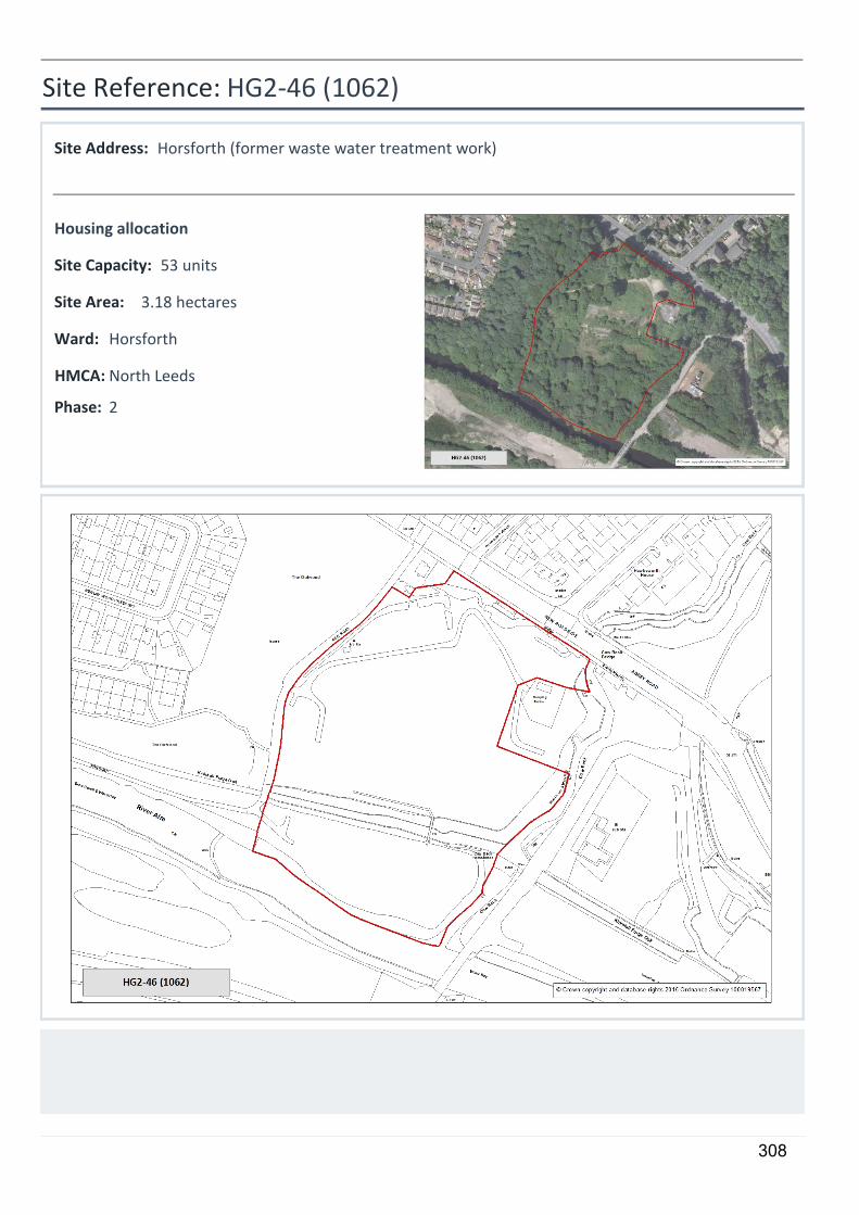
HG2-46 (1062)
Horsforth (former waste water treatment work)
3.18 hectares
53 units
Housing allocation
2
Site Reference:
Site Address:
Site Area:
Site Capacity:
Phase:
HorsforthWard:
North LeedsHMCA:
308
Site Requirements - HG2-46:
• Local Highway Network:
In order to maximise public transport usage, pedestrian and cycle links through to Kirkstall Forge station should be provided.
• Ecology:
An Ecological Assessment of the site is required and where appropriate, mitigation measures will need to be provided to ensure impacts on wildlife corridor function are addressed including a biodiversity buffer (not private garden space) along the west, south and east boundary.
• Conservation Area:
The site is within Newlay Conservation Area. Any development should preserve or enhance the character or appearance of the Conservation Area. The open green space, tree coverage and informal footpaths are important elements of the site and would need to be preserved in any new development. This is likely to result in a very limited development towards the eastern extent of the site, potenitally tying in with the Kirkstall Forge development.
309
5
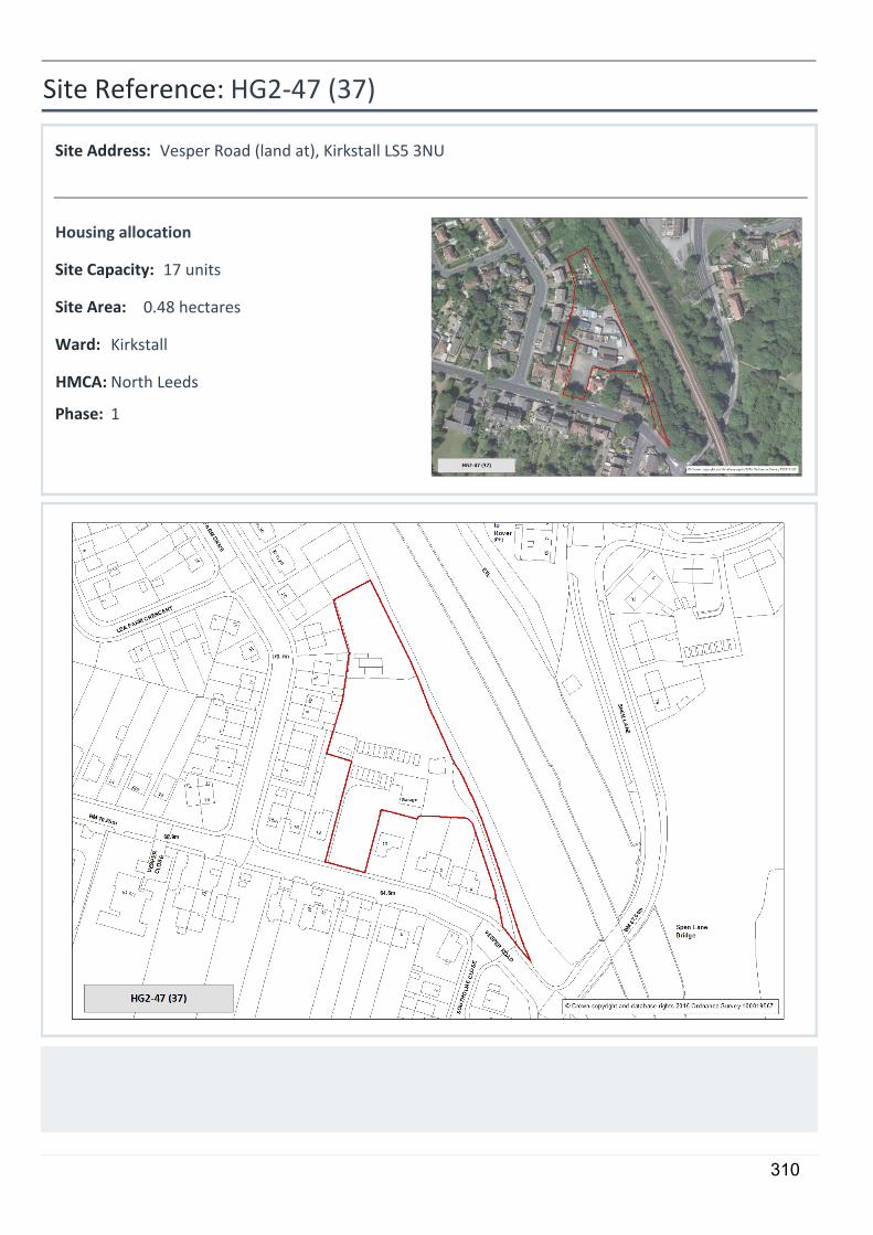
HG2-47 (37)
Vesper Road (land at), Kirkstall LS5 3NU
0.48 hectares
17 units
Housing allocation
1
Site Reference:
Site Address:
Site Area:
Site Capacity:
Phase:
KirkstallWard:
North LeedsHMCA:
310
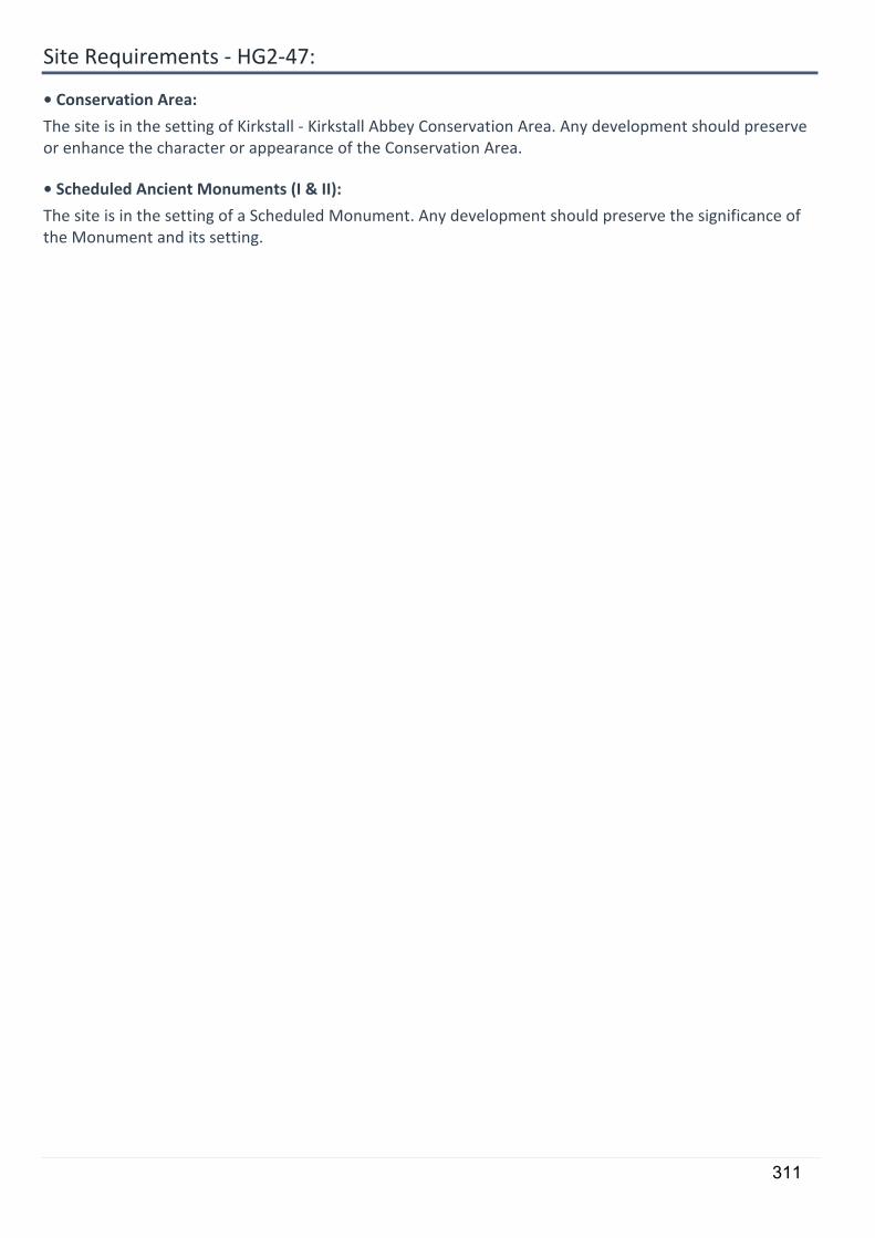
Site Requirements - HG2-47:
• Conservation Area:
The site is in the setting of Kirkstall - Kirkstall Abbey Conservation Area. Any development should preserve or enhance the character or appearance of the Conservation Area.
• Scheduled Ancient Monuments (I & II):
The site is in the setting of a Scheduled Monument. Any development should preserve the significance of the Monument and its setting.
311
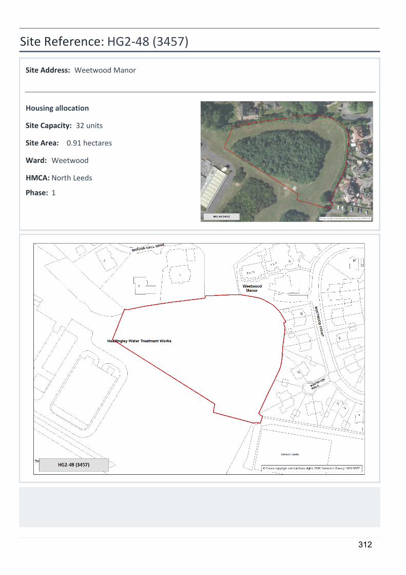
5
HG2-48 (3457)
Weetwood Manor
0.91 hectares
32 units
Housing allocation
1
Site Reference:
Site Address:
Site Area:
Site Capacity:
Phase:
WeetwoodWard:
North LeedsHMCA:
312
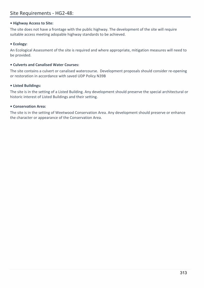
Site Requirements - HG2-48:
• Highway Access to Site:
The site does not have a frontage with the public highway. The development of the site will require suitable access meeting adopable highway standards to be achieved.
• Ecology:
An Ecological Assessment of the site is required and where appropriate, mitigation measures will need to be provided.
• Culverts and Canalised Water Courses:
The site contains a culvert or canalised watercourse. Development proposals should consider re-opening or restoration in accordance with saved UDP Policy N39B
• Listed Buildings:
The site is in the setting of a Listed Building. Any development should preserve the special architectural or historic interest of Listed Buildings and their setting.
• Conservation Area:
The site is in the setting of Weetwood Conservation Area. Any development should preserve or enhance the character or appearance of the Conservation Area.
313
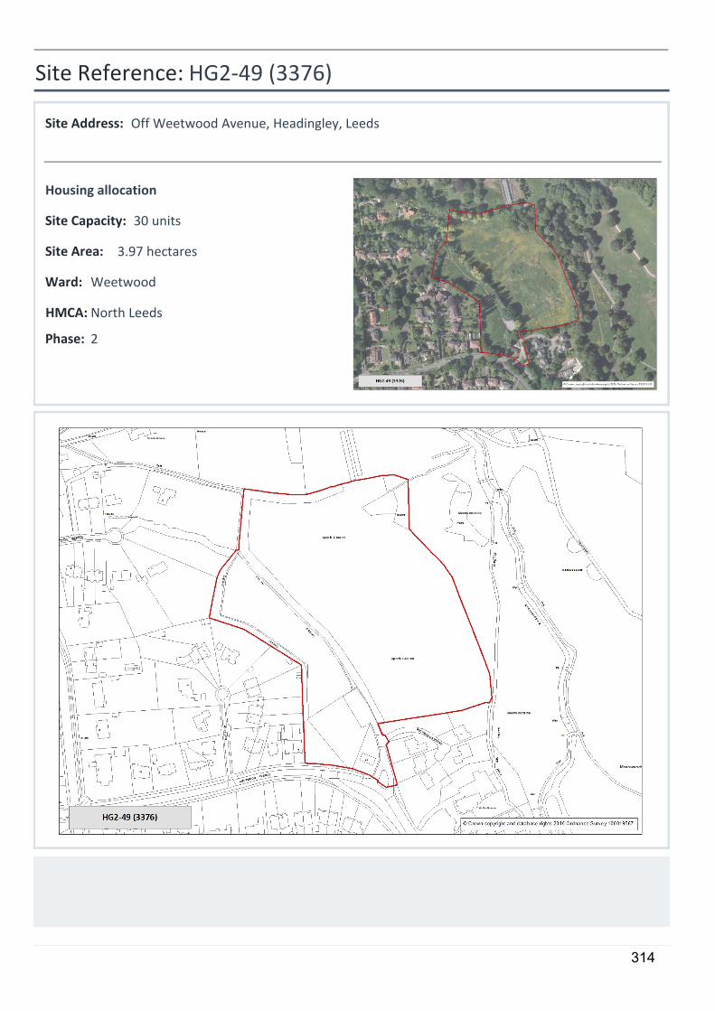
5
HG2-49 (3376)
Off Weetwood Avenue, Headingley, Leeds
3.97 hectares
30 units
Housing allocation
2
Site Reference:
Site Address:
Site Area:
Site Capacity:
Phase:
WeetwoodWard:
North LeedsHMCA:
314
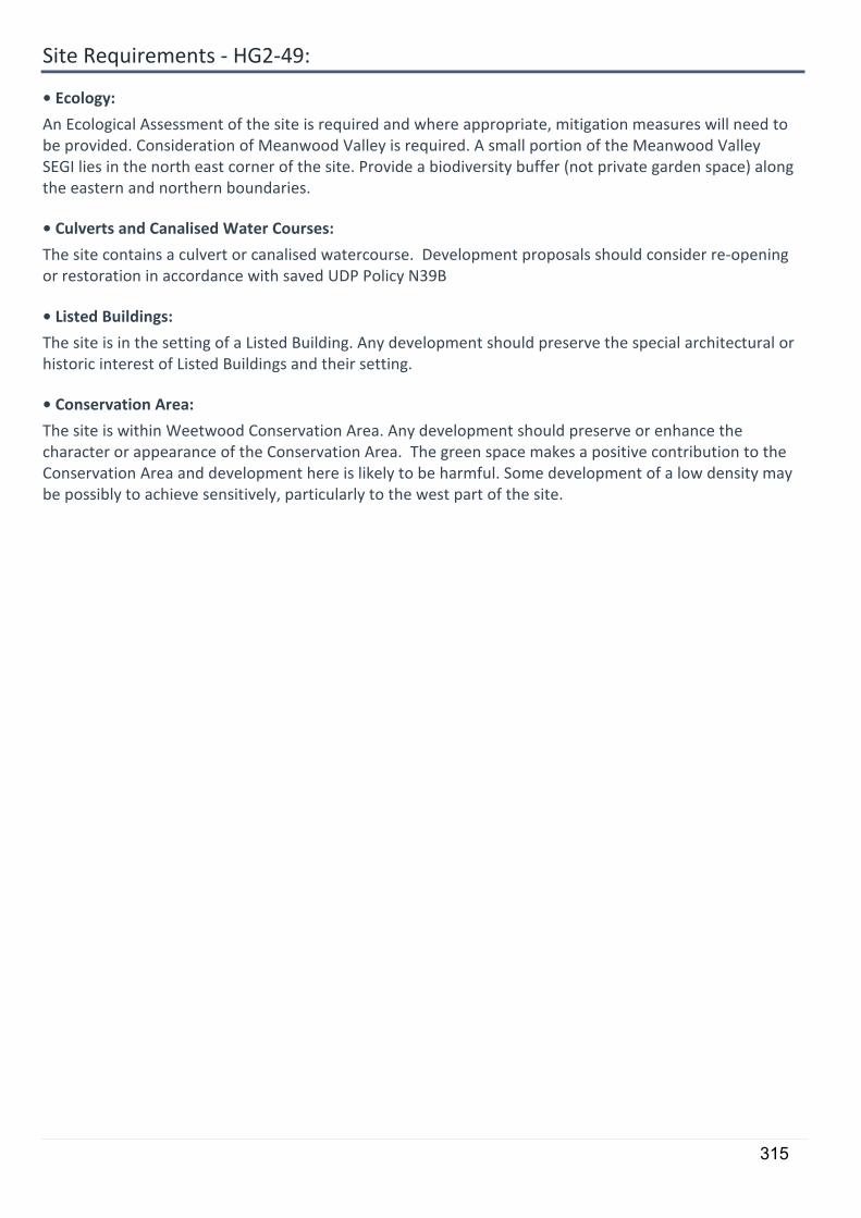
Site Requirements - HG2-49:
• Ecology:
An Ecological Assessment of the site is required and where appropriate, mitigation measures will need to be provided. Consideration of Meanwood Valley is required. A small portion of the Meanwood Valley SEGI lies in the north east corner of the site. Provide a biodiversity buffer (not private garden space) along the eastern and northern boundaries.
• Culverts and Canalised Water Courses:
The site contains a culvert or canalised watercourse. Development proposals should consider re-opening or restoration in accordance with saved UDP Policy N39B
• Listed Buildings:
The site is in the setting of a Listed Building. Any development should preserve the special architectural or historic interest of Listed Buildings and their setting.
• Conservation Area:
The site is within Weetwood Conservation Area. Any development should preserve or enhance the character or appearance of the Conservation Area. The green space makes a positive contribution to the Conservation Area and development here is likely to be harmful. Some development of a low density may be possibly to achieve sensitively, particularly to the west part of the site.
315
5
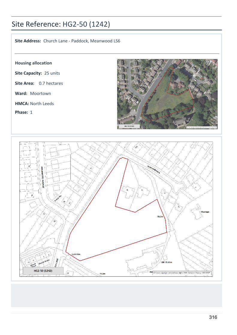
HG2-50 (1242)
Church Lane - Paddock, Meanwood LS6
0.7 hectares
25 units
Housing allocation
1
Site Reference:
Site Address:
Site Area:
Site Capacity:
Phase:
MoortownWard:
North LeedsHMCA:
316
Site Requirements - HG2-50:
• Older persons housing/independent living:
The site is suitable for older persons housing/independent living in accordance with Policy HG4
• Ecology:
An Ecological Assessment of the site is required and where appropriate, mitigation measures will need to be provided.
• Culverts and Canalised Water Courses:
The site contains a culvert or canalised watercourse. Development proposals should consider re-opening or restoration in accordance with saved UDP Policy N39B
• Listed Buildings:
The site is in the setting of a Listed Building. Any development should preserve the special architectural or historic interest of Listed Buildings and their setting.
317
5
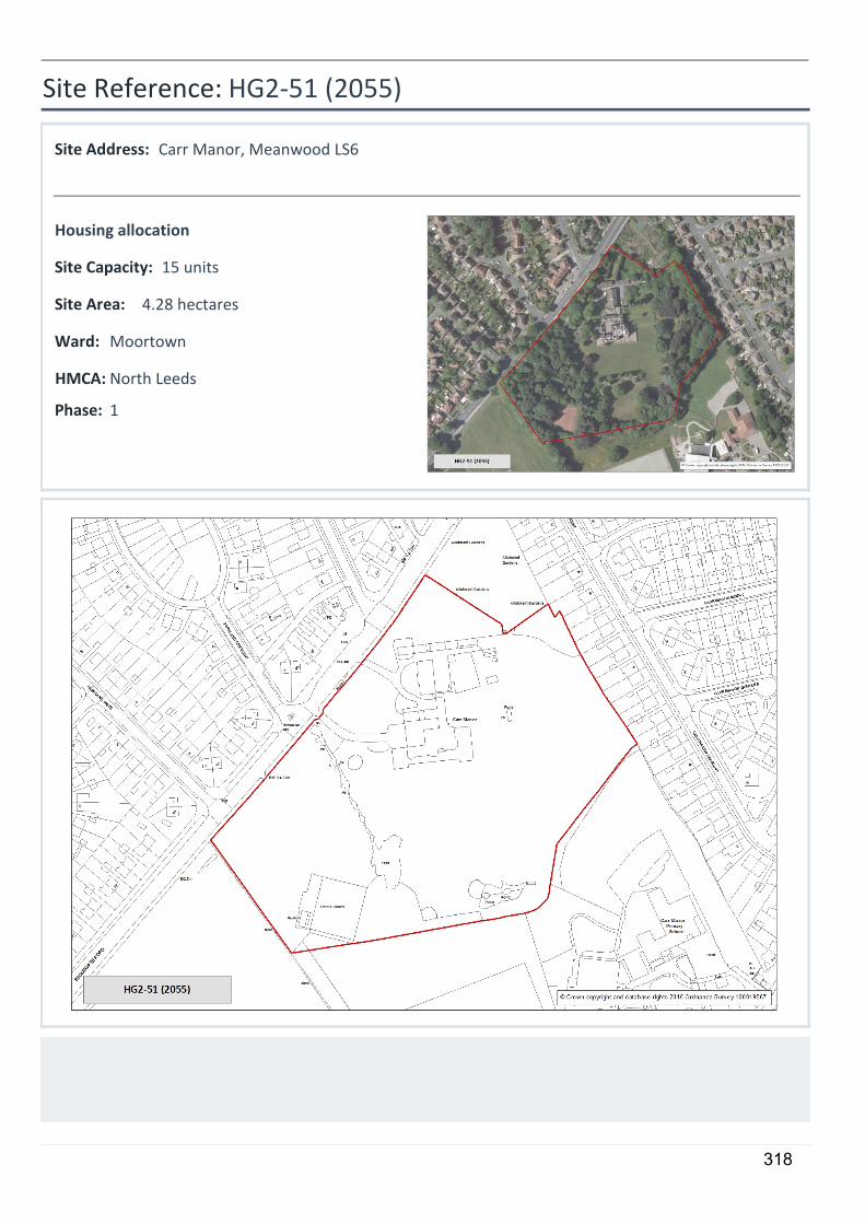
HG2-51 (2055)
Carr Manor, Meanwood LS6
4.28 hectares
15 units
Housing allocation
1
Site Reference:
Site Address:
Site Area:
Site Capacity:
Phase:
MoortownWard:
North LeedsHMCA:
318
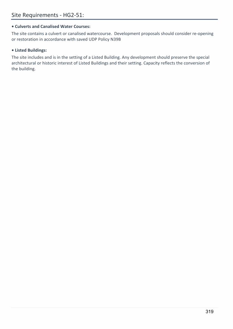
Site Requirements - HG2-51:
• Culverts and Canalised Water Courses:
The site contains a culvert or canalised watercourse. Development proposals should consider re-opening or restoration in accordance with saved UDP Policy N39B
• Listed Buildings:
The site includes and is in the setting of a Listed Building. Any development should preserve the special architectural or historic interest of Listed Buildings and their setting. Capacity reflects the conversion of the building.
319
5
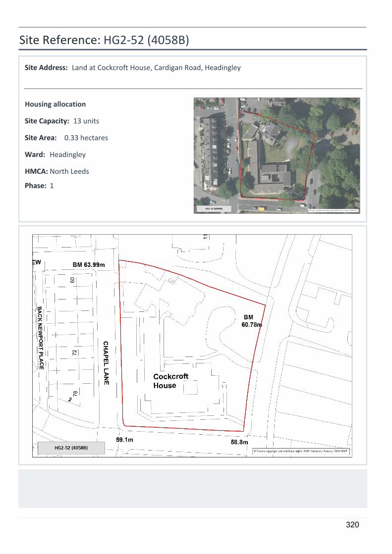
HG2-52 (4058B)
Land at Cockcroft House, Cardigan Road, Headingley
0.33 hectares
13 units
Housing allocation
1
Site Reference:
Site Address:
Site Area:
Site Capacity:
Phase:
HeadingleyWard:
North LeedsHMCA:
320
Site Requirements - HG2-52:
• Conservation Area:
The site is within Headingley Conservation Area. Any development should preserve or enhance the character or appearance of the Conservation Area.
321
5
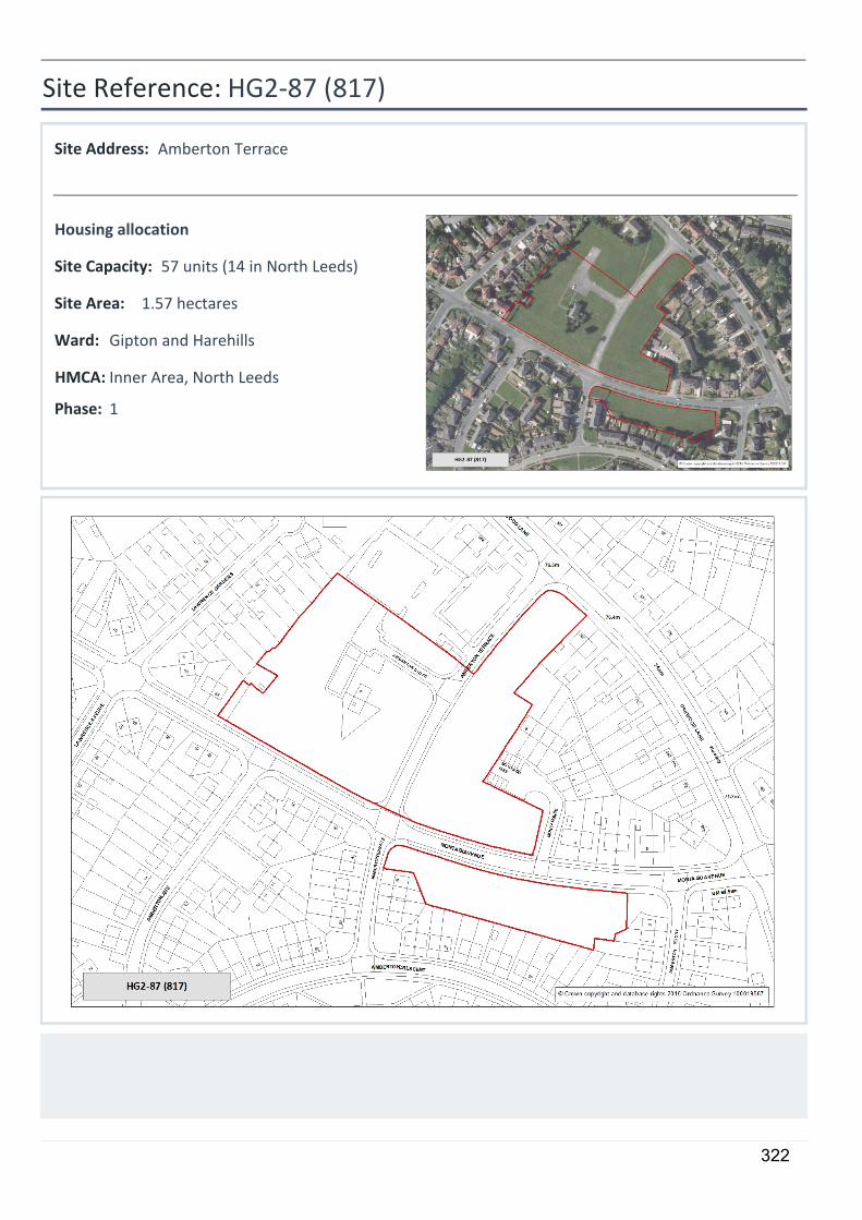
HG2-87 (817)
Amberton Terrace
1.57 hectares
57 units (14 in North Leeds)
Housing allocation
1
Site Reference:
Site Address:
Site Area:
Site Capacity:
Phase:
Gipton and HarehillsWard:
Inner Area, North LeedsHMCA:
322

Site Requirements - HG2-87:
• Older persons housing/independent living:
The site is suitable for older persons housing/independent living in accordance with Policy HG4
323
5
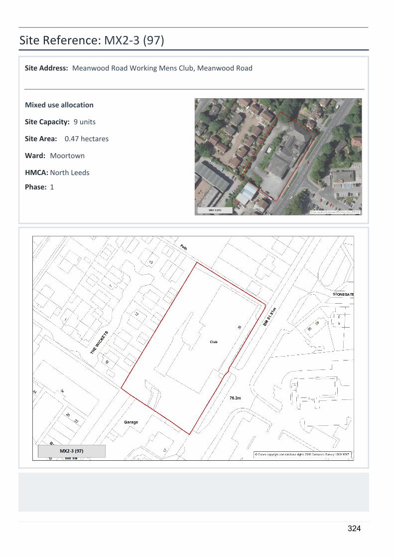
MX2-3 (97)
Meanwood Road Working Mens Club, Meanwood Road
0.47 hectares
9 units
Mixed use allocation
1
Site Reference:
Site Address:
Site Area:
Site Capacity:
Phase:
MoortownWard:
North LeedsHMCA:
324

Site Requirements - MX2-3:
The site is within Meanwood Town Centre boundary, therefore town centre uses would be encouraged on the ground floor.
• Older persons housing/independent living:
The site is suitable for older persons housing/independent living in accordance with Policy HG4
325
5
MX2-4 (3014)
Kirkstall District Centre
3.62 hectares
55 units & 7000 sqm office
Mixed use allocation
1
Site Reference:
Site Address:
Site Area:
Site Capacity:
Phase:
KirkstallWard:
North LeedsHMCA:
326

Site Requirements - MX2-4:
The site is within Kirkstall Town Centre boundary and Kirkstall Primary Shopping Area, therefore there is an expectation for retail and other town centre uses to be delivered at ground floor level.
• Older persons housing/independent living:
The site is suitable for older persons housing/independent living in accordance with Policy HG4
• Highway Access to Site:
To achieve a suitable access, mitigation works will be required on the A65 Commercial Road at Beecroft Street, Savins Mill Way and Kirkstall Lane.
• Listed Buildings:
The site is in the setting of a Listed Building. Any development should preserve the special architectural or historic interest of Listed Buildings and their setting.
327
Safeguarded Land 3.5.10 Section 2, paragraph 2.60 explains the need to designate sites as safeguarded
land – a reserve of potential sites for longer term development post 2028. There are no designated safeguarded land sites in the North HMCA.
Sites for Older Persons Housing/Independent Living
3.5.11 Fourteen housing allocations have easy access to local centres in the North HMCA and have been identified as being particularly suitable for elderly or independent living schemes. These are shown on the HMCA area plans.
POLICY HG4: THE SITE ALLOCATIONS PLAN IDENTIFIES SITES WHICH ARE PARTICULARLY SUITABLE FOR OLDER PERSONS HOUSING/ INDEPENDENT LIVING. THESE ARE SHOWN ON THE POLICIES MAP. IN NORTH THESE SITES ARE: HG2-30 Eyrie Public House site, Holt Park HG2-31 Ralph Thoresby Holt Park HG2-32 Cookridge Fire Station HG2-33 Land south east of Holt Park Leisure Centre, Holt Park HG2-34 Farrar Lane, Adel HG2-44 Clarence Road (land at) – Horsforth HG2-45 St Joseph's, Outwood Lane, Horsforth HG2-50 Church Lane - Paddock, Meanwood MX2-3 Meanwood Road Working Mens Club, Meanwood Road MX2-4 Kirkstall District Centre Sites reserved for Future School Use
3.5.12 Section 2 paragraph 2.64 explains that where land is needed for provision of a school or schools, or extension to a school, these sites are identified on the plan at the end of the section. In North HMCA there are three sites where part of a housing site is to be retained for a school. These sites are: MX1-3 Abbey Road - Kirkstall Forge HG2-36 Alwoodley Lane, Alwoodley HG2-41 South of A65 from Horsforth & Rawdon roundabout to crematorium In addition some sites that are not allocated for housing also need to be reserved for future school use. Policy HG5 applies to these sites: POLICY HG5: THE SITE ALLOCATIONS PLAN ALLOCATES SITES FOR SCHOOL USE. THESE ARE SHOWN ON THE POLICIES MAP. IN THE NORTH HMCA THESE SITES ARE: HG5-1 Victoria Avenue, extension to Newlaithes School HG5-2 Former West Park Centre, Spen Lane
Sites for Gypsies and Travellers 3.5.13 Paragraph 2.65 to 2.72 explains the approach to allocating and safeguarding land
for Gypsies and Travellers. No sites are proposed in North.
Sites for Travelling Showpeople 3.5.14 Paragraph 2.73 explains the approach to allocating sites for Travelling
Showpeople. No sites are proposed in North.
328
EMPLOYMENT PROPOSALS FOR NORTH
Offices 3.5.15 The sites in North have been assessed to determine their total contribution towards
an overall district requirement of 1,000,000 sq m office based development. Sites which either have planning permission for office use (as at 5.4.15) and/or were allocated for employment including office on the Unitary Development Plan and are to be retained as such count towards the office requirement.
POLICY EO1 – IDENTIFED SITES FOR OFFICE USE THE SITE ALLOCATIONS PLAN IDENTIFIES SITES WHICH HAVE EXISTING OR RECENTLY EXPIRED PLANNING PERMISSION, OR WERE PREVIOUSLY ALLOCATED FOR USES INCLUDING OFFICE ON THE UNITARY DEVELOPMENT PLAN AS IDENTIFIED OFFICE SITES. IDENTIFIED OFFICE SITES CONTRIBUTE TO THE TARGET FOR OFFICE USE SET OUT IN CORE STRATEGY POLICY SP9. THESE ARE SHOWN ON THE POLICIES MAP (FOR MIXED USE OR OFFICE USE) IN NORTH THESE SITES ARE:
Identified Office Sites (with planning permission or UDP allocations)
Plan Ref ELR Ref Address Area ha Capacity sqm MX1-2
376 Ring Road W est Park, Silk Mill W ay and Iveson Drive
20.8
4950
MX1-3
626 Abbey Road - Kirkstall Forge LS5
17.8
14270
EO1-4
2701510 Low Lane Horsforth
1.2
8302
EO1-5
2701300
Office Element Corn Mill Fold Low Lane Horsforth LS18
0.1
540
EO1-6
2602760 Bodington Business Park Otley Road Ls16
4.4
24375
EO1-7
2404920 471 Kirkstall Rd LS5
0.1
500
Identified office employment total (sqm): 52937
New office allocations 3.5.16 Further sites suitable for office or mixed use including office have been allocated in
or on the edge of the City Centre and Town Centres. POLICY EO2 – OFFICE ALLOCATIONS, OR MIXED USE ALLOCATIONS WHICH INCLUDE OFFICE USE. THE SITE ALLOCATIONS PLAN ALLOCATES SITES FOR OFFICE OR MIXED USE INCLUDING OFFICE IN ACCORDANCE WITH CORE STRATEGY SPATIAL POLICY 9 (SP9). THESE ARE SHOWN ON THE POLICIES MAP. IN NORTH THESE ALLOCATIONS ARE:
Plan Ref ELR Ref Address Area ha Capacity sqm
MX2-4
3014
Site bounded by Commercial Road, Beechcroft Street, Kirkstall Hill and 28 Kirkstall Lane, Kirkstall, Leeds
3.6
7000
Allocated for office employment total: ( )
7000
329
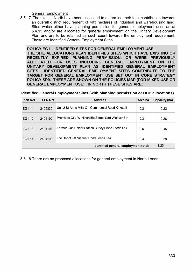
General Employment 3.5.17 The sites in North have been assessed to determine their total contribution towards
an overall district requirement of 493 hectares of industrial and warehousing land. Sites which either have planning permission for general employment uses as at 5.4.15 and/or are allocated for general employment on the Unitary Development Plan and are to be retained as such count towards the employment requirement. These are Identified General Employment Sites.
POLICY EG1 – IDENTIFED SITES FOR GENERAL EMPLOYMENT USE THE SITE ALLOCATIONS PLAN IDENTIFIES SITES WHICH HAVE EXISTING OR RECENTLY EXPIRED PLANNING PERMISSION, OR WERE PREVIOUSLY ALLOCATED FOR USES INCLUDING GENERAL EMPLOYMENT ON THE UNITARY DEVELOPMENT PLAN AS IDENTIFIED GENERAL EMPLOYMENT SITES. IDENTIFIED GENERAL EMPLOYMENT SITES CONTRIBUTE TO THE TARGET FOR GENERAL EMPLOYMENT USE SET OUT IN CORE STRATEGY POLICY SP9. THESE ARE SHOWN ON THE POLICIES MAP (FOR MIXED USE OR GENERAL EMPLOYMENT USE). IN NORTH THESE SITES ARE:
Identified General Employment Sites (with planning permission or UDP allocations)
Plan Ref ELR Ref Address Area ha Capacity (ha) EG1-11
2405330 Unit 2 St Anns Mills Off Commercial Road Kirkstall
0.2
0.22
EG1-12
2404192 Premises Of J W Hinchliffe Scrap Yard W eaver Str
0.3
0.28
EG1-13
2404193 Former Gas Holder Station Burley Place Leeds Ls4
0.5
0.45
EG1-14
2404190 Lcc Depot Off Viaduct Road Leeds Ls4
0.3
0.28
Identified general employment total: 1.23
3.5.18 There are no proposed allocations for general employment in North Leeds.
330
GREENSPACE PROPOSALS FOR NORTH
3.5.19 The plan shows the green space sites proposed for designation within the North HMCA. These are predominantly existing UDP green space sites (some updated and modified to reflect the current situation) and additional sites identified through the Open Space, Sport and Recreation Assessment (OSSRA July 2011) . Existing green space located within housing or employment allocations is not identified for designation however green space provision within any housing proposal will be addressed through the planning application process and the application of Policy G4 (New Green Space Provision) of the Core Strategy. The provision of green space will also be a requirement in some site specific policies contained in the housing section of this chapter. Any UDP green space sites that are not shown are proposed for deletion mainly because they are no longer in an open space use or are below the 0.2ha threshold. They are listed in the Green Space Background Paper.
3.5.20 The largest area of green space within the North area is Roundhay Park (147.9ha)
which provides a wider range of recreational opportunities and attracts people from across the city especially for organised events such as the bonfire and Mela. Adjacent to the park is Roundhay Golf Course, one of only 3 municipal golf courses in the Leeds area. There are a number of woodland areas that are easily accessible such as Adel Wood (36.5ha), Scotland Wood (21.4ha), Hawksworth Wood (22.7) and The Hollies (22.8ha) as well as parks and recreation grounds e.g. Bedquilts Park (22.1ha), Horsforth Hall Park (15.2ha), Alwoodley Park (12.2ha) and Stonegate Recreation Ground (10.5ha). There are distinct corridors of green space following the Adel, Meanwood and Gledhow Becks and concentrations of open space around Becketts Park and Hawksworth. Provision is still in need of improvement in terms of quantity, quality and accessibility. Revised surpluses and deficiencies by typology (undertaken in May 2015) for the Wards that fall completely or partially within the North HMCA are contained in the Green Space Background Paper.
331

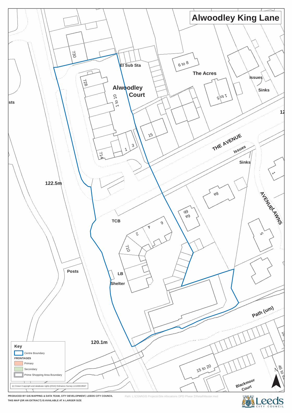
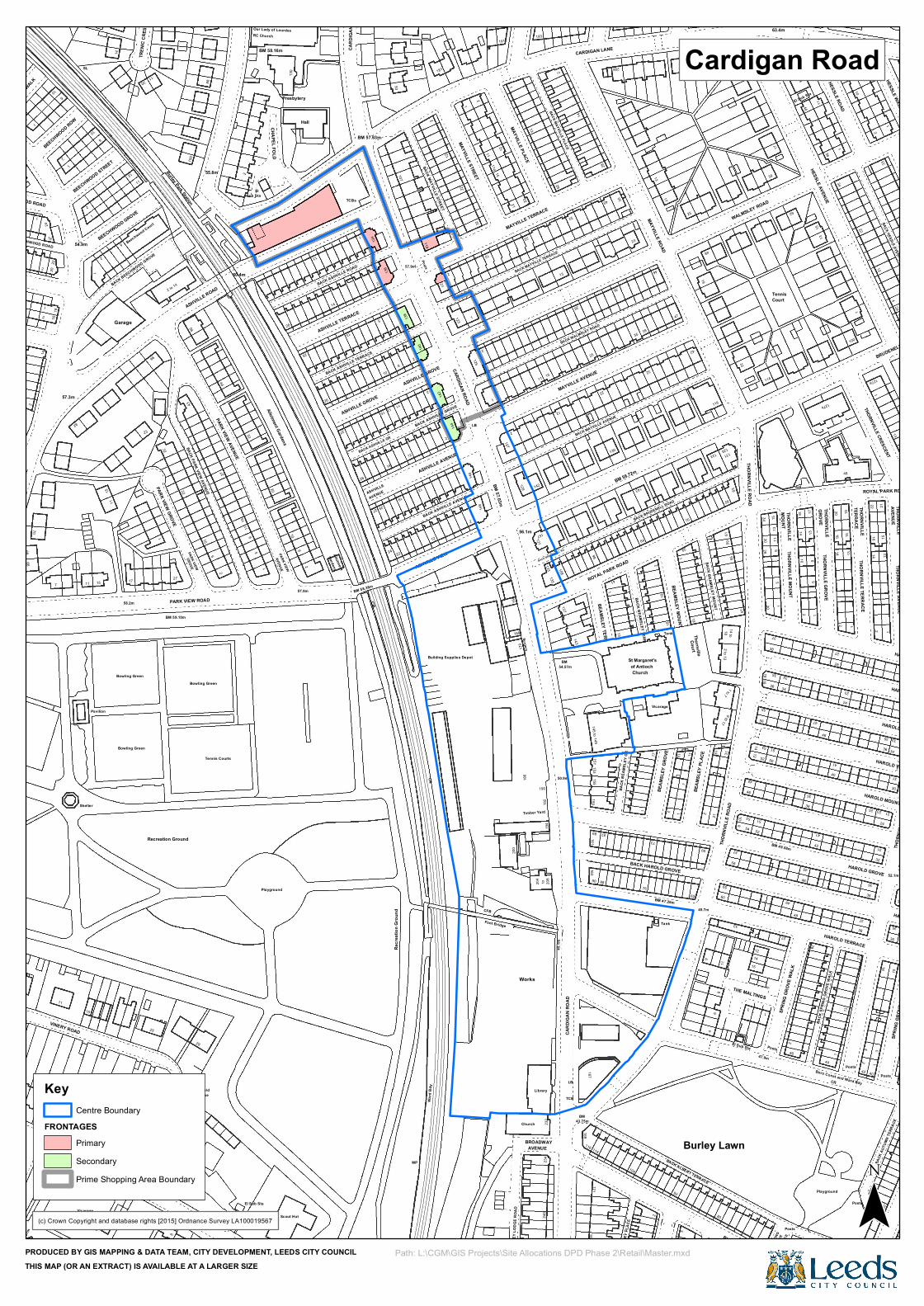
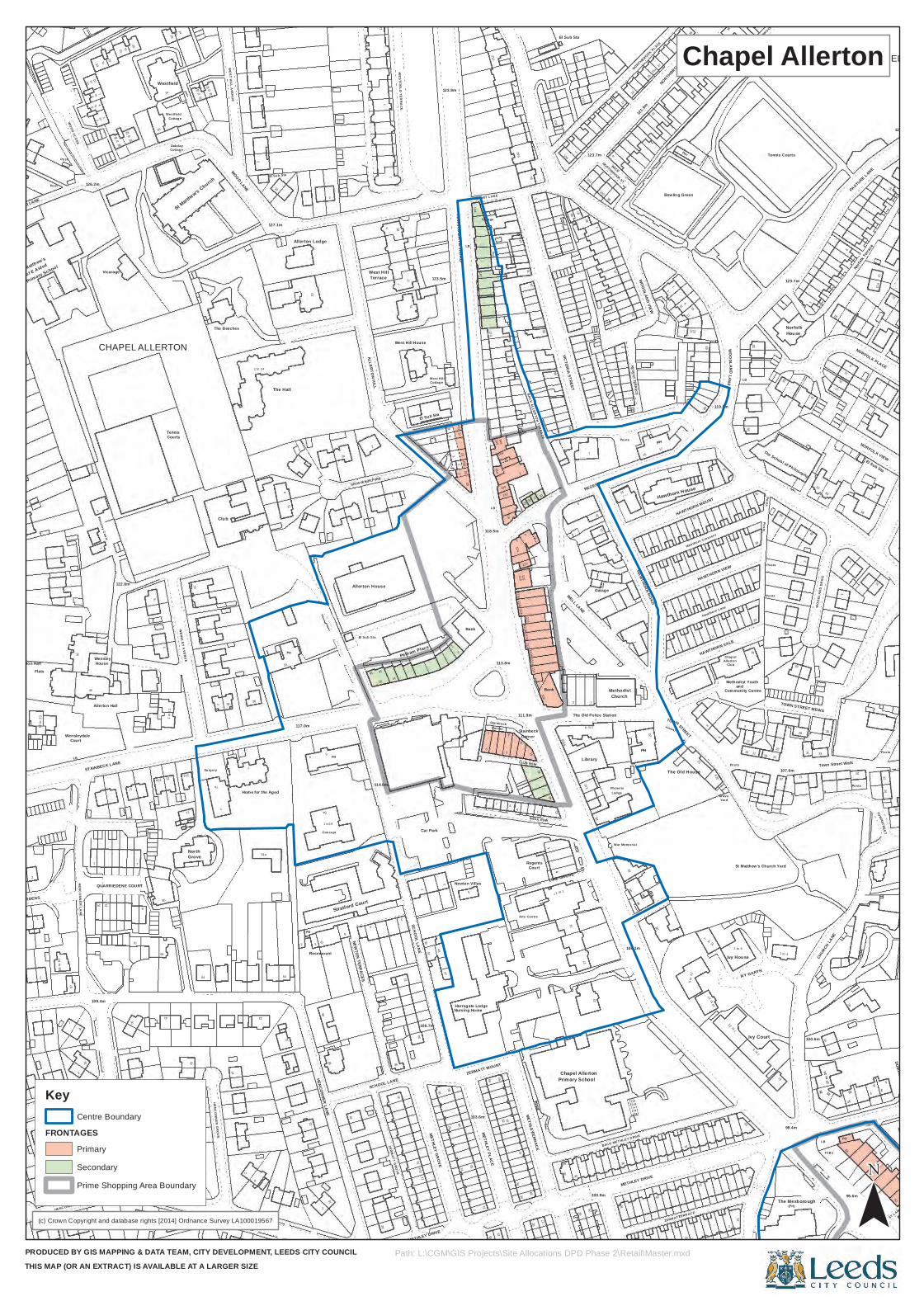
North Area Retail and Site Allocations Plans
332
Posts
LB
Sinks
122.8m
122.5m2
Court
6 to 8
The Acres
Issues
Path (um)
730
714
TCB
710
Alwoodley
6b
Court
1
1 to
10
15
AVENUE
120.1m
46
9 to
14
8a
5
LAWNS46 to 51
728
6a
Blackmoor
Sinks
3
1 to 5
THE AVENUE
Issues
Posts
Shelter
1
El Sub Sta
15 to 20
Sinks
26
(c) Crown Copyright and database rights [2014] Ordnance Survey LA100019567
PRODUCED BY GIS MAPPING & DATA TEAM, CITY DEVELOPMENT, LEEDS CITY COUNCILTHIS MAP (OR AN EXTRACT) IS AVAILABLE AT A LARGER SIZE
Alwoodley King Lane
¯Path: L:\CGM\GIS Projects\Site Allocations DPD Phase 2\Retail\Master.mxd
Key
FRONTAGESCentre Boundary
Primary
Secondary
Prime Shopping Area Boundary

WALK
3616
2
OLD FARM DRIVE
72
8
(PH)
51
OLD OAK GARTH
Linton
49
47
32 to
47
28
27
Old Oak Lawn
29
37
14
57
30
14
24
11
10
The Dalesman
1
Sub
20
Linton Croft
Church
OLDFARMPARADE
34
193 201
206
140
291
146
76
2
4
8
APPR
OACH
15
179
11
19
Shelter
116.1m
12
182
14
OLD O
AK
Surgery
187
BUTCHER HILL
259
202
207
115
127
154
to
57
61
59
El
45
11
OLD OAK
1 to 15
18
17
51
35
67
115.8m
3629
5
to12
5
63
38
139
16 to 31
Sta
26
239
30
Surgery
60
65
71
197
283
33
Stone
48
26to
74
161
12
143
51
55
114.9m
43
1
49
TCB LB
St Andrew's
25
49
CLOS
E
28
72
Shannon House
MOOR
GRA
NGE V
IEW
Governor
137
88
Post
6
172
35
DRIVE
53
2
185
16
69 75
83
119.9m
34
El Sub
Sta
175
toto
153
18
Shelt
er
70
166
14
OLD F
ARM
2
100
Croft
57
37
1
15
1
11
32
26
191
196
195
271
204
46
CR
45
Gas
(c) Crown Copyright and database rights [2014] Ordnance Survey LA100019567
PRODUCED BY GIS MAPPING & DATA TEAM, CITY DEVELOPMENT, LEEDS CITY COUNCILTHIS MAP (OR AN EXTRACT) IS AVAILABLE AT A LARGER SIZE
Butcher Hill Local Centre
¯Path: L:\CGM\GIS Projects\Site Allocations DPD Phase 2\Retail\Master.mxd
Key
FRONTAGESCentre Boundary
Primary
Secondary
Prime Shopping Area Boundary
246
Vicarage
232
2
2
1
16
82
54.9m
11
11
10
60.4m
29
RC Church
Allotment Gardens
Our Lady of Lourdes
Hall
26
Recr
eatio
n Gro
und
45.1m
BACK BRUDEN ELL RD
137
54.57m
181159
89 87
BEAMSLEY TERR
13
BEAM
SLEY
GRO
VE
Tank
1
62
12
60
18
33
3
45
1214
1
33
BM 49.58m
46
Posts
SPRI
NG G
ROVE
WAL
K
CR
PostsBoro Const and Ward Bdy
HAROLD TERRACE
4
32HAROLD GROVE
36
36
HAROLD MOUNT
18
THOR
NVILL
E STR
EET
93
Posts
3
ASHVILLE GROVE
BACK ASHVILLE GROVE
ASHVILLE AVENUE
32
BM 57.03m
191
21
22
BACK MAYVILLE TERRACE
25
36
30
48
58
131
MOUNT
Tennis
15
15
22
16
33
15
234
PARK VIEW 1
BEECHWOOD WALK
70
9
57.3m
8
TREN
IC C
RESC
ENT
96
55.8m
8
26
AVENUE
Surgery
204
190
192
232
169
153
1
BACK
CAR
BERR
Y PL
ACE
104
BM 47.26m
BACK HAROLD GROVE
13
19
45.7m
21
59
2 to 12
51
16
5
THORNVILLE MOUNT14
41
2
24
13
16
33
52.1m
SPRI
NG G
ROVE
VIEW
12
57.9m
2
1214
4
15
2
13
26
14
143
13
25
THORNVILLE ROAD
Court
17
13
HESSLE AVENUE20
1
HESSLE ROAD
10
127a
13
11
Shelter
Pavilion
58.2m
Bowling Green
Bowling Green
27
Croft House
GROVE
29
Ashfield
Scout Hut
2
SL
11
15
32
Sub Sta
BM 58.16m
MP
CFB
170
AVENUE
43.75m
of Antioch
73
17
18
BEAM
SLEY
PLAC
E
68
9 t0 17
55
57
41
14
28
BURLEY LODGE ROAD
50
36
51
46
44
14
Posts
THORNVILLE TERRACE
36
35
14 13
Posts
34
15
BACK
AUT
UMN
TERR
ACE
THORNVILLE AVENUE
34
HAROLD VIEW
138
12
11a
MAYVILLE AVENUE
22
1
35
133129
63
1311
15 to
37
GROVE
34
1
21
HESSLE WALK
ROYAL PARK ROAD
66
15
25
Recreation Ground
El Sub Sta
AVENUEPARK VIEW
GardensBM 58.38m
1
15
BEECHWOOD STREET
12
BEECHWOOD GROVE
BACK BEECHWOOD GROVE
2 to 14
88
27
PARK VIEW AVENUE
El
20
130
25
BACK ASHVILLE ROAD
134
2
10
22
Ward
Bdy
Works
BROADWAY
50.9m
143
167
116
90
155
88
ROYAL PARK ROAD
1Tank
39
11
2
4
THOR
NVILL
E ROA
D
El Sub Sta
15
52
1
THE MALTINGS
9
10
36
47
42
Playground
131
38
BACK AUTUMN ROAD
1
2
AUTU
MN TE
RRAC
E
HAROLD AVENUE
2
12
LB
2
11
MAYVILLE TERRACE
2
13
BACK MAYVILLE PLACE
206
23
46
47
19
224
30
THORNVILLE18
14
THORNVILLE
19
48
TERRACE
11a
212
15
(Convent)
39.6m
House
Tennis Courts
Playground
57.9m
BEECHWOOD ROAD
2420
22
1
BEECHWOOD ROW
10
9
14
23
PARK VIEW GROVE22
11
14
27
CARD
IGAN
ROA
D
27
5
25
18
200
186
Church
234
Library
135
163171
76
10
7
9
80
10
54
53
52
53
35
34
2
91
THORNVILLE GROVE
27
25
40
21
HAROLD WALK
107
CARDIGAN ROAD
2
1
148
11
1271
CARDIGAN LANE
BACK MAYVILLE AVENUE
42
6159
33
15
62
16
100
THORNVILLE22 AVENUE
2
BRUDENELL ROAD
68
11 17
236
8
BM 59.10m
PARK VIEW ROAD
6
2
Allotment
CR24
BACK BEECHWOOD ROAD
2
20
Beechwood Court
1
32Burley Park Station
BACK PARK VIEW AVENUE
ASHVILLE ROAD
44
CHAPEL FOLD
13
26
1
BACK ASHVILLE TERRACE
BM 57.63m
CR
Foot Bridge
166
CROS
S BU
RLEY
LOD
GE R
OAD
246
BM
LB
41
BACK
BEA
MSLE
Y GR
2St Margaret's
92
59
31
1 to 7
8
12
56
55
18
47.9m
20
38
37
27
TERR
ACE
48
2
40
41
42
3
31
24
HAROLD ROAD
HAROLD PLACE
140
119BACK MAYVILLE STREET
2
2
22MAYVILLE STREET
2
22
142
157
29
32
BACK WALMSLEY ROAD
205
BM 56.72m
39
MAYVILLE ROAD
BACK BRUDENELL ROAD
114
39
127b
BM 40
.67m
5
2
1
2
14
10
2
100
56
1
10
13
TCBs
ASHVILLE TERRACE
ASHVILLE
15
136
BACK ASHVILLE GR
13
ASHVILLE VIEW
to19
4
108
CARD
IGAN
ROA
D
161145 to 149
114
BACK BEAMSLEY TERR
Church
2
Vicarage
12BEAMSLEY MOUNT
13Court
Thornville
BACK ALBERT TERRACE
11
58
Posts
GROV
E
49
45
5
1
23
37
2
23
30
17
6
19
13
181
121
3
BACK ASHVILLE AVENUE
1
146
1
12
14
131
193
40
32
34
WALMSLEY ROAD
63.4m
46
El Sub Sta36
111
42a
23
7
43.9m
VINERY ROAD
Bowling Green
6
CARD
IGAN
LANE
2
1a
18
1
1
Garage
43
27
Presbytery
ASHVILLE GROVE
Building Supplies Depot
168
Timber Yard
208
133
TCB
BM
98151
2
BACK BEAMSLEY MOUNT
14 to
Burley Lawn
46
68 SPRI
NG
46
35
28
BACK
SPR
ING
GROV
E W
ALK
28
27
30
35
1
35
31
32
11
142
123
125
129
MAYVILLE PLACE
56.1m
15
12
28
130
84
17
70
116
29
17
13
11
18
15
1
THORNVILLE CRESCENTTHORNVILLE
BACK HESSLE AVENUE
(c) Crown Copyright and database rights [2015] Ordnance Survey LA100019567
PRODUCED BY GIS MAPPING & DATA TEAM, CITY DEVELOPMENT, LEEDS CITY COUNCILTHIS MAP (OR AN EXTRACT) IS AVAILABLE AT A LARGER SIZE
Cardigan Road
Path: L:\CGM\GIS Projects\Site Allocations DPD Phase 2\Retail\Master.mxd
Key
FRONTAGESCentre Boundary
PrimarySecondaryPrime Shopping Area Boundary
2
41
104.9m
12
27
48
22
1
26
Harrogate Lodge
16 19
28
Regents
44
32
31
29
100.9m
106.1m
86
21
Ivy House
(PH)
23
PO
64
7
WOOD CLOSE
12
19
13a13
Westfield
Oakday
12
38
WEST HILL AVENUE
WOOD LANE
West Hill
1
85
1
1
77
Pelham Place
West H il l
3
163
SH ORT LAN E
118.5m
Corner
146
113.8m
118112b
114
111.9m
49102
7
104
123.7m
98
Posts
2
25
WOODLAND VIEW
9
Pav
HAWTHORN MOUNT
119.8m
38
9
15
2
Tennis Courts
18
Norfolk
15
8
Town Street Walk
1
El Sub Sta
WEST LODGE GARDENS
2
HENC ONN ER DR IVE
2
13
14
HENCONNER GROVE
8
33
Rosemount
Concept
NEWTON TERRACES
39
106.7m
METHLEY DRIVE
METHLEY GROVE
4514
103.6m
64
ZERMATT MOUNT
1
27
1
42
METHLEY DRIVE
7
2
1a
TCB s
53
DOMINION CLOSE
26
Primary School
Wensleydale
3
to
38
17
20
14
22
to
Surgery
36
4
2
18
El Sub Sta
12
16
5
71a
271
194
182
160
3
116a
121a
112a
Stainbeck
BACK ALLERTON TERRACE
64
El Sub Sta
WELL LANE
7
2
The Old Police Station
REGENT STREET
8
NORTHBROOK ST
1
PH
23
36
Club
and
82
36
Community Centre
25
2
33
60
9
37
Posts
31
15
7
1
TCB
39
14
33
80
54
FB
23
41
1
36
5
Newton Villas
Nursing Home
7
1 to 17
25
ZERM ATT
14
14
10
1 to 6
Ivy Court
1c
1 to 4
25
STREET
Bank
C of E Aided
Post
41
14
Courts
Cottage
24
Cottage
1 to 24
127.1m
PH
2
7
75
Cottage
65
LB
150
136
126
1
187
85
8
5
Church
1 to 5
19
15
20
NORTHBROOK PLACE
PH
17
STREET
Bowling Green
The Old House
22
HAWTHORN VIEW
Chapel
LB
19
39
WOO
DLAN
D DR
IVE
1
Norfo
lk Ter
race
Posts
121.6m
10
2
59 to
61
31
8
HENCONNER AVENUE
14
2
HENCONNER LANE
36
Car Park
METHLEY PLACE
5
Primary SchoolChapel Allerton
BAC K METHLEY D RIVE
TERR AC E
13
19
The Mexborough
CHUR
CH LA
NE
2
TOWN
26
WOOD LANE
40
1
Wensley
9
To
11a
to
St Matthew's Church
The Beeches
7
8
117.0m
PH
1
WESTF IELD TERRACE
West Hill House
6
HARROGATE ROAD
6
Garage
LB
124
6
110a110
1c
CLUB ROW
36
114
23
106
1 to 8
12
17
23
18
49
11
22a
Hawthorn Lane
47
Yard
HAWTHORN VALE
11
17
23
19 21
23
10
29
1
19
62
11
58
22
1
1
37
66
41
1
7
2
52
50
5a
1 to19
8
Stratford Court
ZERMATT GROVE
31
63
51
29
Arts Cen tre
Court
INGLE ROW
30
27
94
30
War Memorial
88
to
14 to
17
2
23
St Matthew's Church Yard
99.4m
LB
2b
1
7
House
34
Vicarage
STAINBECK LANE
122.8m
26
1 to
11
Club
10
11
Allerton Lodge
Allerton House
123.5m
2
123.9m
6765
a
142
132
4
2
110b
Corner
49
43
3
15
100
6
BACK
Lodge
10
24
2REGENT TERRACE
HAWTHORN ROAD
27
1
11
15
Posts
45
31
18
20
24
11109.4m
1
22
13
31
15
6
26
SCHOOL LANE
15
SCHOOL LANE
11
43
3
4
4
80
5 to
12
1
1
15
Shelter
ST LAW RENCE STREET
17
Post
to6
to3
to
to
28to
24
Tennis
The Hall
ALLERTON HILL
GROSVENOR PARK
El Sub Sta
53
1
210
144
Stainbeck
51
1
15
Bank
108
116
Garage
17
121.9m
1
32
25
14
Hawthorn C rescen t
Allerton
68
26
29
BACK NORTHBROOK STREET
The School of Philosophy
TOWN STREET MEWS
35
PASTURE LANE
NORFOLK PLACE
CHAPELTOWN57
HENCONNER LANE
70
7
QUARRIEDENE COURT
North
21
3
3
3411
a
47
55
33
2
52
3430
LIME GROVE
92
1 to 6
100.6m
95.6m
52
Allerton Hall
12 to
23
St Matthew's
910
126.2m
Allerton Hall
32
3
CHAPEL ALLERTON
WENSLEY AVENUE
7a
Home for the Aged
El Sub Sta
10
Terrace
114.0m
14
Bank
114b114a
116
120
9131
108
106aVICTORIA STREET
8
59
Phoen ix
Methodist
20
TOWN
39
NORTHBROOK STREET
Hawthorn House
Grave
LANEWOODLAND
7
4
House
17
11a
NORFOLK VIEW
16
The Rookery
1
30
11
10
Grove
64
2
54a
42
21
41
METHLEYTERRACE
41
23
35
90
7 to 1
2
IVY GARTH
27 to
33
17
4
Flats
LB
16
Court
toWensley Court
to
23
29
Westfield18
16
2
220
5
2a
18
5
2
170
140148
196
4
20
112
1b24
1d
48
89
126
Library
11
25a
1
15
1
63
5
Posts
Methodist Youth
Posts
Posts
Posts
107.6m
123.7m
12
2
20 to 26
(c) Crown Copyright and database rights [2014] Ordnance Survey LA100019567
PRODUCED BY GIS MAPPING & DATA TEAM, CITY DEVELOPMENT, LEEDS CITY COUNCILTHIS MAP (OR AN EXTRACT) IS AVAILABLE AT A LARGER SIZE
Chapel Allerton
¯Path: L:\CGM\GIS Projects\Site Allocations DPD Phase 2\Retail\Master.mxd
Key
FRONTAGESCentre Boundary
Primary
Secondary
Prime Shopping Area Boundary

32
35
47
39
41
13
18
BACK
VIC
ARS
ROAD
BACK AIRLIE P LACE
141
2
32
2
13
2
126
PONDEROSA CLOSE
BACK AIRLIE AVE NUE
1
Church
2
1
13
1
184
2
12
26
146
1 to 19
35
2
194a
45
a
10
1
53
11
15
49
CRO SS BECK RO AD
53
BACK EL LERS GROVE
202
211
62
17
2
215
3
Hotel
19
1
17
10
LOW THER STREET
13
52
12
122
27
2
25
ROUND
HAY R
OAD18
20
14
64
8a8
59
265
81
8
277
1
Sub Sta
254
72
131
St Augustine's
15
16
24
35
BACK KARNAC ROAD
KARN
AC R
OAD
29
26
27
23
33
15
D Fn
Churc
h1a
14
20
21
37
5
15
1
1
9
2
29 ROUNDHAY MOUNT
3335
42
4
41
BACK ROSSALL ROAD
16
65
3
27
7
4a
79
38
164
LB
219199
3
4
231 1
1
13
16
5
14
White Lodge
14
1a
DOR SET TERRA CE
HOVINGHAM MOUNT
5
Allotment Gardens
SAN DHUR ST PLAC E
2
335
Boro
Cons
t & W
ard B
dy
14 to 22Astoria Court
2
24
3
BACK
HILT
ON R
OAD
31
10
27
20
21
43.6m
HILTO
N ROAD
118
8
102
46
25
LB
12
7
14
1
3
2a
2a
TCB
HILTO
N
67
28
53.0m
186
b
1
BALDOVAN MOUNT
El Sub Sta
CR
47
3
12
LUNAN TERRACE
1
ELLERS GROVE
BACK LUNAN TERRACE
28
213
23
26
2
LASCELLES TERR ACE
57
97a
3
ZETLAND PLACE
BANSTEAD STREET EAST
16
48
45
13
30
BACK LA
MBTON GR
20
4a2a
259
50.0m
63.7m
37
1
33
2
1231
70
HAREHILLS LANE
12
13
14
13
14
MILA N ROAD
HAREHILLS PLA CE
40
5044
1
4
71
27
30
92
61.9m
58
1
68.3m
101
105
2
20
18
22
2727
a
6
2
ROUNDHAY GARDENS
15
15
31
44
115
25
27
56
122
124
71
53
6
Warehouse
148
CON WAY ROAD
36
63
57
152
2
162
68.6m
174
El Sub Sta
10
2a
189223
2
2
56.4m
18
ROAD
4
15
1
1b
11
28
DOR SET AVENUE
BACK SANDHURST ROAD
13
8
1
38
12
Ward Bdy51.5m 2
335b
133
57.6m
17
16
40
24
61a
1
Hall
37
31
Ps
6
13
14
15
173
2
69
1
197
AVENU E CRESCENT
21
49.4m
73
1
31a
17
Montague Burton
Mary
Sun
ley H
ouse
190
1
11
1
205
47
1
2
11
13
2
27
2
3
9
208
85
LASC
ELLE
S VI
EW
64
a
1
16
2
4
19
18
22
16
251 25
36a
HARE
HILL
S RO
AD
121
85
1
29
2
1
2
2
65.2m
9BA
CK N
ICE
V IEW
275
192
12
13
12
Sorting Office
El Sub Sta
LUXOR VIEW
LUXOR ROAD
BACK MILAN ROA D
BROOKFIELD
St Augustine's Court
El Sub Sta
23
26
FFORDE
BACK HAREHILLS PLACE
47
42
AVEN
UE HILL
51
20
2
HILTO
N ROAD
HAREHILLS LANE
103
BACK ROUNDHAY PLACE
School
ROUNDHAY VIEW
BACK HILTON PLA
CE
16
BACK ROUNDHAY CRESCENT
40
23
38
1
39De
f
61161
325
ROUN
DHAY
ROAD
LUXOR STREET
146
HAREHILLS
Clock
72
71
154
175
177
1a
1
1
Factory
2
3
78.0m
3
4
19
6
Boro Const & Ward Bdy
BACK HOVINGHAM MOUNT
14
Chris
tian
14
25
1911
41
230
50.3m
LB
1a
6
21a
26
CHIRTON GROVE
SHEPHERD'S PLACE
26
3
29
61
43
29
Post
HILTON TERRACE
Hotel
1
161
14
ROUN
DHAY
ROAD
2
Sunday
2
1
ALCESTER TERRACE
16
2
10
7
4
14
72
Hotel
BALDOVAN TERRACE
18852
CentreTraining
16
22
HILL T OP PLACE
BALDOVAN PLACE
94
1
LASCELLES ROAD WEST
196
11a
4
2a
15
83
14
51
8
4
LUNAN PLACE
53
1
9
55
4
BANSTEAD TERRA CE EAST
13
53.0m
14
2
22
5
62
LAMBTON PLACE
21
2414
22
10
121
12
2
97
71
1a
3
Centre
11
Mosque &
13
Hall
23
CON WAY ROAD
52
24
34
GRENEJU NCTION
DARFIELD GROVE
299
NICE AVENUE
36
19
6
22
16
2
BACK
HILT
ON R
OAD
74
34
CROSS
HILT
ON G
ROVE
Bapti
st
16
42
60.4m
2
1
11
60.4m
ROUNDHAY GROVE
228
30
11
102
5363
2
20
327
53
8
BACK ROSSALL ROAD
LUXOR ROAD
171
4
168
156
173
1
2a
Harehil ls
3
13
24
14
9235
4
1
1 to 6
15
Toll Bar Fields
27
9
BACK SANDHURST GROVE
1
9
23
33
3a
BACK H
ARES AV
ENUE
22
34
108
15
5
PASTURE ROAD
BACK PASTURE ROAD
AIRL IE PLACE
159
21
65
WHITFIELD STREET
ALCE
STER
ST
5
Hotel
VICA
RS R
OAD
915
Orthodox
128
71
Boro Const & Ward Bdy
PLACE
2
130
Mosque
40
1
ELLERS ROAD
131
a
188
1 to
40
2
54
49.1m
EKOTA PLACE
14
Gipton Beck
207
158
Hotel
El
1
9
14
1
29
26
212
3
LASC
ELLE
S
BACK BANSTEAD STREET
33
36
14
229
LAMBTON STREET
11
180LAMBTON TERRA CE
109
30
50
21
28
11
14a
BACK H
ILL TO
P MOUN
T25
54
257
4135
29a17
1
66
RC Church
204
291
1 to 33
2
BACK
MIL
AN A
VENU
E
19
293
23
42
28
Shelter
40
29
19
97
33
1
ROUNDHAY PLACE
14
1
65.2m
11
12
32
21
BACK ROUNDHAY
115
117
ROUN
DHAY C
RESC
ENT
6
(Hostel )
30
55
17
29
33
49
37
64
El Sub Stas
Buildings58
74
158
2
Factory
2
7
2
Gospel Hall
3
RYAN PLACE
14
13
26
28
24
1
40
SAN DHUR ST ROAD
13
121
7
Boro Const & Ward Bdy
240
Embassy Court
CR
127
2
TCB
28
20
BACK SIDLAW TERRACE
74
18
32
8482
30
24
4
63
ALCESTER ROAD
104
SHEPHERDS LANE
21
LB
185
HILTON STREET
11
5
2
MARKHAM AVENUE
2
132
Church
BK ALCESTER PL
BACK H
ILL TO
P AVE
NUE
10
Centre
BANSTEAD TERRA CE WEST
77
14
75
3
3
85
19
1
209
16
Sub Sta
17
7
1
168
210
217
5
BECK ROAD
214
216
97
54.2m
241
BACK MARKHAM AVENUE
44
20
LAMBTON VIEW
LASCELLES ROAD EAST
45
29
LAMBTON GROVE
15
16
240
7
16a
12
64a
18
261
74
Bank
1
4
Presbytery
Community
11
NICE VIEW
52.4m
ROSSALL GROVE
137
13
4
264
LUXOR STREET
27
AVENUE
24
Roof Car Park
27
27
23
45
28
a
40
HILTON GROVE
99
11
13
Sunday
HILTON PLA
CE
14
BACK ROUNDHAY VIEW
28
28
Surge
ry
CROSS ROUNDHAY AVENUE
58.2m
18
1
12
30
99
Mary Seacole 222
37
30
43
34
51
37
43
33
50
CORNER
60.4m
LUXOR AVENUE
136
MILA N STREET
60
78
2
166
Surgery
70.7m
Factory
221213
1
DORS
ET S
TREE
T
Su rgery 2
2233
16
1
3
Churc
h
HOVINGHAM AVEN UE
UPLAND GARDENS
4
39
SAN DHUR ST GROVE
HAREHILLS AVENUE
1 to 12
21
49
98
172
28
12
2
29
BANK
SIDE
STRE
ET
BACK SHE PHE RD'S PLACE
CRO SS
AL CEST
ER R
OAD
2
2a
14
13
BACK
HILT
ON G
R
67
4
4
Greek
VICA
RS T
ERRA
CE
31
16
BK ALCESTER TERR
HILL TO
P AVENUE1
33
Nursery
BACK EL LERS ROAD
Trinity
13
2
El Sub Sta
35
HAREHILLS AVENUE
84
21
3
194
5
4
4
51
BANSTEAD STREET WEST
LASCELLES STREET
198
77
16
56.7m
LASC
ELLE
S PL
106
1
2
15
30
a
110
95
3
MOUN
T
36
4
230
48
26
22
9
17
18
106
190
71
134
TCB
8387
31
2
1
Centre
227
127
3
129
98
10
22
1
LUXOR AVENUE
18
72
218
KARNAC ROAD39
19
51
12
36
34
Lodge
PC
76.5m
TCB
9
27
32
10
12
ROUNDHAY AVEN
UE 22
11
29
11a
15
Halfway House
33
5
40
35
3
ROSSALL ROAD
323
50
5
BACK MILAN STREET
150
80
65
Garage
TCB
74.7m
217203
22
BACK HOVINGHAM TERRACE229
14
7
29
26
9
BACK DORSET MOUNT
30
BACK SANDHURST PLACE
GLEDHOW VALLEY ROAD
42
301a
4644
43
Bankside Primary School
26
2
SHEPHERD'S PLACE
34
100
22
14
1
48.5m
15
AIRL IE AVENUE
55
BACK ALCESTER RO AD
23
58
School
116
68
Hotel
ALCESTER PLACE
2
United
138
29
188
25
12
BACK BALDOVAN TERRACE
41
2
13
CROS
S BA
NSTE
AD S
TREE
T
1
156
2
196
3
16
6
3
200
16
Surgery
2
2
204
1
30
2
28
10
206
55
Bank
HILL TO
P MOUNT
640
BACK LAS CE LLE S TE RRACE
18
BACK LUNAN PLACE
Hotel
4
1
2
218
20
19
59
119
28
a
263
39
53.3m
2a
86
El
Cultu ral
3
50.9m
21
Bank
62
33
25
25
249
28
33
31
Ea st
36
40a
67.4m
LB
PO
Surgery67
46
107
1
19
2
56
AVENUE
30
BACK ROUNDHAY GROVE
20
41
101
CROS
S MI
LAN
ROAD
2120
315
112
51
NICE STREET
HAREHILLS
54
45
46
163
Und
6
LANE
160
COPGROVE
225
EASTER
LY GROVE
2
24
21
HOVINGHAM TERRACE
DOR SET MOUNT
1
1 to
15
Gipto
n Lod
ge
15
25
BACK DORSET TERRACE
2Sc
ience
22
101 to 5
331
Gipto
n Bec
k
El Sub Sta
337
Issues
23a
(c) Crown Copyright and database rights [2014] Ordnance Survey LA100019567
PRODUCED BY GIS MAPPING & DATA TEAM, CITY DEVELOPMENT, LEEDS CITY COUNCILTHIS MAP (OR AN EXTRACT) IS AVAILABLE AT A LARGER SIZE
Harehills Corner
¯Path: L:\CGM\GIS Projects\Site Allocations DPD Phase 2\Retail\Master.mxd
Key
FRONTAGESCentre Boundary
Primary
Secondary
Prime Shopping Area Boundary
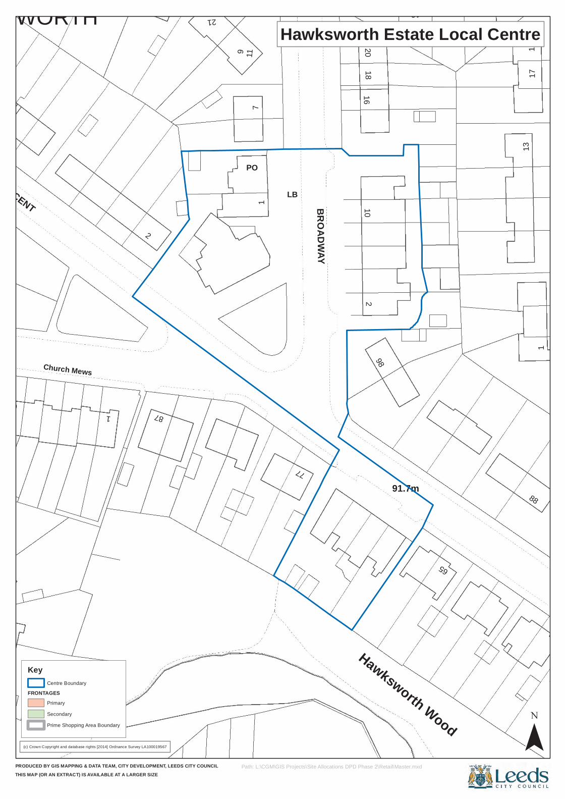
2
1
Hawksworth Wood
13
15
CRAGSIDE CRESCENT
1
23
87
LB
11BROADWAY
19
Church Mews
10
88
PO
65
18
7
162
98
91.7m
9
20
17
61
77
HAWKSWORTH 2119
(c) Crown Copyright and database rights [2014] Ordnance Survey LA100019567
PRODUCED BY GIS MAPPING & DATA TEAM, CITY DEVELOPMENT, LEEDS CITY COUNCILTHIS MAP (OR AN EXTRACT) IS AVAILABLE AT A LARGER SIZE
Hawksworth Estate Local Centre
¯Path: L:\CGM\GIS Projects\Site Allocations DPD Phase 2\Retail\Master.mxd
Key
FRONTAGESCentre Boundary
Primary
Secondary
Prime Shopping Area Boundary
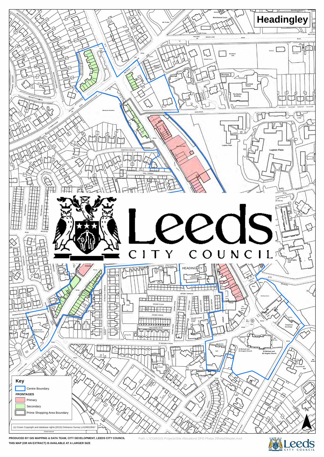
9
Stand
230
236
2
Hotel
1
13 to 15
54
23
13
1 to 7
Muir Court
SAGAR PLACE
77.1m
9
5 to 6
7 3
14 to 25
22
79.6m
2220
9
12
16
11
10a
12
83.8m
All Angels Church
CRES
CENT
32
113
25
45
4
2013
ST ANNE'S ROAD
52c
1121
4
21
BACK A SH VIEW
2
Lounge
17
9
Shelter
1
Holly Bank10
38
4
56
BM 78.67m
83a
85.3m
9
23
16
3
75
4
28
10
13
1 to 18
The Shires
10 to 25
14
Stone Villas
OTLEY ROAD
4
8
5
STONELEA COURT
2
18
14 to 17
39
TERRACE
Dellview
10a
85.3m
5
SM
ROAD
BM 70.12m
All Angels Church
ExchangeTelephone
2
El Sub Sta
Lodge
Governor
1
12
5
8
Baptist Church
4
12
53
20
ST M
ICHA
EL'S
58
35
Post
33
10
17
18
14
GRANBY CLOSE
KING'S PLACE
21
Youth Centre
Garage
TCBs
31
15
10107a
1
ASH GARDENS
STRE
ET
90.8m
16
28
14
2
4
1a
CRESCENT
DERWENTW
ATER
21
27
52
35
21
23
28
1
5
5a
52
21
27
32
5
11
46a46
2
7
8
Place
10a
26 to 32
2
BM 74.38m
26
69
9b
BRODRICK COURT
61
32
1
7
18a
35
WOOD LANE
29
SHIREOAK
4a
9STREET
6
BAINB
RIGGE
ROAD
7
8
83.5m
BM 89.00m
Baptist Church
14
14a
4 TCB
78.0m
3
57
El Sub Sta
23
27 25
21
8 to 20
35
ST MICHAEL'S ROAD
4
2
ST M
ICHAEL'S
1
9
BM 83.12m
7
16
35
30
1
32
29
TREL
AWN
TREL
AWN
11
Church Halls
26 25
TERRACE
54a
210
18
125
16
117
15b
78.0m
11
ASH TERRACE
LBTCBs
23 to 27
25
54
DENNISTEAD CRESCENT
SHAW LANE
13
1
11
CHAPEL TERRACE
8
ParishSt Michaels
Sunday
1
GRUNBERG STREET
2
Ward Bdy
14
GRANBY MOUNT
6
St Lukes Church
Beechwood Court
Grovewood
67
1
Woodland
10
BM83.15m
Building
6a
2
BM 86.03m
Moorfield
21
85.0m
St Michael and
74
19
57
88.58m
Moorfield House
53
Wood Lane Court
Hall
Gas
16a
KIRKSTALL LANE
68
TERR
ACE
6
28
52 40
12
1
GRAN
BY R
OAD
2
9
GRANBY
2 to
8
1
13
War
St Michael and
37
20
8
7
BECKETT'SPARK DRIVE
1
1
21
12
6
TREL
AWNA
VENU
E56
a
50
CR
TCB
Ward Bdy
BM
84.1m
83.62
m
6
2
ST M
ICHA
EL'S
TERR
ACE
GPLB
20
Bank
48
Chapel Square
83
1
24
76.8m
Alma
15
75a
1
733
13b
8
13
2
Arndale
GRAN
BY R
OAD
GP
BM
1
4
63GR
ANBY
VIE
W
4
TCB
16
2
BM 73.24m
1
Bank
82.6m
837
3 5
Skyrack
WOOD LANE
13
65
BM
2
Shalimar
Original Oak Inn
Ebenezer Particular
5
18
CRESCENT
2
Cricket Ground
NORT
H LAN
E
1
5951
75
3
36
77.4m
54a
13
8
GRAN
BY V
IEW
16
31
13
18
1
10
3
PARK
55
2
19
115
2
DERWENTWATER GROVE
1
2
34
TRELAWN
BM 89.54m
18
TREL
AWN
TERR
ACE
15
25
82.9m
3
10
40
2710
3
15a
24
6
30
117
Taps (PH)
9
15
6
DRIVE
16
3a
2
35
Shelter
36
El
34
Grove
2
GRANBY PLACE
11
1
BENNETT ROAD
24
13
4
to
1
16
67
GRUNBERG ROAD
GRANBY TERRACE
Bank
14
1
3
1 to 4
Primary School
Posts
1
5 to 8
83.2m
2
1
8
69.5m
Posts
Bank
7
SHIRE OAK
31
SPRING ROAD
ROAD
Posts
OTLEY
SHIRE OAK STREET
Shiredene
3
1 to 39
Tel Ex
Gas
6
33
3
HEADINGLEY
South Parade
SOUTH
70
11
2
Hotel
44
38
10
68
BM 77.28m
5
Hall
15
2
TERR
ACE
BECK
ETT'S
12
6
25
2
BECKETT'S PARK
PLAC
E
ROAD
BM 87.57m
15
2aSOUTH PARADE
3
222
62
35
25
2
2
22
Post
19
29a 29
23
21
32
Holly
1
1
1a
19
Headingley
26
4
8
3
77
40
1
6
5
POArndale House
Centre
Library
14
9
83.71m
9
Headingley
GRANBY AVENUE
1
16
8
Garage
Highgate House
CROSS GRANBY
2
4
1412
Posts
Lupton Flats
Garage
Villa
5
(PH)
BM
Psychocraft
3
Bank
10
(PH)
Lupton Flats
Palm Villa
10
3 PARADE
1a
55
7
El Sub Sta
45
8
1 to 643
17
25
El Sub S
ta
36
10
35
9
Hotel
1 to 12
12
4
6
29
CRES
CENT
3
17a
13
28
17
11
15
5
14
7
14
8
BAINB
RIGGE
ROAD
6
11
9
109
24
26
13
2
Post
12
20
17
54
12
1
19
52b
50a
87.5m
Car Park
2
16
21a
ASH VIEW
Cinema
115
ASH AVENUE1
2
84.1m
17a
7a
88
Allotment Gardens
4a
52
Club
CHAPEL PLACEGLEBELANDS
1
Sub Sta
80.2m
Hall
Prince's
11
3
2
5
12
Church
3
CR
ALMA ROAD
9 to 12
BM 85.76m
GRANBY STREET
Court
25
15
The
4
85.74m
TCBs
5 Hall
1 to 12
11
65
Surgery
HallsChurch
78.6m
78
Stand
76
61
5
49
4
43a
25
ST MICHAEL'S GROVE
50
BACK GRANBY GROVE
3 1
11
6
CLOSE
8
St Michael's Villas
31
5
10
Meml
GRIM
THOR
PE
107
2
314
31
14
1BECKETT'S PARK DRIVE
9
ASH ROAD
22
2
52
The P
arade
27a
13
7
14
10
Library
CROSS CHAPEL STREET
NORTH LA
NE
2
14
6
TCB
17
81
6
CHAPEL STREET
Cottages
Garage
12
2
Wellfield
GRANBY GROVE
School
4
73
17 to 28
23
Roof Car Park
16
25
HEADINGLEY
7
49
9
GROVE LANE
18
2
BENNETT ROAD
Moorfield
27
19
The Brahm
6
House
Bank
86.3m
63
5
The
Bowling Green
87.5m
Headingley
66.4m
12
BM 84.93m
Gov
35
BM 67.02m
31
(c) Crown Copyright and database rights [2015] Ordnance Survey LA100019567
PRODUCED BY GIS MAPPING & DATA TEAM, CITY DEVELOPMENT, LEEDS CITY COUNCILTHIS MAP (OR AN EXTRACT) IS AVAILABLE AT A LARGER SIZE
¯Path: L:\CGM\GIS Projects\Site Allocations DPD Phase 2\Retail\Master.mxd
Key
FRONTAGESCentre Boundary
Primary
Secondary
Prime Shopping Area Boundary
Headingley
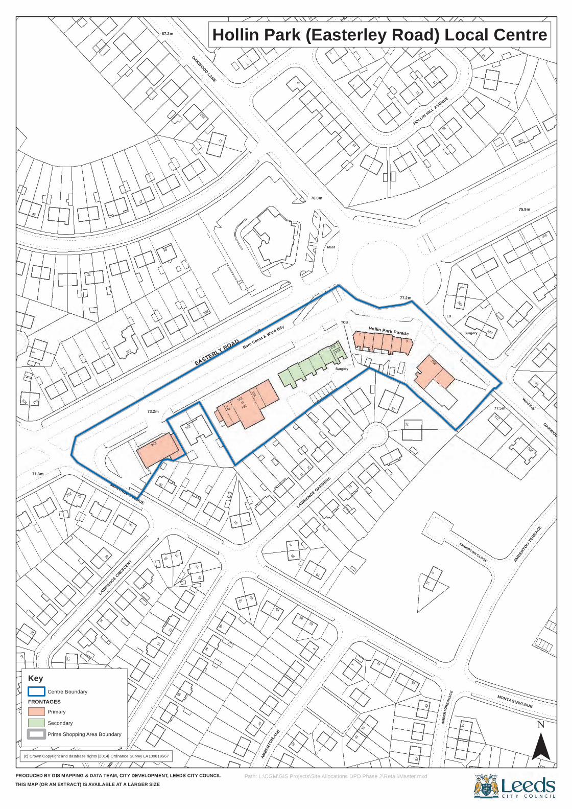
10
TERR
ACE
84
71
2
78.0m
254
11
40
321
75.9m
4
36
2
51
104
83
72
73
OAKWOOD LANE48
EASTERLY ROAD
1
11
11
Mast
12
6
AMBERTON CLOSE
280
Ward Bdy
15
26
27
18
39
75
57
MONTAGU AVENUE
209
63
Surgery
14
1
Hollin Park Parade
11
15
HOLLIN HILL AVENUE
LB
304
349
11
16
29
3723
2
to
HOLLIN HILL DRIVE
26
9
260
77.5m
2
15LA
WRENC
E AVE
NUE 25
15
11
61
55
MONTAGU
2387.2m
226
234
238
Boro Const & Ward Bdy
2
15
15
1
77.2m
21
Surgery
1
316
19
1
52
6
43
183
214
197
82
232
CR
2
14
28
AMBER
TON TE
RRACE
AMBE
RTON
LANE
AVENUE
LAWRENCE CRESCENT
224
71
70
236
69
65
68
63
64
LAWRENCE GARDENS
252
31
345
274
1
LAWRENCE CRESCENT
2
44
42
AMBE
RTON
71.3m
222
73.2m
28
52
1
TCB
351
OAKWOOD LANE
(c) Crown Copyright and database rights [2014] Ordnance Survey LA100019567
PRODUCED BY GIS MAPPING & DATA TEAM, CITY DEVELOPMENT, LEEDS CITY COUNCILTHIS MAP (OR AN EXTRACT) IS AVAILABLE AT A LARGER SIZE
Hollin Park (Easterley Road) Local Centre
¯Path: L:\CGM\GIS Projects\Site Allocations DPD Phase 2\Retail\Master.mxd
Key
FRONTAGESCentre Boundary
Primary
Secondary
Prime Shopping Area Boundary
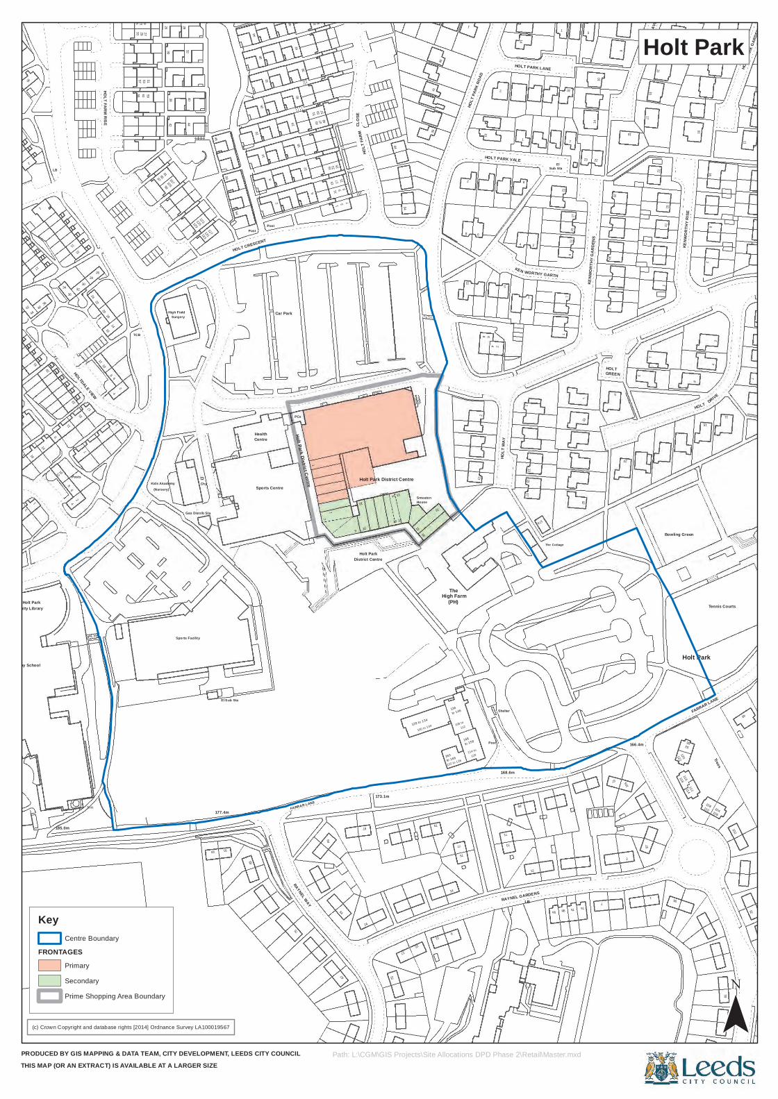
64
26
16
3323
61
97
32
123
127
3612
1
43 4757
125
215
7
14
to 146
75
to 158
Shelter
9a
The Cottage
9b
81
HOLT
FARM
45
6
10
HOLT
WAY
14
9
33
5
HOLT
20
8
171
2
177.4m
85
3
42
1
14
34
2
18
1
TCB
53
High Field
HOLT CRESCENT
Centre
32
PCs
23
87
173.1m
16
11
77
148
RAYNEL GARDENS
7a
105
55
110
64
HOLT PARK LANE
7
11
HOLT
11
Ralph Thoresby School
Tank
29
9
LB
4
17
16
6
25 1951
99
(Nursery)
42
Kids Akademy
Surgery
2840
46
54
Post
51 53
7
District Centre
to 166
122 to 126
High Farm
Post
LB
17a
166.4m
1
122 Trees
Tennis Courts
92
54
Smeaton
41
8
21
10
2
KENW
ORTH
Y RIS
E11
HOLT
PARK
GAR
DENS
185.0m
Sports Facility
Gas Distrib Sta
75
7
18
10
8
11
15
12HOLT FARM RISE
2
59
30105
129
3826
2
30
Holt Park District Centre
179
15
14
106 to
73
168.6m
53
102
CLOS
E
10
2
4 2
5
KEN
2
1
7
16
2
4
8
1
El Sub Sta
RAYNEL WAY
FARRAR LANE
44
31
6
144
5557
26107
44
14
Sports Centre
91
1915
11
9
114 to
120
71
97
118116
108104
49
15
2
4
1
17
711
25
23
5
22
10
23
21
15
6
91
67
36
38
32
Posts
22
2010
29
95
Chy
133
Health
8
48
49
10
24
44
128 to 134
100 to 104
79
136
7b
57
2
95
120
14 13
8
2
1
12
6
8
ElSub Sta
1
1517
11
1
15
8
DRIVE
7
Community Library
54
1
12
11
19
15
30
7
28
HOLTDALE VIEW
26
131
50
44
Post
24
18
3
15
160
69
114
106
Holt Park District Centre
1
1513
WORTHY GARTH
10
3
15
16
16
Holt Park
93
2
17
40
36 24
8
27
9138
125
20
Car Park
42
6
95 97
Holt Park
52
13
17
9
The(PH)
112
12
7
Bowling Green
112
Holt Park
FARRAR LANE
House
35
11
HOLT
PARK
ROAD
HOLT PARK VALE
1
KENW
ORTH
Y GAR
DENS
14
GREEN
HOLT
PARK
AVEN
UE
(c) Crown Copyright and database rights [2014] Ordnance Survey LA100019567
PRODUCED BY GIS MAPPING & DATA TEAM, CITY DEVELOPMENT, LEEDS CITY COUNCILTHIS MAP (OR AN EXTRACT) IS AVAILABLE AT A LARGER SIZE
Holt Park
¯Path: L:\CGM\GIS Projects\Site Allocations DPD Phase 2\Retail\Master.mxd
Key
FRONTAGESCentre Boundary
Primary
Secondary
Prime Shopping Area Boundary
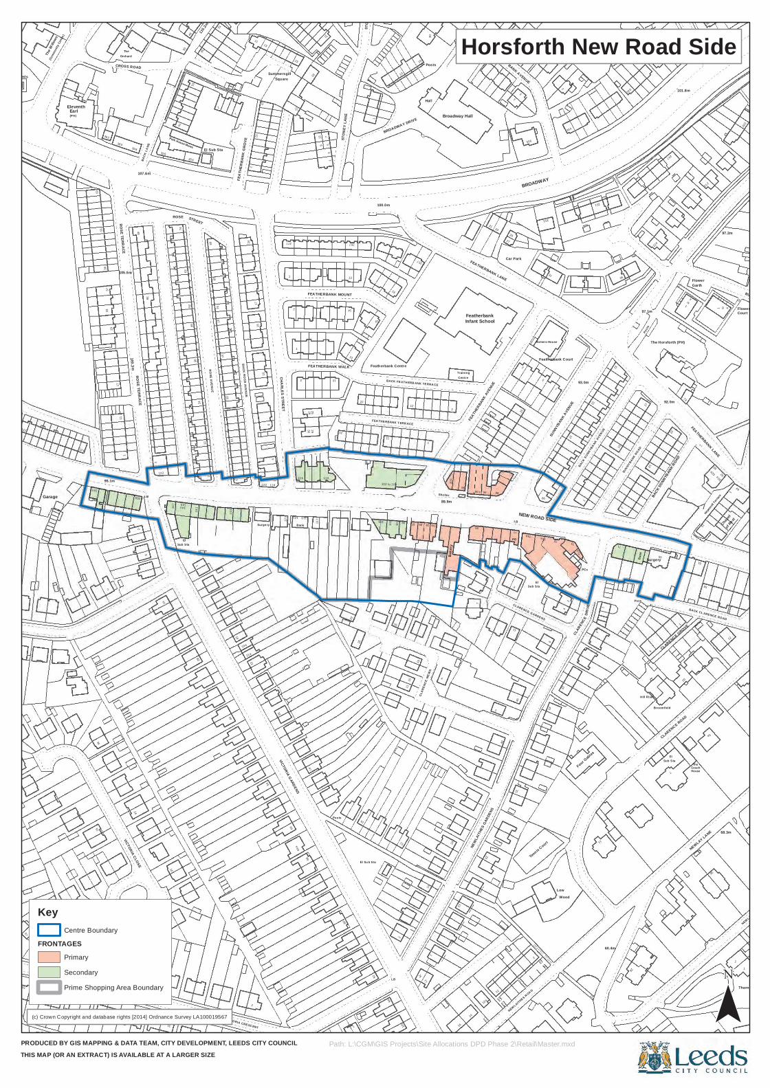
71.9m
165
1
31
ROSE
50
Sub Sta
51
7
546
1364
a
Bank
9
7
1
18
77
14
2
96
2
12
20
11
15
12
CLARENCE GARDENS
31
Romero House
Low
1
93.0m
251
28
922
4
7
El
22
Sub Sta
CLARENCE GROVE
The
NEWLAY LANE
BACK CL ARENCE ROAD
BURLEY LANE
57
51
20
2
8
614
7
74
El
3628
2
40
21
13
123 119
26
25
105
94
LB
BROADWAY DRIVE
95
75
1
Posts
1
Shelter
Training
PO
2
92.0m
BACK S
UNNYB
ANK R
OAD
House
304
1
2
64
51
Thornfield
NEWLAY WOOD ROAD
53
1
2
36
3933
ROSE TERRACE
105.5m
CROSS ROAD
LB
10
122
16
46
Park House Mews
STREET
59
El Sub Sta
21a
17
VICTORIA CRESC ENT
120
Square
116
29
1911
7
FEATHERBANK WALK
FEATHERBANK MOUNT
13
El Su b Sta
103
15
19
91
Bake
ry
7
77
LB
15
Featherbank Court
SUNN
YBAN
K AVE
NUE7
PCs
3
11
SUNNYBANK ROAD
12
97.1m
Hill Rise
Broomfield
CLARENCE ROAD
61
Garth
5a
FEATHERBANK LANE
62a
68.3m
1
200
Court
The W
illows
3729
24
35
354
1
19a
FEAT
HERB
ANK
GROV
E
2
12
10
Surgery
Summersgill
64
2
4729
51
10
Posts
22
23
2
257
1
100
Posts
90 to 94
23
FEATH
ERBA
NK AVE
NUE
FEATHERBANK LANE
BANK AVENUE
El
75a
255
12
CLAR
ENCE
Four Gables
1
27Po
sts
306
20
to4
11
60
1
12
War Memls
Garage
(Commun
ity Ce
ntre)
8
Earl
15
95.1m
360
100.3m
358
2448
ROSE TERRACE
22
52
4737
25
11
118
1
30
11
110
13
22
FEA THERBANK T ERR ACE
89.9m
13
21
3
46
12
675
71a
60.4m
2
65
59
212
Eleventh
63
362BA
CK LA
NE
14
75
62
1
133
22
CHARLES STREET
23
25
267
101
13
Featherbank Centre
97
19
30
CLAR
ENCE
MEW
S
Hall
14
85
12a
3
1
Car Park
3
BROADWAY
7
2
Wood
334
35
320
Hopewell
Terrace
Flower
32
(PH)
124
2
11
155
VICTORIA CLOSE
107.6m
2
16
356
145
61
141
12115
.2m
59
51
19
BACK ROSE AVENUE
24
2
15
1
33
121
VICTORIA GARDENS
66
3
21
1
61
STON
EYCR
OFT
92
100.0m
16
99
100
1112
BACK FEATH ERB ANK TERRA CE
4
24
16
Broadway Hall
NEWLA
ITHES
GAR
DENS
88
27
29
2
336
2
NEW ROAD SIDE
4
73
22
BACK SUNNYBANK AVEN
UE
15
1
The Horsforth (PH)
101.8m
Flower
62b
to 4
Chapel
97.2m
142
1
6
17
TheOrchard
38
143
46
1
24
69ROSE AVENUE
13
4
277
2
1
21
80ST
ONEY
LAN
E
14
11
102 to 108
73
93
89a
Centre
FeatherbankInfant School
23
40
1
31
75b
NEWLAITHES ROAD
Sub Sta
5
86
Tennis C
ourt
43
2
DRIV
E
Allotment Gardens
32
71
Post
Bank
Surgery
247
1
73
Coach
38
62
of Rest
(c) Crown Copyright and database rights [2014] Ordnance Survey LA100019567
PRODUCED BY GIS MAPPING & DATA TEAM, CITY DEVELOPMENT, LEEDS CITY COUNCILTHIS MAP (OR AN EXTRACT) IS AVAILABLE AT A LARGER SIZE
Horsforth New Road Side
¯Path: L:\CGM\GIS Projects\Site Allocations DPD Phase 2\Retail\Master.mxd
Key
FRONTAGESCentre Boundary
Primary
Secondary
Prime Shopping Area Boundary
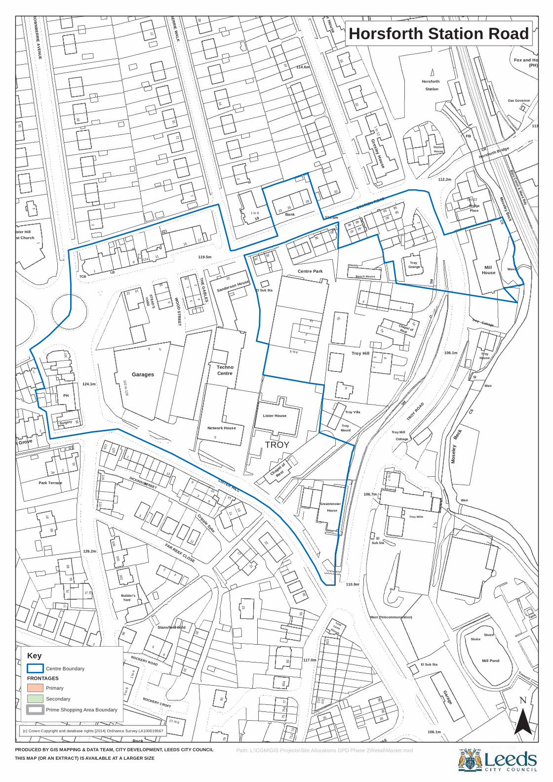
Builder's
4
16
Sanderson House
4 to 6
112
10
Troy
4
El
86
1
SM
Sluice
32
15
25
10
Gresley House
StationHorsforth
(PH)
10
STAN
HOPE
CLO
SE
93a
2
80
108
5 to
8
5
3
THE GABLES
79
22
7575
a
128
Greatminster
26
Troy
Troy Mills
Weir
2
1 to 6
114.6m
46
42
1 to 12
PlaceBridge
Moseley Beck
1
7593
61
TCB1
126.2m
10684
96
Rock
STEAD'S
4
2
5
119.5m
Cripple Syke
11
Lister House
TROY
71
Centre Park
House
Troy Hill
5 to 7
Mose
ley
15
BROWNBERRIE WALK
1
23
5856
CR
CS85
PH
Surgery
81
71
118
12
1 to
4
5
Network House
LISTER HILL
17
El Sub Sta
Chapel of
3
1
117.0m
Lane
7a
90
Mast (Telecommunication)
Chapel of
Grange
106.1m
106.1m
Weir
Sl
Troy
Tank
11
1
44
60
FB
2
3a 2
95
79
11
ROCKERY CROFT
Stansfield Fold
10
1
11
4
10
5
14
21
71a
1a
25
Troy Mill
Rest
Garage
CS
Sluice
House
Baptist Church
18
17
40
16
2
Station
1 to 22
Fox and Hounds
Ash Grove
Park Terrace
83
91
124.1m
LONG
ROW
LB
120
102122 to 126
9
14 2
3
FAR REEF CLOSE
28
83
30
Low
110.9m
75
106.7m
9
TROY ROAD
Beck
Cottage
House
Mill Pond
Weirs
Lister Hill
27
19
29
36
6
113.7m
87
107
110
3
11a
ROCKERY ROAD
13
6
9 to 12
STREETCentreTechno
1323
24
73
93
House
8
Troy Villa
Beech House
WOODVIEW CLOSE
1a
Mill
1
15
28
Bank
Stanier House114.6m
33
STATION ROAD
54
5
1
77
116
1
Yard
DICKINSON
YARD
Garages
STREET
9
2
WOOD
18
6
20
81
22
Rest
83a
77
2
110
Mount
Sub Sta
SM
Cottage
El Sub Sta
Troy
3
BROWNBERRIE AVENUE
14
2
19 48
House
112.2m
CR
Horsforth Bridge
Boro Const & Ward Bdy
Gas Governor
(c) Crown Copyright and database rights [2014] Ordnance Survey LA100019567
PRODUCED BY GIS MAPPING & DATA TEAM, CITY DEVELOPMENT, LEEDS CITY COUNCILTHIS MAP (OR AN EXTRACT) IS AVAILABLE AT A LARGER SIZE
Horsforth Station Road
¯Path: L:\CGM\GIS Projects\Site Allocations DPD Phase 2\Retail\Master.mxd
Key
FRONTAGESCentre Boundary
Primary
Secondary
Prime Shopping Area Boundary
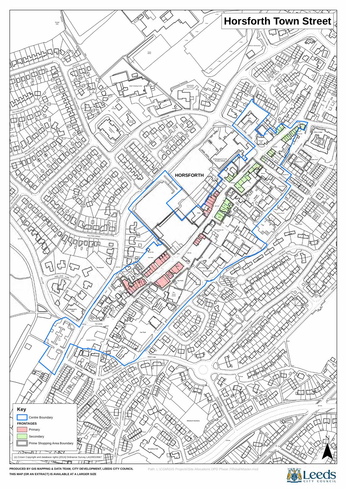
El Sub Sta
21
50
7
29
12
Health
13
1
97
Old
3
El
Church Court
CourtKelly
House
1
6a8
20
PCs
25b
128.3m
37
Method
ist
2
20
Bank
48
42
1
3
4
12
272
3
103.3m
127
GROVE ROAD
40
54
117.3m
4
32
19
101
Sta
Path
30
29
TCBs
64a
L Twr
85e
Bank
84
97
FEAST FIELD
16
El
12
20 to 25
Works
3
Library
102
14 to 19
49
26
119
5
27
3
River View
6
1c
8Ha
ll
Provid
ence
1 to 4
16
148
49
3to
162
6
(PH)
Park
St Margaret's
39
37
35
13
Garden of Rest
39
THE GREEN
11
Graveyard
5
8
STONEYTHORPE
2
6
Town Street Court
BROADWAY DRIVE
10
TOWN STREET
Posts
PLACE
Grove
26
1
Mount
10
93
30
FEAST FIELD
Sub Sta
304
DRURY LANE
Post
123
246
31
5
7
El Sub Sta
38
13
10
Hills
HALL PARK AVENUE
ElSub
5
CHURCH GROVE
2
St Margaret's
1
Vicarage
15
Adult Training Centre
Courts
1
Club
10
(PH)
74
LB
826
8
12
94b
Clinic
96
Town Square
1
OldHorsforth
6
6
41
14
140.8m
1b
11016
127
32
116
129
23
8
122
1
20
59
Ho
132 130
Croft
142.3m
13
30
24
CROSS ROAD
1
7
PARK
46
Park House Mews
FINK H
ILL
59
El Sub Sta
64
119.5m
33
10
17
Square
2
29
19
Shelter
The
12
(PH)
9
19
1219a
19
25
13
27
16
35
19
16
The G
rove
Centre
BACK TOWN STREET
Car Park
20
13
8
11
BANK GARDENS19
1
86
6
3
200
DRURY CLOSE
2
STANHOPE DRIVE
13
Post
1
91
68
17
HALL
1
78
9
30
4
105
100
110
17
133
Vicarage
CHURCH ROAD
16
4951
HORSFORTHSouthlands
92
94a
TOWN STREET
1
34
KERRY STREET
125
1a
44
6
46
143
244
109
Ps
The
144 142
2
Posts
166
to10
43
19
The W
illows
26a
354
43
3
416
47
FEAT
HERB
ANK
GROV
E
31
12
27
BACK
LANE
Summersgill
Community
8 79
Posts
51
1
5
3
17b
13
12b
Posts
32
18
BANK AVENUE
3
Research Facility
Royal
306
Posts
294
71
23
4
2
HALL PARK GARTH
PARK CLOSE
15
Hunger
10
7
29
141
10
3
18
20
15
CHURCH MOUNT
El Sub Sta
to
1142
L Twr
58
60
64
L Twr
134.7m
St Margaret's C of E
Sub Sta
95
Bank
8
3 to 5
714
to 22
Courtya
rd
2
100
4
106
12 to
5
LEA VIEW
121
123
Horsf
orth C
entra
l
114
3
36
10
1
13
242
3525
233
155a
114
9
155bSilver Jubilee
ViewSylvan
Broadga
te Hous
e
PROSPEC
T'S TE
RRACE
157t
o163
1
CROF
T COU
RT
HouseLee
El Sub Stas
War Memls
(Commun
ity Ce
ntre)
8
Earl
360
HALL LANE
358
26
22
6
Car
2
4
38a
38
45
11
19
CHURCH ROAD
119.8m
911
3Stoney Lane
1
1
1
The
10
10a
Chapel of R
est
18
DRURY LANE
20
Church
The
12
21
4
NEW CRESCENT
KERRY
38
7
El
26
24
1
13
2
Post
El Sub Sta
Bungalow
33
33
22
HALL PARK MOUNT
46
15
7
Path (um)
9
21
2
7a
HALL PARK RISE
10a
Church
1
Car Park
14 to 22
CHURCH LANE
3
132.0m
54a
56
66
1
6870
El
89
7
Quarry Terrace
22
The
Brethren's Meeting Room
98
1
ST MARGARET'S AVENUE
Kerry Court
Kerry House
40
THE GROVE
Method
ist Ch
urch
38
1
WALKER ROAD
54
3
128
126
4
Orch
ard
1
146
Olive Lodge
150CHURCH AVENUE
Eleventh
362
BACK
LANE
75
1
Hall
24
22
21
2
23
Museum
6
122.2m
1 to 6
7
Sub Sta
7
Vergers Cottage
17
13
PO
30
Hall
2
PROS
PECT
8
13
38
2
14
334
Jason House
320
96
2
2
25
76
292
190
129
66
22
56
13
2
80
90
SOUTH LEE
119
135
8
121
5
The
10
The Old
2 CHURCH MOUNT
53
55
57 to
59
L Twr
60
8
8585
a
85d
78
Primary School
TOWN CLOSE
7
Quarry
Sub
54
3
18
1
117
113
KERRY GARTH
9
28
40
13
2
El Sub Sta
31
1
119
53
7
2
TCB
140
52
LANE EAST
KERRY HILL
18
TOW
N STR
EET
20
152
164
(PH)
9
356
GATE
7a
61
2
115.2m
40
51
15
1
3
Arms
1
Black Bull
STON
EYCR
OFT
8a
14
14a
Manse
2
Broadway Hall
43
336
Bank
2
HILL
101.8m
101.0m
LB 1
TCB
3
50
109
1
111
20
5
14
12a
HALL PARK AVENUE
1
1
10
8
Tennis
El Sub Sta
9
Day CentreCalverlands
9
L Twr
85b
85c
7
L Twr
Brown Cow Inn
7680
L Twr
99
88
21
L Twr
Sta
6
1 to 6
20
7 to 12
CHURCH GATE
8
5
32
5a
14
Kerry Hill
111
CHURCH GATE
108
to
42
34
36
29
BEDFO
RD COURT
107.0m
5
124 to 128
KERRY VIEW
Phillips Close
House
50
6
7
Smithy
1
6
FINK HI
LL
20
TheOrchard
38
48
58
CLOSE
STONEY RISE
49
23
25
Office
4
TCB
6
2
21
(PH)
King's
THE SQUARE
STON
EY L
ANE
123.7m
Upper
Bank
17a
7
20
12a
Car Park
22 to 28
10NEW STREET
1
106
Allotment Gardens
1
NEW CROFT
247
1511
83
KING EDWARD AVENUE
DRURY AVENUE
9
282
180
61
262
2
248
The
9
42
21
28
11
11
5a
12
22
2
CHURCH CRESCENT
11
23
39
43
79
1
72
87
Bank
2
136.9m
78b
Cottages
1
CHURCH AVENUE
2
Library
2
8
1to6
116
Bracken Ho
42
50
142.6m
5
18
Phillips Close
2
134
35
DRURY AVENUE
Kingd
om
2
House
LEE
139.6m
1
4
136134
138
36
GOLD
EN B
ANK
(c) Crown Copyright and database rights [2014] Ordnance Survey LA100019567
PRODUCED BY GIS MAPPING & DATA TEAM, CITY DEVELOPMENT, LEEDS CITY COUNCILTHIS MAP (OR AN EXTRACT) IS AVAILABLE AT A LARGER SIZE
Horsforth Town Street
¯Path: L:\CGM\GIS Projects\Site Allocations DPD Phase 2\Retail\Master.mxd
Key
FRONTAGESCentre Boundary
Primary
Secondary
Prime Shopping Area Boundary
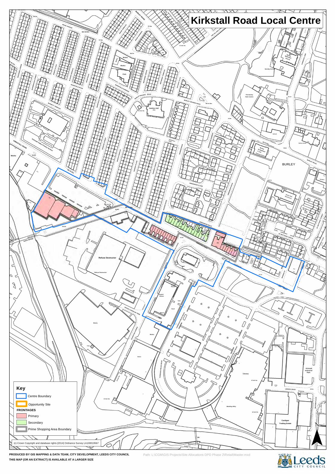
2
BM 48.15m
Works
37
49
KIRKSTALL ROAD
415
10
Water
Sluice
31
14
18
46
Works
57.9m
40
94
BANKFIELD GARDENS
BM 62.30m
BACK
WET
HERB
Y GRO
VE
EVAN
STON
AVE
NUE
14
2
GRANGE
342
8
Haddon Hall
2710
41
4332
7
388
53HA
DDON
ROA
D
32.0m
25
39
376
1111
ST ANN'S AVENUE
30
BURLEY GRANGE ROAD
25
2729
1
3
319
CARD
IGAN
FIEL
DS RO
AD
311
346
El Sub Sta
7ST MATTHIAS' GROVE
3
14 to 19
El Sub Sta
Burley House
57
St Ma
tthias
' Cou
rt
25
42
Gott's Bridge
2
68
67
2
1
1
1115
30
1
45
44
Refuse Destructor
71
32.6m
MART
IN TE
RRAC
E18
BM 33.02m
17
7
91
349
15
House
TCB
2
EVAN
STON
42
1
Depot
5
14
LB
WETH
ERBY
PLAC
E
PO
BACK BURLEY HILL
6
67
Hall
36
366
7
364
1
Bowling Alley
23
2
29
4145
24
338
22
7
Burley
56.1m
Methodist
LENNOX ROAD
ABBO
TS M
EWS
55
1
1
MILF
ORD
PLAC
ESt
Matth
ias Te
rrace
1 to 12
38
18
17
32
Drain
32
52
BM 32.95m
54
Tank
48
30
16
12
1
El Su
b Sta
14
13
Club
363
1
28
15
27
40
57.6m
CARD
IGAN
FIEL
DS R
OAD
Depot
WETH
ERBY
TERR
ACE
337
4LB
12
384
2
63
15
3
GREENHOW WALK
11
284
1
27
26
Burley
BM 48.82m
15
29 to
37
BANK
ER ST
REET
5
332
58
STRE
ETCA
RDIG
AN LA
NE
30.8m
5
24
WOO
DSID
E AV
ENUE
BM 58.52m
38
415
BARN
BROU
GH S
TREE
T
58.2m
55
9
Kirkstall Valley Primary School
31
17
CR
2
River
Aire
2
53
15
2
402
2941
42
BM 58.68m
60
1SO
WOO
D ST
REET
17
El Sub Sta
84
46
ARGIE TERRACE
9
10
56.7m
42
10
1
2
HADD
ON A
VENU
E
4
36
ROADBANKFIELD
Export
12
22
1
37
GREENHOW CLOSE
KIRKSTALL ROAD
21
2
323
42
THE VILLAGE STREET
11
44.8m
350
262
309
Bank
36.9m
37
31.1m
21
19
1
Sloping masonry
48.2m
Cardigan
332
6
2ST
MAT
THIA
S'
36.6m
Kirkstall
Surgery
273
Tennis Courts
40
35
419
23
36
REDCOTE LANE
4612
18
45
34.1m
17
15
32.6m
41
19
13
ARGIE
GARDENS
BURLEY ROAD
351
341
39
28
331
316
El Sub Sta
325
20
10
34
4
15
1
GREE
NHOW
ROAD
Cinema
The Burley
342
39
St Matthias'
15
42.7m
3363
9
64
Park
14
14 to 29
6640
35
32.6m
Ward
Bdy
ARGIE AVENUE
41
15
5729
398
76
20
32
31
17
27
WB
12
28
343
1
(PH)
13
333
HADD
ON R
OAD
32616
HADD
ON AV
ENUE
House
6
2
16
10
14
35
32
19
38
GREE
NHOW
GAR
DENS
PH
270
33
El Sub Sta
C of E
School
6
BURLEY
42
BM 58
.66m
1 to 12
258
8
8
58.5m
12
1
256a
59
13
52
39
41
1
385
BURDETT TERRACE 1
30
BANKFIELD ROAD
42
44
5343
BANK
FIEL
D TE
RRAC
E
Works
Works
Works
2
2
Works
23
El Sub Sta
8
ROAD
14
339
334
PO
AVE
394
8
EVAN
STON
AVE
NUE
48.5m
Tank
329
8
18
24
FB
1
23
TCB
BM 44.30m
17
9
ST ANN'S MOUNT
2
BACK GREEN HOW WALK
STRE
ET
31
35
43
CARD
IGAN
LANE
Primary School
18
Sunday School
BANK
ER ST
1
20 to
28
Church
Trading Estate
Day Nursery
62
2
ST M
ATTH
IAS' S
T
PC
5
BURLEY ROAD
3
256b
11BM
59.15
m
1
BM 35.19m
14
421
6337
56
ADW
ICK
PLAC
E
11
ELSH
AM TE
RRAC
E
16
29
400
ARGI
E ROA
D
16
2
74
43
El Sub Sta
Refuse Destructor
2
45
26
1
1
1
HADD
ON P
LACE
BURLEY
CROSS CARDIGAN TERR
11
11a
3
WET
HERB
Y GR
OVE
2
Works
16
Export
CROSS EVANSTON AVENUE
37
15
10
4
4
CARD
IGAN
FIEL
DS RO
AD
31.4m
327
11a
28
12
32
2
323a
15
348
2a
6
ALLE
RTON
Park Centre
20
275
11
Burley Park
6
Industrial
275
ST M
ATTH
IAS' S
TREE
T
14
(c) Crown Copyright and database rights [2014] Ordnance Survey LA100019567
PRODUCED BY GIS MAPPING & DATA TEAM, CITY DEVELOPMENT, LEEDS CITY COUNCILTHIS MAP (OR AN EXTRACT) IS AVAILABLE AT A LARGER SIZE
Kirkstall Road Local Centre
¯Path: L:\CGM\GIS Projects\Site Allocations DPD Phase 2\Retail\Master.mxd
Key
FRONTAGES
Prime Shopping Area Boundary
Opportunity Site
Centre Boundary
Primary
Secondary
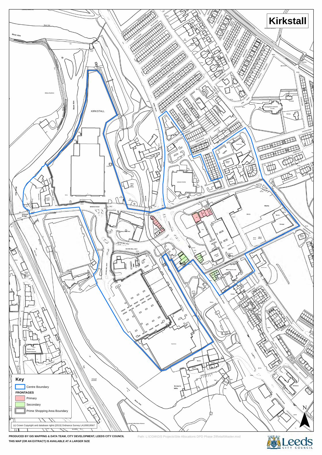
Abbey Gardens
BM 36.68m
A4
(PH)
ROAD
The Ancestor
3
WYTHER GREEN
maso
nry
Weir
D5
FB
SAVI
NS M
ILL W
AY
Drain68
BACK DE LACY MT
2
44.8m
2
12
36
ABBEY ROAD
Peel
NORMAN MOUNT
10a
33
PH
11a
16
34
10
TORDOFF TERRACE9
6
40
Works
TORDOFF PLACE
7
35
25
Library13
BH
8
45
1314
Kirkstall St Stephen's
28
20
2
MORR
IS VIE
W
Abbey
1
MOUNT
Sidnal
45
1
10
71
House
BM 66
.17m
65
TCB
59
LB
71
Allotment Gardens
12
62
63.7m
23
24
36
2
239
253
223
59
1
36.0m
A1
Estate
El
A3
Sub
Industrial
Kirkstall
Track
35.4m
D2
Rive
r Aire
Tank
36.0m
Gas
1
2
BM 36.60m
2
3
26
23
VESPER GROVE
NORMAN STREET
Leisure Centre
Depot
34
3
Medical
Mill Race
21
TCB
Works
4
Liberal
13
Victoria House
El Sub Sta
COMMERCIAL ROAD
HESK
ETH T
ERRA
CE
57
25
BEECROFT STREET
5
75
5
Tanks
7
3
24
1
MORRIS LANE
4
79
PARK
MOUN
T
3
69.5m
GILBERT CLOSE
GLEBE AVENUE
Garage
BM 62.14m
Vicarage
76
48
40
4
255
235
29
2
183
Works
36.6m
Lane
Sta
Apostolic
CR
22
Abbey Gardens
D1
35.7m
35.1m
El Sub Sta
Abbey Retail Park
Railway
1
D Fn
4
2a
4
El
2
2
23
7
9
2
15
15
PH
TCB
4732
PO
MILTON TERRACE
Works
18
7 to 12
Depot
MORRIS MOUNT
BACKHOUSE TERRACE
16a
Chantry
Works
12
27
4
7727
13
36
BM 50.00m
11
House
12
6
Sub Sta
12
Works
89
BEECROFT STREET
COMMERCIAL ROAD
24
Shelter
65.5m
GLEBE PLACE
30
House
15
1
227
Church View
River Aire
58.5m
10
6
183
The
Wyther Lane
(Cistercian, founded 1152)
ETL
BM 37.48m
Centre
ETL
WYTHER DRIVE
2
SAVINS MILL WAY
DE LACY MOUNT
2a
23
1
13
30
12
7
22
St Ann's
8
BM
44
34
8
Shelter
4
LB
20
Centre
SPRING BANK
56
MORRIS LANE
CHURCH STREET
BM 58.80m
Weir
House
Surgery
67
Works
PARK
SANDFORD ROAD
57
42.7m
25
River Aire
27
(C of E)
6
116
13
Works
57
68
1
63.1m
42
245
VICARAGE STREET
25
31
44
38
HESKETH ROAD
1
2
37.5m
River Aire
Bridge Inn
BRIDGE
River Aire
B2
G6
Design
PLACE
CR
KIRKSTALL
Mill Race
70
Memorial
Shelter
River Aire
BM 45.87mMill Race
Sta
9
Sub
12
3
13
22
El Sub Sta
NORMAN GROVE
COMMERCIAL ROAD
NORMAN VIEW
31
12
1
Tank
13
39.9m
VESPER PLACE
Abbey
Works
39
58.5m
ETL
5
11
Primary School
12
6
2
26
46
34
63.7m
8
Sidnal
57
El
1 to 33
SL
4
91
St Stephen's Church
13
BM 67.87m
23
24
28
STATION PARADE
243
40
HESK
ETH P
LACE
3
Pavilion
39.9m
River Aire
WYTHER LANE
(PH)
Wyther
Church
Marcon House
Works
Industrial Estate
36.9m
G4
C4
Leeds Rugby Acadamy
198
Governor
SAVINS MILL WAY
Abbey
Kirkstall Valley Nature Reserve
1
2
Abbey Mills
1
Square
1a
1
BM 40
.14m
28
26a
8
9
38
33
1
14
Court
5
TCBs
KIRKSTALL LANE
36
1
Church Hall57 59
6
Tank
C of E
14 to 19
HESKETH ROAD13
57.3m
Posts
Milford Sports Club
3
11
19
1
39
52.7m
GILBERT CHASE
37
1a
35
67
62.34m
1
37
63
Jacobs Court
Posts
2
23
73
14
Trac
k
120
Shelter
Kirkdene
VICARAGE VIEW
29
78
257
29
2
1
3
225
19
LB 27
HESK
ETH
TERR
ACE
Towing Path
Works
BM 41
.51m
Kirkstall
7
WYTHER DRIVE
12
BRIDGE FOLDRiver Aire
SANDFORD
Slopin
g
MP
Clough
E1
E2
Junction
Sluice
CR
Ward Bdy
Light
13
12
24
13
1
BACK NORMAN MOUNT
2b
6
13
4
1
12
BM 44.52m
15
Superstore
Mills
210
13
14
25
59.12m
18
28
26
41
16
34
31
St Stephen's
15
Victoria Terrace
13
211
5
Club
VICTORIA ROAD
10
16
43.0m
28
73
Health Clinic
12
15
13
Works
93
55
70
2
7763
2
1
31
17
5
15
61
11
41.5m
Minton
16
31
Subway
67.7m
38
61
DE LACY MOUNT
HESK
ETH A
VENU
E
SP
Ward BdyBridge
4
Wyther Bridge
2
B1
B4
1 to 6
C1
Post
Sloping masonry
Tank
Shelter
House
Kirkstall
BRIDGE ROAD
War
Shelter
2
5
42.7m
10
23
1
24
13
32
NORMAN ROW
VESPER TERRACE
7
33
23
10
VESPER MOUNT
Club
26
24
3
15
71
1 to 6
19
Bank
Weir
El Sub Sta
HUTCHINSON'S PLACE
60.4m
MORR
IS GR
OVE
2
53
70
3
BM
55.2m
1
110
61
51
GILBERT MOUNT
12
49
1
Rectory
SANDFORD ROAD
39
30
38
34
KIRKSTALL HILL
237
241
BACK DE LACY MOUNT
12
7
(c) Crown Copyright and database rights [2015] Ordnance Survey LA100019567
PRODUCED BY GIS MAPPING & DATA TEAM, CITY DEVELOPMENT, LEEDS CITY COUNCILTHIS MAP (OR AN EXTRACT) IS AVAILABLE AT A LARGER SIZE
Kirkstall
Path: L:\CGM\GIS Projects\Site Allocations DPD Phase 2\Retail\Master.mxd
Key
FRONTAGESCentre Boundary
Primary
Secondary
Prime Shopping Area Boundary
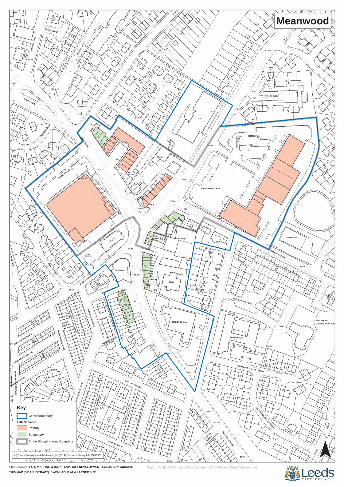
MONK BRIDGE AVENUE
2
9
62
MOUNT
1
MONK BRIDGE STREET
2
SQUARE
19
58.8m
72d
72a
30
6
599
BACK
BEN
TLEY
AVE
NUE
16
BENT
LEY
GROV
E
567
18
565
32
Tank
29
24
16a
11
STAINBECK AVENUE
32
El Sub Sta
Post
3
MEAN
WOOD V
ALLE
Y DRIV
E
44
50
Community Centre
4
2a
10
10
9
1
4
87.5m3
8
MONK BRIDGE TERRACE
2
11
17
MONK BRIDGE GROVE
10
5
4
11
MONK BRIDGE
9
31
2
30
11
12
76
32
68.0m 570
576
2
568
12
567a
Cottage
46
Tank
s
39a
14
BENT
LEY
LANE
14 to 16
23
1
14
MEANWOOD VALLEY MOUNT
Trees
Chur
ch La
ne
62.8m
MEMO
RIAL D
RIVE
TCB
52
16 to 48
36
10
20
2a
Garage
15a
38
2
STONEGATE FARM CLOSE
19
1
MONK BRIDGE PLACE
14
11
1
10
8
73
19
Gas
GORDON VIEW
Church
BENTLEY MOUNT
582
568b
568c
TCB
1256
38
561
19
1
25
BENTLEY GARDENS
42
1
64
3
Capitol Parade
60
ElSub Sta
161
13
26
4
STONEGATE
ROAD
1
5
11
65
58
9
16
7
17
2
20
GORDON DRIVEMONK BRIDGE ROAD
PO
2
571
569
565b
565a
FB
28
2
616
561a
22
CLIPSTON
MOUNT
7
1 to 37Bentley Court
18
7
8
34
28
46
11
11
CHUR
CH LA
NE
War Meml
GREEN ROAD
8
6
4a
22
21
17
76.2m
35
44
1 9
4
15
ELLWOOD CLOSE
MONK BRIDGE
2
19
7
8
14
1315
15
68
70
83
31
11Governor
GORDON TERRACE
74
11
11
Boro Const & Ward Bdy
597
595
Units 1 to 3
18
568a
8
68.3m
64.0m
30
548
37
Laundry
10
Shelter
9
MEANWOOD VALLEY GREEN
34a
17
14
Boro Const & Ward Bdy
72
68
1 to 4
12
THE W
ICKET
S
Bank
15
Shelter
3
21
6
1
1
25
8
60
75
10
1
68
BACK MONK BRIDGE STREET
16
15
3
BACK GORDON TERRACE
The Becketts
5
LB
573
292a
4
15
Bay
1
Club
22
27
1
MEANWOOD ROAD
20
3
18
Posts
30
Games Court
DRIVE
4
3
9
7
2
7
5
1514
4250
13
2
26
Club
Northside Retail Park
2
11
28
2
24
18
MILL POND LANE
1511
12
13
4
19
7
KING'S
77
72
MONK
BRIDG
E DRIV
E
15
72c
1
72b
1
El Su
b Sta
28
601
587
64.9m
BENTLEY PARADE
Health Centre
10
18
65.5m
15
63.7m
2
71.9m
1
36
Meanwood
70.1m
48
15
76
1 to
6
5
1
GREEN CRESC
ENT
8
62 1
11
LB
44
PO
3423
70.1m
CHURCH AVENUE
36
47
40
57
17
27
STONEGATE
52
15
67
STREAMSIDE
12
13
14
18
2
8
BACK
MON
K BR
IDGE
DRI
VE
1 to 26
GORDON PLACE
26
593
591
2
AUTHORPE ROAD
58
563a
559
543
16
Posts
28a
9
30a
2
32a
14
15
Mews
GREEN VIEW
3
GREEN CLOSE
5
1
10
5 to 8
8
PCs
4
32
7
15
42
126
1
(c) Crown Copyright and database rights [2014] Ordnance Survey LA100019567
PRODUCED BY GIS MAPPING & DATA TEAM, CITY DEVELOPMENT, LEEDS CITY COUNCILTHIS MAP (OR AN EXTRACT) IS AVAILABLE AT A LARGER SIZE
Meanwood
¯Path: L:\CGM\GIS Projects\Site Allocations DPD Phase 2\Retail\Master.mxd
Key
FRONTAGESCentre Boundary
Primary
Secondary
Prime Shopping Area Boundary
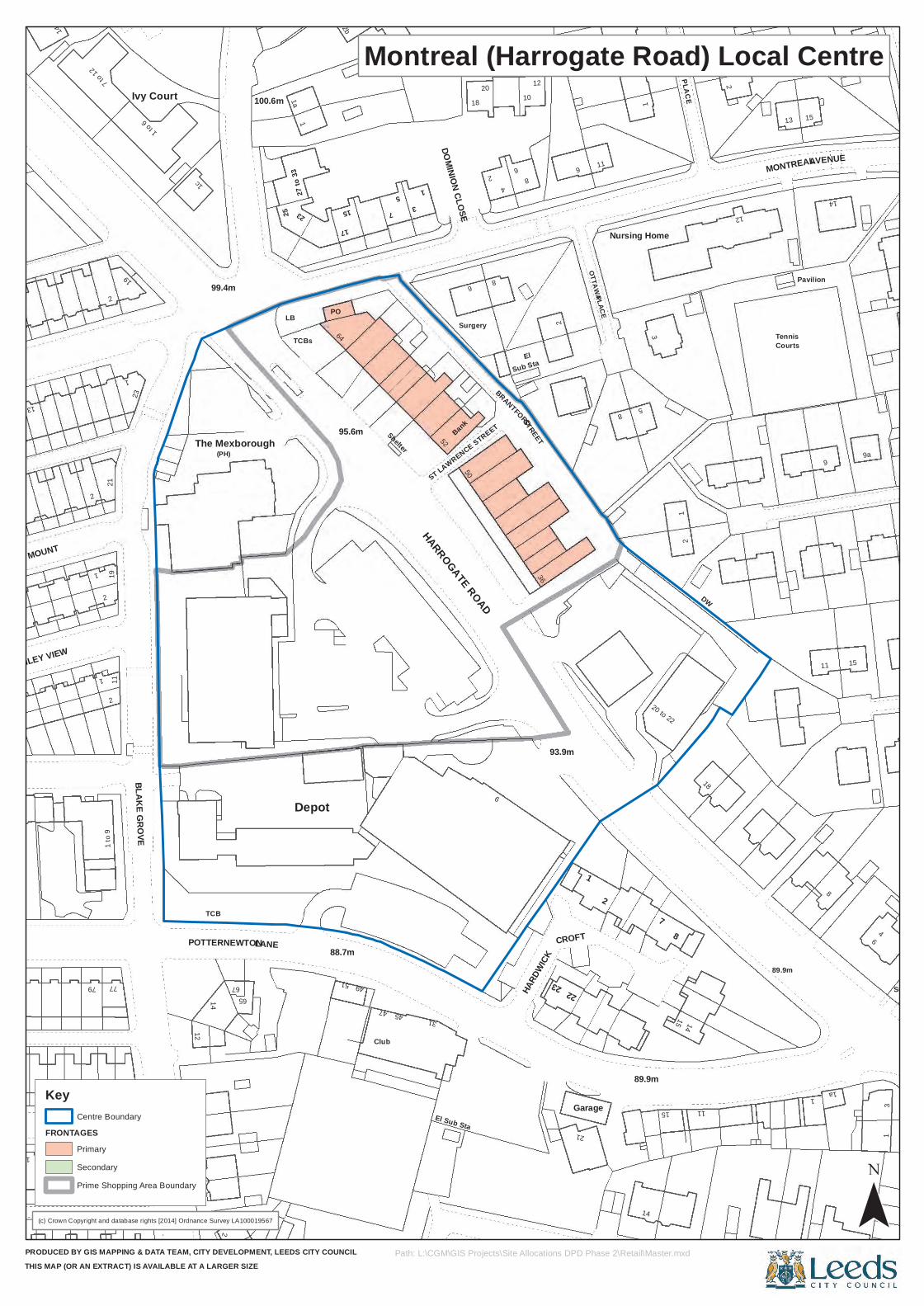
2119
BLAKE GROVE
12
(PH)
65
LANE
23
PO
64
7
18
6
2
CROFT7
18
89.9m
9
8
15
1
11
2
2
POTTERNEWTON
1a
TCBs
53
DOMINION CLOSE
Surgery23
OTTAWA
8
1
20 to 22
1
Pavilion
1a
6
Surgery
2
1
Ivy Court
1c
2531
Bank
4
36
9
5
15
14
13
1 to
911
19
TCB
The Mexborough
9
1
PLACE
89.9m
3
1
DW
2
14 to
17
2
77
23
99.4m
67LB
Depot
2b
Club
1
8
El
BRANTFORD
12
STREET
21
Garage
14
Nursing Home
2
CALGARY PLACE
Courts
27
4
METHLEY VIEW
79
1
2
1
14
1
15
49
47
Shelter
50ST LAWRENCE STREET
8
10
93.9m
22
2
15
11
MONTREAL
11
AVENUE
METHLEY MOUNT
1
1 to 6
100.6m
88.7m
95.6m
52
El Sub Sta
6
20
2
Sub Sta
11
8
13 15
3
7 to 1
2
2
27 to
33
17
51
45
HARROGATE ROAD
HARD
WICK
14
12
Tennis
9a
(c) Crown Copyright and database rights [2014] Ordnance Survey LA100019567
PRODUCED BY GIS MAPPING & DATA TEAM, CITY DEVELOPMENT, LEEDS CITY COUNCILTHIS MAP (OR AN EXTRACT) IS AVAILABLE AT A LARGER SIZE
Montreal (Harrogate Road) Local Centre
¯Path: L:\CGM\GIS Projects\Site Allocations DPD Phase 2\Retail\Master.mxd
Key
FRONTAGESCentre Boundary
Primary
Secondary
Prime Shopping Area Boundary
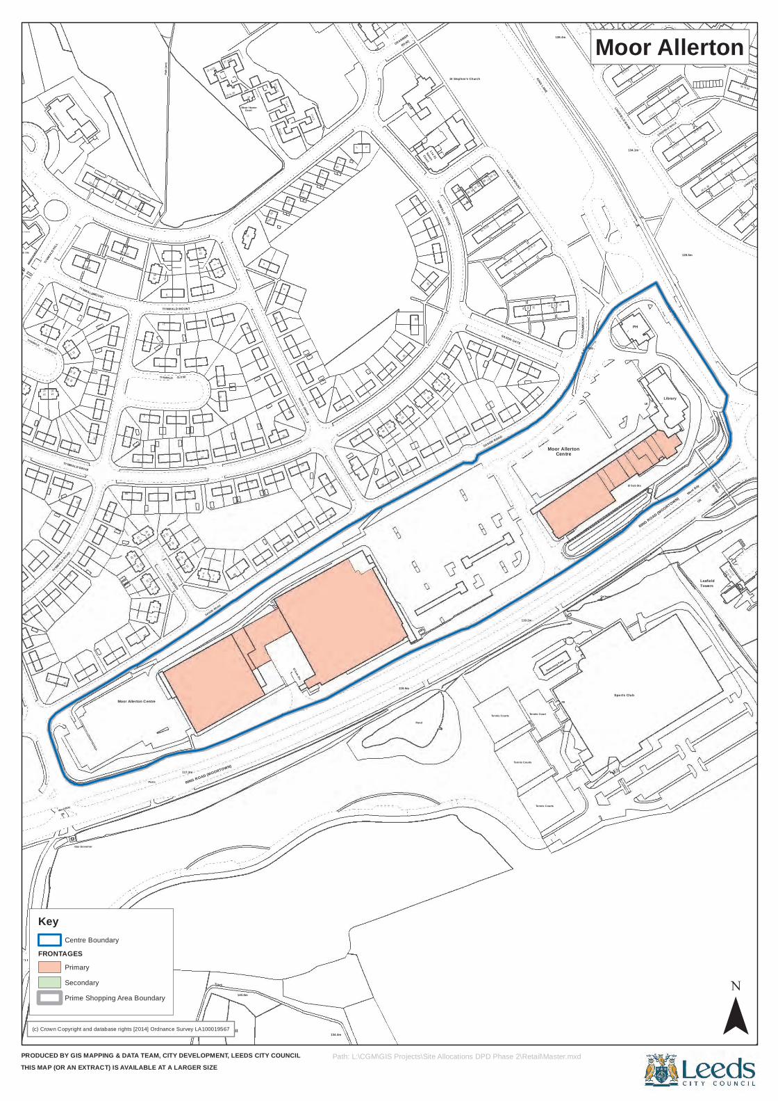
33
3
14
CRWard Bdy
19
72
2
28
1
Posts
2018
140.8m
15
24
El Sub Sta
28
35
31
7
Centre
SAXO
N
LB
14 to 61
43
25
15
2
ROAD
8187
15 to 25
LINGFIELD
10
12
16
19
5
3
42
11
SAXON ROAD
SAXON GROVE
31
1
MOUN
T
4
CR
Leafield
Bay Tree Resource Centre
Cranmer Court
21 to26
4
14
9
11
1 to 3
3a
109
27 to 37
LINGFIELD GREEN 39
14 to 24
LINGFIELD
8
TYNWALD
3
1815
Gas Governor
19
2729
21
16
10
117.3m
8
10
50
48
33
26
29
36
118.6m
Pond
14
Tennis Courts
PH
3
2
Library
47
54 to 44
Path
(um)
27 to29
19a
10 to 12
Court
DRIVE
97
75
51 to 61
26 to 36
62
71
17
20
3
15
TYNWALD MOUNT
16
48
Tunnel How Hill
29
28
41
33
37
30
17
11
SAXON ROAD
15
Ward Bdy
Drain
TYNW
ALD H
ILL
23
2
8
99
77
91 SAXON MOUNT
2
2 to 12
37
41
1
GARDENS
11
74
TYNWALD DRIVE
15
9
50
5
59
Track
1RING ROAD (MOORTOWN)
134.4m
3
SAXON GATE
1
to
Swimming Pool
FB
TCB
Foot
30 to 20
2
15 to 20
63 to 73
39 to 49
134.1m
14 to 24
1 to 11
35
10
209
21
11
25
9 117
22
TYNWALD CLOSE
51
24
Tennis Courts
to
Tennis Court
11
Moor Allerton
Sports Club
El Sub Sta
RING ROAD (MOORTOWN)
Towers
Bridge
MOUNT
45
CourtMoor Haven
5
19
CRANMER
to
95
83
1
2 to 12
LINGFIELD WALK
6
1
15
10
2
7
69
1
17
Moor Allerton Centre
1
SAXON GREEN
43
26
38
27
9
5
11
21
32 to 22
TYNWALD 8
6
4 to 6
7 to 9
3
1
14
28
Saxon1 to 31
TYNWALD
LINGFIELD BANK
3
14 to 24
26 to 36
12
TYNWALD ROAD
23
22
23
26
11
24
1412
62
6
38
30
15
119.2m
25
2
1
Tennis Courts
Collects
1
5
1 to 12
El Sub Sta
25
42 to 32
20 to 10
21
5
89
St Stephen's Church
79
85
93
KING LANE
138.4m
15 to 25
128.6m
33
2 to 12
(c) Crown Copyright and database rights [2014] Ordnance Survey LA100019567
PRODUCED BY GIS MAPPING & DATA TEAM, CITY DEVELOPMENT, LEEDS CITY COUNCILTHIS MAP (OR AN EXTRACT) IS AVAILABLE AT A LARGER SIZE
Moor Allerton
¯Path: L:\CGM\GIS Projects\Site Allocations DPD Phase 2\Retail\Master.mxd
Key
FRONTAGESCentre Boundary
Primary
Secondary
Prime Shopping Area Boundary
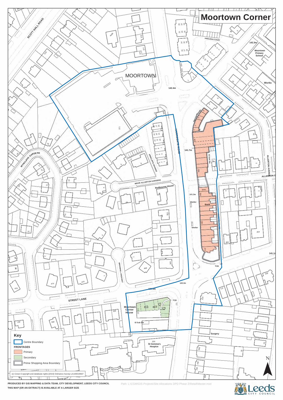
964
19
11
974
483
377
96
113
353
142.4m
HARROGATE ROAD
141.2mHa
rroga
te
352
382370
4
HADLEIGH COURT
ALLERTON PLACE
LB
24
1 3
3a
SHADWELL LANE
25
34
474
BROOMHILL CRESCENT
House
8
379
18
8
MOOR ALLERTON GARDENS21
Shelter
35411
Bank
9
142.3m
454
995
37
2
1
Moortown
El Sub Sta
5
TCB
22
416
1
358
3508
16
4
5
4
5
10
PrimaryMoortown
141.1m
NS
STREET LANE
984a
333
Corner
1
16
369
1
16
2
Shelter
4
Surgery
16
Works
14
ALLERTON GROVE
DE
11
14
371
1 to 12
329
137
418
1725
140.2m
1819
141.7m
3
459
4
115
SCOTT
HALL ROAD
24
375
1512
ARNCLIFFE GRANGE17
Hospice
2
345
458
406
97
612
5
471
5
1
14
ALLERTON AVENUE80
9
WYNCLIF
FE
17
495
986
7
St Gemma's
10
1423
15
414
24
Parad
e
394a
2
El Sub Sta3
TCB
2
3
460
82
476
44
497
GAR
470
44
6
468
139.0m
MOORTOWN
14
4
Redbourne House
20
1
3
396394
37210
9
School
(c) Crown Copyright and database rights [2014] Ordnance Survey LA100019567
PRODUCED BY GIS MAPPING & DATA TEAM, CITY DEVELOPMENT, LEEDS CITY COUNCILTHIS MAP (OR AN EXTRACT) IS AVAILABLE AT A LARGER SIZE
Moortown Corner
¯Path: L:\CGM\GIS Projects\Site Allocations DPD Phase 2\Retail\Master.mxd
Key
FRONTAGESCentre Boundary
Primary
Secondary
Prime Shopping Area Boundary
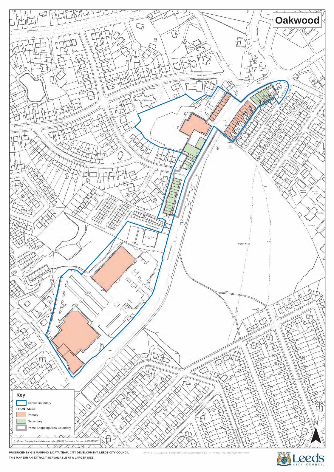
1
30
39
LB
6
24
11
1
15
47
49
2a
1128
17a
26
29
ST CATHERINE 'S WALK
29
14
LB
81
1
80
633
2
633a
635b
Hall
1
UPLAND CRESCENTGLE
DHOW RISE
655
21
TCB
89.6m
85.0m
20
BankPath (um
)
2
OAKWOOD AVE
NUE
498
OAKWOOD NOOK
13
14
117
87.5m
6
Snowdrop
2
2
29
WELL HOUSE CRES CENT
8
1
16
27
47
55
OAKWELL
61
20
WALK
27
1 to 30
The Roundhay
98
79
5
8
70.4m
91.4m
GLEDHOW LANE
450
472
476
Clock
41
126
BACK OAKWOOD AVENUE
13
28
2
3
1
1
26
1
ARLIN
GTON
ROAD
The Bungal ow
GLEDHOW LANE
33
1
1
5
5
8
28
1
FITZROY DRIVE
El Sub Sta 28c
2
1
1
39
11
23
46
(PH)
609
631
2
48
3
13
85.6m
470a
Path
(um
)
490
107
492
23
40
2
2
3
29
GIPTON WOOD ROAD
9
100. 3m
42
24
232
71.0m
343
23
43
to
GLEDHOW LANE
735
3
2
30
1
12
10
Frontl
ine Clos
e
20
19
362
51
19
25
28
10
18
11
56
75
65
BACK RAVENSCAR AVENUE
83
76
Mas t
59
Surgery
3
641
7
Bank
33
OAKWOOD BOUNDARY ROAD
Tower
486
21
Select Ho
GardensOakwood
23
4
1
12
The Gables
36a
34
24
11
2a
32
21
15
1112
1
42
OAKWELL OVAL
7 to
15
ST MARGARET'S DRIVE
ROUNDHAY ROAD
OAKWELL
11
45
18
7
47
20
1
RAVE
NSCAR
TERR
ACE
86
El
38
2
25a
27a
9
40
40
47
Issues
44
2
67
1
PCs
Path
(um)
Surgery
470
Car Park
101
GIPTON WOOD PLACE
496
25
Bank
1
3513
3
24
5
2
Library
125
OAKWOOD MOUNT
1 to 5
4
67
38
36
GLEDHOW WOOD ROAD
17
9
355
28b
COPGROVE ROAD
RAVE
NSCAR
MOUNT
12
1
MOUNT
1
OAKWEL
L DRIVE
5
42
97
51
4
633b
637
112
4
659
El Sub Sta
Path
462124
GIPTON WOOD AVENUE
COPGROVE ROAD
478
16
She lte r
31
96.0m
109
23
7
1
OAKWOOD PLACE
OAKWOOD DRIV
E
1
6
33
2
138
House
35
35
34b
29
Trees
11
44
49
103.3m
KING EDWIN 'S COURT
2
15
20
GLEDHOW WOOD COURT25
2
CRESCENT
11a
33
1
2
2
RAVENSCAR VIEW
72
49
172
62.8m
UPLAND GROVE
1912
1a
ROSSINGTON ROAD
RAVE
NSCAR
Nicholson Court
35
RAVENSCAR AVENUE
104
605
ROUN
DHAY
ROA
D
46
635a
FITZROY DRIVE
649
81.7m
657
1666
1
665
2
1
18
LB
488
130
92.7m
Garage
13
40
1
34a 35
31
1
8
11
2
35
21
34
19
WELL HOUSE GARDENS
6
57
28a
49
4
25
70
4
27
Sub Sta
71
10
Sinks
66
2
El Sub Sta
37
762
1
5
163
9RO
UNDH
AY RO
AD
GVC
Path
She lte r
32
Gipton Wood
El Sub Sta
PO
PRINCES AVENUE
She lte r
8
BACK
OAKWOOD DRIV
E
132
91.1m
Pos t
1
6
LB
1
92.0m
(c) Crown Copyright and database rights [2014] Ordnance Survey LA100019567
PRODUCED BY GIS MAPPING & DATA TEAM, CITY DEVELOPMENT, LEEDS CITY COUNCILTHIS MAP (OR AN EXTRACT) IS AVAILABLE AT A LARGER SIZE
Oakwood
¯Path: L:\CGM\GIS Projects\Site Allocations DPD Phase 2\Retail\Master.mxd
Key
FRONTAGESCentre Boundary
Primary
Secondary
Prime Shopping Area Boundary
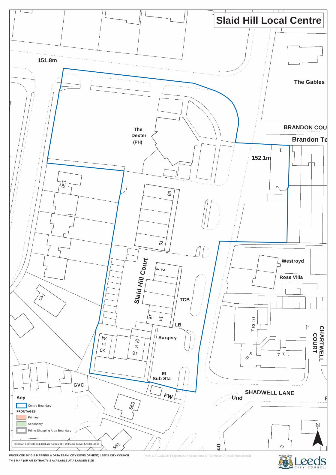
140
31
30The
Slaid
Hill C
ourt
91
El
TCB
1483
FW
LB
3Rose Villa
COURTto22
Und
1
Brandon Terrace
GVC
18
4
Und
6
7 to
10
SHADWELL LANE
The Gables
CHARTWELL
34
561
152.1m
FW
BRANDON COURT
151.8m
150
(PH)
Sub Sta
51 to 4
to56
3Dexter
16
2
Surgery
Westroyd
(c) Crown Copyright and database rights [2014] Ordnance Survey LA100019567
PRODUCED BY GIS MAPPING & DATA TEAM, CITY DEVELOPMENT, LEEDS CITY COUNCILTHIS MAP (OR AN EXTRACT) IS AVAILABLE AT A LARGER SIZE
Slaid Hill Local Centre
¯Path: L:\CGM\GIS Projects\Site Allocations DPD Phase 2\Retail\Master.mxd
Key
FRONTAGESCentre Boundary
Primary
Secondary
Prime Shopping Area Boundary
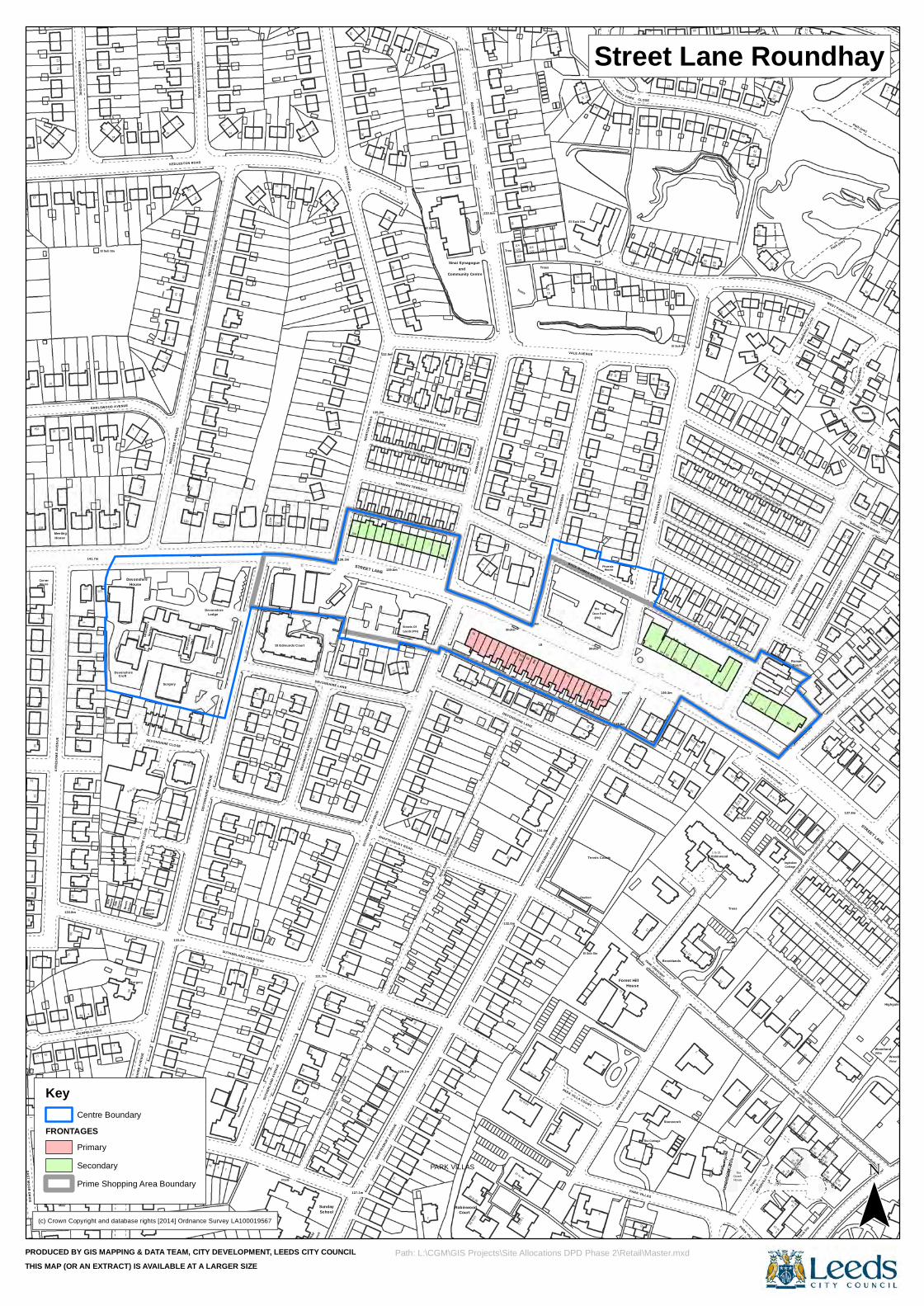
40
12
16a
20
AYRE
SOME
AVE
NUE
11
21
4
61
23
2
3
Willow
31
2740
17
5
BEAU
MONT
AVE
NUE
13
1
65
51aSTREET LANE
372
668
14
NORMAN PLACE
1b
Court
69
1 to 12
29
SHAF
TESB
URY A
VENU
E
1 to 12
4
(PH)
3
30
1
37
32
8
139.3m
33
38
31b
7
17
22
Holmwood
to
12a
1
Ingledew
Court
26
12
El Sub Sta
PARK CRESCENT
50
GARD
ENS
1a
2
STANLEY DRIVE
36
2
222
26
NORTON ROAD
4
El Sub Sta
40
48
45
33
1
56
Path (um)
24
1
10
138
1
15
House
19
1
56
Surgery
133.2m
7a
Devo
nshir
e
7
140.5m
DEVO
NSHI
RE A
VENU
E
14
2
79
131.7m
69
Sunday
53
Mast
SUTH
ERLA
ND A
VENU
E
132.9m
72
BACK NORMAN TERRACE
78
1
34
6
8
29
Shelter
11a
Deer Park
Tennis Courts
House
Forest Hill
27
64
27
6
62
24
26
31
58
10
House
14
BACK ROMAN PLACE
52
14
16
7
27
BACK PARK CRESCENT
2
15
Woodland
31
2614
29
Trees
2
92
34
72
45
71
34
15a
5
39
59
Croft
27
2a
33 to 40
Hall
512
3
SUTH
ERLA
ND A
VENU
E54
St Edmunds Court
77
School
67
13
89
82
21
77
88
33
Leeds (PH)
NORMAN TERRACE65
15
2
1a
81
1
51
ROMA
N AV
ENUE
47
20
37 to 48
13 to 24
139.6m
1 ROMA
N GA
RDEN
S
2
TCBs
PARK VILLAS
10
39
Brooklands
33
12
15
El Sub Sta
11
10
3
25
1 to 6
11
to 25
to 4239
14
4
24
13
1
43
3111
57
1711
51
41
Sinai Synagogue
Community Centre
68
54
110
PARK21
44
42
37
73
51
36
2
3
15
37
11
2
4
Oak
Hous
e
8
Surgery
Devo
nshir
e
38
El Sub Sta
12
11
SUTHERLAND CRESCENT
110
Posts
25
NORT
ON R
OAD
8
16
129.2m
16
BACK NORMAN PLACE
13
1
76
132.0m
63
DEVONSHIRE LANE
PO
25 to 36
7
137.8m
PARK V
ILLAS
4
11a
39
The Cottage
3160a
15
34
23
18
Trees
14
Coach
2
56
11
54
2
1
1
ROMAN DRIVE
1
32
2
1
to 37
ROMAN
CRES
CENT
137.8m
1
11
White House
5
11
INGLEDEW DRIVE
38
1
34
15
5
57
and
132.6m
Tree
40
12
14
Post Trees
59
24
70
SUMM
ERHIL
L PLA
CE
WEST PARK GROVE
16
1
6
Moor
133.8m
2
127
141.7m
128
1
1
1a7
DEVO
NSHI
RE A
VENU
E
LB
61
32
30
5
47
Devo
nshir
e
33
72
89
Unite
d Refo
rmed
Chu
rch1
71
94
100
27
28
23
135.0m
13
60
2
2
53
PARK VILLAS
11
35
BACK DEVONSHIRE LANE
51
6
1
2a
Pavilion
BACK ROMAN GROVE
Phoenix
2811
1
3
House
66
6
11
13
The
ROMAN GROVE
16
18
8
to 19
7
5
to 36
23
3
CROSS
INGLE
DEW CRESC
ENT
33
8
30
1
ROMAN MOUNT
2
VillaWoodland
El Sub Sta
41
20
30
20
112122
81
WEST
Trees
15
85
3
Path (um)
EAST MOOR DRIVE
1a
11
East
House
4a
60Ho
use
EARLSWOOD AVENUE
1
House
DEVO
NSHI
RE C
LOSE
House
75
65
10a
3a
Lodge
8
22
BACK
SHAF
TESB
URY A
VENU
E
139.3m
32
18
139.6m
13
64
Streets Of
58
10
Robinwood
2
LB
The
68
2
11
35
Stonecroft
41
60
2
16 to 21
Trees
1 to 9
BACK ROMAN STREET
5
9
2
27
38
9
21
SUMMER
HILL
17
STREET LANE
View
15
43
KEDLESTON ROAD
WES
TCOM
BE A
VENU
E
12
42
123
El Sub Sta
ROMAN AVENUE
114120
75
1
104
22
17
42
17
11
Corner
125
52
58
Gran
ge
5025
WES
TCOM
BE A
VENU
E
120
32
4947a
Cour
t
16
Devonshire
116
1
66
5
60
1
St An
drew
's Ro
undh
ay
15
34
55
SHAF
TESB
URY A
VENU
E
SHAFTESBURY ROAD
7
1
46
25
13 to 24
16
18
31
72
134.4m
23
14
VALE AVENUE
26
15
37RO
MAN
TERR
ACE
29
62a
21
1 to 31
5
6
to 13
PARKVIEW COURT20
26
ROMAN
VIEW
to 31
13
16
1
42
Pond
BACK INGLEDEW CRESCENT
12
29
151
45
46
133
12
28
6
55
37
134.7m
118
116
Trees
Trees
10
El Sub Sta
8
93
88
20
86
81
57
46
29
31
Path (um)
38
22
3
Meeting
41
1
HOLMFIELD DRIVE
Ash
Beec
hHo
use
Devonshire
9 to 22
Devonshire
9
2
DEVONSHIRE CLOSE
DEVONSHIRE CRESCENT
10
1
31
10
Roun
dhay
Court
5
110a
52
102
DEVONSHIRE LANE
127.1m
51
3
BACK
SHAF
TESB
URY A
VENU
E
25 to 36
24
65
28
67a
11
15
PARK VILLA COURT
El Sub Sta
Shelter
41
9
9
5
1117
25
PARK CRESCENT
33
1 to 10
21
27
31a
30
18
12
15
11a
1
PARK VILLAS
ROMAN PLACE
WOODV
ILLE C
OURT
to 24
14
21
Cottage
to 30
Roman
to 43
INGLEDEW CRESCENT
15
4
Highgate
11
KINGSWOOD GROVE
19
KINGSWOOD AVENUE
24
53
10
Issues
83
106
6
CLOSE
11
94
30
90
75
8482
35
2
53
55
3
(c) Crown Copyright and database rights [2014] Ordnance Survey LA100019567
PRODUCED BY GIS MAPPING & DATA TEAM, CITY DEVELOPMENT, LEEDS CITY COUNCILTHIS MAP (OR AN EXTRACT) IS AVAILABLE AT A LARGER SIZE
Street Lane Roundhay
¯Path: L:\CGM\GIS Projects\Site Allocations DPD Phase 2\Retail\Master.mxd
Key
FRONTAGESCentre Boundary
Primary
Secondary
Prime Shopping Area Boundary
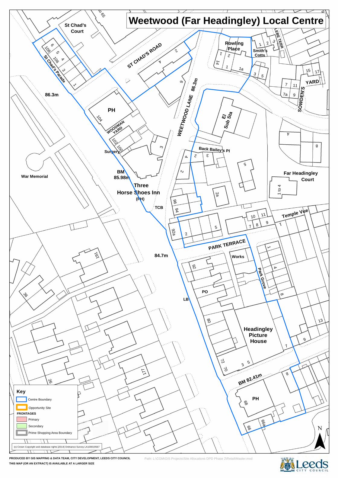
36
106
104
85.98m
94
LB
92
1
Rowling
8
5
Smith's
4
7
8
4
War Memorial
1086
3
BM
177
4
El
Picture
9 1
15
ST CHAD'S AVENUE
St Chad's Parade
ThreeHorse Shoes Inn
92a
2a72
70
PARK TERRACE
10
House
2
1 to
4
9
Temple Vue
8
136
385
Court
1 to 65
PH
100
WOODMAN
TCB
3
84.7m
2
2
3
Sub S
ta
Place 1
BM 82.41m
66a
8
St Chad's
9
2
WEET
WOOD
LANE
PO
5
1 1a
Park Grove
9
17
191
ST CHAD'S ROAD
4
14
Back Bailey's Pl
3
66
Cotts
3
BACK GLEBE TERR
11
SOWD
EN'S
4
Surgery
YARD
(PH)86
.3m
2
5
7
3
PH
11
1
Headingley
7a
YARD
26
86.3m
1
102
96
2
80
Works
68
5
7
CourtFar Headingley
(c) Crown Copyright and database rights [2014] Ordnance Survey LA100019567
PRODUCED BY GIS MAPPING & DATA TEAM, CITY DEVELOPMENT, LEEDS CITY COUNCILTHIS MAP (OR AN EXTRACT) IS AVAILABLE AT A LARGER SIZE
Weetwood (Far Headingley) Local Centre
¯Path: L:\CGM\GIS Projects\Site Allocations DPD Phase 2\Retail\Master.mxd
Key
FRONTAGES
Prime Shopping Area Boundary
Opportunity Site
Centre Boundary
Primary
Secondary
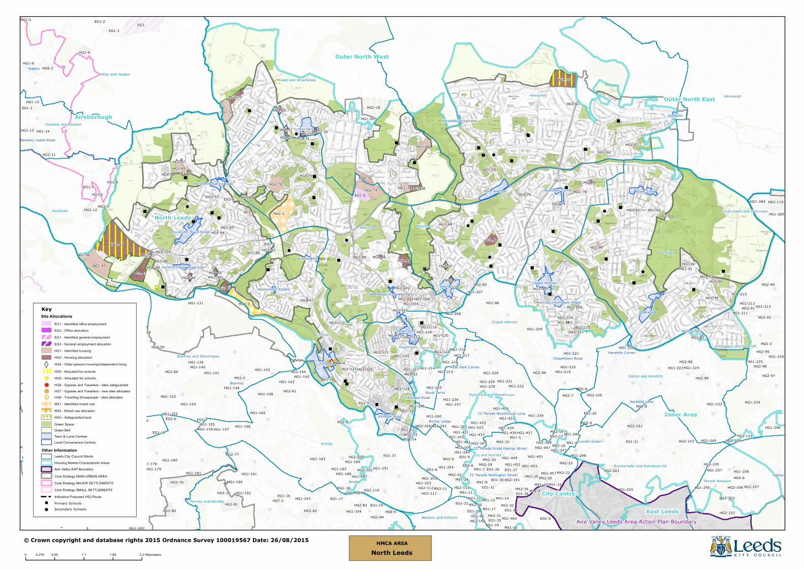
CC Parade Woodhouse Lane
CC Parade Wellington Street
CC Parade Great George Street
HG5-5
HG5-3
HG5-2
HG5-4
HG5-6
HG8-2
HG7-2
HG6-5
Kirkstall
ArmleyPudsey
Yeadon
Holt Park
Headingley
Farsley
Bramley
Oakwood
Meanwood
Harehills Lane
Moor Allerton
Chapel Allerton
Halton
Harehills Corner
Horsforth, Town Street
Street Lane
Cardigan Road
Kirkstall Road
Chapeltown Road
Moortown Corner
Stanningley Bottom
Horsforth Station Road
Royal Parks
Hollins Park
Butcher Hill
Slaid Hill
Horsforth New Road Side
Montreal (Harrogate Road)
Burley Lodge
Lincoln Green
Hyde Park Corner
Chapeltown (Pudsey)
Weetwood (Far Headingley)
Rawdon, Leeds Road
Alwoodley King Lane
Hawksworth Estate
EG3
HG2-41
MX1-2
MX1-3
HG3-15
HG2-18
HG2-36
HG1-284
HG1-97
HG2-119
HG2-81
HG2-76
HG1-12
HG2-101
HG1-73
EG1-21
HG1-96
HG2-43
HG1-234
MX1-8
HG1-70
HG1-58
HG2-82
HG1-256
HG1-296
MX2-7
EG1-3
HG1-60
HG3-4
HG2-91
MX2-11
EO1-6
MX2-9
EG2-8
HG2-122
HG2-12
HG2-201
HG1-72
HG2-9
HG3-16
HG2-92
HG1-226MX2-4
HG2-51
MX2-15
HG2-49
MX1-4
HG3-2
HG2-80
MX1-11
HG1-173
HG2-67
HG2-99
HG1-150
HG2-46
MX1-19
HG1-224
HG1-161
MX2-23
HG1-74
HG1-65
HG2-66
HG1-239
HG2-29
HG1-26
MX2-10
HG2-89
HG1-211
HG1-133
HG2-107HG1-172
HG1-207HG2-85
HG2-38
HG1-103
MX2-32
HG1-216
HG2-56
HG2-112
EG1-5
HG2-58
HG1-131
MX1-24
MX1-12
HG1-254
HG2-77
MX1-20
HG1-90
EO1-31
HG1-152
HG1-164
HG2-84 HG1-464
HG2-95
HG1-242
HG3-14
HG2-96
HG1-436
MX2-5
EO1-4
HG1-134
HG1-78
MX1-13
MX1-6
HG1-303
HG1-111
HG2-3
HG1-257MX2-19
HG1-69
HG2-87
HG2-105
HG1-66
HG1-168
HG1-194
HG1-88
HG1-258
HG3-3
HG1-94
HG1-435
HG1-184
HG1-181
MX1-14
HG1-59
MX1-5
HG1-225
HG1-251
HG1-162
HG1-89
HG1-154
MX1-17MX2-30
HG1-145
EG1-19
EO1-35
HG1-169
HG1-230
HG1-223
HG2-48
EO2-6
HG2-40
MX2-17
HG2-110
HG1-167
HG1-183
HG2-34
HG2-113
EO1-8
HG2-37
EG1-66
HG2-45
HG1-102
HG1-174
HG1-247
HG2-33
HG2-104
HG1-136
HG1-144
HG1-189
HG1-155
HG2-111
HG2-44
EG1-62
HG2-50
HG1-87
HG1-62
HG1-209
HG1-285
HG1-170
HG2-90
HG1-9
HG2-60
HG1-143
HG1-213
HG1-177
HG1-210
HG2-189
HG1-156
MX2-31
EG2-6
HG1-142
HG2-55
HG1-76
HG1-125
HG2-42
HG2-59
MX2-3
EG1-2
HG1-75
HG2-121
HG2-88
HG2-103
HG1-190
HG1-108
MX2-8
EG1-15
EG2-7
HG1-232
HG2-83
HG1-249
HG1-196
HG2-86
HG1-238
HG2-61
HG2-47
HG2-200
HG1-121
EO1-37
EG1-13
HG2-74
HG1-119
HG1-198
HG1-255
HG1-178
HG2-11
HG1-106
HG2-106
HG1-212
HG1-92
HG2-196
HG2-32
HG1-180
HG1-98
HG1-137
HG2-108
HG2-30
EG1-22
HG1-166
HG1-68
HG2-97
HG2-75
HG1-246
EO1-9
EO1-30
HG2-31
HG2-100
HG1-138
HG1-14
HG1-100
MX1-23MX2-34
HG1-135
HG1-197 EO2-9
MX1-10
HG1-91
HG1-157
HG2-52
HG1-192
HG1-217
HG1-176
HG1-233
EO1-36
HG1-71
HG1-208
HG1-112
HG1-151
HG1-228
EG1-17
EO1-2
EG1-14
EG1-12
HG1-61
EO1-27
HG1-140
HG1-222
MX2-26
MX2-20
HG1-171
HG1-195
HG1-63
HG1-175
HG1-123
MX1-7
HG1-104
HG1-129
EG1-16
HG1-64
EG1-11
EO1-33
HG1-148
HG1-93
HG1-149
HG1-79
HG1-252
HG1-83
HG1-107
HG1-158
HG1-220HG1-139
HG1-200
MX2-18
HG1-188
EG1-20
HG1-86
HG2-187
EO1-26
HG1-114HG1-118
HG1-81
HG1-113
EG1-18
HG1-95
HG1-253
HG1-99
HG1-231
HG1-179
HG1-441
HG1-127
HG1-244
HG1-235
HG1-84
HG1-146
HG1-243
HG1-67
EG1-24
HG1-141
HG1-101
HG1-218
HG1-433
HG1-153
EO1-5
HG1-77
EO1-7
HG1-431
MX2-16
HG1-423
HG1-124
HG1-105
HG2-109
HG1-82
HG1-193
HG1-132
HG1-120
HG1-447
HG1-186
HG1-259
HG1-421
HG1-214HG1-219
MX2-22
HG1-215
HG1-128
HG1-85
HG1-250
HG1-240
HG1-122
HG1-241
HG1-248
HG1-191
HG1-236
HG1-109
HG1-452
HG1-419HG1-160
HG1-110
HG1-185
HG1-229
HG1-13
HG1-449
HG1-453
MX2-25
MX1-9
HG1-237
HG1-221
HG1-422
HG1-187
HG1-437
HG1-117
HG1-451
HG1-457HG2-191
Alwoodley
Horsforth
Roundhay
Armley
Pudsey
Weetwood
Harewood
Kirkstall
Moortown
Adel and WharfedaleOtley and Yeadon
Calverley and Farsley
Chapel Allerton
Bramley and Stanningley
Gipton and Harehills
Farnley and Wortley
Headingley
Temple Newsam
Burmantofts and Richmond Hill
Killingbeck and Seacroft
Hyde Park and Woodhouse
Guiseley and Rawdon
Beeston and Holbeck
City and Hunslet
Cross Gates and WhinmoorNorth Leeds
Outer West Inner Area
Aireborough
Outer North East
Outer North West
City Centre
East LeedsAire Valley Leeds Area Action Plan Boundary
© Crown copyright and database rights 2015 Ordnance Survey 100019567 Date: 26/08/2015
0 0.55 1.1 1.65 2.20.275 Kilometers
HMCA AREANorth Leeds
Green Belt
KeySite Allocations
HG4 - Older persons housing/Independent living
EO1 - Identified office employmentEO2 - Office allocationEG1 - Identified general employmentEG2 - General employment allocationHG1 - Identified housingHG2 - Housing allocation
MX1 - Identified mixed useMX2 - Mixed use allocationHG3 - Safeguarded landGreen Space
Town & Local Centres
Leeds City Council WardsHousing Market Characteristic AreasAire Valley AAP BoundaryCore Strategy MAIN URBAN AREACore Strategy MAJOR SETTLEMENTSCore Strategy SMALL SETTLEMENTS
WHG5 - Allocated for schools
G G G GG G G GG G G G
Indicative Proposed HS2 Route
k kkkk kkkk kkkk kkkk kkk
Primary SchoolsSecondary Schools
HG6 - Gypsies and Travellers - sites safeguardedHG7 - Gypsies and Travellers - new sites allocatedHG8 - Travelling Showpeople - sites allocated
"
!
kkk
Other InformationLocal Convenience Centres
") HG5 - Allocated for schools
www.leeds.gov.uk/yourcity
Site Allocations Plan and Aire Valley Leeds Area Action Plan
Retail Background Paper
Publication DraftLeeds Local Development Framework
Development Plan DocumentSeptember 2015
For more information, please contact:LDF Publication Draft Consultation
Forward Planning & ImplementationThe Leonardo Building
2 Rossington StreetLeeds LS2 8HD
Email: [email protected]: www.leeds.gov.uk/yourcity
Site Allocations PlanSection 3: Area Proposals: 5. North
Publication DraftLeeds Local Development Framework
Development Plan DocumentSeptember 2015