Landslides and Their Control iM tiWt hd fJin Mountain ... Fault Muzaffarabad Location of epicenter...
49
April 8, 2010, Strbske Pleso, Slovakia 27 th Session of the EFC Working Party on the Management of Mountain Watersheds Seminar: “Integrated forest and water management of mountain watersheds: Experiences and perspectives” Landslides and Their Control i M ti Wt hd fJ in Mountain W atersheds of Japan – Processes and Countermeasures – Hideaki MARUI Niigata University Research Center for Natural Hazards and Disaster Recovery
Transcript of Landslides and Their Control iM tiWt hd fJin Mountain ... Fault Muzaffarabad Location of epicenter...

April 8, 2010, Strbske Pleso, Slovakia27th Session of the EFC Working Party on the Management of Mountain Watersheds
Seminar: “Integrated forest and water management of mountain watersheds:Experiences and perspectives”
Landslides and Their Control i M t i W t h d f Jin Mountain Watersheds of Japan
– Processes and Countermeasures –
Hideaki MARUINiigata University
Research Center for Natural Hazards and Disaster Recovery
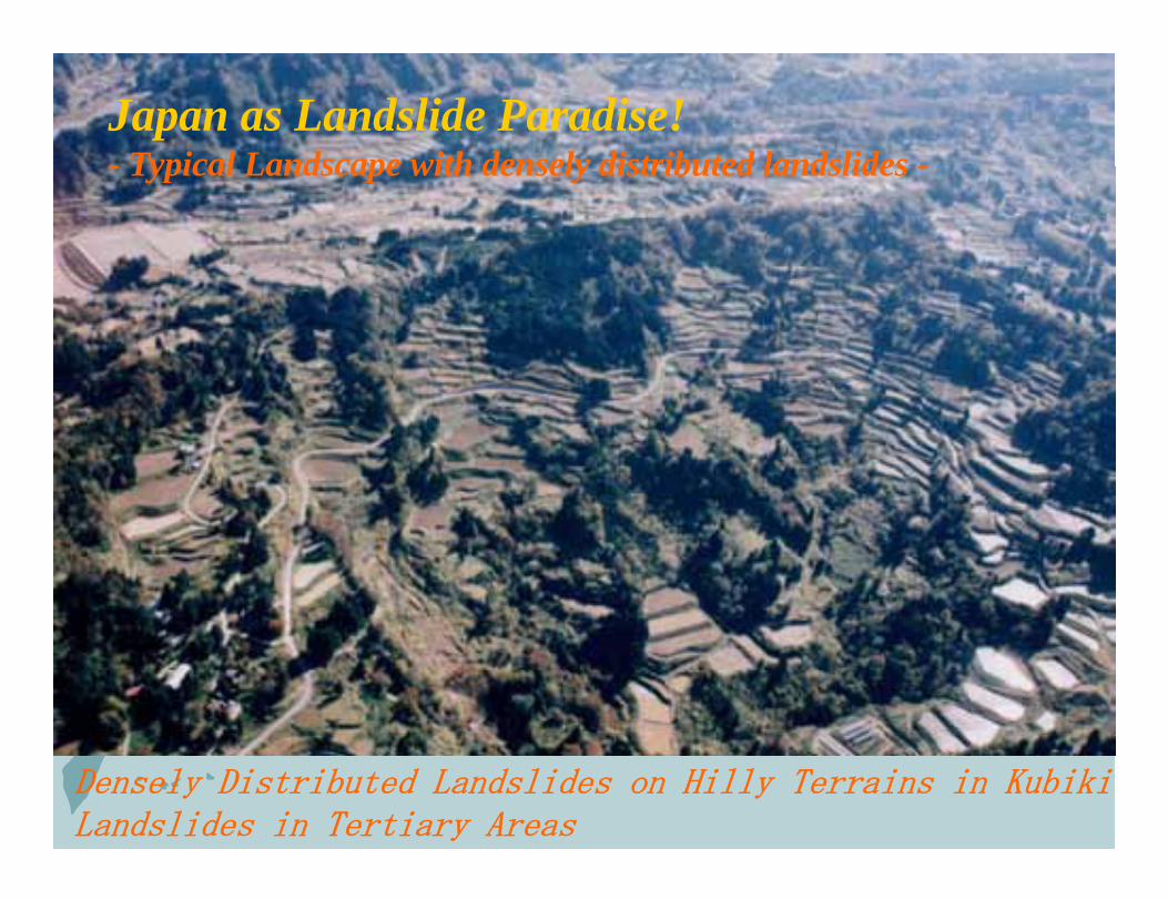
Japan as Landslide Paradise!- Typical Landscape with densely distributed landslides -- Typical Landscape with densely distributed landslides -
Densely Distributed Landslides on Hilly Terrains in Kubiki Landslides in Tertiary Areas

Zentoku Landslide in Iya-Valley / Landslides in Fractured Zo

Landslides in Volcanic Mountain Area
Sounzan Landslide in Hakone / Landslides in Hydrothermal Alteration zones
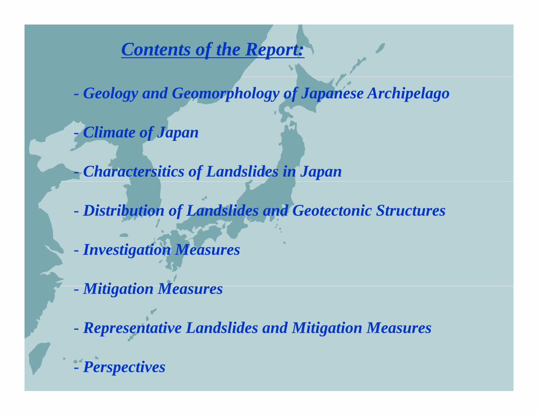
Contents of the Report:
- Geology and Geomorphology of Japanese Archipelago
Cli t f J- Climate of Japan
- Charactersitics of Landslides in Japan
- Distribution of Landslides and Geotectonic Structures
- Investigation Measures
Miti ti M- Mitigation Measures
- Representative Landslides and Mitigation Measures
- Perspectives
Trenches and island arcsaround the Japanese Archipelago
Kurile Arc
NorHonArc
● SendaiMid Nii t ★
rtheastnshu
rc
● Tokyo
Mid Niigata★
SouthwestHonshu Arc
Izum Izu-Mar
Honshu Arc
L
riana Arc
ocat
c
Ryukyu Arc

Major Geologic Zones
(Highest landslide occurrence)
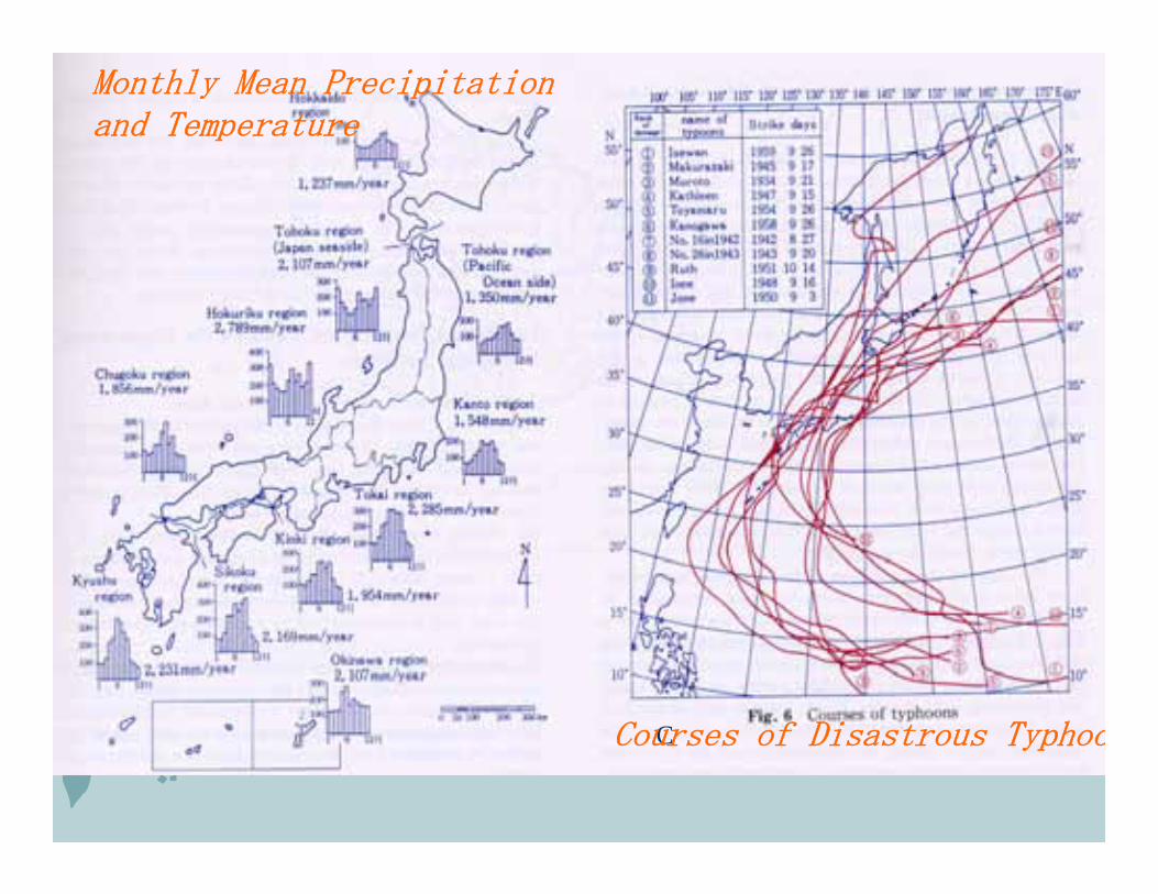
Monthly Mean Precipitationand Temperature
CC ur f Di tr u T hCCourses of Disastrous Typhoo
★
★★
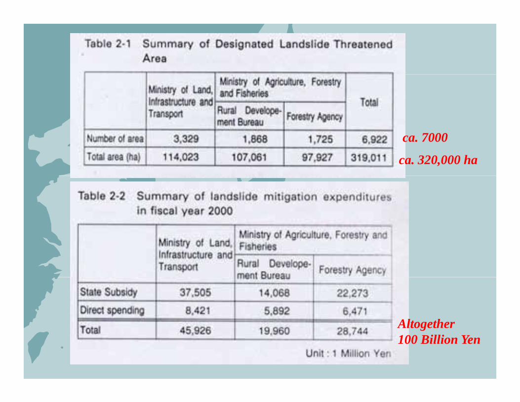
ca. 7000
ca. 320,000 ha
AltogetherAltogether 100 Billion Yen
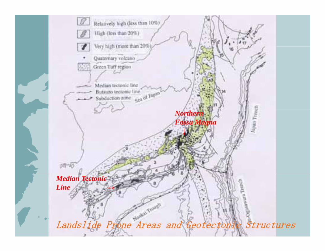
NorthernFossa Magna↓
Median TectonicLine →
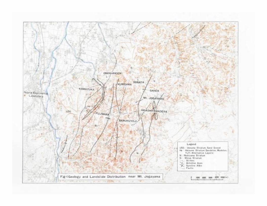
Landslide Prone Areas and Geotectonic Structures
(active)
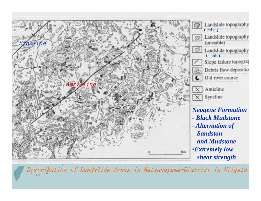
Syncline
(stable)
Anticline
Neogene Formationg- Black Mudstone- Alternation of
Sandston and Mudstone
•Extremely low shear strength
Distribution of Landslide Areas in Matsunoyama-District in Niigata
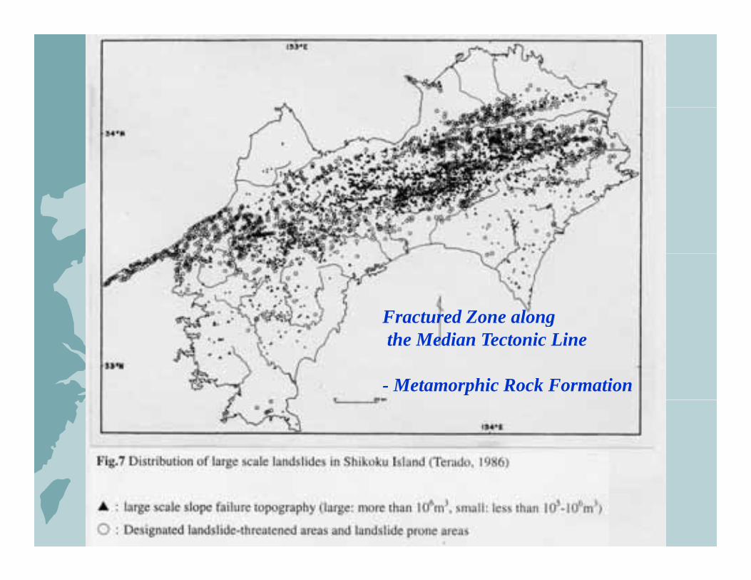
Fractured Zone alonggthe Median Tectonic Line
- Metamorphic Rock Formation
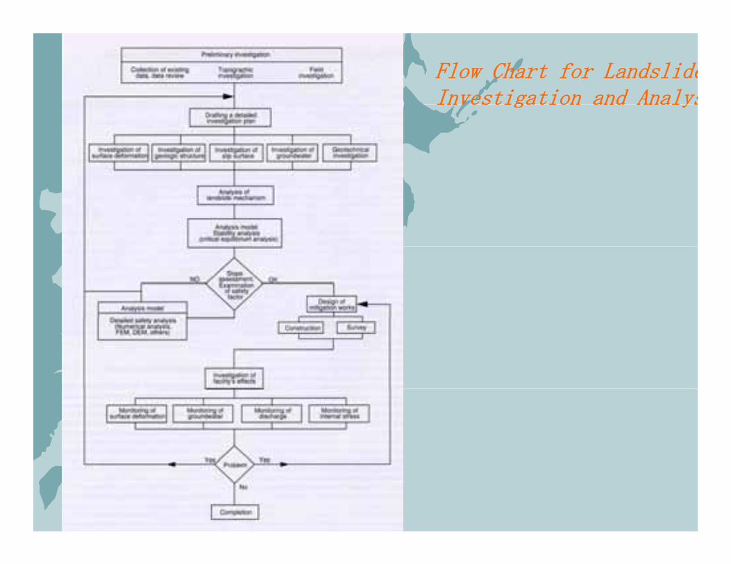
Flow Chart for LandslideInvestigation and AnalysInvestigation and Analys
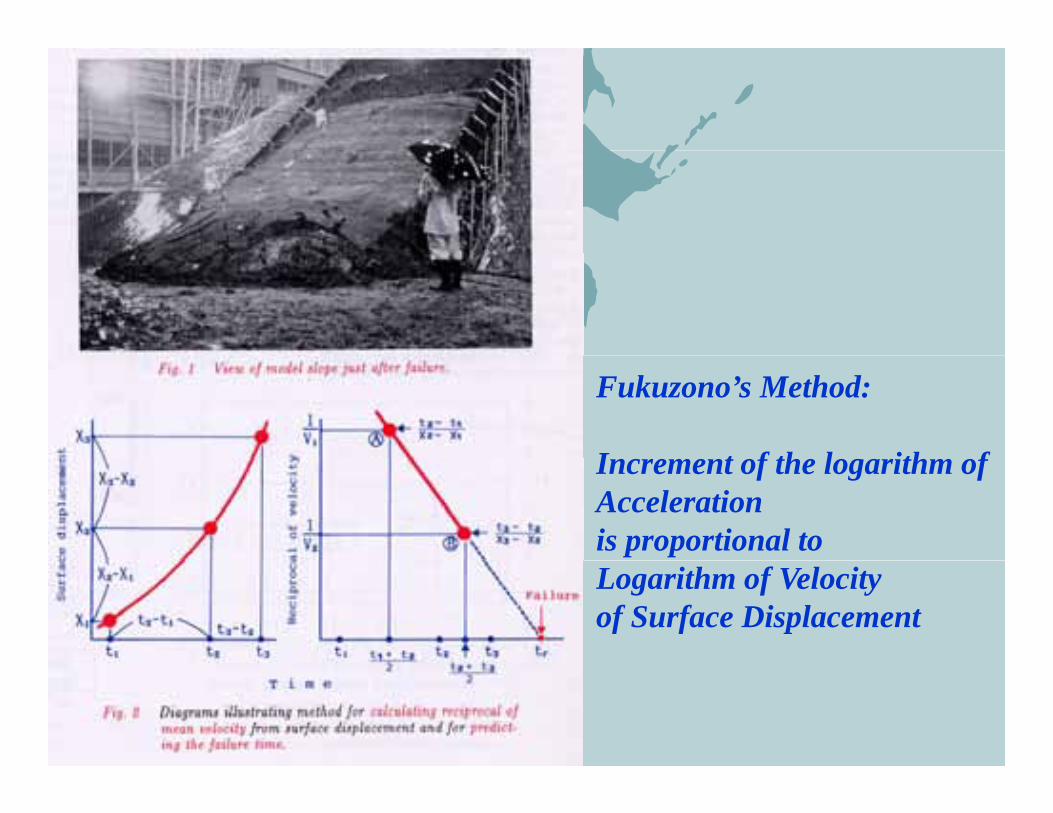
Fukuzono’s Method:
I t f th l ith fIncrement of the logarithm of Accelerationis proportional to Logarithm of Velocity of Surface Displacement

Various Types of Landslide Mitigation MeasuresVarious Types of Landslide Mitigation Measures
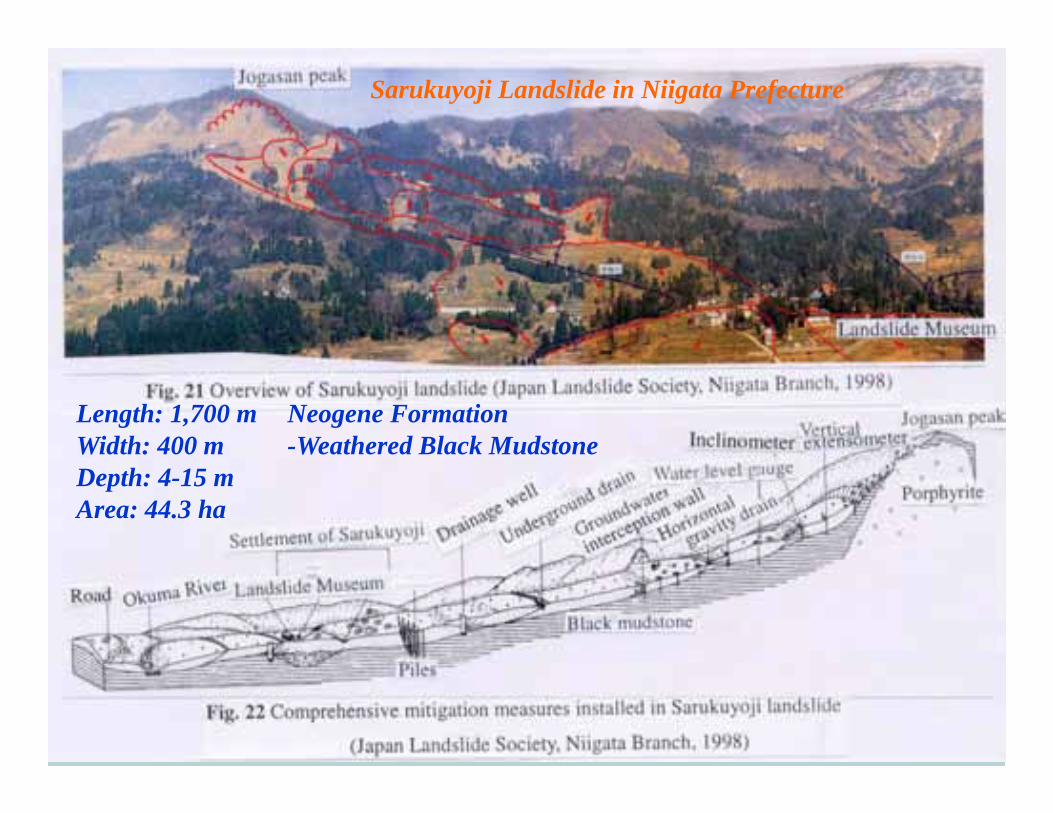
Sarukuyoji Landslide in Niigata Prefecture
Length: 1,700 mWidth: 400 m
Neogene Formation-Weathered Black Mudstone
Depth: 4-15 mArea: 44.3 ha
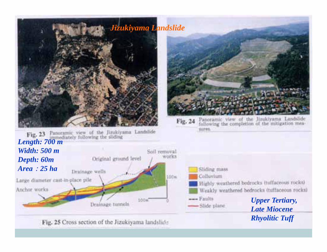
Jizukiyama Landslide
Length: 700 mLength: 700 mWidth: 500 mDepth: 60mArea:25 ha
Upper Tertiary,Late MioceneRhyolitic Tuff

Overview of Odokoro Landslide Plan of Odokoro Landslide andDistribution of Control Measures
Length: 1000 m Crystalline Schist Mesozoic andWidth: 400 – 800 mDepth: deeper than 100 mArea: 60 ha
Crystalline Schist, Mesozoic and Paleozoic Sedimentary RocksSepentine Melange Zone
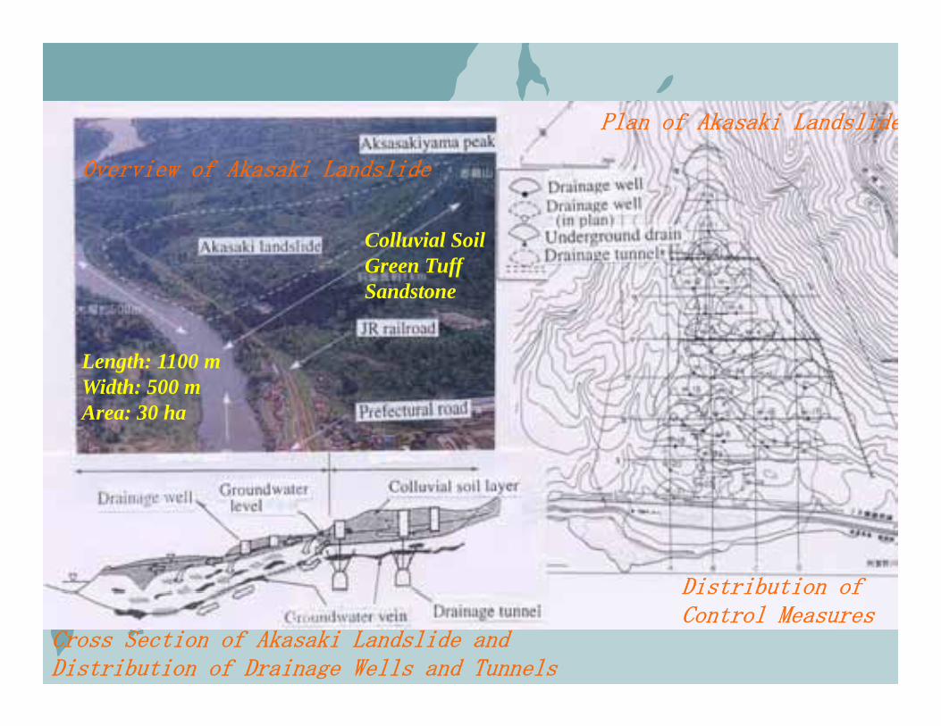
Plan of Akasaki Landslide
Overview of Akasaki Landslide
Colluvial SoilGreen TuffSandstone
Length: 1100 mWidth: 500 mA 30 hArea: 30 ha
Distribution of
Cross Section of Akasaki Landslide andDistribution of Drainage Wells and Tunnels
Distribution ofControl Measures

A tremendous number of landslides were induced by the Mid-Niigata Prefecture Earthquake
Important target: Earthquake Induced Landslides- Important target: Earthquake-Induced Landslides -
Imo River Basin immediately after the 2004 Mid-Niigata Earthquake(Ministry of Land Infrastructure and Transport)
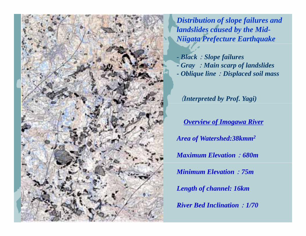
Distribution of slope failures and landslides caused by the Mid-Niigata Prefecture Earthquake
- Black:Slope failures- Gray :Main scarp of landslides
Oblique line:Displaced soil mass- Oblique line:Displaced soil mass
(Interpreted by Prof. Yagi)
Overview of Imogawa River
Area of Watershed:38kmm2
Maximum Elevation:680m
Minimum Elevation:75m
Length of channel: 16km
River Bed Inclination:1/70
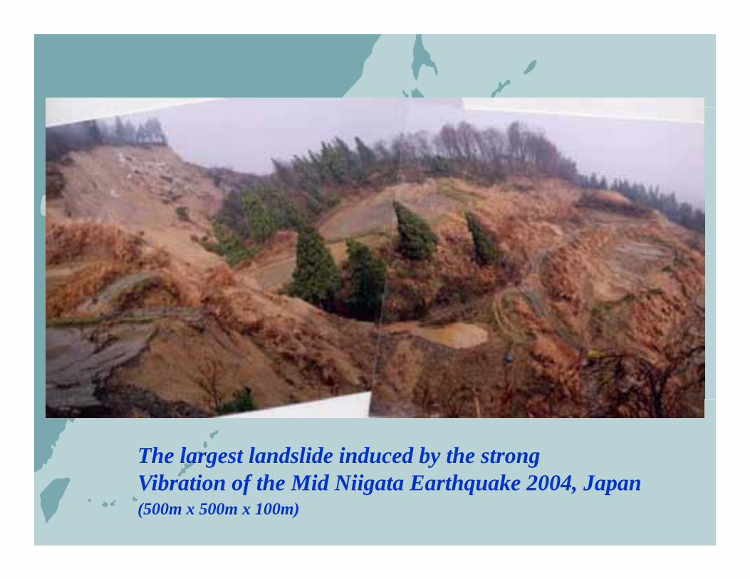
The largest landslide induced by the strong Vibration of the Mid Niigata Earthquake 2004, Japan(500m x 500m x 100m)
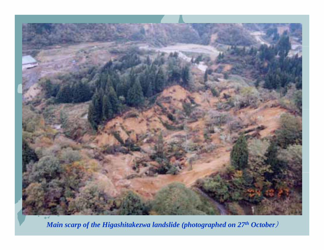
Main scarp of the Higashitakezwa landslide (photographed on 27th October)
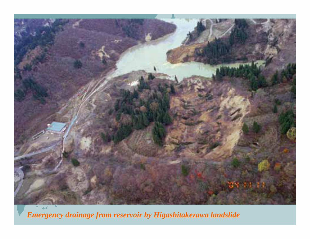
Emergency drainage from reservoir by Higashitakezawa landslide
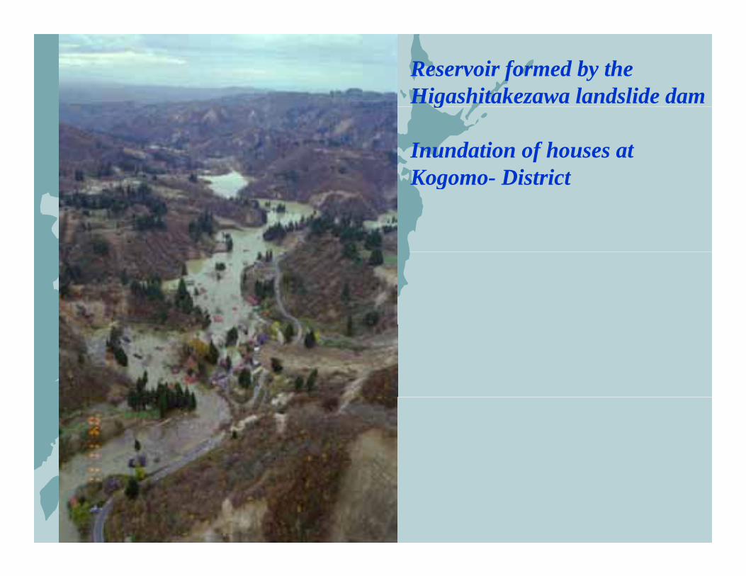
Reservoir formed by the Higashitakezawa landslide damg
Inundation of houses atKogomo- DistrictKogomo- District

Legends: Situation in March 2005
Blue color along river channels: Reservoirg
Landslide dams are shown by circles and triangles:Ci l h Ri Ch l Bl kCircles show River Channel Blockages which are still existing.Orange circle: Countermeasures installedBlue circle: OvertoppingRed circle: Without OvertoppingTriangles show River Channel Blockageswhich are already solved.Green triangle: naturally washed awayGreen triangle: naturally washed awayViolet triangle: artificially excavated
Distribution of Landslide Dams
(Hokuriku Regional Development Bureau)
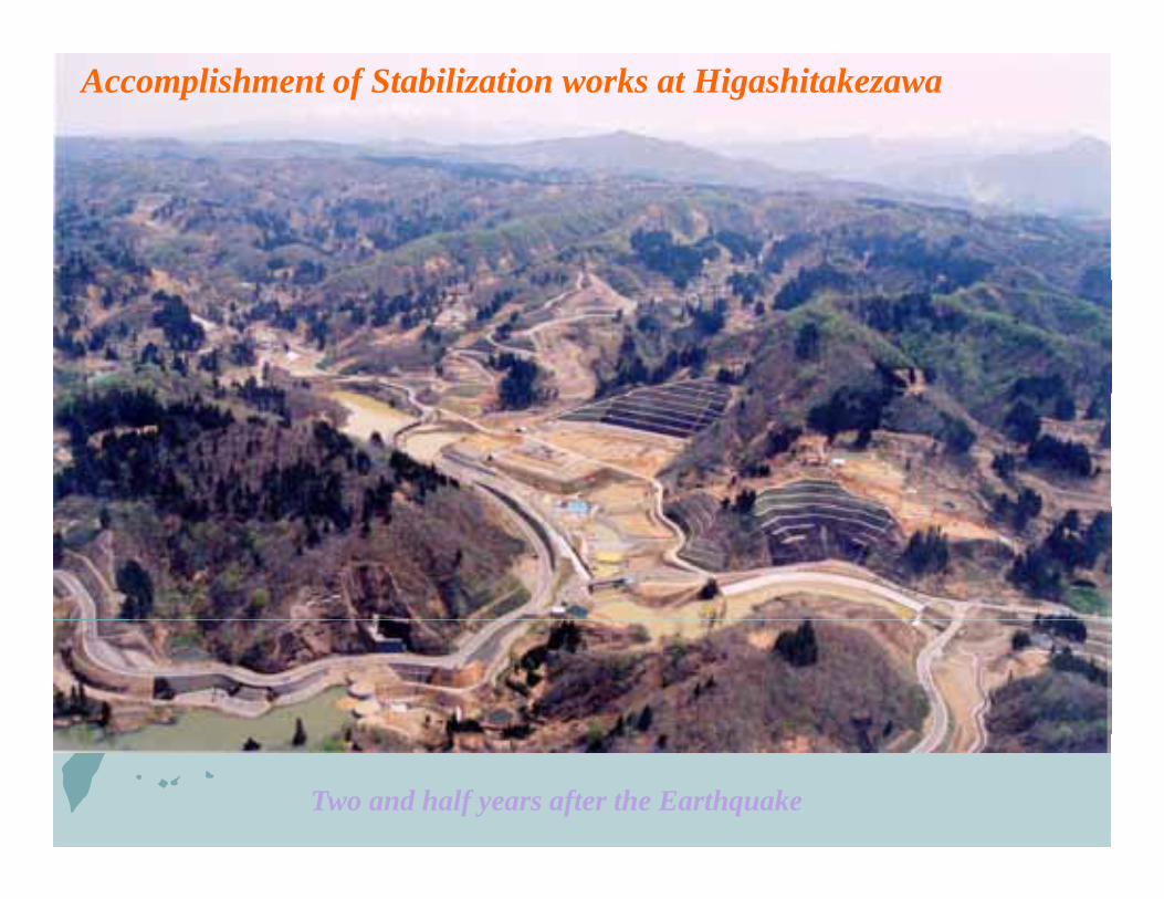
Accomplishment of Stabilization works at Higashitakezawa
Two and half years after the Earthquake
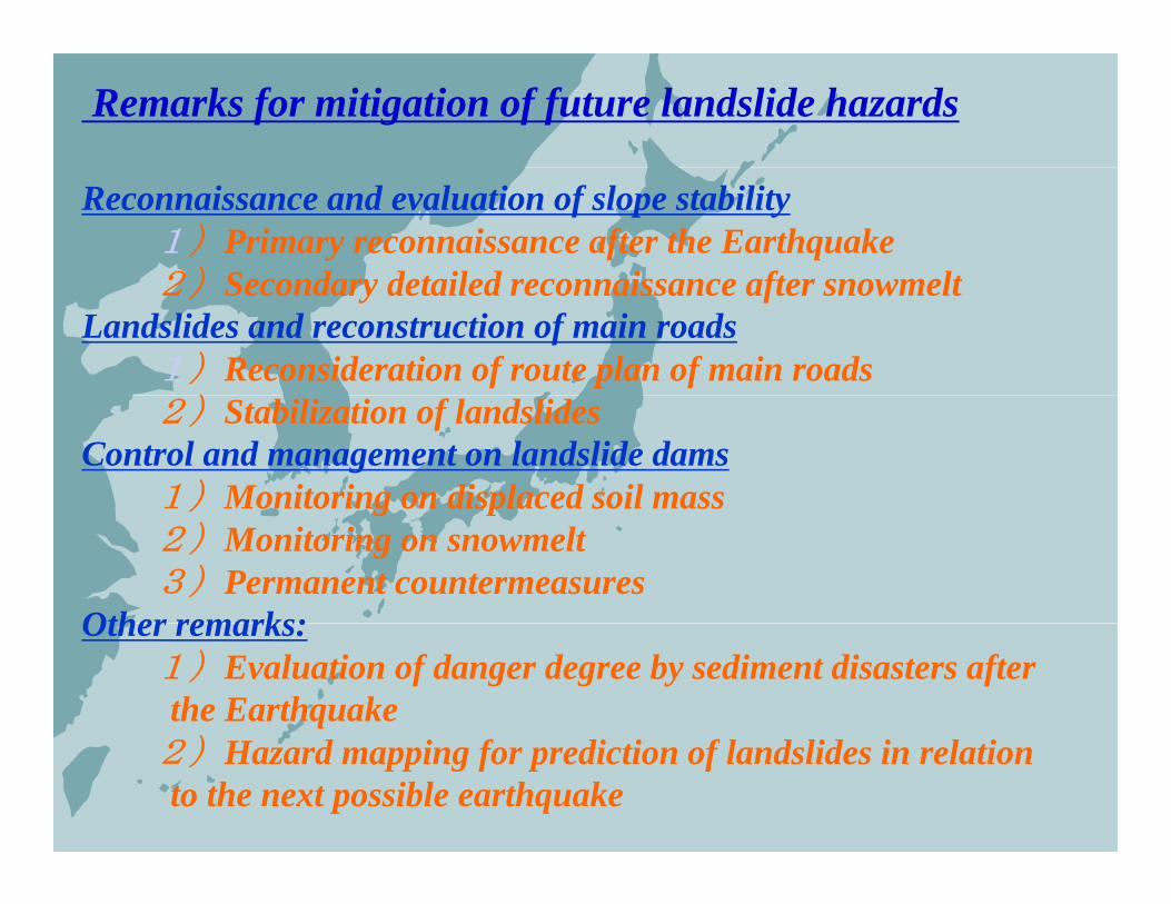
Remarks for mitigation of future landslide hazards
Reconnaissance and evaluation of slope stability1)Primary reconnaissance after the Earthquake2)Secondary detailed reconnaissance after snowmelt2)Secondary detailed reconnaissance after snowmelt
Landslides and reconstruction of main roads1)Reconsideration of route plan of main roads
)2)Stabilization of landslidesControl and management on landslide dams
1)Monitoring on displaced soil mass) g p2)Monitoring on snowmelt3)Permanent countermeasures
Other remarks:Other remarks:1)Evaluation of danger degree by sediment disasters after the Earthquake)2)Hazard mapping for prediction of landslides in relation
to the next possible earthquake
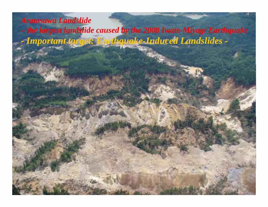
Accomplishment of Stabilization works at HigashitakezawaAratosawa Landslide – the largest landslide caused by the 2008 Iwate-Miyagi Earthquake
I E h k I d d L d lid- Important target: Earthquake-Induced Landslides -
Two and half years after the Earthquake
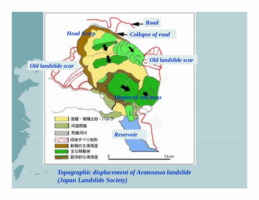
Road
Head Scarp Collapse of road
Old landslide scar
p f
Old landslide scar
Displaced soil mass
Reservoir
Topographic displacement of Aratosawa landslide(Japan Landslide Society)

Before earthquake
Old subsidence zoneSliding surface
After earthquake
Compression zone Subsidence zone
TuffSandstone/Siltstone
Welded tuffPumice tuff
Longitudinal profile of Aratosawa landslide (Tohoku forestry bureau)
Tuff
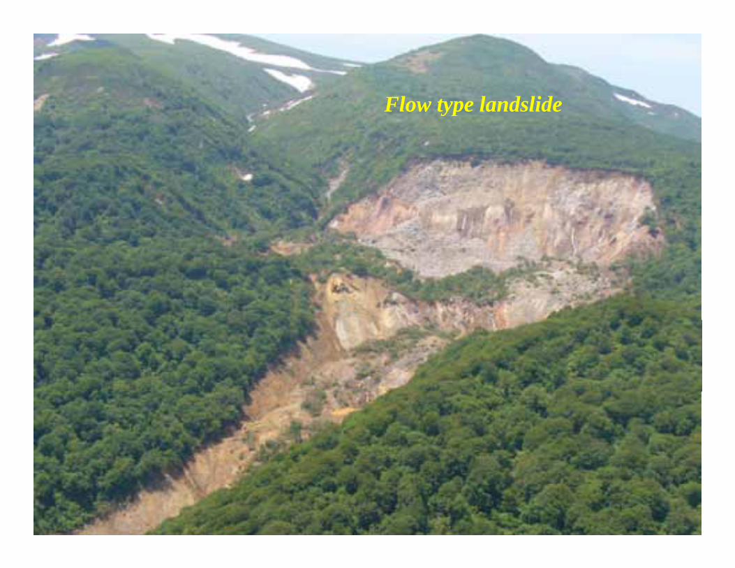
Flow type landslideFlow type landslide
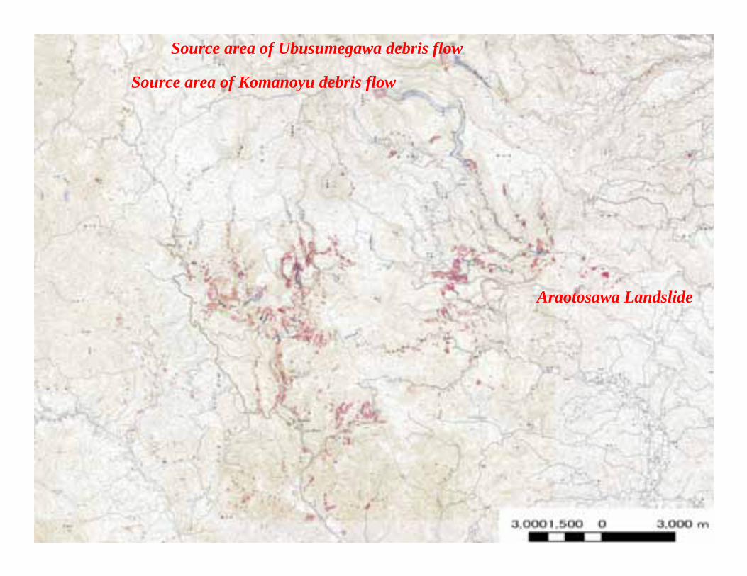
Source area of Komanoyu debris flow
Source area of Ubusumegawa debris flow
Araotosawa Landslide
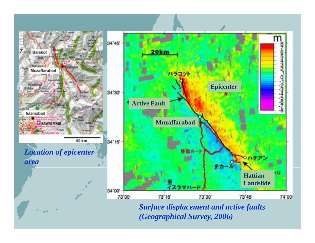
Epicenter
Active Fault
Muzaffarabad
Location of epicenter area
HattianLandslide
Surface displacement and active faults (Geographical Survey, 2006)
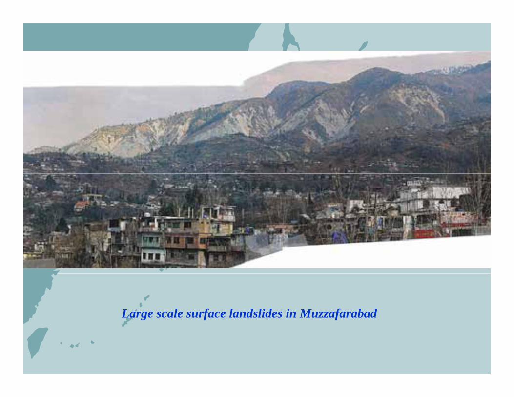
Large scale surface landslides in Muzzafarabad

Hattian landslide – the largest landslide caused by the Northern Pakistan Earthquake
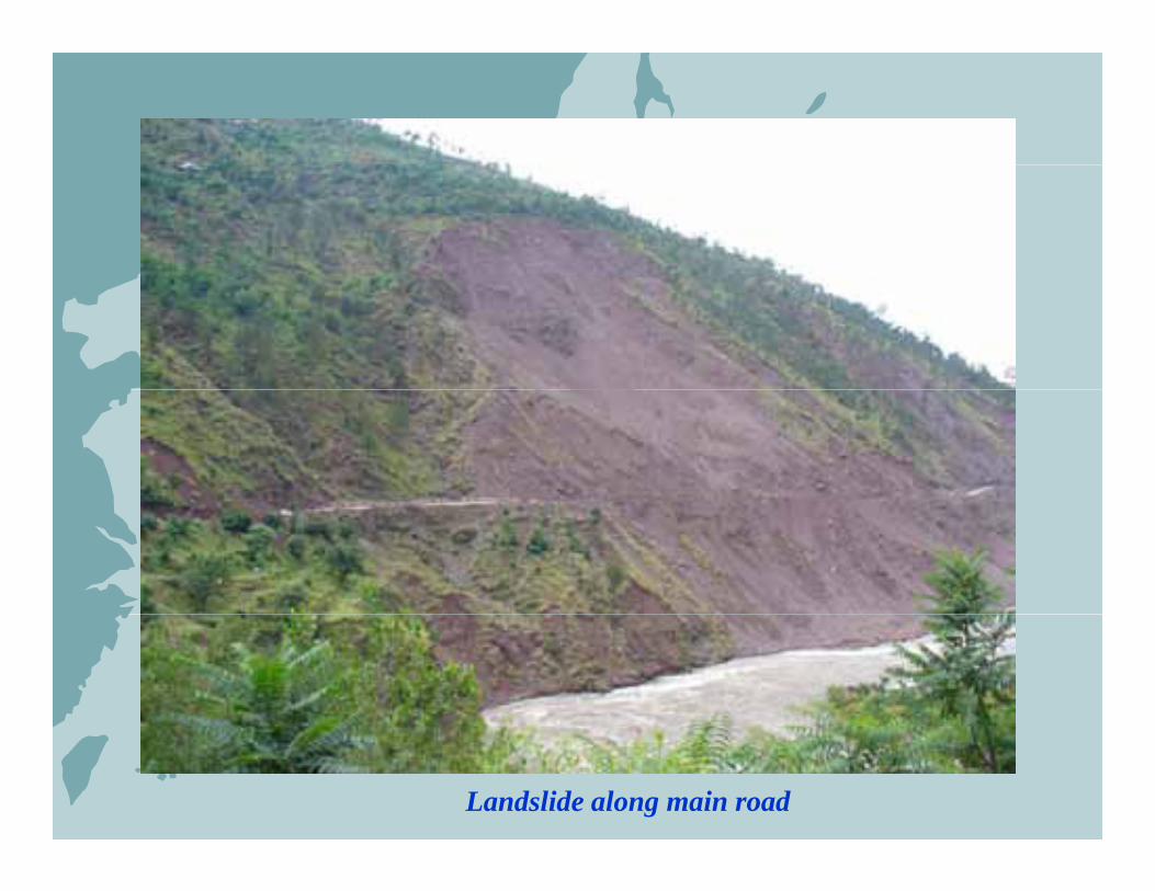
Landslide along main road
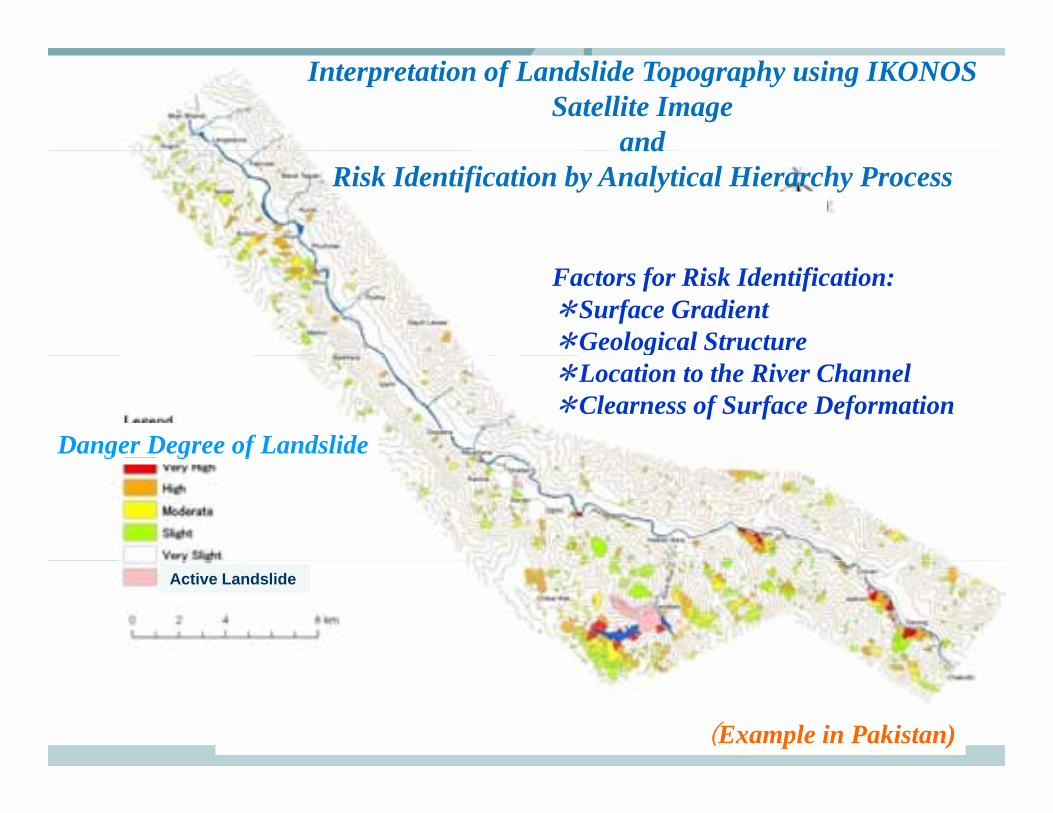
Interpretation of Landslide Topography using IKONOS Satellite Image
andandRisk Identification by Analytical Hierarchy Process
Factors for Risk Identification:*Surface Gradient*Geological Structure
Danger Degree of Landslide
g*Location to the River Channel*Clearness of Surface Deformation
g g f
Active Landslide
(Example in Pakistan)
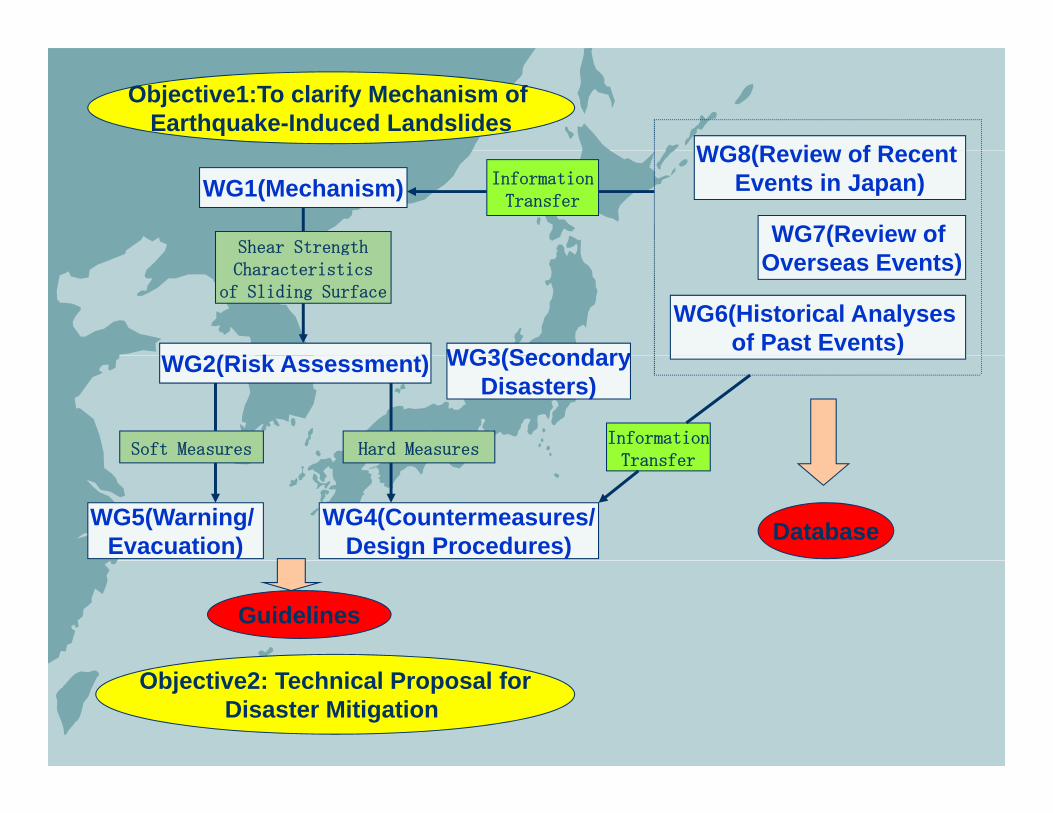
Objective1:To clarify Mechanism of Earthquake-Induced Landslides
WG8(Review of RecentWG1(Mechanism)
Shear Strength
WG8(Review of Recent Events in Japan)
WG7(Review of
InformationTransfer
gCharacteristics
of Sliding Surface
WG2(Ri k A t)
Overseas Events)
WG6(Historical Analyses of Past Events)WG3(SecondaryWG2(Risk Assessment)
Soft Measures Hard Measures
)WG3(SecondaryDisasters)
InformationTransfer
WG5(Warning/ Evacuation)
WG4(Countermeasures/Design Procedures) Database
Transfer
Guidelines
Objective2: Technical Proposal forDisaster Mitigation
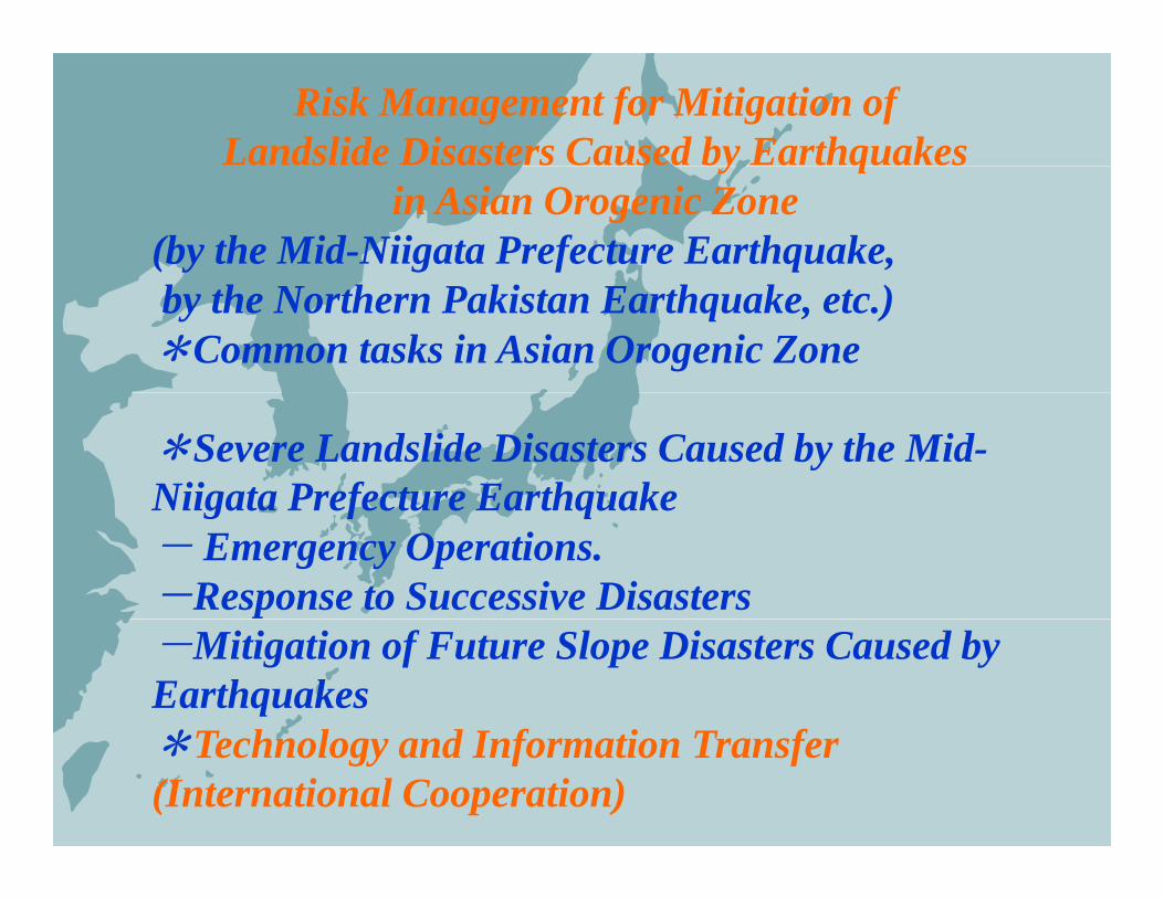
Risk Management for Mitigation of Landslide Disasters Caused by Earthquakesy q
in Asian Orogenic Zone(by the Mid-Niigata Prefecture Earthquake,by the Northern Pakistan Earthquake, etc.)*Common tasks in Asian Orogenic Zone
*Severe Landslide Disasters Caused by the Mid-Niigata Prefecture EarthquakeNiigata Prefecture Earthquake- Emergency Operations.-Response to Successive Disasters-Mitigation of Future Slope Disasters Caused by Earthquakes*T h l d I f i T f*Technology and Information Transfer(International Cooperation)
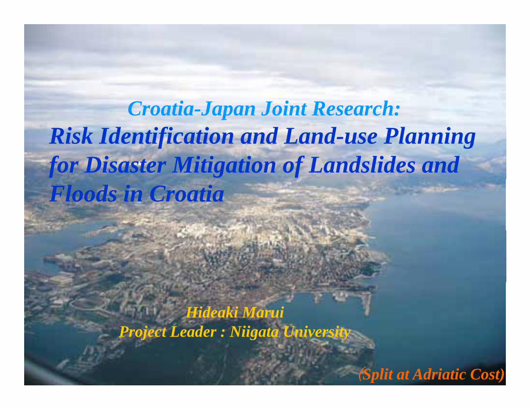
Croatia-Japan Joint Research:Risk Identification and Land-use Planning for Disaster Mitigation of Landslides and Floods in Croatia
Hideaki MaruiProject Leader : Niigata UniversityProject Leader : Niigata University
(Split at Adriatic Cost)
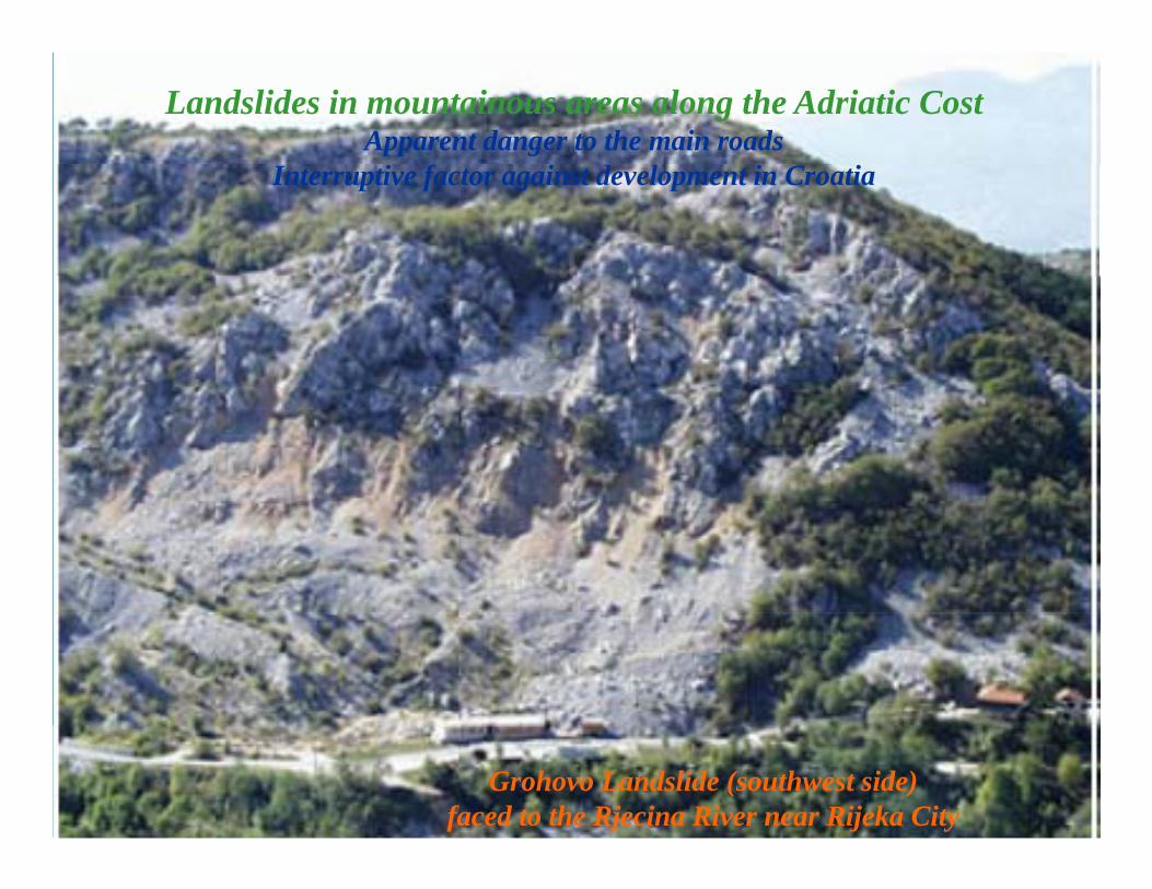
Landslides in mountainous areas along the Adriatic CostApparent danger to the main roads
Interruptive factor against development in Croatia
Grohovo Landslide (southwest side)faced to the Rjecina River near Rijeka City
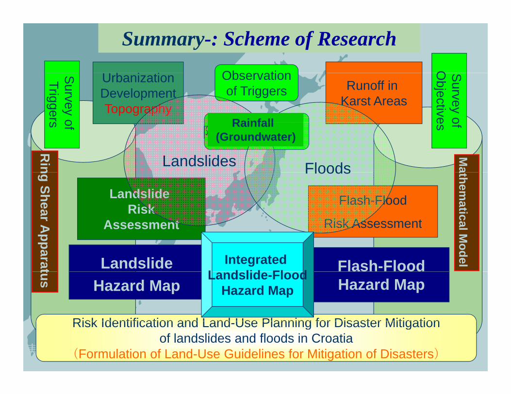
Summary-: Scheme of ResearchO
Ob tiSurvey oTriggers
Survey o
Objective
Runoff in Karst Areas
Observationof Triggers
UrbanizationDevelopmentTopography
Rainfall
社会シ
題・防
of s ofes
降雨(地下水)
Landslides Floods
Rin
Ma
Rainfall(Groundwater)
ステム・人
防災政策Flash-Flood
Risk Assessment
Landslide Risk
A t
Floodsng Shear
athematica
人口問
Risk AssessmentAssessment
Flash-Flood
Apparat
al ModelLandslide Integrated
L d lid Fl d Hazard Map
tus
Risk Identification and Land Use Planning for Disaster Mitigation
Hazard MapLandslide-Flood
Hazard Map
安全な地域社会構築にむけた実用的かつ安価な防災技術のアジア(東北アジア3国+アセアン3国)共同開発
Risk Identification and Land-Use Planning for Disaster Mitigationof landslides and floods in Croatia
(Formulation of Land-Use Guidelines for Mitigation of Disasters)
We are very grateful to you for your kind attentionfor your kind attention