
Land at Norwich Road, Aylsham Landscape and Visual ...
56
Land at Norwich Road, Aylsham Landscape and Visual Assessment November 2019
Transcript of Land at Norwich Road, Aylsham Landscape and Visual ...

Land at Norwich Road, Aylsham
Landscape and Visual Assessment November 2019

iiNorwich Road Aylsham - Landscape and Visual Assessment

Contents
1. Introduction 22. Personal Statement 33. Landscape Planning Issues 44. Topography 75. Local Landscape Character 86. Public Rights of Way 107. Statutory Designations and Cultural Heritage 118. Zone of Theoretical Visibility 129. Light Spillage 1610. Site Proposals 1811. Visual Assessment 1812. Summary 34
13. Appendix: Methodology 37
iiiNorwich Road Aylsham - Landscape and Visual Assessment


1. INTRODUCTION
1.1 This Landscape and Visual Impact Assessment has been prepared to determine the potential impact of new development at Norwich Road, Aylsham.
Purposes of the Document
1.2 The purpose of this document is to assess the landscape, visual and cultural impacts of the potential development on the site.
1.3 The document evaluates the contribution of the site to the landscape character, visual amenity and cultural and heritage features of the local area before assessing the potential impacts of the development on that character and amenity.
Structure of the Document
Landscape Baseline1.4 This section assesses the character and quality of
the local landscape before identifying the extent to which the proposal site contributes to or detracts from that character and therefore its sensitivity to change. Particular reference is made to the district-wide Landscape Character Assessment
1.5 The assessment of the character and of the proposal site identifies the wider landscape receptors that may be affected by the proposals, as well as their sensitivity to change. These receptors may be features
or elements of character that need to be preserved, restored or enhanced.
Development Proposals and Site description
1.6 This section reviews the historic development of the site and its landscape setting, and describes the development proposals.
Landscape and Visual Assessment
1.7 This section assesses the potential landscape and visual impacts of development on the site, based on a thorough field survey and panoramic site photographs. The precise locations of the photographs were plotted using GPS, and were prepared in accordance with LI Advice Note 01/2011: Photography and photomontage in landscape and visual assessment. This is followed by a more detailed assessment of the potential impact of the development.
Conclusion
1.8 This section summarises the predicted overall landscape, cultural heritage and visual impacts of the development.
1.9 This landscape and visual assessment was undertaken only from public rights of way or from land under the control of the site owner. Direct views from private property were not possible, although potential views from neighbouring properties were assessed as far as was possible from nearby public rights of way. The
assessment was undertaken during September 2019.
2Norwich Road Aylsham - Landscape and Visual Assessment

2. Personal Statement
2.1 This report has been prepared by Luke Broom-Lynne CMLI MRTPI.
2.2 I am an independent Chartered Landscape Architect and Chartered Town Planner with over 30 years in professional practice. I was awarded a BA Degree in Landscape Architecture from Leeds Metropolitan University in 1983, followed by a Post-graduate Diploma (with commendation) in 1985. I have been a Chartered member of the Landscape Institute since 1989 and of the Royal Town Planning Institute since 2004.
2.3 I worked in initially in the public sector, including senior posts in the planning teams of the Broads Authority and Norwich City Council. I have worked in the private sector for the past 18 years, including a period as Partner in a major regional planning and property consultancy. I now work as an independent landscape planning consultant, involved in Landscape and Visual Impact Assessment, Urban Design and Masterplanning for a wide range of commercial and residential projects throughout the UK.
2.4 Major recent projects have included • University of East Anglia – Landscape Strategy
• Bewilderwood, Tatton Park and Hoveton – LVIAs and Landscape Strategy
• North Weald AONB and Essex Coast - LVIAs for new solar farms
• Future Biogas – LVIAs and landscape strategy for various power plants in Lincolnshire, Staffordshire, and Cambridgeshire.
• Coltishall airfield – LVIA and landscape strategy.
• Grays, Essex - Masterplanning and urban design for new residential development
2.5 I believe that my submission complies with the requirements of the Codes of Professional Conduct of the Royal Town Planning Institute and the Landscape Institute.
3Norwich Road Aylsham - Landscape and Visual Assessment
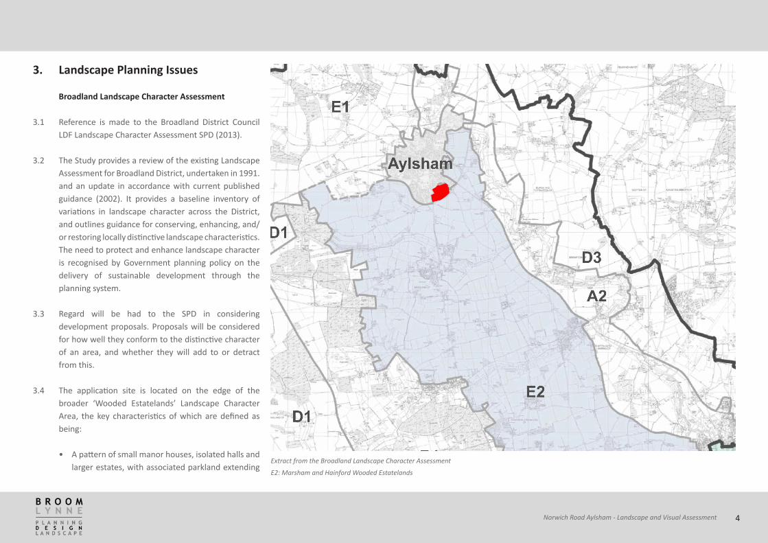
Extract from the Broadland Landscape Character Assessment
E2: Marsham and Hainford Wooded Estatelands
3. Landscape Planning Issues
Broadland Landscape Character Assessment
3.1 Reference is made to the Broadland District Council LDF Landscape Character Assessment SPD (2013).
3.2 The Study provides a review of the existing Landscape Assessment for Broadland District, undertaken in 1991. and an update in accordance with current published guidance (2002). It provides a baseline inventory of variations in landscape character across the District, and outlines guidance for conserving, enhancing, and/or restoring locally distinctive landscape characteristics. The need to protect and enhance landscape character is recognised by Government planning policy on the delivery of sustainable development through the planning system.
3.3 Regard will be had to the SPD in considering development proposals. Proposals will be considered for how well they conform to the distinctive character of an area, and whether they will add to or detract from this.
3.4 The application site is located on the edge of the broader ‘Wooded Estatelands’ Landscape Character Area, the key characteristics of which are defined as being:
• A pattern of small manor houses, isolated halls and larger estates, with associated parkland extending
4Norwich Road Aylsham - Landscape and Visual Assessment

across much of the area:
• These buildings impart a strongly ordered and human influence over the surrounding landscape;
• Numerous copses, woodlands and small plantations associated with these estates, punctuating a landscape of underlying predominantly arable farmland;
• Settlements have many historic buildings associated with them and a strong local vernacular;
• Strong historic dimension throughout the landscape;
• Woodland provides a sense of enclosure;
• Underlain by a mixed geology of Till, with loams and pebbly soils.
Summary of Visual Character
3.5 This gently rolling landscape of predominantly arable farmland is underlain by a mixed geology. In certain locations, Till predominates. This results in a land cover of loams and pebbly soils. Topography within this Landscape Character Type is more strongly rolling than with adjacent flatter landscapes, with field boundary trees, copses and woodlands nestled within the folds of the landscape.
3.6 The numerous copses, woodlands and small plantations provide a sense of enclosure, as well as being points of visual focus within views across the farmland. There is a striking settlement pattern of small manor houses, isolated halls and larger estates. Large historic halls are
dominant landscape features, often with associated parkland and designed landscapes, which contrast with the adjacent farmed landscapes.
3.7 A network of minor and major roads cut across and link small villages within this Landscape Character Type. The influence of the urban edge of Norwich is also quite strong towards the south of this Landscape Character Type.
3.8 Despite this, there is generally a predominantly rural character and associated strong sense of tranquillity throughout most of this landscape. Views across this landscape are restricted in places by the pockets of woodland. In other places, however, long views across gently rolling farmland can be gained.
3.9 The following Key Forces for Change have been identified for the Wooded Estatelands Landscape Character Type:• Loss of field boundaries as a result of agricultural
intensification;
• Small-scale incremental development within villages, which may be inconsistent with local built character and materials;
• Changes in woodland cover as a result of changes in management;
• Changes in management of historic halls and their associated parkland settings;
• Increased use of rural roads associated with tourism and visitors to historic attractions;
• Loss of field trees and mature landscape structure as a result of agricultural intensification.
3.10 The application site is located with the sub-region of the Wooded Estatelands described as Marsham and Hainford
3.11 This character area comprises the gently rising slopes that extend from the Bure valley to the belt of woodland that sharply defines the area to the west.
3.12 At the edge of the Bure floodplain convex slopes sharply define the valley floor. From this point the land rises gently, becoming increasingly undulating where incised by tributaries of the River Bure. The area is made up of a varied drift geology of sands and gravels. This is overlain with loam in some areas, especially in the north where it forms pockets of higher quality agricultural land.
3.13 Most settlements form a dispersed collection of residential buildings with minor central core. During recent years, housing has also developed in small clusters along the busy roads that pass through the area, linking Alysham with Norwich. These developments have for the most part remained contained as individual linear or nucleated developments, such as Marsham.
3.14 Away from the tributaries, slopes are generally open in character affording wide views. Numerous hedgerow trees and intermittent hedgerows provide structure gently filtering these views and reducing the feeling of
5Norwich Road Aylsham - Landscape and Visual Assessment

exposure.
Inherent Landscape Sensitivities
3.15 The following inherent landscape sensitivities have been identified:• Pockets of pasture, open grassland, patterns of
semi-natural vegetation lining tributaries, create interest and diversity in an otherwise arable landscape.
• Generally unified, rural character and recognisable landscape structure with fields defined by hedgerows in many areas.
• Landscape setting of historic halls, manors and churches.
• Landscape setting of villages.
• Characteristic westerly views across the farmland to distinct wooded horizon
Landscape Planning Guidelines
3.16 The following Landscape Planning Guidelines apply to Marsham and Hainford Wooded Estatelands Landscape Character Area:• Seek to conserve and enhance the landscape
structure within the area, including woodland, copses of woodland, mature trees associated with small halls and manors and intact hedgerows;
• Seek to ensure the sensitive location of development involving further tall structures (such as steel pylons and telecommunication masts) in
relation to prominent skyline locations both within the character area and within adjacent character areas;
• Seek to ensure that potential new small-scale development within villages is consistent with the existing settlement pattern, density and traditional built form;
• Seek to conserve the landscape setting of historic halls, manors and churches;
• Seek to promote use of local vernacular buildings materials;
• Seek to ensure new development does not reduce the vertical significance of important historical and architectural features within the landscape, such as church towers.
6Norwich Road Aylsham - Landscape and Visual Assessment

Norwich Road, Aylsham: Site topography
4. Topography
4.1 The plan here shows the local topography, based on a model created using the Environment Agency’s LIDAR data.
4.2 The town of Aylsham is located on high land at around 35 metres above Ordnance Datum, between the valleys of the River Bure to the east, and its tributaries The Mermaid and Mary’s Beck to the south and west.
4.3 The application site is located on south-east facing land at the edge of the town at an elevation of approximately 33 metres at the northern corner, falling to around 22 metres at the south east. Farther east, the land falls to around 8 metres at the floor of the valley of the River Bure.
7Norwich Road Aylsham - Landscape and Visual Assessment

Top left: 1890. Top right: 1946
Bottom left: 1988. Bottom right 2016
5. Local Landscape Character
5.1 Analysis of historical mapping shows how the vegetation and land patterns have evolved in this area. Maps during the 1880s show that this was an area with small rectangular fields fringed by hedgerow and boundary trees. This First Edition Ordnance Survey map indicates that the local landscape was much more rural in character prior to the growth of the Aylsham during the 20th Century. At that time the site was presumably part of Diggen’s Farm and it was subdivided into four fields with individual trees along the boundaries. It was bounded to the south by a country lane called Orchard Lane and to the west by Norwich Road. It was bounded to the east by an unnamed lane (now Buxton Rd) and to the north by open fields.
5.2 By the time of the 1946 aerial photograph, there appeared to be little change in the character of the area, with it being having an essentially rural character. The application site still consisted on four fields, and the boundary trees shown on the original OS maps are evident in the photograph.
5.3 By 1988, the Cromer Road bypass had been installed and all of the former field boundaries and trees on the site had been removed. Although there appear to be areas of different crops on the site, the site has the appearance of a single large field. The bypass follows the former route of Orchard Lane, and all of the trees along the lane appear to have been removed. Further hedgerow loss is also evident in the wider countryside
8Norwich Road Aylsham - Landscape and Visual Assessment

Top left: View westwards from the bypass. Top right: View from Buxton Road
Bottom left: View from Buxton Road. Bottom right: View from Henry Page Road
as fields have been enlarged to suit modern agricultural practices. The town of Aylsham has expanded considerably by this time, with the site now bounded on three sides by residential development, and on the southern side by the bypass severing the site from the surrounding countryside.
5.4 At present, new planting is becoming established along the bypass and in particular at the junction of Buxton Road and the bypass.
5.5 The landscape quality of the application site has been seriously eroded by the expansion of the settlement of Aylsham to the extent that it is now surrounded on three sides by urban development and cut-off from the wider countryside to the south by the A140 by-pass. There are no surviving traditional landscape features such as hedgerows or trees within the site. The vegetation along the southern boundary with the A140 is of recent origin.
5.6 Thus, the landscape is considered to be of ‘ordinary’ quality as defined in the methodology, i.e. ‘typical open agricultural land where attractive features are offset by detractors. Some strategic planning is evident but development is primarily functional including housing estates, business parks or urban fringe land uses.’
9Norwich Road Aylsham - Landscape and Visual Assessment
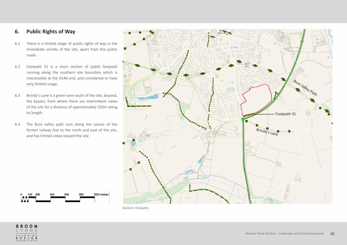
Aylsham: Footpaths
6. Public Rights of Way
6.1 There is a limited range of public rights of way in the immediate vicinity of the site, apart from the public roads.
6.2 Footpath 31 is a short section of public footpath running along the southern site boundary which is inaccessible at the A140 end, and considered to have very limited usage.
6.3 Brindy’s Lane is a green lane south of the site, beyond, the bypass, from where there are intermittent views of the site for a distance of approximately 550m along its length.
6.4 The Bure valley path runs along the course of the
former railway line to the north and east of the site, and has limited views toward the site
Footpath 31
Brindy’s Lane
Bure Valley Path
10Norwich Road Aylsham - Landscape and Visual Assessment

Norwich Road, Aylsham: Statutory Designations
7. Statutory Designations and Cultural Heritage
7.1 No features with statutory designations are present on the site or directly affected by the proposed development.
7.2 Diggens Farmhouse is a Grade II listed 18th Century building located just beyond the north-eastern corner of the site.
7.3 The only other features of note are the Scheduled Ancient Monuments of the Site of Burgh Hall, c 1200 metres East, and Bolwick Hall Farm, 1300 metes south-east.
11Norwich Road Aylsham - Landscape and Visual Assessment

8. Zone of Theoretical Visibility
8.1 To aid the determination of visual impact, a more detailed Zone of Theoretical Visibility (ZTV) exercise was undertaken.
8.2 The results are not intended to show the actual visibility of an object, they are intended to indicate where the object may possibly be visible from. Actual visibility can only accurately be determined by site survey since there are a multitude of local variables that may affect lines of sight. On the other hand, a ZTV/ZVI does show where an object definitely cannot be seen. This is of great help when planning fieldwork because the surveyor knows where there is no need for a “ground truth” check and can focus efforts where there may be views. Simple ZTVs can be used at early stages in the study to make site visits more efficient.
8.3 This involves the generation of a 3-dimensional computer model of the site and its area, and then determines from which locations an object may be visible. It is important to note that the ZVT should be used to guide an assessment of potential visibility, and should always be combined with a site inspection to determine actual site visibility. Nevertheless, it is a useful tool in demonstrating where a development will definitely not be visible due to the permanent and static effects of topography.
8.4 For the purposes of this exercise, LIDAR DSM data prepared by the Environment Agency was used. Light
detection and Ranging (LIDAR) is an airborne mapping technique, which uses a laser to measure the distance between the aircraft and the ground. These datasets are commonly used in the preparation of ZTVs. The DSM data includes such features as trees and buildings, but not all, so gives a general view of the potential visibility (or invisibility) of selected features.
8.5 The model used a notional height of the structures (the ‘transmitter’) as being 6 metres, with an eye height (the ‘receiver’) of 1.65 metres. Clearly the precise impact will depend on the final design and layout of the site.
12Norwich Road Aylsham - Landscape and Visual Assessment

Norwich Road, Aylsham: Zone of Theoretical Visibility map 1
Grid ref: 619723, 326043. Transmitter: 6m. Eye height: 1.65m
ZTV Map 1
8.6 This shows the potential visibility of a 6 metre-high structure on the northern part of the site.
8.7 The existing settlement of Aylsham, hedgerows and woodland blocks provide variable levels of screening. Passing motorists are unlikely to have any views toward the development except in close proximity. The re is a wide cone of visibility toward the site stretching to the south-east of the site, indicating that there will be views from the countryside here, at least of the rooftops subject to landscape mitigation
13Norwich Road Aylsham - Landscape and Visual Assessment

Norwich Road, Aylsham: Zone of Theoretical Visibility map 2
Grid ref: 619895_326090. Transmitter: 6m. Eye height: 1.65m
ZTV Map 2
8.8 This shows the potential visibility of a 6 metre-high structure on the eastern part of the site.
8.9 The existing settlement of Aylsham, hedgerows and woodland blocks provide variable levels of screening. Passing motorists are unlikely to have any views toward the development except in close proximity. The re is a wide cone of visibility toward the site stretching to the south-east of the site, indicating that there will be views from the countryside here, at least of the rooftops subject to landscape mitigation
14Norwich Road Aylsham - Landscape and Visual Assessment

Norwich Road, Aylsham: Zone of Theoretical Visibility map 3
Grid ref: 619725_325875. Transmitter: 6m. Eye height: 1.65m
ZTV Map 1
8.10 This shows the potential visibility of a 6 metre-high structure on the southern part of the site.
8.11 The existing settlement of Aylsham, hedgerows and woodland blocks provide variable levels of screening. Passing motorists are unlikely to have any views toward the development except in close proximity. There is a wide cone of visibility toward the site stretching to the south-east of the site, indicating that there will be views from the countryside here, at least of the rooftops subject to landscape mitigation
15Norwich Road Aylsham - Landscape and Visual Assessment

CPRE Light Pollution and Dark Skies map
9. Light Spillage
9.1 The Campaign to Protect Rural England (CPRE) has long fought for the protection and improvement of dark skies, and against the spread of unnecessary artificial light. CPRE recommends that ‘developers should ensure new developments have well designed lighting schemes that do not cause light pollution.’ Apart from the impact on people’s experience of the countryside, there is an increasing awareness of the effect that light pollution can have on wildlife, by interrupting natural rhythms including migration, reproduction and feeding patterns. Furthermore a 2010 survey by CPRE found that light pollution can cause a great deal of distress to humans too, including disrupted sleep. Advances in lighting technology mean that upward light pollution can be minimised without compromising road safety or increasing crime.
9.2 The CPRE mapping shows that most of the application site is located on the edge of a relatively highly light-polluted area, although close to areas located within significantly darker skies. Care will therefore need to be taken to ensure that any new development does not significantly add to the existing extent of light spillage and ‘night blight’.
9.3 Broadland District Council’s emerging Development Management Policies include EN2 (Landscape). This policy has, as one of its aims the protection of the nocturnal character of the area. The term nocturnal character when used in this context refers to: “...the
16Norwich Road Aylsham - Landscape and Visual Assessment

impact of any external lighting proposals at night when they are likely to have most impact, particularly in the countryside. The presence of any existing lighting should be taken in to account along with levels of illumination associated with the proposed lighting.”
9.4 NPPF clause 125 is also quoted to reinforce the applicability of EN2.
9.5 “National Planning Policy Framework Clause 125 and Norfolk County Council‘s Environmental Lighting Zones Policy both recognise the importance of preserving dark landscapes and dark skies. In order to minimise light pollution, we recommend that any outdoor lights associated with this proposed development should be:• fully shielded (enclosed in full cut-off flat glass
fitments)
• directed downwards (mounted horizontally to the ground and not tilted upwards)
• switched on only when needed (no dusk to dawn lamps)
• white light low-energy lamps (LED, metal halide or fluorescent) and not orange or pink sodium sources”
17Norwich Road Aylsham - Landscape and Visual Assessment

10. Site Proposals
10.1 The land at Norwich Road covers an area of approximately 11.99ha on the southern edge of the settlement of Aylsham.
10.2 This assessment is based on the assumption that the proposal is for residential development of 2-2.5 storeys with associated infrastructure, open space and community uses, plus appropriate landscape mitigation measures.
11. Visual Assessment
11.1 In order to undertake the assessment, the application site and its environs were walked and driven over one day to determine potential views, and identify representative locations (receptors) to demonstrate the visual impact.
11.2 Photographs have been used to demonstrate the key views and vistas, and to indicate potential visibility to and from the proposed development site. The location of the viewpoints was logged using GPS and this data was used to prepare the panoramic visualisations which were used in the preparation of the proposals. The following section summarises the potential visual impacts.
Viewpoints used in the visual assessment
12
3
4
5
6
7
8
9 1011
12
13
14
15
18Norwich Road Aylsham - Landscape and Visual Assessment

Viewpoint 1
Sensitivity
Description of effects
Magnitude of visual effect
Significance
Location: 52.782627°N, 1.265475°E, 15m , TG2031825560
View north-westwards from Buxton Road, approximately 510 metres from the edge of the site
Medium
This is the view from a public road and footpath with expansive views
CONSTRUCTION Construction plant and activity is likely to be a moderate feature in the view
Moderate Moderate adverse
COMPLETION Depending on the nature of the development, new buildings will be visible, forming a new built edge to the town.
Moderate Minor adverse
COMPLETION PLUS MITIGATION Maturing structure planting will enhance the local landscape features and help the new development sit comfortably in its setting
Minor Minor neutral
19Norwich Road Aylsham - Landscape and Visual Assessment

Viewpoint 2
Sensitivity
Description of effects
Magnitude of visual effect
Significance
Location: 52.782635°N, 1.262658°W, 22m, TG2012825552
View westwards along Brindy Lane, a footpath following an old farm track between two fields, approximately 390 metres from the edge of the site.
Medium/high
This is the view from a public footpath in a rural area
CONSTRUCTION Construction plant and activity is likely to be a moderate feature in the view glimpsed through gaps in the hedgerow
Moderate Moderate adverse
COMPLETION Depending on the nature of the development, new buildings will be significant, forming a new built edge to the town, visible through gaps in the hedge.
Moderate Moderate adverse
COMPLETION PLUS MITIGATION Maturing structure planting will enhance the local landscape features and help the new development sit comfortably in its setting
Minor Minor neutral
20Norwich Road Aylsham - Landscape and Visual Assessment

Viewpoint 3
Sensitivity
Description of effects
Magnitude of visual effect
Significance
Location: 52.783142°N, 1.260137°E, 34m, TG1995625601
View northwards Brindy Lane, approximately 260 metres from the application site
Medium/high
This is the view from a public footpath in a rural area
CONSTRUCTION Construction plant and activity is likely to be a noticeable feature in the view where the path-edge footpath opens to allow expansive views northwards
Moderate Moderate adverse
COMPLETION The new buildings will be significant permanent feature, forming a new built edge to the town.
Moderate Moderate adverse
COMPLETION PLUS MITIGATION Maturing structure planting will enhance the local landscape features and help the new development sit comfortably in its setting
Moderate Minor adverse
21Norwich Road Aylsham - Landscape and Visual Assessment
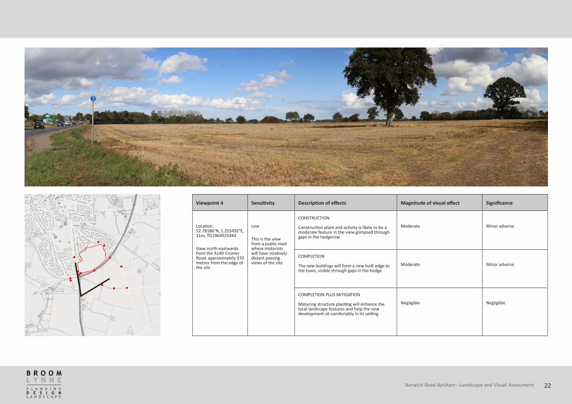
Viewpoint 4
Sensitivity
Description of effects
Magnitude of visual effect
Significance
Location: 52.78186°N, 1.255492°E, 31m, TG1964925444
View north-eastwards from the A140 Cromer Road, approximately 370 metres from the edge of the site
Low
This is the view from a public road where motorists will have relatively distant passing views of the site
CONSTRUCTION Construction plant and activity is likely to be a moderate feature in the view glimpsed through gaps in the hedgerow
Moderate Minor adverse
COMPLETION The new buildings will form a new built edge to the town, visible through gaps in the hedge.
Moderate Minor adverse
COMPLETION PLUS MITIGATION Maturing structure planting will enhance the local landscape features and help the new development sit comfortably in its setting
Negligible Negligible
22Norwich Road Aylsham - Landscape and Visual Assessment

Viewpoint 5
Sensitivity
Description of effects
Magnitude of visual effect
Significance
Location: 52.785442°N, 1.26447°E, 18m, TG2023625870
View westwards from Buxton Road, approximately 250 metres from the edge of the site
Low
This is the view from a public road
CONSTRUCTION Construction plant and activity is likely to be a noticeable feature in the view beyond the bypass
Major Moderate adverse
COMPLETION The new buildings will be significant permanent feature, forming a new built edge to the town.
Minor Minor adverse
COMPLETION PLUS MITIGATION Maturing structure planting will enhance the local landscape features and help the new development sit comfortably in its setting
Moderate Minor adverse
23Norwich Road Aylsham - Landscape and Visual Assessment
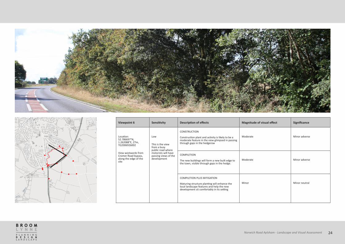
Viewpoint 6
Sensitivity
Description of effects
Magnitude of visual effect
Significance
Location: 52.786697°N, 1.262088°E, 27m, TG2006926002
View westwards from Cromer Road bypass, along the edge of the site
Low
This is the view from a busy public road where motorists will have passing views of the development
CONSTRUCTION Construction plant and activity is likely to be a moderate feature in the view glimpsed in passing through gaps in the hedgerow
Moderate Minor adverse
COMPLETION The new buildings will form a new built edge to the town, visible through gaps in the hedge.
Moderate Minor adverse
COMPLETION PLUS MITIGATION Maturing structure planting will enhance the local landscape features and help the new development sit comfortably in its setting
Minor Minor neutral
24Norwich Road Aylsham - Landscape and Visual Assessment

Viewpoint 7
Sensitivity
Description of effects
Magnitude of visual effect
Significance
Location: 52.78508°N, 1.258598°E, 30m, TG1984225812
View north-eastwards from Cromer Road bypass, along the edge of the site
Low
This is the view from a busy public road where motorists will have passing views of the development
CONSTRUCTION Construction plant and activity is likely to be a moderate feature in the view glimpsed in passing through gaps in the hedgerow
Moderate Minor adverse
COMPLETION The new buildings will form a new built edge to the town, visible through gaps in the hedge.
Moderate Minor adverse
COMPLETION PLUS MITIGATION Maturing structure planting will enhance the local landscape features and help the new development sit comfortably in its setting
Minor Minor neutral
25Norwich Road Aylsham - Landscape and Visual Assessment

Viewpoint 8
Sensitivity
Description of effects
Magnitude of visual effect
Significance
Location: 52.783932°N, 1.25341°E, 29m, TG1949825668
View north-eastwards from Hungate Lane, approximately 190 metres from the edge of the site
Medium
This is the view from a quiet public road
CONSTRUCTION Construction plant and activity is likely to be a minor feature in the view glimpsed through gaps in the hedgerow and tree belts
Minor Minor adverse
COMPLETION The new buildings will form a new built edge to the town, glimpsed through gaps in the hedge.
Minor Minor neutral
COMPLETION PLUS MITIGATION Maturing structure planting will enhance the local landscape features and help the new development sit comfortably in its setting
Minor Minor beneficial
26Norwich Road Aylsham - Landscape and Visual Assessment
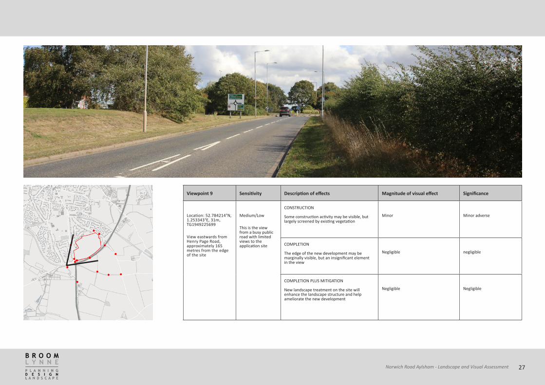
Viewpoint 9
Sensitivity
Description of effects
Magnitude of visual effect
Significance
Location: 52.784214°N, 1.253343°E, 31m, TG1949225699
View eastwards from Henry Page Road, approximately 165 metres from the edge of the site
Medium/Low
This is the view from a busy public road with limited views to the application site
CONSTRUCTION Some construction activity may be visible, but largely screened by existing vegetation
Minor Minor adverse
COMPLETION The edge of the new development may be marginally visible, but an insignificant element in the view
Negligible negligible
COMPLETION PLUS MITIGATION New landscape treatment on the site will enhance the landscape structure and help ameliorate the new development
Negligible Negligible
27Norwich Road Aylsham - Landscape and Visual Assessment

Viewpoint 10
Sensitivity
Description of effects
Magnitude of visual effect
Significance
Location: 52.784813°N, 1.255622°E, 33m, TG1964325773
View eastwards over the site from the corner of the site, close to the Norwich Road junction.
Medium
This is the view over the site from close to a busy road and junction road, and also and footpath at an elevated location with expansive views
CONSTRUCTION Construction activity will be a major feature of the site
Major Major adverse
COMPLETION The new development will transform the character of the site, creating enclosure and hard structures on a formerly plain arable field
Major Minor adverse
COMPLETION PLUS MITIGATION New landscape treatment will enhance the landscape structure and help ameliorate the new development
Moderate Moderate adverse
28Norwich Road Aylsham - Landscape and Visual Assessment

Viewpoint 11
Sensitivity
Description of effects
Magnitude of visual effect
Significance
Location: 52.784622°N, 1.255198°E, 38m, TG1961525750
View eastwards over the site from the Norwich Road junction.
Medium/High
This is the view over the site from close to a busy road and junction road, near a residential area
CONSTRUCTION Construction activity will be a major feature of the site
Major Major adverse
COMPLETION The new development will transform the character of the site, creating enclosure and hard structures on a formerly plain arable field, resulting in the permanent loss of open outlook
Major Major adverse
COMPLETION PLUS MITIGATION New landscape treatment will enhance the landscape structure and help ameliorate the new development
Moderate Moderate adverse
29Norwich Road Aylsham - Landscape and Visual Assessment

Viewpoint 12
Sensitivity
Description of effects
Magnitude of visual effect
Significance
Location: 52.785042°N, 1.255025°E 31m TG1960125796
View eastwards over the site from Norwich Road.
Medium/High
This is the view over the site from a busy road and junction within a residential area
CONSTRUCTION Construction activity will be a major feature of the site beyond the roadside hedgerow, much of which will need to be removed to provide visibility splays
Major Major adverse
COMPLETION The new development will transform the character of the site, creating enclosure and hard structures on a formerly plain arable field, resulting in the permanent loss of open outlook
Major Major adverse
COMPLETION PLUS MITIGATION New landscape treatment will enhance the landscape structure and help ameliorate the new development
Moderate Moderate adverse
30Norwich Road Aylsham - Landscape and Visual Assessment

Viewpoint 13
Sensitivity
Description of effects
Magnitude of visual effect
Significance
Location: 52.786961°N 1.254393°E, 37m TG1954926008
View eastwards over the site from Norwich Road.
Medium/High
This is the view over the site from a busy road within a residential area
CONSTRUCTION Construction activity will be a major feature of the site beyond the roadside hedgerow, much of which will need to be removed to provide visibility splays
Major Major adverse
COMPLETION The new development will transform the character of the site, creating enclosure and hard structures on a formerly plain arable field, resulting in the permanent loss of open outlook
Major Major adverse
COMPLETION PLUS MITIGATION New landscape treatment will enhance the landscape structure and help ameliorate the new development
Moderate Moderate adverse
31Norwich Road Aylsham - Landscape and Visual Assessment

Viewpoint 14
Sensitivity
Description of effects
Magnitude of visual effect
Significance
Location: 52.78186°N, 1.255492°E, 31m TG1964925444
View southwards over the site from Buxton Road.
High
This is the view over the site from a quite road within a residential area
CONSTRUCTION Construction activity will be a major feature of the site
Major Major adverse
COMPLETION The new development will transform the character of the site, creating enclosure and hard structures on a formerly plain arable field, resulting in the permanent loss of open outlook
Major Major adverse
COMPLETION PLUS MITIGATION New landscape treatment will enhance the landscape structure and help ameliorate the new development
Moderate Moderate adverse
32Norwich Road Aylsham - Landscape and Visual Assessment

Viewpoint 15
Sensitivity
Description of effects
Magnitude of visual effect
Significance
Location: 52.788246°N, 1.260995°E, 25m TG1998826171
View south-westwards over the site from Buxton Road.
High
This is the view over the site from a quite road within a residential area
CONSTRUCTION Construction activity will be a major feature of the site
Major Major adverse
COMPLETION The new development will transform the character of the site, creating enclosure and hard structures on a formerly plain arable field, resulting in the permanent loss of open outlook
Major Major adverse
COMPLETION PLUS MITIGATION New landscape treatment will enhance the landscape structure and help ameliorate the new development
Moderate Moderate adverse
33Norwich Road Aylsham - Landscape and Visual Assessment

12. Summary of Landscape and Visual Assessment
12.1 In general, the application site is well contained visually by existing urban development to the north, east and west. It is also reasonably well contained to the south by existing vegetation along the A140. Whilst there are views of the site from the local road network the site is always seen in the context of and against the backdrop of the existing urban area.
Impact on Landscape Character
12.2 The existing landscape is of variable quality. There are some areas which could be defined as ‘good’ quality landscape as defined in the methodology, but much of the area is considered to be of ‘ordinary’ quality.
12.3 As noted in the District Character Assessment, much of the area is an open, elevated landscape with arable farmland and large, regular geometric fields. The site itself has no landscape features of note within it and is heavily influenced by the Cromer Road bypass. Historically comprising a group of four fields bounded by hedgerows and trees, it is now a simple open field bounded largely by more recent planting, separated from the wider countryside by the enclosing effect of urban development and the bypass.
12.4 Nevertheless, the proposals would result in a major and permanent change in the character of the site itself. However, maturing landscape along the A140 bypass
will reduce the impact of the new development, and this will be supplemented with new planting within the site further reducing the impact.
Visual effects
Preliminary ZTV analysis
12.5 The ZTV analysis of the proposed development demonstrates its potential impact over parts of this landscape. The LIDAR DSM data also demonstrates the effects of intervening topography and landscape features, with the result that one is likley to experience glimpsed views as one traverses this landscape. The most open views toward the site from public locations are just from the south-east, from Brindy Lane and Buxton Road. Existing development, topography and vegetation screen the site from wider views.
12.6 In order to fully assess the permanent visual effects of the proposed development, and to determine its effects on the surrounding landscape, the visual Impact survey was undertaken on site to identify the current views into the site and to assess the significance of these views.
12.7 There are likely to be two types of visual effect• Views into the operational area; and
• Changes in landscape character of the vicinity during operations.
12.8 The views assessed were those from which public Church Lane
34Norwich Road Aylsham - Landscape and Visual Assessment

access is possible and are as follows:
Impact upon residential properties
12.9 A number of residential properties have outward views over the application site, notably on Norwich Road and Buxton Road, and it is considered that the will be adversely impacted by the proposals.
12.10 Approximately 12 existing dwellings along Norwich Road have direct open views across the site whilst others may have more oblique views to some degree. Furthermore, it is likley that most of the roadside hedgerow, which might afford some screening, will need to be removed to provide visibility splays. The impact from these properties is therefore considered to be Major adverse, reducing to Moderate in the longer term with landscape mitigation.
12.11 Approximately 15 existing dwellings on Copeman Road have potential rear views across the site. These are mostly bungalows and to some degree their views will be affected by existing vegetation and fencing. Nevertheless, the impact from these properties is therefore considered to be Major adverse, reducing to Moderate in the longer term with landscape mitigation.
12.12 Approximately 6 existing dwellings on Buxton Road have direct facing views across the site whilst others may have more oblique views to some degree. The impact from these properties is considered to be Major adverse, reducing to Moderate in the longer term with landscape mitigation.
12.13 Diggens Farmhouse, adjacent to the eastern site boundary, is surrounded by mature trees, although there may be potential glimpses of the site from this property through the trees. The impact from this property is considered to be Moderate adverse, reducing to Minor in the longer term with landscape mitigation.
Definitive Public Rights of Way
12.14 No definitive rights of way will be directly affected by the proposals, all being outside the site boundary although there will be views toward the development from public roads.
12.15 Footpath 31 is a short section of public footpath running along the southern site boundary which is inaccessible at the A140 end. It usage is therefore considered to be very limited. Anyone using this footpath does however currently have an open outlook across the site. Due to the proximity of this path to the site, the proposal is likely to result in a substantial change in view. The visual impact is therefore considered to be Major adverse.
12.16 There are glimpsed views of the site through hedgerow for a distance of approximately 550m along the green lane called Brindy Lane. From this direction the site is seen against the backdrop of the existing built form of Aylsham, with the A140 by-pass in front. The impact from Brindy Lane during construction and on
completion is considered to be Moderate adverse, reducing to Minor with the establishment of mitigation planting.
Views
12.17 Topography, dense vegetation and limited public access to vantage-points significantly restrict potential views of the site. Depending on the proximity, elevation and extent to which views are restricted and interrupted, it is possible to categorise the views as major, intermediate or minor significance, as follows:
• A major view is one that is open, close and extensive with little or no interruption of the view by intervening vegetation or other screening.
• An intermediate view is one that is obscured due to intervening changes in landform, vegetation or other development.
• A minor view is one that is minimal or glimpsed due to better screening, or a distant view, which may merge into the wider landscape.
12.18 Mature, dense vegetation such as an outgrown hedge and plantation blocks will afford lesser views into a site than a less well-maintained hedge that allows filtered views.
Major Views
12.19 Norwich Road is one of the main approaches into Aylsham and it is essentially suburban in character.
35Norwich Road Aylsham - Landscape and Visual Assessment

Whilst motorists and pedestrians currently using Norwich Road do have an open outlook across the site, they also have views of existing urban development. The development proposals will result in a notable change in view along Norwich Road during construction and on completion. Visual impacts along Norwich Road for motorists, residents and pedestrians have therefore been classified as Major adverse during construction and on completion of the proposals.
12.20 Provided the proposed development is designed to a high standard it will enhance this entrance to the town, including appropriate landscape treatment. Nevertheless, there will be a permanent loss of open outlook, so the impact after the establishment of mitigation planting is considered to be Moderate adverse.
Intermediate Views
12.21 Intermediate views are considered to be along the bypass and from the A 140 on the approaches to the junction with the bypass. Here, motorists will have passing views of the development through gaps in vegetation and other screening.
Minor Views
12.22 Glimpsed views toward the site are likely to be possible from a range of locations within a radius of one to two kilometres in a south-easterly direction. It is considered that the plan will be largely screened by topography
and vegetation and the impact is considered to be negligible.
Impact upon landscape features
12.23 The proposed development is located on a large, intensively farmed field, on land which once comprised several fields bounded by hedgerow. As such, the proposed development will have no impact on any known features of significance.
Impact upon heritage features
12.24 No heritage features will be directly affected by the proposals.
Potential construction impacts
12.25 Before any screening vegetation has matured and before the proposed development has been completed, the construction phase will be a noticeable element within the landscape. However, the plant and development will generally be seen against the backdrop of existing development and trees, or screened by them.
Potential operating impacts
12.26 The new development will replace part of a large arable field with a substantial residential area of buildings, hard surfacing, open space and infrastructure, thus resulting in a permanent change in the character of the site itself. The new buildings will generally be seen
against the existing backdrop of landform, trees and buildings.
12.27 Mitigating planting, using a mix of native tree and shrub species will have a significant beneficial effect, reinforcing the existing landscape structure and helping to seamlessly blend the new structures into the landscape.
Mitigation
12.28 A large are open space is proposed for the central part of the development with views to the south-east over the proposed lagoon. This will link in with a landscape buffers along the southern boundary with the A140 and along the eastern boundary with Diggens Farmhouse will help to soften the impact of development on the surrounding locality as well as making provision for a new footpath/cycle link through the site.
12.29 The Norwich Road frontage is an important approach into the town of Aylsham requiring a strong architectural statement or gateway solution, effectively creating a new entrance to the town. Drawing the existing landscaped corridor along Norwich Road into the site would help to integrate the proposed development into its setting. Similarly, the treatment along the the Buxton Road frontage and against the rear of properties on Copeland Road requires careful consideration so as not to impose unduly on the existing properties.
36Norwich Road Aylsham - Landscape and Visual Assessment

13. APPENDIX
METHODOLOGY
13.1 This report has been prepared in accordance with the guidelines as set out in “Guidelines for Landscape and Visual Impact Assessment: Third Edition”, (GLVIA) published by the Landscape Institute and the Institute of Environmental Management and Assessment. This is widely regarded by professionals as the industry standard on the subject.
13.2 The assessment distinguishes between landscape impacts and visual impacts which, although related, are different. Landscape impacts are changes in the fabric, character and quality of the landscape. Visual impacts relate solely to changes in available views of the landscape and the effects of those changes on people. Impacts can also be beneficial as well as adverse.
13.3 A desktop study of the site was undertaken, including an assessment of character, landform, landscape features, historic evolution, policy and designations. This information was both used for, and assessed against, the site visit.
Definition of the study area
13.4 With regard to the landscape assessment, the views used were chosen based upon their location in relation to the site and other landscape elements. Beyond the
area chosen, the visual effects of the development are not considered likely to be significant. This is due in part to scale and height of the built components of development, the effect of reduced contrast between different landscape textures and colours at increasing distance and the increasing importance of atmospheric conditions in determining the availability of long distance views. At these distances, the development is likely to be screened by local features, such as landform, buildings and vegetation.
Baseline Information
13.5 A thorough inspection of the site was undertaken to determine the Zone of Visual Influence, which involved walking public rights of way and visiting significant public viewpoints to determine the likely visibility of the development. Photographs from selected viewpoints were taken using a Canon EOS 6D full-frame DSLR camera. Viewpoints were selected as being most representative of all potential views into the site, and the precise location was logged using GPS.
13.6 Photographs were taken at a focal length of 50mm (equivalent to 50mm on a conventional 35mm camera), to create the view which is generally accepted as being closest to that seen by the human eye. The photographs used are intended only to give an indication of the view discussed and are not a substitute for visiting the site in person Panoramic views consisted of photographs taken by the criteria outlined above merged together with ICE® software.
No other photographic manipulation was undertaken.
13.7 A brief description of the existing land use of the area is provided and includes reference to existing settlements, transport routes and vegetation cover, as well as local landscape designations, elements of cultural and heritage value and local landmarks or tourist destinations. These factors combine to provide an understanding of landscape value and sensitivity, and an indication of particular key views and viewpoints that are available to visual receptors and therefore are to be included in the visual assessment.
37Norwich Road Aylsham - Landscape and Visual Assessment

Landscape and Townscape Character
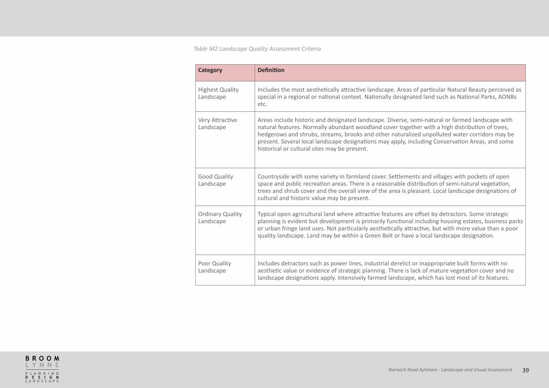
13.8 The baseline landscape and townscape quality was evaluated using the GLVIA guidelines and its classification follows a five point scale interpreted in tables M1 and M2, based on best practice from previous assessments.
Category Definition
Highest value townscape
Nationally or regionally important townscape with high quality, highly valued rare or unusual features. Diverse, stimulating and thriving street level uses with a high level of human comfort, interactive pedestrian environment and strong hierarchy of public amenity and civic spaces. National area/feature designation and assemblage of important listed historical and rich cultural features including Conservation Areas and Listed Buildings or valued modern buildings. Well maintained unified townscape with attractive visual detail and no detractors. Negligible pedestrian and traffic conflict.
Very attractive Townscape
Locally distinctive development form with rich cultural associations using good quality locally characteristic materials. Harmonious relationship between buildings and hierarchy of publicly accessible spaces. Several Listed Buildings or local area/feature designations may apply including features of regional interest. Highly permeable, well maintained and no significant townscape detractors. Townscape promotes social interaction and pedestrian movement dominates traffic circulation with few conflicts.
Good Townscape
Features with historical/cultural local value, possibly designated. Locally distinctive townscape, vernacular or planned layout often with ornamentation in good condition and well maintained. Possibly degraded by unsympathetic modern development but retaining essential characteristics with potential for enhancement. Townscape supports social interaction and pedestrian movement co-exists with traffic movement with few conflicts.
Ordinary Townscape
Development is primarily functional, incoherent development form or minimum design criteria being used in contemporary situations. Little indication of local distinctiveness, design expression or ornamentation. Remnant distinctive townscape features may persist but are no longer in context. Few opportunities for social interaction, limited to specific ‘community’ locations. Traffic circulation usually controls pedestrian movement.
Poor Townscape Poorly designed development form using inappropriate materials and/or materials of limited life span. Unsympathetic scale, lacking structure, variety, coherence or clear communication links. Poor boundary definition and arbitrary ‘unowned’ space, often vandalised, rarely used by community. Townscape in poor condition or decline, unwelcoming or even threatening, with a lack of opportunity for social interaction. Pedestrian movement may be inhibited/severely constrained by major transport barrier.
Table M1 Townscape Assessment Criteria
38Norwich Road Aylsham - Landscape and Visual Assessment
Category Definition
Highest value townscape
Nationally or regionally important townscape with high quality, highly valued rare or unusual features. Diverse, stimulating and thriving street level uses with a high level of human comfort, interactive pedestrian environment and strong hierarchy of public amenity and civic spaces. National area/feature designation and assemblage of important listed historical and rich cultural features including Conservation Areas and Listed Buildings or valued modern buildings. Well maintained unified townscape with attractive visual detail and no detractors. Negligible pedestrian and traffic conflict.
Very attractive Townscape
Locally distinctive development form with rich cultural associations using good quality locally characteristic materials. Harmonious relationship between buildings and hierarchy of publicly accessible spaces. Several Listed Buildings or local area/feature designations may apply including features of regional interest. Highly permeable, well maintained and no significant townscape detractors. Townscape promotes social interaction and pedestrian movement dominates traffic circulation with few conflicts.
Good Townscape
Features with historical/cultural local value, possibly designated. Locally distinctive townscape, vernacular or planned layout often with ornamentation in good condition and well maintained. Possibly degraded by unsympathetic modern development but retaining essential characteristics with potential for enhancement. Townscape supports social interaction and pedestrian movement co-exists with traffic movement with few conflicts.
Ordinary Townscape
Development is primarily functional, incoherent development form or minimum design criteria being used in contemporary situations. Little indication of local distinctiveness, design expression or ornamentation. Remnant distinctive townscape features may persist but are no longer in context. Few opportunities for social interaction, limited to specific ‘community’ locations. Traffic circulation usually controls pedestrian movement.
Poor Townscape Poorly designed development form using inappropriate materials and/or materials of limited life span. Unsympathetic scale, lacking structure, variety, coherence or clear communication links. Poor boundary definition and arbitrary ‘unowned’ space, often vandalised, rarely used by community. Townscape in poor condition or decline, unwelcoming or even threatening, with a lack of opportunity for social interaction. Pedestrian movement may be inhibited/severely constrained by major transport barrier.
Category Definition
Highest Quality Landscape
Includes the most aesthetically attractive landscape. Areas of particular Natural Beauty perceived as special in a regional or national context. Nationally designated land such as National Parks, AONBs etc.
Very Attractive Landscape
Areas include historic and designated landscape. Diverse, semi-natural or farmed landscape with natural features. Normally abundant woodland cover together with a high distribution of trees, hedgerows and shrubs, streams, brooks and other naturalized unpolluted water corridors may be present. Several local landscape designations may apply, including Conservation Areas, and some historical or cultural sites may be present.
Good Quality Landscape
Countryside with some variety in farmland cover. Settlements and villages with pockets of open space and public recreation areas. There is a reasonable distribution of semi-natural vegetation, trees and shrub cover and the overall view of the area is pleasant. Local landscape designations of cultural and historic value may be present.
Ordinary Quality Landscape
Typical open agricultural land where attractive features are offset by detractors. Some strategic planning is evident but development is primarily functional including housing estates, business parks or urban fringe land uses. Not particularly aesthetically attractive, but with more value than a poor quality landscape. Land may be within a Green Belt or have a local landscape designation.
Poor Quality Landscape
Includes detractors such as power lines, industrial derelict or inappropriate built forms with no aesthetic value or evidence of strategic planning. There is lack of mature vegetation cover and no landscape designations apply. Intensively farmed landscape, which has lost most of its features.
Table M2 Landscape Quality Assessment Criteria
39Norwich Road Aylsham - Landscape and Visual Assessment

Contribution to the Landscape Character
13.9 Once the quality of the wider landscape is established, it is useful to consider the contribution that the site makes towards the landscape character. This allows an evaluation of sites that are not of a consistent quality with the wider landscape, for example, a degraded site within a high quality and generally intact landscape.
13.10 This evaluation provides a baseline against which proposals can be assessed.
Category Definition
Outstanding Contribution
Where the existing character of the Site is representative of the local landscape character and the structure of the landscape is intact
Very Positive Contribution
Where the existing character of the Site contains many attributes representative of the local landscape character and the structure of the landscape is apparent
Positive Contribution
Where the existing character of the Site contains some attributes representative of the local landscape character and some incongruous elements but the Site does not detract from the local landscape character
Limited Contribution
Where the existing character of the Site contains some attributes representative of the local landscape character but also incongruous elements that detract from the local landscape character
Negative Contribution
Where the existing character of the Site contains no attributes representative of the local landscape character and the incongruous elements detract from the local landscape character.
Table M3 Contribution of the Site to Local Landscape Character
40Norwich Road Aylsham - Landscape and Visual Assessment

Existing Visual Amenity
13.11 This creates a baseline of the current quality of the view and how it is valued, or likely to be valued, by people. Potential impacts on views are assessed against this baseline to give a more accurate picture of the extent of those impacts.
Category Definition
Exceptional Visual Amenity
Where the quality of existing views is such that people would travel some distance to experience them
High Visual Amenity Where the quality of existing views is such that local people would go out of their way to experience them
Good Visual Amenity
Where the quality of existing views is such that there are few incongruous elements
Fair Visual Amenity Where the quality of existing views is such that there are a number of incongruous elements
Poor Visual Amenity Where the quality of existing views is such that the incongruous elements dominate.
Table M4 Existing Visual Amenity
41Norwich Road Aylsham - Landscape and Visual Assessment

Landscape Effects and Receptors
13.12 Landscape effects are defined by the Landscape Institute as ‘changes to landscape elements, characteristics, character, and qualities of the landscape as a result of development’ and these may be adverse, neutral or beneficial, Landscape receptors are things that are affected by landscape impacts and may include the following:• Landscape elements: introduction or removal
of trees, vegetation and built features and other elements which together form landscape patterns;
• Landscape patterns: degradation or erosion of groups and arrangements of landscape elements, which form patterns that are characteristic of landscape character types;
• Landscape character: the landscape character is a product of a combination of factors that contribute to the creation of a unique setting. Landscape character is a product of the combination of geological features, geomorphic processes, floral and wildlife associations, with social, economic and cultural forces; and
• Cumulative landscape effects: these are defined by the Landscape Institute as resulting from additional changes to landscape amenity caused by the proposed development in conjunction with other development (associated or separate from it), or actions that occurred in the past, present or are likely to occur in the foreseeable future.
13.13 The landscape effects have been assessed by
consideration of three criteria:
• The sensitivity of the landscape resource or receptor (very high, high, medium, low or very low);
• The magnitude of the affected landscape resource (no change, low, medium, high and very high); and
• The significance of the impact (major, moderate, minor or negligible).
13.14 Consideration of the sensitivity of the landscape receptor against the magnitude of change posed by the development to give the significance of the impact is fundamental to landscape assessment and each of these criteria has been defined in more detail with relevance to this assessment.
Sensitivity of Landscape Receptors
13.15 The sensitivity of landscape receptors have been determined by reference to the baseline assessment of the existing landscape. The classification of sensitivity with regard to landscape receptors is defined further in Table M5 and is derived from consideration of the existing (baseline) landscape receptors as follows:• Landscape condition: the state of repair of the
elements of a particular landscape, the integrity and intactness and the extent to which its distinctive character is apparent;
• Landscape value: the importance attached to a landscape or its elements. This is most readily
recognised by the existence of any planning policy designations. These may express national or local consensus, and generally reflect aspects of its quality, cultural associations, scenic or aesthetic characteristics or ecological state. The rarity of the landscape or its particular representation of a certain landscape character may also be considered; and
• Landscape capacity: the ability of a particular landscape or element to absorb change without unacceptable adverse effects on its character. This may be considered with reference to existing landscape characteristics such as scale, topography and existing screening elements as well as landscape change, including the presence of existing development. Generally, landscapes that are already influenced by the type of development proposed have a greater capacity to accommodate the proposed changes, whilst those lacking any influence from similar development will have less capacity.
13.16 It is important to use sensitivity criteria of an appropriate scale for the development. In some cases where criteria are chosen to reflect nationally sensitive sites, such as designated National Parks or Areas of Outstanding National Beauty, it is possible that issues of local importance are under emphasised. The opposite is also true. If the highest significance is assigned to nationally designated landscapes and the study area falls within one, there is the assumption
42Norwich Road Aylsham - Landscape and Visual Assessment
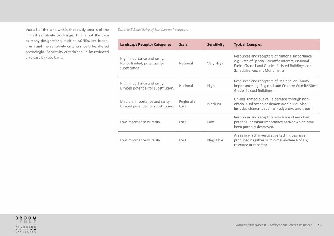
that all of the land within that study area is of the highest sensitivity to change. This is not the case as many designations, such as AONBs, are broad-brush and the sensitivity criteria should be altered accordingly. Sensitivity criteria should be reviewed on a case by case basis.
Landscape Receptor Categories Scale Sensitivity Typical Examples
High importance and rarity. No, or limited, potential for substitution.
National Very High
Resources and receptors of National Importance e.g. Sites of Special Scientific Interest, National Parks, Grade I and Grade II* Listed Buildings and Scheduled Ancient Monuments.
High importance and rarity. Limited potential for substitution. National High
Resources and receptors of Regional or County Importance e.g. Regional and Country Wildlife Sites, Grade II Listed Buildings.
Medium importance and rarity. Limited potential for substitution.
Regional / Local Medium
Un-designated but value perhaps through non-official publication or demonstrable use. Also includes elements such as hedgerows and trees.
Low importance or rarity. Local LowResources and receptors which are of very low potential or minor importance and/or which have been partially destroyed.
Low importance or rarity. Local NegligibleAreas in which investigative techniques have produced negative or minimal evidence of any resource or receptor.
Table M5 Sensitivity of Landscape Receptors
43Norwich Road Aylsham - Landscape and Visual Assessment

Visual Effects and Receptors
13.17 Visual effects are concerned wholly with the effect of the development on views, and general visual amenity of people who have (or will have) views of the development. Visual effects may include the following:
• Visual obstruction: physical blocking of view;
• Visual intrusion: the visual intrusion of the proposed development into an existing view or loss of particular landscape element or features already present in the view; and
• Cumulative visual effects: the cumulative or incremental visibility of similar types of development may combine to have cumulative visual effect, this may concern intervisibility where more than one development may be viewed simultaneously from a viewpoint, or occur sequentially where developments may be viewed from a number of differing location, most commonly from a road, rail route or long distance path.
Sensitivity of Visual Receptors
13.18 Based on the Guidelines for Landscape and Visual Impact Assessment (GLVIA), the different receptor categories are ranked in order of their sensitivity to visual effects as set out in Table M6. It should be stressed that this table is indicative only as it would be impossible to rigidly tabulate sensitivity to change.
Category Sensitivity
Including viewer within nationally designated townscape features (such as the setting of an Area of Outstanding Natural Beauty). Users of such areas are often very aware of the value of views.
Very High
Including viewers looking from windows of their own residential properties or recreational viewers using public rights of way or the setting of a Grade II* listed building.
High
Including views from people engaged in outdoor sports or recreation. Such users are not wholly focused on the landscape around them.
Medium
Including people with cars and on other transport routes. Low
Including people working inside who are not focused on views outside. Negligible
Table M6 Sensitivity of Visual Receptors
Nature
13.19 An impact may be adverse, neutral or beneficial in nature. However, as planting proposed as part of mitigation measures matures, the degree to which the nature of the impact is adverse may reduce, or the degree to which it is beneficial may increase. This is termed as reducing adverse or increasing beneficial.
44Norwich Road Aylsham - Landscape and Visual Assessment

Magnitude of Landscape Effects
13.20 Magnitude of landscape impact is a function of the following factors:• The nature of the effect; and
• The degree of change to the landscape element, taking into account the proposed mitigation measure
• The overall effect on the landscape receptor can range from degradation to enhancement.
Magnitude of Visual Effects
13.21 Magnitude of visual impact is a function of the following factors:• The distance from receptor to the source;
• The nature of the effect (obstruction, intrusion, cumulative); and
• The degree of change to the existing view caused by the construction of an intrusive feature or the obstruction or modification of an existing view, taking into account the agreed mitigation measures. The overall effect upon visual amenity can range from degradation to enhancement.
13.22 It is important to note that magnitude is not a judgement on whether the impact is positive or negative.
Table M7 Magnitude of Landscape Effects
Predicted Landscape Effects Magnitude
Significant loss of, or major alteration to, key elements/features/characteristics of the landscape or introduction of elements considered to make significant changes within the receiving landscape.
Very High
Noticeable loss of, or alteration to, key elements/features/characteristics of the landscape or introduction of elements that may be prominent within the receiving landscape.
High
Partial loss of, or some alteration to, key elements/features/characteristics of the landscape or introduction of elements that may be noticeable within the receiving landscape.
Medium
Minor loss of, or minor alteration to, key elements/features/characteristics of the landscape or introduction of elements that are barely noticeable within the receiving landscape.
Low
No loss of, or alteration to, key elements/features/characteristics of the landscape and no introduction of features.
No Change
45Norwich Road Aylsham - Landscape and Visual Assessment

Predicted Visual Effects Magnitude
The proposals become the dominant feature of the scene to which other elements become subordinate and they significantly affect and change its character. A complete change in view.
Very High
The proposals may form a visible and recognisable new element within the overall scene and may be readily noticed by the observer or receptor. A significant change in view.
High
The proposals are visible within the view and have an effect on the quality of the scene. A noticeable change in view.
Medium
The proposals constitute only a minor component of the wider view, which might be missed by the casual observer or receptor. Awareness of the proposals would not have a marked effect on the overall quality of the scene. A barely perceptible change in view.
Low
No part of the development is discernible. No Change
Table M8 Magnitude of Visual Effects
46Norwich Road Aylsham - Landscape and Visual Assessment

Predicted Visual Effects Magnitude
The proposals become the dominant feature of the scene to which other elements become subordinate and they significantly affect and change its character. A complete change in view.
Very High
The proposals may form a visible and recognisable new element within the overall scene and may be readily noticed by the observer or receptor. A significant change in view.
High
The proposals are visible within the view and have an effect on the quality of the scene. A noticeable change in view.
Medium
The proposals constitute only a minor component of the wider view, which might be missed by the casual observer or receptor. Awareness of the proposals would not have a marked effect on the overall quality of the scene. A barely perceptible change in view.
Low
No part of the development is discernible. No Change
Landscape Capacity
13.23 The process for undertaking this study involves two stages;-
• Definition of local level landscape character areas.
• Assessment of landscape capacity.
Definition of local level landscape character areas
13.24 Prior to assessment of landscape capacity a review of the areas within the study area was required in order to define boundaries for assessment. These boundaries are called ‘Character Areas’ and the establishment of these is based on guidance within “Landscape Character Assessment - Guidance for England and Scotland” (Countryside Agency and Scottish Natural Heritage, April 2002).
13.25 Character areas are defined as…’ distinct, recognisable and consistent patterns of elements in the landscape that makes that landscape different from another’ . Elements and features assessed include a number of different aspects such as the geological pattern, landform, land use, vegetation, ecology, scale and enclosure.
13.26 This characterisation process has already been completed to a district-wide level within the Borough Landscape Character Assessment - June 2001 (BLCA). However the areas within this are considered to be too large for assessment of landscape capacity. Therefore
the character areas within the BLCA were refined in order to produce smaller local–level character areas. This was carried out through desk-top study and on-site assessment using the above guidance.
Assessment of Landscape Capacity
13.27 Landscape Capacity is defined as ‘the extent to which a particular area or type of landscape is able to accommodate change without significant effects on character or overall change in landscape type’. Ref - ‘Topic Paper 6 - Techniques and criteria for judging capacity and sensitivity’ (Countryside Agency and Scottish Natural Heritage, Jan 2004) and illustrates methods for assessing Landscape Capacity.
13.28 The Landscape Capacity is a combination of the sensitivity of the landscape character (both physical/aesthetic and visual) and the value attached to the landscape, and can be expressed as follows;-
13.29 This is adapted from Figure 1(b): Summary of factors to consider in judging landscape capacity for a particular type of change. Page 5, ‘Topic Paper 6 - Techniques and criteria for judging capacity and sensitivity’ (Countryside Agency and Scottish Natural Heritage, Jan 2004)
13.30 Note 1 - In order to provide a consistent assessment, the nature of the type of development that are likely to have an impact on the landscape needs to be defined . For the purposes of this study, it has been agreed that the likely form of development will consist of mainly 2-3 storey residential development with some 4 storey buildings; however, likely numbers of houses and layouts have not been defined but have been assumed to be in range of 35-50 houses per hectare.
13.31 Using this method, the Landscape Sensitivity and Visual Sensitivity of each character area are combined to produce an overall Landscape Character Sensitivity.
13.32 The Landscape Character Sensitivity is then combined with the Landscape Value of the area to produce the overall Landscape Capacity for each character area. The value of the landscape is important in the process as the value attached to certain landscapes will need to be considered in relation to the capacity of the landscape to accept change.
13.33 These aspects and the elements assessed within them can be defined as follows;-
Landscape Capacity to accommodate specific type
of change= Landscape Character Sensitivity
Landscape Sensitivity plus Visual Sensitivity + Landscape Value
47Norwich Road Aylsham - Landscape and Visual Assessment

LANDSCAPE SENSITIVITY
13.34 This is based on judgements about sensitivity of physical and aesthetic elements in the landscape that are most likely to be affected. The level of sensitivity is based on ….a professional judgement about the degree to which the landscape in question is robust, in that it is able to accommodate change without adverse impacts on its character. This means making decisions about;-
• whether or not significant characteristic elements of the landscape will be liable to loss through disturbance;
• whether or not they could be easily restored and;
• whether important aesthetic aspects of character will be liable to change;
• the consideration of new elements, which may also have a significant influence on character.
13.35 These decisions need clear and consistent thought
about three factors;-
• the individual elements that contribute to character; their significance and their vulnerability to change;
• the overall quality and condition of the landscape in terms of it’s intactness; representation of typical character and condition; and
• the aesthetic aspects of landscape character – including scale; enclosure, diversity, form, colour,
line pattern and texture. These elements may have significance for judgements about sensitivity and are different from the perceptual aspects of landscape character which are much more subjective.
(Page 5-6, Topic Paper 6 - Techniques and Criteria for Judging
Capacity and Sensitivity’ (Countryside Agency and Scottish Natural
Heritage, Jan 2004).
13.36 Assessment of these will help to measure the endurance of the landscape character representing the likelihood of change in relation to the degree to which the landscape is able to tolerate change.
13.37 The aspects most likely to be affected and illustrations as to how the level of sensitivity are assessed is based on the following;- Natural Factors
13.38 Vegetation – the nature and extent of woodland and hedgerows will have different sensitivities (e.g. an area with a strong and extensive hedgerow structure will be more sensitive to change than a landscape with few hedges; natural woodland may be more sensitive than a plantation).
13.39 Extent and pattern of semi-natural habitat – presence, size and dispersal of seminatural habitats. There are areas which have greater sensitivity due to the nature of habitats (e.g. species rich grassland will be more sensitive than areas in continued arable crop
production).
13.40 Landform and drainage – presence of water courses, distinctive features (valleys, scarps etc), slopes and elevation all contribute to the sensitivity of the landscape (e.g. features such as prominent slopes, ridges and river valleys would be more sensitive to development than flat landscapes.
Cultural factors
13.41 Land use/function of the area – the nature of land use, the level of scarcity and resilience to change will all have a level of sensitivity attached (e.g. an area of woodland would be more sensitive to change than area of urban fringe activities such as paddocks)
13.42 Settlement Patterns – nature and extent of settlement patterns, would they be sensitive to change (e.g. sprawling urban fringe may be less sensitive to change than a clear town/country divide)
13.43 Historical features – the presence of historical features adds to the sensitivity because of the need to preserve their integrity. Features such as historical parks, Scheduled Ancient Monuments (SAM), Roman roads and scarce/uncommon historical landscape types. The level of sensitivity will depend on their presence, nature and extent.
48Norwich Road Aylsham - Landscape and Visual Assessment

Landscape quality and condition
13.44 Representation of typical character – this will indicate how similar the area is to the landscape character area within which it exists, how many of the typical features it exhibits.
13.45 Intactness – this indicates how well the landscape has survived over a period of time and whether significant features have been lost (e.g. hedges, woods).
13.46 State of repair – this assesses how well the landscape is looked after and whether elements such as hedges have been managed consistently. Aesthetic Factors
13.47 The aesthetic value of the character areas includes an assessment of sensitivity of the following elements – scale, enclosure, diversity, texture, form, pattern and prominence of skyline. (e.g. areas which are small scale; open character; display a greater level of unity rather than fragmentation; possess a number of local visual horizons could all have a greater level of sensitivity).
VISUAL SENSITIVITY
13.48 The study will also take account of the visual sensitivity of the landscape and consideration as to the way people see the landscape. This depends on; -
General Visibility
13.49 This considers the level of visibility (or intervisibility)
in the area, based on the nature of the landform and vegetation cover. Landscapes with higher levels of intervisibility are more sensitive to change.
13.50 This will also consider any key views and the contribution the area makes to the visual setting of an area (including visual links to the wider landscape). Areas containing wider panoramas across areas of countryside will be more sensitive. Population
13.51 This element will consider the number (magnitude) of people likely to perceive change in the landscape. The higher the number of people then the greater the level of magnitude.
13.52 The purpose of viewers being within an area (sensitivity) is considered, as the nature of activity will have a bearing on how visually sensitive the landscape is (e.g. residential and recreational pursuits (e.g. walking) are considered to be more sensitive than transient views of people travelling through or where there are views from workplaces). Mitigation Potential
13.53 This aspect considers the likelihood of change being mitigated, without the mitigation measures themselves having an adverse effect (for example, planting trees to screen a development in a large-scale open landscape could have as great an impact as the development itself). The level of sensitivity
relates to how appropriate mitigation may be in an area, for example, in an area where mitigation is more appropriate the sensitivity would be lower. LANDSCAPE VALUE
13.54 The value of the landscape is an important element in assessing the overall landscape capacity of an area. These are more subjective, experiential or perceptual aspects that can also reflect the local value of a landscape to a community and includes both designated and non-designated elements. These include; - Designations
13.55 The value of a landscape can be recorded by some form of formal designation – from national down to local level. The nature, number and extent of the designation may also indicate the level of sensitivity of the landscape to change – whether physical, visual or historical and is recorded within the assessment as such.
Perceptual Aspects
13.56 The perceptual value of character areas need to be considered within the assessment. The tranquillity of an area can be defined by the extent of noise sources within an area; the absence of views of development and the absence of human activity. The scenic beauty of an area is the subjective value given to an area relating
49Norwich Road Aylsham - Landscape and Visual Assessment

to pleasing patterns and combinations of landscape features that appeal primarily to visual senses. The value will relate to the presence and extent of these aspects.
Settlement Edge
13.57 This aspect refers to the functional (as opposed to visual) role that an area has in relation to the settlement edge. This could relate to whether or not an area defines some form of physical separation between two areas. The level of sensitivity will relate to the presence and extent of these aspects. Local Associations
13.58 There are sometimes parts of landscape areas that have special associations or meanings to a local community and therefore make a contribution to the value of the local landscape. Often, these are not designated but still need to be recorded in some manner in relation to the landscape capacity of the area. Assessing this aspect is an intensive area of work, often requiring extensive local knowledge beyond the resource capability of this study. Therefore, in order to reflect this in the assessment, each area is assumed to have a medium level of sensitivity in relation to cultural associations, except where there is some known aspect that contributes to the value of the area. It is possible that this element could be reviewed as time progresses.
Assessment Thresholds
13.59 Each of the three aspects described above (a. Landscape Sensitivity, b. Visual Sensitivity and c. Landscape Value) have been assessed on a 5 point scale – low, low/medium, medium, medium-high and high. This assessment is based on how prominent each of the categories is within the character area and also the relative sensitivity of each element to change.
Landscape Character Sensitivity
13.60 In order to establish the overall Landscape Character Sensitivity for each of the character areas the individual assessments for Landscape Sensitivity and the Visual Sensitivity are combined on a matrix as below;-
Landscape Capacity
13.61 The result for the Overall Landscape Character Sensitivity is then combined on a similar matrix with the Landscape Value for each of the character areas to produce the overall Landscape Capacity.
13.62 In relation to this study, the following indicates the likely level of development that a landscape character area could accommodate;-
13.63 Low – The landscape character area could not accommodate areas of new development without a significant and adverse impact on the landscape character. Occasional, small scale development may be possible, providing it has regard to the setting and
LAN
DSCA
PE C
HARA
CTER
SEN
SITI
VITY
High Medium Medium/Low Low Low Low
Medium/High
Medium/High Medium Medium/
Low Low Low
Medium High Medium/ High Medium Medium/Low Low
Low/ Medium High High Medium/ High Medium Medium/Low
Low High High High Medium/High Medium
Low Low/Medium Medium Medium/High High
LANDSCAPE VALUE
50Norwich Road Aylsham - Landscape and Visual Assessment

LAN
DSCA
PE S
ENSI
TIVI
TY
High Medium Medium/High
Medium/High High High
Medium/High Low/ Medium Medium Medium/
HighMedium/
High High
Medium Low/ Medium Low/ Medium Medium Medium/High
Medium/High
Low/ Medium Low Low/ Medium Low/ Medium Medium Medium/
High
Low Low Low Low/ Medium Low/ Medium Medium
Low Low/Medium Medium Medium/High High
VISUAL SENSITIVITY
form of existing settlement and the character and the sensitivity of adjacent landscape character areas.
13.64 Low/ Medium – Thresholds for development are low and development can be accommodated only in limited situations, providing it has regard to the setting and form of existing settlement and the character and the sensitivity of adjacent landscape character areas.
13.65 Medium - Thresholds for change are intermediate with the landscape character area able to accommodate areas of new development in some parts, providing it has regard to the setting and form of existing settlement and the character and sensitivity of adjacent landscape character areas.
13.66 Medium/ High – Thresholds for change are high and the area is able to accommodate larger amounts of development, providing it has regard to the setting and form of existing settlement and the character and the sensitivity of adjacent landscape character areas.
13.67 High – Thresholds for change are very high and much of the area is able accommodate significant areas of development, providing it has regard to the setting and form of existing settlement and the character and the sensitivity of adjacent landscape character areas.
51Norwich Road Aylsham - Landscape and Visual Assessment

Very High
including viewers within nationally designated
townscape features, (such as the setting of and Area of Outstanding Natural Beauty).
Users of such areas are often very aware of the value
of views
High
Including viewers looking from windows of their own residential properties or
recreational viewers using public rights of way or the setting of a Grade II* listed
building.
Medium
Including views from people engaged in outdoor sports or recreation. Such users are not wholly focused on the landscape around them.
Low
Including people within cars and on other transport
routes.
Very Low
Including people working inside who are not focused
on views outside.
Sev
ere
A
com
plet
e ch
ange
in
the
view Severe
MajorMajor
ModerateModerate
Major Moderate Minor
Maj
or
A si
gnifi
cant
ch
ange
in
the
view
MajorMajor
ModerateModerate
MinorModerate Minor
Mod
erat
e
A no
ticea
ble
chan
ge in
th
e vi
ew MajorModerate
ModerateMinor
Minor
Moderate Minor Negligible
Min
or
A pe
rcep
ible
ch
ange
in
the
view
ModerateModerate
MinorMinor
NegligibleMinor Negligible
Neg
ligib
le
A
bare
ly
perc
eptib
le
chan
ge in
th
e vi
ew
Negligible Negligible Negligible Negligible Negligible
Non
e
No
chan
ge
None None None None None
Sensitivity of Receptors lies along a continuum from very high to very low, depending on where the view is from (the status of that place) and the activities of the viewer at that location
Mag
nitu
de o
f effe
ct li
es a
long
a c
ontin
uum
from
seve
re to
non
e w
ith a
n ov
erla
p be
twee
n ea
ch d
efine
d ca
tego
ry. T
his w
ill d
epen
d on
the
amou
nt o
f vie
w a
ffect
ed, t
he n
umbe
r of v
iew
ers a
ffect
ed
and
the
dura
tion
of th
e eff
ect
Matrix M1 Calculation of Significance of Effects
52Norwich Road Aylsham - Landscape and Visual Assessment

Eden Cottage, Hunt’s Corner, Banham, Norfolk NR16 2HL. tel: 01953 887656 mob: 07563 538638