Keystone XL Project – Montana Major Facility Siting … · Keystone XL Project – Montana Major...
248
Transcript of Keystone XL Project – Montana Major Facility Siting … · Keystone XL Project – Montana Major...


Keystone XL Project – Montana Major Facility Siting Act Application
Abbreviations and Acronyms
AACE Association for the Advancement of Cost Engineering
AADT average annual daily traffic
ACEC Area of Critical Environmental Concern
AIRFA American Indian Religious Freedom Act
amsl above mean sea level
ANSI American National Standards Institute
APE area of potential effect
API American Petroleum Institute
ASME American Society of Mechanical Engineers
ASTM American Society for Testing and Materials
ATW additional temporary workspace
BLM Bureau of Land Management
BMP Best Management Practices
BNSF Burlington Northern Santa Fe Railway
bpd barrels per day
CAA Clean Air Act
CAPP Canadian Association of Petroleum Producers
CEQ Council on Environmental Quality
CFR Code of Federal Regulations
CH4 methane
CMRP Construction, Mitigation, and Reclamation Plan
CO carbon monoxide
CO2 carbon dioxide
ConocoPhillips ConocoPhillips Company
CRIS Cultural Resources Information Systems Report
i December 2008

Keystone XL Project – Montana Major Facility Siting Act Application
CWA Clean Water Act
dBA decibels on the A-weighted scale
DNRC Department of Natural Resources and Conservation
DOS US Department of State
EDMS Electronic Document Management System
EIA Energy Information Administration
EIS Environmental Impact Statement
EPA Environmental Protection Agency
ERP Emergency Response Plan
ESA Endangered Species Act
°F Degrees Fahrenheit
FBE fusion bonded epoxy
FEMA Federal Emergency Management Agency
FERC Federal Energy Regulatory Commission
GHG greenhouse gas
GIS Geographic Information System
gpm gallons per minute
HCA high consequence area
HDD horizontal directional drilling
IEC International Electrotechnical Commission
IPA Integrated Public Awareness Program
Keystone TransCanada Keystone Pipeline, L.P.
Ldn day-night (average sound) level
Leq equivalent sound level
MAAQS Montana Ambient Air Quality Standards
MCWCA Montana County Weed Control Act
MDR Montana Department of Revenue
ii December 2008
Keystone XL Project – Montana Major Facility Siting Act Application
MEPA Montana Environmental Policy Act
MFSA Major Facility Siting Act
MFWP Montana Fish, Wildlife and Parks
mg/L milligrams per liter
MLA Mineral Leasing Act
MOP Maximum Operating Pressure
MOU Memorandum of Understanding
MTNHP Montana Natural Heritage Program
MWCA Montana Weed Control Act
N2O nitrous oxide
NAAQS National Ambient Air Quality Standards
NACE National Association of Corrosion Engineers
NAGPRA Native American Graves Protection and Repatriation Act
NDT non-destructive testing
NEPA National Environmental Policy Act
NHD national hydrographic dataset
NHPA National Historic Preservation Act
NNSR Non-Attainment New Source Review
NO2 nitrogen dioxide
NPDES National Pollutant Discharge Elimination System
NPS National Park Service
NRCS Natural Resource Conservation Service
NRHP National Register of Historic Places
NSO no surface occupancy
NWP Nationwide Permits
NWR National Wildlife Refuge
O3 ozone
iii December 2008
Keystone XL Project – Montana Major Facility Siting Act Application
OCC Operations Control Center
OPS Office of Pipeline Safety
Pb lead
PEM palustrine emergent wetlands
PFO palustrine forested wetlands
PFYC Potential Fossil Yield Classification
PHMSA Pipeline and Hazardous Materials Safety Administration
PM10 particulate matter, 10 microns or less
PM2.5 particulate matter, 2.5 microns or less
ppm parts per million
POD Plan of Development
ppmw parts per million by weight
Project Keystone XL Project
PSD Prevention of Significant Deterioration
psig pounds per square inch gauge
PSS palustrine scrub-shrub wetlands
RMP resource management planning
ROW right-of-way
RP recommended practice
SCADA Supervisory Control and Data Acquisition
SCORP Statewide Comprehensive Outdoor Recreation Plan
SHPO State Historical Preservation Officer
SIP State Implementation Plan
SO2 sulfur dioxide
SPCC Spill Prevention, Control, and Countermeasure
SSURGO Soil Survey Geographic
SWPA Source Water Protection Area
iv December 2008

Keystone XL Project – Montana Major Facility Siting Act Application
v December 2008
SWPP Storm Water Pollution Prevention Plan
TCP traditional cultural property
TDS total dissolved solids
TLS timing limitations
TMDL total maximum daily load
TOP TransCanada Operating Procedure
tpy tons per year
TransCanada TransCanada Corporation
TSS total suspended solids
µg/m3 micrograms per cubic meter
US United States
USACE United States Army Corps of Engineers
USC United States Code
USCB United States Census Bureau
USDA United States Department of Agriculture
USDOT United States Department of Transportation
USEPA United States Environmental Protection Agency
USFWS United States Fish and Wildlife Service
USGS United States Geological Survey
vpd vehicles per day
VRM Visual Resource Management
WCSB Western Canadian Sedimentary Basin
WEG Wind Erodibility Group
WSA Wilderness Study Area

Keystone XL Project – Montana Major Facility Siting Act Application
Contents
Abbreviations and Acronyms............................................................................................................................... i
1.0 Introduction and Description of the Proposed Facilities .....................................................................1-1 1.1 Introduction ..........................................................................................................................................1-1 1.2 Description of the Proposed Facilities.................................................................................................1-2 1.3 Design Characteristics (ARM 17.20.1509) .........................................................................................1-4
1.3.1 Reports and Documents (ARM 17.20.1509(2))....................................................................1-8 1.3.2 Design Features (ARM 17.20.1509(3)).................................................................................1-9 1.3.3 Engineering Description of the Facilities (ARM 17.20.1509(8)).........................................1-11 1.3.4 Quality Control (ARM 17.20.1509(9)) .................................................................................1-14 1.3.5 Source of Power for Pump Stations (ARM 17.20.1509(10))..............................................1-15 1.3.6 Communication Facilities (ARM 17.20.1509(11))...............................................................1-16 1.3.7 Opportunities and Constraints on Sharing ROWs (ARM 17.20.1509(12))........................1-16
1.4 Construction Description (ARM 17.20.1511(1)) ...............................................................................1-16 1.4.1 Overview ..............................................................................................................................1-16 1.4.2 Explanation of the Work Area (ARM 17.20.1511(2))..........................................................1-26 1.4.3 Ground Disturbance (ARM 17.20.1511(3)).........................................................................1-26 1.4.4 Topsoil Salvage and Rock Removal (ARM 17.20.1511(4)) ...............................................1-26 1.4.5 Types of Roads for Construction and Operations and Maintenance
(ARM 17.20.1511(5))...........................................................................................................1-26 1.4.6 Construction ROW (ARM 17.20.1511(6))...........................................................................1-27 1.4.7 Stream Crossing Alternatives (ARM 17.20.1511(7))..........................................................1-27 1.4.8 Overhead Stream Crossings (ARM 17.20.1511(8)) ...........................................................1-29 1.4.9 Construction Camps (ARM 17.20.1511(9)) ........................................................................1-29 1.4.10 Reclamation Methods (ARM 17.20.1511(10))....................................................................1-29 1.4.11 Fire Control (ARM 17.20.1511(11)) ....................................................................................1-29
1.5 Operation and Maintenance Description (ARM 17.20.1512)...........................................................1-30 1.5.1 Overview (ARM 17.20.1512(1)) ..........................................................................................1-30 1.5.2 Ability to Withstand Natural Disaster and Human Caused Incidents
(ARM 17.20.1512(2))...........................................................................................................1-31 1.5.3 Description of Methods the Applicant will Employ to Control Land Uses on the
ROW (ARM 17.20.1512(3)).................................................................................................1-33 1.5.4 Description of ROW Management Procedures Including Vegetation and Weed
Control, Herbicide Use, and Scheduled Timing (ARM 17.20.1512(4))..............................1-33 1.5.5 Leak Frequency and Size (ARM 17.20.1512(5))................................................................1-34 1.5.6 Leak Detection (ARM 17.20.1512(6)) .................................................................................1-34 1.5.7 Spill Contingency Plan (ARM 17.20.1512(7)).....................................................................1-35 1.5.8 Abandonment.......................................................................................................................1-35
vi December 2008

Keystone XL Project – Montana Major Facility Siting Act Application
2.0 Facility Costs..............................................................................................................................................2-1 2.1 Estimated Cost of Facilities (ARM 17.20.811)....................................................................................2-1 2.2 Linear Facilities, Estimated Annual Cost (ARM 17.20.815)...............................................................2-2 2.3 Pricing Policy (ARM 17.20.817) ..........................................................................................................2-4 2.4 Evaluation of Economic Costs and Benefits (ARM 17.20.818) .........................................................2-4
3.0 Purpose and Explanation of Need (ARM 17.20.928) .............................................................................3-1 3.1 Increasing Crude Oil Demand in the US.............................................................................................3-1 3.2 Decreasing Domestic Crude Oil Supply .............................................................................................3-1 3.3 Increasing WCSB Crude Oil Supply ...................................................................................................3-1 3.4 Further Supply Diversification to Canadian Crude Oil........................................................................3-2 3.5 Binding Shipper Commitments ...........................................................................................................3-2 3.6 Interconnection Agreements (ARM 17.20.929) ..................................................................................3-2
4.0 Analysis of Alternatives............................................................................................................................4-1 4.1 Evaluation of Alternatives (ARM 17.20.1311).....................................................................................4-1
4.1.1 No Action Alternative .............................................................................................................4-4 4.1.2 Route Alternatives .................................................................................................................4-5
4.2 Alternative Siting Study (ARM 17.20.1426 and Circular MFSA-2) ....................................................4-6 4.2.1 Delineation of the Study Area (Circular MFSA-2, Section 3.2) ............................................4-6 4.2.2 Overview Survey (Circular MFSA-2, Sections 3.3, 3.4, and 3.5).........................................4-6
4.3 Baseline Study Requirements (ARM 17.20.1426 and Circular MFSA-2)..........................................4-7 4.3.1 Introduction ............................................................................................................................4-7 4.3.2 Land Use/Recreation.............................................................................................................4-8 4.3.3 Vegetation............................................................................................................................4-15 4.3.4 Wildlife and Fisheries...........................................................................................................4-22 4.3.5 Water Resources.................................................................................................................4-50 4.3.6 Geology................................................................................................................................4-72 4.3.7 Soils......................................................................................................................................4-98 4.3.8 Paleontology ......................................................................................................................4-105 4.3.9 Cultural Resources ............................................................................................................4-109 4.3.10 Visual Resources...............................................................................................................4-117 4.3.11 Transportation....................................................................................................................4-133 4.3.12 Socioeconomics and Environmental Justice ....................................................................4-139 4.3.13 Noise and Electrical Effects (Circular MFSA-2, Section 3.7(19)(a)(e), and
Section 3.8(1)(h))...............................................................................................................4-162 4.3.14 Air Quality...........................................................................................................................4-165 4.3.15 Cumulative Impacts ...........................................................................................................4-171
4.4 Comparison of Alternatives (Circular MFSA-2, Section 3.9)..........................................................4-172 4.5 Selection of Preferred Facility Location (Circular MFSA-2, Section 3.10)....................................4-180
4.5.1 Keystone’s Selection Criteria (Circular MFSA-2, Section 3.10(1)(a))..............................4-180
vii December 2008

Keystone XL Project – Montana Major Facility Siting Act Application
viii December 2008
4.5.2 Application of Preferred Location Criteria (Circular MFSA-2, Section 3.10(1)(b))..........4-182 4.5.3 Relative Importance of Categories (Circular MFSA-2, Section 3.10(1)(c)) .....................4-182 4.5.4 Avoidance Areas (Circular MFSA-2, Section 3.10(1)(d)) .................................................4-182 4.5.5 Other Areas (Circular MFSA-2, Section 3.10(1)(e)) .........................................................4-182 4.5.6 Conclusion .........................................................................................................................4-183
5.0 Consultation and Coordination..................................................................................................................5-1 5.1 Agency Coordination and Consultation ..............................................................................................5-1 5.2 Federal Approval Process and Authorizing Actions ...........................................................................5-1
5.2.1 Department of State...............................................................................................................5-1 5.2.2 Bureau of Land Management................................................................................................5-1 5.2.3 US Army Corps of Engineers Section 404 (Clean Water Act) Nationwide Permits
and Section 10 (Rivers and Harbors Act) Permits................................................................5-2 5.2.4 Section 106 National Historic Preservation Act ....................................................................5-2 5.2.5 US Fish and Wildlife Service.................................................................................................5-3 5.2.6 Office of Pipeline Safety ........................................................................................................5-3 5.2.7 Permits and Relationship to Non-federal Policies, Plans, and Programs............................5-4
5.3 Public Meetings .................................................................................................................................5-10 5.3.1 Public Participation and Open Houses ...............................................................................5-10

Keystone XL Project – Montana Major Facility Siting Act Application
List of Attachments Attachment A Maps and Aerials (To be provided in Volumes 3, 4A, and 4B)
Attachment B Table of Contents of Emergency Response Plan
Attachment C Construction, Mitigation, and Reclamation Plan
Attachment D Pipeline Risk Assessment and Environmental Consequence Analysis (Montana)
Attachment E Economic Report
Attachment F Public Consultation Record
Attachment G Montana Designated Noxious Weeds and Invasive Species Potentially Occurring Along the Proposed and Alternative Routes
Attachment H Special Status Wildlife Species Potentially Occurring Along the Proposed and Alternative Routes
Attachment I Raptor Nest Surveys
Attachment J Waterbody Crossing Tables
Attachment K Soils Unit Tables for Routes A, A1A, and B
Attachment L Smectitic Soils Associated with Cretaceous Shales
Attachment M Cultural Resources Tables (CONFIDENTIAL To be provided in a separate volume)
Attachment N Landownership Along Access Roads
Attachment O Associated Facilities – Transmission Lines Analysis
Attachment P Keystone Frac Out Plan
ix December 2008

Keystone XL Project – Montana Major Facility Siting Act Application
List of Tables Table 1-1 Pump Stations in Montana...........................................................................................................1-4 Table 1-2 Pipe Design Parameters and Specifications .............................................................................1-11 Table 1-3 Pipe Segments with MOP of 1,600 psig ....................................................................................1-12 Table 1-4 Minimum Pipeline Cover ............................................................................................................1-13 Table 1-5 Project Valve Locations in Montana ..........................................................................................1-13 Table 1-6 Location and Size of Proposed Electrical Power Lines in Montana .........................................1-16 Table 1-7 Waterbodies Crossed in Montana using the HDD Method.......................................................1-24 Table 1-8 Resulting Construction Times Based on Estimates of Schedule (calendar days)...................1-25 Table 1-9 Quantification of Regional Natural Hazards in Montana...........................................................1-31 Table 2-1 Project Capital Costs in and outside Montana ............................................................................2-1 Table 2-2 Linear Facilities, Estimated Annual Costs ...................................................................................2-2 Table 4-1 Surface Ownership Crossed by the Alternative Routes in Miles ................................................4-8 Table 4-2 Land Use Type Crossed by the Alternative Routes (Miles) ........................................................4-9 Table 4-3 Land Use Type Crossed by the Alternative Routes (Acres) .......................................................4-9 Table 4-4 Developed Land Use Type (Miles) ............................................................................................4-10 Table 4-5 Potential Residences/Structures within 500 feet of Facilities Along Alternative Routes..........4-10 Table 4-6 Recreation and Special Interest Areas Crossed in Montana....................................................4-11 Table 4-7 Summary of Route-Specific Land Use Impacts ........................................................................4-14 Table 4-8 Vegetation Types Crossed in Montana .....................................................................................4-15 Table 4-9 Summary of Route-Specific Vegetation Impacts.......................................................................4-21 Table 4-10 Game and Commercial Fish Spawning Periods and Habitat ...................................................4-25 Table 4-11 Big Game Winter Ranges Crossed by Route A ........................................................................4-27 Table 4-12 Route A – Prairie Dog Towns Identified during the September 2008 Aerial Surveys...........4-27 Table 4-13 Game Fisheries in Waterbodies Crossed or Downstream of Route A.....................................4-28 Table 4-14 Big Game Winter Ranges Crossed by Route A1A....................................................................4-30 Table 4-15 Route A1A – Black-tailed Prairie Dog Towns Identified during the September 2008
Aerial Surveys ............................................................................................................................4-30 Table 4-16 Game Fisheries in Waterbodies Crossed or Downstream of Route A1A ................................4-31 Table 4-17 Big Game Winter Ranges Crossed by Route B ........................................................................4-33 Table 4-18 Game Fisheries in Waterbodies Crossed or Downstream of Route B.....................................4-35 Table 4-19 Seasonal Timing Restrictions and Buffers for Big Game, Greater Sage-Grouse,
Sharp-tailed Grouse, Migratory Birds, Bald Eagles, and Raptors ............................................4-40 Table 4-20 Piping Plover Critical Habitat within the Study Area................................................................4-44 Table 4-21 Summary of Route-Specific Wildlife, Fisheries and Special Status Species Impacts .............4-47 Table 4-22 Total Waterbody Crossings for Route A ....................................................................................4-54
x December 2008

Keystone XL Project – Montana Major Facility Siting Act Application
Table 4-23 Waterbodies Greater than 10 Acres within 10 Miles Downstream of Route A Crossing.........4-54 Table 4-24 Impaired Waterbodies Crossed by Route A..............................................................................4-55 Table 4-25 Significant Floodplains along Route A.......................................................................................4-56 Table 4-26 Potential Hydrostatic Testing Water Sources and Drainage Basins for Route A.....................4-56 Table 4-27 Total Waterbody Crossings for Route A1A ...............................................................................4-58 Table 4-28 Waterbodies Greater than 10 Acres within 10 Miles Downstream of Route A1A Crossing ....4-58 Table 4-29 Impaired Waterbodies Crossed by Route A1A .........................................................................4-59 Table 4-30 Significant Floodplains Crossed by Route A1A.........................................................................4-60 Table 4-31 Potential Hydrostatic Testing Water Sources and Drainage Basins for Route A1A ................4-60 Table 4-32 Number and Type of Waterbodies Crossed by Route B...........................................................4-61 Table 4-33 Waterbodies Greater than 10 Acres within 10 Miles Downstream of Route B
Crossing Locations .....................................................................................................................4-61 Table 4-34 Impaired Waterbodies Crossed by Route B..............................................................................4-62 Table 4-35 Significant Floodplains Along Route B.......................................................................................4-66 Table 4-36 Potential Hydrostatic Testing Water Sources and Drainage Basins for Route B.....................4-66 Table 4-37 Summary of Route-Specific Water Resources Impacts............................................................4-71 Table 4-38 Summary of Geologic and Paleontological Resources Along Route A....................................4-74 Table 4-39 Summary of Geologic and Paleontological Resources Along Route A1A ...............................4-77 Table 4-40 Summary of Geologic and Paleontological Resources Along Route B....................................4-79 Table 4-41 Oil and Gas Wells within 1,320 Feet of Route A .......................................................................4-82 Table 4-42 Oil and Gas Wells within 1,320 feet of Route A1A....................................................................4-83 Table 4-43 Oil and Gas Wells within 1,320 feet of Route B ........................................................................4-85 Table 4-44 Landslide Incidence and Susceptibility Along Route A.............................................................4-87 Table 4-45 Landslide Incidence and Susceptibility Along Route A1A ........................................................4-88 Table 4-46 Landslide Incidence and Susceptibility Areas Along Route B ..................................................4-88 Table 4-47 Summary of Route-Specific Geology Impacts ..........................................................................4-93 Table 4-48 Summary of Sensitive Soils along the Proposed Keystone XL Project in Montana
(Miles Crossed)...........................................................................................................................4-99 Table 4-49 Summary of Route-Specific Soils Impacts ..............................................................................4-104 Table 4-50 Summary of Route-Specific Paleontology Impacts.................................................................4-108 Table 4-51 Tribal Contact List in Montana .................................................................................................4-110 Table 4-52 Class I File/Records Search Results .......................................................................................4-110 Table 4-53 Results of Aerial Reconnaissance of Routes ..........................................................................4-111 Table 4-54 Summary of Route-Specific Cultural Resources Impacts.......................................................4-115 Table 4-55 BLM VRM Class Objectives.....................................................................................................4-118 Table 4-56 Alternative A Route Miles by VRM Class ................................................................................4-121
xi December 2008

Keystone XL Project – Montana Major Facility Siting Act Application
Table 4-57 Alternative A1A Route Miles by VRM Class............................................................................4-124 Table 4-58 Alternative B Route Miles by VRM Class ................................................................................4-127 Table 4-59 Summary of Route-Specific Visual Resources Impacts .........................................................4-132 Table 4-60 Roadways and Railroads Crossed by Route A in Montana....................................................4-134 Table 4-61 Location of Major Roads and Railroads Crossed by Route A in Montana.............................4-134 Table 4-62 Roadways and Railroads Crossed by Route A1A in Montana ...............................................4-134 Table 4-63 Location of Major Roads and Railroads Crossed by Route A1A in Montana ........................4-135 Table 4-64 Roadways and Railroads Crossed by Route B .......................................................................4-135 Table 4-65 Location of Major Roads and Railroads Crossed by Route B in Montana.............................4-136 Table 4-66 Summary Comparison..............................................................................................................4-136 Table 4-67 Summary of Ownership Crossed by Access Road for Construction......................................4-137 Table 4-68 Summary of Route-Specific Transportation Impacts ..............................................................4-138 Table 4-69 Affected Communities Along the Alternative Routes ..............................................................4-140 Table 4-70 Socioeconomic Conditions in Affected Counties Along the Project .......................................4-140 Table 4-71 Employment and Income Conditions in Affected Counties Along the
KXL Pipeline Project.................................................................................................................4-142 Table 4-72 Semi-skilled and Skilled Labor in Eastern Montana................................................................4-144 Table 4-73 Housing Assessment for Counties Along the Project .............................................................4-144 Table 4-74 Existing Public Services and Facilities Along the Pipeline Route...........................................4-146 Table 4-75 2002 Operations Budget for Public Services...........................................................................4-148 Table 4-76 Property Mill Levies and Tax Rates for the Project .................................................................4-149 Table 4-77 Environmental Justice Statistics in Affected Counties ............................................................4-151 Table 4-78 Social Statistics in Affected Communities1 ..............................................................................4-153 Table 4-79 Construction Spreads Associated with the Project .................................................................4-159 Table 4-80 Summary of Route-Specific Socioeconomics and Environmental Justice Impacts...............4-161 Table 4-81 Structures/Residences within 500 Feet of Facilities Along Alternative Routes
in Montana ................................................................................................................................4-163 Table 4-82 Summary of Route-Specific Noise Impacts.............................................................................4-164 Table 4-83 Climate Data in the Vicinity of the Keystone XL Project .........................................................4-166 Table 4-84 Ambient Air Quality Standards.................................................................................................4-167 Table 4-85 Summary of Route-Specific Air Impacts..................................................................................4-171 Table 4-86 Alternative Routes Summary Statistics from Morgan, Montana to Steele City,
Nebraska (Circular MFSA-2, Section 3.9(1)(a)) ......................................................................4-173 Table 4-87 Comparison of the Most Important Impacts for the Alternative Facility Locations in
Montana (Circular MFSA-2, Section 3.9(1)(a) and (b))...........................................................4-175 Table 4-88 Ranking of Alternative Facility Locations (Circular MFSA-2, Section 3.9(1)(c)......................4-179 Table 5-1 Permits, Licenses, Approval, and Consultation Requirements...................................................5-4
xii December 2008

Keystone XL Project – Montana Major Facility Siting Act Application
xiii December 2008
List of Figures
Figure 1-1 Proposed Project Route ...............................................................................................................1-2 Figure 1-2 Montana Pipeline and Facility Map..............................................................................................1-5 Figure 1-3 Plot Plan for Pump Station with Pig Launcher and Receiver......................................................1-6 Figure 1-4 Plot Plan of Intermediate Mainline Valve.....................................................................................1-7 Figure 1-5 Typical Construction ROW with 25-foot Minimum Offset..........................................................1-17 Figure 1-6 Typical Uncased Bored Road/Railway Crossing.......................................................................1-22 Figure 1-7 Cross Section of a Typical Construction ROW (Not to Scale)..................................................1-28 Figure 4-1 Minority Populations Along Proposed Pipeline Route – Phase II ...........................................4-155 Figure 4-2 Poverty Distribution Along Proposed Pipeline Route – Phase II ............................................4-156

Keystone XL Project – Montana Major Facility Siting Act Application
1-1
1.0 Introduction and Description of the Proposed Facilities
1.1 Introduction The identity of the applicant is TransCanada Keystone Pipeline, L.P. (Keystone), a limited partnership, organized under the laws of the State of Delaware, and owned by affiliates of TransCanada Corporation (TransCanada), a Canadian public company organized under the laws of Canada, and ConocoPhillips Company (ConocoPhillips), a Delaware corporation. Keystone’s primary business address is 450 1st Street, S.W., Calgary, Alberta, Canada T2P 5H1.
Keystone is proposing to construct and operate a crude oil pipeline and related facilities from Hardisty, Alberta, Canada, to the Port Arthur and east Houston areas of Texas in the United States (US). The project, known as the Keystone XL Project (Project), will have a nominal capacity to deliver up to 900,000 barrels per day (bpd) of crude oil from an oil supply hub near Hardisty to existing terminals in Nederland near Port Arthur, and the Houston Ship Channel in Houston, Texas.
TransCanada PipeLines Ltd. (TransCanada PipeLines) will be the operator of the Project. TransCanada, the parent company of TransCanada PipeLines, has more than 50 years experience in the responsible development and reliable and safe operation of North American energy infrastructure including natural gas pipelines, power generation, gas storage facilities, and projects related to oil pipelines and liquefied natural gas facilities. TransCanada owns and operates a natural gas pipeline network of more than 36,500 miles, which taps into virtually all major natural gas supply basins in North America. TransCanada transports the majority of western Canada’s natural gas production across the North American continent to markets in the US and Canada.
Further, Keystone is in the execution phase of the $5.2 billion Keystone Pipeline project, a major international crude oil pipeline project. The Mainline Segment of the Keystone Pipeline project, which extends from the North Dakota-Canada border to Wood River and Patoka, Illinois; and the Keystone Cushing Extension, which extends from Steele City, Nebraska, to Cushing, Oklahoma, are on schedule for completion in 2009 and 2010, respectively. In addition, TransCanada Corporation permitted and constructed the Express Oil Pipeline through Montana and Wyoming in the 1990s.
TransCanada has total assets of approximately US $30 billion. For the year ending December 31, 2007, TransCanada had a net income from continuing operations of approximately US $1.2 billion and a cash flow of approximately US $2.8 billion.
ConocoPhillips is the third-largest integrated energy company in the US, based on market capitalization, as well as reserves of oil and natural gas. Worldwide, of non-government-controlled companies, ConocoPhillips is the sixth-largest holder of proved reserves and the fifth-largest refiner. Headquartered in Houston, Texas, ConocoPhillips operates in nearly 40 countries, has approximately 33,100 employees worldwide and operates more than 11,000 miles of pipelines and more than 60 storage terminals in the US. ConocoPhillips transports both raw and finished petroleum products, including crude oil, propane and refined products such as gasoline, diesel and jet fuel. The company has assets of $190 billion.
The Project will require the issuance of a Presidential Permit by the US Department of State (DOS) to cross the US/Canada border. Issuance of the Presidential Permit is subject to environmental review pursuant to the National Environmental Policy Act (NEPA) (42 United States Code [USC] 4321 et seq.). The Bureau of Land Management (BLM) will be responsible for issuing right-of-way (ROW) Grants and Temporary Use Permits for Project activities on federal lands. In Montana, the Project requires a certificate under the Montana Major Facilities Siting Act (MFSA), which includes environmental review under the Montana Environmental Policy Act
December 2008
Keystone XL Project – Montana Major Facility Siting Act Application
1-2 December 2008
(MEPA). The Montana Department of Environmental Quality (Montana DEQ) has indicated that it also will use the federal Environmental Impact Statement (EIS) and process to satisfy its own process.
This application provides the Montana DEQ with adequate information to satisfy the requirements of the MFSA. This application includes an objective disclosure of environmental impacts, beneficial and adverse, resulting from the Project, as well as a set of reasonable alternatives.
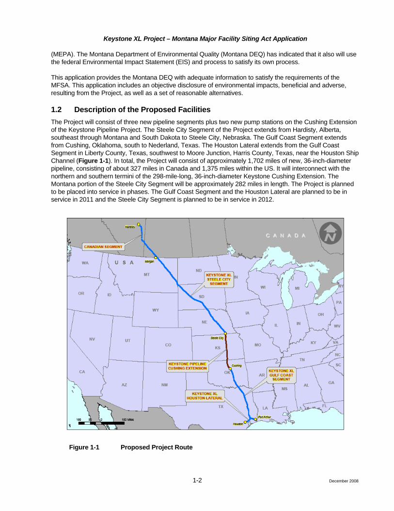
1.2 Description of the Proposed Facilities The Project will consist of three new pipeline segments plus two new pump stations on the Cushing Extension of the Keystone Pipeline Project. The Steele City Segment of the Project extends from Hardisty, Alberta, southeast through Montana and South Dakota to Steele City, Nebraska. The Gulf Coast Segment extends from Cushing, Oklahoma, south to Nederland, Texas. The Houston Lateral extends from the Gulf Coast Segment in Liberty County, Texas, southwest to Moore Junction, Harris County, Texas, near the Houston Ship Channel (Figure 1-1). In total, the Project will consist of approximately 1,702 miles of new, 36-inch-diameter pipeline, consisting of about 327 miles in Canada and 1,375 miles within the US. It will interconnect with the northern and southern termini of the 298-mile-long, 36-inch-diameter Keystone Cushing Extension. The Montana portion of the Steele City Segment will be approximately 282 miles in length. The Project is planned to be placed into service in phases. The Gulf Coast Segment and the Houston Lateral are planned to be in service in 2011 and the Steele City Segment is planned to be in service in 2012.
Figure 1-1 Proposed Project Route
Keystone XL Project – Montana Major Facility Siting Act Application
1-3
In the US, the Project will be constructed as follows:
• 36-inch-diameter Steele City Segment, approximately 850 miles in length, from the US/Canada border at Morgan, Montana, to Steele City, Nebraska, which will be constructed with up to 10 mainline spreads, approximately 80 to 120 miles each, in 2011 and 2012.
• 36-inch-diameter Gulf Coast Segment, approximately 478 miles in length, from Lincoln County, Oklahoma, to Nederland, Texas, which will be constructed with five mainline spreads, varying in lengths from 65 to 122 miles each in 2010 and 2011.
• 36-inch-diameter Houston Lateral, approximately 47 miles in length, from Liberty County, Texas, to Harris County, Texas, which will be constructed with one main spread, in 2011.
A total of 30 new pump stations, each located on an approximate 5-acre site, will be constructed in the US; 18 on the Steele City Segment, 10 on the Gulf Coast Segment, and 2 along the Keystone Cushing Extension in Kansas. Seven of the 18 Steele City Segment pump stations are proposed for construction in Montana.
A tank farm will be located on an approximate 50-acre site near the junction of the Project with the Keystone Cushing Extension in Steele City, Nebraska. Three tanks, each with a design capacity of 350,000 barrels, will be constructed for the purpose of managing oil movements during operations. There are no tank farms in Montana.
Valves will be installed and located as dictated by the hydraulic profile of the pipeline, as required by federal regulations, and with the intent to enhance public safety and protect the environment as part of Keystone’s integrity management practices. The spatial extent of each valve site will be contained within the permanent ROW and other aboveground facility sites (e.g., pump stations) along the Project route. Permanent access to each of these intermediate sites will be acquired.
Densitometer sites for detection of crude oil batch interfaces will be co-located at the last valve upstream of each delivery location as well as at each delivery location. There are no densitometer sites in Montana.
Delivery metering and proving facilities at Nederland, Texas, and Moore Junction, Texas, will measure the amount of product transported and delivered to terminals. There are no delivery metering facilities in Montana.
Temporary use access roads to the construction ROW and temporary use contractor yards or stockpile sites will be required during construction of the Project. Access roads will vary in length and will be required every 5 to 10 miles along the pipeline route and will be about 20 to 30 feet wide. Temporary construction pipe stockpile sites and contractor yards will be up to 30 acres in size. Pipe stockpile sites will be located at 30- to 80-mile intervals along the proposed route. Contractor yards are expected to be needed every 60 miles.
Electric power lines will be constructed, as required, by local power providers to provide power for the new pump stations and to power remotely operated valves and densitometers located along the pipeline route.
Power line and associated facility upgrades will be required in multiple locations along the route. Keystone will not construct nor be responsible for the permitting of new power lines and related facility construction. Local power providers will be responsible for obtaining any necessary approvals or authorizations from federal, state, and local governments for such facilities (subject to the exception noted below). Although the permitting process for the electrical facilities is an independent process, construction and operation of these facilities are considered connected actions under NEPA and MEPA. Moreover, these facilities are associated facilities under the MFSA and are evaluated within this application. Keystone will file a separate ROW Grant Application with BLM for power lines that cross BLM lands along the Steele City Segment. This is required by the BLM in order to ensure those ROWs are processed in parallel with the EIS. Keystone will transfer those ROW grants to the appropriate power providers once those power providers have been selected and have started their permitting processes.
December 2008

Keystone XL Project – Montana Major Facility Siting Act Application
1-4 December 2008
1.3 Design Characteristics (ARM 17.20.1509) The Project has been designed to transport crude oil from Canada to the US Gulf Coast. The pipeline will have a nominal capacity to deliver up to 900,000 bpd. The pipeline route and associated pump stations are shown in Figure 1-2. The pipeline system will be designed, constructed, and operated to meet or exceed all applicable regulatory requirements. Additional information with regard to specific elements of the Project design is provided in subsequent sections.
The 36-inch-diameter pipeline will be buried and placed in a 50-foot-wide permanent easement. During construction, an additional 60-foot-wide temporary easement generally will be required for the safe installation of the pipeline. As described later, under certain site-specific circumstances, additional or reduced temporary work space may be required.
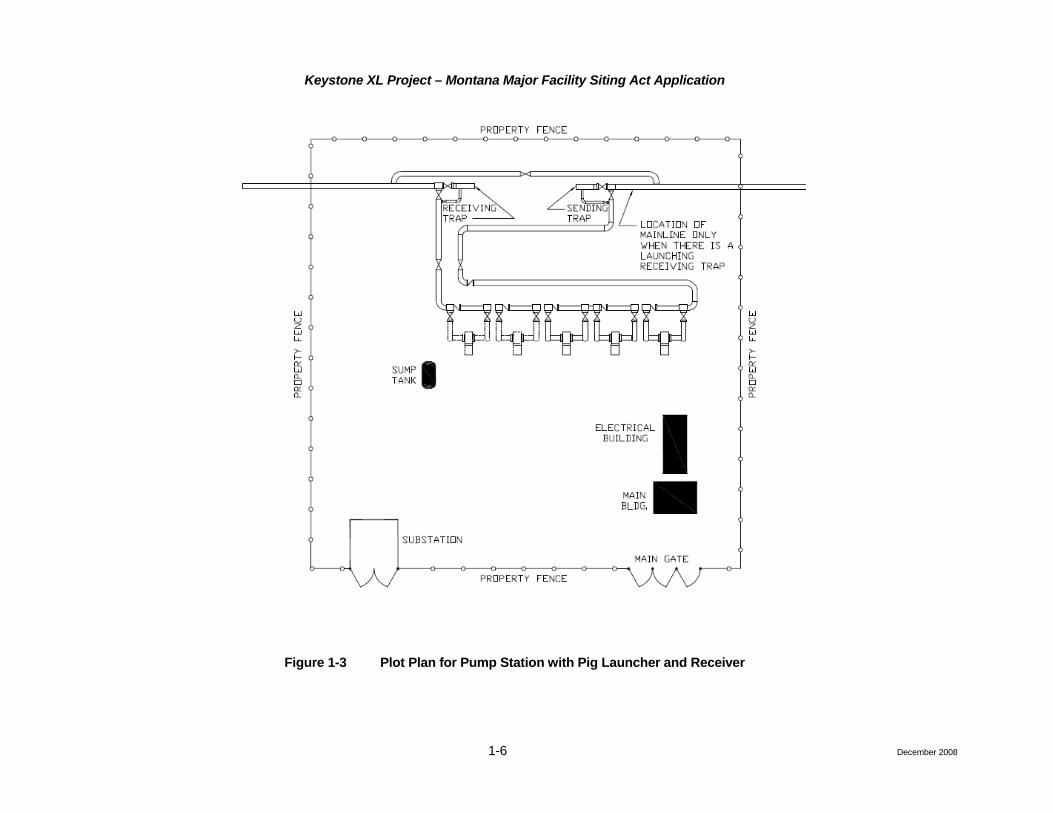
Seven pump stations will be located in Montana. The pump station requirements to support this system capacity is shown in Table 1-1. Each pump will be driven by an air-cooled electric motor. Pig launchers and receivers, typically 200 miles apart, will be installed in Montana at Pump Stations 9 and 13. A typical plot plan of a pump station with a pig launcher and receiver is shown in Figure 1-3. Mainline valves will be installed at each pump station.
Table 1-1 Pump Stations in Montana
Pump Station Number Milepost County Legal Acres
Total Numberof Pumps
PS 09 1.1 Phillips 4-37N – 32E 5 5
PS 10 49.3 Valley 1-31N – 36E 5 5
PS 11 97.9 McCone 1-25N – 42E 5 5
PS 12 148.6 McCone 18-19N – 49E 5 5
PS 13 198.6 Prairie 30-13N – 54E 5 5
PS 14 236.5 Fallon 11-8N – 58E 5 5
PS 15 280 Fallon 25-2N – 61E 5 5
Intermediate mainline valve sites located between the pump stations will be fenced and have a locked gate and be accessible by a permanent access road. On the downstream side of major river crossings, there will be a combination of a manually operated mainline valve and a check valve. This will prevent backflow from the downstream pipe section in the event of abnormal conditions. All other intermediate valves and those located at the pump stations will be remotely operated. Plot plans of the intermediate mainline valves are shown in Figure 1-4.
The exterior of the pipe will be coated with fusion-bonded epoxy (FBE) to protect the pipe from external corrosion. In addition to a FBE external coating system, an impressed current cathodic protection system will be installed.

!(
!(
!(
!(
!(
!(
!(
!(
Canada
MTMTNDND
SDSD
ValleyCountyPhillips
County
PerkinsCounty
HardingCounty
McConeCounty
Butte County
DawsonCounty
PrairieCounty
FallonCounty
Billings
Lame DeerMuddy
Klein
Hays
St. Marie
Busby
Lodge Pole
Agency
Mandaree
Dickinson
Ashland
St. Pierre
Williston
Fallon
Pryor
Lockwood
Azure
HerronGildford
Fox Lake
Colstrip
Box Elder
Havre
Crow Agency
Fort Belknap Agency
Glendive
Camp Three
Miles City
Beaver Creek
Laurel
Knife River
Beach
Havre North
Marmarth
Ray
Sidney
Palermo
Frazer
Worden
Tioga
West Glendive
Stanley
Musselshell
Crosby
Hardin
Rhame
Saddle Butte
Malta
Absarokee
Lewistown
Bison
Huntley
Outlook
Baker
Reserve
Glasgow
Belfield
MottLavina
ForsythBowman
Wibaux
Circle
Alexander
Terry
Ekalaka
Kenmare
Lewistown Heights
Killdeer
Winnett
Fortuna
White Earth
Columbus
Bainville
Ambrose
Watford CityFairview
Park City
Denton
Shepherd
Scranton
PlentywoodScobey
Gascoyne
Portal
Powers Lake
Hettinger
Fort Peck
Bowbells
Taylor
Alamo
NashuaWolf Point
Big Timber
Amidon
Ryegate
Reeder
Buffalo
South HeartSentinel Butte
Regent
Melstone
Grenora
Westby
Dodge
Ismay
Parshall
Plevna
Larson
Saco
Winifred
Chinook
Joliet
Harlem
Halliday
Harlowton
Four Bears Village
EppingFroid
Culbertson
Ross
Golva
Jordan
Reed Point
Medora
Greycliff
Big Sandy
Bucyrus
St. Xavier
Lemmon
Custer
Flaxton
Richey
Gladstone
Noonan
New England
Judith Gap
Poplar
Wildrose
Moore
Springbrook
Hobson
Arnegard
Medicine Lake
Hysham
Opheim
Broadview
Dodson
Lignite
Brockton
Haynes
Flaxville
Grass Range
Camp Crook
Antelope
§̈¦94
§̈¦90
§̈¦90
§̈¦94
§̈¦94§̈¦94
§̈¦90
£¤191
£¤212
£¤85
£¤12
£¤87
£¤2
£¤3
£¤52
£¤312
£¤10
£¤310
£¤10£¤87
£¤10
£¤85
£¤85
£¤12
£¤2
£¤2£¤87
£¤12£¤12
£¤12
£¤12
£¤191
£¤191
£¤191
UV24
UV200
UV59
UV201
UV50
UV22
UV66
UV23
UV39
UV7
UV254
UV236
UV1804
UV80
UV5
UV16
UV232
UV251
UV261
UV75
UV47
UV81
UV79
UV68
UV323
UV248
UV67
UV241
UV8
UV242
UV322
UV1806
UV244
UV19
UV21
UV438
UV447
UV240
UV247
UV338
UV253
UV446
UV344
UV313
UV73
UV40
UV336
UV327
UV405
UV42
UV58
UV250
UV537
UV117
UV311
UV494
UV37
UV511
UV374
UV350UV12
UV243
UV238
UV364
UV371
UV547
UV202
UV449
UV89
UV87
UV10
UV200
UV248
UV1806
UV7
UV1804
UV79
UV42
UV8
UV22
UV5
UV8
UV446
UV248
UV8
UV22
UV8UV242
UV50
UV58
UV40
UV22
UV58
UV8
UV21
UV8
UV1806
PS-10
PS-11
PS-13
PS-14
PS-15
PS-12
PS-09
Fort Peck Lake
Fort Peck Indian Reservation
Crow Indian Reservation
Fort Belknap Indian Reservation
Fort Berthold Indian Reservation
Northern Cheyenne Indian Reservation
Little Missouri National Grassland
Gallatin National Forest
Lewis and Clark National Forest
Grand River National GrasslandCuster National Forest
Charles M. Russell National Wildlife Refuge
I
20 0 2010 Miles
Morgan Keystone XL Project – MontanaFig. 1-2U S A
This map is an illustration of theKeystone XL Project as of July 31, 2008. The route will continue to be refinedbased on consultation with stakeholdersand engineering design.Legend
Major Highways
Federal Lands (Areas)Keystone XL Project
Limited AccessHighwayMajor RoadRailroadStreams and Rivers
US Census Populated Places (areas)Lakes
Forest ServiceDepartment of DefenseBureau of Land ManagementFish and Wildlife ServiceNational Park ServiceBureau of Indian AffairsBureau of ReclamationOther Agencies (NASA, DOE, DOT, DOP, TVA...)
New Pump Stations!(
Keystone XL Project – Montana Major Facility Siting Act Application
1-6 December 2008
Figure 1-3 Plot Plan for Pump Station with Pig Launcher and Receiver

Keystone XL Project – Montana Major Facility Siting Act Application
Figure 1-4 Plot Plan of Intermediate Mainline Valve
1-7 December 2008

Keystone XL Project – Montana Major Facility Siting Act Application
1-8
A Supervisory Control and Data Acquisition (SCADA) system managed from an Operations Control Center (OCC) located in Calgary, Alberta, Canada, will be used to operate the pipeline system and provide emergency system shutdown in the event of an abnormal condition.
The SCADA system will be satellite based with a land based telephone system as backup. Microwave radio signals may be used at some locations to provide the necessary supervisory control to mainline valve sites from a nearby pump station. In an emergency, the pipeline system is designed to be shut down remotely over a period of several minutes.
Aerial patrol of the entire pipeline route will occur a minimum of 26 times per year and not more than 3 weeks apart, as required by federal regulations. This allows a visual inspection of the ROW to check for potential encroachment or issues related to ROW reclamation, such as ditch subsidence or erosion. Any issue discovered will be dealt with in accordance with the appropriate operating and maintenance procedure.
1.3.1 Reports and Documents (ARM 17.20.1509(2))
1.3.1.1 Primary Codes and Regulations
The design, construction, and operation of the US section of the project will be in accordance with 49 Code of Federal Regulations [CFR] Part 195, Transportation of Hazardous Liquids. The project also will comply with other federal and state codes and regulations where applicable, except where variances, modifications or exceptions are requested by Keystone and approved by the appropriate regulatory agency.
49 CFR Part 195 invokes a series of industry standards and practices for materials, components, and construction. Section 195.3 lists reference publications and standards, which are supplemented and or qualified by 49 CFR Part 195.
These publications and standards are grouped by organizations, including the:
• American Society of Mechanical Engineers (ASME);
• American Petroleum Institute (API);
• American National Standards Institute (ANSI);
• American Society for Testing Materials (ASTM);
• US Environmental Protection Agency (USEPA);
• Manufacturer’s Standardization Society;
• Montana Major Facilities Siting Act (MFSA);
• National Association of Corrosion Engineers (NACE);
• Occupational Safety and Health Administration 29 CFR Part 1 (1901 to 1910.441) and Part 2 (1910.000 to End) Safety and Health Standard;
• Pipeline and Hazardous Material Safety Administration (PHMSA); and
• Pipeline Research Council International, Inc. by in corporation American Gas Association.
ASME/ANSI B31.4, Liquid Transportation Systems for Hydrocarbons, Liquid Petroleum, Gas, Anhydrous Ammonia, and Alcohols, is the primary industry standard for the design, construction, and operation of crude oil pipelines to be utilized in conjunction with 49 CFR Part 195.
December 2008

Keystone XL Project – Montana Major Facility Siting Act Application
1-9
1.3.1.2 List of Reports and Documents
A number of reports, documents, and calculations were prepared during preliminary engineering. These are listed below.
• Keystone XL Phase 1 – Route Analysis Report (October 5, 2007)
• Keystone XL Phase 2 – Route Analysis Report (November 26, 2007, Revision 1)
• Design Basis Memorandum – Keystone XL Pipeline Project
• Pump Station Design Basis
• Preliminary Hydraulic Design Basis
• Preliminary Engineering Hydraulic Study Report
• Mainline Pump Study
• Operating Margin Study (RAM)
• Facility Usage Data Report
• Pump Flushing Position Paper
• Pump Station Configuration Position Paper
• Pump Station Study – PCV/VFD Requirements
• HAZID Report
• HAZOP Plan Report
• Site Ambient Conditions Report
• Control and Pressure Protection Philosophy
• Design Basis SCADA Controls
• Batching Plan – Position Paper
• Mechanical Design Criteria (Tank Farms and Pump Stations)
• Civil/Structural Design Criteria
• Process Design Criteria
• Electrical Design Criteria
• Controls Design Criteria
• PHMSA Special Permit Application
• Emergency Response Plan – Table of Contents (Attachment B)
• Construction, Mitigation, and Reclamation Plan (CMRP) (Attachment C)
• Risk Assessment and Environmental Consequences Analysis (Attachment D)
1.3.2 Design Features (ARM 17.20.1509(3)) The Project facilities will be designed, constructed, tested, operated, and maintained in accordance with 49 CFR Part 195, Transportation of Hazardous Liquids by Pipeline; and 49 CFR Part 194, Response Plans for Onshore Oil Pipelines, as well as other applicable federal and state regulations. Therefore, most of the basic design features of the proposed facilities are dictated by regulation and are the state-of-the-art for ensuring safe and reliable operation of the facilities, which intrinsically will reduce the possibility of adverse
December 2008

Keystone XL Project – Montana Major Facility Siting Act Application
1-10
environmental impacts. Specific design features that will mitigate the risk of environmental impacts are identified below. More comprehensive discussions of project design features are provided in subsequent sections.
Facility Location Analysis
Keystone undertook a route alternatives analyses to determine the preliminary routing for the Project. Once the preferred route was selected, ongoing studies, surveys, and field reconnaissance assisted with the refinement of the proposed route and facility location. Keystone is continuing to factor in environmentally sensitive areas, such as wetlands, waters, special-status species habitats, cultural resources, paleontological resources, and other environmental considerations during the ongoing route refinement effort, further reducing potential adverse environmental impacts.
Construction Plans and Schedule
A Project Construction, Mitigation, and Reclamation Plan (CMRP) has been prepared and includes specification and design for reclamation of disturbed land during and subsequent to construction. Construction schedules have been developed, taking into account the timing restrictions for a variety of sensitive species.
Emissions Mitigation
All pumps located at the pump stations will be electrically driven. Therefore, the pump stations will not produce combustion emissions, and operational emissions from each of the pump stations will consist exclusively of fugitive emissions. Normal maintenance operation will result in negligible amounts of fugitive emissions. Since negligible emissions are anticipated, no additional emissions mitigation, beyond meeting the required pipeline construction standards, is proposed.
Overpressure Protection
Mainline pipeline overpressure protection must be limited to a maximum of 110 percent Maximum Operating Pressure (MOP) consistent with 49 CFR Part 195.406(b), stated as:
“(b) No operator may permit the pressure in a pipeline during surges or other variations from normal operations to exceed 110 percent of the operating pressure limit established under (a) of this section. Each operator must provide adequate controls and protective equipment to control the pressure within this limit.”
SCADA
Keystone will utilize a comprehensive SCADA system situated within TransCanada’s OCC to remotely monitor and control the entire pipeline. This design incorporates a number of industry best practices. In addition, remotely operated mainline valves, including those associated with high consequence areas (HCAs), will be monitored by the SCADA system. In the event of a valve closure, the SCADA system generates an automated shutdown of pumping facilities at upstream pump station locations. Pressure transmitters will be installed (at specific locations) to ensure normal pipeline operation.
Keystone will develop a pipeline transient hydraulic system model during the detailed engineering stages of the Project. A comprehensive review of the entire pipeline system, under both steady state and transient hydraulic conditions, will be performed to ensure optional operation of the system.
Valve Placement
Keystone has evaluated the location of valves through an iterative process involving regulatory, environmental, and HCA considerations. While US Department of Transportation (USDOT) regulations stipulate the location of valves required to protect environmental resources, Keystone has added additional valves to further segment the pipeline, increasing Keystone’s ability to isolate the pipeline in the unlikely event of a crude oil release.
December 2008

Keystone XL Project – Montana Major Facility Siting Act Application
1-11
Initially, valves were placed in locations as required by federal regulations (49 CFR Part 195), including placement on either side of large rivers and in areas to protect drinking water reservoirs. After initial valve locations were identified based on engineering considerations, Keystone conducted a preliminary evaluation of PHMSA-defined HCAs. This evaluation identified HCAs that potentially could be affected by a pipeline spill. Based on the HCA evaluation, valve locations were re-assessed to determine where relocation (while still complying with federal regulations) or the addition of new valves could mitigate potential risk to HCAs.
These revised locations were then compared to the location of shallow groundwater aquifers, source water protection areas, and wellhead protection areas. Valve locations were again re-assessed to determine where relocation or the addition of new valves could mitigate potential risk to potentially sensitive groundwater resources (while still complying with federal regulations and providing protection of HCAs). Finally, additional valves were added to reduce the length of pipe between isolating valves.
Leak Detection
Keystone will implement a number of complimentary leak detection methods and systems, which will be overlapping in nature and will progress in leak detection thresholds to reduce potential adverse environmental impacts. For more information, see Section 1.5.6.
1.3.3 Engineering Description of the Facilities (ARM 17.20.1509(8)) Table 1-2 provides various selected design parameters applicable to the proposed pipeline.
New steel pipe for the mainline will be mill inspected by an authorized owner’s inspector and mill tested to Canadian Standard Association or API/ASTM specification requirements, at a minimum. While X70 pipe is the current design basis, approval of a Special Permit from PHMSA may also allow the use of X80 pipe without any reduction in public or environmental safety. Refer to Section 1.4.1.5, Pipe Stringing, Bending and Welding, for description of the joining process.
Table 1-2 Pipe Design Parameters and Specifications
Pipe/Design Parameters Specification
Pipeline design code ASME B31.4-2006
Outside diameter 36-inch
Line pipe wall thickness (0.80 design factor) (1,440 pounds per square inch gauge [psig])
0.463-inch (X70) or 0.405-inch (X80)
Line pipe wall thickness (0.72 design factor) PHMSA Special Permit areas, including highly populated area HCAs, and commercially navigable waterways (per 49 CFR Part 195.450) and station valving (1,440 psig)
0.515-inch (X70) or 0.450-inch (X80)
Heavy wall thickness (at 0.6 design factor) Bore road, cased railway crossings (1,440 psig)
0.619-inch (grade X70) or 0.540-inch (grade X80)
Heavy wall thickness (at 0.5 design factor) Uncased railway crossings, horizontal directional drillings (HDDs) (1,440 psig)
0.743-inch (X70) or 0.648-inch (X80)
Line pipe wall thickness (0.72 design factor) (1,600 psig) 0.572 inch (X70) or 0.500 inch (X80)
Material code API 5L-PSL2
Material grade thousand pounds of pressure per square inch (yield strength)1
Grade X70 or X80
December 2008

Keystone XL Project – Montana Major Facility Siting Act Application
1-12
Table 1-2 Pipe Design Parameters and Specifications
Pipe/Design Parameters Specification
Maximum pump station discharge 1,440 psig
Maximum Operating Pressure (MOP) 1,440 psig2
Minimum field test pressure 1.25 x MOP
Charpy impact test temperature (Joules at °C) Below grade = 5°C (41°F) Above grade = 45°C (-113°F)
85 percent (average) 75 percent minimum single specimen Charpy energy = 33 feet-lb (any heat); 74 feet-lb (all-heat) (average)
Corrosion allowance None
Minimum average joint length (feet) Nominal 80-foot (double-joint)
Field production welding processes Mechanized – gas metal; arc welding (GMAW) Manual-shielded metal arc welding (SMAW)
1 Yield strength of the pipe is provided as yield strength, which is used primarily for design rather than tensile strength. 2 See Section 1.3.3.1.
1.3.3.1 Pipeline Maximum Operating Pressure
The design of the KXL pipeline system is based on a maximum 1,440 psig discharge pressure at each pump station. The result is that the MOP of the pipeline between pump stations is generally 1,440 psig. In liquid pipelines, some sections at lower elevations relative to the pump station discharge may be exposed to slightly higher pressures due to the combined station discharge pressure and hydrostatic head. This can occur during both normal and abnormal operating conditions. The design of the pipeline is based on a steady state and transient analysis to identify MOPs under normal and abnormal operating conditions.
For location-specific, low elevation segments downstream of pump stations, the MOP will be 1,600 psig as identified in Table 1-3. This allows a consistent maximum discharge pressure for all pump stations, optimized for efficiency at nominal flow capacity. All other segments in Montana will have a MOP of 1,440 psig.
Table 1-3 Pipe Segments with MOP of 1,600 psig
Pipe Segment Milepost1 Start Milepost1 End Length (Miles) of Heavy Wall
Pipe Required
US border 0.00 1.24 1.2
From PS 9 to PS 10 1.24 2.55 1.3
From PS 10 to PS 11 49.27 55.86 6.6
From PS 11 to PS 12 98.30 101.84 3.5
From PS 12 to PS 13 149.50 149.63 0.1
From PS 13 to PS 14 198.96 204.00 5.0
From PS 14 to PS 15 236.93 237.24 0.3
December 2008

Keystone XL Project – Montana Major Facility Siting Act Application
1-13
Table 1-3 Pipe Segments with MOP of 1,600 psig
Pipe Segment Milepost1 Start Milepost1 End Length (Miles) of Heavy Wall
Pipe Required
From PS 15 to PS 16 280.30 282.02 1.7
1 Milepost 0 is at the US/Canadian border.
1.3.3.2 Pipe Burial Depths
Pipe burial depths are shown in Table 1-4. Additional depths of cover may be required subject to crossing agreements (e.g., with highways, counties, or other parties) and subject to permits.
Table 1-4 Minimum Pipeline Cover
Location Cover, Normal
Excavation (inches) Cover, Rock
Excavation (inches)
All waterbodies 60 36
Dry creeks, ditches, drains, washes, gullies, etc. 60 36
Drainage ditches at public roads and railroads 60 48
All other land 48 36
Montana pump station location and size information is provided in Table 1-1 in Section 1-3. Project valve location information is provided in Table 1-5.
Table 1-5 Project Valve Locations in Montana
Number Milepost
1 11.3
2 27.3
3 63.5
4 71.7
5 81.2
6 83.8
7 90.7
8 122.7
9 177.6
10 194.0
11 203.1
12 227.4
13 244.6
14 264.9
December 2008
Keystone XL Project – Montana Major Facility Siting Act Application
1-14
1.3.3.3 Cathodic Protection
The components of a cathodic protection system include:
• Rectifiers;
• Anode ground beds;
• Conductive material; and
• Test leads.
Cathodic protection uses a rectifier to convert alternating current power to direct current power. The rectifier output is electrically connected to the pipe on one side and, on the other side, to anodes (metal rods). The rectifier is usually sited adjacent to existing power lines in the area. Anodes are buried in groups (referred to as ground beds) along the pipeline and are backfilled with a carbon-based conductive material to improve their effectiveness. As the electric current follows from the pipeline through the rectifier to the anode bed, exposed pipe-metal is protected from corrosion.
The distance between rectifier units depends on the current requirements of the system. Current requirements are based on different soil types. Typically, a rectifier and anode ground bed can protect 40 or more miles of pipeline from a single location. Efforts are made to co-locate the equipment at other facility sites, such as pump stations or valve sites.
The effectiveness of the cathodic protection system is measured using test leads. Test leads attached to the pipe allow the cathode protection system to be checked on a regular basis. These test leads are located at approximately 2-mile intervals, brought to the surface via wires, and attached to a supporting post.
1.3.4 Quality Control (ARM 17.20.1509(9)) The following quality assurance processes will ensure that TransCanada will meet industry and USDOT standards. Keystone will implement the following Quality Assurance/Quality Control rocesses to meet or exceed industry and USDOT standards:
1.3.4.1 Design QC
• The design of the facilities will meet or exceed Subpart C of 49 CFR Part 195.
1.3.4.2 Manufacturing QC
• Purchase pipe only from pre-qualified vendors according to TransCanada’s vendor qualification procedures.
• All pipe mills selected will be subjected to a formal technical qualification program and an audit to ensure registered quality systems, inspection, and test plans are in place and followed.
• Specification review meetings will be held with each vendor prior to production to review the key specification requirements.
• During production, third-party surveillance will be present in the pipe mill to monitor and assess the manufacturing and stock pile of pipe.
• Recorded details of rolling practices and production heat numbers used for each pipe joint will be required to ensure root cause analysis can later be performed to determine the extent of potentially affected pipe in the event material deficiencies are discovered.
December 2008

Keystone XL Project – Montana Major Facility Siting Act Application
1-15
• TransCanada’s experience has shown that following this proactive approach to preventing and detecting coating disbonding in the factory and the field results in pipelines with a high degree of integrity and safety. To date, TransCanada has not experienced integrity issues with FBE-coated pipelines, some of which have been in service for 28 years.
• Test coating systems to ensure they meet the strict material property requirements of NACE PR-0394 Application, Performance, and Quality Control of Plant-Applied, FBE External Pipe Coating. Cure, flexibility, impact resistance, blast profile, interfacial contamination, thickness and cathodic disbondment resistance are some of the properties evaluated.
• Perform a plant trial to ensure that the coating factory or application plant is capable of applying the coating such that the requirements of the above referenced specifications are met on a consistent basis in the finished product.
• Perform regular non-destructive and destructive tests during plan application on coated pipe samples obtained from the process to confirm the coated pipe meets the specified requirements. Unacceptable coated pipes are rejected and run through the process again until an acceptable product is produced.
• Inspect the coated pipe for “holidays” or coating defects prior to leaving the plant and repair any deficiencies found.
1.3.4.3 Construction Quality Control
• Use care in handling the pipe in stockpiling, transportation, and stringing to minimize any coating damage that may occur.
• Inspect the pipe after welding for “holidays” and again, all deficiencies are repaired prior to backfilling.
• Coat girth weld areas in the field using coating materials that have been previously tested and approved to provide acceptable levels of long-term performance. Welds with unacceptable cure or process parameters are cleaned off and recoated.
• Keystone will have qualified inspectors to ensure quality standards are maintained during pipe transportation, stringing, welding, bending, coating, lowering-in, and backfilling.
• Keystone will non-destructively inspect 100 percent of the welds using radiographic, ultrasonic, or other USDOT-approved method. Welds that do not meet established specifications will be repaired or removed.
• The pipeline will be hydrostatically tested in sections to ensure the system is capable of withstanding the operating pressure for which it is designed. The hydrostatic test will be conducted in accordance with Subpart E of 49 CFR Part 195. See Section 1.4.1.7 for further details on hydrostatic testing.
1.3.4.4 As Built Quality Control
• As built records of the completed facilities will be documented in accordance with Section 195.266 of 49 CFR Part 195 for the life of the facility.
1.3.5 Source of Power for Pump Stations (ARM 17.20.1509(10)) Table 1-6 details the location and size of new electrical power lines associated with the Project pump stations in Montana. Preliminary routing has been identified for each power line. Maps at a scale of 1:350,000 depicting the preliminary routing identified for the transmission lines that will supply the pump stations along the routes are included in Attachment A. Where feasible, the entire length of each of these preliminary power line routes has been placed along existing county roads, section lines, or field edges to minimize interference with adjacent agricultural lands. Additional information on power lines can be found in Attachment O.
December 2008

Keystone XL Project – Montana Major Facility Siting Act Application
1-16 December 2008
Table 1-6 Location and Size of Proposed Electrical Power Lines in Montana
Pump Station Number County Kilovolt
Approximate Length (miles)
Typical Pole/Tower
Spacing (feet)
PS 09 Phillips 115 57.0 500 to 600
PS 10 Valley 115 51.0 500 to 600
PS 11 McCone 115 11.9 500 to 600
PS 12 McCone 69 3.3 300 to 400
PS 13 Prairie 115 9.6 500 to 600
PS 14 Fallon 115 5.1 500 to 600
PS 15 Fallon 115 42.1 500 to 600
1.3.6 Communication Facilities (ARM 17.20.1509(11)) Keystone will use satellite as the primary form of communication and hard telephone line (telco) and microwave radio as back-up. Where feasible, microwave radio communication towers may be located at pump stations and valve sites. Location of these facilities will be determined during detailed design. All remotely operated valve sites and pump stations will have SCADA, which uses the above primary and back-up communication methods. The Project will not install fiberoptic cable.
1.3.7 Opportunities and Constraints on Sharing ROWs (ARM 17.20.1509(12)) The preferred route is co-located with the Northern Border pipeline ROW for most of the first 24 miles in Montana, before diverting southeastward, away from Northern Border. One of the original alternative routes examined for the Project was to co-locate with Northern Border to eastern North Dakota before meeting up with the Keystone Pipeline Project ROW and co-locating with it, southward to Steele City, Nebraska. However, that alternative route would have been approximately 120 miles longer and would have increased the environmental footprint and cost an additional $295,000,000 to construct. With the exception of Northern Border, there are no other co-location opportunities in eastern Montana that proceed in a northwest to southeast direction. It is not feasible from an engineering or economic perspective for a large-diameter pipeline to attempt to follow road ROWs while proceeding in a northwest to southeast direction.
Figure 1-5 is a typical construction ROW with the 25-foot minimum offset needed during construction on a shared ROW.
1.4 Construction Description (ARM 17.20.1511(1)) 1.4.1 Overview Keystone proposes to begin construction of the Steele City Segment in 2011. Construction is expected to be complete in 2012. Keystone expects to commence service on the Steele City Segment in 2012. There will be four construction spreads in Montana. The spreads are expected to range in length from 80 to 120 miles. Actual equipment used will depend upon construction equipment owned by selected contractors. The following

Keystone XL Project – Montana Major Facility Siting Act Application
Figure 1-5 Typical Construction ROW with 25-foot Minimum Offset
1-17 December 2008

Keystone XL Project – Montana Major Facility Siting Act Application
1-18
provides the sequence of construction operations, approximate quantities of the typical construction equipment to be used per spread, and an estimate of the total equipment needs.
1.4.1.1 General Pipeline Construction Procedures
Before starting construction, Keystone will finalize engineering surveys of the ROW centerline and extra workspaces and substantially complete the acquisition of ROW easements and any necessary acquisitions of property in fee.
Overland pipeline construction generally proceeds as a moving assembly line as summarized below. Separate crews will be used for construction of the aboveground facilities.
Standard pipeline construction is composed of specific activities, including survey and staking of the ROW, clearing and grading, trenching, pipe stringing, bending, welding, lowering in, backfilling, hydrostatic testing, and cleanup. In addition to standard pipeline construction methods, Keystone will use special construction techniques where warranted by site-specific conditions. These special techniques will be used when constructing across rugged terrain, waterbodies, wetlands, paved roads, highways, and railways.
1.4.1.2 Survey and Staking
The first step of construction involves marking the limits of the approved work area (i.e., the construction ROW boundaries and any additional temporary workspace areas) and flagging the location of approved access roads and existing utility lines. Wetland boundaries and other environmentally sensitive areas also will be marked or fenced for protection at this time. Before the pipeline trench is excavated, a survey crew will stake the centerline of the proposed trench.
1.4.1.3 Clearing and Grading
Before clearing and grading activities commence, landowner fences will be braced, cut, and temporary gates and fences will be installed to contain livestock, if present. A clearing crew will follow the fence crew and will clear the work area of vegetation (including crops) and obstacles (e.g., trees, logs, brush, rocks). Temporary erosion control measures, such as silt fence or straw bales, will be installed prior to or immediately following vegetation removal down slopes into wetlands and riparian areas. Grading will be conducted where necessary to provide a reasonably level work surface. Where the ground is relatively flat and does not require grading, rootstock will be left in the ground. More extensive grading will be required on steep side slopes or vertical areas and, where necessary, to avoid excessive bending of the pipeline.
The minimum clearing and grading equipment per spread is as follows: six D8 dozers; one 330 backhoe (thumb and hoe pack); two 345 backhoes; two D8 ripper dozers; and one 140 motor grader. Two environmental crews will be required per spread installing silt fence and hay bale structures, as required.
1.4.1.4 Trenching
The trench will be excavated to a depth that provides sufficient cover over the pipeline after backfilling. Typically, the trench will be 7 to 8 feet deep and 4 to 5 feet wide in stable soils. In most locations, the depth of cover over the pipeline will be a minimum of 48 inches (see Table 1-4). Trenching may precede bending and welding or may follow, depending upon several factors, including soil characteristics, water table, presence of drain tiles, and weather conditions at the time of construction.
When rock or rocky formations are encountered, tractor-mounted mechanical rippers, or rock trenchers, will be used to fracture the rock prior to excavation. In areas where mechanical equipment cannot break up or loosen the bedrock, blasting (use of explosives) will be required (see Section 1.4.1.10). Excavated rock will be used to backfill the trench to the top of the existing bedrock profile. Topsoil will be separated from subsoil over the
December 2008

Keystone XL Project – Montana Major Facility Siting Act Application
1-19
trench or over the trench and spoil side. Topsoil will be salvaged and conserved all excavation sites. Topsoil handling is discussed further in Section 1.4.4.
The minimum trenching equipment per spread is as follows: six 345 backhoes; one 345 backhoe with pecker hammer; and two ditching machines.
1.4.1.5 Pipe Stringing, Bending, and Welding
Prior to or following trenching, sections of externally coated pipe nominally 80 feet long (also referred to as “joints”) will be transported by truck over public roads and along authorized private access roads to the ROW and placed or “strung” along the trench in a continuous line. After the pipe sections are strung along the trench and before joints are welded together, individual sections of the pipe will be bent to conform to the contours of the trench by a track-mounted, hydraulic pipe-bending machine. Where multiple or complex bends are required in a section of pipe, that section of the pipeline will be bent at the factory. After the pipe sections are bent, the joints will be welded together into long strings and placed on temporary supports.
The pipeline joints will be lined up and held in position until securely joined by welding. Keystone will non-destructively inspect 100 percent of the welds using non-destructive testing (NDT) methods, such as radiographic, ultrasonic, or other USDOT-approved method. Welds that do not meet established specifications will be repaired or removed. Once the welds are approved, a protective epoxy coating will be applied to the welded joints. The pipeline will then be electronically inspected or “jeeped” for faults or voids in the epoxy coating and visually inspected for any faults, scratches, or other coating defects. Damage to the coating will be repaired before the pipeline is lowered into the trench.
To minimize the impact on agricultural areas, livestock, and wildlife movements during construction, Keystone will leave hard plugs (short lengths of unexcavated trench) or install soft plugs (areas where the trench is excavated and replaced with minimal compaction) to allow machinery, livestock, and wildlife to cross the trench safely. Soft plugs will be constructed with a ramp on each side to provide an avenue of escape for animals that fall into the trench.
Prior to lowering the pipe into the trench, multiple sections of pipe may be welded together above the trench. These welded lengths of pipe may be greater than 1 mile in length. Keystone will lower these sections of pipeline into the trench using side boom tractors.
The minimum stringing, bending, and welding equipment per spread is as follows: two 345 backhoes – one at pipe yard, one at ROW; one D7 dozer; eight string trucks; two bending machines; thirteen 572 side booms; one automatic welding machine with end-facing machine; one welding shack; eight ultrasonic testing units; one hand scanner; one sled; two heat rings; two coating rings; and one sled with generators.
1.4.1.6 Lowering in, Backfilling, and Tie-ins
Before the pipeline is lowered in, the trench will be inspected to be sure it is free of livestock or wildlife, as well as rock and other debris that could damage the pipe or protective coating. In areas where water has accumulated, dewatering may be necessary to permit inspection of the bottom of the trench. The pipeline then will be lowered into the trench.
On sloped terrain, trench breakers (stacked sand bags or foam) will be installed in the trench at specified intervals to prevent subsurface water movement along the pipeline. The trench will then be backfilled using the excavated material.
In rocky areas, the pipeline will be protected with an abrasion-resistant coating or rock shield (fabric or screen that is wrapped around the pipe to protect the pipe and its coating from damage by rocks, stones, and roots).
December 2008

Keystone XL Project – Montana Major Facility Siting Act Application
1-20
Alternatively, the trench bottom will be filled with padding material (e.g., finer grain sand, soil, or gravel) to protect the pipeline. No topsoil will be used as padding material.
The minimum equipment per spread for lowering in and backfilling is as follows: three 345 backhoes (1 equipped with long neck); five 583 side booms; two padding machines; and three D8 dozers.
Three tie-in crews per spread will be utilized to complete the tie-ins to the mainline. The minimum equipment per spread per tie-in crew is as follows: two welding machines; welding shacks, seven 572 side booms; eight ultrasonic testing units; hand scanner; sled; two heat rings; two coating rings; sled with generators; two 345 backhoes (1 equipped with shaker bucket); one 583 side boom; and one D8 dozer.
1.4.1.7 Hydrostatic Testing
The pipeline will be hydrostatically tested in sections of approximately 30 miles (with a maximum of 50 miles) to ensure the system is capable of withstanding the operating pressure for which it is designed. This process involves isolating the pipe segment with test manifolds, filling the line with water, pressurizing the section to a pressure at least 1.25 times the MOP, and maintaining that pressure for a period of 8 hours. The hydrostatic test will be conducted in accordance with 49 CFR Part 195.
Keystone proposes to obtain water for hydrostatic testing from rivers and streams crossed by the pipeline and in accordance with federal, state, and local regulations. The pipeline will be hydrostatically tested after backfilling and all construction work that will directly affect the pipe is complete. If leaks are found, they will be repaired and the section of pipe retested until specifications are met. Water used for the testing will then be transferred to another pipe section for subsequent hydrostatic testing. The water will be returned to the original source. The water will be tested to ensure compliance with the general discharge permit in compliance with National Pollutant Discharge Elimination System (NPDES) requirements, treated if necessary, and discharged.
1.4.1.8 Cleanup and Restoration
During cleanup, construction debris on the ROW will be disposed of and work areas will be final graded and preconstruction contours will be restored as closely as possible.
Segregated topsoil will be spread over the surface of the ROW and permanent erosion controls will be installed. After backfilling, final cleanup will begin as soon as weather and site conditions permit. Every reasonable effort will be made to complete final cleanup (including final grading and installation of erosion control devices) within approximately 20 days after backfilling the trench (approximately 10 days in residential areas).
After permanent erosion control devices are installed and final grading is complete, all disturbed work areas, except annually cultivated fields, will be seeded as soon as possible. Seeding is intended to stabilize the soil, revegetate areas disturbed by construction, and restore native vegetation. Timing of the reseeding efforts will depend upon weather and soil conditions and will be subject to the prescribed dates and seed mixes specified by the landowner, land management agency, or Natural Resource Conservation Service (NRCS) recommendations.
On cultivated lands, seeding will be conducted only as agreed upon with the landowner. Keystone will restrict access along the ROW, using gates or other barriers to minimize unauthorized access by all-terrain vehicles in wooded areas if requested by the landowner. Pipeline markers will be installed at road and railroad crossings and other locations (as required by 49 CFR Part 195) to show the location of the pipeline. Markers will identify the owner of the pipeline and convey emergency information. Special markers providing information and guidance to aerial patrol pilots also will be installed.
December 2008

Keystone XL Project – Montana Major Facility Siting Act Application
1-21 December 2008
The minimum cleanup and restoration equipment per spread is as follows: six D8 dozers; three 345 backhoes; and two tractors with mulcher spreaders (seed and reclamation).
1.4.1.9 Additional Construction Spread Requirements
In addition to the equipment described above, the following resources typically will be deployed on each spread:
• 450 to 500 construction personnel;
• 50 inspection personnel;
• 85 pickups, water trucks, tractor trailers;
• 7 equipment low-boys;
• 7 flat beds; and
• Five 2-ton bob tails.
1.4.1.10 Special Construction Procedures
In addition to standard pipeline construction methods, Keystone will use special construction techniques where warranted by site-specific conditions. These special techniques will be used when crossing paved roads, highways, railroads, steep terrain, waterbodies, wetlands, and when blasting through rock. These special techniques are described below.
Road, Highway, and Railway Crossings
Construction across paved roads, highways, and railroads will be in accordance with the requirements of the road and railroad crossing permits and approvals obtained by Keystone. In general, all major paved roads, all primary gravel roads, highways, and railways will be crossed by boring beneath the road or railroad.
Figure 1-6 illustrates a typical bored road or railroad crossing. Boring requires the excavation of a pit on each side of the feature, the placement of boring equipment in the pit, and boring a hole under the road at least equal to the diameter of the pipe.
Once the hole is bored, a prefabricated pipe section will be pulled through the borehole. For long crossings, sections can be welded onto the pipe string just before being pulled through the borehole. Boring will result in minimal or no disruption to traffic at road or railroad crossings. Each boring will be expected to take 1 to 2 days for most roads and railroads and up to 10 days for long crossings such as interstate or four-lane highways.
Most smaller, unpaved roads and driveways will be crossed using the open-cut method where permitted by local authorities. The open-cut method will require temporary closure of the road to traffic and establishment of detours. If no reasonable detour is feasible, at least one lane of traffic will be kept open, except during brief periods when it is essential to close the road to install the pipeline. Most open-cut road crossings can be finished and the road resurfaced in 1 or 2 days. Keystone will take measures, such as posting signs at open-cut road crossings, to ensure safety and minimize traffic disruptions.
Steep Terrain
Additional grading may be required in areas where the proposed pipeline route will cross steep slopes. Steep slopes often need to be graded down to a gentler slope for safe operation of construction equipment and to accommodate pipe-bending limitations. Additional temporary workspace may be required for storage of graded material and/or topsoil during construction. In such areas, the slopes will be graded prior to pipeline installation and reconstructed as near as practicable to their original contours during restoration.

Keystone XL Project – Montana Major Facility Siting Act Application
Figure 1-6 Typical Uncased Bored Road/Railway Crossing
1-22 December 2008

Keystone XL Project – Montana Major Facility Siting Act Application
1-23
In areas where the proposed pipeline route crosses laterally along the side of a slope, cut and fill grading may be required to obtain a safe, flat work terrace. Topsoil will be stripped from the entire ROW and stockpiled prior to cut and fill grading on steep terrain. Generally on steep slopes, soil from the high side of the ROW will be excavated and moved to the low side of the ROW to create a safe and level work terrace. After the pipeline is installed, the soil from the low side of the ROW will be returned to the high side and the slope’s original contours will be restored. Topsoil from the stockpile will be spread over the surface, erosion control features installed, and seeding implemented. In steep terrain, temporary sediment barriers such as silt fence and straw bales will be installed during clearing to prevent the movement of disturbed soil.
Temporary slope breakers consisting of mounded and compacted soil will be installed across the ROW during grading and permanent slope breakers will be installed during cleanup. Following construction, seed will be applied to steep slopes and the ROW may be mulched with hay or non-brittle straw or covered with erosion control fabric. Sediment barriers will be maintained across the ROW until permanent vegetation is established.
In Montana, the project will cross two areas of Cretaceous shales that could potentially be unstable on slopes over 15 percent, depending on precipitation. Keystone will develop separate construction/reclamation specifications for these areas that could include measures such as timing of construction in relation to precipitation conditions, soils handling, and pre- and post-construction erosion control measures such as grading, trench breakers, water bars, seed mix and seeding method, mulching or matting, and livestock control. These construction/reclamation specifications will be referenced on alignment sheets provided to the construction contractor, environmental inspectors and other appropriate personnel.
Waterbody Crossings
A total of 10 perennial streams and rivers will be crossed in Montana during the construction of the Project. All flowing waterbodies will be crossed using one of four techniques: the open-cut wet method (Keystone’s preferred method); open-cut flume (dry) method; open-cut dam-and-pump (dry) method; or HDD method as described below.
Keystone’s preferred crossing method will be to use the open-cut wet method. The open-cut wet method involves trenching through the waterbody while water continues to flow through the construction work area (CMRP Details 11 and 12). Pipe segments for the crossing will be fabricated adjacent to the waterbody. Generally, backhoes operating from one or both banks will excavate the trench within the streambed. In wider rivers, in-stream operation of equipment may be necessary. Hard or soft trench plugs will be placed to prevent the flow of water into the upland portions of the trench. Trench spoil excavated from the streambed generally will be placed at least 10 feet away from the water’s edge unless stream width is great enough to require placement in the stream bed. Sediment barriers will be installed where necessary to control sediment and to prevent excavated spoil from entering the water. After the trench is dug, the prefabricated pipeline segment will be carried, pushed, or pulled across the waterbody and positioned in the trench. When crossing saturated wetlands with flowing waterbodies using the open-cut method, the pipe coating will be covered with reinforced concrete or concrete weights to provide negative buoyancy. The trench will then be backfilled with native material or with imported material if required by applicable permits. Following backfilling, the banks will be restored and stabilized.
The Project will utilize dry flume or dry dam-and-pump methods (CMRP Details 13 and 14) where technically feasible on environmentally sensitive waterbodies as warranted by resource-specific sensitivities. The flume crossing method involves diverting the flow of water across the trenching area through one or more flume pipes placed in the waterbody. The dam-and-pump method is similar to the flume method except that pumps and hoses will be used instead of flumes to move water around the construction work area. In both methods, trenching, pipe installation, and backfilling are done while water flow is isolated from construction. Once backfilling is completed, the stream banks are restored and stabilized and the flume or pump hoses are removed.
December 2008

Keystone XL Project – Montana Major Facility Siting Act Application
1-24
Keystone plans to use the HDD method of construction to cross three waterbodies in Montana (Table 1-7). The HDD method involves drilling a pilot hole under the waterbody and banks, then enlarging the hole through successive reamings until the hole is large enough to accommodate a prefabricated segment of pipe. Throughout the process of drilling and enlarging the hole, slurry consisting mainly of water and bentonite clay will be circulated to power and lubricate the drilling tools, remove drill cuttings, and provide stability to the drilled holes. Pipe sections long enough to span the entire crossing will be staged and welded along the construction work area on the opposite side of the waterbody and then pulled through the drilled hole. Ideally, use of the HDD method results in no impact on the banks, bed, or water quality of the waterbody being crossed (CMRP Detail 15). Keystone has prepared a plan to address an inadvertent release of drilling mud (see Attachment P).
Table 1-7 Waterbodies Crossed in Montana using the HDD Method
Waterbody Number of Crossings Approximate Milepost(s)
Milk River 1 82.7
Missouri River 1 88.8
Yellowstone River 1 196.0
Wetland Crossings
Data from wetland delineation field surveys, aerial photography, and National Wetland Inventory mapping were used to identify wetlands crossed by the proposed pipeline. Pipeline construction across wetlands will be similar to typical conventional upland cross-country construction procedures, with several modifications where necessary to reduce the potential for pipeline construction to affect wetland hydrology and soil structure.
The wetland crossing method used will depend largely on the stability of the soils at the time of construction. If wetland soils are not excessively saturated at the time of construction and can support construction equipment without equipment mats, construction will occur in a manner similar to conventional upland cross-country construction techniques (CMRP Detail 8). Topsoil will be segregated over the trench line. In most saturated soils, topsoil segregation will not be possible. Additional temporary workspace areas will be required on both sides of particularly wide saturated wetlands to stage construction, fabricate the pipeline, and store materials. These additional temporary workspace areas will be located in upland areas a minimum of 10 feet from the wetland edge.
Construction equipment working in saturated wetlands will be limited to that area essential for clearing the ROW, excavating the trench, fabricating and installing the pipeline, backfilling the trench, and restoring the ROW. In areas where there is no reasonable access to the ROW except through wetlands, non-essential equipment will be allowed to travel through wetlands only if the ground is firm enough or has been stabilized to avoid rutting.
Clearing of vegetation in wetlands will be limited to trees and shrubs, which will be cut flush with the surface of the ground and removed from the wetland. To avoid excessive disruption of wetland soils and the native seed and rootstock within the wetland soils, stump removal, grading, topsoil segregation, and excavation will be limited to the area immediately over the trench line. During clearing, sediment barriers, such as silt fence and staked straw bales, will be installed and maintained on down slopes adjacent to saturated wetlands and within additional temporary workspace areas as necessary to minimize the potential for sediment runoff.
Where wetlands are located at the base of slopes, permanent slope breakers will be constructed across the ROW in upland areas adjacent to the wetland boundary. Temporary sediment barriers will be installed where
December 2008

Keystone XL Project – Montana Major Facility Siting Act Application
1-25
necessary until revegetation of adjacent upland areas is successful. Once revegetation is successful, sediment barriers will be removed from the ROW and disposed of properly.
In wetlands where no standing water is present, the construction ROW will be seeded in accordance with the recommendations of the local soil conservation authorities or land management agency.
Blasting through Rock
Blasting may be required in areas where consolidated shallow bedrock or boulders cannot be removed by conventional excavation methods. If blasting is required to clear the ROW and to fracture rock within the ditch, strict safety precautions will be followed. Keystone will exercise extreme care to avoid damage to underground structures, cables, conduits, pipelines, and underground watercourses or springs. To protect residents, property, and livestock, Keystone will provide adequate notice to adjacent landowners or tenants in advance of blasting. Blasting activity will be performed during daylight hours and in compliance with federal, state, and local codes and ordinances and manufacturers’ prescribed safety procedures and industry practices.
1.4.1.11 Preliminary Construction Schedule and Estimated Duration of Construction Activities
An industry rule-of-thumb for pipeline construction progress is a rate of approximately 20 completed miles per calendar month, which could be used for scheduling purposes. The construction schedule is estimated as follows per spread:
• 3 weeks (21 calendar days) of work on the ROW prior to the start of production welding. These activities would include clearing, grading, stringing, and ditching.
• Production welding, based on an average of 1.25 miles per working day and a 6-day work week (7 calendar days), will be completed at 7.5 miles per week, on average.
• 7 weeks (49 calendar days) of work after completion of production welding. These activities would include NDT of welds, field joint coating, lowering-in, tie-ins, backfill, ROW cleanup, hydrostatic testing, reseeding, and other ROW reclamation work.
Using this as a basis for determining the duration of construction activities on the ROW would yield the time requirements shown below for various spread lengths (Table 1-8).
Table 1-8 Resulting Construction Times Based on Estimates of Schedule (calendar days)
Spread Length Pre-welding Welding Time
Post-welding and
Cleanup Duration
80 miles 21 days 75 days 49 days 145 days (21 weeks)
90 miles 21 days 84 days 49 days 154 days (22 weeks)
100 miles 21 days 94 days 49 days 164 days (24 weeks)
120 miles 21 days 112 days 49 days 182 days (26 weeks)
In addition, about 1 month for contractor mobilization before the work is started and 1 month after the work is finished for contractor demobilization should be added to the overall construction schedule.
Staging areas are designated at the start of each construction spread (located at public road crossings) where access may be gained without necessitating use of private roads, wherever possible.
December 2008

Keystone XL Project – Montana Major Facility Siting Act Application
1-26
1.4.2 Explanation of the Work Area (ARM 17.20.1511(2)) The permanent ROW easement will be 50 feet wide, with an additional 60 feet of temporary workspace, resulting in a nominal 110-foot-wide construction ROW, which is considered the typical width of the level work pad required for construction. Additional temporary work space also will be required for road and stream crossings, sidehill cuts, and at other unique construction locations. ROW width will be narrowed in certain locations as discussed in the CMRP. Additional information about the work area is discussed in Section 1.4.6.
1.4.3 Ground Disturbance (ARM 17.20.1511(3)) An estimate of the area of ground disturbance that would result from construction activities along the preferred route in Montana is approximately 4,300 acres. An estimate of the mileage of flat terrain where no cut and fill excavation would be needed is approximately 111 miles. An estimate of the mileage of terrain where cut and fill excavation to construct a level work surface would be required is approximately 171 miles.
1.4.4 Topsoil Salvage and Rock Removal (ARM 17.20.1511(4)) Topsoil segregation will be based on site specific circumstances and shall implement one of the following mitigating measures. Topsoil will be separated from subsoil over the trench, over the trench and spoil side, or full width of ROW. When soil is removed from only the trench, topsoil will be piled on the near side of the trench and subsoil on the far side of the trench. This will allow for proper restoration of the soil during the backfilling process. When soil is removed from both the trench and the spoil side, topsoil will be stored on the edge of the near side of the construction ROW and the subsoil on the spoil side of the trench. In areas where the ROW will be graded to provide a level working surface and where there is another need to separate topsoil from subsoil, topsoil will be removed from the entire area to be graded and stored separately from the subsoil.
Topsoil will be piled such that the mixing of subsoil and topsoil will not occur. Gaps will be left between the spoil piles to prevent storm water runoff from backing up or flooding.
In agricultural land, rocks that are exposed on the surface due to construction activity will be removed from the ROW prior to and after topsoil replacement to an equivalent quantity, size, and distribution of rocks as that on adjacent, undisturbed lands. Clearing of rocks may be carried out with a mechanical rock picker or by manual means, provided that preservation of topsoil is assured. Rock removed from the ROW will be hauled off the landowner’s premises or disposed of on the landowner’s premises at a location that is mutually acceptable to the landowner and to Keystone.
1.4.5 Types of Roads for Construction and Operations and Maintenance (ARM 17.20.1511(5))
The Project will use approximately 112 miles of public and preexisting private roads to provide access to most of the construction ROW in Montana. Private roads and new temporary access roads will be used only with permission of the landowner or land management agency. A map of construction access roads is included in Attachment A. Three and one-half miles will become permanent roads to valve sites and pump stations.
As a part of its permanent aboveground facilities for operations and maintenance, the Project also will construct short, permanent access roads from public roads to the proposed pump stations, delivery facilities, and mainline valves. Prior to construction, Keystone will finalize the location of permanent access roads along with any additional temporary access roads. At a minimum, construction of new permanent access roads will require completion of cultural resources and biological surveys, along with the appropriate State Historical Preservation Officer (SHPO) and US Fish and Wildlife Service (USFWS) consultations and approvals. Other state and local permits also may be required prior to construction. Generally, permanent access roads will be 15 feet wide and temporary construction roads will be 30 feet in width. Roads will be used every day during construction and once a month for permanent roads to pump stations and valve sites.
December 2008

Keystone XL Project – Montana Major Facility Siting Act Application
1-27 December 2008
1.4.6 Construction ROW (ARM 17.20.1511(6)) The minimum, nominal construction ROW width is 110 feet. Additional temporary work space will be required at road, railroad, and stream crossings, as well as areas of rugged terrain where side hill construction is required. In these areas, the ROW could approach a maximum width of up to 200 feet. The primary criterion used to determine the width of the nominal ROW width is safety. It is the minimum width within which a 36-inch-diameter pipe can be safely installed, given the size of the equipment, the need for passing lanes to maintain the construction sequence, and the need for spoil pile storage area. The 50-foot-wide permanent easement is the typical width negotiated with landowners to allow proper inspection and maintenance of the line. Certain activities are restricted or prohibited within the permanent easement with the primary goal of keeping the pipeline safe. Buildings and excavation are not allowed in the permanent ROW, but normal farming and cultivation practices are not restricted. There are no restrictions for crossing the ROW with normal farming equipment. If it is necessary for unusually heavy equipment to cross the ROW or to excavate near the pipeline, landowners will be requested to notify Keystone prior to such activity. The objective is to ensure the safety of all personnel, property, and equipment.
Figure 1-7 shows a cross section of a typical construction ROW for a 36-inch-diameter pipeline. The cross section is from the Interstate Natural Gas Association of American Foundation (ROW study). Notice the recommended width for the ditch, passing lane, spoil, and working sides.
1.4.7 Stream Crossing Alternatives (ARM 17.20.1511(7)) A complete discussion of the proposed and alternative methods of stream crossings is provided in the CMRP, Section 7, (Attachment C) and Section 1.4.1.10, Special Construction Procedures of this application.
All necessary equipment and materials will be on-site or readily available prior to commencing in-water work. For wet and dry crossings, the minimum equipment utilized to trench, handle pipe, backfill, and cleanup are: two D8 dozers; three 345 backhoes; one bending machine; four 583 side booms; sled with welding machines; ultrasonic testing units; hand scanner; one heat ring; one coating ring; sled with generators; and pumps and hoses as necessary. Actual equipment used will depend upon construction equipment owned by selected contractors. For HDD crossings, the minimum equipment required will typically include the following: HDD rig (one million pound thrust), reclaimer, mud pumps, water pumps, 6-inch drill stem, frac tanks, semi trucks, F250 or F350 pick-up trucks, D-8 dozer, and other miscellaneous equipment as required by the contractor.
Vehicle crossings will be established a sufficient distance from the trench to allow for a wide excavation. For both wet and dry crossings, the trench will be dug to a depth that will allow a minimum of 5 feet of cover below the streambed (8-foot deep trench) and allow 2-foot horizontal to 1-foot vertical taper on trench walls. The trench bottom will be approximately 5 feet wide, tapering to a top-of-ditch width approaching 30 feet, depending upon the soil conditions, as a minimum width trench will be dug to minimize spoil-piles. For HDD crossings, the work will typically be confined to the entry and exit workspaces. The pipe will be installed at the design trajectory with a minimum cover below the bottom of the waterway, typically 25 feet.
As part of detailed design, streams are evaluated for scour potential by comparison of the main-channel mean velocity to a critical velocity or by comparison of the main-channel bed shear stress to a critical sheer stress. These data are used to determine what the required depth of cover should be at each crossing.
For both wet and dry crossings, the water-crossing extra work space for a typical wet crossing is based on stream size: 1) waterways >50 feet wide will require 300 feet x 100 feet on the working sides; and 2) waterways <50 feet wide will require 150 feet x 50 feet on the working sides. The authorized work areas will be maintained with fencing or flagging to avoid unnecessary disturbance of vegetation. A 10-foot vegetation buffer strip between disturbed areas and the watercourse will be maintained as much as possible with silt fencing and/or straw bale barriers. Sediment control structures will be maintained along gradient sides of work

Keystone XL Project – Montana Major Facility Siting Act Application
Figure 1-7 Cross Section of a Typical Construction ROW (Not to Scale)
1-28 December 2008

Keystone XL Project – Montana Major Facility Siting Act Application
1-29
areas and staging areas to prevent heavily silt-laden water from entering a waterbody. Excavated material will not be stockpiled within 10 feet of the watercourse and will be contained with berms and secondary silt fence containment. For HDD crossings, there will be entry and exit workspaces required in excess of the construction ROW. Entry workspaces are typically 250 feet x 40 feet, and exit workspaces are typically 150 feet x 40 feet.
1.4.8 Overhead Stream Crossings (ARM 17.20.1511(8)) No overhead stream crossings are planned.
1.4.9 Construction Camps (ARM 17.20.1511(9)) No construction camps are planned.
1.4.10 Reclamation Methods (ARM 17.20.1511(10)) A detailed description of the reclamation methods can be found in the CMRP (Attachment C). After construction, Keystone will monitor ROW reclamation and erosion control using aerial and visual surveillance. Any post-construction subsidence will be repaired and monitored. Sideslope reclamation is described here. In areas where the proposed pipeline route crosses laterally along the side of a slope, cut and fill grading will be required to obtain a gentler, flat work terrace for safe operation of construction equipment and to accommodate pipe bending limitations. Topsoil will be stripped from the entire ROW and stockpiled prior to cut and fill grading on the side slope. During construction, topsoil piles will be protected from erosion through matting, mulching, watering, or tackifying as deemed practicable, based on site-specific conditions.
After the pipeline is installed, the soil will be returned to the slope’s approximate contours as close as possible to the original pre-construction state. After construction, stabilization of the side slopes will utilize temporary and permanent erosion control features as follows:
• Installation of temporary erosion controls on slopes greater than 5% on all disturbed lands at the recommended spacing or wherever soils are highly erodible immediately after initial disturbance.
• Trench breakers to limit the potential for trench line erosion along the slope
• Permanent slope breakers to limit erosion and divert surface runoff to adjacent stable vegetated areas. In the absence of a stable area, energy-dissipating devices shall be constructed at the end of the slope breaker and beyond the area disturbed by construction.
• Mulch or tackifier application on areas with high erosion potential and on slopes greater than 8 percent unless otherwise approved, based on site-specific conditions.
• Erosion control matting may be applied based on site-specific conditions. The erosion control matting shall be made of biodegradable, natural fiber such as straw or coconut fiber.
• Seed mixes will be developed with input from local soil conservation offices and through collaboration with regional experts. In addition, other measures may be utilized to reestablish vegetation based on site-specific conditions.
Fencing the ROW from livestock, or alternatively, providing compensation to rest a pasture until vegetation can become established. Management concerns such as livestock access to water or movement within a pasture will be incorporated as necessary.
1.4.11 Fire Control (ARM 17.20.1511(11)) Fire prevention and control methods are described in the CMRP in Section 2.16 (Attachment C).
December 2008

Keystone XL Project – Montana Major Facility Siting Act Application
1-30
1.5 Operation and Maintenance Description (ARM 17.20.1512) 1.5.1 Overview (ARM 17.20.1512(1)) This section describes the operations and maintenance component of the Project and includes the processes and systems utilized within the areas of field operations and oil movements. Combined, these areas will carry overall responsibility and accountability to ensure the pipeline system is operated and maintained at a high level of safety, reliability, and efficiency.
1.5.1.1 Operating Procedures
To address both the routine and non-routine pipeline system maintenance, Keystone will use a comprehensive registry of TransCanada Operating Procedures (TOPs) and associated systems. TOPs are fundamentally designed to:
• Address and describe the work that needs to be done at Project facilities;
• Explain why the work needs to be performed;
• Document how often the work is to be done; and
• Describe how the work is to be accomplished (e.g., resources required, scheduling, work instructions, etc.).
TOPs are prepared in accordance with applicable US codes and regulations, as well as standards including: API, ANSI, ASME, Institute of Electrical and Electronics Engineers, National Electrical Manufacturers Association, International Electrotechnical Commission, and TransCanada Engineering Standards. Each TOP also is developed to incorporate critical elements of the Health, Safety, and Environment management process and designed to prevent workplace incidents. TransCanada currently has an inventory of 512 TOPs covering the operation and maintenance requirements for its operating facilities.
Work Management for Field Operations
TransCanada’s Work Management process, which Keystone will implement, ensures that work is completed effectively and efficiently. This includes ensuring that regulatory, safety, commercial, and system operation requirements are met. The Work Management process specifies the identification, planning, scheduling, assigning, and execution of facility maintenance work. It also outlines the follow-up and performance analysis required for work completion and continuous process improvement. A computerized maintenance management system is used to manage this process.
Pipeline Integrity Management Process
Keystone will utilize TransCanada’s comprehensive pipeline Integrity Management Process to monitor and ensure the integrity of all pipeline-related facilities. This process uses advanced inspection and mitigation technologies applied within a comprehensive risk-based methodology. Risk assessment is used to identify potential integrity threats and initiate inspection and mitigation activities, while results from advanced inspections for known or suspected integrity threats are used to develop specific integrity maintenance activities. The integrity management plan will be developed for use in the operating phase to:
• Protect the health and safety of the public;
• Avoid environmental impacts;
• Protect the installed pipelines and facilities; and
• Maintain reliability and adhere to regulatory requirements.
December 2008
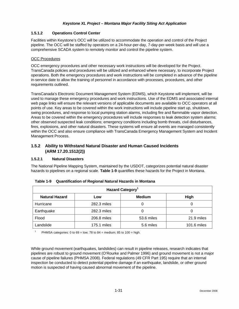
Keystone XL Project – Montana Major Facility Siting Act Application
1-31
1.5.1.2 Operations Control Center
Facilities within Keystone’s OCC will be utilized to accommodate the operation and control of the Project pipeline. The OCC will be staffed by operators on a 24-hour-per-day, 7-day-per-week basis and will use a comprehensive SCADA system to remotely monitor and control the pipeline system.
OCC Procedures
OCC emergency procedures and other necessary work instructions will be developed for the Project. TransCanada policies and procedures will be utilized and enhanced where necessary, to incorporate Project operations. Both the emergency procedures and work instructions will be completed in advance of the pipeline in-service date to allow the training of personnel in accordance with processes, procedures, and other requirements outlined.
TransCanada’s Electronic Document Management System (EDMS), which Keystone will implement, will be used to manage these emergency procedures and work instructions. Use of the EDMS and associated internal web page links will ensure the relevant versions of applicable documents are available to OCC operators at all points of use. Key areas to be covered within the work instructions will include pipeline start up, shutdown, swing procedures, and response to local pumping station alarms, including fire and flammable vapor detection. Areas to be covered within the emergency procedures will include responses to leak detection system alarms; other observed suspected leak conditions; emergency conditions including bomb threats, civil disturbances, fires, explosions, and other natural disasters. These systems will ensure all events are managed consistently within the OCC and also ensure compliance with TransCanada Emergency Management System and Incident Management Process.
1.5.2 Ability to Withstand Natural Disaster and Human Caused Incidents (ARM 17.20.1512(2))
1.5.2.1 Natural Disasters
The National Pipeline Mapping System, maintained by the USDOT, categorizes potential natural disaster hazards to pipelines on a regional scale. Table 1-9 quantifies these hazards for the Project in Montana.
Table 1-9 Quantification of Regional Natural Hazards in Montana
Hazard Category1
Natural Hazard Low Medium High
Hurricane 282.3 miles 0 0
Earthquake 282.3 miles 0 0
Flood 206.8 miles 53.6 miles 21.9 miles
Landslide 175.1 miles 5.6 miles 101.6 miles 1 PHMSA categories: 0 to 69 = low; 78 to 84 = medium; 85 to 100 = high.
While ground movement (earthquakes, landslides) can result in pipeline releases, research indicates that pipelines are robust to ground movement (O’Rourke and Palmer 1996) and ground movement is not a major cause of pipeline failures (PHMSA 2008). Federal regulations (49 CFR Part 195) require that an internal inspection be conducted to detect potential pipeline damage if an earthquake, landslide, or other ground motion is suspected of having caused abnormal movement of the pipeline.
December 2008

Keystone XL Project – Montana Major Facility Siting Act Application
1-32
Table 1-9 illustrates that the likelihood of earthquake or hurricane damage to the Project is low, since the entire project falls outside of the USDOT-defined high earthquake and hurricane hazard areas. Keystone also conducted a route-specific review of earthquake hazards, which confirms the low hazard.
Keystone has evaluated flooding and landslide hazards and has mitigated the risk posed by these hazards through routing and design. Keystone will avoid locating any aboveground facilities, such as valves and pump stations, in floodplains or areas of high landslide potential in Montana. Keystone also will construct all new aboveground facilities to current Uniform Building Code standards. When facilities are located in potential hazard areas, appropriate engineering methods will be implemented to minimize risk. Additionally, as part of Keystone’s integrity management program, geotechnical slope monitoring programs would be implemented as necessary to minimize risk.
Landslides are discussed further in the geologic hazards portions of Section 4.3.6, Chapter 4.0. Both the baseline data deviation and impacts discussion give additional information.
Ice and high wind hazards are not applicable threats to the pipeline facilities. However, these may pose threats to associated powerlines and will be addressed separately by the electrical service providers.
1.5.2.2 Accidents
A major cause of pipeline incidents has historically been accidental third-party excavation damage, resulting from direct hits to the pipeline with sufficient force to puncture the pipe’s wall or from damage to the pipe that results in delayed pipe failure. To reduce the probability of excavation damage, Keystone will implement the following mitigation measures:
• Burial depth of the pipeline to a minimum of 4 feet in most locations, which exceeds federal requirements per 49 CFR Part 195.248;
• An Integrated Public Awareness (IPA) program and encroachment management process;
• Participation in one call, Common Ground Alliance, and local damage prevention programs;
• Regular aerial patrols of the pipeline ROW that meet or exceed federal safety code requirements;
• The use of warning tape buried above the pipeline in select locations; and
• The use of closely spaced, visible signage in select locations; and
1.5.2.3 Integrated Public Awareness Program
Keystone will implement and utilize an IPA program. The IPA program will:
• Inform affected landowners and communities of the location of the facilities, the nature of the crude oil transported, contact information for the company, and what steps to take in the event of an emergency;
• Ensure emergency service agencies fully understand Keystone’s emergency response procedures and responsibilities of each party during an emergency;
• Inform contractors of requirements for working on or near Keystone facilities; and
• Maintain contact with landowners, community groups, contractors, and emergency service agencies that are directly impacted by the Project facilities or operations.
The objectives of the program are to: protect the public from injury; prevent or minimize effects on the environment; protect Keystone facilities from damage from the public; and provide an opportunity for on-going
December 2008
Keystone XL Project – Montana Major Facility Siting Act Application
1-33
public awareness. This program will meet or exceed the requirement for 49 CFR Part 195.440 and API RP 1162.
1.5.3 Description of Methods the Applicant will Employ to Control Land Uses on the ROW (ARM 17.20.1512(3))
Keystone will implement industry-best practices and federal requirements such as overflights and integrated public awareness as outlined by recognized organizations and associations like the Common Ground Alliance, API (guidelines for property development), and existing TransCanada Crossing and Encroachment Operating Procedures. By federal regulation, no permanent structures are allowed on the permanent ROW. Landowners and property developers can request permission to encroach on the ROW with non-permanent structures (e.g., fence lines, retaining walls) by providing plans to Keystone for review. Plans will be reviewed and recommendations provided to ensure the public safety, environmental protection, pipeline integrity, and access to normal and emergency maintenance.
1.5.4 Description of ROW Management Procedures Including Vegetation and Weed Control, Herbicide Use, and Scheduled Timing (ARM 17.20.1512(4))
The Project ROW will be managed in accordance with TransCanada’s Operating Procedures for ROW Management, USDOT regulations, and other best management practices (BMPs) that are appropriate for conditions encountered on the ROW. The objective of ROW management will be to ensure safe operation of the pipeline while minimizing long-term alterations to pre-construction conditions and land use.
After construction is complete, all disturbed areas, except permanent aboveground facilities, will be rehabilitated and restored to the pre-construction land use, as described in the CMRP (Attachment C) and in accordance with 75-20-303 Montana Code Annotated and ARM 17.20.1901-1902; BLM ROW grant conditions; State of Montana permit conditions; and easement conditions. Land acquired for aboveground facilities and any private access roads associated with these facilities will be permanently maintained in a grass or graveled condition.
As discussed in Section 1.3, the pipeline will be periodically inspected from the air and/or ground no less frequently than required by 49 CFR Part 195 (i.e., a minimum of 26 aerial inspections per year). This surveillance will be used to locate and monitor possible encroachments on the ROW as well as nearby construction of other projects; erosion on or near the ROW, including the need for repair of permanent erosion control devices; exposed pipe; repair or replacement of pipeline markers; or other potential concerns that could affect the safety and operation of the pipeline. Any disturbances to the ROW as a result of such maintenance will be promptly rehabilitated in accordance with the CMRP (Attachment C). Aboveground facilities such as mainline control valves will be inspected twice annually or more frequently, if needed.
It is anticipated that cultivated lands affected by the ROW will be returned to pre-construction cultivation, depending on landowner agreements. Similarly, non-cultivated lands such as rangelands, shrublands, or forested habitats will be allowed to revert to pre-construction conditions. It will be necessary to maintain a strip of herbaceous vegetation over the pipeline centerline for surveillance purposes. Encroachment of woody vegetation within the 30-foot strip will be periodically controlled by mechanical means such as chain saws or brush hogs. Use of herbicides to control woody vegetation is not anticipated. If it becomes necessary to use herbicides to control woody vegetation encroachment, herbicide selection and use will be in accordance with all applicable federal, state, and local regulations, as well as TransCanada’s Operating Procedures and/or other applicable BMPs.
Noxious weed infestations on the rehabilitated ROW will be monitored as described in Section 2.13 of the CMRP (Attachment C). Weed control will be assessed in comparison to unimpacted adjacent areas to ensure percent cover does not exceed what is found in adjoining areas. Keystone will confer with the weed board in each county crossed by the pipeline to ensure that noxious weed management practices enacted for the ROW
December 2008

Keystone XL Project – Montana Major Facility Siting Act Application
1-34
are in compliance with county standards, in accordance with the Montana County Weed Control Act (MCWCA) (Title 7, Chapter 22 Part 21) and Montana Weed Control Act (MWCA) (Title 80, Chapter 7 Part 7). Noxious weed treatments may include mechanical, biological, or herbicidal methods, as appropriate, and will be implemented as needed.
1.5.5 Leak Frequency and Size (ARM 17.20.1512(5)) Pipelines are one of the safest forms of crude oil transportation and provide a cost-effective and safe mode of transportation for oil on land. Overland transportation of oil by truck or rail produces higher risk of injury to the general public than the proposed pipeline (USDOT 2002). The Project will be designed, constructed, and maintained in a manner that meets or exceeds industry standards.
A Project specific incident1 frequency and spill volume analysis was conducted for the Project. This study assessed the US portion of the Project and estimated the frequency and volume of releases for five distinct and independent failure causes. The study is a quantitative assessment of spill potential for the entire pipeline system utilizing publicly available historical incident data collected from PHMSA incident reports. Based on the available information, the study produced a conservative incident frequency of 0.000119 incident per mile per year.2 For any 1-mile segment, this probability is equivalent to one spill every 8,400 years.
Keystone believes that the actual number of incidents will be substantially lower than estimated for this analysis due to the safety measures that will be implemented by Keystone and industry improvements in pipeline safety. While the incident analysis was based on historical data, the number of spills on crude oil pipelines has substantially declined in recent years with the implementation of the USDOT Integrity Management Rule.
Maximum spill volumes were determined for a complete rupture of the Project, accounting for maximum throughput, time to isolate the leak (detection and system shutdown), and subsequent drain down from the affected pipeline segment. Maximum spill volumes are used for emergency response pre-planning purposes. Keystone is currently calculating maximum spill volumes for emergency planning purposes.
Actual incident data from the PHMSA indicate that spill volumes are significantly less than the maximum potential drain down volume. Analysis of the current PHMSA dataset (2002 to present) indicates that the vast majority of actual pipeline spills are relatively small, with 50 percent of the spills consisting of 3.0 barrels or less. In 85 percent of the cases, the spill volume was 100 barrels or less, and less than 1,000 barrels in over 95 percent of the time. Oil spills of 10,000 barrels or greater only occurred in 0.5 percent of cases. These data demonstrate that most pipeline spills are small and very large releases of 10,000 barrels or more are extremely uncommon.
1.5.6 Leak Detection (ARM 17.20.1512(6)) In the event a suspected pipeline leak is reported to the OCC, Keystone would implement its emergency pipeline shutdown procedures. After leak confirmation, an emergency pipeline shutdown would proceed. This would involve stopping pumping stations as appropriate. This line shutdown is estimated to take approximately 9 minutes. Once all the operating pumping units have been shutdown, the OCC operator would close the
1 An “incident” refers to a variety of abnormal pipeline events that are reportable to the PHMSA, including the release of oil greater than 5 gallons; a release resulting in an explosion or fire; and accident resulting in human injuries requiring hospitalization; fatality; or property damage (including operator costs, such as product loss, emergency response, and cleanup costs) in excess of $50,000.
2 The state-specific incident rate was lower, but the national frequency was used since it was more conservative (i.e., overestimates risk).
December 2008

Keystone XL Project – Montana Major Facility Siting Act Application
1-35
sectionalizing or isolation valves in the vicinity of the leak to limit any further drain down at the leak site. Closure of these isolation valves would take an additional 3 minutes. Therefore, from when the leak was confirmed, it would take approximately 12 minutes to shutdown and isolate the pipeline.
Keystone also will have a number of complimentary leak detection methods and systems available within the OCC, which is manned on a 24 hours a day, 7 days a week basis. These methods and systems are overlapping in nature and progress in leak detection thresholds. The leak detection methods are as follows:
• Remote monitoring performed by the OCC operator, which consists primarily of monitoring pressure and flow data received from pump stations and valve sites fed back to the OCC by the Keystone SCADA system. Remote monitoring is typically able to detect leaks down to approximately 25 percent to 30 percent of pipeline flow rate.
• Software-based volume balance systems that monitor receipt and delivery volumes. These systems are typically able to detect leaks down to approximately 5 percent of pipeline flow rate.
• Computational pipeline monitoring or model-based leak detection systems that break the pipeline system into smaller segments and monitor each of these segments on a mass balance basis. The leak detection system will comply with 49 CFR Parts 195.134 and 195.444 and follow API 1130, Computational Pipeline Monitoring for Liquid Pipelines. These systems are typically capable of detecting leaks down to a level approximately 1.5 percent to 2 percent of pipeline flow rate.
• Computer-based, non-real-time (accumulated gain/loss) volume trending to assist in identifying low rate or seepage releases below the 1.5 to 2 percent by volume detection thresholds.
• Direct observation methods, which include aerial patrols, ground patrols, and public and landowner awareness programs that are designed to encourage and facilitate the reporting of suspected leaks and events that may suggest a threat to the integrity of the pipeline.
Consistent with industry practice, and in accordance with regulations, including 49 CFR Part 194.115, Keystone response time in the event of a leak must be within 6 hours.
1.5.7 Spill Contingency Plan (ARM 17.20.1512(7)) Keystone has an internal and external notification procedure. In the event of an emergency, Keystone would make a call to the emergency response contact in the immediate vicinity of the incident. In addition, “local” calls are made to others such as City Administrators, etc., if the situation dictates. Response zones will be developed and equipment and personnel will be set up within each zone.
No current mutual aid agreements are in place; however, Keystone will seek out opportunities to join or form co-ops and mutual aid groups within its operating area.
Keystone will be filing its Emergency Response Plan (ERP) for the Project with the PHMSA prior to commencing operations and anticipates approval early in 2011. Items such as frequency of field training exercises and equipment testing procedures will be developed as part of the ERP (Attachment B).
1.5.8 Abandonment Properly maintained, the proposed Project is expected to operate for 50 years or more. Keystone has no identified plans for abandonment of these facilities at this time. If abandonment of any facilities is proposed in the future, the abandonment will be subject to approvals by state and/or federal agencies having jurisdiction. Abandonment will be implemented in accordance with then-applicable permits, approvals, codes, and regulations, and industry best practices.
December 2008

Keystone XL Project – Montana Major Facility Siting Act Application
1-36 December 2008
References
O’Rourke, M. J. and M. C. Palmer. 1996. Earthquake Performance for Gas Transmission Pipelines. Earthquake Spectra 12(3):493.
Pipeline and Hazardous Materials Safety Administration (PHMSA). 2008. PHMSA Pipeline Incident Statistics. Website: http://primis.phmsa.dot.gov/comm/reports/safety/PSI.html
U.S. Department of Transportation (USDOT). 2002. Office of Pipeline Safety Pipeline Statistics. Website: http://ops.dot.gov/stats/stats.htm.

Keystone XL Project – Montana Major Facility Siting Act Application
2-1
2.0 Facility Costs
2.1 Estimated Cost of Facilities (ARM 17.20.811) Estimates of capital costs for the facility are:
• Inside Montana – $1,059,226,000;
• Outside Montana – $5,991,025,000; and
• Total Project – $7,050,251,000.
These capital costs reflect the facilities required to operate the system at a nominal capacity of 900,000 bpd. The detailed breakout of the costs required by ARM 17.20.811 has been provided in a non-public confidential version to Montana DEQ pursuant to a request for confidentiality under ARM 17.20.301.
The estimate was prepared using the methods and level of accuracy defined by the Association for the Advancement of Cost Engineering (AACE) as being appropriate for study estimates (AACE International Recommended Practice No. 18R-97). The link to the AACE website where this document can be viewed is http://www.aacei.org/technical/rps/18r-97.pdf.
This estimate is equivalent to a Class 4 cost estimate as defined in the referenced AACE document. The capital cost estimate was prepared from preliminary engineering designs for the facilities.
Cost components were estimated as follows:
• Quantities of pipe, pump, and motor equipment were estimated and confidential budgetary quotes were obtained from potential suppliers;
• All other materials were estimated as a factored cost of pipe and major equipment;
• Construction costs for both pipeline and facilities were estimated factoring actual costs for current similar construction being executed for TransCanada;
• Land costs were estimated on a state-by-state basis by land management contractors working on the Project; recent local cost information was used for this estimate;
• Engineering and owners’ management costs were estimated as a factor of other direct costs; and
• Mitigation costs were estimated by factoring actual costs from recent executed Projects in both Canada and the US.
The capital costs for facilities in Montana were allocated as follows:
• Pipeline construction and materials costs were prorated as the percentage of the length of US pipeline in Montana;
• Facilities (pump stations and valve sites) construction and materials costs were estimated by extrapolating the unit pricing for these times the actual number in Montana; and
• All other costs were prorated as the percentage of the length of US pipeline in Montana.
December 2008

Keystone XL Project – Montana Major Facility Siting Act Application
2-2 December 2008
2.2 Linear Facilities, Estimated Annual Cost (ARM 17.20.815) The estimated annual costs of the facilities (escalated dollars) and the estimated annual costs (constant dollars) required by ARM 17.20.811 have been provided in a non-public confidential version to Montana DEQ pursuant to a request for confidentiality under ARM 17.20.301.
While Project financing has yet to be finalized, it is anticipated to be financed through a combination of contributions from the owners, bank financing, and access to capital markets.
2.3 Pricing Policy (ARM 17.20.817) The rates for crude oil transportation through the US portion of the Project will be subject to regulation by the Federal Energy Regulatory Commission (FERC). Keystone anticipates there will be two categories of service offered:
Committed or term service – Keystone is proposing long-term contracts with discounted rates and a fixed/variable rate design. The rates vary with contract term, with lower rates offered for longer terms. The fixed portion of the rate is based on levelized 10-, 15-, or 20-year contracts and will not change over the term of the shipper’s contract. The fixed portion of the rate is designed to recover the capital invested and is designed on a postage stamp basis. The variable portion of the rate is a flow-through of the actual operating costs, adjusted annually.
Uncommitted or spot service – Keystone will offer service to non-contract shippers on a month-to-month basis as a posted spot rate. The spot rate will be subject to indexing, as permitted by FERC.
2.4 Evaluation of Economic Costs and Benefits (ARM 17.20.818) Internal costs are addressed above in Sections 2.1 and 2.2 and external costs are addressed in Chapter 4.0, Section 4.4.

Keystone XL Project – Montana Major Facility Siting Act Application
3-1 December 2008
3.0 Purpose and Explanation of Need (ARM 17.20.928)
The purpose of the Project is to transport crude oil production from the Western Canadian Sedimentary Basin (WCSB) to meet growing demand by refineries and markets in the US. The Project will transport crude oil from the oil supply hub near Hardisty, Alberta, Canada and deliver it to existing oil storage terminal facilities near Nederland and Houston, Texas. Construction of the Project will provide US refineries and markets with access to a substantial and reliable supply of Canadian crude oil to meet increasing US demand for petroleum products.
The need for the Project is dictated by a number of factors, including:
• Increasing crude oil demand in the US;
• Decreasing domestic crude supply in the US;
• Increasing WCSB crude oil supply;
• An opportunity to reduce US dependence on foreign offshore oil supply through further supply diversification to stable, secure Canadian crude supplies; and
• Binding shipper commitments in the Project.
3.1 Increasing Crude Oil Demand in the US According to the Energy Information Administration (EIA), US demand for petroleum products has increased by over 11 percent or 2 million bpd over the past 10 years and is expected to increase further (EIA, Annual Energy Review 2007). The EIA estimates that total US petroleum consumption is projected to increase by approximately 1.0 million bpd over the next 10 years (EIA Annual Energy Outlook 2008), representing average demand growth of about 100,000 bpd per year.
The Project’s key delivery area, PADD III or the US Gulf Coast, represents the largest and most complex refining district in the US with 56 refineries comprising approximately 8.4 million bpd of total refining capacity.
3.2 Decreasing Domestic Crude Oil Supply At the same time, domestic US crude supplies continue to decline. For example, over the past 10 years, domestic crude production in the US has declined at an average rate of about 135,000 bpd per year, or 2 percent per year (EIA Annual Energy Review 2007).
3.3 Increasing WCSB Crude Oil Supply Established crude oil reserves in the WCSB are estimated at 179 billion barrels (Canadian Association of Petroleum Producers (CAPP), (January 2008). The primary source of WCSB crude oil supply – over 97 percent – is comprised of Canada's vast oil sands reserves located in northern Alberta. The Alberta Energy and Utilities Board estimates there are 175 billion barrels of established reserves out of 315 billion barrels of bitumen ultimately recoverable in Canada’s oil sands. Alberta has the second largest crude oil reserves in the world, second only to Saudi Arabia.
As a result of growing production from the oil sands, crude oil supplies from the WCSB are expected to increase by about 1.6 million bpd by 2017, from current production of about 2.4 million bpd (CAPP, June 2008).

Keystone XL Project – Montana Major Facility Siting Act Application
3-2 December 2008
3.4 Further Supply Diversification to Canadian Crude Oil The US historically has compensated for decreases in domestic production through increased imports from Canada and foreign offshore sources. Canada is currently the largest supplier of imported crude oil and refined products to the US, supplying over 2.4 million bpd in 2007 and representing over 11 percent of total US petroleum product consumption (EIA Annual Energy Review 2007).
US imports of foreign crude and refined products continue to increase as a result of decreasing domestic production and increasing demand. Crude and refined petroleum product imports into the US have increased by over 3.3 million bpd over the past 10 years. In 2007, the US imported over 13.4 million bpd of crude oil and petroleum products or over 60 percent of total US petroleum product consumption (EIA Annual Energy Review 2007).
The Project would provide an opportunity for US refiners in PADD III to diversify supply away from traditional offshore foreign crude supply and to obtain direct access to secure and growing Canadian crude supplies. Access to incremental Canadian crude supply also would provide an opportunity for the US to supplement annual declines in domestic crude production and more significantly, decrease its dependence on offshore foreign crude supplies, namely from Mexico and Venezuela, the top two heavy crude oil importers into the US Gulf Coast.
3.5 Binding Shipper Commitments Shippers – producers, marketers or refiners – evaluate the merits of various pipeline proposals and ultimately decide which projects to support. Shippers have expressed material interest in the Project and in securing additional crude oil pipeline capacity. Potential shippers have already committed to long-term binding contracts, which will enable Keystone to proceed with regulatory applications and, pending successful regulatory and environmental approvals, with construction of the pipeline. These long-term binding commitments demonstrate a material endorsement of support for the Project, its economics, proposed route, and target market, as well as the need for incremental pipeline capacity and access to Canadian crude supplies.
3.6 Interconnection Agreements (ARM 17.20.929) There are no interconnects in Montana.

Keystone XL Project – Montana Major Facility Siting Act Application
4-1 December 2008
4.0 Analysis of Alternatives
4.1 Evaluation of Alternatives (ARM 17.20.1311) Keystone is designing the Project in order to meet the stated purpose and need of the Project and to meet the specific requirements of its committed shippers, which form the underpinning of the Project, as well as anticipated additional shipper demand and applicable regulatory requirements. The following sets of alternatives were evaluated to assure meeting these requirements.
Alternative Transportation Modes
In consideration of alternate modes of transportation, for context, shipment by road with tanker trucks would require over 4,000 trucks per day to ship 900,000 bpd. By rail, the equivalent requirements would be about 40, 100-tank-car-unit trains per day.
For the Project’s purpose and need, these alternate modes are not practical. Additionally, transportation by pipeline remains the safest mode of transportation for crude oil.
Alternative Starting Points or Destination Points
The start point of the oil hub in Hardisty, Alberta, aligns with the start of the Keystone Pipeline Project, which is currently being executed. The Project is proposed as a further phase of the development of the Keystone Pipeline System. Hardisty is the preferred and flexible initial delivery point for shippers to import oil into the US from the developing supply base in Alberta. Hardisty is a major initiating point for oil shipments from the WCSB.
All three alternative routes utilize the same entry point into the State of Montana. This point was selected because it takes advantage of the reduced environmental footprint resulting from co-location with the Foothills Pipeline System in Canada.
The delivery points at Nederland and Moore Junction in Texas were selected after feedback from potential shippers wishing to develop new supplies of crude oil for the PADD III area refineries on the Gulf Coast of Texas.
Each alternative route utilizes a different exit point from the State of Montana. The relative merits of these points are tied to the relative merits of the reflective alternative routes.
The start and end delivery points were also chosen to be responsive to known shipper interest. Other points were not considered because they would not have been consistent with the Project purpose and need.
Alternative Diameter Pipe and Alternative Flow Rates (System Capacity Analysis)
Crude oil supply and demand outlook discussed in Chapter 3.0 provided the target pipeline capacity that would be of interest to shippers in the timeframe intended for available service. An economic pipeline with an ultimate capacity in the neighborhood of about 1 million bpd was the initial starting point. Additionally, a minimum initial capacity of approximately 500,000 bpd to the US Gulf Coast was targeted based on initial feedback from potential shippers.
Screening hydraulic analysis was done considering different pipeline diameters. For this analysis a maximum pump station discharge pressure of 1,440 psig was selected, this being the maximum pressure rating for ANSI 600 flanges. This pressure provides for economic design of pump station facilities and efficient system operation.

Keystone XL Project – Montana Major Facility Siting Act Application
4-2 December 2008
Following are the results of the initial screening hydraulic analysis for various pipeline diameters.
Pipe Diameter (NPS)
Nominal Design Capacity (bbl/d)
Maximum Discharge Pressure (psig)
30 591,000 1,440
36 900,000 1,440
42 1,530,000 1,440
Pipe sizing must take into account volume requirements, fluid properties, and the type of flow required to maintain batch integrity. Flow velocities in a turbulent flow regime rather than a laminar flow regime are required to maintain batch integrity.
While the 30-inch-diameter pipe provided flow velocities that would provide batch integrity, it was eliminated from further consideration as it did not provide sufficient capacity to meet the targeted maximum capacity. The 42-inch-diameter pipe could provide sufficient capacity, but would require a minimum flow of 624,000 bpd to avoid laminar flow. The expected initial contract volumes would have resulted in a pipeline design not suited for the intended batch operation. The ultimate capacity of approximately 1.5 million bpd was greater than targeted.
Based on these results and the targeted flow regime capacities, the 36-inch-diameter option was selected for further study and development. For the 36-inch-diameter pipeline, batch integrity is achieved for flows above 450,000 bpd.
Further hydraulic analyses were conducted to optimize a 36-inch-diameter pipeline system design. With the maximum pump system discharge pressure of 1,440 psig, it was found that, at some site specific locations with a lower elevation than the upstream pump station, the 1,440 psig pressure could be exceeded under some normal and abnormal system conditions. For these locations, a MOP of 1,600 psig has been specified.
The Project’s capacity is defined in terms of design and nominal capacities. Design capacity refers to the maximum capacity of the pipeline with all operating equipment available. Keystone’s design capacity is 1,000,000 bpd. Nominal capacity refers to the long-term sustainable capacity taking into account seasonal variations in operating temperatures, maintenance requirements, power outages, and operational flexibility. The nominal capacity of the Project, 900,000 bpd, represents 90 percent of the design capacity.
Pipeline Expansion Options Considered
Various ways to utilize and expand the previously permitted Keystone Pipeline Project, the first phase of the Keystone Pipeline system, were considered, including:
• Additional pumping
• Partial looping
• New pipeline – adjacent route
Additional Pumping
Adding pumps on the base Keystone Pipeline system would only provide very nominal increases in overall capacity and was not considered because it would not meet the targeted incremental flow capacities.

Keystone XL Project – Montana Major Facility Siting Act Application
4-3 December 2008
Partial Looping
Looping with additional pumping would add increased capacity to the base pipeline. However, batch quality in a partially looped pipeline system is not maintained to the level required. Unless the entire pipeline is fully looped the desired batch integrity is not achievable.
New Pipeline – Adjacent Route
One continuous new line, adjacent to the existing Keystone Pipeline, also was analyzed. This meets the technical and operational requirements, but the total capital costs, operating costs, and power requirements would be significantly higher due to the longer route between Hardisty and Steele City (1,417 miles vs 1,170 miles). Environmental impacts would be correspondingly greater than those that would occur for the preferred route.
Preferred Pipeline Option
A direct route approach is the preferred alternative. This meets the technical and operational requirements and, when compared to other alternatives, is shorter in length, has a smaller environmental footprint, and is less expensive on an incremental volume basis. Another design benefit is a single bullet pipe design, which will provide better delivered product quality and faster transit times compared to other less direct options and, therefore, create value for Keystone’s customers.
Alternative Size, Number, and Location of Pump Stations
Once the preferred pipeline option was identified, pump station locations were evaluated on the basis of hydraulics, environmental footprint, and cost.
A series of hydraulic analyses were carried out comparing pipe size, pressure, and pump spacing to determine the optimum pump station configuration. Hydraulic analysis indicated that co-locating pump stations with the existing Keystone Pipeline Project pump stations or TransCanada-owned facilities would not result in optimal pump spacing and would result in more, rather than fewer, pump stations.
The chosen pump sizes and configuration were 6,500 or 7,000 hp pumps (to be determined in detail engineering) in a series configuration. Several other pump sizes and pump station configurations were considered including:
• Smaller pumps (5,000 hp instead of 7,000 hp) in a series configuration – This alternative provides some efficiencies for initial volumes and ability to expand for future potential simplicity of operation, but over a longer term requires many more pumps, therefore, a larger pump station foot print and higher capital and operating cost. The pumps required for this type of operation also were not common or proven in the industry.
• Smaller pumps series-parallel configuration – this type of alternative provides benefits of efficiencies for initial volumes and ability to expand for future potential and is common and proven within the industry. It does require a significant pump station footprint, is much more complex to operate, and has a significant cost implication, due to the much greater number of pumps required.
• Larger parallel configuration – in this alternative, the initial and future build up volumes can be accommodated, the pump sizes are comparable to others in use in the industry, and the number of pumps required is similar to the chosen sizes and configuration.
Alternative Pump Fuels and Fuel Sources
Along several areas of the pipeline, using natural gas fired equipment, either as a fuel source for generating power or for directly driving pumping units, was evaluated as an alternative. In these cases, both long- and

Keystone XL Project – Montana Major Facility Siting Act Application
4-4 December 2008
short-term considerations were evaluated and compared to electric power. It was determined that the environmental impact and the costs, both capital and operating, exceeded that of energizing the stations with electrical power provided by new transmission lines.
Pipe Material Grade and Wall Thickness
Steel was the only pipe material considered for the Project. Two pipe grades were considered for the Project; API 5LX-70 with a specified minimum yield strength of 70,000 psi and API 5LX-80 with a specified minimum yield strength of 80,000 psi. Both pipe grades are used in the pipeline industry and both are still being evaluated for use on the Project.
The pipe selected for the project design to meet the requirements of CFR 49, Part 195 are:
36” O.D. x 0.463” w.t., API 5LX-70 (0.80 design factor, 1,440 psig MOP) 36” O.D. x 0.405” w.t., API 5LX-80 (0.80 design factor, 1,440 psig MOP) 36” O.D. x 0.515” w.t., API 5LX-70 (0.72 design factor, 1,440 psig MOP) 36” O.D. x 0.450” w.t., API 5LX-80 (0.72 design factor, 1,440 psig MOP) 36” O.D. x 0.619” w.t., API 5LX-70 (0.60 design factor, 1,440 psig MOP) 36” O.D. x 0.540” w.t., API 5LX-80 (0.60 design factor, 1,440 psig MOP) 36” O.D. x 0.743” w.t., API 5LX-70 (0.50 design factor, 1,440 psig MOP) 36” O.D. x 0.648” w.t., API 5LX-80 (0.50 design factor, 1,440 psig MOP) 36” O.D. x 0.572” w.t., API 5LX-70 (0.72 design factor, 1,600 psig MOP) 36” O.D. x 0.500” w.t., API 5LX-80 (0.72 design factor, 1,600 psig MOP)
System Alternatives
To provide potential shippers with the desired capacity expansion of the Keystone System from Hardisty to the refinery area of the USGC, Keystone developed a pipeline transportation system that will be appropriately sized and economically justifiable. Key design and economic considerations included:
• Present and future capacity requirements;
• Crude oil quality considerations; and
• Minimizing potential environmental effects and project footprint.
The design that was selected represents the optimum combination of these considerations.
The No Action Alternative also is evaluated, as are system alternatives and routing alternatives.
4.1.1 No Action Alternative Under the No Action Alternative, Keystone would not request approval for, nor construct the proposed Project. If the proposed facilities are not constructed, the short- and long-term impacts identified in this MFSA application will not occur; however, Keystone will not be able to meet the demonstrated market need within the required timeframe. Moreover, shippers will seek other means to move their product or shut in production. It is purely speculative to predict the resulting effects and actions that could be taken by another entity or the shippers as well as any associated direct and indirect environmental impacts. However, it is clear that the demand for crude oil in the US overall and in the area served by the Project is increasing. Thus, not building the proposed facilities could limit some or all of the access to additional crude oil supplies, thus jeopardizing the benefits to be provided by the Project, which would include substantial tax revenues to the counties crossed.

Keystone XL Project – Montana Major Facility Siting Act Application
4-5
4.1.2
4.1.2
4.1.2
4.1.2 Route Alternatives The proposed route for the Project was developed through an iterative, multidisciplinary route selection process. This process involved the systematic identification of objectives, control points, collection of data, review of alternatives, and continual reassessment of these factors as refinement occurred. Additionally, the process unfolded in two distinct phases, given modifications to basic Project objectives, which had significant impacts on suitable routing alternatives.
.1 Objectives
The purpose of the Project is to:
• Transport crude oil production from the WCSB to meet growing demand by refineries and markets in the US;
• Transport crude oil from the oil supply hub near Hardisty, Alberta, Canada and deliver it to existing oil storage terminal facilities near Nederland and Houston, Texas; and
• Provide US refineries and markets with access to a substantial and reliable supply of Canadian crude oil to meet increasing US demand for petroleum products.
.2 Definition of Control Points
The following control points served to define the route (see Attachment A, Figure 1). In Canada, the Project is co-located with an existing pipeline. That dictates the port of entry to the US.
• Co-location with Foothills Pipeline in Canada;
• US/Canada border crossing near Morgan, Montana;
• Construction limitations at Fort Peck Reservoir, Montana;
• Crossing the Niobrara River at locations not designated as wild and/or scenic;
• Minimization of new pipeline by connecting with the Keystone Cushing Extension;
• Delivery point at Nederland, Texas; and
• Delivery point at the Houston Ship Channel, Texas.
The last two bullets are not applicable to route selection in Montana and, thus, are not discussed further.
.3 Steele City Segment
The Steele City Segment of the Project takes a more direct route from Hardisty, Alberta, to Steele City, Nebraska, than that of the Keystone Pipeline Project. The development of the Keystone Pipeline Project included the conversion to crude oil service of a significant underutilized segment of TransCanada’s Canadian Mainline assets from the Alberta border running east through Saskatchewan to Manitoba. No other existing assets are available for this kind of conversion and use on the Keystone XL Project, therefore a direct route was chosen.
Four route alternatives were initially considered for the Steele City Segment of the Project to interconnect with the Keystone Cushing Extension. One alternative was construction of a new pipeline directly from the US/Canada border to the interconnection at Cushing, Oklahoma. This alternative did not take advantage of the opportunity to avoid new pipeline construction by connecting with the Keystone Cushing Extension. Therefore, it would require construction of several hundred more miles of pipeline than other alternatives, with associated costs and environmental disturbances. For these reasons, this alternative was removed from further consideration.
December 2008

Keystone XL Project – Montana Major Facility Siting Act Application
4-6
Several other alternatives were considered, all of which involved construction of new pipe to a point near Steele City, Nebraska, where the Project could then connect with the Keystone Cushing Extension to deliver oil to the Gulf Coast Segment (please refer to the Overview Map). Of the three remaining routes that were considered, the Project team identified Steele City Route Option B as the preferred route. Route B is significantly shorter, by over 100 miles, than the other alternatives, resulting in the following overall benefits:
• Reduced environmental footprint and impact;
• Reduced landowner impacts;
• Reduced congestion in relation to population;
• Reduced overall construction costs; and
• Reduced operating costs.
4.2 Alternative Siting Study (ARM 17.20.1426 and Circular MFSA-2) In preparation for the Alternative Siting Study and Baseline Study and selecting a preferred location for the Project facilities. Keystone obtained many publically available electronic data layers to map the avoidance areas and other environmental constraints. Keystone’s routing process avoided wilderness areas and primitive areas; attempted to identify a location that achieves the best balance of preferred location criteria listed in Circular MFSA-2, Section 3.1 and the avoidance areas described and referenced in Circular MFSA-2, Sections 3.2, 3.4, 3.7, and 3.8; and selected alternate routes that would either avoid, or allow means for, mitigation of adverse impacts.
4.2.1 Delineation of the Study Area (Circular MFSA-2, Section 3.2) Given the size and scope of the proposed Project (see Attachment A, Figure 1) and considering all reasonable endpoints for the facility within or outside the State of Montana, the study area for the portion of the Project that would be located within the State of Montana is simply identified as “eastern Montana” (Circular MFSA-2, Section 3.2 (2) and (4)). In identifying this broad study area, obviously, many of the siting criteria and avoidance areas outlined in Circular MFSA-2 could not be “avoided” within the study area, but were certainly taken into consideration while selecting the alternative routes through the study area.
Once the study area was defined, the avoidance areas defined in Circular MFSA-2, Section 3.2 (d) and (e) were mapped (see Attachment A, Figure 2) showing eastern Montana with all avoidance areas mapped, but no routes) (Circular MFSA-2, Section 3.2 (3)). In addition to Attachment A, Figure 2 and to fully satisfy the requirements of Circular MFSA-2, Section 3.2 (3), electronic equivalents, complete with shapefiles and metadata, are being filed on DVD with the Montana DEQ.
The methods used to determine the boundaries of the study area are explained above. While the factors listed under Section 3.2(2) were not specifically considered during the delineation of the study area, due to the large size of the study area (all of eastern Montana), all of the factors listed under Section 3.2(2) were carefully considered during identification of alternative locations suitable for siting the facility.
4.2.2 Overview Survey (Circular MFSA-2, Sections 3.3, 3.4, and 3.5) In accordance with Circular MFSA-2, Section 3.3 (2), Keystone held public open houses along the preferred route in June 2008 and discussed the Project and alternate routing with County Commissioners in Daniels, Roosevelt, and Sheridan counties, where the alternative routes would pass (see Section 5.3 and Attachment F). Keystone also publically noticed the Project and alternate routes again in November 2008 in the following newspapers: Glendive Ranger Review, Glasgow Courier, Fallon County Times, Circle Banner, Billings Gazette, Miles City Star, and the Wolf Point Herald News. Attachment F provides copies of the notices that were published in these eastern Montana newspapers in November 2008.
December 2008
Keystone XL Project – Montana Major Facility Siting Act Application
4-7
In accordance with Circular MFSA-2, Section 3.3(3), Keystone has prepared base maps at a scale of 1:100,000 along each of the alternate routes (in Attachment A). Consistent with Circular MFSA-2, Section 3.3(5), the areas specified in Sections 3.2(1)(e) and 3.4(2), were avoided by all three routes to the maximum extent possible. Where it was not possible to avoid these areas, mitigation of significant adverse impacts is possible. The mapping for the Overview Survey was prepared in accordance with the requirements of, and in consideration of, the factors listed in Sections 3.3(6), (7), and (8).
Circular MFSA-2, Section 3.3(9). In the late summer of 2007, a study team consisting of representatives from engineering, environmental, construction, and land was assembled to analyze pipeline routing options from Morgan, Montana, to Steele City, Nebraska. The initial route concept was to co-locate with the Northern Border Pipeline southeastward through Montana, North Dakota, and much of South Dakota, until meeting up with the current Keystone Pipeline route; then co-locating with the Keystone Pipeline route southward to Steele City (Route Option A). Route A crossed the Fort Peck Indian Reservation. Because of the extensive statutory and procedural requirements associated with the acquisition of ROWs across the reservation, Keystone determined that the Project schedule could be jeopardized by proceeding with Route A. Consequently, a route around the reservation was formulated and analyzed (Route Option A1A). The study team also discussed looking at a direct “straight line” route from Morgan to Steele City (Route Option B).
In August 2007, the Project study team convened and, using current, relevant desktop data assessed routing options from Morgan to Steele City. Using recent aerial imagery and geographic information system (GIS) data, including land base maps, US Geological Survey (USGS) quadrangle (topography and land use) maps, existing utility locations, etc., the study team refined the preliminary routes and produced maps to support the field reconnaissance.
Subsequently, extensive field reconnaissance was conducted. The routes were flown by fixed-wing aircraft. Key locations were identified to visit during ground reconnaissance. The team also conducted site visits to locations that were of interest and could be accessed by public roads.
The study team reconvened to discuss data collected during the aerial and ground reconnaissance. Further route refinement was done based on the team’s findings. The routing criteria set forth in Circular MFSA-2 were mapped and considered to help refine the alternate routes within the State of Montana. Each of the alternate routes considered in the Baseline Study below, were, at one time, the preferred route.
Although the primary preferred and alternate routes are selected, these routes continue to undergo refinement as additional location-specific information becomes available.
Based on these alternative routes and this alternative route selection process, much of the formal process laid out in Circular MFSA-2, Sections 3.4 and 3.5 for the overview survey was rendered moot; however, all of the factors and criteria listed in Sections 3.4, 3.7, and 3.8 were considered in the baseline study and impact assessment of the alternative routes.
4.3 Baseline Study Requirements (ARM 17.20.1426 and Circular MFSA-2) 4.3.1 Introduction There are three alternative routes evaluated in this section, Routes A, A1A, and B. The following sections address the various resources that may be impacted by the three alternative routes in Montana. Each section identifies common baseline information, followed, where appropriate, by data relevant to each of the three routes, and then an assessment is provided of the resource impacts expected to result from each alternative. Resource impact assessments that are common to all route alternatives are presented in a single section; where appropriate, route-specific impacts are summarized in a table at the end of each technical section.
December 2008

Keystone XL Project – Montana Major Facility Siting Act Application
4-8
4.3.2
4.3.2 Land Use/Recreation
.1 Baseline Data and Description of Routes – All Routes
Land Ownership (Circular MFSA-2 3.7(4))
The linear mileage crossed by the three alternative routes is categorized by surface ownership in Table 4-1. For Routes A1A and B, land ownership along the routes is primarily private. Route A primarily crosses substantial Tribal-owned lands; Route B crosses no Tribal-owned lands; and Route A1A crosses on 1 mile of Tribal-owned lands. All three routes also cross state and federal lands. Land ownership along the three alternatives is shown in Attachment A, Figure 2.
Table 4-1 Surface Ownership Crossed by the Alternative Routes in Miles
Route A Route A1A Route B
Federal 17.5 17.4 42.6
State 14.3 35.2 19.4
Tribal 89.6 1.0 0
Private 59.2 151.9 220.7
Total 180.7 205.5 282.7
Source: Montana Natural Heritage Program (2007) Montana Public Ownership Layer.
The Tribal land ownership type includes Bureau of Indian Affairs Trust Lands, Turtle Mountain Allotted Lands, as well as private lands on the Fort Peck Indian Reservation. Federal lands are predominantly BLM lands in both the Malta and Miles City Districts, but also include a short crossing of USFWS lands on Route A1A and a crossing of US Department of Defense/US Army Corps of Engineers (USACE) property on Route B. State-owned land is almost exclusively Montana State Trust Lands, except for a short segment along Route B, which crosses water under State Department of Natural Resources ownership.
Land Use
Land use types crossed by the alternative routes are detailed in Table 4-2 in miles and in Table 4-3 in acres. The predominant types of land uses crossed are agricultural land, grassland/rangeland, developed, forest land, wetland/riparian, and waterbody. Specific information on the types of agricultural lands also is included in the table. On Routes A and B, the most common land use type crossed is grassland/rangeland with fallow agricultural land as the second most common type. No other land use type makes up more than 3 percent of the total miles crossed. On Route A1A the predominant land use type is fallow agricultural land with grassland/rangeland as the second most common type. Similar to the other two routes, no other land use type makes up more that 3.5 percent of the total miles crossed by Route A1A. Land uses crossed by the proposed pipeline are shown in Attachment A, Mapbook 1.
The agricultural land use type includes actively cultivated land, row crops, and hayfields. The specific types of cropland were acquired from the Montana Department of Revenue (MDR) agricultural land reappraisal data layer. The rangeland/grassland type includes range and pasture. Developed land includes residential, industrial, and commercial areas, as well as transportation and utility corridors. Forest includes upland forests only. The wetland/riparian type includes wetlands with 50 percent or more tree coverage as well as emergent and shrub dominated wetlands. The waterbody land use type includes ephemeral, intermittent, and perennial stream channels as well as open water and manmade ditches and ponds.
December 2008

Keystone XL Project – Montana Major Facility Siting Act Application
4-9
Table 4-2 Land Use Type1 Crossed by the Alternative Routes (Miles)
Land Use Type Route A Percent of
Total Route A Route A1A
Percent of Total
Route A1A Route B Percent of
Total Route B
Agricultural Land
Dryland cropland 3.9 2.2 6.7 3.3 8.1 2.9
Pivot irrigated cropland 1.5 0.8 0.8 0.4 0.6 0.2
Sprinkler irrigated cropland
0.00 0.00 0.00 0.00 0.00 0.00
Flood irrigated cropland 1.8 1.0 1.1 0.6 2.7 1.0
Fallow cropland 79.2 43.8 102.8 50.0 82.6 29.2
Subtotal 86.4 47.8 111.5 54.2 94.0 33.2
Rangeland/Grassland 88.5 49.0 86.6 42.2 171.7 60.7
Developed 2.7 1.5 2.9 1.4 3.3 1.2
Forest 0.0 0.0 0.0 0.0 0.4 0.1
Wetland/Riparian 0.9 0.5 2.5 1.2 5.3 1.95
Waterbody 2.2 1.2 2.0 1.0 8.1 2.9
Total 180.7 100 205.5 100 282.7 100 1 GIS Land Use layer for the three routes was digitized from 2006 aerial photos. The layer was subsequently compared, and
cropland types further attributed based on MDR agricultural land reappraisal layer. MDR layer is in development and no metadata were available for the dataset from the state.
Table 4-3 Land Use Type1 Crossed by the Alternative Routes (Acres)
Land Use Type Route A Route A1A Route B
Agricultural land 1,198.9 1,545.2 1,288.5
Rangeland/Grassland 1,227.1 1,199.2 2,370.7
Developed 35.6 36.9 50.0
Forest 0.6 0.3 5.7
Wetland/Riparian 11.8 34.9 75.0
Waterbody 31.8 29.6 111.9
Total 2,504.6 2,845.5 3,901.4 1 GIS Land Use layer for the three routes was digitized from 2006 aerial photos. The layer was subsequently compared, and
cropland types further attributed based on MDR agricultural land reappraisal layer. MDR layer is in development and no metadata were available for the dataset from the state.
Note: Acreage totals include a permanent ROW of 50 feet and additional temporary ROW of 60 feet, as well as additional temporary workspace (ATW). ATW was estimated as 3.96 percent additional acreage of those types crossed by the individual route ROWs.
December 2008

Keystone XL Project – Montana Major Facility Siting Act Application
4-10
Developed Land (Circular MFSA-2 Section 3.7(4)
In developing the routes, the location of developed areas was a key factor. As such, there are relatively few impacts to residential, commercial, or industrial land uses along any of the routes. These types are shown in detail in Table 4-4. ROW is the developed land use type most often crossed by all routes. This type includes roads, railroads, and utility corridors. The second most crossed type is industrial, which includes uses like electric power or gas utility stations, manufacturing or industrial plants, landfills, mines, quarries, or wind farms. Only Route B has a mine within 1 mile of the route. It is a sand and gravel mine in Valley County. Route B crosses approximately 800 feet away from the property line of the mine. It is not anticipated that there will be any impact to the mine as a result of the construction, operation, or maintenance of the pipeline. Special use type includes schools, parks, cemeteries, golf courses, and ball fields. This land use is not crossed by Routes A or A1A and only 0.02 mile is crossed on Route B. Residential areas are minimally impacted, with Route A having 0.13 mile in residential land use type crossing five areas in Valley and Roosevelt counties; Route A1A having 0.02 mile crossing in one area in Valley County; and Route B crossing 0.01 mile, two areas, one in Valley County and the other in McCone County. More specific information on residences/structures within 500 feet of routes is shown in Table 4-5. The alternative routes have been chosen to provide safe distance from existing residences.
Table 4-4 Developed Land Use Type1 (Miles)
Developed Land Use Types Route A Route A1A Route B
Commercial 0.0 0.3 0.1
Industrial 0.6 0.4 0.1
Residential 0.1 0.0 0.1
Right-of-way 1.9 2.1 3.2
Special use 0.0 0.0 0.1
Total 2.7 2.86 3.3 1 GIS Land Use layer for the three routes was digitized from 2006 aerial photos.
Table 4-5 Potential Residences/Structures within 500 feet of Facilities Along Alternative Routes
Route A Route A1A Route B
Number of structures/residences 57 43 11
Recreation and Special Interest Areas (Circular MFSA-2 Section 3.7(15))
Recreation and special interest areas crossed by the alternate routes in Montana are listed in Table 4-6. Recreation and special interest areas are shown on Attachment A, Figure 2. Route A and A1A cross the BLM Bitter Creek Area of Critical Environmental Concern (ACEC) and Wilderness Study Area (WSA). Route A1A also crosses the Medicine Lake National Wildlife Refuge (NWR). The crossing is of the diversion canal that supplies, and is included within, Medicine Lake NWR; however, the crossing of this area would utilize the HDD technique to avoid surface impacts. There is one easement crossed by Route B: the Phillips County USFWS Wetland Easement. This easement is described in further detail in Section 4.3.4, Wildlife and Fisheries.
December 2008

Keystone XL Project – Montana Major Facility Siting Act Application
4-11
Table 4-6 Recreation and Special Interest Areas Crossed in Montana
Special Interest Area Miles Crossed
Route A
Bitter Creek ACEC and BLM WSA 4.1
Fort Peck Indian Reservation 89.6
Route A1A
Bitter Creek ACEC and BLM WSA 4.1
Medicine Lake National Wildlife Refuge 0.1
Route B
Phillips County USFWS Wetland Easement 0.8
Lewis and Clark National Historic Trail (cross both the northern and southern trails)
Na1
1Trail boundary is not defined.
None of the routes cross roadless areas of 5,000 acres or more, national primitive areas, national monuments, national recreation areas, national forests, state parks, state wildlife areas, agricultural experiment stations or cross rivers in reaches that have a wild and scenic designation. One Class I fishery and one Class II fishery are crossed by Route B. However, both will be crossed using the HDD technique, so no impacts are anticipated. No Class I or Class II streams are crossed by Route A or A1A.
.2 Impact Assessment (Circular MFSA-2 3.7(4)) 4.3.2
Issues
• Establishment of a new pipeline ROW;
• Damage to agricultural equipment or features (e.g., drainage tiles and irrigation systems) during construction;
• Temporary loss of agricultural productivity during the construction period;
• Increased noise during construction;
• Visual impacts associated with the construction ROW, which include removal of existing vegetation, exposure of bare soils, and earthwork and grading scars;
• Increased noise and dust to nearby residential and commercial areas from pipeline construction activities; and
• Increased noise to nearby residential and commercial areas as a result of pump station operations.
Construction
The majority of land crossed by the alternative routes in Montana would be rangeland/grassland and agriculture. Other land use categories that would be affected by construction account for 3.5 percent or less of the miles crossed by any alternative. Land use on Route A is equally divided between rangeland/grassland and agriculture. Route A1A has a slightly higher percent of lands in agriculture. Route B has the largest percentage of rangeland/grassland, compared to the other alternatives.
December 2008

Keystone XL Project – Montana Major Facility Siting Act Application
4-12
Surface disturbance to various land uses that would be caused by construction of the Project are summarized in Table 4-2. A relatively small, temporary loss of crops and forage land will occur in many agricultural and rangelands during construction. In areas where drainage tile is present, the tiles could be inadvertently damaged by the installation of the pipeline. Keystone will repair or restore drain tiles, fences, and lands that are temporarily disturbed during pipeline construction, as described in the CMRP. Section 4.3 of the CMRP also describes topsoil handling and reclamation practices designed to restore all types of agriculture land to its prior use.
Special interest areas crossed by the routes are shown in Table 4-6. Mitigation measures outlined in the CMRP will minimize impacts to these areas. Keystone will work with the appropriate agency or tribe to address issues related to crossing these special interest areas and implement minimization and mitigation measures as agreed to by the agency or tribe and Keystone.
Residences within 500 feet of a route will experience short-term inconvenience from construction equipment noise for a period of 1 week to 30 days. During construction, Keystone will be required to comply with any local construction noise requirements. For more information see Section 4.3.13.
Operation
No permanent structures can be constructed or placed on the permanent pipeline ROW for the entirety of the ROW lease period, representing a long-term future constraint on development of private land. The 50-foot-wide permanent ROW will be maintained in an open condition for the life of the pipeline facilities. No other operational impacts are anticipated to agriculture and rangeland or special management areas. If there are to be surface disturbances due to future maintenance activities, these will be reclaimed after the disturbance, utilizing measures described in the CMRP.
The impacts of aboveground facilities on visual resources will depend on the location of each individual facility and its visibility from the surrounding area. More detailed information on visual resources is provided in Section 4.3.10. Keystone has located the pump stations based on hydraulic and engineering design and access considerations, but also has considered impacts on aesthetics and sensitive environmental resources. Most pump stations are located on private land. Each alternative has one pump station on state-owned land, and Alternative A also has one pump station on Tribal land. All pump stations are in rangeland or non-irrigated agricultural land.
During operation of the pipeline, noise impacts associated with the electrically driven pump stations are expected to be minimal and limited to the vicinity of the facilities. Noise is addressed in Section 4.3.13.
Impact to Recreation (MFSA-2 3.7(16))
Project impacts to recreation areas are expected to be associated with construction. Adverse impacts to recreational aesthetics would be limited to upgrading existing access roads and pipeline and facility construction would be temporary. After construction the disturbed ROW would be permanently reclaimed and any disrupted recreational activities would resume. As the pipeline would be buried, no long-term impact to recreational activities are expected.
In order to assess the relationship of the affected recreational areas to the regional supply of recreation opportunities, a review of the Montana Statewide Comprehensive Outdoor Recreation Plan (SCORP) was conducted. Routes A, A1A, and B pass through Montana State Parks Region 6. Route B also passes through Region 7. According to the SCORP, the top four recreational facility needs in Region 6 are:
• Bike and pedestrian trails;
• Hunting lands;
December 2008

Keystone XL Project – Montana Major Facility Siting Act Application
4-13
• State parks; and
• Playgrounds.
Region 7 listed the following top four recreational facility needs:
• Lakes;
• Camping with hunting;
• RV dumping station; and
• Swimming pools.
Hunting can occur on Montana State Trust Lands and there is the potential for short-term recreational disruptions as construction passes through; however, hunting opportunities would still exist nearby on State Trust Lands which construction would not affect. Route A crosses the fewest miles of Montana State Trust Lands (approximately 13 miles); Route B crosses the most miles (approximately 35 miles); and Route B crosses an intermediate number of miles (19 miles). Any disrupted hunting opportunities on these lands would resume in the long-term as the land is reclaimed.
Impacts to the Bitter Creek ACEC by Routes A and A1A, and the Medicine Lake NWR by Route A1A, would be short-term during construction. Additionally, impacts would be very small and limited when compared to the total acreage of these recreational areas. While Route B would intercept the Lewis and Clark National Historic Trail, there are no campsites or other recreational facilities within 2 miles of where Route B crosses the Lewis and Clark National Historic Trail.
Land Management Plans (Circular MFSA-2, Section 3.4 (7)(b), 3.7(4))
Comprehensive land use plans were requested from all the potentially affected counties. Land use plans were received from Valley, Fallon, Daniels, and Sheridan counties, as well as from the Fort Peck Indian Reservation. After a review of the county and reservation land use plans, it has been determined that there is no restrictions or land use planning concern that would preclude pipeline construction. Route A1A would cross the diversion canal that supplies, and is included within, the Medicine Lake NWR; however, Keystone would cross this area utilizing the HDD technique. No other federal or state land use plans would prohibit pipeline construction.
4.3.2.3 Summary of Route-Specific Land Use Impacts
Route-specific impacts for land use are summarized in Table 4-7. Identified impacts will be substantially mitigated as discussed within this application and further outlined in the CMRP for all Routes. Based strictly on the relative lengths of the routes within the State of Montana and not taking into consideration the overall effect through Montana, South Dakota, and Nebraska, Route B has the greatest impacts. However, when the full Steele City Segment impacts are considered, frequently the additional length of Routes A and A1A would result in greater impacts.
December 2008

Keystone XL Project – Montana Major Facility Siting Act Application
4-14
Table 4-7 Summary of Route-Specific Land Use Impacts
Route Alternatives
Resource Route A Route A1A Route B
Miles of Pipe
Steele City Segment 919.7 951.3 850.7
Portion in Montana 180.7 205.5 282.7
Land Use
Land ownership Route A surface ownership comprises primarily tribal (50 percent) ownership with minor components of private (33 percent), federal (10 percent), and state (8 percent) ownership.
Route A1A surface ownership comprises primarily private (74 percent) ownership with minor components of state (17 percent), federal (8.5 percent), and tribal (0.5 percent) ownership.
Route B surface ownership comprises primarily private (78 percent) ownership with minor components of federal (15 percent) and state (7 percent) ownership.
Land use Land use is primarily composed of agricultural (48 percent) and rangeland/grassland (49 percent) types with minor components of developed, waterbodies, wetland/riparian, and forest types.
Land use is primarily composed of agricultural (54 percent) and rangeland/grassland (42 percent) types with minor components of developed, waterbodies, wetland/riparian, and forest types. Same as Route A; however, Route A1A would result in the second greatest impact of the alternatives.
Land use is primarily composed of rangeland/grassland (61 percent) and agricultural (33 percent) types with minor components of waterbodies (3 percent), developed, wetland/riparian, and forest types. Same as Route A; however, Route B would result in the greatest impact of the alternatives, due to its length in Montana.
Developed land Developed land use comprises approximately 2.74 miles in length, primarily associated with existing ROW and minor components of industrial and residential use types.
Developed land use comprises approximately 2.86 miles in length, primarily associated with existing ROW and minor components of commercial, industrial, and residential use types. Same as Route A; however, Route A1A would result in the second greatest impact of the alternatives.
Developed land use comprises approximately 3.29 miles in length, primarily associated with existing ROW and minor components of commercial, industrial, residential, and special use types. Same as Route A; however, Route B would result in the greatest impact of the alternatives, due to its length in Montana.
Recreation and special interest areas
Recreation and special use areas crossed by Route A include the Bitter Creek ACEC, BLM WSA, and Fort Peck Indian Reservation.
Recreation and special use areas crossed by Route A1A include the Bitter Creek ACEC, BLM WSA, and Medicine Lake NWR.
Recreation and special use areas crossed by Route B include the Phillips County USFWS Wetland Easement and Lewis and Clark National Historic Trail.
December 2008

Keystone XL Project – Montana Major Facility Siting Act Application
4-15
4.3.3
4.3.3 Vegetation
.1 Baseline Data and Description of Routes – All Routes (Circular MFSA-2 Section 3.9(1)(c)(viii))
Vegetation types and community characterizations for the proposed routes were identified based on interpretation of aerial photography. Vegetation communities were placed into four types: agriculture, forest, grassland, and wetland. Distribution of vegetation types is strongly influenced by variations in topography, elevation, aspect, moisture, and soil type. Table 4-8 summarizes the miles for each vegetation type within the three proposed pipeline corridor alternatives. Total miles does not reflect total crossed by the pipeline alternatives, rather it only accounts for total vegetation land use types crossed.
Table 4-8 Vegetation Types Crossed in Montana
Cover Type Miles Crossed
Route A
Agriculture 86.4
Forest 0.0 (<0.1)
Grassland 88.5
Wetland Palustrine Emergent Wetlands Palustrine Forested Wetlands1
Palustrine Scrub-shrub Wetlands
0.7 0.1 0.1
Total 175.8
Route A1A
Agriculture 111.5
Forest 0.0 (<0.1)
Grassland 86.6
Wetland Palustrine Emergent Wetlands Palustrine Forested Wetlands1 Palustrine Scrub-shrub Wetlands
1.8 0.0 (<0.1) 0.7
Total 200.6
Route B
Agriculture 94.0
Forest 0.4
Grassland 171.6
Wetland Palustrine Emergent Wetlands Palustrine Forested Wetlands1
Palustrine Scrub-shrub Wetlands
4.2 0.9 0.2
Total 271.3 1 For the purposes of this analysis, all riparian forests are being classified as palustrine forested wetlands (PFO), thereby increasing the
amount of forested wetland impact.
December 2008

Keystone XL Project – Montana Major Facility Siting Act Application
4-16
The following descriptions of the vegetation types are consistent with species nomenclature found in the US Department of Agriculture Natural Resources Conservation Service Plants Database (USDA NRCS 2008a).
Agriculture
Agricultural lands are located throughout the majority of the Project area. The topography is composed of gently rolling hills and plains. Hay (i.e., areas of grasses, legumes, or grass-legume mixtures) and cultivated crops (i.e., areas used for production of annual crops such as corn, etc.) characterize a majority of the agricultural crops within the Project area (USDA 2007).
Forest
Forest land is characterized by natural or semi-natural woody vegetation, generally greater than 6 meters tall. Tree canopy accounts for 25 to 100 percent of the cover in forest land (USEPA 2008a). Topography of the area is rugged and consists of rolling hills dissected by drainages scattered throughout the Project area. Common upland trees include junipers (Juniperus spp.) and deciduous trees.
Grassland
Generally topography for grasslands includes treeless rolling hills and plains dissected by intermittent drainages. Vegetation typical in the Project area grasslands include: blue grama grass (Bouteloua gracilis), needlegrass (Nasella viridual), thickspike wheatgrass (Elymus lanceolatu), and western wheatgrass (Pascopyrum smithii) (USEPA 2008b). Sagebrush habitats also were grouped in the grassland cover type. The primary upland shrub community that occurs throughout the Project area is silver sagebrush (Artemesia cana). Silver sagebrush occupies relatively mesic sites, and is generally found on the upper floodplain terraces of the larger creeks in the Project area. Wyoming big sagebrush (Artemisia tridentata spp. wyomingensis) also occurs in some small, sparse stands throughout the study area. Silver buffaloberry (Shepherdia argentea) occurs in small, isolated patches in protected draws, drainage heads, and swale bottoms (USEPA 2008b).
Wetlands/Riparian Areas (Circular MFSA-2 Section 3.7(12)(b)(xxi))
Within the region, wetlands and riparian areas are limited in extent and usually found along shallow to deeply incised landforms associated with drainages. Riparian areas are defined by the NRCS and USDA (GM 190.411, Part 411) as areas with unique soil and vegetation characteristics between terrestrial and aquatic ecosystems. Included in this definition are wetlands and those portions of floodplains and valley bottoms that support riparian vegetation. The riparian areas provide critical vegetation and transportation corridors for mammals, birds, and amphibians; maintain water quality; stabilize stream banks; provide flood control; and have aesthetic values (USDA NRCS 2008b). Mature riparian forests, defined by the Circular MFSA, are riparian stands of cottonwood or mixed cottonwood-conifer forests greater than 300 feet long and 30 feet wide where average canopy height is 50 feet or more and average density of mature trees is greater than 20 stems per acre (Circular MFSA-2 Section 3.7 (12)(b)(xxi)). For the purposes of this analysis all riparian forests are being classified as PFO wetlands.
Wetlands within the Project areas were classified into three categories: palustrine emergent wetlands (PEM); palustrine scrub-shrub wetlands (PSS); and PFO (Cowardin et al. 1979). In PEM wetlands, fowl blue grass (Poa palustris), and fox tail (Hordeum jubatum) dominate areas that typically contain water for several weeks after spring snowmelt. Shallow-marsh vegetation such as spikerush (Eleocharis palustris) and wheat sedge (Carex antherodes) dominate areas where water typically persists for a few months each spring, and deep-marsh vegetation like cattails (Typha latifolia) and hardstem bulrush (Scirpus acutus) occupies areas where water persists throughout the year. PSS wetlands are dominated by woody vegetation less than 5 meters in height. The species present could be true shrubs, young trees, or trees that are stunted due to environmental conditions. Common PSS species may include greasewood (Sarcobatus), winterfat (Krascheninnikovia lanata), fourwing saltbush (Atriplex canescens), and shadscale saltbush (Atriplex confertifolia). PFO wetlands are dominated by woody vegetation greater than or equal to 5 meters in height. Common PFO species
December 2008

Keystone XL Project – Montana Major Facility Siting Act Application
4-17
include: boxelder (Acer negundo) eastern cottonwood (P. deltoides), peachleaf willow (Salix amygdaloides), gray alder (Alnus incana), water birch (Betula occidentalis), redosier dogwood (Cornus sericea), chokecherry (Prunus virginiana), skunkbush sumac (Rhus trilobata), Drummond’s willow (Salix drummondiana), narrowleaf willow (Salix exigua), shining willow (Salix lucida), silver buffaloberry (Sheperdia argentea), and snowberry species (Symphoricarpos spp.). Exotic species of tamarisk species (Tamarix spp.) and Russian olive (Elaeangus angustifolia) are common within these stands (USDA NRCS 2008a; USEPA 2008a,b).
Noxious Weeds (Circular MFSA-2 Sections 3.8(1)(d))
The State of Montana is experiencing a rapid introduction and spread of noxious weeds on all types of land ownership. A “noxious weed” is defined by MCWCA (2003) as any exotic plant that is established and may be harmful to agriculture, livestock, crops, land, and injurious to public health (MCWCA 2003). Noxious weeds have become a growing concern in the western US, based on their ability to increase in cover relative to surrounding vegetation and exclude native plants from an area. A variety of ground disturbances such as agriculture, construction, and roadside activity can increase the spread of noxious weeds. In addition, noxious weeds can be transported by heavy machinery and vehicles used during construction.
The spread of noxious weeds has resulted in substantial economic impacts on some sectors in Montana, including the loss of crops, and animal production, and a decline in aesthetics and recreation experiences. As a result, the local county governments in Montana were given the responsibility to implement and enforce weed management. The MWCA (Title 7, Chapter 22 Part 21) requires each county to appoint a weed control board. The act authorizes any state agency controlling land within a district to enter into a written agreement with the board. The MWCA (Title 80, Chapter 7 Part 7) provides for technical assistance, funding of noxious plant management programs, and embargos. In addition, the federal Noxious Weed Act of 1974, as amended (7 USC 2801 et seq) requires cooperation with state, local, and other federal agencies in the application and enforcement of all laws and regulations in relation to the management and control of noxious weeds (MWCA 2003).
The Montana Weed Management Plan was created to strengthen local weed management programs. Management of noxious weeds in Montana is divided into four priorities based on a unique species classification system. These include a watch list (Category 4), non-established new invaders (Category 3), established new invaders (Category 2), and those species that are widespread in the state (Category 1) (Weed Management Task Force 2008). Attachment D lists potential noxious weeds that maybe encountered by the Project (Weed Management Task Force 2008; MWCA 2003).
The BLM works cooperatively with other federal, state, and local agencies and private landowners to manage and control noxious weeds by giving grant money to parties involved in control and eradication of noxious weeds in Montana (BLM 2007). Such cooperative agreements include a Memorandum of Understanding (MOU) to control noxious weeds between landowners and federal, state, and local agencies in Montana. Priorities and strategies for treatment are determined through existing MOU’s and the USDA. Integrated pest management is employed in many counties to control noxious weeds through the use of biological, mechanical, and chemical controls (BLM 2007).
Special Status Plant Species
Special status species are those in which state and/or federal agencies provide protection by law, regulation, or policy. Federally listed and federally proposed for listing species with designated critical habitat are protected under the federal Endangered Species Act (ESA) of 1973. Other species of concern include those species that have been designated as Special Status by the BLM and Species of Concern by the Montana Fish, Wildlife and Parks (MFWP), and the Montana Natural Heritage Program (MTNHP). This designation is not a regulatory or statutory classification. “Instead, this designation provides a basis for resource manager and decision-makers to direct limited resources to priority data collection needs and address conservation needs proactively (MTNHP and MFWP 2006).”
December 2008

Keystone XL Project – Montana Major Facility Siting Act Application
4-18
Attachment H is a record of all special status and other species of concern including plant species. The table also lists each species status. MTNHP location data (MTNHP 2008) was used to determine if there were any known occurrences within the Project. Based on Natural Heritage Inventory data, four populations of other species of concern are located in the vicinity of Route B. One population of other species of concern is located near Route A in Valley County. The closest special status plant species found near either route alternative is 2.4 miles away from the centerline; therefore all known populations are located well outside of the temporary and permanent ROWs and will not be affected by the Project.
Natural Areas (Circular MFSA-2, Section 3.7(12)(b)(ix); (xiv))
The proposed pipeline routes were selected to minimize environmental impacts and cost. As a result few state natural areas are crossed. Alternative B passes within a quarter mile of the Charles M. Russell NWR near the Missouri River crossing, but does not cross the refuge. Alternative A crosses the Bitter Creek ACEC, which also is a BLM WSA, and the Fort Peck Indian Reservation. Alternative A1A crosses the Bitter Creek ACEC. The diversion canal that supplies, and is included within, Medicine Lake NWR also would be crossed by Alternative A1A. It is likely that if Alternative A1A is chosen, HDD will be used to cross the canal. See Table 4-1, for a detailed tabulation of all lands managed by public agencies crossed by each alternative. In each instance, if the route were to be chosen, preconstruction planning and mitigation measures would be discussed with the appropriate agency in order to cross the area in the best way possible. At this time no specially managed buffer areas surrounding national wilderness areas, and national primitive areas have been identified.
4.3.3.2 Impact Assessment – Upland Vegetation (Circular MFSA-2, Section 3.7(12)(d))
• Temporary loss of agricultural production.
• Permanent loss of woody vegetation over the 30-foot-wide corridor, centered on the pipeline.
• Potential to introduce or spread noxious weeds.
Construction
During construction of the Project, vegetation will be cleared from the construction ROW and re-established following construction except in forested areas (please see Table 4-8 for miles of disturbance within each vegetation cover type). Typically in agricultural lands, disturbances occur annually during annual planting operations. There will be minimal change to agricultural lands since these areas would be revegetated and maintained in vegetative cover similar to that found before construction. Other affected vegetation communities include grassland (consisting of native prairie and seeded pastureland).
Pipeline construction will involve both the temporary and permanent alteration of vegetation through ROW preparation and excavation, high traffic activity, and the clearing of shrubs and trees. Vegetation recovery rates are estimated to be 1 to 5 years for herbaceous components, 5 to 15 years for low shrubs, and 20 or more years for woodlands (depending on age and species). The reestablishment of pastures, rotated croplands, and open grassland range following construction is expected to take approximately 1 to 5 years.
Reclamation, native species revegetation, and revegetation success monitoring, as outlined in the CMRP (Attachment C), would be completed for disturbed areas within the construction ROW after Project construction activities are completed. Under normal to above-normal precipitation conditions, vegetative cover in the reclaimed areas would consist primarily of herbaceous plants after 1 to 3 years. Reclamation success is dependent upon several variables, including soil preparation, season of seed application, and precipitation levels after seed application.
Long-term impacts to vegetation include the loss of woody species (i.e., evergreen and deciduous trees) during clearing activities. The 50-foot-wide permanent ROW will be maintained free of trees for the life of the Project except in certain limited circumstances. Within that permanent ROW, a 30-foot-wide corridor, centered
December 2008

Keystone XL Project – Montana Major Facility Siting Act Application
4-19
on the pipeline, will be maintained solely in an herbaceous condition. Trees and shrubs will be removed during clearing activities and converted to early successional herbaceous and grassland communities. Trees and shrubs eventually will reestablish a presence in the temporary easement area after construction. However, shrubs will not become reestablished in the temporary easement area naturally for approximately 5 years or more and trees will require a minimum of 20 years or more, depending on species and age of woodlands cleared.
Based on the CMRP, Keystone will monitor revegetation success along the pipeline ROW until revegetation is successful. Revegetation would be considered successful if, upon visual survey, the density and cover of non-nuisance vegetation are similar in density and cover to adjacent, undisturbed lands. In agricultural areas, restoration of land productivity would be considered successful if crop yields are similar to adjacent undisturbed portions of the same field. Reseeding will be based upon reclamation success and natural rainfall amounts received in the years following revegetation efforts.
Keystone will use seed mixtures approved by the NRCS in each affected county. On federal lands, Keystone will use seed mixtures approved by the appropriate agencies. Other than forested communities, vegetation affected by pipeline construction is expected to return to near pre-Project conditions. Impacts that may occur if desirable plant species are not established in the ROW within a short period of time include higher soil erosion rates, increases in weedy species, and reduced forage production.
Noxious and Invasive Plant Species (Circular MFSA-2, Section 3.8(1)(d))
Construction surface disturbance could contribute to the introduction of noxious and invasive weed species and other undesirable plant species. These species are fast growing and could displace native species and inhibit the establishment of native grass, forb, and shrub species. Increases in noxious and invasive weed species are particularly serious within wetland areas and other sensitive plant communities. Typical locations for noxious weed infestations are riparian zones, roads, and disturbed soils.
To prevent the spread of noxious weeds Keystone would implement the procedures outlined in the CMRP (Section 2.13), as summarized below.
All construction equipment will be cleaned prior to use on a job site. Erosion control measures such as straw bales used will be free of noxious weeds. Areas infested with noxious weeds will be clearly marked. Prior to disturbing the soil, solid handling procedures and treatments to infested areas such as herbicides and mowing prior to seed development may be used to help prevent the spread of noxious weeds. Herbicides will not be used in or within 100 feet of a wetland or waterbody. In areas containing isolated weed populations, topsoil from the full-width of the construction ROW will be stripped and stored separately from other top soil and subsoil.
After construction Keystone will maintain weed densities on land disturbed during construction to a level that does not exceed adjacent undisturbed land to limit the potential spread of weeds onto adjacent agricultural lands.
Operation
Pipeline operation and maintenance will have minimal impact to revegetated areas. Maintenance impacts will generally be limited to infrequent traffic along the pipeline ROW. Routine clearing of trees and shrubs on the ROW generally would not occur more frequently than every 3 years. Sites for ancillary facilities (e.g., pump stations) will remain as a grassland or grass covered area.
Keystone will employ multiple safeguards to prevent a pipeline release. The chance of a spill occurring is very low and if a spill occurred, the volume is likely to be relatively small. In the unlikely event of a pipeline release, Keystone would initiate its ERP and emergency response teams would contain and clean up the spill. To minimize impacts to vegetation, appropriate remedial measures will be implemented to meet federal and state
December 2008
Keystone XL Project – Montana Major Facility Siting Act Application
4-20
4.3.3
standards designed to ensure protection of human health and environmental quality. Additional information on potential impacts to vegetation resulting from a crude oil spill is provided in the Risk Assessment (Attachment H).
.3 Impact Assessment - Wetland Vegetation (Circular MFSA-2, Section 3.7(12)(d))
Construction
Based on 2006 field aerial photointerpretation of the proposed pipeline routes, all routes would cross wetlands. Mileage for wetlands crossed for each alternative are located in Table 4-8. None of the proposed pump stations would be located in wetlands, based on aerial interpretation of the sites.
Effects on wetland vegetation would be greatest during and immediately following construction. To mitigate the potential for these impacts, Keystone would implement the procedures outlined in the CMRP (Attachment C), as summarized below.
The construction ROW width would be reduced through certain wetlands to minimize potential effects. Keystone would restore or mitigate impacts to wetlands affected by construction activities, to the extent practicable. Pipeline construction through wetlands must comply, at a minimum, with USACE Section 404 permit conditions. Section 404(b)(1) guidelines restrict the discharge of dredged or fill material into wetland areas where a less environmentally damaging practicable alternative exists.
For rivers that are crossed by the HDD method, streamside wetlands or floodplain forests would not be affected. Smaller streams and ephemeral or intermittent drainages would likely be open cut, wetlands located in these areas would be crossed by trenching. No permanent loss of wetlands will occur as a result of this Project; however, forested wetlands would be permanently converted to herbaceous wetland. Herbaceous vegetation in palustrine emergent wetlands is expected to reestablish to pre-construction levels within 1 to 5 years following the completion of reclamation, resulting in a short-term loss of vegetation and available habitat for some wildlife species. Trees in the temporary workspace in forested wetlands would recover in 20 to 50 years. Keystone will work with each USACE District to examine what kind of compensation will be required for this permanent conversion of wetland habitat.
As described in the CMRP, specific construction techniques will be used to retain the hydrological and vegetation characteristics of wetlands that will be disturbed by construction. These techniques will include segregation and replacement of wetland soils (except in areas of standing water, saturated wetlands, or where no topsoil is evident) so that soil profiles and native vegetation seed and rootstock would be reestablished to help ensure successful restoration and reestablishment of local drainage patterns to restore existing surface and subsurface water flow patterns.
Operation
Woody vegetation in forested wetlands would be removed periodically above the pipeline (approximately 15 feet on each side of the centerline) to maintain visibility of the area above the pipeline for aerial pipeline observation and to permit access to all areas along the pipeline in the event of an emergency.
.4 Summary of Route-Specific Vegetation Impacts 4.3.3
Route-specific impacts for vegetation are summarized in Table 4-9. Identified impacts will be substantially mitigated as discussed within this application and further outlined in the CMRP for all Routes. Based strictly on the relative lengths of the routes within the State of Montana and not taking into consideration the overall effect through Montana, South Dakota, and Nebraska, Route B has the greatest impacts. However, when the full Steele City Segment impacts are considered, frequently the additional length of Routes A and A1A would result in greater impacts.
December 2008

Keystone XL Project – Montana Major Facility Siting Act Application
4-21
Table 4-9 Summary of Route-Specific Vegetation Impacts
Route Alternatives
Resource Route A Route A1A Route B
Miles of Pipe
Steele City Segment 919.7 951.3 850.7
Portion in Montana 180.7 205.5 282.7
Vegetation
Vegetation cover types
Primary vegetation cover types include agriculture (49 percent) and grassland (50 percent) with minor forest and wetland components.
Primary vegetation cover types include agriculture (55 percent) and grassland (43 percent) with minor forest and wetland components. Same as Route A; however, Route A1A would result in the second greatest impact of the alternatives.
Primary vegetation cover types include agriculture (35 percent) and grassland (63 percent) with minor forest and wetland components. Same as Route A; however, Route B would result in the greatest impact of the alternatives, due to its length in Montana.
Noxious weeds 28 noxious weed species have been identified as having the potential to occur along Route A.
Same as Route A. 31 noxious weed species have been identified as having the potential to occur along Route B.
Special status plant species
No special status plant species were identified on Route A; therefore, no adverse impacts are anticipated.
No special status plant species were identified on Route A1A; therefore, no adverse impacts are anticipated.
No special status plant species were identified on Route B; therefore, no adverse impacts are anticipated.
References
Bureau of Land Management (BLM). 2007. Noxious Weed Control Management for Montana, North Dakota, and South Dakota. Website: http://www.grants.gov/search/announce.do;jsessionid= LGRQw1p9Gh2lxTGfYPcjbQTnHsXntlc9w1gGhy4h12W4txJwkL3J!661295728. (Accessed September 9, 2008.)
Cowardin, L. M., V. Carter, F. C. Golet, and E. T. LaRoe. 1979. Classification of Wetlands and Deepwater Habitats of the United States. Prepared for the U.S. Fish and Wildlife Service. FWS/OBS-79/31. December 1979.
Montana Weed Control Association (MWCA). 2003. Title 7 Chapter 22 Part 21, County Weed Control Act. Website: http://www.mtweed.org/weedLegislation.html. (Accessed September 9, 2008.)
_____. 2008. Montana’s Noxious Weed List. Website: http://www.mtweed.org/weedLegislation.html. (Accessed September 8, 2008.)
Montana Natural Heritage Program (MTNHP). 2008. Species of Concern Reports. County lists. Website: http://nhp.nris.mt.gov/SpeciesOfConcern/Default.aspx. (Accessed September 10, 2008).
December 2008

Keystone XL Project – Montana Major Facility Siting Act Application
4-22
Montana Natural Heritage Program and Montana Fish Wildlife and Parks (MTNHP and MFWP). 2006. Montana animal species of concern. Helena, Montana: Montana Natural Heritage Program and Montana Department of Fish Wildlife and Parks. 17 p.
U.S. Department of Agriculture (USDA) Natural Resource Conservation Service (NRCS). 2008a. Plants Database. Website: http://plants.usda.gov/. (Accessed September 8, 2007.)
U.S Department of Agriculture (USDA). 2007. Montana State Agricultural Overview. Website: http://www.nass.usda.gov/Statistics_by_State/Ag_Overview/AgOverview_MT.pdf. (Accessed November 4, 2008.)
_____. 2008b. Part 411; Riparian Area and Management. Website: http://policy.nrcs.usda.gov/ viewDirective.aspx?id=2640. (Accessed September 11, 2008.)
University of Montana at Missoula. 2008. Invaders Database System. Website: http://invader.dbs.umt.edu/ query3.asp. (Accessed September 9, 2008.)
U.S. Environmental Protection Agency (USEPA). 2008a. Multi Resolution Land Characteristics Consortium (MRLC). Website: http://www.epa.gov/mrlc/definitions.html. (Accessed September 9, 2008.)
_____. 2008b. Montana Front Land Cover Types. Descriptions of the Level IV Ecoregions of Montana. Second Addition. Website: ftp://ftp.epa.gov/wed/ecoregions/mt/mt_front_1.pdf. (Accessed September 9, 2008.)
Weed Management Task Force. 2008. Montana Weed Management Plan. Montana Department of Transportation: Helena, Montana. Website: http://agr.mt.gov/weedpest/pdf/2008weedPlan.pdf. (Accessed November 4, 2008.)
4.3.4 Wildlife and Fisheries
4.3.4.1 Baseline Data and Description of Routes – All Routes
Terrestrial Wildlife (Circular MFSA-2, Section 3.7(12)(a);(b)(i); (ii); (xviii))
Wildlife habitats along the alternative routes consist of cropland, native prairie, sagebrush grasslands, range or pasture land, forest lands, riparian woodland, wetlands, and aquatic and riverine habitats. Descriptions of vegetative communities that will be crossed by the routes are discussed in Section 4.3.2. The routes are dominated by rangeland and cropland. Table 4-3, lists the acreage impacts to wildlife habitats. Although cropland is undeveloped land that represents open space, it has limited value as wildlife habitat since vegetative cover and food sources are present primarily on a short-term basis due to seasonal harvesting and cultivation. The primary value of agricultural land as wildlife habitat is that it contributes seasonal food sources for small mammals and avian species during the growing season. Crop residue remaining after harvest provides a food source for small mammals, songbirds, gamebirds, and waterfowl.
Undeveloped natural areas such as riparian river bottoms, wetlands and aquatic habitat, grasslands, and native prairie, play an important role in sustaining native wildlife populations. Wetlands are considered a significant habitat for waterfowl and waterbird production, as well as resting, and foraging habitat for other wildlife species. Both upland and riparian woodlands provide important cover and habitat for game species, nesting areas for songbirds, and migratory stopover areas for forest-associated neotropical migrants. Native prairie habitat also provides important habitat for wildlife species. Important undeveloped wildlife habitats that will be crossed by the proposed route, as discussed below, include forests, wetlands, grasslands, and surface water features. Refer to Section 4.3.3, for more detailed information on these habitats.
Although the alternative routes were selected to minimize environmental impacts, a few sensitive wildlife habitat areas are crossed. Alternative A crosses the Bitter Creek ACEC, which also is a BLM WSA, and the
December 2008

Keystone XL Project – Montana Major Facility Siting Act Application
4-23
Fort Peck Indian Reservation. Alternative A1A crosses the Bitter Creek ACEC. The diversion canal that supplies, and is included within, Medicine Lake NWR also would be crossed by Alternative A1A; however it would be likely the crossing of this area that would utilize HDD. See Table 4-6 for a detailed tabulation of all lands managed by public agencies crossed by each alternative. In each instance if the route were to be chosen, preconstruction planning and mitigation measures would be discussed with the appropriate agency in order to cross the area in the best way possible. At this time no specially managed buffer areas surrounding national wilderness areas and national primitive areas have been identified.
Big Game Species (Circular MFSA-2 Section 3.7(12)(b)(xv)(xvi)(xvii))
Principal big game species that could occur along all three routes include mule deer, white-tailed deer. All three routes cross winter range for mule deer, white-tailed deer, and pronghorn. Elk winter range and summer security areas are not crossed by any of the three routes. In addition, mountain goat and bighorn sheep seasonal ranges are not crossed by the proposed alternative routes (Attachment A, Figure 3).
Small Game Species
Small game species that could occur along the alternative routes include upland gamebirds, waterfowl, furbearers, and small mammals. Specific species could include mourning dove, northern bobwhite, ring-necked pheasant, greater sage-grouse, sharp-tailed grouse, ruffed grouse, gray partridge, wild turkey, eastern fox squirrel, eastern gray squirrel, red squirrel, eastern cottontail, sandhill crane, and a number of migratory waterfowl. Furbearers include beaver, bobcat, red fox, gray fox, swift fox, raccoon, badger, ermine, least weasel, long-tailed weasel, and mink.
Greater Sage-Grouse/Sharp-tailed Grouse (Circular MFSA-2 Section 3.7(12)(b)(xviii))
The greater sage-grouse is considered the most sensitive small game species along all three alternative routes and is discussed further as a special status species in Section 4.3.4.3 and Attachment H. The distribution of sage-grouse and sharp-tailed grouse lek sites and winter range is found in Confidential Volume 4A. The number of leks crossed by each alternative route is discussed under each route description.
Waterfowl (Circular MFSA-2 Section 3.7(12)(b)(xix); Section 3.8 (1)(c)(v))
No waterfowl production areas are crossed by any of the three alternatives. In order to evaluate the amount of high waterfowl population densities and prime waterfowl locations, an analysis of waterbodies greater than 10 acres was conducted. Tables 4-23, 4-28, and 4-33 in Section 4.3.5, list the locations of these sites. These locations are discussed under the appropriate route.
Nongame Species
The three routes traverse various regions, which are inhabited by a diversity of nongame species (e.g., small mammals, raptors, songbirds, amphibian, and reptiles). Nongame mammals include shrews, bats, squirrels, prairie dogs, pocket gophers, pocket mice, voles, and mice. These small mammals provide an important prey base for the region’s predators including, coyote, badger, skunk, raptors (eagles, buteos, accipiters, owls), and snakes.
The majority of the songbirds inhabiting the region, particularly in woodland areas, are neotropical migrants. These are birds that breed in North America but winter in the neotropical region of Central and South America. Examples of neotropical migrants that potentially could occur in the area of the proposed route include lark bunting, kingbird, and various vireos and warbler species. Eastern kingbird, American crow, western and eastern meadowlark, horned lark, and sparrows are common open-country inhabitants, while woodpeckers, blue jay, chickadees, wrens, vireos, warblers, and cardinals are typical summer or year-long residents of shrublands and woodlands.
December 2008

Keystone XL Project – Montana Major Facility Siting Act Application
4-24
Nongame birds include a variety of songbirds and raptor species, most being species associated with open, grassland habitat, although woodland species also are represented along woodland riparian corridors as well as in upland forests along the route. Raptors likely to be present in open habitats include turkey vulture, burrowing owl, golden eagle, red-tailed hawk, Swainson’s hawk, northern harrier, ferruginous hawk, American kestrel, short-eared owl, and great horned owl. The northern harrier, short-eared owl, burrowing owl, and ferruginous hawk are the only ground nesters.
Surveys (Circular MFSA-2 Section 3.7(12)(b)(xxii))
An aerial survey was completed to collect raptor nest and prairie dog town occurrence information along all routes from September 22 through September 25, 2008. For raptor nests, the survey included coverage of all alternative ROWs and an area of at least 0.25 mile on each side of each proposed alignment. At major river crossings; survey coverage was expanded to 1 mile on each side of the ROW to search for bald eagle nests. September raptor nest data are presented in Attachment I. For prairie dog towns, the survey documented all towns crossed by the proposed routes. All aerial surveys were conducted in a helicopter with a pilot and a two-person survey team. The results of these surveys are listed under each specific route.
Aquatic Resources
Aquatic resources are defined in this study as fish and invertebrate communities that inhabit perennial streams and pond/lake environments. The description of aquatic communities focuses on important fisheries, which are defined as species with recreational or commercial value or threatened, endangered, or sensitive status (i.e., special status). This section describes recreationally or commercially important fisheries that occur at or immediately downstream of the proposed crossings. Special status aquatic species are discussed in Section 4.3.4.3. The study area for aquatic resources includes the perennial streams, rivers, and ponds/lakes that will be crossed by the proposed pipeline route. Other waterbodies are included if they are located within approximately 0.5 mile of the proposed crossing and support recreationally or commercially important game fish or special status aquatic species.
Invertebrate communities that occur in waterbodies along the proposed route include worms, immature and adult insect groups, shellfish, and other forms of aquatic life. The composition can vary depending on flowing or standing water and other physical characteristics of the waterbody. Invertebrates function in the aquatic environment through their food web dynamics and are valued as indicators of water quality. For the purpose of describing aquatic resources, it is assumed that invertebrates are present in all Project area waterbodies.
Recreationally important fish species or groups that occur within waterbodies crossed by the proposed route are listed in Table 4-10. Table 4-10 also includes the associated spawning periods and habitats.
The Missouri and Yellowstone rivers are the only rivers listed as having fisheries values of Class I or II by the MFWP. These rivers are crossed by Route B only. The Missouri and Yellowstone rivers will be crossed using the HDD measures. Routes A and A1A do not cross any Class I or II rivers (Circular MFSA-2, Section 3.7(12)(b)(xi)).
4.3.4.2 Baseline Data and Description – Route A
Wildlife Habitats and Special Interest Areas
Undeveloped wildlife habitat that will be crossed on Route A includes approximately: 17.5 miles of federal land, 89.6 miles of tribal lands, 14.3 miles of state land, 0.67 mile of emergent wetlands, 0.05 mile of forested wetlands, 0.13 mile of scrub-shrub wetlands, 88.53 miles of grassland, and 0.02 mile of forests.
December 2008

Keystone XL Project – Montana Major Facility Siting Act Application
4-25
Table 4-10 Game and Commercial Fish Spawning Periods and Habitat
Spawning Periods (in gray) Months 2
Species or Group 1 J F M A M J J A S O N D Habitat
Burbot Eggs are scattered over sand or gravel substrates.
Bass Shallow areas over clean gravel and sand bottoms.
Brown bullhead Spawn in shallow areas by building nests in mud substrate.
Bullhead (yellow and black) Usually spawn in weedy or muddy shallow areas by building nests.
Buffalo fish Spawn at depths of 4 to 10 feet over gravel or sand substrates.
Carp Adhesive eggs scattered in shallow water over vegetation, debris, logs, or rocks.
Catfish (flathead and blue) Nest builders with habitat similar to channel catfish.
Channel catfish Prefers areas with structures such as rock ledges, undercut banks, logs, or other structure where it builds nests.
Crappy Eggs deposited in depressions on bottom in cove or embayments.
Freshwater drum Buoyant eggs drift in river currents during development.
Muskellunge Spawn in tributary streams and shallow lake channels.
Northern pike Small streams or margins of lakes over submerged vegetation.
Paddlefish Moves into rivers and spawns over flooded gravel bars.
Sauger Moves into tributary streams or backwaters where they spawn over rock substrates.
Shovelnose sturgeon Spawning occurs in open water channels of large rivers over rocky or gravelly bottoms.
Sunfish Nest builders in diverse substrates and shallow depths.
Walleye Spawn in lakes and streams in shallow water over rock substrates.
White bass Egg masses deposited over sand bars, submerged vegetation, or other instream debris.
Yellow perch Shallow open water over weedy areas. 1 Rainbow trout is not included because the species does not spawn in streams crossed by the pipeline routes. 2 Spawning periods are approximate and could occur in only a portion of a particular month.
Source: Eddy and Underhill 1974; Harlan et al. 1987; Skaar 2001.
December 2008

Keystone XL Project – Montana Major Facility Siting Act Application
4-26
Phillips County USFWS Wetland Easement
The proposed Route A crosses this USFWS wetland easement between Mileposts 4.19 and 5.01 (USFWS 2008a) in Phillips County. A wetland easement is “a legal agreement signed with the United States of America, through the US Fish and Wildlife Service (Service) pays the landowner to permanently protect wetlands. Wetlands covered by an easement cannot be drained, filled, leveled, or burned. When these wetlands dry up naturally, they can be farmed, grazed, or hayed. Wetlands covered by an easement are mapped and a copy of the easement and maps is sent to the landowner. No signs are placed on the property and the easement does not affect hunting or mineral rights” (USFWS 2008c).
Fort Peck Indian Reservation
Option A would transect 89.6 miles of the Fort Peck Indian Reservation. The USFWS supports the rights of Native Americans to be self-governing, and further supports the authority of Native American governments to manage, co-manage, or cooperatively manage fish and wildlife resources, and to protect their federally recognized authorities (USFWS 1994). Additional tribal consultation regarding fish and wildlife impacts and mitigation would then be necessary prior to the construction of this alternative route.
Bitter Creek ACEC and WSA
The Bitter Creek ACEC and WSA are BLM public lands in northern Valley County where special management attention is required to protect important historic, cultural, or scenic values, fish and wildlife resources, or other natural systems, and to protect life and safety from natural hazards (BLM 2000). Route A crosses the ACEC between Mileposts 41.79 and 42.35, 42.94 and 42.95, and 44.39 and 47.96 for a total of 4.13 miles and 55.07 acres (based on a nominal construction ROW of 110 feet).
Big Game, Small Game, and Nongame (Circular MFSA-2 Section 3.7(12)(xv))
Big game species occurring along the proposed Route A are similar to those mentioned for all routes. Based on GIS analysis from the MFWP and MTNHP, Table 4-11 lists the length and affected acreage of winter game ranges crossed by Route A.
Small game species occurring along the proposed Route A are similar to those mentioned for all routes. Based on the MFWP historic data, 8 greater sage grouse lek sites have been identified as occurring within 4 miles of Route A. Sixteen sharp-tailed grouse lek sites have been identified as occurring within 2 miles of Route A.
Nongame species occurring along the proposed Route A are similar to those mentioned for all routes. The September 2008 aerial surveys located prairie dog towns along Route A at the locations listed in Table 4-12. Attachment I lists the locations of raptor nests along Route A. A total of eight raptor stick nests were identified during the overflight. All eight were inactive at the time of survey.
Aquatic Resources
Route A will cross five perennial streams. Game fish include a variety of warm water species listed in Table 4-10. Route A does not cross any Class I or II fisheries. A list of game fisheries crossed or downstream of Route A is found in Table 4-13.
4.3.4.3 Baseline Data and Description – Route A1A
Wildlife Habitats and Special Interest Areas
Undeveloped wildlife habitat that will be crossed on Route A1A includes approximately: 17.4 miles of federal land, 1.0 mile of tribal lands, 35.2 miles of state land, 1.81 miles of emergent wetlands, 0.04 mile of forested wetlands, 0.65 mile of scrub-shrub wetlands, 86.63 miles of grassland, and 0.02 mile of forests.
December 2008

Keystone XL Project – Montana Major Facility Siting Act Application
4-27
Table 4-11 Big Game Winter Ranges Crossed by Route A
Milepost Locations
Game Type Beginning Milepost
Ending Milepost
Total Length Crossed (miles)
Acreage Affected During
Construction 149.07 A-149.55 0.4 6.4 150.18 A-156.62 6.4 85.9 170.39 A-171.54 1.3 15.3
White-tailed deer winter range
171.56 A-177.99 6.4 85.7
Total 14.5 193.3 8.9 A-27.4 18.4 245.5
30.5 A-51.5 21.1 280.7 176.2 A-177.9 1.8 23.8
Mule deer winter range
178.8 A-179.9 0.4 5.7
Total 41.7 555.7 11.31 A-12.3 1.1 13.5 12.60 A-13.8 1.2 15.5 14.00 A-20.4 6.4 85.7 20.47 A-26.9 5.7 76.3
Antelope winter range
38.36 A-50.5 12.2 162.1
Total 26.5 353.1
Source: MFWP 2008a (http://nris.mt.gov/gis/); acreage based on a nominal construction ROW of 110 feet.
Table 4-12 Route A – Prairie Dog Towns Identified during the September 2008 Aerial Surveys
Approximate Milepost Activity Status Town Description/Comments 80.5 Active Small town (5 to 10 burrows), low density
82.0 to 85.0 Active Large town, high density 85.5 Active Large town, high density
51.0 to 59.0 Active Large town, low density 62.0 to 63.0 Active Moderate town, moderate density 65.0 to 68.0 Active Moderate town, moderate density
91.5 Active Small town, low density 119.2 Active Small town, low density 132.0 Active Moderate town, moderate density
107.0 to 108.0 Active Large town, high density 125.0 to 126.0 Active Moderate town, moderate density 171.3 to 173.2 Active Large town, high density
December 2008

Keystone XL Project – Montana Major Facility Siting Act Application
4-28
Table 4-13 Game Fisheries in Waterbodies Crossed or Downstream of Route A
County Waterbody Name Fishery Class1 Number of CrossingsPhillips Dunham Coulee Non-salmonid fishery 1 Phillips East Fork Whitewater Creek Non-salmonid fishery 1 Phillips Frenchman Creek Non-salmonid fishery 1 Valley Jordan Coulee Non-salmonid fishery 1 Valley Big Coal Bank Coulee Non-salmonid fishery 1 Valley Rock Creek Non-salmonid fishery 1 Valley Collins Creek Non-salmonid fishery 2 Valley East Fork Collins Creek Non-salmonid fishery 1 Valley Burnett Creek Non-salmonid fishery 1 Valley Willow Creek Non-salmonid fishery 1 Valley Chisholm Creek Non-salmonid fishery 1 Valley Eagles Nest Coulee Non-salmonid fishery 1 Valley Canyon Creek Non-salmonid fishery 1 Valley Buggy Creek Non-salmonid fishery 1 Valley West Fork Porcupine Creek Non-salmonid fishery 1 Valley Middle Fork Porcupine Creek Non-salmonid fishery 1 Valley Snow Coulee Non-salmonid fishery 1 Valley East Fork Porcupine Creek Non-salmonid fishery 1 Valley West Fork Little Porcupine Creek Non-salmonid fishery 1 Valley East Fork Little Porcupine Creek Non-salmonid fishery 1 Valley Cottonwood Creek Marginal salmonid fishery 2 Roosevelt Tule Creek Non-salmonid fishery 1 Roosevelt Boxelder Creek Marginal salmonid fishery 1 Roosevelt Smith Coulee Marginal salmonid fishery 1 Roosevelt Long Creek Marginal salmonid fishery 2 Roosevelt Poplar River Marginal Salmonid Fishery 1 Roosevelt Kirns Coulee Marginal salmonid fishery 1 Roosevelt Spring Creek Non-salmonid fishery 1 Roosevelt Coyote Coulee Non-salmonid fishery 1 Roosevelt Big Muddy Creek Non-salmonid fishery 1 Roosevelt Sand Creek Non-salmonid fishery 1 Roosevelt Sheep Creek Non-salmonid fishery 1 Roosevelt Shell Creek Non-salmonid fishery 1 Roosevelt Shotgun Creek Non-salmonid fishery 1 Roosevelt Little Muddy Creek Non-salmonid fishery 1 Roosevelt Deer Creek Non-salmonid fishery 1 1 Non salmonid fishery – Waters that do not provide habitat for trout and salmon species. Non-salmonid species include
sturgeons, suckers, minnows, etc. Blue Ribbon – Class I: Recreational fishery of outstanding value. Red Ribbon fishery – Class II: Recreational fishery of high value.
December 2008

Keystone XL Project – Montana Major Facility Siting Act Application
4-29
Bitter Creek ACEC and WSA
The Bitter Creek ACEC and WSA are BLM public lands in northern Valley County where special management attention is required to protect important historic, cultural, or scenic values, fish and wildlife resources, or other natural systems, or to protect life and safety from natural hazards (BLM 2000). Route A1A crosses the ACEC between Mileposts 41.79 and 42.35, 42.94 and 42.95, and 44.39 and 47.96, for a total of 4.13 miles and 55.07 acres (based on a 110-foot construction ROW).
Medicine Lake National Wildlife Refuge
Route A1A crosses a small portion of the Medicine Lake NWR between Mileposts 169.19 and 169.25, equaling a total of 0.06 mile and 0.8 acre. The crossing is of the diversion canal that supplies, and is included within, Medicine Lake NWR; however, it would be likely the crossing of this area that would utilize HDD.
Big Game, Small Game, and Nongame
Big game species occurring along the proposed Route A1A are similar to those mentioned for all routes. Based on GIS analysis from the MFWP and MTNHP, Table 4-14 lists the length and affected acreage of game ranges crossed by Route A1A.
Based on the MFWP historic data, 8 greater sage grouse lek sites that have been identified as occurring within 4 miles of Route A1A. One sharp-tailed grouse lek site has been identified as occurring within 2 miles of Route A1A.
Nongame species occurring along the proposed Route A1A are similar to those mentioned for all routes. The September 2008 aerial surveys located prairie dog towns along Route A1A at the locations listed in Table 4-15. Attachment I lists the locations of raptor nests along Route A1A. A total of 19 raptor nests were identified during overflight. All 19 were inactive at the time of survey.
Aquatic Resources
Route A1A will cross 10 perennial streams. Game fish include a variety of warm water species listed in Table 4-10. Route A1A does not cross any Class I or II fisheries. A list of game fisheries crossed or downstream of Route A1A is found in Table 4-16.
4.3.4.4 Baseline Data and Description – Route B
Wildlife Habitats and Special Interest Areas
Undeveloped wildlife habitat that will be crossed on Route B includes: 0.82 mile of USFWS property/easements, 42.6 miles of federal land, no tribal lands, 19.4 miles of state land, 1.81 miles of emergent wetlands, 0.04 mile of forested wetlands, 0.65 mile of scrub-shrub wetlands, 171.65 miles of grassland, and 0.38 mile of forests.
Phillips County USFWS Wetland Easement
Route B crosses this USFWS wetland easement between Mileposts 4.19 and 5.01 equaling 0.82 mile of disturbance (USFWS 2008a) in Phillips County. A wetland easement is described by the USFWS as “a legal agreement signed with the United States of America, through the U.S. Fish and Wildlife Service (Service)” that pays landowners to permanently protect wetlands. Wetlands covered by an easement cannot be drained, filled, leveled, or burned. When these wetlands dry up naturally, they can be farmed, grazed, or hayed. Wetlands covered by an easement are mapped and a copy of the easement and maps is sent to the landowner. No signs are placed on the property and the easement will not affect hunting or mineral rights” (USFWS 2008c).
December 2008

Keystone XL Project – Montana Major Facility Siting Act Application
4-30
Table 4-14 Big Game Winter Ranges Crossed by Route A1A
Milepost Locations
Game Type Beginning Milepost
Ending Milepost
Total Length Crossed (miles)
Acreage Affected During
Construction 75.10 82.18 7.1 94.4 87.20 90.21 3.1 40.1
151.53 161.73 10.2 136 169.41 173.39 3.9 53.1
White-tailed deer winter range
175.40 183.11 7.7 102.8 Total 31.9 426.4
8.95 27.36 18.4 245.5 30.47 51.52 21.1 280.7
Mule deer winter range
148.46 153.63 5.2 68.9 Total 44.6 595.1
11.31 12.32 1.1 13.5 12.60 13.76 1.2 15.5 14.00 20.43 6.4 85.7 20.47 26.19 5.7 76.3
Antelope winter range
38.36 50.52 12.2 162.1 Total 26.5 353.1
Source: MFWP 2008a (http://nris.mt.gov/gis/); acreage based on a nominal construction ROW of 110 feet.
Table 4-15 Route A1A – Black-tailed Prairie Dog Towns Identified during the September 2008 Aerial Surveys
Approximate Milepost Activity Status Town Description/Comments 57.8 to 63.0 Active Small town (10 to 20 burrows), low density 74.2 to 81.3 Active Small town (10 to 20 burrows), low density, no individuals
observed 83.9 to 87.0 Active Large town, high density, near wet drainage 88.8 to 92.0 Active Large town, moderate density 92.9 to 101.2 Active Large town, high density
106.7 Active Small town, low density 109.8 to 111.7 Active Large town, high density 114.2 to 115.8 Active Large town, moderate density 120.1 to 120.7 Active Moderate town, high density 133.6 to 134.6 Active Moderate town, moderate density 138.9 to 139.8 Active Large town, high density 173.2 to 172.9 Active Moderate size and density
193.2 Active Small town, low density 204.5 Active Moderate size and density
December 2008
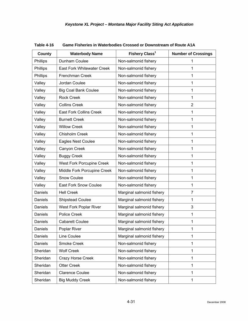
Keystone XL Project – Montana Major Facility Siting Act Application
4-31
Table 4-16 Game Fisheries in Waterbodies Crossed or Downstream of Route A1A
County Waterbody Name Fishery Class1 Number of Crossings
Phillips Dunham Coulee Non-salmonid fishery 1
Phillips East Fork Whitewater Creek Non-salmonid fishery 1
Phillips Frenchman Creek Non-salmonid fishery 1
Valley Jordan Coulee Non-salmonid fishery 1
Valley Big Coal Bank Coulee Non-salmonid fishery 1
Valley Rock Creek Non-salmonid fishery 1
Valley Collins Creek Non-salmonid fishery 2
Valley East Fork Collins Creek Non-salmonid fishery 1
Valley Burnett Creek Non-salmonid fishery 1
Valley Willow Creek Non-salmonid fishery 1
Valley Chisholm Creek Non-salmonid fishery 1
Valley Eagles Nest Coulee Non-salmonid fishery 1
Valley Canyon Creek Non-salmonid fishery 1
Valley Buggy Creek Non-salmonid fishery 1
Valley West Fork Porcupine Creek Non-salmonid fishery 1
Valley Middle Fork Porcupine Creek Non-salmonid fishery 1
Valley Snow Coulee Non-salmonid fishery 1
Valley East Fork Snow Coulee Non-salmonid fishery 1
Daniels Hell Creek Marginal salmonid fishery 7
Daniels Shipstead Coulee Marginal salmonid fishery 1
Daniels West Fork Poplar River Marginal salmonid fishery 3
Daniels Police Creek Marginal salmonid fishery 1
Daniels Cabarett Coulee Marginal salmonid fishery 1
Daniels Poplar River Marginal salmonid fishery 1
Daniels Line Coulee Marginal salmonid fishery 1
Daniels Smoke Creek Non-salmonid fishery 1
Sheridan Wolf Creek Non-salmonid fishery 1
Sheridan Crazy Horse Creek Non-salmonid fishery 1
Sheridan Otter Creek Non-salmonid fishery 1
Sheridan Clarence Coulee Non-salmonid fishery 1
Sheridan Big Muddy Creek Non-salmonid fishery 1
December 2008

Keystone XL Project – Montana Major Facility Siting Act Application
4-32
Table 4-16 Game Fisheries in Waterbodies Crossed or Downstream of Route A1A
County Waterbody Name Fishery Class1 Number of Crossings
Sheridan Reserve Creek Non-salmonid fishery 1
Sheridan Neiser Creek Non-salmonid fishery 1
Sheridan Lake Creek Non-salmonid fishery 1
Sheridan Lost Creek Non-salmonid fishery 1
Roosevelt West Shotgun Creek Non-salmonid fishery 1
Roosevelt East Shotgun Creek Non-salmonid fishery 1
Roosevelt Snake Creek Non-salmonid fishery 1 1 Non-salmonid fishery – Waters that do not provide habitat for trout and salmon species. Non-salmonid species include
sturgeons, suckers, minnows, etc. Blue Ribbon – Class I: Recreational fishery of outstanding value. Red Ribbon fishery – Class II: Recreational fishery of high value.
Big Game, Small Game, and Nongame
Big game species occurring along Route B are similar to those mentioned for all routes. Based on GIS analysis from the MFWP and the MTNHP, Table 4-17 lists the length and affected acreage of game ranges crossed by Route B.
Small game species occurring along Route B are similar to those mentioned for all routes. Based on the MFWP historic data, 24 greater sage grouse lek sites that have been identified as occurring within 4 miles of Route B. No historic sharp-tailed grouse lek sites have been identified within 2 miles of Route B.
Nongame species occurring along Route B are similar to those mentioned for all routes. Aerial surveys for raptor nests and prairie dog towns were conducted between September 22 and 25, 2008. One inactive prairie dog town was observed at the time of survey along Route B. Attachment I lists the locations of raptor nests along Route B. A total of 47 raptor nests were identified during the overflight. Of the 47 nests, 2 were active and 45 were inactive at the time of survey. One of the active nests was identified as a red-tailed hawk nest.
Aquatic Resources
Route B will cross 13 perennial streams in Montana. These include three larger rivers: the Milk River, the Missouri River, and the Yellowstone River. The Missouri River east of Fort Peck Reservoir to the border of Richland County is classified as a Class II, Red Ribbon Fishery and the Yellowstone River through Prairie County is classified as a Class I, Blue Ribbon Fishery. Game fish include a variety of warm water species such as burbot, walleye, crappie, channel catfish, pumpkinseed, sauger, green sunfish, bluegill, northern pike, sturgeon, and paddlefish (BLM 1995). A list of game fisheries crossed or downstream of the proposed Route B is found in Table 4-18.
December 2008

Keystone XL Project – Montana Major Facility Siting Act Application
4-33
Table 4-17 Big Game Winter Ranges Crossed by Route B
Milepost Locations
Game Type Beginning Milepost Ending Milepost Total Length
Crossed (miles) Acreage Affected
During Construction
54.38 57.42 3.0 40.5
65.77 68.17 2.4 32
79.79 84.92 5.1 68.4
87.31 91.03 3.7 49.6
121.3 124.35 3.1 40.7
137.73 142.86 5.1 68.4
152.97 171.01 18.0 240.5
193.56 196.93 3.4 44.9
244.51 247.23 2.7 36.3
248.48 248.57 0.1 1.2
White-tailed deer winter range
279.12 282.28 3.2 42.1
Total 49.9 664.7
Mule deer winter range 9.13 28.2 19.03 253.7
28.44 29.7 1.3 17.3
32.81 33.8 1.0 13.6
34.29 35.2 0.9 11.8
35.77 36.6 0.8 10.4
37.25 65.8 28.5 380.3
66.96 67.0 0.1 1.1
88.54 89.4 0.8 11.1
89.72 130.9 40.5 539.5
131.44 131.7 0.3 3.6
152.97 161.9 8.9 118.8
202.92 204.2 1.2 16.4
211.98 225.7 13.2 175.7
244.51 247.2 2.7 36.3
248.48 248.6 0.1 1.2
256.71 259.9 3.2 42.8
260.95 264.8 3.8 50.9
269.02 280.2 11.2 148.8
280.69 281.6 0.1 12
Total 119.4 1,845.3
December 2008

Keystone XL Project – Montana Major Facility Siting Act Application
4-34
Table 4-17 Big Game Winter Ranges Crossed by Route B
Milepost Locations
Game Type Beginning Milepost Ending Milepost Total Length
Crossed (miles) Acreage Affected
During Construction
11.39 12.38 0.1 13.2
12.68 13.82 1.1 15.2
14.08 20.27 6.2 82.5
21.55 26.85 5.3 70.7
38.75 65.77 27.0 360.3
74.63 82.67 8.0 107.2
83.73 83.74 0.0 0.1
111.66 129 17.3 231.2
162.17 163.12 0.1 12.7
163.91 164.33 0.4 5.6
219.19 219.49 0.3 4
254.97 255.69 0.7 9.6
258.25 258.89 0.6 8.5
Antelope winter range
267.97 280.18 12.2 162.8
Total 81.3 1,083.6
Source: MFWP 2008a (http://nris.mt.gov/gis/); acreage based on a nominal ROW of 110 feet.
December 2008

Keystone XL Project – Montana Major Facility Siting Act Application
4-35
Table 4-18 Game Fisheries in Waterbodies Crossed or Downstream of Route B
Waterbody County Fishery Class1 Number of Crossings
Route B
Dunham Coulee Phillips Non-salmonid fishery 1
Corral Coulee Phillips Non-salmonid fishery 2
Frenchman Creek Valley Non-salmonid fishery 1
Hay Coulee Valley Non-salmonid fishery 1
Rock Creek Valley Non-salmonid fishery 1
Willow Creek Valley Non-salmonid fishery 1
Lime Creek Valley Non-salmonid fishery 1
Black Coulee Valley Non-salmonid fishery 1
Brush Fork Valley Non-salmonid fishery 1
Bear Creek Valley Non-salmonid fishery 1
Unger Coulee Valley Non-salmonid fishery 1
Buggy Creek Valley Non-salmonid fishery 1
Alkali Coulee Valley Non-salmonid fishery 1
Wire Grass Coulee Valley Non-salmonid fishery 1
Spring Creek Valley Non-salmonid fishery 1
Mooney Coulee Valley Non-salmonid fishery 1
Cherry Creek Valley Non-salmonid fishery 1
Foss Coulee Valley Non-salmonid fishery 1
Spring Coulee Valley Non-salmonid fishery 1
East Fork Cherry Creek Valley Non-salmonid fishery 1
Milk River Valley Non-salmonid fishery 1
Missouri River McCone Salmonid fishery, Red Ribbon, Class II 1
West Fork Lost Creek McCone Non-salmonid fishery 1
Jorgensen Coulee McCone Non-salmonid fishery 1
Cheer Creek McCone Non-salmonid fishery 1
Bear Creek McCone Non-salmonid fishery 1
South Fork Shade Creek McCone Non-salmonid fishery 1
Flying V Creek McCone Non-salmonid fishery 2
Figure Eight Creek McCone Non-salmonid fishery 1
December 2008

Keystone XL Project – Montana Major Facility Siting Act Application
4-36
Table 4-18 Game Fisheries in Waterbodies Crossed or Downstream of Route B
Waterbody County Fishery Class1 Number of Crossings
Middle Fork Prairie Elk Creek McCone Non-salmonid fishery 1
East Fork Prairie Elk Creek McCone Non-salmonid fishery 1
Lone Tree Creek McCone Non-salmonid fishery 1
Redwater River McCone Non-salmonid fishery 1
Buffalo Springs Creek McCone Non-salmonid fishery 3
Cottonwood Creek Dawson Non-salmonid fishery 1
Berry Creek Dawson Non-salmonid fishery 1
Hay Creek Dawson Non-salmonid fishery 1
Upper Seven Mile Creek Dawson Non-salmonid fishery 1
Clear Creek Dawson Non-salmonid fishery 1
Cracker Box Creek Dawson Non-salmonid fishery 1
Yellowstone River Dawson Non-salmonid fishery, Blue Ribbon, Class I 1
Cabin Creek Prairie Non-salmonid fishery 1
West Fork Hay Creek Prairie Non-salmonid fishery 1
Hay Creek Prairie Non-salmonid fishery 2
Dry Fork Creek Fallon Non-salmonid fishery 2
Pennel Creek Fallon Non-salmonid fishery 1
Sandstone Creek Fallon Non-salmonid fishery 1
Red Butte Creek Fallon Non-salmonid fishery 1
Hidden Water Creek Fallon Non-salmonid fishery 1
Little Beaver Creek Fallon Non-salmonid fishery 1
Soda Creek Fallon Non-salmonid fishery 1
North Fork Coal Bank Creek Fallon Non-salmonid fishery 1
South Fork Coal Bank Creek Fallon Non-salmonid fishery 1
Boxelder Creek Fallon Non-salmonid fishery 1 1 Non-salmonid fishery – Waters that do not provide habitat for trout and salmon species. Non-salmonid species include sturgeons,
suckers, minnows, etc. Blue Ribbon – Class I: Recreational fishery of outstanding value. Red Ribbon fishery – Class II: Recreational fishery of high value.
December 2008

Keystone XL Project – Montana Major Facility Siting Act Application
4-37
4.3.4.5 Impact Assessment
Terrestrial Wildlife
Issues
• Habitat loss or alteration and incremental habitat fragmentation;
• Loss of breeding success from exposure to construction and operational noise and from higher levels of human activity;
• Limited direct mortalities from Project construction and operation; and
• The potential loss of individuals from exposures to accidental crude oil releases.
Construction
Wildlife Habitat
Potential impacts to terrestrial wildlife species from the Project can be classified as short-term, long-term, and permanent. Short-term impacts consist of activities associated with Project construction and changes in wildlife habitats lasting less than 5 years. This would include impacts to species dependent on herbaceous habitats. Long-term impacts would consist of changes to wildlife habitats lasting 5 years or more and would include species dependent on habitats with woody species components. Permanent impacts would result from construction of aboveground facilities that convert natural habitat to an industrial site. The severity of both short- and long-term impacts would depend on factors such as the sensitivity of the species impacted, seasonal use patterns, type and timing of construction activities, and physical parameters (e.g., topography, cover, forage, and climate).
Less mobile or burrowing species may be lost to construction vehicles and equipment. Other potential impacts include habitat loss or alteration, habitat fragmentation, and animal displacement. Individuals may be permanently displaced and perish due to increased competition or other effects of being forced into sub-optimal habitat. Indirect impacts from increased noise and additional human presence also could lead to displacement and lowered fitness. However, the habitat adjacent to the construction zone would support displaced animals due to the small scale amount of disturbance compared to the surrounding available habitat.
Habitat fragmentation is frequently a concern when clearing ROWs. In general, fragmentation results in an altered wildlife community as species more adaptable to edge habitats establish themselves, while species requiring undisturbed habitats are subject to more negative effects. These effects would result in overall changes in habitat quality, habitat loss, increased animal displacement, reductions in local wildlife and migratory bird numbers, and changes in species composition. The severity of these effects on migratory birds depends on factors such as sensitivity of the species, seasonal use, type and timing of construction activities, and physical parameters (e.g., topography, cover, forage, and climate). The effects of fragmentation on native wildlife populations would be relatively small since the majority of the Project would cross relatively open habitat types (e.g., shrubland, grassland, and cultivated land).
Due to the linear nature of the Project over a large geographic area (approximately 282 linear miles of new pipe), the area impacted will represent a small percent of available wildlife habitat on a regional basis. The effects of short- and long-term habitat loss on native wildlife populations will be relatively small since the majority of habitat disturbance will be restored to the pre-disturbance condition. Agricultural lands will continue to be used for pre-construction uses while rangeland/grassland habitats will be reclaimed to primarily herbaceous communities using appropriate seed mixes prescribed by local, state, and federal agencies. Loss of shrub communities will be long-term (5 to 20 years or more) within reclaimed areas of the construction ROW since these communities will become reestablished through the natural reinvasion of woody species. Loss of woodland vegetation will be permanent since trees will not be allowed to reestablish within 15 feet of either
December 2008

Keystone XL Project – Montana Major Facility Siting Act Application
4-38
side of the pipeline centerline. Habitat losses also will be long-term at permanent aboveground pipeline facility locations such as pump stations and access roads.
Construction of Route B will result in the short-term disturbance and long-term habitat modification of: 0.82 mile of the Phillips County USFWS wetland easement, 19.4 miles of state lands, and 42.6 miles of federal lands. Long-term conversion of wooded habitats to herbaceous communities will result in an increase in habitat fragmentation in these areas but habitat conversion also could increase habitat diversity, depending on the extent of habitats affected and the extent and distribution of undisturbed habitats remaining in the state wildlife areas. Construction during the fall hunting seasons will create conflicts with hunter use of these areas.
Big Game Species
Construction impacts to primary big game species (white-tailed deer, mule deer, and antelope) will include the short-term loss of potential forage and will result in a temporary increase in habitat fragmentation within the proposed surface disturbance areas. These losses of vegetation will represent only a small percentage of the overall available habitat within the broader Project region. The loss of shrubland vegetation would be long-term (greater than 5 years and, in some cases, more than 20 years). In the interim, herbaceous species will become established within 3 to 5 years, depending on future weather conditions and grazing management practices that would affect reclamation success in the Project region. In most instances, suitable habitat adjacent to the disturbed areas would be available for wildlife species until grasses and woody vegetation were reestablished within the disturbance areas.
Indirect short-term impacts will result from increased noise levels and human presence during surface disturbance activities. Big game animals (especially antelope and mule deer) would decrease their use within 0.5 mile of surface disturbance activities due to increased noise levels (Ward et al. 1980; Ward 1976). This displacement would be short term and animals would return to the disturbance area following construction activities.
Small Game Species
Potential impacts to small game from the Project will result in the temporary loss of habitat and short-term habitat fragmentation until vegetation is reestablished. Indirect impacts could include the temporary displacement of small game from the disturbance areas as a result of increased noise and human presence. Although habitats adjacent to the Project and other disturbance areas may support some displaced animals, species that are at or near carrying capacity could suffer some increased mortalities due to displacement. Displacement or loss of small game animals from disturbance areas will be short-term because of their generally high reproductive potentials and the fact that animals will return to the disturbance areas following completion of construction and reclamation activities.
Potential direct impacts to small game species could include nest or burrow abandonment, loss of eggs or young where construction occurs during the breeding season. Of greatest concern is the potential for loss of lekking grounds and other greater sage-grouse and sharp-tailed grouse habitat (e.g., nesting habitat).
Although the Project would not result in a permanent loss of habitat along the pipeline ROW, the regeneration of sagebrush would likely be slow. A 30-year interval represents the approximate recovery period for a stand of Wyoming big sagebrush. A 20-year interval represents the approximate recovery time for a stand of mountain sagebrush (Connelly et al. 2000). The potential impacts on sage-grouse habitat would be minimized by locating the proposed ROW within previously disturbed areas (i.e., adjacent to existing pipelines and/or roads) to the extent possible. Given the abundant suitable habitat in the general area, it is not likely that the minor, yet long-term, loss of habitat along the pipeline ROW would affect sage-grouse populations in the vicinity of the Project.
December 2008

Keystone XL Project – Montana Major Facility Siting Act Application
4-39
Depending on the timing of construction, the Project could potentially impact sage-grouse and sharp-tailed grouse during lekking activities or brood rearing. Keystone will continue to consult with MTFWP, BLM, and USFWS regarding recommended avoidance and minimization measures in order to address sage-grouse lek buffers, sites and breeding areas.
Nongame Species
Direct impacts to nongame species from surface disturbance activities will result from the temporary loss of habitat and increased fragmentation until vegetation is reestablished. Potential impacts also will result in mortalities of less mobile or burrowing nongame species (e.g., small mammals, birds, reptiles, amphibians, invertebrates) due to exposure to vehicles and construction equipment traffic. Potential direct impacts also could include nest or burrow abandonment or loss of eggs or young where construction occurs during the breeding season. Other impacts will include the short-term displacement of some of the more mobile species (e.g., medium-sized mammals, adult birds) as a result of surface disturbance. Although the habitats adjacent to the proposed disturbance area may support some displaced animals, species that are at or near carrying capacity could suffer some increased mortalities. Displacement or loss of nongame species from disturbance areas will be short-term because of their generally high reproductive potentials and the fact that animals will return to the disturbance areas following completion of construction and reclamation activities.
If surface disturbance activities occur during the breeding season for passerines, raptors, and other summer avian residents (approximately March 1 through August 31), nest or territory abandonment or the loss of eggs or young (loss of productivity) for the breeding season could result. Impacts to nesting birds will depend on the nest location relative to the proposed disturbance area, the phase of the breeding period, and the level and duration of the disturbance.
Table 4-19 outlines the preferred timing and buffer distances for a variety of species provided by the agencies. Keystone will continue to work with the agencies to determine a mutually agreeable strategy for minimizing potential impacts, while still allowing for a feasible construction schedule.
Operation
Normal pipeline operations will have negligible effects on terrestrial wildlife resources. Direct impacts to wildlife species populations and habitats from maintenance activities such as physical pipe inspections or ROW repair will be the same as those discussed above for construction. In order to reduce potential impacts to important wildlife resources as a result of maintenance activities, Keystone will consult with the appropriate state wildlife agencies prior to the initiation of maintenance activities beyond standard inspection measures.
Keystone will employ multiple safeguards to prevent a pipeline release. The chance of a spill occurring is very low and if a spill occurred, the volume is likely to be relatively small. In the unlikely event of a pipeline release, Keystone would initiate its ERP and emergency response teams would contain and clean up the spill. To minimize impacts to wildlife, appropriate remedial measures will be implemented to meet federal and state standards designed to ensure protection of human health and environmental quality. Additional information on potential impacts to wildlife resulting from a crude oil spill is provided in the Risk Assessment (Attachment D).
Aquatic Resources
Issues
• Short-term physical disturbance to stream channels;
• Short-term increases in suspended solids concentrations from in-stream activities and erosion from adjacent disturbed lands;
• One-time increases in downstream sedimentation from in-stream activities and erosion from adjacent disturbed lands;
December 2008
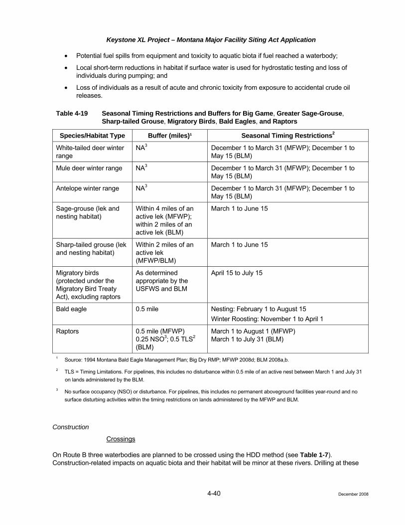
Keystone XL Project – Montana Major Facility Siting Act Application
4-40
• Potential fuel spills from equipment and toxicity to aquatic biota if fuel reached a waterbody;
• Local short-term reductions in habitat if surface water is used for hydrostatic testing and loss of individuals during pumping; and
• Loss of individuals as a result of acute and chronic toxicity from exposure to accidental crude oil releases.
Table 4-19 Seasonal Timing Restrictions and Buffers for Big Game, Greater Sage-Grouse, Sharp-tailed Grouse, Migratory Birds, Bald Eagles, and Raptors
Species/Habitat Type Buffer (miles)¹ Seasonal Timing Restrictions2
White-tailed deer winter range
NA3 December 1 to March 31 (MFWP); December 1 to May 15 (BLM)
Mule deer winter range NA3 December 1 to March 31 (MFWP); December 1 to May 15 (BLM)
Antelope winter range NA3 December 1 to March 31 (MFWP); December 1 to May 15 (BLM)
Sage-grouse (lek and nesting habitat)
Within 4 miles of an active lek (MFWP); within 2 miles of an active lek (BLM)
March 1 to June 15
Sharp-tailed grouse (lek and nesting habitat)
Within 2 miles of an active lek (MFWP/BLM)
March 1 to June 15
Migratory birds (protected under the Migratory Bird Treaty Act), excluding raptors
As determined appropriate by the USFWS and BLM
April 15 to July 15
Bald eagle 0.5 mile Nesting: February 1 to August 15 Winter Roosting: November 1 to April 1
Raptors 0.5 mile (MFWP) 0.25 NSO3; 0.5 TLS2 (BLM)
March 1 to August 1 (MFWP) March 1 to July 31 (BLM)
1 Source: 1994 Montana Bald Eagle Management Plan; Big Dry RMP; MFWP 2008d; BLM 2008a,b.
2 TLS = Timing Limitations. For pipelines, this includes no disturbance within 0.5 mile of an active nest between March 1 and July 31 on lands administered by the BLM.
3 No surface occupancy (NSO) or disturbance. For pipelines, this includes no permanent aboveground facilities year-round and no surface disturbing activities within the timing restrictions on lands administered by the MFWP and BLM.
Construction
Crossings
On Route B three waterbodies are planned to be crossed using the HDD method (see Table 1-7). Construction-related impacts on aquatic biota and their habitat will be minor at these rivers. Drilling at these
December 2008

Keystone XL Project – Montana Major Facility Siting Act Application
4-41
rivers will aid in minimizing impacts to important game and commercial fish species and special status species. Directional drilling will not alter or remove habitat because construction within the channel will not be required. It is possible that mud from the directional drilling could inadvertently enter the active stream along the drilling route. Measures will be undertaken to reduce additional seepage and cleanup of what was released will occur. If any seepage enters the stream, increased turbidity or physical impact to the covering substrate will be localized and short-term (less than 1 day). All preventative and response measures to frac-outs will be located in a frac-out contingency plan. Open cut trenching will be used on the remaining perennial streams, all of which contain at least one or more game fish species.
In-stream Habitat
In the vicinity of the trenchline, trenching and backfilling can result in alteration of in-stream habitat and the mortality of benthic invertebrates inhabiting that reach of the watercourse. Studies done to monitor the effects on benthic invertebrates have indicated that the impacts are short-term. The disturbed area typically is recolonized by benthic invertebrates to near pre-construction levels by the spring or summer following construction (Tsui and McCart 1981; Schubert and Vinikour 1987).
Backfilling the in-stream trench can either improve or lessen the quality of habitat available. This habitat quality change will depend largely on the nature of the soil materials from the lower depths of the trench with respect to those near the surface. If backfilling results in a different material on the stream bed surface than the adjacent areas, a local habitat modification may have occurred. However, the limited extent of the disturbed area and the active bottom substrate sorting by a river suggest any such habitat modification will be small and of short duration in most stream environments.
Bank Cover
Vegetative cover along the stream banks of a waterbody provides cover for fish, shading, bank stability, erosion control, and an increased food and nutrient supply due to the deposition of insects and vegetative matter into the watercourse. Loss of bank cover may result in increased water temperatures, reduced food supply, impaired aesthetics, and reduced productivity. The potential for channel migration also can be increased since the removal of vegetation destabilizes the banks at discrete locations. Given the relatively small width of disturbance associated with a pipeline crossing, the above impacts tend to be negligible relative to an entire stream system. The CMRP provides bank restoration measures that will ensure short-term bank stability (temporary erosion control structures) and rapid vegetation recovery (replanting woody species where appropriate).
Interruption of Fish Movement
Most water crossing methods allow movement of fish across the ROW; however, some techniques such as dry crossing procedures, may temporarily block or delay normal movements. Long-term interruption of fish movement in a watercourse or a relatively short-term delay in spawning migration can have adverse impacts. Interruptions during sensitive periods typically are not a concern since in-stream construction generally can be performed outside of sensitive periods. Blockage of non-spawning-related fish movement for limited periods (less than 7 days) should not affect fish growth and behavior. Delays of less than 3 days will not adversely affect spawning migrations (Dryden and Stein 1975).
Direct Disturbance of Spawning
In-stream construction activities can displace spawning fish from preferred habitat and result in the utilization of lower quality spawning habitat. Generally, this is of limited concern for water crossing construction since in-stream activities generally are not scheduled during spawning periods. Keystone will work with agencies as necessary to further define spawning periods and to refine construction schedules to avoid, where possible,
December 2008

Keystone XL Project – Montana Major Facility Siting Act Application
4-42
instream activities during sensitive periods. As shown in Table 4-10, spawning periods for most fish species extend from April through June.
Water Quality Effects
It is widely recognized that in-stream excavation activities result in short-term increases in total suspended solids (TSS) levels and turbidity. These levels decrease with distance from the source as particles settle. The levels also decrease with time following cessation of in-stream activities.
The impact to aquatic organisms by increases in suspended solids levels is a function of the duration of exposure and the concentration of suspended solids. While relatively high levels of TSS can occur immediately downstream of a crossing, the effects are very short-term with construction across most streams being completed in 1 day. The waterbodies in the Project area normally experience wide ranges in seasonal flow rates (large peak flows due to precipitation events), and drain through areas with relatively fine grained soils. These factors cause sudden natural peaks in suspended solids concentrations. The aquatic systems supported by these waterbodies are adapted to such increases.
The extent of the increase in TSS levels would be mitigated by Keystone through the use of BMPs that include: measures to reduce the period of instream activity, spoil handling techniques, equipment access and installation procedures. Standard industry BMPs also address upland erosion and sediment control procedures to limit the potential for runoff from disturbed areas to contribute to increased in-stream TSS.
Sedimentation Effects
Solids introduced into suspension in a waterbody ultimately will settle on the streambed downstream of the crossing. The distance from the crossing is dependent upon the depth of flow, flow velocity, particle diameter, and flow characteristics. Coarser materials (sands and gravels) tend to settle relatively close to the crossing location and tend to be distributed uniformly across the stream section. Fine silts and clays can stay in suspension for considerable periods of time and will tend to settle in natural depositional areas downstream of the crossing.
The channel substrates of the streams and rivers that will be crossed by the Project consist primarily of fine grained materials (clay, silt, and sand). Fine-grained excavated material that is deposited downstream is expected to be similar to the existing substrate. Stream flows will suspend and re-deposit excavated materials during higher flow periods.
Young and Mackie (1991) found that benthic invertebrates inhabiting the upper surface of the substrate may be more adaptable to sedimentation than are taxa occupying the interstitial spaces of the substrate. Post construction studies have shown that benthic invertebrate populations generally have recovered to normal within 1 to 2 months of construction. Tsui and McCart (1981) reported benthic invertebrate populations downstream of a water crossing had recovered to near pre-construction levels shortly after construction.
The BMPs adopted for the Project as described in the CMRP will mitigate the short-term effects of downstream sedimentation, as discussed under Water Quality Effects.
Hydrostatic Testing
The CMRP and Table 4-36 in subsection 4.3.5.4, list 10 streams or rivers in Montana as potential water sources for hydrostatic testing for Route B. The water sources are located throughout the length of the proposed route. The water is likely to be withdrawn from water sources during summer and fall months. Relatively small one-time withdrawals will occur from the streams or rivers designated for hydrostatic test water in accordance with withdrawal permits.
December 2008

Keystone XL Project – Montana Major Facility Siting Act Application
4-43
4.3.4
Withdrawal rates and volumes will be designed to avoid impacts to aquatic life and downstream water users. Hydrostatic test water will be discharged to the land surface at an approved location or be returned to the source with an approved energy dissipation device. Discharged water may evaporate or infiltrate into the soil or drainage where the water is released. Hydrostatic test water will be withdrawn and returned to the same water source.
Water withdrawal could entrain small fish and drifting macroinvertebrates. The expected numbers of organisms removed during entrainment is considered to be relatively small in relation to the overall numbers in the stream or river. In summary, hydrostatic testing will result in minor impacts to aquatic biota. The discharge of hydrostatic test water will follow state permit requirements, which will reduce potential effects on water quality or aquatic organisms. Energy dissipaters also will be used to prevent erosion at discharge locations.
Operation
Routine maintenance of the pipeline ROW will consist of periodic tree and brush removal. Vegetation removal adjacent to waterbodies will be limited to the removal of trees within 15 feet of the centerline. As a result, maintenance activities will not affect aquatic biota or their habitat.
Keystone will employ multiple safeguards to prevent a pipeline release. The chance of a spill occurring is very low and if a spill occurred, the volume is likely to be relatively small. In the unlikely event of a pipeline release, Keystone would initiate its ERP and emergency response teams would contain and clean up the spill. To minimize impacts to aquatic resources, appropriate remedial measures will be implemented to meet federal and state standards designed to ensure protection of human health and environmental quality. Additional information on potential impacts to aquatic resources resulting from a crude oil spill is provided in the Risk Assessment (Attachment D).
.6 Special Status Species: Baseline Data and Description – All Routes
Special status species are those in which federal and/or state agencies provide protection by law, regulation, or policy. This includes federally listed and federally proposed for listing species with designated critical habitat that are protected under the ESA, and species listed as sensitive or special status by the BLM. The BLM special status species are protected by law, regulation, or policy on lands owned by the BLM only. Other species of concern analyzed in this document include those species that have been designated as Species of Concern by the MFWP and the MTNHP. This designation is not a regulatory or statutory classification. “Instead, this designation provides a basis for resource managers and decision makers to direct limited resources to priority data collection needs and address conservation needs proactively” (MTNHP and MFWP 2006).
Special status species analysis focused on wildlife and plant species and habitats that may be affected by construction and operation of the proposed Project. The process considered federal laws and state statutes. The ESA is administered by the USFWS and provides broad national protection for fish, wildlife, and plants that are listed as endangered, threatened or proposed for listing. The ESA outlines procedures for federal agencies to follow when a listed species or designated habitat may be affected by an action they authorize, fund, or permit.
Special status wildlife and aquatic species potentially occurring within suitable habitat along all alternative routes are discussed under the appropriate route analysis below.
Consultation (Circular MFSA-2 Section 3.0(4); Section 3.7(12)(d))
Potential occurrence data for sensitive terrestrial and aquatic species was obtained from MFWP, MTNHP, USFWS websites, and other applicable websites (e.g., NatureServe). In addition, consultations with the USFWS, MFWP, and MTNHP were used to gather occurrence data. The results of these desktop analyses and consultations are identified in Attachment H. Methods for establishing a baseline of status, occurrence,
December 2008

Keystone XL Project – Montana Major Facility Siting Act Application
4-44
and associated habitat of wildlife that may occur within the proposed Project area include reviewing published literature, natural heritage database information, internet websites, agency correspondence, and field surveys. Biologists with the USFWS, MFWP, and MTNHP were contacted for information about the status of wildlife species, habitat, special wildlife features, and habitats in the proposed Project area (USFWS 2008b). Aerial biological surveys were conducted in April and September 2008 to identify raptor nests and prairie dog towns.
Wildlife Habitat and Critical Habitat (Circular MFSA-2 Sections 3.7(1)(e)) and 3.7 (12)(b)(x))
Habitats for special status species are similar to those discussed in Section 4.3.4.2.
Critical habitat is defined in the ESA as “(i) the specific areas within the geographic area occupied by a species, at the time it is listed in accordance with the Endangered Species Act, on which are found those physical or biological features (I) essential to conserve the species and (II) that may require special management considerations or protection; and (ii) specific areas outside the geographic area occupied by a species at the time it is listed, upon determination that such areas are essential to conserve the species (ESA Section 3(5)(A)).” Critical habitat is not crossed by any of the route alternatives but is present for the piping plover in proximity to the alternative routes. Table 4-20 lists the locations of piping plover critical habitat within the study area.
Table 4-20 Piping Plover Critical Habitat within the Study Area
Counties Location Comments
Sheridan Alkali Lakes and Wetlands including Medicine Lake National Wildlife Refuge
Phillips Bowdoin National Wildlife Refuge
McCone/Richland/Roosevelt Missouri River
McCone/Garfield/Valley/Phillips Fort Peck Reservoir/Charles M. Russell National Wildlife Refuge
Source: Federal Register 2001.
Special Status – Aquatic Species
Based upon data obtained from agency consultation and websites (USFWS 2008c; MFWP 2008e,f; MTNHP 2008a,b), a total of 10 special status aquatic wildlife species were identified as potentially occurring along all routes (Attachment H). Occurrence potential along the proposed route was evaluated for each species based on its habitat requirements and/or known distribution. A summary of sensitive species that occur along each alternative route is provided below.
4.3.4.7 Special Status Species: Baseline Data and Description – Route A
A total of 59 special status wildlife and aquatic species could potentially occur within suitable habitat along the proposed Route A. Of the 59, 3 (black-footed ferret, whooping crane, and piping plover) are federally listed. Thirty-seven are identified as BLM species of concern and 22 are listed as MFWP species of concern. All special status species potentially occurring along Route A are listed in Attachment H.
Terrestrial and Aquatic Species
A total of 55 special status terrestrial wildlife species could potentially occur within suitable habitat along the proposed Route A. Of the 55, 3 (black-footed ferret, whooping crane, and piping plover) are federally listed. The remaining 52 are identified as BLM species of concern and species of concern.
December 2008

Keystone XL Project – Montana Major Facility Siting Act Application
4-45
4.3.4
A total of four special status aquatic species could potentially occur within suitable habitat along the proposed Route A. These include the blue sucker, pearl dace, sauger, and northern redbelly x finescale dace. All four are BLM and MFWP species of concern. Big Muddy Creek, crossed by Route A at Milepost A-147, contains known occurrence data for the blue sucker and sauger.
.8 Special Status Species: Baseline Data and Description – Route A1A
A total of 47 special status wildlife species could potentially occur within suitable habitat along the proposed Route A1A. Of the 47, 3 (black-footed ferret, whooping crane, and piping plover) are federally listed, 12 are identified as BLM species of concern, and 22 are MFWP species of concern.
Terrestrial and Aquatic Species
A total of 46 special status terrestrial wildlife species could potentially occur within suitable habitat along the proposed Route A1A. Of the 46, three (black-footed ferret, whooping crane, and piping plover) are federally listed. The remaining 43 are identified as BLM species of concern and MFWP species of concern.
One special status aquatic species (northern redbelly x finescale dace) could potentially occur within suitable habitat along the Route A1A. This species is identified as a BLM species of concern and a MFWP species of concern. However, according to the MTNHP (2008), Route A1A does not cross any streams with any known occurrence data for sensitive fish species.
4.3.4.9 Special Status Species: Baseline Data and Description – Route B
A total of 65 special status wildlife species could potentially occur within suitable habitat along the proposed Route B. Of the 65, five (black-footed ferret, whooping crane, interior least tern, piping plover, and the pallid sturgeon) are federally listed, 57 are identified as BLM species of concern, and 14 are Montana species of concern. Attachment H lists all special status species identified as potentially occurring along Route B.
Terrestrial and Aquatic Species
A total of 56 special status terrestrial wildlife species could potentially occur within suitable habitat along the proposed Route B. Of the 56, four (black-footed ferret, whooping crane, interior least tern, and piping plover) are federally listed. The remaining 52 are identified as BLM species of concern and MFWP species of concern.
A total of nine special status aquatic species could potentially occur within suitable habitat along the proposed Route B. Of the nine, one (pallid sturgeon) is federally listed. The remaining eight are identified as BLM species of concern and MFWP species of concern.
Cherry Creek, the Milk River, the Missouri River, the Redwater River, the Yellowstone River, and Boxelder Creek all contain habitat for special status species. These are the sicklefin chub, sturgeon chub, shortnose gar, sauger, blue sucker, redbelly x finescale dace, and paddlefish. Finally, the pallid sturgeon; a USFWS endangered species is present in the Milk River, the Missouri River, and the Yellowstone River.
4.3.4.10 Special Status Species: Impact Assessment
Issues
• The issues are the same as those for general wildlife species in Section 4.3.4.
Construction
Terrestrial Wildlife Species
Potential impacts to sensitive wildlife resources are similar to those discussed in this section. Direct impacts to sensitive species from surface disturbance activities include the loss or alteration of potential breeding and/or
December 2008

Keystone XL Project – Montana Major Facility Siting Act Application
4-46
foraging habitats and short-term habitat fragmentation until native vegetation has become reestablished. Potential impacts also could include mortalities of less mobile species as the result of exposure to vehicle and construction equipment traffic, and the potential abandonment of a nest site or territory, including the loss of eggs or young. Other impacts will include short-term displacement of some of the more mobile species from the disturbance areas as a result of increased noise and human presence.
A number of occurrences of species of special concern have been identified by the MTNHP as occurring near or within the Project area. For terrestrial wildlife, most sensitive species may be rare within a given state but their populations are relatively secure elsewhere. In addition, most are relatively mobile species that could avoid short-term construction disturbance with no resulting long-term adverse effects on local populations. Increased mortality rates could occur in species that are less mobile as the result of exposure to vehicles and construction traffic. This will result in the loss of some individuals but the relatively narrow and linear disturbance area that will be associated with pipeline construction is unlikely to have measurable adverse effects on local populations of sensitive species. For a few species, however, such as the greater sage-grouse, construction through an important habitat feature, such as a lek, may result in the loss of a local breeding population. This could result in extirpation of a remnant population and contribute to a trend leading to federal listing without the implementation of appropriate mitigation.
Surface disturbance activities along the pipeline ROW will result in the disturbance of portions of native prairie, wetland, and woodland habitats, which may contain potentially suitable habitat for a number of sensitive species. Preconstruction surveys for federally listed, BLM special status species, and state special status species are still to be determined through consultation with the USFWS, BLM, and state wildlife agencies. If surveys are required, they will be completed prior to surface disturbances. Once these surveys are complete and if important habitat or populations are identified, appropriate protection measures will be implemented in order to minimize potential impacts to these species.
Aquatic Species
The types of impacts that could affect sensitive fish species are similar to those discussed for game fish species. Construction-related impacts on sensitive species living in streams that will be crossed by the Project using HDD (subsection 4.3.5.4, Table 4-36) will be minor, since directional drilling will eliminate disturbance within the channel. In contrast, open-cut trenching at other streams listed above will result in alteration of bottom substrates, temporary increased sedimentation, and possible removal of riparian vegetation. The degree of impact will depend upon whether important fish spawning or rearing habitat is altered. Adult fish are likely to move away from the construction area. Generally, impacts could range from several weeks to several years, depending on the life stages that are affected and whether future spawning will be affected.
Natural Heritage Inventory information indicates that special status species are found almost exclusively in large rivers including the Missouri, the Yellowstone, and the Milk, all of which will be crossed using HDD, resulting in minimal to no impacts. Other waterbodies with special status species include Boxelder Creek on Route B, and the Poplar River on Route A1A. These waterbodies will more likely be crossed by an open cut method, but low water conditions would be favored in many cases, often avoiding key spawning times for special status species. Keystone will continue its consultation with the appropriate agencies to determine a mutually agreeable strategy for minimizing potential impacts.
Potential sources for hydrostatic testing and dust control water are listed in Section 4.3.5. Specific water volumes that will be withdrawn from these streams are not known at this time but will be quantified as details of the hydrostatic test plan are finalized. Nevertheless, water use from any of these streams will result in a relatively small one-time flow reduction. Water withdrawal is expected to represent a relatively small percentage of base flow conditions. Therefore, impacts on fish habitat will be considered minor in the mid-size to large streams. A low level impact could occur in the smaller streams. The discharge of hydrostatic test water will follow state permit requirements, which will eliminate potential water quality effects on sensitive species.
December 2008

Keystone XL Project – Montana Major Facility Siting Act Application
4-47
4.3.4
Operation
In order to reduce potential impacts to sensitive wildlife species as a result of maintenance activities, Keystone will consult with the appropriate state wildlife or land management agency prior to the initiation of maintenance activities beyond standard inspection measures.
Keystone will employ multiple safeguards to prevent a pipeline release. The chance of a spill occurring is very low and if a spill occurred, the volume is likely to be relatively small. In the unlikely event of a pipeline release, Keystone would initiate its ERP and emergency response teams would contain and clean up the spill. To minimize impacts to special status species, appropriate remedial measures will be implemented to meet federal and state standards designed to ensure protection of human health and environmental quality. Additional information on potential impacts to special status species resulting from a crude oil spill is provided in the Risk Assessment (Attachment D).
.11 Summary of Route-Specific Wildlife, Fisheries and Special Status Species Impacts
Route-specific impacts for wildlife, fisheries, and special concern species are summarized in Table 4-21. Identified impacts will be substantially mitigated as discussed within this application and further outlined in the CMRP for all Routes. Based strictly on the relative lengths of the routes within the State of Montana and not taking into consideration the overall effect through Montana, South Dakota, and Nebraska, Route B has the greatest impacts. However, when the full Steele City Segment impacts are considered, frequently the additional length of Routes A and A1A would result in greater impacts.
Table 4-21 Summary of Route-Specific Wildlife, Fisheries and Special Status Species Impacts
Route Alternatives
Resource Route A Route A1A Route B
Miles of Pipe
Steele City Segment 919.7 951.3 850.7
Portion in Montana 180.7 205.5 282.7
Wildlife and Fisheries
Big game species Route A crosses 14.5 miles of white-tailed deer winter range, 41.68 miles of mule deer winter range, and 26.48 miles of antelope winter range.
Route A1A crosses 31.98 miles of white-tailed deer winter range, 44.63 miles of mule deer winter range, and 26.48 miles of antelope winter range.
Route B crosses 49.85 miles of white-tailed deer winter range, 119.37 miles of mule deer winter range, and 81.27 miles of antelope winter range.
Greater sage grouse and sharp-tailed grouse
Route A crosses 8 known greater sage-grouse leks and/or their associated buffer zones.
Route A1A crosses 8 known greater sage-grouse leks and/or their associated buffer zones.
Route B crosses 24 known greater sage-grouse leks and/or their associated buffer zones.
Aquatic resources Route A does not cross any Class I or II fisheries.
Route A1A does not cross any Class I or II fisheries.
Route B crosses one Class I fishery at the Yellowstone River and one Class II fishery at the Missouri River.
December 2008

Keystone XL Project – Montana Major Facility Siting Act Application
4-48
Table 4-21 Summary of Route-Specific Wildlife, Fisheries and Special Status Species Impacts
Route Alternatives
Resource Route A Route A1A Route B
Miles of Pipe
Steele City Segment 919.7 951.3 850.7
Portion in Montana 180.7 205.5 282.7
Special Status Species
Special status species
A total of 59 special status wildlife species could potentially occur within suitable habitat along Route A. Of the 59, three (black-footed ferret, whooping crane, and the piping plover) are federally listed under the ESA; 37 are identified as BLM species of concern; and 22 are Montana species of concern.
A total of 47 special status wildlife species could potentially occur within suitable habitat along Route A1A. Of the 47, three (black-footed ferret, whooping crane, and the piping plover) are federally listed under the ESA; 12 are identified as BLM species of concern; and 22 are Montana species of concern.
A total of 65 special status wildlife species could potentially occur within suitable habitat along Route B. Of the 65, five (black-footed ferret, whooping crane, interior least tern, piping plover, and the pallid sturgeon) are federally listed under the ESA; 51 are identified as BLM species of concern; and 14 are Montana species of concern.
References
Bureau of Land Management (BLM). 2008a. Correspondence from K. Undlin (BLM) to P. Lorenz (ENSR). August 22, 2008.
_____. 2008b. Correspondence from J. Carlson (BLM) to P. Lorenz (ENSR). August 14, 2008.
_____. 2000. Bitter Creek and Mountain Plover Areas of Critical Environmental Concern Plan Amendment and Environmental Assessment. Glasgow Field Station. Glasgow, Montana. December 2000.
_____. 1995. Big Dry Resource Management Plan and Final Environmental Impact Statement. Miles City District Office. Big Dry Resource Area. February 1995.
_____. 1994. Montana Bald Eagle Management Plan. Billings, Montana. July 1994.
Connelly, J. W., M. A. Schroeder, A. R. Sands, and C. E. Braun. 2000. Guidelines to Manage Sage Grouse Populations and Their Habitats. Wildlife Society Bulletin 28(4):967-985.
Dryden, R. L. and J. M. Stein. 1975. Guidelines for the Protection of the Fish Resources of the Northwest Territories During Highway Construction and Operation. Department of the Environment, Fisheries and Marine Service, Technical Report Series No. CEN/T-75-1.
Eddy, S. and J. Underhill. 1974. Northern Fishes. University of Minnesota Press, Minneapolis, Minnesota. 414 pp.
Federal Register. 2001. Endangered and Threatened Wildlife and Plants; Proposed Designation of Critical Habitat for the Northern Great Plains Breeding Population of the Piping Plover; Reopening of Public
December 2008

Keystone XL Project – Montana Major Facility Siting Act Application
4-49
Comment Period and Notice of Availability of Draft Economic Analysis Federal Register 66 (249): 67165-67166.
Harlan, J., E. Speaker, and J. Mayhew. 1987. Iowa Fishing and Fishing. Iowa Department of Natural Resources, Des Moines, Iowa.
Montana Fish Wildlife and Parks (MFWP). 2008a. Correspondence from W. Davis (MFWP) to P. Lorenz (ENSR). August 14, 2008.
_____. 2008b. Website: http://fwp.mt.gov/insidefwp/GIS/download.aspx#Wil. (Accessed September 2008.)
_____. 2008c. Correspondence from W. Davis (MFWP) to P. Lorenz (ENSR). August 14, 2008.
_____. 2008d. Email Request for information to W. Davis, P. Gunderson, and T.O. Smith, Montana Fish, Wildlife and Parks from P. Lorenz, ENSR. October 17, 2008.
_____. 2008e. Email Request for Information to Adam Messer, Montana Fish, Wildlife, and Parks from P. Lorenz, ENSR. October 17, 2008.
Montana Natural Heritage Program (MTNHP). 2008a. Email Request for Information to Martin Miller, Montana Natural Heritage Program from P. Lorenz, ENSR. October 16, 2008.
_____. 2008b. Species of Concern Reports. County lists. Website: http://nhp.nris.mt.gov/SpeciesOfConcern/ Default.aspx. (Accessed September 10, 2008.)
Montana Natural Heritage Program and Montana Fish Wildlife and Parks (MTNHP and MFWP). 2006. Montana animal species of concern. Helena, Montana. 17 p.
Schubert, J. P. and W. S. Vinikour. 1987. “Effects on Suspended and Substrate Sediments in Two Streams Resulting from Different Gas-pipeline Installation Techniques.” In: 4th Symposium on Environmental Concerns in Right-of-Way Management, Indianapolis, Indiana.
Skaar, D. 2001. Spawning Times of Montana Fishes. Montana Fish, Wildlife and Parks. March 2001.
Tsui, P. T. P. and P. J. McCart. 1981. Effects of Stream Crossing by a Pipeline on the Benthic Macroinvertebrate Communities of a Small Mountain Stream. Hydrobiologia, 79:271-276.
U.S. Fish and Wildlife Service (USFWS). 2008a. Email correspondence from S. Fields (USFWS) to P. Lorenz (ENSR). September 10, 2008.
_____. 2008c. Endangered, Threatened, Proposed, and Candidate Species Montana Counties. Endangered Species Act. March 2008.
_____. 2008b. Website: http://www.fws.gov/mountain-prairie/realty/wetesmt.htm. (Accessed September 12, 2008.)
Ward, A. L. 1994. The Native American Policy of the U.S. Fish and Wildlife Service. June 28, 1994.
_____. 1976. Elk Behavior in Relation to timber harvest Operations and Traffic on the Medicine Bow Range in South-central Wyoming. In: Proceedings Elk-logging-roads Symposium, ed. S. R. Hieb. Pp. 32-43. Moscow, University of Idaho.
December 2008

Keystone XL Project – Montana Major Facility Siting Act Application
4-50
4.3.5
Ward, A. L., N. E. Fornwalt, S. E. Henry, and R. A. Hodorff. 1980. Effects of Highway Operation Practices and Facilities on Elk, Mule Deer, and Pronghorn Antelope. Report No. FHWA-RD-79-143. National Technical Information Service, Springfield, Virginia.
Young, R. J. and G. L. Mackie. 1991. The Effect of Winter Oil-pipeline Construction on the Benthic Invertebrate Community of Hodgson Creek. N.W.T. Can. J. Zool. 69: 2154-2160.
4.3.5 Water Resources This section includes identified water resources that are crossed by or affected by the alternate routes developed for the Project. General conditions that are common to all alternative routes are first discussed. Following the general discussion, conditions unique to each individual alternative route are discussed. After the conditions, impact assessments are discussed in the same format, with general consequences followed by unique consequences for individual alternative routes.
.1 Baseline Data and Description – All Routes
Surface Water (Circular MFSA-2, Section 3.7(12)(b)(vi))
Surface water resources that occur along Route B are located in the Missouri River water resource region, as identified by its major river systems (Seaber et al. 1994). Primary drainages along all alternatives are depicted in Attachment A, Mapbook 3.
Waterbody crossings were identified utilizing GIS analysis of the USGS National Hydrographic Dataset (NHD). The results were checked against USGS 1:24,000 topographic quadrangle maps and any necessary corrections or additions to waterbody names were made. The NHD classifies waterbodies according to the hydrologic characteristics of each stream reach or waterbody. The features classified as “Artificial Path” reflect a waterbody that is too wide to be represented by a single line feature. In the case of this classification, each instance was analyzed on USGS maps and was either assigned the classification of perennial stream/river or reservoir. This was done under the assumption that streams large enough to receive the “Artificial Path” designation are in fact perennial in nature and that the vast majority of impounded waterbodies in this area are man-made reservoirs. Detailed tabulations of the stream crossings associated with each of the alternative routes are included Sections 4.3.5.2, 4.3.5.3, 4.3.5.4, and Attachment J.
Major waterbodies within 10 stream miles were identified in a two-part process. GIS analysis of the NHD was utilized to identify all feature types of lake/pond or reservoir that were greater than 10 acres in surface area and within 10 miles of the centerline. Each of these features was then investigated using desktop analysis to determine the hydrologic connectivity and up- or down-stream location. Those features that were hydrologically connected and located downstream were included in Tables 4-23, 4-28, and 4-33 (subsection 4.3.5.2).
The National Park Service (NPS), National Center for Recreation and Conservation’s Nationwide Rivers Inventory was consulted regarding Wild and Scenic Rivers designation. No river corridors in the Wild and Scenic Rivers system or those that may be eligible for inclusion in the system are crossed by any of the alternative routes (NPS 2008).
Water Quality
The Clean Water Act (CWA), Section 303(c), requires each state to review, establish, and revise water quality standards for all surface waters within the state. To comply with this requirement, Montana has developed its own beneficial use classification system to describe state-designated use(s). Regulatory programs for water quality standards include default narrative standards, non-degradation provisions, a Total Maximum Daily Load (TMDL) regulatory process for impaired waters, and associated minimum water quality requirements for the designated uses of listed surface waterbodies within the state.
December 2008

Keystone XL Project – Montana Major Facility Siting Act Application
4-51
The State of Montana’s water quality classifications for all streams crossed by each alternative can be found in Attachment J. The MFWP assigned fisheries value classes of I and II which are discussed in Section 4.3.4, Wildlife and Fisheries, and listed in Tables 4-13, 4-16, and 4-18.
Pollution due to storm water runoff during construction and reclamation will be controlled in accordance with the Storm Water Pollution Prevention Plan (SWPPP) that will be developed prior to permitting. The SWPPP will include descriptions of storm water management controls and BMPs to be implemented.
Sediment discharges are the major pollutant of concern from storm water due to increased erosion from the disturbed areas during construction activities and prior to final stabilization through completed reclamation. These discharges will be controlled throughout the entire project, with special attention committed at any wetland or waterbody crossings. Discharges will be controlled through measures such as vegetative buffers, silt fences, straw bale barriers, and permanent slope breakers (water bars), among others.
Other pollutants of concern are fuels, lubricants, and other hazardous materials. The control and containment of these pollutants will be detailed in the Spill Prevention, Containment, and Countermeasures (SPCC) Plan, which will be developed for each construction spread and submitted prior to construction.
Groundwater
Existing literature on the geology and groundwater hydrogeology of the counties in Montana affected by the Project were reviewed. Particular emphasis was placed on the location of shallow aquifers (i.e., those aquifers with a depth of less than 200 feet), depth to the shallow groundwater table, and expected use of the shallow aquifers within a few miles of the alternate routes. Availability of existing literature and published studies of the aquifers in this region vary. In areas where the level of detail is low, a considerable degree of uncertainty exists relative to groundwater resources. These locations include areas where estimates of the depth to the water table are based on regional groundwater elevation contours, and where water quality estimates are a general estimate of water quality based on regional or sometimes county-wide evaluations. Generally, areas where aquifers are heavily used or are potentially sensitive to contamination have more complete and available information. These areas may include shallow alluvial aquifers along major river drainages where the river alluvium is a major source of domestic and irrigation water supply.
All of the proposed pipeline alternative routes lie within the Great Plains physiographic province (Fenneman 1928). Continental glaciation during the Pleistocene covered most of northern Montana with a complex array of glacial drift and glacial outwash. This glacial material covers the bedrock aquifers in many areas and provides shallow alluvial groundwater for domestic and agricultural use in both current stream valleys and also from buried glacial paleochannels. In many cases, the buried paleochannels are not continuous, and serve as major sources of groundwater only for local use. In many areas of northern Montana, the glacial drift is fine-grained and relatively impermeable, thus it acts as a “confining layer” above the bedrock aquifers. Within this fine-grained drift, local paleochannels can be found, which can provide groundwater for ranches and small communities.
Three main aquifer types are found along the alternative routes in eastern Montana:
1. Unconsolidated alluvial and/or glacial aquifers;
2. Lower Tertiary aquifers, mainly in the Fort Union Formation; and
3. Upper Cretaceous aquifers, mainly in the Fox Hills and Hell Creek formations.
The most sensitive aquifers are the shallow alluvial aquifers found in unconsolidated alluvial and glacial sediments along major drainages. Sensitive groundwater resources are defined as those shallow groundwater areas that occur in permeable rock units or unconsolidated alluvium, or where the groundwater is used for
December 2008

Keystone XL Project – Montana Major Facility Siting Act Application
4-52
domestic or irrigation purposes (Smith et al. 2000). Locations where the proposed pipeline alternative routes will either cross or be within a few miles of an identified sensitive groundwater resource are indicated.
Phillips and Valley counties are crossed by all the alternatives as shown in Attachment A, Figure 2. These two counties were glaciated during the Pleistocene, and thus have a thick veneer of glacial till and drift, which is generally around 20 to 40 feet thick, but can reach approximately 100 feet thick (Whitehead 1996). This glacial till overlies the upper Cretaceous Judith River, Clagett, and Bearpaw formations. The glacial till is relatively impermeable, and acts as a “confining layer” above the upper Cretaceous bedrock aquifer found mainly in the Judith River Formation. The glacial till can contain locally permeable buried zones of coarse glacial outwash which may provide water for ranches. The upper Cretaceous Judith River Formation is the main aquifer and consists of sandstone and siltstone. The aquifer is confined, and the water table elevation ranges from 2,600 to 2,800 feet above mean sea level (amsl) (Libmeyer 1985). Groundwater quality ranges from Montana Class II with a total dissolved solid (TDS) content between 500 and 1,800 milligrams per liter (mg/L), to Montana class III with a TDS between 1,800 and 10,000 mg/L. The water table is from 150 to 500 feet deep based on drilling depths for recorded water wells (Smith et al. 2000).
A number of drainages in Phillips and Valley counties are considered sensitive groundwater resources and would be crossed by all alternatives. These include Frenchman Creek above Frenchman Reservoir; Rock Creek, which is considered sensitive due to the shallow alluvial aquifer; and Buggy Creek, which could be a sensitive groundwater resource depending on the depth to groundwater.
Water Supplies and Wells (Circular MFSA-2, Section 3.4(1)(v))
Along all the alternative routes within Montana, the municipal water supply systems identified are dependant on withdrawals from groundwater sources. These sources are often alluvial aquifers associated with streams and rivers. Private wells also are likely located along each of the alternatives. Source Water Protection Areas (SWPAs) were identified along all alternate routes. Identified SWPA reports were reviewed and analyzed.
SWPAs associated with each route are discussed in the respective sections. No SWPAs depending on surface waters were identified.
Floodplains
From a geomorphic perspective, floodplains are relatively low, flat areas of land that surround waterbodies and hold overflows during flood events. Floodplains are often associated with rivers and streams, where they consist of stream deposited sediments forming levels (or “terraces”) deposited at different times along the watercourse.
From a policy perspective, the Federal Emergency Management Agency (FEMA) defines a floodplain as being any land area susceptible to being inundated by waters from any source (FEMA 2005). Much of the basic inventory, regulation, and mitigation efforts for floodplains and flood mitigation (including the National Flood Insurance Program) have been led by FEMA. Executive Order 11988, Floodplain Management, states that actions by federal agencies shall avoid to the extent possible the long- and short-term adverse impacts associated with the occupancy and modification of floodplain development wherever there is a practicable alternative.
Each agency shall provide leadership and shall take action to reduce the risk of flood loss, to minimize the impact of floods on human safety, health and welfare, and to restore and preserve the natural and beneficial values served by floodplains in carrying out its responsibilities for: 1) acquiring, managing, and disposing of federal lands, and facilities; 2) providing federally undertaken, financed, or assisted construction and improvements; and 3) conducting federal activities and programs affecting land use, including but not limited to water and related land resources planning, regulating, and licensing activities.
Pump stations will not be located within the FEMA-defined 100-year floodplain.
December 2008

Keystone XL Project – Montana Major Facility Siting Act Application
4-53
Along all alternative routes through Montana, low terraces occur at the majority of stream crossings. For smaller intermittent and ephemeral drainages, these are typically narrow and infrequently flooded. At crossings of rivers and larger perennial streams, floodplains are wider and may be more frequently flooded to a particular elevation depending on the magnitude of a given flood. Floodplains identified within this report were those with widths approaching 1 mile or more according to desktop analysis of USGS 1:24,000 topographic quadrangle maps and aerial photography.
Wetlands and Riparian Areas
Once the preferred route is established, the wetlands and riparian areas along this route will be field delineated in accordance with the direction provided by the USACE – Omaha District. Specific information regarding discussions with the USACE district’s personnel, level of effort, wetland and other waters of the US delineation methodology, and permitting requirements will be submitted to the lead federal agency. For more information on wetland and riparian areas, see Section 4.3.3, Vegetation.
Hydrostatic Testing (Circular MFSA-2, Section 3.8(1)(c)(iii)(E))
The pipeline will be hydrostatically tested in sections to ensure the system is capable of withstanding the operating pressure for which it is designed. This process involves isolating the pipe segment with test manifolds, filling the line with water, pressurizing the section to a pressure at least 1.25 times the MOP, and maintaining that pressure for a period of 8 hours. The hydrostatic test will be conducted in accordance with 49 CFR Part 195. Keystone proposes to obtain water for hydrostatic testing from rivers and streams crossed by the pipeline and permit that one-time use in accordance with federal, state, and local regulations. The pipeline will be hydrostatically tested after the pipeline is installed and backfilled. Only water from local water sources with no additives will be used. If leaks are found, they will be repaired and the section of pipe retested until specifications are met. Water used for the testing will then be transferred to another pipe section for subsequent hydrostatic testing and eventually returned to the source location. The water will be used and discharged in accordance with the NPDES discharge permit requirements.
Compliance with NPDES permits shall be achieved during the discharge of test water. There will be no discharge of any water containing oil or other substances that are in sufficient amounts as to create a visible color film on the surface of the receiving water. No discharge into state-designated exceptional value waters; waterbodies which provide habitat for federally listed threatened or endangered species; or waterbodies designated as public water supplies will occur unless appropriate federal, state, and local permitting agencies grant written permission. To avoid impacts from introduced species, no inter-basin transfers (discharge) of hydrostatic test water will occur.
The rate of discharge will be regulated to a 3,000 gallons per minute (gpm) maximum. Energy dissipation devices such as straw bale structures and splash pups will be utilized, and sediment barriers installed, as necessary, to prevent erosion, streambed scour, suspension of sediments, or excessive stream flow. Water will be disposed of by using good engineering judgment so that all federal, state, and local environmental standards are met.
4.3.5.2 Baseline Data and Description – Route A
Surface Water (Circular MFSA-2 Sections 3.4(1)(u) and 3.8(1)(c)(iii)(C))
Major streams crossed by Route A include Frenchman Creek just above Frenchman Reservoir in Phillips County near the Valley County line. In Valley County this alternative would cross Rock Creek, Willow Creek, and the headwaters of Buggy Creek, West Fork Porcupine Creek (western Fort Peck Indian Reservation boundary) and Middle Fork Porcupine Creek. The headwaters of Tule and Boxelder creeks would be crossed in Roosevelt County along with the Poplar River, Big Muddy Creek (eastern Fort Peck Indian Reservation boundary), Shotgun and Little Muddy creeks. Table 4-22 lists the total number of waterbody crossings. Reservoirs located within 10 stream miles downstream from Route A are indicated in Table 4-23. Attachment J, is a detailed tabulation of the stream crossings associated with Route A.
December 2008

Keystone XL Project – Montana Major Facility Siting Act Application
4-54
Table 4-22 Total Waterbody Crossings for Route A
County Perennial Intermittent Canal/Ditch Reservoir/Lake
Phillips 1 46 0 3
Valley 1 133 0 0
Roosevelt 3 113 2 0
Total 5 292 2 3
Table 4-23 Waterbodies Greater than 10 Acres within 10 Miles Downstream of Route A Crossing
County Stream
Crossing Point Approximate
Milepost
Affected Downstream
Reservoir/Fishery/ Wildlife Area Other Description
Phillips Tributaries East Fork Whitewater Creek
1.3 to 2.8 Unnamed
Phillips East Fork Whitewater Creek and tributaries
10.3 to 11.2 Salsbery Reservoir
Phillips Frenchman Creek and tributaries
17.6 to 25.8 Frenchman Reservoir Pipeline passes approximately 0.5 mile upstream on Frenchman Creek
Valley Collins Creek and tributaries
34.3 to 34.9 Desert Claim Reservoir
Roosevelt Tributaries Poplar River
129.5 to 133.2 Geddart Lake
Roosevelt Shotgun Creek 168 Unnamed Two on-channel reservoirs
Water Quality (Circular MFSA-2, Section 3.4(1)(j), 3.7(18))
Where stream segments have been designated by Montana, the use classifications of surface waterbodies at proposed crossings are indicated in Attachment J. A. This table also indicates uses supported or impaired as listed by Montana DEQ and approved by the USEPA where applicable to the waterbodies crossed. Stream segments listed as impaired by the USEPA, and the reasons for such listing, are further identified in Table 4-24.
December 2008

Keystone XL Project – Montana Major Facility Siting Act Application
4-55
Table 4-24 Impaired Waterbodies Crossed by Route A
Waterbody Name
State Water Quality Classification
Supports Use Designation Impairment Priority
Aquatic life Partial support
Fisheries (non-salmonid) Partial support
Alteration in stream-side or littoral vegetative covers; chlorophyll-a; low flow alterations
Agriculture Partial support Industry Partial support
Low flow alterations
Drinking water (human health) Full support
Frenchman Creek
Recreation Partial support Low flow alterations
TMDLs not started 2009-2012
Buggy Creek Aquatic life Partial support
Fisheries (non-salmonid) Partial support
Iron
Agriculture Full support
Industry Full support
Drinking water (human health) Full support
Recreation Full support
TMDLs not started 2009-2012
Aquatic life Partial support
Fisheries (non-salmonid) Partial support
Alteration in stream-side or littoral vegetative covers; low flow alterations; nitrogen (total); phosphorus (total); sedimentation/siltation
Recreation Not assessed Marginal agriculture Not reported Marginal industry Not reported
Big Muddy Creek
Marginal drinking water (human health) Not reported
TMDLs not started 2009-2013
Source: Montana DEQ 2006.
Groundwater
Route A would cross the Fort Peck Reservation and then into North Dakota, traversing Phillips, Valley, and Roosevelt counties as shown in Attachment A, Figure 2. The Fort Peck Reservation is covered by glacial till 20 to 40 feet in thickness that is similar to that found along Route B and Route A1A. Beneath the glacial till, the Fort Peck Reservation is underlain mainly by the upper Cretaceous aquifers, with the Bearpaw Shale being the most common unit (Whitehead 1996). Along the eastern boundary of the Reservation and beyond the Reservation to the North Dakota border, this alternative route would be underlain by the lower Tertiary Fort Union Formation aquifer.
Water quality in the upper Cretaceous units and in the Fort Union Formation would be similar along this alternative route to that found in these same aquifers along Route A1A. Groundwater elevations in both the upper Cretaceous units and the Fort Union Formation would be around 2,000 feet amsl (Whitehead 1996).
December 2008

Keystone XL Project – Montana Major Facility Siting Act Application
4-56
Groundwater flow would be to the southeast. Sensitive alluvial aquifers can be expected where this alternative route crosses Snow Coulee, at Big Muddy Creek, Porcupine Creek, Boxelder Creek, the Poplar River, Spring Creek, Little Muddy Creek, Shotgun Creek above Bainville, and Big Muddy Creek.
Water Supplies and Wells
There is one SWPA associated with a municipal water system within 1 mile of Route A. No other systems were identified within 5 miles.
Floodplains
Zones along Route A in Montana of major interest from a regulatory floodplain perspective are indicated in Table 4-25.
Table 4-25 Significant Floodplains along Route A
Approximate Milepost Watercourse Associated with Floodplain
125.0 to 126.4 Poplar River
144.6 to 147.2 Big Muddy Creek
167.4 to 168.5 Shotgun Creek
Wetlands and Riparian Areas
Route A crosses 0.85 mile of wetlands that are located within the permanent ROW. Please see Section 4.3.3, for further discussion.
Hydrostatic Testing (Circular MFSA-2, Sections 3.8(1)(c)(iii)(D)and (E))
Potential hydrostatic water sources for Route A are contained in Table 4-26.
Table 4-26 Potential Hydrostatic Testing Water Sources and Drainage Basins for Route A
Approximate Location Where Pipeline Crosses Water Source
(Milepost) Drainage Basins and Water Sources
25.0 Frenchman Creek
39.1 Willow Creek
64.4 Middle Fork Porcupine Creek
125.5 Poplar River
146.9 Big Muddy Creek
168.0 Shotgun Creek
175.1 Little Muddy Creek
193.0 Missouri River (South Dakota)
December 2008

Keystone XL Project – Montana Major Facility Siting Act Application
4-57
4.3.5.3 Baseline Data and Description – Route A1A
Surface Water (Circular MFSA-2 Sections 3.4(1)(u) and 3.8(1)(c)(iii)C)
Route A1A would cross Frenchman Creek, Rock Creek, Willow Creek, and the headwaters of Buggy Creek in Phillips and Valley counties. Route A1A would then cross West Fork Porcupine Creek and Middle Fork Porcupine Creek above the Fort Peck Indian Reservation boundary in Valley County. Hell Creek, West Fork Poplar River, Police Creek, the Poplar River, and Smoke Creek would all be crossed in Daniels County. In Sheridan County Wolf Creek, Big Muddy Creek and its tributaries, and Diversion Ditch Number One would be crossed. Above the crossing, Diversion Ditch Number One diverts water from Big Muddy Creek, transporting it into Medicine Lake NWR approximately 2 miles downstream from the crossing. The East and West Forks of Shotgun Creek and tributaries would be crossed in Roosevelt County. Table 4-27 lists the total number of waterbody crossings. Reservoirs located within 10 stream miles downstream from Route A1A are indicated in Table 4-28. Attachment J, is a detailed tabulation of the stream crossings associated with Route A1A.
Water Quality (Circular MFSA-2, Section 3.4(1)(j), 3.7(18))
Where stream segments have been designated by Montana, the use classifications of surface waterbodies at proposed crossings are indicated in Attachment J. This table also indicates uses supported or impaired as listed by Montana DEQ and approved by the USEPA where applicable to the waterbodies crossed. Stream segments listed as impaired by the USEPA, and the reasons for such listing, are further identified in Table 4-29.
Groundwater
Route A1A would diverge from Route B in western Valley County and go along the northern border of the Fort Peck Reservation, down the eastern side of the Reservation and then into North Dakota, as shown in Attachment A, Figure 2. The route would go through Phillips, Valley, Daniels, Sheridan, and Roosevelt counties. Starting in eastern Valley County and continuing through Daniels, Sheridan, and Roosevelt counties, this alternative route would be underlain by glacial till that overlies the lower Tertiary Fort Union aquifer. Along the Poplar River and the West Fork of the Poplar River, the route would encounter the upper Cretaceous bedrock aquifers.
Groundwater levels in the upper Cretaceous aquifers range from 3,000 feet amsl along the western part of this alternative route to around 2,000 feet amsl near the North Dakota border, suggesting groundwater flow to the southeast (Whitehead 1996). Aquifer properties and water quality in the upper Cretaceous aquifers are similar to that found in these units along Route B. In Daniels and western Roosevelt counties, water quality in the upper Cretaceous has a TDS generally below 1,000 mg/L. In eastern Roosevelt County, the water quality in the upper Cretaceous units ranges from 1,000 to 3,000 mg/L. For the Fort Union Formation aquifer, the water level ranges from around 3,000 feet in eastern Valley County to about 2,000 feet amsl near the North Dakota border, suggesting groundwater flow to the southeast (Whitehead 1996). Water quality in the Fort Union along this alternative route is similar to that found in the Fort Union along Route B.
Sensitive alluvial aquifers with shallow depths to the water table and relatively coarse and permeable alluvial sediments can be expected where this alternative route crosses the West Fork of the Poplar River, the East Fork of the Poplar River, Hell Creek, Police Creek, Big Muddy Creek, Line Coulee, Wolf Creek, and Lake Creek.
Water Supplies and Wells
There are no SWPAs associated with a municipal water system within 1 mile of Route A1A. There are two SWPAs within 1 to 3 miles, and one SWPA within 3 to 5 miles.
December 2008
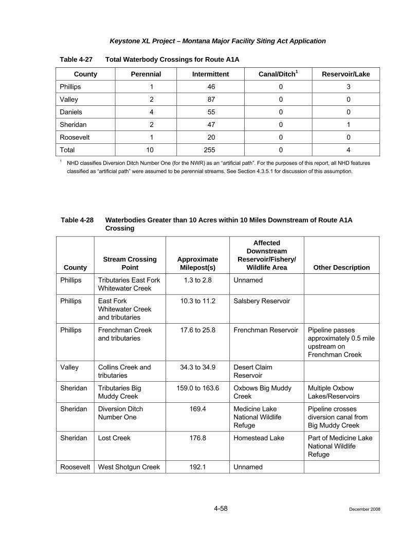
Keystone XL Project – Montana Major Facility Siting Act Application
4-58
Table 4-27 Total Waterbody Crossings for Route A1A
County Perennial Intermittent Canal/Ditch1 Reservoir/Lake
Phillips 1 46 0 3
Valley 2 87 0 0
Daniels 4 55 0 0
Sheridan 2 47 0 1
Roosevelt 1 20 0 0
Total 10 255 0 4 1 NHD classifies Diversion Ditch Number One (for the NWR) as an “artificial path”. For the purposes of this report, all NHD features
classified as “artificial path” were assumed to be perennial streams. See Section 4.3.5.1 for discussion of this assumption.
Table 4-28 Waterbodies Greater than 10 Acres within 10 Miles Downstream of Route A1A Crossing
County Stream Crossing
Point Approximate Milepost(s)
Affected Downstream
Reservoir/Fishery/ Wildlife Area Other Description
Phillips Tributaries East Fork Whitewater Creek
1.3 to 2.8 Unnamed
Phillips East Fork Whitewater Creek and tributaries
10.3 to 11.2 Salsbery Reservoir
Phillips Frenchman Creek and tributaries
17.6 to 25.8 Frenchman Reservoir Pipeline passes approximately 0.5 mile upstream on Frenchman Creek
Valley Collins Creek and tributaries
34.3 to 34.9 Desert Claim Reservoir
Sheridan Tributaries Big Muddy Creek
159.0 to 163.6 Oxbows Big Muddy Creek
Multiple Oxbow Lakes/Reservoirs
Sheridan Diversion Ditch Number One
169.4 Medicine Lake National Wildlife Refuge
Pipeline crosses diversion canal from Big Muddy Creek
Sheridan Lost Creek 176.8 Homestead Lake Part of Medicine Lake National Wildlife Refuge
Roosevelt West Shotgun Creek 192.1 Unnamed
December 2008

Keystone XL Project – Montana Major Facility Siting Act Application
4-59
Table 4-29 Impaired Waterbodies Crossed by Route A1A
Waterbody Name
State Water Quality Classification
Supports Use Designation Impairment Priority
Aquatic life Partial support
Fisheries (non-salmonid) Partial support
Alteration in stream-side or littoral vegetative covers; chlorophyll-a; low flow alterations
Agriculture Partial support Industry Partial support Low flow alterations Drinking water (human health) Full support
Frenchman Creek
Recreation Partial support Low flow alterations
TMDLs not started 2009-2012
Aquatic life Partial support Fisheries (non-salmonid) Partial support Iron Agriculture Full support Industry Full support Drinking water (human health) Full support
Buggy Creek
Recreation Full support
TMDLs not started 2009-2012
Aquatic life Partial support Sedimentation/siltation; temperature, water
Fisheries (marginal salmonid)
Insufficient information
Agriculture Full support Industry Full support Drinking water (human health) Full support
Poplar River
Recreation Not supported Escherichia coli
TMDLs not started 2009-2013
Aquatic life Partial support
Fisheries (non-salmonid) Partial support
Alteration in stream-side or littoral vegetative covers; low flow alterations; nitrogen (total); phosphorus (total); sedimentation/siltation
Recreation Not assessed Marginal agriculture Not reported Marginal industry Not reported
Big Muddy Creek
Marginal drinking water (human health)
Not reported
TMDLs not started 2009-2014
Source: Montana DEQ 2006.
December 2008

Keystone XL Project – Montana Major Facility Siting Act Application
4-60
Floodplains
Zones along Route A1A in Montana of major interest from a regulatory floodplain perspective are indicated in Table 4-30.
Table 4-30 Significant Floodplains Crossed by Route A1A
Approximate Mileposts Watercourse Associated with Floodplain
96.4 to 97.0 East Fork Poplar River
110.2 to 111.6 Poplar River
155.8 to 156.5 Big Muddy Creek
166.0 to 173.0 Big Muddy Creek
Wetlands and Riparian Areas
Route A1A crosses 2.5 miles of wetlands that are located within the permanent ROW. Please see Section 4.3.3, for further discussion.
Hydrostatic Testing (Circular MFSA-2, Section 3.8(1)(c)(iii)(D) and (E))
Potential hydrostatic water sources for Route A1A are contained in Table 4-31.
Table 4-31 Potential Hydrostatic Testing Water Sources and Drainage Basins for Route A1A
Approximate Location where Pipeline Crosses Water Source (Milepost) Drainage Basins and Water Sources
25.0 Frenchman Creek
39.1 Willow Creek
63.5 Middle Fork Porcupine Creek
96.8 West Fork Poplar River
110.9 Middle Fork Poplar River
155.8 Big Muddy Creek
172.4 Lake Creek
194.4 East Shotgun Creek
224.0 Missouri River (South Dakota)
.4 Baseline Data and Description – Route B 4.3.5
Surface Water (Circular MFSA-2, Sections 3.4(1)(u) and 3.8(1)(c)(iii)(C))
The major stream crossings in Montana along Route B include Frenchman Creek just above Frenchman Reservoir, Rock Creek and tributaries, and the Milk River and tributaries in Valley County. The Missouri River is proposed to be crossed at the Valley-McCone County Line, just over 1 mile below the Fort Peck Dam where the river is approximately 1,000 feet wide. The drainage area of Fort Peck Reservoir is traversed in McCone County, where Route B is never closer than approximately 2 miles to Fort Peck Reservoir and is
December 2008

Keystone XL Project – Montana Major Facility Siting Act Application
4-61
separated from the reservoir by State Highway 24. Route B crosses Bear Creek, a tributary to Fort Peck Reservoir, approximately 14 miles upstream from the reservoir in McCone County. Prairie Elk Creek also is crossed in McCone County. The Redwater River and tributaries are crossed in McCone and Dawson counties. Clear Creek and the Yellowstone River and tributaries are crossed in Dawson County. Cabin Creek and tributaries are crossed in Prairie County. Tributaries of Fallon Creek, Little Beaver Creek and tributaries, and Boxelder Creek and tributaries are crossed in Fallon County. Table 4-32 lists the total number of waterbody crossings. Several reservoirs are located near or 10 stream miles downstream from the Project, as indicated in Table 4-33.
Table 4-32 Number and Type of Waterbodies Crossed by Route B
County Perennial Intermittent Canal/Ditch Reservoir/Lake Phillips 0 40 0 4
Valley 5 80 13 2
McCone 1 139 0 2
Dawson 2 69 0 1
Prairie 2 28 0 0
Fallon 3 89 0 3
Total 13 445 13 12
Table 4-33 Waterbodies Greater than 10 Acres within 10 Miles Downstream of Route B Crossing Locations
County Stream Crossing
Point Approximate Milepost(s)
Affected Downstream
Reservoir/Fishery/ Wildlife Area Other Description
Phillips Tributaries East Fork Whitewater Creek
1.3 to 2.8 Unnamed
Phillips East Fork Whitewater Creek and tributaries
10.3 to 11.2 Salsbery Reservoir
Phillips, Valley Frenchman Creek and tributaries
17.7 to 25.9 Frenchman Reservoir Pipeline passes approximately 0.5 mile upstream on Frenchman Creek
Valley Tributaries Bear Creek 49.4 to 49.7 Reservoir Number Four
Pipeline passes within 0.1 mile of reservoir
Valley Oxbow Milk River Milk River Floodplain
Unnamed Reservoir Pipeline passes within approximately 0.1 mile of oxbow on floodplain
McCone Tributaries Fort Peck Reservoir including Bear Creek
102.3 to 105.5 Fort Peck Lake and Charles M. Russell Wildlife Refuge
Highway 24 is located between Project and Reservoir
McCone Tributary South Fork Shade Creek
113.7 Christianson Reservoir
Pipeline passes within 0.1 mile of reservoir
December 2008

Keystone XL Project – Montana Major Facility Siting Act Application
4-62
Table 4-33 Waterbodies Greater than 10 Acres within 10 Miles Downstream of Route B Crossing Locations
County Stream Crossing
Point Approximate Milepost(s)
Affected Downstream
Reservoir/Fishery/ Wildlife Area Other Description
McCone Tributaries Lost Creek 134.3 to 136.1 Unnamed Reservoir Downstream from Haynie Reservoir, with additional tributaries
McCone Tributaries Lost Creek 139.3 to 141.0 Unnamed Reservoir
Dawson Upper Sevenmile Creek
166.1 Lindsay Reservoir Approximately 10 river miles downstream
Water Quality (Circular MFSA-2, Sections 3.4(1)(j), and 3.7(18))
Where stream segments have been designated by Montana, the uses of surface waterbodies at proposed crossings are indicated in Attachment J. This table also indicates major uses supported or impaired as listed by Montana DEQ and approved by the USEPA where applicable to the waterbodies crossed. Stream segments listed as impaired by the USEPA, and the reasons for such listing, are further identified in Table 4-34.
Table 4-34 Impaired Waterbodies Crossed by Route B
Waterbody Name
State Water Quality Classification
Supports Use Designation Impairment Priority
Aquatic life Partial support
Fisheries (non-salmonid) Partial support
Alteration in stream-side or littoral vegetative covers; chlorophyll-a; low flow alterations
Agriculture Partial support
Industry Partial support
Low flow alterations
Drinking water (human health)
Full support
Frenchman Creek
Recreation Partial support Low flow alterations
TMDLs not started 2009-2012
Aquatic life Partial support
Fisheries (non-salmonid) Partial support Iron
Agriculture Full support
Industry Full support
Drinking water (human health) Full support
Buggy Creek
Recreation Full support
TMDLs not started 2009-2012
Aquatic life Partial support
Fisheries (non-salmonid) Partial support Iron
Agriculture Full support
Cherry Creek
Industry Full support
TMDLs not started 2009-2012
December 2008

Keystone XL Project – Montana Major Facility Siting Act Application
4-63
Table 4-34 Impaired Waterbodies Crossed by Route B
Waterbody Name
State Water Quality Classification
Supports Use Designation Impairment Priority
Drinking water (human health)
Full support
Recreation Full support
Aquatic life Not assessed
Fisheries (non-salmonid) Not assessed
Agriculture Partial support
Industry Partial support Fecal coliform
Drinking water (human health) Not supported Lead; mercury
Milk River
Recreation Threatened Fecal coliform
TMDLs not started 2009-2012
Aquatic life Partial support
Fisheries (marginal salmonid)
Partial support
Alteration in stream-side or littoral vegetative cover; other flow regime alterations; temperature, water
Agriculture Full support
Industry Full support
Drinking water (human health) Full support
Missouri River
Recreation Full support
TMDLs not started 2009-2012
Aquatic life Partial support
Fisheries (non-salmonid) Partial support
Alteration in stream-side or littoral vegetative cover; phosphorus (total); physical substrate habitat alterations; total Kjehldahl nitrogen
Recreation Not assessed
Marginal agriculture Not reported
Marginal industry Not reported
Middle Fork Prairie Elk Creek
Marginal drinking water (human health)
Not reported
TMDLs not started 2009-2012
Aquatic Life Partial support
Fisheries (non-salmonid) Partial support
Alteration in stream-side or littoral vegetative cover; phosphorus (total); physical substrate habitat alterations; total Kjehldahl nitrogen
Recreation Not assessed
East Fork Prairie Elk Creek
Marginal agriculture Not reported
TMDLs not started 2009-2012
Marginal industry Not reported Marginal drinking water
(human health) Not reported
December 2008

Keystone XL Project – Montana Major Facility Siting Act Application
4-64
Table 4-34 Impaired Waterbodies Crossed by Route B
Waterbody Name
State Water Quality Classification
Supports Use Designation Impairment Priority
Aquatic life Not assessed
fisheries (non-salmonid) Partial support Fish-passage barrier
agriculture Full support
Industry Full support
Drinking water (human health) Not assessed
Yellowstone River
Recreation Not assessed
TMDL not required
Aquatic life Not supported
Fisheries (non-salmonid) Not supported
Oxygen, dissolved; sedimentation/ siltation; total Kjehldahl nitrogen
Recreation Full support
Agriculture Not assessed
Industry Not assessed
Cabin Creek
Drinking water (human health)
Not assessed
TMDLs not started 2009-2012
Aquatic life Partial support
Fisheries (non-salmonid) Partial support
Total dissolved solids
Recreation Full support
Agriculture Not assessed
Industry Not assessed
Pennel Creek
Drinking water (human health)
Not assessed
TMDLs not started 2009-2012
Aquatic life Partial support
Fisheries (non-salmonid) Partial support
Nitrate/nitrite (nitrite + nitrate as n); total Kjehldahl nitrogen
Recreation Full support
Agriculture Not assessed
Industry Not assessed
Sandstone Creek
Drinking water (human health) Not assessed
TMDLs not started 2009-2012
Source: Montana DEQ (2006).
Groundwater
Route B continues through Valley County, where several additional sensitive groundwater resources are encountered, including Cherry Creek, the Milk River, which is a highly sensitive groundwater resource in Montana, and the Missouri River. The shallow alluvial aquifer in the alluvium of the Missouri River is a highly sensitive groundwater resource in Montana because of the shallow depth to groundwater (less than 50 feet) and the considerable use of the groundwater.
December 2008

Keystone XL Project – Montana Major Facility Siting Act Application
4-65
In McCone County, Route B crosses two aquifers, the upper Cretaceous Hells Creek/Fox Hills aquifer and the lower Tertiary Fort Union aquifer. Approximately one-third of Route B in McCone County is in the Hells Creek/Fox Hills outcrop area beginning south of the Missouri River in the dissected uplands. The remainder of Route B within McCone County is within the rolling upland plains underlain by the lower Tertiary aquifer.
The upper Cretaceous Hells Creek/Fox Hills aquifer has groundwater elevations in the range of 2,200 to 2,400 feet amsl (Whitehead 1996), with a TDS ranging from 500 to 1,800 mg/L dominated by sodium bicarbonate. The permeable sandstones of the lower one-third of the Hells Creek/Fox Hills aquifer contain a confined aquifer overlain by less permeable mudstones. The lower Tertiary Fort Union aquifer consists of interbedded sandstones, mudstones, shale, and coal seams. Groundwater elevations in the Fort Union in McCone County are in the range of 2,400 feet amsl in the northern part of the county to 2,800 feet amsl in the southeastern part of the county. Groundwater flow is to the northwest, toward the Missouri River. The Fort Union aquifer is mostly a confined aquifer that is found in sandstones interbedded with shales and mudstones. Water quality is variable with TDS ranging from 500 to as much as 5,000 mg/L, and sodium bicarbonate is the primary constituent (Busby et al. 1995). Water depths in the Fort Union range from 100 to 150 feet below ground surface (bgs) (Swenson and Drum 1955). Groundwater flow in the lower Tertiary Fort Union aquifer is mostly local in that flow is to local drainages from highland recharge areas.
Dawson, Prairie, and Fallon counties are part of the Lower Yellowstone aquifer system with groundwater resources in the lower Tertiary Fort Union Formation, linked to the lower Yellowstone River system. The Fort Union Formation is a shallow bedrock aquifer, and provides most of the groundwater used in all three counties. Major streams in the area, such as the Yellowstone, have considerable alluvial material along their banks and in terraces which contain important shallow aquifers used for water supply. The upper Cretaceous Fox Hills and Hell Creek formations underlie the lower Tertiary Fort Union at depths from 600 to 1,600 feet bgs. Groundwater flow in the Fox Hills and Hells Creek formations is confined and part of a regional flow system that directs groundwater flow to the lower Yellowstone River. Groundwater flow in the Fort Union Formation includes both local flow from higher topographic areas to local drainages and a general regional flow to the Yellowstone River. Groundwater elevations in the lower Tertiary Fort Union aquifer range from 2,600 to 3,000 feet amsl. The Yellowstone River acts as a regional drain for groundwater in the Fort Union aquifer, because a groundwater low area exists along the course. Groundwater elevations in the underlying upper Cretaceous Fox Hills/Hells Creek aquifer range from 2,200 to 2,800 feet amsl. Groundwater levels in the alluvial aquifers adjacent to the lower Yellowstone River are in the range of 2,000 to 2,200 feet amsl (Smith 1998). Water quality is similar to river water quality, consisting of calcium bicarbonate water with TDS ranges from 1,000 to 1,500 mg/L. Wells in the Fort Union aquifer yield an average of 10 gpm, and water is dominated by sodium bicarbonate, with a TDS range of 500 to 5,000 mg/L. Average TDS is about 1,670 mg/L (Smith et al. 2000). Water in the Fox Hills aquifer also is sodium bicarbonate dominated, but the TDS ranges from 1,000 to 2,500 mg/L, averaging about 1,460 mg/L (Smith et al. 2000). About 60 percent of all wells in these three counties are less than 200 feet deep (Smith 1998), and the maximum well depth is around 400 feet (Smith et al. 2000).
Through these three counties, Route B crosses a few streams with shallow alluvial aquifers which could be considered sensitive groundwater areas. The crossings at the Yellowstone River and Sandstone Creek are the most sensitive groundwater areas. At the crossing of the lower Yellowstone River, the alluvial groundwater table is less than 50 feet bgs and the groundwater aquifer is a highly sensitive groundwater area in Montana because of the shallow groundwater table, the permeable unconsolidated alluvial material, and the use of the groundwater (Smith et al. 2000). This route crosses Sandstone Creek within 2 miles of Baker, Montana, where groundwater from both the Fort Union and the Fox Hills aquifers is used for public water supply. Also, the alluvium of Sandstone Creek contains a shallow aquifer. Crossing the alluvial plains of ephemeral creeks also may involve shallow alluvial aquifers that have water during the spring but may be mostly dry during the late summer and fall.
December 2008

Keystone XL Project – Montana Major Facility Siting Act Application
4-66
Water Supplies and Wells
There was one SWPA associated with a municipal water system identified within 1 mile of Route B, three additional SWPAs within 1 to 3 miles, and two additional SWPAs within 3 to 5 miles of the route.
Floodplains
Zones along Route B in Montana of major interest from a regulatory floodplain perspective are indicated in Table 4-35.
Table 4-35 Significant Floodplains along Route B
Approximate Mileposts Watercourse Associated with Floodplain
82.5 to 84.9 Milk River
86.9 to 90.0 Missouri River
146.1 to 146.8 Redwater River
194.8 to 196.0 Yellowstone River
Wetlands and Riparian Areas
Route B crosses 2.5 miles of wetlands that are located within the permanent ROW. Please see Section 4.3.3, Vegetation, for further discussion.
Hydrostatic Testing (Circular MFSA-2, Sections 3.8(1)(c)(iii)(D) and (E))
Potential hydrostatic water sources for Route B are contained in Table 4-36.
Table 4-36 Potential Hydrostatic Testing Water Sources and Drainage Basins for Route B
Approximate Location where Pipeline Crosses Water Source (Milepost) Drainage Basins and Water Sources
25.9 Frenchman Creek
40.4 Willow Creek
82.7 Milk River
88.9 Missouri River
146.5 Redwater River
195.9 Yellowstone River
201.9 Cabin Creek
244.1 Sandstone Creek
262.2 Little Beaver Creek
281.2 Boxelder Creek
December 2008

Keystone XL Project – Montana Major Facility Siting Act Application
4-67
4.3.5.5 Impact Assessment – All Routes (Circular MFSA-2, Sections 3.6(5) and 3.7(18))
Surface Water Issues
• Water quality degradation from temporary increases in suspended solids concentrations during in-stream construction activities or erosion from disturbed lands;
• Increased sedimentation in streams resulting from in-stream construction or nearby activities;
• Channel and bank modifications that affect channel morphology and stability;
• Reduced flows in streams where water is withdrawn for hydrostatic testing; and
• Water quality degradation in streams, lakes, impoundments, or surface water-based public water supplies from pipeline spills or leaks, or from spills or leaks of fuel, lubricants, or hazardous materials during construction or operation.
Construction
Waterbody Crossings (Circular MFSA-2, Section 3.8(1)(g))
Depending upon the construction technique used, the installation of the pipeline across waterbodies can cause the following impacts:
• Temporary degradation of water quality in the form of increased suspended solids concentrations;
• Sedimentation (deposition of solids introduced into suspension by construction activities); and
• Channel and bank modifications.
Keystone is proposing the following water crossing techniques (see CMRP).
• HDD;
• Open cut wet crossings;
• Open cut dry flumed crossings; and
• Open cut dry dam and pump crossings.
Since HDD does not involve any intended direct contact with the waterbody, channel bed, or banks, no impact is expected at these crossings. It is possible that a frac-out (drilling lubricant release) or inadvertent return of drilling lubricant could enter the waterbody. Open cut wet crossings involve the direct excavation of the channel and banks in contact with any flow present. HDD or dry crossing procedures will be considered at some crossings pending determination of crossing-specific resources (aquatic life), which may warrant extraordinary mitigation. At open cut wet crossings, the extent of increased suspended solids concentrations and downstream sedimentation impacts will depend on the flow conditions at the time of construction and the channel substrate. Measures related to managing spoil, timing, access, and equipment are included in the CMRP. These measures will limit impacts of increased suspended solids concentrations and downstream sedimentation. Most open cut crossings will be completed in 24 to 48 hours or less, dependent upon stream width. Larger open cut crossings may take upwards of 7 to 10 days.
Runoff and the resulting erosion of lands adjacent to waterbodies can lead to the introduction of solids into suspension and the deposition of sediment in-stream. The CMRP includes extensive procedures to limit the extent of disturbed land adjacent to waterbodies, to control erosion, and methods to prevent sediments from entering waterbodies or wetlands. These measures include BMPs, such as clearing limits, buffer strips, drainage diversion structures, and sediment barrier installations. Keystone will comply with the NPDES construction storm water permit process with respect to pipeline construction and operation. Keystone will
December 2008

Keystone XL Project – Montana Major Facility Siting Act Application
4-68
develop and file a SWPPP as part of the NPDES construction stormwater permitting effort. This plan will include BMPs to minimize soil erosion and sedimentation.
Open cut crossings will involve disturbance of stream banks and channel bottoms. During construction of open cut crossings where stream flow is present, temporary increases in suspended sediment are likely due to this disturbance. The CMRP includes procedures for limiting the extent of this disturbance and the restoration of disturbed areas. Restoration includes grading, stabilization, and revetment BMPs. These BMPs embrace bioengineering concepts, which encourage the restoration of natural streambanks.
Streams listed by Montana DEQ as not attaining designated beneficial uses are crossed by each alternative. Among those crossed, the following streams contain impairments due to sedimentation/siltation: Big Muddy Creek on Route A, the Poplar River and Big Muddy Creek on Route A1A, Cabin Creek on Route B.
The pipeline will be constructed under flood management structures (levees and drainage ditches) as well as river channels with potential for lateral scour. The pipeline will be buried at an adequate depth under channels, adjacent floodplains, and flood protection levees to avoid pipe exposure caused by channel degradation and lateral scour. Determination of the pipeline burial depth will be based on site-specific channel and hydrologic investigations where deemed necessary.
Hydrostatic Test Water Withdrawal and Discharge
Depending on locations, state requirements, and availability, water will be obtained and withdrawn from nearby streams or privately owned reservoirs. Recycling water between test sections will reduce withdrawal volumes.
Water used for hydrostatic testing of the pipeline will be obtained from surface water resources. The volume for a 50-mile test section of 36-inch pipe is approximately 14 million gallons (43 acre-feet). Withdrawal rates and volumes will be designed to avoid impacts to aquatic life and downstream water users. Hydrostatic test water will be discharged to the land surface at an approved location to the same source from which it was removed. Discharged water may evaporate or infiltrate into the soil or drainage where the water is released.
If water is withdrawn from a sensitive surface water source during a low-flow period or at a time when particular flow are needed for other uses, habitat reductions for water-dependent resources (e.g., fisheries, aquatic invertebrates) could occur. A similar effect on surface water resources could occur if large withdrawals are made from aquifer zones that provide late-season baseflows to streams.
Streams listed by Montana DEQ as not attaining designated beneficial uses are crossed by each alternative. Among those crossed, the following streams contain impairments due to low flow alterations and are proposed as potential hydrostatic test water sources: Frenchman Creek on all routes and Big Muddy Creek on Routes A and A1A.
In accordance with the CMRP, hydrostatic test water withdrawals from surface waterbodies will be made at controlled rates and with equipment that will minimize impacts on stream beds and aquatic life. Keystone will coordinate with federal and state agencies to further identify such water sources and seasonal concerns. Similarly, discharges of hydrostatic testing waters will be made such that water quality requirements are met. Discharge controls will include restrictions on pipeline dewatering rates, velocity control devices (such as splash pups or diffusers), and/or temporary synthetic channel linings.
Water quality will not be reduced by pipe cleaning or hydrostatic test waters because discharged water will be required to meet water quality standards imposed by the discharge permits issued by Montana DEQ for the permitted discharge locations. Water discharge rates will not exceed the daily discharge criteria referenced in the permits.
December 2008

Keystone XL Project – Montana Major Facility Siting Act Application
4-69
Spill Prevention
Refueling and lubricating of most construction equipment will be restricted to upland areas at least 100 feet away from the edge of any streams, wetlands, ditches, and other waterbodies and at least 150 feet away from groundwater wells. Wheeled and tracked construction equipment will be moved to an upland area more than 100 feet away from streams, wetlands, ditches, and other waterbodies for refueling when necessary. Fuels and lubricants will be stored in designated areas and in appropriate service vehicles. Whenever possible, storage sites for fuels, other petroleum products, chemicals, and hazardous materials, including wastes, will be located in uplands or at least 100 feet from waterbodies and wetlands. SPCC procedures are described in the CMRP and will be implemented in compliance with 40 CFR Part 112 (for oil spills) and corresponding state regulations.
In a few cases, such as for pumps or directional drill equipment located within or near a waterbody or wetland, refueling will be necessary within or near a waterbody or wetland. In these situations, protective measures identified in the SPCC portion of the CMRP will be followed.
Operation
Normal operations will not adversely affect water resources. Minor surface disturbance activities from pipeline inspection and maintenance may occur infrequently and at widely spaced locations.
Keystone will employ multiple safeguards to prevent a pipeline release. The chance of a spill occurring is very low and if a spill occurred, the volume is likely to be relatively small. In the unlikely event of a pipeline release, Keystone would initiate its ERP and emergency response teams would contain and clean up the spill. To minimize impacts to surface water resources, appropriate remedial measures will be implemented to meet federal and state standards designed to ensure protection of human health and environmental quality. Additional information on potential impacts to surface water resources resulting from a crude oil spill is provided in the Risk Assessment (Attachment D).
To reduce the amount of product that could enter surface waters, federal regulation (49 CFR Part 195.260(3)) stipulates that new pipelines must have valves installed on both sides of any waterbody that has at least a 100-foot width between ordinary high water marks. According to the Office of Pipeline Safety (OPS), intermittent and ephemeral streams are not considered waterbodies. In general, wetlands are not considered by the OPS to be waterbodies. Consequently, valves are required by OPS on both sides of the larger perennial streams. Keystone will comply with these OPS requirements. Valve locations, in addition to those required for major waterbody crossings, will be incorporated into the final design based upon the outcome of the risk assessment. These additional valves will further aid in minimizing the amount of material that could be released into other waterbodies in the unlikely event of a spill. The location of valves, spill containment measures, and Keystone's ERP will minimize adverse effects to perennial, intermittent, and ephemeral waterbodies, as well as to groundwater.
Groundwater Issues
• Groundwater quality degradation during or after construction from disposal of materials, pipeline spills, or leaks that seep into shallow aquifers used for domestic, agricultural, or public water supplies.
Construction
Reductions in groundwater quality from spills, leaks, or disposal practices are not anticipated during construction. Most of the aquifers along the route will be at least temporarily isolated from any spills on the land surface and attending personnel will be able to respond to an incident before contaminants migrate into groundwater. In areas with near-surface groundwater or in areas adjacent to surface waterbodies, additional procedures and measures will be implemented as presented in the CMRP.
December 2008

Keystone XL Project – Montana Major Facility Siting Act Application
4-70
Operation
While routine operation of the Project will not affect groundwater resources, there is the possibility that a crude oil release could migrate through near-surface materials and enter a water-bearing zone or system. All SWPAs within 5 miles of all alternatives have been identified and are discussed in Sections 4.3.5.2, 4.3.5.3, and 4.3.5.4.
Keystone will employ multiple safeguards to prevent a pipeline release. The chance of a spill occurring is very low and if a spill occurred, the volume is likely to be relatively small. In the unlikely event of a pipeline release, Keystone would initiate its ERP and emergency response teams would contain and clean up the spill. To minimize impacts to groundwater resources, appropriate remedial measures will be implemented to meet federal and state standards designed to ensure protection of human health and environmental quality. Additional information on potential impacts to groundwater resources resulting from a crude oil spill is provided in the Risk Assessment (Attachment D).
Wetlands Issues
• Potential modifications in wetland productivity because of modifications to surface and subsurface flow patterns from pipeline construction;
• Temporary and permanent modifications in wetland vegetation community composition and structure from clearing and operational maintenance;
• Loss of wetlands due to backfilling or draining;
• Wetland soil disturbance;
• A temporary increase in turbidity and fluctuations in wetland hydrology; and
• Construction through prairie pothole areas could affect the water retaining substrate in these wetlands and result in permanent alterations to their water holding capacity.
Construction
Based on GIS analysis of the digitized land use layer, 2.5 miles of pipeline Route B will cross wetlands. Effects on wetland vegetation will be greatest during and immediately following construction. To mitigate the potential for these impacts, Keystone will implement the procedures outlined in the CMRP.
The construction ROW width will be reduced to 85 feet through certain wetlands to minimize potential effects. Keystone will restore or mitigate impacts to wetlands affected by construction activities, to the extent practicable. Pipeline construction through wetlands must comply, at a minimum, with USACE Section 404 Nationwide Permit (NWP) conditions.
For rivers that are crossed by the HDD method, streamside wetlands or floodplain forests will not be affected. Smaller streams and ephemeral or intermittent drainages will likely be open cut and wetlands located in these areas will be crossed by trenching. No permanent loss of wetlands will occur as a result of this Project; however, it is likely that a small fraction of forested wetland will be permanently converted to herbaceous wetland to facilitate aerial patrols of the permanent ROW. Trees will not be allowed to reestablish within 15 feet of either side of the pipeline centerline. Herbaceous vegetation in palustrine emergent wetlands is expected to reestablish to pre-construction levels within 1 to 5 years following the completion of reclamation, resulting in a short-term, temporary loss of vegetation and available habitat for some wildlife species.
As described in the CMRP, specific construction techniques will be used to retain the hydrological and vegetation characteristics of wetlands that will be disturbed by construction. These techniques will include segregation and replacement of wetland soils (except in areas of standing water, saturated wetlands, or where no topsoil is evident) so that soil profiles and native vegetation seed and rootstock will be reestablished to help
December 2008

Keystone XL Project – Montana Major Facility Siting Act Application
4-71
4.3.5
ensure successful restoration and reestablishment of local drainage patterns to restore existing surface and subsurface water flow patterns.
Operation
Woody vegetation in forested wetlands will be removed periodically above the pipeline (approximately 15 feet on each side of the centerline) to maintain visibility of the area above the pipeline for aerial pipeline observation and to permit access to all areas along the pipeline in the event of an emergency.
.6 Summary of Route-Specific Water Resources Impacts
Route-specific impacts for water resources are summarized in Table 4-37. Identified impacts will be substantially mitigated as discussed within this application and further outlined in the CMRP for all Routes. Based strictly on the relative lengths of the routes within the State of Montana and not taking into consideration the overall effect through Montana, South Dakota, and Nebraska, Route B has the greatest impacts. However, when the full Steele City Segment impacts are considered, frequently the additional length of Routes A and A1A would result in greater impacts.
Table 4-37 Summary of Route-Specific Water Resources Impacts
Route Alternatives
Resource Route A Route A1A Route B
Miles of Pipe
Steele City Segment 919.7 951.3 850.7
Portion in Montana 180.7 205.5 282.7
Water Resources
Perennial waterbodies crossed
Route A crosses 5 perennial streams.
Route A1A crosses 10 perennial streams.
Route B crosses 13 perennial streams.
Wetlands crossed (miles)
Route A crosses 0.86 mile of wetlands.
Route A1A crosses 2.50 miles of wetlands.
Route B crosses 5.27 miles of wetlands.
Floodplains crossed (miles)
Route A crosses 5.1 miles of floodplains.
Route A1A crosses 9.7 miles of floodplains.
Route B crosses 7.4 miles of floodplains.
Impaired waterbodies crossed
Route A crosses three impaired waterbodies (including one with sedimentation/siltation as impairment).
Route A1A crosses four impaired waterbodies (including two with sedimentation/siltation as impairment).
Route B crosses 11 impaired waterbodies (including one with sedimentation/siltation as impairment).
Surface water protection areas
Route A crosses one surface water protection area within 1 mile; zero within 5 miles.
Route A1A crosses zero surface water protection areas within 1 mile; two within 1 to 3 miles; one additional within 3 to 5 miles.
Route B crosses one surface water protection area within 1 mile; three within 1 to 3 miles; two additional within 3 to 5 miles.
References
Busby, J. F., B. A. Kimball, J. S. Downey, and K. D. Peter. 1995. Geochemistry of Water in Aquifers and Confining Units of the Northern Great Plains in Parts of Montana, South Dakota, North Dakota, and Wyoming. U.S. Geological Survey Prof. Paper 1402-F.
December 2008

Keystone XL Project – Montana Major Facility Siting Act Application
4-72
Federal Emergency Management Agency (FEMA). 2005. National Flood Insurance Program, Flood Insurance Definitions. Website: http://www.fema.gov/nfip/19def2.htm.
Fenneman, N. H. 1928. Physiographic Divisions of the United States. Annals of the Association of American Geographers, Vol. 18, No. 4, (December 1928), pp. 261-353.
Libmeyer, D. H. 1985. Freshwater Heads and Groundwater Temperatures in the Aquifers of the Northern Great Plains in Parts of Montana, North Dakota, South Dakota, and Wyoming. U.S. Geological Survey Professional Paper 1402-D.
Montana Department of Environmental Quality (Montana DEQ). 2006. 2006 Integrated 303(d)/305(b) Water Quality Report for Montana. Montana Department of Environmental Quality, Water Quality Planning Bureau, Helena, Montana. Website: http://cwaic.mt.gov/wq_reps.aspx?yr=2006qryId=37017. (Accessed August 6, 2007.)
National Park Service (NPS). 2008. Nationwide Rivers Inventory, National Center for Recreation and Conservation. Website: http://www.nps.gov/ncrc/programs/rtca/nri/index.html. (Accessed October 9, 2008.)
Seaber, P. R., F. P. Kapinos, and G. L. Knapp. 1994. Hydrologic Unit Maps. U.S. Geological Survey, Water-Supply Paper 2294. Second printing, U.S. Government Printing Office, Washington, D.C.
Smith, L. N. 1998. Geologic framework of hydrologic units in the lower Yellowstone River area: Dawson, Fallon, Prairie, Richland, and Wibaux Counties, Montana. Montana Groundwater Assessment Atlas No. 1, Part B, Map 1.
Smith, L. N., J. I. LaFave, T. W. Patton, J. C. Rose, and D. A. McKenna. 2000. Groundwater Resources of the Lower Yellowstone River Area: Dawson, Fallon, Prairie, Richland, and Wibaux Counties, Montana. Montana Groundwater Assessment Atlas No. 1.
Swenson, F. A. and W. H. Drum. 1955. Geology and Groundwater Resources of the Missouri River Valley in Northeastern Montana. U.S. Geological Survey Water Supply Paper 1263.
Whitehead, R. L. 1996. Groundwater Atlas of the United States, Segment 8: Montana, North Dakota, South Dakota, and Wyoming. U.S. Geological Survey Hydrologic Atlas 730-I.
4.3.6 Geology
4.3.6.1 Baseline Data and Description of Routes – All Routes
Physiography, Topography, and Geology
Routes A, A1A, and B are located in the Great Plains physiographic province (Fenneman 1928). In eastern Montana, the Great Plains is divided into two major sections, the Glaciated Missouri Plateau and the Unglaciated Missouri Plateau. The Missouri Plateau is essentially a dissected plateau characterized by badlands, buttes and mesas, and exhumed mountain ranges such as the Black Hills. Routes A and A1A are entirely in the Glaciated Missouri Plateau; Route B is in the Glaciated Missouri Plateau from where it enters the US near Morgan, Montana. The glaciated area is generally of low relief compared to the unglaciated area which has more variety of landforms (Trimble 1980). The Glaciated Missouri Plateau is covered by glacial deposits, but the boundary between the glaciated and non-glaciated sections is not distinct because the glacial deposits thin gradually. Route B crosses the Unglaciated Missouri Plateau south from the vicinity of Morgan, Montana, to the South Dakota state line. Elevations along Route B vary from 3,000 feet amsl in the northern and southeastern parts of the Project area to around 2,000 feet amsl at the Missouri River. Elevations along
December 2008

Keystone XL Project – Montana Major Facility Siting Act Application
4-73 December 2008
Routes A and A1A range from 2,000 to 2,500 feet amsl and the topography is low relief, even along major drainages such as the Poplar River.
The surficial deposits are primarily composed of Quaternary alluvium, colluvium, and glacial till. The alluvium primarily occurs in modern channels and floodplains, but also is present in older river terraces or in glacial deposits. Landslide deposits also are present in limited areas along the sides of drainages along Route B.
The bedrock geology consists of Upper Cretaceous and Tertiary rocks. Tables 4-38, 4-39, and 4-40, Bedrock Units, provide a description of the bedrock units that are crossed by the three routes. The Claggett Shale and the Bearpaw Shale were deposited under marine conditions and the Judith River Formation was deposited under marine to marginal marine conditions (Condon 2000). The Fox Hills Formation is a marginal marine sandstone that has widespread distribution throughout the Northern Rocky Mountain basins from northeast Colorado to Montana. Overlying the Fox Hills Formation is the Hell Creek Formation, which was deposited under non-marine conditions in depositional environments of river channels, floodplains, and lakes.
The Tertiary section is primarily represented by various members of the Fort Union Formation, which was deposited under non-marine conditions similar to the Hell Creek Formation in river channels, floodplains, and lakes. Both the Hell Creek and Fort Union Formations appear to have been sourced by uplift and erosion of emerging Rocky Mountains to the west and south of the Project area (McDonald 1971). The Flaxville Formation is thought to be Miocene in age and was deposited by braided streams sourced to the west and southwest (Leckie 2006).
The entire route crosses the western fringe of the Williston Basin, a major structural basin that covers northeastern Montana, most of North Dakota, and northwestern South Dakota (Peterson and MacCary 1987). The Williston Basin also extends north into Saskatchewan and Manitoba in southern Canada. The basin contains about 15,000 feet of Paleozoic through Tertiary sedimentary rock. The center of the basin is located in western North Dakota and in the Project area, the rocks dip gently towards the east and northeast. Major structural features crossed by the proposed routes include the Hinsdale, Weldon-Brockton, and Poplar Fault Zones or Lineaments and the Cedar Creek Anticline. The fault zones or lineaments extend into the Precambrian basement (ancient rocks that lie beneath the sedimentary rock section). These fault zones are thought to have influenced sedimentation patterns in the basin, but are not thought to be active at present (Fischer 2005). The Cedar Creek Anticline is a northwest to northeast trending anticlinal structure in southeastern Montana and extends into the southwestern corner of North Dakota and the northwestern corner of South Dakota (Clement 1987). The Cedar Creek Anticline is 145 miles long and 6 to 20 miles wide. Route B is located on the southwest flank of the Cedar Creek Anticline and generally parallels the strike of the anticline.
Mineral Resources
The major energy mineral resources in the Project area are oil, natural gas, and coal (Montana Bureau of Mines and Geology 1963). Uranium deposits also are present, but do not represent an important resource. The major non-fuel mineral resources are sand, gravel and bentonite (Montana Bureau of Mines and Geology/USGS 2004; Kennedy 1990). The Williston Basin is a major oil and gas producing basin. In the US-portion of the basin, total production to the end of 2007 was approximately 2.5 billion barrels of oil and 470 billion cubic feet of gas (Burke 2006; Montana Board of Oil and Gas 2007; North Dakota Industrial Commission 2007; South Dakota Oil and Gas Section 2008). Oil production decline in the 1990s has been offset in recent years by technological advances, which have allowed for increased production from the Bakken Formation, which has an estimated technically recoverable resource of 3.7 billion barrels of oil and 1.9 trillion cubic feet of gas (USGS 2008a). The pipeline route crosses only a few oil and gas producing areas since the route lies on the western edge of the basin. Tables 4-41, 4-42, and 4-43 list the wells that are within 1,320 feet of Routes A, A1A, and B, respectively.

Keystone XL Project – Montana Major Facility Siting Act Application
Table 4-38 Summary of Geologic and Paleontological Resources Along Route A
Geologic Formation (Fm)/Deposit (Map Symbol) Period Description
BLM PFYC System Class/Types of Fossils Milepost(s)
Alluvium/colluvium (Qal), landslides (Qls), sand and gravel (Tsg)
Tertiary - Quaternary
Sand, gravel, and clay. Class 2/Mammals. Occur sporadically throughout route, alluvium primarily occurs along drainages and river crossings.
Sentinel Butte Member of Fort Union Fm. (Tfsb)
Tertiary - Paleocene
Primarily siltstone, mudstone, and claystone with lesser amounts of lignite and fine-grained sandstone. Can be up to 700 feet thick. Forms prominent bluffs.
Class 5/Mammals. 177.50 to 178.25 178.78 to 180.68
Tongue River Member of Fort Union Fm. (Tftr)
Tertiary - Paleocence
Poorly cemented sandstone interbedded with siltstone and mudstone and coal. Some coals have burned to form “clinker beds.” Commonly eroded to badland topography. Thickness 400 to 650 feet.
Class 5/Plants, mammals and mollusks.
132.68 to 177.50 178.25 to 178.78
Lebo Member of Fort Union Fm. (Tfle)
Tertiary - Paleocene
Sandstone, siltstone, and mudstone interbedded with carbonaceous shale. Forms rolling hills. Thickness 180 to 300 feet.
Class 5/Mammals. 93.48 to 96.50 96.65 to 105.49 108.47 to 116.75 116.88 to 117.42 129.77 to 132.68
Tullock Member of Fort Union Fm. (Tft)
Tertiary - Paleocene
Sandstone, claystone, and carbonaceous shale and thin isolated coal beds. Thickness 200 to 300 feet.
Class 5/Invertebrates and vertebrates (fish, amphibians, reptiles, birds, mammals).
93.20 to 93.48 96.50 to 96.65 105.49 to 108.47 116.75 to 116.88 117.42 to 122.48 128.4 to 129.77
4-74 December 2008

Keystone XL Project – Montana Major Facility Siting Act Application
Table 4-38 Summary of Geologic and Paleontological Resources Along Route A
Geologic Formation (Fm)/Deposit (Map Symbol) Period Description
BLM PFYC System Class/Types of Fossils Milepost(s)
Hell Creek Fm/Fox Hills Fm. (Khc/Kfh)
Upper Cretaceous
Hell Creek Fm. - Shale, mudstone, and lenticular coal beds. Forms badland topography. Contact with underlying Fox Hills Fm. is gradational and sometimes not distinguishable. Thickness 300 to 400 feet. Fox Hills Fm - Thin interbedded sandstone, siltstone, and clay grading upward to poorly consolidated sandstone. Thickness 200 feet.
Hell Creek - Class 5/Large numbers of plants and terrestrial vertebrates (fish reptiles, dinosaurs), invertebrates (mollusks), and plants. Fox Hills - Class 3/Contains marine vertebrates and invertebrates. Lesser occurrence of plants and terrestrial vertebrates (reptiles, dinosaurs, mammals).
75.90 to 76.90 77.22 to 77.60 78.39 to 79.38 80.21 to 83.47 84.15 to 84.23 84.51 to 93.20 112.48 to 128.40
Bearpaw Fm. (Kb) Upper Cretaceous
Bentonitic mudstone and shale with fossiliferous concretions containing. Thickness 1,100 feet or more. The Pierre shale is the eastern equivalent to the Claggett, Judith River, and Bearpaw Fms.
Class 3/Commonly contains marine invertebrates (ammonites and pelecypods) and vertebrates.
0.00 to 1.15 3.55 to 23.32 28.46 to 29.32 20.38 to 32.34 32.83 to 38.91 39.76 to 39.91 40.66 to 75.90 76.90 to 77.22 77.60 to 78.39 79.38 to 80.21 83.47 to 84.15 84.23 to 84.51
Judith River Fm. (Kjr) Upper Cretaceous
Sandstone, siltstone, mudstone, shale, and coal or lignite. Thickness up to 600 feet.
Class 5/Contains a variety of vertebrate fossils including fish, turtles, crocodiles, dinosaurs, and mammals. Also invertebrates and plants.
1.15 to 3.55 23.32 to 24.82 25.22 to 28.46 29.32 to 30.38 32.34 to 32.83 38.91 to 39.76 39.91 to 40.66
4-75 December 2008

Keystone XL Project – Montana Major Facility Siting Act Application
4-76 December 2008
Table 4-38 Summary of Geologic and Paleontological Resources Along Route A
Geologic Formation (Fm)/Deposit (Map Symbol) Period Description
BLM PFYC System Class/Types of Fossils Milepost(s)
Claggett Shale (Kcl) Upper Cretaceous
Shale and siltstone with bentonite beds near the base. Thickness up 200 to 500 feet.
Class 3a/Reptiles, dinosaurs, plants and invertebrates.
24.82 to 25.22
Source: Bergantino 2001, 2003; Bergantino and Wilde 1998a,b,c,d; BLM 1992; 2006; Condon 2000.

Keystone XL Project – Montana Major Facility Siting Act Application
Table 4-39 Summary of Geologic and Paleontological Resources Along Route A1A
Geologic Formation (Fm)/Deposit (Map Symbol) Period Description
BLM PFYC System Class/Types of Fossils Milepost(s)
Alluvium/colluvium (Qal), sand and gravel (Tsg)
Tertiary - Quaternary
Sand, gravel, and clay. Class 2/Mammals. Occur sporadically throughout route, alluvium primarily occurs along drainages and river crossings.
Sentinal Butte Member of Fort Union Fm. (Tfsb)
Tertiary - Paleocene
Primarily siltstone, mudstone, and claystone with lesser amounts of lignite and fine-grained sandstone. Can be up to 700 feet thick. Forms prominent bluffs.
Class 5/Mammals. 192.58 to 192.86 195.96 to 205.47
Tongue River Member of Fort Union Fm. (Tftr)
Tertiary - Paleocence
Poorly cemented sandstone interbedded with siltstone and mudstone and coal. Some coals have burned to form “clinker beds.” Commonly eroded to badland topography. Thickness 400 to 650 feet.
Class 5/Plants, mammals, and mollusks.
114.42 114.59 116.54 to 155.10 156.52 to 192.58 192.86 to 195.96
Lebo Member of Fort Union Fm. (Tfle)
Tertiary - Paleocene
Sandstone, siltstone, and mudstone interbedded with carbonaceous shale. Forms rolling hills. Thickness 180 to 300 feet.
Class 5/Mammals. 87.43 to 90.79 98.17 to 98.29 99.43 to 99.94 100.28 to 109.01 112.71 to 114.42 114.59 to 116.54 155.10 to 156.52
Tullock Member of Fort Union Fm. (Tft)
Tertiary - Paleocene
Sandstone, claystone, and carbonaceous shale and thin isolated coal beds. Thickness 200 to 300 feet.
Class 5/Invertebrates and vertebrates (fish, amphibians, reptiles, birds, mammals).
83.09 to 87.43 90.79 to 91.76 97.61 to 98.17 98.29 to 99.43 99.94 to 100.28 109.10 to 110.44 111.21 to 112.71
4-77 December 2008
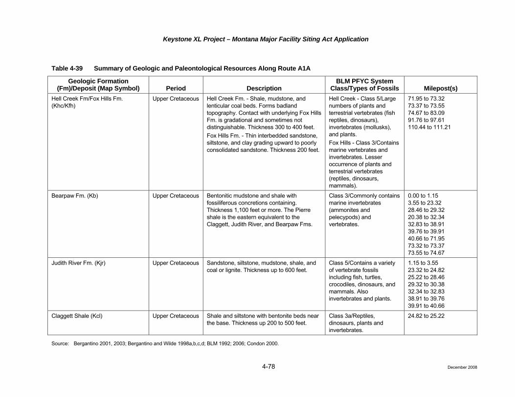
Keystone XL Project – Montana Major Facility Siting Act Application
4-78 December 2008
Table 4-39 Summary of Geologic and Paleontological Resources Along Route A1A
Geologic Formation (Fm)/Deposit (Map Symbol) Period Description
BLM PFYC System Class/Types of Fossils Milepost(s)
Hell Creek Fm/Fox Hills Fm. (Khc/Kfh)
Upper Cretaceous Hell Creek Fm. - Shale, mudstone, and lenticular coal beds. Forms badland topography. Contact with underlying Fox Hills Fm. is gradational and sometimes not distinguishable. Thickness 300 to 400 feet. Fox Hills Fm. - Thin interbedded sandstone, siltstone, and clay grading upward to poorly consolidated sandstone. Thickness 200 feet.
Hell Creek - Class 5/Large numbers of plants and terrestrial vertebrates (fish reptiles, dinosaurs), invertebrates (mollusks), and plants. Fox Hills - Class 3/Contains marine vertebrates and invertebrates. Lesser occurrence of plants and terrestrial vertebrates (reptiles, dinosaurs, mammals).
71.95 to 73.32 73.37 to 73.55 74.67 to 83.09 91.76 to 97.61 110.44 to 111.21
Bearpaw Fm. (Kb) Upper Cretaceous Bentonitic mudstone and shale with fossiliferous concretions containing. Thickness 1,100 feet or more. The Pierre shale is the eastern equivalent to the Claggett, Judith River, and Bearpaw Fms.
Class 3/Commonly contains marine invertebrates (ammonites and pelecypods) and vertebrates.
0.00 to 1.15 3.55 to 23.32 28.46 to 29.32 20.38 to 32.34 32.83 to 38.91 39.76 to 39.91 40.66 to 71.95 73.32 to 73.37 73.55 to 74.67
Judith River Fm. (Kjr) Upper Cretaceous Sandstone, siltstone, mudstone, shale, and coal or lignite. Thickness up to 600 feet.
Class 5/Contains a variety of vertebrate fossils including fish, turtles, crocodiles, dinosaurs, and mammals. Also invertebrates and plants.
1.15 to 3.55 23.32 to 24.82 25.22 to 28.46 29.32 to 30.38 32.34 to 32.83 38.91 to 39.76 39.91 to 40.66
Claggett Shale (Kcl) Upper Cretaceous Shale and siltstone with bentonite beds near the base. Thickness up 200 to 500 feet.
Class 3a/Reptiles, dinosaurs, plants and invertebrates.
24.82 to 25.22
Source: Bergantino 2001, 2003; Bergantino and Wilde 1998a,b,c,d; BLM 1992; 2006; Condon 2000.

Keystone XL Project – Montana Major Facility Siting Act Application
Table 4-40 Summary of Geologic and Paleontological Resources Along Route B
Geologic Formation (Fm)/Deposit (Map Symbol) Period Description
BLM PFYC System Class/Types of Fossils Milepost(s)
Alluvium/colluvium (Qal), landslides (Qls), sand and gravel (Tsg)
Tertiary - Quaternary
Sand, gravel and clay. Class 2/Mammals. Occur sporadically throughout route, alluvium primarily occurs along drainages and river crossings.
Flaxville Fm. (Tf) Tertiary - Miocene Sand and gravel. Class 2/Mammals. 48.45 to 48.59
Ludlow Member of Fort Union Fm. (Tfl)
Tertiary - Paleocene
Primarily sandstone, siltstone, mudstone, carbonaceous shale and lignite, up to 460 feet thick.
Class 5/Mammals. 200.99 to 203.63 240.77 to 244.62 244.78 to 250.93 251.23 to 251.28 251.47 to 251.68 252.49 to 253.95 254.07 to 254.16 254.45 to 254.58 269.64 to 270.45 272.72 to 282.50
Tongue River Member of Fort Union Fm. (Tftr)
Tertiary - Paleocence
Poorly cemented sandstone interbedded with siltstone and mudstone and coal. Some coals have burned to form “clinker beds.” Commonly eroded to badland topography. Thickness 400 to 650 feet.
Class 5/Plants, Mammals and mollusks.
129.04 to 200.99 203.63 to 240.77
Lebo Member of Fort Union Fm. (Tfle)
Tertiary - Paleocene
Sandstone, siltstone, and mudstone interbedded with carbonaceous shale. Forms rolling hills. Thickness 180 to 300 feet.
Class 5/Mammals. 119.70 to 121.31 123.68 to 123.96 124.08 to 124.57 125.04 to 125.08 128.00 to 129.04
4-79 December 2008

Keystone XL Project – Montana Major Facility Siting Act Application
Table 4-40 Summary of Geologic and Paleontological Resources Along Route B
Geologic Formation (Fm)/Deposit (Map Symbol) Period Description
BLM PFYC System Class/Types of Fossils Milepost(s)
Tullock Member of Fort Union Fm. (Tft)
Tertiary- Paleocene
Sandstone, claystone, and carbonaceous shale and thin isolated coal beds. Thickness 200 to 300 feet.
Class 5/Invertebrates and vertebrates (fish, amphibians, reptiles, birds, mammals).
105.41 to 105.5 105.64 to 107.3 112.57 to 112.61 112.77 to 113.40 113.60 to 113.68 114.98 to 115.24 116.49 to 116.51 116.55 to 119.70 121.31 to 123.68 123.96 to 124.08 124.57 to 125.04 125.08 to 128.00
Hell Creek Fm/Fox Hills Fm. (Khc/Kfh)
Upper Cretaceous Hell Creek Fm. - Shale, mudstone, and lenticular coal beds. Forms badland topography. Contact with underlying Fox Hills Fm. is gradational and sometimes not distinguishable. Thickness 300 to 400 feet. Fox Hills Fm. - Thin interbedded sandstone, siltstone, and clay grading upward to poorly consolidated sandstone. Thickness 200 feet.
Hell Creek - Class 5/Large numbers of plants and terrestrial vertebrates (fish reptiles, dinosaurs), invertebrates (mollusks), and plants. Fox Hills - Class 3/Contains marine vertebrates and invertebrates. Lesser occurrence of plants and terrestrial vertebrates (reptiles, dinosaurs, mammals).
91.55 to 105.41 105.5 to 105.64 107.3 to 112.57 112.61 to 112.77 113.4 to 113.60 113.68 to 114.98 115.24 to 116.49 116.51 to 116.55 244.62 to 244.78 250.93 to 251.23 251.28 to 251.47 251.68 to 252.49 253.95 to 254.07 254.16 to 254.45 254.58 to 257.92 258.97 to 269.64 279.45 to 272.72
4-80 December 2008

Keystone XL Project – Montana Major Facility Siting Act Application
4-81 December 2008
Table 4-40 Summary of Geologic and Paleontological Resources Along Route B
Geologic Formation (Fm)/Deposit (Map Symbol) Period Description
BLM PFYC System Class/Types of Fossils Milepost(s)
Bearpaw Fm./Pierre Shale (Kb/Kp) Upper Cretaceous Bentonitic mudstone and shale with fossiliferous concretions containing thickness 1,100 feet or more. The Pierre shale is the eastern equivalent to the Claggett, Judith River, and Bearpaw Fms.
Class 3/Commonly contains marine invertebrates (ammonites and pelecypods) and vertebrates.
0.00 to 1.15 3.55 to 21.34 21.72 to 23.79 30.69 to 36.01 36.34 to 37.12 44.58 to 44.82 45.17 to 48.45 48.59 to 91.55 257.92 to 258.97
Judith River Fm. (Kjr) Upper Cretaceous Sandstone, siltstone, mudstone, shale, and coal or lignite. Thickness up to 600 feet.
Class 5/Contains a variety of vertebrate fossils including fish, turtles, crocodiles, dinosaurs, and mammals. Also invertebrates and plants.
1.15 to 3.55 21.34 to 21.72 23.79 to 30.69 36.01 to 36.34 37.12 to 38.96 39.47 to 40.16 41.44 to 44.58 44.82 to 45.17
Claggett Shale (Kcl) Upper Cretaceous Shale and siltstone with bentonite beds near the base. Thickness up 200 to 500 feet.
Class 3a1/Reptiles, dinosaurs, plants and invertebrates.
38.96 to 39.47 40.16 to 41.44
Source: Bergantino 1999, 2001, 2003; BLM 1992; 2006; Condon 2000; Gill and Cobban 1966; SWCA 2008; Vuke and Colton 2003; Vuke et al. 2001, 2003; Wilde and Bergantino 2004; Wilde and Smith 2003a,b.

Keystone XL Project – Montana Major Facility Siting Act Application
4-82
Table 4-41 Oil and Gas Wells within 1,320 Feet of Route A
Milepost Distance
(feet) Long. Lat. Operator Status1 Field2 County
17.59 1201 West -107.31 48.80 Guyer, W.B. P&A WC Phillips
20.12 95 West -107.28 48.77 Pacific Enterprises Oil Co. P&A WC Phillips
71.73 546 East -106.26 48.55 Chevron USA. Inc. P&A WC Valley
105.91 1064 West -105.55 48.42 Placid Oil Company P&A Benrud, E Roosevelt
105.95 198 East -105.55 48.42 Sinclair Oil & Gas Company P&A WC Roosevelt
106.01 964 West -105.55 48.42 HNG Oil Company P&A WC Roosevelt
106.21 191 East -105.54 48.42 Chandler & Assoc., Inc. P&A WC Roosevelt
107.58 109 West -105.51 48.42 Equitable Res. Energy Company P&A WC Roosevelt
108.08 441 East -105.50 48.42 The California Company P&A WC Roosevelt
108.86 796 West -105.49 48.41 Mallon Oil Company P&A WC Roosevelt
109.63 897 West -105.47 48.41 Davis Oil Company P&A WC Roosevelt
109.81 730 East -105.47 48.41 Mallon Oil Company P&A WC Roosevelt
109.92 765 West -105.46 48.40 Oryx Energy Company P&A WC Roosevelt
110.05 938 East -105.46 48.41 Murphy Expl. & Prod. Company. P&A WC Roosevelt
110.31 783 East -105.46 48.41 Placid Oil Company P&A WC Roosevelt
110.55 1292 East -105.45 48.41 Amarex, Inc. P&A WC Roosevelt
149.32 188 East -104.64 48.28 Oil Dev. Company of Texas P&A WC Roosevelt
149.33 205 East -104.64 48.28 Hunt Petroleum, Inc. P&A WC Roosevelt
170.80 236 West -104.22 48.16 Noble Energy, Inc. P&A WC Roosevelt
172.90 640 East -104.18 48.15 Zoller & Danneburg Expl. Ltd. P&A WC Roosevelt
172.92 533 East -104.18 48.14 XOIL Inc. P Bainville Roosevelt
173.20 222 East -104.18 48.14 St. Mary Land & Expl. Company
P Bainville Roosevelt
174.80 880 West -104.16 48.12 St. Mary Land & Expl. Co. P Bainville II Roosevelt
178.42 1293 West -104.09 48.10 Zenergy Operating Company, LLC
Permit to Drill
WC Roosevelt
178.51 1295 West -104.09 48.10 Duncan, Raymond T. P&A WC Roosevelt
1 P&A – Plugged and Abandoned; P – Producing. 2 WC – Wildcat, no field designation.
December 2008

Keystone XL Project – Montana Major Facility Siting Act Application
4-83
Table 4-42 Oil and Gas Wells within 1,320 feet of Route A1A
Milepost Distance
(feet) Long. Lat. Operator Status1 Field1 County
17.59 1201 West -107.31 48.80 Guyer, W.B. P&A WC Phillips
20.12 95 West -107.28 48.77 Pacific Enterprises Oil Company
P&A WC Phillips
76.26 198 East -106.148293 48.648411 Armstrong Operating, Inc.
P&A WC Valley
106.51 658 East -105.494915 48.673361 Nerdlihc Company, Inc. SI Cabaret Coulee
Daniels
107.76 708 East -105.472640 48.662868 Pan Am Petroleum P&A WC Daniels
119.08 132 West -105.229632 48.653882 Adobe Res. Corp P&A WC Daniels
124.72 114 West -105.106980 48.651969 RME Petroleum Company
P&A Smoke Creek
Daniels
152.12 1028 East -104.523483 48.645999 SV Limited, A Colorado LP
P&A Green Coulee
Sheridan
153.86 1195 West -104.490507 48.640873 Northern Michigan Expl. Company
P&A Green Coulee E
Sheridan
155.25 493 East -104.459457 48.639488 Linn Operating, Inc. P Wakea Sheridan
155.30 812 East -104.458009 48.640111 Linn Operating, Inc. P Wakea Sheridan
155.33 722 East -104.457340 48.639722 Linn Operating, Inc. P Wakea Sheridan
155.90 233 East -104.445994 48.637254 Oryx Energy Company P&A WC Sheridan
157.02 1085 East -104.421538 48.639376 Gulf Oil Corporation P&A WC Sheridan
158.81 106 West -104.413772 48.619285 Cenex #1359 P&A WC Sheridan
159.81 667 East -104.414560 48.604726 Cenex, Inc. P&A Reserve Sheridan
160.36 841 West -104.422863 48.597656 Cenex #1359 P&A Reserve Sheridan
160.83 293 East -104.420109 48.590399 Cenex, Inc. P&A Reserve Sheridan
161.61 224 West -104.425287 48.579544 Cenex #1359 P&A Reserve Sheridan
161.95 952 West -104.429579 48.575105 Northern Oil Production, Inc.
P&A Reserve Sheridan
162.85 664 East -104.426585 48.561401 Basic Earth Science Systems, Inc.
P&A Reserve, South
Sheridan
163.47 1221 East -104.428220 48.550502 Cenex #1359 P&A Reserve Sheridan
167.24 1129 East -104.499239 48.521594 Oil Country Traders WW Honker Sheridan
167.26 1229 East -104.499384 48.521213 Slawson Exploration Company, Inc.
P&A Honker Sheridan
173.25 764 West -104.538525 48.449482 Jayhawk Exploration Inc.
P&A WC Sheridan
December 2008

Keystone XL Project – Montana Major Facility Siting Act Application
4-84
Table 4-42 Oil and Gas Wells within 1,320 feet of Route A1A
Milepost Distance
(feet) Long. Lat. Operator Status1 Field1 County
185.99 1000 East -104.409006 48.299850 G3 Operating, LLC P Froid, South Roosevelt
186.03 1227 East -104.407709 48.299847 G3 Operating, LLC TA Froid, South Roosevelt
186.77 422 West -104.401617 48.289044 Columbus Energy Corporation
P&A WS Roosevelt
197.63 359 West -104.186851 48.249412 Harper Oil Company (Buckhorn Petroleum)
P&A Burget, East Roosevelt
197.88 1210 East -104.181260 48.253532 ST Oil Company P Burget, East Roosevelt
200.62 1106 West -104.122235 48.245182 Oasis Petroleum North America LLC
P Red Bank Roosevelt
201.35 824 East -104.106164 48.249935 B & R Development, Inc.
P Red Bank Roosevelt
202.03 838 East -104.091373 48.249469 Missouri Basin Well Service, Inc.
P&A Red Bank Roosevelt
202.43 1235 East -104.080751 48.246425 Williston Industrial Supply Corp.
P&A Red Bank Roosevelt
202.68 723 East -104.079221 48.242693 Williston Industrial Supply Corp.
AID Red Bank Roosevelt
1 P&A – Plugged and abandoned.
WC – Wildcat, no field designation.
SI – Shut-in.
P – Producing.
WW – Converted to water well.
TA – Temporarily abandoned.
WS – Shallower pool wildcat.
AID – Active injection well.
December 2008

Keystone XL Project – Montana Major Facility Siting Act Application
4-85
Table 4-43 Oil and Gas Wells within 1,320 feet of Route B
Milepost Distance
(feet) Long Lat Operator Status1 Field2 County
17.66 350 West -107.313143 48.801712 Guyer, W.B. P&A WC Phillips
36.89 286 West -107.039888 48.605994 Guyer, W.B. P&A WC Valley, E Valley
45.51 399 West -106.913381 48.518998 Seaboard Oil P&A WC Valley, E Valley
130.64 170 East -105.766937 47.613947 Rainbow Res. Inc. P&A WC McCone
127.86 10 East -105.820444 47.632156 Gulf Oil Corp. P&A WC McCone
124.39 325 West -105.863156 47.671766 Pioneer Prod. P&A WC McCone
127.01 356 East -105.825397 47.642980 Gulf Oil Corp. P&A WC McCone
127.48 60 East -105.825790 47.635786 Gulf Oil Corp. P&A WC McCone
96.05 93 East -106.258806 47.969621 Axem Res. Inc. P&A WC McCone
256.90 274 West -104.210889 46.226288 Artex Oil Co. G-SI WC Fallon
259.65 110 East -104.191231 46.189511 Artex Oil Co. G-SI WC Fallon
261.10 218 East -104.181908 46.169575 Warner, Frank A. P&A Plevna Fallon
268.44 380 West -104.155312 46.067152 Shell Oil Co. P&A WC Fallon
264.25 392 West -104.175491 46.125994 Sands Oil Co. G-P Plevna, South Fallon
264.45 148 East -104.168295 46.123299 Bowers Oil & Gas, Inc.
G-P Plevna, South Fallon
268.79 167 East -104.146255 46.063951 Sands Oil Co. G-SI WC Fallon
265.35 91 West -104.170446 46.110220 Sands Oil Co. G-SI WC Fallon
272.49 96 West -104.119753 46.016059 Sands Oil Co. G-P Gas Light Fallon
272.98 23 West -104.119009 46.008905 Sands Oil Co. G-P Gas Light Fallon
159.63 90 West -105.361421 47.310197 Jackson, L P&A WC Dawson 1 P&A – Plugged and Abandoned; G-SI – Gas Shut in; G-P – Gas Producing.
2 WC – Wildcat, no field designation.
December 2008

Keystone XL Project – Montana Major Facility Siting Act Application
4-86
Route B crosses the Fort Union Coal region from just south of the Missouri River to the South Dakota state line (Averitt 1963). Routes A and A1A pass through the Fort Union Coal region in Roosevelt County, as well as Sheridan County for Route A1A. The coal in the Fort Union Formation is generally lignite in the Project area. To the southwest of Route B in the Powder River Basin, the coal becomes progressively higher rank to sub-bituminous and is mined extensively in that area of Montana as well as northeast Wyoming. No lignite mines are present along the proposed route. Lignite has been mined by surface and underground methods near Routes A and A1A, but no mining was reported after 1975 (Mudge et al. 1977).
In southeastern Montana, uranium-bearing lignites have been found in the Fort Union Formation (Weissenborn and Weiss 1963). While some fairly high-grade deposits have been identified in northeast Fallon County and northern Carter County, Route B does not intersect identified deposits. Lignite is not currently mined for uranium.
Bentonite, a clay derived from layers of volcanic ash, is present in mineable quantities in the Bearpaw Shale, but also occurs in other upper Cretaceous and Tertiary formations. Bentonite has variety of uses but is commonly used as a major constituent of drilling fluids and as a moisture absorbent. In the Project area, bentonite has been mined in an area known as the Chinook-Malta-Glasgow bentonite district (Kennedy 1990). There are a number of abandoned pits in the Glasgow-Malta area. Bentonite was mined and processed southeast of Glasgow beginning in 1976 (BLM 1992). The processing plant was shut down in 1979, but mining continued until 1985. According to the BLM, the bentonite claims have been abandoned. As of 2004, there was no bentonite mining in the area (Montana Bureau of Mines and Geology/USGS 2004).
Aggregate production occurs from local deposits in floodplains and glacial deposits. Sand and gravel deposits have been identified to the east of Route B in glacial sediments in the Fort Peck Indian Reservation and areas to the north (Weis 1963). Gravel deposits also are present along the Yellowstone River where the route crosses the river. For Routes A and A1A, sand and gravel are widespread in northeast Montana due to extensive Tertiary deposits, glacial deposits, and alluvium that contain sand and gravel. None of the routes cross aggregate mining operations.
Geologic Hazards
Seismic Hazards
There are three major phenomena associated with seismic hazards: Faults, seismicity, and ground motion. The following describes the potential for seismic hazard occurrence along the three routes. Section 4.3.6.2, Impact Assessment, discusses the potential impacts of seismic hazards to the proposed Project.
Faults are dislocations where blocks of earth material on opposite sides of the faults have moved in relation to one another. Rapid slippage of blocks of earth past each other can cause energy to be released, resulting in an earthquake. The Weldon-Brockton fault zone or lineament has surface expression in the Brockton-Froid Fault that has been defined as late Quaternary in age (Attachment A; Mapbook 4), generalized figure showing location of Brockton-Froid Fault) (USGS and Montana Bureau of Mines and Geology 2006). Late Quaternary means that movement has occurred in the last 300,000 years. The fault has been mapped on-trend with the Weldon-Brockton lineament 50 miles east of Route B in Roosevelt County, just north of Culbertson, Montana. The Brockton-Froid fault zone crosses Route A at Milepost 146.00 and crosses Route A1A in the vicinity of Milepost 146.00. The fault was mapped on the basis of surface features, shallow auger holes, and evidence obtained from oil and gas exploration data (Wheeler 1999). There is an indication of offset in older strata, but no evidence that would lead to a conclusion of movement on the fault in the last 10,000 years. An active fault is one in which movement can be demonstrated to have taken place within the last 10,000 years (USGS 2008b). Also, the evidence is not conclusive as to whether it is a fault. Some researchers think it is entirely an erosion feature in glacial deposits that cover the area.
Seismicity concerns the intensity, frequency, and location of earthquakes in a given area. Eastern Montana has historically had little earthquake activity (USGS 2008c,d). From 1973 to 2007, east of longitude
December 2008

Keystone XL Project – Montana Major Facility Siting Act Application
4-87
110 degrees west, there were 14 earthquakes, 7 of which were not assigned magnitudes. The other 7 had magnitudes of 4.1 or less.
Ground motion hazards result when the energy from an earthquake is propagated through the ground. The USGS ground motion hazard mapping indicates that potential ground motion hazard in the proposed Project area is low. The hazard map used estimates peak ground acceleration expressed as a percentage of the acceleration of gravity with a 2 percent probability of exceedance in 50 years (Frankel et al 1997; Petersen et al. 2008).
Landslides
Landslide is a term used for various processes involving the movement of earth material down slopes (USGS 2004). Landslides can occur in a number of different ways in different geological settings. Large masses of earth become unstable and by gravity begin to move downhill. The instability can be caused by a combination of steep slopes, periods of high precipitation, undermining of support by natural processes (stream erosion), or unintentional undercutting or undermining the strength of unstable materials in the construction of roads and structures.
Cretaceous and Tertiary rocks in the Missouri River Plateau have high clay content and upon weathering can be susceptible to instability in the form of slumps and earth flows. Landslide potential is enhanced on steeper slopes. Formations that are especially susceptible are the Cretaceous-aged Claggett, Bearpaw, and Pierre Shales as well as shales in the Tertiary Fort Union Formation (Radbruch-Hall et al. 1982). These shale units can contain appreciable amounts of bentonite, a rock made up of montmorillonite clay that has deleterious properties when exposed to moisture.
The three routes are located in areas of varying landslide susceptibility and recorded incidence. Landslide susceptibility “refers to the likelihood of a landslide occurring in an area on the basis of terrain conditions,” but does not take into account the probability of occurrence (National Research Council 2004). Incidence is based on the percentage of area involved in movement (low: less than 1.5 percent; moderate: 1.5 to 15 percent; and high: more than 15 percent) (Radbruch-Hall et al. 1982). Tables 4-44, 4-45, and 4-46 show the landslide incidence and susceptibility for Routes A, A1A, and B, respectively.
Table 4-44 Landslide Incidence and Susceptibility Along Route A
Pipeline Segment (Approximate
Mileposts) Landslide Incidence
Landslide Susceptibility
Approximate Mileposts where Slope Exceeds 15 Percent and is Underlain by Cretaceous Shale
or Mapped Landslide Deposit
0.00 to 70.0 Low High 0.02 to 0.08; 13.70 to 14.0; 16.30 to 16.60; 24.55 to 24.70; 25.50 to 25.61; 32.32 to 33.33; 38.93 to 39.02; 39.90 to 40.93; 46.47 to 46.51
70.0 to 127.0 Low Low
127.0 to 137.0 Low High 82.37 to 82.68; 88.65 to 88.67; 89.05 to 89.11
137.0 to 170.0 Low Low
170.0 to 180.68 Moderate Low
Source: Bergantino 2001, 2003; Bergantino and Wilde 1998a,b; Condon 2000; National Atlas 2008; Radbruch-Hall et al. 1982.
December 2008

Keystone XL Project – Montana Major Facility Siting Act Application
4-88
Table 4-45 Landslide Incidence and Susceptibility Along Route A1A
Pipeline Segment (Approximate
Mileposts) Landslide Incidence
Landslide Susceptibility
Approximate Mileposts where Slope Exceeds 15 Percent and is Underlain by Cretaceous Shale or
Mapped Landslide Deposit
0.00 to 70.0 Low High 0.02 to 0.08; 13.70 to 14.0; 16.30 to 16.60; 24.55 to 24.70; 25.50 to 25.61; 32.32 to 33.33; 38.93 to 39.02; 39.90 to 40.93; 46.47 to 46.51
70.0 to 195.00 Low Low 97.00 to 97.06
195.00 to 205.47 Moderate Low
Source: Bergantino 2001, 2003; Bergantino and Wilde 1998a,b,c,d; Condon 2000; National Atlas 2008; Radbruch-Hall et al. 1982.
Table 4-46 Landslide Incidence and Susceptibility Areas Along Route B
Pipeline Segment (Approximate
Mileposts) Landslide Incidence
Landslide Susceptibility
Approximate Mileposts where Slope Exceeds 15 Percent and is Underlain by Cretaceous Shale or
Mapped Landslide Deposit
0.0 to 82.3 Low High 0.02 to 0.08; 13.70 to 14.00; 16.30 to 16.60; 21.50 to 21.70; 25.00 to 25.50; 26.00 to 26.40; 36.10 to 36.20; 38.90 to 39.10; 40.00 to 40.40; 41.40 to 41.60; 48.00 to 48.40; 55.00 to 55.20; 81.90 to 82.00
82.3 to 90.3 Low Low
90.3 to 116.5 Moderate High 90.40 to 91.50; 93.90 to 94.10; 101.90 to 102.10; 112.50 to 112.60
116.5 to 282.6 Low Low
Source: Bergantino 1999, 2001, 2002; Condon 2000; National Atlas 2008; Radbruch-Hall et al. 1982; Vuke and Colton 2003; Vuke et al. 2001, 2003; Wilde and Bergantino 2004; Wilde and Smith 2003a,b.
Of particular concern for slope stability are Cretaceous shales that are present on slopes greater than 15 percent (Montana DEQ 2004). In the Project area, steeper slopes occur along the Missouri River valley walls and larger tributaries (Radbruch-Hall et al. 1982). Landslides are documented at Mileposts 39 and 90.4 to 91.5. At both of these locations, slumps have occurred at major drainages, the former at the Willow Creek crossing and the latter on the south side of the Missouri River Valley (Bergantino 2002, 1999). No landslide deposits have been identified along Route A or A1A. Tables 4-44, 4-45, and 4-46, respectively, present places on the proposed routes where slopes exceed 15 percent and are underlain by Cretaceous shale. These areas with steep slopes and underlain by Cretaceous shales may have more susceptibility to landslides than other areas.
Subsidence
No ground subsidence or karst hazards are present in the vicinity of any of the three proposed routes (National Atlas 2008).
Flooding
In general, seasonal flooding hazards exist where the proposed pipeline route would cross rivers and streams, and flash flooding hazards exist where the pipeline would cross localized drainages. Route B would cross 13 perennial streams and 445 intermittent streams all of which are locations where seasonal or flash flooding
December 2008

Keystone XL Project – Montana Major Facility Siting Act Application
4-89
4.3.6
could occur. The stream and drainage crossings for Route B are listed in Tables 4-22 and Attachment G. Route A would cross 5 perennial streams and 292 intermittent streams, all of which are locations where seasonal or flash flooding could occur. The stream and drainage crossings for Route A are listed on Table 4-23 and Attachment G. Route A1A would cross 10 perennial streams and 255 intermittent streams, all of which are locations where seasonal or flash flooding could occur. The stream and drainage crossings for Route A1A are listed on Table 4-23 and Attachment J.
Swelling Clays
The bentonite layers in the Claggett, Bearpaw, and Pierre Shales may present hazards associated with swelling clays (Olive et al. 1989). These formations are considered to have “high swelling potential.” Bentonite has the property whereby when wet, it expands significantly in volume. When bentonite layers are exposed to successive cycles of wetting and drying, they swell and shrink, the soil fluctuates in volume and strength. Structures built on soil with high shrink-swell potential can be damaged as soils expand and shrink.
.2 Impact Assessment
The Project may have potential adverse impacts on geological, mineral, and paleontological resources. In addition to the potential effects of the Project on the various resources, there are potential impacts of geological hazards to the Project. Impacts to geological resources or minerals would be considered significant and would require mitigation if construction and operation of the proposed pipeline and associated facilities (pump stations, meters, and valves) would:
• Adversely affect unique geological features that are protected under state or federal programs;
• Preclude or hinder the development of mineral resources; and
• Cause damage or loss of vertebrate or invertebrate fossils that are considered to have scientific importance by paleontologists.
Impacts of geological hazards to the Project would be significant if the hazard would:
• Hinder the construction in such a manner as to cause inordinate delays in schedule;
• Cause damage resulting in disruption of service; and
• Result in the spillage or release of reportable quantities of product that causes impact to soil and water resources.
Geology
Construction
Issues
• Disturbances to topography resulting in disruption of drainage.
The effects of construction would include disturbances to the topography along the proposed ROW and at aboveground facilities due to grading and trenching activities. Upon completion of construction, Keystone would restore topographic contours and drainage patterns as closely as possible to pre-construction conditions. Limited blasting would be required in areas where shallow bedrock or boulders were encountered that could not be removed by conventional excavation with a track hoe trencher, ripping with a bulldozer followed by track hoe excavation, or hammering with a track hoe-mounted hydraulic hammer followed by excavation. Blasting may be conducted where bedrock cannot be disaggregated by using hydraulic hammers or other machinery. In the event blasting is necessary, the CMRP has procedures for conducting blasting (see Attachment C).
December 2008

Keystone XL Project – Montana Major Facility Siting Act Application
4-90
The construction techniques proposed in the CMRP are sufficient to minimize impacts and restore surface contours and no unavoidable adverse impacts to topography are expected.
Operation
Issues
• No issues associated with geological resources were identified with operation.
Operation of the proposed pipeline and associated aboveground facilities would not materially alter the geologic and topographic conditions or worsen existing unfavorable geologic conditions in the area.
No unavoidable adverse impacts to geological resources would be anticipated due to operations.
Mineral Resources
Construction
Issues
• Potential interference with existing mining or oil and gas operations.
The proposed routes cross several oil and gas fields. In addition, the routes may cross aggregate resources in alluvial valleys and terraces. Nevertheless, construction would have very minor and short-term impact on current mineral extraction activities due to the temporary and localized nature of pipeline construction activities. Several oil and gas wells were identified within or close to the proposed pipeline construction ROW (Tables 4-41, 4-42, and 4-43; tables showing oil and gas wells with 1,320 feet of each route). Construction activities potentially could damage wells, associated underground fluid lines and pipelines, and disrupt normal operations and routine maintenance. Also, damage to oil and gas facilities, if they should occur, could present health, safety, and contamination hazards. Abandoned wells also could be impacted since construction potentially could remove existing abandoned well markers and damage near-surface cement plugs. Because oil and gas are produced from depths of more than 1,000 feet, construction of the pipeline would not be expected to affect the oil and natural gas producing formations. Rather, any construction-related impacts would be limited to surface or near-surface components of the wells and gathering systems, which would temporarily disrupt production until repairs are made. Prior to construction, Keystone would identify the exact locations of active, shut-in, and abandoned wells and any associated underground pipelines in the construction ROW and take appropriate precautions to protect the integrity of such facilities. Keystone also would abide by utility locate rules in Montana and conduct due diligence to identify and contact all oil and gas well operators and pipeline gathering system owners prior to construction activities.
Potential impacts to surface mineral extraction operations, if any, would be limited to temporary short-term encumbrances during construction and would be minimized by Keystone working with the owners and/or operators of oil and gas facilities during ROW negotiations and facilities construction. Because construction of the pipeline would be limited to near-surface disturbance, the proposed Project would not impact oil and gas production. Construction of the pipeline would not result in an irretrievable commitment of mineral resources or unavoidable adverse impacts to mineral resources.
Operation
Issues
• Potential for reduced access to underlying minerals;
• Potential interference with future mining operations; and
December 2008
Keystone XL Project – Montana Major Facility Siting Act Application
4-91
• Potential subsidence over underground mined-out voids leading to loss of ground support and damage or breakage of pipe.
Long-term operation of a pipeline has the potential to preclude access to mineral resources. Because the pipeline is a narrow linear feature, it is not expected present a hindrance to access to oil and gas resources. Although the proposed route is in an area of potential exploitable minerals (lignite and sand and gravel), no current plans to mine such resources were identified. No active or abandoned underground mine workings were identified along the proposed route, therefore, ground subsidence issues associated with underground mining are not a concern.
Operation of the proposed Project would not have a significant added impact on current or future mineral recovery operations in the area, generally because of the lack of identified mineral resources other than oil and gas. Additionally, impacts on future mineral development would not constitute a significant loss of mineral resource or mineral availability because of the narrow, linear nature of the pipeline ROW relative to the expanse of areas with mineral resource potential. It is anticipated that the pipeline trench would be backfilled with materials derived from the trench excavation, and it might be necessary to obtain some construction sand and gravel from local, existing commercial sources for use as pipe padding, road base, or surface facility pads. These demands for sand and gravel would not substantially affect the long-term availability of construction materials in the area.
Geologic Hazards
Construction
Issues
• Potential damage to the pipeline and the safety of the workers due to geological hazards encountered during construction.
The main hazard of concern during construction of the pipeline would be from unintentional undercutting of slopes or construction on steep slopes resulting in instability that would lead to landslides. Other hazards may result from construction on Cretaceous shales that contain bentonite beds. The high swelling hazard may cause slope instability during periods of precipitation. When selecting the proposed pipeline route, Keystone will attempt to minimize the amount of steep slopes crossed by the pipeline. Special pipeline construction practices described in the CMRP would minimize slope stability concerns during construction.
Measures to reduce risks from landslides involve surveying areas identified as medium landslide susceptibility or higher by qualified individuals to assess site-specific landslide risks. Avoidance of steep slopes may be all that is needed to lessen the risk. If a re-route is not possible, there may be a number of engineering remedies depending on site-specific conditions. Those remedies can include, but are not limited to, re-direction of surface and groundwater away from unstable areas, construction of retaining walls, or removal of unstable materials. Pipeline installation techniques, using padding and rock-free backfill can protect the pipeline from minor earth movements. Also, orientation of the pipeline along the long axis of a slope face would minimize the overall energy to which a segment of pipe would be exposed during a major landslide event.
Operation
Issues
• Potential damage to the pipeline and associated facilities from landslides and slope instability;
• Potential damage to the pipeline and associated facilities from earthquakes (ground motion) and ground displacement (fault movement);
• Potential damage to the pipeline and related facilities from ground subsidence;
December 2008

Keystone XL Project – Montana Major Facility Siting Act Application
4-92
• Potential damage to the pipeline from flood scour; and
• Potential damage to facilities from swelling clay.
Landslides
Large ground failure can result in damage to pipeline and associated facilities. If landsliding is severe enough, loss of support to the pipeline could lead to catastrophic rupture of the pipeline. The proposed pipeline facilities would be designed and installed in accordance with 49 CFR Part 195, and Transportation of Hazardous Liquids by Pipeline (provisions for external stress on pipelines). During pipeline operations, movement or abnormal loading of pipe as a result of landslides that impairs the serviceability would be reported according to 49 CFR Part 195.55.
Seismicity
Potential seismic hazards to Project facilities would include strong ground shaking, surface faulting, or secondary ground deformation such as liquefaction and flow failure. Pipelines and aboveground facilities are capable of withstanding substantial ground motion. The proposed Project is in an area where the probability of a strong earthquake is low and ground motion hazard probability is low; there would be a low risk of related hazards of earthquake induced landslides. The proposed Project does not cross identified active faults so ground displacement due to fault movement is not a concern.
Flooding and Scour
Flooding hazards to Project facilities would include inundating surface facilities, debris flows, or scouring stream beds at the point of the pipeline crossing. Severe scouring often leaves exposed unsupported spans of pipe. In general, seasonal flooding hazards exist where the proposed pipeline route would cross major streams and rivers, and flash flooding hazards exist where the proposed pipeline would cross small watersheds. The proposed pipeline routes would cross perennial and ephemeral streams as identified in Tables 4-22, 4-23, and 4-24 and Attachment J. All these crossings are potential seasonal or flash flooding locations. Though flooding in and of itself does not represent a significant risk to buried pipelines, stream scour and mud/debris flows often accompanying flooding can impact pipelines by exposing and leaving unsupported spans of pipe. To minimize these effects, the proposed pipeline would be buried at a sufficient depth to avoid possible scour at waterbody crossings. In addition, regular visual inspection of the proposed pipeline route would be used to identify areas that would be potentially exposed after flood events. The aboveground facilities are not located within areas susceptible to flooding.
Swelling Clays
High-strength steel pipelines are not affected by swelling clays, but surface facilities like pump stations may be vulnerable to damage by swelling clays. Damage may include cracking and buckling of foundations, disruption of utility lines, and connections from pump stations to the mainline. Potential impacts due to swelling soils can be mitigated by conducting detailed geotechnical site investigations of pump station sites to define shrink-swell potential. If the hazard is present, excavation and removal of swelling clay and replacement with specification fill or pile placement can reduce or eliminate potential impacts. In addition, routing of drainage around foundations to avoid standing water also can help prevent hazards due to swelling clay.
In summary, a number of places along the routes have been identified as having a potential for landslides, slope instability, flood hazards, and swelling clay. Seismic and ground subsidence hazards are not expected to pose concerns. Appropriate engineering design and pipeline routing would reduce the potential effects that pipeline facilities would suffer from potential natural hazards during operation of the proposed facilities. Further, operation of the proposed Project and facilities is not expected to worsen unfavorable geologic conditions in the area.
December 2008

Keystone XL Project – Montana Major Facility Siting Act Application
4-93
4.3.6.3 Summary of Route-Specific Geology Impacts
Route-specific impacts for Geology are summarized in Table 4-47. Identified impacts will be substantially mitigated as discussed within this application and further outlined in the CMRP for all Routes. Based strictly on the relative lengths of the routes within the State of Montana and not taking into consideration the overall effect through Montana, South Dakota, and Nebraska, Route B has the greatest impacts. However, when the full Steele City Segment impacts are considered, frequently the additional length of Routes A and A1A would result in greater impacts.
Table 4-47 Summary of Route-Specific Geology Impacts
Route Alternatives
Resource Route A Route A1A Route B
Miles of Pipe
Steele City Segment 919.7 951.3 850.7
Portion in Montana 180.7 205.5 282.7
Geology
Physiography, topography, geology
There are no unique geological features along Route A.
Same as A. Same as A.
Mineral resources There are 24 oil and gas well locations within 0.25 mile of Route A; 3 are active producers and 21 are abandoned. Route A crosses about 32.0 miles of deposits that may contain gravel resources.
There are 9 oil and gas well locations within 0.25 mile of Route A1A; 4 are active producers and 5 are abandoned or temporarily abandoned. There is one active injection disposal well within 0.25 mile of Route A1A. Route A1A crosses about 54.0 miles of deposits that may contain gravel resources.
There are 20 oil and gas well locations within 0.25 mile of Route B; 4 are active producers, 4 are shut-in gas producers, and 12 are abandoned. Route B crosses about 34.0 miles of deposits that may contain gravel resources.
Seismic hazards None. Same as A. Same as A.
Landslides Route A crosses 90.0 miles of low incidence and low susceptibility areas; 80.0 miles of low incidence and high susceptibility areas, and 11.0 miles of moderate incidence and low susceptibility areas; and 2.5 miles where slopes exceed 15 percent on Cretaceous shale bedrock.
Route A1A crosses 125.0 miles of low incidence and low susceptibility areas; 70.0 miles of low incidence and high susceptibility areas, and 10.0 miles of moderate incidence and low susceptibility areas; and 2.0 miles where slopes exceed 15 percent on Cretaceous shale bedrock.
Route B crosses 175.0 miles of low incidence and low susceptibility areas; 82.0 miles of low incidence and high susceptibility areas, and less than 26.0 miles of moderate incidence and high susceptibility areas; and 4.0 miles where slopes exceed 15 percent on Cretaceous shale bedrock.
Subsidence None. None. None.
Flooding Route A crosses 5 perennial streams and 292 intermittent streams prone to seasonal or flash flooding.
Route A1A crosses 10 perennial streams and 255 intermittent streams prone to seasonal or flash flooding.
Route B crosses 13 perennial streams and 445 intermittent streams prone to seasonal or flash flooding.
December 2008
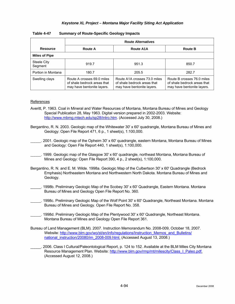
Keystone XL Project – Montana Major Facility Siting Act Application
4-94
Table 4-47 Summary of Route-Specific Geology Impacts
Route Alternatives
Resource Route A Route A1A Route B
Miles of Pipe
Steele City Segment 919.7 951.3 850.7
Portion in Montana 180.7 205.5 282.7
Swelling clays Route A crosses 69.0 miles of shale bedrock areas that may have bentonite layers.
Route A1A crosses 73.0 miles of shale bedrock areas that may have bentonite layers.
Route B crosses 76.0 miles of shale bedrock areas that may have bentonite layers.
References
Averitt, P. 1963. Coal in Mineral and Water Resources of Montana, Montana Bureau of Mines and Geology Special Publication 28, May 1963. Digital version prepared in 2002-2003. Website: http://www.mbmg.mtech.edu/sp28/intro.htm. (Accessed July 30, 2008.)
Bergantino, R. N. 2003. Geologic map of the Whitewater 30' x 60' quadrangle, Montana Bureau of Mines and Geology: Open File Report 471, 6 p., 1 sheet(s), 1:100,000.
_____. 2001. Geologic map of the Opheim 30' x 60' quadrangle, eastern Montana, Montana Bureau of Mines and Geology: Open File Report 440, 1 sheet(s), 1:100,000.
_____. 1999. Geologic map of the Glasgow 30' x 60' quadrangle, northeast Montana, Montana Bureau of Mines and Geology: Open File Report 390, 4 p., 2 sheet(s), 1:100,000.
Bergantino, R. N. and E. M. Wilde. 1998a. Geologic Map of the Culbertson 30' x 60' Quadrangle (Bedrock Emphasis) Northeastern Montana and Northwestern North Dakota. Montana Bureau of Mines and Geology.
_____. 1998b. Preliminary Geologic Map of the Scobey 30' x 60' Quadrangle, Eastern Montana. Montana Bureau of Mines and Geology Open File Report No. 360.
_____. 1998c. Preliminary Geologic Map of the Wolf Point 30' x 60' Quadrangle, Northeast Montana. Montana Bureau of Mines and Geology. Open File Report No. 358.
_____. 1998d. Preliminary Geologic Map of the Plentywood 30' x 60' Quadrangle, Northeast Montana. Montana Bureau of Mines and Geology Open File Report 361.
Bureau of Land Management (BLM). 2007. Instruction Memorandum No. 2008-009, October 18, 2007. Website: http://www.blm.gov/wo/st/en/info/regulations/Instruction_Memos_and_Bulletins/ national_instruction/20080/im_2008-009.html. (Accessed August 13, 2008.)
_____. 2006. Class I Cultural/Paleontological Report, p. 124 to 152. Available at the BLM Miles City Montana Resource Management Plan. Website: http://www.blm.gov/rmp/mt/milescity/Class_I_Paleo.pdf. (Accessed August 12, 2008.)
December 2008

Keystone XL Project – Montana Major Facility Siting Act Application
4-95
_____. 1992. Judith Valley Phillips Resource Management Plan Environmental Impact Statement. Montana State Office, October 1992. Website: http://www.blm.gov/mt/st/en/prog/planning/JVP.html. (Accessed August 13, 2008.)
Burke, R. B. 2006. Deep Gas production in North Dakota’s Williston Basin – Look Again (abstr). Website: http://www.searchanddiscovery.net/documents/2006/06088houston_abs/abstracts/burke.htm. (Accessed July 30, 2008.)
Clement, J. H. 1987. Cedar Creek: A Significant Paleotectonic Feature of the Williston Basin In: J. A. Longman, (ed.), Williston Basin: Anatomy of a Cratonic Oil Province, Papers collected and edited by J. A. Peterson, D. M. Kent, S. B. Anderson, R. H. Pilaske, and M. W. Longman. The Rocky Mountain Association of Geologists, Denver, Colorado, 1987, p. 323-336
Condon, S. M. 2000. Stratigraphic Framework of Lower and Upper Cretaceous Rocks in Central and Eastern Montana. U. S. Geological Survey Digital Data Series DDs-57.
Fenneman, N. H. 1928. Physiographic Divisions of the United States. Annals of the Association of American Geographers, Vol. 18, No. 4, (December 1928), pp. 261-353.
Fischer, D. W., J. A. LeFever, J. A. Sorensen, S. A. Smith, L. D. Helms, R. D. LeFever, S. G. Whittaker, E. N. Steadman, and J. A. Harju. 2005. The Influence of Tectonics on the Potential Leakage of CO2 from Deep Geological Sequestration Units in the Williston Basin. Plains CO2 Reduction Partnership, University of North Dakota. Website: http://www.netl.doe.gov/technologies/carbon_seq/ partnerships/phase1/pdfs/InfluenceTectonicsPotenital.pdf. (Accessed July 29, 3008.)
Frankel, A., C. Mueller, T. Barnhard, D. Perkins, E. V. Leyendecker, N. Dickman, S. Hanson, and M. Hopper. 1997. Seismic-hazard Maps for the Conterminous United States, Map C - Horizontal Peak Acceleration with 2 Percent Probability of Exceedance in 50 Years, U.S. Geological Survey Open-File Report 97-131-F.
Gill, J. R. and W. A. Cobban. 1966. The Red Bird Section of the Upper Cretaceous Pierre Shale in Wyoming, U.S. Geological Survey Professional Paper 393-A, 73 p.
Hoganson, J. W. and J. Campbell. 2002. Paleontology of Theodore Roosevelt National Park, North Dakota Notes No. 9; North Dakota Geological Survey. Website: https://www.dmr.nd.gov/ndgs/NDNotes/ ndn9_h.htm. (Accessed September 9, 2008.)
Kennedy, B. B. 1990. Surface Mining. Society for Mining, Metallurgy, and Exploration (U.S.), 1206 p.
Leckie, D. A. 2006. Tertiary Fluvial Gravels and Evolution of the Western Canadian Prairie Landscape (abstr.). http://www.sciencedirect.com/science?_ob=ArticleURL&_udi=B6V6X-4KBDWMH-1&_user=10&_rdoc=1&_fmt=&_orig=search&_sort=d&view=c&_acct=C000050221&_version=1&_urlVersion=0&_userid=10&md5=6bf0cfd3574e8a10019978f6ed2954db. (Accessed June 28, 2008.)
McDonald, R. E. 1971. Eocene and Paleocene Rocks of the Southern and Central Basins, in Mallory, W. (ed.), 1972, Geologic Atlas of the Rocky Mountain Region, Rocky Mountain Association of Geologists, Denver, Colorado, p 243-256.
Montana Board of Oil and Gas. 2007. Montana Oil and Gas Annual Reviews 1951 to 2006. Department of Natural Resources and Conservation of the State of Montana; Oil and Gas Conservation Division, billings Montana, 93 p. Website: http://bogc.dnrc.state.mt.us/annualreviews.asp. (Accessed July 30, 2008.)
December 2008

Keystone XL Project – Montana Major Facility Siting Act Application
4-96
Montana Bureau of Mines and Geology/U.S. Geological Survey. 2004. Mineral Industry of Montana. Website: http://minerals.usgs.gov/minerals/pubs/state/mt.html. (Accessed July 1, 2008.)
Montana Bureau of Mines and Geology. 1963. Mineral and Water Resources of Montana, Montana Bureau of Mines and Geology Special Publication 28, May 1963. Digital version prepared in 2002-2003. Website: http://www.mbmg.mtech.edu/sp28/intro.htm. (Accessed July 30, 2008.)
Montana Department of Environmental Quality. 2004. Application Requirements for Linear Facilities, Alternative Siting Study Baseline Study Impact Assessment. Montana DEQ Circular MFSA-2, 2004 edition.
Mudge, M. R., M. Sokaski, D. D. Rice, and G. McIntyre. 1977. Status of Mineral Resource Information for the Fort Peck Indian Reservation, Northeastern Montana. Bureau of Indian Affairs Administrative Report 28.
National Atlas. 2008. Website: http://nationalatlas.gov/maplayers.html?openChapters=chpgeol. (Accessed July 11, 2008.)
National Research Council. 2004. Partnerships for Reducing Landslide Risk. The National Academies Press, Washington D.C., 144 p. Website: http://www.nap.edu/catalog.php?record_id=10946#toc. (Accessed August 1, 2008.)
North Dakota Industrial Commission. 2007. Production Statistics. Website: https://www.dmr.nd.gov/oilgas/ stats/statisticsvw.asp. (Accessed July 30, 2008.)
Olive, W. W., A. F. Chleborad, C. W. Frahme, J. Schlocker, R. R. Schneider, and R. L Shuster. 1989. Website: http://pilevoid.com/surevoid_web/soil_maps/reg_rm.html. (Accessed August 14, 2008.)
Petersen, M. D., A. D. Frankel, S. C. Harmsen, C. S. Mueller, K. M. Haller, R. L. Wheeler, L. Russell., R. L. Wesson, L. Robert, Y. Zeng, O. S. Boyd, D. M. Perkins, N. Luco, E. H. Field, C. J. Wills, and K. S. Rukstales. 2008. Documentation for the 2008 Update of the United States National Seismic Hazard Maps: U.S. Geological Survey Open-File Report 2008–1128, 61 p.
Peterson, J. A. and L. M. McCary. 1987. Regional Stratigraphy and General Petroleum Geology of the U.S. Portion of the Williston Basin and Adjacent Areas, in J. A. Longman (ed.), Williston Basin: Anatomy of a Cratonic Oil Province, Papers collected and edited by J. A. Peterson, D. M. Kent, S. B. Anderson, R. H. Pilaske, and M. W. Longman. The Rocky Mountain Association of Geologists, Denver, Colorado, 1987, p. 9-43.
Radbruch-Hall, D. H., R. B. Colton, W. E. Davies, I. Lucchitta, B. A. Skipp, and D. J. Varnes. 1982. Landside Overview Map of the United States. U.S. Geological Survey Professional Paper 1183.
South Dakota Oil and Gas Section. 2008. Historical Production Statistics. Website: http://www.state.sd.us/ denr/DES/Mining/Oil&Gas/producti.htm. (Accessed July 30, 2008.)
SWCA Environmental Consultants. 2008. Paleontological Assessment for Federal Land along the Montana Segment of the Keystone XL Pipeline Project. Prepared for ENSR Corporation and BLM, September 12, 2008; 312 p.
Trimble, D. E. 1980. The Geologic Story of the Great Plains. U.S. Geological Survey Bulletin 1493.
December 2008

Keystone XL Project – Montana Major Facility Siting Act Application
4-97
U.S. Geological Survey (USGS). 2008a. Assessment of Undiscovered Oil Resources in the Devonian-Mississippian Bakken Formation, Williston Basin Province, Montana and North Dakota. U.S. Geological Survey Fact Sheet 2008-3021.
_____. 2008b. Visual Glossary. Website: http://earthquake.usgs.gov/learning/glossary. php?term= active%20fault. (Accessed August 14, 2008.)
_____. 2008c. Seismicity Map of Montana. Website: http://earthquake.usgs.gov/regional/states/montana/ seismicity.php.(Accessed July 1, 2008.)
_____. 2008d. National Earthquake Information Center Earthquake Search; U.S. Geological Survey/National Earthquake Information Center 1073 to present Database. Website: http://neic.usgs.gov/neis/epic/ epic_rect.html. (Accessed July 31, 2008.)
_____. 2004. Landslide Types and Processes. USGS Fact Sheet 2004-3072. Website: http://pubs.usgs.gov/fs/ 2004/3072/pdf/fs2004-3072.pdf. (Accessed on July 31, 2008.)
U.S. Geological Survey and Montana Bureau of Mines and Geology. 2006. Quaternary Fault and Fold Database for the United States. Website: http//earthquakes.usgs.gov/ regional/qfaults/.(Accessed July 31, 2008.)
Vuke, S. M. and R. B. Colton. 2003. Geologic Map of the Terry 30' x 60' Quadrangle, Eastern Montana, Montana Bureau of Mines and Geology: Open File Report 477, 9 p., 1 sheet(s), 1:100,000.
Vuke, S. M., E. M. Wilde, R. B. Colton, and M. C. Stickney. 2003. Geologic Map of the Wibaux 30' x 60' Quadrangle, Eastern Montana and Adjacent North Dakota, Montana Bureau of Mines and Geology: Open File Report 465, 11 p., 1 sheet(s), 1:100,000.
Vuke, S. M., E. M. Wilde, R. N. Bergantino, and R. B. Colton. 2001. Geologic Map of the Ekalaka 30' x 60' Quadrangle, Eastern Montana and adjacent North and South Dakota, Montana Bureau of Mines and Geology: Open File Report 430, 1 sheet(s), 1:100,000.
Weis, P. L. 1963. Sand and Gravel in Mineral and Water Resources of Montana, Montana Bureau of Mines and Geology Special Publication 28, May 1963. Digital version prepared in 2002-2003. Website: http://www.mbmg.mtech.edu/sp28/intro.htm. (Accessed July 30, 2008.)
Weissenborn, A. E. and P. L. Weis. 1963. Uranium in Mineral and Water Resources of Montana, Montana Bureau of Mines and Geology Special Publication 28, May 1963. Digital version prepared in 2002-2003. Website: http://www.mbmg.mtech.edu/sp28/intro.htm. (Accessed July 30, 2008.)
Wheeler, R. L. (compiler). 1999. Fault number 707, Brockton-Froid fault zone, in Quaternary Fault and Fold Database of the United States: U.S. Geological Survey. Website: http://earthquakes.usgs.gov/ regional/qfaults. (Accessed July 31, 2008.)
Wilde, E. M. and R. N. Bergantino. 2004. Geologic Map of the Fort Peck Lake East 30' x 60' Quadrangle, Eastern Montana, Montana Bureau of Mines and Geology: Open File Report 498, 10 p., 1 sheet(s), 1:100,000.
Wilde, E. M. and L. M. Smith. 2003a. Geologic and Structure Contour Map of the Richey 30' x 60' Quadrangle, Eastern Montana, Montana Bureau of Mines and Geology: Open File Report 475, 9 p., 1 sheet(s), 1:100,000.
December 2008

Keystone XL Project – Montana Major Facility Siting Act Application
4-98 December 2008
4.3.7
_____. 2003b. Geologic Map of the Circle 30' x 60' Quadrangle, Eastern Montana, Montana Bureau of Mines and Geology: Open File Report 470, 5 p., 1 sheet(s), 1:100,000.
4.3.7 Soils
.1 Baseline Data and Description of Routes
The Project route will be located within two land resource regions of soil resources in Montana. Generally, from north to south, these include the following (NRCS 2006):
• Northern Great Plains Spring Wheat Region; and
• Western Great Plains Range and Irrigated Region.
The Northern Great Plains Spring Wheat Region is located in the northern-most portion of the route, including portions of Montana and South Dakota. Much of this region has been topographically smoothed by continental glaciation and is blanketed by undulating till and level to gently rolling lacustrine deposits. The soils typically have thick, dark topsoils with mixed or smectitic mineralogy. Ustolls occur on uplands, and Aquolls occur in low wet areas and along streams. Some of the Ustolls have a high content of sodium, and some of the Aquolls have a high content of sodium and lime. Orthents occur on the steeper slopes. The soils in the region dominantly have a frigid soil temperature regime, an ustic or aquic soil moisture regime.
The Western Great Plains Range and Irrigated Region includes portions of Montana, South Dakota, and northern Nebraska. This region is an elevated piedmont plain dissected by numerous rivers flowing to the east. Slopes generally are gently rolling or rolling. Flat-topped, steep-sided buttes and badlands also occur in this region. The soils are varied and range from very deep organic soils to shallow soils with thin topsoil horizons. Most have mixed or smectitic mineralogy, but some have carbonatic mineralogy. Most of the soils in the region have a mesic or frigid soil temperature regime and an ustic or aridic soil moisture regime.
Summary Soil Characteristics
This section includes a description of the soil characteristics for the Project. The soil baseline characterization for the alternate routes is based on Soil Survey Geographic (SSURGO) database review and analyses. SSURGO is the most detailed level of soil mapping done by the NRCS (Soil Survey Staff 2007). This investigation focused on soil characteristics or limitations of particular interest to the proposed pipeline construction. The results of the SSURGO data assessment are shown in Table 4-48. Please refer to Attachment K for a detailed summary of soil map units crossed by each alternative route for each county.
Soils Common to All Montana Routes
The soils in the northern portion of Montana generally formed in glacial till. Some glacial lacustrine deposits occur and shale may be exposed on some uplands. Small areas of alluvial deposits occur along rivers and drainageways. The soils are generally very deep, well drained, and loamy or clayey. Soils such as Natrustalfs (Elloam and Thoeny series) and Haplustalfs (Phillips series) formed in till on till plains. Ustorthents (Hillon and Sunburst series) formed in till on till plains and hills. Argiustolls formed in till on till plains and hills (Bearpaw, Joplin, Scobey, Telstad, and Vida series) and in alluvium on alluvial fans, stream terraces, and hills (Ethridge and Evanston series). The freeze-free period averages ranges from 120 to 165 days (NRCS 2006).
Route A
The soils along this route in Montana generally formed in glacial till. Soils are typically very deep. The most common soil complex encountered along this route is the Williams-Zahill loams. These soils are very deep and occur on plains with slopes of 2 to 8 percent. The Williams-Zahill soils are compaction prone and can be calcareous. The Turner sandy loam also is common along this route. These soils occur on alluvial fans, stream terraces, and relict stream terraces. These soils have thick dark surfaces (NRCS 2008).

Keystone XL Project – Montana Major Facility Siting Act Application
Table 4-48 Summary of Sensitive Soils along the Proposed Keystone XL Project in Montana (Miles Crossed)
County Total Miles1
Wind Erosion2
Water Erosion3 LRP4 Hydric5
Compaction Prone6
Prime Farmland7
Farmland of Statewide
Importance7 Shallow
Bedrock8 Stony – Rocky9 Droughty10
Option A
Phillips 25.1 0.0 6.5 9.6 0.4 0.0 10.0 10.0 0.0 9.1 0.0
Valley 68.4 0.0 42.7 46.5 0.4 381.2 4.5 1.9 0.0 10.5 4.5
Roosevelt 87.2 0.0 12.6 8.0 1.8 50.6 32.4 28.5 0.0 27.1 17.6
Option A Totals 180.7 0.0 61.8 64.1 2.6 431.8 46.9 40.4 0.0 46.7 22.1
Option A1A
Phillips 25.1 0.0 6.5 9.6 0.4 24.6 10.0 10.0 0.0 9.1 0.0
Valley 57.1 0.2 34.1 36.7 0.4 50.8 6.6 6.4 0.0 11.0 6.9
Daniels 48.8 0.0 7.8 2.4 0.2 39.9 10.2 8.4 0.0 25.7 18.7
Sheridan 46.4 0.0 11.6 5.3 1.0 45.4 19.3 4.1 0.0 30.8 2.2
Roosevelt 28.1 0.0 8.5 3.9 0.4 27.5 10.3 9.6 0.0 5.7 1.1
Option A1A Totals
205.5 0.2 68.5 58.0 2.5 188.2 56.4 38.5 0.0 82.2 29.1
Option B
Phillips 25.8 0.0 6.5 9.5 0.3 25.3 11.2 11.2 0.0 8.9 0.0
Valley 63.1 0.0 40.0 47.5 0.6 62.2 2.8 0.9 0.0 11.7 3.8
McCone 67.4 5.2 20.5 36.4 0.1 53.0 22.0 13.4 0.0 2.7 4.9
Dawson 40.7 1.1 8.9 28.8 0.3 32.3 8.3 2.7 3.1 11.0 9.5
Prairie 21.0 1.1 10.8 15.2 0.0 16.4 3.7 1.0 1.5 2.3 3.8
Fallon 64.4 0.2 17.9 42.0 0.1 42.3 20.9 19.9 0.0 0.5 0.6
4-99 December 2008
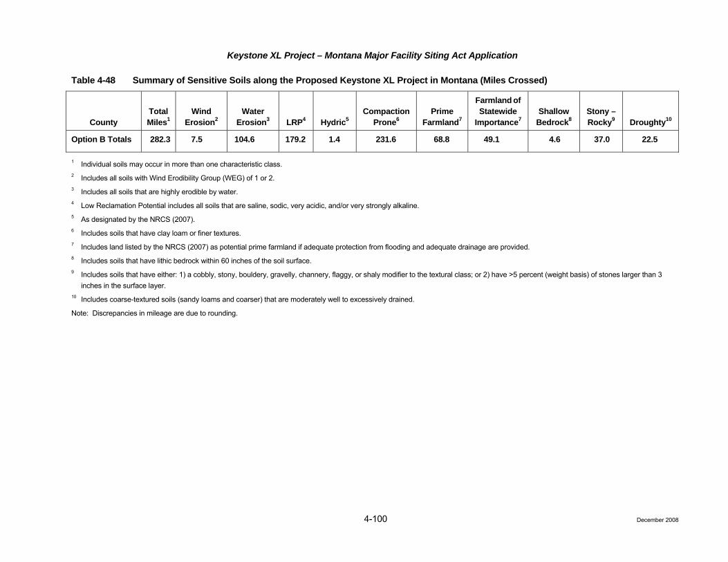
Keystone XL Project – Montana Major Facility Siting Act Application
4-100 December 2008
Table 4-48 Summary of Sensitive Soils along the Proposed Keystone XL Project in Montana (Miles Crossed)
County Total Miles1
Wind Erosion2
Water Erosion3 LRP4 Hydric5
Compaction Prone6
Prime Farmland7
Farmland of Statewide
Importance7 Shallow
Bedrock8 Stony – Rocky9 Droughty10
Option B Totals 282.3 7.5 104.6 179.2 1.4 231.6 68.8 49.1 4.6 37.0 22.5
1 Individual soils may occur in more than one characteristic class. 2 Includes all soils with Wind Erodibility Group (WEG) of 1 or 2. 3 Includes all soils that are highly erodible by water. 4 Low Reclamation Potential includes all soils that are saline, sodic, very acidic, and/or very strongly alkaline. 5 As designated by the NRCS (2007). 6 Includes soils that have clay loam or finer textures. 7 Includes land listed by the NRCS (2007) as potential prime farmland if adequate protection from flooding and adequate drainage are provided. 8 Includes soils that have lithic bedrock within 60 inches of the soil surface. 9 Includes soils that have either: 1) a cobbly, stony, bouldery, gravelly, channery, flaggy, or shaly modifier to the textural class; or 2) have >5 percent (weight basis) of stones larger than 3
inches in the surface layer. 10 Includes coarse-textured soils (sandy loams and coarser) that are moderately well to excessively drained.
Note: Discrepancies in mileage are due to rounding.
Keystone XL Project – Montana Major Facility Siting Act Application
4-101
Prime farmland soils occupy approximately 26.0 percent of Route A in Montana. Other sensitive soils crossed include 1.4 percent of hydric soils, and 35.5 percent of low reclamation potential soils, and 12.2 percent of droughty soils. Soils with shallow bedrock do not occur along this route. Details are further listed in Table 4-48.
Route A1A
Most of the soils encountered along this route are similar to Route A. Route A1A has approximately 24.8 more miles crossed. The soils along this route in Montana generally formed in glacial till. Soils are typically very deep and occasionally calcareous.
Prime farmland soils occupy approximately 27.4 percent of Route A1A in Montana. Other sensitive soils crossed include 1.2 percent of hydric soils, 28.2 percent of low reclamation potential soils, and 14.2 percent of droughty soils. Soils with shallow bedrock do not occur along this route. Details are further listed in Table 4-48.
Route B
From McCone County south to Fallon County the soils formed on old plateaus and terraces that have been eroded. Slopes generally are gently rolling to steep. Steeply sloping badlands border a few of the larger river valleys. In some areas flat-topped, steep-sided buttes rise sharply above the general level of the plains. The soils are generally shallow to very deep, well drained, and clayey or loamy. In areas of cretaceous shales, soils with high bentonite clay contents may occur, such as the Neldore series. These soils frequently have saline or sodic soil chemical properties. See Section 4.3.6, Geology, for further discussion on the landslide prone and clay soils prone to shrink-swell in Montana.
Other soils that occur in the area such as Ustorthents formed in residuum on hills and ridges (Cabba, Cabbart, and Yawdim series). Ustifluvents (Havre series) formed in alluvium on fans, terraces, and flood plains. Haplustepts (Busby, Cherry, Delpoint, Lonna, and Yamacall series) formed in alluvium, eolian deposits, and residuum on terraces, fans, and hills. Calciustepts (Cambeth series) formed in alluvium, colluvium, and residuum on fans, hills, and plains. Natrustalfs (Gerdrum series) and Haplustolls (Shambo series) formed in alluvium and glaciofluvial deposits on fans and terraces and in drainageways.
Prime farmland soils occupy approximately 24.4 percent of Route B in Montana. Other sensitive soils crossed include 0.5 percent of hydric soils, 63.5 percent of low reclamation potential soils, and 8.0 percent of droughty soils. Approximately 1.6 percent of soils with shallow bedrock are crossed. Details are further listed in Table 4-48.
4.3.7.2 Impact Assessment – All Routes (Circular MFSA-2, Section 3.1(6) and Section 3.4(1)(k))
Issues
• Accelerated wind or water erosion on disturbed areas during construction and operation (including maintenance activities);
• Reduced soil quality and corresponding reductions in the productivity of desirable vegetation or crops as a result of accelerated erosion, soil mixing, compaction, spills, or disturbance of irrigation or drainage features; and
• Hydrocarbon contaminated soils encountered within the pipeline trench caused by leaks and spills from adjacent pipelines.
Construction
Grading and excavating for the proposed pipeline and ancillary facilities will disturb a variety of agricultural, rangeland, wetland, and forestland soils. Certain inherent soil characteristics influence the agricultural productivity and revegetation potential after disturbance. The major soil characteristics of concern and the miles crossed of each type for each alternative route are indicated in Table 4-48. The quantification of acreage
December 2008

Keystone XL Project – Montana Major Facility Siting Act Application
4-102
for each of the characteristics is based on data in the SSURGO database. Key soil characteristics of concern include highly erodible soils, hydric soils, prime farmland, compaction prone soils, stony and rocky soils, shallow to bedrock soils, low reclamation potential, and droughty soils.
Soils classified as prime farmland typically possess the most favorable qualities for agricultural production (e.g., fertility, structure, depth and water holding capacity, microbial populations, infiltration and percolation rates, slope, and drainage). Short-term impacts such as soil compaction from equipment traffic, excavation and handling, and spills of fuels and lubricants may alter the capability of these soils temporarily following construction. Short-term impacts to prime farmland are anticipated on 30 percent of Route A, 27.5 percent of Route A1A, and 24.5 percent of Route B (all percents based on average). Where facilities, such as pump stations, are located on prime farmland permanent impacts would occur. On average, a typical pump station would impact approximately 5 acres. Route A and Route B each have one pump station located on prime farmland.
Farmland of Statewide Importance is land other than Prime Farmland, which has a good combination of physical and chemical characteristics for the production of crops. Route A and Route B have two pump stations located on farmland of statewide importance, while Route A1A has 1.1 pump stations on Farmland of statewide importance.
Although accelerated erosion due to construction-related soil disturbance could occur at any stage of construction, the maximum potential for erosion within the construction ROW would be expected after final grading has occurred but before a vegetative cover had been reestablished. Wind erodible soils are not commonly encountered on any of the routes. Route B crosses a slightly higher percentage of water erodible soils, 12.4 percent, compared to 7.0 percent of Route A or 10.4 percent of A1A. Attachment A, Mapbook 5, Highly Erodible Soils, depicts areas along all routes with highly erodible soils. All other areas along the routes are assumed to be low to moderately erodible soils.
While hydric soils are not commonly encountered (less than 2 percent crossed by each route) they would be difficult to reclaim and sensitive to disturbance. Hydric soils generally are defined as those that have evidence of saturation within 12 inches of the land surface for an extended period of time during the growing season. The presence of a hydric soil is often associated with native wetland hydrology and vegetation or with agricultural (farmed) wetlands. Both compaction-prone and hydric soils are especially prone to structural and aeration damage when trafficked or excavated.
Compaction-prone soils will likely result in compaction and rutting from the movement of heavy construction vehicles along the construction ROW and additional temporary work areas, and on access roads. The degree of compaction would depend on the moisture content and texture of the soil at the time of construction. Compaction would be most severe where heavy equipment operates on moist to wet soils with high clay contents. Detrimental compaction also can occur on soils of various textures and moisture contents if multiple passes are made by high ground weight equipment. Route A and A1A cross a substantial percentage of compaction prone soils (94.0 and 91.6 percent, respectively). Route B crosses approximately 82.0 percent of compaction prone soils.
Typically soils that are compaction prone also are prone to rutting or displacement when saturated. Rutting occurs when the soil strength is not sufficient to support the applied load from vehicle traffic. Rutting affects the surface hydrology of a site as well as the rooting environment. The process of rutting physically severs roots and reduces the aeration and infiltration of the soil, thereby degrading the rooting environment. Rutting also disrupts natural surface water hydrology by damming surface water flows, creating increased soil saturation upgradient from ruts, or by diverting and concentrating water flows, creating accelerated erosion. When grading is required and in areas of isolated weed populations, the topsoil shall be removed from the entire ROW and stored separately from subsoil. However, in all other locations topsoil will be removed from the trenchline only. Where trenchline only topsoil stripping occurs, rutting from equipment traffic may mix thinner
December 2008

Keystone XL Project – Montana Major Facility Siting Act Application
4-103
topsoils with the subsoil, thereby reducing soil productivity. Rutting is most likely to occur on moist or wet fine textured soils, but also may occur on dry sandy soils due to low soil strength.
Where stony or rocky soils are crossed, revegetation recovery rates may be slow. Route A1A would impact the most substantial percentage of stony or rocky soils, approximately 40.0 percent. Comparatively Route A and Route B would impact about 26.0 and 13.1 percent, respectively, of stony or rocky soils. Similarly, in areas of shallow bedrock (relative to the trench excavation depth), excavation may result in rock fragments remaining on the surface or within the trench backfill at levels that will limit the success of restoration efforts. Where the pipeline route crosses soils with lithic bedrock blasting or rock saws may be required for trenching. Route A and A1A do not cross any soils that are shallow to lithic bedrock. Only 1.6 percent of Route B is shallow to lithic bedrock.
Droughty soils would be prone to wind erosion during construction and would be more difficult to successfully stabilize and revegetate following construction. Less than 15 percent of droughty soils would be crossed by all routes. Similarly, scattered areas of low reclamation potential soils, such as soils that are saline, sodic, or strongly alkaline are known to occur in the Project region. Saline and/or sodic soils often have drainage limitations and may undergo compaction impacts similar to the hydric or compaction-prone soils. In addition, the success of stabilization and restoration efforts in these areas may be limited unless additional treatments and practices are employed to offset the adverse physical and chemical characteristics of the soils. Route B crosses approximately 63.5 percent of low reclamation potential soils compared to 35.5 percent and 28.2 percent of A and A1A, respectively.
Cretaceous shales weather to form soils high in smectitic clay minerals typically referred to as Bentonite clays. These soils typically have high shrink-swell potentials and also are prone to erosion by water when disturbed. Please see Attachment L, Smectitic Soils Associated with Cretaceous Shales, which provides a summary of smectitic soils crossed in Montana. Soils such as the Sunburst series occur in Valley, Phillips, and McCone counties. The Sunburst series has a very high shrink-swell potential due to a high percentage of smectite clay minerals. The proposed route will cross numerous other smectitic soils such as Neldore, Scobey, Gerdrum, Creed, and Bascovy series. Badlands also may be associated with cretaceous shales and may be highly erodible and difficult to reclaim when disturbed. Please refer to Section 4.3.6.1 for further discussion on slope instability associated with cretaceous shales and swelling clays.
Keystone plans to minimize or mitigate potential impacts to soils by implementing the soil protection measures identified in the CMRP (Attachment C). The measures include procedures for segregating and replacing topsoil, trench backfilling, relieving areas compacted by heavy equipment, removing surface rock fragments, and implementing water and wind erosion control practices. In addition, Keystone will work closely with landowners and soil conservation agencies to identify and implement recommended soil conservation practices in specific areas where they are necessary. Damaged irrigation and tile drainage systems will be repaired in accordance with the CMRP.
To accommodate potential discoveries of contaminated soils, Keystone will develop unanticipated contaminated soil discovery procedures in consultation with relevant agencies. These procedures will be added to the CMRP. If hydrocarbon contaminated soils are encountered during trench excavation, the state agency responsible for emergency response and site remediation will be contacted immediately. A remediation plan of action will be developed in consultation with that agency. Depending on the level of contamination found, affected soil may be replaced in the trench or removed to an approved landfill for disposal.
Operation
Very small scale, isolated surface disturbance impacts resulting in accelerated erosion, soil compaction, spills, and related reductions in the productivity of desirable vegetation or crops could result from pipeline maintenance traffic and incidental repairs. Impacts related to excavation and topsoil handling are not likely to
December 2008

Keystone XL Project – Montana Major Facility Siting Act Application
4-104
4.3.7
occur. If they do occur, they will be limited to small areas where certain pipeline maintenance activities take place or where reclamation is unsuccessful. During operation, these types of impacts will be addressed with the affected landowner and a mutually agreeable resolution reached.
Keystone will employ multiple safeguards to prevent a pipeline release. The chance of a spill occurring is very low and if a spill occurred, the volume is likely to be relatively small. In the unlikely event of a pipeline release, Keystone would initiate its ERP and emergency response teams would contain and cleanup the spill. To minimize impacts to soils, appropriate remedial measures will be implemented to meet federal and state standards designed to ensure protection of human health and environmental quality. Additional information on potential impacts to soils resulting from a crude oil spill is provided in the Risk Assessment (Attachment D).
.3 Summary of Route-Specific Soils Impacts
Route-specific impacts for soils are summarized in Table 4-49. Identified impacts will be substantially mitigated as discussed within this application and further outlined in the CMRP for all Routes. Based strictly on the relative lengths of the routes within the State of Montana and not taking into consideration the overall effect through Montana, South Dakota, and Nebraska, Route B has the greatest impacts. However, when the full Steele City Segment impacts are considered, frequently the additional length of Routes A and A1A would result in greater impacts.
Table 4-49 Summary of Route-Specific Soils Impacts
Route Alternatives
Resource Route A Route A1A Route B
Miles of Pipe
Steele City Segment 919.7 951.3 850.7
Portion in Montana 180.7 205.5 282.7
Soils
Prime farmland Route A crosses 46.9 miles of prime farmland.
Route A1A crosses 56.4 miles of prime farmland.
Route B crosses 68.8 miles of prime farmland.
Sensitive soils Route A crosses 75.8 miles of smectitic soils.
Route A1A crosses 54.8 miles of smectitic soils.
Route B crosses 114.0 miles of smectitic soils.
References
Natural Resources Conservation Service (NRCS). 2006. Land Resource Regions and Major Land Resource Areas of the United States, the Caribbean, and the Pacific Basin. U.S. Department of Agriculture Handbook 296.
Natural Resources Conservation Service (NRCS), Lincoln, Nebraska. 2008. Official Soil Series Descriptions. Website: http://soils.usda.gov/ technical/classification/osd/index.html. (Accessed September 10, 2008.)
Natural Resources Conservation Service (NRCS) Staff. 2007. Soil Survey Geographic (SSURGO) Database for all counties crossed. Website: http://soildatamart.nrcs. usda.gov. (Accessed 2007.)
December 2008

Keystone XL Project – Montana Major Facility Siting Act Application
4-105
4.3.8
4.3.8 Paleontology
.1 Baseline Data and Description of Routes – All Routes (Circular MFSA-2, Section 3.4(10)(a)(b)(c) and Section 3.7(13)(14)(b)(c)
Recently, the BLM has adopted the Potential Fossil Yield Classification (PFYC) system to identify and classify fossil resources on federal lands (BLM 2007). The PFYC system is summarized briefly as follows (BLM 2007):
Occurrences of paleontological resources are closely tied to the geologic units (i.e., formations, members, or beds) that contain them. The probability for finding paleontological resources can be broadly predicted from the geologic units present at or near the surface. Therefore, geologic mapping can be used for assessing the potential for the occurrence of paleontological resources.
Using the PFYC system, geologic units are classified based on the relative abundance of vertebrate fossils or scientifically significant invertebrate or plant fossils and their sensitivity to adverse impacts, with a higher class number indicating a higher potential. This classification is applied to the geologic formation, member, or other distinguishable unit, preferably at the most detailed mappable level. It is not intended to be applied to specific paleontological localities or small areas within units. Although significant localities may occasionally occur in a geologic unit, a few widely scattered important fossils or localities do not necessarily indicate a higher class; instead, the relative abundance of significant localities is intended to be the major determinant for the class assignment.
The PFYC system is meant to provide baseline guidance for predicting, assessing, and mitigating paleontological resources. The classification should be considered at an intermediate point in the analysis, and should be used to assist in determining the need for further mitigation assessment or actions.
The BLM intends for the PFYC system to be used as a guideline as opposed to rigorous definitions. Descriptions of the potential fossil yield classes are presented below (BLM 2007):
Class 1 – Very Low. Geologic units that are not likely to contain recognizable fossil remains.
• Units that are igneous or metamorphic, excluding reworked volcanic ash units; and
• Units that are Precambrian in age or older.
Class 2 – Low. Sedimentary geologic units that are not likely to contain vertebrate fossils or scientifically significant nonvertebrate fossils.
• Vertebrate or significant invertebrate or plant fossils not present or very rare;
• Units that are generally younger than 10,000 years before present;
• Recent Aeolian deposits; and
• Sediments that exhibit significant physical and chemical changes (i.e., diagenetic alteration).
Class 3 – Moderate or Unknown. Fossiliferous sedimentary geologic units where fossil content varies in significance, abundance, and predictable occurrence; or sedimentary units of unknown fossil potential.
• Often marine in origin with sporadic known occurrences of vertebrate fossils;
• Vertebrate fossils and scientifically significant invertebrate or plant fossils known to occur intermittently; predictability known to be low; and
• Poorly studied and/or poorly documented. Potential yield cannot be assigned without ground reconnaissance.
December 2008

Keystone XL Project – Montana Major Facility Siting Act Application
4-106
Class 3a – Moderate Potential. Units are known to contain vertebrate fossils or scientifically significant nonvertebrate fossils, but these occurrences are widely scattered. Common invertebrate or plant fossils may be found in the area, and opportunities may exist for hobby collecting. The potential for a Project to be sited on or impact a significant fossil locality is low, but is somewhat higher for common fossils.
Class 3b – Unknown Potential. Units exhibit geologic features and preservational conditions that suggest significant fossils could be present, but little information about the paleontological resources of the unit or the area is known. This may indicate the unit or area is poorly studied, and field surveys may uncover significant finds. The units in this class may eventually be placed in another class when sufficient survey and research is performed. The unknown potential of the units in this class should be carefully considered when developing any mitigation or management actions.
Class 4 – High. These are geologic units containing a high occurrence of significant fossils. Vertebrate fossils or scientifically significant invertebrate or plant fossils are known to occur and have been documented, but may vary in occurrence and predictability. Surface disturbing activities may adversely affect paleontological resources in many cases.
Class 4a – Unit is exposed with little or no soil or vegetative cover. Outcrop areas are extensive with exposed bedrock areas often larger than 2 acres. Paleontological resources may be susceptible to adverse impacts from surface disturbing actions. Illegal collecting activities may impact some areas.
Class 4b – These are areas underlain by geologic units with high potential but have lowered risks of human-caused adverse impacts and/or lowered risk of natural degradation due to moderating circumstances. The bedrock unit has high potential, but a protective layer of soil, thin alluvial material, or other conditions may lessen or prevent potential impacts to the bedrock resulting from the activity:
• Extensive soil or vegetative cover; bedrock exposures are limited or not expected to be impacted;
• Areas of exposed outcrop are smaller than two contiguous acres;
• Outcrops form cliffs of sufficient height and slope so that impacts are minimized by topographic conditions; and
• Other characteristics are present that lower the vulnerability of both known and unidentified paleontological resources.
Four Class 4 and Class 5 units may be combined as Class 5 for broad applications, such as planning efforts or preliminary assessments, when geologic mapping at an appropriate scale is not available. Resource assessment, mitigation, and other management considerations are similar at this level of analysis, and impacts and alternatives can be addressed at a level appropriate to the application.
The probability for impacting significant paleontological resources is moderate to high, and is dependent on the proposed action. Mitigation considerations must include assessment of the disturbance, such as removal or penetration of protective surface alluvium or soils, potential for future accelerated erosion, or increased ease of access resulting in greater looting potential. If impacts to significant fossils can be anticipated, on-the-ground surveys prior to authorizing the surface disturbing action will usually be necessary. On-site monitoring or spot-checking may be necessary during construction activities.
Class 5 – Very High. Highly fossiliferous geologic units that consistently and predictably produce vertebrate fossils or scientifically significant invertebrate or plant fossils, and that are at risk of human-caused adverse impacts or natural degradation.
December 2008
Keystone XL Project – Montana Major Facility Siting Act Application
4-107
4.3.8
Class 5a – Unit is exposed with little or no soil or vegetative cover. Outcrop areas are extensive with exposed bedrock areas often larger than two contiguous acres. Paleontological resources are highly susceptible to adverse impacts from surface disturbing actions. Unit is frequently the focus of illegal collecting activities.
Class 5b – These are areas underlain by geologic units with very high potential but have lowered risks of human-caused adverse impacts and/or lowered risk of natural degradation due to moderating circumstances. The bedrock unit has very high potential, but a protective layer of soil, thin alluvial material, or other conditions may lessen or prevent potential impacts to the bedrock resulting from the activity:
• Extensive soil or vegetative cover; bedrock exposures are limited or not expected to be impacted;
• Areas of exposed outcrop are smaller than two contiguous acres; and
• Outcrops form cliffs of sufficient height and slope so that impacts are minimized by topographic conditions.
Other characteristics are present that lower the vulnerability of both known and unidentified paleontological resources.
Tables 4-38, 4-39, and 4-40 summarize the paleontological resource potential and sensitivity of geologic formations crossed by Route A, Route A1A, and Route B. A paleontological resource assessment was conducted for lands managed by the BLM along Route B (SWCA Environmental Consultants 2008a). Field surveys also were conducted along the Route B corridor, transmission line routes, and access road locations. File searches also were conducted at the Miles City and Malta Field Offices of the BLM as well as records of the University of California, Museum of Paleontology. Routes A and A1A were not surveyed on the ground, but the conclusions of potential fossil yield for the formations along Route B should be adequate to characterize the fossil yield potential of the same formations found along the other routes.
Several of the formations, Judith River, Hell Creek, and Fort Union, have a high degree of sensitivity for paleontological resources because of the high potential for the presence of scientifically important fossils. During the paleontological assessment, 20 nonsignificant fossil occurrences were documented and 14 “significant” fossil localities were discovered.
.2 Impact Assessment
Construction
To reduce impacts to potentially important fossil localities, Keystone would conduct surveys for resources on the route and develop a mitigation plan to protect fossil resources on federal lands encountered during proposed Project construction. Provisions of the plan for protection of paleontological resources would include worker training, spot monitoring of construction activities, sampling for microfossils where appropriate, obtaining stratigraphic information in excavations, salvaging fossil resources, and unanticipated discoveries plan for large or extremely important fossil finds.
Under no circumstances would fossils be removed from private lands for any reason, including curation, without the written consent of the landowners.
Adherence to a paleontological mitigation plan would minimize adverse impacts to scientifically important paleontological resources on federal lands. Important paleontological resources on non-federal lands may be recovered only with approval of the landowners, and therefore, may be unavailable for scientific curation.
Operation
Issues
• Potential damage and loss of scientifically important fossils from maintenance activities.
December 2008

Keystone XL Project – Montana Major Facility Siting Act Application
4-108
4.3.8
Any potential effects to fossils from maintenance activities would be isolated due to the probable disbursed nature of maintenance activities. Also, potential impact during operations and maintenance would be minimal since activity would occur on previously disturbed ROW.
Normal operation of the proposed pipeline and its associated facilities would not disturb important paleontological resources. Maintenance activities would result in surface disturbance, but typically would occur within the ROW that was previously disturbed during construction. Since no new disturbances would be anticipated from maintenance activities (i.e., maintenance activities would occur within the ROW), impacts to paleontological resources would be negligible.
.3 Summary of Route-Specific Paleontology Impacts
Route-specific impacts for paleontology are summarized in Table 4-50. Identified impacts will be substantially mitigated as discussed within this application and further outlined in the CMRP for all Routes. Based strictly on the relative lengths of the routes within the State of Montana and not taking into consideration the overall effect through Montana, South Dakota, and Nebraska, Route B has the greatest impacts. However, when the full Steele City Segment impacts are considered, frequently the additional length of Routes A and A1A would result in greater impacts.
Table 4-50 Summary of Route-Specific Paleontology Impacts
Route Alternatives
Resource Route A Route A1A Route B
Miles of Pipe
Steele City Segment 919.7 951.3 850.7
Portion in Montana 180.7 205.5 282.7
Paleontology
Fossil potential Route A crosses the Judith River, Hell Creek, and Fort Union formations, all having a high potential for scientifically important fossils such as dinosaurs and mammals. Total miles crossed: 116.
Route A1A crosses the Judith River, Hell Creek, and Fort Union formations; all having a high potential for scientifically important fossils, such as dinosaurs and mammals. Total miles crossed: 142.
Route B crosses the Judith River, Hell Creek, and Fort Union formations, all having a high potential for scientifically important fossils, such as dinosaurs and mammals. Total miles crossed: 207.0.
References
Bureau of Land Management (BLM). 2007. Instruction Memorandum No. 2008-009, October 18, 2007. Website: http://www.blm.gov/wo/st/en/info/regulations/Instruction_Memos_and_Bulletins/ national_instruction/20080/im_2008-009.html. (Accessed August 13, 2008.)
SWCA Environmental Consultants. 2008a. Paleontological assessment for federal land along the Montana Segment of the Keystone XL Pipeline Project. Prepared for ENSR Corporation and BLM, September 12, 2008, 312 pages.
_____. 2008b. Paleontological assessment for federal land along the Montana Segment of the Keystone XL Pipeline Project: Field survey recommendations. Prepared by SWCA Environmental Consultants for ENSR Corporation and BLM, August 8, 2008, 9 pages.
December 2008

Keystone XL Project – Montana Major Facility Siting Act Application
4-109
4.3.9
4.3.9 Cultural Resources
.1 Prehistoric and Historic Overview of the Study Area (MFSA-2 Section 3.4, 10a)
Eastern Montana contains a rich and varied cultural history which can be categorized into four prehistoric periods and the later historic period. Of the prehistoric periods, these four divisions can be further broken down into a multitude of human complexes associated with different food procurement strategies and technological advances. While very valid for a professional archaeological perspective, further analysis of the five periods of time is unwarranted for the purpose of overview and will be omitted from this document.
Prehistory in regards to human occupation in Montana begins with the Paleoindian Period, which ranges from 12,000 Before Present and continues until 8,000 Before Present. During this time span, humans residing on the Plains led a highly migratory lifestyle. This was in great part to the necessity of these populations to follow and exploit late Pleistocene animals and harvest associated plant life.
Of these populations the most well recognized Paleoindian group for this period is referred to as the Clovis complex. Clovis is categorized by a distinct, basally fluted projectile point; these points, along with associated material, are the earliest unequivocal evidence of a Paleoindian complex in North America. Clovis projectiles have been best known from areas such as the Colby mammoth kill site in Wyoming. Other complexes include, but are not limited to, Goshen, Folsom, Agate Basin, Hell Gap, Alberta, and Cody. All previously mentioned Paleoindian complexes mark technological or style changes which can be followed throughout time.
Directly following the Paleoindian Period is the Archaic Period. This period ranges from 8,000 Before Present to 1,500 Before Present and is marked by a shift from stemmed lanceolate projectiles to the use of large side notched forms. This indicates a drastic change in technology, where the emphasis in the Archaic Period changes from that of utilizing hand thrown spears toward the use of a propelled dart or atlatl. Not only is there a severe technological shift but a drastic climate change as well. This paleoclimatic change in turn triggered differing subsistence strategies, which may have emphasized an increased dependence on floral resources throughout the Plains.
The invention of the bow and arrow reflects a technological innovation which marks the Late Prehistoric Period that ranged from 1,500 Before Present to 250 Before Present. During this time human populations increased dramatically across the region which is evident from an increase in radiocarbon dating localities. Subsistence strategies carried along the same routes as the two earlier periods in the form of migratory hunting strategies and limited horticulture. The late prehistoric period also offers a diverse palate of rock art examples. This art ranges from fertility representations to grandiose depictions of bison hunts strewn across rock shelter walls.
The Protohistoric Period (250 to 130 Before Present), which is poorly represented in material remains in eastern Montana is categorized by major population migrations as well as significant changes involved with material culture. Native populations acquired the horse and increasing numbers of firearms and respectively began to utilize both, perhaps no other introduction was as significant a catalyst to the mobile ethnohistoric cultures of the Plains. Trade goods became very common during this period as did the introduction of metal tools, glass beads, and textiles.
Historical context in relation to this area is well documented, ranging from early expansion and the fur trade to Euro American settlement in the form of Homesteads and the expanse of agriculture. Railroads and collaborative highway efforts all shaped the area, as did the interactions between the native populations and the expanding Euro American groups. These interactions directly resulted in multiple treaties between the US government and various tribal entities, which in a way, now shape the manner in which some 12,000 years of history must now be addressed.
December 2008

Keystone XL Project – Montana Major Facility Siting Act Application
4-110
4.3.9.2 Native American Consultation and SHPO Data Requests
Tribal engagement has been initiated with 72 tribal members from 16 tribes for the entirety of the Project. These tribes were recognized as having a potential past or present affiliation with the Project area. Seven of the 16 Tribes are from Montana and only 3 have responded, see Table 4-51. Formal consultation with the tribes will be the responsibility of the DOS.
Table 4-51 Tribal Contact List in Montana
Tribe Date of Contact Status
Blackfeet Nation May 27, 2008 Written reply as of July 24, 2008. Consultation desired.
Fort Peck Tribes May 27, 2008 Verbal reply as of July 24, 2008. Consultation desired.
Northern Cheyenne Tribe May 27, 2008 Written reply as of July 24, 2008. Consultation desired.
Salish and Kootenai Tribes May 27, 2008 No reply.
Little Shell May 27, 2008 No reply.
Crow May 27, 2008 No reply.
Chippewa Cree May 27, 2008 No reply.
Efforts to identify places of traditional or religious importance to Native American tribes will continue throughout the environmental review and construction phases of the Project. The consultation process, once initiated, will include asking interested tribes to participate in consultation when a traditional cultural property (TCP) may be affected by the proposed Project. Any TCP that may be affected by the Project will be treated in accordance with the National Historical Preservation Act (NHPA), as amended, and its implementing regulations, and other applicable federal statutes and/or tribal laws and policies, as appropriate. No surface disturbance will occur within or immediately adjacent to the boundary of a TCP prior to completion of all consultation required by law. Any data recovery or mitigation plan will be reviewed and approved by the lead federal agency and appropriate SHPO. Tribal representatives will be asked to participate in the development of any such data recovery or mitigation plan in accordance with federal mandates.
Data requests have also been made of the Montana SHPO Office with regard to the three routes. File/record searches were requested and received for the areas crossed by each Route so that it could be determined what types of sites and previous cultural inventories have been conducted in these areas. The results of these file searches are summarized in Table 4-52.
Table 4-52 Class I File/Records Search Results
Route # Prehistoric Sites # Historic Sites # Unknown Sites
Route A 13, 1 Eligible 68, 9 Eligible 148
Route A1A1 30, 1 Eligible 20, 6 Eligible 22
Route B 148, 0 Eligible 62, 13 Eligible 6 1 Unique portion of Route A1A.
December 2008

Keystone XL Project – Montana Major Facility Siting Act Application
4-111
4.3.9.3 Baseline Data and Description of Routes – All Routes (MFSA-2, Sections 3.4(10)(a)(b)) and 3.7(13)(14)
Places that may be of traditional cultural importance to Native American people include, but are not limited to, locations associated with the traditional beliefs concerning tribal origins, cultural history, or the nature of the world; locations where religious practitioners went or go to perform ceremonial activities based on traditional cultural rules or practice; ancestral habitation sites; trails; burial sites; and places from which plants, animals, minerals, and waters possessing healing powers or used for other subsistence purposes, may be taken. Additionally, some of these locations may be considered sacred to particular Native American individuals or tribes. It is the responsibility of all parties involved to take into account the effects the proposed Project may have on all localities.
If a resource has been identified as having importance in traditional cultural practices and the continuing cultural identity of a community, it may be considered a TCP. The term “traditional cultural property” first came into use within the federal legal framework for historic preservation and cultural resource management in an attempt to categorize historic properties containing traditional cultural significance. National Register Bulletin 38: Guidelines for Evaluating and Documenting Traditional Cultural Properties (Parker and King 1989) defines a TCP as “one that is eligible for inclusion in the National Register of Historic Places (NRHP) because of its association with cultural practices or beliefs of a living community that (a) are rooted in that community’s history and (b) are important in maintaining the continuing cultural identity of the community.” To qualify for nomination to the NRHP, a TCP must be more than 50 years old, must be a place with definable boundaries, must retain integrity, and meet certain criteria as outlined in National Register Bulletin 15: How to Apply the National Register Criteria for Evaluation (NPS 1995).
File Search and Aerial Survey
Systems utilized by the Montana SHPO include both the Cultural Resource Information Systems Report (CRIS), which documents all previously recorded sites within the search area and the Cultural Resource Annotated Bibliography System, which supplements the CRIS database but provides additional data in relation to dates and coverage of past surveys. Documentation of Routes A, A1A, and B files/records searches are provided in Attachment M, Confidential Volume 3B. Together these databases allow a summary to be generated of what types of Cultural resources are located within the area of potential effect (APE). A summary of all sites within the APE for all three routes is summarized in Table 4-52.
In addition to file searches, an aerial cultural inventory was conducted September 22–26, 2008 (MFSA 2, Section 3.4, 10c, Section 3.7, as Amended for Aerial Archaeological Survey). Methodology was in accordance with aerial archaeological standards; however, AECOM Environment European aerial guidelines were adapted to suit the diverse climate and topography of Eastern Montana. As few references for this type of work exist, guidelines are not well established and field expedient measures were utilized. These surveys were conducted from a Bell Jet Ranger helicopter flying at an altitude of between 75 and 150 feet off the ground surface. This altitude was deemed ideal, as was a cruising speed of roughly 25 miles per hour. Total results for aerial survey in reference to all three routes are summarized in Table 4-53.
Table 4-53 Results of Aerial Reconnaissance of Routes1
Route # Prehistoric Sites # Historic Sites # Unknown Sites
Route A 1 14 1
Route A1A 5 21 4
Route B 4 40 6 1 Sites visible from a helicopter.
December 2008

Keystone XL Project – Montana Major Facility Siting Act Application
4-112
Route A
Keystone conducted a Class I cultural resource files/records search which was initiated with the Montana SHPO. The Class I file/records search produced a total of 229 previously recorded sites within the APE for Keystone’s Route A. An overview of these resources is provided below.
• 68 historic sites;
• 13 prehistoric sites; and
• 148 unknown or no indication of age sites.
Of the 68 historic sites, 7 are deemed as ineligible for the NRHP, 9 are classified as eligible under criterion C and D of the NRHP guidelines, and the remaining 52 are listed as undetermined. The 13 prehistoric sites consist of 1 eligible site and 12 undetermined sites, and the remaining 148 previously recorded locations remain undetermined.
The aerial survey conducted on Route A produced 16 sites; of these 16, 1 prehistoric cairn was recorded, 1 positive crop mark of an unknown age was recorded, and the remaining 14 sites were associated with historic agriculture in the area. Roughly 24 miles of centerline are shared with Routes A, A1A, and B as such the sites referenced in this paragraph are unique to Route A.
Route A1A
An additional Class I cultural resource files/ records search was conducted in regards to Keystone’s Route A1A. This second search produced a total of 72 previously recorded sites within the APE for Route A1A. A significant portion of Route A1A is shared with Route A, in consideration of this fact only the unique portion of Route A1A will be referenced below. Findings are as follows.
• 20 historic sites;
• 30 prehistoric sites; and
• 22 unknown or no indication of age sites.
Of the 20 historic sites, 6 are recorded as eligible under criterion C and D of the NRHP, 9 are deemed ineligible, and the remaining 5 are considered undetermined. The 30 prehistoric sites include 1 eligible site and 29 undetermined locations. The unknown localities are all listed as undetermined for the NRHP under any criterion.
The aerial survey of Route A1A yielded 5 prehistoric sites, 2 sites of unknown age, and 21 historic sites. Collectively, a total of 28 sites were recorded. Routes A and A1A share a significant portion (approximately 27 miles) of centerline APE as well.
Route B
A Class I cultural resource files/record search was performed in regards to the proposed centerline of Route B. This file/records search yielded 216 previously recorded sites within the APE of Route B. A summary is provided below.
• 62 historic sites;
• 148 prehistoric sites; and
• 6 multi-component sites.
December 2008

Keystone XL Project – Montana Major Facility Siting Act Application
4-113
4.3.9
Of the historic sites, 13 are listed as eligible under the NRHP, the remaining 49 are listed as ineligible or undetermined. None of the Prehistoric sites are listed as eligible, and of the six multi-component sites, all are listed as undetermined for NRHP listing under any criterion.
The aerial survey completed on the Route B of the Project yielded 50 sites within close proximity to the APE. Of these 50, 4 are prehistoric, 6 are of unknown age, and the remaining 40 are historic. The four sites considered prehistoric include a cairn and three stone circle sites.
The six sites, which were recorded as being of an unknown age consist of both cairns and either positive or negative crop markings. Crop markings are defined as either an over- or under-developed section of plant growth, which may yield a distinct pattern. These patterns may be beneficial in pointing out to the aerial observer the possibility of sub surface cultural material.
All historic sites consist of historic farming/ranching activities and associated behavior (i.e., trash piles or corral structures). The overwhelming majority of sites throughout this region reflect a deep history associated with rural agriculture.
.4 Impact Assessment
Issue
Construction and operation of the Project could affect NRHP-eligible historic properties such as prehistoric or historic archaeological sites, districts, buildings, structures, and objects.
Construction
Those areas in which construction activity is planned or where impacts are likely to occur are referred to as the area of potential effect, or APE. Specifically, the APE is defined as the geographic area or areas within which an undertaking may directly or indirectly cause changes in the character or use of NRHP-eligible sites, if any such sites exist.
Only those cultural resources located in the APE were reviewed to determine if any would be subject to impacts that could affect their eligibility for the NRHP based on NRHP criteria for evaluation. For the Project, the APE is the 200-foot-wide survey corridor in areas where the Project parallels an existing pipeline, the 300-foot-wide survey corridor in greenfield areas, the footprint of proposed pump stations, access roads to be used and/or upgraded during construction, pipe yards, contractor yards, and any other temporary use or staging areas, plus a 50-foot buffer.
Construction and operation of the Project could potentially affect NRHP-eligible sites. These could include prehistoric or historic archaeological sites, districts, buildings, structures, objects, and locations with traditional cultural value to Native Americans or other groups. Project impacts could include: the physical disturbance during construction on archaeological sites located within the Project APE; the demolition, removal, or alteration of historic or architecturally significant structures/features; and the introduction of visual or audible elements (e.g., pump stations) that could alter the site’s setting. Impacts to NRHP-eligible sites would be mitigated through avoidance or SHPO- and DOS-approved data recovery techniques. Mitigation may include, but would not be limited to, one or more of the following measures: 1) avoidance through the use of realignment of the pipeline centerline, relocation of pump stations, or changes in the construction and/or operational design; 2) data recovery, which may include the systematic professional excavation of an archaeological site or the preparation of photographic and/or measured drawings documenting standing structures; and 3) the use of landscaping or other techniques that would minimize or eliminate effects on the historic setting or ambience of standing structures.
Whenever feasible, Keystone will avoid NRHP-eligible sites identified within the Project APE. Keystone will consult with DOS and the appropriate SHPO(s) to identify measures to avoid adversely affecting these sites. If
December 2008

Keystone XL Project – Montana Major Facility Siting Act Application
4-114
adverse effects to any NRHP-eligible sites cannot be avoided, Keystone will develop treatment plans for mitigating those effects. Keystone will file avoidance or treatment plans, as appropriate, with DOS and the appropriate SHPO(s).
Construction activities and associated operations could adversely affect undiscovered archaeological sites. If previously undocumented sites are discovered within the construction corridor during construction activities, all work that might adversely affect the discovery will cease until Keystone, in consultation with the appropriate parties, can evaluate the site’s eligibility and the probable effects. If the previously unidentified site is recommended as eligible to the NRHP, impacts will be mitigated through the steps outlined in an approved Unanticipated Discovery Plan, which will be included in the cultural resources survey reports prepared for the preferred route.
If construction or other Project personnel discover what they believe to be human remains, funerary objects, or items of cultural patrimony on federal land, construction will cease within the vicinity of the discovery and the appropriate agency and tribal representatives will be notified of the find. Treatment of any discovered human remains, funerary objects, or items of cultural patrimony found on federal land will be handled in accordance with Native American Graves Protectionand Repatriation Act (NAGPRA). Construction will not resume in the area of the discovery until the authorized agency has issued a notice to proceed.
If human remains and associated funerary objects are discovered on state or private land during construction activities, construction will cease within the vicinity of the discovery and the county coroner or sheriff will be notified of the find. Treatment of any discovered human remains and associated funerary objects found on state or private land will be handled in accordance with the provisions of applicable state laws as outlined in the Unanticipated Discovery Plan.
Operation
The primary impact of the operation phase of the Project is the potential introduction of visual or audible elements (e.g., pump stations), which could alter the setting associated with historic properties. Keystone will mitigate these operational impacts to NRHP-eligible sites by the use of landscaping or other techniques that will minimize or eliminate effects on the historic setting or ambience of standing structures if applicable.
.5 Summary of Route-Specific Cultural Resources Impacts 4.3.9
Route-specific impacts for cultural resources are summarized in Table 4-54. Identified impacts will be substantially mitigated as discussed within this application and further outlined in the CMRP for all Routes. Based strictly on the relative lengths of the routes within the State of Montana and not taking into consideration the overall effect through Montana, South Dakota, and Nebraska, Route B has the greatest impacts. However, when the full Steele City Segment impacts are considered, frequently the additional length of Routes A and A1A would result in greater impacts.
December 2008

Keystone XL Project – Montana Major Facility Siting Act Application
4-115
Table 4-54 Summary of Route-Specific Cultural Resources Impacts
Route Alternatives
Resource Route A Route A1A Route B
Miles of Pipe
Steele City Segment 919.7 951.3 850.7
Portion in Montana 180.7 205.5 282.7
Cultural
Aerial cultural survey, prehistoric sites
Within Route A’s survey corridor, one prehistoric site was observed.
Within Route A1A’s survey corridor, five prehistoric sites were observed.
Within Route B’s survey corridor, four prehistoric sites were observed.
Aerial cultural survey, historic sites
Within Route A’s survey corridor, 14 historic sites were observed.
Within Route A1A’s survey corridor, 21 historic sites were observed.
Within Route B’s survey corridor, 40 historic sites were observed.
Aerial cultural survey, unknown sites
Within Route A’s survey corridor, one site of unknown age was observed.
Within Route A1A’s survey corridor, two sites of unknown age were observed.
Within Route B’s survey corridor, six sites of unknown age were observed.
Previously recorded historic sites
Within Route A’s survey corridor, 68 historic sites were previously recorded, 9 eligible for the NRHP. Access roads file/records search produced 34 historic sites, 2 eligible for NRHP.
Within Route A1A’s survey corridor, 20 historic sites were previously recorded, 6 eligible for the NRHP. Access roads file/records search produced 64 historic sites, 7 eligible for NRHP.
Within Route B’s survey corridor, 62 historic sites were previously recorded, 13 eligible for the NRHP. Access roads file/records search produced 49 historic sites, 20 eligible for NRHP.
Previously recorded prehistoric sites
Within Route A’s survey corridor 13 prehistoric sites were previously recorded, 1 eligible for the NRHP. Access roads file/records search produced 9 prehistoric sites, 0 eligible.
Within Route A1A’s survey corridor 30 prehistoric sites were previously recorded, 1 eligible for the NRHP. Access roads file/records search produced 9 prehistoric sites, 0 eligible.
Within Route B’s survey corridor 148 prehistoric sites were previously recorded, 0 eligible for the NRHP. Access roads file /records search produced 5 prehistoric sites, 0 eligible.
Previously recorded multi-component sites
Within Route A’s survey corridor for both centerline and access roads, no multi-component sites were previously recorded.
Within Route A1A’s survey corridor for both centerline and access roads, no multi-component sites were previously recorded.
Within Route B’s survey corridor for both centerline and access roads, 6 multi-component sites were previously recorded.
Previously recorded sites of unknown age
Within Route A’s centerline survey corridor, 148 sites of unknown age were previously recorded. Access roads file/records search produced 81 sites of unknown age, 0 eligible.
Within Route A1A’s centerline survey corridor, 22 sites of unknown age were previously recorded. Access roads file/records search produced 88 sites of unknown age, 0 eligible.
Within Route B’s centerline survey corridor, no sites of unknown age were previously recorded. Access roads file/records search produced 62 sites of unknown age, 0 eligible.
December 2008

Keystone XL Project – Montana Major Facility Siting Act Application
4-116
References
Aerial archaeology in Britain. Riley, D. N. and N. Derrick. 1982. Aylesbury, Bucks, United Kingdom: Shire Publications.
Air photography and archaeology. 1987. Riley, D. N. and N. Derrick. Philadelphia, University of Pennsylvania Press.
American Indian Religious Freedom Act : Oversight hearing before the Subcommittee on Native American Affairs of the Committee on Natural Resources, House of Representatives, One Hundred Third Congress, First Session, on Effectiveness of P.L. 95-346--the American Indian Religious Freedom Act of 1978 (AIRFA).
The Antiquities Act and Federal Land Policy and Management Act Amendments of 1979: Hearing Before the Subcommittee on Parks, Recreation, and Renewable Resources of the Committee on Energy and Natural Resources, United States Senate, Ninety-sixth Congress, First Session, on S. 1176. September 13, 1979.
Archaeological investigations on the Northern Border Pipeline: Montana Segment: Report [S.l.: s.n., 1983-1984].
Archaeology of the High Plains. Gunnerson, J. H. Denver, Colorado: Rocky Mountain Region, USDA Forest Service, 1987.
Archaeology on the Great Plains. Lawrence: University Press of Kansas, c1998.
Cultural Resource Investigations of the South Dakota Segment of the Northern Border Pipeline Project [Omaha, Nebraska] (2223 Dodge St., Omaha 68102): Northern Plains Natural Gas Co.], 1982.
Folsom tools and technology at the Hanson Site, Wyoming. Frison, G. C. Albuquerque: University of New Mexico Press, c1980.
Guidelines for Evaluating and Documenting Rural Historic Landscapes. [Washington, D.C.?] : U.S. Department of the Interior, National Park Service, Interagency Resources Division, [1990?]
Guidelines for Evaluating and Documenting Traditional Cultural Properties. [Washington, D.C.?] : U.S. Department of the Interior, National Park Service, Interagency Resources Division, [1990?]
How to Apply the National Register Criteria for Evaluation. [Washington, D.C.?] : U.S. Department of the Interior, National Park Service, Interagency Resources Division, [1991]
Montana Legacy : Essays on History, People, and Places. Helena, Montana. Montana Historical Society Press, C2002.
Native American Graves Protection and Repatriation Act : Hearing Before the Committee on Indian Affairs, United States Senate, One Hundred Third Congress, first session, on oversight hearing on understanding how the Native American Grave Protection and Repatriation Act is being implemented, May 27, 1993, Washington, DC.
National Park Service (NPS). 1995. Nationwide Programmatic Agreement: Simultaneous Review of NPS Plans and Section 106 Compliance for Component Undertakings.
December 2008

Keystone XL Project – Montana Major Facility Siting Act Application
4-117
4.3.10
Parker, P. and T. King. 1989. Guidelines for Evaluating and Documenting Traditional Cultural Properties. National Register Bulletin 38. National Park Service, Washington, D.C. 1990.
Plains Indians. A.D. 500-1500: The Archaeological Past of Historic Groups. Norman: University of Oklahoma Press, c1994.
Prehistoric Hunters of the High Plains. Frison, G. C. New York: Academic Press, c1978.
Roadside History of Montana. Spritzer, D. E., 1946-Missoula, Montana: Mountain Press Pub., c1999.
Survival by Hunting: Prehistoric Human Predators and Animal Prey. Frison, G. C. Berkeley: University of California Press, c2004.
The Archeology of the Plains: An Assessment (with Special Reference to the Missouri River Basin). Jennings, J. D. 1909-Salt Lake City: University of Utah, Department of Anthropology, [1955].
The Colby Mammoth Site: Taphonomy and Archaeology of a Clovis Kill in Northern Wyoming. Frison, G. C. Albuquerque: University of New Mexico Press, c1986.
4.3.10 Visual Resources
.1 Baseline Data and Description of Routes – All Routes (Circular MFSA-2, Sections 3.4(9), 3.7(10), and 3.8(1)(b)
Visual resources are those characteristics of the landscape visible to residents and visitors. Descriptions of visual resources include the aesthetic value of the natural and developed landscape, the public value of viewing the natural landscape, and the visibility of the landscape from sensitive viewpoints (e.g., residences, recreation areas, rivers, and highways). Documentation of potential visual effects of the pipeline includes evaluation of physical features of the landscape, with particular attention to the ability of the particular landscape to absorb the visual modifications that would be introduced, together with the level of concern, or sensitivity, people have for scenic quality. Together these factors define the degree of landscape modification that would acceptable.
Approximately 15 percent (42 miles) of the length of the proposed Project occurs on lands managed by the BLM; the State of Montana owns approximately 7 percent (19 miles); and 78 percent (221 miles) are privately owned. There are no formal guidelines for managing visual resources for private or state owned lands. The BLM is responsible for identifying and protecting scenic values on public lands under several provisions of the Federal Land Policy Management Act and the NEPA. The BLM Visual Resource Management (VRM) system was developed to facilitate the effective discharge of that responsibility in a systematic, interdisciplinary manner.
The VRM system, documented by the BLM in the 8400 series VRM Manual (BLM 1986), was used as the basis for both the visual resources inventory and the assessment of visual impacts of proposed Project route alternatives. The VRM system includes an inventory process, based on a matrix of scenic quality, viewer sensitivity to visual change, and viewing distances, which leads to classification of public lands and assignment of visual management objectives. Four VRM classes have been established, which serve two purposes: 1) as an inventory tool portraying relative value of existing visual resources, and 2) as a management tool portraying visual management objectives for the respective classified lands to establish the guidelines for the level of acceptable visual change allowed in the landscape. The management objectives for each of the VRM classes are displayed in Table 4-55.
December 2008

Keystone XL Project – Montana Major Facility Siting Act Application
4-118
Table 4-55 BLM VRM Class Objectives
Class I Objective The objective of this class is to preserve the existing character of the landscape. This class provides for natural ecological changes; however, it does not preclude very limited management activity. The level of change to the characteristic landscape should be very low and must not attract attention.
Class II Objective The objective of this class is to retain the existing character of the landscape. The level of change to the characteristic landscape should be low. Management activities may be seen, but should not attract the attention of the casual observer. Any changes must repeat the basic (design) elements of form, line, color, and texture found in the predominant natural features of the characteristic landscape.
Class III Objective The objective of this class is to partially retain the existing character of the landscape. The level of change to the characteristic landscape should be moderate. Management activities may attract attention, but should not dominate the view of the casual observer. Changes should repeat the basic elements found in the predominant natural features of the characteristic landscape.
Class IV Objective The objective of this class is to provide for management activities, which require major modification of the existing character of the landscape. The level of change to the characteristic landscape can be high. These management activities may dominate the view and be the major focus of viewer attention. However, every attempt should be made to minimize the impact of these activities through careful location, minimal disturbance, and repeating the basic (design) elements.
Rehabilitation Areas Areas in need of rehabilitation from a visual standpoint should be flagged during the inventory process. The level of rehabilitation will be determined through the resource management planning (RMP) process by assigning the VRM class approved for that particular area.
Source: Visual Resource Contrast Rating, BLM Manual Handbook 8431-1, January 17, 1986.
The VRM system also includes a "contrast rating" procedure for evaluating the potential visual effects of a proposed Project or management activity. The VRM system was used to evaluate the visual impact of the proposed Project and alternatives as well as the potential cumulative visual effects of the Project in the context of other activities that have taken place or may take place in the area in the reasonably foreseeable future.
Although BLM lands are interspersed among private lands throughout the Project area, BLM visual resource analysts for both the Malta and Miles City Field Offices addressed all of the lands within their jurisdictions when they conducted inventories, recognizing that the character of the landscape is not limited by ownership boundaries. Consequently, all public and private lands in the area of the proposed pipeline have been classified under the VRM system. The VRM classes established by the BLM were taken as the starting point for inventorying visual resources for the proposed Project and alternatives. Field reconnaissance was conducted to determine whether conditions had changed to the degree that any of the classifications were outdated, and to update them as necessary. There was a minor difference in the approaches taken to the inventory process by the two BLM field offices. The Miles City Field Office opted to classify a 2-mile-wide corridor for all Interstate and US highways Class II and a similar corridor for all state highways and a few other highways Class III. The Malta Field Office apparently did not assess the traffic levels and sensitivity of the motorists on highways to be sufficient to affect the classification in every case. For the sake of consistency and to be somewhat more conservative, this analysis opted to follow the Miles City Field Office approach.
December 2008

Keystone XL Project – Montana Major Facility Siting Act Application
4-119
There are three classes of scenic quality under the BLM VRM system, differentiated as Class A, Class B, and Class C. Ratings are arrived at through an evaluation of seven design factors: landform, vegetation, water, color, adjacent scenery, scarcity, and cultural modifications. Each of the factors is evaluated in the context of, and in comparison with, the characteristic landscape of the physiographic province in which the study area resides. Class A scenery is considered distinctive, with considerable variety in form, line, color, and texture. Class B scenery has enough variety in form, line, color, and texture to attract interest and is above average in the regional context, though not unique or highly distinctive. Class C scenery is considered common. Not unattractive, necessarily, but typical throughout the region.
Visual sensitivity is based on a mixture of the type of users, the quantity of users, the level of interest in the landscape, the duration of views, the land use context, and the proximity of viewers to a proposed change in the landscape. For example, recreational sightseers are likely to be more sensitive to visual change than workers commuting to jobs. Residents viewing the landscape while relaxing on their patios or decks on a Sunday afternoon are likely to be more sensitive than interstate travelers cruising past at 75 miles per hour. Viewers within 0.5 mile – the foreground viewing distance – are likely to be more sensitive to a visual modification than someone with a 0.5-mile to 4-mile – middle ground – viewing distance, or more.
In keeping with the guidance of Circular MFSA-2, Section 3.8(b), specific visual resource information for the Project route alternatives is focused on the area within 0.75 mile and within view of the proposed alignment (i.e., a 1.5-mile-wide corridor along each of the alternative routes). The following general description of the landscape sets the context for evaluating the potential visual effects of the alternatives.
The visual environment of the proposed Project occurs in, and is characterized by, the visual resources of the Missouri Plateau section of the Great Plains Physiographic Province (Fenneman 1931). Portions of the study area are included in both the glaciated section of the province, generally north of the Missouri River, and the unglaciated section, generally south of the Missouri River. Topography for both sections tends to be generally flat to gently rolling with undulating, rolling hills in places, some bluffs, and hummocky areas. The rolling prairie lands are interspersed with uplands, wet vegetation, streams, and rivers. There are a few areas that are deeply eroded. The southern region of the study area is primarily an elevated plain with gently rolling slopes and flat-topped, steep-sided buttes, and badlands.
Major rivers, such as the Missouri, the Yellowstone, and the Milk, and the associated Fort Peck Reservoir comprise the dominant water features of the region. General vegetation types consist of grasslands, riparian/wetlands, developed, barren, rangeland, and agriculture. Natural landscapes are predominantly rangeland/grasslands; disturbed areas are largely dryland wheat and hay fields, with widely disbursed community settlements.
Route A
Scenic Quality
With few exceptions, scenic quality for Alternative A is rated Class C – Common. Terrain is generally flat to gently rolling for most of the route. It is somewhat more rugged in the upper reaches of the route from Mileposts 11 to 48, although the Alternative A alignment would parallel an existing pipeline and utilize gentler valley terrain wherever possible. Vegetation is approximately 50 pecent prairie grassland and 50 percent cropland with a mix of dryland wheat and hay. Approximately 0.48 percent of Alternative A is in wetlands with a range of vegetation types and only 0.01 percent of the route is forested (see Table 4-8).
Cultural modifications near the Alternative A route include a few widely disbursed communities, residences, agricultural facilities, agricultural lands, highways, and other roads.
Alternative A would cross two areas that the BLM has designated VRM Class II, but that are not on major rivers or high standard roadways. The Class II designation would protect areas the agency has determined to have unusual value for visual resources. The first is an area from Mileposts 12.0 to 25.6, where Alternative A
December 2008

Keystone XL Project – Montana Major Facility Siting Act Application
4-120
would cross through the edge of an area of some 200 square miles encompassing the French Creek drainage. The landscape at the southwesterly edge of the Class II area, where Alternative A would cross, would be considered mostly common if it were not associated with the larger drainage, although Alternative A would cross three notable coulees in addition to French Creek and approximately 0.5 mile of associated wetlands. The second Class II area is focused on Rock Creek Canyon and includes most of the Bitter Creek WSA. The area is slightly larger than the French Creek Class II area. Alternative A would cross approximately 16.4 miles of the Class II area, including approximately 3.5 miles of the WSA. Alternative A would cross Rock Creek and Willow Creek at approximately Mileposts 32.5 and 39.0, respectively. It also would cross several lesser tributaries. Except for the two major creek crossings, neither of which has extensive wetlands, most of the terrain crossed by this alternative is fairly common rolling grassland with some hummocky areas.
Two additional small areas totaling less than 5 miles combined have been designated Class II. Both are associated with US Highway 2.
Visual Sensitivity
Residential Viewpoints
Views from residences are considered sensitive because residents are potentially subject to long duration views of the landscape and because they are often financially and emotionally committed to their location. A total of 53 individual residences are located within 0.75 mile of the proposed route for Alternative A. Only 4 of the 53 residences are located in BLM-designated Class II areas and 3 of the 4 are in the areas associated with US Highway 2. There are 27 residences that benefit from some degree of vegetative or structural screening from the Alternative A alignment. There are a few dense windbreak type screens, although most are mixtures of less substantial vegetation and farm buildings. No naturally wooded areas have been found to provide screening from the Alternative A alignment. One residence is situated such that it would benefit from a terrain barrier.
No residential clusters were identified within 0.75 mile of Alternative A. There are only two communities near the route: Culbertson, approximately 5.3 miles south of the route at US Highway 2 and Montana State Highway 16, and Bainville, approximately 1.5 miles south of the route along US Highway 2, 14 miles east of Culbertson.
Recreation and Transportation Viewpoints
Alternative A would not cross any major rivers or recreation areas. Highways crossed by Alternative A include US Highway 2 and, from west to east, Montana State Highways 24, 13, and 16. In addition, it would run parallel to US Highway 2 for approximately 5 miles near Bainville. Of lesser significance, but notable for their effect on BLM VRM classifications, Alternative A would cross Powder River Road about 9 miles west of Montana State Highway 13. Average annual daily traffic levels (AADT) at the various road crossings vary widely. US Highway 2 carries approximately 1,300 vehicles per day (vpd) near the proposed crossing. AADT on the state highways ranges from 257 vpd on Montana State Highway 24 to 385 vpd on Montana State Highway 13, and 957 vpd on Montana State Highway 16. The Powder River Road is gravel surfaced and appears to be lightly traveled, although no traffic counts are available.
Travel routes accommodate substantial numbers of people, some of whom are hurrying through for business purposes, but some also are on recreational adventures and thus more sensitive to the visual environment. The travel routes are documented to acknowledge the potential to adversely affect the visual experience for all viewers, but especially for those who are more attuned to the visual environment.
Special Areas
Special areas include an extensive list of areas that are likely to attract people that would be especially sensitive to visual degradation (see Circular MFSA-2, Section 3.7 (10)). The only area on the list that could be
December 2008

Keystone XL Project – Montana Major Facility Siting Act Application
4-121
affected by Alternative A is the Bitter Creek WSA, since WSAs are typically managed to minimize effects that would jeopardize the characteristics that would contribute to wilderness character in each area.
VRM Classes
Portions of Alternative A cross areas that have been designated VRM Class II, III, and IV by the BLM. Field reconnaissance verified that most of the BLM designations are still reasonable and appropriate. The Class III areas for low traffic gravel roads are questionable, but lacking the BLM documentation for the designations, it was deemed best to accept them for this analysis. The one area that was changed for the analysis was the crossing of Montana State Highway 24 north of Glasgow, which was analyzed as a Class III corridor in order to be consistent with numerous state highway classifications throughout the Miles City Field Office jurisdiction. The Malta Field Office had taken a different tack and had not designated Class III areas of lightly used roads. Attachment A, Figure 4 illustrates the VRM classes for the study area in general and the Alternative A route in particular.
With the change for Montana State Highway 24, the route for Alternative A is: 19.3 percent (Class II); 5.6 percent (Class III); and 75.2 percent (Class IV) (Table 4-56).
Table 4-56 Alternative A Route Miles by VRM Class
Miles by VRM Class
Approximate Location From
Milepost To
Milepost Class II Class III Class IV Total Frenchman Creek 0.00 11.96 11.96
11.96 25.59 13.64
25.59 30.67 5.07
Rock Creek, Bitter Creek WSA 30.67 47.05 16.38
47.05 58.91 11.86
Montana State Highway 24 58.91 61.01 2.10
61.01 100.06 39.05
Powder River Road 100.06 102.12 2.06
102.12 109.70 7.58
Montana State Highway 13 109.70 111.77 2.07
111.77 155.53 43.75
Montana State Highway 16 155.53 157.71 2.18
157.71 168.70 10.99
Parallel to US Highway 2 168.70 170.60 1.91
170.60 171.16 0.56
US Highway 2 Crossing 171.16 174.07 2.91
Parallel to Montana State Highway 327
174.07 175.70
1.63
175.70 180.65 4.95
Total Miles 34.83 10.04 135.77 180.65
Percent of Total 19.28 5.56 75.16 100.00
December 2008

Keystone XL Project – Montana Major Facility Siting Act Application
4-122
Route A1A
Scenic Quality
Scenic quality for Alternative A1A is rated Class C – Common for the most part. Terrain is generally flat to gently rolling for most of the route. It is somewhat more rugged in the upper reaches of the route from Mileposts 11 to 48 where scenic quality may have sufficient variety to rate Class B, although the Alternative A1A alignment would parallel an existing pipeline and utilize gentler valley terrain wherever possible. Vegetation is approximately 43 percent prairie grassland and 56 percent agricultural cropland with a mix of dryland wheat and hay. Approximately 1.2 percent of the route is in wetland vegetation of various types and just 0.01 percent is forested (see Table 4-8). There are two center pivot irrigation systems crossed by the route, and there are a few small areas of irrigated agriculture along stream bottoms.
Cultural modifications near the Alternative A1A route include a few widely disbursed communities, residences, agricultural facilities, agricultural lands, highways, and other roads.
Alternative A1A would cross two areas that the BLM has designated VRM Class II, but that are not on major rivers or high standard roadways. The Class II designation would protect areas the agency has determined to have unusual value for visual resources. The Class II areas are the same two that were described above for Alternative A as the upper 51.8 miles of Alternative A1A share a common alignment with Alternative A. The first Class II area is a segment from Mileposts 12.0 to 25.6, where Alternative A1A would cross through the edge of an area of some 200 square miles encompassing the Frenchman Creek drainage. The landscape at the southwesterly edge of the Class II area, where Alternative A1A would cross, would be considered mostly common if it were not associated with the larger drainage, although Alternative A1A would cross three notable coulees in addition to Frenchman Creek and approximately 0.5 mile of associated wetlands. The second Class II area is focused on Rock Creek Canyon and includes most of the Bitter Creek WSA. The area is slightly larger than the Frenchman Creek Class II area. Alternative A1A would cross approximately 16.4 miles of the Class II area, including approximately 3.5 miles of the WSA. Alternative A1A would cross Rock Creek and Willow Creek at approximately Mileposts 32.5 and 39.0, respectively. It would also cross several lesser tributary creeks. Except for the two major creek crossings, neither of which has extensive wetlands, most of the terrain crossed by this alternative is fairly common rolling grassland with some hummocky areas.
Visual Sensitivity
Residential Viewpoints
Views from residences are considered sensitive because residents are potentially subject to long duration views of the landscape and because they are often financially and emotionally committed to their location. A total of 62 individual residences, plus approximately 72 clustered in the communities of Homestead and Froid, are located within 0.75 mile of the proposed route for Alternative A1A. Just one residence (at Milepost 24.2) is located in a BLM designated Class II area. At least 33 residences benefit from some degree of vegetative or structural screening from the Alternative A1A alignment. There are several dense windbreak type screens, and others include a mixture of less substantial vegetation and farm buildings. No naturally wooded areas have been found to provide screening from the Alternative A1A alignment. Several of the residences in Froid benefit from at least partial screening by neighboring residences and other buildings closer to the Alternative A1A alignment.
In addition to the two communities nearest the route, there are four communities near enough to the route that they would be considered in foreground-middle ground viewing distance of the Alternative A1A alignment: Antelope, approximately 3.5 miles north of the route State Highway 16 (Milepost 156); Reserve, 1.8 miles west of the route at Milepost 160; Medicine Lake, approximately 1.0 mile southeast of the route on State Highway 16 at Milepost 168; and McCabe, approximately 1.2 miles southeast of the route at Milepost 190.
December 2008

Keystone XL Project – Montana Major Facility Siting Act Application
4-123
Recreation and Transportation Viewpoints
Alternative A1A would not cross any major rivers or recreation areas. It would cross a narrow peninsula of the Medicine Lake NWR. However, the crossing is merely a 300-foot-wide strip of land accommodating the man-made Diversion Ditch #1 at Milepost 169.2; it is not a primary activity area of the refuge. Alternative A1A would pass between the two larger units of the Medicine Lake NWR, avoiding each by 1,200 feet to 1,500 feet.
Alternative A1A would not cross any US highways. It would cross three Montana state highways: State Highways 24, 13, and 16, which it would cross three times heading southerly along the eastern boundary of the Fort Peck Indian Reservation. AADT levels at the various road crossings vary widely, but are all relatively low. State Highway 24 carries approximately 257 vpd near the proposed crossing. Counts available for State Highway 13 were obtained approximately 20 miles south of the Alternative A1A crossing, but the 385 vpd count is a reasonable estimate for the relevant highway segment. AADTs near the State Highway 16 crossings range from 1,104 vpd at the northernmost crossing to 957 vpd a few miles south of the southerly crossing.
Travel routes accommodate substantial numbers of people, some of whom are hurrying through for business purposes, but some also are on recreational adventures and thus more sensitive to the visual environment. The travel routes are documented to acknowledge the potential to adversely affect the visual experience for all viewers, but especially for those who are more attuned to the visual environment.
Special Areas
Special areas include an extensive list of areas that are likely to attract people that would be especially sensitive to visual degradation (see Circular MFSA-2, Section 3.7(10)). The only area on the list that could be affected by Alternative A1A is the Bitter Creek WSA, since WSAs are typically managed to minimize effects that would jeopardize the characteristics that would contribute to wilderness character in each area.
VRM Classes
Portions of Alternative A1A cross areas that have been designated VRM Class II, III, and IV by the BLM. Field reconnaissance verified that most of the BLM designations are still reasonable and appropriate. The Class III areas for low traffic gravel roads are questionable, but lacking the BLM documentation for the designations, it was deemed best to accept them for this analysis. The one area that was changed for the analysis was the crossing of State Highway 24 north of Glasgow, which is a Class IV area on BLM maps, but which was changed to a Class III corridor for this analysis in order to be consistent with numerous state highway classifications throughout the Miles City Field Office jurisdiction. The Malta Field Office had taken a different tack and had not designated Class III areas of lightly used roads. Attachment A, Figure 4 illustrates the VRM classes for the study area in general and the Alternative A1A route in particular.
With the change for State Highway 24, the route for Alternative A1A is: 14.6 percent (Class II)l 6.5 percent (Class III); and 78.9 percent (Class IV) (Table 4-57).
Alternative A1A would border on the north and east of the Fort Peck Indian Reservation. It would cross the western end of the Medicine Lake NWR. Alternative A1A would cross Montana State Highways 13, 16, and 24, as well as the Burlington Northern Santa Fe Railroad (BNSF), and thus affect viewers traveling these roadways and railway.
December 2008

Keystone XL Project – Montana Major Facility Siting Act Application
4-124
Table 4-57 Alternative A1A Route Miles by VRM Class
Miles by VRM Class
Approximate Location From
Milepost To
Milepost Class II Class III Class IV Total
0.00 11.96 11.96
11.96 25.59 13.64
Frenchman Creek
25.59 30.67 5.07
Rock Creek, Bitter Creek WSA 30.67 47.05 16.38
47.05 59.81 12.76
Montana State Highway 24 59.81 61.81 2.00
61.81 108.51 46.70
Montana State Highway 13 108.51 110.51 2.00
110.51 155.33 44.83
Montana State Highway 16 155.33 157.35 2.01
157.35 162.26 4.91
Parallel to and crossing Montana State Highway 16
162.26 166.72
4.46
166.72 178.69 11.97
Crossing Montana State Highway 16
178.69 181.55
2.87
181.55 205.27 23.72
Total Miles 30.02 13.34 161.92 205.27
Percent of Total 14.62 6.50 78.88 100.00
Route B
Scenic Quality
With only a few exceptions, scenic quality for Alternative B is rated Class C – Common. Terrain is generally flat to rolling. Vegetation is mainly rangeland/grassland (64 percent), but there are fairly substantial areas of dryland agriculture and there are a few small areas of irrigated agriculture along river and stream bottoms, totaling approximately 35 percent of the route. There also are about 4 miles interspersed between Mileposts 102 and 116 where the route would skirt around and through some barren badlands areas. Slightly less than 1 percent of the route is in wetlands and approximately 0.4 percent is forested (see Table 4-8). Three main river corridors would warrant Class B scenic designation: the Milk River at approximately Milepost 82.6, the Missouri River at Milepost 88.9, and the Yellowstone River at Milepost 195.9. The river corridors are quite narrow where Alternative B would cross. The availability of perennial water along the rivers has sustained stands of larger trees than are typically found in the region, most of which are cottonwoods and willows.
Cultural modifications near the proposed Project include a few widely disbursed communities, residences, agricultural facilities, agricultural lands, highways, and other roads.
December 2008
Keystone XL Project – Montana Major Facility Siting Act Application
4-125
Alternative B would cross three areas that the BLM has designated VRM Class II, but that are not on major rivers or high standard roadways. They were apparently designated Class II to protect areas the agency has determined to have unusual value. The first is an area from Mileposts 12.0 to 25.8, where Alternative B would cross through the edge of an area of some 200 square miles encompassing the French Creek drainage. The landscape at the southwesterly edge of the Class II area, where Alternative B would cross, would be considered mostly common if it were not associated with the larger drainage, although Alternative B would cross three notable coulees in addition to French Creek and approximately 0.5 mile of associated wetlands. The second Class II area is focused on Rock Creek Canyon and includes most of the Bitter Creek WSA. The area is slightly larger than the French Creek Class II area. Alternative B would cross Rock Creek and Willow Creek from Mileposts 35.1 to 43.5 in the southerly quarter of the area. Except for the creek crossings, neither of which has extensive wetlands, most of the terrain crossed by this alternative is fairly common rolling grassland with some hummocky areas. Alternative B would pass approximately 4 miles southwest of the WSA. The third noted Class II area is smaller; Alternative B would cross it from Mileposts 125.4 to 128.9. Alternative B would parallel the East Fork Prairie Elk Creek and cross several small tributary drainages in addition to the creek. The landscape is rangeland/grassland with a complex network of excised drainages. It is not generally apparent what warranted the Class II designation and BLM records are not complete regarding the designation.
Visual Sensitivity
Residential Viewpoints
Views from residences are considered sensitive because residents are potentially subject to long duration views of the landscape and because they are often financially and emotionally committed to their location. A total of 70 individual residences and one small cluster of residences are located within 0.75 mile of the proposed route for Alternative B. An estimated 20 of the 70 residences are located in BLM-designated Class II areas. There are 33 residences that benefit from some degree of vegetative screening from the Alternative B alignment. The vegetative screens vary from heavy, dense windbreaks to light residential landscaping; most have been planted and very few are natural wooded areas. Few, if any, residences benefit from terrain barriers.
The only identified cluster of residences is on the southwest edge of Baker, just inside the 0.75 mile corridor at approximately Milepost 247.
With the exception of the Baker outskirts noted above, there are no communities within the 0.75 mile corridor for Alternative B. Communities near the route include: Glasgow, 4.9 miles distance; Circle, 1.5 miles distance; Glendive, 19 miles distance; and Baker, most of which is over 3.2 miles distance.
Recreation and Transportation Viewpoints
The proposed Project would cross two branches of the Lewis and Clark Trail, one near the Missouri River crossing and one near the Yellowstone River crossing. The exact locations of the routes of the Lewis and Clark party are unknown, but it is expected that some recreationists and history buffs visit the area for the experience of seeing the country the explorers passed through. Alternative B would be located within 0.25 mile of the Charles M. Russell NWR boundary, but would be more than 5.5 miles from the Dredge Cuts Swimming Areas and approximately 6 miles from the Downstream Campground at the base of Fort Peck Dam.
Highways crossed by Alternative B include Interstate Highway 94, US Highways 2 and 12, and, from north to south, Montana State Highways 24, 117, 13, 200, 200S, and 7. In addition, it would run parallel to Montana State Highway 24 for several miles southeast of the Missouri River and parallel to Montana State Highway 200S for several miles southeast of Circle. Of lesser significance, but notable for their effect on BLM VRM classifications, Alternative B would cross Old Smoky Road just north of US Highway 2, Nickels Road south of the Missouri River, County Road 504 east of Fallon, and County Road 247 south of Baker. AADT at
December 2008

Keystone XL Project – Montana Major Facility Siting Act Application
4-126
4.3.10
the various road crossings vary widely. Interstate Highway 94 carries over 3,000 vpd near the proposed crossing, US Highway 2 carries approximately 1,500 vpd, and US Highway 12 carries approximately 1,100 vpd. AADT on the state highways range from less than 200 vpd on Montana State Highway 24 where it parallels the pipeline route to just over 800 vpd where Alternative B would cross Montana State Highway 200S. All of these lesser roads are gravel surfaced and appear to be lightly traveled, although no traffic counts are available for them.
Alternative B also crosses the BNSF railroad line that parallels the Missouri River and US Highway 2. This line has scheduled AMTRAK service so it carries a substantial amount of passenger traffic daily, and thus would affect passengers/viewers traveling this railway.
Travel routes accommodate substantial numbers of people, some of whom are hurrying through for business purposes, but some also are on recreational adventures and thus more sensitive to the visual environment. The travel routes are documented to acknowledge the potential to adversely affect the visual experience for all viewers, but especially for those who are more attuned to the visual environment.
Special Areas
Special areas include an extensive list of areas that are likely to attract people that would be especially sensitive to visual degradation (see Circular MFSA-2, Section 3.7 (10)). The only areas on the list that could be affected by Alternative B are the Charles M. Russell NWR and residential areas, both of which were addressed above.
VRM Classes
Portions of Alternative B cross areas that have been designated VRM Class II, III, and IV by the BLM. Field reconnaissance verified that most of the BLM designations are still reasonable and appropriate. The Class III areas for low traffic gravel roads are questionable, but lacking the BLM documentation for the designations, it was deemed best to accept them for this analysis. The one area that was changed for the analysis was the crossing of Montana State Highway 24 north of Glasgow, which was analyzed as a Class III corridor rather than the Class IV established by the Malta Field Office in order to be consistent with numerous state highway classifications throughout the Miles City Field Office designation. Attachment A, Figure 4 illustrates the VRM classes for the study area in general and the Alternative B route in particular.
With the change for Montana State Highway 24, the route for Alternative B is: 15.0 percent (Class II), 13.8 percent (Class III); and 71.3 percent (Class IV) (Table 4-58).
.2 Impact Assessment – All Routes
Issue
• Construction and operation of the proposed Project could affect the aesthetic value of the visual environment.
Construction
Construction activity may directly or indirectly cause changes in the visual environment. The proposed Project would parallel Northern Border pipeline in parts. It consists of proposed pump stations, access roads to be used and/or upgraded during construction, pipe yards, contractor yards, and any other temporary use or staging areas.
December 2008

Keystone XL Project – Montana Major Facility Siting Act Application
4-127
Table 4-58 Alternative B Route Miles by VRM Class
Miles by VRM Class
Approximate Location From
Milepost To
Milepost Class II Class III Class IV Total Frenchman Creek 0.00 12.04 12.04 12.04 25.75 13.71 25.75 35.14 9.39 Rock Creek 35.14 43.46 8.32 43.46 68.15 24.69 Montana State Highway 24 68.15 71.09 2.94 71.09 78.91 7.82 Old Smoky Road 78.91 80.85 1.95 US Highway 2, BNSF/AMTRAK, Milk River
80.85 84.07 3.22
84.07 86.94 2.87 Missouri River 86.94 91.34 4.40 91.34 92.92 1.57 Parallel to Montana State Highway 24 92.92 103.28 10.36 103.28 107.89 4.62 Nickels Road 107.89 109.90 2.00 109.90 125.40 15.50 East Fork Prairie Elk Creek 125.40 128.91 3.51 128.91 144.96 16.05 Montana State Highways 13, 200, and 200S 144.96 161.94 16.98
161.94 192.00 30.06 Interstate Highway 94, Yellowstone River
192.00 196.96 4.96
196.96 203.14 6.19 County Road 504 203.14 206.37 3.23 206.37 206.70 0.33 206.70 206.71 0.01 206.71 243.42 36.70 US Highway 12 243.42 245.54 2.12 245.54 247.17 1.63 Montana State Highway 7 247.17 249.54 2.37 249.54 263.78 14.23 County Road 7 Little Beaver Road 263.78 265.78 2.00 265.78 282.28 16.50 Total Miles 40.24 41.84 200.21 282.28 Percent of Total 14.26 14.82 70.92 100.00
December 2008
Keystone XL Project – Montana Major Facility Siting Act Application
4-128
Construction of the Project could potentially affect visual resources. Project impacts could include the physical disturbance during construction of the visual environment’s landform, vegetation, and/or structures. Mitigation of adverse effects may include, but would not be limited to, one or more of the following measures: 1) avoidance through realignment of the pipeline centerline, relocation of pump stations, or changes in the construction and/or operational design; 2) selection of a color palette for aboveground facilities that would blend with the existing visual environment to minimize visual contrast; and 3) use of screening, landscape feathering, or other techniques that would minimize or eliminate adverse effects.
Construction of a pipeline includes several stages. In general terms, it begins with clearing and grubbing of the work area, followed by trenching, pipe assembly and welding, laying in of the pipe, backfilling the trench, and finally, reclamation of the surface. All of these activities have visual components that may contrast with the existing visual environment. A generally positive consideration regarding pipeline construction is that the activity moves relatively rapidly along the approved route. Noise and dust from heavy machinery would affect a given location for several weeks, at most. The visual effects in an environment like the study area would include a moderately strong linear feature beginning with the clearing and grubbing, which would expose soil by scraping off existing grass and the few shrubs that may be found in parts of the area. None of the alternatives would cross a heavily forested area. Topographic modifications would be minor; for the most part, the pipeline would follow native terrain and the backfill would restore the surface to natural levels. Major rivers would be directionally drilled such that there would be little or no surface disturbance between the endpoints of the drilling. Upon completion of construction, the disturbed ROW would be revegetated. Observation of the ROW of previous pipelines constructed in the study area indicates that the visual effects of the pipeline, itself, would be virtually eliminated within approximately 1 to 5 years after completion of construction, depending on rainfall. Agricultural areas might lose one growing season, depending on the timing of pipeline construction. However, visual effects of the pipeline across agricultural areas would be essentially eliminated with the first crop grown on those portions of the ROW.
Pump stations, some road improvements, and electric power lines to service the pump stations would be permanent above ground features. They would be industrial in character with above ground piping, metal support buildings, and a relatively small electric substation at each pump station site (Figure 1-3). Activity at the pump stations would include occasional visits by maintenance teams in small trucks; no full time employees would be based at the pump stations.
Operation
The primary impact of the operation phase of the Project is the potential introduction of visual elements (e.g., vehicles and maintenance equipment) which could further alter the visual environment. No other impacts would be associated with the operation phase of the Project.
.3 Impact Assessment – Route A 4.3.10
Construction
Visual effects of construction of the pipeline would be essentially as described above. There would be a very short-term period of approximately 6 months during active construction when heavy equipment would be present and active on any given segment of the ROW. Activities would be somewhat similar to the large scale farming activities that occur in many parts of the region, with large tractors and dozers progressing along the route. Upon completion of the active construction, there would be a readily identifiable linear feature in the landscape, although the visual contrast would be moderate because the native soils along the route tend to be buff and gray colored, which is lighter, but not strikingly so, than the soft gray-greens and beiges of the grasslands during much of the year. Depending on the timing of pipeline construction, if the construction scar is visible in the spring when the grasslands are a more vivid green, this linear color contrast may be stronger. Nevertheless, the requirements of both the Class III and Class IV objectives would be met. The pipeline would attract very little, if any, attention and would clearly not dominate the view of the casual observer except during active construction.
December 2008

Keystone XL Project – Montana Major Facility Siting Act Application
4-129
Standard trench construction is proposed for the four VRM Class II areas: the two areas along US Highway 2 and the Frenchman Creek and Rock Creek Canyon areas, including the Bitter Creek WSA. It is expected that the visual effects in these areas would be essentially the same as for most of the rest of the Alternative A route. The terrain and surface conditions would, for the most part, be amenable to successful reclamation in a reasonable time frame. Consequently, there would be moderate adverse visual effects in the short term, but the standards of the Class II area would be readily achieved upon completion of successful reclamation of the ROW. That is, the existing landscape character would be maintained and the pipeline would not attract the attention of the casual observer (Table 4-55).
Four pump stations are proposed for Alternative A. Two of the four – Pump Stations 9 and 10 – are proposed for VRM Class IV areas at Mileposts 1.2 and 50.1, respectively. Pump Stations 11 and 12 are proposed to be located at Mileposts 110.5 and 156.7, respectively, which are in Class III areas.
Pump Station 9, proposed for Milepost 1.2, would be located in a wheat field. It would be approximately 1.0 mile from the nearest residence, a middle-ground viewing distance. There are no major traffic arteries in the vicinity. Pump Station 10, proposed for Milepost 50.1 would be located on open grassland several miles from any residence or major roads.
Pump Station 11 is proposed for agricultural land at Milepost 110.5 in a VRM Class III area. This location is within approximately 1,200 feet of Montana State Highway 13 and approximately 2,400 feet of a farm residence to the north.
Pump Station 12 also would be located in a Class III agricultural area at Milepost 156.7. It would be within a few hundred feet of Montana State Highway 16 and in the middle-ground viewshed of several residences, the nearest of which would be approximately 2,200 feet to the north. Assuming efforts are made to minimize the pump station’s visual contrast with the surrounding environment, as described above for Pump Station 11, Pump Station 12 also should meet the standards of the VRM Class III area in which it would be located.
Operation
In the longer term, after successful reclamation, there would be little, if any, discernible visible contrast between the pipeline ROW and the surrounding landscape. It is anticipated that reclamation would be successfully completed within approximately 5 to 10 years after construction is completed as the soil and moisture conditions throughout the Alternative A route are conducive to reestablishing native grasses.
The visual effects of construction of the pump stations described above would be essentially the long-term effects as well. Once completed, the pump stations would continue largely unchanged for the life of the Project.
4.3.10.4 Impact Assessment – Route A1A
Construction
Visual effects of construction of the pipeline would be essentially as described above. There would be a very short-term period of approximately 6 months during active construction when heavy equipment would be present and active on any given segment of the ROW. Activities would be somewhat similar to the large scale farming activities that occur in many parts of the Alternative A1A route, with large tractors and bulldozers progressing along the route. Upon completion of the active construction, there would be a readily identifiable linear feature in the landscape, although the visual contrast would be moderate because the native soils along the route tend to be buff and gray colored, which is lighter, but not strikingly so, than the soft gray-greens and beiges of the grasslands during much of the year. Depending on the timing of pipeline construction, if the construction scar is visible in the spring when the grasslands are a more vivid green, this linear color contrast may be stronger. Nevertheless, the requirements of both the Class III and Class IV objectives would be
December 2008

Keystone XL Project – Montana Major Facility Siting Act Application
4-130
achievable. The pipeline would attract very little, if any, attention and would clearly not dominate the view of the casual observer except during active construction.
Standard trench construction is proposed for the two VRM Class II areas: the Frenchman Creek and Rock Creek Canyon areas, including the Bitter Creek WSA. It is expected that the visual effects in these areas would be essentially the same as for most of the rest of the Alternative A1A route. The terrain and surface conditions would, for the most part, be amenable to successful reclamation in a reasonable time frame. Consequently, there would be moderate adverse visual effects in the short term, but the standards of the Class II area would be readily achieved upon completion of successful reclamation of the ROW. That is, the existing landscape character would be maintained and the pipeline would not attract the attention of the casual observer (Table 4-55).
Five pump stations are proposed for Alternative A1A. All five are proposed for VRM Class IV areas. Pump Station 9, proposed for Milepost 1.2, would be located in a wheat field on state owned land. It would be approximately 1.0 mile from the nearest residence, a middle-ground viewing distance. There are no major traffic arteries in the vicinity. Pump Station 9 would be located on state owned land; the other 4 pump stations in this alternative would be located on privately owned land. Pump Station 10, proposed for Milepost 50.1 would be located on open grassland several miles from any residence or major road. Pump Station 11 is proposed for grassland at Milepost 92.2, approximately 3.6 miles from the nearest residence and even farther from a major road. Pump Station 12 would be located on agricultural land at Milepost 146.5. This pump station would be approximately 9 miles from State Highway 16, the nearest major highway, but it would be just 1,800 feet from the nearest residence. The residence does have a substantial windbreak row of trees to screen the view of Pump Station 12. Pump Station 13 is proposed for Milepost 195.2, approximately 6 miles north of US Highway 6, the nearest major highway. It would be located on agricultural land approximately 1,500 feet from the nearest residence. This residence would have direct views of the pump station.
All five pump stations should readily meet the requirements of VRM Class IV, which permit activities to “dominate the view and be the major focus of viewer attention.”
Operation
In the longer term, after successful reclamation, there would be little, if any, discernible visible contrast between the pipeline ROW and the surrounding landscape. It is anticipated that reclamation would be successfully completed within approximately 5 to 10 years after construction is completed as the soil and moisture conditions throughout the Alternative A1A route are conducive to reestablishing native grasses.
The visual effects of construction of pump stations described above would be essentially the long-term effects as well. Once completed, the pump stations would continue largely unchanged for the life of the project.
4.3.10.5 Impact Assessment – Route B
Construction
Visual effects of construction of the pipeline would be essentially as described above. There would be a very short-term period of approximately 6 months during active construction when heavy equipment would be present and active on any given segment of the ROW. Activities would be somewhat similar to the large scale farming activities that occur in many parts of the Alternative B route, with large tractors and dozers progressing along the route. Upon completion of the active construction, there would be a readily identifiable linear feature in the landscape, although the visual contrast would be moderate because the native soils along the route tend to be buff and gray colored, which is lighter, but not strikingly so, than the soft gray-greens and beiges of the grasslands during much of the year. Depending on the timing of pipeline construction, if the construction scar is visible in the spring when the grasslands are a more vivid green, this linear color contrast may be stronger. Nevertheless, the requirements of both the Class III and Class IV objectives would be met. The pipeline would attract very little, if any, attention and would clearly not dominate the view of the casual observer.
December 2008

Keystone XL Project – Montana Major Facility Siting Act Application
4-131
Directional drilling is proposed for the crossings of the Milk, Missouri and Yellowstone rivers. At the Milk River, the drilling would commence above US Highway 2 and would pass under the highway, the railroad, and the river. Consequently, there would be essentially no adverse visual effects through this VRM Class II area. Similarly, directional drilling of the Missouri River would avoid any disturbance or scarring of the moderately steep slopes on the south side of the river. For the Yellowstone River, the directional drilling would cross from the flats north of the river under both the railroad and the river and would emerge on the plateau above the river to the south. Finally, it is expected that Interstate Highway 94 would be directionally drilled, which would avoid visual disturbance of most of that Class II area as well.
Standard trench construction is proposed for the remaining four VRM Class II areas, US Highway 12 and the three areas not associated with a river, a highway, or a railroad. It is expected that the visual effects in these areas would be essentially the same as for most of the rest of the Alternative B route. The terrain and surface conditions would, for the most part, be amenable to successful reclamation in a reasonable time frame. Consequently, there would be moderate adverse visual effects in the short term, but the standards of the Class II area would be readily achieved upon completion of successful reclamation of the ROW. That is, the existing landscape character would be maintained and the pipeline would not attract the attention of the casual observer (Table 4-55).
Seven pump stations are proposed for Alternative B. Five of the seven – Pump Stations 9, 10, 13, 14, and 15 – are proposed for VRM Class IV areas, and two would be in Class III areas. Pump Station 11 is proposed for Milepost 97.9, which is located approximately 1 mile from State Highways 24 and 9 miles south of the Missouri River. Terrain in the area would prevent travelers on Montana State Highway 24, a lightly traveled road, from seeing the pump station. Pump Station 12 is proposed for Milepost 148.5 approximately 2 miles southeast of the community of Circle. It would be within about 500 feet of Montana State Highway 200S, a fairly busy rural highway. In all cases, the pump stations would be painted in colors selected from the BLM palette to make them blend as much as possible with the surrounding landscape. Pump Stations 9, 10, 13, 14, and 15 would readily meet the standards of VRM Class IV. Pump Station 11 would satisfy the requirements of VRM Class III as it would be effectively screened from most viewers by terrain.
Operation
In the longer term, after successful reclamation, there would be little, if any, discernible visible contrast between the pipeline ROW and the surrounding landscape. It is anticipated that reclamation would be successfully completed within approximately 5 to 10 years after construction is completed as the soil and moisture conditions throughout the Alternative B route are conducive to reestablishing native grasses.
The visual effects of construction of the pump stations described above would be essentially the long-term effects as well. Once completed, the pump stations would continue largely unchanged for the life of the Project.
4.3.10.6 Summary of Route-Specific Visual Resources Impacts
Route-specific impacts for visual resources are summarized in Table 4-59. Identified impacts will be substantially mitigated as discussed within this application and further outlined in the CMRP for all Routes. Based strictly on the relative lengths of the routes within the State of Montana and not taking into consideration the overall effect through Montana, South Dakota, and Nebraska, Route B has the greatest impacts. However, when the full Steele City Segment impacts are considered, frequently the additional length of Routes A and A1A would result in greater impacts.
December 2008

Keystone XL Project – Montana Major Facility Siting Act Application
4-132
Table 4-59 Summary of Route-Specific Visual Resources Impacts
Route Alternatives
Resource Route A Route A1A Route B
Miles of Pipe
Steele City Segment 919.7 951.3 850.7
Portion in Montana 180.7 205.5 282.7
Visual
Visual sensitivity – residential viewpoints
Route A would pass within 0.75 mile of 53 residences; 27 have some degree of vegetative or structural screening. There are no residential clusters within 0.75 mile.
Route A1A would pass within 0.75 mile of 62 individual residences and approximately 72 residences in two community clusters. At least 33 individual units have some degree of vegetative or structural visual screening and the Froid community cluster would provide some internal structural screening.
Route B would pass within 0.75 mile of 70 residences; 33 have some degree of vegetative or terrain screening. There is one residential cluster within 0.75 mile.
Visual sensitivity – recreation/ transportation viewpoints
Route A would not cross any recreation areas or major rivers. Route A would cross US Highway 2, State Highways 24, 13, and 16; it would parallel US Highway 2 for approximately 5 miles.
Route A1A would not cross any recreation areas or major rivers. Route A1A would cross State Highways 24 and 13, and would cross State Highway 16 three times.
Route B would not cross any formal recreation areas; it would cross two branches of the Lewis and Clark Trail. It would cross the Milk, Missouri, and Yellowstone Rivers. Route B would cross Interstate Highway 94; US Highways 2 and 12; State Highways 24, 117, 13, 200, 200S, and 7. It would parallel State Highways 24 and 200S for several miles each.
Special areas Route A would cross the Bitter Creek WSA.
Route A1A would cross the Bitter Creek WSA and a water supply canal associated with the the Medicine Lake NWR.
Route B would not cross any special areas.
VRM classes VRM classes crossed by Route A include: Class II: 19.3 percent; Class III: 5.6 percent; and Class IV: 75.2 percent.
VRM classes crossed by Route A1A include: Class II: 14.6 percent; Class III: 6.5 percent; and Class IV: 78.9 percent.
VRM classes crossed by Route B include: Class II: 14.3 percent; Class III: 14.8 percent; and Class IV: 70.9 percent.
References
Bureau of Land Management (BLM). 1986. BLM Manual Section 8400: Visual Resource Management System. U.S. Department of the Interior, Bureau of Land Management, Washington, D.C.
Fenneman, N. M. 1931. Physiography of the Western United States. McGraw-Hill Book Company, New York.
December 2008

Keystone XL Project – Montana Major Facility Siting Act Application
4-133
4.3.11
4.3.11 Transportation
.1 Baseline Data and Description of Routes – All Routes
Airports and Aeronautical Hazards (MFSA-2, Section 3.7(9)(g))
Public air fields and air strips were examined in relation to all three route alternatives. Aerial photo and topographic analysis review was conducted to identify any public or unregistered airfields along the alternative routes. There are no impacts on public air transportation with any of the proposed routes. There may be other unregistered private airfields existing within the Project area, however, these were not identified due to their size. Attachment A, Mapbook 1 shows all known airfields as well as other transportation infrastructure in the areas surrounding the three routes.
There are no aeronautical hazards associated with the construction, operation, or maintenance of the pipeline. Transmission lines that will service the pump stations will be permitted separately and will address this issue as applicable.
Roadways and Railways (MFSA-2 Section 3.7(1)(d&e))
Roadway and railway impacts are anticipated for all alternatives. Roadways were broken into categories for assessment.
• Major roads (limited access highways, US Highway without limited access, and state and secondary highways); and
• Minor roads (local roads or city streets).
Major roads are networks that serve large scale transportation needs. They act as a major connection to major municipal locations. These roadways are primarily established and maintained for interstate travel and commerce. Minor roads are those transportation corridors having less volume and use than major roads. They are mainly established for local travel within the state. BNSF is the only railroad operator that has railway crossed by the routes. All three alternatives cross at least one BNSF railway.
Route A would cross US Highway 2, Montana State Highways 13, 24, and 6, as well as the BNSF railway. Table 4-60, summarizes the roadway and railway crossings that would occur under Route A. Specific crossing locations of major roadways or railways are listed in Table 4-61, below.
Route A1A would cross Montana State Highways 13, 16, and 24 as well as the BNSF railway. This route does not cross any US Highways or Interstate Highways. Table 4-62 summarizes the roadway and railway crossings that would occur under Route A1A. Specific crossing locations of major roadways or railways are listed in Table 4-63, below.
Route B would cross Interstate Highway 94, US Highways 2 and 12, Montana State Highways 13, 24, 117, 200, and 247. Montana State Highway 13 is considered a scenic byway by the BLM. The BNSF spur from Glendive, Montana, to Circle, Montana, that is crossed in out-of-service (BNSF 2006) Table 4-64, summarizes the roadway and railway crossings that would occur under Route B. Specific crossing locations of major roadways or railways are listed in Table 4-65, below. A summary comparison of roads and railroads crossed by each alternative is provided in Table 4-66.
December 2008

Keystone XL Project – Montana Major Facility Siting Act Application
4-134
Table 4-60 Roadways and Railroads Crossed by Route A in Montana
Road Class Count
Local neighborhood road, rural road, city 57
Primary road 1
Private road for service vehicles (logging) 6
Railroad feature (main, spur, or yard) 1
Secondary road 3
Vehicular trail (four-wheel drive) 27
Total Crossings 95
Major roads1 5
Minor roads 89
Railways 1 1 Denotes no interstate highways.
Table 4-61 Location of Major Roads and Railroads Crossed by Route A in Montana
Location (Milepost) Road Name
59.97 Montana State Highway 24
110.71 Montana State Highway 13
156.62 Montana State Highway 16
168.10 BNSF Railway
172.67 US Highway 2
Table 4-62 Roadways and Railroads Crossed by Route A1A in Montana
Road Class Count
Four-wheel drive trail 10
Local road or city street 69
State and secondary highway 5
Railway 5
Total Crossings 89
Major Roads1 5
Minor Roads 79
Railways 5 1 Denotes no interstate highways.
December 2008

Keystone XL Project – Montana Major Facility Siting Act Application
4-135
Table 4-63 Location of Major Roads and Railroads Crossed by Route A1A in Montana
Location (Milepost) Road Name
60.96 Montana State Highway 24
109.66 Montana State Highway 13 Scenic Byway
155.79 BNSF Railway
156.50 Montana State Highway 16
164.66 Montana State Highway 16
167.03 BNSF Railway
172.76 BNSF Railway
175.98 BNSF Railway
178.99 BNSF Railway
180.26 Montana State Highway 16
Table 4-64 Roadways and Railroads Crossed by Route B
Road Class Count
Local neighborhood road, rural road, city 98
Scenic byway 1
Primary road 2
Private road for service vehicles (logging) 7
Railroad feature (main, spur, or yard) 7
Secondary road 5
Total Crossings 120
Major roads1 10
Minor roads 113
Railway 7 1 Includes Interstate Highway 94.
December 2008

Keystone XL Project – Montana Major Facility Siting Act Application
4-136
Table 4-65 Location of Major Roads and Railroads Crossed by Route B in Montana
Location (Milepost) Road Name
69.68 Montana State Highway 24
82.30 US Highway 2
82.40 BNSF Railway
83.74 Montana State Highway 117
145.98 Montana State Highway 13 Scenic Byway
146.87 Montana State Highway 200
147.73 Montana State Highway 200
147.77 BNSF Railway
154.18 BNSF Railway
163.23 BNSF Railway
193.04 Interstate Highway 94
196.01 BNSF Railway
243.92 BNSF Railway
244.50 US Highway 12
248.34 Montana State Highway 7
269.03 Montana State Highway 247 Table 4-66 Summary Comparison
Road Class Route A Count Route A1A Count Route B Count Local neighborhood road, rural road, city 57 69 98
Scenic byways 0 0 1
Primary road 1 0 2
Private road for service vehicles (logging) 6 0 7
Railroad feature (main, spur, or yard) 1 5 7
Secondary road 3 5 5
Vehicular trail (4WD) 27 10 10
Total Crossings 95 89 130 Major roads 51 5 1 102
Minor roads 89 79 113
Railroads 1 5 7 1 Denotes no interstate highway. 2 Denotes one interstate highway.
December 2008

Keystone XL Project – Montana Major Facility Siting Act Application
4-137
4.3.11
.2 Impact Assessment (MFSA-2, Section 3.7(1)(d&e))
Projects Listed in Montana Tentative Construction Program for 2008 to 2012
In the Project area there is one transportation project that has been outlined in the Montana DOT Tentative Construction Program for 2008 to 2012 that may occur during the time of the Steele City Phase of Construction planned for 2011 to 2012 (Montana DOT 2008). Routes A and A1A are not expected to cross any Montana DOT construction projects. Route B may cross a bridge replacement project that is located near Highway 504 in Prairie County. This project is scheduled to occur in 2012.
Consultation with Montana Department of Transportation (MFSA-2, Section 3.7(9)(e))
Montana DOT was consulted regarding highway crossings and encroachment on highway ROWs. Through consultation with the Glendive, Montana, DOT office, the Manual on Uniform Traffic Control Devices was referenced as a suitable guideline. This is the only guideline the Project needs to reference for traffic control (Montana DOT 2008a). Consultation also was conducted with program and policy analysis for Montana DOT. In this consultation, the Project was encouraged to obtain all necessary road crossing and utility permits prior to construction (Montana DOT 2008b).
The Project CMRP states construction across paved roads and highways will be in accordance with the requirements of the road crossing permits and approvals obtained by Keystone. In general, all major paved roads and primary gravel roads will be crossed by boring beneath the road.
4.3.11.3 Access Roads (Circular MFSA-2, Section 3.7(7))
The location of access roads for each of the routes was determined by using U.S. Census Bureau (USCB) TIGER data and/or aerial interpretation. Existing (established) roads will be used for ROW access to the maximum extent practicable. Please see Attachment A, Mapbook 1 for the location of all access roads for each route alternative. The majority of the access roads that were identified within the Project study area are used for agriculture and/or livestock purposes, and consists of dirt or graveled roads. Since many of these roads are private, and not maintained; they may or may not require improvements. The majority of these roads will only be used during construction, but a small number could potentially be used for maintenance and monitoring during operation of the pipeline. The tables in Attachment N provide the general location (Milepost where the road intersects the ROW), ownership, and length (miles) of each access road for each route alternative. A summary of the ownership (distance crossed for all access roads per route) is shown below in Table 4-67.
Table 4-67 Summary of Ownership Crossed by Access Road for Construction
Ownership Type Route A Route A1A Route B
Federal miles 14.93 14.98 23.06
State miles 6.96 7.23 2.94
Tribal miles 17.79 0.01 0.00
Private miles 25.72 59.25 85.50
Total 65.4 81.47 111.5
December 2008

Keystone XL Project – Montana Major Facility Siting Act Application
4-138
Routes A, A1A, and B
Access roads that were identified for Route A would cross approximately 15 miles of federal land, 7 miles of state land, 18 miles of tribal land, and 11 miles of private property. A total of 36 access roads have been identified for Route A. Although two roads cross the Bitter Creek ACEC, it was confirmed with the BLM Malta Field Office that it would be possible to utilize certain existing roads in this area with the understanding that there would be certain restrictions attached to the use of the roads by the BLM.
Access roads that were identified for Route A1A would cross approximately 14 miles of federal land, 7 miles of state land, 1 mile of Tribal land, and 16 miles of private property. A total of 49 roads have been identified for Route A1A.
Access roads that were identified for Route B would cross approximately 23 miles of federal land, 3 miles of state land, and 86 miles of private property. Alternative B does not cross any Tribal lands. A total of 52 roads have been identified for Route B.
4.3.11.4 Summary of Route-Specific Transportation Impacts
Route-specific impacts for transportation are summarized in Table 4-68. Identified impacts will be substantially mitigated as discussed within this application and further outlined in the CMRP for all Routes. Based strictly on the relative lengths of the routes within the State of Montana and not taking into consideration the overall effect through Montana, South Dakota, and Nebraska, Route B has the greatest impacts. However, when the full Steele City Segment impacts are considered, frequently the additional length of Routes A and A1A would result in greater impacts.
Table 4-68 Summary of Route-Specific Transportation Impacts
Route Alternatives
Resource Route A Route A1A Route B
Miles of Pipe
Steele City Segment 919.7 951.3 850.7
Portion in Montana 180.7 205.5 282.7
Transportation
Airports No public airports impacted. Same as Route A. Same as Route A.
Roadways and Railways
Route A would cross US Highway 2, Montana State Highways 13, 24, and 16, and the BNSF railway.
Route A1A would cross Montana State Highways 13, 16, 24 and the BNSF railway.
Route B would cross Interstate Highway 94, US Highways 2 and 12; Montana State Highways 13, 24, 117, 200, and 247. Montana State Highway 13 is considered a scenic byway by the BLM. The BNSF spur from Glendive, Montana, to Circle, Montana, which is crossed in out-of-service (BNSF 2006).
December 2008

Keystone XL Project – Montana Major Facility Siting Act Application
4-139
Table 4-68 Summary of Route-Specific Transportation Impacts
Route Alternatives
Resource Route A Route A1A Route B
Miles of Pipe
Steele City Segment 919.7 951.3 850.7
Portion in Montana 180.7 205.5 282.7
Access roads Route A would cross approximately 15 miles of federal land, 7 miles of state land, 18 miles of tribal land, and 11 miles of private property. A total of 36 roads have been identified for Route A.
Route A1A would cross approximately 14 miles of federal land, 7 miles of state land, 1 mile of Tribal land, and 16 miles of private property. A total of 49 roads have been identified for Route A1A.
Route B would cross approximately 23 miles of federal land, 3 miles of state land, and 86 miles of private property. Route B does not cross any Tribal lands. A total of 52 roads have been identified for Route B.
References
Burlington Northern Santa Fe (BNSF) Railway Company. 2006. Montana Operating Division System Maintenance and Planning. Map created January 1, 2006. Website: http://www.bnsf.com/tools/reference/ division_maps/div_mt.pdf. (Accessed August 26, 2008.)
Montana Department of Transportation, Glendive Office. 2008a. Personal communication. J. Frank (Montana DOT) to K. Arndt (ENSR). October 14, 2008.
_____, Helena Office. 2008b. Personal communication. J. Frank (Montana DOT) to K. Arndt (ENSR). October 15, 2008.
_____. 2008c. Federal and State Tentative Construction Projects 2008-2012. Map created January 2008. Website: http://www.mdt.mt.gov/travinfo/docs/ tcp_montana_map.pdf. (Accessed August 26, 2008.)
4.3.12 Socioeconomics and Environmental Justice
4.3.12.1 Baseline Data and Description of Routes – All Routes
A list of communities that may be affected by the the three routes and their respective Year 2000 population statistics are shown in Table 4-69. This list identifies all communities within 0.5 to 2 miles of the routes in Montana (Circular MFSA-2, Section 3.4 (6)).
Population, Employment, and Income (Circular MFSA-2, Section 3.4 (6)(7)(c,e,h))
Population
Counties affected by both Route A and Route A1A also had declining populations from 1990 to 2000. Phillips County had the most significant decline for Route A, while Sheridan County recorded the most significant decline for Route A1A at -24.2 percent.
Route B traverses predominantly rural and sparsely populated areas, with population densities ranging from 0.7 to 3.8 people per square mile for the majority of the route. Populations in the affected counties have declined from 1990 to 2000. Prairie County recorded the largest decline at 13.3 percent. The least significant
December 2008

Keystone XL Project – Montana Major Facility Siting Act Application
4-140
decline was Dawson County at 4.7 percent. The City of Glendive lies within the boundaries of Dawson County. With a population of 4,729 in 2000, Glendive is the largest city within a county affected by Route B in Montana.
Table 4-69 Affected Communities Along the Alternative Routes
State/Community County
Relative Proximity to
Project (miles) Population (2000)1 Route A Nashua Valley 2 325
Bainville Roosevelt 2 153
Route A1A Nashua Valley 2 325
Reserve Sheridan 0.5 37
Medicine Lake Sheridan 2 269
Froid Roosevelt 2 195
Route B
Nashua Valley 2 325
Circle McCone 2 644
Baker Fallon 2 1,695 1 USCB 2000b.
Table 4-70 summarizes the current population as well as population trends in the counties crossed by the proposed routes.
Table 4-70 Socioeconomic Conditions in Affected Counties Along the Project
Population1 % Change in Population Population Density (per square mile)1
State/County 1990 2000 1990 to 2000 2000 Route A Phillips 5,163 4,601 -10.9 0.9
Valley 8,239 7,765 -5.8 1.6
Roosevelt 10,999 10,496 -4.6 4.5
Route A1A
Phillips 5,163 4,601 -10.9 0.9
Valley 8,239 7,765 -5.8 1.6
Daniels 2,266 2,017 -11 1.4
Sheridan 4,732 3,447 -27.2 2.4
Roosevelt 10,999 10,496 -4.6 4.5
December 2008

Keystone XL Project – Montana Major Facility Siting Act Application
4-141
Table 4-70 Socioeconomic Conditions in Affected Counties Along the Project
Population1 % Change in Population Population Density (per square mile)1
State/County 1990 2000 1990 to 2000 2000 Route B
Phillips 5,163 4,601 -10.9 0.9
Valley 8,239 7,765 -5.8 1.6
McCone 2,276 1,977 -13.1 0.7
Dawson 9,505 9,059 -4.7 3.8
Prairie 1,383 1,199 -13.3 0.7
Fallon 3,103 2,837 -8.6 1.8 1 USCB 2000b.
Employment and Income (Circular MFSA-2, Section 3.4 (7)(c,e)))
Employment, local industry, and income trends in the counties crossed by the routes are summarized in Table 4-71.
All of the affected counties have per capita personal incomes that are lower than the state average. Phillips County has the lowest per capita personal income of the six affected Montana counties along Route B, while Valley County had the highest. Fallon County was the only affected county that had a median household income higher than the Montana state average. McCone County had the lowest median household income.
Major industries, by employment, in the counties along Route B are consistently agriculture, government, and retail trade. Health care and social assistance also is a major industry in Dawson County. Counties with larger population centers, such as Dawson and Valley counties, have the largest labor forces, while the least populated counties, such as McCone and Prairie, have the smallest labor forces, both under 1,000 labor force participants. The unemployment rates for the affected counties were all below the state average of 3.8 percent. Phillips and Prairie counties both had the highest unemployment rates at 3.6 percent as of August 2008.
Major industries in counties affected by Routes A and A1A are agriculture, government, and retail trade, as well as, in Roosevelt County, health care and social assistance. Roosevelt and Valley counties recorded the largest labor forces, while Daniels County, at 771 labor force participants, recorded the smallest. Roosevelt County recorded the lowest per capita personal income for both Route A and Route A1A. Roosevelt County also had the lowest median household income for both counties, as well as the highest unemployment rate, at 3.6 percentage points above the Montana state average.
The amount of skilled and semi-skilled labor in eastern Montana, and their corresponding average median wage is shown in Table 4-72. Counties within the eastern Montana region, employ 55 percent more skilled labor than they do semi-skilled labor. Additionally, skilled laborers earn an average median wage that is 71.5 percent greater than the average median wage of semi-skilled laborers.
December 2008

Keystone XL Project – Montana Major Facility Siting Act Application
4-142
Table 4-71 Employment and Income Conditions in Affected Counties1 Along the KXL Pipeline Project
Labor Force (Aug
2008)1
Unemployment Rate %
(Aug 2008)1 Industry2 Employees2
Annual Wages
($1000)2
Per Capita Personal
Income ($)3
Median Household Income ($)3
Route A
Agriculture 1,116 $4,215
Government 447 $17,772
Phillips 2,035 3.6 $15,058 $31,742
Retail trade 225 $2,884
Agriculture 1,544 $3,506
Government 777 $35,220
Valley 3,737 3.2
Retail trade 450 $7,306
$16,246 $34,514
Government 1,857 $78,448
Agriculture 1,378 $2,559
Roosevelt 3,812 7.4
Health care and social assistance
477 $12,993
$11,347 $27,067
Route A1A
Agriculture 1,116 $4,215
Government 447 $17,772
Phillips 2,035 3.6
Retail trade 225 $2,884
$15,058 $31,742
Agriculture 1,544 $3,506
Government 777 $35,220
Valley 3,737 3.2
Retail trade 450 $7,306
$16,246 $34,514
Agriculture 883 $1,618
Government 180 $6,599
Daniels 771 3.5
Retail trade 85 $665
$16,055 $29,052
Agriculture 1244 $2,249
Government 374 $17,074
Sheridan 1,734 2.7
Retail trade 228 $2,571
$16,038 $31,791
Government 1,857 $78,448
Agriculture 1,378 $2,559
Roosevelt 3,812 7.4
Health care and social assistance
477 $12,993
$11,347 $27,067
December 2008

Keystone XL Project – Montana Major Facility Siting Act Application
4-143
Table 4-71 Employment and Income Conditions in Affected Counties1 Along the KXL Pipeline Project
Labor Force (Aug
2008)1
Unemployment Rate %
(Aug 2008)1
Annual Wages
($1000)2
Per Capita Personal
Income ($)3
Median Household Income ($)3 Industry2 Employees2
Route B
Agriculture 1,116 $4,215
Government 447 $17,772
Phillips 2,035 3.6
Retail trade 225 $2,884
$15,058 $31,742
Agriculture 1,544 $3,506
Government 777 $35,220
Valley 3,737 3.2
Retail trade 450 $7,306
$16,246 $34,514
Agriculture 827 $2,583
Government 188 $5,722
McCone 986 2.3
Retail trade 92 $954
$15,162 $29,746
Agriculture 1,058 $3,259
Government 789 $31,496
Dawson 4,131 3.3
Health care and social assistance
705 $22,279
$15,368 $35,740
Agriculture 387 $1,886
Government 178 $6,794
Prairie 532 3.6
Retail trade 43 $453
$14,422 $31,221
Agriculture 738 $1,706
Mining 337 $29,001
Fallon 1,842 2.2
Government 283 $10,740
$16,014 $37,822
1 U.S. Bureau of Labor Statistics 2008.
2 U.S. Bureau of Economic Analysis 2006.
3 USCB 2000b.
December 2008

Keystone XL Project – Montana Major Facility Siting Act Application
4-144
Table 4-72 Semi-skilled and Skilled Labor in Eastern Montana1
Spread Number Total Number of Jobs Average Median Wage
Semi-skilled labor 20,810 $21,336
Skilled labor 32,280 $36,587 1 Ockert. 2008. Includes data for potentially affected counties as well as Carter, Custer, Garfield,
Powder River, Richland, Rosebud, Treasure, and Wibaux counties.
4.3.12.2 Housing Supply (Circular MFSA-2, Section 3.4 (7)(h))
The most pertinent component of local housing markets for the purposes of the Project is the inventory of short-term accommodations. Such accommodations include recreational vehicle spaces, motel and hotel rooms, and campgrounds. In some instances, recreational cabins and seasonal housing for migratory workers also may be available. Table 4-73 has detailed lodging information for the counties crossed in Montana.
Table 4-73 Housing Assessment for Counties Along the Project
State/County
Total Housing
Units (2000)1
Total Rental Units
(2000)1
Rental Vacancy Rate
(%) (2000)1 Hotel/Motel Rooms2,3,4,5,6
Recreational Vehicle Sites7
Building Permits (2006)8
Route A
Phillips 2,502 632 14.1 126 40 0
Valley 4,847 826 7.9 253 44 1
Roosevelt 4,044 1,375 9.2 155 0 3
Route A Totals 11,393 2,833 10.4(avg) 534 84 4
Route A1A
Phillips 2,502 632 14.1 126 40 0
Valley 4,847 826 7.9 253 44 1
Daniels 1,154 219 11.9 40 0 2
Sheridan 2,167 429 19.8 104 0 0
Roosevelt 4,044 1,375 9.2 155 0 3
Route A1A Totals
14,714 3,481 12.58(avg) 678 84 6
Route B
Phillips 2,502 632 14.1 126 40 0
Valley 4,847 826 7.9 253 44 1
McCone 1,087 240 25.8 14 0 0
Dawson 4,168 1,076 12.5 277 94 3
December 2008

Keystone XL Project – Montana Major Facility Siting Act Application
4-145
Table 4-73 Housing Assessment for Counties Along the Project
State/County
Total Housing
Units (2000)1
Total Rental Units
(2000)1
Rental Vacancy Rate
(%) (2000)1 Hotel/Motel Rooms2,3,4,5,6
Recreational Vehicle Sites7
Building Permits (2006)8
Prairie 718 143 15.4 0 9 0
Fallon 1,410 333 22.5 91 18 0
Route B Totals 14,732 3,250 16.37 (avg) 761 205 4 1 USCB 2000a.
2 Travelpost.com 2008.
3 AAA Colorado 2008.
4 Tripadvisor.com 2008.
5 Ockert 2008. 6 Personal communication.
7 Delorme 2004.
8 USCB 2000b.
Counties along Route B tend to have very low housing supply and a low level of new development. The lowest rental housing supply and growth occur in McCone and Prairie counties. Dawson County has the highest supply of total rental units than any other county.
Most of the counties have a very limited supply of short-term housing. In some counties (i.e., Prairie County) there are less than 145 total rental units in addition to an extreme scarcity of recreational vehicle spaces and hotel/motel rooms. The greatest supply of short-term accommodations was in the counties with larger population centers, such as Valley and Dawson counties. Arranging housing for Project workers in the more sparsely populated counties will be challenging.
Counties along Route A and Route A1A also have very low housing supply and a low level of new development. Phillips County had the lowest number of total rental units along Route A, while Daniels County registered the lowest number of total rental units along Route A1A. Recreational vehicle sites and other short-term accommodations are very sparse as well.
4.3.12.3 Public Services and Facilities (Circular MFSA-2, Section 3.4 (7)(f,g,h))
Table 4-74 outlines selected public services and facilities serving the area, including critical access facilities for each county, which are within approximately 50 miles of the proposed routes. While schools are not expected to be utilized by the construction crews, they are included in Table 4-74, along with county tax revenue for county school districts, to assist in giving a more detailed representation of the counties potentially affected. Additionally, Table 4-75 provides the 2002 Operations Budget for significant public services supplied by the municipalities potentially affected.
December 2008

Keystone XL Project – Montana Major Facility Siting Act Application
4-146
Table 4-74 Existing Public Services and Facilities Along the Pipeline Route
State/County Police/Sheriff Departments1
Fire Departments1
Nearest Medical Facilities2 Schools3
Local/ Countywide
School Revenue (2006)4
Route A
Phillips 1 2 Phillips County Hospital (Malta)
1 district, with 5 elementary schools, 7 middle schools, and 4 high schools
$2,680,878
Valley 4 3 Frances Mahon Deaconess Hospital (Glasgow)
8 districts, with 15 elementary schools, 18 middle schools, 8 high schools
$5,034,286
Roosevelt 1 5 Poplar Community Hospital (Poplar); Roosevelt Memorial Medical Center (Culbertson)
1 district, with 10 elementary schools, 8 middle schools, and 6 high schools
$5,355,576
Route A1A
Phillips 1 2 Phillips County Hospital (Malta)
1 district, with 5 elementary schools, 7 middle schools, and 4 high schools
$2,680,878
Valley 4 3 Frances Mahon Deaconess Hospital (Glasgow)
8 districts, with 15 elementary schools, 18 middle schools, and 8 high schools
$5,034,286
Daniels 1 3 Daniels Memorial Healthcare Center (Scobey)
1 district, with 3 elementary schools, 3 middle schools, and 3 high schools
$1,178,922
Sheridan 2 3 Sheridan Memorial Hospital (Plentywood)
1 district, with 4 elementary schools, 4 middle schools, and 4 high schools
$1,502,283
Roosevelt 1 5 Roosevelt Memorial Medical Center (Culbertson); Poplar Community Hospital (Poplar)
1 district, with 10 elementary schools, 8 middle schools, and 6 high schools
$5,355,576
December 2008

Keystone XL Project – Montana Major Facility Siting Act Application
4-147
Table 4-74 Existing Public Services and Facilities Along the Pipeline Route
State/County Police/Sheriff Departments1
Fire Departments1
Nearest Medical Facilities2 Schools3
Local/ Countywide
School Revenue (2006)4
Route B
Phillips 1 2 Phillips County Hospital (Malta)
1 district, with 5 elementary schools, 7 middle schools, and 4 high schools
$2,680,878
Valley 4 3 Frances Mahon Deaconess Hospital (Glasgow)
8 districts, with 15 elementary schools, 18 middle schools, and 8 high schools
$5,034,286
McCone 2 1 McCone County Health Center (Circle)
1 district, with 2 elementary schools, 2 middle schools, and 1 high school
$1,123,672
Dawson 2 4 Glendive Medical Center (Glendive)
1 district, with 4 elementary schools, 4 middle schools, and 2 high schools
$5,298,317
Prairie 2 1 Prairie Community Health Center (Terry)
2 districts, with 3 elementary schools, 3 middle schools, and 1 high school
$486,653
Fallon 2 2 Fallon Medical Complex (Baker)
1 district, with 2 elementary schools, 3 middle schools, and 2 high schools
N/A
1 Capital Impact 2008. 2 HomeTownLocator 2008. 3 Great Schools 2008. 4 Montana Department of Revenue 2006.
N/A = Not Available.
December 2008

Keystone XL Project – Montana Major Facility Siting Act Application
4-148
Table 4-75 2002 Operations Budget for Public Services
City/Town Police
Protection1 Fire
Protection1 Regular
Highways1 Solid Waste
Management1
Housing and Community
Development1
Route A
Malta $151,000 $24,000 $87,000 $275,000 $294,000
Glasgow $587,000 $51,000 $538,000 $228,000 $14,000
Nashua $8,000 $3,000 $27,000 $8,000 NA
Poplar $128,000 $14,000 $68,000 $232,000 $35,000
Culbertson $14,000 $7,000 $12,000 $39,000 NA
Bainville2 $5,000 NA $18,000 $22,000 $10,000
Route A1A
Malta $151,000 $24,000 $87,000 $275,000 $294,000
Glasgow $587,000 $51,000 $538,000 $228,000 $14,000
Nashua $8,000 $3,000 $27,000 $8,000 NA
Plentywood $192,000 $29,000 $82,000 $133,000 NA
Scobey2 $145,000 $10,000 $125,000 $66,000 $1,000
Medicine Lake $8,000 $3,000 $15,000 $21,000 NA
Froid $5,000 $4,000 $3,000 $28,000 $16,000
Poplar $128,000 $14,000 $68,000 $232,000 $35,000
Culbertson $14,000 $7,000 $12,000 $39,000 NA
Bainville $5,000 NA $18,000 $22,000 $10,000
Route B
Malta $151,000 $24,000 $87,000 $275,000 $294,000
Glasgow2 $587,000 $51,000 $538,000 $228,000 $14,000
Nashua $8,000 $3,000 $27,000 $8,000 NA
Circle $80,000 $4,000 $28,000 $74,000 $64,000
Glendive2 $704,000 $280,000 $406,000 $764,000 $28,000
Terry $40,000 $6,000 $22,000 $91,000 $240,000
Baker $168,000 $28,000 $120,000 $159,000 NA 1 City-Data 2008. 2 2006 Operations Budget.
December 2008

Keystone XL Project – Montana Major Facility Siting Act Application
4-149
4.3.12
In general, the availability of public services and their associated funding are functions of the size and population of the county and the number of larger communities in the county. There are multiple law enforcement providers, including the respective state patrols, county sheriffs, and local police departments. In many instances, mutual aid/cooperative agreements among agencies allow members of one agency to provide support or backup to other agencies in emergency situations.
A network of fire departments and districts provide fire protection and suppression services across the region. Many of the fire districts across the region are staffed by volunteers and are housed in stations located in the larger communities.
For each county affected there is at least one acute care facility either within the county crossed or in a neighboring county, providing emergency medical care and in several cases also serving as the base for local emergency medical response and transport services.
.4 Fiscal Benefits (Circular MFSA-2, Section 3.4 (7)(h))
Employing a cost approach, states generally assess the value of pipelines to facilitate consistent valuation over all the counties crossed within the state. The resultant value is assigned to affected counties and taxing jurisdictions and property taxes are assessed accordingly. The effective property tax rates are then calculated using state property tax levies for pipelines, county property tax levies on pipelines, or a combination of the two. Table 4-76 lists the various property tax mill levy values as well as the effective tax rates for each county.
Table 4-76 Property Mill Levies and Tax Rates for the Project
State/County Property Tax Route A Phillips $5,652,324 Valley $11,952,553 Roosevelt $17,167,302
Total Route A $34,772,179 Route A1A Phillips $5,723,342 Valley $10,317,130 Daniels $11,716,901 Sheridan $8,938,948 Roosevelt $5,689,121
Total Route A1A $42,385,442 Route B Phillips $6,373,781 Valley $12,788,963 McCone $15,849,656 Dawson $11,039,339 Prairie $5,434,242 Fallon $9,387,828
Total Route B $60,873,809
Source: TransCanada Pipeline.
December 2008
Keystone XL Project – Montana Major Facility Siting Act Application
4-150 December 2008
4.3.12
Taxes levied by various state, county, or local taxing jurisdictions may include taxes on gross receipts from the sales of goods and services and corporate income taxes. Federal agencies also assess fees for use of public lands for activities such as pipeline and transmission line ROWs. These taxes and fees vary by region and have not been identified.
.5 Environmental Justice (Circular MFSA-2, Section 3.4 (7)(d))
Executive Order 12898, Federal Actions to Address Environmental Justice in Minority Populations and Low-Income Populations (59 Federal Register 7629) requires that impacts on minority or low-income populations be taken into account when preparing environmental and socioeconomic analyses of projects or programs that are proposed, funded, or licensed by federal agencies. The Environmental Justice Guidance under NEPA prepared by the CEQ Guidance (1997) is commonly used in implementing Order 12898 in preparing NEPA documents. The State of Montana does not have a separate Environmental Justice Policy beyond the NEPA requirements.
The purpose of the Order is to avoid the disproportionate placement of any adverse environmental, economic, social, or health impacts from federal actions and policies on minority populations, low-income populations, and Indian tribes and to allow all portions of the population an opportunity to participate in the development of, compliance with, and enforcement of federal laws, regulations, and policies affecting human health of the environment regardless of race, color, national origin, or income. The provisions of the Order apply to programs involving Native Americans and Hispanic communities. These requirements will be addressed by: 1) ensuring broad distribution of public information on the Project through public scoping meetings; and 2) conducting government-to-government consultation with Native American groups either residing in or with historical ties to the area. Details regarding public scoping meeting dates and locations can be found in Section 5.3.
Tables 4-77 and 4-78 provide 2000 USCB statistics on race, ethnicity, and income status in affected counties and communities. Affected counties are those counties potentially crossed, affected communities in the proximity of the routes include those communities crossed by the routes (within 0.5 mile) as well as communities located within 2 miles of the routes. The sections below discuss the minority populations and low income populations potentially affected.
Minority Populations
The Council on Environmental Quality (CEQ) Guidance defines the term “minority population” to include people who identify themselves during the census as Black or African American, Asian or Pacific Islander, Native American or Alaskan Native, or Hispanic. Hispanic origin refers to ethnicity and language, not race, and may include people whose heritage is Puerto Rican, Cuban, Mexican, and Central or South American. For the purpose of this evaluation, all people who identified themselves as Hispanic are included as a minority population.
In accordance with the CEQ Guidance, minority populations should be identified where either: 1) the minority population in an affected area (e.g., a county or community) exceeds 50 percent; or 2) the minority population percentage of the affected area is meaningfully greater (1.5 times) than the minority population percentage in the general population of the surrounding area (e.g., the state, county, or other appropriate unit of geographical analysis) as shown in Figure 4-1. The surrounding area used for comparison of affected counties/communities were the state populations.
Based upon review of the 2000 USCB data, there are minority populations located in a few counties crossed and several communities in the proximity of the proposed routes. As described below, in some cases, there are minority populations occurring in portions of the counties crossed by the proposed routes that are “meaningfully greater” than their corresponding minority populations in the general population.

Keystone XL Project – Montana Major Facility Siting Act Application
Table 4-77 Environmental Justice Statistics in Affected Counties1
Racial/Ethnic Categories (% of total population, 2000)2
State/County3
Total Population
(2000) White Black
Native American or Alaskan
Native
Asian or Pacific
Islander Hispanic4 Other
Two or More Races
Median Family Income (2004)5
Families With Income Below the
Poverty Level6 (%) (2004)
Montana 90.6 0.3 6.2 0.6 2 0.6 1.7 40,487 10.5
Route A
Phillips 4,601 89.4 0.2 7.6 0.3 1.2 0.4 2.1 $37,259 13.8 *
Valley 7,675 88.1 0.1 9.4 0.2 0.8 0.3 1.8 $39,044 9.5
Roosevelt* 10,620 40.9 0 55.8 0.4 1.2 0.3 2.5 $27,833 27.6 *
Route A1A
Phillips 4,601 89.4 0.2 7.6 0.3 1.2 0.4 2.1 $37,259 13.8 *
Valley 7,675 88.1 0.1 9.4 0.2 0.8 0.3 1.8 $39,044 9.5
Daniels 2,017 96 0 1.3 0.3 1.6 0.6 1.7 $35,722 13.4 *
Sheridan 4,105 97 0.1 1.2 0.3 1.1 0.2 1.2 $35,345 10.6 *
Roosevelt* 10,620 40.9 0 55.8 0.4 1.2 0.3 2.5 $27,833 27.6 *
Route B
Phillips 4,601 89.4 0.2 7.6 0.3 1.2 0.4 2.1 $37,259 13.8 *
Valley 7,675 88.1 0.1 9.4 0.2 0.8 0.3 1.8 $39,044 9.5
McCone 1,977 97.0 0.3 1.1 0.3 1 0 1.4 $35,887 14.1 *
Dawson 9,059 97.4 0.3 1.2 0.1 0.9 0.3 0.6 $38,455 11.7 *
Prairie 1,199 98.0 0 0.5 0.2 0.7 0.2 1.2 $32,292 13.3 *
Fallon 2,837 98.6 0.1 0.3 0.4 0.4 0.1 0.5 $38,636 9.5
4-151 December 2008

Keystone XL Project – Montana Major Facility Siting Act Application
Table 4-77 Environmental Justice Statistics in Affected Counties1
Racial/Ethnic Categories (% of total population, 2000)2
State/County3
Total Population
(2000) White Black
Native American or Alaskan
Native
Asian or Pacific
Islander Hispanic4 Other
Two or More Races
Median Family Income (2004)5
Families With Income Below the
Poverty Level6 (%) (2004)
1 Affected areas are those counties where new pipeline facilities or surface disturbing activities associated with pipeline installation are proposed. 2 Minority populations defined as “non-white” (black, Native American or Alaskan Native, Asian Pacific Islander, or Hispanic). 3 Counties are listed geographically from north to south (or east to west) as proposed Project crosses the area.
4 Persons of Hispanic origin may be of any race, and for census-gathering purposes, Hispanic is a self-identified category. In this table individuals may have reported themselves as only Hispanic or in combination with one or more of the other races listed. This may result in the sum of percentages for all ethnic categories to be greater than 100 percent for any one county.
5 The median family income is defined here for a family of three. The poverty threshold is defined as the average threshold for a family of three and is not adjusted for regional, state, or local variations in the cost of living.
6 The percent of families with income below the poverty threshold in 2000, as defined by the USCB for federal statistical purposes, based on a family of three. Counties with a higher percent of the population below the poverty level than that occurring in the respective state are identified with an asterisk (*).
* Denotes minotirty population or poverty level that is significantly greater than the state average (1.5 times the state average or greater).
Source: USCB 2000a.
4-152 December 2008
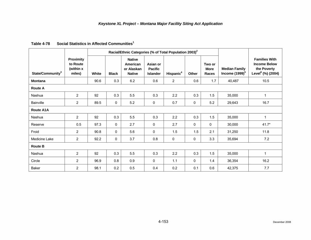
Keystone XL Project – Montana Major Facility Siting Act Application
Table 4-78 Social Statistics in Affected Communities1
Racial/Ethnic Categories (% of Total Population 2003)2
State/Community3
Proximity to Route (within x
miles) White Black
Native American or Alaskan
Native
Asian or Pacific
Islander Hispanic4 Other
Two or More Races
Median Family Income (1999)5
Families With Income Below
the Poverty Level6 (%) (2004)
Montana 90.6 0.3 6.2 0.6 2 0.6 1.7 40,487 10.5
Route A
Nashua 2 92 0.3 5.5 0.3 2.2 0.3 1.5 35,000 1
Bainville 2 89.5 0 5.2 0 0.7 0 5.2 29,643 16.7
Route A1A
Nashua 2 92 0.3 5.5 0.3 2.2 0.3 1.5 35,000 1
Reserve 0.5 97.3 0 2.7 0 2.7 0 0 30,000 41.7*
Froid 2 90.8 0 5.6 0 1.5 1.5 2.1 31,250 11.8
Medicine Lake 2 92.2 0 3.7 0.8 0 0 3.3 35,694 7.2
Route B
Nashua 2 92 0.3 5.5 0.3 2.2 0.3 1.5 35,000 1
Circle 2 96.9 0.8 0.9 0 1.1 0 1.4 36,354 16.2
Baker 2 98.1 0.2 0.5 0.4 0.2 0.1 0.6 42,375 7.7
4-153 December 2008

Keystone XL Project – Montana Major Facility Siting Act Application
4-154 December 2008
Table 4-78 Social Statistics in Affected Communities1
Racial/Ethnic Categories (% of Total Population 2003)2
State/Community3
Proximity to Route (within x
miles) White Black
Native American or Alaskan
Native
Asian or Pacific
Islander Hispanic4 Other
Two or More Races
Median Family Income (1999)5
Families With Income Below
the Poverty Level6 (%) (2004)
1 Affected areas are those communities within 0.5 mile or 2 miles of new pipeline facilities or surface disturbing activities associated with pipeline refurbishment are proposed. 2 Minority populations defined as "non-white" (Black, Native American or Alaskan Native, Asian Pacific Islander, or Hispanic). 3 Communities are listed geographically from north to south (or east to west) as the proposed Project crosses the area. 4 Persons of Hispanic origin may be of any race, and for census-gathering purposes, Hispanic is a self-identified category. In this table individuals may have reported themselves
as only Hispanic or a combination with one ore more of the other races listed. This may result in the sum of percentages for all ethnic categories to be greater than 100 percent for any one country.
5 The median family income is defined here for a family of three. The poverty threshold is defined as the average threshold for a family of three and is not adjusted for regional, state, or local variations in the cost of living.
6 The percent of families with income below the poverty threshold in 2000, as defined by the USCB for federal statistical purposes, based on a family of three. Communities with a higher percent of the population below the poverty level than that occurring in the respective state are identified with an asterisk (*).
* Denotes minotirty population or poverty level that is significantly greater than the state average (1.5 times the state average or greater).
Source: USCB 2000a.
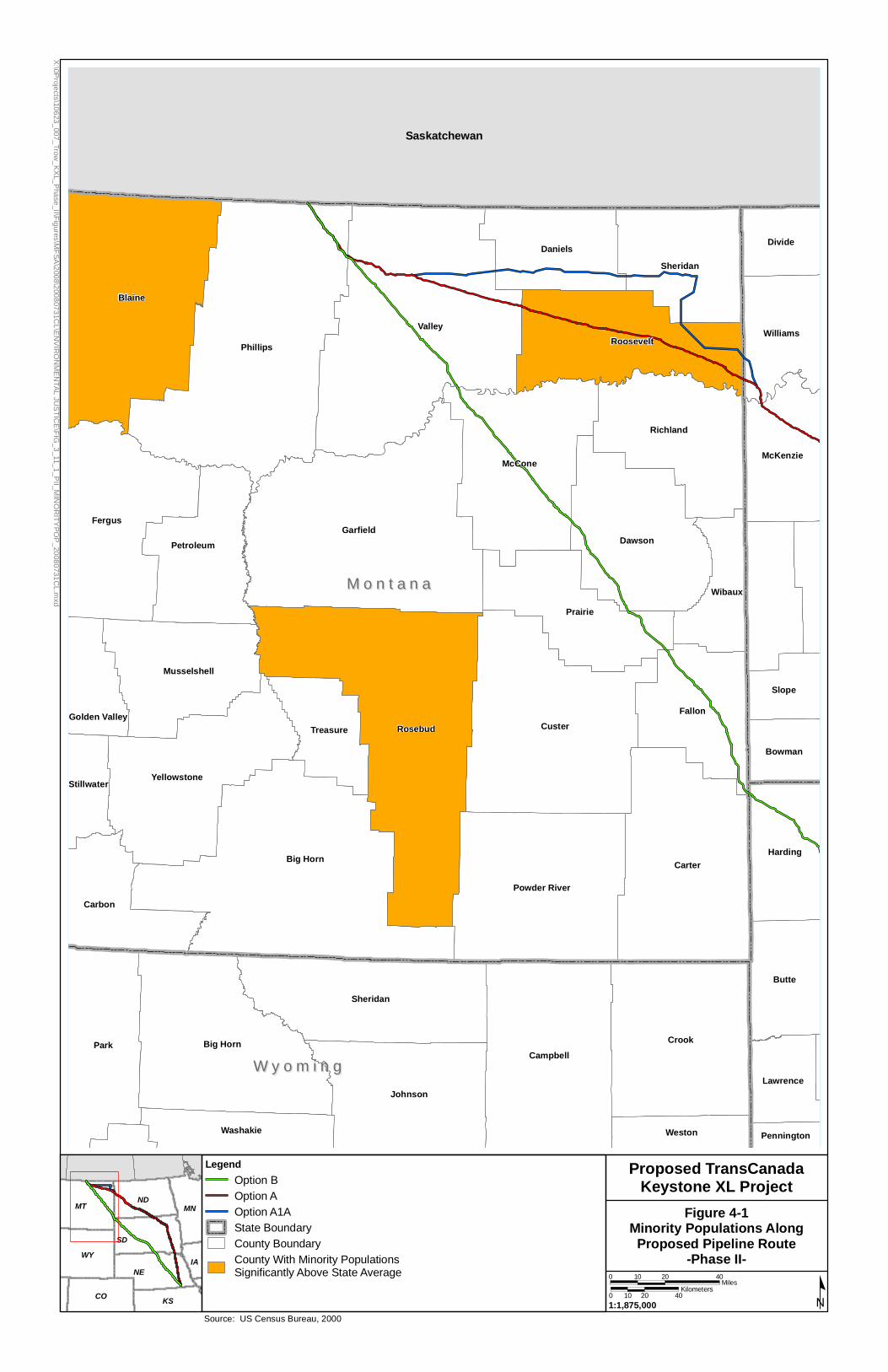
Saskatchewan
Valley
Phillips
Garfield
Blaine
Big Horn
CusterRosebud
Carter
CrookPark Big Horn
Fergus
Campbell
McCone
Dawson
Sheridan
Prairie
Fallon
Johnson
Powder River
Richland
Roosevelt
Yellowstone
Butte
Sheridan
Daniels
Carbon
Harding
Petroleum
Musselshell
McKenzie
Williams
Wibaux
Divide
Treasure
Slope
Washakie
Lawrence
Weston
Bowman
Stillwater
Golden Valley
Pennington
M o n t a n aM o n t a n a
W y o m i n gW y o m i n g
Proposed TransCanadaKeystone XL Project
Figure 4-1Minority Populations Along
Proposed Pipeline Route-Phase II-
MT
NE
SD
WY
ND
CO KS
MN
IA
0 20 4010Miles
0 20 4010Kilometers
1:1,875,000
LegendOption BOption AOption A1AState BoundaryCounty BoundaryCounty With Minority PopulationsSignificantly Above State Average
X:\0Projects\10623_007_Trow
_KX
L_Phase_II\Figures\M
FSA\2008\20080731C
L\EN
VIR
ON
ME
NTAL
JUS
TICE
\FIG_3_11_1_P
II_MIN
OR
ITYPO
P_20080731C
L.mxd
Source: US Census Bureau, 2000

Saskatchewan
Valley9.5%
Phillips13.8%
Garfield10.7%
Blaine21.5%
Custer13.7%
Rosebud17.7%
Carter10.7%
McCone14.1%
Dawson11.7%
Prairie13.3%
Fallon9.5%
Powder River9.9%
Richland12.2%
Roosevelt27.6%
Sheridan10.6%
Daniels13.4%
Wibaux10.6%
M o n t a n aM o n t a n a
W y o m i n gW y o m i n g
Proposed TransCanadaKeystone XL Project
Figure 4-2Poverty Distribution AlongProposed Pipeline Route
-Phase II-
CO KS
NE
SD
MTND
WY
MN
IA
0 20 4010Miles
0 20 4010Kilometers
1:1,875,000
LegendOption BOption AOption A1AState BoundaryCounty Boundary
Below Poverty Level PercentageNot Included in Study5% - 10%10% - 15%15% - 20%>20%
X:\0Projects\10623_007_Trow
_KX
L_Phase_II\Figures\M
FSA\2008\20080731C
L\EN
VIR
ON
ME
NTAL
JUS
TICE
\FIG_3_11_2_P
II_PO
VER
TYP
OP_20080731C
L.mxd
Source: US Census Bureau, 2000

Keystone XL Project – Montana Major Facility Siting Act Application
4-157
Route A travels through the Fort Peck Indian Reservation, which is home to two separate Indian Nations, the Sioux and the Assiniboine. Route A travels through an area with a higher minority population (Native American) than Route B or A1A. The communities of Nashua and banville are located within 2 miles of Route A; both Nashua and Bainville have a similar racial makeup as the State of Montana.
Route A1A avoids traveling directly through the Fort Peck Indian Reservation, following the northern border of the Reservation from west to east before turning south. Based on county-level census data, only Roosevelt County has a meaningfully larger minority population than the state (as over half of the residents of the county are Native American). None of the communities within 0.5 or 2 mile have significantly larger minority populations than the State of Montana.
Route B traverses six counties in Montana. None of the counties along Route B were determined to have “meaningfully greater” minority populations as compared to the State of Montana. In addition, none of the affected communities along Route B as listed in Table 4-77 have a meaningfully greater minority population compared to Montana.
Low-Income Populations
Low income populations were identified along the proposed routes by comparing the percent of the population below the poverty level (according to 2000 USCB data) in the affected counties and communities to the percent of the population below the poverty level in the State of Montana. If the percent in the affected county or community was greater than the percent in the state, the affected county or community was determined to be a low-income population. The percentage of families with incomes below the poverty level for the affected counties and communities are identified on Tables 4-77 and 4-78. Counties and communities with a poverty level greater than the state or county are discussed below; a county was considered to have a “significantly” greater low-income community if its low-income population was 1.5 times greater than that of the state. Based on CEQ Guidance low-income populations reside within the study area. Figure 4-2 displays the poverty rates of affected counties as well as neighboring counties.
Four counties along Route B (Philips, McCone, Dawson, and Prairie) have a greater percentage of families living below the poverty level than the state on average; however none of these are significantly greater than the state. The Town of Circle, located within McCone County and within 2 miles from the Route B has 16.2 percent of its families living below the poverty level (as compared with 14.1 percent in the county and 10.5 percent in the state). This is a significantly greater percentage than that of the state.
Both Philips County and Roosevelt County along Route A have a higher percentage of families living below the poverty level than the State of Montana; Valley County has a fewer percentage of families living below the poverty level. Roosevelt County has nearly 28 percent of families living below the poverty level, a significantly greater percentage than the State of Montana. The community of Bainville (Roosevelt County) is located within 2 miles of Route A and has significantly more families living below the poverty level than Montana.
The counties of Phillips, Daniels, Sheridan, and Roosevelt along Route A1A each have a higher percentage of families living below the poverty level than the State of Montana; Valley County has a fewer percentage of families living below the poverty level. Roosevelt County has nearly 28 percent of families living below the poverty level, a significantly greater percentage than the State of Montana. Reserve (Sheridan County) is located within 0.5 mile of Route A1A and has a significant percentage of families living below the poverty level. The community of Froid (Roosevelt County) is located within 2 miles of Route A1A and has a greater number of families living below the poverty level than Montana, but the difference is not considered to be significant.
December 2008

Keystone XL Project – Montana Major Facility Siting Act Application
4-158
4.3.12
4.3.12
.6 Environmental Justice – Impact Assessment
The environmental justice demographic analysis revealed significant low income populations residing along Route B and significant minority and low income populations along Routes A and A1A. Public participation is a goal of the NEPA process; this participation is especially important when low-income populations, minority populations or tribal populations have the potential to be affected by a Project. Therefore, Keystone has been engaged in public consultation since the Project was first announced in July 2008. As explained in detail in Chapter 5, Keystone is committed to ongoing and regular correspondence, communication, and consultation with all stakeholders. Keystone shares information about the Project and provides opportunities for identification and resolution of questions, issues, and concerns through a number of channels, including press releases, the Project website, e-mail, toll free telephone numbers, one-on-one discussions between landowners and land agents, and direct mailings. To date, Keystone’s public participation program included meetings with community leaders and open houses. Public participation and consultation activities will continue throughout the life of the Project.
Route B does not traverse any Native American lands. Route A travels directly through the Fort Peck Indian Reservation, making this option less desirable. Route A1A avoids traveling directly through the Indian Reservation; however, this route is not as direct as Route B with respect to the overall Project.
Both short-term and long-term benefits will stem from increases in employment opportunities for the areas surrounding the Project route. Increased spending in the affected areas also will benefit community businesses that will provide materials and services for the construction and operation of the pipeline/pumping stations. In addition, increases in state and local property tax revenues will provide additional monies to local governments, some of which may be used to support local social programs for minority and/or low income groups.
While portions of the pipeline routes are located in areas of significant minority populations and with families living below the poverty level, the Project also is located in areas with relatively few families living below the poverty level.
.7 Socioeconomics – Impact Assessment (Circular MFSA-2, Sections 3.4(7)(a), 3.7(3)(5))
Issues
• Compensation to landowners for conveyance of easements and restrictions and damage to land and property;
• Construction workforce demands on local infrastructure;
• Fiscal benefits from goods and services purchased locally and associated tax revenue generated; and
• Tax revenues generated by the pipeline.
Construction (Circular MFSA-2, Section 3.4 (7)(a))
Compensation for Damages to Land Use and Property
The Project will be constructed in predominantly rural, agricultural areas, where land uses such as ranching and farming are the main economic engines. Keystone will acquire pipeline easements from landowners and will provide landowners with monetary compensation for the conveyance of those easements. Construction activities will create the potential for damage to land and property, including drainage tiles, irrigation systems, fences, and crop productivity. Keystone will restore damaged or disturbed lands and also will repair or restore drain tiles, irrigation systems, fences, and other items and features that are damaged or temporarily disturbed during construction. Mitigation measures for damage to land and property during construction are discussed in detail in the CMRP. Monetary compensation for damages would be agreed to in advance in the easement agreements and/or negotiated on a case-by-case basis with the individual landowner. Land use would return to its previous function, such as ranching and farming, once construction was completed.
December 2008

Keystone XL Project – Montana Major Facility Siting Act Application
4-159
Demands on Local Infrastructure (Circular MFSA-2, Section 3.7 (3)and (5))
Construction of the Project in Montana is proposed to be completed in four spreads (see Table 4-79). Keystone anticipates that it will require approximately 6 months to complete each spread. Work on the Project in Montana is proposed to commence in 2011 and to be completed by the end of 2012. Approximately 500 to 600 construction personnel (Keystone employees, contractor employees, construction inspection staff, and environmental inspection staff) are expected to be associated with each spread for a total workforce of approximately 2,000 to 2,900 construction personnel. Additionally, construction of pump stations and delivery facilities will require an additional 20 to 30 workers per station for a total of approximately 1,280 to 1,580 workers at the peak, since all pump stations will not be constructed simultaneously. Construction of pump stations and delivery stations is to commence in 2011 and be completed by the end of 2012.
Table 4-79 Construction Spreads Associated with the Project
Spread Number Location According to Map
Approximate Distance within Construction Spread (miles)
Spread 1 Phillips and Valley counties 81.18
Spread 2 McCone and Dawson counties 82.02
Spread 3 Dawson, Prairie, and Fallon counties 83.73
Spread 4 Fallon County 35.00
Keystone proposes to hire temporary construction staff from the local population where possible. It is estimated that approximately 10 to 15 percent of the total construction workforce could be hired locally, with the remaining portion (85 to 90 percent or more) consisting of non-local personnel. Keystone estimates that long-term operation of the pipeline will require a total of approximately four to eight permanent employees in Montana.
The construction period will be relatively short in any given area and most non-local workers will not be accompanied by their families during their work tenure. Consequently, it is expected that most workers will use temporary housing, such as hotels/motels, recreational vehicle parks, and campgrounds. Some workers are likely to rent furnished apartments and homes, due to the constrained availability of other accommodations, though this is generally less preferable because landlords and property management companies prefer extended term commitments. Most of the temporary workers will seek housing in the more populated, service-oriented towns located within a reasonable commuting distance to the work site. As the more convenient options fill, workers will seek alternatives, driving farther, looking at smaller communities, even using campgrounds in nearby state parks, which typically have limits on the length of occupancy. Furthermore, some individuals may desire to relocate as the active construction area in each spread moves along the pipeline route. The net effect of these factors is that the temporary housing demand will be dynamic.
In the more rural areas it will be more difficult for local housing markets to fill these temporary housing needs due to the more limited availability of temporary housing in close proximity to construction work sites. Construction workers in these areas are likely to drive farther to find housing in nearby small towns or rely more heavily on recreational vehicle parks and campgrounds. Conversely, in the portions of the route through more populated areas, the local housing markets will be much more likely to absorb the temporary housing needs of construction workers as they will be more likely to find hotels/motels in towns and cities in close proximity to construction work sites.
Because of the remote areas in Montana, Keystone considered the potential need to set up construction camps. In-depth discussions were held with several pipeline construction contractors regarding the use of construction camps. Feedback from the pipeline contractors was that their personnel would not stay in the
December 2008

Keystone XL Project – Montana Major Facility Siting Act Application
4-160
construction camps, and that lodging such as motels and recreational parks would be preferred. Based on this information, as well as the Housing/Lodging Inventory, it was determined that construction camps will not be established.
Impacts to primary and secondary schools are projected to be minimal. It is projected that very few, if any, construction workers would bring school-aged children to the area.
Other construction-related impacts on local services may include increased demand for permits for vehicle load and width limits and local police assistance during construction at road crossings to facilitate traffic flow (for more information on roads see Section 4.3.11). In more rural sections of the proposed route, response times to highway or construction-related accidents may be lengthy, given communication, dispatch, and travel time considerations. In these areas, it may be necessary to provide on-site first responder services; however, Keystone will work with the local law enforcement, fire departments, and emergency medical services to determine the best course of action and coordinate for effective emergency response. Plans associated with these issues will be addressed in the ERP once the final design has been completed. The degree of impact will vary from community to community, depending on the number of non-local workers and accompanying family members that temporarily reside in each community, the duration of their stay, and the size of the community. Although these factors are too indeterminate and variable to accurately predict the magnitude of impact, the effects will be short-term and, therefore, are not expected to be significant.
Short-term Fiscal Benefits
Taxes that may apply, other than property taxes levied by various state, county, or local taxing jurisdictions, include taxes on gross receipts from the sales of goods and services. These taxes and fees vary by region or locality and will be received only during the construction period (approximately 6 months).
Operation (Circular MFSA-2, Section 3.7 (5))
Demands on Local Infrastructure
The limited number of permanent employees associated with the Project will result in negligible long-term impacts on public services.
Long-term Fiscal Benefits
In the operation phase, the pipeline will increase the tax base in the states, counties, and communities crossed. Keystone has estimated a total of $34,772,179 and $42,385,442 in property taxes will be paid to counties along Route A and Route A1a, respectively. Additionally, Keystone has estimated that a total of approximately $60,873,809 million will be paid in property taxes during the first year of pipeline operation for Route B.
Keystone will employ multiple safeguards to prevent a pipeline release. The chance of a spill occurring is very low and if a spill occurred, the volume is likely to be relatively small. In the unlikely event of a pipeline release, Keystone would initiate its ERP and emergency response teams would contain and clean up the spill. To minimize impacts to the public, appropriate remedial measures will be implemented to meet federal and state standards designed to ensure protection of human health and environmental quality. Additional information on potential impacts to public health and safety resulting from a crude oil spill is provided in the Risk Assessment (Attachment D).
Environmental Justice
Risk analyses need to be conducted for all locations identified as having significant minority populations and low income populations.
December 2008

Keystone XL Project – Montana Major Facility Siting Act Application
4-161
4.3.12.8 Summary of Route-Specific Socioeconomics and Environmental Justice Impacts
Route-specific impacts for socioeconomics and environmental justice are summarized in Table 4-80. Identified impacts will be substantially mitigated as discussed within this application and further outlined in the CMRP for all Routes. Based strictly on the relative lengths of the routes within the State of Montana and not taking into consideration the overall effect through Montana, South Dakota, and Nebraska, Route B has the greatest impacts. However, when the full Steele City Segment impacts are considered, frequently the additional length of Routes A and A1A would result in greater impacts.
Table 4-80 Summary of Route-Specific Socioeconomics and Environmental Justice Impacts
Route Alternatives
Resource Route A Route A1A Route B
Miles of Pipe
Steele City Segment 919.7 951.3 850.7
Portion in Montana 180.7 205.5 282.7
Socioeconomics
Affected communities
One community falls within 0.5 mile of Route A.
Three communities fall within 0.5 mile of Route A1A.
Three communities fall within 0.5 mile of Route B.
Total population in affected counties
Route A counties have a total population of 18,261 per Bureau of the Census data, year 2000.
Route A1A counties have a total population of 23,725 per Bureau of the Census data, year 2000.
Route B counties have a total population of 27,438 per Bureau of the Census data, year 2000.
Housing supply 8,891 total housing units and 2,201 total rental housing units are in the counties affected by Route A.
12,212 total housing units and 2,849 total rental housing units are in the counties affected by Route A1A.
14,732 total housing units and 3,250 total rental housing units are in the counties affected by Route B.
Public services A total of five police/sheriff departments, 8 fire departments, and three hospitals are in the counties affected by Route A.
A total of eight police/sheriff departments, 14 fire departments, and five hospitals are in the counties affected by Route A1A.
A total of 13 police/sheriff departments, 13 fire departments, and six hospitals are in the counties affected by Route B.
Fiscal relationship A total of $34,772,179 in property tax will be dispersed among the affected counties along Route A.
A total of $42,385,442 in property tax will be dispersed among the affected counties along Route A1A.
A total of $60,873,809 in property tax will be dispersed among the affected counties along Route B.
Environmental Justice
Minority populations
Along Route A, one county, Roosevelt, had a minority population that was significantly greater than the state average.
Along Route A1A, one county, Roosevelt, had a minority population that was significantly greater than the state average.
None of the affected counties along Route B had a minority population that was significantly greater than the state average.
Low income populations
Along Route A, two counties, Phillips and Roosevelt, had a poverty level that was significantly greater than the state average.
Along Route A1A, three counties, Daniels, Sheridan, and Roosevelt, had a poverty level that was significantly greater than the state average.
Along Route B, four counties, Phillips, McCone, Dawson, and Prairie, had a poverty level that was significantly greater than the state average.
December 2008

Keystone XL Project – Montana Major Facility Siting Act Application
4-162
References
AAA. 2008. AAA Travel. Website: http://www.aaacolorado.com/travel/. (Accessed September 2008.)
Capital Impact. 2008. Law Enforcement Agencies and Fire Departments in Montana. Website: http://www.capitolimpact.com/gw/statepage.asp?state=mt&stfips=30&stname=Montana. (Accessed September 2008.)
City-Data. 2008. Website: http://www.city-data.com/. (Accessed November 2008.)
Delorme. 2004. Montana Atlas & Gazetteer. P.O. Box 298, Yarmouth, Maine 04096.
Great Schools. 2008. Website: http://www.greatschools.net/. (Accessed September 2008.)
HomeTownLocator. 2008. Montana Counties. Website: http://montana.hometownlocator.com/counties/. (Accessed September 2008.)
Montana Department of Revenue. 2005-2006 Biennial Reports. Website: http://mt.gov/revenue/ publicationsreports/ biennialreports/2005-2006biennialreport.pdf. (Accessed July 21, 2008.)
Ockert, S. 2008. Department of Commerce, Census and Economic Information Center, Montana. Email Communication with S. Graber, ENSR. September 17, 2008.
Travelpost.com. 2008. Hotel Directory. Website: http://www.travelpost.com/hotels.aspx. (Accessed September 2008.)
Tripadvisor.com. 2008. Website: http://www.tripadvisor.com/. (Accessed September 2008.)
U.S. Census Bureau (USCB). 2000a. American Fact Finder. Website: http://factfinder.census.gov. (Accessed September 2008.)
_____. 2000b. State and County Quick Facts. Website: http://quickfacts.census.gov/ qfd/index.html. (Accessed September 2008.)
U.S. Bureau of Economic Analysis (USBEA). 2006. Local Area Personal Income. Website: http://www.bea.gov/bea/regional/reis/default.cfm#step3. (Accessed September 2008.)
U.S. Bureau of Labor Statistics (USBLS). 2008. Local Area Unemployment Statistics. Website: http://data.bls.gov/PDQ/outside.jsp?survey=la. (Accessed September 2008.)
4.3.13 Noise and Electrical Effects (Circular MFSA-2, Section 3.7(19)(a)(e), and Section 3.8(1)(h))
4.3.13.1 Baseline Data and Description of Routes – All Routes
The existing noise environment is characterized by determining ambient noise levels, identifying existing noise sources, identifying noise sensitive receptors in the vicinity of Project noise sources, and evaluating local terrain features that may affect noise transmission.
All the alternative routes occur primarily in rural agricultural areas (refer to Section 3.1.2, Land Use, for more information). Because of the primarily agricultural and rural land uses, existing ambient noise levels along the routes are quite low. It is estimated that the Ldn dBA range between 40 dBA (rural residential) and 45 dBA (agricultural cropland) (USEPA 1978). Ambient (background) noise levels occur from roadway traffic, farm machinery on a seasonal basis, pets, and various other household noises. Pipeline areas along major
December 2008
Keystone XL Project – Montana Major Facility Siting Act Application
4-163
highways and Interstates may experience higher ambient noise levels of approximately 68 to 80 dBA (USEPA 1978), (see Section 4.3.11, for the roads that the three routes cross).
Structures located within 500 feet of the construction ROW, by route, are summarized in Table 4-81. There are no residences located within 500 feet of the property boundary of pump stations on any route.
Table 4-81 Structures/Residences within 500 Feet of Facilities Along Alternative Routes in Montana
Route A Route A1A Route B
Number of structures/residences 57 43 11
4.3.13.2 Impact Assessment
Issues
• Increased noise to nearby residential and commercial areas from pipeline construction activities.
• Increased noise to nearby residential and commercial areas as a result of pump station operation.
Construction
Residences within 500 feet of a route will experience short-term inconvenience from construction equipment noise for a period of 1 week to 30 days. During construction, Keystone will be required to comply with any local construction noise requirements. In addition, Keystone has agreed to limit construction activities primarily to daylight hours.
Operation
During operation of the pipeline, the noise impact associated with the electrically driven pump stations will be limited to the vicinity of the facilities. Areas similar to the alternative routes have background noise levels in the 35-dBA range (Keystone 2007).
Currently no state laws exist in Montana regulating pump stations; however, noise mitigation measures will be applied if needed to meet specific county or city noise regulations. The pump stations will be constructed in a manner to minimize potential impacts from noise.
The construction activities, primarily for any new station, will be performed with standard heavy equipment, such as track-excavator, backhoe, bulldozer, dump trucks, cement truck, and boring equipment. Elevated noise levels generated during construction will be temporary, and not all of the equipment presented herein is used in each phase of construction. Further, equipment used is not generally operated continuously, nor is the equipment always operated simultaneously. As such, no adverse or long-term noise impacts from construction are anticipated. Noise abatement techniques can be implemented during the construction phase of the Project, if needed and/or required to mitigate for construction-related noise disturbances to nearby residences, businesses, and recreation areas.
Based on construction noise analyses conducted for other proposed pipeline Projects (ERT 1987), noise levels of 60 dBA or above would extend up to 12,000 feet perpendicular from the centerline of the pipeline. These levels would occur sporadically over the construction period. Because of the short duration, and the generally rural alignment of the ROW, these noise levels should not be disruptive to other activities in the vicinity.
December 2008
Keystone XL Project – Montana Major Facility Siting Act Application
4-164
4.3.13
4.3.13
4.3.13
The principal measures proposed by Keystone to mitigate impacts in existing residential areas include requiring effective mufflers on construction equipment and ensuring that construction proceeds quickly through such areas and limiting the hours during which activities with high-decibel noise levels could be conducted. Landowners within 500 feet of the ROW will be given advanced notice prior to construction. Noise will be minimized when in the immediate vicinity of herds of livestock or poultry operations that are particularly sensitive to noise. If an individual landowner is concerned with noise levels associated with weekend construction, mitigation of those concerns may be discussed with Keystone. Keystone will set up a toll-free telephone line for landowners to report any construction noise-related issues.
During permitting activities for the Project, Keystone will determine whether state, county, or local noise regulations exist for a given location.
.3 Induced Electrical Currents and Electric or Magnetic Effects (Circular 3.7 (19)(c)(e))
There are neither induced current nor electric or magnetic field impacts associated with the construction, operation or maintenance of a pipeline (aside from cathodic protection, which will be buried with the pipe). Transmission lines that will service the pump stations will be permitted separately and will address these issues as applicable.
.4 Radio and Television Interference (Circular 3.7 (19) (f))
There are no radio or television interference impacts associated with the construction, operation, or maintenance of pipeline. Transmission lines that will service the pump stations will be permitted separately and will address these issues as applicable.
.5 Summary of Route-Specific Noise Impacts
Route-specific impacts for noise are summarized in Table 4-82. Identified impacts will be substantially mitigated as discussed within this application and further outlined in the CMRP for all Routes. Based strictly on the relative lengths of the routes within the State of Montana and not taking into consideration the overall effect through Montana, South Dakota, and Nebraska, Route B has the greatest impacts. However, when the full Steele City Segment impacts are considered, frequently the additional length of Routes A and A1A would result in greater impacts.
Table 4-82 Summary of Route-Specific Noise Impacts
Route Alternatives
Resource Route A Route A1A Route B
Miles of Pipe
Steele City Segment 919.7 951.3 850.7
Portion in Montana 180.7 205.5 282.7
Noise and Electrical Effects
Temporary noise impacts from construction and operation
There are no residences within 500 feet of any of the pump stations along Route A. Operational noise impacts from the electrically-driven pumps are projected to be minor.
There are no residences within 500 feet of any of the pump stations along Route A1A. Operational noise impacts from the electrically-driven pumps are projected to be minor.
There are no residences within 500 feet of any of the pump stations along Route B. Operational noise impacts from the electrically-driven pumps are projected to be minor.
December 2008
Keystone XL Project – Montana Major Facility Siting Act Application
4-165 December 2008
References
ERT. 1987. Draft Environmental Impact Report/Environmental Impact Statement for the Angeles Pipeline Project. California State Clearing House Number 85112707.
Keystone Pipeline, L.P. 2007. Submitted to U.S. Department of State by Keystone XL, L.P. Application for Presidential Permit. April 4.
U.S. Environmental Protection Agency (USEPA). 1978. Protective Noise Levels. Condensed Version of USEPA Levels Document. Based on Information of Levels of Environmental Noise Requisite to Protect Public Health and Welfare with Adequate Margin of Safety, EPA/ONAC 550/9-74-004. March 1974.
4.3.14 Air Quality
4.3.14
4.3.14
.1 Baseline Data and Description
The climate and air quality section in this document describes the regional climate and meteorological conditions that influence transport and dispersion of air pollutants and discusses the existing levels of criteria air pollutants in the region. Applicable federal and state (Montana) air quality regulatory programs are discussed. This section also presents a summary of the emissions from the proposed facilities to be located in Montana.
Construction emissions will occur during the construction of the proposed pipeline. Operational emissions will be limited to the proposed pump stations to be located along the pipeline. The proposed pump stations are to be electrically driven, with electricity to be provided from local electric utilities. The pump stations will not include a source of backup power supply; therefore, operational emissions from each of the pump stations will consist only of fugitive emissions. Air quality impacts from the construction and operation of Keystone’s facilities are summarized in Section 4.3.14.7.
The climate data presented here are representative of the region where pipeline construction emissions could impact air quality. Historical climate data from meteorological stations along the proposed pipeline ROW for Circle and Bredette, Montana, are found in Table 4-83.
.2 Air Quality Regulatory Requirements
Project facilities will be subject to the following federal and state air quality regulations implementing the Federal Clean Air Act (CAA) of 1970 and its amendments. The CAA, 42 USC 7401 et seq. as amended in 1977 and 1990 is the basic federal statute governing air pollution. The provisions of the CAA that potentially are relevant to this Project are listed below and discussed in the following subsections:
• National Ambient Air Quality Standards (NAAQS);
• Prevention of Significant Deterioration (PSD);
• Non-attainment New Source Review (NNSR); and
• Greenhouse Gases (GHG).

Keystone XL Project – Montana Major Facility Siting Act Application
Table 4-83 Climate Data in the Vicinity of the Keystone XL Project
Circle, Montana Location1 Jan Feb Mar Apr May Jun Jul Aug Sep Oct Nov Dec Annual
Average max. temperature (°F) 26.0 33.1 43.2 57.7 68.8 78.2 86.9 85.8 73.4 59.7 42.0 30.2 57.1
Average min. temperature (°F) 3.8 10.6 19.4 31.1 41.5 50.3 55.8 53.9 42.8 31.9 19.0 8.2 30.7
Average total precipitation (in.) 0.44 0.31 0.60 1.27 2.04 2.61 1.94 1.27 1.28 0.82 0.37 0.45 13.40
Average total snow fall (in.) 5.6 3.4 3.6 2.2 0.4 0.0 0.0 0.0 0.1 0.9 2.6 5.1 23.9
Average snow depth (in.) 4 4 1 0 0 0 0 0 0 0 0 2 1
Bredette, Montana Location2 Jan Feb Mar Apr May Jun Jul Aug Sep Oct Nov Dec Annual
Average max. temperature (°F) 20.2 26.9 37.9 55.0 67.4 76.4 83.9 83.0 70.7 57.3 37.5 25.3 53.4
Average min. temperature (°F) 0.5 6.9 16.9 30.0 40.8 49.5 54.5 52.9 42.7 31.8 17.4 6.1 29.2
Average total precipitation (in.) 0.36 0.24 0.48 0.88 1.86 2.71 2.07 1.49 1.12 0.66 0.34 0.32 12.53
Average Total snow fall (in.) 5.5 3.8 4.7 2.8 1.0 0.0 0.0 0.0 0.2 1.7 4.1 5.1 28.8
Average snow depth (in.) 5 5 3 0 0 0 0 0 0 0 1 2 1 1 Source: Western Regional Climate Center (WRCC), Circle, Montana, Station 241758, http://www.wrcc.dri.edu/cgi-bin/cliMAIN.pl?mt1758. 2 Source: WRCC, Bredette, Montana, Station 241088, http://www.wrcc.dri.edu/cgi-bin/cliMAIN.pl?mt1088.
4-166 December 2008

Keystone XL Project – Montana Major Facility Siting Act Application
4-167
4.3.14.3 National Ambient Air Quality Standards
The United States Environmental Protection Agency (USEPA) promulgated air quality standards for six common air pollutants (also called criteria pollutants):
• Ozone (O3);
• Nitrogen dioxide (commonly called NO2);
• Carbon monoxide (CO);
• Sulfur dioxide (SO2);
• Lead (Pb); and
• Particulate matter based on a particle size of 10 microns or less (PM10), and particulate matter with an aerodynamic diameter less than or equal to 2.5 microns (PM2.5).
These standards include primary standards designed to protect health, and secondary standards to protect public welfare, predominately visibility. These NAAQS reflect the relationship between pollutant concentrations and health and welfare effects and therefore, are supported by sound scientific evidence.
Each state is required to implement and enforce the NAAQS under a process called State Implementation Plans (SIPs), which are approved by the USEPA. Generally the SIPs are comprised of air quality rules that are applicable to stationary sources that may emit criteria or hazardous air pollutants. The CAA as amended in 1990 assigned new NAAQS attainment deadlines of 3 to 20 years, and categorized non-attainment as marginal, moderate, serious, severe, or extreme, depending upon the degree of violation of the NAAQS. The 1-hour and 8-hour CO standard, 3-hour and 24-hour SO2 standard, and 24-hour PM10 standard shall not be exceeded more than once per year. The NAAQS that are based on annual pollutant averaging periods are not to be exceeded.
The NAAQS and Montana Ambient Air Quality Standards (MAAQS) and PSD Increments for Class I and Class II areas are listed in Table 4-84. In order to compare the standards, all levels that were stated in parts per million (ppm) or parts per billion were converted to micrograms per cubic meter (µg/m3).
Table 4-84 Ambient Air Quality Standards
Pollutant Averaging Period NAAQS (µg/m3) MAAQS
PSD Class I Increment
(µg/m3)
PSD Class II Increment
(µg/m3)
NO2 1-Hour Annual
-- 100
0.30 ppm 0.05 ppm
-- 2.5
-- 25
CO 1-Hour 8-Hour
40,000 10,000
23 ppm 9 ppm
N/A N/A
N/A N/A
SO2 1-Hour 3-Hour 24-Hour Annual
-- 1300 365 80
0.50 ppm --
0.10 ppm 0.02 ppm
-- 25 5 2
-- 512 91 20
PM10 24-Hour Annual
150 --1
150 µg/m3 50 µg/m3
8 4
30 17
December 2008

Keystone XL Project – Montana Major Facility Siting Act Application
4-168
Table 4-84 Ambient Air Quality Standards
Pollutant Averaging Period NAAQS (µg/m3) MAAQS
PSD Class I Increment
(µg/m3)
PSD Class II Increment
(µg/m3)
PM2.5 24-Hour2 Annual3
35 15
-- --
N/A N/A
N/A N/A
Settled Particulate Matter
30-Day -- 10 gm/m2
Visibility Annual -- 3x10⁻⁵ / m
O3 8-Hour4 147 -- N/A N/A
H2S 1-Hour -- 0.05 ppm N/A N/A
Fluoride in forage Monthly grazing season
-- --
50 µg/g 35 µg/g
Pb 90-Day quarterly
-- 1.5
1.5 µg/m3 --
N/A N/A
N/A N/A
1 The PM10 annual NAAQS has been revoked; however, state regulations still include the annual PM10 standard. 2 Based on the 3-year average of the 98th percentile concentration within an area. 3 Based on the 3-year average of weighted annual mean. 4 The fourth highest 8-hour concentration in each year, averaged over 3 consecutive years, must not exceed 0.075 ppm.
Source: USEPA 2008, http://www.epa.gov/air/criteria.html, http://www.deq.mt.gov/dir/legal/Chapters/CH08-02.pdf.
.4 Prevention of Significant Deterioration 4.3.14
PSD regulations are designed to prevent significant deterioration of air quality in areas that are classified as attainment or unclassified. PSD review regulations apply to proposed new or modified sources in those areas that have the potential to emit criteria pollutants in excess of predetermined de minimis values (40 CFR Part 52.21). Increments for criteria pollutants are based on the PSD classification of the area. Class I areas are assigned to federally protected wilderness areas, such as national parks, and allow the lowest increment of permissible deterioration. This essentially precludes development near these areas. Class II areas are designed to allow for moderate, controlled growth, and Class III areas allow for heavy industrial use.
Under the PSD program, a major source is defined in 40 CFR 52, “A source is a ‘major stationary source’ or major emitting facility if:
1. It can be classified in one of the 28 named source categories listed in Section 169 of the CAA and it emits or has the potential to emit 100 tons per year (tpy) or more of any pollutant regulated by the Act; or
2. It is any other stationary source that emits or has the potential to emit 250 tpy or more of any pollutants regulated by the CAA” (USEPA 1990).
The Project will not have stationary sources that are included as one of the 28 named source types listed in Section 169 of the Act; therefore, 250 tpy is the threshold for major source status. Potential emissions from operation of the pipeline will be well below the 250 tpy that is required for PSD permitting and below the
December 2008

Keystone XL Project – Montana Major Facility Siting Act Application
4-169
4.3.14
4.3.14
4.3.14
100 ton/year threshold that requires evaluation of ozone impacts under PDS (40 CFR 52.21(i)(5)(i)); therefore, PSD review does not apply.
The proposed alternatives do not intersect a designated Federal Class I area; therefore, all alternatives would be designated as a PSD Class II area under state and federal air quality regulations.
.5 Non-attainment New Source Review
NNSR is required for major stationary sources locating or expanding in non-attainment areas. The areas potentially impacted by the proposed Project are in attainment for all criteria pollutants; therefore, NNSR does not apply.
.6 Greenhouse Gases
Carbon dioxide (CO2) CH4, and nitrous oxide (N2O) are all naturally occurring GHGs whose concentrations in the atmosphere have increased as a result of human activities since the dawn of the industrial revolution. GHGs in general and CO2 in particular, have become an issue of intense public debate and much recent litigation. In Massachusetts v. EPA, the US Supreme Court held that CO2 satisfies the definition of “air pollutant” and that the USEPA has authority to regulate emissions of CO2 and other GHGs from new motor vehicles under the CAA (Massachusetts v. EPA 2007). It is important to note that the Court did not rule that CO2 and other GHGs were subject to regulation under the CAA, nor did the Court require creation of any standards or emission control requirements for GHGs.
CO2, CH4, and N2O are not criteria pollutants for which NAAQS are set, nor are they regulated under New Source Performance Standards, Maximum Achievable Control Technology, or any other CAA regulatory emission standards or limitations. Therefore, although CO2 is an air pollutant, it is not a regulated air pollutant for CAA regulatory and permitting purposes. No regulatory limitations or other CAA emission standards apply to CO2, CH4, or N2O.
.7 Impact Assessment
Issues
• Fugitive dust generation from pipeline construction equipment and unpaved road traffic;
• Combustion emissions from construction equipment; and
• Fugitive emissions from pump stations and associated piping and maintenance pigging operations.
Construction
Construction of Route B would result in intermittent and short-term fugitive emissions. These emissions would include fugitive dust from soil disruption and combustion emissions from construction equipment and construction worker commuter vehicles.
The quantity of fugitive dust emissions would depend on the moisture content and texture of the soils that would be disturbed, along with the frequency and duration of precipitation events. The majority of pipeline construction activities will pass by a specific location within a 30-day period; therefore, fugitive dust emissions during construction would be restricted to the brief construction period along each segment of the proposed pipeline route, with construction impacts diminishing once construction activities end and after disturbed areas are reclaimed. Fugitive particulate emissions from roadways consist of heavier particles and tend to settle out of the atmosphere within a few hundred yards. Therefore, fugitive particulate emissions would be limited to the immediate vicinity of the Project and the surrounding region would not be significantly impacted.
Construction equipment would result in temporary increases in combustion emissions and local airborne particulate matter concentrations. The combustion emissions from construction equipment would be minimized
December 2008

Keystone XL Project – Montana Major Facility Siting Act Application
4-170
because engines must be built to meet federal standards for mobile sources established by the USEPA mobile source emissions regulations. In addition, the USEPA is requiring the sulfur content of non-road diesel to be reduced from 500 parts per million by weight (ppmw) to 15 ppmw by mid-2010, reducing SO2 and particulate emissions from diesel combustion. CO2 is a naturally occurring gas whose presence in the atmosphere is necessary for all life. Areas near the construction of the pipeline may briefly experience slightly higher CO2 concentrations as a result of construction vehicular traffic. Increased concentrations of CO2, if measureable, would not cause localized adverse human health or ecological impacts. If dust control plans are required by state agencies, they will be filed prior to land disturbance activities.
Keystone will limit dust impacts in residential and commercial areas adjacent to pipeline construction by utilizing dust minimization techniques (primarily watering disturbed surfaces) in accordance with the CMRP (Attachment C). Wind-generated dust after construction will be controlled utilizing land surface reclamation measures outlined in the CMRP.
Operation
It is anticipated that seven pump stations will be constructed along the preferred alternative. All pipeline pumps located at the pump stations will be electrically driven. The pump stations may include a source of backup power supply; however, this will not consist of an emergency generator engine or other combustion sources. Therefore, the pump stations will not have combustion emissions, and operational emissions from each of the pump stations will exclusively consist of fugitive emissions. Since there will be a relatively small number of piping components at each of the pump stations, only negligible amounts of fugitive emissions will occur from crude oil pipeline connections and pumping equipment at the pump stations.
4.3.14
4.3.14
.8 Description of Alternative Routes (A and A1A)
Air quality impacts along the alternative routes will generally be the same as the air quality impacts along Route B. Route A would have approximately four pump stations due to the shorter distance traversing Montana. Route A1A would have approximately five pump stations. Due to the shorter distances of the routes, emissions as a result of pipeline construction would be lower than the emissions from the Route B due to the decreased mileage in Montana.
Route A would cross the Fort Peck Reservation in Montana. The Fort Peck Reservation is designated as a Native American Indian Class I area by the USEPA; therefore, the USEPA would have jurisdiction for the portions of Route A, that cross tribal lands. The USEPA does not currently have a federal fugitive dust control plan regulation in place; however, the USEPA would need to be contacted to determine the fugitive dust control procedures that would be necessary during construction.
.9 Summary of Route-Specific Air Impacts
Route-specific impacts for air are summarized in Table 4-85. Identified impacts will be substantially mitigated as discussed within this application and further outlined in the CMRP for all Routes. Based strictly on the relative lengths of the routes within the State of Montana and not taking into consideration the overall effect through Montana, South Dakota, and Nebraska, Route B has the greatest impacts. However, when the full Steele City Segment impacts are considered, frequently the additional length of Routes A and A1A would result in greater impacts.
December 2008

Keystone XL Project – Montana Major Facility Siting Act Application
4-171
Table 4-85 Summary of Route-Specific Air Impacts
Route Alternatives
Resource Route A Route A1A Route B
Miles of Pipe
Steele City Segment 919.7 951.3 850.7
Portion in Montana 180.7 205.5 282.7
Air Quality
Climate data Climate will be same across the three routes.
Same as A. Same as A.
Ambient air quality Ambient air quality standards are a state standard, so the same will apply across the three routes.
Same as A. Same as A.
Prevention of significant deterioration
PSD regulations will not apply as emissions do not trigger thresholds. The only difference would be that Route A crosses Tribal Land, so USEPA would have jurisdiction of any air quality permitting if it were to occur on Tribal lands, which is not anticipated.
PSD regulations will not apply as emissions don’t trigger thresholds. The only difference would be that Route A1A crosses Tribal land, so USEPA would have jurisdiction of any air quality permitting if it were to occur on Tribal lands, which is not anticipated.
PSD regulations will not apply as emissions do not trigger thresholds. Only difference would be that Route A crosses Tribal land, so USEPA would have jurisdiction of any air quality permitting if it were to occur on Tribal lands, which is not anticipated.
Non-attainment new source review
The entire state of Montana is considered in attainment of ambient air quality standards, so the same will apply across the three route alternatives.
Same as A. Same as A.
Greenhouse gases GHG language provided will be the same across the three route alternatives.
GHG language provided will be the same across the three route alternatives.
GHG language provided will be the same across the three route alternatives.
References
Massachusetts v. EPA. 2007. Supreme Court of the United States. 2006. Massachusetts et al. v. Environmental Protection Agency et al. No. 05-1120. Argued November 29, 2006 - Decided April 2, 2007. Website: www.supremecourtus.gov/opinions/06pdf/05-1120.pdf. (Accessed 2008).
U.S. Environmental Protection Agency. 1990. DRAFT. "New Source Review Workshop Manual," Office of Air Quality Planning and Standards, October 1990.
_____. 2008. National Ambient Air Quality Standards. Website: http://www.epa.gov/air/criteria.html.
4.3.15 Cumulative Impacts Cumulative impacts are defined in the CEQ regulations 40 CFR 1508.7 as “…the impact on the environment that results from the incremental impact of the action when added to other past, present, and reasonably foreseeable actions regardless of what agency… or person undertakes such other actions.” These actions include current and projected area development (e.g., oil and gas); management activities and authorizations
December 2008

Keystone XL Project – Montana Major Facility Siting Act Application
4-172
4.3.15
4.3.15
on public lands (e.g., range conversion and forestry programs); land use trends; and applicable industrial/infrastructure components (e.g., utility corridors).
Foreseeable construction projects were screened to determine whether they will overlap in time and space with the Project and thus could interact to cause cumulative impacts. Cumulative construction projects primarily include locations where Keystone XL would be co-located with existing utility corridors and locations associated with new power line construction.
.1 Power Lines
The construction of the electrical transmission and distribution power lines necessary for the Project will occur during the same timeframe and in the same general area as the Project. Construction activities will be of short duration in any single location. Most power lines will be co-located with other ROWs (i.e., roadways, pipeline corridors, and existing power lines) or located along field edges or section lines to reduce the overall amount of habitat fragmentation and interference with agricultural operations. The amount of land associated with the power line ROWs represents a small fraction of available native vegetation in the region. As a consequence, these power lines do not represent a substantial cumulative disturbance to the environment.
.2 Northern Border
The Northern Border Pipeline has been in-service since 1982, and the existing ROW has been reclaimed. Routine maintenance and refurbishment activities along the existing Northern Border Pipeline ROW will have minimal cumulative impacts on resources when combined with adjacent, new pipeline construction. The Project will be adjacent to the Northern Border Pipeline for approximately 19 miles within the US, starting at Milepost 0. In this area, any sites required for work on the Northern Border pipeline will be relatively infrequent, isolated, located in small, discrete areas, and work will involve small crews for short-time periods. Consequently, cumulative impacts from maintenance activities along the existing Northern Border Pipeline system are considered to be negligible. Figure 1-5 diagrams construction disturbance and permanent easements in locations adjacent to existing pipelines.
4.4 Comparison of Alternatives (Circular MFSA-2, Section 3.9) In accordance with Circular MFSA-2, Section 3.9(1)(a), Table 4-86 provides a comparison of summary statistics for the alternative routes evaluated for the Steele City Segment from the Montana border to Steele City, Nebraska. Also in accordance with Circular MFSA-2, Section 3.9(1)(a), Table 4-87 provides a comparison of the most important impacts related to pipeline construction and operation for each of the alternative facility locations within the State of Montana. These impacts are reflective of the baseline studies and impact zone summaries for each technical resource area, pursuant to Sections 3.7 and 3.8 (Circular MFSA-2). It is very important to note that, although Route B is the longest route within the State of Montana, it is the shortest overall route between Morgan, Montana, and Steele City, Nebraska by over 100 miles, resulting in the following overall benefits:
• Reduced environmental footprint and impacts;
• Reduced landowner impacts;
• Least impact to population centers;
• Reduced overall construction costs; and
• Reduced overall operating costs.
In accordance with Circular MFSA-2, Section 3.9(1)(b), Table 4-87 also provides a description of the degree to which the most important adverse impacts can be mitigated along all three routes.
December 2008

Keystone XL Project – Montana Major Facility Siting Act Application
4-173 December 2008
In accordance with Circular MFSA-2, Section 3.9(1)(c), Table 4-88 provides a relative ranking of the three alternative routes. Again, it is important to note that, based strictly on the relative lengths of the routes within the State of Montana, and not taking into consideration the overall effects through Montana, South Dakota, and Nebraska, Route B has greater impacts on certain resources. However, while Route B is longer through the State of Montana, it has less impact to wetlands, agricultural land, perennial stream crossings, public/tribal lands, developed lands, and does not cross a national wildlife refuge or a Native American reservation.
Table 4-86 Alternative Routes Summary Statistics from Morgan, Montana to Steele City, Nebraska (Circular MFSA-2, Section 3.9(1)(a))
Parameter Route A Route A1A Route B
Total Miles of Pipe 919.7 951.3 850.3
Montana – Ownership Miles Crossed
Federal 17.5 17.4 42.6
State 14.3 35.2 19.1
Tribal 89.6 1.0 0.0
Private 59.2 151.8 220.6
Subtotal 180.6 205.4 282.3
North Dakota – Ownership Miles Crossed
Federal 3.8 30.2 0.0
State 4.0 0.1 0.0
Tribal 0.0 0.0 0.0
Private 269.1 229.2 0.0
Subtotal 276.9 259.5 0.0
South Dakota – Ownership Miles Crossed
Federal 30.2 2.8 0.0
State 0.1 5.0 20.9
Tribal 0.0 0.0 0.0
Private 229.2 275.9 291.9
Subtotal 259.5 283.7 312.8
Nebraska – Ownership Miles Crossed
Federal 0.0 0.0 0.0
State 0.0 0.0 0.0
Tribal 0.0 0.0 0.0
Private 202.5 202.5 255.1
Subtotal 202.5 202.5 255.1
Number of perennial streams/rivers crossed1 58 63 41
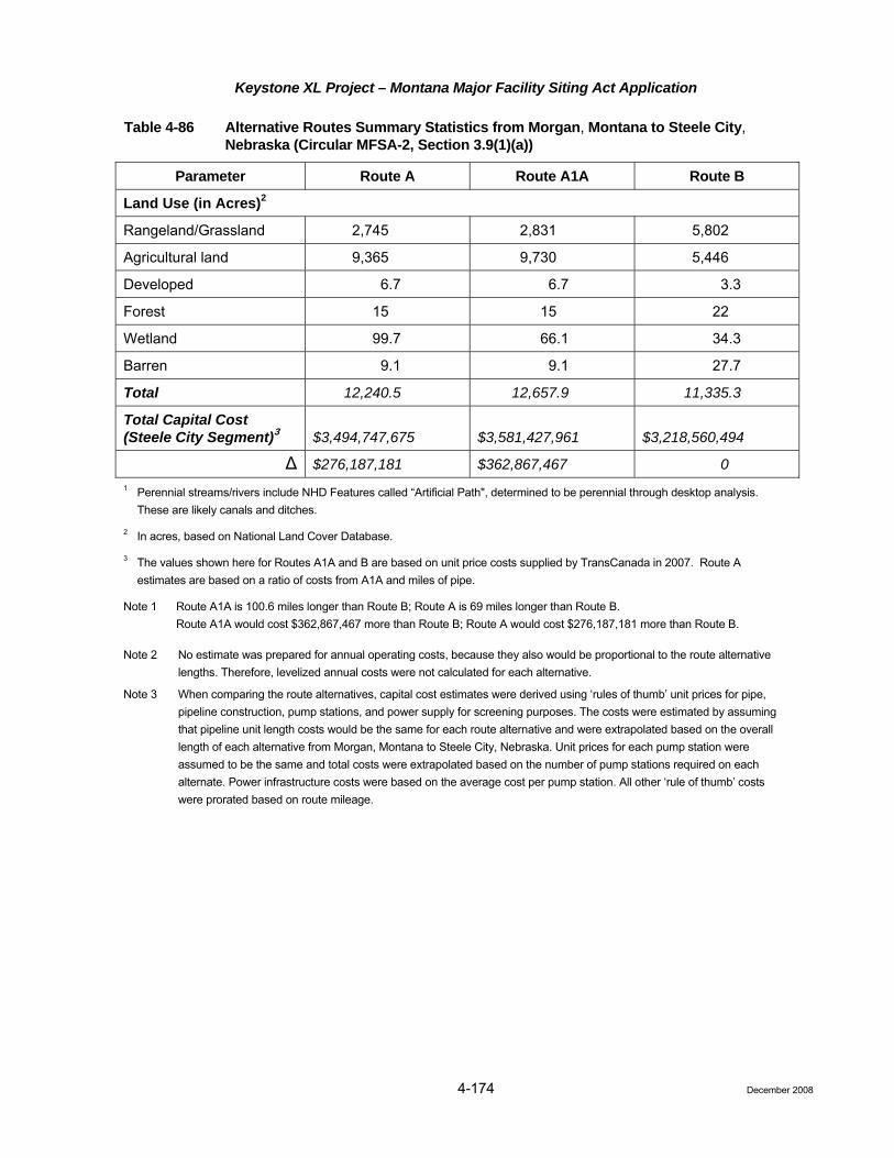
Keystone XL Project – Montana Major Facility Siting Act Application
4-174
Table 4-86 Alternative Routes Summary Statistics from Morgan, Montana to Steele City, Nebraska (Circular MFSA-2, Section 3.9(1)(a))
Parameter Route A Route A1A Route B
Land Use (in Acres)2
Rangeland/Grassland 2,745 2,831 5,802
Agricultural land 9,365 9,730 5,446
Developed 6.7 6.7 3.3
Forest 15 15 22
Wetland 99.7 66.1 34.3
Barren 9.1 9.1 27.7
Total 12,240.5 12,657.9 11,335.3
Total Capital Cost (Steele City Segment)3 $3,494,747,675 $3,581,427,961 $3,218,560,494
Δ $276,187,181 $362,867,467 0 1 Perennial streams/rivers include NHD Features called “Artificial Path", determined to be perennial through desktop analysis.
These are likely canals and ditches.
2 In acres, based on National Land Cover Database.
3 The values shown here for Routes A1A and B are based on unit price costs supplied by TransCanada in 2007. Route A estimates are based on a ratio of costs from A1A and miles of pipe.
Note 1 Route A1A is 100.6 miles longer than Route B; Route A is 69 miles longer than Route B. Route A1A would cost $362,867,467 more than Route B; Route A would cost $276,187,181 more than Route B.
Note 2 No estimate was prepared for annual operating costs, because they also would be proportional to the route alternative lengths. Therefore, levelized annual costs were not calculated for each alternative.
Note 3 When comparing the route alternatives, capital cost estimates were derived using ‘rules of thumb’ unit prices for pipe, pipeline construction, pump stations, and power supply for screening purposes. The costs were estimated by assuming that pipeline unit length costs would be the same for each route alternative and were extrapolated based on the overall length of each alternative from Morgan, Montana to Steele City, Nebraska. Unit prices for each pump station were assumed to be the same and total costs were extrapolated based on the number of pump stations required on each alternate. Power infrastructure costs were based on the average cost per pump station. All other ‘rule of thumb’ costs were prorated based on route mileage.
December 2008
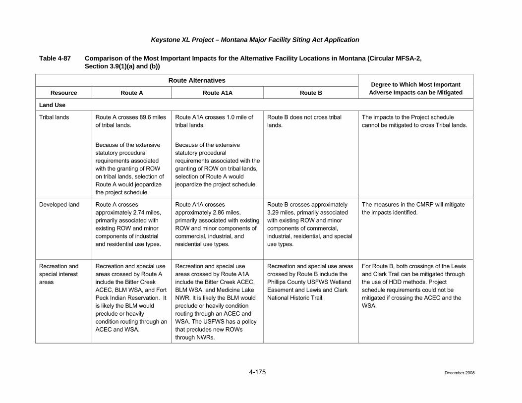
Keystone XL Project – Montana Major Facility Siting Act Application Table 4-87 Comparison of the Most Important Impacts for the Alternative Facility Locations in Montana (Circular MFSA-2,
Section 3.9(1)(a) and (b))
Route Alternatives
Resource Route A Route A1A Route B Degree to Which Most Important
Adverse Impacts can be Mitigated
Land Use
Tribal lands Route A crosses 89.6 miles of tribal lands.
Because of the extensive statutory procedural requirements associated with the granting of ROW on tribal lands, selection of Route A would jeopardize the project schedule.
Route A1A crosses 1.0 mile of tribal lands.
Because of the extensive statutory procedural requirements associated with the granting of ROW on tribal lands, selection of Route A would jeopardize the project schedule.
Route B does not cross tribal lands.
The impacts to the Project schedule cannot be mitigated to cross Tribal lands.
Developed land Route A crosses approximately 2.74 miles, primarily associated with existing ROW and minor components of industrial and residential use types.
Route A1A crosses approximately 2.86 miles, primarily associated with existing ROW and minor components of commercial, industrial, and residential use types.
Route B crosses approximately 3.29 miles, primarily associated with existing ROW and minor components of commercial, industrial, residential, and special use types.
The measures in the CMRP will mitigate the impacts identified.
Recreation and special interest areas
Recreation and special use areas crossed by Route A include the Bitter Creek ACEC, BLM WSA, and Fort Peck Indian Reservation. It is likely the BLM would preclude or heavily condition routing through an ACEC and WSA.
Recreation and special use areas crossed by Route A1A include the Bitter Creek ACEC, BLM WSA, and Medicine Lake NWR. It is likely the BLM would preclude or heavily condition routing through an ACEC and WSA. The USFWS has a policy that precludes new ROWs through NWRs.
Recreation and special use areas crossed by Route B include the Phillips County USFWS Wetland Easement and Lewis and Clark National Historic Trail.
For Route B, both crossings of the Lewis and Clark Trail can be mitigated through the use of HDD methods. Project schedule requirements could not be mitigated if crossing the ACEC and the WSA.
4-175 December 2008

Keystone XL Project – Montana Major Facility Siting Act Application
Table 4-87 Comparison of the Most Important Impacts for the Alternative Facility Locations in Montana (Circular MFSA-2, Section 3.9(1)(a) and (b))
Route Alternatives
Resource Route A Route A1A Route B Degree to Which Most Important
Adverse Impacts can be Mitigated
Wildlife and Fisheries
Greater sage grouse and sharp-tailed grouse
Route A crosses 8 known greater sage-grouse leks and/or their associated buffer zones.
Route A1A crosses 8 known greater sage-grouse leks and/or their associated buffer zones.
Route B crosses 24 known greater sage-grouse leks and/or their associated buffer zones.
Impacts can be mitigated through negotiated construction windows and buffer zones, as well as adherence to the CMRP to restore habitat.
Aquatic resources Route A does not cross any Class I or II fisheries.
Route A1A does not cross any Class I or II fisheries.
Route B crosses one Class I fishery at the Yellowstone River and one Class II fishery at the Missouri River.
Both of these rivers will be directionally drilled. There will be no impact to these resources.
Special Status Species
Special status species
A total of 59 special status wildlife species could potentially occur within suitable habitat along Route A. Of the 59, three (black-footed ferret, whooping crane, and the piping plover) are federally listed under the ESA; 37 are identified as BLM species of concern; and 22 are Montana species of concern.
Surveys would ultimately determine species presence and development of mitigation to avoid impacts.
A total of 47 special status wildlife species could potentially occur within suitable habitat along Route A1A. Of the 47, three (black-footed ferret, whooping crane, and the piping plover) are federally listed under the ESA; 12 are identified as BLM species of concern; and 22 are Montana species of concern.
Surveys would ultimately determine species presence and development of mitigation to avoid impacts.
A total of 65 special status wildlife species could potentially occur within suitable habitat along Route B. Of the 65, five (black-footed ferret, whooping crane, interior least tern, piping plover, and the pallid sturgeon) are federally listed under the ESA; 51 are identified as BLM species of concern; and 14 are Montana species of concern.
Surveys would ultimately determine species presence and development of mitigation to avoid impacts.
Impacts can be mitigated through negotiated construction windows and buffer zones, as well as adherence to the CMRP to restore habitat.
4-176 December 2008

Keystone XL Project – Montana Major Facility Siting Act Application
Table 4-87 Comparison of the Most Important Impacts for the Alternative Facility Locations in Montana (Circular MFSA-2, Section 3.9(1)(a) and (b))
Route Alternatives
Resource Route A Route A1A Route B Degree to Which Most Important
Adverse Impacts can be Mitigated
Water Resources
Perennial waterbodies crossed
Route A crosses five perennial streams.
Route A1A crosses 10 perennial streams.
Route B crosses 13 perennial streams.
Impacts will be mitigated by implementation of the procedures in the CMRP.
Wetlands crossed (miles)
Route A crosses 0.86 mile of wetlands.
Route A1A crosses 2.50 miles of wetlands.
Route B crosses 5.27 miles of wetlands.
Impacts will be mitigated by implementation of the procedures in the CMRP.
Surface water protection areas
Route A crosses one surface water protection area within 1 mile and zero within 5 miles.
Route A1A crosses zero surface water protection areas within 1 mile; two within 1 to 3 miles; and one additional within 3 to 5 miles.
Route B crosses one surface water protection area within 1 mile; three within 1 to 3 miles; and two additional within 3 to 5 miles.
Mitigative measures through pipeline design are found in Section 1.5 that are in accordance with 49 CFR, Part 195, and implementation of the ERP.
Geology
Landslides Route A crosses 90.0 miles of low incidence and low susceptibility areas; 80.0 miles of low incidence and high susceptibility areas; 11.0 miles of moderate incidence and low susceptibility areas; and 2.5 miles where slopes exceed 15 percent on Cretaceous shale bedrock.
Route A1A crosses 125.0 miles of low incidence and low susceptibility areas; 70.0 miles of low incidence and high susceptibility areas; 10.0 miles of moderate incidence and low susceptibility areas; and 2.0 miles where slopes exceed 15 percent on Cretaceous shale bedrock.
Route B crosses 175.0 miles of low incidence and low susceptibility areas; 82.0 miles of low incidence and high susceptibility areas; less than 26.0 miles of moderate incidence and high susceptibility areas; and 4.0 miles where slopes exceed 15 percent on Cretaceous shale bedrock.
Impacts will be mitigated by adherence to the measures in the CMRP and the measures described in (Chapter 1.0, Section 1.4.10).
4-177 December 2008

Keystone XL Project – Montana Major Facility Siting Act Application
4-178 December 2008
Table 4-87 Comparison of the Most Important Impacts for the Alternative Facility Locations in Montana (Circular MFSA-2, Section 3.9(1)(a) and (b))
Route Alternatives
Resource Route A Route A1A Route B Degree to Which Most Important
Adverse Impacts can be Mitigated
Cultural
Previously recorded eligible sites
Ten eligible for the NRHP. Seven eligible for the NRHP. Thirteen eligible for the NRHP. After surveys are completed and DOS and SHPO determine site eligibility, sites will be avoided where possible, or data recovery will mitigate impacts.
Socioeconomics
Economic benefits to counties
A total of $34,772,179 in property tax will be disbursed amont the affected counties along Route A.
A total of $42,385,442 in property tax will be disbursed among the affected counties along Route A1A.
An estimated total of $60,873,809 in property tax will be disbursed annually among the affected counties along Route B.
N/A
Environmental Justice
Minority and Low Income populations
Along Route A, one county, Roosevelt, had a minority population that was significantly greater than the state average.
Along Route A1A, one county, Roosevelt, had a minority population that was significantly greater than the state average.
None of the affected counties along Route B had a minority population that was significantly greater than the state average.
Mitigative measures include local hiring, where possible, and equitable easement negotiations for all landowners.
Note: Although Route B is the longest route within the State of Montana, it is the shortest route, overall, to Steele City, Nebraska.

Keystone XL Project – Montana Major Facility Siting Act Application
4-179
Table 4-88 Ranking of Alternative Facility Locations (Circular MFSA-2, Section 3.9(1)(c)1
Route Alternatives2
Resource Route A Route A1A Route B
Levelized annual costs, including environmental costs and mitigation costs3
2 3 1
Reliability4 2 2 2
Land use and ownership considerations 3 2 1
Socioeconomic considerations 3 2 1
Earth resources 2 2 2
Engineering considerations 2 2 2
Visual resources 2 2 2
Biological resources 1 2 3
Historic, archaeologic, and paleontologic resources 2 1 3
Recreation 2 3 1
Water resources 1 2 3
Noise, radio, and television interference and electrical effects5 2 2 2 1 An indication of the relative differences among the alternatives is provided above in Tables 4-86 and 4-87.
2 A “1” indicates most favorable; a “3” indicates least favorable.
3 Levelized annual costs were calculated only for Route B, and are provided in the “Confidential” non-public version of the application. Levelized annual costs were not calculated for Routes A and A1A; however, they would be greater due to the greater lengths of these routes.
4 Because all three routes would be constructed in accordance with all required regulations, standards, and specifications for liquid pipelines, all three routes would provide equally reliable service.
5 There are no residences within 500 feet of any pump station on any of the alternative routes, so effects are not expected to be an issue.
NOTE: Based strictly on the relative lengths of the routes within the State of Montana, and not taking into consideration the overall effects through Montana, South Dakota, and Nebraska, Route B has greater impacts on certain biological, historic, archaeological, and paleontologic resources. However, while it is longer through the State of Montana, Route B has less impact to wetlands, agricultural land, perennial stream crossings, public/tribal lands, developed lands, and does not cross a national wildlife refuge or a Native American reservation.
December 2008

Keystone XL Project – Montana Major Facility Siting Act Application
4-180
4.5.1
4.5.1
4.5.1
4.5 Selection of Preferred Facility Location (Circular MFSA-2, Section 3.10)
4.5.1 Keystone’s Selection Criteria (Circular MFSA-2, Section 3.10(1)(a)) In accordance with Circular MFSA-2, Section 3.10(1), Keystone has selected Route B as its preferred facility location. Keystone took many criteria into consideration when evaluating the various routing alternatives that it considered and in selecting a preferred route, including all of the criteria and constraints required in the Circular MFSA-2. Keystone’s selection criteria included the following:
• Length;
• Environmental constraints;
• Population density;
• Land issues;
• Land use;
• Regulatory issues; and
• Construction issues.
A variety of information (existing agency and publicly available data), maps, and ground and aerial reconnaissance were utilized to determine and evaluate the above criteria as defined below:
.1 Assumptions
• Several assumptions were made that influenced the selected route for the Steele City Segment of the Project:
• Starting point – U.S./Canadian border near Morgan, Montana.
.2 Length
One of the criteria examined when selecting a pipeline route is total length and associated environmental footprint and costs. Minimizing the length of a pipeline route is a major goal during the planning process, but may not always be the most cost effective option. Routing a pipeline to avoid environmentally sensitive and densely populated areas, as well as crossing locations for large waterbodies, also are important factors in determining a pipeline route. The cost of mitigation of environmental issues, geotechnical issues, land acquisition issues, and constructability issues may outweigh the cost of additional length of pipeline route. Potential schedule issues related to extensive permitting processes may also result in a preference for a longer route.
.3 Environmental Constraints
The methodology employed to conduct the environmental constraints study utilizes a “fatal flaw” approach, seeking to determine what, if any, environmental, land-use/planning, or physiographic issues represent impediments to pipeline construction within the study area. The data used for this analysis were generally based on publicly available information, especially existing GIS databases, and previous experience/knowledge of the area. The approach for this analysis was to gather and assess data related to:
• Wetland resource areas;
• Waterbodies and associated riparian habitat/floodplain;
• Land use and public lands, including park land and wildlife management areas;
December 2008

Keystone XL Project – Montana Major Facility Siting Act Application
4-181
4.5.1
4.5.1
4.5.1
• Location of critical habitat for special status species (threatened, endangered, and species of concern); and
• Other species of concern.
Supplemental investigations would further address the features noted above, as well as:
• Waterbody classifications;
• Wellhead protection areas and aquifers;
• Listed Contaminated Sites;
• Cultural Resources/Native American Lands; and
• HCAs as designated by OPS.
The most significant environmental constraints affecting the routing analysis were the Bitter Creek WSA (located along Route Option A), Medicine Lake NWR (located along Route Option A1A), the USACE lands on Route Option B, and the expansive number of “prairie pothole” wetland complexes along the eastern portion of Route Option A. Other environmental features within the study area, particularly large waterbodies and extensive floodplain areas, were considered.
.4 Population Density
The project area’s population density is relatively low along all three route options, with the majority of the land use being agriculture and rangeland/grassland. The largest urban areas (counties with a population greater than 10 per square mile) in the project area are in southeastern South Dakota and eastern Nebraska. In general, population densities are greater along Route Options A and A1A than they are along Route Option B.
.5 Land Issues
Each route option was examined for any potential land acquisition problems. The majority of the Project traverses agricultural areas, grasslands, and rangelands, so issues related to urban sprawl are not expected; however, the timing of construction in relation to crop harvest should be considered.
.6 Land Use
Large Scale Avoidance Areas: the pipeline was routed around the following land use categories to the extent practical:
a) National Parks, National Monuments, State Parks with developed recreation facilities;
b) Indian Reservations, Tribal Lands; and
c) Other publicly owned lands including BLM, USFWS, State Lands, National Park Service (NPS), USACE, etc.
Small Scale Avoidance Areas: the following areas also were avoided to the extent practical (100 to 500 feet from the route):
d) Residences and farmsteads;
e) Rural schools and recreational areas;
f) Towns and suburban developments;
g) Municipal sewage ponds;
h) Industrial facilities (e.g. rail yards, warehouses), except when in industrial corridors;
December 2008

Keystone XL Project – Montana Major Facility Siting Act Application
4-182
4.5.1
4.5.1
i) Cemeteries; and
j) Well heads and irrigation pivot points.
Co-location Areas-Large and Small Scale: to the extent practical, the pipeline was co-located with the following existing facilities:
k) Existing pipelines; and
l) Electrical transmission lines.
.7 Regulatory
Regulatory processes that are incompatible with the Project schedule are important route selection criteria. For example, on Route Option A, the regulatory and statutory processes for acquiring ROW on the Fort Peck Indian Reservation would jeopardize Keystone’s ability to achieve the Project schedule.
.8 Construction Issues
Each route option was examined for any potential construction problems or challenges that would affect the overall Project budget and schedule. Road, railroad, utility, and major waterbody crossings were documented and considered. Also considered were large wetland areas and the number of HDDs expected. Other factors considered were terrain, erosion control, and restoration.
4.5.2 Application of Preferred Location Criteria (Circular MFSA-2, Section 3.10(1)(b))
The preferred location criteria listed in Section 3.1(2) were considered to the extent they are applicable to pipeline routing. Initially, Keystone considered co-locating with the existing Northern Border Pipeline ROW (i.e., Route A), but regulatory constraints along this route would jeopardize the Project schedule, which is not acceptable to Keystone or its customers. Logged areas versus timbered areas were not considerations because neither exists along the alternative routes. Geologically stable areas were certainly considered during the selection process, as were the remainder of the location criteria listed in Sections 3.1(2) and 3.1(1) (by reference). However, because a considerable length of the project (almost 70 percent) will be constructed outside of the State of Montana, many of the same criteria, as well as several others, had to be considered in the other states crossed. Overall, a quantitative weighting analysis is not appropriate for pipeline projects. Based on consideration of all of the criteria discussed above, Route B was determined to be the preferred route.
4.5.3 Relative Importance of Categories (Circular MFSA-2, Section 3.10(1)(c)) Keystone did not weight the importance of the categories listed in Table 4.4-3 because a weighting approach is not appropriate for the pipeline routing process.
4.5.4 Avoidance Areas (Circular MFSA-2, Section 3.10(1)(d)) All of the areas specified in Section 3.2(1)(d)(i)(iii) were mapped and considered for all three routes, and were avoided with each route alternative, with the exception of Route A1A, which crosses a supply canal associated with the Medicine Lake NWR.
4.5.5 Other Areas (Circular MFSA-2, Section 3.10(1)(e)) All of the areas specified in Section 3.2(1)(d)(iv) through (f) were mapped and considered in the routing of all three routes. All of these areas were avoided with each route alternative. All of the areas specified in Sections 3.4(1) through (3) were mapped (where data were available) and were avoided to the extent possible. Where those areas were not avoidable, mitigation of significant adverse impact is possible. For the
December 2008

Keystone XL Project – Montana Major Facility Siting Act Application
4-183 December 2008
preferred route (Route B), siting the facility through those areas that could not be avoided will result in less cumulative adverse environmental impact and economic costs (including the costs of reasonable mitigation measures), than siting the facility in any other alternative location.
4.5.6 Conclusion Keystone evaluated the various routing alternatives described in this application using the criteria discussed above. Various data resources were utilized in the assessment and included the following:
• Recent aerial photography obtained from the US Department of Agriculture;
• USGS Topographic Quadrangle maps;
• State Gazetteers;
• SSURGO Database;
• National Land Cover Database; and
• GIS layers containing public data obtained from various county, state, and federal government websites; commercial background data provided by ESRI; and internal existing utility data.
These data were utilized to identify the following information in the selection of the route by accomplishing the following:
• Maximizing co-location opportunities with other existing pipelines, electric transmission lines, railways, roadways and other utilities;
• Identification of preferred topography, land use areas, etc; and
• Identification of major constraint areas such as national and state parks and forests, wildlife management areas, wetlands areas, waterbodies, difficult or unstable terrain, high density development, etc.
Extensive aerial and ground reconnaissance were then conducted across the various alternatives to finalize the route options. While Route B was longer through Montana, the overall impacts across the entire Steele City Segment must be considered. As a result, Route B was selected as the preferred alternative for several reasons, including the following previously mentioned benefits:
• Reduced environmental footprint and impacts;
• Reduced landowner impacts;
• Least impact to population centers;
• Reduced overall construction costs; and
• Reduced overall operating costs.
For the foregoing reasons, Keystone submits that selection of Route B as the preferred alternative is appropriate.

Keystone XL Project – Montana Major Facility Siting Act Application
5.0 Consultation and Coordination
5.1 Agency Coordination and Consultation An initial meeting was held between the DOS and Keystone on June 2, 2008. Introductory meetings were held between Keystone and the BLM, USACE, NPS, and USFWS, both at the federal and regional levels, to discuss the Project, identify any potential issues with these agencies, and initiate the permitting processes. Similar meetings have been held with the Montana DEQ, the MDNRC, MFWP, and other state agencies and entities, including the Montana State Legislators from eastern Montana.
Keystone filed a Presidential Permit application and supporting documents, including a preliminary Environmental Report, with the DOS on September 19, 2008. The purpose of the preliminary Environmental Report was to assist the DOS in making a determination on the lead agency status for the NEPA process. On November 20, 2008, Keystone filed a comprehensive Environmental Report with the DOS. The November 20 Environmental Report includes electronic shapefiles for the refined centerline and pump station locations (filed with DOS separately); field survey reports; and documentation of agency consultation regarding wetlands and cultural and biological resources. A supplemental filing will be made with the DOS in June 2009. In March 2008, a SF 299 application form requesting issuance of a ROW grant and preliminary environmental information was submitted to the BLM Billings State office. Early in 2009, supplemental information to the SF 299 ROW grant application form and a Preliminary Plan of Development (POD) will be filed with the BLM. In addition to these filings and the current MFSA application, an application for a certificate under the South Dakota Energy Conversion and Transmission Facilities Act will be made with the South Dakota Public Utilities Commission in early 2009.
5.2 Federal Approval Process and Authorizing Actions A number of federal agencies have permitting, environmental review, and regulatory roles with respect to the Project. The roles of the applicable federal agencies with respect to the Project are summarized below.
5.2.1 Department of State The Project requires a Presidential Permit authorizing the construction and operation of pipeline facilities across the US/Canada border. Executive Order 11423 (33 Federal Register 11741), as amended by Executive Order 12847 (58 Federal Register 29511) and Executive Order 13337 (69 Federal Register 25299), governs the DOS’s issuance of Presidential Permits. In evaluating Presidential Permit applications, the DOS conducts an environmental review pursuant to NEPA. An initial meeting was held between the DOS and Keystone on June 2, 2008, in Washington, DC, to introduce the Project. Subsequent meetings have been held with the DOS to discuss aspects of the NEPA process as it applies to the Project.
5.2.2 Bureau of Land Management The BLM has authority to issue ROW grants for all affected federal lands under the Mineral Leasing Act (MLA) of 1920, as amended (30 USC 181 et seq.). This action would be in accordance with 43 CFR 2800 and 2880, subsequent 2800 and 2880 Manuals, and Handbook 2801-1. For the Project, the BLM will consider the issuance of a new ROW grant and issuance of associated temporary use permits that would apply to BLM-managed lands crossed by the Project, as well as all other federal lands affected. Conformance with land use plans and impacts on resources and programs will be considered in determining whether to issue a ROW grant. As noted, the SF 299 application form requesting issuance of a ROW grant and preliminary environmental information was submitted to the BLM Billings State office in March 2008 to initiate the cost recovery agreement process so that BLM staff could participate in agency meetings and assist Keystone with routing across BLM lands. The BLM has indicated that it has accepted the March 2008 SF 299 application as the formal ROW grant application and is only awaiting supplemental information, including a Preliminary POD, which will be filed in early 2009.
December 2008 5-1

Keystone XL Project – Montana Major Facility Siting Act Application
Keystone has engaged BLM staff members in Montana in numerous meetings regarding the Project. Keystone has met on several occasions with staff members at the State Office in Billings. Also, Keystone representatives have met twice with the staff members in the Malta Field Office, Glasgow Field Station, and Miles City Field Office. Some of the issues, concerns, and suggestions provided in these meetings include:
• The Lewis and Clark Trail Special Resource Management Area;
• The Project’s consistency with RMPs;
• Paleontological resources;
• Sage grouse leks and other wildlife-related seasonal constraints;
• VRM classifications on BLM lands crossed;
• Coordination with grazing allotment permittees;
• Frenchman Creek ACEC;
• Separate ROW grant applications will be required for the pipeline and the electric transmission lines;
• USFWS wetland and grassland easements; and
• Suggested entering into a Programmatic Agreement for the Section 106 process.
5.2.3 US Army Corps of Engineers Section 404 (Clean Water Act) Nationwide Permits and Section 10 (Rivers and Harbors Act) Permits
Section 404 of the CWA establishes a permit program administered by the USACE to regulate the discharge of dredge and fill materials into the Waters of the US, including their adjacent wetlands. The Project will be under the jurisdiction of multiple USACE districts. Keystone began field surveys in the spring of 2008 along all areas of the proposed route where survey permission was obtained. These field surveys identified USACE jurisdictional waters of the US and wetlands crossed by the Project. Keystone will file this information with the USACE and will apply for Section 404 permits. Certain NWPs will be applicable, including NWP 33 for access and dewatering and NWP 12 for utility crossings for most of the USACE districts. Keystone will require approvals under Section 10 (Rivers and Harbors Act). Keystone intends to submit its Section 404 and Section 10 permit applications to the appropriate USACE District offices in 2009.
Keystone representatives have met, or have been involved in telephone and email conversations, with USACE Omaha District personnel located in Helena and Fort Peck, Montana; Pierre, South Dakota; and Omaha and Kearney, Nebraska. Keystone representatives also have discussed the Project with USACE Kansas City District personnel who confirmed that Keystone should work with the Omaha District staff for the Section 404 permitting of the Steele City Segment. All USACE staff members have indicated that most, if not all, of the waterbody and wetland crossings along the Steele City Segment could be covered under the Nationwide 12 permit.
5.2.4 Section 106 National Historic Preservation Act Section 106 of the NHPA, as amended, requires the lead federal agency to take into account the effects of its undertakings on historic properties or historic resources listed in, or eligible for listing in, the NRHP and to afford the Advisory Council on Historic Preservation an opportunity to comment if there will be adverse effects to NRHP-eligible properties. Historic properties are prehistoric or historic districts, sites, buildings, structures, objects, or properties of traditional religious or cultural importance, which are listed or eligible for listing in the NRHP, including artifacts, records, and material remains related to such a property or resource.
The DOS, as lead federal agency, is responsible for NHPA Section 106 compliance for all lands, both public and private, affected by the Project. Keystone, as the applicant, is preparing information, analyses, and
December 2008 5-2

Keystone XL Project – Montana Major Facility Siting Act Application
recommendations necessary for DOS to comply with Section 106, in accordance with Advisory Council on Historic Preservation’s regulations at 36 CFR Section 800.2.
Keystone representatives have met with the SHPOs in each state crossed to familiarize them with the Project and garner their concerns and input. All SHPOs were consulted regarding research design and methodologies as well as survey protocol approval.
As the lead agency, the DOS also is responsible for complying with the tribal consultation requirements of Section 106 of the NHPA, as amended, the NAGPRA, and American Indian Religious Freedom Act (AIRFA). Compliance involves contacting Native American groups with traditional or historical ties to the lands crossed by the proposed Project and ensuring that the requirements of the NHPA, NAGPRA, and AIRFA are met.
Keystone initiated Tribal outreach with a number of tribes recognized as having a potential past or present affiliation with the proposed Project area. To date, a number of tribes have responded to the initial outreach letters. At this time, official government-to-government consultation has not begun; however, consultation will occur as part of the NEPA process through the lead federal agency. In addition, Keystone has continued to engage interested tribes outside of the Section 106 process and will do so throughout construction.
5.2.5 US Fish and Wildlife Service Section 7 of the ESA, as amended, states that any Project authorized, funded, or conducted by any federal agencies should not “…jeopardize the continued existence of any endangered species or threatened species or result in the destruction or adverse modification of habitat of such species which is determined to be critical” [16 USC 1536(a)(2)(1988)]. The USFWS is responsible for ensuring compliance with the ESA. The DOS, as the lead federal agency, is responsible for initiating informal consultation with the USFWS to determine the likelihood of effects on listed species. The DOS or the applicant as a non-federal party is required to consult with the USFWS to determine whether any federally listed or proposed endangered or threatened species or their designated critical habitat occur in the vicinity of the proposed Project. If, upon review of existing data, the DOS determines that these species or habitats may be affected by the proposed Project, the DOS is required to prepare a Biological Assessment to identify the nature and extent of adverse impact and to recommend mitigation measures that will avoid the habitat and/or species or that will reduce potential impact to acceptable levels. If, however, the DOS determines that no federally listed or proposed endangered or threatened species or their designated critical habitat will be affected by the proposed Project, no further action is necessary.
Keystone has met and consulted with the USFWS regarding potential occurrence of special status species along the pipeline route. Based on USFWS input, Keystone developed a list of special status species that would require surveys and identified appropriate survey protocols. Once the survey protocols were approved by the USFWS, surveys were initiated in the summer and fall of 2008 and will continue during the spring of 2009.
Keystone continues to consult with the USFWS regarding potential impacts of the Project to special status species and possible mitigation measures to reduce impacts. Based on the results of field surveys and potential impacts to sensitive species, Keystone will prepare a draft Biological Assessment. This document will be submitted to the DOS following the completion of spring 2009 field surveys. The DOS will then review the draft Biological Assessment, revise as necessary, and submit the document to the USFWS for its concurrence.
5.2.6 Office of Pipeline Safety The OPS, PHMSA, within the USDOT is the primary enforcement agency that regulates the safety of interstate transportation of hazardous liquids by pipelines, including crude oil. Federal regulations governing the construction and safe operation of pipelines are enforced by the OPS. To comply with federal regulations (49 CFR Parts 194 and 195), Keystone will be required to develop a comprehensive ERP for the Project. The OPS will review and approve Keystone’s ERP prior to operation. Keystone has prepared a comprehensive ERP for the Keystone Pipeline Project and submitted it to PHMSA for review and approval. Upon receipt of
December 2008 5-3

Keystone XL Project – Montana Major Facility Siting Act Application
PHMSA approval, Keystone will use the ERP as the basis for preparation of an ERP specific to the Project, incorporating adjustments to reflect Project-specific factors. At that time, Keystone will submit the Keystone XL ERP to PHMSA for approval.
Additionally, the OPS will conduct regular inspections of pipeline facilities in the future to enforce continual compliance with federal regulations. The OPS also will review and approve Keystone’s Integrity Management Process for HCAs. Keystone has filed an application with PHMSA for a special permit authorizing Keystone to design, construct, and operate the project at up to 80 percent of the steel pipe Specified Minimum Yield Strength.
Keystone is preparing a Pipeline Risk Assessment and Environmental Risk Analysis, which evaluates the risk of pipeline disruption and its potential environmental consequences. This document will be submitted within the next two months as privileged and confidential information. Keystone has engaged in initial consultation with OPS.
5.2.7 Permits and Relationship to Non-federal Policies, Plans, and Programs A preliminary list of federal, state, and local permits and approvals is provided in Table 5-1. Individual road crossing and road use permits are not included in this table, since such permits will be a standard requirement in all counties crossed.
Table 5-1 Permits, Licenses, Approval, and Consultation Requirements
Agency Permit or Consultation/Authority Agency Action
Federal
Department of State (DOS) Presidential Permit, Executive Order 11423 of August 16, 1968 (33 Federal Register 11741, et seq.)
Consider approval of cross-border facilities; lead federal agency under NEPA
ROW Grant and Temporary Use Permit under Section 28 (Mineral Leasing Act [MLA])
Consider approval of ROW grant and temporary use permits for the portions of the Project that would encroach on federal lands
Archeological Resources Protection Act (ARPA) permit
Consider issuance of cultural resource use permit to excavate or remove cultural resources on federal lands
Bureau of Land Management (BLM)
Notice to Proceed Following issuance of a ROW grant and approval of the Project’s POD, consider the issuance of a Notice to Proceed with Project development and mitigation activities for federal lands
Section 404, Clean Water Act (CWA)
Consider issuance of Section 404 permits for the placement of dredge or fill material in Waters of the US, including wetlands
US Corps of Engineers (USACE) – Omaha, Tulsa, Fort Worth, and Galveston Districts
Section 10 Permit (Rivers and Harbors Act of 1899)
Consider issuance of Section 10 permits for pipeline crossings of navigable waters
December 2008 5-4

Keystone XL Project – Montana Major Facility Siting Act Application
Table 5-1 Permits, Licenses, Approval, and Consultation Requirements
Agency Permit or Consultation/Authority Agency Action
US Fish and Wildlife Service (USFWS)
Endangered Species Act (ESA) Section 7 Consultation, Biological Opinion
Consider lead agency findings of an impact of federally listed or proposed species; provide Biological Opinion if the Project is likely to adversely affect federally listed or proposed species or their habitats
Federal Highway Administration
Crossing permit Consider issuance of permits for the crossing of federally funded highways
49 CFR Part 195 Review and approve integrity management plan for high consequence areas
49 CFR Part 194 Review and approve Emergency Response Plan
Office of Pipeline Safety
Special permit Waiver of the 0.72 design factor
Section 401, CWA, Water Quality Certification
Consider approval of water use and crossing permits for non-jurisdictional waters (implemented through each state’s Water Quality Certification Program)
US Environmental Protection Agency (USEPA), Regions VI, VII, and VIII
Section 402, CWA, National Pollutant Discharge Elimination System (NPDES)
Review and issue NPDES permit for the discharge of hydrostatic test water (implemented through each state’s Water Quality Certification Program, where required)
US Department of Treasury – Bureau of Alcohol, Tobacco, and Firearms
Treasury Department Order No. 120-1 (formerly No. 221), effective July 1, 1972
Consider issuance of permit to purchase, store, and use explosives should blasting be required
National Oceanic and Atmospheric Administration (NOAA), National Marine Fisheries Service (NMFS)
Magnuson-Stevens Act Consult on Essential Fish Habitat (EFH)
Montana
Montana State Historic Preservation Office – Montana Historical Society
Section 106 consultation regarding NRHP eligibility of cultural resources and potential project effects on historic properties, Compliance with Montana State Antiquities Act
Review and comment on activities potentially affecting cultural resources
Montana DEQ – Director’s Office MEPA Office
Montana Environmental Policy Act (MEPA) Permit and Montana Major Facility Siting Act (MFSA) Compliance
Review and comment on environmental activities and alternative siting study; review and use federal EIS to meet MEPA requirements
December 2008 5-5
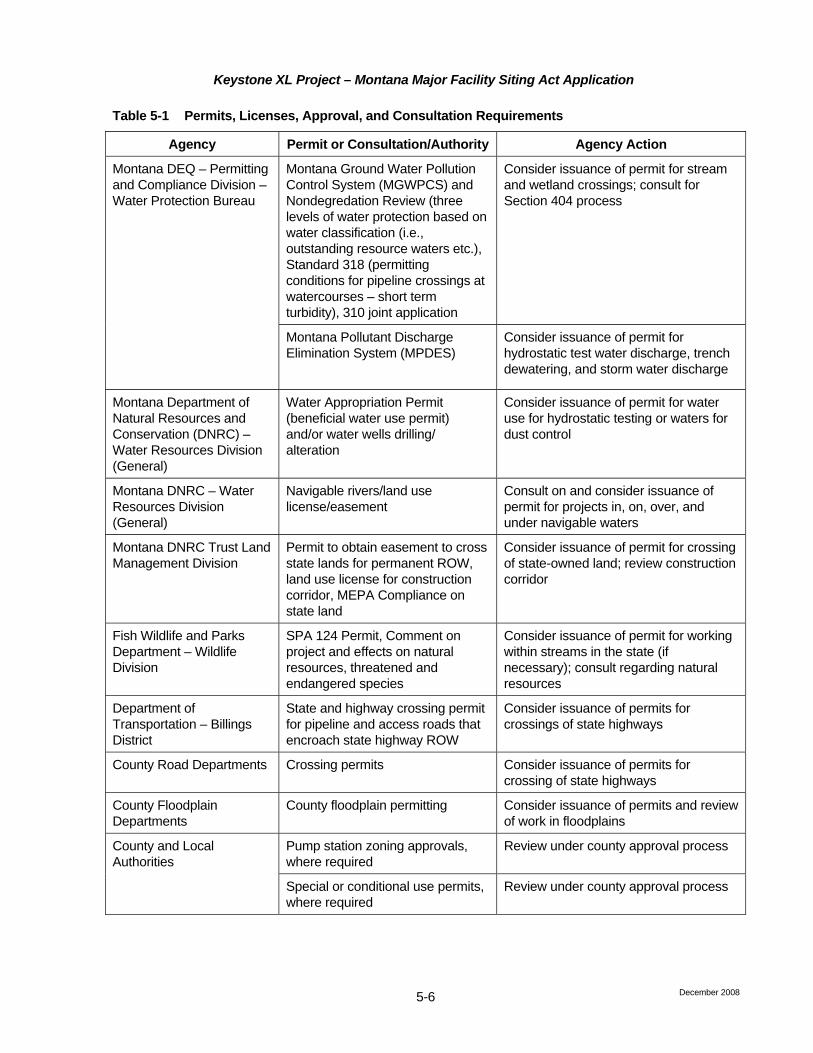
Keystone XL Project – Montana Major Facility Siting Act Application
Table 5-1 Permits, Licenses, Approval, and Consultation Requirements
Agency Permit or Consultation/Authority Agency Action
Montana Ground Water Pollution Control System (MGWPCS) and Nondegredation Review (three levels of water protection based on water classification (i.e., outstanding resource waters etc.), Standard 318 (permitting conditions for pipeline crossings at watercourses – short term turbidity), 310 joint application
Consider issuance of permit for stream and wetland crossings; consult for Section 404 process
Montana DEQ – Permitting and Compliance Division – Water Protection Bureau
Montana Pollutant Discharge Elimination System (MPDES)
Consider issuance of permit for hydrostatic test water discharge, trench dewatering, and storm water discharge
Montana Department of Natural Resources and Conservation (DNRC) – Water Resources Division (General)
Water Appropriation Permit (beneficial water use permit) and/or water wells drilling/ alteration
Consider issuance of permit for water use for hydrostatic testing or waters for dust control
Montana DNRC – Water Resources Division (General)
Navigable rivers/land use license/easement
Consult on and consider issuance of permit for projects in, on, over, and under navigable waters
Montana DNRC Trust Land Management Division
Permit to obtain easement to cross state lands for permanent ROW, land use license for construction corridor, MEPA Compliance on state land
Consider issuance of permit for crossing of state-owned land; review construction corridor
Fish Wildlife and Parks Department – Wildlife Division
SPA 124 Permit, Comment on project and effects on natural resources, threatened and endangered species
Consider issuance of permit for working within streams in the state (if necessary); consult regarding natural resources
Department of Transportation – Billings District
State and highway crossing permit for pipeline and access roads that encroach state highway ROW
Consider issuance of permits for crossings of state highways
County Road Departments Crossing permits Consider issuance of permits for crossing of state highways
County Floodplain Departments
County floodplain permitting Consider issuance of permits and review of work in floodplains
County and Local Authorities
Pump station zoning approvals, where required
Review under county approval process
Special or conditional use permits, where required
Review under county approval process
December 2008 5-6

Keystone XL Project – Montana Major Facility Siting Act Application
Table 5-1 Permits, Licenses, Approval, and Consultation Requirements
Agency Permit or Consultation/Authority Agency Action
South Dakota
South Dakota Historical Society
Consultation under Section 106, NHPA
Review and comment on activities potentially affecting cultural resources
Public Utilities Commission Energy Conversion and Transmission Facilities Act
Consider issuance of permit for a pipeline and associated facilities
Section 401, CWA, Water Quality Certification
Consider issuance of permit for stream and wetland crossings; consult for Section 404 process
Department of Environment and Natural Resources, Surface Water Quality Program Hydrostatic Testing/Dewatering
and Temporary Water Use Permit (SDG070000)
Consider issuance of General Permit regulating hydrostatic test water discharge, construction dewatering to waters of the state ,and Temporary Water Use Permit
Department of Game, Fish, and Parks
Consultation Consult regarding natural resources
Department of Transportation
Crossing permits Consider issuance of permits for crossing of state highways
County Road Departments Crossing permits Consider issuance of permits for crossing of county roads
County and Local Authorities
Pump station zoning approvals, where required
Review under county approval process
Special or conditional use permits, where required
Review under county approval process
Nebraska
Nebraska State Historic Preservation Office
Consultation under Section 106, NHPA
Review and comment on activities potentially affecting cultural resources
Department of Environmental Quality (DEQ), Division of Water Resources
Section 401, CWA, Water Quality Certification
Consider issuance of permit for stream and wetland crossings; consult for Section 404 process
Excavation Dewatering and Hydrostatic Testing Permit Form NEG6720000 Dewatering Form NEG6721000 Relocation
Consider issuance of permit regulating hydrostatic test water discharge and construction dewatering to waters of the state
Department of Environmental Quality (DEQ), Division of Air Quality
Nebraska Administrative Code Title 129, Construction Permit
Consider issuance of permit for construction of proposed tank farm at Steele City
December 2008 5-7
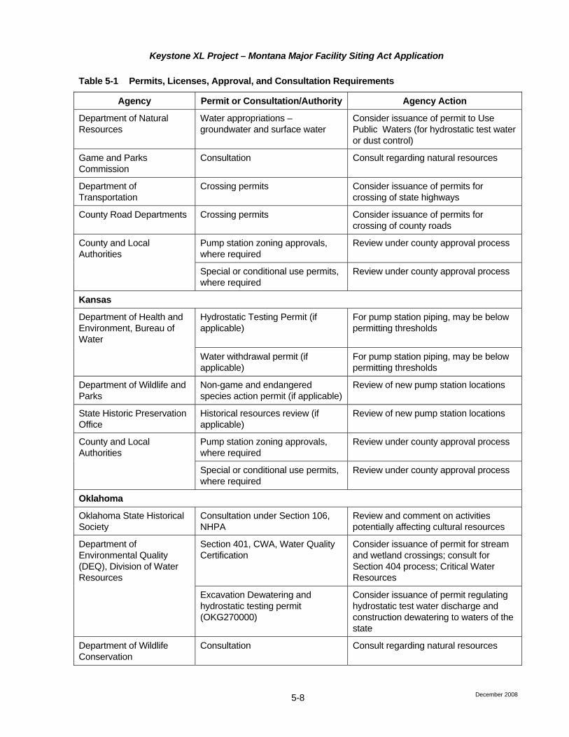
Keystone XL Project – Montana Major Facility Siting Act Application
Table 5-1 Permits, Licenses, Approval, and Consultation Requirements
Agency Permit or Consultation/Authority Agency Action
Department of Natural Resources
Water appropriations – groundwater and surface water
Consider issuance of permit to Use Public Waters (for hydrostatic test water or dust control)
Game and Parks Commission
Consultation Consult regarding natural resources
Department of Transportation
Crossing permits Consider issuance of permits for crossing of state highways
County Road Departments Crossing permits Consider issuance of permits for crossing of county roads
County and Local Authorities
Pump station zoning approvals, where required
Review under county approval process
Special or conditional use permits, where required
Review under county approval process
Kansas
Department of Health and Environment, Bureau of Water
Hydrostatic Testing Permit (if applicable)
For pump station piping, may be below permitting thresholds
Water withdrawal permit (if applicable)
For pump station piping, may be below permitting thresholds
Department of Wildlife and Parks
Non-game and endangered species action permit (if applicable)
Review of new pump station locations
State Historic Preservation Office
Historical resources review (if applicable)
Review of new pump station locations
County and Local Authorities
Pump station zoning approvals, where required
Review under county approval process
Special or conditional use permits, where required
Review under county approval process
Oklahoma
Oklahoma State Historical Society
Consultation under Section 106, NHPA
Review and comment on activities potentially affecting cultural resources
Section 401, CWA, Water Quality Certification
Consider issuance of permit for stream and wetland crossings; consult for Section 404 process; Critical Water Resources
Department of Environmental Quality (DEQ), Division of Water Resources
Excavation Dewatering and hydrostatic testing permit (OKG270000)
Consider issuance of permit regulating hydrostatic test water discharge and construction dewatering to waters of the state
Department of Wildlife Conservation
Consultation Consult regarding natural resources
December 2008 5-8

Keystone XL Project – Montana Major Facility Siting Act Application
Table 5-1 Permits, Licenses, Approval, and Consultation Requirements
Agency Permit or Consultation/Authority Agency Action
Department of Transportation
Crossing permits Consider issuance of permits for crossing of state highways
County road departments Crossing permits Consider issuance of permits for crossing of county roads
County and Local Authorities
Pump station zoning approvals, where required
Review under county approval process
Special or conditional use permits, where required
Review under county approval process
Texas
Texas State Historic Preservation Office
Consultation under Section 106, NHPA
Review and comment on activities potentially affecting cultural resources
Texas Commission on Environmental Quality (TCEQ)
Section 401, CWA, Water Quality Certification
Consult for Section 404 process; permit regulating hydrostatic test water discharge, and construction dewatering to waters of the state
Parks and Wildlife Department
Consultation Consult regarding natural resources
Coastal Zone Management Program
Consult on state-owned lands and consider issuance of Coastal Zone Consistency Determination
Texas General Land Office
State owned lands Consider approval of easement grants for ROW cover state-owned lands
Railroad Commission of Texas
State lead on oil and gas projects; excavation dewatering and hydrostatic testing permit
Consider issuance of permit to operate the pipeline; consider issuance of permit regulating hydrostatic test water discharge and construction dewatering to waters of the state
Department of Transportation
Crossing permits Consider issuance of permits for crossing of state highways
County road departments Crossing permits Consider issuance of permits for crossing of county roads
County and Local Authorities
Pump station zoning approvals, where required
Review under county approval process
Special or conditional use permits, where required
Review under county approval process
Jefferson County drainage district
Crossing permits Consider issuance of permits for crossing of drainage canals
Lower Neches Valley Authority
Crossing permits Consider issuance of permits for crossing of drainage canals
December 2008 5-9
Keystone XL Project – Montana Major Facility Siting Act Application
December 2008 5-10
5.3 Public Meetings 5.3.1 Public Participation and Open Houses Keystone has been engaged in public consultation even prior to the Project being formally announced in July 2008. To date, Keystone’s public participation program has included meetings with community and county leaders, as well as open houses for public participation. Keystone has met with or contacted community and county leaders along the entire route, including County Commissioners along the proposed and alternative routes in Montana. Keystone has met with leaders from more than 85 communities during the spring and summer of 2008. These meetings were designed to:
• Introduce the Project, listen to and capture initial thoughts and concerns, and describe ways for interested parties to get additional information from Keystone and the Project team;
• Discuss plans for more detailed public participation and consultation with local landowners and stakeholders ensuring community leaders were comfortable with Keystone’s approach;
• Assist in planning effective open houses by asking community leaders to identify potentially interested constituencies and potential local issues and concerns; and
• Begin to establish a business relationship between Keystone and the local units of government and communities neighboring the pipeline.
In April and May of 2008, Keystone conducted presentations to County Commissioners of all Montana counties being traversed by the proposed route. Those presentations to the Commissioners included members of the public that participated in the Commissioner meetings. The Montana counties involved in these presentations included: Phillips, Valley, McCone, Prairie, Dawson, and Fallon counties.
In June and July 2008, 27 open houses were held along the Initial Proposed Route in the following locations:
Montana South Dakota
Glasgow (Valley County) Buffalo (Harding County) Circle (McCone County) Faith (Meade County) Glendive (Dawson County) Phillip (Haakon County) Baker (Fallon County) Murdo (Jones County) Winner (Tripp County)
Nebraska Kansas
Atkinson (Holt County) El Dorado (Butler County) Burwell (Garfield County) Clay Center (Clay County) Fullerton (Nance County) York (York County) Fairbury (Jefferson County)
Oklahoma Texas
Durant (Bryan County) Beaumont (Jefferson County) Stroud (Lincoln County) Livingston (Polk County) Ada (Pontotoc County) Liberty (Liberty County) Lufkin (Angelina County) Nacogdoches (Nacogdoches County) Winnsboro (Wood County) Tyler (Smith County) Paris (Lamar County) All of the County Commissioners, mayors, and other public leaders along the proposed route exhibited support for the Project.

Keystone XL Project – Montana Major Facility Siting Act Application
December 2008 5-11
Keystone is committed to ongoing and regular correspondence, communication, and consultation with all stakeholders. Keystone shares information about the Project and provides opportunities for identification and resolution of questions, issues, and concerns through a number of channels, including press releases, the Project web site (www.transcanada.com/KXL), e-mail ([email protected]), toll-free telephone numbers for general inquiries (1-866-717-7473) and for landowner issues (1-877-860-4881), one-on-one discussions between landowners and land agents, and direct mailings. Public participation and consultation activities will continue throughout the life of the Project. Additionally, stakeholders are advised how to access Project information and to provide feedback by other means.
Assessment in Montana (Circular MFSA-2, Section 3.7 (6))
The open house meetings held along the proposed route in Montana were well received. A summary of issues and comments from open houses in Montana is provided below under six main topic areas.
• Economic impact: Many of the rural communities along the proposed route are seeking jobs and potential economic activity. Participants had a positive view of the Project’s potential to create local jobs and generate opportunities for local businesses to provide goods and services.
• Tax revenue: The possibility of significant tax revenue was attractive to local and state governments.
• Route location and selection: Stakeholders raised a wide range of issues related to route location and the route refinement process.
• Safety and environment: Many attendees asked general questions related to pipeline safety, including environmental impact of leaks, and impact on water sources (existing water lines, aquifers, and irrigation systems), noxious weeds, protection of sandhills and wetlands, and the impact on soil productivity and tree cover.
• Easement agreements: Several issues related to easements were discussed, including liability issues and cleanup responsibility, as well as compensation to affected landowners.
• Construction: There was interest in such issues as depth of cover, impact on roads, construction methods, and time of year when construction will occur.
In September and October, 2008, Keystone representatives met with and/or contacted the County Commissioners in Daniels, Roosevelt, and Sheridan counties, through which Routes A and A1A would pass. The concerns and support for the project by the Commissioners in these counties were very similar to those expressed in the open house meetings. Records of the meetings and discussions held with Daniels, Roosevelt, and Sheridan County Commissioners are provided in Attachment F. Overall, the County Commissioners were optimistic regarding the positive economic impact the proposed project would have on their counties. The Commissioners specifically cited the influx of workers with the associated sales tax revenue as well as the property taxes gained from taxation of the facilities. Concerns about environmental impacts were limited, as there would be no change in land use over the long term. None of the Commissioners expressed any major concerns regarding environmental impacts associated with the alternative routes.
In mid-November, 2008, in accordance with Montana Code Annotated 75-20-211 (4), Keystone published a public notice in the Glendive Ranger Review, Glasgow Courier, Fallon County Times, Circle Banner, Billings Gazette, Miles City Star, and the Wolf Point Herald News. The notice described the proposed project, provided a map showing the alternative routes in Montana, and provided a website and toll-free number to receive feedback and comments on the project. Copies of the public notices are provided in Attachment F.