JANUARY OF 2010 - concar.gov.br · proposal approved by the CONCAR on December 19th, 2008, was a...
204
1 ACTION PLAN FOR THE IMPLEMENTION OF THE JANUARY OF 2010
Transcript of JANUARY OF 2010 - concar.gov.br · proposal approved by the CONCAR on December 19th, 2008, was a...

1
ACTION PLAN FOR THE IMPLEMENTION OF THE
JANUARY OF 2010

2

3
Ministry of Planning, Budget and Management National Commission of Cartography
Action Plan for the Implementation of the
National Spatial Data Infrastructure
Rio de Janeiro 2010

4
This document was prepared by the CINDE
Planning Committee of the National Spatial Data Infrastructure

5
PREFACE
The National Spatial Data Infrastructure - NSDI was legally established by the Presidential Decree No. 6666 of November 27th, 2008 (annex I). In addition to formulating definitions, pointing out responsibilities and establishing guidelines, the decree stipulated a deadline of 180 days for the National Commission of Cartography (CONCAR) to prepare an action plan for the NSDI implementation and submit it to the Ministry of Planning, Budget and Management (MP). In the section VIII of its Article 6, the Decree introduced a minimum list of items to be addressed in the refered plan.
In its plenary meeting on December 19th, 2008, the CONCAR voted for the creation of a Specialized Committee which would be responsible for the elaboration of the action plan for the NSDI’s implementation. This committee, named CINDE (Planning Committee for the NSDI) was formed between January and March of 2009 and brought together 110 members representing 26 organizations in Brazil, of which 22 related to the federal government, three state secretariats and one university. The complete list of the organizations and members of the CINDE components are listed in the annex III.
CINDE’s work result is consolidated in this document, called ACTION PLAN FOR THE IMPLEMENTATION OF THE NATIONAL SPATIAL DATA INFRASTRUCTURE. The organizational way of CINDE’s work, by Working Groups (WGs), reflected the way the document was designed, in chapters. Each eight (8) chapters foreseen for the Plan, as the proposal approved by the CONCAR on December 19th, 2008, was a work subject of a WG. Each WG had one or two leaders. All WGs worked under the central coordination of the CINDE.
The chapters of this document were designed to address the dimensions of the implementation of a Spatial Data Infrastructure (SDI), namely the Organizational dimension, the Technical dimension and the Human dimension. The first chapter deals with general concepts and guidelines for the NSDI implementation, Chapters 2 to 7 address essential organizational, technical and human matters. The consolidation takes place in Chapter 8, which corresponds to the ACTION PLAN of the NSDI itself, which also is refered as Action Plan.
The chapters of this document are described below:
Chapter 1 - SPATIAL DATA INFRASTRUCTURE (SDI): CONCEPTS. It presents a collection of concepts and essential definitions for the Action Plan development, highlighting the elements of the informational architecture of a SDI, namely: data, metadata and services. It provides information about international experiences and proposes a strategy for the NSDI based on the implementation cycles. It launches the conceptual basis for the other chapters, developed from extensive literature research. Recommended reading for those who have little knowlegde of the subject.
Chapter 2 – SUBSIDIES FOR THE NSDI’S ACTION PLAN.
It emphasizes the organizational dimension of the Action Plan, directing it as to the general policy issues, legislation and associated coordination with the effort to build a SDI. It analyzes

6
the Decree No. 6.666/08 and elaborates upon the principles of the NSDI, after examining the motivations, benefits and risks associated with this initiative, making recommendations for the implementation. It also provides subsidy to creating a management structure for the NSDI. It comes out with an important basis for Chapter 8.
Chapter 3 – NSDI’S ACTORS: IDENTIFICATION AND FUNCTIONS.
Performs an initial survey of the NSDI actors, among which are the official producers of geospatial data and information – GI of the federal government. The institutions that have obligations established in the Decree No. 6.666/08, are called federal actors of the NSDI. (See annex I).
Chapter 4 - GEOSPATIAL DATA AND METADATA.
It identifies sets of reference and thematic data that will be available at the NSDI, and elaborates on the conditions so that a set of reference geospatial data or thematic is considered official, according to the Article 2 - § 2º of the Decree No. 6666/08. It devotes an entire section to the geospatial metadata subject. Identifing some of the officials producers of GI from the federal sector and will make their data available in the NSDI.
Chapter 5 - BRAZILIAN DIRECTORY OF GEOSPATIAL DATA
The Brazilian Directory of Geospatial Data – “DBDG” can be understood as the technological and informational structure of the NSDI, included the data, metadata, and, search services and data access. Chapter 5 presents the design of the “DBDG” considering its conceptual, logical and physical dimensions. It also elaborates on the Brazilian Portal of Geospatial Data – SIG Brazil, which will provide the resources of the DBDG for publication or query about the existence of geospatial data, as well as the access to the related services.
Chapter 6 – CAPACITY BUILDING AND HUMAN RESOURCES TRAINING.
It presents the first version of the NSDI’s capacity building and Human Resources Training Plan, focusing on the producers, providers, managers and GI users. It considers the need to implement a Knowledge Management System as a component part of the support infrastructure to the NSDI capacity building and training. It also establishes a set of guidelines and proposes training programs and human resources training.
Chapter 7 - DISSEMINATION AND COMMUNICATION.
It presents the first version of a NSDI Communication Plan, including: goals and objectives to be achieved, guidelines for effective communication, communication strategies, monitoring and evaluation, target audience definition and actions to the Communication Plan implementation.
Chapter 8 – NSDI’S ACTION PLAN. Chapter 8 is where the consolidation of the working group’s contributions that elaborated the previews chapters takes place and where the answers to the requests about deadlines and costs made on the Decree No. 6.666/08 can be found. It is where the lines of action with the respective “products" (results) expected are presented; it also defines schedules, responsibilities and implementation costs (detailed in annex II). Chapter 8 offers the basis for the further

7
development of a detailed project chronogram, besides proposing an implementation strategy based on short, medium and long term priorities.
Chapter 8 is therefore, the component of this document which reading is more recommended to those who need strategic and tactical information about the implementation process planned for the NSDI. Once this Action Plan is approved and the necessary financial resources to run it assured, the actors responsible for its execution will have a ready to use tool in which they will be able to rely on to initiate the implementation.
The proposal of a coordinating and execution structure of the NSDI’s ACTION PLAN is an important contribution of Chapter 8. The information collected in the bibliography related to the international experiences, and the reflections made in the preparation of the Chapters 2 and 3, especially, provide the basis for the structure proposed in Chapter 8. It should be noted that the provisions of the Decree No. 6.666/08 regarding to the actions coordination for the NSDI’s implementation have been properly observed in this elaboration.
The organization adopted in Chapter 8 follows the same logic that guided the structure of this document. The action lines were grouped into categories related to the components of the NSDI, studied in Chapters 1 and 2, namely Management; Norms & Standards; Data; Technology; Capacity building and training; Dissemination, the last two linked to the component called "People", also called "Actors" and the first (Management), to the “Institutional” component.
The categorization used in Chapter 8 has as main advantage the fact that the Working Groups (WGs) of the CINDE were composed according to this same focus. This is, therefore, already formed groups to begin the work of building the NSDI, once the Action Plan is approved and the necessary resources for its execution allocated. Such WGs would act under the leadership of a specialized committee of the CONCAR ("Specialized Committee of the NSDI ") which, in turn, would have its work guided and followed directly by the CONCAR Technical subcommittees, as proposed in Chapter 8 - Section 8.2.
The implementation strategy of the NSDI proposed in the Action Plan (first in Chapter 1 - Section 1.5) is based on a stagger of goals according to priorities and objectives well-defined to be achieved over implementation cycles, which are described in Chapter 8. It is provided three cycles and the following deadlines:
Cycle I – December 2010
Cycle II – 2011 to 2014
Cycle III – 2015 to 2020
It is very important that priorities are established on a short-term basis, taking into consideration the goals to be achieved on a medium and long-term basis. This is the challenge of making the NSDI initiative grow within the public sector, where it was conceived. It may gain strength and consolidate in the next 12 to 18 months.
The NSDI ACTION PLAN is a management tool, guiding the implementation project of the National Spatial Data Infrastructure. As it is known, this is a complex and long-term project,

8
with a number of inherent risks, which might be mitigated in a planned way. Therefore, the Action Plan should be flexible enough to incorporate the changes that inevitably will occur throughout the project. It should also be improved during their execution, resulting into the publication of periodic reviews.
Finally, it is worth emphasizing that the reading or consultation to the Chapters 3-7 can be done in topics for further clarification, as it is needed to deepen the points discussed in Chapter 8 - ACTION PLAN OF THE NSDI.

9
Table of Contents Chapter 1 Spatial Data Infrastructure (SDI) Concepts.................................... ........................................13 1.1 Introdution...............................................................................................................................13 1.2 Definitions and Components of a SDI….................................................................................14 1.3 Elements of the informational architecture of a SDI...............................................................17 1.3.1 Data, information and knowlegde ........................................................................................17 1.3.2 Data and geospatial information...........................................................................................18 1.3.3 Classification of the data of a SDI........................................................................................19 1.3.4 Metadata and quality of cartographic documents.................................................................21 1.3.5 Web Services and service-oriented architecture (SOA).......................................................26 1.4 Web Geosservices: A SDI Base Oriented to Services (IOS)..................................................28 1.5 Sucessful factors in the implementation of a SDI ..................................................................31 References......................................................................................................................................34 CHAPTER 2 SUBSIDIES FOR THE NSDI’S ACTION PLAN ...................................................................39 2.1 A model of conception to SDI................................................................................................ 39 2.2 Guidelines for Planning the NSDI………..……….................................................................40 2.2.1 Motivation and benefits........................................................................................................41 2.2.2 Needs and recommendations to build a SDI ………………………...................................42 2.2.3 The modal of pyramdal organization................................................................................... 44 2.3 NSDI legal framework……................................................................................................... 46 2.3.1 Guiding Principles ............................................................................................................. 49 2.4 NSDI’s Institutional Aspects…............................................................................................. 49 2.4.1 Organization and management............................................................................................ 49 2.4.2 Acess policies and data use...................................................................................................52 2.4.3 Legislation and legal issues of data......................................................................................52 2.4.4 Institutional Strengthing....................................................................................................... 53 2.5 Norms, Standards, and Specification in the NSDI................................................................. 53 2.6 CONCAR’S role in the NSDI implementation ……............................................................. 54 References..................................................................................................................................... 58 Chapter 3 NSDI’s ACTORS– IDENTIFICATION AND FUNCTIONS …….........................................61 3.1 Introdution ...............................................................................................................................61 3.2 Actors of the National Spatial Data Infrastructure.................................................................62 3.2.1 Organizational and administrative actors .............................................................................62 3.2.2 Producers of Geospatial data and information of reference and thematic...........................63 3.2.3 Users.................................................................................................................................... 66 3.2.4 Data and value-added information producers ….................................................................66 3.2.5 Products and services providers in the areas of geoprocessing and related..........................67 3.3 Other NSDI actors…............................................................................................................. 67 References..................................................................................................................................... 68

10
Chapter 4 GEOSPATIAL DATA AND METADATA.............................................................................. 69 4.1The NSDI and the Producers of Geospatial data and Information...........................................69 4.2 geospatial Data and Information.............................................................................................73 4.2.1 Geoespatial data of reference...............................................................................................73 4.2.2 Thematic geospatial data and information......................................................................... 78 4.2.3 Special Geospatial Data........................................................................................................80 4.2.3.1 Nautical Cartography.........................................................................................................80 4.2.3.2 Aeronautical Cartography..................................................................................................80 4.2.4 Official Geospatial Data.......................................................................................................81 4.3 Geospatial Metadata................................................................................................................82 4.3.1 Concept and importance for the NSDI.................................................................................82 4.3.2 Standards and Metadata profiles...........................................................................................83 4.3.3 The profile of geospatial metadata in Brazil - Profile MGB…………................................86 4.3.4 Loading, Editing and Dissemination Environment............................................................. 88 4.3.5 Recommendations............................................................................................................... 88 4.4 Quality and Consistency of Geospatial Data.......................................................................... 89 4.4.1 Norms and standards of geospatial data of reference...........................................................90 4.4.2 Norms, standards and specifications of thematic geospatial data.........................................92 4.4.3 Norms, standards and special specifications of geospatial data...........................................94 4.4.3.1 Nautical Cartography........................................................................................................ 94 4.4.3.2 Aeronautical Cartography................................................................................................. 95 4.5 Recommendations................................................................................................................... 95 References.................................................................................................................................... 96 Chapter 5 BRAZILIAN DIRECTORY OF GEOSPATIAL DATA (DBDG)..........................................97 5.1 The DBDG and the interoperabilitystandard of the electronic government............................97 5.2 Conceptual diagram of the DBDG......................................................................................... 98 5.2.1 Application layer................................................................................................................. 99 5.2.2 Intermediary layer...............................................................................................................100 5.2.3 Servers layers .....................................................................................................................100 5.3 Non-functional requirements.................................................................................................100 5.3.1 General................................................................................................................................101 5.3.2 Hardware.............................................................................................................................101 5.3.3 Software .............................................................................................................................101 5.4 The Brazilian Portal of geospatial data..................................................................................102 5.4.1 Functional Requirements....................................................................................................103 5.4.2 Software .............................................................................................................................105 5.4.3 Hardware ...........................................................................................................................105 5.5 The Administration Module..................................................................................................105 5.5.1 Functional Requirements....................................................................................................106 5.6 Network servers………........................................................................................................ 107 5.6.1 Functional Requirements....................................................................................................107 5.7 Reference configuration for a NSDI node ……....................................................................108 5.7.1 Software .............................................................................................................................108

11
5.7.2 Hardware............................................................................................................................108 5.8 Data hosting, metadata and services of actors without own infrastructure.......................108 5.8.1 Functional Requirements....................................................................................................109 5.8.2 Data Storage and Maintenance.......................................................................................... 109 5.8.3 Data Format........................................................................................................................109 5.8.4 Software .............................................................................................................................109 5.8.5 Hardware.............................................................................................................................109 5.9 Information and Communication Security policy for the DBDG (POSIC-DBDG)…...…..110 5.9.1 Objective............................................................................................................................ 110 5.9.2 Concepts............................................................................................................................. 110 5.9.2.1 Information..................................................................................................................... 110 5.9.2.2 Information and Communication Security...................................................................... 110 5.9.2.3 Manager of Information and Communication……........................................................ 110 5.9.2.4 Information Processing................................................................................................... 110 5.9.2.5 Security breach................................................................................................................ 110 5.9.2.6 Term of Individual Commitment................................................................................... 110 5.9.2.7 Term of Equipment Lease of the DBDG........................................................................ 111 5.9.2.8 Term of Access Authorization …….............................................................................. 111 5.9.3 Information and Communication Security (SIC) Structure………................................... 111 5.9.4 Structure of Managers of the Information and Communication Security (GesSIC- DBDG. …………………………………………………………………………………………………..111 5.9.5 The Responsibilities........................................................................................................... 112 5.9.5.1 of the General-Coordinator of the GesSIC-DBDG ....................................................... 112 5.9.5.2 of the GesSIC-DBDG .................................................................................................... 112 5.9.5.3of the components of the Information systems teams of the participanting bodies and entities ………………………………………………………………………………………….113 5.9.6. Applicability..................................................................................................................... 113 5.10 Reference configurations of the NSDI servers................................................................... 114 References................................................................................................................................... 117 Chapter 6 CAPACITY BUILDING AND HUMAN RESOURCES TRAINING …..……..………….119
6.1 Introducion.............................................................................................................................119 6.1.1 Target Audience for HR …………......................................................................................121 6.1.2 Concept of Capacity Building and Training..................................................................... 122 6.1.2.1 - Cycle of Capacity Building and Training.....................................................................123 6.1.2.2 - Survey of Capacity Building and Training Needs ........................................................125 6.1.2.3 – Capacity Building and Training Schedule....................................................................125 6.1.2.4 Execution and Evaluation of the Capacity Building and Training Program..................126 6.1.3 Considerations in Distance Education.............................................................................. 127 6.1.3.1 Benefits and Limitations of Distance Education.............................................................128 6.1.3.2 Quality in Distance Education.........................................................................................128 6.1.3.3 Team of Distance Education...........................................................................................130 6.1.3.4 Virtual Learning Environment (VLE).............................................................................131 6.2 Knowledge Management.......................................................................................................133 6.2.1 Concepts Relating to Knowledge Management.................................................................133

12
6.2.2 Knowledge Creation...........................................................................................................134 6.2.3 Components and Functions of Knowledge Management...................................................136 6.2.4 Support System for Knowledge Management...................................................................136 6.3 Guidelines for capacity building and training........................................................................138 6.3.1 Profile and Guidelines for the Audience.............................................................................139 6.3.1.1 - Institucional ..................................................................................................................139 6.3.1.2.1 Producers.......................................................................................................................140 6.3.1.2.2 Users ............................................................................................................................142 6.3.1.3 Technology .....................................................................................................................143 6.3.1.3.1 Management of the DBDG and SIG Brazil..................................................................143 6.4 Capacity Building and Training Programs of Human Resources..........................................143 6.4.1 Structure of Capacity Building and Training Programs ....................................................144 6.4.1.1 Capacity Building and Training Modules........................................................................145 6.4.1.2 Considerations for Capacity Building and training programs in distance Learning (VLE) ………………………………………………………………………………………………….152 6.4.1.3 Considerations about the system of support to Knowledge Management......................152 6.4.2 Action Lines of capacity building and Training Programs …............................................153 References....................................................................................................................................154 Chapter 7 DISSEMINATION AND COMMUNICATION.................................................................... 159 7.1Introducion..............................................................................................................................159 7.2 Objective....... ........................................................................................................................160 7.3Goals.......................................................................................................................................161 7.4 Guidelines for Effective Communication..............................................................................161 7.5 Strategies................................................................................................................................161 7.6 Monitoring and Evaluation...................................................................................................162 7.7 Target Audience....................................................................................................................162 7.8 Actions for the implementation of the Communication Plan..............................................162 7.8.1 Actions for the period between the plan’s approval and the SIG Brazil Portal launch (Cycle I – until 30/06/2010)……………)...............................................................................................163 7.8.1.1 Target Audience: Managers.............................................................................................164 7.8.1.2 Target Audience: Producers and Users............................................................................164 7.8.1.3 Target Audience: Media..................................................................................................164 7.8.2 Actions for the period between the release of the GIS Portal and Brazil 30/12/2010 ......164 7.8.2.1 Target audience: Managers.............................................................................................164 7.8.2.2 Target Audience: Producers and Users ...........................................................................165 7.8.2.3 Target Audience: Academy.............................................................................................165 7.8.2.4 Target Audience: Media..................................................................................................165 7.8.3 Actions for the Cycle II - 2011 to 2014.............................................................................165 7.8.4 Actions for the Cycle III - 2015 to 2020............................................................................166 References....................................................................................................................................167 Chapter 8 NSDI’S ACTION PLAN………….............................................................................................. 169 8.1 NSDI Actors …......................................................................................................................169

13
8.2 Organizational and Managerial Model of the NSDI..............................................................170 8.3 Short Term priorities for the NSDI Action Plan …...............................................................172 8.4 The NSDI implementation Strategy ……..............................................................................173 8.4.1 Launch Event......................................................................................................................173 8.4.2 Cycle I.................................................................................................................................173 8.4.2.1 Cycle I - Period up to 30/06/2010...................................................................................174 8.4.2.2 Cycle I - Period up to 31/12/2010...................................................................................175 8.4.3 Cycle II (2011 - 2014)........................................................................................................176 8.4.4 Cycle III (2015 - 2020).......................................................................................................176 8.5 Analytical Structure of the Action Plan ................................................................................176 8.6 Schedule of the First implementation cycle...........................................................................177 8.7 Products and implementation Cost........................................................................................178 8.8 Action Plan Update................................................................................................................179 8.9 General Considerations..........................................................................................................180 ANNEX I………….....................................................................................................................181 The Presidential Decree no 6666 of Nov 27th, 2008...................................................................183 ANNEX II…………...................................................................................................................187 Tables with details of the action lines / products, by NSDI category and total costsof the Cycle I ......................................................................................................................................................189 ANNEX III..................................................................................................................................199 Planning Committee of the National Spatial Data Infrastructure or Planning Committee of the NSDI ..........................................................................................................................................201

14

15
Chapter 1- SPATIAL DATA INFRASTRUCTURE (SDI): CONCEPTS SPATIAL DATA INFRASTRUCTURE (IDE): Concepts 1.1 Introdution Since the early 90s the construction of the so-called Spatial Data Infrastructure (SDI) has been considered an essential action in good governance, both by the state and by the society in many countries, according to the Onsrud research (2001). The formulation and understanding of the concepts associated with terms and expressions such as data, geographic data, non-geographic information, geographic or geospatial information have an ever increasing role in meeting the demands of the knowledge, territorial and environmental, social programs and investments management; of the risks mitigation and impacts of natural phenomena, and other types of demands. In fact, the valorization of the geographic information is due to the increase of a more respectful mentality towards the environment, in a global level, and the social and economic demands for a better understanding of the territorial reality, as it subsidises the implementation of management policies and sustainable development. In the early 90s, the Agenda 21, the final document of the United Nations Conference for the Environment and Development, in its Section IV, Chapter 40, entitled "Information for Decision- Making", emphasized the need to increase the acquisition activities, evaluation and data analysis using new technologies such as Geographic Information System (GIS), Remote Sensing (RS) and Global Positioning System (GPS) (Maruyama, Akiyama, 2003). One of the conclusions of the United Nations Conference on Environment and Development, in 1992, was the recognition that in many areas (territorial and knowledge) the quality of data used is not adequate and, even where data are available, and even though these are of satisfactory quality, its usefulness is reduced by access restrictions or lack of standardization of data sets. Overcoming these difficulties is a challenge to be faced in the implementation of a SDI. The awareness increase about the main role of agreements sharing geospatial data bases, aiming the integration, compatibility (harmonization) and those considered available for common use was a factor that forced the evolution of the SDIs in the world. These agreements, initially established among government agencies, today comprehend all the sectors of society in many countries. 1. 2 Definitions and Components of a SDI In Brazil, the Decree no 6.666 of Nov 27th, 2008 (DOU, Nov 28th, 2008, p. 57), establishes the National Spatial Data Infrastructure (NSDI) and defines it as the integrated set of technologies, policies, procedures and coordination mechanisms and monitoring, standards and agreements,

16
necessary to facilitate and organize the generation, storage, access, sharing, dissemination and use of geospatial data from federal, state, district and municipal sources (BRAZIL, 2008). In the available bibliography by the commitees, continental and national bodies, associations, universities, conferences and initiatives such as:
• GSDI (Global Spatial Data Infrastructure Association) • CP-IDEA (Comité Permanente para la Infraestructura de Datos Geoespaciales de las • Américas) • FGDC (Federal Geographic Data Committee, USA) • PCGIAP (Permanent Committee for GIS Infrastructure for Asia and the Pacific)
and others, several meanings to the generic term Spatial Data Infrastructure (SDI) can be found. Next, some of these are studied, noting that the basic concepts related to data and information (geo) spatial or geographic - here referred to by its acronym, GI –will be explored in the next section. The term Spatial Data Infrastructure is often used to denote a basic set of Technologies, policies and institutional arrangements that facilitate the availability and access to spatial data (Coleman; MCLAUGHLIN 1997, GSDI, 2000; PCGIAP, 1995). The Federal Geographic Data Committee of the United States (FGDC, 1997) initially defined its "National Spatial Data Infrastructure" (NSDI) as "a set of policies, standards and procedures under which organizations and technologies interact to promote the use, administration and more efficient production of geospatial data."In 2004 the FGDC conducted a review of this concept, in order to incorporate in it other fundamental dimensions, namely: actors / people, capacity building, articulation with the Federal Units, and services. The Spatial Information Council of Australia and New Zealand (ANZLIC), responsible for coordination and development of Australian SDI, highlights that "A Spatial Data Infrastructure provides a basis for spatial data search, evaluation, transfer and application for users and providers within all levels of government, commercial and industrial sectors, non-profit sector, academic and the general public" (ASDI, 2004). Groot and McLaughlin (2000) define the SDI as a set of spatial databases in networking, handling methodologies and analysis of information, human resources, institutions, organizations and economic and technological resources that interact under a model of conception, implementation and maintenance, and mechanisms that facilitate the exchange, the access and the responsible use of spatial data at a reasonable cost for applications of domains and specific objectives. Whereas Moeller (2001) highlights the existence in the construction of SDIs around the world, of "many differences: legal, organizational and economic, and many common elements: standards, fundamental data, catalogs/clearinghouse and technology." [The clearinghouse concept was designed to facilitate the search, the order, the transfer, and the electronic sale of spatial data

17
ensuring the dissemination of data from various sources throughout the Internet (CROMPVOETS; BREGT, 2003, PASSION, NICHOLS, Coleman, 2008).
According to Paixão; Nichols and Coleman (1997), "the term spatial data infrastructure (SDI) includes data resources, systems, networks, norms and governmental matters that involve geographic information, which is delivered to the potential users through various means". Giff and Coleman (2003) highlight that a SDI shall provide an effective and efficient framework that is easy to use, capable of speeding the search for geographic data by users.
The definition of the National Geographic Institute of Spain is also worth mentioning:
starting from the premise that the processes related to geographic information (GI) should be unified, that the GI should be widely accessible, and that there should be a consensus among institutions to share information, the term Spatial Data Infrastructure is used to name the set of technologies, policies, structures and institutional arrangements that facilitate the availability and the access to spatial information (IGN / IDEE, called the National IDE, 2008).
The examination of various definitions of SDI presented here demonstrates that the proposed definition in the Decree 6.666/08 - transcribed in the first paragraph of this section - is consistent with that is found in the specialized literature. It is also worth noting that the legal framework of the NSDI in Brazil follows the most current and comprehensive part of the definition of a SDI, in which the concept of services prevails over the geospatial data. In this sense, a SDI can be understood as a set of services that offer a variety of useful and interesting functionality to a community of users of geospatial data. If, previously, the emphasis was on the data that the user could access, now the emphasis is on various "uses" that can be made from these data. The Decree No. 6.666/08, considered the Legal Framework of SDI, will be discussed in its main points in Chapter 2 of this document. Masser (2002) points the following set of motivations for the implementation of a SDI:
• The growing importance of geographic information within the information society, • The need for governments to coordinate the acquisition and supply of data; • The planning need for the social, environmental and economic development as quoted
by Clinton (Executive Order 1994, creating the U.S. SDI): "GI is crucial to promoting economic development, improving our monitoring of resources and protect the environment";
• The government modernization at all levels of management and development (acquisition, production, analysis and dissemination of data and information).
Concerning to the objectives of a SDI, the following is highlighted:
• Sharing GI initially in public administration, and then to the whole society; • Increasing electronic administration in the public sector;

18
• Ensuring citizens the existing rights of public access to GI for decision-making; • Incorporating GI produced by the private sector; • Harmonizing the GI provided as well as record the characteristics of GI; • Subsidizing decisions more efficiently and effectively.
The justification for the implementation of a SDI is connected, fundamentally, to two ideas (IGN,2008):
• The access to the existing spatial data should occur in an easy, convenient and effective way;
• The IG should be reused once it has been used for the project that justified its purchase, given the high costs of production.
It is international consensus that a SDI should be based on five pillars, or components, which, according to Warnest (2005), are strongly related and interact among them. Figure 1.1 shows these components and serves as the basis for the elaboration of the current Action Plan, as it can be seen in the content and themes explored in each chapter of the plan
Figure 1.1 - Components of a SDI. Source: Adaptaded by Warnest (2005).
Data – Constitute the central component. In a SDI, when it says "data" it includes several sets of geospatial data, classified into three categories: reference, thematic and value-added. People – The parties involved or interested, also called actors: the public and private sector are responsible for the acquisition, production, maintenance and the supply of spatial data; the academic sector is responsible for education, capacity building, training and research in SDI, and the user determines which spatial data are required and how they should be accessed (WILLIAMSON; RAJABIFARD; FEENEY, 2003).

19
Institutional – The institutional component comprehend the politicies, legislation and coordination issues. From the policy perspective the custody, the price and the licensing have important roles (WARNEST, 2005). The custody deals with the responsability to ensure that the sets of reference data are acquired, produced and maintained in accordance with specifications, standards and policies set by the SDI, attending a community of users (MASSER, 2002). The custody, once established, helps to eliminate duplicates, references the information, supports the creation, production and management of data, products and services of spatial information, and also facilitates the acquisition of informational products The costs, prices policy, licensing and use authorization provide the commercial and legal means to safeguard the interests of providers, as well as the users. The political and legal matters are addressed to assure the effective management of risk associated with the use of spatial information, and also for the purpose of detailing the terms and the conditions for its use (THOMPSON; WARNEST; CHIPCHASE, 2003, apud PAIXÃO, NICHOLS; COLEMAN, 2008). Tecnology – Describes the physical and of infrastructure means necessary for the establishment of network and of the computer-related mechanisms that allow to: search, browse, find, access, provide and use the geospatial data. Theoretically it helps maintain process, disseminate and give access to spatial data (WILLIAMSON, RAJABIFARD; FEENEY, 2003). Standards & Specification– Allow the discovery, the exchange, the integration and the usability of the spatial information. Patterns of spatial data include reference systems, data models, data dictionaries, data quality, data and metadata transfer (EAGLESON; ESCOBAR; WILLIAMSON, 2000, apud PAIXÃO; NICHOLS; COLEMAN, 2008). 1.3 Elements of the informational architecture of a SDI This section focuses on the essential elements of the informational architecture of a SDI - data, metadata and services - and brings up a range of important concepts associated with such elements. Chapters 4 and 5 deepen the matters related to data, metadata and services in the particular context of the NSDI. In this chapter, the focus is conceptual and informative. 1.3.1 Data, information and knowlegde The specialized literature highlights the diversity of concepts and terms used to describe spatial data, geographic or geospatial information, geospatial bases and geospatial knowledge. However, in a more basic level, it appears that there are many concepts and understandings of what data, information and knowledge is, although these concepts are inherently interdependent. Given the importance of such concepts for the understanding of the subsequent chapters, the first item in Section 1.3 is dedicated to them.

20
Data are observations or the result of a measure (by investigation, calculation or research) of characteristics features of the nature, state or condition of something of interest, which are described by formal representations and, by being presented directly or indirectly to the consciousness, serving as a basis or assumption in the cognitive process (DAVENPORT, 2001; HOUAISS, 2001; SETZER, 2001;). The information is generated from some treatment or data processing by its user, involving besides formal procedures (translation, formatting, fusion, display, etc..) cognitive processes of each individual (Lisbon, 2001; MACHADO, 2002; SETZER, 2001). The characteristics, understanding, use and application of the information vary as they are handled by different organizations and individuals. Ikematu (2001) presents the following significant properties of the information:
• Information is infinitely shareable; • The value of the information increases with its use and socialization; • The value of the information decreases with time. However, the useful life and its
historical-temporal vary according to the type of information. The information for the decision making has a bigger useful life than the operational information (depending on the area of knowledge or the type of business);
• The value of information increases when it is combined/integrated with other data and also has its use expanded when it is compared and integrated with other information.
Knowledge is defined as "information that has been analyzed and evaluated on its reliability, relevance and importance "(Davenport, 2001), being generated from the interpretation and integration of data and information. The combination and analysis of data and information from various sources constitute the knowledge needed to subsidise decision making, inherent to a business or to a matter to be dealt. The knowledge is dynamic, being modified by the individual's interaction with the environment, characterising learning. In a broader view, Rezende says that learning is the integration of new information into knowledge structures in order to make them potentially useful in future processes of processing and elaboration by each individual. 1.3.2 Data and geoespatial information As presented by Aronoff (1989) and Borges (1997), "Spatial data are any type of data that describe phenomena which are associated with some spatial dimension." The mesure observed from a phenomenon or occurrence on or under the Earth surface is what is called geographic data. Geographic, geospatial or geo-referenced data are spatial data where the spatial dimension refers to its position on the Earth and in its near space, in a particular moment or period of time. Longley et al. (2001) emphasizes that "the adjective geographic refers to the surface and to the space close to the Earth," and "spatial refers to any space, not only the space of the Earth's surface." As examples of non-geographic spaces it can be mentioned: the cosmic space, the

21
human body space, which is captured by tools that generate images for diagnosis, and several other spaces of interest from different areas of knowledge. It has been recently observed the ever-increasing use of the term "geospatial" to designate a region of the 3D space that comprehend the Earth's surface, its subsoil and the space near the planet (Longley et al., 2001). This concept, illustrated in the Figure 1.2, appears in the name chosen for the SDI in Canada: Canadian Geospatial Data Infrastructure - CGDI. The Permanente Comitee for the America’s spatial data infrastructure (CP-IDEA) also praises the use of the term geospatial data
Figure 1.2 – From the spatial perspective to geographic.
Fonte: CGDI (2000). For Lisbon (2001), the information is obtained from the processing or the background of the raw or processed data. Similarly, the geographic information is result of the geographic data processing. The GI acronym has been used in this document to refer to geographic or geospatial information, which comprehend the data from, on the, under, and near the Earth's surface, being characterized by at least three components: spatial or positional, descriptive or semantic, and temporal Geographic bases or geospatial bases bring together sets of data identified by its position on Earth's surface. Such sets are described, in its spatial dimension, in relation to a geodetic reference system and, in its descriptive dimension, through graphical representations made in according to a particular cartographic system of reference. The geospatial bases are specializations of the spatial bases. The geodetic and cartographic bases are specializations of the geospatial or geographic bases, which comprehend the observations and the coordinates of the stations components of the national geodetic system (geodetic data bases) and the terrestrial national systematic mapping (geographic, topographic and special).

22
However, the geospatial data bases, in its broadest meaning, include the bases that depict all the themes related to the information of the near space, the surface and the subsurface of the Earth (thematic data bases). In the Legal Framework of the NSDI (Decree 6.666/08, DOU of Nov 28th, 2008, p. 57), geospatial information or data are defined as:
"Those who are distinguished essentially by the spatial component, which associates with each entity or phenomenon a location on Earth, translated by geodetic system of reference, at a given time or period of time, being able to be derived, among other sources, from the technologies of survey, including those associated with global systems of positioning supported by satellites as well as mapping or sensing Remote (BRAZIL, 2008).”
1.3.3 Classification of the data of a SDI Reference data in a SDI, are data or sets of data that provide general information of not particularized use, elaborated as essential bases for the geographic referencial of information on the surface of the national country. They can be understood as basics inputs for the georeferencing and geographic context of all the specific territorial themes. It is considered reference data over which is built or refers to any other reference or thematic data. In a nationwide SDI, the reference data may vary with a number of factors such as: the environmental, scientific and socioeconomic development of the country, the technological level of production of their government agencies, and their geographic, territorial and environmental characteristics. The Figure 1.3 shows the reference data from many countries, that typically comprehend the following data sets:
• of geodetic control;; • from the topographic and registered charts; • Geographic names; • political and administrative limits; • Elevation and bathymetry, and • Registration of property and land.

23
Figure 1.3 – reference Data per country. Source: Onsrud (2001).
The so-called thematic data for a SDI are the sets of data and information about a particular phenomenon or thematic (climate, education, industry, vegetation, etc...) in a region or all over the country. They include qualitative and quantitative values that refer spatially to the reference data, and are usually linked to the main objectives of the management of their respective producer bodies. The thematic data are generated by different sectorial, regional, state, local or other area actors. The figure 1.4 shows the set of thematic data of different countries. It is important to notice that eight countries - Colombia, Hungary, Indonesia, Northern Ireland, Japan, Russia, Sweden and the USA - take as reference data sets of geospatial data considered as thematic by other countries, such as: vegetation, soils, geology; cover and land use, which are defined by specially by the physical-environmental characteristics and by the performance of economic sectors (agriculture, mining and petroleum, and, natural hazards) of each country. There is not a strict rule to define thematic data.
Figure 1.4 - Thematic data by country.

24
Source: Onsrud (2001). The specialized literature shows a third class of data, in addition to the reference and thematic: the value-added data. Value-added data are data added by users or producers (public or private) to the reference and thematic data, for particular reasons and specific use, and that may belong to the sectorial, regional, state, municipal, urban and other areas. The value-added data may have a wide range of thematic detail and geographic coverage. The reference, thematic and value-added data are considered official, in Brazil’s case, when standardized and approved by the competent body. The 2nd § of the Article 2 of the Decree No. 6.666/08 considers this subject, as following: “2nd § will be considered official geospatial data those approved by the competent Federal public administration agencies, and, those that are in accordance with the Article I of the caput." (The article I of the caput deals with the definition of geospatial data or information.) Chapter 4 is dedicated to the data and metadata of the NSDI, and one of the goals proposed for it, is to identify which sets of data will be considered of reference and thematic in the Brazilian NSDI. This analysis should take into account the needs and demands by GI of the government and the society, to be free from any kind of bias, particularly cartographic bias that tends to prevail in this type of discussion. It is necessary to keep in mind that the sets and data bases that comprehend a SDI are not restricted to digital maps and a SDI should also facilitate the dissemination and the access to such data. 1.3.4 Metadata and quality of cartographic documents The evolution of the computer science, the information technology and their applications in the production of geospatial data have cheapened and popularized the use of geo-technologies such as Geographic Information System (GIS), Remote Sensing (RS), Global Positioning System (GPS), Location Based Services (LBS). However, the solid integration of data from many sources (cartographic bases of reference and thematic bases) requires knowledge of concepts, standards and specifications relating to the data and applications they are intended. The significant growth in the use of the geo-technologies in many sectors, especially in territorial planning and management, has contributed to the generation of large volumes of geospatial data and information by the public and private organizations. However, as these data are normally produced to meet specific requirements of projects and applications, they show different specifications and technical features. In this context of diversified production and specifications, the interpretation and the appropriate use of data by different users require the availability of a set of information about these data that is conducive to the comprehension and understanding of its applicability and way of use. The metadata are defined by a set of data and information that documents and describe the data. The term metadata has acquired the popularized meaning of "the data about data". The specialized literature shows several definitions for metadata in its broadest sense, and for

25
geospatial metadata, which is a specialization of the broader concept of metadata. Following are some definitions:
• High level description, providing information about spatial referencing, quality, lineage, periodicity, access and distribution of the data (Goodchild, 1997);
• Data that identifies and describes how to use data (LONGLEY et al., 2001); and • Essential Information so that the geographic data are used in a consistent way (PEREIRA
et al., 2001). For Goodchild (1997), Lima, Câmara and Queiroz (2002), Ribeiro (1997), Weber et al. (1999), the use of metadata has as main objectives:
• Preserve internal investment (of the organizations) in the production of data; • Compose the portfolio of information and data of the organizations/institutions; • Provide information for identifying, processing, interpreting and integrating data from
external sources. Summarizing, the metadata are intended to document and organize in a systematic and structured way the data of the organizations, facilitating their sharing and maintenance, besides disciplinating their production, storing and, essentially, guiding their use in the diverse users applications. In its Article 2, section II, the Decree No. 6.666/08 defines "metadata of geospatial information" as follows: "a set of descriptive information about the data, including the characteristics of their survey, production, quality and storage structure, essential to promote their documentation, integration and availability, as well as enabling their search and exploration. " With the increasing use of the global information network (Internet), the search for data and information has been expanded significantly. The metadata become essential pieces in this environment, providing the descriptions of the data and thereby allowing them to become useful. Such information – the metadata consist of a set of characteristics about the data that not always are included in the data itself. The documentation of a systematic and structured way of the cartographic data, through geospatial metadata standard, for the disclosure and dissemination of the products of the Terrestrial Systematic Cartography - geographic, topographic and cadastral scales - is considered a key factor to ensure the use and integration of these data and information to the systems of information and decision support, to which the positional component is relevant. The data and information contained in the earthy systematic cartography documents are geometric references of the territorial space, namely, they portray the elements of the physical and biotic means of the national territory portion, shaped properly to be visualized in the diverse scales of cartographic representation. These documents correspond to the reference bases so that the other themes can be compiled or georeferenced (ARIZA, 2002, Longley et al., 2001). As the construction of nationwide information systems has been, usually, an effort of the state /nation, some countries have begun internal and external articulation (through the creation of

26
Committees, Working Groups, etc..) for the development of proposals of metadata standard for their statistical, cartographic, geodetic and environmental information systems. In Brazil, it is observed that few organizations are implementing the metadata for their geospatial bases, and, even though, do not have a geospatial metadata standard. With the evolution of the services available in the web environment the exchange of data has been intensified and facilitated by the development of software for information transfer. According to Weber et al. (1999), "the data transfer applications involve a serie of joint actions involving access, availability and adequacy of the data" in addition to the information needed to process and use the data set, i.e. the metadata. It should be noted that the metadata provide the information needed to know what a set of data offers –their content and characteristics - , besides the presentation and representation ways of the data. In this way, the metadata report the characteristics of the data to be available and accessed in a SDI. IGAC (2005) mentions the role and importance of the metadata, listed below: • Describe the data resources and their organization; • Improve the internal productivity of the institutions; • Are key elements in the management of geospatial data; • Facilitate the reuse of the information and are important in the diffusion processes, therefore they support the search and knowledge of the existing data; • Reduce the duplication of efforts in publicizing the data set of the institutions. It is possible to list the following guidelines for the metadata generation: • The metadata generation should be sought throughout the data production; • In projects of data generation, it should be forecasted the necessary investments for the metadata generation; • In the metadata generation, prioritize the most current data sets compared to the older ones. The defined sections in the several standards of existing geospatial metadata correspond to three levels of metadata: of discovery or identification, of exploration, and of use (NGDF, 2000) The metadata of identification comprise the necessary information so the user can discern the content, format and extention of a geospatial data set. These metadata cover matters relating to " what, who, where, how and when", allowing the user to decide whether the data set is potentially useful. The metadata of exploration report the relevant information so the users can evaluate the adequacy of the geospatial data requirements to their applications. The set of metadata (of exploration) regarding the quality, informs about the technical specifications of production considered in the acquisition, data processing and cartographic and geographic representation of the data.

27
The existence of data quality measures is essential to evaluate the reliability of results obtained from applications of spatial analysis made with these data. In general, the quality metadata of geospatial data describe, the lineage, the accuracy, the logical consistency, the completeness, and, depending on the type of data that it has being described, the accuracy, the restrictions of acquirement/acquisition and the data processing(conversions, corrections, etc..) done during the production of a data set. The metadata of use consist of the sections that describe the ways of obtaining the data, media supply, computational requirements (operating system and applications, among others), the copyrights, the restrictions and responsibilities of use. In these are also informed, optionally, additional contacts for any questions on the use of data. A geospatial metadata profile shall contain a basic set of elements that describes about the characteristics of the cartographic products derived from those data, and ensure their identification, exploitation and consistently use. This basic set is proposed as the common core to all types of cartographic products. The special mapping, cadastral and thematic products require a better detail of the items of some metadata sections to reveal their specificities. Analyzing the set of information that constitute the existing geospatial metadata standards and considering the increasing production of geospatial data in the digital environment in the last decades, we can infer that the documents pertaining to the earthy systematic cartography require, for a consistent use, at least: • Identification; • Geographic coverage; • Spatial organization and spatial reference; • Lineage (inputs and production processes); • Quality and status; • Entities and attributes; • Credits and restrictions of use; • Forms of supply and access, and • Reference of the metadata. The National Commission for Cartography (CONCAR), through its Structuring Committee of Geospatial Metadata (CEMG), is implementing the Profile of Brazilian Geospatial Metadata (Profile MGB) based on the ISO 19115 standard, object of public consultation so contributions and suggestions of producers and users of this type of data can be added. This theme is revisited in Chapter 4 of this document. The quality is understood as the conformity with projected specifications or prescribed (ARIZA, 2002). Table 1.1 shows how the quality issue has been and is treated in the Industrial Age and in the Information Age (and services), going through the quality of projects, processes and products control to the total quality and the certification according to international standards.

28
Table 1.1 - Historical evolution of quality
Industrial phase year Product Quality 1775 Process Quality 1924 Project Quality 1975
information Phase (and
services) year
Total quality control 1956 Quality cycles 1960 Total quality 1984 Certification 1987
Fonte: Sebastian e Col, apud Ariza (2002). The expansion use of geotechnologies by users of other knowledge sectors, unrelated to the cartography precision matters, has caused inadequacies in the use and integration of data (Table 1.2). Other issues that contribute to the inappropriate use of cartographic bases as references for thematic mapping are: lack of adequate training, lack of documentation and inadequacy of the cartographic bases used. Relevant aspects such as data model, acquisition, referencial and geodetic/cartographic treatment and representation forms, storage, among others technical items of production, are often ignored, making contributions to inconsistency occurrences in the use of cartographic documents as reference for other determination (Table 1.3).
Table 1.2 - Common problems in managing geospatial information ISSUES ORIGIN
Heterogeneity
various media different Formats
cartographic: - Scales
- Projections - Symbols - Thematic
Temporal reference Different dates of preparation Complexity Representation of elements with
various geometries multiple origin Variety of producers
Different purposes Various precisions Different methods
documentation Subtitle (not complete) No adoption of metadata standards
Source: Adaptated from Ariza (2002).

29
The production of cartographic and thematic bases without the proper documentation associated makes the quality inviable of verification. The control and the documentation of the production provide the following warranties: consistent data generation, production investments preservation, and efficient dissemination. The metadata implement in a structured and standardized way this documentation, informing the users the content, the features, the specifications, the quality, the restrictions and use responsibilities of the available products. Table 1.3 Process that generate errors in the production/use of geospatial data
PROCESS REASON
conceptual modeling Inadequacy of the data model
Survey / data acquisition
Errors in the fieldwork Errors in the information sources used
Typing inaccuracy Geographic features inaccuracy
storage Inadequate numerical and spatial accuracy Processing errors
Handling / treatment Superposition errors Inadequate classes Intervals
Errors Propagation
cartographic representation
Cordinate transformation errors Scale inaccuracy
output device inaccuracy Deformations of the reprodution support
utilization Wrong undertanding Inappropriate use
Source: Aronoff (1989). 1.3.5 Web services and to service-oriented architecture (SOA) Web services can be understood as applications and accessible components of application by the web, able to exchange data, share tasks and automate processes over the Internet. Because they are based on simple and non-proprietary standards, the web services enable the programs to communicate directly to each other and exchange data regardless their location, computing platforms, operating systems or languages. The web concept of service is crutial in the comprehension of the functional model of a SDI. SDI’s have been increasingly implemented under the SOA philosophy (Services Oriented Architecture), emerging from it the concept of Spatial Data Infrastructure Service-Oriented, that will be deepened from this section. In a SOA environment, the nodes on the network make their resources available to other nodes through independent services, to which all have access in a standardized way from metadata services. Unlike object oriented architectures, the SOAs are made up by loosely coupled application services and highly interoperable. In order to communicate, these services are based on an independent formal definition of the underlying platform and of the programming language.

30
Through the SOA it is intended that the software components developed are highly reusable, once the interface between these components is defined according to a public and opened standard. Thus, a service developed in the C # language, for example, can be used by a Java application. This way, the web services tend to reduce the costs of software integration and data sharing. The infrastructure of standards and web services expand considerably the user’s access to processing resources. An alternative definition of SOA is found in Wikipedia:
“SOA is a set of principles and methodologies for designing and developing software in the form of interoperable services. These services are well-defined business functionalities that are built as software components (discrete pieces of code and/or data structures) that can be reused for different purposes. SOA design principles are used during the phases of systems development and integration.”
The modeling and project methodology for SOA applications is known as “analysis and projects oriented to services." SOA is framework for the development of software as well as an implementation famework. For a successful SOA project, the development team should be guided by the mentality to create services of shared use (of common interest). The development of systems according to SOA requires a commitment to this model in terms of planning, tools and infrastructure. In the implementation of a Spatial Data Infrastructure Oriented Services (IOS), the web services architecture assumes the existence of three roles - Provider, Consumer (also called User or Client), and register - which perform three types of operation as outlined in Figure 1.5.
Figure 1.5 - Architecture model of SOA to a SDI. SOURCE: IGN/IDEE (2008).
31
Providers (also called "producers" in the case of data providers) provide or publish their metadata (of data or services) through an intermediary agent, which maintains a Register containing the description of the data and available services (through catalogs of data and services). The Consumers or Users seek and find the data and services that they need through the agent, and request them or ivokes directly from the Providers. The access to the register is usually done through a portal. In the context of an IOS it is common to find the expressions web geosserviços or web services OGC (OWS), because the most standards and protocols used are those developed and disseminated by, what perhaps is, one of the most influential international organization in the field of GIS by the web: the OGC (Open Geospatial Consortium). However, there are protocols even more basic that those from OGC, prepared and distributed by the W3C (World Wide Web Consortium), which the OGC seeks to adhere. The protocols recommended by the W3C are becoming more widespread in the world of web services, being those most commonly used in the implementation of a SOA architecture. In a more basic level, it’s them that enable the operations shown in Figure 1.5, "Publishes", "finds out" (or "Find") and "Connect" (or "Requests" or "ivokes"). Such protocols are: HTTP (Hyper Text Markup Language): specifies how the browser and the server exchange information in a request and response way. XML (Extensible Markup Language): This is a system of encoding data in a form of text, its main characteristic is that it can be "understandable" and processed by software, it will have an important role in the Spatial Web, it serves as a platform for GML, an encoding standard XML to spatial data, and also because metadata encoded in XML, to spatial data and geosservices provide a basis for searches in catalogs and data services. SOAP (Simple Object Access Protocol) is a specification created by Microsoft, IBM and others, currently under the auspices of the W3C, which defines how two objects can communicate in different processes through the exchange of XML data. That is, defines a unique way to "deliver" or send XML-encoded data. UDDI (Universal Description, Discovery and Integration) is a collection of protocols and APIs (Application Programming Interface) that allows registration and web services description so that they can be cataloged and searched; the record in the catalog UDDI is done in XML. UDDI can be defined as the “business catalog” of the Internet, through which web services can be bought or sold like any other product of e-commerce. WSDL (Web Services Description Language) describes the public interface to web services and, as the SOAP, it is also based in XML; the WSDL describes a way of communication, also, the protocol requirements and the message formats required to interact with the services listed in the catalog.

32
SOAP, UDDI and WSDL are technologies independent of platform that make extensive use of XML, a standard language that is used to define protocols and encode data packets that applications use to communicate with each other. Through SOAP messages, the catalog UDDI can be accessed. As a result of this access it is generated one (or more) document (s) WSDL containing the description of the requirements of the protocol and message formats required to interact with the service (s) registered in the catalog. Due to its importance for this document, the concepts associated with the Web geosserviços and to the IOS will be expanded in the next section. 1.4 Web Geosservices: A SDI Base Oriented to Services (IOS) The spatial data processing, or geoprocessing, is a processing domain that much benefits from the web. The geoprocessing comprises a complex and diverse set of expensive operations to maintain in a full-feature standalone systems. The solution to this problem is in the web geosservice, which are designed to provide users with integrated functions selectively usable, for instance, converting stored data in two or more servers to the same coordinate reference system. The model service is the model that governs the structure of the web geosserviços. It is an architecture in which individual services have interfaces of known types. These are described in metadata services that are available to users through a standard request by OGC (operation Get Capabilities). There are catalogs or records of services that provide access to collections of metadata services through consultations. The geosserviços are addressable by a URL and are available to the public through the Internet. In the geosservices web initiative, the OGC has been building the interfaces for services and spacial data and also defining the metadata information in order to ensure that the architecture will work on an environment of distributed geoprocessing. Some of the most important services specified and documented by the OGC are described below in a briefly way (IGN / IDEE (2008)): WMS (Web Map Service) This OGC standard specifies the behavior of a service that produces, allows visualizing and consulting georeferenced maps. The WMS service allows visualizing GI in general and consulting the entities showed in a vector map, allows overlying vector data to raster data in different formats, reference systems of coordinating and projections, located in different servers. The WMS requests can be made by a default browser in format of URL’s. WFS (Web Feature Service) Allows the user to access, view and even modify (insert, update and delete) all attributes of a geographic phenomenon represented in vector format. It is implicity considered that the vector data will be in GML format, however, any other vector format can be used. The data bank can only be seen through the WFS interface. WCS (Web Coverage Service) The term coverage, in English, refers to a file or set of data in raster format, used to represent phenomena with continuous spatial variations. The WCS service allows not only visualizing data

33
in raster format, but also consult the numerical value associated with each pixel. Unlike the WFS, that returns discrete geographic phenomena, the WCS returns representations of spatial phenomena that relate a spatio-temporal domain with a spectrum of properties. The WCS allows complex searches to the data. This service allows data to be interpreted, extrapolated, etc… and not just visualized, as it happens in WMS. Gazetteer Service (Service of geographic names in Brazil) This service allows you locate a geographic phenomenon through its name. Retriving the geometry of the entities that are associated with the name of the toponym searched, it combines toponyms with spatial searches and locates information through texts strings or spatial search. The search by name allows fixing other criteria such as the spatial extention in which the search is based on or type of phenomenon in an available list (river, mountain, village, etc.) The OGC specification of the Gazetteer corresponds to a WFS profile. CSW (Web Catalog Service) The CSW is a service of the OGC specification that allows the publication and access to digital catalogs of metadata to geospatial data and services, as well as other resource information. In basic terms, the CSW allows publishing and seeking information of data, services, and applications and, in general, all type of resource. The catalog services are essential to search and access to the registered resources within a SDI. It is the type of implemented service by the so-called clearinghouses, which have as an objective the search and the access to the GI. The actual Action Plan for the NSDI building will may benefit from the availability of the public and opened specifications of the OGC web services, based on protocols and standards widely accepted in the worldwide web, in order to make the geosservices supply fast for the community users in Brazil. This subject will be better explored, regarding to the implementation of the NSDI, in Chapter 5 of this document. Davis and Alves (2006) propose an architecture for the development of a spatial data infrastructure oriented to services based on a SOA, where the data are provided by different information services via computer networks, thus forming what may be called "second-generation of SDI, "as illustrated in Figure 1.6.

34
Figure 1.6 - Spatial Data Infrastructure-oriented services. Source: Davis and Alves (2006).
A SDI Oriented to Services (IOS) can be understood as the confluence of several geographic data providers, each providing access to data through specific web services that can be found through XML messages. In order to choose which data and services meet their needs, the user performs searches through a metadata repository about available information and geosservices. Certainly, the providers of such information and geosservices shall have, previously, registered the metadata in the repository (Figure 1.6). According to Davis and Alves (2006) the main idea of the SDI’s is to offer services of access to the GI, based on catalogs of data collections, making indifferent in the eyes of the user, the place, means and physical structure of storage. In the SDI’s, the data access is accomplished only through services; it is possible to encapsulate the physical structure of the data. The users also do not need to know where data is stored, in them, because each data provider is responsible for recording, along with a cataloging service: what data they have, where they are, how they are organized, and where the metadata are. The authors mentioned note that in the SDIs it is simply needed that the user consult one service to determine whether the data they want are available, and another service to evaluate details of its source and production, and, if satisfied with the quality of the data, activate a third service to retrieve them. The model proposed by those authors for an IOS makes use of the Architecture of OGC Service, as illustrated in Figure 1.7.

35
Figure 1.7 – OGC Service Architecture Source: Davis; Alves (2006).
The IOS shall be distributed, support multiple applications, different types of customers, many data sources, multiple groups for maintainance and upgrading, all forming a heterogeneous computational environment. The IOS also should not impose the adoption of specific products to their participants, but instead, should provide an architectural view and determine the minimum set of standards required for the existence of interoperability. Besides, these standards need to be accepted as widely as possible. 1.5 Sucessful factors in the implementation of a SDI This chapter of basic concepts concludes that, the prerequisites and the critical success factors in building a Spatial Data Infrastructure are under analysis, according to the experience of countries that are ahead in this effort. The following prerequisites for the implementation of a SDI can be cited:
• Institutional Change regarding the culture of geospatial data documentation (through metadata standards)
• Awareness of the management and technical body, in a growing and permanent way, of the need to know and make their data and information catalogs to integration and analysis aiming the decision-making;
• Implementation and gradual incorporation (systematic and permanent) of data and metadata catalog according to international standard, of the existing geospatial databases;
• Implementation of search and access mechanisms, according to data and metadata pattern, that makes the data usable at the national, regional and international levels.
It is noted the importance of the thematic metadata issue, that will be revisited, in Chapter 4 of this Plan.

36
In Brazil, due to its geographic and cultural characteristics, and given the stage of its institutions development, the purpose of this Action Plan is building gradually the NSDI, over implementation cycles with deadlines and objectives well defined. In this way three cycles are suggested, which will be duly detailed in Chapter 8 Cycle I: from August, 2009 to December, 2010; Cycle II: from 2011 to 2014; Cycle III: from 2015 to 2020. Thus, at the end Cycle I or the 1st cycle of the NSDI implementation is expected that all physical infrastructure and informational of data, metadata and services required for publishing, searching and accessing data and GI produced by certain institutions of the Federal Executive - identified in Chapter 3 - is fully implanted. The Cycle I’s scope of the NSDI implementation will be detailed in Chapter 8 of the Action Plan The Spatial Data Infrastructure implementation success depends on balancing a number of general factors, among them (ICDE 1999): Coordination and conduction – in the responsabilities of the main producers and users of geospatial data and information, considering the national needs; Engagement of actors and participants - Governmental institutions from the different spheres of government, non-governmental, academia, private sector and citizens; Political and financial backing – the support from higher governmental spheres is essential in the guidelines definition and in the allocation of financial input to the execution stage of a SDI implementation; Technical Cooperation – consists of identifying the experiences of management of geospatial data, establishing institutional arrangements for data sharing, searching for support in the experience of other countries and maintaining interaction with regional and global initiatives; Research and development - the technologies involved in the building of a SDI require research, studies, investigation and projects in: Telecommunications, Information Technology (Database, Information tecnology and Geomatics), SIG, SR, GPS, LBS, and others. It is worth emphasizing the importance of a dissemination plan, which considers the need to raise the general awareness level of the importance and benefits contributed by a SDI. The dissemination plan, discussed in Chapter 7, should ponder that a significant part of the target audience, which includes decision-makers, is made by people who are not familiar with the subject domain of the technicians and the producers of GI. Therefore, the promotional material provided by the dissemination area shall include practical and easy to understand examples, in an accessible language and based on modern techniques of visual communication, able to demonstrate the NSDI concrete benefits. The continuousness of indispensable financial resources for the gradual NSDI implementation relies on the success of that work.

37
Finally, among the critical factors of success in building the informational architecture of a SDI, which will be the focus of Cycle I, should be considered the aspects related to data, its standardization and technology needed for their generation, availability, access and use (including analysis), including the standards and specifications for:
• Modeling • Quality • Classification / Categorization • Standardization, Harmonization and Integration • Metadata • Storage, distribution and dissemination • Access through services
These construction steps are summarized in Figure 1.8 and are considered essential for the viability of the first cycle of the NSDI building.
From the discovery ==========> to plain interoperability Standardization Harmonization Integration
• Metadata • Search service • Data policy • Sharing agreements
and Licensing • Coordenation
Structures …
• Geodetic structure • Continuous data • Qualility control • Certification • Data model
…
• Catalog Service • Visual Service • Search Service • Object access service • Generalization Service • Geoprocessing Service
…
Figure 1.8 – Steps to a consistent dissemination geospatial data.
Source: IGN, IDEE (2008).

38
References ARIZA, F. J. Calidad en la producción cartográfica. Espanha: Ra-Ma Editorial, 2002. 389 p. ARONOFF, I. Geographical information system: management perspective. Ottawa: WDL Publications,1989. ASDI. What is a ASDI?. Austrália, 2004. Available on: <http://www.anzlic.org.au/ infrastructure_ASDI.html#what>. Accessed on: Jan 10th 2004. BORGES, K. A. B. Uma extensão do modelo OMT para aplicações geográficas. Dissertation (Master's thesis in Public Administration) – Fundation João Pinheiro, Belo Horizonte, 1997. Available in: <http: //www.dpi.inpe.br/cursos>, 2002. Accessed on: Set 22nd, 2003. BRASIL. Decree no 6.666, of November 27th, 2008. Establishes within the Federal Executive, the National Spatial Data Infrastructure – NSDI (Considered interesting to complement). Official Diary of Brazil´s Federal Government, Brasília, DF, Nov 28th, 2008. Section 1, p. 57. CGDI. Development of a "Plan and process model for the standards component of the Canadian geospatial data infrastructure (CGDI)": final version. Ottawa, 2000. Available on: <http://cgdi.gc.ca/CGDI.cfm/fuseaction/Key Docs. home/gcs. cfm>. Accessed on: Dez 8th 2003. COLEMAN D.J.; MCLAUGHLIN. Defining global geospatial data infrastructure (GGDI): components, stakeholders and interfaces. Canada: Department of Geodesy and Geomatics Engineering. University of New Brunswick, 1997. Available on: <http://www.gsdi.org/docs1997/97_ggdiwp1.html>. Accessed on: Jan 10th 2004. COLEMAN, D. J.; MCLAUGHLIN, J. D.; NICHOLS, S. E. Building a spatial data infrastructure. In:PERMANANENT CONGRESS MEETING OF THE FEDERATION INTERNATIONALE DES GEOMETRES (FIG), 64., 1997, Singapore. Proceedings... Singapore, 1997. CONFERENCIA DAS NAÇÕES UNIDAS PARA O MEIO AMBIENTE E DESENVOLVIMENTO, 1., 1992, Rio de Janeiro. Agenda 21... Brasília: Federal Senate, Subsecretariat of Technical Editions, 1996. CROMPVOETS, J.; BREGT, A. World status of national spatial data clearinghouses. URISA, [s. l.], v. 15, 2003. Access and Participatory Approaches. DAVENPORT, T. H. Ecologia da Informação. São Paulo: Futura, 2001. 316 p. DAVIS, C. A.; ALVES, L. L. Infraestrutura de dados espaciais: potencial para uso local. Magazine Informática Pública, Belo Horizonte, v. 8, n. 1, p. 65-80, 2006.

39
EAGLESON, S.; ESCOBAR F.; WILLIAMSON, I. Hierarchical spatial reasoning applied to automated design of administrative boundaries using GIS. In: URISA CONFERENCE PROCEEDINGS, 20., 2000, Orlando. Proceedings... Orlando, 2000. FAIZ, S. Modelisation, exploitation et visualisation de l’information qualité dans les bases de données geographiques. 1996. Tesis (Doctorat en Géographie)–Universidade of Paris, Orsay, 1996. FGDC. A strategy for the national spatial data infrastructure. Reston, 1997. Available on: <http://www.fgdc.gov/nsdi/strategy/strategy.html>. Accessed on: Mar, 10th. 2003. ______. Digital Geospatial Metadata. Washington, EUA, 1997. Available on: <http://www.fgdc.gov> Accessed on: Ago 21th. 2000. FONSECA, F. T.; JAMES E. M. Toward an alternative notion of information systems ontologies: information engineering as a hermeneutic enterprise. Journal of the American Society for Information Science and Technology, Silver Spring, v. 56, n. 1, p. 46–57, 2005. FREITAS, A. L. B. Catálogo de metadados de dados cartográficos como suporte para a implementação de clearinghouse nacional. 2005. Dissertation (Master's in Engineering)– Military Engineering Institute (IME), Rio de Janeiro, 2005. GIFF, G.G.; COLEMAN, D.J. Financing SDI development: examining alternative funding models. In: WILLIAMSON, I.; RAJABIFARD, A.; FEENEY, M. F. Developing spatial data infrastructures: from concept to reality. London: Taylor and Francis, 2003. GOODCHILD, M. Gis interoperability. [s. l.]: [s. n.], 1997. Available on: <www.env .gov.bc.ca/gdbc/fmebc>. Accessed on: Set 8th. 2002. GROOT, R.; MCLAUGHLIN, J. Geospatial data infrastructure. New York: Oxford University Press, 2000. GSDI. Developing spatial data infrastructures: the SDI cookbook. [s. l.], 2000. Available on: <http://www.gsdi.org/gsdicookbookNSDIx.asp>. Accessed on: Jan 12th. 2004. ______. Developing spatial data infrastructures: the sdi cookbook. [s. l.], 2004. Available on: <http://www.gsdi.org/gsdicookbookNSDIx.asp>. Accessed on: April 15th. 2006. HOUAISS, A. Eletronic dicionary of Portuguese language. Version 1. [s. l.]: Instituto Antonio Houaiss; Editora Objetiva, 2001. CD-ROM. ICDE. Policy framework for information sharing. [s. l.], 1999. Available on: <http://www.igac.gov.co/cpidea/cpidea/docum_refe.htm>. Accessed on: Dez 8th. 2003. IGN/IDEE. Course about IDE. [s. l.], 2008. Taught by by Instituto Geográfico Espanhol (IGN) and Politechnical University of Madri (UPM), at IBGE, Rio de Janeiro, 2008. 1 CD-ROM.

40
IGAC. Taller cuenca de la Amazônia. Bogotá, 2005. IKEMATU, R. S. Gestão de metadados: sua evolução na tecnologia da informação. DataGramaZero, [s.l.], v. 2, n. 6, 2001. Available on: <http://www.dgzero.org/Atual /Art_02.htm>. Accessed on Feb 10th. 2004. LAZZAROTTO, D.R.; SLUTER, C.R.; DALMOLIN, Q. Projeto para avaliação da qualidade do mapeamento In: SIMPÓSIO DE CIÊNCIAS GEODÉSICAS E TECNOLOGIAS DE GEOINFORMAÇÃO, 1., 2004, Recife.Anais... Recife: Department of Cartography. Federal University of Pernambuco, 2004. CD-ROM. - LIMA, P.; CÂMARA, G.; QUEIROZ, G. R. GeoBR: Syntactic and semantic exchange of spatial data. In: SIMPÓSIO BRASILEIRO DE GEOINFORMÁTICA, 4., 2002, Caxambu (MG). Anais... Caxambu (MG), 2002. LISBOA, J. F. Curso de projeto de banco de dados geográficos. Manaus: Computer science School of North Region; SBC, 2001. 57p. LONGLEY, P. A. et al. Geographic information systems and science. Inglaterra: John & Sons, 2001.454p. MACHADO, F. B. Limitações e deficiências no uso da informação para tomada de decisões. Caderno de pesquisas em administração, São Paulo, v. 9, n. 2, 2002. MARUYAMA H.; AKIYAMA M. Responsibility of NMO’s for sustainable development. In: CAMBRIDGE CONFERENCE, 2003, Southampton. Papers... Southampton, 2003. MASSER, I. et al. Global spatial data infrastructures: at the crossroads moving forward. In: CONFERÊNCIA GSDI, 6., 2003, Budapeste. Papers... Budapeste, 2003. Available on: <http://www.gsdi.org/gsdiConferences.asp>. Accessed on: March 15th. 2004. MASSER, I. Report on a comparative analysis of NSDI's in Australia, Canada and the U.S. contract report work item d5.4 to ginie (geographic information network in europe). [s. l.]: [s. n.], 2002. Available on: <http://www.ec-gis.org/ginie /doc/SDIComparative_report_Final.pdf.>. Accessed on: May 10th. 2003. MOELLER, J. Spatial data infrastructures: a local to global view. In: CONFERÊNCIA GSDI, 4., 2001, CapeTown. Papers... Cape Town, 2000. Available on: <http:// www.gsdi.org/gsdiConferences.asp>. Accessed on : March 14th . 2003 NATALI, A. C. C.; FALBO, R. A. Infraestrutura para gerência de conhecimento. In: WORKSHOP DE TECNOLOGIA DE INFORMAÇÃO E GERÊNCIA DE CONHECIMENTO; SIMPÓSIO BRASILEIRO DE QUALIDADE DE SOFTWARE, 1.; 2., 2003, Fortaleza. Anais... Fortaleza, 2003.
41
NGDF. Discovery metadata guidelines. Version 1.2. [s. l.]: National Geospatial Data Framework (NGDF) Management Board, 2000. Availabe on: <www.ngdf. org.uk>. Accessed on: April 20th. 2003. PAIXÃO, S.; NICHOLS, S; COLEMAN, D. Towards a spatial data infrastructure: brazilian iniciatives. Spatial data infrastructure: Brazilian initiatives. Brazilian Journal of Cartography, Rio de Janeiro, n. 60, Ago 2008 ONSRUD, H. Survey of national spatial data infrastructures around the world. [s. l.]: [s. n.], 2001. Available on: <http://www.spatial.maine.edu/~onsrud/GSDI. htm>. Accessed on: April 7th. . 2003. PCGIAP. Relatórios on line. [s. l.], 1995. Available on: <http://www.percom.apgis. gov.au>. Accessed on: Dez 8th. 2003. PEREIRA, A. V. G. et al. Metadados: sistemas de informação geográfica. Lisboa: Instituto Superior de Agronomia, 2001. Available on: <http://www.isa.utl.pt/dm/sig/sig20002001/ TemaMetadados/trabalho.htm>. Accessed on: Oct 11th. 2003. REZENDE, C. G. Conceitos e perspectivas em sistemas de informação e de apoio à tomada de decisão.Tematec, Rio de Janeiro, ano 9, n. 68. Available on: <http://www1.serpro.gov.br/ publicacoes/tematec/PUBTEM68.htm>. Accessed on: Feb 10th. 2004. RIBEIRO, G. P. Metadados geoespaciais digitais: qualificação para tese de doutorado em Ciência da Computação. Rio de Janeiro: COPPE/UFRJ, 1997. Relatório Técnico ES-420/97. SANTOS, M.; SILVEIRA, M. L. O Brasil: território e sociedade no início do século XXI. Rio de Janeiro: Record, 2001. 471p. SERVICES ORIENTED ARCHITECTURE. In: WIKPÉDIA. [s. l.], 2009. Available on: < http://pt.wikipedia.org/wiki/Service-oriented_architecture>. Accessed on: March 11th. 2009. SETZER, V. W. Dado, informação, conhecimento e competência. Datagrama, São Paulo v. 10, 2001. Available on: <http://www.ime.usp.br/~vwsetzer>. Accessed on: June 12th . 2004. Coleção Ensaios Transversais. SILVA, O. C. et al. Uma infraestrutura de conhecimento geoespacial para compartilhamento de dados e metadados sobre o ecossistema Antártico. Porto Alegre: Sociedade Brasileira de Computação; SIBGRAPI, 2008. THOMPSON, B.; WARNEST, M.; CHIPCHASE, C. State SDI development: a victorian perspective. In: WILLIAMSON, I.; RAJABIFARD, A.; FEENEY, M. F. Developing spatial data infrastructures: from concept to reality. London: Taylor and Francis, 2003. WARNEST, M. A collaboration model for national spatial data infrastructure in federated countries. 2005. Dissertation (Ph.D. in Geomatics)–Department of Geomatics. University of Melbourne, Australia,2005.

42
WEBER, E. et al. Qualidade de dados geoespaciais. Porto Alegre: Computer Science Institute. Federal University of Rio Grande do Sul, 1999. 37p. Research Report - RHAE / CNPq – RP-293. WILLIAMSON, I.; RAJABIFARD, A.; FEENEY M.E. Future directions for SDI development. In: ______. Developing spatial data infrastructures: from concept to reality, eds. London: Taylor and Francis, 2003. W3C. Web Services Architecture Working Group. [s. l.]: Web Services Architecture Requirements, W3C Working Draft, 200.

43
Subsidies for the NSDI’S Action Plan 2 .1 A Model of Conception to SDI The design of the SDI model adopted by several countries, including Mexico and Colombia, considers dimensions of implementation in which the components of a SDI discussed in Chapter 1 are grouped, namely: People (HR), Data, Institutional, Technology, Rules and Standards. Investigating on these external models, it can be concluded that for the NSDI it is possible to propose a similar model, according to Table 2.1. The Human dimension involves the producers, users and other human resources participants, which will be referred to as NSDI’s actors. The administrative dimension - also called Organizational - comprises the legal framework, issues of organization and management and those concerned to institutional strengthening. Whereas the technical dimension addresses the data and metadata, standards & specifications and technology issues. Table 2.1 – Conception model of a SDI: dimensions and its elements Dimension Elements Human Producers and users
Human resources Administrative or Organizational Legal framework
Organization and management Institutional strength
Technique Data and metadata Standards and specifications Technology
Source: Adapted from IDEMEX (2006), IEDG (2005) and Martinez (2005). It should be noted that each country designs and implements the components of its SDI according to its cultural, environmental, political-administrative, and economic reality and the institutional connections between the public, private and academic sectors. Specifically in Brazil, it is also needed to take into account the Federal government's efforts in the developing of a national information policy that could provide important guidelines for the NSDI in the course of its implementation. In the organization of this Action Plan, Chapter 3 is devoted to the NSDI actors through the lens of the organizations or entities to which such actors belong, that can be classified into the following groups: Government entities at various levels of government (Federal, state, county and municipal); Academy (universities, research institutes, technical schools, and others); Private sector (private sector, business environment) and; Society (NGOs, associations and citizens in general).

44
In the design of the Action Plan proposed here, the last three groups of actors shall be gradually incorporated into the process starting after the conclusion of the first cycle of the NSDI implementation (Chapter 1, Section 1.5). One consequence of the Presidential Decree No 6.666/08 is that the Action Plan of the NSDI should define which government agencies will be involved in the execution of the plan and its respective roles (producers, users, managers). This subject is the focus of Chapter 3, which content addresses issues of Human and Organizational dimensions of the NSDI. Still regarding the Action plan, Chapters 4 and 5 are entirely devoted to the technical dimension, while chapters 6 and 7, address key issues related to the Human and Organizational dimensions, namely: People capacity building and disclosure of the NSDI, in face to the need to expand the level of awareness of stakeholders and society in general as to the access and use of GI. It should be emphasized that geospatial data and information are considered essential factors of information policies and good governance for the nations. The needs identified in Chapters 3 to 7 require organization and management actions to be met during the construction of the NSDI, in other words, during the execution of the Action plan. For this reason, the Action plan could not fail to emphasize the organizational dimension. This is the focus of this chapter. It should be noted that, the Organizational dimension includes planning functions, management and organization that give guidance on the management, coordination, technical environment, development of the human factor, inter-political and legal relations , regulatory issues (norms, specifications and standards), definition of responsibilities and duties of production and updating the GI data. Moreover, they address the legal issues regarding copyright. For the reasons above, this chapter is to analyze and guide the formulation of the Action Plan particularly on issues of general policy, legislation and coordination (management) associated with the effort of the NSDI building. Naturally, this exercise should be done in the light of the Legal Framework established by the Decree no 6.666/08. Another concern of this chapter is to provide guidelines regarding to the technical norms issues and specifications for the managers of the NSDI. 2.2 Guidelines for Planning the NSDI Implanted under the auspices of the Federal government, norms, specifications and protocols set to allow interoperability of content and services, facilitating and encouraging the access to the GI and its use by all society, the National Spatial Data Infrastructure (NSDI) will be a decisive factor and a sine qua non condition for the State modernization in the so-called the Information Age. The worldwide movement of the SDIs building began in the first half of the year 1990. By examining the literature and through contacts established with various organizations directly involved in work planning and implementation of national SDIs, it appears that the motivations for such initiatives is a common factor to all. There is also certain uniformity in relation to

45
anticipated benefits, risks and precautions to be observed, and needs to be fulfilled in building a national SDI. It is understood that all this external experience deserves consideration in the Action plan preparation. Therefore, this section is dedicated to its record, including a set of recommendations and guidelines to be observed in the process of the NSDI building. Being the Organizational dimension the focus of this chapter, and the planning one of the functions included in it, no other part of the plan would be more appropriate to do so. 2.2.1 Motivation and benefits As seen in Chapter 1, a SDI consists of the policy framework, institutional agreements, data, people and technologies that allow the effective sharing and the consistent use of GI. The set of motivation for the implementation of a National SDI, applicable in the Brazilian NSDI context is the following:
• The GI has economic and strategic value as an essential component of public sector information, as the basis for the development of new markets and new jobs in value-added industries based on geographic location.
• The GI has a social and political value because it provides solutions for planning and integration of policies and to direct interventions where they are most needed, generating quantifiable benefits for citizens, businesses and government;
• Governments around the world increasingly understand the value of the GI and implement actions that seek to develop the generation and exploitation of this information, considered important assets in Knowledge Management;
• The GI should not be seen merely as an amount of data, should be regarded as vital to the creation of strategic informational infrastructure for the society, permeating the information systems of government planning and enhancing the information management and knowledge (Figure 2.1).
The first basic goal of the NSDI will be to provide access to geospatial data produced within the state. From the success of its implementation, the following general benefits can be expected:
• Inclusion of society in the information age, with the increase of the public access to the application of Geo-information, and, consequently, reducing the distance between citizens and the state / government;
• Searching for a greater gap of transparency and budget linked to geospatial information policy;
• Effectiveness and Governability: capacity expansion of the Government's response with the inclusion of geospatial analysis in decision making;
• Subsidy to the growing demand of society for designed and implemented public policies, having the territory as an analyzed factor, done in a systematic and participatory way.
• Increasing focus on the sustainable development expanding the social participation. • Improvement in the actions resulting from emergency planning and national security; • Strengthening the State <--> Federation integration;

46
• Promoting the use of the GI and geo-technologies for decision-making in social, environmental and economic processes.
Figure 2.1 - Benefits of SDIs. Source: Adapted from Martinez (2005).
2.2.2 Needs and recommendations to build a SDI Despite the wide range of motivations and benefits resulting of its implementation, the building of a SDI requires a lot of precautions and mitigation measures, the risks involved and the difficulties to be overcome. The list below highlights some of the main difficulties typically encountered in implementing SDI initiatives:
• Inadequacies of geospatial data: data that often do not exist are outdated or incomplete; • Lack of metadata: a description of available geospatial data is often incomplete and often
non-existent; • Lack of an established culture of metadata documentation between the Brazilian official
producers of GI; • Incompatible geospatial data sets: Due to different scales, different referential (geodetic),
produced from raw materials and / or several methodologies; • Incompatibility between initiatives of (SDIs) which exist as a rule, work on an isolated
way (lack of interoperability of content and services); • Lack of coordination and leadership on the policy of GI; • The resistance to change among the actors of the SDI is a classic hurdle that should be
mitigated with the help of a sufficiently comprehensive dissemination plan; • Critical need for capacity building in the areas of education, training, research and
management. To deal with these difficulties and challenges, the international experiences point to a range of requirements to be met in the building of a SDI, including:
• Nationwide quality geospatial data. • Regulation, norms and production and update specifications; • Standards and protocols for data integration;
47
• Information systems and communication technologies; • Agreements and partnerships of cooperation, sharing, and production / upgrade; • Spatialization of the information and treatment tools for decision making (inter-related
context, from simple to complex); • Planning components, management and implementation: ongoing maintenance, training
and technical experience; • Professional training in the use of geo-technologies for the management area and users,
with the support of the educational system. The following highlights a range of guidelines formulated by some renowned experts who have been working on the design and implementation of SDIs. Although one cannot consider them all necessarily applicable in the case of the Brazilian NSDI, recommendations in general are valid in such points of reflection: Richardt Groot’s Orientation, 1997:
• It is necessary a sponsor of the highest political level that is recognized by all participants in the project;
• The beneficiaries of a SDI shall be identified and have an active/asset participation in its development and implementation;
• The competence of the development group shall be increased and quickly achieved; • The development should be modular, with the definition of blocks of achievement /
success, with low financial resources and short deadlines not exceeding six months, but with a final product capable of generating confidence and to be seen by all as useful;
• The process shall be managed as a process of innovation and transfer of technology; • The product shall be validated until its full adequacy is proved.
Guidelines of Ian Masser, 1997:
• Having a formal mandate from the government and accompanied by the necessary resources that allow its implementation;
• Linking the success to the intensity in which the users' requirements are met; • Striving to integrate the majority of GI producers and users. There are different actors
regarding their roles and the commitment of the several participants is not necessarily equal;
• Where there is little SIG activity and technology limitations and trained human resources, it is recommended the promotion of a National Geographic Information Center;
• Creating the awareness among politicians and decision makers that the GI is a national resource that shall be administered and coordinated in accordance with the national interests.
Lance McKee’s Guidelines, 1996:
• The technological obstacles are minor compared to the existing institutional and cultural obstacles;

48
• Every SDI is a long-term initiative/project; • To maximize the benefits, people who can influence the progress of a SDI shall learn,
analyze, communicate, imagine, innovate and plan in a team way. The World Bank (2007) emphasizes that knowledge should be put in the service of development and gives prominence to the role of knowledge as a driving force to welfare, environmental and economic growth in developing countries, and elaborates the following recommendations to these countries:
• Formalizing policies to reduce the gap of knowledge; • Strengthening the institutions responsible for solving issues and problems related to
information; • Having the conviction that knowledge is at the center of development efforts for the
progress, which will allow discovering creative solutions to complex problems. 2.2.3 The model of pyramidal organization Like any other essential infrastructure to the development of a nation – i.e., transport, energy resources, communications and others – for a SDI to be effectively implemented, it is necessary to:
• Operate at all levels: local, regional, national, continental and global; • Maintain relations with other infrastructure such as e-government, public administration
in general, research and investigation (academy), educational, with the private sector and with the society / citizen;
• Establish coordination bodies that define institutional strengthening programs, management, updating and permanent maintenance;
• Define clearly the responsibilities for its development, regulation, maintenance and operation.
The pyramidal structure of hierarchy presented and cited in the bibliography (GSDI, 2004, and RAJABIFARD et al., 2000) identifies the importance of the interrelation between the different levels of SDIs and the interdependence among its components. The figure 2.2 points to some initiatives underway around the world at different levels: global, continental, national, regional, state, local and institutional. From the regional to the institutional level, the examples of initiative included were all Brazilian. There is greater relevance for the Brazilian NSDI initiatives the GSDI, Global Mapping Project (Global Map - GM), CP-IDEA Geo SUR, MGA and INSPIRE at the international level presented below: The GSDI (Global Spatial Data Infrastructure) is an association for technical-cientific exchange and promotion of the SDI global initiatives. The GSDI holds annual conferences in which issues associated with DSIs and cases of implementation are discussed. Another worldwide initiative is the Global Mapping Project, or Global Map (GM), made to support environmental management at the global level and, in addition to data, includes norms and unified specifications for the scale

49
of 1:1,000,000. More information about these two initiatives can be found at: www.gsdi.org, www.iscgm.org The continental initiatives have focused on the establishment of Standing Committees to continental SDIs, such as the case of the Comité Permanente para la Infraestructura de Datos Geoespaciales de las Américas (PC-IDEA), and also in projects such as the GeoSUR (La Red Geospatial America del Sur) and MGA(Mapa Global de Las Américas ). In Europe, the Directive INSPIRE of the European Parliament came into force on May 15th, 2007, aiming the implementation of a SDI for European Community countries, and it is considered one of the major continental SDI initiatives in the world. More information on these four initiatives can be found in the same order, on: www.cp-idea.org, geosur.caf.com, www.mgdelasamericas.org, inspire.jrc.ec.europa.eu
Figure 2.2 – Interrelation among the various levels of SDI. Source: Adapted from GSDI (2004).
Regarding the construction of national SDIs, as quoted by Maguirre (2004), there are currently around 200 initiatives in development. In the Americas, SDIs have already been established in: the U.S., Canada, Colombia, Mexico, and Chile. Others like the ones in: Ecuador, Peru, Brazil are under implementation. In some countries, including Brazil, SDI initiatives have already been deployed at different levels below the national. Among the developing state initiatives in Brazil we can name: Spatial Data Infrastructure of Bahia, the GeoBase Project of Espírito Santo, Project EmplasaGeo of Emplasa - SP. At the municipal level, the experience in Belo Horizonte Prodabel. At the institutional/corporate initiatives of the Security Institutional Cabinet (GSI), with the project GEOPR, and the Ministry of Environment, with the project SINIMA (National Information System on Environment), which includes applications for composition of maps and catalog metadata GI environment Among Brazilian companies that have initiatives deploying SDIs, it is worth mentioning: Vale, Petrobras and CPRM. These and all other initiatives above should be included in a detailed

50
survey to be held during the NSDI implementation, in the course of Cycle I, for all will be encouraged to share their data, GI and services with the NSDI, in addition the experience and accumulated knowledge in their initiatives. As for the international initiatives, the monitoring and the constant contact with them will make possible to incorporate important learning to the NSDI implementation. The same will occur from the movements already in course in Brazil, not only the deployment of SDIs, but also of enterprises related to electronic government, e.g. Project e-PING, and other government initiatives and of the society in general. Finally, it is important to highlight that the pyramid organization model in which the SDIs are based will allow the NSDI established by this current Federal government initiative to provide a technological, informational and regulatory framework, by which they can be integrated into the SDIs of other levels :BR, CO, MX, CL, BC, ES, U.S., ... Bahia, Salvador, ... Rio de Janeiro, Sao Paulo, toward to the base of the pyramid, from the regional to the institutional (Figure 2.2). This is the main benefit of the pyramid organization model of SDIs. 2.3 NSDI Legal framework The legal framework is a key element for planning the NSDI implementation, defining responsibilities and scope of the actors work, formulating definitions, establishing guidelines and providing guidance, also setting a deadline (of 180 days) to elaborate the Action Plan for the NSDI implementation. Figure 2.3 presents the chronology of the decrees of creation of some national SDI, so that the SDI legal framework can be situated in the global context.
Figure 2.3 – Institution chronology of the legal framework of some national SDI’s
Source: Freitas (2005), with data “Survey of National Spatial Data Infrastructure around the World, 2001”.H. Onsrud (updated until 2006)
The NSDI was established by the Presidential Decree No 6666 of November 27th, 2008, published in the Official Diary of Brazil’s Federal Government (ISSN 1677-7042), section 1, page 57, of November 28th, 2008. This legal framework appears in its entirety as an appendix to this document. The first Article identifies its goals or motivations (the extracted text of the decree is in italics):

51
1stArt. – It is established, within the Federal Executive Authority sphere, The National Spatial Data Infrastructure (NSDI), with the object to: I. Promote the proper arrangement in the generation, in the storage, in the access, in sharing, dissemination and in the use of geospatial data of federal, state, county and municipal source, for the benefit of the country's development; II. Promote the use of the standards and norms approved by the National commission of cartography (CONCAR) in the production of geospatial data by the federal, state, county and municipal government agencies; and III. Avoid the duplicity of actions and the resources waste in obtaining geospatial data by public administration bodies, through the dissemination of metadata relating to such available data in public bodies and entities of the federal, state, county and municipal spheres. In addition to defining the concept of NSDI, the decree shows essential definitions that will be analyzed based on the concepts presented in Chapter 1: National Spatial Data Infrastructure - NSDI: Integrated set of technologies; policies, mechanisms and coordination and monitoring procedures, standards and agreements necessary to facilitate and to order the generation, storage, access, sharing, dissemination and use of the federal, state, county and municipal geospatial data source. Besides the components included in the above definition, the Action Plan considers the Human dimension present in every SDI, according to the concepts discussed in Chapter 1. Two chapters of the Action plan (6 and 7) are devoted to the human dimension.
• Geospatial data or information: one that is distinguished mainly by the spatial component, that associates to each entity or phenomenon, a location on Earth, translated by geodetic system reference, at a given time or period of time, which can be derived, among other sources, from technology survey, including those associated with global positioning systems supported by satellites as well as mapping or remote sensing.
As seen in Chapter 1 - Section 1.3, data is defined as observation or measure of something of interest, and, information as the transformation or data treatment, made by its user from the understanding of the observable relation (in the data) and the knowledge of the user itself. Chapter 4 of the Action plan is dedicated to the analysis of geospatial data and information that shall compose the NSDI, particularly in its first implementation cycle.
• Metadata of Geospatial information: a set of descriptive information about the data, including the characteristics of its survey, production, quality and storage structure, essential to promote their documentation, integration and availability, as well as to enable their search and exploitation.

52
As discussed in Chapter 1, Item 1.3.4, the term Geospatial Metadata is applicable to both data and geospatial information. The inclusion in the decree of the objectives and geospatial metadata functions shows the importance in the context of the informational architecture of the NSDI.
• Brazilian Directory of Geospatial Data - DBDG: data servers system distributed on the World Wide Web, capable of gathering electronically producers, managers and users of geospatial data, with a view to storing, sharing and accessing to these data and to the related services.
The DBDG can be understood as the technological and informational infrastructure of the NSDI, including the data, metadata and the search and access services to these data. The DBDG will be described in its conceptual, logical and technological dimensions in Chapter 5. An entire section of this chapter will be dedicated to SIG Brazil portal, defined below.
• Brazilian Portal of Geospatial Data, named “Brazil’s Geographic System of Information – “SIG Brazil" portal that will provide the resources from DBDG to the dissemination or consultation about the existence of geospatial data, as well as to the access of related services.
In the Article 3, of the Decree no 6.666/08 it is mandatory the sharing and the dissemination of geospatial data and its metadata for all bodies and entities of the federal Executive Power. These data and metadata should be available through the SIG Brazil, in a free of charge way to duly identified user (§ 2o), observing the provision of § 1, which indicates the only mandatory exception "the information whose secrecy is vital to the society and the security of the state." The Article 3 can be considered one of the greatest impacts of the NSDI legal framework. It is true that the Article mentioned excludes from mandatory the sharing and dissemination by the bodies and entities of the federal Executive Power only and solely "the information" considered of national security, "in accordance with the article 5 subsection XXXIII, of the Constitution and the Law no 11.111 of May 5th, 2005. Meaning that, all other geospatial data and information should be shared and disseminated to all bodies and entities of the federal government. Moreover and not least, it is true that all users duly identified through the SIG Brazil portal, should be able to access the available data in DBDG free of charge. The NSDI will only fulfill its purpose and justify all the effort and investment for its implementation, if such access is broad, general and unrestricted for all data that can be spread. The compliance with the Article 3 of Decree 6.666/08 points to the need of a survey, study and analysis of political access and use of data from each of the actors of the NSDI. The fact that users have the right to free access to the data does not mean that he/she has no duties with respect to such data and their producers. These rights and duties should be introduced in data sharing agreements to be concluded between the institutions that produce and use; as well as in terms of data to be observed by individual users. Some of these institutional aspects of the NSDI, which relate directly to the applicability of the Article 3 of the legal framework, are treated in Chapter 2 - Section 2.4.

53
In its Article 4 of the NSDI’s Decree requires the bodies and agencies of the federal Executive Power:
• To follow the established standards for the NSDI and the norms related to the National Cartography not only in the direct or indirect production but also in the acquisition of geospatial data;
• When planning new projects for production of geospatial data, before executing these projets, to consult the National Commission of Cartography (CONCAR), in order to eliminate duplicity of effort and resources.
The same decree shows in its article 5, the competency of the Brazilian Institute of Geography and Statistics (IBGE), entity responsible for technical and administrative support to the CONCAR, and in its article 6, the attributes of the CONCAR related to the NSDI. Those attributes will be reviewed in the Section 2.6 of this chapter, which is dedicated to the theme of organizational and management structure of the NSDI. Besides the deadline for the elaboration the action plan for the NSDI implementation (180 days from the Decree publication), the legal framework still shows in the article 6, the need for CONCAR to set in the action plan:
• Deadline for the implementation of physical and virtual structures of the DBDG and SIG-Brazil;
• Deadline to ratify norms for the metadata and geospatial data standards; • Deadline for the bodies and entities from the federal Executive Power to make available
and to store in the system server of their responsibility, the metadata of the geospatial data of their acquisition;
• Deadline for the beginning of the metadata and geospatial data dissemination and the availability of the related services through SIG Brazil;
• Rules for the availability of the metadata in the NSDI of new projects or geospatial data acquisitions;
• The financial resources required for the NSDI implementation, having heard the IBGE, including the DBDG and SIG Brazil needs, as well as the financial resources needed for the standard development, for the NSDI dissemination, human resources training and promoting partnerships with entities and federal, State, county and municipal bodies.
It should be noted that the deadlines set by CONCAR, according to the article 6, of the Decree no 6.666/08, correspond to some but not all, of the tasks (action items) presented in the action plan of the NSDI. Deadlines, goals, responsibilities and resources are covered in the Chapter 8, which contains the Action plan of the NSDI itself. Finally, the article7, of the NSDI legal framework defines that it is up to the Department of Planning and Strategic Investment, the Ministry of Planning, Budget and Management, "to promote, along with the federal, county, state and municipal administration bodies, through the CONCAR, the actions concerning to the agreements deals and cooperation, in order to share their acquisition of geospatial data".
54
The importance of article 7 is clear regarding to the composition of the management structure of the NSDI, a topic that will be discussed in Section 2.6 of this chapter. 2.3.1 Guiding Principles The following suggested guiding principles for the development of the NSDI were adapted from the principles considered in the construction of the SDI from the Colombia (ICDE 2001), in the light of the legal framework established by the Decree no 6.666 of November 27th, 2008. This is not a big list, and its goal is simply to launch ideas for future discussions on the subject.
• It will be accomplished group actions for dissemination, agreements and capacity building events, initially among public entities, represented or not in the CONCAR, and then adding, gradually, the private sector and other organizations.
• The Participation in the NSDI will not affect the ownership of the information produced and in production. Each participant will respect the intellectual property rights of the other participating entities.
• The participants will cooperate in the coordination, implementation, promotion and funding for construction and effective development of the NSDI.
• The activities will be guided to meet the customers / users demand, with long-term vision and the necessary institutional support, and also the allocation of experienced professionals in the dealing with geospatial and information data.
• The participants will work to adjust their plans and institutional projects to the definitions and agreements to be established to the NSDI, in order to ensure its sustainability.
2.4 NSDI’s Institutional Aspects
2.4.1 Organization and management
As discussed earlier, the organizational dimension of the NSDI includes the elements: legal framework, organization and management, and, institutional strengthening. The legal framework establishes the principles, guidelines, actors and key roles of the NSDI, basis on which to design a model of organization and management (also called coordination model) that takes into consideration the need for institutional strengthening. In the view of the Mexican NSDI, the organizational dimension is conceived as the structure of hierarchies with defined functions to negotiate, to make agreements and establish partnerships and agreements on data sharing, on higher-level directors, and the policies and guidelines of the actions that normalize the relations among the parties involved and committed in the construction of the NSDI (IDEMEX, 2006 ).
The models of design, organization and management of the SDIs are associated with the political-administrative reality, to the form of State organization, the mechanisms of social participation and environmental and to the territory aspects of each nation. In table 2.2 are shown the organizational models of some SDIs implanted or under implementation, as a subsidy to the Brazilian NSDI.

55
As noted in the examples included in Table 2.2, the models of organization and management of various SDIs also include, in addition to a directive superior board, the structures that deal with issues of technical standardization (development of norms, standards and specifications), there included committees and working groups, and also other more specific structures of each nation.
Table 2.2 - Organizational and management Model of the SDI by country
Organizational and management model
NSDI – Countries Superior Council
Advisory Council
Technical Committee
Work groups
Colombia – ICDE
Coordinating Committee: ministries And institutions
Technical Committee - Fundamentals Data - GI Standards - Metadata Catalog - GI Policies - Plan Demands, National Programs and Projects. - Promoting and dissemination
Ecuador – IEDG Geo-information National Council
Coordinating Committee Technical Committee
- Cartography Plan (Fundamental Data) - Cartographic Norms
Chile – SNIT Ministers Council Advisory Committee
- Geodesy - Definitions and Thesaurus - Standards - Projects
Mexico – IDEMEX
National Advisory Council
Executive Committee Specialized Technical Committee
Cuba – IDERC NSDI National Commission
Executive Secretariat Work Groups
Canada – Geo-connections
Administration Council Director
Advisory Thematic Committees
Advisory Technical Network: - Policies Advisory Committee - Architecture Advisory Committee
United States– NSDI Directive Committee (FGDC) Secretariat - Work Groups
- Partnerships Organization Portugal – SNIG Coordinating
Committee (Portuguese Geographic Institute – IGP)
- Metadata Catalog Services - Geo-services - Interaction area with the geographic Community
Spain – IDEE Geographic Superior Council
SDI Work Group: President, Secretary and Members of the Executive Board
- Thematic and reference data - Metadata - Architecture e norms - Data Policy - Nomenclature - IDEE Observatory - UNSDI Coordination Workshop - Legal security of the Territorial information - Cartographic historical heritage in the SDIs
Europe – INSPIRE
Member state Commission (32 countries)
- Case of developing use - Users demanding identification and Spatial objects types - Analysis (As-is) - Analysis (Gap) - Norms development and Data Specifications. - Implementation, test e validation - Cost benefit analysis

56
Australia and New Zeland – ANZLIC
Superior Council - Territories and governments members
- Spatial Infrastructure Committee Industry developing committee
- Policy and Strategy Group
At The GSDI conference of 2002, Taylor gave a lecture about Global mapping concept and recent progress; he talks about some essential issues of the organizational dimension of a NSDI: The importance of building cohesive and significant associations among all levels of government, industry and academy. Association means total involvement, not only of support;
• The importance of political support, with required allocation resources to build the NSDI (as provided in the Decree no 6666 of November 27th , 2008, the Plan should have estimate cost of the NSDI implementation so that the necessary resources are foreseen in the general budget of the Union);
• The importance of public understanding about what the NSDI is. This should be done in a language that everyone understands, not technical, involving the civil society as much as possible (this point, of extremely relevance, is taken into account in the actions of the NSDI dissemination, Chapter 7);
• The importance of showing tangible and valuable results to the society. In the Section 2.6 of this Chapter are the fundaments of the organizational e management structure of the NSDI, in the light of the Decree no 6.666/08. 2.4.2 Access policies and data use
To ensure that the resources of public information are available to the future generations, the public information should be published and transferred by various means and channels, as much as possible. When the available information resources are made known, their potential use by future generations are increased. This is a growing potential, it never decreases (Onsrud, 2000)
The preceding paragraph summarizes the philosophy that permeates the building of the SDI in the countries. Such philosophy should be based on the formulation of access policies and data use. Next, some recommendations about access policies and data use, formulated in line with the principles above:
• Maximize the availability of the public sector information for its use and reuse
emphasizing the transparency and good governance, • Enhance the access and the conditions of reuse of public sector information, expanding
the access, use, integration and its sharing; • Improve access to the information and disseminate its content in electronic format and
by the Internet.
It is necessary to remember that the GI disseminated in the NSDI by federal, State, county and municipal public bodies should be available and free of charge to every user who is identified through SIG Brazil Portal, as provided by the article3 § 2 of the Decree No. 6666/08.

57
2.4.3 Legislation and legal issues of data In the Brazilian legislation many pieces of legislation mention cartographic and thematic documentation in their articles, such as: The Atlantic Forest Law, the law that prohibits construction in areas of sandbanks, the law that defines the rules for the transfer of civil servants, among others. However the production of thematic and cartographic data is defined through its own set of laws: the Legislation of the National Cartographic System (SCN), the laws referring to the regulatory norms of the basic earthy cartography, the law of the Brazilian geological service, the laws referring to the Brazilian Geodetic System, among many others that define and regulate the production of various thematic and sectorial geospatial data. The laws that mention cartographic documentation and those that govern the production and maintenance of GI should be stocktaking and the result of this survey should subsidise the construction of the access policies, sharing and use of the GI, which take into account the rights of the producers and duties of users, central factor in construction of a SDI. According to Onsrud (2004) many legal issues affecting the access and the use of geographic information, including: the law of intellectual property (i.e. copyright, patent and business secret), the freedom of access to the information (access to government records) and the privacy of individual information. The policies of nations general information are directed to encourage the provision of data to the society, bringing economic development without neglecting the aspects of national security, ensuring privacy of personal information, supporting the effective functioning of democratic processes and protecting intellectual property rights. In most nations all these reasons are supported, but still compete with additional laws. A basic premise that affects some information laws, especially in developed countries is that economic and social benefits are maximized when it is guaranteed a broad freedom of access to the information.The conviction, acquired from experience, is that the diversification of sources and channels for information distributing establishes a social condition that allows economy and democracy growth.
The freedom of access to the information creates a balance between the citizen’s right to be informed about governmental activities and the need to maintain the confidentiality of some government records. The presence of such laws in a nation often increases significantly, the ability of citizens to access and copy geographic data and records maintained or used by governmental bodies.
Relatively few nations in the world offer broad freedom of access to the information. Among them are included: Australia, Austria, Canada, Colombia, Denmark, Finland, France, Hungary, Ireland, Israel, Japan, Luxembourg, Netherlands, New Zealand, South Africa, Sweden and The United States. Many national laws of freedom of information were enacted in the last 25 years and many other nations are considering joining to this type of law. The purpose of the freedom

58
of information is to keep citizens informed, what is vital for the functioning of a democratic society.
2.4.4 Institutional Strengthening The institutional strengthening includes the development of an investigation and formation plan about issues related to the NSDI, that addresses the following points: investigation, knowledge transfer, leadership training, flexible functional organizational and operational systems, able to adapt to environmental changes; the development of national and international polices of technical cooperation; the creation of networks of knowledge; the exchange of experiences and establishment of better practices.
The institutional strengthening has as its central focus the people: human resources and actors, training programs and knowledge management, providing a greater internal and external institutional integration. As previously mentioned, Chapters 6 and 7 are focused on the NSDI human dimension.
2.5 Norms, Standards and Specifications in the NSDI Data, metadata and technology are elements of the technical dimension discussed in Chapters 4 and 5 of this Plan. This section addresses general concepts about the element norms and specifications of technical dimension, considering the relevance of this theme to the National Cartographic System (SCN), and therefore, the need to address it adequately in the NSDI planning.
It should be noted that the norms and specifications of SCN reflect the methods and technologies at the time of the Decree-Law No 243 of 1967, which established the guidelines and bases of the Brazilian cartography, and the Decree No. 89817, of 1984, which dealt with the regulatory instructions of the technical norms of National Cartography. The developments in the field of geo-technology and TICs in the last two decades highlight the need for technical review of those statutes, already identified by CONCAR.
The norms and technical specifications are the regulatory framework for that the data to be generated and the information to be integrated to provide assurance of: comparability, sharing, compatibility, reliability, consistency and completeness.
From experience accumulated in several countries and organizations, norms and specifications are important to solve issues relating to: data modeling, methodology of acquisition and processing data, quality control (having in view the data consistency), among others, all effective and reliable production guiding dissemination. Norms and specifications shall be prepared for each group of geospatial data. The lack of norms and specifications for the geospatial data production, in some organizations, creates problems regarding to the data and their use, since their line of production is unknown.

59
It affects the metadata documentation, what makes impossible the use of consistent data. This type of problems prevents the access to the information and causes high costs to the organizations and to their users. The words norms and specification have different meanings, yet complementary. The norm is a mandatory document, a descriptive reference of a mandatory compliance, which describes "what to do." The specifications are an addition to the norms to indicate the aspects that characterize the data in the form of parameters, such as, in the case of geospatial data: scale, longitude and latitude dimensions, minimum areas, the positional accuracy, of geometry, topology, attributes, units and methods of measurement and comparison, etc. In the implementation of norms and specifications, in several sectors of knowledge, standards are used to provide compatibility and comparability at national and international levels. Standard is defined as: a comparison basis, something that the general consensus or a particular official body acclaimed as an approved type (Houaiss, 2001), or what is used as a basis for quality or quantity evaluating (Holland, 2004). As an example, the following standards can be cited: metric; cartographic accuracy, metadata (ISO and Dublin Core), viewing and exchange of geospatial data (OGC) and others. 2.6 CONCAR’s role in the NSDI Implementation
The Decree No. 6666 of November 27th, 2008 defines the following responsibilities and tasks related to the NSDI implementation:
To the Brazilian of Geography and Statistic Institute- IBGE ( article 5):
• Build, make available and operate the SIG Brazil, in accordance with the action Plan for the NSDI implementation;
• Perform the role of the manager of DBDG through the management and maintenance of SIG Brazil, seeking to incorporate new functionalities to it;
• Disclose the procedures for electronic access to the repository of data and its distributed metadata and for the use of corresponding services in compliance with the defined guidelines by the CONCAR for the DBDG;
• Observe any imposed restrictions to the publication and access to the geospatial data defined by producing bodies;
• Preserve, as established by the law no 5.534 of November 14th ,1968, the confidentiality of statistical data considered geospatial data;
• Present the proposed resources necessary for the NSDI implementation and maintenance.
To the National Commission of Cartography - CONCAR (article 6):
• Establish procedures for the evaluation of new projects for the geospatial data acquisition;
• Approve the NSDI standards and the norms for the National Cartography, according to the existing cartographic legislation;
• Define guidelines for the DBDG and ensure that it is implemented and maintained in

60
accordance with the Standards of Interoperability of Electronic Government, maintained by the Department of Logistics and Information Technology, of the Ministry of Planning, Budget and Management;
• Promote the development of open-source solutions and of free distribution to meet the servers environment demands distributed on a network, using the existing knowledge in specialized segments of society such as universities, research centers of the country, State or private companies and professional organizations;
• Coordinate the DBDG implementation according to the action plan for the NSDI implementation;
• Monitor the activities performed by the IBGE under in the Decree no 6.666. • Submit to the Ministry of Planning, Budget and Management the action plan for the
NSDI implementation. CONCAR is a collegiate body of the Planning, Budget and Management Ministry updated according to the Decree s/n of August 1st, 2008. The tasks of the CONCAR according to the first article of this Decree are:
• Advise the Minister of State in the supervision of the National Cartographic System; • Coordinate the execution of National Cartographic Policy; • Perform other tasks under the appropriate legislation.
The functions of supervising and coordinating of CONCAR in the processes of National Cartographic System, in the execution of the National Cartographic Policy and in the NSDI Implementation - that shall occur in accordance with that policy – are clearly established in the earlier mentioned legislation: in the Decree s/n of August 1st, 2008 and the Decree 6.666 of November 27th, 2008. Therefore, CONCAR is the entity responsible for the coordination of the NSDI implementation process. Consequently, it is up to CONCAR to design, offer and implement an organizational model and management for the NSDI.
This Action Plan includes a proposal of the NSDI organizational model and management presented in chapter 8 - Section 8.2, taking into account the central role of coordination played by CONCAR. In order to subsidise the formulation of such proposal, some additional reflections and information are presented next.
In order to face the challenge of taking the additional attributions, which have been charged by the Decree no 6.666/08, CONCAR will need material, political and institutional reinforcement. The material reinforcement is foreseen in the same Decree 6.666/08, since the IBGE plays the role of the executive branch of CONCAR and will have, among other attributions, the task of presenting the proposals of budgetary resources for the NSDI implementation and maintenance, as seen previously.
It is also clear in the NSDI legal framework that will be up to the Planning Department and Strategic Investments, of the MP, acting through the CONCAR, to promote the negotiation and conclusion of partnerships and agreements aimed to share the geospatial data collections generated by organs of all Brazilian government spheres. Here, it should be noted that, although

61
this is a key role in the NSDI coordination, it is not the only one. Other functions shall be foreseen.
The need of political-institutional strengthening of CONCAR is understood as the central issue in the formulation of organizational model and management proposal for the NSDI. Although this issue does not need be treated in time of preparing the Action Plan, it should not be seen as an issue of minor significance, because the probability of the successful execution of the Plan will be directly proportional to the representativeness and effectiveness of the viable management structure to the NSDI.
Therefore, it is suggested that the reflection about the CONCAR political and institutional strengthening, in order to broaden its representativeness and effectiveness, be encouraged and streamlined. To support this reflection, Table 2.2 presents the various forms of organization of numerous SDIs. In addition, it is presented below the model of organizational structure and management of the Spanish SDI (IDEE), which is becoming a reference model in terms of organization since its implementation in 2002.
Geographic Superior Council
• Superior body, advisory and of planning of the State, in the cartography scope. • Develops and coordinates the National SDI (called IDEE). • The State at various levels and sectors. • Composition:
• Representatives • Seven ministries, seventeen regional governments, two local authorities • Technical Secretariat: IGN Spain • Geomatic Commission • IDEE Working Group • More than 100 organizations, 250 members • Universities • Companies
• Eight SGTs and more than three meetings a year.
Attributions
• Analysis of existing GI valid to be incorporated to the IDEE. • Preparation of an action proposal on the part of the AAPP, to complete the infrastructure. • Analysis of available GI metadata, and its accessibility. • Definition of architecture, norms and technical specifications to be followed for the
establishment and integration in the IDEE. • Policy analysis on data distribution, licensing and pricing, extracting analysis,
conclusions and preparing action proposals.
Subgroup of Work
• Committees Composition and Technical and Organizational work groups.

62
• Volunteers. • Recommendations by consensus.
CONCAR has already been carring out work through specialized committees, some of which have been and are being proposed and established, in order to deepen in the main technical issues involved in the NSDI implementation. To name a few:
CMND (Specialized Committee of the National Digital Map Library), created in order to elaborate a geospatial vector data structure - EDGV.
CEMG (Specialized Committee Geospatial Metadata Structure), created in order to propose a geospatial metadata profile for Brazil, whose main product - Profile MGB (Geospatial Metadata Brazil) - will be taken to public consultation in 2009, aiming further approval by CONCAR.
CNMC (Expert Committee on Standards for Cadastral Mapping), established in 2006 with the objective of proposing norms for cadastral mapping.
CINDE (Planning Committee of the National Spatial Data Infrastructure), established in December, 2008 with the objective of developing the Action plan for the NSDI implementation.
References BANCO MUNDIAL. Informe sobre o desarrollo mundial: el conocimiento al servicio del desarrollo. In: NAGEL, Lizia Helena. O conhecimento a serviço do desenvolvimento, uma "revolução" conceitual e prática. 2007. Available on: <http://www.unicamp.br/~histedbr/rev. Accessed on Jan 14th. 2009. BRASIL. Decree no 6.666, of November 27th, 2008. Establishes within the Federal Executive, the National Spatial Data Infrastructure – NSDI. Official Diary of Brazil´s Federal Government, Brasília, DF, Nov 28th, 2008. Section 1, p. 57. FREITAS, A. L. B. Catálogo de metadados de dados cartográficos como suporte para a implementação de clearing house nacional. Dissertation (Masters in Cartography Engineering)– Instituto Militar de Engenharia, Rio de Janeiro, 2005. GROOT, R. Spatial data infrastructure (SDI) for sustainable land management. ITC Journal, p. 1, 1997.GSDI. The strategic development plan. In: CONFERÊNCIA GSDI, 7., 2004, Bangalore. Papers...Bangalore, 2004. Available on: <http://www.gsdi.org/gsdi Conferences.asp>. Accessed on :May, 22nd. 2004. HOLANDA, A. F. Novo dicionário Aurélio da língua portuguesa . [s. l.]: Positivo, 2004. HOUAISS, A. Dicionário eletrônico Houaiss da língua portuguesa. Version 1.0. [s. l.]: Objetiva, 2001. ICDE. Policy framework for information sharing. 1999. Available on: <http://www.igac.gov.co/cpidea/cpidea/docum_refe.htm>. Accessed on: Dec, 8th. 2003.

63
IDEMEX. Elementos conceptuales de la IDEMEX. 2006. Available on <http://www.inegi.gob.mx/geo/contenidos/espanol/IDEMex.pdf?s=geo&c=1352>. Accessed on: March 7th. 2007. IDEMEX. Modelo de la IDEMEX. 2008. Available on <www.inegi.gob.mx/geo/contenidos/espanol/IDEMex.pdf?s=geo&c=1352>. Accessed on: Fev 15th. 2008. IEDG. La infraestructura de datos espaciales en el desarrollo de la sociedad de la información de convergencia en el Ecuador. 2005. Accessed on Ago 18th. 2005. IGN/IDEE. Curso sobre IDE. [s. l.], 2008. Ministrado pelo Instituto Geográfico Espanhol (IGN) e Universidade Politécnica de Madri (UPM), no IBGE, Rio de Janeiro, 2008. MAGUIRRE. P. Evolução de IDEs, no mundo. In: GIS BRASIL, 10., 2004, São Paulo. Anais... São Paulo: GIS BRASIL, 2004. MARTINEZ, D. I. R. Políticas de información geográfica. Colômbia: Instituto Geográfico Agustín Codazzi – IGAC, 2005. MARTINEZ, D. I. R. Fortalecimiento institucional en infraestructuras de datos espaciales IDE, beneficios y lineamientos. Colômbia: Instituto Geográfico Agustín Codazzi – IGAC, 2005. MASSER. I. All shapes and sizes: the first generation of national spatial data infrastructures. International Journal of Geographical Information Science, London, v. 13, n. 1, p. 67-84. MCKEE, L., Building the GSDI discussion paper. In: EMERGING GLOBAL SPATIAL DATA INFRASTRUCTURE CONFERENCE, 1., 1996. Königswinter. Proceedings… Königswinter: Umbrella Organization for Geographical Information, 1996. MOELLER, J. Spatial data infrastructures: a local to global view. In: CONFERÊNCIA GSDI, 4., 2001, Cape Town. Papers... Cape Town, 2001. Available on <http:// www.gsdi.org/gsdiConferences.asp>. Accessed on April 4. 2003. ONSRUD, H.J. Geographic information legal issues. Oxford: EOLSS Publishers, 2004. Available on<http://www.spatial.maine.edu/~onsrud/pubs/GILegalIssues.html>. Accessed on: Fev 28th. 2009. ONSRUD, H.J. The tragedy of the information commons. In: TAYLOR, F. Policy Issues in modern cartography. Oxford: Elsevier Science, 2000. p. 141-158. RAJABIFARD, A. et al. From local to global SDI initiatives: a pyramid of building blocks. In: CONFERÊNCIA GSDI, 4., 2000, Cape Town. Papers... Cape Town, 2000. Available on <http:// www.gsdi.org/gsdiConferences.asp>. Accessed on May 10th . 2003. TAYLOR, F. Global mapping concept and recent progress. 2003. Lecture in Mexico . Available on < http://www.gsdiconf/GSDI-6/proceedings/ 2002-09-GSDI6>. Accessed on: 10 ago. 2005.

64
NSDI’s Actors – Identification and Functions 3.1 Introduction Chapter 1 highlights the role of the component People - or Actors - in the effective construction of the NSDI, noting that it integrates all the other components (Figure 1.1). Being one of the NSDI pillars, the actors should have their participation and functions examined according to organizational and technical aspects. The first essential task to be accomplished is to identify these actors, considering the scope intended for NSDI. Then, once understood the scope intended to the NSDI, the actors should be identified from the roles they will play in the implementation. Chapter 1 introduces the following concept of actors of a SDI: “The parties involved or interested (...) are the public and private sector that are responsible for the acquisition, production, maintenance and supply of spatial data, the academic sector is responsible for education, capacity building, training and SDI research, and the user determines what spatial data are required and how they should be accessed (Williamson et al., 2003)” The previous concept points to a wide range of enterprise that, in addition to permeate all productive sectors of society, reach citizens and the organized civil society. These actors need to work following guiding principles, among which are those of more direct involvement:
• Joint actions of dissemination, training and agreements will be carried out, initially among the public sector, represented or not by CONCAR, and then adding gradually the private sector and other organizations.
• The participation in the NSDI will not affect the ownership of the information produced and under production. Each participant will respect the intellectual property rights of the other participating entities.
• Participants will cooperate in the coordination, implementation, promotion and funding for the construction and effective development of the NSDI.
• The activities will be oriented to meet the customers/users demand, with a long-term vision and the necessary institutional support, including the allocation of experienced professionals in dealing with geospatial data and information.
3.2 Actors of the National Spatial Data Infrastructure Chapter 1 conceptualizes actors in a general and comprehensive way, identifying the large groups or participant sectors of a SDI :
• Government institutions (at all levels of government); • The academy (universities, institutes and research centers); • The private sector (companies formed with a profit purpose); • The society (citizens and civil society).

65
Under another approach, particularly useful in the elaboration of this chapter, GSDI (2004) points out the actors that should be involved in the construction of a SDI. Adapting that reference list to the context of the NSDI, we come to the following groups: 1. Organizational and administrative actors; 2. Producers of geospatial data and information of reference and thematic; 3. Users; 4. Producers of data and value-added information; 5. Providers of products and services in the areas of geo-processing and related. The NSDI’s Actors are identified in the items and tables below under the previous approach. 3.2.1 Organizational and Administrative Actors It is clear that countries with more developed national SDIs are characterized by strong frameworks of coordination between the participant bodies. When it comes to qualifying the coordinating role of a SDI, it is necessary to identify some important features of this function, such as:
• Leadership • Conflict negotiation between the various body components • Political support • Dissemination and wide publicity • Technical guidance supply and standardization tools • Broadening awareness of the importance of the SDI • Dissemination of benefits and results
It is identified as major functions of the NSDI coordination:
• Budget planning • Formulation of plans and priorities • Establishment of rules and responsibilities • Participation encouragement • Support to the elaboration of cooperation and data sharing agreements
The Decree No. 6.666/08 defines the roles and responsibilities, in the process of the NSDI implementation; of the three entities of the federal sector clearly identifiable as organizational and administrative actors, namely: the National Commission of Cartography (CONCAR), the Brazilian Institute of Geography and Statistics (IBGE) and the Ministry of Planning, Budget and Management (MP), which Department of Planning and Investment (SPI) is responsible for promoting, with the government bodies at all levels of government, "actions towards the agreements and cooperation conclusion, aiming the sharing of their collections of geospatial data "(Annex I - Decree No. 6666 of Nov 27th, 2008). Chapter 8 is the part of this document in which a model of organization and management for NDSI is proposed, taking into consideration the organizational and administrative actors

66
explained in the legal framework of the NSDI (Section 8.2). 3.2.2 Producers of geospatial data and information of reference and thematic Along with the first group of the NSDI actors, as seen in the previous section, the group of GI producers is what carries the biggest importance in terms of drafting this Action Plan, to the extend that the Brazilian Directory of Geospatial Data (DBDG) and the Portal that will give access (SIG Brazil) - objects of analysis in Chapter 5 - can only be developed and implemented with the full support and participation of such actors in the process of building the NSDI. According to the concepts presented in Chapter 1 (Item 1.3.3), geospatial data and information can be: of reference, thematic and value-added. This way, the identification of the producers of GI goes, necessarily, by the definition of which data and geospatial information should be considered of reference and thematic in the NSDI, since data on aggregate value derive from these two categories. This discussion is the subject of Chapter 4. This chapter aims to carry out an initial exercise and a comprehensive identification of producers of GI, with emphasis on the actors in the federal public sector. Federal actors are defined here as GI producers linked to the federal Executive Power. This definition is revisited in Chapter 8 (Section 8.1), due to its relevance in the indication of responsibilities in the Action Plan of the NSDI, knowing that the Decree no6.666/08, in its 3rd Article, establishes the obligation of sharing and dissemination of geospatial data for all bodies and agencies of the federal Executive Power (Annex I - Decree No. 6666 of Nov 27th, 2008). In the production of geospatial data, there are actors whose performance is backed by legal diplomas, and therefore considered official producers. There are also those that produce data for the development of their activities or business, usually linked to the private sector (producers of geospatial databases). So, it is necessary to identify the actors who produce GI in response to assignments issued by the Federal Constitution, such as those related to statistical systems, cartographic and geological. Several federal actors are involved in the elaboration of this Action Plan. However, the identification of the actors producers of GI, desired here does not depend, absolutely, on t its participation in elaborating this document, because some of the GI producers considered of reference or thematic, according to the definitions in Chapter 4, have not indicated a representative for CINDE, specialized committee of CONCAR, that prepares this Action Plan. Such actors should be encouraged to engage in the NSDI initiative along the process (Chapter 8 - Section 8.1). Tables 3.1 and 3.2 present the results of the identification of actors producers of thematic reference GI, respectively. It should be noted that the emphasis in these tables are not about the definition of the sets of data and information considered of reference or thematic - which is covered in Chapter 4 - but in a broad identification of the NSDI set of actors, the producers of these types of data and information. The types and categories of reference data and thematic considered in Tables 3.1 and 3.2 are defined and detailed in Chapter 4.

67
Table 3.1 Official Producers of Geospatial Data of Reference
Geodesic Control
Geodetic Networks:
planim
etric, altim
etric,
GNSS, Tide Gauge and
gravim
etric
Terrestrial
mapping
System
atic ‐ Geographic
Terrestrial
Mapping
System
atic ‐ Topo
graphic
Terrestrial
Mapping
System
atic Cadastral
Ortho
rectified
mosaics
Num
erical mod
el
Ortop
hotography charts
charts‐im
age
Geographical N
ames
Political
Adm
inistrative
Division
Conservation
Units
River basin
Indigeno
us Lands
Data and Inform
ation Land
Nautical charts
Aeron
autical charts
Ministry of Science and Technology – ON XMinistry of Science and Technology ‐ INPE X XMinistry of Defense ‐ Aeronautics – ICA Aerial photography squadron 1º./6º. X X
Ministry of Defence – Army ‐ DSG X X X X X XMinistry of Defence – Navy - DHN X X XMinistry of Agrarian Development ‐ INCR X XMinistry of Justice ‐ FUNAI X XMinistry of Environment – ANA XMinistry of Environment – ICMBio X XMinistry of Planning, Budget and managment – IBGE X X X X X X X XMinistry of Foreign Affairs ‐ CBDL XFederal Agencies, State and Municipal by contracting private iniciative X X X X X X X X
Basic Earth Cartography Subsidiary and AccessorySpecial
Cartography
Geospatial Data of reference
Actors /Producers of GI of Reference

68
Table 3.2 ‐ Producers of thematic geospatial data and information from the federal sector
The Civil Office of the Presidency XMinistry of Planning, Budget and Management X X X X X X X X X X X X X X X X X XMinistry of Foreign Affairs
Ministry of Environment X X X X X XMinistry of Transport XMinistry of Cities XMinistry of Science and Technology X X X XMinistry of Defense
Ministry of Communications XMinistry of Education XMinistry of Culture XMinistry of Agrarian Development XMinistry of Social Development XMinistry of Development, Industry and Foreign Trade X XMinistry of Agriculture and Food Supply X X X X X
Ministry of Mines and Energy X X X X XMinistry of Justice XMinistry of Health XMinistry of Sports XMinistry of Tourism XMinistry of Social Welfare X
Biodiversity
Justice
Water resources
Vegetation
Geology
Geophysics
Hydrogeology
Mineral Resources
Ecological
and
Econom
ic
Zone Divisions
Climate
Risks
Deforestation
/Focus
of
heat
Degraded areas
Environm
ental statistics
Econom
ic statistics
Social statisticsFederal actors/producers of
thematic GI
Geomorphology
Soils
Cover and Land
Use
Biom
es
Hydrochem
istry
Regionalization
Migration
Transport
Health
Education
Energy
Agriculture
Livestock
Communications
Housing,
Sanitation
and
Urbanization
Culture, Leisure and
Sports
Extractive industry
Transformation industry

69
In Table 3.2, it should be noted that there are official producers related to some of the federal actors producers of thematic GI, such as the Society of Mineral Resources Research (CPRM), under the Ministry of Mines and Energy and the National Observatory (ON) connected to the Ministry of Science and Technology. In Table 3.2 there was no intention to restrict the identification of that important group of actors to those considered official, but to show that the direct administration of the federal bodies are mostly producers of GI and should, at some point, engage in the NSDI initiative. 3.2.3 Users This group is key, because the NSDI should be built according to the need for data users, products and services of geospatial information. The users include manufacturers of GI, because there is no producer who is not also a potential user. The federal actors, for example, are heavy users of GIs, who use it as a basis for the formulation of public policies based on geospatial dimension. The same can be said about the actors at other levels of government mentioned in the legal framework: state, municipal and district levels. Outside the public sector, it can be mentioned companies from various sectors of the productive chain that make intensive use of GI in their activities, such as forestry, mining, agriculture, transport infrastructure, energy and communications, oil and gas and many others. Such companies may also benefit, as users, from the entire volume of the GI that will be available in the NSDI, returning value to the society through better products and services. The user needs should be captured, analyzed and addressed through the NSDI implementation so that the offer of GI and services through the DBDG is tuned to that demand, even to anticipate it. The success of an IDE depends on how effectively it is able to meet the demands of its users or customers. Thus, the actors "users" should also participate in building the NSDI. The design of DBDG and its Portal of access (GIS Brazil), mentioned in Chapter 5 takes into consideration the need for users inclusion in the process of building the NSDI. 3.2.4 Data and value-added information producers Chapter 1 in its Section 1.3.3, presents the following definition of value-added data: “Data added by users or producers (public or private) to the reference and thematic data, for particular reasons and specific use, and that may belong to the sectional, regional, state, municipal, urban and other fields. The value-added data may have a wide range of thematic detail and geographic coverage”. From this definition, several examples of data and value-added information producers can be identified, belonging to the large group of participants of a SDI: public sector, private sector, academy and civil society. It is expected that the weight and participation of this group of actors increase considerably with the development of the NSDI, following the increase of GI availability through DBDG, which is scheduled to happen during Cycle II (2011-2014), until the consolidation during Cycle III of the NSDI implementation (2015-2020). Between data and value-added information producers are the companies, increasingly numerous,

70
offering online services based on GI. These companies may benefit as users of the entire volume of the GI to be available on the NSDI, returning value to society through data and value-added information, and better services that can be provided by the web. Similarly, private companies referred in Item 3.2.3 (2nd paragraph), besides users that may extend their portfolio of geo-information products and services, and eventually make them available through the DBDG. Also worth mentioning, in this group of actors are the public and private organizations that have already been implementing the SDI’s thematic initiatives from the regional to the corporate, as shown in Section 2.2.3 of Chapter 2. Such initiatives could be gradually integrated into the NSDI through DBDG. 3.2.5 Products and services providers in the areas of geo-processing and related These actors belong to the geoprocessing, geomatics geotechnologies (eg GPS, LBS, SR, etc.) and technologies of geo-information service sector expanding in Brazil. It is usually companies in the private sector that supply hardware and software products, as well as design services and development of systems/applications, design and construction of geospatial databases, operating systems support, training and consulting. They are actors of great importance given the contribution that can be provided throughout the construction of the NSDI, providing products and services to both organizational and administrative actors and producers of GI. As an example of opportunity for services that should be stimulated by the NSDI implementation, it can be noted the compatibility of geospatial vector data with the EDGV standard (Chapter 4 - Item 4.2.1), and the load of metadata in the MGB profile which approval is in course at CONCAR (Chapter 4 - Item 4.3.3). 3.3 Other NSDI’s actors In building a NSDI, it should be considered the associations with various other sectors, including non-organized society, in obtaining data and information, construction, sharing and updating of the NSDI. The so-called "cooperative groups" should be formed to allow all parties to participate and contribute to the NSDI, strengthening it. The geospatial data and information policies of the NSDI shall provide rules and procedures towards the integration of these cooperative groups. Such cooperation should report in a systematic way the bonuses of such experiences based on their responsibilities, obligations, benefits, and shared control guided to improve the availability system and access of geospatial data.

71
References GSDI. Recetario IDE. [s. l.]: 2004. WILLIAMSON, I.; RAJABIFARD, A.; FEENEY M.E. Future directions for SDI development. In Developing spatial data infrastructures: from concept to reality, eds. London: Taylor and Francis, 2003. BRASIL. Decree no 6.666, of November 27th, 2008. Establishes within the Federal Executive, the National Spatial Data Infrastructure – Official Diary of Brazil´s Federal Government, Brasília, DF, Section 1, n.232, p.57 Nov 28th, 2008 GINIE: Rede Europeia de Informação Geográfica - IST-2000-29493 ICDE. Policy framework for information sharing, 1999. Available on: <http://www.igac.gov.co/cpidea/cpidea/docum_refe.htm>. Accessed on: 8 dez. 2003. IDEMEX. Elementos Conceptuales de la IDEMEX, 2006. Disponível em: <www.inegi.gob.mx/geo/contenidos/espanol/IDEMex.pdf?s=geo&c=1352>. Accessed on: 7 mar. 2007. IEDG; Miguel Ruano N. La Infraestructura de datos espaciales en el desarrollo de la sociedad de la informaci n de convergencia en el Ecuador. [s. l.], 2005. IGAC. Taller cuenca de la Amazônia. Bogotá, 2005. IGAC. Fortalecimiento Institucional “CAPACITY BUILDING” . [s. l.], 2006. IGN/IDEE. Curso sobre IDE. [s. l.], 2008. Ministrado pelo Instituto Geográfico Espanhol (IGN) e Universidade Politécnica de Madri (UPM), no IBGE, Rio de Janeiro, 2008. 1 CD-ROM. INSPIRE. Resumo Executivo: para uma estratégia europeia de I.G. Rio de Janeiro, 2004. INSPIRE. DIRETRIZES: 2007/2008. [s. l.], 2008. MOELLER, J. Spatial data infrastructures: a local to global view. In: CONFERÊNCIA GSDI, 4., 2001, Cape Town. Papers... Cape Town, 2001. Available on: <http:// www. gsdi.org/gsdiConferences.asp>. Acesso em 4 abr. 2003. MCKEE, L. Building the GSDI discussion emerging global spatial data infrastructure conference,1996.
RAJABIFARD, A. et al. from local to global SDI initiatives: a pyramid of building blocks. In: CONFERÊNCIA GSDI, 4., 2000, Cape Town. Papers... Cape Town, 2000. Available on: <http://www.gsdi.org/gsdiConferences.asp>.

72
Chapter 4 Geospatial Data and Metadata 4.1 The NSDI and the Producers of Geospatial data and Information This chapter, dedicated to the NSDI data and geospatial metadata, begins by recapitulating the definition of geospatial data contained in the Decree no 6.666/08:
“Geospatial data is what is distinguished essentially by the spatial component, that associates with each entity or phenomenon a location on Earth, translated by reference geodetic system, at a given time or period of time, and can be derived, among other sources, from survey technologies, including those associated with global positioning systems supported by satellites as well as mapping or remote sensing.”
In the last decades, the adequacy to the computational environment, the evolution of positioning techniques by satellite (GNSS), Remote Sensing (RS) and the emergence of the Geographic Information System (GIS) have started a real revolution in the treatment and handling of Geospatial Data. Because of these events, an exponential growth in the production of digital geospatial data and the migration from analog data to the digital media happened; however, it did not always happened in an orderly manner. The complexity of the production and dissemination, inherent to the very nature of the geospatial data has brought difficulties to institutions and researchers interested in the reuse of data already used in other projects, plans, products or programs. Some factors make data reuse difficult, such as:
• Absence or non-observation of defined standards; • Decentralized production with different methods; • Incipient Documentation about the methodology and standards used in the production; • Bureaucratic difficulties to access the data, and • Unawareness of existing collections.
Contextualized studies and projects about the geographic area require the knowledge of the territory at different times, with a time interval increasingly smaller. In certain applications, this period can be even hours, as in the case of the monitoring natural disasters (floods, earthquakes, volcanic eruptions and others) or ecological disasters caused by mankind (oil spills, bush fires, pollution and other).

73
Nevertheless, besides the time factor, there might be a need to collect data with distinctive detailing, in different scales, from local to global. As an example, imagine a hypothetic crop forecast system that needs to handle data from various types of remote sensors, maps of different themes (soils, geology, drainage, etc...), field surveys, and location data obtained by GNSS systems, besides data from secondary sources; all of this, in varied scales with different resolutions and accuracies. With the advent of the internet and web technologies, the problem of enabling applications of this kind of complexity, that employs a wide variety of data with distinct characteristics, produced, maintained and made available from various sources in different locations, is no longer technological. This problem refers to the possibility of location and access to such data sets, as well as to the need to harmonize and integrate them, so that they can be compared and combined. The previous situation points to some of the main factors that stimulated the construction initiatives of the Spatial Data Infrastructure - SDIs. The key point of a SDI is that it implies the necessary use of established norms and standards, to ensure the interoperability of geospatial data and information (GI) essential to enable applications of the government and society interests. The task of identifying the data to be available and disseminated through the NSDI in the three cycles of implementation passes, necessarily, by the identification of the institutions and governmental producers bodies, providers and GI managers,. From this identification it will be possible to list the institutions with legal attribution of production, as well as, pointing the responsibility to define recommendations, standards and guidelines about these data. In this Action Plan, the identification of the NSDI actors, producers and geospatial data managers is the subject of the 3rd chapter, where some of the official producers of the federal sector are highlighted. They are considered official because they have their performance supported by legal diploma in force, among which are those that regulate the identified systems in Table 4.1.

74
Table 4.1 – Systems and official registration, legal protection and producers
Official producers of the Federal Sector
Source Legal Protection Institution Type of Data and geospatial information
National Cartographic System
(SCN)
Decree-law 243, of 28/2/1967 Decree 89.817, of 20/6/1984
Brazilian Navy - DHN Brazilian Army - DSG Air Force – ICA IBGE
Nautical charts Land charts Aeronautical charts Land charts
Brazilian Geodetic System
(SGB)
Decree-law 243, of 28/2/1967 Decree 89.817, of 20/6/1984
IBGE Geodetics
National Statistical System (SEN)
Law 6.183, of 11/12/1974 IBGE statistical
Constitution of 1988, article 22/XVII Decree-law 764, of 15/8/1969 Law 8.970, of 28/12/1994 Decree 1.524, of 20/06/1995
Brazilian geologic service
Brazilian geological system
Law 5.878, of may/1973 Decree-law 4.740, de 13/06/2003
IBGE
geological
National Information System on Environment (SINIMA)
Law. 6.938, of 31/08/1981 Decree 99.274, of 06/06/1990 (¹)
Components of the SISNAMA – Environment National system (MMA e linked)
Environmental
National Register of rural Buildings (CNIR)
Law 10.267, of 30/10/2001 MDA - INCRA Land
The additional information about legal protection is the following: - Law No. 9.433 of Jan 01, 1997 - National Policy of Water Resources – Articles 5. No. 25°, 26°, 27°, 29° III - Information System about Water Resources
Bylaws of ANA - Resolution 567 of Aug 17, 2009 (into force on Sep 1, 2009) – Art.2o. .The role of ANA will be in accordance with the fundamentals, objectives, guidelines and instruments of the National Water Resources policies and will be developed in conjunction with the bodies and public and private entities members of the National Water Resources Management; and it shall: XVII - organize, implement and manage the National System of Information regarding Water Resources (SNIRH).

75
- Motion CNRH 38 of Dec 7, 2006 (DOU of May 5th, 2007) - Recommends the adoption of the Information System of Groundwater (SIAGAS) (maintained by CPRM) by management bodies and users of hydrogeological information as national basis shared for: storage, handling, exchange and dissemination of information about groundwater.
- Motion CNRH no 39 of Dec 07, 2006 (DOU of May 8th, 2007) - Recommends the integration of the information systems: SINIMA, SIAGAS, SIGHIDRO, NHIS, and SIPNRH SNIRH; to the managing entities of environmental information systems, hydro-mineral, water resources and sanitation.

76
Chapter 3 shows the federal actors considered the producers of reference geospatial data, according to the above legislation and others in force, and offers a preliminary survey of the data produced by those actors (Table 3.1). Table 4.2 provides a more detailed view of reference geospatial data in their public sector producers. T able 4.2 - Actors and Producers of the Public Sector: geospatial data of reference
Geospatial Data of Reference General charts of the Basic Mapping Land Geodetic control Geographic and Topographic Systematic Cadastral Subsidiary and Accessories
PRODUCERS OF DATA
Net
wor
k pl
anim
etric
Net
wor
k al
timet
ric
Perm
anen
t GN
SS N
etw
ork
- RB
MC
Perm
anen
t tid
e ga
uge
netw
ork
Geo
desy
Gra
vim
etric
net
wor
k
Hyd
rogr
aph
Rel
ief
Veg
etat
ion
Tran
spor
t Sys
tem
Ener
gy a
nd C
omm
unic
atio
ns
Wat
er S
uppl
y an
d ba
sic
Sani
tatio
n
Educ
atio
n an
d C
ultu
re
Econ
omic
Stru
ctur
e
Loca
tions
Land
mar
ks
Lim
it
Publ
ic A
dmin
istra
tion
Hea
lth a
nd H
uman
Ser
vice
s
Rur
al
Urb
an
Orth
orec
tifie
d M
osai
c
Orth
opho
togr
aphy
cha
rts
charts‐im
age
Geo
grap
hic
Nam
es
Polit
ical
Adm
inis
trativ
e D
ivis
ion
Con
serv
atio
n U
nits
Riv
er b
asin
Indi
geno
us L
ands
Num
eric
al m
odel
Land
info
rmat
ion
Ministry of Science and Technology – ON x Ministry of Science and Technology – INPE x x Ministry of Defense ‐ Air Force ‐ Squadron of Aerial Survey 1o/6o
x x
Ministry of Defense ‐ Army – DSG x x x x x x x x x x x x x x x x x x x x Ministry of Defense ‐ Navy ‐ DHN x x Ministry of Agrarian Reform ‐ INCRA x x X Ministry of Justice ‐ FUNAI x Ministry of Environment ‐ ANA x x Ministry of Environment ‐ ICMBio x x Ministry of Planning, Budget and Management ‐ IBGE
x x x x x x x x x x x x x x x x x x x x x x x x
Ministry of Foreign Affairs ‐ CBDL x x x Federal Agencies, state and local employment through the private sector
x x x x x x x x x

77
In Table 4.2, it is not listed the special geospatial data, which are described in the Section 4.2.3. The term "special data" was adapted from "special charts", taken from the Decree-Law No 243 of Feb 28, 1967 relating to the nautical and aeronautical charts.
It is important to highlight that the list of the actors producers of reference data can be broaden during the execution of the Plan, as new producers and managers, not necessarily restricted to the federal sector, are identified and incorporated into the process during the foreseen surveys and diagnostics about legal attribution of production and dissemination of geospatial data.
4.2 Geospatial Data and Information
The concepts of reference data, thematic and value-added were presented in chapter 1 (Section 1.3). Based on that, it is important to examine some concepts of the legislation in force concerning the production of the most basic type of geospatial data existent: the cartographic data. It is the Decree-Law No 243 of February 28, 1967; which sets the guidelines and bases of the Brazilian cartography and other measures.
The Decree-Law No 243/67, in its 4th chapter, approaches the Representation of the Territorial Space and establishes that the Brazilian space will be represented through charts and other similar ways. The charts, as to the dimensional representation, are classified in Planimetrics and Plani-altimetrics; and, as to the informative character, in Genera charts, Special and Thematic.
• General charts - "provide generic information of not particularized use "; • Thematic charts –are those that "have one or more specific phenomena, serving the
dimensional representation only to locate the theme" and • Special charts –are those that "record specific information destined particularly, to a
single class of users."
The definitions of the Decree-Law No 243/67 and the norms and corresponding specifications (Decree-Law No 89.817/84) identify the hierarchy, the types of maps and the products of the National Cartographic System (SCN), considering that the earth basic systematic mapping charts reach the scales from 1:1,000,000 to 1:25,000, and follow an international standard of nomenclature.
4.2.1 Geospatial data of reference
According to chapter 1, Item 1.3.3, data or sets of data that provide generic information of not particularized use are called geospatial data of reference, elaborated as essential basis for geographic referencing of information on the surface of the national territory. They constitute the basic inputs for geo-referencing and geographic context of all the specific territorial thematic.
The definition of the previous paragraph is closely matched with the General charts, seen above. It can be stated that the General charts of terrestrial systematic mapping (in digital formats) not only represent an important source of reference data, as well as the different types of General charts that can be treated, in themselves, as sets of geospatial data of reference. That view is supported in this chapter.
In this document, the components that are represented in Tables 4.3, 4.4, 4.6 and 4.7 are classified as data and sets of geospatial data of reference. The column “cycle” indicates in which

78
cycle of implementation of the NSDI it is planned to make available that type of data and/or corresponding metadata through the Brazilian Directory of Geospatial Data - BDGD.
Table 4.3 – reference data: geodetic control
Geodetic Control Geospatial Data of reference
Format Definition Cycle Official producers identified
Obs.
network planimetric Geodetic stations that provide plani-altimetric coordination (latitude, longitude and altitude geometric)of the network landmark of the passive planimetric Brazilian Geodetic System (SGB)
I -
network altimetric Geodetic stations that provide the altitude in relation to the sea level, materialized by Reference Level (RRNN) from the Altimetric network high accuracy (RAAP) do SGB
I
network GNSS Permanent - RBMC
Trace data GNSS available in international standard format (RINEX). Have as one of its goals act as reference stations, eliminating the need for the user hold a receptor in a point I
Tide gauge network Permanent for geodesy- RMPG
Set of data and information on the sea level, obtained from observations of tide gauge stations (EEMM).
I
IBGE – Decree- Law 243, Cap VI, art 12, Nr 1)
Gravimetric network
vector and alphanumeric
Geodetic stations that provide information of gravity throughout the national territory
I ON
Table 4.4 – Reference data: general charts of mapping land
General charts of the Basic Mapping Systematic Land
Geospatial Data of reference Format Definition Cycle
Official producers identified Observation
Raster Maps and geographic charts produced according to the laws in force in the digital environment, on scales smaller than 1:250.000.
charts of geographic mapping
Vector Maps and geographic charts produced according to the laws in force in the digital environment, on scales smaller than 1:250.000.
I Members of SCN – Decree-Law243, Cap.
II, art 2, Cap. V and Cap. VIII, art. 17
a, b
Raster Topographic charts at scales 1:25.000; 1;50.000; 1:100.000; 1:250.000; produced according to legal norms in force, in digital environment.
a
Hydrography
Relief
Vegetation
Transportation System
Energy and Communications
Charts of topographical land mapping Vector
Topographic charts at scales 1:25.000; 1;50.000; 1:100.000; 1:250.000; produced according to the laws in force in the digital environment.
Waters supply and Sanitation
I
Member do SCN – Decree-Law243, Cap. II, art. 2, Cap. V and Cap. VIII, art. 17
a, c
Observation:
a- In Cycle I, the implementation of the NSDI all the associated metadata shall be provided, as well as data that can be made available by producers, as their production capacity (Chapter 8). b- Providing charts in the scales 1:1,000,000, 1:5,000,000 and smaller in the patterns of the NSDI.

79
c-The data sets associated with the categories of information from the General Topographical charts can also be provided by producers according to their capacities.
In table 4.4 the topographical mapping consists of the division of the national territory in maps of general and articulated types. This approach is very useful for the production of the geospatial data, especially in the context of the National Cartographic System (SCN), because it limits and defines areas of work, facilitating the manipulation of data in various stages of the production process.
It is important to note that a map is nothing more than a vision of geospatial data of a certain delimited region by its respective cropping or geographic framing. In this sense, the map can be viewed as a "product" generated from a set of geospatial data. With the technological advances, the set of data generators of a map can be stratified into categories of information and continuously throughout the territory.
This approach implies the need to consider the storage and the consequent release of these categories of information according to the applications of the users, either continuously or according to the cropping of a map. This is the predominant view in the context of spatial data infrastructure, and that is recommended to the NSDI.
The conceptual modeling and data structuring have been implemented by component institutions of the SCN, and in 2006 the CONCAR constituted the Specialized Committee for structuring of the Digital National Map Collection (CEMND), that developed the Structure of Geospatial Vector Data (EDGV) for application in the SCN and in the NSDI (LUNARDI, 2006).
In the model proposed to the EDGV, the occurrences (instances) are represented by classes of similar objects and functionality. These classes have been grouped under the categories of information listed in table 4.5. The basic premise for this group is the common functional aspect. The data or sets of data associated with each one of these categories are also considered geospatial data of reference in the NSDI.
Table 4.5 – Information Category (continues)
Information Category Description
Hydrography Category that represents all the waters and the ocean surface, as well as elements, natural or artificial, emerged or submerged contained in that environment.
Relief Category that represents the shape of the Earth's surface and bottom of waters dealing, also, the exposed materials, except for the vegetation cover.
Vegetation (1) Category that represents, in general, the various types of natural vegetation and cultivated fields.
Transportation System Category that groups the set of systems for the transport and movement of cargo and passengers, as well as the structures of support attached to these activities.
Energy and Communication Category that represents the structures associated with the generation, transmission and distribution of energy, as well as communication.

80
Waters Supply and basic Sanitation
Category that groups the set of structures associated with the capture, storage, treatment and distribution of water as well as those relating to basic sanitation.
Education and Culture Category that represents the areas and buildings associated with education and sports, culture and leisure.
Economic Structure Category that represents the areas and buildings where there are activities for the production of goods and services that usually have economic result.
Table 4.5 – Information Category of EDGV (conclusion)
Information Category Description
Locations Category that represents the concentration of various types of human habitation.
Landmarks Category that groups classes of elements that serves as reference to measurements relative to the surface of the Earth or natural phenomena.
Limits /boundaries Category that represents the different limits in the coverage area of that referred map, namely, levels of political and administrative limits; the special areas (conservation units and indigenous lands); areas of operational planning, and private areas (not classified in the other categories) as well as the elements that define these lines on the land.
Public Administration Category that represents the areas and buildings where public authority activities are carried out.
Health and Human Services Category that represents the areas and buildings for social service and health.
(1) in The topographic charts, the category "Vegetation" is a subset of a broader class, also called "Vegetation", included in data sets and thematic information (Section 4.2.2). The geospatial data in cadastral scales, produced in the sphere of the state and municipal administrations by members of the SCN, have been updated and compose various master plans of cities and metropolitan areas. CONCAR instituted, in 2006, the Committee of norms of the Cadastral Mapping (CENMC), in order to generate its normalization and standardization. The data of the cadastral mapping, highlighted in table 4.6, is also considered of reference in the NSDI.
Table 4.6 – Reference data: land cadastral mapping
General charts of the Land Cadastral Mapping
Geospatial Data of Reference
Format Definition Cycle Official producers identified
Observation

81
Raster Urban cadastral charts produced according to the laws in force in the digital environment.
II and III
charts of Cadastral Mapping
Vector
Urban cadastral charts produced according to the laws in force in the digital environment.
II and III
Members of the National Cartography System – Decree-Law 243, chap. II, art 2º, sole Paragraph
a, b, c
Observations:
a. The metadata should be fully available, in the profile approved by CONCAR. b. On a scale of 1:10,000 in Cycle II or before, if available. c. Scales of 1:500, 1:1,000, 1:2,000, 1:5,000 and 1:10,000 from the Cycle III or earlier if available.
Table 4.7 put together a set of data that is also considered of reference to the NSDI, that do not fit into the previous classifications (Tables 4.3, 4.4 and 4.6), and that in this documentation are named subsidiaries and accessories, because in general, they are reference inputs to the production of thematic data and even of other types of reference data. This is the case, for example, of the orthorectified mosaics that can be used in the production of map of the topographic mapping landing, and cadastral.
Table 4.7 – Reference data: Subsidiary and accessories
Geospatial Data of Reference
Format Definition Cycle Official producers identified
Obs.
Orthorectified Mosaics
Raster Set of orthorectified images, in digital format and in cells of predefined size, arranged in rows and columns (Raster), referenced to SGB.
I a
Numerical Mode of land (MNT) represents the topography of a region of the surface, which stores the altitude of the points on the surface of the ground. Numerical
model
Raster and Vector
Numeric Elevation Model (MNE) represents the land surface, including other objects, such as the canopy of trees and buildings.
I
Members of the National Cartography System -Decree-Law N° 243, ch. IV, Paragraph. 2º
a
Political Administrative Division
(DPA)
Vector and Alphanumeric
Informational component that portrays the Political Administrative Division (DPA) of The Country composed of polygons and associated entries: Bank of Territorial Structures (BET) and Geographic Operational Base - BOG (database containing units of statistical collection - census sectors).
I
Law 311 – Creation of CNE e CNG; Decree-Law: no161 de CNE, 13/02/67 – National Plan of statistics, that keeps the Decrees: nº 1.022, 11/08/36; nº 5.981, de 10/11/43 ; Law 6.183, de 11/12/74 – PGIEG Law 5.172, of 25/10/1966 ; CF Art.? States and Municipalities
c
Conservation Units
Vector
Vector Data legally set up by the Public authorities with the objective of conservation and defined limits, under special administration arrangements, to which they apply adequate guarantees of protection. I
ICMBio and MMA – Decree 6.100 of 26/04/2007 Art. 1 and 2, and Law 11.516 de 28/08/2007
a

82
Indigenous Lands
Vector Vector data corresponding to the demarcation of lands traditionally occupied by Indians.
I FUNAI – Decree-Law n° 1.775 de 08 de janeiro de 1996. Art. 1
a
River basin
Vector Polygons that define areas of contribution by waterways.
I CNRH, ANA a
Land information
Vector
Polygons that delimit farms and associated registration information.
I INCRA - Law 10.267, de 30/10/2001 a
Geographic Names
alphanumeric Official and standardized informational component, present in the general map naming geographic features considering geocartographic aspects, historical, cultural and linguistic.
I
b
Ortho
photography charts
Raster
They are aerial photographs of which were removed the distortions caused by relief displacement. These data are produced according to the laws, in force, digital and in cells format(pixels), of predefined size, arranged in rows and columns. I a
charts-image
Raster charts obtained by geometric correction of satellite image. These data are produced according to the laws, in force, digital and in cells format(pixels), the default size, arranged in rows and columns (Raster).
I
Integrantes do Sistema Cartográfico Nacional – Decreto- Law n° 243, Capítulo IV, paragraph 2
a
Observations:
a. Cycle I of the implementation of the NSDI all associated metadata should be available, as well as data that may be provided by producers, as their production capacity (Chapter 8). b. Available in the search system to the data Bank of Geographic Names in Brazil. c. Available in the search system (metadata) and download: Political-Administrative Division grid
The geospatial data presented in tables 4.3, 4.4 and 4.6 are highly correlated and should possess extremely consistency with each other, which is emphasized in their technical specifications. These data are used as a basis for the other data reference.
4.2.2 Thematic geospatial data and information
According to chapter 1, Item 1.3.3, the sets of data and information about a specific phenomenon in a given region of interest or throughout the country is called data e thematic information. They include several qualitative and quantitative values that are spatially referenced to the reference data, and usually are linked to the central objectives of the management of their respective producers. They are generated to promote environmental, economic and social development.
It is important to note the fact that a thematic data can be used as reference in the production of another data does not characterize it as "of reference" in the NSDI. For geospatial data to be considered "of reference" it should fit into the Section 4.2.1 of this chapter. As regards the data or sets of data and thematic information themselves, they are classified as such in the NSDI, as listed in Table 4.8.

83
Table 4.8 – Data and thematic information (continues) Thematic Geospatial Data
Format Definition Cycle Official producers
identified Obs
Vegetation Raster and Vector
Geospatial data and descriptive of phytogeographic character that include the vegetation types represented by Phyto-ecological Regions and Areas of vegetation with their formations and sub-formations and floristic characteristics, observation points and forest inventory, according to the classification of Brazilian vegetation (IBGE , 1992). (Minimum Detail (BD) scale 1:250,000. Outputs = 1:250,000 and smaller).
I
IBGE, Law 5878, Art. 3, V of 11 de May de 1973; Decree 74084 of 20/05/1974; and Decree- Law 4740, Art. 2, 18 and 19 of 13/06/2003
-
Geo mapping
Vector
Geological maps with lithostratigraphic units delimitations, geological structures and mineral resources at 1:50,000 scales to 1:2,500,000
I
CPRM – Decree 1.524 of 20/06/95
-
Geology Systematization of Information
Raster and Vector
Geological data Character that includes geological units, geological provinces and geotectonic units. (IBGE minimum detailing (BD) scale 1:250,000. Outputs = 1:250,000 and smaller). I
IBGE, Law 5878, Art. 3, V de 11th of May of 1973; Decree 74084 of 20/05/1974; and Decree- Law nº 4740, Art. 2, 18 and 19 of 13/06/2003
-
geophysics Raster
Data from aerial surveys and magnetometric gammaspectrometric represented in processed images.
I
CPRM – Decree 1.524 of 20/06/95
-
mapping Vector Hydrogeological Map at 1:2,500,000 scale I CPRM – Decree 1.524 of 20/06/95
-
hydrogeology
registration and Systematization of Information
Vector
Data that include important information for the understanding of the characteristics of the subsoil and the presence of water. Basically consist of data from tubular wells and manuals, such as depth, flow, static and dynamic levels, etc.. (IBGE minimum detailing (BD) scale 1:250,000 Outputs = 1:250,000 and smaller).
I
CPRM – Decreto 1.524 de 20/06/95
IBGE, Law 5878, Art. 3, V de 11 de maio de 1973; Decreto 74084 de 20/05/1974; e Decree-Law nº 4740, Art. 2, 18 e 19 de 13/06/2003
-
Table 4.8 - Data and thematic information (conclusion) Thematic Geospatial Data Format Definition Cycle Official producers
identified Obs
Hydrochemistry Of surface
Raster and Vector
Data including the information about the potability, chemical types and possibilities for agricultural use of groundwater in Brazil, through the physical and chemical analysis of surface water. (minimum detail (BD) scale 1:250.000. Outputs = 1:250,000 and smaller).
I
IBGE, according the Decree-Law nº 4740, de 13/06/2003; and Decree 74084 of 20/05/1974; -
underground Raster and Vector
Geospatial Data including the information about the potability, chemical types and possibilities for agricultural use of groundwater in Brazil, through the physical and chemical analysis of surface water. (minimum detail (BD) scale 1:250.000. Outputs = 1:250,000 and smaller). I
IBGE, Law 5878, Art. 3, V of 11th May of 1973; Decree 74084 of 20/05/1974; and Decree-Lawnº 4740, Art. 2, 18 and 19 of 13/06/2003
-

84
geomorphology
Raster and Vector
Data of Geomorphological character that include the morphostructural fields, geomorphological units and the types of models. (Minimum detail (BD) scale 1:250,000. Outputs = 1:250,000 and smaller).
I -
Soils Raster and Vector
Data of pedological character, which include the identification of classes of soil fertility, texture and slope of the land, and the results of physical and chemical analysis and morphological description of soil profiles. (IBGE detailing minimum (BD) scale 1:250,000. Outputs = 1:250,000 and smaller).
I
IBGE, Law 5878, Art. 3, V of 11th of May of 1973; Decree 74084 of 20/05/1974; and Decree-Law nº 4740, Art. 2, 18 and 19 of 13/06/2003
EMBRAPA Soils, according Decree-Law nº ___, de __/__/____
-
Cover and Land Use Raster and Vector
Geospatial data that comprise the systematic survey to identify the types of coverage and use of land, for the entire national territory River, through the interpretation of satellite images and analysis of forms of occupation and the characteristics of the production process. (Minimum detail (BD) scale 1:250,000. Outputs = 1:250,000 and smaller).
I -
Biomes Vector
Data that include large sets of plant and animal life from the aggregated types of dominant vegetation. It aims to guide studies related to large biological assemblies, aiming at the establishment of regional planning and public policy. (Minimum detail (BD) scale 1:250,000. Outputs = 1:250,000 and smaller).
I -
Water resources
Raster and Vector
Geospatial data that comprise the systematization of information and hydrological gicas hidrogeol gicas Brazil, integrating the information produced by IBGE and other national institutions. (minimum detail (BD) scale 1:250.000. Outputs = 1:250,000 and smaller).
I
IBGE, Law 5878, Art. 3, V of 11th of May of 1973; Decree 74084 of 20/05/1974; and Decree-Lawnº 4740, Art. 2, 18 and 19 of 13/06/2003
-
Biodiversity Raster and Vector
Geospatial data that includes the systematization of information about Brazilian biodiversity from bibliographic information and from biodiversity inventories and systematized in the form of records and scientific collections. (Minimum detail (BD) scale 1:250,000. Outputs = 1:250,000 and smaller). I
IBGE, Law 5878, Art. 3, V of May,11th of 1973; Decree 74084 of 20/05/1974; and Decree-Lawnº 4740, Art. 2, 18 and 19 of 13/06/2003
MMA
-
Ecological-Economic Zoning
Vector
Final product of the study that integrates data and social, economic and ecological information, materialized on a map of land management, according to the methodology established I
Decree 4297 of 10/07/2002
-
4.2.3 Special geospatial data
As described in the Decree-Law no. 243/67, special mapping charts are those that record specific information aimed, particularly, to a single class of users. In this documentation, nautical and aeronautical charts also included among the data members of the NSDI are recognized as special data. Tables 4.9 and 4.10 show the charts, data and relevant information to the special data.
4.2.3.1 – Nautical Cartography
Table 4.9 – Special Data: Nautical cartography

85
Nautical Cartography Geospatial data
Format Definition Cycle Official producers identified
Observation
Synoptic charts
Raster Provides daily synoptic situation (weather forecast) of Brazilian coast. (offshore)
I -
Raster I
Nautical charts
Vector
Letters that provide essential information for navigation within the Brazilian jurisdiction, scales 1:25.000;1:50.000;1:100.000;1:250.000; 1:500.000;1:1.000.000 II a
Messages or Notices to Mariners
Text Corrections updating nautical charts I
Raster III Bathymetry Data
Data base
Measurement data that define the deep seabed that can be fluvial nautical.
III
Marine Hydrographic Center- CHM
Observation: Only metadata, Vector may not be available in function of international agreements
4.2.3.2 Aeronautical cartography
Table 4.10 – Special Data: Aeronautical cartography (continues)
Aeronautical cartography Geospatial data Format Definition Cycle Official
producers identified
Observation
Worldwide Aeronautical chart
1:1.000.000 (WAC)
Chart or chart-image Of Visual flight rules - 1:500.000 (CNAV/CINAV)
Visual Flight Rules (VFR)
Aeronautical chart of pilotage
1:250.000 (CAP/CIAP)
Raster
Visual flight rules (VFR) are meant to support the flights for this navigation visual flight rules are used. They resemble the Topographical Mapping charts
I
Institute of Aeronautical Cartography
ICA
It will be posted onCycle I the existing charts, since there is no national coverage on these scales.

86
Table 4.10 – Special Data: Aeronautical cartography (conclusion)
Aeronautical cartography
Official Geoespatial Data Format Definition Cycle Observation producers
Identified Routes Charts (ERC) varied scales
The IFR charts are documents used to flight instrument support. This set consists of a series of charts that must be periodically re-edited, according to a strict schedule, established by international commitments. These charts contain aeronautical information at various scales, which are subject to an extremely dynamic update process, occurring at any time situations involving updates, for example, frequency changes, the emergence of artificial obstacles, airways creation, no-fly zones, works in aerodromes, equipment maintenance, etc… Updates found in the AIS web site (www.aisweb.aer.mil.br).
Area rule chart (ARC) – varied scales
Standart Departure Chart (SID) – varied scales
Institute of Aeronautical Cartography
Instrument Flight Rules
(IFR)
Standart Arrival Chart intrument (STAR) – varied scales
RASTER I -
Instrument Approach Chart (IAC) – varied scales
Visual Approach chart (VAC) – varied scales
The IFR charts are documents used to flight instrument support. This set consists of a series of charts that must be periodically re-edited, according to a strict schedule, established by international commitments. These charts contain aeronautical information at various scales, which are subject to an extremely dynamic update process, occurring at any time situations involving updates, for example, frequency changes, the emergence of artificial obstacles, airways creation, no-fly zones, works in aerodromes, equipment maintenance, etc.. Updates found in the AIS web site (www.aisweb.aer.mil.br).
Aerodrome Chart (ADC) – varied scales
Pre departure clearance chart (PDC) – varied scales
Institute of Aeronautical Cartography
Instrument Flight Rules
(IFR)
-I Matrix Chart of minimum
altitude radar (CAMR) – varied scales
Flight Path Chart (FPC) – varied scales
Chart Type A – obstacle chart - varied scales
The PEZPA only exists for the main aerodrome of the country. It Will be divulgued those existed during Cycle I
Cartographic documents whose purpose is to protect the areas surrounding the aerodromes, indiscriminate about the emergence of possible obstacles to the Air Navigation.
Zone of protection aerodrome
(ZPA)
Institute of Aeronautical Cartography
PEPZA – Specific Plan for ZPA (varied scales)
I Matrix

87
4.2.4 Official geospatial data
The Decree No. 6.666/08 in its Article 2, item V, § 2, defines Official Geospatial Data as “those approved by competent bodies of the Federal Public Administration, and that are in accordance with item I of the caput," which, in turn, only highlights the definition of geospatial data or information, reviewed in the first paragraph of this chapter.
In order to be considered "official," a certain set of geospatial data shall be, necessarily, approved by the competent federal body. It is understood by competent, the body whose legal attribution is to elaborate technical specifications referring to the set of geospatial data and / or those with legal support to approval.
A set of geospatial data can be considered official even if it has not been produced by an official producer of the public sector. No matter who has produced it, if the data are duly approved by the competent authority it will be considered official in the sphere of the NSDI.
A set of data shall comply with the standards established for the NSDI and cartographic norms in force to be ratified by the competent federal jurisdiction. It is important to note that the need of standardization of the geospatial data and information, is implicit and determines the process of approval, in the sense that a set of data can not be approved unless there is a standard (model and data structure) predetermined for that type of data.
The approval process of a data set, in the NSDI sphere, aims to ensure its harmonization, integration and interoperability through DBDG. This is a process of medium and long term that requires a whole preparation and training of the data producers so they reconcile their productions with the established standards. For this reason, one can not impose that, in the Cycle I of the NSDI implementation, only official data are made available.
It is important to emphasize that even if the reference data produced and maintained by a certain organization does not comply with the standards of the NSDI, they can be made available through the DBDG in the standards and formats that they have been produced. However, the data produced from the beginning of the Cycle II shall be made available in accordance with the standards. The data produced previously should be standardized until the end of the Cycle III.
Finally, it is worth mention that the definition presented here for official data applies to both data of reference (Section 4.2.1) as to the data and thematic information (Section 4.2.2), as well as special data (Section 4.2.3) with the exception that, in this last case, given the nature of the special cartographic production, the standards to be observed should follow norms and conventions originated from treaties or international organizations instead of standards established by CONCAR.
4.3 Geospatial Metadata
4.3.1 Concept and importance for the NSDI
In the simplest definition, metadata are "data that describe the data." It is a summary of the characteristics of a data set or other information resource, in a digital media or not. They gather

88
the necessary information to make the data useful. This information is constituted by a set of characteristics about the data and is not always included in the data itself.
It is possible to store metadata in any format, such as in a text file (for example, in bibliographic records of a library), in a specific language as XML - Extensible Markup Language - or in a database structure. When an electronic records database from a library is created, it is possible to find a book quickly from its title, author or subject. It is also possible to use the metadata in other services of search, for example, to find publications of the same author available from a certain date. Without these metadata, the search and selection of bibliographical references would be much more difficult.
Metadata give support to the tasks of documentation and data organization of the companies, facilitating their sharing and maintenance, besides taking control of their production. The good quality of metadata allows users to understand the content of the data that is being observed, its potential and also its limitations. Its importance is evidenced in this other definition: metadata compose one of the research areas of the Information and Communication Technology (TIC) that transforms raw data into knowledge (Ikematu, 2001).
Due to the small size compared to the data they describe, metadata are easily shared. When creating and sharing metadata with others; the information about the existing data becomes immediately available to anyone who seeks that data. That way, metadata facilitate and speed the discovery and help reduce the duplication of efforts in the data production.
In the context of geospatial information, metadata describe: "What, Where, When, How and Who" relating to the production of the data. The only major difference that exists with respect to the other non-spatial metadata is the emphasis on spatial component – The component "Where" (IGGI, 2004, IGN, 2008):
• WHAT: Title and description of the data • WHERE: Geographic extent of the data • WHEN: Date of creation, update periods, etc. • HOW: Method of obtaining the information, format, etc. • WHO: Person / people who created the product
In a SDI, the geospatial metadata (MGs) are the essential requirement that can locate, describe and evaluate the GI (IGN, 2008). The technicians or bodies responsible for creating geospatial products (maps, charts, continuous basis, chart-image, orthophotos, thematic charts, atlas, geographic studies and others) should also be responsible for creating the metadata associated with each product. This orientation is critical to seek the good quality of metadata because it brings together the task of documenting - and creating metadata means basically this – to those who know the products to be documented.
It is very common that descriptions of stages of the process of production are suppressed in the documentation of the project, and standing only in the memory of those who have made them. Consequently, the users who need to evaluate in detail the applicability of the data and its respective use often seek a new cartographic survey, because they do not know the origin and the quality of the already existing data.

89
The Decree No. 6.666/08 defines Geospatial Metadata as "the set of descriptive information about the data, including the characteristics of their survey, production, quality and structure of storage, essential to promote its documentation, integration and deployment, as well as to enable their search and exploration".
In its Article 3, the decree also determines that the sharing and dissemination of the geospatial data and their metadata become mandatory to the bodies and entities of the federal executive authority and facultative to those of the state, municipal and district/county sphere.
4.3.2 Standards and metadata profiles
The exchange of data has been intensified and different applications that enable the transfer of information have been developed with the evolution of the services available in the web environment. According to Weber et al. (1999), "the data transfer applications involve a series of connected actions including access, availability and adequacy of the data," in addition to the necessary information to process and use the set of data, allowing the search and research among systems, indicating the appropriateness and the possibility data transfer.
In order to facilitate this exchange of metadata and data among users and organizations, some international standards of metadata have been specified and implemented. The use of a common standard for metadata enables the sharing of the described data according to this standard, facilitating the access to them within organizations and the exchange of data among different organizations.
The patterns of MG are conceptualized and structured into sections with specific functions (Freitas, 2005) of:
• Identify the producer and the technical responsibility of production; • standardize the used terminology; • Ensure the sharing and the transfer of data; • Make possible the integration of information; • Provide the quality control; • Ensure the minimum requirements of availability.
Among the most popular standards for geospatial metadata, it is highlighted:
• Dublin Core Standard (Dublin Core, 1999) - it is a simple and effective model of documentation of a wide range of resources of information, described through textual elements as "Title", "Description", "Creator," etc.. It was not developed specifically for geospatial data, but for textual and numeric data, but agreed to be a minimal set (including 15 elements) for description of metadata and was the basis for the evolution of other standards of metadata.
• FGDC Standard (FGDC, 1998) - in fact, the pattern is called "Content Standards for Digital Geospatial Metadata - CSDGM" and it was developed by the Federal Geographic Data Committee (that is why the acronym / name in standard) of the U.S. It was a pioneer standard of MG, adopted by the U.S. federal agencies. The current version dates from 1998 and was used by different organizations around the world. Currently the FGDC

90
works on the migration of the metadata from its standard to the norm ISO 19115, as other international bodies.
• ISO Standard (ISO 19115, 2003) – the norm ISO 19115: 2003 (Geographic Information-
Metadata) specified by the Technical Committee 211 (TC 211) of the ISO is part of a family of several norms for geographic information and supports the spatial referencing. It uses the Modeling Unified Modeling Language (UML) (www.uml.org) to represent its sections, entities and elements of metadata. It is a very broad norm - with about 400 elements – that allows definition of profiles (see definition below) and of extensions for specific fields of application. Currently, it is considered ideal for use in the international departments and agencies of geospatial data production. As consequence, it has been serving as a standard indeed, providing the basis for the definition of the MGs of the SDIs from several countries.
As the composition of systems of information has been, usually, an effort of the state / nation, some countries have begun internal and external dialogues (Committees, Working Groups, etc..) for the development of proposals of metadata standards to be implemented in the production of their systems of information- statistical, cartographic / geodetic and environmental. In Brazil it is observed that few organizations are implementing the metadata of their geospatial databases, even when they do not have standardization according to the standard of MG to be used.
In the standard ISO 19115, a metadata profile contains a basic and necessary set of elements that show the characteristics of geospatial products of a particular community and ensures its identification, evaluation and consistent use (Figure 4.1). This basic set is proposed as a common core to all types of geospatial products, knowing that the products of special mapping, cadastral and thematic items require more detailing of the items of some sections of the metadata to describe their specificities.
Figure 4.1 – Metadata profile of a community.
Source: Norm ISO 19115: 2003.

91
Eventually, the generic set of metadata defined by the standard may not accommodate any application that makes use of specific data. In this case, the standard can allow the definition of additional metadata that best meet the needs of the user. This is the creation case – in case it does not exist – from a metadata extension standard (see gray area in the Figure 4.1), on the other hand, it should obey the established rules by the standard itself. The Figure 4.1 illustrates the existing relation among the metadata established by the standard, the core components of the standard MG, the MG profile of a community and the extension made for the profile.
The architecture of the NSDI will include a catalog of metadata, a directory of MG that will be distributed physically and geographically by Geo-network servers, as suggested in the item 4.3.4 of this chapter. Each institution, producer of GI, will provide and maintain the metadata of their products in a local node, participant of the DBDG. These and other information about the architecture of the NSDI are treated in the Chapter 5.
MGs contained in each node shall obey the profile of MG established by CONCAR according to Decree no 6.666/08, art. 4, item I ("bodies and entities should ... in the direct or indirect production, or in the data acquisition ... obey the standards [of data and metadata] established to the NSDI ...") and, as it will be seen ahead, they can be accessed locally, through procedures of harvesting of MG on the network, or through applications that use CSW catalog services (Section 1.4).
4.3.3 The profile of geospatial metadata in Brazil - Profile MGB
As mentioned earlier, a worldwide trend has been the definition of profiles of MGs based on the norm ISO 19115: 2003. CONCAR, through Structuring Committee of Geospatial Metadata (CEMG), is specifying and consolidating the profile of geospatial metadata in Brazil (MGB Profile) based on this norm.
Among the motivations to use the norm ISO of geospatial metadata in relation to other standards, are:
• It is part of a family of geospatial standards, known as the "19000 series", with more than 40 standards;
• Use of lists controlled by codes (codelists), whenever possible, in the place of free text, making the interoperability of metadata more effective in this standard, and
• Support for another language, besides English.
To execute this task, the CEMG formed in May/2008 a specific working group (WG1-CEMG), constituted of representatives from various organs of CONCAR, producers of the SCN, to consolidate a proposal of national profile of the MG. Throughout its work, the group WG1-CEMG studied the norm ISO 19115 and some profiles based on it:
• MIG - Metadata of Geographic Information (Portugal)1 , • NEM - Spanish Core of Metadata (Spain); • NAP - North American Profile (US / Canada), and • LAMP - Latin American Metadata Profile (proposed for Latin America).
1 Both within the European initiative INSPIRE (Infrastructure for Spatial Information in the European Community)

92
As a result, it was established a proposal of national profile of MG, submitted by CONCAR to public consultation this year, to collect the contributions and suggestions of producers and users of geospatial data and information. The document, available on CONCAR’s site (www.concar.ibge.gov.br), called "Geospatial Metadata Profile of Brazil (MGB)."
It was not necessary, so far, the definition of any extension to the ISO standard on the MGB profile. The profile has been exercised, through simulations, by the main producer bodies of the SCN, through its representatives in the CEMG. In the case of the IBGE, for example, these simulations included products of the Geodesy, Cartography, Geography and Natural Resources fields.
The proposal of the MGB profile includes most of the sections of metadata in the norm ISO 19115, including the most relevant aspects of the documentation of GI produced in the country. The profile defined by WG-1-CEMG covers the following sections of the norm:
• MD_Metadata - INFORMATION OF THE SET OF METADATA ENTITIES: defines metadata of a product and establishes hierarchy;
• MD_Identification – IDENTIFICATION INFORMATION: basic information required to identify a product uniquely;
• MD_Constraints – CONSTRAINTS INFORMATION : security and legal restrictions in the access and in the use of the data;
• DQ_DataQuality - DATA QUALITY INFORMATION: describes its lineage (sources and processes of production), the quality and the tests realized in the data. The attributes of Lineage and Reports suggested to be included in the description of lineage, by method of producing geospatial data, are listed in the attached MGB profile;
• MD_Maintenance Information – MAINTENANCE INFORMATION OF THE DATA: describes practices of maintenance and updade;
• MD_Spatial Representation – SPATIAL REPRESENTATION INFORMATION: describes the mechanism used to represent the geospatial data (vector or raster (matrix))
• MD_ReferenceSystem - REFERENCE SYSTEM INFORMATION: describes system of spatial reference and temporal used;
• MD_Content Information - CONTENT INFORMATION: describe the content of the (s)catalog (s) of coverage and form used to define the form of geospatial data;
• MD_Distribution – DISTRIBUTION INFORMATION: information of the distribution and methods of access to the geospatial data.
The profile should be applied mainly to the metadata of products of the Basic Systematic Cartography, but the WG1-CEMG also specified a summarized version of the profile (picture below), based on "Core Metadata for Geographic Datasets" from the norm ISO 19115, to be adopted by others producers of GI.
The purpose of this summary is to stimulate the culture of documentation of geospatial products through metadata standards, in the organizations, that may not have elements that compose the complete MGB profile, establishing an initial set of elements that form in Cycle I of the NSDI, the basis of the documentation of the geospatial data that will be maintained in the infrastructure.

93
Table 4.11 enumerates the elements of this summarized profile, including the obligation of its fulfillment, as defined in the ISO norm itself:
Table 4.11 - MGB profile summarized
Entites and elements of the core of metada’s profile MGB summarized
Entity/element obligatoriness Entity/Element Obligatoriness
1. Title Obligatory 12 . type of spatial representation
Optional
2. Date Obligatory 13. reference system
Obligatory
3. Reponsable Obligatory 14 . Lineage Optional
4. Geografic extention Conditional 15. Online access Optional
5. Idiom Obligatory 16. metadata identifier
Optional
6. Caractes cod of CDG Conditional 17. Metadata standart names
Optional
7. Thematic category Obligatory 18. Metadata norm version
Optional
8. Spatial resolution Optional 19. metadata idiom Conditional
9. Summary Obligatory 20. Metadata character codes
Conditional
10. Distribution format Obligatory 21. contact to metadata
Obligatory
11. Time and altimetric extension
optional 22. date to metadata
Obligatory
23. status Obligatory
4.3.4 Loading, editing and dissemination environment
Currently there are many types of software that implement documentation environments, editing, retrieval and geospatial metadata dissemination. Examples of such software are the ArcIMS Metadata Server (from ESRI), the GeoConnect Geodata Management Server (Intergraph) and the GeoNetwork (FAO /ONU).

94
The suggested tool for documentation, editing and distribution of metadata in the case of the NSDI is the GeoNetwork (GeoNetwork, 2008). Among the main features of GeoNetwork, that justifies its recommendation, stands out:
• Free and of open code; • Advanced search engines; • Native support to the standards of the known MGs (eg FGDC, ISO 19115); • Metadata editing based on defined profiles of MG; • Metadata synchronization among distributed catalogs; • Interface with user in several languages; (it has already customized to Portuguese from
Brazil) • Access control; • Management of users and groups of users; • Use of protocols that allow connection with many MG products.
A more detailed description of the GeoNetwork environment and its integration into the Brazilian NSDI can be found in Chapter 5.
4.3.5 Recommendations
When you begin a project of documentation or classification of metadata, it is very common to face resistance by the producers of data, holders of knowledge of the characteristics of these data. It is not uncommon to hear the following difficulties of those responsible for the documentation (IGGI, 2004):
− Existence of other higher priority activities; − Unnecessary additional work; − Confidential nature of the data content, lack of personnel for the task; − Unnecessary additional bureaucracy; − Lack of confidence in the process.
This difficulty should be solved from the involvement of all technical staff responsible for the production of geospatial data, making them aware of the essential role that their metadata will have within the NSDI structure, as seen in item 4.3.1. This involvement should be stimulated and disseminated through lectures, training and practical workshops that teach and exercise the profile of MG adopted for the NSDI and their respective tools of loading, editing, publication and dissemination of geospatial metadata.
As previously stated, the ideal is that the metadata creation be done by the person responsible for the elaboration of the respective product which is being documented, and, alongside the process of generating data, namely, in their line production. With the impossibility of that happening, it is suggested a minimal supervision of the created metadata, made by the producer of the Geospatial data.
Moreover, it is recommended the management support of the higher hierarchy (executive level) of each organization in the definition of policies and implementation of a metadata Policy. It is import to identify the resources needed to develop, maintain and explore the MGs

95
and define the different roles in the metadata Policy of the organization, from the individual – that has the knowledge and experience in handling the set of data- responsible for creating a individual record of metadata, to the existence of a committee that coordinate the execution of the metadata policy established and represents the organization with the CONCAR.
Another point to be noted, according to the Decree 6.666/08, Article 4, item II, is that the metadata of planned products or under development should also be cataloged, not just those already concluded, avoiding the duplication of efforts in similar projects and, this way, reducing resources waste, especially at the public administration sphere. This is also one of the goals of the NSDI, clearly expressed in the related decree, in its Article 1, item III. The stage at a certain product should be recorded in the element Status of the MGB profile.
4.4-Quality and Consistency of the Geospatial Data
This section aims to identify and prioritize the actions needed so the geospatial data and information show the quality and consistency desirable for the inclusion in the NSDI. To achieve this goal, it is important to clarify first the meaning of quality and consistency.
The definition currently most widespread is that quality refers to the characteristics of a data that confer aptitudes to meet implied or explicit needs. Considering that these data belong to the NSDI, the first expectation is that they all should be consistent regarding the attributes as to the other correlated data.
Complementing the above definition, norm ISO 9000: 2000 is cited, which defines quality as the degree in which a set of inherent characteristics meet the requirements (established/set needs or expectations, generally implied or obligatory). So in this case the quality expresses the degree of adherence of a data to the standards that meet a specific use.
Thus, the definition of standards ensures that data have consistency to its incorporation into the NSDI, while the rates for grading the quality report how much the data adhere to these standards establishing minimum values of conformity.
Considering that norm ISO 19115 was defined as standard for the metadata of the NSDI, the metadata shall report the data situation on the positional accuracy, completeness, logical consistency, temporal and thematic accuracy. The National Cartographic System norms for the systematic mapping data, and other norms for other types of data, establish some of these elements as necessary, defining the standards of each one.
However, in face of the technological evolution, it is important to verify whether other elements should be considered necessary and which should be considered as desirable. So, it is up to this section to identify, for each type of data, what technical specifications should be adopted in their preparation, seeking the conformity with the standards of the NSDI. It is also important to identify the necessary actions to ensure that all these specifications are available for the data loading in the NSDI.

96
4.4.1 Norms and standards of geospatial data of reference
The geospatial data of reference are the basis for the production of other information or other data of reference and, therefore, the criteria to be adopted related to them shall be the strictest as possible, in order to reduce the propagation of errors to the final products.
The production and standardization of the reference data are defined, in part, in the Decree-Law No 243 of 1967. It is up to institutions, in it foreseen, to define standards that ensure the consistency of data and that its quality be suitable for their purpose, whatever it is, to be the baseline for all GI produced in the country. The same principle will be applied to any other GI official producer institution not foreseen in the referred decree.
The following tables - 4:12 to 4:14 – deal with geospatial data of reference standards, observing the same categorization of the data presented in item 4.2.1. The abbreviation "NI" is used where standards were not identified.
Table 4.12 - Geodetic Control: norms, standards and specifications
Geodetic Control Specif. defines standard Purpose Responsible Institution
Situation/ Executor Inst
Cycle
Classic
Service Bulletin 1602
General Standards and Specifications for Geodetic Surveys
Passive by GNSS Specs GPS
Landmarks planimetric for activities of georeferencing, urban and rural registration of engineering works and mapping
Elaborated/IBGE I
Network Planimetric
GNSS Permanent RBMC
Specification for implementation Daily measurements of GNSS receivers with purpose to provide to the user
relative positioning
Will be elaborated/IBGE
I
Network altimetric
Service Bulletin 1602
General Standards and specifications for Geodetic Surveys
Altimetric reference points for georeferencing activities, urban and rural registration, works of engineering and mapping
Elaborated/IBGE I
Permanent tide gauge network for Geodetic
Technical specification for installation of tide gauges
Tide gauge records sensors aimed at monitoring the vertical datum
IBGE
(Dec. Lei 243)
Will be elaborated/IBGE
I
Gravimetric network
Service Bulletin 1602 General Standards and Specifications for Geodetic Surveys
Observations of gravity in order to Determine values of geopotential
ON NI I

97
Table 4.13 – Land mapping: norms, standard and specifications
Geospatial data specf. defines standard Purpose Responsible Institution
Situation/ Executor Inst
cycle
Vector data, scales smaller than 1:250,000
Map série Brasil (2ª versão Man. CIM, doc.
Téc. BCIM, e MD, v.5.0)
Tech..Specif. that defines a vector data model to garantee logical consistency
IBGE - Art 8º do Decreto Lei Nr 243, 28 Fev67
Under updating IBGE
I
Cartography land (geographic Mapping)
Raster data, scales smaller than 1:250,000
NI NI IBGE NI NI
Raster data, scales 1:250.000 and larger ET-PCDG
Tech.Specif. that sets the standards of the products of sets of geospatial data type
raster chart under elaboration /
DSG I
Elaborated/ CONCAR/ CEMND
I ET-EDGV
Tech.Specif. That defines a conceptual model for vectorial data ensuring logical consistency (supplies conceptual consistency and of those dom. alphanumeric)
ET-ADGV
Tech.Specif. that defines acquisition rules of geometry data ensuring logical consistency of the geometry attribute and topological consistency
.
Elaborated/ DSG I
ET-PCDG
Tech.Specif. that defines standards of the products of vector geospatial data sets
Under elaboration / DSG
I
ET-RDG
Tech.Specif that guarantees the consistency in the representation of these classes objects.
Cartography land (topographical Mapping)
Vector data, scales 1:250.000 and larger
ET-CQPCDG
Tech.Specif. that defines procedures to quality control of vector geospatial data product sets
Brazilian Army- DSG –decree-law 243 Chap IV, art 6º. §1º, item b) with the Chap VII, art. 15, § 1º , number 2
Under elaboration / DSG I
Cartography land
(CADASTRAL MAPPING)
Raster data, scales 1:10.000 and larger
Under elaboration Tech.Specif. that defines standards of products of geospatial data sets type raster cadastral plant
CONCAR

98
Vector data, scales 1:10.000 and larger
Tech.Specif. that defines standards of cadastre vectorial plants
CONCAR
Table 4.14 – Geospatial data of reference, subsidiaries and accessories: norms, standards and specifications
Geospatial Data Subsidiary and Accessories
specif. defines standard
Purpose Responsible Institution
Situation/ Executor Inst
cycle
Optical raster NI a NI NI I
Orthorectified Mosaics
Radar raster NI a NI NI I
model numerical
NI a NI NI I
Political Administrative Division (DPA)
Standards and specifications for the maintenance of the Political Administrative Division of the Brazilian Territorial Division
Tech.Specif that defines the application of the Political Administrative Division DPA for statistical surveys and geographic studies
IBGE - Decree-Law: no
311: CNE and CNG; no 161 de 13/02/67 – National Plan of survey that maintain the Decrees: nº 1.022,
11/08/36; nº 5.981, of
10/11/43 ;
Law 6183, of 11/12/74 –
PGIEG under review/modernization
IBGE
I
Conservation Units NI NI
ICMBio and MMA – Decree of 6.100 of
26/04/2007 Art. 1 and 2, and law 11.516 of
28/08/2007
NI I
Indigenous Lands NI NI
FUNAI – Decree-Law n° 1.775 of 8th of January
of 1996. Art. 1
NI I
River Basin NI NI CNRH, ANA NI NI
Data and Land information
NI NI INCRA – law 10.267 of 30/10/2001
NI NI
Geographic Names ET-BNGB
Tech.specif. that defines a conceptual model for Geographic Names ensuring standardization in a historical cultural and geocarthographic context.
CONCAR-Decree lawi Nr 243, Chapter IV, Art
6º, § 2º
elaborating/CNGeo I
chat-Image
Orthophotography chart
ET-PCDG ET-CQPCDG
Tech.Specif that defines standards of geospatial data products type: chart –image and Orthophoto chart, for scales
1:250,000 and larger Spec. Tec. that defines the
Brazilian Army- DSG –Dec. law 243 Chap IV, art 6º. §1º, Letra b) with chapter VII, art. 15, § 1º
,num. 2
Elaborating / DSG I
Observation:
a. The contractor will specify the product in accordance with the purpose of it.

99
4.4.2 Norms, standards and specifications of thematic geospatial data
The table 4.15 addresses the standards of thematic geospatial data defined in the item 4.2.2.The abbreviation "NI" is used where standards were not identified.
Table 4.15 – Thematic geospatial data: norms, standards and specification
Geospatial data specf. defines standard
Purpose Responsible Institution
Situation/ Executor Inst
cycle
Vegetation Technical Manual for Vegetation
Technical specifications that define procedures for vegetation mapping IBGE Elaborated/IBGE
II
Geological Mapping Technical Manual of GEOBANK
Technical specifications that define procedures for mapping and registration data
CPRM Elaborated/CPRM
II
Geology Database and Environmental Information - Geology
Technical Manual of Geology
Technical specifications that define procedures for the production of information Geology.
IBGE Elaborated/IBGE
II
Mineral Resources Technical Manual of GEOBANK
Technical Specifications that define procedures for mapping and registration data
CPRM Elaborated/CPRM
II
Geochemistry Technical Manual of GEOBANK
Technical Specifications that define procedures for mapping and registration data
CPRM Elaborated/CPRM
II
Geophysics
Technical specification for hiring services
Technical Specification that defines procedures for contracting for geophysical surveys
CPRM Elaborated/CPRM
II
Mapping NI NI CPRM NI NI Hydrogeology
Registration and Systematization of the information
Technical Manual of SIAGAS
Technical specifications that define procedures for data register
CPRM Elaborated/CPRM
II
Of Surface NI NI IBGE NI NI
Hydrochemistry underground NI NI IBGE NI NI
Geomorphology Technical Manual of Geomorphology
Technical specifications that define procedures for the production of information about
geomorphology IBGE Elaborated/IBGE
II
Soils Technical Manual of pedology
Technical specifications that define procedures for the production of pedology information.
IBGE Elaborated/IBGE
II
Cover and Land Use Technical Manual of land use
Technical specifications that define procedures for the production of cover and land use Information.
IBGE Elaborated/IBGE
II
Biomes
NI NI IBGE Under elaboration IBGE
II
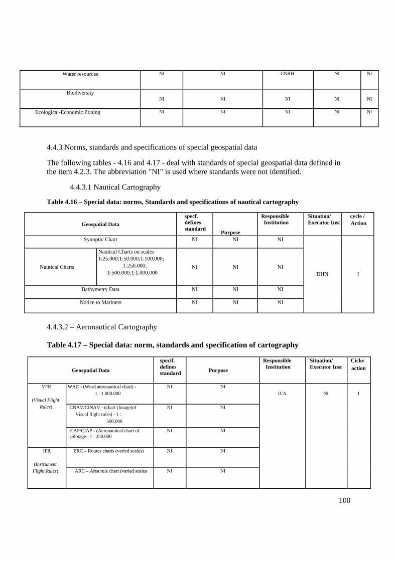
100
Water resources NI NI CNRH NI NI
Biodiversity NI NI NI NI NI
Ecological-Economic Zoning NI NI NI NI NI
4.4.3 Norms, standards and specifications of special geospatial data
The following tables - 4.16 and 4.17 - deal with standards of special geospatial data defined in the item 4.2.3. The abbreviation "NI" is used where standards were not identified.
4.4.3.1 Nautical Cartography
Table 4.16 – Special data: norms, Standards and specifications of nautical cartography
Geospatial Data specf. defines standard
Purpose
Responsible Institution
Situation/ Executor Inst
cycle / Action
Synoptic Chart NI NI NI
Nautical Charts
Nautical Charts on scales 1:25.000;1:50.000;1:100.000;
1:250.000; 1:500.000;1:1.000.000
NI NI NI
Bathymetry Data NI NI NI
Notice to Mariners NI NI NI
DHN I
4.4.3.2 – Aeronautical Cartography Table 4.17 – Special data: norm, standards and specification of cartography
Geospatial Data
specif. defines standard Purpose
Responsible Institution
Situation/ Executor Inst
Ciclo/ action
WAC - (Word aeronautical chart) - 1 : 1.000.000
NI NI
CNAV/CINAV - (chart (Image)of Visual flight rules) - 1 :
500.000
NI NI
VFR
(Visual Flight Rules)
CAP/CIAP - (Aeronautical chart of pilotage– 1 : 250.000
NI NI
ERC – Routes charts (varied scales) NI NI IFR
(Instrument Flight Rules) ARC – Area rule chart (varied scales NI NI
ICA NI I

101
SID – Standard departure Chart (varied scales)
NI NI
STAR – Standard Departure Chart (varied scales)
NI NI
IAC – Instrument approach chart (varied scales)
NI NI
VAC – Visual Approach Chart (varied scales)
NI NI
ADC – Aerodrome chart (varied scales) NI NI
PDC – Pre-departure clearance chart (varied scales)
NI NI
CAMR – Chart of minimum altitude radar (varied scales)
NI NI
FPC – Flight path chat (varied scales) NI NI
Chart Typo A – chart of obstacles (varied scales)
NI NI
ZPA
Zone Protection
Aerodome
PEPZA – Specific plan for ZPA (varied scales)
NI NI
NI I
4.5 Recommendations
The federal actors of the NSDI should, in due course, complete the tables of data and norms and specifications related to the themes of their responsibility having in mind the availability of geospatial data in DBDG. An action item addressing this task is foreseen in the Action Plan of the NSDI (Chapter 8).
References BRASIL. Decree no 6.666, of November 27th, 2008. Establishes within the Federal Executive, the National Spatial Data Infrastructure – NSDI (Considered interesting to complement). Official Diary of Brazil´s Federal Government, Brasília, DF, Nov 28th, 2008. Section 1, p. 57. DUBLIN CORE. Portal, 1999. Available on: http://www.dublincore.org/documents/dcmi-terms/. Accessed on:

102
FGDC. Content Standards for digital geospatial metadata. Reston, 1998. Available on: <http://www.fgdc.gov/standards/projects/FGDC-standards-projects/metadata/base-metadata/v2_0698.pdf>. Accessed on: > Feb, 28th of 2009. FREITAS, A., L., B. Catálogo de metadados de dados cartográficos como suporte para a implementação de Clearinghouse nacional. 2005. Dissertação (Mestrado em Engenharia)–Instituto Militar de Engenharia – IME. Rio de Janeiro, 2005. GEONETWORK. GeoNetwork opensource V2.2: the complete manual. [s. l.]: The Opensource Geospatial Foundation, 2008. Available on: <http://geonetwork-opensource.org/documentation/manual/geonetwork-manual/Manual.pdf>. Accessed on: April 22nd 2009. IGGI - Working Group on Metadata Implementation. The principles of good metadata management, 2004. Available on: <http://www.iggi.gov.uk/assets/downloads/files/prin_good_meta.pdf>. Accessed on: Feb 26th 2009. IGN/IDEE. Curso sobre IDE. [s. l.], 2008. Ministrado pelo Instituto Geográfico Espanhol (IGN) e Universidade Politécnica de Madri (UPM), no IBGE, Rio de Janeiro, 2008. 1 CD-ROM. IKEMATU, R. S. Gestão de metadados: sua evolução na tecnologia da informação. DataGramaZero, [s.l.], v. 2, n. 6, 2001. Available on: <http://www.dgzero.org/Atual /Art_02.htm>. Accessed on: 10 fev. 2004. LUNARDI, O. A., AUGUSTO, M. J. Infra-estrutura dos dados espaciais brasileira: mapoteca nacional digital. In: 7º CONGRESSO BRASILEIRO DE CADASTRO TÉCNICO MULTIFINALITÁRIO E GESTÃO TERRITORIAL, 7., 2006, Florianópolis. Anais... Florianópolis, 2006. SENRA. N. Informação estatística: política, regulação, coordenação. Revista IBCIT, v. 28, n. 2, 1999. Available on: <http://revista.ibict.br/ciinf/NSDIx.php/ciinf/issue/view/55>. Accessed on: March 4th 2009. ISO 19115: 2003 - Geographic information - Metadata. WEBER, E. et al. Qualidade de dados geoespaciais: relatório de pesquisa - RHAE / CNPq – RP-293. Rio Grande do Sul: Instituto de Informática. Universidade Federal do Rio Grande do Sul,1999. 37p.

103
Chapter 5
The Brazilian Directory of Geospatial Data As stipulated in Decree No. 6.666/08 (Annex I), "the Brazilian Directory of Geospatial Data (DBDG) is a system of data servers, distributed on the world wide web, able to gather electronically producers, managers and users of geospatial data with a view to storing, sharing and access to those data and related services. "This chapter deals with the logical and physical description of the DBDG as well as the Brazilian Geospatial Data Portal, named Systems of Geographic Information of Brazil or "SIG Brazil." This last is a virtual interface of the DBDG that enables the publication of information about geospatial data and services, enabling location and access to these resources.
Section 5.1 provides a brief connection between the NSDI and the interoperability patterns of electronic government established by the Federal Government (BRAZIL, e-ping (2008)), emphasizing its fulfillment in the course of the plan. Section 5.2 discusses the conceptual view of the DBDG, with the components identified. Non-functional requirements for all DBDG are presented in section 5.3. The Brazilian Geospatial Data Portal is described in section 5.4, while section 5.5 deals with a particular module of the portal: the administration module. Sections 5.6, 5.7 and 5.8 describe functional requirements to be implemented in the nodes of the DBDG, in a basic node of reference and in a hosting node, respectively. In section 5.9, it is detailed all the Information and Communication Security Policy for the NSDI. Finally, the section 5.10 provides reference configurations for the server components of the NSDI.
5.1 The DBDG and the interoperability standard of the electronic government
The implementation of systems distributed with resources of interoperability can be done through different technologies. In Brazil, the definitions relating to the technologies associated with interoperability are defined by the e-PING (http://www.governoeletronico.gov.br/acoes-e-projetos/e-ping-padroes-de-interoperabilidade):
The e-PING architecture - Interoperability Standards of Electronic Government - defines a minimum set of assumptions, policies and technical specifications that regulate the information and Communication Technology (ICT) use in the federal government, establishing the interaction conditions with the other branches and spheres of government and with the society in general.
The version 4.0 of the e-PING makes the following consideration about interoperability, when evaluating the different existing concepts:
"Interoperability is not only Systems Integration, and not only Network Integration. It does not refer only data exchange among systems. Not just addresses definition of technology. It is, actually, the sum of all these factors, considering, also, the existence of legacy systems, hardware platforms and software installed. It starts from principles that deal with the diversity of components, with the use of various products from different suppliers. The goal is the consideration of all factors so that the systems can act cooperatively, setting the norms, policies and the standards needed to achieve these goals "(Brazil, 2008b).

104
It is clear, in these considerations, that the achievement of the integration among systems of different institutions is a process that must be conducted in order to consider the different technological realities of the involved actors. This implies a technological proposal for the implantation of the DBDG that incorporates solutions to high or low technological capacity institutions.
The e-PING also defines a set of general policies that must be followed in the implementations of the specific segments that compose it, namely:
• Alignment with the Internet; • Adoption of the XML as a primary standard of exchange; • Adoption of Browsers as the principal means of access; • Adoption of metadata to government information resources; • Development and adoption of a Standard Metadata of Electronic government; • Development and maintenance of the list of Government affairs; • Market support for the proposed solutions; • Scalability; • Transparency; • Preferential adoption of Open Standards.
Regarding the data relating to the geo-processing area, the e-PING defines a set of opened standards that must be used. Those standards are based, primarily, on the definitions of the OGC (Open Geospatial Consortium - http://www.opengeospatial.org/).
Aligning to those definitions, the DBDG must follow the norms and policies set by the e-PING, predicting solutions for the participation of institutions with different levels of technological capacity and favoring the integration of servers through web services.
The construction of the NSDI portal should, still, follow the recommendations for the accessibility defined in the e-MAG (Model of Accessibility of electronic government), whose main concern is to ensure access to available contents on the portals and websites of the public administration on the world wide web for use by people with special needs.
In the remaining sections of this chapter, the guidelines of the e-PING applicable to the DBDG are highlighted.
5.2 Conceptual diagram of the DBDG
The Brazilian Directory of Geospatial Data will be implemented according to a multi-layer architecture, what can be better understood with the help of the Figure 5.1.
In the referred figure three layers are highlighted: the application layer, the intermediary layer and the server’s layer. Each one of these layers can be understood according to the following descriptions.
5.2.1 Application Layer

105
This layer is composed of web browsers or applications that are within the client domains. Both browsers and applications can interact with the DBDG through SIG Brazil Portal, while direct access to the geospatial data servers of the DBDG (located in the nodes of the network) are only possible through applications, since the current conception for this first implementation stage of the DBDG, its nodes will only provide web services. It is important to emphasize that the interactions of the application layers with the others must occur through the protocol Hypertext Transfer Protocol (HTTP) in order to minimize routing problems when using the World Wide Web to access the information. As example of user applications, products like gv-GIS, Quantum GIS, Google Earth, among others can be highlighted.
Figure 5.1 DBDG´s Conceptual Diagram
5.2.2 Intermediary Layer
The intermediary layer plays various roles:
1) register users, 2) control the access to stored information in the global catalogs, 3) process the requests generated by the application layer, 4) add metadata from the catalogs of remote servers, 5) provide access in a simple way, to the resources of DBDG, 6) provide functionalities for the DBDG maintenance; 7) maintain records of all geospatial data servers members of the DBDG; and 8) provide statistical data on the operation of DBDG that support a more effective scalability of its structure.
In order to meet these demands, the intermediary layer has the following components: SIG Brazil Portal and administration module. Functions 1 to 5 are performed by the SIG Brazil Portal, while the others are the responsibility of the administration module. Such components, due to their importance, are discussed in greater detail in the following sections of this chapter.
In the intermediary layer, the following entities can also be highlighted: the global metadata catalog, the server catalog and the Web server.

106
Global metadata catalog - Entity responsible for metadata storage, either data or geospatial services collected from all providers nodes of geospatial data. This catalog works with metadata consistent with ISO 19115/2003 and, more specifically, with the profile of this norm established by the National Commission of Cartography - CONCAR.
Servers catalog – Entity responsible for the information storage related to all geospatial data servers that integrate the DBDG. Such information is used in the operations of metadata retrieval for the composition of the global metadata catalog and in the collection of statistical data about the DBDG use.
Web Server - This is an HTTP server (Hypertext Transfer Protocol), responsible for publishing all SIG Brazil Portal.
5.2.3 Servers Layer
This layer is formed from several types of servers: geospatial data, web services, file and metadata (CSW - Catalog Service for Web) under the responsibility of producer organizations of geospatial data that integrate the DBDG. The set of servers under the responsibility of an entity provider of geospatial data is called node. This way, the DBDG can be characterized as a network of nodes that work together through interfaces based on open standards and that use the World Wide Web as a physical means of communication. The composition of geospatial data and services offered by a node is the exclusive responsibility of the organization to which it is linked, and it should meet the minimum requirements defined in this chapter.
It is important to highlight, also, the existence of a different node, regarding to scalability, designed to host geospatial data and metadata from institutions that do not have the minimum infrastructure required specified in this chapter. This node meets all the requirements surveyed for the common nodes and is under the IBGE responsibility. Their characteristics are discussed in the Section 5.8.
5.3 Non-functional requirements
In this section several non-functional requirements that must be considered in the implementation of the DBDG are defined.
5.3.1 General
Interoperability - The recommendations of the e-PING should be followed.
Maintainability- The system must be documented following the UML - OMG (2009) standard.
Accessibility - All the interfaces with the user must follow the guidelines foreseen in the e-MAG.
Availability - The institution producer of geographic information, responsible for the node, must ensure a minimum availability of 90%, considering a day of 8 hours.
Scalability - The servers must allow an easy aggregation of resources in order to meet future demands due to increasing volume of stored data and fall of performance due to increasing simultaneous connections.

107
Reliability
• Structure of power supply capable of maintaining the continuity of servers operation for periods compatible with the parameters defined in the item "availability";
• Average time to repair faults, in the subsystems components of a node, lower than 24 hours;
• Response time of the server maps application lower than 8s, and • Internet Channels with minimal bandwidth of 512 kbps exclusive to the DBDG
integration.
Security
• The node must have protection resources (hardware / software) that ensure the data and metadata integrity stored on their servers;
• The access of users/applications to data download could be achieved through identification implemented by the institution producer of the information.
• Strategies that ensure the metadata integrity during transferring operations to the global catalog of metadata must be implemented, and
• Other requirements are described in Section 7.1 of the e-PING.
5.3.2 Hardware
• It is recommended that servers and network devices have redundancy in order to ensure the minimum rates of performance established in the general non-functional requirements.
• It is recommended that the computers used for hosting related applications be homologated for operation with some distribution of operating system of open source.
• The new equipment must be purchased with a minimum of two-year warranty and on-site support, with 24h maximum attendance.
5.3.3 Software
• The implementation of map and metadata servers must be compatible with the services specified by the OGC: WMS and CSW. Additional services that may be offered by the institution should follow, whenever possible, the OGC corresponding specifications.
• It must be, preferably, adopted free or open source software in the composition of the servers.
• In case of opting for storing the geospatial data in a database, database management systems that have spatial module and allow an integrated approach to alphanumeric and spatial attributes should be preferred.
5.4 The Brazilian Portal of geospatial data
According to Davis and Alves (2006), geoportal is a "website that is an entry point to geographic content available on the Web." Thus, the SIG-Brazil will be a geoportal that will serve as the entry point to the DBDG.

108
The DBDG is the basic structure on which to develop the gateway to metadata and geographic data. Figure 5.2 shows the general structure of the access to data according to the model proposed in GSDI (2004).
Figure 5.2 – access to the data through Portal Source: GSDI (2004) adapted
In the diagram of figure 5.2, a person uses a search interface to perform a search, the portal then makes a request to one or more registered catalog servers, which in their turn consult their metadata bases, and from these, the data.
The implementation of this structure implies that, each institution has its "metadata and geospatial data services," so that the portal can search them and organize the answers to show the user. However, given the characteristics of the Brazilian public institutions, not all of them will be able to implement and maintain the services necessary for the functioning of a structure based entirely on "Web Services", this situation is also recognized by the e-PING itself.
Considering this reality, the DBDG foresees the following possibilities for publication of metadata and geospatial data in the Portal:
• From the institution’s own servers provider of the metadata and geospatial data. • From servers managed directly by the IBGE and that host metadata and geospatial data
from institutions that do not have the necessary infrastructure adherent to the requirements of the e-PING and of the NSDI.
This last possibility should be the result of agreement reached involving the IBGE and the referred institution. All procedure for the publication of these raw materials is discussed in the section correspondent to the administration module (Section 5.4).
The focus of the version 1.0 of the portal will be on metadata and WMS on the geospatial data publication. Subsequently, other web services will be available OGC standards.
5.4.1 Functional Requirements
The use case diagram of the figure 5.3 relates the foreseen functionalities initially for the SIG Brazil Portal.

109
Figure 5.3 – Functionalities of the SIG Brazil Portal
1. Options to search metadata:
• Through home institution - the user chooses the institution from a list; • Through Category - the user chooses the category from a list; • Through geographic extension - the user defines on a map the research extension or
inform the geographic coordinates; • Through federation units or cities - the user chooses the UF or the city from a list; • Through scale - the user informs the scale; • Through period of time - the user types the time frame; • Through free text - the user types any text, and • Through multiple parameters - the user uses mathematic and logical operators to define
the search.
2. Results of the metadata search:
When the search is finished, the metadata found will be shown in summarized form; by clicking on a summarized metadata, a complete metadata will be shown with options to download the text for local storage.
3. WMS Viewer services:
When searching for a metadata, the user can view the data through a WMS service. This WMS viewer will have standard browsing features (pan and zoom) and will permit the overlap of a layer with basic elements of reference.
4. Catalog of institutions participating in the DBDG:
It is about the list of registered institutions, containing at least the name, logo and contact information such as telephone number, email address, web site, list of services under its responsibility and information about the use or not of own infrastructure. The list will bring a statistical evaluation of the service availability, indicating the number of access attempts and the

110
number of success in the attempts. The statistics will be grouped by periods, namely: from the date of first the attempt, attempts at the last 30 days, attempts at the last five days and attempts on the day before.
5. Web services Catalog of data access:
The Web services addresses will be an integrant part of the metadata, but in this functionality, all the services will be listed and organized by provider institution. The list will bring a statistical evaluation of the service availability, indicating the number of access attempts and the number of success in the attempts. The statistics will be grouped by periods, namely: from the date of first the attempt, attempts at the last 30 days, attempts at the last five days and attempts on the day before.
6. Reference documents: is the list of the reference documents about the NSDI.
7. Schedule: is the schedule of events related to the NSDI or to the SDIs building.
8. Software catalog: is the catalog of software used in the portal and others considered relevant. The catalog must contain the description of the software, main functionalities, institutions that use and addresses to obtain.
9. Institutions catalog: is the list of the participating institutions of the NSDI, which have or not registered node in the DBDG containing at least the name, logo and contact information as telephone number, email address and web site. This catalog includes the catalog of participating institutions of the DBDG.
10. SDI Catalogs in other countries: it is the list of websites of the existing SDIs or under development in others countries.
11. Application catalog of geo-processing, organized into the following categories:
• Geographic Names • Interactive maps • Converters
12. Portal statistics:
• Number of access to the site • Number of registered metadata • Number of active services • Number of participating institutions • Number of participating nodes
13. Module for metadata creation and edition (Section 5.4)
14. Help module to the user:
• FAQ • Contact us • Help to users about the functionalities of the portal

111
5.4.2 Software
In Table 5.3 of the topic 5.10 there is a software recommendation to be used on the Brazilian portal of Geospatial Data server.
5.4.3 Hardware
In the Tables 5.1 and 5.2 of the topic 5.10, it is described a reference server to the Portal. The adoption of a scalable architecture, as a blade server, is very advisable. The recommendation of this action plan is that the infrastructure used in blade servers of the Topic 5.8 (chassis, rack, no-breaks, etc.) hosts the Portal’s server too.
5.5 The Administration module
The administration module is one of the components of the intermediary layer presented in Section 5.2 - Conceptual diagram of the DBD; it aims to offer tools with the purpose of maintain and manage the DBDG in a appropriate way, following in a precise and constant way the availability of artifacts (data, metadata and services), elaborating statistics for many different purposes, registering data producers and managing the interaction among the users and the SIG Brazil portal.
Figure 5.4 Use case diagram of the module
5.5.1 Functional Requirements
The administration module should implement the following functionalities:
1. CSW server’s of institution database: the module should be able to effect and maintain the register of metadata servers of the participating institutions in database.
2. Metadata database: the module should allow the registration and the online edition of metadata for those institutions that do not have the necessary resources to maintain them themselves. The metadata produced will be under the responsibility of the IBGE in relation to its storage and availability through agreements among the parties. The following options should be offered:
• Form for metadata entry • Form for entering metadata in XML format
112
• Importing Metadata in batch or individual 3. Geospatial data load: the module should allow the upload of its geospatial data to the IBGE servers, for those institutions that do not have the proper infrastructure. From this point, such data will be under the responsibility of the managerial body of the DBDG regarding the storage, confidentiality and availability, through partnerships established by mutual agreement. More details about this functionality can be obtained in the section 5.8.
4. Maintenance of the active services list: the module should be able to periodically map the active and inactive services.
5. Updated statistics maintenance: statistics such as access to the portal, amount of registered metadata, number of active services and participating institutions shall be collected and stored in database periodically.
6. Frequently asked questions (FAQ) maintenance: the module should keep record of the frequently asked questions and answers about the NSDI.
7. "Contact us" maintenance: the module should register in the database all the questions and suggestions from an online form available to users.
8. Help guide Maintenance: the module should maintain the Portal’s help guide.
9. News publication: the module should allow the publication of news elaborated in accordance with the CONCAR convenience and the DBDG managerial body.
The software requirements related to security, described in the items 7.1.7 and 7.1.10 of the e-PING reference document - version 4.0, should also be implemented in the Administration Module.
5.6 Network servers
As stated in the section 5.2, the DBDG consists of a network of servers that provide geospatial data and metadata through services. The set of servers under the responsibility of an entity provider of geospatial data is called node.
The servers components of a node may, under the institution provider of information, be physically separated or integrated into the same unit.
The kinds of data offered in the NSDI first cycle are defined in Chapter 4. The data, made available by the producer institution, may be stored in file systems and / or geographic database.
In the network servers, there might be nodes fully implemented from hardware and software resources, previously existing in the institution, or nodes implemented according to the specifications of a minimum node of reference, as recommended in the section 5.7. However, in any situation, the functional requirements in this section must be met. Similarly, the non-functional requirements such nodes should be in accordance with what is presented in the section 5.3.

113
The functional requirements of the other elements components of the network servers - Portal, Administration Module, reference basic node and hosting node - can be found in the sections 5.4, 5.5, 5.7 and 5.8, respectively.
5.6.1 Functional Requirements
For the first NSDI cycle, each node of the DBDG component shall provide, necessarily, the following functionalities:
1. Geospatial data Storage: geospatial data can, at each institution’s discretion, be stored in geographic databases or file system.
2. Storage of geospatial metadata in a local catalog: geospatial metadata shall be stored in a local catalog and available to access and retrieval through a catalog service.
3. Recovery of the stored geospatial data: mechanism for recovery (download) of stored geospatial data on database or system of file.
4. Visual access service to stored geospatial data: the web service, implemented in the node, shall provide images for in browsers visualization (maps service), from stored geospatial data.
5. Service for metadata location and retrieval: provides web service to locate and retrieve geospatial metadata stored in the local catalog.
Optionally, the nodes could offer functionalities in addition to those previously listed such as: geographic names service, coordinates conversion service, among others.
5.7 Reference configuration for a NSDI node
In this section, it is described a complete configuration of reference, hardware and software for a node, as recommendation for institutions that do not have infrastructure for data dissemination through the web. The functional and nonfunctional requirements of this configuration must meet what was presented in the sections 5.6 and 5.3, respectively. The recommendation of this Action Plan is that three machines be used in the constitution of the node: one application and CSW server, one file server and another one for database.
5.7.1 Software
The software recommendation for the three servers that constitute the node is given in table 5.3
5.7.2 Hardware
The hardware recommended for each of the three servers that constitute the node can be found in tables 5.1 and 5.2.5.3.
5.8 Data hosting, metadata and services of actors without own infrastructure.
This topic deals with the implementation of an infrastructure of servers for data producers bodies, members of the NSDI, but lacking technological, financial or administrative resources to make their data available according to the recommendations defined in this Action plan. The infrastructure described should be implanted in one of the headquarters of the IBGE and it will

114
be a distinguished node of the network server, once it will host data from several institutions. The functional requirements of this structure include all of those of a network node server and a few more, concerning the data maintenance, which will be done remotely by the producer institution.
It is also recommended, in this section, the hardware and software configurations to be followed. These configurations meet the non-functional requirements that were presented in the section 5.3. Regarding software used, the priority is given to solutions of free distribution.
The SIG Brazil portal will offer a functionality feature of the participating producers, as previously described. In this register, the participating body may choose to use their own servers or use the infrastructure available at the IBGE. This topic deals exclusively with the second option.
5.8.1 Functional Requirements
• Availability of the same functionalities of a network server node: according to Item 5.6.1. • Data Maintenance: The system should enable producer bodies to send and remove their
spatial data stored in the system. • Metadata maintenance: The system should enable producer bodies to register and edit
their metadata in the data stored in the system.
5.8.2 Data Storage and Maintenance
The data will be stored in file systems. This infrastructure should provide space on disc for each institution producer of data and FTP service so they can upload their files and keep their data stored remotely. If the files sent are considered of high volume, like most of the raster data, the supplying institution may, alternatively, record them on external media (CD, DVD, etc) and send them to the IBGE.
The environment and software configuration necessary for the correct availability of the data should, if possible, also be carried out, remotely, by the producing entities. If those who implemented the system verify the impracticability of this action line, it will be up to the IBGE to keep the environment and software configurations.
5.8.3 Data Format
Vector data, when in files system, must be stored in Shape file format and in the standards set by the e-PING. Raster data, in GeoTIFF format.
5.8.4 Software
The software recommendation to be used in the node of the data and metadata hosting are in table 5.3.
5.8.5 Hardware
This structure, that should be able to store data from several institutions, is more complex than the other nodes of the network server. This complexity grows as new data producers make use of the hosting resource. Aiming the scalability, a cluster of servers aggregated under a blade

115
architecture is proposed. The minimum configurations of reference are related in the tables 5.1 and 5.2.
It is recommended to duplicate this structure in order to ensure the availability.
5.9 Information and Communication Security policy for the DBDG (POSIC-DBDG)1
5.9.1 Objective
To establish doctrinal principles for the implementation, responsibilities attribution and maintenance of the structure established for the Information and Communication Security for the NSDI, in order to protect the collection of data received, processed, produced, used, transported and stored in the Brazilian Geospatial Data (SIG Brazil), as well as to maintain the access to its services under the technical and administrative responsibility of the IBGE.
5.9.2 Concepts
5.9.2.1 Information
Set of data, text, images, methods, systems, or any form of representation endowed with meaning in a specific context, in spite of where it is stored or the way in which it is transmitted or replicated.
5.9.2.2 Information and Communication Security
Actions that aim to enable and ensure the: availability, integrity, confidentiality and authenticity of the information.
5.9.2.3 Manager of Information and Communication
The employee that, in the exercise of its competencies, is responsible, even temporarily, by processing the information of a sector, body, system or project of the NSDI.
5.9.2.4 Information Processing
Implementation of the protection guarantees suitable to the actions of: reception, production, reproduction, use, access, transportation, transmission, distribution, storage, disposal/elimination and control of the information, including secrecy.
5.9.2.5 Security Breach
Action or omission, intentional or accidentally, that compromises the information and Communication security.
5.9.2.6 Term of Individual Commitment
1 Suited according to the normative instruction no 1, of july13, 2008, that “Disciplines the Management of the Information and Communication Security in the Federal Public Administration, direct or indirect, and supply with other needs”

116
Formal document, to be signed by the DBDG’s infrastructure user and through which are set rules to be met, establishing a bond of personal commitment to the preservation of the interests set by CONCAR for the NSDI.
5.9.2.7 Term of Equipment Lease of the DBDG
Formal document to be signed by user of the equipment belonging to the infrastructure of DBDG through which the user certifies being aware that it will be used exclusively for the business service and in accordance with the established software configuration.
5.9.2.8 Term of Access Authorization
Formal document that all users who access the SIG Brazil Portal should acknowledge, through which will be granted logical access rights to the digital collection of data and services.
5.9.3 Information and Communication Security (SIC) Structure
SIC structure is built by the union of two fundamental aspects: cultural and technological, since properly grounded by the highest level of the organizational structure and by a solid documental support, what makes possible to deal with the information in an organized, controlled and safe way.
Although it is not visible, SIC involves complex factors of difficult conduction, inspection and control due to the vulnerabilities existent everywhere and considered, in a work environment, as normal.
SIC controls over all virtual reality associated with a context where data and information result of an interrelation of computing resources, communication systems, human components and programs. For getting such control, due the difficulty to prove the authorship of an action in the virtual world, it is necessary to implement, institutionally, documents and instructions standardized, that, when well-constructed, act mainly to establish, in a legitimate and unquestionable way, the correlation between agent and fact.
There can be no doubt, dissonance or distortion among the outlined strategies for the implementation and maintenance measures of the SIC and the strategies outlined by the National Commission of Cartography, in order to achieve the organizational purposes.
It is in the cultural context that the human being fits, the employee is a key part of great complexity, through which flow all processes of information and bring with it a range of unpredictable variables, not always easy to solve.
The technological factor has lower complexity than the others, because it is composed by predictable variables that can in one way or another, be overcome or adjusted properly.
5.9.4 Structure of Managers of the Information and Communication Security (GesSIC-DBDG)
Each participating body or entity of the DBDG must formally name a GesSIC to take responsibility by the conduction of the POSIC-DBDG and their respective systems and servers that concentrate geospatial data. Such representative must have the knowledge needed to conduct

117
the matter as well as the respective authority to conduct the necessary adjustments in order to implement the internal data security and meet the demands of the DBDG manager.
The GesSIC-DBDG named by the bodies and participating entities of the NSDI will act under the guidance, orchestration and supervision of a IBGE GesSIC general coordinator, who will be responsible for applying the POSIC-DBDG. This general coordinator will be a key member of the work group dedicated to Technology, in the sphere of the NSDI Implementation Committee, according to the proposal of organizational model and coordination presented in the chapter 8 - Section 8.2.
5.9.5 The Responsibilities
5.9.5.1 of the General-Coordinator of the GesSIC-DBDG
• Fulfill the information and communication security policy, as well as the respective basic norms of security established for the NSDI.
• Interact with the others GesSIC-DBDG, in order to monitor the established measures of security fulfillment;
• Ensure the strengthening of the security culture; • Keep a training program of SIC for the GesSIC-DBDG; • Keep the DBDG prepared for any internal or external audits relating to the SIC, and • Guide and orchestrate the performance of the GesSIC-DBDG.
5.9.5.2 of the GesSIC-DBDG
The GesSIC-DBDG, by the available means and the general-coordinator guidelines, has the duty to:
• Suggest procedures and measures of protection for improving the infrastructure of the existing SIC;
• Implement the of the information and communication security policy as well as comply with the respective basic norms of security established to the DBDG;
• Assist the general-coordinator about SIC issues of his body or entity; • Change, propose, analyze and verify if the SIC requirements are being performed in
accordance with SIC policy in order to obtain the desired effect; • Identify the IT resources of its body or entity that need protection, according to their
respective degrees of confidentiality of information processed or stored by them. This procedure of identification should be formally explicit;
• Report promptly the SIC incidents to the general coordinator, after a preliminary evaluation, aiming security measures improvement;
• Prepare and send to the general Coordinator, a report of risks and vulnerabilities analyses, at least once a year;
• Analyze the impact of the interruption or implementation services and its consequences to the NSDI context, establishing a contingency plan;
• Present, implement, revise and adjust annually the contingency plan, applying periodic tests in the participant body or entity;

118
• Require the authorized external staff to perform services involving the DBDG computational resources the signature of the Individual Commitment and Equipment Lease Terms of the DBDG as well as the fulfillment of rules set in the referred Terms;
• Adopt measures so that the (installations, maintenance or corrections) services are performed without compromising the safety of digital information systems, and
• Ensure, by the available means and from the superior guidance received, that all the participating NSDI actors of the DBDG are aware of the SIC’s policy in force, through the DBDG terms of individual Commitment and of equipment lease signature.
5.9.5.3 of the components of the Information Systems Teams of the participating bodies and entities.
• Do not disclose characteristics of the local network, server equipments, and safety aspects applied in the services development;
• Help the GesSIC-DBDG to disclosure the safety rules established to the NSDI; • Advise the GesSIC-DBDG, when requested, in the evaluation of the SIC incidents. • Establish procedures to ensure that the backups are being made and stored properly and
securely, and • Execute contingency plan exercises
5.9.6. Applicability
The SIC measures shall ensure an acceptable level of protection in case of attack or damage towards the information resources. Such measures are applicable to:
• The activities involving legal procedures, processing or storing if information in electronic means;
• the information technology and to the digital information systems; • the internal and external users, to the GesSIC-DBDG and to the components of the IT
sectors of the respective bodies and participating entities that interact with the available services with databases under the NSDI context, and
• The contracts made with companies or third parties, whose scope involves access to the digital information of any kind, being integrated or not, available in one (or more) computer (s), server (s) or media by the local network, through intranet or Internet.

119
5.10 Reference configurations of the NSDI Servers
Table.1 Hardware
Cabinet Processors RAM Storage RAID Controller Others Estimated Costs (R$)
Servers of the SIG Brazil portal
Note: To be assembled on Blade chassis hosting node
2 quad-core units 2,33 GHz
64GB DDR2 667MHz ECC
2 HD SAS 300 GB
10.000 rpm
Support for SAS disks that implement RAID 0 and 1
2Ethernet Gigabit Network ports. hot-swap’s fun and power supplies and redundants.
35.000,00
CSW Applications Server
Tower 2 quad-core units 2,33 GHz
16GB BDDR2 667MHz ECC
4 HD SAS 300 GB 15.000 rpm
Support for SAS disks that implement RAID 0 and 1
4Ethernet Gigabit Network ports. hot-swap’s fun and power supplies and redundants.
22.000,00
File Server
Tower 2 quad-core units 2,33 GHZ
1BGB DDR2 667MHz ECC
4 HD SAS 300 GB 15.000 rpm
Support for SAS disks that implement RAID 0 and 1
4Ethernet Gigabit Network ports. hot-swap’s fun and power supplies and redundants
22.000,00
Node of the network
BD Server
Tower 2 quad-core units 2,33 GHz
16GB DDR2 667MHz ECC
4 HD SAS 300 GB 15.000 rpm
Support for SAS disks that implement RAID 0 and 1
4Ethernet Gigabit Network ports. hot-swap’s fun and power supplies and redundants
22.000,00
Hosting’s Node (Blade Server’s Infrastructure)
Blade Server 2 quad-core units 2,33 GHz (by processing blade)
64GB DDR2 667 MHz ECC(by processing blade)
External device type storage área network (SAN) space for 12 disks SATA/SAS initial capacity of 6TB
2Ethernet Gigabit Network ports Rack of 19˝ and 40 RU (rack unit). Blade Chassi compatible with the processing blades with appropriate ventilation and power supplies e that include the foreseen rack.
85.000,00 + 35.000,00 by processing blade

120
Table 5.2 Network equipments and power conditioning
Servers of the SIG Brazil portal
Router/Firewall Internet channel Switch No-break Estimated cost (R$)
Servers of the SIG Brazil portal ----------------- ----------------- ----------------- ----------------- 0,00 (same equipment of
the hosting’s node)
Network node Protocol LAN TCP/IP,NAT, DHCP, DNS, Pap,Chap, Protocol WAN TCP/IP integrated firewall, filtering adress, telnet management resource, console, web, VPN support, built-in switch with 8 ports with 10/100 base TX fast Ethernet and 1( one ) upstream port (WAN) routing speed 100 Mbps
512 Kbps
5 fixed IP adress
Minimum guarantee of 90% band speed contracted
24 ports at least 2 of them Gigabit Ethernet
Support to the VLAN
Administration’s surface
2800 W of power
Input voltaje 120/220 V and Output voltaje 120V
30 min. of autonomy
11.000,00 + 12.000,00/year (internet)
Hosting’s Node (Blade Server’s Infrastructure) Protocol LAN
TCP/IP,NAT, DHCP, DNS, Pap,Chap, Protocol WAN TCP/IP integrated firewall, filtering adress, telnet management resource, console, web, VPN support, built-in switch with 8 ports with 10/100 base TX fast Ethernet and 1( one ) upstream port (WAN) routing speed 100 Mbps
1 Mbps
5 fixed IP adress
Minimum guarantee of 90% band speed contracted
24 ports at least 2 of them Gigabit Ethernet
Support to the VLAN
Administration’s surface
8 KVA of power
Input voltaje 120/220 V and Output voltaje 120V
30 min. of autonomy
12.800,00 + 22.000,00/year (internet)

121
Table 5.2- Software
Operational System Managerial system of database
HTTP Server Map server
(WMS)
CSW server Metadata editing Container for Java Servlet
Servers of the SIG Brazil portal GNU Linux Postgre SQL with
spatial module PostGIS
Apache Geoserver Geonetwork Tomcat
Network node GNU Linux Postgre SQL with spatial module PostGIS
Apache Geoserver Geonetwork Tomcat
Hosting’s Node (IBGE’s Blade Server Infrastructure)
GNU Linux equipped with servers cluster management software
Postgre SQL with spatial module PostGIS
Apache Geoserver Geonetwork Geonetwork Tomcat

122
References
BEAUJARDIÈRE, J- OpenGIS® Web Map Server Implementation Specification. Version: 1.3.0, 2006 .Disponível em: http://portal.opengeospatial.org/files/?artifact_id=14416.
BRASIL. Decree no 6.666, of November 27th, 2008. Establishes within the Federal Executive, the National Spatial Data Infrastructure – NSDI (Considered interesting to complement). Official Diary of Brazil´s Federal Government, Brasília, DF, Section 1, n.232, p. 57.Nov 28th, 2008a. BRASIL, e-PING – Padrões de Interoperabilidade de Governo Eletrônico – Documento de Referência Versão 4.0, December16th, 2008b.
CASANOVA, M. A. et al. – Banco de Dados Geográficos, Curitiba: Mundogeo, 2005.
DAVIS, C. A, ALVES, L. L. - Infraestruturas de Dados Espaciais: Potencial para Uso Local – Ip Informática Pública, Ano 8, nº1, págs. 65-80, 2006.
GSDI – Developing Spatial Data Infrastructures: The SDI Cookbook, version 2.0, 25 january 2004. Disponível em: http://www.gsdi.org/pubs/cookbook
NEBERT et al. - OpenGIS® Catalogue Services Specification, 2007. Disponível em: http://portal.opengeospatial.org/files/?artifact_id=20555
OMG - OMG Unified Modeling Language (OMG-UML), Superstructure. Version 2.2, 02/02/2009. Disponível em: http://www.omg.org/spec/UML/2.2/Superstructure/PDF/

123
Chapter 6
6.1 Introduction
The human resources formation main drive is the training of new conduct approach or modifications of the previous ones. This concept can be considered as the development process to provide knowledge, skills and attitudes in order to meet the specific requirements of the various components and concepts of the National Spatial Data Infrastructure - NSDI.
A SDI has, according to the Agustin Codazzi Geographic Institute (IGAC, 2006), the technical, human and management aspects. In the present chapter the human aspect will be addressed, which is directly linked to the acquisition of knowledge and human resources formation. This aspect focus lies on the individual who is part of a group, a professional category, a sector, an organization. He is the target of training and capacity building in Information and Communication Technology (ICT) and Geospatial Information Technology (GIT), in study or research levels, to create cultural capital and knowledge, as outlined in Figure 6.1
Figure 6.1 the individual and the knowledge acquisition Source: Adaptaded of IGAC (2006)
The human aspect (IGAC, 2006) shows the need to consider individuals as a creator of knowledge. For this, it is necessary to channel efforts into developing new skills and strengthening the idea of education recycling, because often it is required to unlearn practices, and make room for new models.
The importance of considering the human aspect in structuring the NSDI refers to the valorization and investment in the individual regarded as the central point in this context. The main results of this investment are achieved through:
Group, Sector Category Organization
Training in ICT
Individual
Cultural Capital and knowledge Studies
and Research

124
• Creation of culture and appreciation of geospatial data and information usage and services from the NSDI;
• Establishment of support and awareness of the concepts, principles, and decision making process besides fundamental aspects related to the adoption of the NSDI;
• Clarification and motivation for engagement, binding, participating, sharing and using the NSDI by target-audiences in the strategic, operational and management levels;
• Understanding the importance of standards, specifications and patterns related to the production, diffusion and dissemination of data and information in the NSDI;
• Understanding the characteristics of data and information, products and services of the NSDI;
• Explanation of the characteristics of geospatial data and metadata production processes for the NSDI and its products;
• Promotion and motivation of the use and sharing of geospatial data and metadata by agencies not compulsorily linked to the NSDI (state, municipal and district agencies); and
• Promotion and motivation to prepare future professionals in academic and technical level, who participate in the implementation, maintenance, production and use of the NSDI and their geospatial data and information and metadata, among others.
In Contemporary Management Theory, according to Chiavenato (2006), Human Capital is considered in an organization as the set of skills and talents. Competence involves knowledge, skills, attitudes, interests, traits, value or other personal characteristic. The talent is outstanding and differentiated skills that an individual naturally has, and may or may not be developed or expanded. Thus, it is not enough for an organization to have people, the organizational structure and culture must be considered.
The investment in training and capacity building of human capital in the scope of the NSDI involves:
• The promotion, diffusion and dissemination; the institutional strengthening of the National Commission of Cartography (CONCAR) and the NSDI actors;
• The adoption of established patterns and standards & specifications; • The consideration of new development and industry technologies; • The generation and updating of data and information; and • The application of knowledge Management Techniques

125
Picture 6.2 represents areas involved in the capacity building and training of Human Capital
Figure 6.2 the human capital in the NDSI context Source IDEMEX (2008) adapted
All questions and clarifications on the terminology related to Knowledge Management are presented in Section 6.2 of this chapter. The following picture shows the target audience for HR training. 6.1.1 Target audience for HR training
Figure 6.3 components of the NSDI and its target audience
Components OF the NSDI
ooxWord://word/media/image139.png
Como explicado no capítulo 1, foram considerados na estruturação do público-alvo, os cinco componentes da INDE: Pessoas, Institucional, Dados, Tecnologia, Normas e Padrões. Considera-se que o componente Pessoas permeia os outros componentes, que são os sujeitos da capacitação e do treinamento. Desta forma o público-alvo levantado está
Institutional components of the
NSDI:Production organization and Users (strategic level)
Com
pone
nt “
PEO
PLE
” of
the Data components of
NSDI:Producers (managerial and operational levels) users (managerial and operational levels)
Technology component of the
NSDI:NSDI management and maintenance Documentation and data standard (Metadata)
Sstandard & specificationComponents of the
Quality and reliability (standardization, Harmonization and integration); Documentation and data standardization (Metadata)
NSDI PROMOTION and dissemination
Institutional strengthening of CONCAR and NSDI actors
KNOWLEDGE of MANAGMENT
HUMAN CAPITAL
Pattern, standarts & specification Generation of Data and
information
Technology Development
Industry

126
As illustrated in Picture 6.3: The component “People” in the NSDI Institutional segment comprises the strategic level of the producers and users organization; in the Data segment are managerial and operational levels of producers and users as well as the academic sector, the organized society and the citizens; In the Technology segment are the actors responsible for the NSDI management and maintenance; finally, in the component Standards & Specifications are the actors responsible for quality and reliability as well as those responsible for the data and metadata documentation.
A detailed description of the profile and guidelines for each target are listed in Section 6.3 of this chapter. 6.1.2 Concept of Capacity Building and Training
This item is intended to formalize the terminology used in this chapter and to establish an understanding of the capacity building and training stages.
In the context of the NSDI, capacity building is defined as the development of theoretical knowledge in order to target action, facilitate the construction of operative representations and make possible the hypothesis formulation. The theoretical knowledge can be characterized by concepts and disciplinary knowledge, organizational and rational, resources that provide support and security needed for the professional development in their activities/tasks and in the decision making (LE Boterf, 2003, apud Moreira, 2005) .
Training is defined as the development of the know-how which is built by "conduct, methods or instruments which practical application is dominated by the professional." Know-how is to be able to apply procedures in carrying out an activity/task (Le Boterf, 2003, apud Moreira, 2005).
For Chiavenato (2006), capacity building and training are professional education processes, applied in a systematic and organized manner, through which people learn knowledge, skills and competencies in terms of specific objectives, involving four types of behavioral changes, illustrated in Figure 6.4, namely:
Transmission of information: the essential element in capacity building and training programs is the content: information sharing among trainees and trained as a body of knowledge;
Skills development: especially the abilities, skills and knowledge directly related to professional performance;
Development or modification of attitudes: generally changing of negative to favorable attitudes; increased motivation, acquisition of new habits, new attitudes, and even new paradigms;
Concept development: capacity building and training can be conducted to raise the level of abstraction and conceptualization of ideas and philosophies.

127
Figure 6.4 Types of changing behavior through capacity building and training Source: Chiavenato (1999) adapted
The main goals of empowering and training people are: a) prepare them for immediate execution of tasks, b) provide opportunities for continuous personal development, and c) change their attitudes to increase motivation and receptiveness to a new situation. 6.1.2.1 – Capacity building and Training Cycle França (2007) and Chiavenato (2006) consider capacity building and training as phenomena that arise as a result of the efforts of each person, the intentional act of providing the means to facilitate learning. Learning is a change in behavior and occurs on daily basis and in all people. Capacity building and training should guide these learning experiences in a positive and beneficial direction, as well as supplement and reinforce them with planned activities, so that people at all levels (strategic, managerial and operational) can quickly develop their knowledge, attitudes and skills that will benefit themselves and the system. Thus, capacity building and training cover a programmed sequence of events that can be viewed as a continuous process, whose cycle renews every time it is repeated. The capacity building and training process resemble an opened system model, whose components illustrated in Picture 6.5, are:
• Inputs – trainees, organizational resources, data and information, knowledge, etc..; • Throughputs - as learning processes, individual learning, training program, etc..; • Outputs– skilled people, knowledge, skills, organizational success or effectiveness, etc..,
and • Feedback - evaluation of the procedures and results of capacity building and training by
informational or systematic research means, aiming constant improvements.
Capacity building
and
Training
Transmission of information
Skills development
Development of attitudes
Concept development
Increase people’s knowledge: Information about the NDSI and its produts/service, policy and guidelines, rules and regulation and their clients
Improve skills and abilities: Enable for the implementation and operation tasks, handling hardware, software, tools
Develop / modify behavior: Change negative attitudes to positive attitudes, awareness, and sensitivity of people with producers and users of the NSDI
Raise the level of abstraction Develop ideas and concepts to help people think globally and in large terms

128
Inputs Throughputs Outputs
Feedback
Figure 6.5 Capacity building and training as a system Source Chiavenato (2006) adapted
In broad terms, capacity building and training involve a process composed of four steps, showed in Figure 6.
• Survey of capacity building and training needs (Diagnosis); • Programming of capacity building and training according to the needs (Drawing); • Implementation and execution (leading); and • Results evaluation.
Figure 6.6 – Training process Source: Chiavenato (2006) adapted
6.1.2.2 Capacity building and training needs survey
The needs survey is the first step in planning the capacity building and training programs; and corresponds to the preliminary diagnosis of what should be done. This survey can be done in three levels of analysis (CHIAVENATO, 2006, and Lima et al. Al., 2008):
Trainees Organizational
resources
Knowledge, attitudes, skills, organizational success
Evaluation of procedures
Capacity building and training process of individual learning

129
• At the level of total organization analysis: the organizational system is evaluated in order to determine the emphasis to be given to the capacity building or training;
• At the level of human resources analysis: the human resources profile is surveyed (qualification, knowledge level required, attitude towards new situation, training time, description of the capacity building and training content) and
• At the level of tasks and operations analysis: the skill acquisition system is based on what is expected the person after the capacity building and training (attitudes and behavior). The human resources profile analyses defines the type and purpose of the qualification/training.
The needs survey should result in information, presented in Picture 6.7 for planning the capacity building and training program.
Figure 6.7 – Main points of a capacity building and training items Source: Chiavenato (2006) and Comparsi et.al (2008)
6.1.2.3 Capacity building and training schedule
Once conducted the survey and the capacity building and training needs are determined, it is time for the program, addressing the following items:
• Addressing a specific need at a time; • Clear definition of the capacity building and training goals; • Fragment of the work being carried out in modules, packages or cycles; • Determination of the capacity building and training content; • Choose the instruction and training methods, as well as the technology available; • Identification of the needed resources to implement the capacity building and training
program, as well as the type of coach or instructor, audiovisual resources, machinery, equipment, materials, manuals, etc..,
• Designation of the target audience to be enabled/trained (number of people, time availability, skill, knowledge and kind of attitudes, behavioral personal characteristics);

130
• Designation of the training program location, considering the following: in training centers or in the organization or in a virtual environment (distance learning);
• Season or frequency of training programs, time or occasion; • Cost-benefit analysis; and • Control and evaluation of results in order to verify critical points that require adjustments
and modifications, to improve program effectiveness.
Once the nature of skills, knowledge and desired behaviors are determined as a result of training programs, the next step will be the choice of teaching resources to be used in the training program in order to optimize learning, i.e., achieve the largest instruction volume and content (qualitative and quantitative) with the least expenditure of effort, time and financial resources.
The following pedagogic features can be used: lectures, seminars and conferences; workshops, case method (case studies), discussion groups, panels, debates, simulation and games; programmed instruction; technical meetings, teleconferencing, videoconferencing, audiovisual resources, multimedia communication, virtual learning environments, among others.
In the NSDI capacity building and training program should be considered different types of education systems, adapting them to the target audience and their needs. It can be either in person or at distance.
6.1.2.4 Capacity building and Training Program Execution and Evaluation
The capacity building and training implementation is directly related to the instructor, the type of learner, content and infrastructure. In this sense, some items are noted in the NSDI context, which should be considered for the training program success, namely (Chiavenato, 2006):
• Suitability of the training to the NSDI needs; • Quality of the content, pedagogic and didactic training; • Managerial cooperation and support (heads, directors or managers); • Instructor’s qualification and training; and • Student’s qualification, skills and abilities.
The capacity building and training program evaluation is crucial for the adjustment diagnosis and use of necessary corrections to reach pedagogic and didactic improvement and development in the teaching-learning process. Thus, it is necessary a continuous evaluation process, involving teacher, student, content and infrastructure, making sure that the objectives were achieved in all stages of the capacity building/training program (feedback process).
Thus, the evaluation of the NSDI capacity building and training program should check: • If the program has generated positive changes in the student behavior; • If achieved the capacity building and training goals established for the NSDI; • If there are student demands for new subjects or densification of themes presented, in
order to permanently upgrade the program, among others. 6.1.3 Considerations in Distance Education

131
Contemporary society is a reflection of socio-technical and cultural changes spurred by new information and communication technologies. According to Levy (1999), the boom of global interconnection of computers and its memories has been experienced lately, providing cyberspace. This new means of communication is powered by people interaction, in which, the human being is the key part of the gear. Unwittingly, people are inserted in the connection era, everything is in the network (Lemos, 2003).
A peculiar aspect of the cyberspace is the deterritorialization. The synchronous and asynchronous communications generate a new sense of time, space and communication and information transmission. This form of communication enables groups of people to consult and build in real time a common memory, even though they are at different times and places. No one owns this new space, but all are co-responsible for its maintenance.
In this context, Lemos (2002, p. 145) defines cyberspace as:
[...] an environment of pluralistic movement discussions, reinforcing a variety of skills and using the sub product of knowledge that is generated from the community bonds, being able to enhance the exchange of competencies, creating the collectivization of knowledge. The current dynamics of computer networks development and its exponential growth characterizes the cyberspace as a complex interactive and self-organizing organism.
In cyberspace emerges the phenomenon called cyberculture that, according to Levy (1999, p. 17), is "a set of techniques (material and intellectual), practices, attitudes, modes of thought and values that develops along with the growth of cyberspace."
Cyberculture has linked its existence to the interaction between manking and new technologies of information and communication. This communicational environment, where the computer and the Internet set the tone of the interactivity, has been providing the collective construction of a large volume of online information, creating a dependency relationship between information and society, that is, more and more people rely on the online information to work and study. Moreover, cyberspace has provided a favorable way to cooperative learning in synergy with the "collective intelligence" (Levy, 1998).
In this context of cyberspace and cyberculture, the Online Distance Learning (ODL) has been gaining importance, scaled by the possibilities created by the current stage of telecommunications development. Currently, distance education becomes the best alternative approach and transmission of knowledge to supply, with quality, to large portions of the population simultaneously (Landim, 1997).
Distance education is enhanced by Internet flexibility and interactivity and it stands as a symbol of permanent and continuing education, becoming an example of attraction and investment as a new learning environment.
The engagement of educational institutions to the ODL is growing, even with resistance, and surprisingly the number of companies seeking this type of education to train human resources is also growing. One of the factors justifying the strong engagement is the mobility that the ODL system offers in the context of cyberspace.

132
The actors in this system are not fixed in time and space. They can be connected to a computer in their home, work, school or university, and, most important, according to their pace of learning or teaching.
However, it is not enough just spread the knowledge in order to meet the demand for continuing education through distance education techniques, whose infrastructure and personnel cost in long term, is lower than in traditional teaching. One has to consider the increasing demand for quality education. Some teaching resources deployed on the web, such as virtual learning environments, video conferencing, computer games, and interactive simulators, enable customization and diversification of learning forms.
There are many definitions of distance education, but in the context of the NSDI, which aims to meet a considerable number of trainees in various locations in Brazil, occupying different positions in different federal, state, provincial, municipal and private institutions and agencies; the distance learning multimedia system is considered a two-way communication system with students away from and the teachers and helped by a support organization to meet the knowledge in a flexible way of a massive and dispersed population. This system is configured with only technical features that allow economies in scale. (MARIN RICARDO IBÁÑEZ, 1986, apud LANDIM, 1997).
Distance education, by definition, aims not only reduce the boundaries between school and those who want to learn, as well as minimize the problems of access to education, using, for this, the most diverse information and communication technologies.
6.1.3.1 Benefits and Limitations of Distance Education
As a valuable educational process set out in Brazil and in several other countries, distance education has benefits and limitations that should be considered for a successful NSDI capacity building and training program, as shown in Table 6.1 below, according to Palloff (2002).

133
Table 6.1 - Benefits and Limitations of Distance Education
Benefits Limitations Opening: reducing barriers to access, courses diversification, vacancies increase; Flexibility: time, place and pace of learning flexibility; the possibility to stay in the work place; training outside the traditional classroom; Effectiveness: the student is the center of the learning process; theoretical-practical training applicable to the professional activity; content developed by experts and use of multimedia; interactivity fostered by trained tutors; Continuing and Personal Education: developing of initiatives, attitudes, interests, habits and education values; job training; meeting the demands of various groups; Economy: cost reduction in comparison to classroom teaching systems; economies in scale outweigh the high initial costs; and Others: facilitates the standardization of concept and the reuse of content in order to formatting different courses according to the audience.
Cost: higher in the implantation process; Team: the formation of a multidisciplinary team working in an interdisciplinary way; and Interactivity: the student-machine relation can be an aggravating factor for the failure of a project in distance education, but investment in the training of tutors and the technologies that facilitate interaction tutor-student and student-student can be done. This interaction is important for the creation of learning communities in cyberspace.
Source: Palloff (2002)
6.1.3.2 Quality in Distance Education
The Ministry of Education and the Department of Distance Education developed a document called Quality Benchmarks for Distance Learning Courses (Neves, 2003), which is not legally binding, but the references there contained guide institutions in developing projects in distance education. This document presents ten basic items, listed below, which should be considered in ODL projects that focus on quality in its construction, dissemination and implementation:
• Managers commitment; • Project design; • Multidisciplinary professional team; • Communication / interaction between teacher and student; • Educational resources; • Supporting infrastructure; • Continuous and comprehensive quality evaluation; • Agreements and partnerships; • Transparency of information; and • Financial sustainability
A distance learning course requires investments with the preparation and hiring of the multidisciplinary team, with the acquisition and installation of physical and technological infrastructure, with the production and dissemination of educational materials, distribution and

134
maintenance logistics of products, among others. These investments involve money and time. In this administrative context of the ODL the manager commitment is critical to the project success.
The ODL has its own identity. It is not as simple as transpose the classroom to the digital environment using the most modern technological resources to have a good distance learning course. The flexibility inherent in distance education, regarding the pace and conditions of the student to learn, has to be considered. Then, a distance learning course requires administration; language; design; monitoring; evaluation; logic, technical, methodological and pedagogic resources. All these things have to be included in the project design.
In order to develop a capacity building and training program in distance education, the institution should have a multidisciplinary team, because, besides the specialist teachers in the available subject, the tutors and experts in distance education, we shall rely on professionals in different ICT among others, according to the course proposed.
Another relevant point for the success of a distance learning course is the institution's commitment with the communication and interactivity between teacher-student and student-student, preventing isolation and providing an exciting, motivating and supportive learning process. Nowadays, there are information resources and communication facilitators of this process.
For the educational resources - printed material, videos, television programs, radio, video conferencing, web pages, etc...- the key is to find harmony between their production and language logic with the learning objectives. There is no role model, due to socio-cultural diversity of the country.
The evaluation of distance education is crucial to the quality of the system. Systematic continuous and comprehensive evaluation of all aspects is needed, aiming adjust and readjust the chosen model, always striving for total quality.
Besides, it is necessary to evaluate student learning, for sure, which model should consider its learning pace and, when possible, allow the self-evaluation to make it more autonomous, promoting its intellectual independence.
6.1.3.3 Team of Distance Education
The team that develops ODL projects consists of experts from various disciplines, whose work involves from technological support to learning process achievement, through preparation of pedagogic materials with media resources, marketing strategy, courses development, training of tutors, among other activities. Santos (2003) describes the key experts who should compose an ODL team and their activities, namely:
• Instructional designer: this role is played by a teacher or a specialist in the course subject. To perform this function it is necessary to enjoy researching and reading. To prepare the courses is required for each subject and/or processes, check the pertinent literature, organize information in a logic sequence according to the objective of the course and the pre-qualification and training requirements, and build the course structure, trying to make it attractive, coherent and realistic (COSTA, 2004). The review of the elaborated ODL module is also played by this professional.

135
• Instructional designer: examines the needs, build the learning environment design, selects technologies according to the learning needs and the structural conditions of the students, and evaluates the processes of construction and use of the course.
• Web writer: articulates the content through a script that empowers itself from the use of different applicable languages and formats (hypertext, multimedia and mixing).
• Web designer: develops the script, created by webwriter, creating the content aesthetic/artwork from the digital language potential.
• Programmer: develop Virtual Learning Environments (VLE), creating programs and interfaces for synchronous and asynchronous communication, planned activities, file management and database.
• Tutor: It is a teacher who comes and takes questions from students throughout the course. It is considered a facilitator of the autonomous student learning, who shall interact with them in chat rooms, forums and course environment itself. Abilities to deal with the public, as well as communication and flexibility to adapt to new technologies are some important skills for a tutor.
• Instructor: is the teacher responsible to complement the teaching materials with face-to-face or distance lessons, with the synchronous or asynchronous ICT resources.
• Coordinator: is responsible for managing the project, monitor the activities with project management methodology, suit the educational and technological processes demands, define the processes, articulate the development of the activities between the educators, designers, programmers and final clients team, measure the proper technology infrastructure (software, hardware, data network) to execute educational projects, conduct research, tests and homologation of media outlets to be used in educational environment, and mapping and monitoring educational/technological intern processes aiming at the production of learning objects in different media outlets.
• Educator, is responsible for conducting the pedagogic review of educational projects to suit the distance education specifications; monitoring the design; developing and implementing educational projects aimed at ODL; ensuring alignment with business needs, consistency and the quality actions; advising and monitoring the work development of the tutor; managing the learning progression; monitoring student production; elaborating guidance material; producing pedagogic supporting material; observing and analyzing the performance of classes of distance learning courses; evaluating pedagogic project development; proposing evaluation models; promoting training of tutors; among other functions.
• Illustrator: is a professional with Fine Arts and/or industrial design degree who applies basic concepts of illustration (light and shade, anatomy, perspective and color), adapting them to different language as vector or traditional illustrations, varying traits, mastering different styles of traits and technologies that facilitate the use in the applied field. This professional is essential, since not always the web designer is trained to create a good illustration.
To create the team's commitment with an integrated and productive work it is necessary to create a dynamic curriculum that combines the skills and encourages the interdisciplinary involvement of the entire development team crossing the boundaries between teachers, students and content. Figure 6.8 shows the necessary link between the components for team success in distance education project.

136
Figure 6.8 Articulation for an ODL project success Source: Filatro, 2004
The quality of the ODL projects involve the participation of each team member, with their expertise and skills in the process of creating materials and content, and in the use of them in the learning process (Santos, 2003).
6.1.3.4 Virtual Learning Environment (VLE)
For Vavassori and Raabe (2003, p. 312), a virtual learning environment is "a system that brings together a number of resources and tools, enabling and enhancing their use in learning activities via the Internet at a distance course". Santos (2003, p. 226) goes further in this conceptualization of what a VLE is when he says that "it is not enough to create a website and make it available in cyberspace," because even if this site uses the hypertext feature, it is of fundamental importance to be interactive.
A virtual learning environment has some items that are important in its constitution, so that the environment provides an interactive communication and gather in its structure all the interfaces and resources that facilitate the interaction of characters involved in the learning process.
Santos (2003) offers some questions that should be considered in the construction of sites or software that will be available in the cyberspace as VLEs:
• Create hypertext sites that add the following features in its interface:
− Intertextuality: links to other sites or documents; − Intratextual: connections with the same document (able to return to the starting or the
previous point − Navigability: simple environments of easy access and transparency of information; − Mix: combine several languages (sounds, text, static and dynanic images, graphs,
maps)

137
− Multimedia: integration of various media supports. • Strengthen in this site the possibilities of interactive communication
− Synchronous: real-time communication; − Asynchronous: communication at any time, sender and receiver do not need to be
connected at the same time. − • Create research activities: to stimulate the construction of knowledge from problem
situations that need to contextualize issues of the significant universe of the subject. • Strengthen formative evaluation: to stimulate knowledge that will be constructed in a
communicative process of negotiations, (re)signifying the authorship and co-authorship. • Provide and encourage ludic artistic connections and fluid navigation. • Adopt the concept of usability by standardization of the interface.
The VLE interface shall have, besides hypertext, coupled interfaces that facilitate the contact between people and the decentralization and distribution of information, encouraging interactivity in these environments. This means synchronous or asynchronous communication interfaces, namely:
• Forum: can be defined as a website whose sole purpose is to allow questions about a particular subject and make them available for others to answer or check them or even to propose new questions (VAVASSOURI, Rahab, 2003, p. 313).
• Chat: commonly known as chat room. It allows participants to communicate in real time in a global communication among students, teachers and guests in rooms of different subjects and interests. It also allows private conversations. (VAVASSOURI; Raab, 2003).
• TeamWave: it is a chat in real time interface, incorporated to learning environment that allows more structured conversations that can be documented (recorded).
• Cu-See Me: abbreviation in English- See You See Me, which is a videoconferencing system that allows chats in real time using image (video), sound and text (VAVASSOURI; Raab, 2003).
• Discussion list: they are used for asynchronous communication and are similar to the forum. The fundamental difference is that messages are socialized in the form of electronic mail in where the user does not need to access a specific environment in cyberspace to send and receive messages. Many prefer the mailing list to forum because of the familiarity with the message boxes (SANTOS, 2003).
Currently there are virtual learning environments that make use of the above resources for free supporting the tutor-student and student-student interactions, and that can be customized to meet needs of capacity building and training programs in the distance education, in organizations and academic institutions.

138
6.2 Knowledge Management
It is intended to implement in the NSDI a management model that involves an integrated set of methodologies, techniques and technological resources suitable to the creation, dissemination and sharing of knowledge generated through its technical groups.
Under the laws that govern the new organizations, what matters is not limited solely to the spheres of production and distribution of objects. The ability to generate information and to produce knowledge becomes crucial on the agenda of competitive organizations. Therefore, to establish interactive streams that provide permanent information sharing and encouraging the production and dissemination of knowledge is the role of knowledge management and differential factor in competition between modern institutions.
The implementation of this process of knowledge management using Information and Communication Technology (ICT) tools aims to:
• Establish dynamic of continuous learning; • Allow the creation and dissemination of knowledge; and • Install the processes needed for knowledge management, permanently stimulating
creativity and proposing innovations in the activity field of the NSDI.
Thus, this section aims to present some considerations on the knowledge management and its terminologies.
6.2.1 Concepts Relating to Knowledge Management
Initially it is necessary to review the concepts presented in Chapter 1 (Section 1.3.1) to distinguish information from knowledge, thereby differentiating between Knowledge Management and Information Management.
"The information is generated from any treatment or processing of data by its user, involving, in addition to formal procedures (translation, formatting, merging, displaying, etc..), cognitive processes of each individual."
It can be said that information is the result of a research over a set of data, followed by an analysis and in any way explicited, by any comment, graphic creation, or reports, among others (SAMPAIO, 2003)
In line with the concepts of Chapter 1, knowledge can be understood as the interconnection of the meanings that people make in their minds between information and its application in a set of actions (Dixon, 1937). Polanyi (1983) distinguishes two types of knowledge, namely: explicit knowledge and tacit knowledge.
The explicit knowledge involves knowledge of facts, and is acquired primarily through information and often formal education. This kind of knowledge is documented in books, manuals, databases. Tacit knowledge is subjective because it is based on personal experiences and beliefs, formed within a social, professional and individual context; is not owned by an organization or a community but by the individual and his cognition.

139
In today's world, where organizations need to create and exchange information faster and in greater volume to be more competitive, it becomes necessary to make reuse and exchange of tacit knowledge, which is poorly documented and not managed in the interactions between people (Sampaio, 2003). According to this author, knowledge management is indispensable for the propagation of information in order to get people to perform tasks effectively, assisting in decision making, providing means of collaboration, assisting the management skills and spreading and disseminating the individual knowledge. Gartner Group (2008) defines knowledge management as:
[...] A discipline that promotes, with integrated vision, management and sharing of all information assets owned by the company. This information may be in a database, documents, procedures, as well as in people, through their experiences and skills.
There are various definitions of knowledge management in literature. However, in the NSDI scope, the definition proposed by Burk (2000) is considered appropriate since knowledge management is treated as a continuous process of capturing and sharing expertise of a community to accomplish the mission of an organization. According to this author, knowledge management offers the community the opportunity to build a collaborative innovative culture, which shares knowledge and is always engaged in learning. (BURK, 2000).
The knowledge management approach takes the organizations to change the capital perspective, no longer being only tangible and starting to aggregate intangible assets, formed by the environmental, structural, intellectual and relationships capital.
The environmental capital consists of a set of factors that describe the businessess environment where the organization operates. The Structural capital is the necessary infrastructure for the organization functioning, formed by the set of administrative systems, models, routine, trademarks, patents, culture, and computer programs. The Intellectual capital consists of people and considered the greatest asset of an organization. This capital belongs to the individual and is defined by the capabilities, skills, experience and formal knowledge from the people within an organization to generate revenue or increase their prestige and social recognition. Currently, an organization aggregates value and therefore is more competitive for attracting, collecting and maintaining its intellectual capital. And finally, the capital of relationships is the key for success by linking partners and employees at all levels: strategic, tactical and operational. It is through this capital that an organization obtains financial and reputation return which leads to provide data information, products and quality services.
6.2.2 Knowledge Creation
The process of knowledge creation, according to Nonaka & Takeuchi (1995), consists in transforming tacit into explicit knowledge, storing it, changing it, broadcasting it, spreading it and reusing it in the organization, through sequential flow based on socialization, internalization, outsourcing and combination, as shown in Picture 6.9.

140
i: individual g: group o: organization
Figure 6.9 - Spiral of knowledge Source: Nonaka & Takeuchi, 1995
Socialization is the sharing of tacit knowledge. There should be an interaction among individuals that somehow, stimulated, begin to share knowledge, i.e. skills, experiences, ideas, perceptions, etc...so it will occur. An individual can acquire this knowledge from another, even without using any language, because it may be acquired through observation, imitation and practice. Externalization is the conversion of tacit into explicit knowledge. It consists in turning the knowledge of an issuer individual in an articulate and transferable knowledge to the receptor individual, through a written language or any representation, for example, graphics, symbols or other resources. It is through externalization that the organization can map the tacit knowledge and make it applicable to their processes. Combination is the occurrence of combined explicit knowledge to generate new knowledge through processes of adding information, rating or categorizing the explicit knowledge presented. This can happen when individuals combine and exchange knowledge through e-mails, meetings, documents and even in informal conversations. Internalization is the conversion of explicit knowledge into tacit knowledge. It is created through the interpretation of explicit knowledge that are in manuals, books, regulations, communications and various types of documents in the organization. The internalization can be described as a way to get the tacit knowledge or know-how, which should be placed in documents to facilitate the transfer to other people.

141
The spiral of knowledge occurs at first in the socialization, while tacit knowledge is exchanged and then converted to explicit knowledge through externalization. Starting the process of combining, the newly acquired knowledge is mixed to the existing one, generating new knowledge to the organization. Finally this new knowledge will be internalized and transformed into manuals, documents, regulations, etc.., making the whole process restart, through socialization. For an effective spiral of knowledge in the organization, it is necessary that the involved actors are sufficiently motivated and it is also needed full dissemination of knowledge, which is the aim of the organizational policy and guidelines, so that all live in a propitious and collaborative environment. 6.2.3 Components and Functions of Knowledge Management According to Garvin (1993) an organization based on knowledge/learning, recognizes knowledge as a strategic asset that can be created to be processed internally and used externally, using the potential of its intellectual capital, in which the worker of knowledge is a critical component. According to Pereira (2007), the components of a model of knowledge management are formed by:
• Strategy: aligns the core competencies of the organization with the knowledge management;
• Structure: defines the organizational model as a flexible structure and appropriate to the knowledge management practices;
• Process: includes the functions and practices of Knowledge Management oriented towards results; and
• People: redirects the process of HR management in the organization (Strategic People Management) with a focus on Skills Management and Corporate Education.
According to Argyris (1992) the functions of knowledge management include the organizational learning (create/capture) and skills management (evaluate). Organizational learning is the process by which an organization exercises its selective competence and intelligence to respond to its internal and external environment. It is an ongoing process to detect and correct errors. The management of competence can be institutional and individual. The institutional competence considers the organization as a set of institutional powers (of the organization) and the individual competence (of each collaborator) employed in the organization: processes; techniques; flow; in the products and services; and in the social environment. 6.2.4 Support System for Knowledge Management

142
The support system for knowledge management has its technological origins in the Internet through the development of search engines, portals, groupware, information management, business models, management by processes and qualities, organizational learning, artificial intelligence, and more recently, through the management of intellectual capital (Terra, 2001). This system helps the process of capturing and storing acquired and explicit knowledge in a shared base accessible to all members of an organization. It uses technologies that encourage and allow the generation, systematization, codification and transfer of knowledge, developing tools that are easily used and enable resources to be used efficiently applicable in performing tasks. The generation of knowledge includes all activities that add new knowledge to the individual and the group. This includes activities of creation, acquisition, addition, adaptation and diffusion of new concepts. The codification of knowledge is the capture and representation of it so that it can be used by another person or organization. This transfer involves the movement of knowledge from one place to another and, consequently, its absorption. A support system to knowledge management is effective when it allows organizations to increase the productivity and extend their values efficiently for both work group and individual. Thus, a support system to knowledge management aims to manage the acquisition, organization, refinement, analysis, dissemination and knowledge dissemination in all its forms within an organization (Brint, [200 -]). According to Tiwana (2000) apud in Sampaio (2003), architecture of support system to knowledge management has five metacomponents, showed in picture 6.10:
• Knowledge flow: facilitates the knowledge flow within a knowledge management system;
• Mapping information: aims to link information and map them so they are able to be converted into organizational knowledge;
• Source of information: data source that feed data and information to knowledge management systems;
• Exchange of information and knowledge: no technological tools and facilitators that provide the exchange of tacit and explicit information, help to create and share context and facilitate the adaptation of knowledge about the new context, and
• Intelligent agents and mining information: their purpose is to mine information, seek and find knowledge.
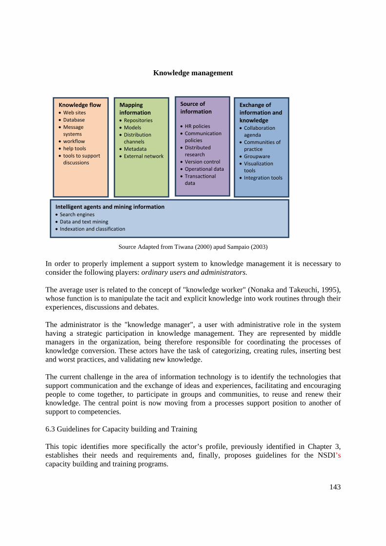
143
Knowledge management
Figure 6.10 – Metacomponents
Source Adapted from Tiwana (2000) apud Sampaio (2003) In order to properly implement a support system to knowledge management it is necessary to consider the following players: ordinary users and administrators. The average user is related to the concept of "knowledge worker" (Nonaka and Takeuchi, 1995), whose function is to manipulate the tacit and explicit knowledge into work routines through their experiences, discussions and debates. The administrator is the "knowledge manager", a user with administrative role in the system having a strategic participation in knowledge management. They are represented by middle managers in the organization, being therefore responsible for coordinating the processes of knowledge conversion. These actors have the task of categorizing, creating rules, inserting best and worst practices, and validating new knowledge. The current challenge in the area of information technology is to identify the technologies that support communication and the exchange of ideas and experiences, facilitating and encouraging people to come together, to participate in groups and communities, to reuse and renew their knowledge. The central point is now moving from a processes support position to another of support to competencies. 6.3 Guidelines for Capacity building and Training This topic identifies more specifically the actor’s profile, previously identified in Chapter 3, establishes their needs and requirements and, finally, proposes guidelines for the NSDI’s capacity building and training programs.
Knowledge flow • Web sites • Database • Message systems
• workflow • help tools • tools to support discussions
Mapping information • Repositories • Models • Distribution channels
• Metadata • External network
Source of information • HR policies • Communication policies
• Distributed research
• Version control • Operational data • Transactional data
Exchange of information and knowledge • Collaboration agenda
• Communities of practice
• Groupware • Visualization tools
• Integration tools
Intelligent agents and mining information • Search engines • Data and text mining • Indexation and classification

144
The picture 1.2 from Chapter 1, defines five groups as the NSDI components. Given that the group keeps People in matrix with other groups, the target audience of the capacity building and training program proposed in this chapter is restricted to four residual groups: Institutional, Data, Technology and Standards & Specifications. Still in order to relate the target audience, which shall be submitted to the capacity building and training, here are some remarks on the Decree-Law No. 243/67 which lays down the guidelines and bases of Brazilian Cartography and gives other measures, and on the Decree 6666/08 (Annex I) about the sharing and dissemination of geospatial data and metadata, and managing the DBDG GIS Brazil. The article 2 of the Decree-Law No 243/67 states that the cartographic activities throughout the national territory are carried out through a single system - the National Cartographic System - subject to discipline plans and normative instruments, according to the rules of this Decree/law. The sole paragraph clarifies that the National Cartographic System is constituted by the national, public and private entities, whose main function is to perform cartographic works or related activities. The definition of the target audience involved in the implementation of the NSDI goes far beyond the article being discussed, since it takes into account all those interested in geo-information. According to article 3 of the Decree No. 6666 of Nov 27th, 2008, the sharing and dissemination of geospatial data and metadata is mandatory to all agencies and entities of the Federal Executive Power and optional to agencies and entities of the state, county and municipal Executive Power. This article further extends the scope of target audiences, since the State, Federal District and City Council align their public policies with the national. This process, favorable to the federative system, aims to minimize costs and establish partnerships among the entities in chasing common goals inherent to the NSDI. It is observed that the NSDI target audience identified by its components and actors comprises the following groups: Corporate NSDI Management Standards & Specifications Management, Production and Use of Data Production of Geospatial Data and Information (governmental actors, private sector and civil organizations) Documentation / metadata Use of Geospatial Data and Information (governmental, private and civil organizations) Technology NSDI Management (administration and management, information security and communication, access, retrieval and distribution) 6.3.1 Profile and Guidelines for the target-Audience

145
Below are the details of the previously identified groups, with their profiles and guidelines for the preparation of the capacity building and training program. 6.3.1.1 Institutional In this group are included public and private managers, civil organizations, such as: state, municipal and district managers; ministry managers; directors of the administration bodies direct and indirect (municipal or foundational) and directors of private companies and civil organizations that are associated with the production, use and management of geospatial data and metadata. Through legislation, there is the obligation of meeting the needs of this public when it comes to the federal level, and, whenever possible, taking into account the needs of the public counterpart at the state, district and municipal level. In this group are also included individuals responsible for the development of Standards and Specifications of the legal assignment of each institution. Profile This group of individuals has the strategic and decisive power in their organizations since the establishment of public policies, of management and administration, and even the production of geo-information. Analyzing the structure of the Brazilian public administration, a non-exhaustive list of skills that constitute the institutional profile of the group:
• Elaboration and proposing public policies related to the generation and strategic management of geospatial data;
• Strategic decision in associations of development regional, local and other institutions of associative character to support socioeconomic development activities;
• Political decision in the central, regional and local management, linked to development, planning, socio-economic infrastructure, agricultural and environmental regulation;
• Management companies in the area of consulting and project design; • Management of service companies specializing in the field of cartography, geography,
geosciences, geospatial data and information production, modeling, development and management of databases and in the area of decision support systems;
• Institutions management connected to public security and intelligence; • Education and research institutions management; • Interorganizational coordination committees related to production, management and use
of geospatial data and information, and • Non-governmental organizations involved in the production and use of geospatial data
and information. Guidelines: Knowledge should provide the necessary understanding to the discussion, drafting and proposal of public policies, in order to create strategic guidelines and promote the NSDI actions. It is important that the manager is encouraged to visualize the matrix, i.e. the overall context of the production, dissemination and use of geospatial data and information, in combination with the other sectors of society.

146
It is necessary for managers to understand the benefits and the issues related to the adoption and implementation of the NSDI. Thus, the engagement of participants is essential as a factor of success of this initiative. The emphasis of the training programs should be focused on the target audience of each part. Considering the occupation switch of positions of high rank, the managers of permanent staff should also be addressed. For this target audience it suggested the thematic related to the modules: basic conceptual understanding to adopt the NSDI, Benefits of the NSDI adoption; Characteristics of the NSDI data, products and NSDI services and promote the inclusion of the NSDI themes in universities and technical schools, which are proposed in Capacity building and Training Program Table, in the Section 6.4. Considering the profile of the managers, the techniques to be used should be objective, concise and motivating. The higher the hierarchical level of management, the option should be for workshops and seminars. For this audience it is important to emphasize that the capacity building and training modules address the obligation of the themes set out in the Decree No. 6666/08. The training and capacity building should be promoted, if possible, in the location of the institutions. They may be ministered in the agency/institution in training centers established by the National Commission of Cartography (CONCAR), or through distance education systems. 6.3.1.2 Management, Production and Data Use This group includes the institutions and the bodies that produce and use geospatial data and metadata of the NSDI, also including geospatial data producers who fill the managerial, tactical and operational (staff) position. The users (individuals, group of individuals and/or bodies/institutions), holders or not of technical knowledge, are responsible for the use of data provided by the NSDI. 6.3.1.2.1 Producers Among the producers of the NSDI geospatial data and metadata (identified in Chapter 3 - Section 3.2) will be the focus of the capacity building and training programs proposed in Section 6.4, all professionals in the managerial tactical and operational levels of bodies and entities of the Federal, State, County and Municipal Executive Power, whose activities are related to the production of geospatial data and metadata. Profile Reference data: professionals and technicians, properly skilled by Regulatory Committee of the Engineer and Geosciences, who work directly on the production of referential geospatial data.

147
Thematic data: professionals and technicians, properly skilled by a regulatory committee of the related fields, who work directly on the production of thematic socioeconomic, territorial and environmental geospatial data. Value-added data: professionals and technicians, skilled by regulatory committee of the related fields (item to be observed in the NSDI cycle II), who use and generate geospatial data related to the regional, state, municipal, urban and other sectors with wide range of thematic detail and geographic coverage. Geospatial Metadata: professionals who document the reference thematic and value-added data, using the metadata profile established by the National Commission of Cartography (CONCAR), which allows the use of geospatial data and information consistently. Guidelines The knowledge should provide the necessary understanding for the production of geospatial data and metadata according to the norms, technical specifications and CONCAR’s standards, to promote the NSDI actions. The promotion of culture of data documentation, by the producer agencies of geospatial data and information, according to the Brazil’s Profile of Geospatial Metadata (MGB Profile), enables the exchange of data and information between the various sectors, thus avoiding duplication of efforts and wasted resources, NSDI requirements, as provided in paragraph III of Article 1 of the Decree No. 6666/08. Producers should be trained about the NSDI benefits, its importance and purposes, its operation, its regulations, technical specifications and standards pertaining to the production of geospatial data and metadata, as well as learn about the legal duties and responsibility of production and data and metadata updating; the characteristics of the generating processes of data, products and metadata, in order to make them available in DBDG GIS Brazil. The training programs should emphasize to the data producers the importance of the coordination and the agreements of geospatial data and information sharing with other sectors of the society. For that target audience (management, tactical and operational level) are suggested the themes comprising the modules: basic conceptual understanding for adoption of the NSDI; benefits of adopting the NSDI; Norms, specifications and standards related to the production of data and metadata; Application of norms, specifications and standards in the generation of data and metadata; Characteristics of production processes of geospatial data and metadata and its products, and Practice for the production of geospatial data and metadata, including data conversion, which is proposed in the NSDI Capacity building and Training Programs (Section 6.4). The trainings and capacity buildings should be disseminated, if possible, inside the institutions. They may be done in the agency/institution, in training centers established by CONCAR, or through distance education systems.

148
6.3.1.2.2 Users Profile Users are members of the federal, state, municipal and district bodies, of the direct and indirect administration bodies (municipal or organizational); from the private sector, of civic organizations, nongovernmental organizations and associations (NGOs); and citizens (average user not linked to any organization or entity), who use the data and metadata provided by the NSDI in order to integrate them in different applications, making thematic analysis of various subjects and, or simply using the services of GIS Brazil. Users are deemed collaborators for the development, enrichment and evolution of the NSDI, having essential role in the generation of value-added data. This exchange of information would consist in the NSDI service, and this information shall be properly certified (item to be set from Cycle II). Guidelines The users considered in this item may have access to information, know it, evaluate it, acquire it, integrate it and use it in different applications, promoting the use of geospatial data, thus materializing their importance in activities or projects that does not predict the use of this type of data. The NSDI will provide for the academic department and researchers with subsidies for studies and projects in the search for creative solutions to the problems of society, with the use of geospatial information and technologies as well as for research, education and entertainment projects, through reliable and updated case studies. The private sector may be actively and defined linked to production, maintenance, custody and distribution of value-added data, as well as in the creation of products and services of geospatial data and metadata. With access and knowledge of geospatial data, the organizations would promote government transparency and dissemination of their activities. Capacity building and training programs shall cover knowledge and the NSDI concepts, emphasizing the main aspects: the benefits of its adoption, the principles, guidelines and needed general requirements, the importance of norms, specifications and patterns of production and dissemination of data and metadata, and the NSDI data, products and services characteristics. These training programs require the insertion of the following topics: clarification of the NSDI legal framework; importance of management, documentation of geospatial data and information (metadata), and quality and reliability (standardization, harmonization and integration). The capacity training for this target audience will include: emphasis on the aspects and benefits of adopting the NSDI, in the principles, guidelines, general requirements, at a managerial tactical and operational level; presentation of the general characteristics of the NSDI data, metadata, products and services; insertion of the NSDI themes in teaching and research institutions, which are proposed in Table Capacity Building and Training Program in the Section 6.4.
149
The training and capacity building should be promoted, if possible, in the institution locations. In the agency/institution building, in training centers defined by CONCAR, or through distance education systems. 6.3.1.3 Technology 6.3.1.3.1 Management of the DBDG and SIG Brazil The Decree No. 6666/08, in its article 1, states in its first paragraph one of the major goals of the NSDI: "promote appropriate planning in the generation, storage, access, sharing, dissemination and use of geospatial data". The decree text highlights the need of a component in the area of Information and Communication Technology (ICT) for implementation, as defined in the Decree, of the direct Brazilian Directory of Geospatial Data (DBDG): system of data servers, distributed worldwide in the computers network, able to electronically gather producers, managers and users of geospatial data, aiming storing, sharing and access to these data and related services. To effectively implement the legal framework of the NSDI, it is necessary a set of technologies maintained and managed, at the operational level, by skilled professionals in the field of Information and Communication Technology (ICT) and Geographic Information Technology (SIT). These professionals should form multidisciplinary teams linked to the producers of geospatial data. They will be responsible for data and metadata management and maintenance of geospatial services provided by the NSDI through the SIG Brazil; therefore, they consist in a target audience for the NSDI training. Profile The target audience addressed in this item consists of ICT professionals: database managers, network managers, computer systems analysts and developers, support analysts; and professional SIT: spatial database analysts, geoservices systems analysts and developers, and information security professionals. Guidelines Training programs for this group should address the demands of implementing the DBDG and GIS Brazil, and the professionals in the production of geospatial data and metadata, according to norms, technical specifications and CONCAR standards for the promotion of the NSDI actions. These professionals should be trained in the NSDI purpose and operation, its regulations, technical specifications and standards related to the production of geospatial data and metadata, as well as knowing the characteristics of the processes of generating data, metadata and products, with the purpose of making them available in the DBDG and GIS Brazil. The professionals will be trained to develop, implant, manage, maintain and operate the DBDG and GIS Brazil, providing customization and development of new tools, and information security and communications systems, whose modules are suggested in the Capacity building and Training Programs (Section 6.4).

150
The training and capacity building should be promoted, if possible in the locations of the institutions. They may happen in the agency/institution, in training centers defined by CONCAR, or through distance education systems. 6.4 Capacity building and Training Program of Human Resources This section aims to present the planning of capacity building and training programs, which are required for the implementation and maintenance of the NSDI. The planning of capacity building and training expands to ten years, distributed in three cycles of NSDI implementation, introduced in Chapter 1 (Section 1.5) and planned in Chapter 8.. In the first cycle, the main actions for the NSDI implementation should be executed, so that at the time of its release, there will be available in the DBDG and GIS Brazil, a set of data and metadata required by the scope of the actors defined in the Decree No. 6666/08, as well as referred training programs, pointing out the prospects of upcoming deployment cycles and ensuring the sense that such an initiative is sustainable. In the second cycle, actions to complement the first cycle will be carried out, in order to allow full realization of the capacity building and training identified in the action lines. In the third cycle, activities will be developed to allow the sustainable continuation of the presented design. In this phase actions for continuous improvement will be developed, knowledge enhancement and others that contribute to the internalization of the NSDI thematics in the organizational culture of the involved institutions and agencies. It is foreseen in the three cycles, processes of evaluation and retroactive processes or feedback, in order to seek continuous improvement and adjustment of the learning process. Because of the need to develop and implement the issues related to the capacity building and training in the NSDI thematics, it is suggested the establishment of the Working Group on Capacity building and Training of Human Resources (WG Training), within the framework of the NSDI coordination, proposed in Chapter 8 (Section 8.2). The WG Training shall contain subgroups (SWGs), which are made according to planned actions and activities. In order to assist the work of WG Training and its subgroups and to enable the process of building the infrastructure of capacity building and training programs, it is expected the recruitment of specialized consultancy for some actions, that will be described throughout the text. The structuring of capacity building and training has been planned to be developed into modules. This strategy allows the adaptation of capacity building and training in accordance with the profile of each target audience; facilitates the estimate of costs and makes the operation flexible. 6.4.1 Structure of Capacity building and Training Programs

151
The structure of capacity building and training programs is based on combination of modules that address specific knowledge issues, forming similar groups. The groups considered were: Group 1 – Addresses the rise of awareness, consciousness and motivation to adopt the NSDI culture. This group focuses on understanding the concepts, principles, decisive processes and fundamental aspects related to the adoption of the NSDI in the strategic (module 1a), managerial, tactical and operational (module 1b) levels. Group 2 - Addresses the promotion (module 2a) and the instrumentalisation (modules 2b, 2c and 2d) of knowledge and use of norms, specifications and standards associated with the production and dissemination of data and metadata used in the NSDI. Group 3 - Addresses the promotion (module 3b) and instrumentation (modules 3c, 3d and 3e) of knowledge of the data and geospatial metadata production processes characteristics, and its use. It is included in this group the approach to promote knowledge of the NSDI data, metadata, products and services characteristics (module 3a). Group 4 - Addresses the instrumentation related to the development, implementation, management, maintenance (module 4a) and operation (module 4b) of the NSDI, DBDG and GIS Brazil. Group 5 - Addresses the promotion of the NSDI thematic in the educational and research institutions (module 5a). 6.4.1.1 Capacity building and Training Modules In Table 6.2, it can be found the descriptions and length of the capacity building and training modules. The length of the modules has been designed according to the experience of agencies and institutions involved in preparing the NSDI Action Plan. The training lenght of the modules 3c, 3d and 3e varies with the knowledge level of institutions members, the suitability and implementation stage in which the production line is. For an initial level it is suggested the estimated length of 2 (two) weeks; this type of training is more effective when done in partnership with bodies linked to the NSDI.

152
Table 6.2 Capacity building and training modules Module Duration (in hours) Description 1a 2: with intervals for
explanations and debates with the participants
Basic comprehension of concepts, principles, decisive processes and fundamental aspects related to the adoption of the NSDI, as well as clarification and generation of motivation to adhesion, bonding, participation, data and information sharing and use of the NSDI by the target audience in a strategic level
1b 2: with intervals for explanations and debates with the participants
Emphasis in the aspects and benefits of the NSDI adoption, in the principles, guidelines and general requirements in managerial, tactic and operational levels
2a 6 Presentation of regulations, specifications and standards related to the production and dissemination of data and metadata used in the NSDI
2b 48 Practice on the application of regulations, specifications and standards related to be used in the reference data production, NSDI maintenance services and its use
2c 48 Practice on the application of regulations, specifications and standards related to be used in the thematic data production, NSDI maintenance services and its use
2d 48 Practice on the application of regulations, specifications and standards related to be used in the metadata production, NSDI maintenance services and its use
3a 3 Presentation of general characteristics of the NSDI data, metadata, products and services 3b 6 Presentation of characteristics of production processes of geospatial data and metadata to the
NSDI and its products 3c Variable Practice for the production of geospatial reference data 3d Variable Practice for the production of geospatial thematic data 3e Variable Practice for the production of geospatial metadata 4a 105 Practice designed to the development, implementation, management and maintenance of
DBDG and SIG Brazil 4b 35 Practice designed to the operation of the DBDG and SIG Brazil 5a 6 Promotion to the NSDI thematic insertion in the curricula and projects, the faculty of
education and research institutions, aiming the rise of awareness and consciousness and the preparation of future professionals who can participate in the implementation, maintenance, production and use of the NSDI

153
The main features of the modules: technical, local, instructors/trainers and time are found in Table 6.3. The techniques observed are considered appropriate for the purpose of each module; however others may be used according to the needs of each group of target audience. It is predicted the realization of courses and workshops in conferences, seminars and symposia regarding some modules. These events are opportunities to promote the presentation and dissemination of the NSDI culture. In this plan it is considered that capacity building, in attendance training courses, would use facilities to be defined by the CONCAR members or target agencies of the training, taking advantage of the existing training infrastructure in the government centers. The estimated number of instructors, set for this plan, took into account that several modules can be performed simultaneously. It is proposed the creation of a sub-group of instructors, within the WG Training, that will teach the attendance modules and enable new instructors, who will be the specialists in the government spheres. It is also intended that the coordinator and tutors who will manage the VLE capacity building and training system of the NSDI and teach the VLE modules, respectively, should be trained through contracted training services for VLE coordinators and tutors. The time for execution of modules should follow CONCAR schedule. This prediction depends on the materialization of the training phases for trainers and preparation of pedagogic and educational support resources. Table 6.4 contains the capacity building and training programs indicated for each target audience and their availability cycle.

154
Table 6.3 - Characteristics of capacity building and Training Modules Groups Modules Techniques Location Instructors Time
Lectures and meetings, workshops at conferences
Auditorium, classrooms of institutions or agencies appointed by CONCAR, or Conferences
2 groups with 2 instructors (4)
1a
VLE/Videoconference Access to the NSDI sites of distance education, videoconference room
1 group with 2 instructors (2)
Lectures, workshops, courses in conferences
Auditorium, classrooms of institutions or agencies appointed by CONCAR, or Conferences
2 groups with 2 instructors (4)
1 Adoption of SNDI culture
1b
VLE/Videoconference Access to the NSDI sites of distance education, videoconference room
1 group with 2 instructors (2)
Seminary, workshops, courses in conferences
Auditorium, classrooms of institutions or agencies appointed by CONCAR, or Conferences
2 groups with 2 instructors (4) 2a
VLE/Videoconference
Access to the NSDI sites of distance education, videoconference room
1 group with 2 instructors (2)
2b Practice workshop Facilities of the production agencies of geospatial fundamental reference data
2 groups with 2 instructors (4)
2c Practice workshop Facilities of the production agencies of geospatial fundamental reference data
2 groups with 2 instructors (4)
2 Regulations, specifications and related standards
2d Practice workshop Facilities of the production agencies of geospatial fundamental reference data
2 groups with 2 instructors (4)
3a Lectures, workshops, courses in conferences
Auditorium, classrooms of institutions or agencies appointed by CONCAR, or Conferences
2 groups with 2 instructors (4)
3 Productions of data and metadata and its use
3b Seminar Workshops, courses in Congresses
Auditorium, classrooms of institutions or agencies appointed by CONCAR, or Conferences
2 groups with 2 instructors (4)
According to determined CONCAR calendar

155
VLE/ Videoconference Access to the NSDI sites of distance education, videoconference room
1 group with 2 instructors (2)
3c Practice Workshop Facilities of the production agencies of geospatial fundamental reference data
2 groups with 2 instructors (4)
3d Practice Workshop Facilities of the production agencies of geospatial fundamental reference data
2 groups with 2 instructors (4)
3e Practice Workshop Facilities of the production agencies of geospatial fundamental reference data
2 groups with 2 instructors (4)
4a Practice Workshop
Facilities of the agencies responsible for implementing and maintaining the DBDG and GIS Brazil
2 groups with 2 instructors (4) 4
DBDG and SIG Brazil
4b Practice Workshop Facilities of the agencies responsible for managing the DBDG and GIS Brazil
2 groups with 2 instructors (4)
Seminar Auditorium, classrooms of institutions or agencies appointed by CONCAR, or Conferences
2 groups with 2 instructors (4) 5
Education and research institutions
5a
VLE/ Videoconference Access to the NSDI sites of distance education, videoconference room
1 group with 2 instructors (2)

156
Table 6.4 Capacity building and Training Programs NSDI components Department Target audience Modules Availability cycles
1st cycle, March 2010 (classroom) Institutional, regulations
and standards Management, regulations and specifications Managers (strategic) 1a, 5a
2nd cycle (VLE) 1st cycle, March 2010 (classroom) Fundamental of reference 1b, 2a, 2b,
3b, 3c 2nd cycle (VLE)
Thematic 1b, 21, 2c, 3b, 3d 2nd cycle
Added-value 1b, 2a, 3a 2nd cycle 1st cycle, March 2010 Reference (classroom)
Producers (Managerial, tactic, operational)
Metadata 1b, 2a, 2d, 3b, 3e
2nd cycle Reference and thematic (VLE) Thematic (classroom)
Direct and indirect management 1b, 3a
Educational 1b, 3a, 5a
1st cycle, March 2010 (classroom) or 2nd cycle (VLE)
Organized society 1b, 3a
Data
Users (Managerial, tactic, operational)
Citizen 1b, 3a 2nd cycle
Professional of information and communication security 1b, 2a, 3a, 4a
Spatial BD analyst 1b, 2a, 3a, 4a, 4b
Geoservices analysts 1b, 2a, 3a, 4a, 4b GIT Professional
Geoservices developers
1b, 2a, 3a, 4a, 4b
BD manager 1b, 2a, 3a, 4a, 4b
Network manager 1b, 4a, 4b Support analysts 1b, 4a, 4b System analysts 1b, 2a, 3a, 4a
Technology SNDI Management
CIT Professional
Developers 1b, 2a, 3a, 4a
1st cycle (2 modules) and 2nd cycle
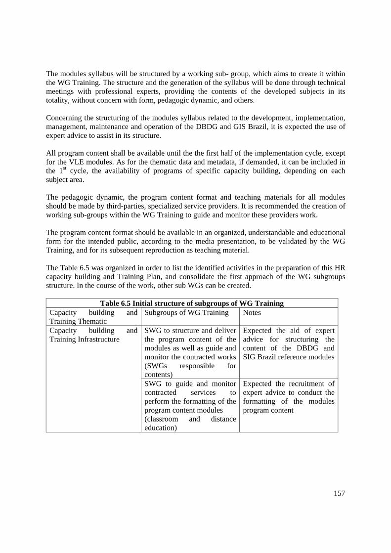
157
The modules syllabus will be structured by a working sub- group, which aims to create it within the WG Training. The structure and the generation of the syllabus will be done through technical meetings with professional experts, providing the contents of the developed subjects in its totality, without concern with form, pedagogic dynamic, and others. Concerning the structuring of the modules syllabus related to the development, implementation, management, maintenance and operation of the DBDG and GIS Brazil, it is expected the use of expert advice to assist in its structure. All program content shall be available until the the first half of the implementation cycle, except for the VLE modules. As for the thematic data and metadata, if demanded, it can be included in the 1st cycle, the availability of programs of specific capacity building, depending on each subject area. The pedagogic dynamic, the program content format and teaching materials for all modules should be made by third-parties, specialized service providers. It is recommended the creation of working sub-groups within the WG Training to guide and monitor these providers work. The program content format should be available in an organized, understandable and educational form for the intended public, according to the media presentation, to be validated by the WG Training, and for its subsequent reproduction as teaching material. The Table 6.5 was organized in order to list the identified activities in the preparation of this HR capacity building and Training Plan, and consolidate the first approach of the WG subgroups structure. In the course of the work, other sub WGs can be created.
Table 6.5 Initial structure of subgroups of WG Training
Capacity building and Training Thematic
Subgroups of WG Training Notes
SWG to structure and deliver the program content of the modules as well as guide and monitor the contracted works (SWGs responsible for contents)
Expected the aid of expert advice for structuring the content of the DBDG and SIG Brazil reference modules
Capacity building and Training Infrastructure
SWG to guide and monitor contracted services to perform the formatting of the program content modules (classroom and distance education)
Expected the recruitment of expert advice to conduct the formatting of the modules program content

158
SWG to guide and monitor contracted services for the reproduction of the modules educational materials (classroom and distance education)
Expected the recruitment of expert advice to conduct the formatting of the modules program content
Dissemination (communication)
SWG for planning and enabling prediction of courses and workshopsCongresses, symposia and seminars
Develop propagation resources and short courses for events (SWG Promotion)
Multipliers training SWG Instructors - Composed by technicians from governmental spheres - Expected use of training services of coordinators and tutors distance education
NSDI Knowledge management
SWG to guide and monitor contracted services for the structuring of a system to support knowledge management and feedback procedures
Expected recruitment of expert advice for the structuring of a system to support knowledge management, manager and knowledge workers preparation and establishment of feedback procedures
VLE in NSDI SWG to guide and monitor the work of providing the infrastructure for distance learning (SWG of VLE)
Expected the promotion of participation of agencies and institutions possessing distance education culture providing infrastructure for VLE
6.4.1.2 Considerations for capacity building and training Programs in distant learning (VLE) The development and implementation of the distance education system structure and its functions and modules of capacity building and training should be performed by agencies and institutions with VLE culture, directly or through partnerships. It is recommended the creation of a sub-working group to guide and monitor the work. The structure of a distance learning system and the minimum required staff were described in Section 6.1.3. 6.4.1.3 Considerations about the system of support to Knowledge Management

159
It is expected the use of specialized service to develop and implement a system of Knowledge Management Support for documentation, management, consultation and analysis of experiences generated in the adoption, development and use of the NSDI. It is recommended that CONCAR comprises a sub-working group to guide and monitor the contracted work. The preparation of the administrator and the knowledge workers of the System of Knowledge Management Support, which will integrate the NSDI, may be funded by hiring the specialized services of training. 6.4.2 Action Lines of capacity building and Training Programs In order make the implementation of the NSDI possible, it is necessary to create action lines for the NSDI development, implementation, monitoring and continuous updating. Thus, all variables should be planned with the cooperation and collaboration of the participant institutions. The action lines planned for the Capacity building and Training Programs consider the whole process of the NSDI implementation and are available as part of the collection of documents generated in the elaboration of this chapter. Annex II contains, with detailing, the tables with the action lines focusing on the Cycle I of the NSDI implementation; in it, the actions related to the Capacity Building and Training Programs was considered.

160
References
ARGYRIS, Chris. Enfrentando defesas empresariais. Rio de Janeiro: Campus, 1992.
BRASIL. Decree no 6.666, of November 27th, 2008. Establishes within the Federal Executive, the National Spatial Data Infrastructure – NSDI. Official Diary of Brazil´s Federal Government, Brasília, DF, Nov 28th, 2008. Section 1, p. 57.
BRASIL. Decree n° 243, February, 28th 1967. Fixed the Guidelines and Bases of Brazilian cartography. Official Diary of Brazil’s Federal Government, Brasília, DF, Feb 28th 1967. N 243.
BRINT. Process to product: creating tools for knowledge management, [200-]. Available on: <http://www. Brint.com/mendels/online/120205/jackson/secn1.htm>. Accessed on: 2001.
BURK, M. knowledge management: everyone benefits by sharing information, [200-]. Available on: <http://www.fhwa.dot.gov/km/prat.htm.>. Accessed on: 2000.
CHIAVENATO, I. Recursos humanos: o capital humano das organizações. 8. ed. São Paulo: Atlas, 2006.
CHIAVENATO, I. Administração de recursos humanos: fundamentos básicos. 4. ed. São Paulo: Atlas, 1999.
COMPARSI, V. C. V. et al. Avaliação dos intangíveis: uma aplicação em capital humano. Revista Gestão e Produção, São Carlos, v. 15, n. 3, p. 619-634, Sept.-Dec. 2008.
COSTA, Gilda Helena B. de. Mais sobre o designer de projetos de EAD, 2001. Available on: <http:\\ www.timaster.com.br/revista/colunistas/ler_colunas_emp.asp ?cod=411>. Accessed on: Oct 23rd 2004.
DIXON, N. Common knowledge: how companies thrive by sharing what they know. Boston, Massachusetts: Harvard Business School Press, 1937.
FILATRO, Andréa. Design instrucional contextualizado. São Paulo: Senac, 2004.
FRANÇA, A. C. L. Práticas de recursos humanos – PRH: conceitos, ferramentas e procedimentos. São Paulo: Atlas, 2007.
GARTNER. Página da empresa Gartner Group, [200-?]. Available on: <http://www.gartner.com>. Accessed on: March 2008.
GARVIN, D. A. Building a learning organization: harvard business a learning organization. Harvard Business Review. v. 71, s. 4, p. 78-91, Jul.-Aug. 1993.
IDEMEX . Infra estructura de datos espaciales de México: Modelo de la IDEMex, 2008
IGAC – Instituto Geografico Agustin Codazzi. ICDE - infraestrutura colombiana de dados espaciais, 2006.

161
IGAC – Instituto Geografico Agustin Codazzi. Infraestructuras de dados espaciales – IDE (Spatial Data Infrastructure), 2005.
LANDIM, Cláudia M. das M. P. F. Educação a distância: algumas considerações. Rio de Janeiro: [s.n.], 1997.
LE BOTERF, Guy. Desenvolvendo a competência dos profissionais. Porto Alegre: ArtMed, 2003.
LEMOS, André. Cibercultura: alguns pontos para compreender a nossa época. In: LEMOS, André; CUNHA, Paulo (Orgs). Olhares sobre a Cibercultura. Porto Alegre: Sulina, 2003. p.11-23.
LÉVY, Pierre. Cibercultura. São Paulo: Editora 34, 1999.
LÉVY, Pierre. A inteligência coletiva: por uma antropologia do ciberespaço. São Paulo: Loyola, 1998.
MOREIRA, G. R. A equipe de educação a distância na cibercultura: um estudo de casos múltiplos. 2005. Dissertation (Master’s Degree in Education) – University Estácio de Sá, Rio de Janeiro, 2005.
NEVES, Carmen Moreira de Castro. Referencias de qualidade para cursos a distância, 2009. Available on: < http://portal.mec.gov.br/seed/arquivos/pdf/ ReferenciaisdeEAD.pdf>. Accessed on: Mar 23rd, 2009.
NONAKA, I.; TAKEUCHI, H. The knowledge creating company: how Japanese companies creating the dynamics of innovation. Oxford: Oxford University Press, 1995.
PALLOFF, Rena M.; PRATT, Keith. Construindo comunidades de aprendizagem no ciberespaço. Porto Alegre: ArtMed, 2002.
PEREIRA, Heitor José. Gestão do conhecimento como processo corporativo nas organizações: uma visão aplicada à gestão pública. In: CICLO ESTADUAL DE PALESTRAS – GESTÃO DO CONHECIMENTO – INOVAÇÃO NO SETOR PÚBLICO, 1., 2007, São Paulo, Anais eletrônicos... São Paulo: EMPLASA, 2007. Available on: <http://www.emplasa.sp.gov.br/portalemplasa/ciclo_de_palestras/ciclo_de_palestras.asp>. Accessed on: Apr. 2007.
POLANY, M. The tassit dimension. London: Peter smith Pub, 1983.
SAMPAIO, Jonice Oliveira. EPHISTHEME: um ambiente de gestão de conhecimento científico. 2003. Dissertation (Mater’s Degree in Systems and Computing Engineering)– Federal University of Rio de Janeiro, Rio de Janeiro, 2003.
SANTOS, Edméa Oliveira dos. Articulação de saberes na EAD online: por uma rede interdisciplinar e interativa de conhecimentos em ambientes virtuais de aprendizagem. In: SILVA, Marco (Org.). Educação online. São Paulo: Loyola, 2003. p. 217-230.

162
TERRA, José Cláudio Cyrineu. Gestão do Conhecimento: o grande desafio empresarial: uma abordagem baseada no aprendizado e na criatividade. São Paulo: Negócio Editora, 2001.
VAVASSORI, Fabiane Barreto; RAABE, André Luis Alice. Organização de atividades utilizando ambientes virtuais: um estudo de caso. In: SILVA, Marco (Org.). Educação online. São Paulo: Loyola, 2003. p. 311-325.
ABREU, Andre. Usabilidade e a padronização no e-learning. In: SILVA, Marco (Org.). Educação online. São Paulo: Loyola, 2003. p. 369-376.
ARAÚJO, V. O. H. Seminários de Educação. Revista Ponto de Referencia, Rio de Janeiro, n. Dec 3rd, 2008.
ARGYRIS, Chris. A integração indivíduo-organização. São Paulo: Atlas, 1975.
BAGGIO, L. O perfil do gestor de recursos humanos nas organizações no conhecimento. Dissertation (Master’s Degree in Production Engineering) – Federal Technological University of Paraná, Campus Ponta Grossa: Ponta Grossa, 2008.
BRESSER, L. C. P. A reforma do estado dos anos 90: lógica e mecanismos de controle. Cadernos MARE da Reforma do Estado, Brasília, 1997.
CHOO, Chun Wei. A organização do conhecimento: como as organizações usam a informação para criar significado, construir conhecimento e tomar decisões. São Paulo: SENAC, 1998. 416p.
DAVENPORT, Thomas; PRUSSAK, Laurence. Conhecimento empresarial: como as organizações gerenciam o seu capital intelectual, Rio de Janeiro: Campus, 1999.
GOMES, E. Gestão do conhecimento: definição conceitual, múltiplos usos e interpretações. [s. l.]: ANATEL (National Agency of Telecomunication): 2002.
JUNIOR, J. F.; SILVA, M. H. Capital intelectual e a gestão de recursos humanos, 2004. Disponível em: <http://www.informal.com.br>. Acesso em: 2 de mar. 2009.
LASPISA, D. F. A Influência do conhecimento individual na mem ria organizacional: estudo de caso em call center. Dissertation (Master’s Degree in Engineering and Knowledge Management) – Federal University of Santa Catarina, Florianópolis, 2007.
LEMOS, André. Cibercultura, tecnologia e vida social na cultura contemporânea. Porto Alegre: Sulina, 2002.
LIMA, C., Silva, H. F. A importância do treinamento: percepção de algumas organizações empresariais do vale do paraíba. In: ENCONTRO LATINO AMERICANO DE INICIAÇÃO CIENTÍFICA; ENCONTRO LATINO AMERICANO DE PÓS-GRADUAÇÃO, 11., 7., 2006, São José dos Campos, Anais... São José dos Campos: University of Vale do Paraíba, 2006.
MAIA, Carmem. Para os professores: virtuais, semivirtuais e presenciais. In: _______. Guia Brasileiro de Educação a Distância 2002/2003. São Paulo: Esfera, 2002. p. 11-21.

163
MARX, I. C. Sociedade civil e sociedade civil organizada: o ser e o agir, 2006. Available on: <http://jus2.uol.com.br/doutrina/texto.asp?id=8257>. Accessed on: Feb 22nd, 2009.
MATAYOSHI, M. H.; VIEIRA, S. F. A. Processo de implantação de educação a distancia em treinamentos corporativos: um estudo de caso. In: CONGRESSO INTERNACIONAL DE ADMINISTRAÇÃO: GESTÃO ESTRATÉGICA NA ERA DO CONHECIMENTO, 1., 2008, Ponta Grossa (PR). Anais... Ponta Grossa (PR): [s.n.], 2008.
MENDES, Alexandre. Gestão do Conhecimento: a espiral do conhecimento. São Paulo, 2008. Available on: <http://imasters.uol.com.br/artigo/10659/ gerencia/gestao_do_conhecimento_-_a_espiral_do_conhecimento.>. Accessed on:
OLIVEIRA, M. B. P.; FERREIRA, R. H.; SANTOS, S. L. Gestão de pessoas e as organizações públicas. 2008. Degree Conclusion Essay. (Degree in Business Management) –IBTA/ INEA Colleges, São José dos Campos, 2008.
PETER, Senge. The fifth discipline: the art and practice of learning organizations. New York: Currency Doubleday, 1990.
RAYMOND, Eric S. The cathedral and the bazaar: musings on linux and open source by an accidental revolutionary. [s. l.]: O’Reilly, Sebastopol, 2001. Available on: <http://gnuwin.epfl.ch/articles/en/cathedralbazaar/cathedral-bazaar.pdf>.
SCHOLTZ, R.L.; IBDAIWI, T.K. Capital Intelectual: um desafio para as organizações. Article presented as partial requirement for approval on Subject Degree Conclusion Essay, Course Business Management with emphasys on Foreign Trade, Methodist College of Santa Maria – FAMES, Porto Alegre, 2007.
STORCH, Sérgio. Inteligência organizacional e societal: processos, estruturas e instituições. In: CICLO ESTADUAL DE PALESTRAS – GESTÃO DO CONHECIMENTO – INOVAÇÃO NO SETOR PÚBLICO, 2., São Paulo, 2008. Palestras... São Paulo, 2008. Available on: <http://www.emplasa.sp.gov.br/ portalemplasa/ciclo_de_palestras/ciclo_de_palestras.asp>.
SUROWIECKI, James. A sabedoria das multidões. São Paulo. Record, 2006.
SZTAJNBERG, A.; SEIXAS, R. B., ALVES, N. Formação de recursos humanos em tecnologia da informação para o estado do Rio de Janeiro. Rio de Janeiro, 2009. Artigo do Grupo de Trabalho Redes: Sistemas Operacionais e Aplicações Cliente/Servidor.
TRAVASSOS, A. Recursos humanos: como gerenciá-los em projetos. Curitiba: Editora Mundo, 2006.
WEINBERGER, Davis. A nova desordem digital: os novos princípios que estão reinventando os negócios, a educação, a política, a ciência e a cultura. Rio de Janeiro: Campus, 2007.
WENGER, Etienne. Communities of practice: learning meaning and identity. New York: Cambridge University Press, 1999.

164
Chapter 7
DISSEMINATION AND COMMUNICATION
7.1 Introduction
Currently there is a growing knowlegment of some modern society challenges, such as environmental protection, health and security issues, improvement of infrastructure and development, which require identification of where the necessity pressure is greater, and which means are needed to effectively target the intervention, monitor results and evaluate impacts.
For all these tasks, the geographic information (GI) is crucial, as it must not only exist, but should be easily obtained, investigating whether it is suitable for their intended use, how it can be accessed and whether it can be integrated with other information. It is therefore necessary to implement policies, institutional arrangements, technologies, data and personnel, making it possible to share and use effectively the geographic information. That is why there is the effort of several countries to build their Spatial Data Infrastructure – SDI. Since 2008 Brazil has been making this effort in an objective way, after considering this need since CONCAR’s strategic planning in 2005. At that time it has established as "Vision of the future: an agency capable of guaranteeing a National Cartographic System of excellence to ensure the timeliness and integrity of the National Spatial Data Infrastructure (NSDI)."
By focusing on the actions to implement the NSDI, it shall be ensured its sustainability. Therefore, it is necessary to ponder in order to communicate the whole society about the initiative of organizing geographic information, showing the importance of this organization in public policies development and advancement of knowledge in society.
Communication is the process by which people acquire understanding and commitment to change processes. This requires that the transmitting agent use the same language of the receiving agent, otherwise there will not be understanding and commitment (MODERN 2009).
To support the changing processes, communication plays two key roles:
INFORMATION - Provides people with the information they need to understand the process of change and adapt to the new.
PERSUASION - Position change as something desirable and achievable. The exact extent of information and persuasion depends on the needs and reactions of the target audience.
Figure 7.1 shows the construction process of communication in three key stages: preparation, acceptance and commitment. In the preparation stage the product should be presented to the target audience, clearly, showing their potential; in the second stage, acceptance, it will be shown that the "new product" will bring benefits to users and producers, emphasizing the positive aspects of the change, to finally consolidate the third phase, commitment, when the institutional effective involvement occurs, with active participation of those involved in contributing with ideas and resources for the consolidation of the proposed change. From there, all involved are actors of the communication project, bringing their experiences to guide the direction and presentation of successful cases.

165
At each step, if the work is not properly done, a distorted and negative view of the product, which is being disseminated, can be produced, causing frustration and loss of time and money.
An effective communication plan drives the action, and, for its execution, it is necessary to extend the functions and possibilities of communication, increasing the effectiveness of communication processes that cross the internal environment and assist the consolidation of mission, objectives, and acquisition of results of the organization (Arantes, 1998). It should therefore have the following approach, as the chart below:
Figure 7.1 – Phases of building the communication process Source: MLS Comunicações (2006)
• Create Awareness: link the understanding between "what" is going to happen and "When" it will happen.
• Create Understanding: link the understanding between "Why" it is happening and "how" it will happen.
• Developing Commitment: develop the active participation with those who understand "What," "When," "Why" and "How" in order to make them more involved. "
• Boosting Action: boost people and project performance through commitment to ongoing initiatives.
7.2 Objective
The purpose of the communication plan is to make all potential users and society aware of the existence of the NSDI and GIS Brazil, its guidelines, criteria and operating rules, as well as to provide general information to the Brazilian public about the importance and scope of the NSDI.
7.3 Goals
• Raise awareness of the target audience about the benefits of creating the NSDI, adoption of standards and sharing of geospatial data and information;

166
• Promote the use of geospatial data and information, produced by public institutions and agencies of the federal, state, county and municipal spheres, of the standards approved by CONCAR
• Disseminate the standards and rules for the availability of geospatial data and information on GIS Brazil, highlighting the experiences and successes cases in the implementation of the NSDI in Brazil and abroad;
• Encourage the use of the GIS Brazil portal.
7.4 Guidelines for Effective Communication
• Be specific regarding the objectives; • Use appropriate language to the target audience; • Create the demand for communication; • Do not wait for the "right time"; • Make communication a leadership priority; • Define and understand the target audiences; • Understand that the action and example are the most effective forms of communication; • Understand that communication starts at the top, but should involve all levels; • Do not underestimate the power of informal networks, and • Use all possible opportunities and channels (excessive use of a single channel adds
limited value).
7.5 Strategies
There are certain essential elements to any communication strategy that should be incorporated into the implementation of the NSDI and in the creation of the website GIS Brazil. Thus, the strategy must:
• Start with a direct effort at the top of the organization - effective communications require involvement and support from all levels of the organization;
• There must be consistency in the message - every communication must say the same thing. Whatever is said may have some degree of variation in the details, but must be essentially the same message;
• Be carefully planned, thoroughly and effectively implemented - the communication actions are part of the routine work and must be planned and budgeted as such;
• Promote a coordinated effort within and outside the organization - what is being said within the organization must be consistent with what is being said outside;
• Ensure a carefully planned communication - it is important to guarantee that the used channels can honour the commitment at the necessary time;
• Ensure a multilevel communication, with the same message properly elaborated for specific segments of the population - different segments of society have different levels of training, background and cultural issues that dictate how the message should be developed; and
• Promote the feedback of the target audience to the NSDI – taking this evaluation is very important to measure the success of the project and replenish its development.
7.6 Monitoring and Evaluation

167
The evaluation process will be permanent and shall include the following activities:
• Opinion polls on the use, satisfaction and unmet needs; • Development of reports identifying corrective actions and necessary harmonizations • Implementation of corrective measures and adequacy in the strategies and actions for
diffusion and dissemination.
7.7 Target Audience
• Administrators: incumbent directors and managers of institutions or agencies identified as the NSDI actors;
• Producers and users: technicians who produce and/or use geospatial data and information;
• Academy: education professionals, from technical to university level in subjects/courses related to the topic;
• Press: journalists and media representatives; • Organized society: according to Marx (2006), “it is a part of the civil society that is
organized in the fight for greater inclusion in political activity, legitimized primarily by the occurrence of two factors: the impossibility of solving the major problems, that now plague humanity, only through the actions of government or market mechanisms; and in the current state of discredit in the political representation systems”. Fall into this category the Non-Governmental Organizations (NGOs); and
• Citizen: average user who is not associated with any organization or entity.
7.8 Actions for the implementation of the Communication Plan
For the implementation of dissemination and disclosure actions it is advisable to use a communication company with experience in press consultancy, internal communications, planning events, creation and maintenance of websites.
It is crucial during the whole process, the personal attendance at seminars, conferences, forums, workshops and the NSDI stalls at fairs and exhibitions.
The communication actions were planned according to the execution phase of the project, specific to each target audience, always remembering that the implementation of actions depends on the availability of resources, as described in chapter 8.
In addition to the disclosure actions described in Sections 7.8.1, 7.8.2, 7.8.3 and 7.8.4, there are actions related to capacity bulding and training that will be supported by specific diffusion and dissemination actions (sending out invitations, review and reproduction of educational and pedagogic material, certificates, badges, and others).
The contents of diffusion and dissemination should contemplate the NSDI information, its function and importance for deep knowledge about national territory in order to guide government actions and give society a real knowledge of the country.
Moreover, in communication matters it is important to emphasize the contribution of all agencies and entities in the federal, state district and municipal spheres with availability of its geospatial data and information, aiming to consolidate the NSDI and the SIG Brazil.

168
The conduct of the dissemination actions must be done by the Communication Working Group (WG), on the Specialized Committee (proposed in Chapter 8, Section 8.2) of the NSDI within the CONCAR, with the following tasks under its responsibility:
• Creation and development of a NSDI logo, which will present throughout all actions and communication items;
• Inventory of recipients for elaboration and maintaining of a database with target audiences contact details (mailing list);
• Production of institutional and informative material, such as pamphlets, brochures, posters, tokens, promotional materials and digital information;
• Installation of the NSDI stalls at fairs and exhibitions; • Event plannings, lectures and presentations at seminars, conferences, forums, workshops
in institutions and agencies from the government, universities, organizations and entities representing society;
• Publication of articles in magazines, newspapers and websites specialized in geography, cartography and geothecnology, and in magazines of public information in the education and health areas, among others;
• Definition of the media to be used according to the spread of the target audience and its various knowledge levels;
• Creation of a forum for discussions and clarifications; and • Production of technical/motivational and institutional videos about the NSDI, its benefits
and applications.
7.8.1 Actions for the period between the plan’s approval and the SIG Brazil Portal launch (Cycle I – until 30/06/2010)
NSDI launch event
Holding an event/ceremony to launch the NSDI (Beginning of the implementation) in November 2009, in Brasilia, with the participation of the NSDI actors, authorities, civil society and media. The main objective of this act is to inform everyone about the NSDI, which will bring benefits to the whole society - access and use of GI, the economy of resources and geospatial knowledge of the country, promoting adherence and participation of the various spheres of the government. Agreements to join the initiative will be signed, prioritizing governmental actors. The focus at this time is the federal actors, but states and municipalities will be encouraged to join this project.
The lines of action presented in Annex II of the Plan of Action relate to activities that interact with the diffusion and dissemination, as indicated below:
• Beginning of the capacity building and Training Program: combined construction WG - capacity building and GT - Dissemination;
• Inventory and diagnosis of reference and thematic data; • Composition of the Norms, Standards and Specifications Program; and • Consolidation of the adhesion term, norms and rules to DBDG and GIS Brazil adhesion;
licenses of use, copyrights and confidentiality, among others.
7.8.1.1 Target Audience: Managers

169
Approach/content: basic understanding of decisive and vital processes to the NSDI implementation. Focus on the importance of the NSDI, grandeur of the project (goals, resources, planning the PPA – Planejamento Plurianual: Multi-year Plan) and commitment necessary for the success in building the NSDI.
Media/actions: distribution of brochures, sending of personal e-mails, set up of educational seminars and workshops for information exchange between actors. Sending explanatory material (presentations, tutorial, and texts), about the NSDI to internal disclosure in the institution.
7.8.1.2 Target audience: Producers and Users
Approach/content: educational area, for the preparation of professionals who are working on implementing the NSDI, highlighting the importance of standards (reference, data and metadata).
Media/actions: sending personalized e-mails, registration of users and dissemination of tutorials and reference documents on the CONCAR website.
7.8.1.3 Target Audience: Media
Approach/content: informative area, focusing on the importance of the NSDI, its applications and utilities (aspect and concept).
Media/actions: press releases, invitations to follow-up seminars for managers.
7.8.2 Actions for the period between the release of the Portal GIS Brazil and 30/12/2010
During this period, various activities are planned for implementation of the NSDI Plan and the Communication Plan. For the completion of Cycle I it will be promoted the evaluation of the NSDI implementation, in addition to the activities listed below:
• FAQ; • Launch of SIG Brazil Portal; • Permanent sending of newsletter; • Diffusion of links with the SDI and GI projects from other countries; • Participation in technical and scientific events, national and international; • Participation in Continental and Global Forums; • Development of means and tools of dissemination and communication; • And others.
7.8.2.1 Target Audience: Managers
Approach/content: incentive to visit broadcast and publicize the SIG Brazil Portal in institutions and agencies.
Media/actions: sending personalized e-mail, considering two groups of managers: those who already have the data and metadata, from their institution or agencies, accessible via the portal and those who are not. Sending explanatory material (presentations, tutorials, text), about the SIG Brazil Portal in order to disseminate and internal disclosure in the institution.
7.8.2.2 Target Audience: Producers and Users

170
Approach/content: encouraging the use of the Portal SIG Brazil and suggesting improvements and contributions to the enhancement of the same.
Media/actions: sending personalized e-mail, answering questions from users via institutional e-mail.
7.8.2.3 Target Audience: Academy
Approach/content: Disclosure of available services in the portal and incentive for future data producers to use the portal.
Media/actions: Sending explanatory material (presentations, tutorials, text) about the SIG Brazil Portal in order to disseminate and internal disclosure in the institution or agency.
7.8.2.4 Target Audience: Media
Approach/content: informative area, focusing on the importance of the portal, its available services and information, as well as its applications and utilities (aspect and concept).
Media/actions: press releases, invitations to launch event.
7.8.3 Actions for the cycle II – 2011 to 2014
During this time, it is expected an improvement in the tools for evaluating the implementation/deployment, raising of suggestions and demands, satisfaction measurement and other monitoring and management, which will conduct the guidelines for adjustments and improvements of means, services and diffusion associated with the access and use of GI by the NSDI.
Following actions, and dissemination and communication pieces for this period, are identified among others:
• On-line Service /FAQ; • Permanently sending newsletter; • Dissemination and communication of the implemented actions; • Consolidation of support component to access and use of GI for education (faculty and
students); • Broadcast links with the SDI and GI projects from other countries; • Organization of periodic event about the implementation and evolution of the NSDI, with
the first logo in the beginning of cycle II by the end of 2014; • Participation in technical and scientific events, national and international; • Participation in Continental and Global Forums; • Development of means and tools for dissemination and communication; and • Encouragement of the states and municipalities engagement.
7.8.4 Actions for the cycle III – 2015 to 2020
171
For this cycle there are planned actions for the improvements in service, implementation and communication to society (sending newsletter, participation in events and developing new publicity materials).
In this period the commitment between government and society should be consolidated, with the institutional internalization of the action lines for the NSDI Implementation Plan, in which the Communication Plan plays an essential role: not only to join experiences but also listening and engaging the users.
The proposal of periodic events to monitor the implementation of the NSDI allows systematic evaluation and restructuring giving it visibility, consolidating the level of commitment of states and municipalities, as well as promoting actions of society adherence and its voluntary participation.
References
ARANTES, N. Sistemas de gestão empresarial. 2ª ed. São Paulo: Editora Atlas, 1998.
MARX, I. C. Sociedade civil e sociedade civil organizada: o ser e o agir. 2006. Available on: http://jus2.uol.com.br/doutrina/texto.asp?id=8257> Accessed on Feb 22nd, 2009.
MLS Comunicações, 2006.
MODERNO, C. Do conceito de comunicação ao conceito de publicidade e marketing. Available on: <http://www.ipv.pt/forumedia/f2_idei6.htm> Accessed on Apr 15th, 2009.

172
Chapter 8 NSDI’S Action Plan 8.1 NSDI actors In designing an implementation strategy for the NSDI, it is necessary to consider the actors involved in this process, with their different profiles and demands, namely: government agencies, academy, private sector and society. The universe consisted of these four groups include: producers and/or providers of geospatial data and information (GI), managers and users of GI and related services. The same organization can perform one or more of these roles. In Brazil, producers, providers and GI managers are found in governmental entities of the four government levels: federal, state, county and municipal. Nevertheless, the Brazilian directory of Geospatial Data - DBDG as defined in Decree 6.666/08, can only take place if the producers, providers and managers of GI related to federal bodies are directly involved in its implementation. Some of these bodies are already participating in this Action Plan development; those who have not adhered to this initiative will have the opportunity to do so during the plan execution. The prominence given to the federal government bodies is justified by the fact that the Legal Framework of the NSDI, Decree 6.666/08, determines the obligation of sharing and dissemination of geospatial data for these bodies (Chapter 2 - Section 2.3). However, the bodies linked to other levels of government will be encouraged to participate and may join the process of the NSDI implementation at any stage, whereas prepared for it, with the ability to publish and maintain content and services, with their own resources. For the effectiveness of this Action Plan, it will be used the term federal actors of the NSDI to designate federal agencies that maintain and/or use the GI data collection that, by its nature, acuity, present time, usability and reliability are useful and relevant in the formulation of public policies. The term used, “federal actor” of the NSDI, intends only to define a preliminary set of actors through which it is planned to initiate the implementation process of the NSDI. In this approach, the value-added data producers have also been highlighted as well as the traditional producers of data and thematic reference. In the light of Decree 6.666/08 each federal actor producers of GI should become a node of the DBDG, even though, at first, just to provide metadata from its production. The federal actors of the NSDI considered data producers are those suggested in Sections 4.1 and 4.2 of Chapter 4. The lists of producers and managers presented in Chapter 3 (Tables 3.1 and 3.2), and the lists of geospatial data detailed in Chapter 4, should be expanded during the execution of the Action Plan, as new actors are identified and incorporated into the process in accordance with surveys and diagnostics that should be carried out under assignments on the production and dissemination of the geospatial data.

173
8.2 Organizational and Managerial Model of the NSDI The organization and managerial model of the NSDI presented in this section is the result of discussions initiated in the elaboration of Chapter 2 (see Sections 2.4 and 2.6), and deepened during CONCAR meetings in 2009. The ideas and suggestions of various members of CONCAR converged on a model proposed and agreed upon at the 16th Plenary Meeting of CONCAR, on November 4, 2009, during the review period of this Action Plan. Thus, this model already reflects CONCAR's decision by consensus at that Plenary. In Chapter 2 - Item 2.4.1, Table 2.2 It is presented a compilation of the coordination models of the SDIs adopted in several countries. Based on the overall structure of Table 2.2, expressed in the titles of columns 2 to 5, it is presented below, the model proposed for the NSDI, which is illustrated in Figure 8.1: Steering Council - in the light of Decree No. 6666 of November 27th, 2008, that constitutes the NSDI, and the Decree s/n of August, 1st 2008, which organizes the National Commission of Cartography - CONCAR, it is clear that CONCAR, as a collegiate agency under the Ministry of Planning, Budget and Management, having as attributions: to assist the State Ministry in the supervision of the National Cartographic System, to coordinate the national cartographic policy, among others, should perform as the Steering Council of the NSDI, fulfilling the normative and directive role, and must establish rules, norms, standards and guidelines that enable the NSDI implementation and evolution. Management Council – as a collegiate body of the State Ministry, CONCAR will also serve as the Management Council of the NSDI. CONCAR will have the active and articulated support of their technical sub-commissions, to facilitate the accomplishment of this role that, in the model presented here comprises the functions of planning, implementation management, and the NSDI maintenance.
Sub-commission on National Defense Issues (SDN); Sub-commission on Spatial Data (SDE); Sub-commission on publicizing (communication) (SDI); Sub-commission on Legislation and Standards (SLN); Sub-commission on Planning and Monitoring (SPA).
Further, still in this section, some of the new responsibilities that the sub-commissions of CONCAR must assume, in addition to their current competencies, related to the NSDI thematic will be addressed. Technical Committee – subsidises the Management Council (CONCAR), acting under the guidance and direct monitoring of the CONCAR technical sub-commissions. They will be responsible for coordinating the operation of the NSDI Action Plan. It shall consist of a group of experts, who demonstrate leadership skills, and, preferably chosen in the bodies of CONCAR’s members. The Technical Committee of the NSDI, as named here, will be established as a specialized CONCAR’s committee, with a similar structure to that adopted in the constitution of the CINDE, responsible for this Action Plan. In addition to a Coordinator designated by

174
CONCAR, the NSDI Specialized Committee, will have two Sub-coordinators or leaders for each of the categories in which the action lines for this plan are gathered - Management, Norms, Standards & Specifications, data and metadata, Technology, Capacity building and Communication. Working Groups (WGs) - operationalizes the Action Plan of the NSDI, under the supervision, guidance and monitoring of the Specialized Committee and sub-commissions. The Working Groups, which may be created according to the effective demands for the work support of the Specialized Committee, will have variable composition and will count as a rule, with representatives of different NSDI actors. It is recommended that each participating agency in the implementation choose at least two representatives (titular and substitute) in the various WGs depending on their level of participation. It can be said that the WGs represent an extension of the Specialized Committee of the NSDI according to the thematic and organizational dimensions.
Figure 8.1 NSDI Organizational Chart The action lines presented in Appendix II lead to the following recommendations of the WG: WG DBDG, with a sub-WG Data hosting, under the leadership of the Technical Committee of the NSDI; WG – Capacity building and Training, under the leadership of their committee leaders, and GT Communication, under the leadership of The Communication Committee leaders. However, for the SDI’s implementation experience in a many countries, and given the diversity of themes to be addressed in the action lines, others WGs involving the many institutional actors may be formed, such as
1o) WG Data and Geospatial Metadata to perform: a) inventory and diagnostic of data and geospatial metadata, b) legislation survey regarding and related to geospatial data (see Chapter 2 - Item 2.4.3); c) copyright laws issues, dissemination restrictions and use, among others. This WG would act under the leadership of the Data and Metadata Specialized Committee of the NSDI leaders. 2o) WG Standards & Specification, to put into practice the inventory of norms & standards related to the existing NSDI and updating demands in order to adapt them to the reality of the NSDI implementation, and other relevant tasks. This WG would act under the leadership of the Standards and Specification Technical Committee leaders of the NSDI.
CONCAR
Executive Secretariat
Technical Committee of NSDI SDN SDE SDI SLN SPA
WG 1 WG 2 WG n

175
To fulfill its role as Management Council, the sub-commissions of CONCAR should have their goals expanded, taking new assignments (besides the current ones), and its staff reviewed. : In order to assist in revising the goals and tasks of the CONCAR specialized sub-commissions, this Plan identifies a number of activities needed for the NSDI implementation process, and the respective sub-commissions that should guide, supervise and monitor these actions with the Specialized Committee and Groups work (the following lists are not exhaustive): A) Sub-commission on Planning and Monitoring (SPA):
• General activities of organization, management, monitoring and evaluation, with the issuance of periodic reports to CONCAR on the execution work of the Action Plan;
• Indication of the resources allocation for the full NSDI operation, consistent with the demand presented by the institutions (according to Decree No. 6.666/08, the Brazilian Institute of Geography and Statistics - IBGE is responsible for requesting resources for the NSDI).
• Revision proposals and systematic readjustment of the Action Plan, aiming to incorporate the demands arising from the adhesion of new actors, the first readjustment is forecasted to August 2010;
• Support to the linkage to establish agreements and partnership of cooperation and sharing geospatial data (according to Decree No. 6.666/08 the links are between the Department of Planning and the Strategic Investment, MP)
• Linkage actions between the subcommittees of CONCAR in order to guide and monitor the work of the specialized Committee of the NSDI and the working Groups.
B) Sub-commission on Legislation and Standards (SLN):
• Elaboration of proposals to regulate the NSDI and strengthening of its legal framework; • Legislation Survey related to geospatial data, in conjunction with SDE; • Guideline and guidance when preparing issues pertaining to copyright law restrictions on
dissemination and data use, in conjunction with the SDE. • Guidance and monitoring the work of Standards and Specifications of the NSDI
Specialized Committee. C) Sub-commission on publicizing (communication) (SDI):
• Diffusion of the NSDI benefits, in order to raise subscriptions for the initiative and contribute to the increased level of awareness about its importance (access and use of GI)
• Guidance and monitoring the work of the Specialized Committee on Communication of the NSDI.
D) Sub-commission on Spatial Data (SDE)

176
• Establishing national standards for the NSDI data and metadata, considering the international standards, when appropriate, regarding the production, dissemination and use of geospatial information;
• Inventory and diagnostic of data and geospatial metadata; • Legislation Survey related to geospatial data, in conjunction with the SLN; • Formulating guidelines and guidance about copyright issues, restrictions on data
dissemination and use, in conjunction with the SLN. • Guidance and monitoring of the work of the Data and Metadata Specialized Committee
of the NSDI. 8.3 Short-Term priorities for the NDSI Action Plan This first version of the Action Plan identifies actions, deadlines, expected results and those responsible so the initiative of building the NSDI is released within a relatively short time, with proper awareness and mobilization of decision makers and opinion leaders, and with the allocation of the budgetary resources for the investments and indispensable costs. This implies the need to establish priorities for short, medium and long term, but mainly short and medium term. The implementation strategy of the NSDI should be based on a schedule of targets according to priorities defined in each cycle of implementation, as it will be seen in the following section. Thus, it is proposed to focus on the following action lines from August 2009 to March 2010:
• Agreements deals on the NSDI adhesion to the initiative (focusing on the federal actors); • Make the NSDI launch event; • Coordination and linkage of the sub-commissions work.
8.4 The NSDI implementation Strategy The NSDI action plan starts by the definition of an implementation strategy, knowing that the NSDI grows from one stage to another in a constant and gradual process of inclusion of new participants, which makes it more extensive by the aggregation of new subject and services. Therefore the recommended approach in the plan consists of a process based on implementation cycles (or building cycles), where it is intended to go beyond important steps of the project of the NSDI implementation. Three cycles of implementation are expected as described in the general goals and objectives in this section. During Cycle I and parallel to its work, a launch event of the NSDI will be planned and done, according to the following. 8.4.1 Launch Event An important launch event is expected to occur in March, 2010. In this event all federal actors that will be directly involved with the initiative should be present. It is expected the presence of authorities, media, academy and others.

177
This event will be a moment of engagement and awareness of the entities involved, where it will be highlighted the importance of the INDE’s enterprise, its operation and applicability, as well as the signing of Accession to this initiative. This launch event is a first step towards awareness of the importance and the effort of building the NSDI. It is also a moment of visibility for the initiatives already in progress in the organizations producers and managers of GI of the federal sector. The idea is to encourage new members. 8.4.2 Cycle I At the end of Cycle I of the NSDI implementation it is expected the minimal infrastructure of hardware, software, telecommunications and facilities of the DBDG and the GIS Portal Brazil, with search tools, exploration and access of data and geospatial metadata implemented and working. The Plan includes deadlines, resources and mechanisms for identification, diagnosis, registration, training, incorporation, activation and support for the federal NSDI actors, and defines the conditions that such players must fill out, in terms of maintenance teams of the DBDG infrastructure beyond the norms, standards and protocols that must be observed in the publication and availability of data and services through the SIG Brazil. Definitions not covered in this first version of the Plan should be completed subsequent revisions. The SIG Brazil – Access portal to the DBDG - should not only be available to users with features designed in Chapter 5 of this plan, but also offer new features that may be demanded by users. The service that provide help to the user, in Cycle I, foresee a mechanism for measuring customer satisfaction that allows the NSDI managers to take corrective measures and improve the service where necessary. The preliminary list of the federal NSDI actors is defined in Chapter 3 (Tables 3.1 and 3.2); however, as noted earlier, it can be increased, as new actors are identified. As mentioned before, the focus on federal actors does not mean that in the Cycle I the NSDI will be restricted to them. Other government entities, from other levels of government, besides federal, may require credential as DBDG’s virtual node and therefore publish its metadata and GI’s production and make services available through SIG-Brazil. However it’s noteworthy, that regarding to the inclusion of new producers or providers, Cycle I will remain restricted to the governmental sector. In cycle I a set of activities are identified, which implementation has been planned to last two periods: up to 30/06/2010 and 31/12/2010. 8.4.2.1 Cycle I - period up to 30/06/2010 The guidelines and specific goals for this period are as follow: • The goal for this period is to install the hardware, configure and test the software environment and platforms, network mechanisms, DBDG’s routines and administrative procedures, in

178
addition to evaluate and adjust the storage, performance, availability and safety requirements, based on chapter 5 of this Plan. • Participation in this period of the cycle will be asked of the GI’s official producers of the federal sector and recommended to all other federal actors. For actors at others levels of government, their participation will be left opened. But everyone will be encouraged to join the initiative. The basis for this recommendation is the own NSDI legal framework. The Action Plan sets deadlines for: identifying and/or adherence of actors, and diagnostic and other preparatory actions for those who will join the DBDG in the period up to 30/06/2010. In this deadline, among others activities, it will be completed the information’s surveys started during the elaboration of the plan, along with federal actors. • The SIG Brazil should have a first operational version in this time of the Cycle I, providing functionalities for: information and news about the NSDI, communication channels (FAQ, Contact, etc.), users’ register to receive news, DBDG’s administration, search and access to the data and information that will be available from the respective metadata, also map display (WMS), as defined in the chapters 4 and 5 of this Plan. • For all GI’s producers, the availability of metadata, according to the Brazilian geospatial metadata profile (MGB) presented in the chapter 4, which must be approved by the CONCAR, is mandatory and must be completed for all data of any kind, which may be available by each producer through the DBDG. • The publication of metadata of the sets of geospatial data maintained in collection by the federal actors must be as wide as possible and address, necessarily, the sets of data to be available during this period, which must be defined in the surveys and diagnostic that will take place within that period. The chapter 4 provides guidance to this matter. • The GI’s official producers should strive to publish in this period, the greatest possible amount of reference’s data and, if it is possible, within the standard of Structuring geospatial vector data (EDGV). What is not possible to be available in this standard can be available for any type of access, including visualization of service (WMS – web map service), but it will not be considered official data (Chapter 4, for the definition of reference’s geospatial data, Item 4.2.1; official data, in the item 4.2.4). • All sets of reference data, vector or raster that become available through SIG Brazil, by federal producers, in this period of Cycle I should be displayable through WMS services (Chapter 4, Tables 4.3 to 4.7). • The GI’s federal producers must strive to publish through DBDG, and in this period, the greatest possible amount of data and thematic information and respective metadata (Tables 4.8 and 4.15, Chapter 4). It is desirable that at least one part of these thematic data and their metadata can be displayed through WMS services at the end of this period of the Cycle I. The rest must be available for download at least. Future revisions of this plan must provide, also, deadlines for the proposition, consultation and approval of the CONCAR’s standards for thematic data. The data migration to these standards must be made during a period of transition, by the end of that time all thematic data must be in accordance with the established standards. This period can exceed this first period of cycle I, however it is desirable that it does not exceed the end of the second period of this cycle, it must be finished within cycle I.

179
• Data and products of value-added and their respective metadata may be made available for access through download. It is not necessary that these data are visible through the visualization tool available on SIG Brazil portal. For the NSDI’s federal actors (and only for these) such minimal availability by download will be mandatory for all types of geospatial data. 8.4.2.2 Cycle I - period up to 31/12/2010 The specific guidelines and objectives for the period up to 31.12.2010 are the followings: • This period sets the end of Cycle I of building the NSDI. This cycle’s goal is that all the NSDI’s federal actors have become nodes of the DBDG and started publishing their geospatial data and metadata, for universal access by the government and society through the SIG Brazil. • All the NSDI’s federal actors identified within the established deadline in the Plan, during Cycle I, will be encouraged to join the NSDI’s initiative. The Participation will remain optional for other actors, though the philosophy of "open-doors" remains, so new actors linked to others levels of government, besides the federal, can join at any time. In future revisions, this Action Plan will set a deadline for identification and/or membership of actors and the diagnostics and other preparatory actions of those who will join the DBDG in this period, taking into account the conclusion deadline of the plan (31/12 / 2010). If such deadlines are not defined in the first version of the Plan, they must be provided in later revisions. • The SIG Brazil must make available in this period, the functionalities foreseen in chapter 5, having already joined any improvements suggested by the users, as for example, new services. In future revisions, this plan should provide mechanisms for treatment and analysis of these suggestions and the required deadline for the improvements incorporation on the SIG Brazil. If such mechanisms and deadlines are not addressed in the first version of the Plan, they must be defined in later revisions. • The GI’s federal producers must strive to publish the maximum amount of reference’s data and their respective metadata within the EDGV’s standard and the MGB’s profile, respectively, up to the end of this period. However, what it is not possible to be made available in the EDGV’s standard can also be made available, through (WMS) visualization service. • The GI’s federal producers should strive to publish the maximum amount of data and thematic information, produced by them, within the standards established by CONCAR during this period. The same will apply to other types of thematic data, of new producers or not, that are identified during the NSDI’s cycle I. The next revision of this action plan must preview deadlines for the prototypes conclusion of data production in the EDGV’s standard, having in mind its homologation for the scales of foreseen publication. If such deadline is not concluded in the first version of this Plan, it must be concluded in subsequent revisions. Within this period, the Action Plan must also preview a capacity building program, including seminars, workshops and lectures for managers and GI’s producers, and training tools to convert to EDGV’s standard and metadata (MGB), besides support services for institutions identified as

180
DBDG nodes. It aims to give the bodies candidates for DBDG’s nodes the necessary conditions for the publication of their data and metadata according to the minimum requirements. This capacity building and the support services may be extended to other institutions of the public sector, even the state and municipal spheres, who apply as DBDG’s nodes in cycle I. 8.4.3 Cycle II (2011 - 2014) This will be the cycle of the DBDG’s consolidation in the federal government and its extension to other levels of government. This cycle also marks the strengthening of the Institutional and People components, besides the sedimentation of norms and standards. The focus will be on both the data and the services, which must be expanded according to the user demands. Thus, services WFS, WCS, SLD and Gazetteer, to cite just a few examples (see Chapter 1 - Section 1.4) must be available to the users throughout this cycle, enriching this way the potential of exploitation and use of GI for all users. Such services may be offered either through the SIG Brazil or directly by the DBDG’s nodes. Integration with other SDIs - continental, thematic, regional, institutional/corporate - will be one of the important goals of this cycle, as well as and the broad dissemination of the initiative to all productive sectors of the society. The main goal of cycle II is transforming the NSDI into the main search engine, exploration and access of geospatial data and metadata of Brazil, supporting the public policies formulation in the sphere of the federal government. 8.4.4 Cycle III (2015 - 2020) By the end of Cycle III it is expected that the NSDI has permeated all productive sectors of the society, besides the government, and have consolidated itself as a search reference, exploration and access of geospatial data and metadata in Brazil. In this cycle, it will also be consolidated the integration with others SDIs. The major goal of this cycle is transforming the NSDI into the main search engine, exploration and access to geospatial data and information of the Brazil, supporting the public policies formulation by the governmental sector and to the society itself in the decisions making related to their routine, including encouraging voluntary participation. At the end of cycle III it is expected that the NSDI is internationally recognized for its ability to contribute to transnational projects. 8.5 Analytical Structure of the Action Plan For a better understanding of the Action Plan, figure 8.2 presents its analytical structure in a diagram form. The analytical structure was elaborated from the main categories of the action plan, namely: Management, Norms and Standards, Data and Metadata, Technology, Capacity building and

181
Communication (Dissemination). Each category has an associated set of "products" or "lines of action". The articulated execution of these action lines will lead to the NSDI implementation. For each one of the products, it is related the main activities or tasks needed to carry them to the term. This way, the management plan is facilitated, dividing it into measurable and controllable units. The products and activities needed to complete them are detailed in Appendix II.
Figure 8.2 Analytical Structure of the NSDI’s Action Plan
8.6 Schedule of the First Implementation Cycle The schedule in figure 8.3 shows the deadlines for some of the main goals of the NSDI Cycle I. The Deadlines are cut-off date estimated for the delivery of products after the execution of each activity related to them. The frameworks identified take into account the date proposed for the beginning of the cycle I (Aug 08, 2009). If this date is not confirmed, the framework may be altered to reflect the new reality. The detailed deadlines of each product and its activities can be seen in Appendix II.

182
Figure 8.3 Macro Schedule – cycle I
8.7 Products and implementation Cost This section presents the estimated resources required to execute the previewed activities for cycle I of the NSDI implementation. Table 8.1 shows a summary and the sum of the costs for each of the foreseen products. More detailed costs are shown in Appendix II, with the estimated deadlines for the actions conclusion and those responsible. Table 8.1 – Deadlines, Products and NDSI implementation cost, Cycle I Category Deadline1 Product
Jan/10th Program or NSDI action in the PPA March/10th NSDI’s Coordination Structure March/10th
NSDI Specialized Committee
March/10th Work groups April/10th Basic safety standards June/10th Legal instrument with the rules of operation and participation in the
NSDI June/10th Action Plan for the cycle II Dec/10th Implementation evaluation
Management
Dec/10th Agreements and partnership of cooperation and data sharing Feb/10th Geospatial metadata standard Norms and
Standards
Dec/10th Norms, Standards and specifications defined and updated
1 This is the deadline for each product; Appendix II shows the details of tasks deadlines by Product

183
April/10th Action Plan of the data producers actors Data and Metadata June/10th Catalog of the geospatial metadata June/10th Systems of Services - DBDG Dec/10 SIG Brazil Portal Technology Dec/10 DBDG network of nodes Mai/10 Capacity building and training program July/10 Syllabus of the modules of capacity training and training Dec/10 Trainers / multipliers trained Dec/10 Syllabus of the modules of capacity training and formatted training Capacity Building
Dec/10 Teaching materials for the modules capacity training and reproduced training
Mar/10 Diffusion plan and dissemination Mar/10 NSDI Launch event Mai/10 Meeting with institutions and federal agencies Dec/10 NSDI Communication and dissemination Dec/10 Meeting with academic institutions Dec/10 Meeting with institutions and state and local government agencies Dec/10 Launch event of SIG Brazil Portal
Communication (dissemination)
Dec/10 Workshops Sum of the investments of the Cycle I: R$ 2.060.700,00 Sumo the Cycle I (Cost): R$ 7.863.720,00
Total cost of the cycle: R$ 9.924.420,00
8.8 Action Plan Update The implementation of the plan will be monitored and evaluated periodically. These evaluation processes will generate reports on the progress of the plan containing information on achievements, challenges and lessons learned, supporting the Action Plan update. This is the first version of the Action Plan for the NSDI’s implementation, which focus is on the cycle of implementation, as defined in this chapter. 8.9 General Considerations The elaboration of this plan began right after the publication of Decree no 6.666/08 and was concluded within the six months deadline established in it. The document was then submitted by CINDE to CONCAR, that after being approved at the 14th Plenary Meeting (May 27, 2009) was submitted to the MP. On that same occasion, CONCAR guided CINDE on making consistency and form reviews in chapters 1 to 7. This present version - called the 1° revised version - is the result of this work.

184
The completion of the plan by the deadline was only possible thanks to the dedication of the participants of the CINDE indicated by component agencies of the CONCAR to carry out this work. The elaboration effort of this document has made it clear that the success in the implementation of the National Infrastructure of Spatial Data enterprise will depend on the effective engagement of the federal actors, and should be based on the establishment of cooperation agreements among the agencies who will be responsible for the management, development, implementation and committed and shared management of the NSDI. Brazil's entry in the group of countries that have a SDI will depend on the synergy of action, in partnership, with the various actors. It is worth noting that, once defined by CONCAR the standards of data and metadata required for the establishment of the NSDI, it will be required the adoption, by the Brazilian government, of restrictive and guiding measures to hire services of data acquisition and/or updating and geospatial information, in order to ensure adhesion to the approved NSDI’ standards.

185
ANNEX I
The Presidencial Decree no. 6.666 of November, 27th 2008

186
Presidency of the Republic
Civil Office
Suboffice for legal issues
Decree No. 6666, November 27th, 2008.
Establishes, within the sphere of the federal Executive Power, the National Infrastructure of Geospatial Data (NSDI), and stipulates other measures.
THE PRESIDENT OF THE REPUBLIC, in the exercise of the powers conferred upon him by the article 84, item VI, sub-item "a" of the Constitution, having regard with provision in the Decree no 89817 of June 20th, 1984, and in the Decree of August 1st, 2008, which deals with the National Commission of Cartography (CONCAR),
DECREES:
Art1st. – It is established, within the Federal Executive Power sphere, The National Spatial Data Infrastructure (NSDI), with the object to: I. Promote the proper arrangement in the generation, in the storage, in the access, in sharing, disseminating and in the use of geospatial data from federal, state, county and municipal, for the benefit of the country's development; II. Promote the use in the production of geospatial data by public bodies of the federal, state, county and municipal, by the standards and norms approved by the National commission of cartography (CONCAR); and III. Avoid the duplicity of actions and the waste of resources in obtaining geospatial data by the public administration bodies, through the dissemination of metadata relating to such available data in public bodies and entities of the federal, state, county and municipal spheres. § 1 In order to meet the goals described in this article, it will be implemented the Brazilian Directory of Geospatial Data (DBDG), which should consider the Brazilian Portal of Geospatial Data, entitled "Brazilian Portal of Geospatial data - SIG Brazil ", the main portal for access to the data, their metadata and related services. Article 2 for the purposes of this Decree, it is understood by: I - geospatial data or information: what is distinguished mainly by the spatial component, that associate to each entity or phenomenon in a location on Earth, translated by geodetic system of reference, at a given time or period of time, which can be derived, among other sources, survey of technologies, including those associated with global positioning systems supported by satellites as well as mapping or remote sensing.

187
II – Geospatial Metadata of information: a set of descriptive information about the data, including the characteristics of its survey, production, quality and storage structure, essential to promote their documentation, integration and availability, as well as enabling their search and exploitation. III – National Spatial Data Infrastructure - NSDI: Integrated set of technologies; policies, mechanisms, coordination and monitoring procedures, standards and agreements necessary to facilitate and to order the creation, storage, access, sharing, dissemination and use of the federal, state, county and municipal geospatial data source. IV – Brazilian Directory of Geospatial Data - DBDG: data servers system distributed on the World Wide Web, capable of gathering electronically producers, managers and users of geospatial data providing assistance to store, share and access to these data and to the related services; and V – Brazilian Portal of Geospatial Data, named “SIG Brazil” portal that will provide resources from DBDG to disseminate or consult about the existence of geospatial data, as well as to the access to related services. § 1° the statistical data can, at the criterion of the producer body, be considered as geospatial data, since they are in accordance with the definition of the item I of the caput. § 2° will be considered official geospatial data those approved by the competent bodies of the federal public administration, and that are in accordance with section I of the caput. Article 3 the sharing and dissemination of geospatial data and metadata is obligatory to all agencies and entities of the federal Executive Power and voluntary to agencies and entities of the state, county and municipal executive authorities. § 1° it is an exception to this obligation the information whose secrecy is vital to the society and State security, in accordance with the art. 5°, subsection XXXIII, of the Constitution and the Law no. 11.111 of May 5th, 2005. § 2° The geospatial data available on the DBDG by the federal, state, county and municipal bodies and entities shall be accessed through the SIG Brazil, freely and without tax to the user properly identified, according to the provision in the § 1°. Article 4 the bodies and entities of the federal Executive Power must: I – In the production, direct or indirect, or in the acquisition of geospatial data, follow the established standards for the NSDI and the norms related to the National Cartography and II - consult the National Commission of Cartography (CONCAR) before starting the execution of new projects for the production of geospatial data in order to eliminate the duplication of effort and resources. Article 5 it is the duty conferred by the Brazilian Institute of Geography and Statistics (IBGE), as the entity responsible for the technical and administrative support to the CONCAR: I - Build, make available and operate the SIG Brazil, in accordance with the action Plan for the NSDI implementation, as mentioned in the section VIII of the article 6. II – Be the manager of the DBDG through the management and maintenance of the SIG Brazil, seeking to incorporate new functionalities to it; III - Publicize the procedures for electronic access to the repository of data and its distributed metadata and for the use of corresponding services in compliance with the defined guidelines by the CONCAR for the DBDG; IV - Observe any imposed restrictions to the publication and access to the geospatial data defined by producing bodies.

188
V - Preserve, as established in the law no 5.534 of November 14th, 1968, the confidentiality of statistical data considered geospatial data in accordance with the § 1° of the Art.2°; and VI - Show the proposals of the necessary resources for the NSDI implementation and maintenance. Sole paragraph. The IBGE will send to the CONCAR, annually, report on the activities realized under this article. Article 6- It is the duty conferred by CONCAR: I- Establish procedures for the evaluation of new projects mentioned in the section II of the art. 4°; II – Approve the NSDI standards and the norms for the National Cartography under the Decree-Law No 243 of February 28th, 1967, and the Decree No. 89817 of June 20th, 1984; III - Define the guidelines for the DBDG, in order to subsidise the action of the IBGE, mentioned in the section III of the Art. 5°; IV – Ensure that the DBDG is implemented and maintained in accordance with the Standards of Interoperability of Electronic Government, maintained by the Department of Logistics and Information Technology, of the Ministry of Planning, Budget and Management; V - Promote the development of opened-source solutions and of free distribution to meet the serves environment demands distributed on a network, using the existing knowledge in specialized segments of the society such as universities, research centers of the country, state or private companies and professional organizations; VI - Coordinate the DBDG implementation according to the action plan for the NSDI implementation mentioned in the section VIII of this article; VII - Monitor, under the sole paragraph of the art. 5°, the activities performed by The IBGE foreseen in the referred article; and VIII – Submit to the Ministry of Planning, Budget and Management the Action Plan for the NSDI implementation, in order to meet the requirements of this Decree, until 180 days after its publication containing, among others, the following aspects: a) Deadline for the implementation of physical and virtual structures of the DBDG and SIG-Brazil; b) Deadline to ratify norms for the metadata and geospatial data standards; c) Deadline for the bodies and entities from the federal Executive Power make available and store in the system server of their responsibility, the metadata of the geospatial data of their collection; d) Deadline for the beginning of the metadata and geospatial data dissemination and the availability of the related services through SIG Brazil; e) Rules for the availability of the metadata in the NSDI of new projects or geospatial data acquisitions; f) The financial resources required for the NSDI implementation, having heard the IBGE, in the terms of the art. 5th, including the DBDG and SIG Brazil needs, as well as the financial resources needed for the standard development, for the NSDI dissemination, human resources training and promoting partnerships with entities and federal, State, county and municipal bodies. Article 7- It is the duty conferred by the Department of Planning and Strategic Investment, of the Ministry of Planning, Budget and Management, to promote, along with the federal, county, state and municipal administration bodies, through the CONCAR, the actions concerning to the agreements deals and cooperation, in order to share their collection of geospatial data. Article 8 - this decree enters into force at the data of its publication

189
Brasilia, November 27th, 2008, the 187° of the Independence and 120° of the Republic. Luiz Inácio Lula da Silva Paulo Bernardo Silva This text does not substitute the text published in the Official Diary of Brazil’s Federal Government of November 28th, 2008

190
ANEXO II
Tables with details of the action/products lines, by the NSDI category and Cycle I total costs

191
CATEGORY: MANAGEMENT (Continue) PRODUCT (ACTION LINE): Program or NSDI Action in the PPA
DESCRIPTION Program or action through which financial resources will be released to implement the NSDI’s Action Plan.
ACTIVITIES RESPONSIBLE DEADLINE/ PERIOD
Review activities defined in the Plan. IBGE Nov/2009 Detail the program or action. IBGE Dec/2009 Include the NSDI as a program or action in the PPA. MP Jan/2010 PRODUCT (ACTION LINE): NSDI Coordination Structure
DESCRIPTION Organization and management model of the NSDI, formed by the CONCAR, its technical subcommissions and specialized committees (Specialized Committee of the NSDI) and Working Groups.
ACTIVITIES RESPONSIBLE DEADLINE/ PERIOD
Formalize the structure and coordination and management model of the NSDI. CONCAR Nov/2009
Consolidate charts proposal of the CONCAR’s technical subcommissions. CONCAR/SE Dec/2009 Approve the subcommissions’ new attributions and charts. CONCAR March/2010 PRODUCT (ACTION LINE): NSDI’s Specialized Committee
DESCRIPTION CONCAR’s Specialized Committee responsible for the coordination of the operationalization of the NSDI’s Action Plan.
ACTIVITIES RESPONSIBLE DEADLINE/ PERIOD
Consolidate the structure proposal, attributions and operating model of the Specialized Committee. CONCAR/SE Dec/2009
Approve the creation and to constitute Specialized Committee. CONCAR March/2010 PRODUCT (ACTION LINE): Working Groups
DESCRIPTION Groups of specialists responsible for the operationalization of the NSDI’s Action Plan, under supervision, orientation and monitoring of the Specialized Committee and CONCAR’s subcommissions.
ACTIVITIES RESPONSIBLE DEADLINE/ PERIOD
Create Working Groups according to the Specialized Committee’s effective demands of work support, looking recommendations from Chapter 8 – Section 8.2 of the NSDI’s Action Plan.
Specialized Committee March/2010
PRODUCT (ACTION LINE): Security Basic Norms
DESCRIPTION Norms to flow and dissemination of the NSDI data
ACTIVITIES RESPONSIBLE DEADLINE/ PERIOD
Survey the security basic norms with the GSI. Specialized Committee/ GSI
April/2010
Acquire Security Digital Certificate. Specialized Committee April/2010

192
CATEGORY: MANAGEMENT (Continuation) PRODUCT (ACTION LINE): Legal instrument with the operating and participating rules in the NSDI
DESCRIPTION Instrument that formalize and define the rules of participation, diffusion, dissemination and use of the geospatial data in the NSDI.
ACTIVITIES RESPONSIBLE DEADLINE/ PERIOD
Elaborate generic model of the adhesion’s term to the NSDI. SPI Dec/2009 Elaborate model for agreements of technical cooperation aiming at the production sharing and maintenance of the data available in the NSDI. SP June/2010
Elaborate a model for agreements between the NSDI and institutions devoid of appropriated structure to the DBDG. SPI June/2010
Diagnose the guiding factors on the preservation of collection, dissemination and communication and duties of use.
SDE/SLN Specialized Committee
June/2010
Undertake studies on copyright, preservation and duties of use. SDE/SLN Specialized Committee
June/2010
Elaborate rules of participation in the NSDI ensuring copyrights and use of the available information.
SDE/SLN Specialized Committee
June/2010
PRODUCT (ACTION LINE): Action Plan for the Cycle II
DESCRIPTION Action plan that contains the activities to be carried out and the respective resources necessary for the implantation of the Cycle II.
ACTIVITIES RESPONSIBLE DEADLINE/PERÍOD
Define the activities to be carried out in the cycle II. CONCAR/SPA Specialized Committee
June/2010
Define the resources necessary to carry out the activities of the cycle II. CONCAR/SPA Specialized Committee
June/2010
Elaborate the Plan. CONCAR/SPA Specialized Committee
June/2010
PRODUCT (ACTION LINE): Evaluation of the implementation
DESCRIPTION Process of implementation evaluation
ACTIVITIES RESPONSIBLE DEADLINE/PERIOD
Establish the mechanisms of evaluation Specialized Committee Dec/2009
Evaluate the performance of the plan. Specialized Committee Dec/2010
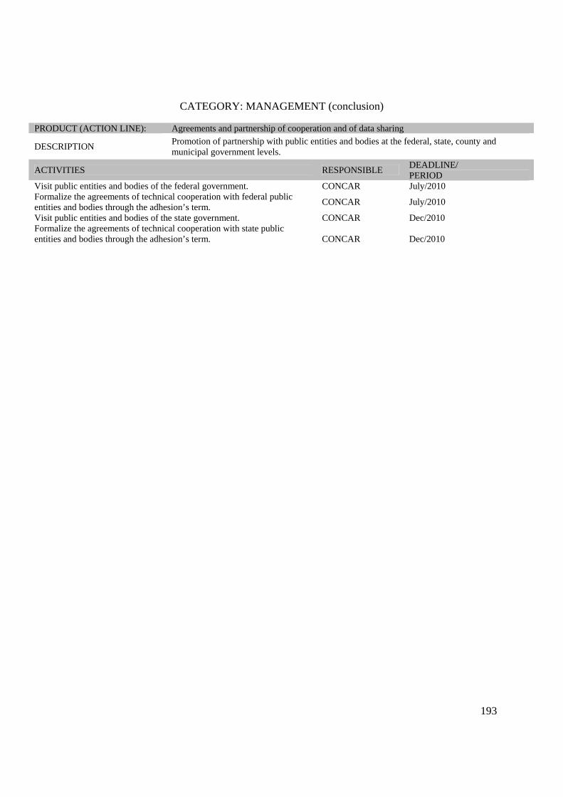
193
CATEGORY: MANAGEMENT (conclusion)
PRODUCT (ACTION LINE): Agreements and partnership of cooperation and of data sharing
DESCRIPTION Promotion of partnership with public entities and bodies at the federal, state, county and municipal government levels.
ACTIVITIES RESPONSIBLE DEADLINE/ PERIOD
Visit public entities and bodies of the federal government. CONCAR July/2010 Formalize the agreements of technical cooperation with federal public entities and bodies through the adhesion’s term. CONCAR July/2010
Visit public entities and bodies of the state government. CONCAR Dec/2010 Formalize the agreements of technical cooperation with state public entities and bodies through the adhesion’s term.
CONCAR Dec/2010

194
CATEGORY: NORMS AND STANDARDS PRODUCT (ACTION LINE): Standard of the Geospatial metadata
DESCRIPTION Elaborate, submit to the public consultation, approve and publish the metadata standard that will be used in the NSDI.
ACTIVITIES RESPONSIBLE DEADLINE/ PERIOD
Submit the profile to the public consultation CEMG(1) OCT/2009 Promote the consolidation’s meeting of the public consultation. CEMG OCT/2009 Approve the MGB profile CONCAR NOV/2009 Publish the standard of the geospatial metadata CONCAR DEC/2009 Reproduce the standard of the geospatial metadata CONCAR/SE FEB/2010 Note: Acording to the article 6, section VIII, ítem e. (1) Structuring Committee of Geospatial Metadata.
PRODUCT (ACTION LINE): Norms, standards and specifications defined and updated
DESCRIPTION Elaborate, submit to the public consultation, approve and publish the reference documentation to the issues of data’s standardization.
ACTIVITIES RESPONSIBLE
DEADLINE/ PERIOD
Survey the standards not yet identified and the responsible for their elaboration.
Specialized Committee APRIL/2010
Elaborate the data’s standards, those that were not identified. Specialized Committee DEC/2010
Specify the techniques relating to the official data- Geographic names CNGEO(2) AUG/2010 Specify the techniques relating to the reference data-general charts of the type charts-image and Orthophotography charts. DSG/IBGE AUG/2010
Specify the techniques of geodetic control for the data of planimetric, altimetric and tide gauge network. IBGE AUG/2010
Specify the techniques related to vector data at 1:1.000.000 scale and smaller. IBGE DEC/2010 Specify the techniques related to vector data on the scale 1:250.000 and larger (ET-ADGV, ET-PDG, ET-RDG. DSG MAY/2010
Specify the techniques related to vector data of cadastral mapping. CNMC(3) DEC/2010 Specify the techniques related to vector data to the thematic mapping: geological, mineral resources, geochemistry, geophysics and hydrology. CPRM DEC2011
Specify the techniques related to the thematic data of geology(systematization of information),hydrogeology, hydrochemistry, geomorphology, soils (systematization of information), cover and land use, vegetation, biomes, water resources, scientific collection.
IBGE DEC2011
Specify the techniques related to the special geospatial data thematic data of the nautical cartography’s synoptic charts and raster nautical charts and messages or notices to marines.
CHM AUG/2010
Elaborate the technical specifications related to the special geospatial data of the Aeronautical Cartography. ICA AUG/2010
Request the technical specifications related to the soil thematic data. EMBRAPA AUG/2010 Specify the techniques related to the raster data. CONCAR DEC/2010
(2) Committee of Geographic Names. (3) Committee of Normalization of the Cadastral Mapping.

195
CATEGORY DATA AND METADATA
PRODUCT (ACTION LINE): Action plan of the actors producers of data
DESCRIPTION Detailed plan, supported by the legislation in force, by institution, which explain the data, material and services (including preparation of data converters) and training, schedule chronogram and application of resources in order to incorporate to the NSDI.
ACTIVITIES RESPONSIBLE DEADLINE/ PERIOD
Develop an action plan model so that the data producers can incorporate the NSDI (Cycle I) and promote a technical meeting between the actors
Specialized committee March / 2010
Elaborate the plans by the producers actors in charge
Specialized committee producer actors
April / 2010
Evaluate and elaborate an integrated plan (data and metadata) Specialized committee April / 2010
Transfer resources to implement the integrated plan MP April / 2010
PRODUCT (ACTION LINE): Catalog of Geospatial Metadata
DESCRIPTION Distributed set of metadata describing the geospatial data, according to the Standard defined in the NSDI.
ACTIVITIES RESPONSIBLE DEADLINE/ PERIOD
Customize the GeoNetwork (complete profile) CEMG JAN/2010
Promote Workshop of training in the institutions.
CEMG and Specialized committee
April / 2010
Make available the geospatial metadata on the servers of the DBDG. Producer actors June / 2010

196
CATEGORY: TECHNOLOGY
PRODUCT (ACTION LINE): Systems of service
DESCRIPTION Hiring companies for development general services and a corrective and gradual process maintenance of nodes of the DBDG, in the federal actors.
ACTIVITIES RESPONSIBLE DEADLINE/ PERIOD
Specify and bid companies to hire
Specialized committee/IBGE JUNE/2010
PRODUCT (ACTION LINE): SIG portal Brazil
DESCRIPTION DBDG Virtual Interface, which enables the publication and search of geospatial data and services, facilitating the location and the access to these resources.
ACTIVITIES RESPONSIBLE DEADLINE/ PERIOD
Create the SIG Brazil Portal for its launch
Specialized committee/IBGE June / 2010
Approve the SIG Brazil Portal CONCAR DEC/2010
Integrate the catalog service of the NSDI with the catalog of the e-government services.
Specialized committee e-PING
To be defined
PRODUCT (ACTION LINE): Network of nodes of the DBDG
DESCRIPTION
System of data servers, grouped in nodes, distributed on the worldwide network of Computers, electronically capable of gathering producers, managers and geospatial data users, in order to store, share and access these data and related services.
ACTIVITIES RESPONSIBLE DEADLINE/ PERIOD
Raise how many institutions will need to receive the basic structure to integrate to the NSDI in Cycle I.
Specialized committee March / 2010
Develop terms of reference for the acquisition of hardware components provided to a node DBDG.
Specialized committee March / 2010
Acquiring hardware for the DBDG nodes. Specialized committee May / 2010
Evaluate the need for additional hardware for the hosting node and Portal, and purchase if it is necessary.
Actors/Specialized committee / IBGE May / 2010
Provide nodes of the institutions identified for the Cycle I. Actors Dec / 2010

197
CATEGORY: CAPACITY BUILDING TRAINING( Continuation) PRODUCT (ACTION LINE): Capacity Building and Training Program
DESCRIPTION
Program that aims to: Sensitize, raise awareness and motivate the target audience for adhesion to the NSDI; train and teach how to use technically the knowledge and the use of norms; standards and associated specifications; the characteristics of the data and information, products and services; and the process of geospatial data and metadata production; and train and teach how to use technically the development, management, maintenance and operation of the DBDG and SIG Brazil; as well as promote and motivate the inclusion of the NSDI’s theme in the teaching and research’s institutions.
ACTIVITIES RESPONSIBLE DEADLINE/ PERIOD
Compose the Capacity Building and training program of the NSDI.
Specialized Committee MAY/2010
PRODUCT (ACTION LINE): Capacity building and training module contents.
DESCRIPTION Elaborate the content about the technical and operational requirements related to the capacity building modules foreseen.
ACTIVITIES RESPONSIBLE DEADLINE/ PERIOD
Elaborate reference’s term for hiring specialized company for structuring of the module’s content related to the DBDG and SIG Brazil.
Specialized Committee/IBGE APRIL/2010
Hire specialized service for content’s elaboration.
Specialized Committee/IBGE MAY/2010
Structure and provide the content of the reference metadata and data modules (orientations with instructions to fill out the profile MGB, data converters, and others foreseen in the capacity building’s module of the chapter 6).
Specialized Committee
JULY/2010
PRODUCT (ACTION LINE): Capable instructors/multipliers
Description Enable the servers indicated by the participating bodies to be instructors/multipliers.
activities RESPONSIBLE DEADLINE/PERIOD
Train the NSDI’s multipliers for the reference metadata and data modules: managers, producers, users and management/DBDG/Portal.
Specialized Committee MAY/2010 to OCT/2010
Evaluate the content structured by modules of geospatial metadata and reference data taught to the instructors/multipliers.
Specialized Committee AUG/2010 to DEC/2010

198
CATEGORY: CAPACITY BUILDING TRAINING(CONCLUSION)
PRODUCT (ACTION LINE): Content of the capacity building and training modules in the corrected format
DESCRIPTION Composition and formatting the capacity building and training modules to the target audience: managers, producers, users and technology.
ACTIVITIES RESPONSIBLE DEADLINE/ PERIOD
Elaborate reference’s term for hiring specialized company to format the syllabus considering the pedagogical, didactic and motivational aspects of the modules in the attending modality.
Specialized Committee MARCH/2010
Hire Company
Specialized Committee/IBGE MAY/2010
Format the modules’ contents (live)
Specialized Committee/Contracted Service
DEC/2010
PRODUCT (ACTION LINE): Teaching materials for the reproduced capacity building and training modules
DESCRIPTION Teaching materials’ reproduction with the incorporated pedagogical, didactic, and motivational aspects.
ACTIVITIES RESPONSIBLE DEADLINE/ PERIOD
Elaborate reference’s term to hire specialized service in teaching material’s reproduction.
Specialized Committee MARCH/2010
Hire specialized company Specialized Committee APRIL/2010
Reproduce teaching material Contracted Work MARCH/2010 to DEC/2010

199
CATEGORY: DISSEMINATION/COMMUNICATION (Continue) PRODUCT (ACTION LINE): Plan of dissemination and Communication
DESCRIPTION Document containing the guidelines for diffusion and dissemination for the NSDI.
ACTIVITIES RESPONSIBLE DEADLINE/ PERIOD
Compose the NSDI Communication Plan Specialized committee March / 2010
PRODUCT (ACTION LINE): NSDI Launch event
DESCRIPTION Event for the preliminary dissemination, with the signature of the cooperation terms of the suppliers of the NSDI first data.
ACTIVITIES RESPONSIBLE DEADLINE/ PERIOD
Hold meetings to plan the events organization Specialized committee /CONCAR/ MP
March / 2010
Make the event CONCAR/SE E MP March / 2010 PRODUCT (ACTION LINE): Meeting with institutions and federal public bodies
DESCRIPTION Meeting to inform and encourage partnerships with public bodies and entities within the federal government with the possibility of signed agreements at the release of the Portal.
ACTIVITIES RESPONSIBLE DEADLINE/ PERIOD
Hold meetings to plan and organize the event.
Specialized committee May / 2010
Make the event
Specialized committee/ hired service
May / 2010
PRODUCT (ACTION LINE): Communication and dissemination of the NSDI
DESCRIPTION Set of actions to promote and disseminate the NSDI importance and their applications and utilities.
ACTIVITIES RESPONSIBLE DEADLINE/ PERIOD
Develop terms of reference and bid in order to hire communication company to carry out activities under the Chapter 7 - Cycle I (creation of logo and visual identity, graphic material and electronic media advisory, video, website design to launch the SIG Brazil, etc.)..
Specialized committee April / 2009
Hire specialized comminucation service Specialized committee/ IBGE June / 2010
Plan and facilitate the dissemination of the NSDI in events related to the subject.
Specialized committee Dec / 2010
Coordinate the activities actions of support by the hired company Specialized committee Dec / 2010

200
CATEGORY: DISSEMINATION/COMMINUCATION (CONCLUSION)
PRODUCT (ACTION LINE): Meeting with academic institutions (Universities, Research Centers and Schools techniques)
DESCRIPTION Meeting to inform and encourage partnerships with the academic area (universities, Research Centers and Technical Schools) with possible signatures of cooperation and exchange agreements.
ACTIVITIES RESPONSIBLE DEADLINE/PERIOD
Hold meetings to plan the event.
Specialized committee/ hired service
Dec / 2010
Make the event.
Specialized committee/ hired service
Dec / 2010
PRODUCT (ACTION LINE): Meeting with institutions and state and local government bodies
DESCRIPTION Meeting to inform and encourage partnerships with public bodies and entities within of state and local governments with possible signatures of agreements in the launch event of the Portal version 2.
ACTIVITIES RESPONSIBLE DEADLINE/PERIOD
Promote meetings to plan the event
Specialized committee/ hired service
Dec / 2010
Make the event
Specialized committee/ hired service
Dec / 2010
PRODUCT (ACTION LINE): Launch event f the SIG BRAZIL PORTAL
DESCRIPTION Event to disseminate the SIG Brazil Portal and the DBDG
ACTIVITIES RESPONSIBLE DEADLINE/ PERIOD
Promote meetings to plan the event
Specialized committee/ hired service
Dec / 2010
Make the event
Specialized committee/ hired service
Dec / 2010
PRODUCT (ACTION LINE): Workshops
DESCRIPTION Events for specialized target-audiences to disseminate the NSDI.
ACTIVITIES RESPONSIBLE DEADLINE/PERIOD
Promote meetings to plan the event
Specialized committee/ hired service
Dec / 2010
Make the event
Specialized committee/ hired service
Dec / 2010
Sum of the Cycle I (investments) R$ 2.060.700,00Sum of Cycle I (cost) R$ 7.863.720,00 Total Cost of the Cycle I R$ 9.924.420,00
201
ANNEX III Participants of Planning Committee of the National Spatial Data Infrastructure - CINDE

202
Participants of the CINDE AGENCY Agustin Justo Trigo MMA/ANA Alan Juliano da Rocha Santos SEPLAN/SE Alessandro Schmidt ( lieutenant Colonel ) DHN/CHM Alexandre de Amorim Teixeira MMA/ANA Alexandre Iamamoto Ciuffa SEPLAN/SP - IGC Alice Maria Barreto Vieira IBGE Anna Lucia Barreto de Freitas IBGE Antonio Carvalho Filho IBGE Antonio Fernando Garcez Faria ( Captain ) DHN/CHM Antonio Henrique Correia (Major) DSG Aramis Ribeiro Motta GSI/PR Camila Bassetto ICA Carlos Alberto dos Santos IBGE Carlos Fernando Quartaroli EMBRAPA Celso Donizetti Talamoni SEPLAN/SP - IGC Celso José Monteiro Filho IBGE Charles Capella de Abreu Ministry of Tourism Claudio João Barreto dos Santos IBGE Clodoveu Davis UFMG Divino Cristino de Figueiredo CONAB Dulce Santoro Mendes IBGE Edaldo Gomes MDA/INCRA Edmar Moretti MMA/CGTI Elaine Villares Silveira DHN/CHM Elaine Xavier MP/SPI Eliana Maria Khalil Mello MCT/INPE Eugênio José Saraiva Câmara Costa Ministry of Transportation /SPNLT Fernanda dos Santos Lopes Cruz SEPLAN/SE Flávia Dantas Moreira SEPLAN/SE Francisca Luíza Gimenez Cardieri EMPLASA Gabriel Dietzsch (1o Lieutenant Engineering) ICA Giovanna Altomare Catão IBGE Graciosa Rainha Moreira IBGE Hélio Gouvêa Prado ( Colonel ) DSG Hellen Cano IBGE Herben Kally de Almeida IBGE Hesley da Silva Py IBGE Humberto Mesquita Navarro Junior MMA Isabel de Fátima Teixeira Silva IBGE Izabella Maria Swierczynskizs SEPL/Paraná Jece Lopes ANTT / SUEME / GEINT João Bosco de Azevedo IBGE João Cândido de Melo Júnior MME/DS/DNPM/PE João Henrique Gonçalves CPRM

203
Participants of the CINDE AGENCY
Jorge Dirceu de Melo Cerqueira ( Captain ) GSI/PR José Carlos Louzada IBGE José Eduardo Bezerra da Silva IBGE José Enílcio Rocha Collares IBGE José Mauro de Moura Alves ( Colonel ) DSG Judson Magno da Silva Matos MDA/INCRA Julia Célia Mercedes Strauch IBGE Karênina Martins Teixeira Ministry of Transportation /SPNLT Leonardo Arthur Esteves Lourenço (1o lieutenant.) DSG Leonardo Marini Pereira (1o Lieutenant Engineering.) ICA Leonardo Pozzo Rodarte ANTT/SUPLA/GEINF Leonel Antônio da Rocha Teixeira MMA/SEDR Linda Soraya Issmael ( captain) DSG Luciana Ferreira Lau IBGE Luciana Medeiros Senra Ministry of the Cities Luigino Italo Palermo IBGE Luis Cavalcanti da Cunha Bahiana IBGE Luis Fernando Bueno CENSIPAM Luis Geraldo Ferreira INPE Luíz Henrique Moreira de Carvalho (ST) DSG Márcia de Almeida Mathias IBGE Marcio Bomfim P. Pinto MMA/ANA Marcio Constant de Andrade Reis ANEEL/SGI Márcio Lúcio Corrêa Ministry of Tourism Marcos Ferreira dos Santos IBGE Margareth Simões P. Meirelles EMBRAPA Maria Cecilia Parente Badauy ANTAQ/Dir. Vias Naveg. Maria do Carmo Dias Bueno IBGE Maria Elisabete Silveira Borges MMA/SEDR Mariano Frederico Pascual IBAMA Marlon Crislei Silva IBAMA/CRS Massashige Takiguchi IBGE Maurício Dayrell MMA Moema José de Carvalho Augusto IBGE Osvaldo da Cruz Morett Netto ( captain .) DSG Nadima Sayegh Ezarani GSI/PR Nicolas de Andrade Roscher (CF) DHN/CHM Nina Figueira Maltz (Tenente) DSG Omar Antonio Lunardi ( Colonel .) DSG Oséias Borges dos Santos ( captain .) DSG Patricia Rizzi MMA/ICBIO Paulo Roberto de Miranda Barros ( Colonel) GSI/PR Paulo Roberto de Noronha Denys Ministry of Transportation /SPNLT

204
CINDE Participants AGENCY Paulo Roberto Martini INPE Paulo Roberto Xavier Ferreira ANTAQ/Dir. Vias Naveg. Priscila Lopes Soares da Costa MMA/SEDR Priscilla May Delany Masson EMPLASA Rafael March Castañeda Filho IBGE Ricardo Forim Lisboa Braga IBGE Ricardo Peng MMA/SEDR Ricardo Ramos Freire (EN) DHN/CHM Roberto Maisenhelder (T) DHN/CHM Roberto Penido Duque Estrada (lieutenant Colonel) DSG Rogério Luis Ribeiro Borba IBGE Shigemaru Nakayama EMPLASA Sílvio Barbosa da Silva Júnior ANTT/SUEME/GEINT Sonia Albieri IBGE Sonia Maria Alves da Costa IBGE Sueli Borges da S. Gouvêa CPRM Thaís Machado Scherrer MCT/CNPQ Oliveira Henrique de Araújo IBGE Valther Xavier Aguiar ANEA Verner Riebold Ministry of Transportation/DNIT Walter Uchoa Dias Junior SEPLAN/SE Wesley Silva Fernandes IBGE Wladimir da Silva Meyer (Major) DSG