It’s Our Future Princess Anne Commons/Transition Area 4-7 chapter four » Adhere to the Design...
19
chapter four THE PRINCESS ANNE COMMONS & TRANSITION AREA It’s Our Future www.ourfuturevb.com
Transcript of It’s Our Future Princess Anne Commons/Transition Area 4-7 chapter four » Adhere to the Design...

chapter fourTHE PRINCESS ANNE COMMONS & TRANSITION AREA
It’s Our Future
www.ourfuturevb.com

The Princess Anne Commons/Transition Area 4-1
chapter fourTHE PRINCESS ANNE COMMONS AND TRANSITION AREA
THE PRINCESS ANNE COMMONS/TRANSITION AREA
› Quality Development
› Planned Mix of Public and Private Uses
› Exceptional Open Spaces
› Design with Nature
The Princess Anne Commons and The Transition Area are strategically located between the more urbanized region of the City to the north and the rural area to the south. This area remains an important component of the City’s overall land use planning strategy. The ‘Green Line’ is the boundary between the urban part of the City to the north and the lower density and rural areas to the south.The Princess Anne Commons, shown on the next page, consists of what was, in prior Comprehensive Plans, the western portion of the Transition Area and the North Princess Anne SGA. With the December 2005 amendments to the Comprehensive Plan, this area was identified as being within the Interfacility Traffic Area (ITA) between NAS Oceana and NALF Fentress. One of the principal effects of this new designation was to reduce the residential density to what could be achieved by-right with Agricultural zoning (one unit per 15 acres). A second effect was an increase in the area owned by the City of Virginia Beach, as the City and U.S. Navy began a program of purchasing property voluntarily offered to the City. Despite these land use constraints, the City recognized unique opportunities in this area and developed the ITA and Vicinity Master Plan to identify the vision for this area. The Interfacility Traffic Area and Vicinity Master Plan was prepared with effective community involvement to provide planning policy guidance in the areas of land use, transportation, environmental stewardship, infrastructure, public service delivery, economic vitality, AICUZ compatibility, housing and community design. Specific policies from this plan are provided later in this chapter. The full Interfacility Traffic Area and Vicinity Master Plan can be found in the document library at www.ourfuturevb.com. In sum, the Princess Anne Commons offers a unique opportunity for educational, entertainment, recreational, habitat preservation, and quality economic development opportunities. It is a true jewel within Virginia Beach. The Transition Area consists of the area bordered by Princess Anne and Sandbridge Roads along the ‘Green Line’ to the north, North Landing Road to the west, Indian River Road to the south, and New Bridge Road to the east. (See map next page.)
Canoeists
Signature Golf Course
USA Field Hockey

4-2The Princess Anne Commons/Transition Area
chapter four
PRINCESS ANNE COMMONS & TRANSITION AREA

4-3The Princess Anne Commons/Transition Area
chapter fourIt is not the intent of this Plan for the Princess Anne Commons or the Transition Area to become part of the urban area north of the Green Line. Nor is it intended that the Transition Area be limited to the very low densities appropriate for rural growth. The policies of this Comprehensive Plan have been designed to ensure that this continues to be a well-planned area. While recognizing that some land use adjustments are appropriate to accomplish strategic public outcomes and adapt to changes to the Oceana Land Use Conformity program, proposed developments within The Princess Anne Commons and Transition Area should adhere to the following general recommendations.
The Princess Anne Commons/ Transition AreaGeneral Recommendations
Unless otherwise addressed within the ‘Special Area Recommendations’ section of this chapter, proposed developments in these areas should conform to the following planning recommendations designed for general application:
» Continue the tradition of high quality development by adhering to the planning and design principles cited in the ‘Transition Area Design Guidelines’.
» Adhere to a maximum average calculated density of one dwelling unit per acre, except where otherwise recommended.
» Cluster uses in a creative manner to minimize impervious surfaces, protect open spaces and optimize site amenity and design opportunities.
» Recognize that, when completed, Nimmo Parkway will be the major east-west arterial roadway in this area, transforming North Landing Road to a minor collector role.
» Development proposals should strive to achieve the goal of attaining 50% open space including berms, trees, buffers and trails to create safe, accessible and attractive roadway corridors and internal green space.
» Design with nature by creating site plans that respect and showcase valued natural resources.
» Use all available resources including those provided by the City’s Historic Review Board and Historic Preservation Commission as well as the Princess Anne County/Virginia Beach Historical Society to preserve designated historic resources.
» Efforts to retain these historic resources should be accomplished in a responsible and innovative manner. The efforts include providing land use planning guidance and tax credit assistance to owners of historic properties in order to help protect and preserve the City’s limited number of valuable historic resources and surrounding open space areas.
Municipal Center-City Hall
Neighborhood Trail System

4-4The Princess Anne Commons/Transition Area
chapter four
Stumpy Lake
» Owners of qualified properties should be encouraged to participate in the Virginia Beach Historical Register program and receive recognition for their contributions to our City’s heritage.
» Incorporate into all public and private development plans a well-planned system of multipurpose trails, greenways and other linkages, especially with regard to the Stumpy Lake-Back Bay Greenway, to implement the strategic goals of the adopted Outdoors Plan. This Plan is available in the online document library at www.ourfuturevb.com.
» Demonstrate that the capacity of roadways and other infrastructure in the Transition Area can adequately support the demand placed on them by discretionary development proposals.
» Ensure all projects employ energy efficient systems, preferably equivalent to or higher than the standards set for the Leadership in Energy and Environmental Design (LEED™) ‘Certified’ rating.
» Ensure all development proposals conform to the provisions of the Oceana Land Use Conformity program and AICUZ provisions.
The Princess Anne CommonsA majority of The Princess Anne Commons is located between Princess Anne Road and North Landing Road. This area is divided into three parts: North Princess Anne Commons, Central Princess Anne Commons, and South Princess Anne Commons.
North Princess Anne Commons
The existing land uses in North Princess Anne Commons, comprise an array of public and private activities including recreational, entertainment, medical, educational, office, and retail. The location of North Princess Anne Commons is primarily located southwest of the intersection of Rosemont Road and Dam Neck Road, east of the single-family residential development of Salem Lakes, north of Landstown Road, and encompassing the Virginia Beach National Golf Course. North Princess Anne Commons includes a variety of academic
institutions including Landstown Elementary, Middle and High Schools, the Virginia Beach Campus of Tidewater Community College, the Higher Education Center for Old Dominion and Norfolk State Universities and the Advanced Technology Center. Land uses between this academic village and Dam Neck Road include Princess Anne District Park, the Farmers Market, retail shops, a residential area, a solid waste
Virginia Beach Amphitheater

4-5The Princess Anne Commons/Transition Area
chapter four
transfer facility, and the Public Works/Public Utilities Operations facilities. The southern part of this area includes a medical village, an athletic village, public parkland and other areas used for outdoor entertainment. As a prominent ‘Placemaker’ in the City, ‘North Princess Anne Commons’ not only serves as the principal gateway to the Virginia Beach Municipal Center and court complex, it has become a premier destination offering the public a wide range of special events and services. For example, North Princess Anne Commons includes: the Virginia Beach Amphitheater, Sportsplex, Virginia Beach National Golf Course, the National Field Hockey Training Center, a regional medical campus with specialized support services and a hierarchy of educational facilities that covers elementary to postgraduate studies. Each village within North Princess Anne Commons aligns with the strategic goals for the area. This destination will continue to offer our citizens and visitors experiences that will enrich their lives and reaffirms that Virginia Beach is a community for a lifetime.Information about North Princess Anne Commons including Design Guidelines that affect this area is available in the online document library at www.ourfuturevb.com.
North Princess Anne Commons Recommendations
» Preserve and protect the large stand of mature trees at the corner of Princess Anne Road and Dam Neck Road.
» Continue the theme of villages of academic institutions, medical, recreational and entertainment.
» Ensure well planned high quality economic development opportunities that promote the North Princess Anne Commons Villages.
» Conduct a relocation feasibility study on the existing public facility yards located between Rosemont Road and Princess Anne Road to assess possible alternative uses for this area.
» Any redevelopment of the City owned property on the north corner of Princess Anne Road and Dam Neck Road should advance the City’s goal of achieving the academic and medical villages. Should the City decide to redevelop the existing Farmers Market site, careful consideration must be part of the decision making process to determine the type, size and location(s) of similar ‘farm-to-market’ and affiliated activities, thereby ensuring optimal economic benefit for farmers and others participants.
Sportsplex (Athletic Village)
Advanced Technology Center (Academic Village)
NORTH PRINCESS ANNE COMMONS
› Athletic Village
› Academic Village
› Medical Village
Sentara Princess Anne Hospital (Medical Village)

4-6The Princess Anne Commons/Transition Area
chapter four chapter four
PRINCESS ANNE COMMONS

4-7The Princess Anne Commons/Transition Area
chapter four
» Adhere to the Design Guidelines for Princess Anne Commons.
» Direct private access to Princess Anne Road will not be permitted except when the property in question has no other reasonable access to the circulation system as it is part of the City’s Access Controlled road network, identified on page 6-8.
Central Princess Anne Commons
The location of Central Princess Anne Commons is generally south of the Virginia Beach National Golf Course to just north of North Landing Road.The existing land uses in the Central Princess Anne Commons Area are primarily rural residential, forested, and cultivated land located within an area of several constraints including floodplain and jet noise levels exceeding 75 DNL.
Central Princess Anne Commons Recommendations
» Adhere to the Design Guidelines for Princess Anne Commons.
» Limit maximum residential density to that allowed ‘By right’ under existing zoning.
» The core area of Central Princess Anne Commons offers an opportunity for quality corporate office, institutional, research, and similar
facilities. The majority of the existing parcels within the ‘core’ are larger than parcels fronting on Landstown and Salem Roads, offering good opportunities for quality development. This Plan recommends that individual properties in the core should be consolidated to create significant development sites (greater than 15 acres) appropriate for such development. Suitable roadway and utility infrastructure must be available prior to development of this type.
» Light industrial uses, including business incubator and flex office/warehouse uses, are appropriate in areas outside of designated ‘Special Areas’ identified in the Interfacility Traffic Area and Vicinity Master Plan.
» With the close proximity of North Princess Anne Commons, this area is appropriate for additional recreational uses.
» The area outside of the ‘core’ is recommended for continued by-right agricultural, equestrian, and rural residential uses. Where parcels in this area are greater than 15 acres, quality office, research, or similar development is acceptable if adequate infrastructure and services are available.
» Acquisition of properties from willing sellers within Central Princess Anne Commons is recommended consistent with the Oceana Land Use Conformity program.
Courthouse Market Place
Municipal Center-Administrative Offices

4-8The Princess Anne Commons/Transition Area
chapter fourSouth Princess Anne Commons
A major natural area is located along North Landing River where our City boundary adjoins that of Chesapeake. This area should be preserved and enhanced, as needed, to protect this natural resource. South Princess Anne Commons Recommendations
» Promote acquisition of land from willing sellers along the corridor of the North Landing River and its tributaries to protect valued natural resources and increase participation in the Navy’s ‘Encroachment Partnering’ program.
» Land uses in the area should be limited to the existing natural resource base, by-right rural residential, and agricultural and related activities.
» A study of the potential use of this area as a major park or preserve should be conducted with park development to follow, if feasible.
Transition AreaThe boundaries of the Transition Area now include North Landing, Princess Anne and Sandbridge Roads to the north; New Bridge Road to the east; and Indian River Road to the south. The Transition Area, located south of the Green Line and north of the rural area,
is characterized by many high quality residential neighborhoods that include significant open space areas. Much of the Transition Area has been developed. However, undeveloped tracks of land, subject to AICUZ restrictions, are located in the western region of the Transition Area along with a patchwork of smaller, undeveloped properties in the eastern sector that, for the most part, are located outside the AICUZ impact areas. The eastern edge of the Transition Area is in close proximity to the headwaters of Back Bay and the National Wildlife Refuge. The central part of the Transition Area is bisected by the City’s West Neck Creek District Park corridor, a major natural corridor. Both natural features help define this area and provide unparalleled amenities for those who live in and visit this area.
A map of the Transition Area and the planning policies that affect this area are presented earlier in this chapter.
Special AreasThere are areas generally within ‘The Princess Anne Commons’ and ‘Transition Area’ that deserve special attention, including the Historic Princess Anne Center, Interfacility Traffic Area, and the Interfacility Traffic Area and Vicinity.
Residential Development
Judicial Building at the Municipal Center

4-9The Princess Anne Commons/Transition Area
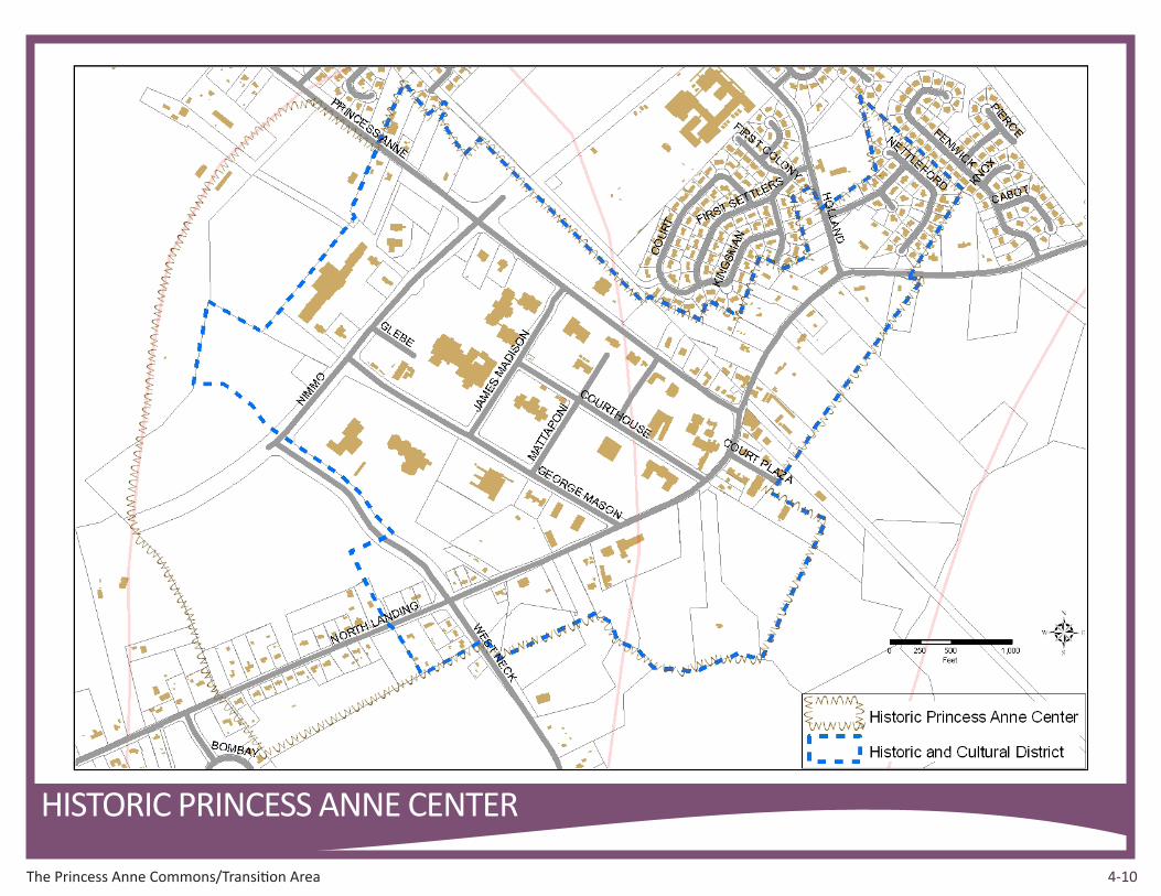
chapter fourHistoric Princess Anne Center
Historic Princess Anne Center includes the Virginia Beach Municipal Center/ Court Complex and the surrounding environs. In addition to being the seat of our City government and court system, this Center includes the Princess Anne Historic and Cultural Zoning Overlay District, a line of established homes along North Landing Road and numerous small businesses and offices. The City owns much of the land located outside the restricted noise zones in the northwestern area of this center. This historic center is where Princess Anne Road meets Nimmo Parkway. Both are major roadways and integral parts of the City’s transportation system. The importance of this area as a strategic crossroads in central Virginia Beach will continue to grow into the foreseeable future. Historic Princess Anne Center is planned to expand its role as a highly attractive destination with a balanced blend of residential, commercial and open spaces to complement the form and function of the municipal center, court complex and historic district. While it will continue to serve as a gateway between the urban north and rural south, this center will experience new and improved land uses that will enhance the character of this important and historic area that is the seat of our municipal government. Historic Princess Anne Center Recommendations
The following specific recommendations apply to the Historic Princess Anne Center area.
» Planned land uses, both public and private, should be compatible with those found in the municipal center and court complex and, where appropriate, may include residential, office, retail, service, hotel and institutional uses.
» Expand coverage of the Princess Anne Historic and Cultural District to include all of the Historic Princess Anne Center.
» New residential developments should include a reasonable amount of workforce housing units, consistent with related City policies.
» The use, intensity and design of infill development along North Landing Road should reflect the existing character of the Princess Anne Historic and Cultural District.
» All projects proposed within the Princess Anne Historic and Cultural District must respect the heritage and reinforce the integrity of the district’s historic character. The scale, placement, massing and proportion of buildings, additions and architectural details should be designed in a way that is consistent with the historic character of this district.
» Ensure that new development in and outside the Princess Anne Historic and Cultural District employs high quality site and building designs that complement the classic Neo-Georgian architecture of the municipal center.
Showcase Natural Resources
4-10The Princess Anne Commons/Transition Area
chapter fourchapter four
HISTORIC PRINCESS ANNE CENTER

4-11The Princess Anne Commons/Transition Area
chapter four
» Integrate carefully planned landscaping and open spaces.
» The design of new or improved roadways located within or approaching this Center must reflect exceptional quality in keeping the character of this historic area.
» Improve mobility by limiting roadway access points along arterials and adhere to the recommendations of the Princess Anne Corridor Study (document available in the online document library at www.ourfuturevb.com).
» Direct private access to Princess Anne Road will not be permitted except when the property in question has no other reasonable access to the circulation system as it is part of the City’s Access Controlled road network, identified on page 6-8.
Interfacility Traffic Area
The Interfacility Traffic Area (ITA) is a product of the Hampton Roads Joint Land Use Study and the City’s Oceana Land Use Conformity program. The ITA was created in 2005 to address land use compatibility issues associated with frequent overflights of military jets in this part of the City. The boundary of the ITA generally overlaps ‘The Princess Anne Commons’ and includes portions of the ‘Transition Area’ impacted by noise zones at or greater than 65 DNL. The planning policies affecting the ITA have been carefully written to achieve compliance with the provisions of the City’s adopted Oceana Land Use
Conformity program.The entire Interfacility Traffic Area is subject to certain development limitations due to jet noise restrictions and must be carefully planned to achieve a coherent and compatible land use pattern. Of the roughly 4400 acres within this special area, less than half are developable due to the presence of water, wetlands, existing development
or other constraints. The Southeastern Parkway is planned to traverse the ITA in a northeast to southwest direction and will include interchanges at Princess Anne and Indian River Roads.
Interfacility Traffic Area Recommendations
In addition to the General Recommendations for the Transition Area, the following specific recommendations apply to the Interfacility Traffic Area:
» Adhere to the provisions of the Oceana Land Use Compatibility and AICUZ programs that include:
› Limiting maximum residential density to that allowed ‘By right’ under existing zoning.
› Promote business growth that aligns with the City’s economic growth strategy and conforms to the Oceana Land Use Conformity program.
› Promote acquisition of land from willing sellers
Landstown Commons

4-12The Princess Anne Commons/Transition Area
chapter fouralong the corridor of the North Land River and its tributaries to protect valued natural resources and increase participation in the Navy’s ‘Encroachment Partnering’ program.
» Properties within the Interfacility Traffic Area located south of the proposed Southeastern Parkway that front on Princess Anne Road are planned for office, educational, institutional and other AICUZ compatible uses. Parcels should be consolidated to provide more attractive, well planned, and efficient use of land. Such unified development should utilize reverse frontage access with internal roadway links to existing points of access on Princess Anne Road or, where available, by connecting to other tracts of land that afford access to Nimmo Parkway. No new access points to Princess Anne Road are recommended for properties that develop in this unified fashion.
» Complete right-of-way acquisitions needed to build the Southeastern Parkway.
» Ensure that future infill uses within the Princess Anne Commons complement the activity and quality of existing public venues.
» Direct private access to Nimmo Parkway or Princess Anne Road will not be permitted except when the property in question has no other reasonable access to the circulation system as it is part of the City’s Access Controlled road network, identified on page 6-8.
INTERFACILITY TRAFFIC AREA AND VICINITY
In January 2010, the City began work on a Master Plan for the Interfacility Traffic Area (ITA) and Vicinity. As with other area plans, the process relied heavily on input from the public, property owners, business
community, City leadership, as well as the Navy. Although the planning process was similar to that used for the Strategic Growth Areas, the ITA and Vicinity is not a Strategic Growth Area and therefore should not compete with economic development activity intended for the SGAs. This area will focus on providing locations for rural or campus-like development that may not be suitable in a more urban setting.
More specifically, the ITA vision prioritizes strengthening development nodes along the Princess Anne Corridor. In areas where residential uses fall outside of restricted AICUZ zones, vibrant mixed-use districts are envisioned where people can live, work, and recreate within walking distance to services and gathering spaces.
Because much of the development focuses on concentrated uses, campus models can create a beautiful, interconnected character for the area. This tradition is already present in the current Municipal Center, Princess Anne Commons, Sportsplex, Sentara Hospital Complex, and College Campuses. The intent is to reinforce and infill these campuses and to create new clusters and quadrangles for research and development, religious facilities, and incubator and medical offices. There was strong support for integrating these centers for research and green technologies. Thoughtful implementation of this vision will position the ITA and Virginia Beach as a leader in sustainable urban edge development.
INTERFACILITY TRAFFIC AREA AND VICINITY Recommendations
» Strive to achieve 50% open space with extensive connectivity throughout ITA and Vicinity
» Protection of most sensitive land

The Princess Anne Commons/Transition Area 4-13
chapter four
DESCRIPTIONThe ITA and Vicinity Area includes the actual ITA, which spans the area between NAS Oceana and NALF Fentress, as well as additional surrounding areas including the northwest corner of Princess Anne Commons east of the Green Line, the undeveloped area north of the Green Line, and most of the Princess Anne Historic and Cultural District to the east.
INTERFACILITY TRAFFIC AREA AND VICINITY MASTER PLAN BOUNDARY
4-14The Princess Anne Commons/Transition Area
chapter four
» Residential development limited to areas outside of AICUZ restricted areas
» Mixed use town center style development in the Municipal Center and Historic/Cultural District
» Low-impact campus style development for work, education, research, recreation and worship (remainder of ITA and Vicinity Area)
» Guidelines for building types to ensure appropriate quality and character
» Expansion of suburban infrastructure in northern but not southern part of ITA and Vicinity Area south of Indian River Road
» Development remains limited along existing unimproved infrastructure
» Potential for extension of mass transit service to Princess Anne Commons and the Municipal Center
The ITA and Vicinity Master Plan identifies six nodes or “places” with specific recommendations for each:
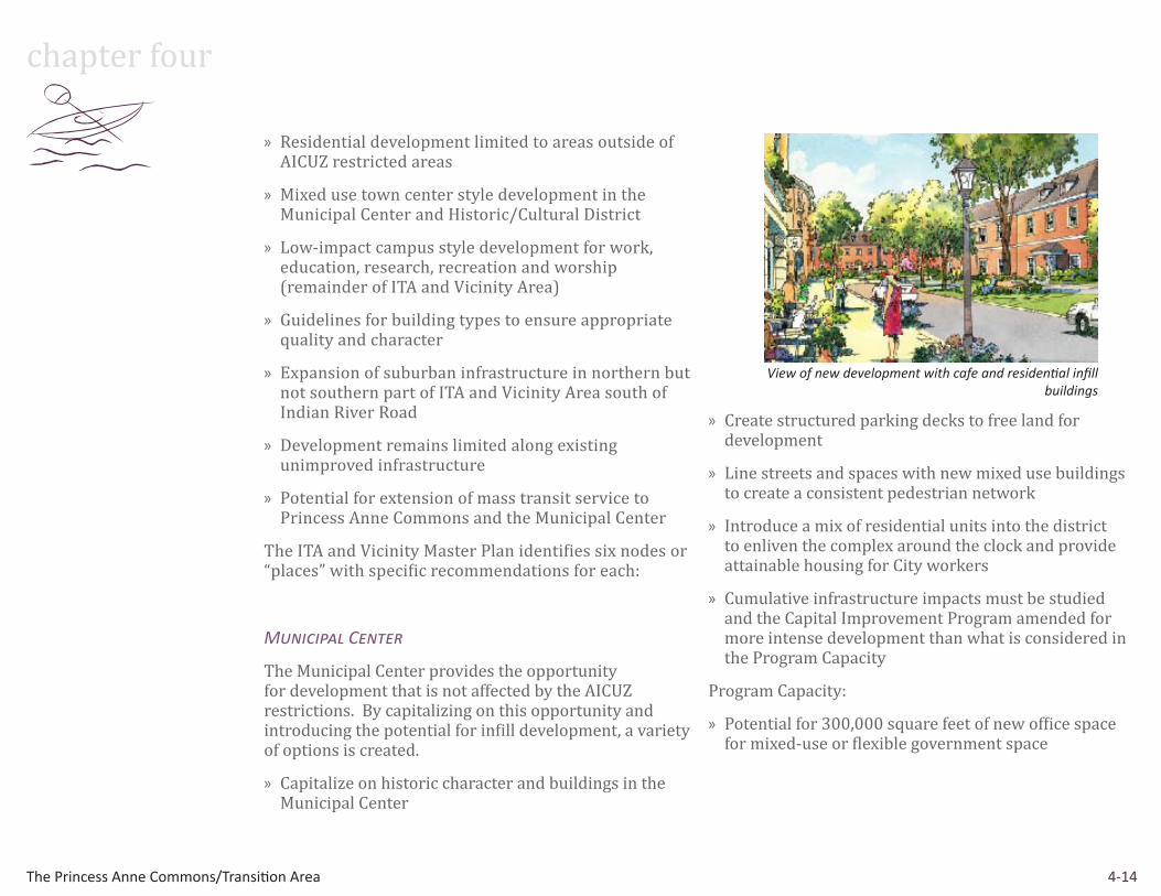
Municipal Center
The Municipal Center provides the opportunity for development that is not affected by the AICUZ restrictions. By capitalizing on this opportunity and introducing the potential for infill development, a variety of options is created.
» Capitalize on historic character and buildings in the Municipal Center
» Create structured parking decks to free land for development
» Line streets and spaces with new mixed use buildings to create a consistent pedestrian network
» Introduce a mix of residential units into the district to enliven the complex around the clock and provide attainable housing for City workers
» Cumulative infrastructure impacts must be studied and the Capital Improvement Program amended for more intense development than what is considered in the Program Capacity
Program Capacity:
» Potential for 300,000 square feet of new office space for mixed-use or flexible government space
View of new development with cafe and residential infill buildings

4-15The Princess Anne Commons/Transition Area
chapter four
Historic/Cultural District
There is a strong desire to restore and reinforce the district’s historic character. Buildings are evaluated to determine whether renovation and reuse is feasible, and efforts are made to keep historic buildings when possible.
» Capitalize on historic character and buildings on North Landing Road
» Focus parking behind buildings
» Line streets and spaces with low-rise mixed use buildings of two and three stories
» Focus attention on appropriate streetscaping elements to enforce the historic character including street lamps, planters, benches, and other elements
» Develop consistent architectural character using Virginia precedents such as Williamsburg
» Restore and reuse the Buffington House as a public or private community amenity
» Preserve Courthouse building
Program Capacity:
» Small footprint infill buildings along Princess Anne Road and North Landing Road
Princess Anne Commons
Princess Anne Commons will be the City of Virginia Beach’s center for integrated education, research, health care, and wellness facilities.
» Complete the existing development into a health, education, and research campus
» Use landscaping and building placement to create quad-like spaces
» Encourage incubator space for biotechnology, biomedical, and research companies
» Plan buildings to allow for structured parking to be phased as density increases
» Cumulative infrastructure impacts must be studied and the Capital Improvement Program amended for more intense development than what is considered in the Program Capacity
Program Capacity:
» Potential for 100,000 square feet of retail
» Potential for 1.7 million square feet of office, research, and education space
Aerial view of Princess Anne Commons
View down Princess Anne Road in Historic/Cultural District

4-16The Princess Anne Commons/Transition Area
chapter fourPrincess Anne Corporate Park
Princess Anne Corporate Park supports ancillary uses to the medical and research institutions nearby in Princess Anne Commons and provides an opportunity for health and wellness related businesses.
» Provide office and commercial development potential for the City of Virginia Beach
» Group buildings along streets and place parking behind to improve the quality of the pedestrian experience
» Employ landscaping and sustainable stormwater management techniques to “green” the development and link it to the trail and open space framework
» Cumulative infrastructure impacts must be studied and the Capital Improvement Program amended for more intense development than what is considered in the Program Capacity
Program Capacity:
» Potential for City-led development of two million square feet of office, research and light industrial space
» Strive to achieve 50% open space
» Multidisciplinary focus
Brown Farm Area
The farm formerly owned by the Brown family provides opportunity for institutional (e.g., church), retail, and office uses in a series of campuses centered around a town square. Development preserves open space and maintains a rural character.
»Determine the appropriate level of development within the Transition Area of the City
»Allow for development of a new church and accompanying school and recreation fields
» Tailor development patterns to types of users which fit market demand for this piece of land
» Cumulative infrastructure impacts must be studied and the Capital Improvement Program amended for more intense development than what is considered in the Program Capacity
Program Capacity:
» Office and Research Campuses
» “Town Square” for church, retail, and office space
» Extension of West Neck Parkway and Nimmo Parkway
» Strive to achieve 50% open space
» 75 acres: Church, schools, and athletic fields
Aerial view of Princess Anne Corporate Park
Aerial view of Brown Farm Area

4-17The Princess Anne Commons/Transition Area
chapter four » 200 acres: Campus development (potential for 2
million square feet)
» 244 acres: Open space and roads
Sustainable Laboratory and Services
This ‘Green Village’ supports public and private uses, education, and civic groups focused on sustainability efforts. The area brings high profile research jobs and presence, helping reinforce Virginia Beach’s image as a green city.
» New location for City Waste Management facility on Dam Neck Road
» Create a ‘green village’ with leasable space for green technology providers
» Encourage sustainable education and research
» Cumulative infrastructure impacts must be studied and the Capital Improvement Program amended for more intense development than what is considered in the Program Capacity
Program Capacity:
» Potential for 100 acres for transfer station, storm debris, and biofuel facility
The full set of recommendations can be found in the ITA and Vicinity Master Plan, which is available in the document library at www.ourfuturevb.com.
Aerial view of Sustainable and Laboratory Services Area

4-18The Princess Anne Commons/Transition Area
chapter four chapter four
ITA & VICINITY MASTER PLAN