Is Mobile the Future of GIS? Matt Sheehan WebMapSolutions.
24
Is Mobile the Future Is Mobile the Future of GIS? of GIS? Matt Sheehan Matt Sheehan WebMapSolutions WebMapSolutions
-
Upload
caroline-barton -
Category
Documents
-
view
215 -
download
2
Transcript of Is Mobile the Future of GIS? Matt Sheehan WebMapSolutions.

Is Mobile the Future of Is Mobile the Future of GIS?GIS?
Matt SheehanMatt Sheehan
WebMapSolutionsWebMapSolutions
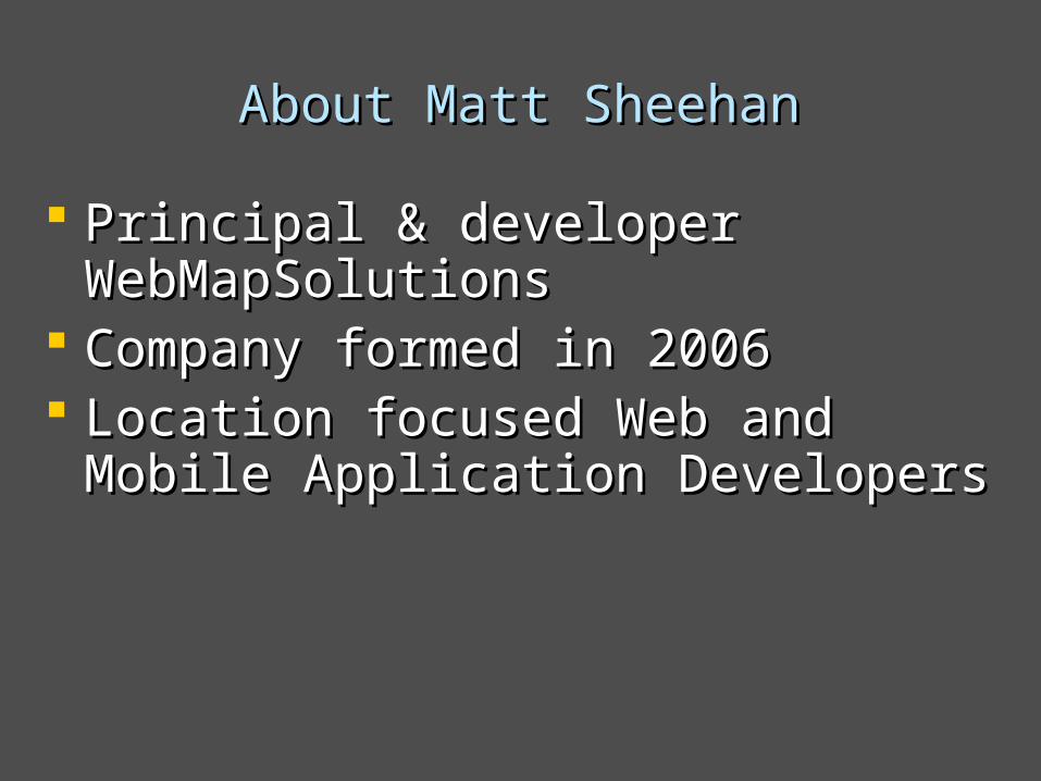
About Matt SheehanAbout Matt Sheehan
Principal & developer WebMapSolutionsPrincipal & developer WebMapSolutions Company formed in 2006Company formed in 2006 Location focused Web and Mobile Location focused Web and Mobile
Application DevelopersApplication Developers

AgendaAgenda
Background Background - Internet to Web 2.0 to mobile- Internet to Web 2.0 to mobile - Geospatial history - Geospatial history
MobileMobile - Mobile Demystified- Mobile Demystified - Geo-Mobile applications- Geo-Mobile applications

BackgroundBackground
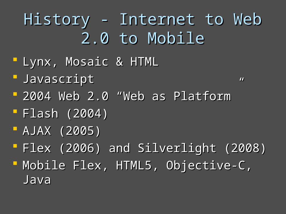
History - Internet to Web 2.0 to History - Internet to Web 2.0 to MobileMobile
Lynx, Mosaic & HTMLLynx, Mosaic & HTML JavascriptJavascript 2004 Web 2.0 “Web as Platform”2004 Web 2.0 “Web as Platform” Flash (2004)Flash (2004) AJAX (2005)AJAX (2005) Flex (2006) and Silverlight (2008)Flex (2006) and Silverlight (2008) Mobile Flex, HTML5, Objective-C, JavaMobile Flex, HTML5, Objective-C, Java
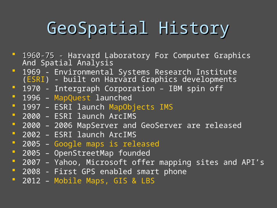
GeoSpatial HistoryGeoSpatial History 1960-75 - 1960-75 - Harvard Laboratory For Computer Graphics And Spatial
Analysis 1969 - Environmental Systems Research Institute (ESRI) - built on
Harvard Graphics developments 1970 - Intergraph Corporation – IBM spin off 1996 – MapQuest launched 1997 – ESRI launch MapObjects IMS 2000 – ESRI launch ArcIMS 2000 – 2006 MapServer and GeoServer are released 2002 – ESRI launch ArcIMS 2005 – Google maps is released 2005 – OpenStreetMap founded 2007 – Yahoo, Microsoft offer mapping sites and API’s 2008 - First GPS enabled smart phone 2012 – Mobile Maps, GIS & LBS
MobileMobile

Mobile DemystifiedMobile Demystified Mobile is confusing!Mobile is confusing!
- Hardware - Smartphones & Tablets- Hardware - Smartphones & Tablets
- Platforms – iOS, Android, Windows .. - Platforms – iOS, Android, Windows ..
- Software – Web v native v hybrid- Software – Web v native v hybrid
- Languages – Mobile Flex, HTML 5, - Languages – Mobile Flex, HTML 5, Objective-C, Java …Objective-C, Java …

HardwareHardware Smartphones Smartphones - Screen size 2.1 – 4”- Screen size 2.1 – 4” - Good for routing, check-in apps etc- Good for routing, check-in apps etc
Tablets Tablets – – Screen size 7” – 10.1”Screen size 7” – 10.1” - Offers the possibility of richer more - Offers the possibility of richer more
complex appscomplex apps

Mobile AppsMobile Apps WebWeb - Javascript/HTML 5 = most mobile browsers- Javascript/HTML 5 = most mobile browsers - Flash, Flex & Silverlight– - Flash, Flex & Silverlight– notnot Apple iOS Apple iOS
Native – Installed apps eg. Objective-C (iOS)Native – Installed apps eg. Objective-C (iOS)advantages – performance?advantages – performance?disadvantage – built for one platformdisadvantage – built for one platform
Hybrid - Installed apps eg. Adobe Mobile FlexHybrid - Installed apps eg. Adobe Mobile Flexadvantages – runs on most platformsadvantages – runs on most platformsdisadvantage – performance?disadvantage – performance?

Applications of Mobile Applications of Mobile TechnologyTechnology

Location Focused API’sLocation Focused API’s
Maps and more Google, MapQuestMaps and more Google, MapQuest
GIS – ESRIGIS – ESRI
Other location serviceOther location service
– – Foursquare, Facebook, GeoLoqiFoursquare, Facebook, GeoLoqi
- GeoMarketing, GeoFencing, GeoSocial- GeoMarketing, GeoFencing, GeoSocial

Available Mobile GIS AppsAvailable Mobile GIS Apps
ESRI – Free app iOS & Android. ESRI – Free app iOS & Android. ArcGIS.comArcGIS.com
ESRI – ArcGIS Online templatesESRI – ArcGIS Online templates
WebMapSolutions – GeoMobile for ArcGISWebMapSolutions – GeoMobile for ArcGIS
Free app iOS, Android, BlackberryFree app iOS, Android, Blackberry

Sharing your GIS DataSharing your GIS Data
ArcGIS Server – dynamic, tiled, feature lyrsArcGIS Server – dynamic, tiled, feature lyrs
ArcGIS Online – web mapsArcGIS Online – web maps
ShapefilesShapefiles
Other – GeoServer, MapserverOther – GeoServer, Mapserver

Mobile GeoSpatial Applications Mobile GeoSpatial Applications VisualizationVisualization
View your data as layers over basemaps – fields, soil type etcView your data as layers over basemaps – fields, soil type etc Both static and dynamic dataBoth static and dynamic data

Mobile GeoSpatial Applications Mobile GeoSpatial Applications Management and CoordinationManagement and Coordination
Tracking and coordinating field workersTracking and coordinating field workers Live data updates from the fieldLive data updates from the field

Mobile GeoSpatial Applications Mobile GeoSpatial Applications Query & SearchQuery & Search
View feature attributes. Query for features with specific attributesView feature attributes. Query for features with specific attributes

Mobile GeoSpatial Applications Mobile GeoSpatial Applications ToolsTools
Geospatial tools for specific work flows – buffering, measure, routingGeospatial tools for specific work flows – buffering, measure, routing

Mobile GeoSpatial Applications Mobile GeoSpatial Applications Data CollectionData Collection
The end of pen and paperThe end of pen and paper Adding & updating features – field fertilizationAdding & updating features – field fertilization

Mobile GeoSpatial Applications Mobile GeoSpatial Applications Updates, Editing, AnnotationUpdates, Editing, Annotation
Feature and Attribute Editing. Feature and Attribute Editing. Updates done in the field sent to central serverUpdates done in the field sent to central server

Mobile GeoSpatial Applications Mobile GeoSpatial Applications Online/OfflineOnline/Offline
No Wi-Fi …. no problem!No Wi-Fi …. no problem! Caching data on the mobile deviceCaching data on the mobile device

Is Mobile the Future of GIS?Is Mobile the Future of GIS? Mobile = OpportunityMobile = Opportunity ContextContext New usersNew users New toolsNew tools New marketsNew markets
QuestionsQuestions Should we re-label ourselves - location Should we re-label ourselves - location
based solution providers?based solution providers? Is this the end for Trimble?Is this the end for Trimble? Will be start also looking to Google etc Will be start also looking to Google etc
for (GIS) solutions?for (GIS) solutions?

Thank You - Questions?Thank You - Questions?
Website and Blog: Website and Blog: www.webmapsolutions.com
Twitter: Twitter: www.twitter.com/flexmappers
YouTube: YouTube: www.youtube.com/webmapsolutions
[email protected]@webmapsolutions.com