IR-T04 Decision Report Template - der.wa.gov.au · IR-T04 Decision Report Template v2.0 (July 2017)...
82
Licence: L9013/2016/1 IR-T04 Decision Report Template v2.0 (July 2017) i Licence Division 3, Part V Environmental Protection Act 1986 Licence Number L9013/2016/1 Applicant Gascoyne Resources Limited ACN 139 522 900 File Number DER2016/002214 Premises Dalgaranga Gold Project Mining Lease 59/749 and Miscellaneous Licence 59/151 DAGGAR HILLS WA 6638 Date of Report 1 November 2018 Decision Report
Transcript of IR-T04 Decision Report Template - der.wa.gov.au · IR-T04 Decision Report Template v2.0 (July 2017)...

Licence: L9013/2016/1
IR-T04 Decision Report Template v2.0 (July 2017) i
Licence Division 3, Part V Environmental Protection Act 1986
Licence Number L9013/2016/1
Applicant
Gascoyne Resources Limited
ACN 139 522 900
File Number DER2016/002214
Premises Dalgaranga Gold Project
Mining Lease 59/749 and Miscellaneous Licence 59/151
DAGGAR HILLS WA 6638
Date of Report 1 November 2018
Decision Report

Licence: L9013/2016/1
IR-T04 Decision Report Template v2.0 (July 2017) ii
Table of Contents 1. Definitions of terms and acronyms ................................................................... 1
2. Purpose and scope of assessment ................................................................... 4
Works Approval W6012/2016/1 .............................................................................. 4
Variations to W6012/2016/1 - WWTP and landfill ............................................ 5
Variations to W6012/2016/1 - Power station .................................................... 6
Variations to W6012/2016/1 Amendment Notice 1 - Processing of ore and tailings storage ............................................................................................................. 8
3. Overview of Premises......................................................................................... 9
Infrastructure .......................................................................................................... 9
Exclusions to the Premises .................................................................................. 11
Operational Aspects ............................................................................................. 11
Category 5 – processing of ore and tailings storage ...................................... 11
WWTP ........................................................................................................... 13
Landfill ........................................................................................................... 14
Tailings geochemistry ........................................................................................... 14
4. Legislative context............................................................................................ 23
Part IV of the EP Act ............................................................................................ 23
Contaminated Sites Act 2004 ............................................................................... 23
Environment Protection and Biodiversity Conservation Act 1999 (Cth) ................. 23
Other relevant approvals ...................................................................................... 23
Part V of the EP Act ............................................................................................. 23
Applicable regulations, standards and guidelines .......................................... 23
Works approval and licence history ............................................................... 24
5. Consultation ...................................................................................................... 24
6. Location and siting ........................................................................................... 25
Siting context ........................................................................................................ 25
Residential and sensitive premises ....................................................................... 25
Specified ecosystems ........................................................................................... 25
Groundwater ........................................................................................................ 26
Hydrogeology ....................................................................................................... 27
Gilbeys pit and TSF ....................................................................................... 27
Golden Wings ................................................................................................ 28
Modelling .............................................................................................................. 28
Topography .......................................................................................................... 28
Meteorology ......................................................................................................... 29
7. Risk assessment ............................................................................................... 37

Licence: L9013/2016/1
IR-T04 Decision Report Template v2.0 (July 2017) iii
Determination of emission, pathway and receptor ................................................ 37
Consequence and likelihood of risk events ........................................................... 43
Acceptability and treatment of Risk Event ............................................................. 44
Risk Assessment - Contaminated Stormwater ...................................................... 44
Description .................................................................................................... 44
General characterisation of emission............................................................. 44
Description of potential adverse impact from the emission ............................ 44
Criteria for assessment.................................................................................. 45
Proposed controls ......................................................................................... 45
Key findings ................................................................................................... 45
Consequence ................................................................................................ 46
Likelihood of consequence ............................................................................ 46
Overall rating ................................................................................................. 47
Risk Assessment - Process water storage ............................................................ 47
Description .................................................................................................... 47
Identification and general characterisation of emission .................................. 47
Description of potential adverse impact from the emission ............................ 47
Criteria for assessment.................................................................................. 47
Applicant controls .......................................................................................... 47
Key findings ................................................................................................... 48
Consequence ................................................................................................ 48
Likelihood of Risk Event ................................................................................ 48
Overall risk rating of process water ............................................................... 48
Risk Assessment - Raw water storage ................................................................. 48
Description .................................................................................................... 48
Identification and general characterisation of emission .................................. 49
Description of potential adverse impact from the emission ............................ 49
Criteria for assessment.................................................................................. 49
Applicant controls .......................................................................................... 49
Key findings ................................................................................................... 49
Consequence ................................................................................................ 50
Likelihood of Risk Event ................................................................................ 50
Overall risk rating of raw water ...................................................................... 50
Risk Assessment - Tailings pumps, slurry and decant return pipelines ................. 50
Description .................................................................................................... 50
Identification and general characterisation of emission .................................. 50
Description of potential adverse impact from the emission ............................ 50

Licence: L9013/2016/1
IR-T04 Decision Report Template v2.0 (July 2017) iv
Criteria for assessment.................................................................................. 50
Proposed controls ......................................................................................... 50
Key findings ................................................................................................... 51
Consequence ................................................................................................ 51
Likelihood ...................................................................................................... 51
Overall risk rating of ...................................................................................... 51
Risk Assessment - Tailings storage overflow ........................................................ 51
Description .................................................................................................... 51
Identification and general characterisation of emission .................................. 51
Description of potential adverse impact from the emission ............................ 51
Criteria for assessment.................................................................................. 52
Proposed controls ......................................................................................... 52
Key findings ................................................................................................... 52
Consequence ................................................................................................ 52
Likelihood ...................................................................................................... 52
Overall risk rating of TSF overflow ................................................................. 52
Risk Assessment – Tailings storage - seepage .................................................... 53
Description .................................................................................................... 53
Identification and general characterisation of emission .................................. 53
Description of potential adverse impact from the emission ............................ 53
Criteria for assessment.................................................................................. 53
Proposed controls ......................................................................................... 53
Key findings ................................................................................................... 54
Consequence ................................................................................................ 54
Likelihood ...................................................................................................... 55
Overall risk rating of TSF seepage ................................................................ 55
Risk Assessment – TSF pond water quality ...................................................... 55
Description ................................................................................................. 55
Identification and general characterisation of emission .............................. 55
Description of potential adverse impact from the emission ......................... 55
Criteria for assessment .............................................................................. 56
Proposed controls ...................................................................................... 56
Key findings ............................................................................................... 56
Consequence ............................................................................................ 56
Likelihood .................................................................................................. 56
Overall risk rating of the decant pond attraction to wildlife .......................... 56
Risk Assessment WWTP – release of waste water ........................................... 56

Licence: L9013/2016/1
IR-T04 Decision Report Template v2.0 (July 2017) v
General hazard characterisation and impact .............................................. 56
Criteria for assessment .............................................................................. 57
Applicant controls ...................................................................................... 57
Key findings ............................................................................................... 57
Consequence ............................................................................................ 58
Likelihood of Risk Event ............................................................................. 58
Overall rating ............................................................................................. 58
Risk Assessment – Seepage from WWTP ponds ............................................. 58
General hazard characterisation and impact .............................................. 58
Criteria for assessment .............................................................................. 58
Proposed controls ...................................................................................... 58
Key findings ............................................................................................... 59
Consequence ............................................................................................ 59
Likelihood of consequence ........................................................................ 59
Overall rating ............................................................................................. 59
Risk Assessment – landfill waste as scavenger attractant ................................ 59
General hazard characterisation and impact .............................................. 59
Proposed controls ...................................................................................... 59
Key findings ............................................................................................... 60
Consequence ............................................................................................ 60
Likelihood of consequence ........................................................................ 60
Overall rating ............................................................................................. 60
Risk Assessment – Landfill waste disposal and leachate .................................. 61
General hazard characterisation and impact .............................................. 61
Criteria for assessment .............................................................................. 61
Proposed controls – landfill leachate .......................................................... 61
Key findings ............................................................................................... 62
Consequence ............................................................................................ 62
Likelihood of consequence ........................................................................ 63
Overall rating ............................................................................................. 63
8. Regulatory controls .......................................................................................... 64
Specified infrastructure and equipment controls ................................................... 64
Ore processing and tailings storage .............................................................. 64
Wastewater treatment plant and ponds ......................................................... 66
Landfill ........................................................................................................... 66
Specified actions .................................................................................................. 66
Inspection of infrastructure ............................................................................ 66
Licence: L9013/2016/1
IR-T04 Decision Report Template v2.0 (July 2017) vi
Landfill ........................................................................................................... 67
Monitoring ............................................................................................................ 67
Monitoring - decant pond ............................................................................... 67
Monitoring – groundwater .............................................................................. 67
Information .................................................................................................... 68
9. Determination of Licence conditions .............................................................. 68
10. Applicant’s comments ...................................................................................... 68
11. Conclusion ........................................................................................................ 68
Appendix 1: Key documents .................................................................................... 69
Appendix 2: Summary of applicant’s comments on risk assessment and draft conditions .................................................................................................................. 72
Attachment 1: Licence L9013/2016/1(amended) ..................................................... 75
Table 1: Definitions .................................................................................................................. 1
Table 2: Prescribed Premises Categories – W6012/2016/1 ..................................................... 5
Table 3: Departures from construction requirements - WWTP and landfill ................................ 5
Table 4: Departures from construction requirements – power plant .......................................... 7
Table 5: Departures from construction requirements – Category 5........................................... 8
Table 6: Dalgaranga Gold Project prescribed premises infrastructure .................................... 10
Table 7: Gilbeys TSF embankment raises .............................................................................. 12
Table 8: Tailings geochemistry ............................................................................................... 15
Table 9: Relevant approvals ................................................................................................... 23
Table 10: Works approval and licence history ........................................................................ 24
Table 11: Receptors and distance from activity boundary ...................................................... 25
Table 12: Environmental values ............................................................................................. 25
Table 13: Designated Areas ................................................................................................... 26
Table 14: Pastoral wells ......................................................................................................... 26
Table 15: Potable water supply and production bores ............................................................ 26
Table 16: Subsurface at the plant site .................................................................................... 27
Table 17: Gilbeys groundwater and pit water sample analysis (from Rockwater, 2016) ......... 32
Table 18: Groundwater quality at Golden Wings (from MRB, 2017) ....................................... 34
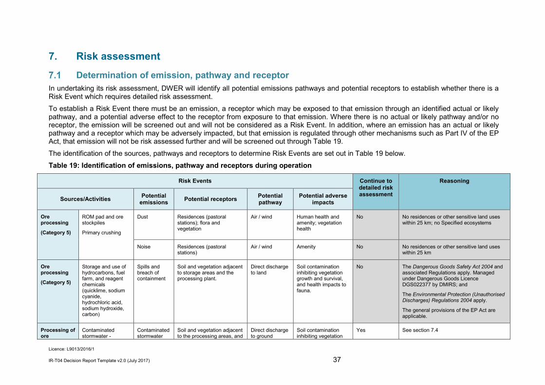
Table 19: Identification of emissions, pathway and receptors during operation ...................... 37
Table 20: Risk rating matrix.................................................................................................... 43
Table 21: Risk criteria table .................................................................................................... 43
Table 22: Risk treatment table ............................................................................................... 44
Table 23: proposed controls for stormwater ........................................................................... 45
Table 24: Applicant controls for process water ....................................................................... 47

Licence: L9013/2016/1
IR-T04 Decision Report Template v2.0 (July 2017) vii
Table 25: Applicant controls for raw water .............................................................................. 49
Table 26: Applicant controls for spillage from tailings and decant return lines ........................ 50
Table 27: Proposed controls for impact of tailings overtopping the TSF ................................. 52
Table 28: Proposed controls for TSF seepage ....................................................................... 53
Table 29: Applicant controls for sewage discharge from rupture of pipes, storage tank failure or overtopping of the ponds.................................................................................................... 57
Table 30: Applicant controls for seepage from the ponds ....................................................... 58
Table 31: Applicant controls landfill odour .............................................................................. 59
Table 32: Applicant controls for landfill leachate ..................................................................... 62

Licence: L9013/2016/1
IR-T04 Decision Report Template v2.0 (July 2017) 1
1. Definitions of terms and acronyms In this Decision Report, the terms in Table 1 have the meanings defined. Table 1: Definitions
Term Definition
ACN Australian Company Number
Applicant Gascoyne Resources Limited
ARI Average Recurrence Interval
BOD Biological Oxygen Demand
Category/ Categories/ Cat.
Categories of Prescribed Premises as set out in Schedule 1 of the EP Regulations
CFU Colony Forming Units
CIL Carbon In Leach
Clean Fill has the meaning defined in the Landfill Definitions
Delegated Officer an officer under section 20 of the EP Act.
Department means the department established under section 35 of the Public Sector Management Act 1994 and designated as responsible for the administration of Part V, Division 3 of the EP Act.
DER Department of Environment Regulation
As of 1 July 2017, the Department of Environment Regulation (DER), the Office of the Environmental Protection Authority (OEPA) and the Department of Water (DoW) amalgamated to form the Department of Water and Environmental Regulation (DWER).
DMIRS Department of Mines, Industry Regulation and Safety
As of 1 July 2017, the Department of Mines and Petroleum and the Department of Commerce amalgamated to form the Department of Mines, Industry Regulation and Safety (DMIRS). DMIRS was established under section 35 of the Public Sector Management Act 1994.
DoW Department of Water
As of 1 July 2017, the Department of Environment Regulation (DER), the Office of the Environmental Protection Authority (OEPA) and the Department of Water (DoW) amalgamated to form the Department of Water and Environmental Regulation (DWER). DWER was established under section 35 of the Public Sector Management Act 1994.
DWER Department of Water and Environmental Regulation
As of 1 July 2017, the Department of Environment Regulation (DER), the Office of the Environmental Protection Authority (OEPA) and the Department of Water (DoW) amalgamated to form the Department of Water and Environmental Regulation (DWER). DWER was established under section 35 of the Public Sector Management Act 1994 and is responsible for the administration of the Environmental Protection Act 1986 along with other legislation.
EA-RAS treatment plant Extended aeration returned activated sludge process treatment plant

Licence: L9013/2016/1
IR-T04 Decision Report Template v2.0 (July 2017) 2
EP Act Environmental Protection Act 1986 (WA)
EP Regulations Environmental Protection Regulations 1987 (WA)
EPBC Act Environment Protection and Biodiversity Conservation Act 1999 (Cth)
Existing Licence The Licence issued under Part V, Division 3 of the EP Act and in force prior to the commencement of, and during this Review
EA-RAS Extended Aeration returned activated sludge process
GWTSF Golden Wings in-pit TSF
HDPE high density polyethylene
Inert Waste Type 1 has the meaning defined in the Landfill Definitions
Inert Waste Type 2 has the meaning defined in the Landfill Definitions
km kilometre
Landfill definitions The document titled “Landfill Waste Classification and Waste Definitions 1996” published by the Chief Executive officer of the Department of Environment as amended from time to time.
Licence Holder Gascoyne Resources Limited
m metres
mg milligram
L litre
mbgl metres below ground level
Mt million tonnes
MW Megawatt
NEPM National Environmental Protection Measure
Occupier has the same meaning given to that term under the EP Act.
Prescribed Premises has the same meaning given to that term under the EP Act.
Premises refers to the premises to which this Decision Report applies, as specified at the front of this Decision Report
Primary Activities as defined in Schedule 2 of the Revised Licence
Putrescible has the meaning defined in the Landfill Definitions
Risk Event As described in Guidance Statement: Risk Assessment
RIWI Act Rights in Water and Irrigation Act 1914
ROM run of mine
Rural Landfill Regulations
Environmental Protection (Rural Landfill) Regulations 2002

Licence: L9013/2016/1
IR-T04 Decision Report Template v2.0 (July 2017) 3
UDRs Environmental Protection (Unauthorised Discharges) Regulations 2004 (WA)
TSF Tailings Storage Facility
TSS Total Suspended Solids
WADCN Weak Acid Dissociable Cyanide
WRD Waste Rock Dump
WWTP Wastewater Treatment Plant

Licence: L9013/2016/1
IR-T04 Decision Report Template v2.0 (July 2017) 4
2. Purpose and scope of assessment This assessment is the result of a concurrent application from Gascoyne Resources Limited (Gascoyne Resources) (the Applicant) for a new works approval and licence to operate a gold processing plant and tailings storage facility (TSF), power plant, wastewater treatment plant (WWTP) and a landfill at the Dalgaranga Gold Project. The concurrent application was received by the then Department of Environment Regulation on 1 November 2016. W6012/2016/1 was issued on 2 June 2017. W6012/2016/1 Amendment Notice 1 was issued on 18 October 2017, for changes relating to gold processing infrastructure and addition of an in-pit TSF. Licence L9013/2016/1 was issued on 20 December 2017 for operation of the WWTP and the landfill. Gascoyne Resources subsequently submitted construction compliance documents for the gold processing infrastructure, the TSFs and the power plant, and an amendment to L9013/2016/1 was initiated by DWER to include operation of the new infrastructure on the Licence. Licence amendment November 2018: The amended Decision Report includes the previous assessment of emissions and discharges associated with operation of the WWTP and landfill (as assessed for the existing licence) and further assesses the emissions and discharges associated with operation of the gold processing plant, Gilbeys TSF, Golden Wings in-pit TSF, and the power plant. Background The Dalgaranga Gold Project is located in the Murchison region of Western Australia, approximately 60 kilometres (km) northwest of Mount Magnet. The mine was initially developed in the early 1990’s by Equigold NL, with 229,000 ounces of gold produced from the Gilbeys and Golden Wings deposits before mine closure in 2001. Gascoyne Resources acquired a 100% interest in the project in 2016, and is redeveloping the site to mine approximately 25.7 million tonnes (Mt) of ore from the Gilbeys and Golden Wings deposits in the following ten years. Ore mined from Gilbeys and Golden Wings deposits will be transported to the ROM pad for crushing and grinding at the dry processing plant, with gold production by a carbon-in-leach (CIL) gold processing plant. Tailings will be deposited at the existing Gilbeys TSF and also Golden Wings in-pit TSF.
Works Approval W6012/2016/1 Works Approval W6012/2016/1 was issued on 2 June 2017 for construction of: a dry processing plant, a CIL gold processing plant, an embankment raise of the existing Gilbeys TSF, a 12 MW diesel fired power station, a waste water treatment plant; and a putrescible landfill site. W6012/2016/1 Amendment Notice 1 was issued on 18 October 2017 for two further embankment raises on Gilbeys TSF (total of 3 staged embankment raises), use of Golden Wings Pit as an in-pit TSF, relocation of raw water and process water ponds, construction of one large sedimentation pond in place of three, and an increase in category 5 throughput. No changes relating to the power station, WWTP or landfill were made. Table 2 lists the prescribed premises categories that were approved for construction under the works approval W6012/2016/1 and Amendment Notice 1.

Licence: L9013/2016/1
IR-T04 Decision Report Template v2.0 (July 2017) 5
Table 2: Prescribed Premises Categories – W6012/2016/1
Classification of Premises
Description Approved Premises production or design capacity or throughput
Category 5 Processing or beneficiation of metallic or non-metallic ore 2.8 Mt tonnes per year
Category 52 Electric power generation 12 MW
Category 85 Sewage facility 70 m3 per day
Category 89 Putrescible landfill site 400 tonnes per year
W6012/2016/1 includes condition 5: Condition 5. Key items of infrastructure which are required to be built are listed in the
Infrastructure Requirements Table. The Works Approval Holder must not depart from the requirements specified in column 2 of the Infrastructure Requirements Table except:
(a) where such departure is minor in nature and does not materially change or affect the infrastructure; or
(b) where such departure improves the functionality of the infrastructure and does not increase risks to public health, public amenity or the environment;
and all other Conditions in this Works Approval are still satisfied.
Variations to W6012/2016/1 - WWTP and landfill W6012/2016/1 construction compliance documents for the WWTP and the landfill were received by DWER on 5 October 2017. Some key items required to be built under condition 5 of the works approval departed from the requirements specified. Table 3 below lists the departures as informed by the Construction Compliance Report, and provides the considerations of the Delegated Officer. Table 3: Departures from construction requirements - WWTP and landfill
WWTP infrastructure requirements
Departure Delegated Officer considerations
Moving Bed Bioreactor (MBBR-70)
An ‘Extended Aeration returned activated sludge process’ (EA-RAS) WWTP has been installed, instead of an MBBR-70.
TMC Water Recycling certified the EA-RAS’s performance and structural integrity, and noted that the EA-RAS is designed to meet Class C discharge requirements (TMC, 2017).
The Delegated Officer considered that the operational efficiencies and treated effluent standards of the EA-RAS treatment plant are similar to that of the MBBR-70 and therefore the change does not increase risks to public health, public amenity or the environment. There are no additional emissions or discharges from the operation of the EA-RAS treatment plant that require assessment.
Treatment capacity of 70 m3/day.
The treatment capacity of the installed EA-RAS treatment plant is plated at 50 m3/day or 200 Equivalent
Camp village accommodation capacity is 240 people. During the production phase of operations, 160 to 200 people will be on site at any one time (from W6012/2016/1

Licence: L9013/2016/1
IR-T04 Decision Report Template v2.0 (July 2017) 6
People (TMC, 2017).
Certification of the WWTP evaporation ponds (WWTP Construction Report, 2017) includes assumptions of: maximum village occupancy of 240 people; maximum waste water flow of 230 L/day/person; and wastewater volume 55.2 m3/day.
Application).
Throughput may peak to 55 m3/day during the project’s construction phase.
The Delegated Officer considered that given the number of people accommodated on site at any one time will not exceed 240 people only during the construction phase, the treatment capacity of the WWTP remains adequate. Once construction is complete, the Licence will be amended for a treatment capacity of 50 m3/day.
Landfill infrastructure requirements
Departure Delegated Officer considerations
Landfill trench no more than 20 m in length and no more than 5 m deep.
The landfill trenches have been surveyed as having the following dimensions:
• Trench for putrescible waste: 19 m length, 4 m depth.
• Trench for ‘industrial waste’: 36 m length, 4 m depth.
A borrow pit in the Gilbeys Waste Rock Dump (WRD) had been established by the previous owner of the site as a source of saprolite for remedial work. Rather than constructing a new trench, Gascoyne Resources propose to use the borrow pit trench (length 36 m) as an ‘industrial’ landfill trench which will accept Clean Fill, Inert Waste Type 1 and Inert Waste Type 2.
The Delegated Officer determined that where the trench for ‘industrial’ waste accepts Clean Fill, Type 1 Inert Waste and Inert Waste Type 2 (excluding tyres) only, the increase in length to 36 m does not increase risk to public health, public amenity or the environment (as assessed in Sections 7.13 and 7.14 below).
Variations to W6012/2016/1 - Power station Construction compliance documents for the power station were received by DWER on 31 May 2018. Some key items required to be built under condition 5 of W6012/2016/1 departed from the requirements specified. Table 4 below lists the variations from infrastructure requirements and the considerations of the Delegated Officer.

Licence: L9013/2016/1
IR-T04 Decision Report Template v2.0 (July 2017) 7
Table 4: Departures from construction requirements – power plant
Power station infrastructure requirements
Departure Delegated Officer considerations
Category 52: 12 MW diesel fired power station (housing 10 operating and 2 standby 1 MW diesel generators).
Power station was constructed with four (4) Jenbacher J620 Type “J” gas powered generators rated at 3,360 kW each and two diesel powered standby generators rated at 1,000 kW each.
On 31/07/2018, Gascoyne Resources provided a letter from the Technology and Infrastructure Manger of Zenith Pacific Pty Ltd, confirming that the generators as installed and commissioned are free from defects, and NOx emissions met the manufacturer’s specification of the gas generators stated emission value of NOx <500mg/NM3 (5% O2).
Risk of air emissions was screened out of the assessment for W6012/2016/1 due to the distance to the closest sensitive receptor. Risk of air emissions from gas powered generators are considered to be lower for air emissions than for diesel powered generators.
Variation to the infrastructure required is a material change to the original proposed infrastructure, but do not increase risks to public health, public amenity or the environment.
Category 52 - Electric power generation: “premises (other than premises within category 53 or an emergency or standby power generating plant) on which electrical power is generated using a fuel” with production or design capacity 20 MW or more using natural gas, or 10 MW or more using fuel other than natural gas. (EP Regulations).Therefore Category 52 does not apply.
Category 84: Electric power generation: “premises (other than premises within category 53 or an emergency or standby power generating plant) on which electrical power is commercially generated using natural gas as a fuel”, with production or design capacity more than 10 MW but less than 20MW (EP Regulations). Category 84 does not apply as selling of electricity is not occurring.
Power plant oil and fuel tanks - Double skinned tanks or constructed within a bunded area in accordance with AS1940.
Three horizontal 368.5kL LNG tanks were installed. Gascoyne Resources states that the pressure tanks are constructed to ASME VIII code and are fitted with leak detection systems. The tanks comply with the requirements of AS1210 for pressure vessels, and are design registered with WorkSafe (Design Reg. No. WA: WAP20121). The facility is also designed and installed to the DMIRS Approved Code of Practice AS3961: 2005.
The variation does not increase risks to public health, public amenity.
Storage of LNG and diesel is risk assessed and authorised under Dangerous Goods Licence DGS022377

Licence: L9013/2016/1
IR-T04 Decision Report Template v2.0 (July 2017) 8
Key finding: The Delegated Officer has reviewed the information regarding the power plant as constructed, and has determined that the production of power at the premises is not within the descriptions of categories listed in the Environmental Protection Regulations 1987 Schedule 1. The power plant is therefore not within the scope of this assessment.
Variations to W6012/2016/1 Amendment Notice 1 - Processing of ore and tailings storage
Construction compliance documents for the processing plant and associated infrastructure were received by DWER on 31 May 2018. Some key items required to be built under condition 5 of W6012/2016/1 Amendment Notice 1 departed from the requirements specified. Table 5 below lists the variations from infrastructure requirements and the considerations of the Delegated Officer. Table 5: Departures from construction requirements – Category 5
Category 5 infrastructure
Requirement Departure Delegated Officer considerations
Raw water pond
Overflow able to be pumped to the Process water pond.
Overflow is gravity fed to the process water pond via a HDPE lined spillway rather than pumping the overflow
The variation does not increase risks to public health, public amenity or the environment.
Wet process circuits
CIL tanks placed on a concrete pad bunded to contain jetting and with containment capacity equivalent to 110% of the capacity of one of the leach tanks, with electric sump pumps installed in the concrete flooring.
Gascoyne Resources advised that the CIL tanks are contained within a concrete bund for the containment of spillage. The volume of the bunding is 284kL which is a containment capacity equivalent to 18% of the capacity of one of the leach tanks.
Any losses outside of the CIL bund are contained within the plant drainage system and directed to the sedimentation pond.
Variation to the infrastructure may increase risks to public health, public amenity or the environment.
The Department of Mines, Industry Regulation and Safety (DMIRS) has confirmed that the CIL tanks have been risk assessed and found that risks to people, property and the environment are eliminated or minimised so far a reasonable practicable (in accordance with DGS Act s61), and Licensed under Dangerous Goods Licence (DGS022377).
Sediment pond Lined with compacted soil material.
A compacted soil liner was not installed in the sedimentation pond.
Gascoyne Resources stated in the Compliance Report that the base of the pond is hard lateritic material underlain by oxidised clay and is considered highly impermeable, and sources
No supporting documentation (i.e. permeability tests, photos) was provided with the compliance report as evidence that the in-situ soils at the base of the pond were highly impermeable.
Variation to the infrastructure may increase risks to public health, public amenity or the environment. The variation is assessed in the risk assessment below in Section 7.4.

Licence: L9013/2016/1
IR-T04 Decision Report Template v2.0 (July 2017) 9
provided (Absolute Geotechnics, 2017) and (Rockwell, 2017).
Caustic soda (sodium hydroxide)
Stored in a 60m3 caustic storage tank.
Caustic soda is stored in a smaller 31m³ storage tank. The reagent storage area is compliant with the storage of dangerous goods.
Authorised under Dangerous Goods Licence DGS022377
Cyanide sparging, mixing and storage tanks
Contained within a concrete bunded area constructed to drain to sumps with recovery pumps.
No cyanide mixing tank has been installed as cyanide will be delivered in liquid form. The cyanide storage tank is contained within a bunded concrete area compliant with the requirements for dangerous goods storage. The reagent storage area is compliant with the storage of dangerous goods.
Authorised under Dangerous Goods Licence DGS022377
Quicklime (calcium oxide)
Stored in a 100 t silo with dust collector.
Quicklime is stored in a 125 t silo with a dust collector fitted on top of the silo.
Authorised under Dangerous Goods Licence DGS022377
Fuel farm 450kL double skinned fuel tanks.
The diesel fuel farm for mobile mining equipment consists of 6 double skinned 110kL tanks.
A Dangerous Goods Site Licence has been issued by the Department of Mines, Industry Regulation and Safety on 22 January 2018.
Authorised under Dangerous Goods Licence DGS022377
3. Overview of Premises
Infrastructure The Dalgaranga Gold Project infrastructure, as it relates to Prescribed premises categories 5, 85 and 89, is detailed in Table 6. Information has been summarised from the application and compliance documents.

Licence: L9013/2016/1
IR-T04 Decision Report Template v2.0 (July 2017) 10
Table 6: Dalgaranga Gold Project prescribed premises infrastructure
Prescribed Activity Category 5
2.8 Mtpa of ore from Gilbeys, Gilbeys South, Sly Fox and Golden Wings open pits will be transported to a ROM pad for crushing and grinding followed by CIL gold processing. Tailings will be discharged to Gilbeys TSF or Golden Wings in-pit TSF.
1 ROM pad and ore stockpiles
2 Primary Crushing Plant
3 Single Stage Grinding Plant
4 Process and Raw water storage ponds
5 Gravity Concentration and Intensive Leaching, Classification, Leaching and Adsorption, Elution, Electrowinning
6 Smelting
7 Carbon regeneration
8 Gilbeys TSF (including staged embankments, cut-off trench and decant)
9 Golden Wings in-pit TSF
10 Tailings pumps and pipelines
11 Decant return pumps and pipelines
12 Chemical reagent storage (quicklime, sodium cyanide, hydrochloric acid, sodium hydroxide, carbon)
13 Sedimentation pond
Prescribed Activity Category 85
Sewage from the site’s 240 bed accommodation camp will be treated by extended aerated primary treatment prior to discharge to sewage evaporation ponds. Biosolids will be separated from the influent wastewater and disposed offsite, and sludge will be recirculated.
1 EA-RAS sewage treatment plant
2 Evaporation ponds (x 2)
Prescribed Activity Category 89
Landfill trenches have been constructed within Gilbeys Waste Rock Dump (WRD) and will be constructed in following years in Golden Wings WRD. Waste will comprise of Putrescibles, Inert Waste Type I, Inert Waste Type II and Clean Fill. A separate trench will be used for the burial of tyres.
1 Landfill trenches within a waste rock dump.
Directly Related Activities
2 Dewatering equipment (Gilbeys open pit, transport and storage of water prior to use).
Licence: L9013/2016/1
IR-T04 Decision Report Template v2.0 (July 2017) 11
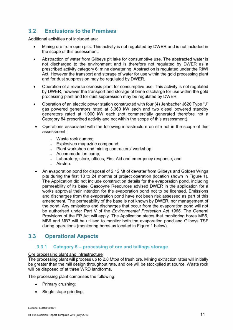
Exclusions to the Premises Additional activities not included are:
• Mining ore from open pits. This activity is not regulated by DWER and is not included in the scope of this assessment.
• Abstraction of water from Gilbeys pit lake for consumptive use. The abstracted water is not discharged to the environment and is therefore not regulated by DWER as a prescribed activity category 6: mine dewatering. Abstraction is regulated under the RIWI Act. However the transport and storage of water for use within the gold processing plant and for dust suppression may be regulated by DWER.
• Operation of a reverse osmosis plant for consumptive use. This activity is not regulated by DWER, however the transport and storage of brine discharge for use within the gold processing plant and for dust suppression may be regulated by DWER.
• Operation of an electric power station constructed with four (4) Jenbacher J620 Type “J” gas powered generators rated at 3,360 kW each and two diesel powered standby generators rated at 1,000 kW each (not commercially generated therefore not a Category 84 prescribed activity and not within the scope of this assessment).
• Operations associated with the following infrastructure on site not in the scope of this assessment:
o Waste rock dumps; o Explosives magazine compound; o Plant workshop and mining contractors’ workshop; o Accommodation camp; o Laboratory, store, offices, First Aid and emergency response; and o Airstrip.
• An evaporation pond for disposal of 2.12 Mt of dewater from Gilbeys and Golden Wings pits during the first 18 to 24 months of project operation (location shown in Figure 1). The Application did not include construction details for the evaporation pond, including permeability of its base. Gascoyne Resources advised DWER in the application for a works approval their intention for the evaporation pond not to be licensed. Emissions and discharges from the evaporation pond have not been risk assessed as part of this amendment. The permeability of the base is not known by DWER, nor management of the pond. Any emissions and discharges that occur from the evaporation pond will not be authorised under Part V of the Environmental Protection Act 1986. The General Provisions of the EP Act will apply. The Application states that monitoring bores MB5, MB6 and MB7 will be utilised to monitor both the evaporation pond and Gilbeys TSF during operations (monitoring bores as located in Figure 1 below).
Operational Aspects
Category 5 – processing of ore and tailings storage Ore processing plant and infrastructure The processing plant will process up to 2.8 Mtpa of fresh ore. Mining extraction rates will initially be greater than the mill design throughput rate, and ore will be stockpiled at source. Waste rock will be disposed of at three WRD landforms. The processing plant comprises the following:
• Primary crushing;
• Single stage grinding;

Licence: L9013/2016/1
IR-T04 Decision Report Template v2.0 (July 2017) 12
• Gravity concentration and intensive leaching;
• Classification;
• Leaching and adsorption;
• Electrowinning; and
• Smelting. Reagents to be used in the processing plant are:
• Quicklime (calcium oxide) stored in a silo with dust collector.
• Cyanide – delivered as 98% concentrate and sparged from a storage tank and sparging system. Cyanide storage tanks are contained in a concrete bund with collection sump and recovery pumps.
• Caustic soda (sodium hydroxide) – contained by bunding.
• Hydrochloric acid.
• Activated Carbon stored in bulk boxes.
• Grinding media – 105 mm steel balls. Tailings from the processing plant will initially be deposited in Gilbeys TSF which is adjacent to Gilbeys pit, then at Golden Wings pit as an in-pit TSF. Figure 1 below shows the site layout and Figures 2 and 3 are the processing flow charts. Gilbeys TSF and embankment raises Gilbeys TSF is a paddock type TSF which was constructed in the early 1990’s. Tailings from production of 229,000 ounces of gold was deposited before mine closure in 2001. Permeability of the base of the TSF has not been clarified, but consolidation of tailings from previous deposition would have occurred. The TSF is constructed on lateritic caprock, overlying sand and gravels to a layer of saprolitic clay or basalt. The embankment raises proposed for Gilbeys TSF are shown in Table 7 below. Stage 1 has been completed (Compliance Reporting, 2018). The decant structure and decant access causeway will be constructed to the respective embankment crest levels for each stage. Table 7: Gilbeys TSF embankment raises
Gilbeys TSF embankment stage
Raise (m) Height above natural ground level (m)
Area (ha) Storage capacity (Mt)
Stage 1 lift of 3.5 m RL 438.5 15.5 49.35 1.86
Stage 2 lift of 3.0 m RL 441.5 18.5 50.22 1.64
Stage 3 lift of 2.5 m RL 444.0 21.0 50.75 1.38
Monitoring bores at Gilbeys TSF, located as shown in Figure 4, have been constructed at locations around the TSF and the evaporation pond. The evaporation pond is temporary until dewatering is complete at Golden Wings pit, and will replaced as a waste rock dump. Golden Wings in-Pit TSF At completion of mining at Golden Wings pit (approximately 20 months mining) the pit will have dimensions of approximately 600 m length x 325 m wide, with a maximum depth of about 130 m. The standing water table in Golden Wings pit is 5 - 8 m, but will be lowered by dewatering

Licence: L9013/2016/1
IR-T04 Decision Report Template v2.0 (July 2017) 13
(Rockwater, 2017). Tailings will be deposited into the Golden Wings in-pit TSF (GWTSF) after completion of mining at Golden Wings pit and completion of tailings deposition at Gilbeys TSF. GWTSF will provide tailings storage for approximately 11.7 Mt tailings (about 4.7 years’ deposition) with tailings deposited to a maximum 0.5 mbgl. The Golden Wings Waste Rock Dump (WRD) will be constructed around the perimeter of the pit, with the intention that the WRD will form the outer embankments for a future paddock TSF (subject of a future amendment). Groundwater monitoring bores at Golden Wings have been constructed at locations shown in Figure 5. Process Pond The process pond will accept decant return water and is able to accept overflow from the raw water pond and water pumped from the sedimentation pond. As a contingency, water can be pumped via the site drainage network to the process plant sedimentation pond. Raw water pond The raw water pond will accept mine dewater and bore water. Overflow is gravity fed to the process pond. Stormwater management Site drainage is designed to accommodate a 1 in 100 year rainfall event ARI (average recurrence interval) of 72 hours duration. All stormwater from the processing area and mining contractor yard that is not contained within bunding is directed to the sedimentation pond. Stormwater direction is by defined drainage channels as shown in Figure 5 below. The drainage area includes the:
• dry processing area (ore stockpiles and dry crushing plant);
• wet plant pad (milling, CIL, metal recovery, and refining and reagent areas); and
• mine contractor area. Water from the sedimentation pond can be pumped to the process pond and the sedimentation pond is contingency storage from the process pond. The ROM pad is bunded. Drainage from plant site buildings, workshop, power station and fuel storage facility are directed to the ‘site sedimentation pond’ (different pond to the sedimentation pond associated with the process plant). Washdown bays will include contaminated water recovery systems with water reused. As discussed in Section 4.2, this aspect of the premises is excluded from the assessment as not being or directly related to the prescribed activities at the premises.
WWTP The following information is from the Decision report for the existing licence L9013/2016/1. A camp village accommodated up to 240 people during construction of the processing plant. During the production stage of operations, 200 people are expected on site at any one time. Sewage is treated by an extended aeration returned activated sludge process (EA-RAS) treatment plant, with a manufacturer’s plated design capacity of 50 m3/day. Biosolids are intercepted and separated by screening prior to treatment within the WWTP, and disposed off-site. Sludge will be pumped out of the WWTP sludge tank around 1 - 3 times per year and removed off site. Treated effluent is discharged to two 1.5 mm high density polyethylene (HDPE) lined evaporation ponds (Figure 7).

Licence: L9013/2016/1
IR-T04 Decision Report Template v2.0 (July 2017) 14
Landfill The following information is from the Decision report for the existing licence L9013/2016/1. Waste will be disposed of in trenches in landfills located within Gilbeys Pit Waste Rock Dump (WRD) for the first year’s operations, then in a landfill to be constructed within the Golden Wings WRD. Up to 400 tonnes of waste will be landfilled in total per year. Landfill trenches will be used for burial of Putrescible Waste, Inert Waste Types I and 2 and Clean Fill. Gascoyne Resources also propose to use a 36 m long borrow pit trench which had been dug out by the previous owner named the ‘industrial landfill’ trench which will only be used for burial of Clean Fill, Inert Waste Type 1 and Inert Waste Type 2 wastes. Tyres will be buried in separate trenches. Putrescible trenches will be covered once per week or as soon as practicable after deposit and prior to compaction, and the industrial trench will be covered within three months of the final waste load in each trench.
Tailings geochemistry Soilwater Consultants (SWC, 2016) analysed two tailings composite samples for Golden Wings and Gilbeys projects. SWC found that the tailings contain considerable sulfur most likely to be derived from the shale ore of the sample, which contained small but significant carbonate percentage. Net acid generation testing was carried out and determined that the Gilbeys composite sample was non-acid forming, with an oxidised pH of 7.8. The Golden Wings composite sample formed acid which was not neutralized during testing and reported oxidised pH of 3.0 (SWC, 2016). Gascoyne Resources propose that the cyanide Carbon-In-Leach (CIL) circuit will involve addition of liming agent to keep the pH high to prevent production of HS gas, which will buffer the tailings material to maintain relatively low acid producing potential during operations. The metal content of tailings from Gilbeys pit and Golden Wings pit (from SWC, 2016) is shown in Table 8 below.

Licence: L9013/2016/1
IR-T04 Decision Report Template v2.0 (July 2017) 15
Table 8: Tailings geochemistry

Licence: L9013/2016/1
IR-T04 Decision Report Template v2.0 (July 2017) 16
Figure 1: Site layout

Licence: L9013/2016/1
IR-T04 Decision Report Template v2.0 (July 2017) 17
Figure 2: Processing flow chart (1)

Licence: L9013/2016/1
IR-T04 Decision Report Template v2.0 (July 2017) 18
Figure 3: Processing flow chart (2)

Licence: L9013/2016/1
IR-T04 Decision Report Template v2.0 (July 2017) 19
Figure 4: Groundwater monitoring bores - Gilbeys TSF

Licence: L9013/2016/1
IR-T04 Decision Report Template v2.0 (July 2017) 20
Figure 5: Golden Wings monitoring bore locations (from MRB, 2017)

Licence: L9013/2016/1
IR-T04 Decision Report Template v2.0 (July 2017) 21
Figure 6: Stormwater management

Licence: L9013/2016/1
IR-T04 Decision Report Template v2.0 (July 2017) 22
Figure 7: WWTP and Evaporation Ponds 1 and 2

Licence: L9013/2016/1
IR-T04 Decision Report Template v2.0 (July 2017) 23
4. Legislative context Part IV of the EP Act
There are no Environmental Protection Act 1986 (EP Act) Part IV referral and approvals including appeal determinations, which are relevant to this assessment.
Contaminated Sites Act 2004 The premises is not recorded in DWER’s Contaminated Sites database.
Environment Protection and Biodiversity Conservation Act 1999 (Cth)
The Dalgaranga Gold Project proposal has not been referred or assessed under the Environment Protection and Biodiversity Conservation Act 1999 (Cth). There are no identified matters of national environmental significance which would require referral or assessment under the Environment Protection and Biodiversity Conservation Act 1999 (Cth).
Other relevant approvals Table 9 summarises approvals relevant to the project. Table 9: Relevant approvals
Legislation Number Approval
Mining Act 1978
CPS 7240/1 Approved to clear 227 ha, includes clearing required for Golden Wings Pit, 17 November 2016
CPS 7240/2 For clearing, issued and active 10 December 2017.
Reg.ID 69003 Mining Proposal and mine closure plan (Rev 4) submitted 13 September 2017, approved 11/05/2017. Includes processing plant, TSF, landfill, power station and WWTP and ponds.
Dangerous Goods Safety Act 2004 and regulations
DGS022377 Dangerous Goods Licence issued by DMIRS on 22/01/2018
Rights in Water and Irrigation Act 1914
GWL 183561 Issued 31/3/2017.
Part V of the EP Act
Applicable regulations, standards and guidelines The overarching legislative framework of this assessment is the EP Act and EP Regulations. The guidance statements which inform this assessment are:
• Guidance Statement: Setting Conditions (October 2015)
• Guidance Statement: Decision Making (February 2017)
• Guidance Statement: Risk Assessment (February 2017)

Licence: L9013/2016/1
IR-T04 Decision Report Template v2.0 (July 2017) 24
• Guidance Statement: Environmental Siting (November 2016) Guidance Statement: Licence Duration (August 2016)
Works approval and licence history Table 10 summarises the works approval and licence history for the premises. Table 10: Works approval and licence history
Instrument Issued Nature and extent of works approval, licence or amendment
W1691/1996/1 27/05/1996 Issued to Equigold NL for grinding and milling works (ore), and potential for water pollution.
W1737/1996/1 28/10/1996 For mine dewatering and construction of Tailings Dam 1.
L6749/1996/1 13/11/2000 Issued to Equigold NL for processing or beneficiation of metallic or non- metallic ore.
L6749/1996/2 13/11/2000 Previous licence re-issued.
L6749/1996/3 12/11/2001 Processing or beneficiation of metallic or non-metallic ore. Expired 21/12/2001.
W6012/2016/1 2/06/2017 New works approval issued to Gascoyne Resources Limited - for construction of works for updating a gold processing plant with associated infrastructure, power station, WWTP and landfill.
W6012/2016/1 18/10/ 2017 Amendment Notice 1 - for two embankment raises on Gilbeys TSF, use of Golden Wings Pit as a TSF, relocation of raw water and process water ponds, construction of one sedimentation pond to replace three, and increase category 5 throughput.
L9013/2016/1 20/12/2017 New Licence issued to Gascoyne Resources Limited - for operation of WWTP and landfill.
W6012/2016/1 27/08/2018 Amendment Notice 2 - to extend commissioning period.
L9013/2016/1 1/11/2018 To include category 5 onto the licence, and clarify and assess works approval non compliances for operation
5. Consultation Consultation was undertaken upon acceptance of the application for the concurrent works approval and licence. The application was advertised in the West Australian on 5 December 2016 for a 21 day comment period. There were no submissions. Letters inviting comment were sent to the former Department of Water (DoW), the then Department of Mines and Petroleum (DMP), and Shire of Mount Magnet on 5 December 2016. DoW provided comment that the approaches proposed for surface water management, including risk treatments proposed in the application, are sufficiently aimed to minimise risks to water resources at the site (DOW 2017a). No comments were received from DMP (now DMIRS) or the Shire of Mount Magnet.

Licence: L9013/2016/1
IR-T04 Decision Report Template v2.0 (July 2017) 25
6. Location and siting Siting context
The Dalgaranga Gold Project (the Project) is located approximately 60 kilometres (km) northwest of Mount Magnet in the Murchison region of Western Australia. The location of the Dalgaranga Project mining tenements are shown in Figure 8 below.
Residential and sensitive premises The distances to sensitive land users are detailed in Table 11. Table 11: Receptors and distance from activity boundary
Sensitive Land Users Distance from Prescribed Activities
Residential premises No residences or other sensitive land uses within 25 km have been identified.
The closest town is Mount Magnet which is about 60 km to the southeast.
Specified ecosystems Specified ecosystems are areas of high conservation value and special significance that may be impacted as a result of activities at or Emissions and Discharges from the Premises. The distances to relevant specified ecosystems are shown in Table 12. Table 12 also identifies the distances to other environmental values which do not fit the definition of a specified ecosystem. Table 12: Environmental values
Environmental value Distance from the Premises
Ramsar Sites in Western Australia None identified within 100 km.
Parks and Wildlife Managed Lands and Waters Unallocated Crown Land Department Interest proposed for conservation adjacent to the premises.
Ecological communities (TECs and PECs) Closest Priority Ecological Community is 32 km west
Threatened/Priority Flora Closest Priority Flora is 16 km east.
Threatened/Priority Fauna Critically endangered fauna Pezoporus occidentalis (night parrot) (found dead) – 18 km east
Priority fauna (bird) Falco peregrinus (peregrine falcon) – 12 km west
Vulnerable – Reptiles found 8 km north northwest
Endangered - mammals – evidence of – 17 km north
Potential groundwater dependent ecosystems None identified within 25 km of the premises.
Subterranean fauna Studies published by Rockwater in 2016 indicated that while stygofauna occurred in the Dalgaranga Project area, there are no species of conservation significance, and troglofauna are unlikely to be found in areas of risk (from W6012/2016/1 Application).
Designated Areas relevant to the premises location are listed in Table 13.

Licence: L9013/2016/1
IR-T04 Decision Report Template v2.0 (July 2017) 26
Table 13: Designated Areas
Groundwater and water sources
Distance from Premises
Public drinking water source areas
Closest is the P1 Mount Magnet Water Reserve, 46 km east.
Hydrography WA 250K – Surface Water Polygons
No rivers, lakes or significant surface water bodies at the Project area.
Some minor non perennial watercourses in the area.
Area subject to inundation 3 km west-southwest.
Twenty Seven Mile Creek and Gunnetharra Creek (tributaries of the Sanford River) 12 km northwest and 32 km north respectively.
Groundwater Premises is located within the East Murchison Groundwater Management Area
Groundwater Pastoral wells closest to the premises are tabled below (from Amendment Notice 1 Application). Table 14: Pastoral wells
A summary of wells located on the premises is listed in Table 15 (from W6012/2016/1 Application). Table 15: Potable water supply and production bores
Groundwater and water sources
Depth to Groundwater
Salinity (mg/L) Environmental Value
Potable Water Bore 4.30 mbgl 1,100 mg/L Potable water supply and production bores located on the premises.
Suitable for stock watering, though there are currently no on-site bores being used for that purpose.
GR#1 3.94 mbgl 2,600 mg/L
GR#2 4.12 mbgl 2,600 mg/L

Licence: L9013/2016/1
IR-T04 Decision Report Template v2.0 (July 2017) 27
Hydrogeology Absolute Geotechnics Pty Ltd concluded in Gascoyne Resources Ltd Dalgaranga Project Geotechnical Assessment – Plant Site, 12 August 2016 that hydrogeological investigations undertaken for the feasibility studies identified that the local region has a shallow lateritic caprock layer that is 2-5 m thick and is underlain by a zone of deep weathered clay and saprolite. This geological sequence is present at Golden Wings, Gilbeys and Sly Fox pits. The subsurface conditions at the plant site are summarised in Table 16 below. Table 16: Subsurface at the plant site
Layer Typical depth to top of layer Typical layer thickness
Clayey Sand Surface level 0.5 m
Lateritic caprock 0.5 m 2.5 m
Gravelly clay – low plasticity 2.8 m 7.4 m
Gravelly clay - high plasticity 10.2 m 5.2 m
Schist 15.4 m Unproven
Standing water level measured in July 2016 was 8.75 mbgl. In 2017, Gascoyne Resources commissioned Groundwater Resource Management (GRM) to review the hydrogeological investigations at the Dalgaranga Project. GRM reported that groundwater occurrence in the vicinity of the mines is predominantly associated with fractured rock aquifers and the transition zone between weathered and fresh rock. Results from field investigations indicated the fracture rock aquifers at Golden Wings have significant yields (up to 30 L/s) when first intersected during drilling. However, yields reduce to 5 to 6 L/s in response to pumping, suggesting limited aquifer extents and/or modest hydraulic conductivities in the general rock mass (GRM, 2017).
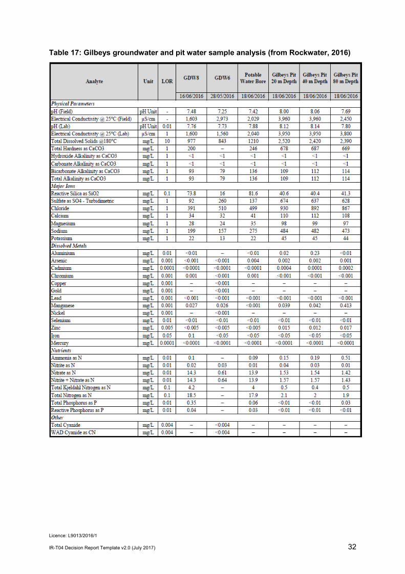
Gilbeys pit and TSF Before the start of mining in 1996, groundwater at Gilbeys pit was 5 to 10 mbgl, and at the TSF and the processing plant, around 2.8 mbgl (BFP, 1996). However, in May 2016, groundwater levels in Gilbeys pit were recorded at 37 mbgl and in bores around the pit 10 to 30 mbgl, reflecting residual drawdown from mine dewatering and the effect of evaporation at the surface (Rockwater, 2016). The chemical analysis of water sampled in June 2016 around Gilbeys pit and at the potable water bore is presented below in Table 17. Monitoring locations are shown in Figure 9. Bores GWD6, GWD8 and Potable Water Bore recorded neutral pH with relatively low salinity. Gilbeys pit water recorded higher alkalinity and salinity (reflecting a period of evapo-concentration) and elevated in Al, Mn and Zn (reflecting mineralised host rocks) (Rockwater, 2016). Pit water quality is within the ANZECC & ARMCANZ (2000) recommended values for livestock drinking water. The hydrogeological review by GRM in 2017 also concluded that Gilbeys pit is acting as a groundwater sink. GRM (2017) noted that there was a slight difference between groundwater levels around the Gilbeys pit and the pit lake water level, and water quality analysis, indicating that the Gilbeys pit void water quality has increased in salinity from around 1,050 to 1,850 mg/L in 1998 to 2,400 to 2,500mg/L in 2016 through evaporative concentration, although the pH is not changed dramatically. Groundwater contours as measured by GRM in 2017 is shown in Figure 10.

Licence: L9013/2016/1
IR-T04 Decision Report Template v2.0 (July 2017) 28
Golden Wings Hydrogeological test holes were drilled in March 2017 in the vicinity of the Golden Wings deposit comprising four shallow holes (18 m) and four deep holes (147 – 150 m). Groundwater was recorded at levels between 4.0 and 7.9 mbgl. A shallow aquifer of laterite and silcrete is saturated from about 4 to 5 mbgl and is underlain by clay and saprolite of low permeability to depths of 40 – 70 mbgl. Below this is a deeper, locally-permeable, mafic bedrock to 150 m (Rockwater, 2017). Groundwater samples from the shallow monitoring bores were brackish with salinities 1,870 to 2,390 mg/L TDS. Samples from the deep bores were 3,540 to 3,840 mg/L TDS. Field pH values were 7.23 to 7.97 (slightly alkaline) (Rockwater, 2017). Groundwater sampling at Golden Wings in 2017 at locations shown in Figure, gave the analysis results as shown in Table 18 below provided similar results of brackish, slightly alkaline groundwater quality, suitable as livestock drinking water (MRB, 2017).
Modelling The Dalgaranga Feasibility Study Hydrological Assessment (Rockwater, 2016 pp 14) reports that modelling indicated that the final Gilbeys pit void would be a permanent groundwater sink; the salinity of the pit water would gradually increase, and there will be no flow from the pit lake to groundwater around the pit. Modelling of potential impacts of seepage from Golden Wings in-pit TSF to groundwater was conducted by Rockwater in 2017. The modelling indicated:
• There would be low levels of Weak Acid Dissociable Cyanide (WADCN) in groundwater around the Golden Wings in pit TSF at the end of tailings emplacement (after 4.2 years) with concentrations of 0.20 mg/L or more extending up to 150 m down-gradient WSW of the in-pit TSF, and lesser distances in other directions.
• Concentrations in the plumes would decrease rapidly.
• Salinities dispersing from tailings will be similar to salinities currently recorded in the local aquifers.
• Water seeping from tailings in Golden Wings pit would be gradually diluted and move in a direction towards Gilbeys pit, which after mining, will remain a groundwater sink (Rockwater 2017).
Modelled water levels around Golden Wings pit and Gilbeys pit at three stages during tailings emplacement are shown in Figure 5 below, and show:
• Continuing cone of depressions around Gilbeys pit resulting from dewatering.
• Rapid rise in groundwater levels close to Golden Wings pit during tailings placement.
• Hydraulic flow around Golden Wings pit returning to the normal pattern of westerly flow 10 years after tailings emplacement.
DWER has considered the limitations of the modelling and information provided, but supports the principle conclusion of the modelling exercise that the extent of groundwater contamination from the Golden Wings in-pit TSF will be limited to the vicinity of the facility.
Topography Topography is subdued and drainage is mainly sheet wash. The low gradient flow direction of drainage is south westerly via a calcreted valley whose catchment extends about 15 km to the
Licence: L9013/2016/1
IR-T04 Decision Report Template v2.0 (July 2017) 29
east, 30 km north and 7 km south of the mine site.
Meteorology The climate of the region is arid with episodic rainfall events and hot summers, with high evaporation rate. DER GIS data indicates the premises lies between annual rainfall isohyets 200 - 250 mm/year, and between evaporations isopleths 3,200 mm/year and 3,400 mm/year. A 1 in 100 year 72 hour rainfall event is approximately 160 mm (from Bureau of Meteorology, 2017).

Licence: L9013/2016/1
IR-T04 Decision Report Template v2.0 (July 2017) 30
Figure 8: Location of the Dalgaranga Project tenements

Licence: L9013/2016/1
IR-T04 Decision Report Template v2.0 (July 2017) 31
Figure 9: Gilbeys pit groundwater monitoring bore locations (from Rockwater 2016)
Licence: L9013/2016/1
IR-T04 Decision Report Template v2.0 (July 2017) 32
Table 17: Gilbeys groundwater and pit water sample analysis (from Rockwater, 2016)

Licence: L9013/2016/1
IR-T04 Decision Report Template v2.0 (July 2017) 33
Figure 10: Groundwater contours November 2017 (from MRB, 2017)

Licence: L9013/2016/1
IR-T04 Decision Report Template v2.0 (July 2017) 34
Table 18: Groundwater quality at Golden Wings (from MRB, 2017)

Licence: L9013/2016/1
IR-T04 Decision Report Template v2.0 (July 2017) 35
Figure 11: Modelled predicted groundwater levels at Golden Wings (Rockwell 2017)

Licence: L9013/2016/1
IR-T04 Decision Report Template v2.0 (July 2017) 36
Figure 12: Modelled WADCN concentrations at GWTSF
Licence: L9013/2016/1
IR-T04 Decision Report Template v2.0 (July 2017) 37
7. Risk assessment Determination of emission, pathway and receptor
In undertaking its risk assessment, DWER will identify all potential emissions pathways and potential receptors to establish whether there is a Risk Event which requires detailed risk assessment. To establish a Risk Event there must be an emission, a receptor which may be exposed to that emission through an identified actual or likely pathway, and a potential adverse effect to the receptor from exposure to that emission. Where there is no actual or likely pathway and/or no receptor, the emission will be screened out and will not be considered as a Risk Event. In addition, where an emission has an actual or likely pathway and a receptor which may be adversely impacted, but that emission is regulated through other mechanisms such as Part IV of the EP Act, that emission will not be risk assessed further and will be screened out through Table 19. The identification of the sources, pathways and receptors to determine Risk Events are set out in Table 19 below. Table 19: Identification of emissions, pathway and receptors during operation
Risk Events Continue to detailed risk assessment
Reasoning
Sources/Activities Potential emissions Potential receptors Potential
pathway Potential adverse
impacts
Ore processing
(Category 5)
ROM pad and ore stockpiles
Primary crushing
Dust
Residences (pastoral stations); flora and vegetation
Air / wind
Human health and amenity; vegetation health
No
No residences or other sensitive land uses within 25 km; no Specified ecosystems
Noise Residences (pastoral stations)
Air / wind Amenity No No residences or other sensitive land uses within 25 km
Ore processing
(Category 5)
Storage and use of hydrocarbons, fuel farm, and reagent chemicals (quicklime, sodium cyanide, hydrochloric acid, sodium hydroxide, carbon)
Spills and breach of containment
Soil and vegetation adjacent to storage areas and the processing plant.
Direct discharge to land
Soil contamination inhibiting vegetation growth and survival, and health impacts to fauna.
No The Dangerous Goods Safety Act 2004 and associated Regulations apply. Managed under Dangerous Goods Licence DGS022377 by DMIRS; and
The Environmental Protection (Unauthorised Discharges) Regulations 2004 apply.
The general provisions of the EP Act are applicable.
Processing of ore
Contaminated stormwater -
Contaminated stormwater
Soil and vegetation adjacent to the processing areas, and
Direct discharge to ground
Soil contamination inhibiting vegetation
Yes See section 7.4

Licence: L9013/2016/1
IR-T04 Decision Report Template v2.0 (July 2017) 38
Risk Events Continue to detailed risk assessment
Reasoning
Sources/Activities Potential emissions Potential receptors Potential
pathway Potential adverse
impacts (category 5) management and
storage pond (sediments, hydrocarbons, CIL processing reagents)
groundwater. Infiltration through ground to groundwater
growth and survival, and health impacts to soil fauna.
Contamination of groundwater with impacts to beneficial uses.
Processing of ore (category 5)
Wet process circuits
(Gravity Concentration and Intensive Leaching, Classification, Leaching and Adsorption, Elution, Electrowinning)
Accidental spillage or discharge of ore feed of reagents or solutions through tanks leaks or failure.
Soil and vegetation adjacent to the ponds
Groundwater
Direct discharge to land and infiltration to groundwater
Soil contamination inhibiting vegetation growth and survival, and health impacts to fauna.
Contamination of groundwater with impacts to beneficial uses
No The Dangerous Goods Safety Act 2004 (DGS Act) and associated Regulations apply. Managed by DMIRS under Dangerous Goods Licence.
Risk assessment for Dangerous Goods Licence found that risks to people, property and the environment are eliminated or minimised so far as reasonably practicable (in accordance with DGS Act s61) and Licensed under Dangerous Goods Licence (DGS022377).
The Environmental Protection (Unauthorised Discharges) Regulations 2004 apply.
Processing of ore (category 5)
Wet processing and Smelting
Gaseous emissions from carbon regeneration kiln, from process solutions including acid wash, elution columns, electrowinning cells, CIL tanks, barren/intermediate/pregnant solution tanks.
Residences (pastoral stations)
Air / wind Human health No No residences or other sensitive land uses within 25 km

Licence: L9013/2016/1
IR-T04 Decision Report Template v2.0 (July 2017) 39
Risk Events Continue to detailed risk assessment
Reasoning
Sources/Activities Potential emissions Potential receptors Potential
pathway Potential adverse
impacts
Processing of ore (category 5)
Process water storage
Contaminated water – due Process water overtopping ponds.
Soil and vegetation adjacent to the storage area
Direct discharge to land
Soil contamination inhibiting vegetation growth and survival, and health impacts to fauna.
Yes See section 7.5
Contaminated water - Ponds seepage
Groundwater Infiltration through ground
Contamination of groundwater with impacts to beneficial uses.
Processing of ore (category 5)
Raw water storage Raw water - Ponds overtopping
Soil and vegetation adjacent to the ponds
Direct discharge to land
Soil contamination inhibiting vegetation growth and survival, and health impacts to fauna.
Yes See section 7.6
Raw water - Ponds seepage
Groundwater Infiltration through ground
Contamination of groundwater with impacts to beneficial uses
Processing of ore (category 5)
Tailing storage -surface Tailings dust Residences (pastoral
stations).
Air / wind dispersion
Health and amenity No No sensitive land uses within 25 km
TSF closure and capping managed under the Mining Act 1978 by DMIRS through Mining Proposal and long term closure planning. Soil and vegetation in
dispersion path Contamination of soils inhibiting vegetation growth and survival and health impacts to fauna
No
Processing of ore (category 5)
Tailings storage - Gilbeys TSF embankment failure
Tailings and decant water
Soil and terrestrial ecosystems in the pathway of tailings.
Surface water bodies in pathway of tailings.
Groundwater
Direct discharge to land and infiltration to groundwater.
Contamination of ground, surface water and groundwater with metals and metalloids, sulfide minerals (if present), dissolved solids, cyanide and arsenic.
No Embankment failure assessed and managed under the Mining Act 1978 by DMIRS through Mining Proposal and long term closure planning.

Licence: L9013/2016/1
IR-T04 Decision Report Template v2.0 (July 2017) 40
Risk Events Continue to detailed risk assessment
Reasoning
Sources/Activities Potential emissions Potential receptors Potential
pathway Potential adverse
impacts
Processing of ore (category 5)
Tailings pumps, slurry and decant return pipelines
Tailings slurry or decant water (leaks or pipeline failure)
Soil and vegetation adjacent to the processing plant, TSF and pipelines.
Direct discharge
Soil contamination inhibiting vegetation growth and survival and health impacts to fauna
Yes See section 7.7
Processing of ore (category 5)
Tailings storage Overflow - tailings, decant water, or stormwater containing decant water after heavy rainfall.
Soils and vegetation in the path of overflow.
Direct discharge.
Contamination of surrounding soils with metals and metalloids, sulfide minerals (if present), dissolved solids, cyanide and arsenic.
Yes See section 7.8
Processing of ore (category 5)
Tailings storage
Tailings leachate seepage
Soil and vegetation adjacent to the TSF.
Infiltration through embankments
Groundwater mounding.
Inundation of vegetation root zones resulting in poor vegetation health or death.
Yes
See section 7.9
Groundwater. Infiltration through base of the TSF.
Contamination groundwater with metals and metalloids, sulfide minerals (if present), dissolved solids, cyanide and arsenic with impacts to beneficial use of stock drinking water.
Processing of ore (category 5)
Tailings storage – pond water quality
Tailings and decant water pond containing cyanide
Birds or bats Birds or bats drinking the decant water
Cyanide poisoning of native wildlife
Yes See Section 7.10
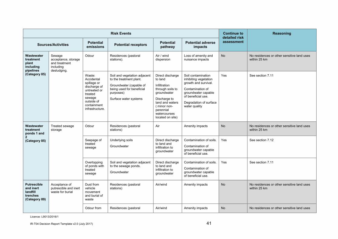
Licence: L9013/2016/1
IR-T04 Decision Report Template v2.0 (July 2017) 41
Risk Events Continue to detailed risk assessment
Reasoning
Sources/Activities Potential emissions Potential receptors Potential
pathway Potential adverse
impacts
Wastewater treatment plant including pipelines (Category 85)
Sewage acceptance, storage and treatment including desludging.
Odour Residences (pastoral stations).
Air / wind dispersion
Loss of amenity and nuisance impacts
No No residences or other sensitive land uses within 25 km
Waste: Accidental spillage or discharge of untreated or treated sewage outside of containment infrastructure.
Soil and vegetation adjacent to the treatment plant.
Groundwater (capable of being used for beneficial purposes)
Surface water systems
Direct discharge to land
Infiltration through soils to groundwater
Discharge to land and waters ( minor non-perennial watercourses located on site)
Soil contamination inhibiting vegetation growth and survival.
Contamination of groundwater capable of beneficial use.
Degradation of surface water quality
Yes See section 7.11
Wastewater treatment ponds 1 and 2 (Category 85)
Treated sewage storage
Odour Residences (pastoral stations)
Air Amenity impacts No No residences or other sensitive land uses within 25 km
Seepage of treated sewage
Underlying soils
Groundwater
Direct discharge to land and infiltration to groundwater
Contamination of soils.
Contamination of groundwater capable of beneficial use.
Yes See section 7.12
Overtopping of ponds with treated sewage
Soil and vegetation adjacent to the sewage ponds.
Groundwater
Direct discharge to land and infiltration to groundwater
Contamination of soils.
Contamination of groundwater capable of beneficial use.
Yes See section 7.11
Putrescible and inert landfill trenches (Category 89)
Acceptance of putrescible and inert waste for burial
Dust from vehicle movement and burial of waste
Residences (pastoral stations)
Air/wind Amenity impacts No No residences or other sensitive land uses within 25 km
Odour from Residences (pastoral Air/wind Amenity impacts No No residences or other sensitive land uses

Licence: L9013/2016/1
IR-T04 Decision Report Template v2.0 (July 2017) 42
Risk Events Continue to detailed risk assessment
Reasoning
Sources/Activities Potential emissions Potential receptors Potential
pathway Potential adverse
impacts the degradation of putrescible waste
stations)
within 25 km
Odour from the degradation of putrescible waste Scavengers and indirect
receptors – vegetation and fauna
Air/wind Increase in vermin
Potential alteration to local ecosystems
Yes See section 7.13
Windblown waste
Leachate seepage
Groundwater suitable for stock watering.
Infiltration through waste rock dump material and ground
Contamination of groundwater
Yes See Section 7.14

Licence: L9013/2016/1
IR-T04 Decision Report Template v2.0 (July 2017) 43
Consequence and likelihood of risk events A risk rating will be determined for risk events in accordance with the risk rating matrix set out in Table 20 below. Table 20: Risk rating matrix
Likelihood Consequence
Slight Minor Moderate Major Severe
Almost certain Medium High High Extreme Extreme
Likely Medium Medium High High Extreme
Possible Low Medium Medium High Extreme
Unlikely Low Medium Medium Medium High
Rare Low Low Medium Medium High
DWER will undertake an assessment of the consequence and likelihood of the Risk Event in accordance with Table 21 below. Table 21: Risk criteria table
Likelihood Consequence
The following criteria has been used to determine the likelihood of the Risk Event occurring.
The following criteria has been used to determine the consequences of a Risk Event occurring:
Environment Public health* and amenity (such as air and water quality, noise, and odour)
Almost Certain
The risk event is expected to occur in most circumstances
Severe • onsite impacts: catastrophic • offsite impacts local scale: high level
or above • offsite impacts wider scale: mid-level
or above • Mid to long-term or permanent impact to
an area of high conservation value or special significance^
• Specific Consequence Criteria (for environment) are significantly exceeded
• Loss of life • Adverse health effects: high level or
ongoing medical treatment • Specific Consequence Criteria (for
public health) are significantly exceeded
• Local scale impacts: permanent loss of amenity
Likely The risk event will probably occur in most circumstances
Major • onsite impacts: high level • offsite impacts local scale: mid-level • offsite impacts wider scale: low level • Short-term impact to an area of high
conservation value or special significance^
• Specific Consequence Criteria (for environment) are exceeded
• Adverse health effects: mid-level or frequent medical treatment
• Specific Consequence Criteria (for public health) are exceeded
• Local scale impacts: high level impact to amenity
Possible The risk event could occur at some time
Moderate • onsite impacts: mid-level • offsite impacts local scale: low level • offsite impacts wider scale: minimal • Specific Consequence Criteria (for
environment) are at risk of not being met
• Adverse health effects: low level or occasional medical treatment
• Specific Consequence Criteria (for public health) are at risk of not being met
• Local scale impacts: mid-level impact to amenity
Unlikely The risk event will probably not occur in most circumstances
Minor • onsite impacts: low level • offsite impacts local scale: minimal • offsite impacts wider scale: not
detectable • Specific Consequence Criteria (for
environment) likely to be met
• Specific Consequence Criteria (for public health) are likely to be met
• Local scale impacts: low level impact to amenity
Rare The risk event may only occur in exceptional circumstances
Slight • onsite impact: minimal • Specific Consequence Criteria (for
environment) met
• Local scale: minimal to amenity • Specific Consequence Criteria (for
public health) met
^ Determination of areas of high conservation value or special significance should be informed by the Guidance Statement: Environmental Siting. * In applying public health criteria, DWER may have regard to the Department of Health’s Health Risk Assessment (Scoping) Guidelines. “onsite” means within the Prescribed Premises boundary.

Licence: L9013/2016/1
IR-T04 Decision Report Template v2.0 (July 2017) 44
Acceptability and treatment of Risk Event DWER will determine the acceptability and treatment of Risk Events in accordance with the Risk treatment table 22 below: Table 22: Risk treatment table
Rating of Risk Event
Acceptability Treatment
Extreme Unacceptable. Risk Event will not be tolerated. DWER may refuse application.
High May be acceptable.
Subject to multiple regulatory controls.
Risk Event may be tolerated and may be subject to multiple regulatory controls. This may include both outcome-based and management conditions.
Medium Acceptable, generally subject to regulatory controls.
Risk Event is tolerable and is likely to be subject to some regulatory controls. A preference for outcome-based conditions where practical and appropriate will be applied.
Low Acceptable, generally not controlled.
Risk Event is acceptable and will generally not be subject to regulatory controls.
Risk Assessment - Contaminated Stormwater
Description Stormwater not captured by bunding from the dry processing area (primary crushing plant and stockpiles) and the wet plant pad (milling, CIL tanks, metal recovery and refining and reagent areas), or overtopping of bunding by tank spills or rupture, are captured by cutoff drains and are directed to an unlined sedimentation pond. Contaminants in stormwater may be discharged directly to ground by overtopping of the sedimentation pond or seepage through its base. The base of the pond is 5 m of laterite overlying clay. Groundwater at the plant area is approximately 8 - 10 mbgl.
General characterisation of emission Stormwater may contain sediment and hydrocarbons from the dry processing areas, and metals, metalloids, hazardous chemicals and solutions from the wet process area if overtopping of bunding occurs.
Description of potential adverse impact from the emission Soils and ground may become contaminated. Depending on the extent and nature of spillage and stormwater release, health of terrestrial and surface water ecosystems may be reduced. There are no Specified Ecosystems or surface water bodies within 10 km of the project area. Infiltration of contaminated stormwater to groundwater may impact on the beneficial use of groundwater as stock water.

Licence: L9013/2016/1
IR-T04 Decision Report Template v2.0 (July 2017) 45
Criteria for assessment ANZECC (2000) drinking water guidelines for livestock. ASC NEPM for soils and groundwater.
Proposed controls The Application states that the entire site drainage is designed to accommodate a 1 in100 year rainfall event (average rainfall intensity) of 72 hours duration. Applicant controls for stormwater are set out in Table 23 below. Table 23: proposed controls for stormwater
Control Construction Operation
Stormwater management
Cut- off drains direct stormwater not contained by bunding from: the dry processing area (primary crushing plant and stockpiles); and the wet plant pad (milling, CIL, metal recovery and refining and reagent areas) to the Sedimentation Pond.
The processing plant catchment area was sheeted with compacted lateritic material.
-
Sedimentation pond Accepts stormwater from the dry processing area (ore stockpiles and primary crushing plant) not contained within bunding.
Accepts stormwater from the wet plant pad (milling, CIL, metal recovery and refining and reagent areas), not contained within bunding.
Water able to be pumped to the process water pond as contingency (pipeline installed).
Capacity of 25,000m3 (sized to accommodate more than a 1 in 100 year ARI 72 hour rainfall event with 300 mm freeboard).
Maintenance of minimum 300 mm freeboard.
Key findings
The Delegated Officer has reviewed the information regarding impacts of contaminated stormwater and has found:
1. Stormwater and spills from dry and wet processing areas not contained by bunding are captured by cut-off drains and directed to an unlined sedimentation pond.
2. Potential contaminants from the dry processing area include hydrocarbons and sediments.
3. Potential contaminants from the wet processing area and process pond include reagents and chemicals used in CIL processing, including cyanide species and other metals and metalloids and hazardous chemicals and solutions.
4. There are no ‘specified ecosystems’ or surface water bodies within 10 km of the project area.

Licence: L9013/2016/1
IR-T04 Decision Report Template v2.0 (July 2017) 46
5. Groundwater at the site and in the locality is suitable for stock watering. 6. The project is located within a groundwater area proclaimed under the Rights in
Water and Irrigation Act 1914. 7. Bunding at the wet process area has capacity to contain 18% of the largest CIL
tank. Containment of larger spills (such as by rupture of a tank) will depend on drainage to sump tanks and operation of sump pumps.
8. The base of the pond is 5 m of lateritic caprock (low permeability overlying) clay. 9. The sedimentation pond is located within the influence of the modelled
groundwater sink of Gilbeys pit. 10. The sedimentation pond is sized to accommodate stormwater from more than a 1
in 100 year 72 hour rainfall event. 11. Water from the sedimentation pond can be pumped to the process pond as a
contingency.
Consequence Impacts to soils and ecosystems Spills from CIL tanks will drain to sumps with pumps. Bunding will contain 18% of a CIL tank. Rupture or failure of a tank may not be contained by bunding or able to be pumped fast enough to prevent overtopping of the bunding. Based upon the potential contaminants which may be collected by the stormwater system, distance to specified ecosystems, impacts of contamination of ground and soils from stormwater or overtopping of bunding or the sedimentation pond, impacts are mid-level on-site. Therefore the consequence is moderate.
Impacts to groundwater Although groundwater at the premises is not currently used for stock water, and it is not proposed to be used for that purpose during the operational lifetime of the project, the project should be managed so as to ensure that groundwater quality is maintained to ensure that groundwater remains suitable for its highest beneficial use. With consideration for the contaminants in chemicals used in the wet process area, the quality of the groundwater, and depth to groundwater, the consequence of seepage through the base of the sedimentation pond and infiltration to groundwater is that the ANZEEC 2000 guidelines for livestock watering may not be met. Impacts would be restricted to the modelled long term drawdown zone of Gilbeys pit. The consequence of seepage from the sedimentation pond may therefore be mid-level on-site and is hence moderate.
Likelihood of consequence Direct discharge to ground Given that stormwater and spills from the processing areas not contained by bunding will be contained by cut off drain, that rupture of a CIL tank would be an unusual event; the sedimentation pond is sized for a 1 in 100 year 72 hour rainfall event and water can be pumped to the process pond, the likelihood of impacts from contaminated stormwater directly discharging to ground will probably not occur in most circumstances. Therefore the likelihood is unlikely. Seepage to groundwater Stormwater and such spills from the processing areas not contained by bunding will be directed

Licence: L9013/2016/1
IR-T04 Decision Report Template v2.0 (July 2017) 47
to an unlined sedimentation pond. The sedimentation pond is constructed on low permeability ground with groundwater 8 - 10 mbgl. The likelihood of the “moderate” consequence to groundwater from infiltration through ground to groundwater will probably not occur in most circumstances. Therefore the likelihood is unlikely.
Overall rating The overall rating for the risk of contaminated stormwater is medium.
Risk Assessment - Process water storage
Description Water used for mineral processing will be delivered to the process water pond from the TSF as decant water, and also from the raw water pond. Process pond water spills may occur by overtopping, and seepage may occur through the base of the pond.
Identification and general characterisation of emission Process water may contain contaminants including metals and metalloids, sulfide minerals (if present), dissolved solids, cyanide, arsenic, and mercury.
Description of potential adverse impact from the emission Overflow of process water to ground may contaminate soils, and impact terrestrial and surface water ecosystems. There are no Specified Ecosystems or surface water bodies within 10 km of the project area. Infiltration of process water to groundwater may contaminate groundwater suitable for stock watering. Ground beneath the process plant area is 5 m of clay overlying lateritic caprock and groundwater is approximately 8 - 10 mbgl.
Criteria for assessment ASC NEPM for soils and groundwater.
Applicant controls The Application included controls for process water management as set out in Table 24 below. Table 24: Applicant controls for process water
Site Infrastructure
Construction Operation
Process water pond
Accept TSF decant return water via decant return pump.
Able to accept storage of overflow from the raw water pond, and water transferred from the sedimentation pond.
Contingency overflow via pipeline to the sedimentation pond.
Maintenance of minimum 300 mm freeboard.
Lined with 1.5 mm HDPE.
10,000 m3 capacity.
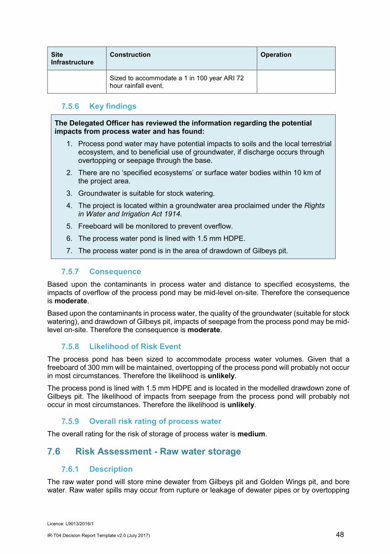
Licence: L9013/2016/1
IR-T04 Decision Report Template v2.0 (July 2017) 48
Site Infrastructure
Construction Operation
Sized to accommodate a 1 in 100 year ARI 72 hour rainfall event.
Key findings
The Delegated Officer has reviewed the information regarding the potential impacts from process water and has found:
1. Process pond water may have potential impacts to soils and the local terrestrial ecosystem, and to beneficial use of groundwater, if discharge occurs through overtopping or seepage through the base.
2. There are no ‘specified ecosystems’ or surface water bodies within 10 km of the project area.
3. Groundwater is suitable for stock watering. 4. The project is located within a groundwater area proclaimed under the Rights
in Water and Irrigation Act 1914. 5. Freeboard will be monitored to prevent overflow. 6. The process water pond is lined with 1.5 mm HDPE. 7. The process water pond is in the area of drawdown of Gilbeys pit.
Consequence Based upon the contaminants in process water and distance to specified ecosystems, the impacts of overflow of the process pond may be mid-level on-site. Therefore the consequence is moderate.
Based upon the contaminants in process water, the quality of the groundwater (suitable for stock watering), and drawdown of Gilbeys pit, impacts of seepage from the process pond may be mid-level on-site. Therefore the consequence is moderate.
Likelihood of Risk Event The process pond has been sized to accommodate process water volumes. Given that a freeboard of 300 mm will be maintained, overtopping of the process pond will probably not occur in most circumstances. Therefore the likelihood is unlikely. The process pond is lined with 1.5 mm HDPE and is located in the modelled drawdown zone of Gilbeys pit. The likelihood of impacts from seepage from the process pond will probably not occur in most circumstances. Therefore the likelihood is unlikely.
Overall risk rating of process water The overall rating for the risk of storage of process water is medium.
Risk Assessment - Raw water storage
Description The raw water pond will store mine dewater from Gilbeys pit and Golden Wings pit, and bore water. Raw water spills may occur from rupture or leakage of dewater pipes or by overtopping

Licence: L9013/2016/1
IR-T04 Decision Report Template v2.0 (July 2017) 49
of the pond. Seepage may occur through the base of the pond.
Identification and general characterisation of emission Water in Gilbeys pit recorded slightly higher alkalinity and salinity and Al, Mn and Zn compared with local groundwater, but suitable as for stock drinking water, as discussed in Section 7.5.1 above. (Rockwater, 2016). Groundwater at Golden Wings pit is brackish and slightly alkaline, suitable for stock drinking water as discussed in Section 7.5.2 above (MRB, 2017). Water in Sly Fox pit is expected to also be suitable for stock watering due to its location in close vicinity to Gilbeys pit.
Description of potential adverse impact from the emission Mine dewater discharged to ground may inundate vegetation, inhibit vegetation growth and survival, and impact terrestrial and surface water ecosystems. There are no Specified ecosystems, flora or surface water bodies within 10 km of the project area.
Criteria for assessment ANZECC & ARMCANZ (2000) drinking water guidelines for livestock. ASC NEPM for soils and groundwater.
Applicant controls The Applicant’s controls to manage impacts from raw water transfer and storage are identified in Table 25: Table 25: Applicant controls for raw water
Infrastructure Construction Operation
Raw water pond Accepts mine dewater from Gilbeys pit, Sly Fox pit and Golden Wings pit, and bore water.
Lined with 1.5 mm HDPE. 6,000 m3 capacity
Fitted with a level control system.
Overflow gravity fed via HDPE lined spillway to the process water pond.
Maintenance of minimum 300 mm freeboard to accommodate a 1 in 100 year ARI 72 hour rainfall event.
Gilbeys pit dewater pipelines
HDPE pipelines.
Situated within bunded open trenches to contain spillage.
-
Key findings
The Delegated Officer has reviewed the information regarding the potential impacts from water piped from Gilbeys pit and stored in the raw water pond and has found: 1. Dewater quality from Gilbeys, Sly Fox and Golden Wings pits is expected to
remain within guidelines for livestock drinking water. 2. There are no ‘specified ecosystems’ or surface water bodies within 10 km of the

Licence: L9013/2016/1
IR-T04 Decision Report Template v2.0 (July 2017) 50
project area. 3. The raw water storage pond will be lined with 1.5 mm HDPE. 4. The raw water storage pond is fitted with a level control system, and 300 m
freeboard will be maintained. 5. Contingency overflow of the raw water pond is by spill way to the process pond.
Consequence Based upon the quality of the pit dewater and distance to specified ecosystems, the impacts of pipe spillage and pond overflow and seepage may be low level on-site. Therefore the consequence is minor.
Likelihood of Risk Event Taking into consideration the containment infrastructure and freeboard management proposed, the minor impact of spillage or seepage of raw water will probably not occur in most circumstances. Therefore the likelihood is unlikely.
Overall risk rating of raw water The overall rating for the risk of transport and storage of raw water is medium.
Risk Assessment - Tailings pumps, slurry and decant return pipelines
Description Tailings and decant return pipelines and pumps may rupture or leak.
Identification and general characterisation of emission Tailings contain soluble metals, metalloids and cyanide species. Geochemistry of the tailings from ore sourced from Gilbeys pit and Golden Wings pit is discussed in Section 4.4 above.
Description of potential adverse impact from the emission Spillage or discharges from pipes and pumps may contaminate soils, smother vegetation, and have toxic effects on terrestrial and freshwater ecosystems. There are no Specified ecosystems or surface water bodies within 10 km of the project area.
Criteria for assessment ASC NEPM for soils
Proposed controls The Applicant’s controls to manage impacts of spillage and discharge from tailings pumps, pipelines and decant return line are presented in Table 26. Table 26: Applicant controls for spillage from tailings and decant return lines
Site Infrastructure
Construction Operation
TSF slurry pipes
TSF decant return water
Constructed with HDPE.
Situated within bunded open trenches
Daily inspections.
Shut down when flow meter readings

Licence: L9013/2016/1
IR-T04 Decision Report Template v2.0 (July 2017) 51
Site Infrastructure
Construction Operation
lines to contain spillage.
Fitted with flow meters and telemetry.
indicate pipeline failure.
Key findings
The Delegated Officer has reviewed the information regarding risk of tailings and return line and has found:
1. Tailings slurry or decant water discharged to land may contaminate soils, with toxic effects on terrestrial and freshwater ecosystems. There are no Specified ecosystems, flora or fauna, or surface water features on the premises.
2. Tailings and return water pipelines will be trenched to contain spills, flow monitored and visually inspected daily.
Consequence Based upon the contaminants in tailings slurry and decant water, and distance to specified ecosystems, the impacts of spillage from TSF pipelines may be mid-level on-site. Therefore the consequence is moderate.
Likelihood Given the applicant controls to prevent and contain spillage, the likelihood of impacts to soils and terrestrial ecosystems will probably not occur in most circumstances. Therefore the likelihood is unlikely.
Overall risk rating of The overall rating for the risk of tailings slurry and decant water lines is medium.
Risk Assessment - Tailings storage overflow
Description Tailings stored at Gilbeys TSF and Golden Wings in-pit TSF may overflow due to overtopping, or a rain event.
Identification and general characterisation of emission Tailings contain metals and metalloids, sulfide minerals (if present), dissolved solids, cyanide and arsenic. Geochemistry of the tailings from ore sourced from Gilbeys pit and Golden Wings pit is discussed in Section 4.4 above.
Description of potential adverse impact from the emission Overflow of a TSF may contaminate surrounding soils with metals and metalloids, sulfide minerals (if present), dissolved solids, cyanide and arsenic, smother vegetation, and have toxic effects on terrestrial and freshwater ecosystems. There are no Specified ecosystems or surface water bodies within 10 km of the project area.

Licence: L9013/2016/1
IR-T04 Decision Report Template v2.0 (July 2017) 52
Criteria for assessment ASC NEPM for soils and groundwater
Proposed controls The Applicant’s proposed controls to manage the risks of tailings and stormwater overtopping the TSF are set out in Table 27 below. Table 27: Proposed controls for impact of tailings overtopping the TSF
Site Infrastructure Construction Operation
Gilbeys TSF embankment raises:
Stage 1
Constructed to embankment crest level RL438.5 m for additional storage capacity for approximately 1.86 Mt tailings.
Each raise is sized for additional storage capacity and a 1 in 100 year average occurrence interval 72 hour storm event with a 500 mm freeboard.
A total freeboard of 500 mm maintained.
Minimum of once daily inspections of the freeboard.
Golden Wings in-pit TSF WRD located around the pit will contain tailings/stormwater.
Tailings deposition no more than 0.5 mbgl.
Key findings
The Delegated Officer has reviewed the information regarding risk of TSF overtopping and has found:
1. Tailings or stormwater overflow discharged to land may contaminate soils, with toxic effects on terrestrial and freshwater ecosystems.
2. There are no Specified ecosystems, flora or fauna, or surface water features on the premises.
3. A total freeboard of 500 mm will be maintained at Gilbeys TSF and Golden Wings in-pit TSF, to contain at least a 1 in 100 year, 72 hour rain event.
Consequence Based upon the contaminants in tailings slurry/stormwater, the distance to specified ecosystems, and the quality of the groundwater (suitable for stock watering), the impacts of overflow of either of the TSFs may be mid-level on-site. Therefore the consequence is moderate.
Likelihood Given a 500 mm minimum freeboard, the likelihood impacts from a TSF overflow will probably not occur in most circumstances. Therefore the likelihood is unlikely.
Overall risk rating of TSF overflow The overall rating for the risk of overflow of either TSF is medium.

Licence: L9013/2016/1
IR-T04 Decision Report Template v2.0 (July 2017) 53
Risk Assessment – Tailings storage - seepage
Description Seepage of tailings leachate from Gilbeys TSF or Golden Wings in-pit TSF to groundwater may occur. Groundwater near the TSF and Gilbeys pit was recorded during 2016 at 10 – 27 mbgl. Groundwater at Golden Wings pit was recorded in 2017 at 4 – 8 mbgl.
Identification and general characterisation of emission Net acid generation testing was carried out and determined that the Gilbeys composite sample was non-acid forming, with an oxidised pH of 7.8. The Golden Wings composite sample formed acid which was not neutralized during testing and reported oxidised pH of 3.0 (SWC, 2016). Tailings leachate contains metals and metalloids, sulfide minerals (if present), dissolved solids, cyanide and arsenic.
Description of potential adverse impact from the emission Contamination of groundwater with metals and metalloids, sulfide minerals (if present), dissolved solids, cyanide and arsenic may occur, with impacts to beneficial use of stock drinking water. Mounding of groundwater may have impacts to vegetation health through inundation of roots or contamination of water and soils.
Criteria for assessment ANZECC (2000) drinking water guidelines for livestock. ASC NEPM for soils and groundwater
Proposed controls To minimise seepage and impacts from seepage, the Applicant proposes to manage tailings deposition and the decant pond for maximum drying and photochemical breakdown of cyanide, as outlined in Table 28. Table 28: Proposed controls for TSF seepage
Site Infrastructure Construction Operations
Gilbeys TSF Independent decant pump located within the decant tower.
Spigots for tailings deposit located on the upstream edge of the crest of the TSF perimeter embankment.
Conductor pipe to extend to base of embankment.
Spigot off-takes spaced not less than 18 m and not more than 40 m apart.
Minimum of once daily inspections of the TSF
A supernatant pond maintained as close as possible around the decant tower.
Surface area of the decant pond minimised.
Return of decant water to the process plant maximised.
Tailings deposited in discrete layers, not exceeding 300mm thickness.
Tailings deposited sub aerially

Licence: L9013/2016/1
IR-T04 Decision Report Template v2.0 (July 2017) 54
Site Infrastructure Construction Operations
Golden Wings in- pit TSF
Single spigot points located along the western and northern perimeter of the pit for subaerial deposition.
Pontoon mounted pump for recovery of decant water
The tailings beach will be formed such that development of pond from rainfall events will form in the centre of the pit.
Maintence of decant pond as far away from walls as practically possible.
Return of decant water to the process plant maximised.
Recovery bores to ensure groundwater levels do not reach < 4 mbgl at during deposition.
Wet processing - The CIL circuit will involve addition of liming agent to keep the pH high to prevent production of HS gas, which will buffer the tailings material to maintain relatively low acid producing potential during operations.
Gascoyne Resources will operate for a target tailings slurry pH of 9 -10.
Key findings
The Delegated Officer has reviewed the information regarding risk of TSF overtopping and has found:
1. Tailings leachate (including soluble metals, metalloids and cyanide species) may seep through the base and walls of the TSFs and intercept groundwater.
2. Groundwater quality is suitable for stock watering. 3. The project is located within a groundwater area proclaimed under the Rights
in Water and Irrigation Act 1914. 4. There are no Specified ecosystems or flora on the premises. Surrounding
vegetation is considered shallow rooted. 5. Tailings will be deposited and the decant pond managed for maximum drying
of tailings and breakdown of cyanide. 6. Recovery bores will be used to ensure groundwater levels at Golden Wings do
not reach <4 mbgl. 7. It is likely that there is a hydraulic gradient towards each pit with the long term
gradient to Gilbeys pit which will act as a groundwater sink (Rockwater 2017b).
Consequence Groundwater contamination Although groundwater in the vicinity of the TSF is not currently used for stock water, and it is not proposed to be used for that purpose during the operational lifetime of the project, the project should be managed so as to ensure that groundwater quality is maintained at its baseline level. Groundwater quality should therefore be protected to ensure that groundwater remains suitable for its highest beneficial use. Based upon the potential contaminants in tailings leachate, and the quality of the groundwater
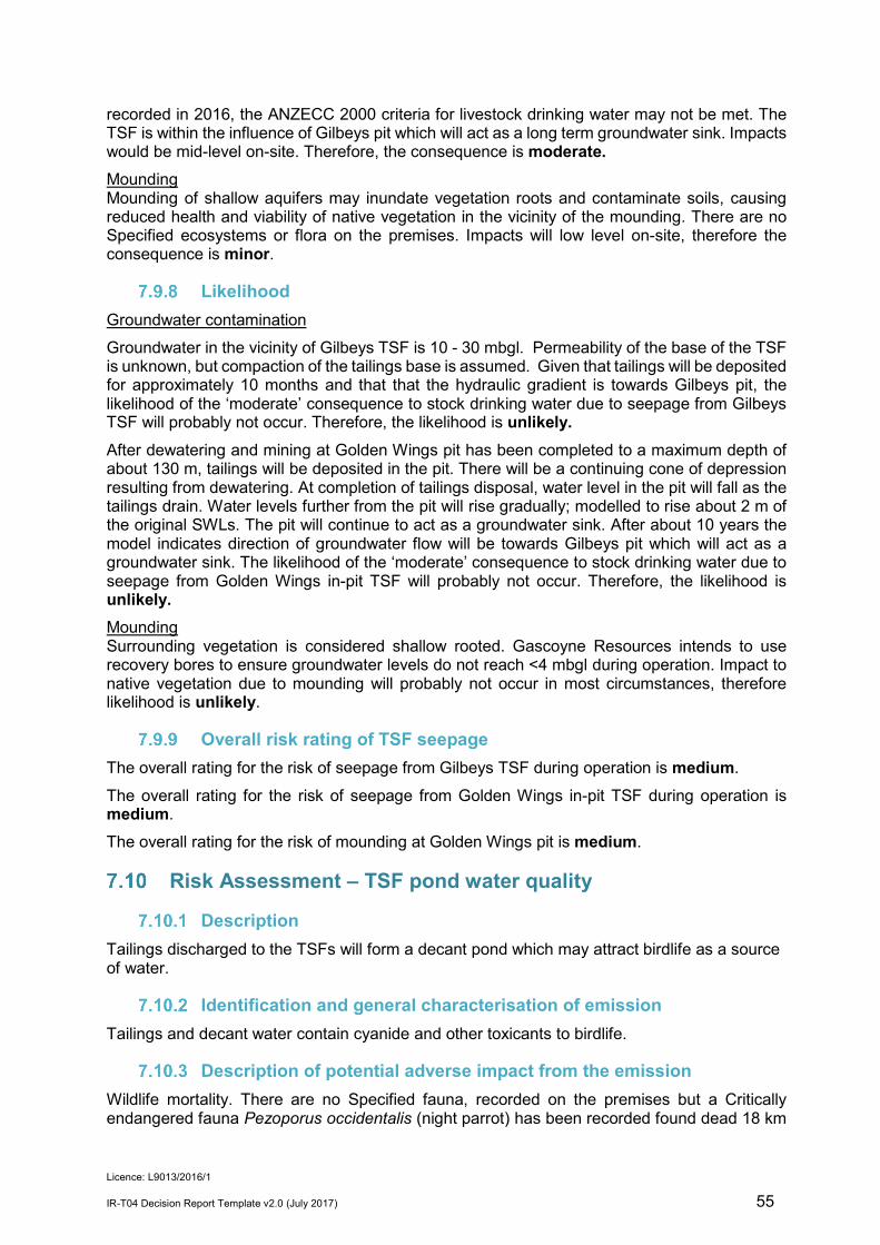
Licence: L9013/2016/1
IR-T04 Decision Report Template v2.0 (July 2017) 55
recorded in 2016, the ANZECC 2000 criteria for livestock drinking water may not be met. The TSF is within the influence of Gilbeys pit which will act as a long term groundwater sink. Impacts would be mid-level on-site. Therefore, the consequence is moderate. Mounding Mounding of shallow aquifers may inundate vegetation roots and contaminate soils, causing reduced health and viability of native vegetation in the vicinity of the mounding. There are no Specified ecosystems or flora on the premises. Impacts will low level on-site, therefore the consequence is minor.
Likelihood Groundwater contamination Groundwater in the vicinity of Gilbeys TSF is 10 - 30 mbgl. Permeability of the base of the TSF is unknown, but compaction of the tailings base is assumed. Given that tailings will be deposited for approximately 10 months and that that the hydraulic gradient is towards Gilbeys pit, the likelihood of the ‘moderate’ consequence to stock drinking water due to seepage from Gilbeys TSF will probably not occur. Therefore, the likelihood is unlikely. After dewatering and mining at Golden Wings pit has been completed to a maximum depth of about 130 m, tailings will be deposited in the pit. There will be a continuing cone of depression resulting from dewatering. At completion of tailings disposal, water level in the pit will fall as the tailings drain. Water levels further from the pit will rise gradually; modelled to rise about 2 m of the original SWLs. The pit will continue to act as a groundwater sink. After about 10 years the model indicates direction of groundwater flow will be towards Gilbeys pit which will act as a groundwater sink. The likelihood of the ‘moderate’ consequence to stock drinking water due to seepage from Golden Wings in-pit TSF will probably not occur. Therefore, the likelihood is unlikely. Mounding Surrounding vegetation is considered shallow rooted. Gascoyne Resources intends to use recovery bores to ensure groundwater levels do not reach <4 mbgl during operation. Impact to native vegetation due to mounding will probably not occur in most circumstances, therefore likelihood is unlikely.
Overall risk rating of TSF seepage The overall rating for the risk of seepage from Gilbeys TSF during operation is medium.
The overall rating for the risk of seepage from Golden Wings in-pit TSF during operation is medium. The overall rating for the risk of mounding at Golden Wings pit is medium.
Risk Assessment – TSF pond water quality
Description Tailings discharged to the TSFs will form a decant pond which may attract birdlife as a source of water.
Identification and general characterisation of emission Tailings and decant water contain cyanide and other toxicants to birdlife.
Description of potential adverse impact from the emission Wildlife mortality. There are no Specified fauna, recorded on the premises but a Critically endangered fauna Pezoporus occidentalis (night parrot) has been recorded found dead 18 km

Licence: L9013/2016/1
IR-T04 Decision Report Template v2.0 (July 2017) 56
east, and priority fauna Falco peregrinus (peregrine falcon) recorded12 km west.
Criteria for assessment Research has indicated that gold processing tailings with residual WAD-CN in solution above 50 mg/L, with a salinity of less than 50,000 mg/L, present a risk to wildlife health (Adams et al 2008).
Proposed controls The Applicant will target the following cyanide levels at the TSF:
• <80 mg/L WAD-CN at the spigot outlet
• <50 mg/L WAD-CN at the decant water pond
Key findings
The Delegated Officer has reviewed the information regarding impacts from the TSF pond to wildlife and has found:
1. The salinity of water dispersing from the tailings discharged into the TSFs will be similar to salinities currently recorded in the local aquifers - brackish to slightly saline – with salinities in the order of 800 mg/L to 3,840 mg/L.
2. The salinity of the groundwater and tailings are of relatively low salinity and the shallow water in the decant pond is likely to attract birds.
3. Tailings with residual WAD-CN in solution above 50 mg/L present a risk to wildlife. 4. Threatened/Priority birds have been recorded as occurring within 20 km.
Consequence Consequence of wildlife drinking the decant water may be mortalities to fauna including fauna of high conservation value. Significant Consequence Criterial may be exceeded and therefore the consequence is major.
Likelihood WAD-CN in the decant water pond may be greater than <50 mg/L. The risk event could occur at some time, so likelihood is possible.
Overall risk rating of the decant pond attraction to wildlife The overall rating for the risk of the decant pond to wildlife is high.
Risk Assessment WWTP – release of wastewater
General hazard characterisation and impact Wastewater may contain high levels of nutrients and pathogens. The release of wastewater to the environment due to rupture of pipes, storage tank failure or overtopping of the ponds may cause contamination of the underlying soils and impact the health and viability of terrestrial and riparian ecosystems There are no Specified ecosystems or surface water bodies on the premises. Based on sampling in March 2017, groundwater in the vicinity of the WWTP and ponds is approximately 4 - 5 mbgl (Rockwater, May 2017).
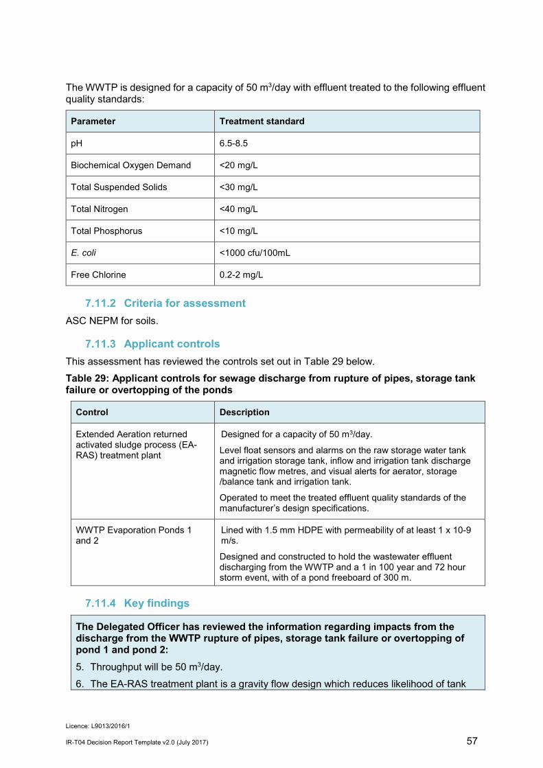
Licence: L9013/2016/1
IR-T04 Decision Report Template v2.0 (July 2017) 57
The WWTP is designed for a capacity of 50 m3/day with effluent treated to the following effluent quality standards:
Parameter Treatment standard
pH 6.5-8.5
Biochemical Oxygen Demand <20 mg/L
Total Suspended Solids <30 mg/L
Total Nitrogen <40 mg/L
Total Phosphorus <10 mg/L
E. coli <1000 cfu/100mL
Free Chlorine 0.2-2 mg/L
Criteria for assessment ASC NEPM for soils.
Applicant controls This assessment has reviewed the controls set out in Table 29 below. Table 29: Applicant controls for sewage discharge from rupture of pipes, storage tank failure or overtopping of the ponds
Control Description
Extended Aeration returned activated sludge process (EA-RAS) treatment plant
Designed for a capacity of 50 m3/day.
Level float sensors and alarms on the raw storage water tank and irrigation storage tank, inflow and irrigation tank discharge magnetic flow metres, and visual alerts for aerator, storage /balance tank and irrigation tank.
Operated to meet the treated effluent quality standards of the manufacturer’s design specifications.
WWTP Evaporation Ponds 1 and 2
Lined with 1.5 mm HDPE with permeability of at least 1 x 10⁻⁹ m/s.
Designed and constructed to hold the wastewater effluent discharging from the WWTP and a 1 in 100 year and 72 hour storm event, with of a pond freeboard of 300 m.
Key findings
The Delegated Officer has reviewed the information regarding impacts from the discharge from the WWTP rupture of pipes, storage tank failure or overtopping of pond 1 and pond 2: 5. Throughput will be 50 m3/day. 6. The EA-RAS treatment plant is a gravity flow design which reduces likelihood of tank

Licence: L9013/2016/1
IR-T04 Decision Report Template v2.0 (July 2017) 58
overflow during a power outage, and includes float sensors, magnetic flow meters, and alarms.
7. Storage capacity and freeboard of the ponds are adequate and will be maintained during operation.
8. Pond 2 provides contingency storage capacity. 9. There are no Specified ecosystems on the premises. The watercourses on site are
minor and non-perennial.
Consequence Based upon the capacity of the treatment plant, and distance to Specified ecosystems and surface waters, there may be low level on-site impacts from pipe rupture or pond overtopping. Therefore the consequence is minor.
Likelihood of Risk Event Based upon the upset monitoring systems of the WWTP, sizing of the ponds and maintenance of the pond freeboard, the impact of pipe rupture or pond overtopping will probably not occur in most circumstances and therefore the likelihood is unlikely.
Overall rating The Delegated Officer has compared the consequence and likelihood ratings described above for the Risk Criteria (Table 15) and determined that the overall rating for the rupture of pipes, storage tank failure or overtopping of ponds during operation is medium.
Risk Assessment – Seepage from WWTP ponds
General hazard characterisation and impact The release of wastewater to the environment due to seepage from the WWTP ponds may cause contamination of the underlying soils and degradation of groundwater. The EA-RAS sewage facility is able to treat effluent to the quality as described in section 8.4, prior to discharge to evaporation ponds. The project is located within a groundwater area proclaimed under the Rights in Water and Irrigation Act 1914 (RIWI Act). Based on groundwater contours (Rockwater, 2017) and pond base depths confirmed at construction, the Applicant states the base of the WWTP ponds are 2 m or more above groundwater.
Criteria for assessment Relevant land and groundwater quality criteria include the ANZECC 2000 for fresh and marine waters and ASC NEPM for soils and groundwater.
Proposed controls Table 30: Applicant controls for seepage from the ponds
Control Description
Siting of Infrastructure The base of the ponds are 2 m or more above groundwater.
Extended Aeration returned activated sludge process
Designed to meet treated effluent quality standards as described in section 8.4.1.

Licence: L9013/2016/1
IR-T04 Decision Report Template v2.0 (July 2017) 59
Control Description
(EA-RAS) treatment plant
WWTP Ponds 1 and 2 The ponds are lined with 1.5 mm HDPE with permeability of 1 x 10⁻⁹ m/s.
Key findings
The Delegated Officer has reviewed the information regarding seepage through the base of pond 1 and pond 2: 1. The groundwater at the project is capable of beneficial use of stock watering. 2. Ponds 1 and 2 are lined with1.5mm HDPE liner with permeability 1 x 10⁻⁹ m/s. 3. The base of the ponds are at least 2 m above groundwater level. 4. The Department of Water was consulted on the application and responded to confirm
that the approaches to wastewater management were deemed sufficient to minimise risks to water resources at the site.
Consequence Based upon the manufacturer’s stated final effluent quality and the quality of the groundwater, there may be low-level on-site impacts and therefore the consequence is minor.
Likelihood of consequence Based upon the information detailed above including the lining of the ponds, the impact from seepage will probably not occur in most circumstances and therefore likelihood is unlikely.
Overall rating The overall risk rating of the base of pond 1 and pond 2 during operation is medium.
Risk Assessment – landfill waste as scavenger attractant
General hazard characterisation and impact Scavengers may be attracted to the odour or sight of putrescible waste in trenches or on rubbish blown by wind, causing ecosystems to be altered by an increase in potential predators and thriving of scavenger species. Birds and other scavengers may travel some distance to a food source.
Proposed controls Table 31: Applicant controls landfill odour
Infrastructure Control
Landfill Fenced.
Landfill trenches located on the higher levels of the waste rock dump (>5 m) to reduce runoff entering the landfill trench.
No more than 400 tonnes waste disposed by landfilling.
Tires buried in a separate trench.

Licence: L9013/2016/1
IR-T04 Decision Report Template v2.0 (July 2017) 60
Infrastructure Control
Putrescible trenches Trench dimensions are maximum 20 m in length and 5m deep.
Waste covered once per week or as soon as practicable after deposit and prior to compaction by 0.15 m cover, with final cover 1 m.
‘Industrial’ Trench Sited within Gilbeys WRD
Only to accept only be used for burial of Clean Fill, Inert Waste Type 1 and Inert Waste Type 2 wastes.
Trench dimensions are maximum 36 m in length and 5 m deep.
Key findings
The Delegated Officer has reviewed the information regarding the operation of the putrescible landfill and the impact to ecosystems and has found: 1. Putrescible, Inert Waste Type 1 and Inert Waste Type 2 and Clean Fill will be accepted
at the landfill trenches for disposal. The acceptance of waste for disposal not meeting the types permitted for disposal, may result in a breach of section 53 of the EP Act.
2. No more than 400 tonnes per year of waste is to be disposed, including an estimated 320 tonnes of putrescible waste.
3. Landfill is fenced to reduce wind-blown waste.
4. Scavengers have the potential to travel distances, thrive and alter ecosystems.
5. Waste will be covered frequently. Covering of waste is important to reduce the attraction of scavengers.
Consequence There is potential for offsite ecosystems to be altered by attraction and thriving of scavenger species at the landfill. Considering the volumes of putrescible waste to be disposed, the Delegated Officer considers that there may be minimal level off-site impacts and therefore considers the consequence to be minor.
Likelihood of consequence Based upon the controls detailed above, including the tonnage of waste accepted, frequency of cover, and fencing, the Delegated Officer has determined that the impact to ecosystems will probably not occur in most circumstances and considers the likelihood of the consequence to be unlikely.
Overall rating The Delegated Officer has compared the consequence and likelihood ratings described above for the Risk Criteria (Table 11) and determined that the overall rating for the risk of the operation of the putrescible landfill to threatened/priority fauna as medium.
Licence: L9013/2016/1
IR-T04 Decision Report Template v2.0 (July 2017) 61
Risk Assessment – Landfill waste disposal and leachate
General hazard characterisation and impact Waste of the following waste types will be disposed of in trenches at the Waste Rock Dump:
• Clean Fill; • Putrescible Waste; • Inert Waste Type 1; and • Inert Waste Type 2.
The most significant impact of landfill waste disposal is the generation of leachate caused by the percolation of rainfall through the waste matter extracting soluble and suspended substances as it moves. Leachate quality varies throughout the operational life of the landfill and after its closure. During the early stages of waste degradation and leachate generation the composition is acidic and high in volatile fatty acids (the acetogenic phase). This acid leachate may dissolve other components of the wastes, such as metals. The leachate also contains high concentrations of ammoniacal nitrogen and has both a high organic carbon concentration and a biochemical oxygen demand. Additionally, metals, metalloids and major ions are likely to be present. The burial of waste in trenches on top of the waste rock dumps could increase the potential for leachate generation due to the increased rainfall infiltration as a result of the coarser nature of the material in large waste rock dumps compared to natural soils. The infiltrating rainfall is likely to enter into storage within void spaces in the waste rock materials and where excess water emerges as seepage around the base of the dump. It may take several years for continuum breakthrough, where the storage capacity of the waste rock dumps is filled, at which point seepage will commence at the base of the dump. The depth to the water table could be shallower than surrounding areas due to the increased groundwater recharge beneath the waste rock dump features. However, Gilbeys pit will act as a long term groundwater sink (Rockwater, 2016a).
Criteria for assessment ANZECC 2000 for livestock water Landfill Waste Classification and Waste Definitions 1996
Proposed controls – landfill leachate The Applicant has the following controls in place to manage leachate at the landfill as set out in Table 32 below.

Licence: L9013/2016/1
IR-T04 Decision Report Template v2.0 (July 2017) 62
Table 32: Applicant controls for landfill leachate
Infrastructure Design or construction
Operation Reference to Issued Works Approval (Schedule 3)
Landfill trenches
Sited within Gilbeys and/or Golden Wings WRDs.
Located more than 250 m from any watercourse.
Landfill trenches are to be located on the higher levels of the waste rock dump (>5 m).
Putrescible landfill trench dimensions are up to 20 m in length and 5 m deep.
‘Industrial’ landfill trench is up to 36 m in length 5 m deep.
‘Industrial’ landfill trench will only bury Clean Fill, Inert Waste Type 1 and Inert Waste Type 2 wastes.
Putrescible landfill trench will only accept Putrescibles, Clean fill, Inert Waste Type1, Inert Waste Type 2 (excluding tyres)
‘Industrial’ landfill trench will only accept Clean Fill, Inert Waste Type 1 and Inert Waste Type 2 wastes.
Tyres will be buried in a separate trench.
Total waste buried to be 400 tonnes/year.
No waste oils, hydrocarbon contaminated waste or chemicals to be disposed.
• Year 1:Gilbeys WRD/ Golden Wings WRD
• Year 2: Golden Wings WRD
Key findings
The Delegated Officer has reviewed the information regarding the operation of the landfilling and the impact to groundwater and has found: 1. Groundwater at the project is capable of beneficial use for livestock watering.
2. The project is located within a groundwater area proclaimed under the RIWI Act.
3. Landfill trenches will be located in the higher levels of the waste rock dump to reduce stormwater runoff entering the trenches.
4. Leachate from landfill trenches may discharge as seepage from the base of the Waste Rock Dump. Groundwater is 5 – 10 mbgl.
5. Rainfall in the region is low and evaporation is high.
6. The amount of waste planned to be accepted per year is relatively low.
Consequence Based upon the tonnage of putrescible waste to be buried, the impact of leachate from the landfill may result in minor on-site impacts and specific consequence criteria of the ANZECC 2000 guidelines for stock are likely to be met. Therefore the consequence is minor.

Licence: L9013/2016/1
IR-T04 Decision Report Template v2.0 (July 2017) 63
Likelihood of consequence Based upon the distances from the base of the cells to groundwater, regional climatic conditions, and that Gilbeys pit will act as a long term groundwater sink, the likelihood of the minor consequence will probably not occur in most circumstances. Therefore, the Delegated Officer considers the likelihood to be unlikely.
Overall rating The overall rating for the risk of landfill waste and leachate during operation is medium.

Licence: L9013/2016/1
IR-T04 Decision Report Template v2.0 (July 2017) 64
8. Regulatory controls The risks are set out in the assessment in section 10 and the controls are detailed in this section. In accordance with Guidance Statement: Risk Assessments (February 2017), where the Applicant’s proposed controls lowered the consequence or likelihood of a risk event, these controls will be conditioned in the instrument. The conditions of the Licence will be set to give effect to the determined regulatory controls.
Specified infrastructure and equipment controls The Delegated Officer considers that the operation and maintenance of the specified infrastructure and specified actions are necessary to manage risks as assessed in section 8.
Ore processing and tailings storage
Infrastructure Requirements
Stormwater
Stormwater from the: • dry processing area (ore stockpiles and dry crushing plant); • wet plant pad (milling, CIL, metal recovery, and refining and
reagent areas); and • mine contractor area
not contained in bunding, directed to the Sedimentation Pond by cut off drains.
Located as shown in Figures 1 and 6.
Sedimentation Pond Accepts stormwater from the dry processing area (ore stockpiles and primary crushing plant) not contained within bunding.
Accepts stormwater from the wet plant pad (milling, CIL, metal recovery and refining and reagent areas), not contained within bunding.
Accepts contingency overflow from the process water pond.
Water able to be pumped to the process water pond (pipeline installed).
25,000 m3 capacity (sized to accommodate stormwater runoff from more than a 1 in 100 year ARI 72 hour rainfall event).
Freeboard of 300 mm maintained.
Located as shown in Figure 1.
Process water pond
Accepts TSF decant return water via decant return pump.
Able to accept overflow from the raw water pond and water transferred from the Sedimentation pond.
10,000 m3 capacity.
Lined with 1.5 mm HDPE.
A 300 mm minimum freeboard maintained.
Located as shown in Figures 1 and 6.
Raw water pond
Accepts mine dewater from Gilbeys pit, Sly Fox pit and Golden Wings pit, and bore water.
6,000 m3 capacity.
Lined with 1.5 mm HDPE.

Licence: L9013/2016/1
IR-T04 Decision Report Template v2.0 (July 2017) 65
Infrastructure Requirements
Fitted with a level control sysem
Overflow by HDPE spillway to the Process water pond.
Located as shown in Figures 1 and 6.
Gilbeys pit and Golden Wings pit dewater pipes
HDPE
Situated within bunded open trenches to contain spillage.
Located as shown in Figure 1.
Tailings slurry pipes and pumps
Decant return lines and pumps.
HDPE
Situated within bunded open trenches to contain spillage.
Fitted with flow meters and telemetry.
Located as shown in Figure 1.
Gilbeys TSF
Stage 1 embankment crest level RL438.5 m
A minimum 500 mm Total Freeboard maintained.
Located as shown in Figure 1.
Gilbeys TSF Decant tower
Independent decant pump located within decant tower for recovery of decant water.
Gilbeys TSF Spigots for tailings deposit
Located on the upstream edge of the crest of the TSF perimeter embankment.
Conductor pipes to extend to base of embankment.
Spigot off-takes spaced not less than 18 m and not more than 40 m apart.
Golden Wings in- pit TSF
Tailings deposition no more than 0.5 mbgl (to contain rainfall associated with a 1 in 100 year ARI 72 hour rainfall event).
Maintence of decant pond as far away from walls as practically possible.
Located as shown in Figure 1.
Golden Wings in- pit TSF pontoon mounted pump
Pontoon mounted pump at the southeastern side of the pit for recovery of decant water.
Golden Wings in- pit TSF spigots for tailing deposition
Single spigot points located along the western and northern perimeter of the pit for subaerial deposition.
Gilbeys TSF groundwater monitoring bores
Located as depicted in Figure 4.
Golden Wings in-pit TSF groundwater monitoring bores
Four shallow and four deep groundwater monitoring bores located as depicted in Figure 5.
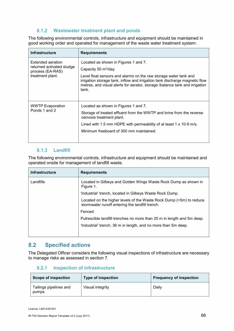
Licence: L9013/2016/1
IR-T04 Decision Report Template v2.0 (July 2017) 66
Wastewater treatment plant and ponds The following environmental controls, infrastructure and equipment should be maintained in good working order and operated for management of the waste water treatment system:
Infrastructure Requirements
Extended aeration returned activated sludge process (EA-RAS) treatment plant.
Located as shown in Figures 1 and 7.
Capacity 50 m3/day
Level float sensors and alarms on the raw storage water tank and irrigation storage tank, inflow and irrigation tank discharge magnetic flow metres, and visual alerts for aerator, storage /balance tank and irrigation tank.
WWTP Evaporation Ponds 1 and 2
Located as shown in Figures 1 and 7.
Storage of treated effluent from the WWTP and brine from the reverse osmosis treatment plant.
Lined with 1.5 mm HDPE with permeability of at least 1 x 10⁻⁹ m/s.
Minimum freeboard of 300 mm maintained.
Landfill The following environmental controls, infrastructure and equipment should be maintained and operated onsite for management of landfill waste.
Infrastructure Requirements
Landfills Located in Gilbeys and Golden Wings Waste Rock Dump as shown in Figure 1.
‘Industrial’ trench, located in Gilbeys Waste Rock Dump.
Located on the higher levels of the Waste Rock Dump (>5m) to reduce stormwater runoff entering the landfill trench.
Fenced.
Putrescible landfill trenches no more than 20 m in length and 5m deep.
‘Industrial’ trench, 36 m in length, and no more than 5m deep.
Specified actions The Delegated Officer considers the following visual inspections of infrastructure are necessary to manage risks as assessed in section 7.
Inspection of infrastructure
Scope of inspection Type of inspection Frequency of inspection
Tailings pipelines and pumps
Visual integrity Daily

Licence: L9013/2016/1
IR-T04 Decision Report Template v2.0 (July 2017) 67
Return water lines Visual integrity Daily
Gilbeys TSF embankment freeboard
Visual to confirm required freeboard capacity is available
Daily
Dewatering pipelines Visual integrity Daily
Landfill
Landfill Specified Action
Waste processing
Total cumulative waste accepted to be no more than 400 tonnes/year.
Clean fill, Putrescible waste, Inert Waste Type 1 and Inert Waste Type 2 accepted only.
All waste buried within a defined trench.
Burial in the ‘Industrial’ trench limited to Clean Fill, Inert Waste Type 1 and Inert Waste Type 2 (excluding tyres).
Tyres buried in a separate trench.
Any waste that has been blown outside the active landfill area collected and returned to the tipping area on a weekly basis.
Covering of waste
Waste covered with a dense, incombustible material.
Waste in putrescible trenches totally covered once per week or as soon as practicable after deposit, with no waste left exposed. Final cover to be 1m.
‘Industrial’ trench to be covered within three months of the final waste load.
Enough cover material stored and readily available at any one time for the tipping area to be covered at least twice.
Monitoring
Monitoring - decant pond The Licence holder will be required to sample WAD-CN monthly with a limit imposed of 50 mg/L to confirm cyanide remains below concentrations able to cause bird death; and pH.
Monitoring – groundwater The Licence Holder will be required to sample groundwater at groundwater monitoring bores surrounding Gilbeys TSF and Golden Wings in-pit TSF to enable detection of seepage of tailings leachate to groundwater from the TSFs (and by default the evaporation ponds). The applicant has indicated that the following analytes will be monitored: pH, TDS, Al, As, Cd, Cr(VI) and Cr(Total), Co, Cu, Fe, Hg, Ni, Se, Zn, WAD-CN. Based on the information in MEND (2004) and Smith (2007) and on the characterisation of mineralization in the area, Sb and Tl will also be added. A full suite of major ions (i.e. Na, K, Ca, Mg, Cl, SO4 and HCO3) will also be added, as changes in concentrations and proportions of these chemical constituents often occur before concentrations of metals increase if seepage takes place. During tailings placement in Golden Wings pit, monitoring bore MBWD01 is indicated to rise at a similar rate as the tailings in the pit. Groundwater at MBWD01 at the last year of tailings disposal is modelled to be greater than the original surface water level. The Applicant has stated that recovery bores will be used to ensure groundwater levels do not reach <4 mbgl. A limit will be placed on MBWD01 for groundwater to remain <4 mbgl.

Licence: L9013/2016/1
IR-T04 Decision Report Template v2.0 (July 2017) 68
Information A compliance report is required to be submitted annually indicating the extent to which the licence holder has complied with the conditions of the licence for the preceding year, and for documenting actual throughput for each prescribed category. An Annual Environment Report is required for reporting of monitoring results, and landfill cells opened and closed with their locations.
9. Determination of Licence conditions The conditions in the issued amended Licence in Attachment 1 have been determined in accordance with the Guidance Statement: Setting Conditions. The Guidance Statement: Licence Duration has been applied and the licence expiry remains unchanged, being 20 years from the date of original issue of the Licence. DWER notes that it may review the appropriateness and adequacy of controls at any time and that, following a review, DWER may initiate amendments to the licence under the EP Act.
10. Applicant’s comments The Applicant was provided with the draft Decision Report and draft Licence on 26 October 2018. The Applicant provided comments which are summarised, along with DWER’s response, in Appendix 2.
11. Conclusion This assessment of the risks of activities on the Premises has been undertaken with due consideration of a number of factors, including the documents and policies specified in this Decision Report (summarised in Appendix 1). Based on this assessment, it has been determined that the amended Licence will be granted subject to conditions commensurate with the determined controls and necessary for administration and reporting requirements. Alana Kidd MANAGER, RESOURCE INDUSTRIES INDUSTRY REGULATION Delegated Officer under section 20 of the Environmental Protection Act 1986

Licence: L9013/2016/1
IR-T04 Decision Report Template v2.0 (July 2017) 69
Appendix 1: Key documents Document title In text ref Availability
Application form: works approval/licence (concurrent works approval and licence) dated 28/10/2016
- DWER records (A1191126)
Works Approval W6012/2016/1- Dalgaranga Gold Project W6012/2016/1 Accessed at www.dwer.wa.gov.au
W6012/2016/1 Amendment Notice1 W6012/2016/1 Accessed at www.dwer.wa.gov.au
Licence L9013/2016/1 – Dalgaranga Gold Project L9013/2016/1 Accessed at www.dwer.wa.gov.au
Absolute Geotechnics Pty Ltd, 12 August 2016, Gascoyne Resources Ltd Dalgaranga Project Geotechnical Assessment – Plant Site.
Absolute Geotechnics (2016)
DWE records (A1720000)
Adams, M.D., Donato D.B., Schulz, R.S. and Smith, G.B., (2008) Influences of Hypersaline Tailings on Wildlife Cyanide Toxicosis; MERIWA Project M398 (II) ‘Cyanide Ecotoxicity at Hypersaline Gold Operations’ Final Report Volume 2 – Definitive Investigation, 26 August 2008
Adams et al, 2008 Accessed at:
https://www.mriwa.wa.gov.au/publications/previous-project-reports/
Ashton Safety Health Environment, January 2017. Dangerous Goods Assessment GNT Resources Ltd – Dalgaranga Project
Ashton, 2017 DWER records (A1685351)
Australian and New Zealand and Conservation Council and Agriculture and Resource Management Council of Australia and New Zealand, 2000. National Water Quality Management Strategy, Australian and New Zealand Guidelines for Fresh and Marine Water Quality
ANZECC 2000 Accessed at
www.environment.gov.au
BFP, June 1996. Geotechnical Assessment Proposed Tailings Impoundment and Plant Site Dalgaranga Project Final Report
BFP, 1996 Part of application for W1737/1996/1 (from hard copy records)
Clark Lindbeck and Associates Pty Ltd, October 2016. Dalgaranga Gold Project Works Approval & Operating Licence Supporting Document
Application DWER records (A1191130)
Coffey, 2 June 2017. GNT Resources Pty Ltd, Dalgaranga Gold Mine TSF Embankment Raise Design Report Stage 2
Coffey, 2017 DWER records (A1510699)

Licence: L9013/2016/1
IR-T04 Decision Report Template v2.0 (July 2017) 70
(RL 441.5m) and 3 (RL 444m)
Clark Lindbeck and Associates Pty Ltd, August 2017. Works Approval (W6012/2016/1) Amendment Supporting Document,
Amendment Notice 1 Application
DWER records (A1510699)
Gascoyne Resources Limited, 31 May 2018. Letter titled W6012/2016/1 – Verification of Infrastructure Requirements Listed in Table 2 of the Works Approval. Attachment 1
Compliance Reporting, 2018 DWER Records (A1685346)
Department of Environment and Conservation, 1996 (As amended December 2009. Landfill Waste Classification and Waste Definitions
Landfill Waste Classification and Waste Definitions 1996
Accessed at
www.dwer.wa.gov.au
Email correspondence from Ian Kerr, Gascoyne Resources, sent 19/01/2017 4:27PM. Subject: FW: W6012 Dalgaranga Gold Project works approval queries
- DWER records
Email correspondence from Ian Kerr, Gascoyne Resources, sent 8/02/2017 11:23 AM. Subject: RE: W6012 Dalgaranga Gold works approval queries
- DWER records (A1373520)
Email correspondence from Belinda Clark, Clark Lindbeck & Associates, sent: 5/10/2017 4:57 AM. Subject: Dalgaranga Project, Gascoyne Resources (W6012/2016/1) - Landfill, WWTP and WWTP ponds construction documents
Construction compliance documents
DWER records (A1536309)
Email correspondence – Subject: RE: W6012/2016/1 21 day amendment word doc , from Belinda Clarke, Clarke Lindbeck & Associates Pty Ltd, sent 12/10/2017 4:10PM
- DWER Records (A1541651)
Email correspondence – Subject: RE: Draft W6012/2016/1 - response to comments cut off drain, from Belinda Clarke, Clarke Lindbeck & Associates Pty Ltd, sent 17/10/2017 11:17AM
- DWER Records (A1541840)
Email correspondence from Belinda Clark, Clark Lindbeck & Associates, sent: 15/11/2017 12:17 PM. Subject: RE: Dalgaranga Project - Gascoyne Resources L9013 queries
- DWER records (A1560612)

Licence: L9013/2016/1
IR-T04 Decision Report Template v2.0 (July 2017) 71
Email correspondence from Belinda Clark, Clark Lindbeck & Associates, sent: 6/12/2017 11:12 AM. Subject: FW: Comments on draft Dalgaranga DWER Licence and Decision Report
Applicant’s comments DWER records (A1575006)
Groundwater Resource Management, November 2017. Dalgaranga Gold Project Hydrogeological Report to November 2017
GRM, 2017 DWER records (A1717766)
Mend, 2004. Review of Water Quality Issues in Neutral pH Drainage; Examples and Emerging Priorities for the Mining Industry in Canada. Mend Report 10.1 Mend, 2004
The report is available from the website http://mend-nedem.org/mend-report/review-of-water-quality-issues-in-neutral-ph-drainage-examples-and-emerging-priorities-for-the-mining-industry-in-canada/
National Environment Protection (Assessment of Site Contamination) Measure 1999
NEPM ASC Accessed at
www.environment.gov.au
Rockwater, August 2016. Dalgaranga Feasibility Study, Hydrogeological Assessment, Report for Gascoyne Resources Limited
Rockwater, 2016 Application supporting documentation
Rockwater, May 2017. Dalgaranga Project Golden Wings Pit – Groundwater testing and dewatering evaluation.
Rockwater, 2017a DWER records (A1510699)
Rockwater, July 2017. Dalgaranga Project Assessment of Potential Impact of In-Pit TSF, Golden Wings
Rockwater 2017(b)
DWER records (A1510699)
Scope Australia, 12 June 2017. Letter RE: Dalgaranga Gold Project Accommodation Village Certification – Evaporation Pond
Scope, 2017 DWER records (A1536309)
Smith, K.S., 2007. Strategies to predict metal mobility in surficial mining environments, in DeGraff, J.V. (Ed.), Understanding and Responding to Hazardous Substances at Mine Sites in the Western United States. Geological Society of America Reviews in Engineering Geology, v.XVII, 25-45.
Smith, 2007 The paper is available from web site http://pebblescience.org/Pebble-Mine/acid-drainage-pdfs/GSAREG017-Smith_508.pdf
TMC Water Recycling, 13 June 2017. RWS 50kL/d Class C Waste Water Plant Operation Assessment
TMC, 2017 DWER records (A1536309)

Licence: L9013/2016/1
IR-T04 Decision Report Template v2.0 (July 2017) 72
Appendix 2: Summary of applicant’s comments on risk assessment and draft conditions
Condition Summary of Licence Holder comment DWER response
Decision Report Table 6 Ore mined from Gilbeys South and Sly Fox open pits will now also be transported to the ROM pad and processed.
The pits are in the vicinity of Gilbeys pit, as shown in Figure 1. See further response below regarding TSF monitoring.
Gilbeys South and Sly Fox pits are added to Decision Report Table 6 infrastructure table.
Decision Report 3.3.1 Caustic soda (sodium hydroxide) is not contained within same bunding containment as the cyanide storage plant, but is contained by bunding.
There is no change to risk and the Decision Report is edited to correct.
Decision Report 3.3.1 and Licence Condition 2 Table 3
As a contingency, process water can be pumped to the process plant sedimentation pond. Licence Holder noted that pumping is via the site drainage network.
Pumping via the drainage network will occur as a contingency only. Decision Report and Licence is edited accordingly.
Decision Report 3.3.1 ‘Infrastructure sedimentation pond’ has been renamed as ‘site sedimentation pond’.
Decision Report is edited with the updated name.
Decision Report 7.4.1 Base of the pond is up to 5 m lateritic overlaying clay, not clay overlaying caprock.
Groundwater is 8 – 10 mbgl. There is no essential change to risk, and Decision Report is edited to correct.
Decision Report 7.5.7 Licence Holder queried if HDPE liner should reduce the consequence rating from moderate to minor
HDPE liner contributes to the likelihood, which is rated as ‘unlikely’, not to the consequence of seepage as a risk event. No change required.
Decision Report 7.14.1 The Licence Holder noted that regional rainfall is low and claimed that it would be unlikely that leachate would exit the base of the waste rock dump, though not critical to the risk rating.
Meteorological information from Section 6.8 is added to Sections 7.12.4 (key findings) and 7.12.6 (likelihood). Risk rating remains the same.

Licence: L9013/2016/1
IR-T04 Decision Report Template v2.0 (July 2017) 73
Condition Summary of Licence Holder comment DWER response
Decision Report 8.1.3 and Licence condition 8.1.3
Request to remove reference to Gilbeys Waste Dump as location for the ‘Industrial Landfill’.
‘Industrial Landfill’ is a previous borrow pit located in Gilbeys Waste Rock Dump and opportunistically used by Gascoyne Resources for inert waste burial. The ‘Industrial landfill’ is a one-off trench which has a particular size and accepts only inert waste types. Reference to its location in Gilbeys Waste Dump is better explained in the Decision Report 8.1.3 and remains in the licence.
Condition 2 Table 3 The Raw water pond will now also accept mine dewater from Sly Fox pit.
Dewater from Sly Fox pit is expected to be similar to that from Gilbeys pit. The raw water pond is lined with HDPE. Risk of storage of raw water remains essentially the same.
Condition 2 Table 3 Raw water pond line is edited to include water from Sly Fox Pit, and Decision Report Sections 7.6 and 8.1.1 are also updated.
Condition 2 Table 3 Minor modification has been made to the dewater pipeline at Golden Wings pit due to haul road conditions (see below Figure 13. The pipeline now runs to the west of MBWD03 and MBWS03.
Location of the dewater pipelines has been removed from infrastructure location requirements as the operational requirements are adequate to manage risk of dewater pipeline rupture and spill.
Site Plan 1 may be updated if/when the licence is amended in the future.
Condition 2 Table 3
Request to remove reference to WWTP Evaporation Pond 2 as emergency storage because the pond will now be utilised to maximize evaporation from a larger surface area.
Minimum freeboards remains applicable to Evaporation Pond 2, and reference to use as emergency storage is removed from the condition and the Decision Report.
Decision Report 8.3.2 and Licence Condition 8 Table 7.
“The tailings geochemistry does not include selenium and tin. Antinomy is also at very low concentrations at 1ppm. Cadmium is also not present or at very low concentrations. These metals should be removed from the monitoring requirements.”
“Gascoyne have been issued a Licence to Take Water by DWER. Conditional to this licence is the Groundwater Licence
The Licences referred to by Gascoyne Resources are assessed and issued under different legislation. DWER acknowledges that the Legislation is currently administered by the one Department.
Nonetheless, the suite of analytes and frequency of monitoring in the EP Act Part V Licence is consistent

Licence: L9013/2016/1
IR-T04 Decision Report Template v2.0 (July 2017) 74
Condition Summary of Licence Holder comment DWER response
Operating Strategy (GLOS). This defines the monitoring requirements for the TSF monitoring bores. This does not include Antinomy, Cadmium, Cobalt, Copper, Nickel, Selenium, and Thallium. Monitoring is also required biannually not quarterly. Gascoyne believe that the licences should be aligned given the DMA’s are part of one department.”
Gascoyne Resources also requested that quarterly monitoring frequency changed to align with the approved GLOS that requires 6-monthly monitoring.”
with EP Act Part V Licence monitoring now required at gold premises that store tailings from CIL gold processing, due to toxicity and potential presence of these heavy metals.
The purpose of the Part V Licences’ monitoring regime includes for detection of seepage from the TSF, including longitudinal analysis of spikes and trends including seasonal changes, and if seepage is detected, to determine any impacts.
It is also noted that tailings geochemistry from Sly Fox and Gilbeys South pits may be expected to be similar to that from Gilbeys Pit given their close vicinity, but has not been confirmed.
The monitoring frequency and analytes remain unchanged. A further amendment application may be submitted requesting this with relevant information to allow an assessment.
Licence Condition 8 Table 7.
Production bores PBWD02 and PBWD03 are 10 m from each of MBWD02 and MBWD03. Gascoyne requested these be included as alternative sampling locations when they are pumping for practical purposes.
Given the closeness of the production bores to the deep monitoring bores MBWD02 and MBWD03 it is agreed to include them as alternative sampling locations. Deeper bores may be also be reviewed as part of another amendment.

Licence: L9013/2016/1
IR-T04 Decision Report Template v2.0 (July 2017) 75
Attachment 1: Licence L9013/2016/1(amended)