INTERGOVERNMENTAL OCEANOGRAPHIC WORLD …€¦ · WORLD METEOROLOGICAL ORGANIZATION _____ DATA ......
38
INTERGOVERNMENTAL OCEANOGRAPHIC COMMISSION (OF UNESCO) ___________ WORLD METEOROLOGICAL ORGANIZATION _____________ DATA BUOY COOPERATION PANEL TWENTY-SIXTH SESSION OBAN, UNITED KINGDOM 27 – 30 SEPTEMBER 2010 DBCP-XXVI/Doc. 10.3 (2.IX.2010) _______ ITEM: 10.3 ENGLISH ONLY ARGOS OPERATIONS AND DEVELOPMENTS (Submitted by CLS) Summary and purpose of the document As for past DBCP meetings, this document contains, in consolidated form, the summary report from CLS/Service Argos, covering report on 2009 – 2010 Operations and System Improvements. ACTION PROPOSED The Panel will review the information contained in this report and comment and make decisions or recommendations as appropriate. See part A for the details of recommended actions. ______________________ Appendices: A. Report on 2009 – 2010 Operations and System Improvements
Transcript of INTERGOVERNMENTAL OCEANOGRAPHIC WORLD …€¦ · WORLD METEOROLOGICAL ORGANIZATION _____ DATA ......
INTERGOVERNMENTAL OCEANOGRAPHIC COMMISSION (OF UNESCO)
___________
WORLD METEOROLOGICAL ORGANIZATION_____________
DATA BUOY COOPERATION PANEL
TWENTY-SIXTH SESSION
OBAN, UNITED KINGDOM 27 – 30 SEPTEMBER 2010
DBCP-XXVI/Doc. 10.3
(2.IX.2010)
_______
ITEM: 10.3
ENGLISH ONLY
ARGOS OPERATIONS AND DEVELOPMENTS
(Submitted by CLS)
Summary and purpose of the document
As for past DBCP meetings, this document contains, in consolidated form, the summary report from CLS/Service Argos, covering report on 2009 – 2010 Operations and System Improvements.
ACTION PROPOSED The Panel will review the information contained in this report and comment and make decisions or recommendations as appropriate. See part A for the details of recommended actions.
______________________ Appendices: A. Report on 2009 – 2010 Operations and System Improvements
DBCP-26/Doc. 10.3, p. 2
-A- DRAFT TEXT FOR INCLUSION IN THE FINAL REPORT 10.3.1 Mr. Bill Woodward (CLS America) and Ms Fabienne Jacq (CLS/Argos) presented a report on Argos operations and system improvements during 2009-2010. [to be completed according to the actual discussion during the session]
______________________
APPENDIX A
REPORT ON 2009 – 2010 OPERATIONS AND SYSTEM IMPROVEMENT
List of Contents
1. 2009-2010 Argos Highlights ...............................................................3
1.1. Operations ..............................................................................3
1.2. System improvements ................................................................3
1.3. Outlook ..................................................................................3
2. Argos space segments ......................................................................4
2.1. Operational status.....................................................................4
2.2. METOP-A HRPT Switch Zone ........................................................4
2.3. Ascending Nodes Local hour ........................................................5
2.4. Next launches of satellites with Argos instrument .............................6
3. Argos ground segment......................................................................6
3.1. Global antennas (delayed mode)...................................................6 3.1.1. Operations ........................................................................................... 7
3.1.2. System improvements............................................................................. 7
3.2. Regional antennas (real-time mode) ..............................................8 3.2.2. System improvements............................................................................13
3.3. Processing centers .................................................................. 16 3.3.1. Operations ..........................................................................................17
3.3.2. System improvements............................................................................19
4. Argos user’s applications ................................................................ 24
4.1. Monitoring Argos platforms........................................................ 24
4.2. Argos-3 ................................................................................ 25 4.2.1. Argos-3 Test Program (DBCP 22, item 8.3.17) ..............................................25
4.2.2. DBCP Pilot Project for the Evaluation of Argos-3 Technology............................26
4.3. Data Timeliness...................................................................... 28 4.3.1. Indian Ocean Delays (DBCP 24, item 8.4 (iv)) ...............................................28
DBCP-26/Doc. 10.3, Appendix A, p. 2
4.3.2. Real-Time Monitoring for GTS Data and Timeliness (DBCP 23, item 8.6.2.19) .......28
4.3.3. CLS Real-Time Antenna Upgrade Project – Responding to DBCP Requirements ......31
5. Annexes ..................................................................................... 32
List of Figures
Figure 1: Argos constellation ................................................................................................................4
Figure 2: MetOp-A HRPT Switch Zone..................................................................................................5
Figure 3: Local Equator crossing time .................................................................................................5
Figure 4: Global Processing Antennae.................................................................................................6
Figure 5: NOAA and METOP playback and Real-time datasets processed per Month in 2009.......7
Figure 6: Real-time coverage map network .........................................................................................8
Figure 7: Real-time antenna monthly availabilityOperations .............................................................8
Figure 8: Resolute Bay City ...................................................................................................................9
Figure 9: HRPT coverage of Muscat station ......................................................................................10
Figure 10: METOP-A realtime Coverage (2010) .................................................................................10
Figure 11: Current Argos HRPT network with 20 selected real-time stations ................................14
Figure 12: Data time availability (in minutes) with the current Argos real-time network ..............15
Figure 13: Data time availability (in minutes) with the Argos real-time network upgraded ..........15
Figure 14: Architecture of the CLS France and the CLS America global processing centers......16
Figure 15: ARGOS French global processing center synoptic ........................................................17
Figure 16: Disaster Recovery Room located in CNES (Toulouse, France) .....................................18
Figure 17: Average Number of messages processed per day .........................................................18
Figure 18: Data Available in 1 hour.....................................................................................................19
Figure 19: Account activity menu on ArgosWeb...............................................................................20
Figure 20: Average delivery time in minutes of GTS bulletins.........................................................21
Figure 21: Argos web service scheme ...............................................................................................22
Figure 22: SUA & Id request menu menu on ArgosWeb...................................................................23
Figure 23: Same Argos track processes by the old method (at left) and the new one (at right) ..23
Figure 24: Monthly active Argos platforms statistics .......................................................................24
Figure 25: Argos platforms repartition ...............................................................................................25
Figure 26: Argos-3 buoy (Clearwater) deployment in Med. Sea.......................................................27
Figure 27: Map of Initial Argos-3 DBCP Pilot Project Deployments ................................................27
Figure 28: Argos platforms GTS processed per day.........................................................................29
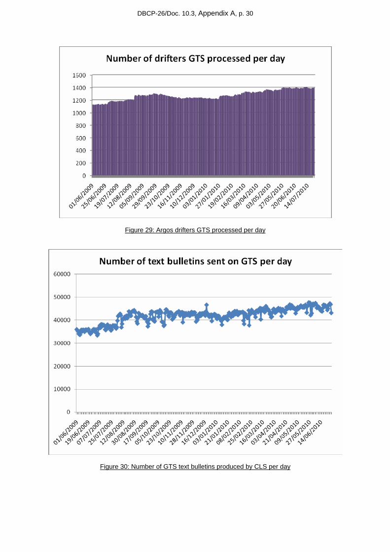
Figure 29: Argos drifters GTS processed per day.............................................................................30
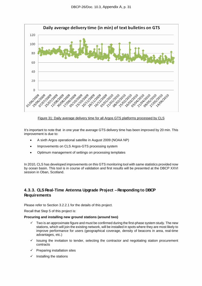
Figure 30: Number of GTS text bulletins produced by CLS per day ...............................................30
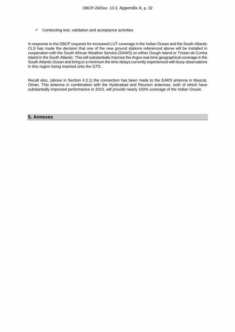
Figure 31: Daily average delivery time for all Argos GTS platforms processed by CLS ...............31
DBCP-26/Doc. 10.3, Appendix A, p. 3
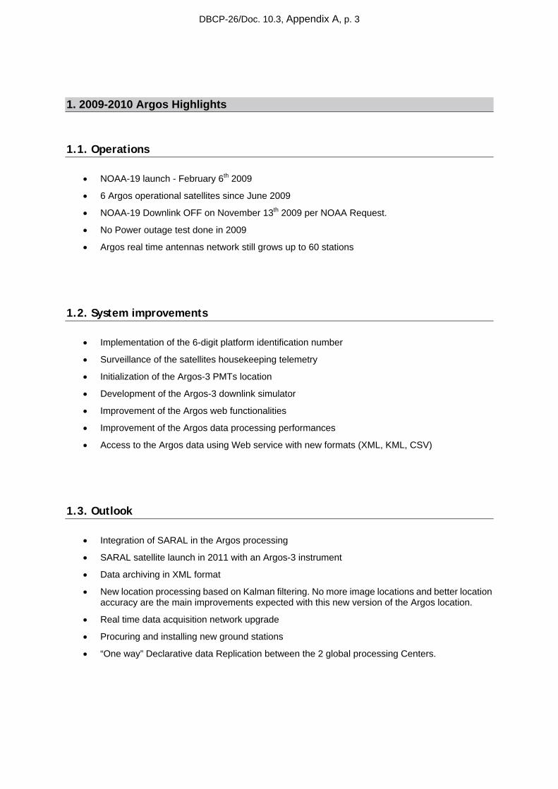
1. 2009-2010 Argos Highlights
1.1. Operations
• NOAA-19 launch - February 6th 2009
• 6 Argos operational satellites since June 2009
• NOAA-19 Downlink OFF on November 13th 2009 per NOAA Request.
• No Power outage test done in 2009
• Argos real time antennas network still grows up to 60 stations
1.2. System improvements
• Implementation of the 6-digit platform identification number
• Surveillance of the satellites housekeeping telemetry
• Initialization of the Argos-3 PMTs location
• Development of the Argos-3 downlink simulator
• Improvement of the Argos web functionalities
• Improvement of the Argos data processing performances
• Access to the Argos data using Web service with new formats (XML, KML, CSV)
1.3. Outlook
• Integration of SARAL in the Argos processing
• SARAL satellite launch in 2011 with an Argos-3 instrument
• Data archiving in XML format
• New location processing based on Kalman filtering. No more image locations and better location accuracy are the main improvements expected with this new version of the Argos location.
• Real time data acquisition network upgrade
• Procuring and installing new ground stations
• “One way” Declarative data Replication between the 2 global processing Centers.
DBCP-26/Doc. 10.3, Appendix A, p. 4
2. Argos space segments
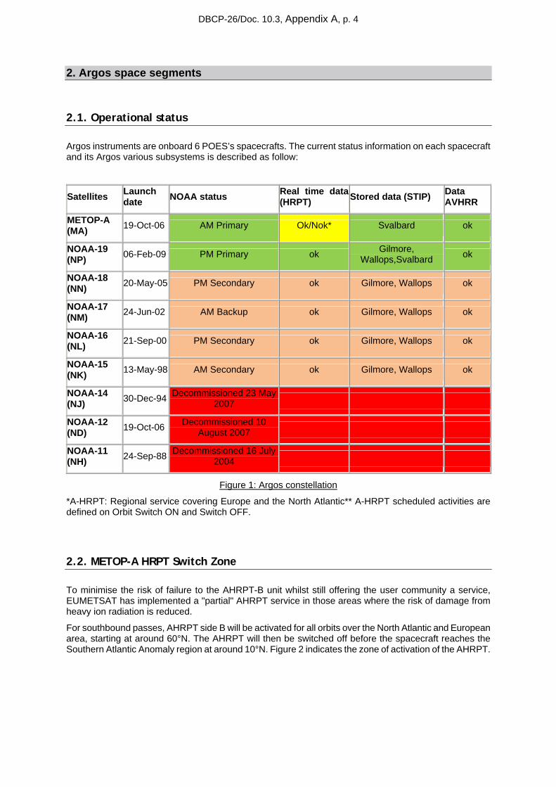
2.1. Operational status
Argos instruments are onboard 6 POES’s spacecrafts. The current status information on each spacecraft and its Argos various subsystems is described as follow:
Satellites Launch date NOAA status Real time data
(HRPT) Stored data (STIP) Data AVHRR
METOP-A (MA) 19-Oct-06 AM Primary Ok/Nok* Svalbard ok
NOAA-19 (NP) 06-Feb-09 PM Primary ok Gilmore,
Wallops,Svalbard ok
NOAA-18 (NN) 20-May-05 PM Secondary ok Gilmore, Wallops ok
NOAA-17 (NM) 24-Jun-02 AM Backup ok Gilmore, Wallops ok
NOAA-16 (NL) 21-Sep-00 PM Secondary ok Gilmore, Wallops ok
NOAA-15 (NK) 13-May-98 AM Secondary ok Gilmore, Wallops ok
NOAA-14 (NJ) 30-Dec-94 Decommissioned 23 May
2007
NOAA-12 (ND) 19-Oct-06 Decommissioned 10
August 2007
NOAA-11 (NH) 24-Sep-88 Decommissioned 16 July
2004
Figure 1: Argos constellation
*A-HRPT: Regional service covering Europe and the North Atlantic** A-HRPT scheduled activities are defined on Orbit Switch ON and Switch OFF.
2.2. METOP-A HRPT Switch Zone
To minimise the risk of failure to the AHRPT-B unit whilst still offering the user community a service, EUMETSAT has implemented a "partial" AHRPT service in those areas where the risk of damage from heavy ion radiation is reduced.
For southbound passes, AHRPT side B will be activated for all orbits over the North Atlantic and European area, starting at around 60°N. The AHRPT will then be switched off before the spacecraft reaches the Southern Atlantic Anomaly region at around 10°N. Figure 2 indicates the zone of activation of the AHRPT.
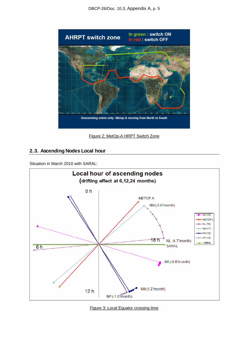
DBCP-26/Doc. 10.3, Appendix A, p. 5
Figure 2: MetOp-A HRPT Switch Zone
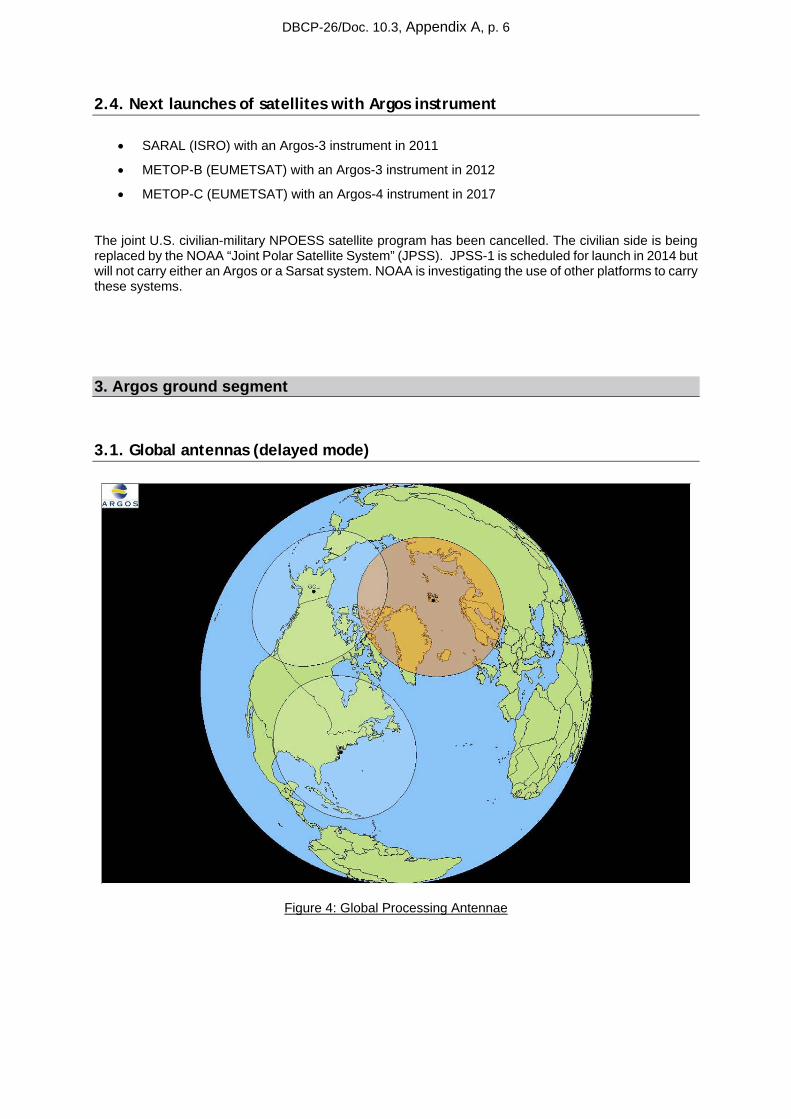
2.3. Ascending Nodes Local hour
Situation in March 2010 with SARAL:
Figure 3: Local Equator crossing time
DBCP-26/Doc. 10.3, Appendix A, p. 6
2.4. Next launches of satellites with Argos instrument
• SARAL (ISRO) with an Argos-3 instrument in 2011
• METOP-B (EUMETSAT) with an Argos-3 instrument in 2012
• METOP-C (EUMETSAT) with an Argos-4 instrument in 2017
The joint U.S. civilian-military NPOESS satellite program has been cancelled. The civilian side is being replaced by the NOAA “Joint Polar Satellite System” (JPSS). JPSS-1 is scheduled for launch in 2014 but will not carry either an Argos or a Sarsat system. NOAA is investigating the use of other platforms to carry these systems.
3. Argos ground segment
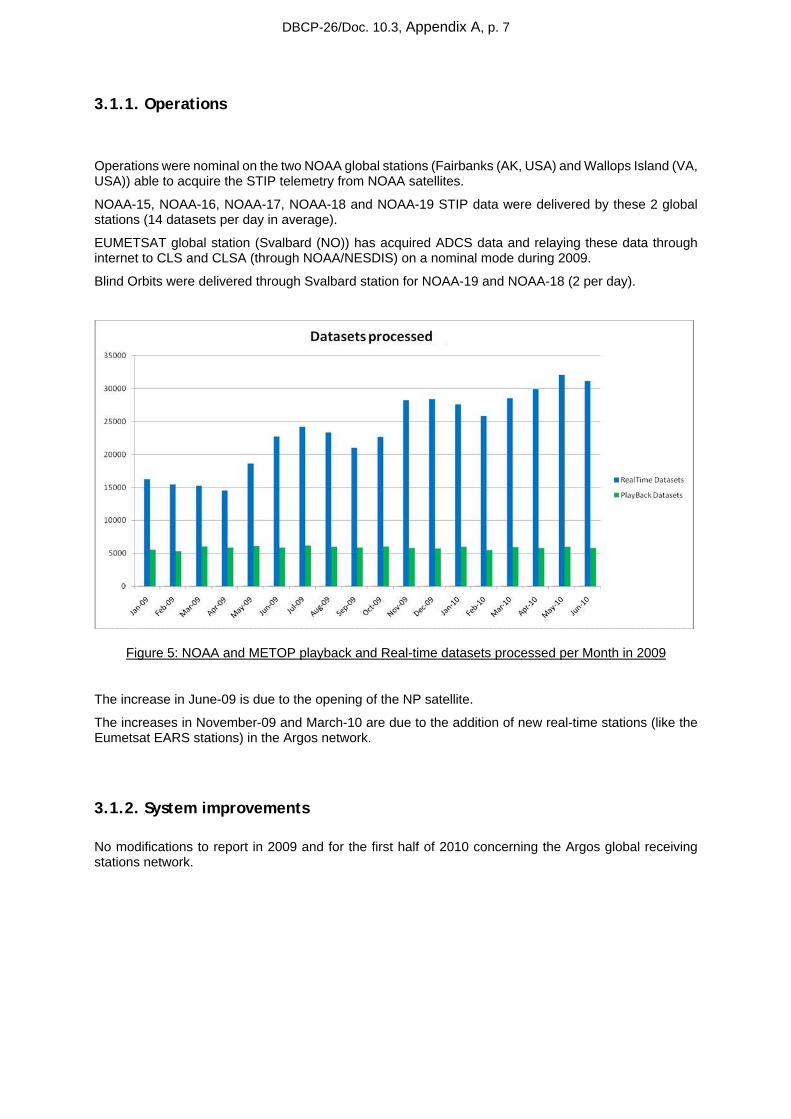
3.1. Global antennas (delayed mode)
Figure 4: Global Processing Antennae
DBCP-26/Doc. 10.3, Appendix A, p. 7
3.1.1. Operations
Operations were nominal on the two NOAA global stations (Fairbanks (AK, USA) and Wallops Island (VA, USA)) able to acquire the STIP telemetry from NOAA satellites.
NOAA-15, NOAA-16, NOAA-17, NOAA-18 and NOAA-19 STIP data were delivered by these 2 global stations (14 datasets per day in average).
EUMETSAT global station (Svalbard (NO)) has acquired ADCS data and relaying these data through internet to CLS and CLSA (through NOAA/NESDIS) on a nominal mode during 2009.
Blind Orbits were delivered through Svalbard station for NOAA-19 and NOAA-18 (2 per day).
Figure 5: NOAA and METOP playback and Real-time datasets processed per Month in 2009
The increase in June-09 is due to the opening of the NP satellite.
The increases in November-09 and March-10 are due to the addition of new real-time stations (like the Eumetsat EARS stations) in the Argos network.
3.1.2. System improvements
No modifications to report in 2009 and for the first half of 2010 concerning the Argos global receiving stations network.
DBCP-26/Doc. 10.3, Appendix A, p. 8
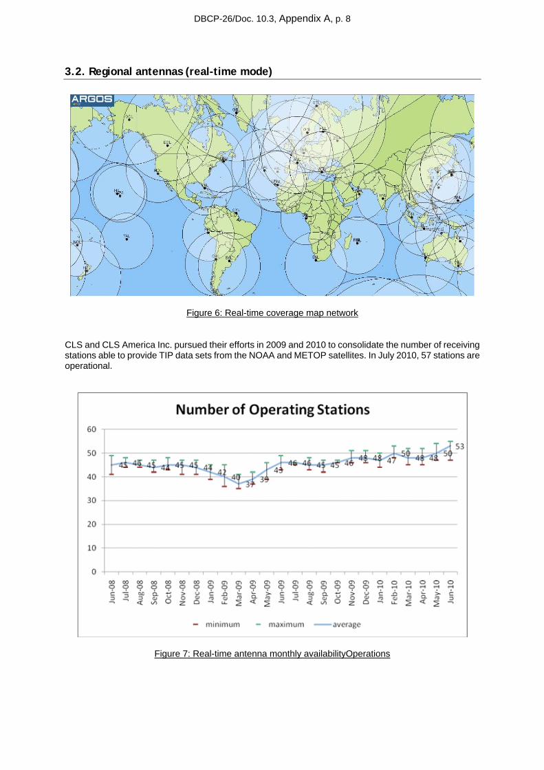
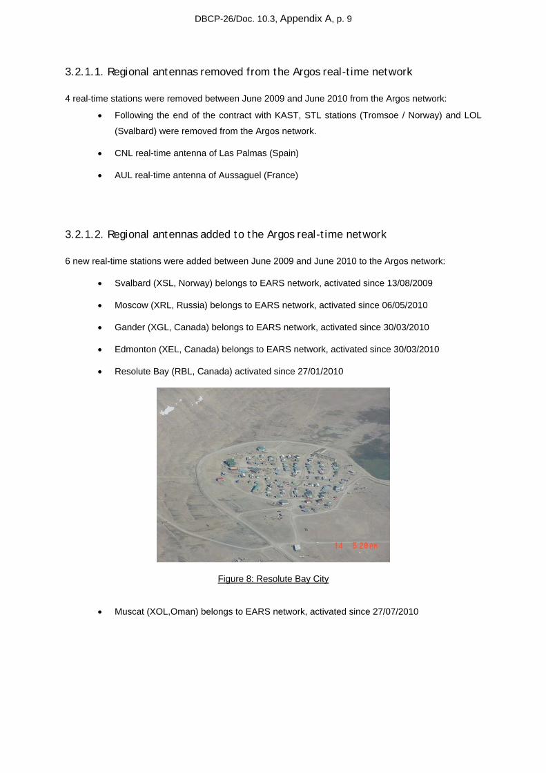
3.2. Regional antennas (real-time mode)
Figure 6: Real-time coverage map network
CLS and CLS America Inc. pursued their efforts in 2009 and 2010 to consolidate the number of receiving stations able to provide TIP data sets from the NOAA and METOP satellites. In July 2010, 57 stations are operational.
Figure 7: Real-time antenna monthly availabilityOperations
DBCP-26/Doc. 10.3, Appendix A, p. 9
3.2.1.1. Regional antennas removed from the Argos real-time network
4 real-time stations were removed between June 2009 and June 2010 from the Argos network:
• Following the end of the contract with KAST, STL stations (Tromsoe / Norway) and LOL
(Svalbard) were removed from the Argos network.
• CNL real-time antenna of Las Palmas (Spain)
• AUL real-time antenna of Aussaguel (France)
3.2.1.2. Regional antennas added to the Argos real-time network
6 new real-time stations were added between June 2009 and June 2010 to the Argos network:
• Svalbard (XSL, Norway) belongs to EARS network, activated since 13/08/2009
• Moscow (XRL, Russia) belongs to EARS network, activated since 06/05/2010
• Gander (XGL, Canada) belongs to EARS network, activated since 30/03/2010
• Edmonton (XEL, Canada) belongs to EARS network, activated since 30/03/2010
• Resolute Bay (RBL, Canada) activated since 27/01/2010
Figure 8: Resolute Bay City
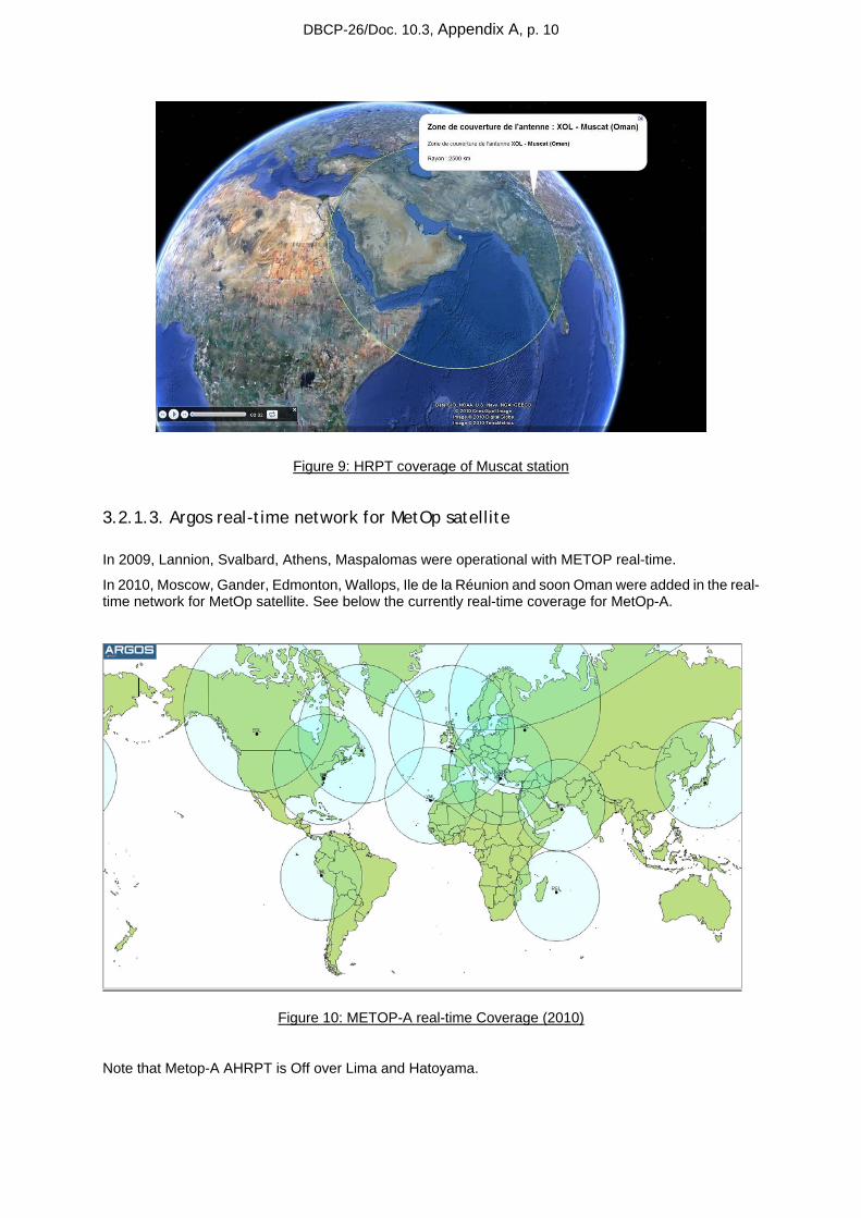
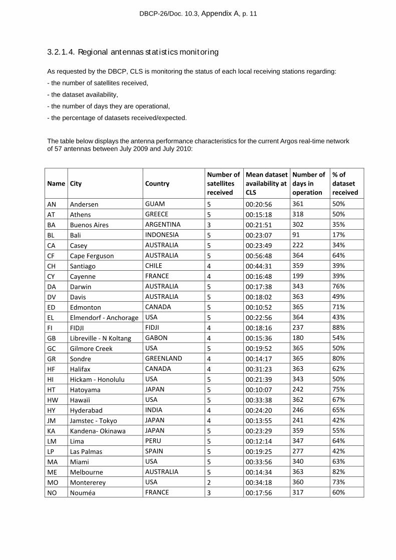
• Muscat (XOL,Oman) belongs to EARS network, activated since 27/07/2010
DBCP-26/Doc. 10.3, Appendix A, p. 10
Figure 9: HRPT coverage of Muscat station
3.2.1.3. Argos real-time network for MetOp satellite
In 2009, Lannion, Svalbard, Athens, Maspalomas were operational with METOP real-time.
In 2010, Moscow, Gander, Edmonton, Wallops, Ile de la Réunion and soon Oman were added in the real-time network for MetOp satellite. See below the currently real-time coverage for MetOp-A.
Figure 10: METOP-A real-time Coverage (2010)
Note that Metop-A AHRPT is Off over Lima and Hatoyama.
DBCP-26/Doc. 10.3, Appendix A, p. 11
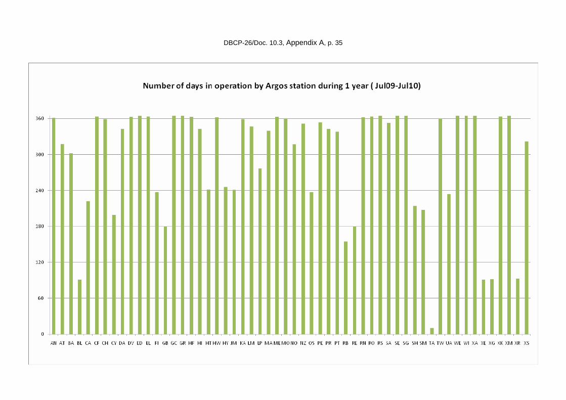
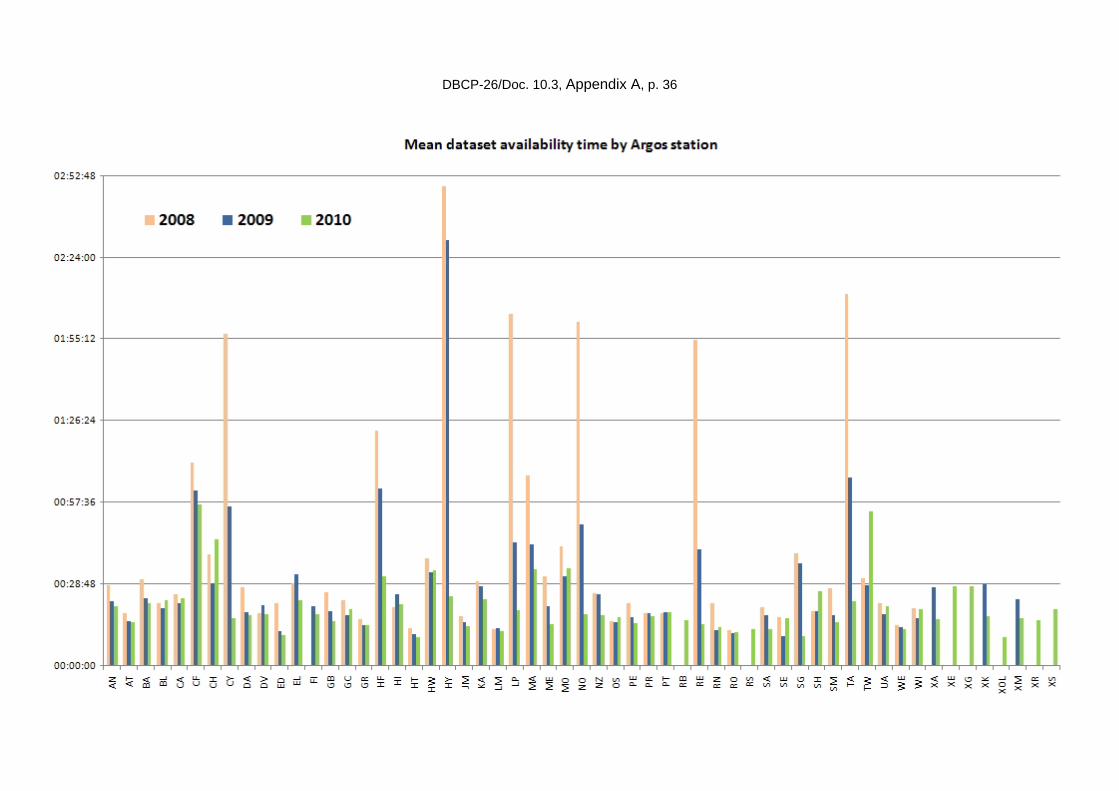
3.2.1.4. Regional antennas statistics monitoring
As requested by the DBCP, CLS is monitoring the status of each local receiving stations regarding:
- the number of satellites received,
- the dataset availability,
- the number of days they are operational,
- the percentage of datasets received/expected.
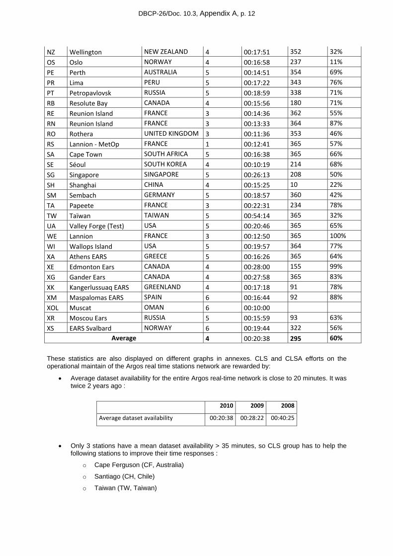
The table below displays the antenna performance characteristics for the current Argos real-time network of 57 antennas between July 2009 and July 2010:
Name City Country Number of satellites received
Mean dataset availability at CLS
Number of days in operation
% of dataset received
AN Andersen GUAM 5 00:20:56 361 50%
AT Athens GREECE 5 00:15:18 318 50%
BA Buenos Aires ARGENTINA 3 00:21:51 302 35%
BL Bali INDONESIA 5 00:23:07 91 17%
CA Casey AUSTRALIA 5 00:23:49 222 34%
CF Cape Ferguson AUSTRALIA 5 00:56:48 364 64%
CH Santiago CHILE 4 00:44:31 359 39%
CY Cayenne FRANCE 4 00:16:48 199 39%
DA Darwin AUSTRALIA 5 00:17:38 343 76%
DV Davis AUSTRALIA 5 00:18:02 363 49%
ED Edmonton CANADA 5 00:10:52 365 71%
EL Elmendorf ‐ Anchorage USA 5 00:22:56 364 43%
FI FIDJI FIDJI 4 00:18:16 237 88%
GB Libreville ‐ N Koltang GABON 4 00:15:36 180 54%
GC Gilmore Creek USA 5 00:19:52 365 50%
GR Sondre GREENLAND 4 00:14:17 365 80%
HF Halifax CANADA 4 00:31:23 363 62%
HI Hickam ‐ Honolulu USA 5 00:21:39 343 50%
HT Hatoyama JAPAN 5 00:10:07 242 75%
HW Hawaïi USA 5 00:33:38 362 67%
HY Hyderabad INDIA 4 00:24:20 246 65%
JM Jamstec ‐ Tokyo JAPAN 4 00:13:55 241 42%
KA Kandena‐ Okinawa JAPAN 5 00:23:29 359 55%
LM Lima PERU 5 00:12:14 347 64%
LP Las Palmas SPAIN 5 00:19:25 277 42%
MA Miami USA 5 00:33:56 340 63%
ME Melbourne AUSTRALIA 5 00:14:34 363 82%
MO Montererey USA 2 00:34:18 360 73%
NO Nouméa FRANCE 3 00:17:56 317 60%
DBCP-26/Doc. 10.3, Appendix A, p. 12
NZ Wellington NEW ZEALAND 4 00:17:51 352 32%
OS Oslo NORWAY 4 00:16:58 237 11%
PE Perth AUSTRALIA 5 00:14:51 354 69%
PR Lima PERU 5 00:17:22 343 76%
PT Petropavlovsk RUSSIA 5 00:18:59 338 71%
RB Resolute Bay CANADA 4 00:15:56 180 71%
RE Reunion Island FRANCE 3 00:14:36 362 55%
RN Reunion Island FRANCE 3 00:13:33 364 87%
RO Rothera UNITED KINGDOM 3 00:11:36 353 46%
RS Lannion ‐ MetOp FRANCE 1 00:12:41 365 57%
SA Cape Town SOUTH AFRICA 5 00:16:38 365 66%
SE Séoul SOUTH KOREA 4 00:10:19 214 68%
SG Singapore SINGAPORE 5 00:26:13 208 50%
SH Shanghai CHINA 4 00:15:25 10 22%
SM Sembach GERMANY 5 00:18:57 360 42%
TA Papeete FRANCE 3 00:22:31 234 78%
TW Taïwan TAIWAN 5 00:54:14 365 32%
UA Valley Forge (Test) USA 5 00:20:46 365 65%
WE Lannion FRANCE 3 00:12:50 365 100%
WI Wallops Island USA 5 00:19:57 364 77%
XA Athens EARS GREECE 5 00:16:26 365 64%
XE Edmonton Ears CANADA 4 00:28:00 155 99%
XG Gander Ears CANADA 4 00:27:58 365 83%
XK Kangerlussuaq EARS GREENLAND 4 00:17:18 91 78%
XM Maspalomas EARS SPAIN 6 00:16:44 92 88%
XOL Muscat OMAN 6 00:10:00
XR Moscou Ears RUSSIA 5 00:15:59 93 63%
XS EARS Svalbard NORWAY 6 00:19:44 322 56% Average 4 00:20:38 295 60%
These statistics are also displayed on different graphs in annexes. CLS and CLSA efforts on the operational maintain of the Argos real time stations network are rewarded by:
• Average dataset availability for the entire Argos real-time network is close to 20 minutes. It was twice 2 years ago :
2010 2009 2008
Average dataset availability 00:20:38 00:28:22 00:40:25
• Only 3 stations have a mean dataset availability > 35 minutes, so CLS group has to help the following stations to improve their time responses :
o Cape Ferguson (CF, Australia)
o Santiago (CH, Chile)
o Taiwan (TW, Taiwan)
DBCP-26/Doc. 10.3, Appendix A, p. 13
3.2.2. System improvements
3.2.2.1. Presentation of Argos real-time stations upgrade project
As presented last year during the DBCP XXVI, a new project was launched in 2009 with CNES with the aim to replace antennas in the existing Argos real-time network with antennas compatible with NOAA, MetOp and SARAL (Satellite with Argos and Altika). Several steps have been defined for this project:
1. System design studies and engineering
Studying the existing network
Identifying applications where data delivery time is a particularly sensitive issue
Identifying geographical areas requiring priority coverage
Defining the optimum network to be set up to meet requirements
Defining the station network upgrade strategy
Identifying stations qualifying for upgrade
Studying these stations (in terms of upgradeability)
Conducting negotiations with the owners of these stations.
2. NOAA/METOP/SARAL/NPOESS receiver development
Using the CNES feasibility study and making any necessary adjustments
Selecting the upgrading contractor
Negotiating the upgrading contract
Monitoring upgrading work
Conducting test, validation and acceptance activities.
3. Upgrading the three CLS stations ("Konsberg")
Implementing the new receiver
Implementing the new station control software
Conducting test, validation and acceptance activities.
4. Upgrading non-CLS stations (about eight)
Eight is an approximate figure and must be confirmed during the first-phase system study.
This activity comprises the following tasks:
• Procuring a receiver
• Upgrading the station control software
• Implementing the new receiver
• Implementing the station control software
• Conducting test, validation and acceptance activities.
DBCP-26/Doc. 10.3, Appendix A, p. 14
5. Procuring and installing new ground stations (around two)
Two is an approximate figure and must be confirmed during the first-phase system study. The new stations, which will join the existing network, will be installed in spots where they are most likely to improve performance for users (geographical coverage, density of beacons in area, real-time advantages, etc.)
Issuing the invitation to tender, selecting the contractor and negotiating station procurement contracts
Preparing installation sites
Installing the stations
Conducting test, validation and acceptance activities
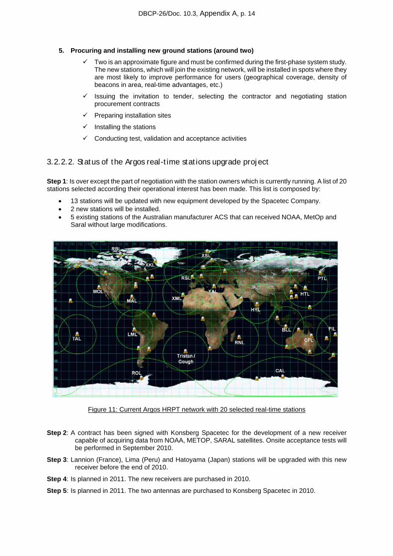
3.2.2.2. Status of the Argos real-time stations upgrade project
Step 1: Is over except the part of negotiation with the station owners which is currently running. A list of 20 stations selected according their operational interest has been made. This list is composed by:
• 13 stations will be updated with new equipment developed by the Spacetec Company. • 2 new stations will be installed. • 5 existing stations of the Australian manufacturer ACS that can received NOAA, MetOp and
Saral without large modifications.
Figure 11: Current Argos HRPT network with 20 selected real-time stations
Step 2: A contract has been signed with Konsberg Spacetec for the development of a new receiver capable of acquiring data from NOAA, METOP, SARAL satellites. Onsite acceptance tests will be performed in September 2010.
Step 3: Lannion (France), Lima (Peru) and Hatoyama (Japan) stations will be upgraded with this new receiver before the end of 2010.
Step 4: Is planned in 2011. The new receivers are purchased in 2010.
Step 5: Is planned in 2011. The two antennas are purchased to Konsberg Spacetec in 2010.
DBCP-26/Doc. 10.3, Appendix A, p. 15
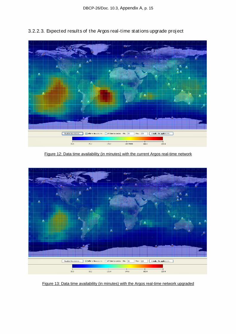
3.2.2.3. Expected results of the Argos real-time stations upgrade project
Figure 12: Data time availability (in minutes) with the current Argos real-time network
Figure 13: Data time availability (in minutes) with the Argos real-time network upgraded
DBCP-26/Doc. 10.3, Appendix A, p. 16
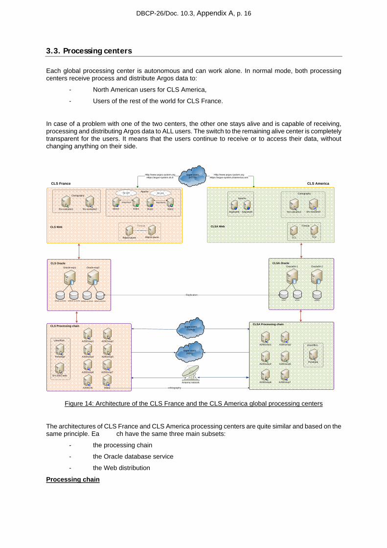
3.3. Processing centers
Each global processing center is autonomous and can work alone. In normal mode, both processing centers receive process and distribute Argos data to:
- North American users for CLS America,
- Users of the rest of the world for CLS France.
In case of a problem with one of the two centers, the other one stays alive and is capable of receiving, processing and distributing Argos data to ALL users. The switch to the remaining alive center is completely transparent for the users. It means that the users continue to receive or to access their data, without changing anything on their side.
Http://www.argos-system.orgHttps://argos-system.clsamerica.com
Http://www.argos-system.orgHttps://argos-system.cls.fr
Argos users(HTTP)
Argos users(ADS)
Argos users(Telnet)
Tomcat CLSA Web
CLS Processing chain
A2001exp1 A2001exp2
CLS Web
Rdp10-jaune
Web3 Web4
Rdp12-jaune
Load balancing
Vip vip6
keepalived
CLS OracleOracle-exp1 Oracle-exp2
ARGA on EVA3 SARGP on EVA4
A2001exp4 A2001exp5
A2001exp6 A2001exp7
ARGP on EVA3SARGA on EVA4
Web1 Web2
Vip vip1
keepalived
Apache
Apache
Argosweb
CLSA Processing chain
A2001exp1 A2001exp2
A2001exp4 A2001exp5
A2001exp6 A2001exp7
CLSA OracleOracle64-1 Oracle64-2
ARGP ARGA SARGP
Cartography
Srv-cwicarto1 Srv-cwicarto2
Cartography
Srv-cwicarto1 Srv-cwicarto2
Replication
A2001nfs orbitography
Useroffice
Srv-2001-web
Penelope
Useroffice
Penelope
Diane
Antenna network
CLS France CLS America
Argosweb
Tomcat
TC1 TC2
Figure 14: Architecture of the CLS France and the CLS America global processing centers
The architectures of CLS France and CLS America processing centers are quite similar and based on the same principle. Ea ch have the same three main subsets:
- the processing chain
- the Oracle database service
- the Web distribution
Processing chain
DBCP-26/Doc. 10.3, Appendix A, p. 17
Composed of different software modules, the processing chain is in charge of receiving and processing the Argos data issued from the satellites and acquired by the global and real-time ground stations networks.
Argos data are processed in terms of collect and location, and stored into a database.
The processing chain is also in charge of distributing the data by ADS (Automatic Distribution System) or allowing users to access to their data using Telnet.
Oracle database service
At the heart of the computing architecture, the Oracle database is used to store the Argos declarative data as well as the processed data.
In order to keep a perfect coherency between CLS France and CLS America centers (mandatory to guarantee the redundancy between both centers), an automatic mechanism of replication is implemented between CLS France and CLS America databases.
Web distribution
Based on a farm of Apache Web servers, the Web distribution allows the users to access their data using a Web cartographic interface. The service of maps is supported by two cartographic servers on which are running the mapping engines C-Map for the marine cartography and MapInfo for the terrestrial one. The application server is supported by Tomcat.
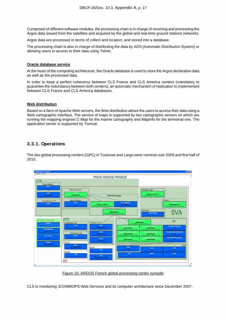
3.3.1. Operations
The two global processing centers (GPC) in Toulouse and Largo were nominal over 2009 and first half of 2010.
Figure 15: ARGOS French global processing center synoptic
CLS is monitoring JCOMMOPS Web Services and its computer architecture since December 2007.
DBCP-26/Doc. 10.3, Appendix A, p. 18
Redundancy was used at least once a month (Up to 4 times in one month). Redundancy means all Argos users were rerouted to CLS or CLSA during an anomaly on the nominal GPC.
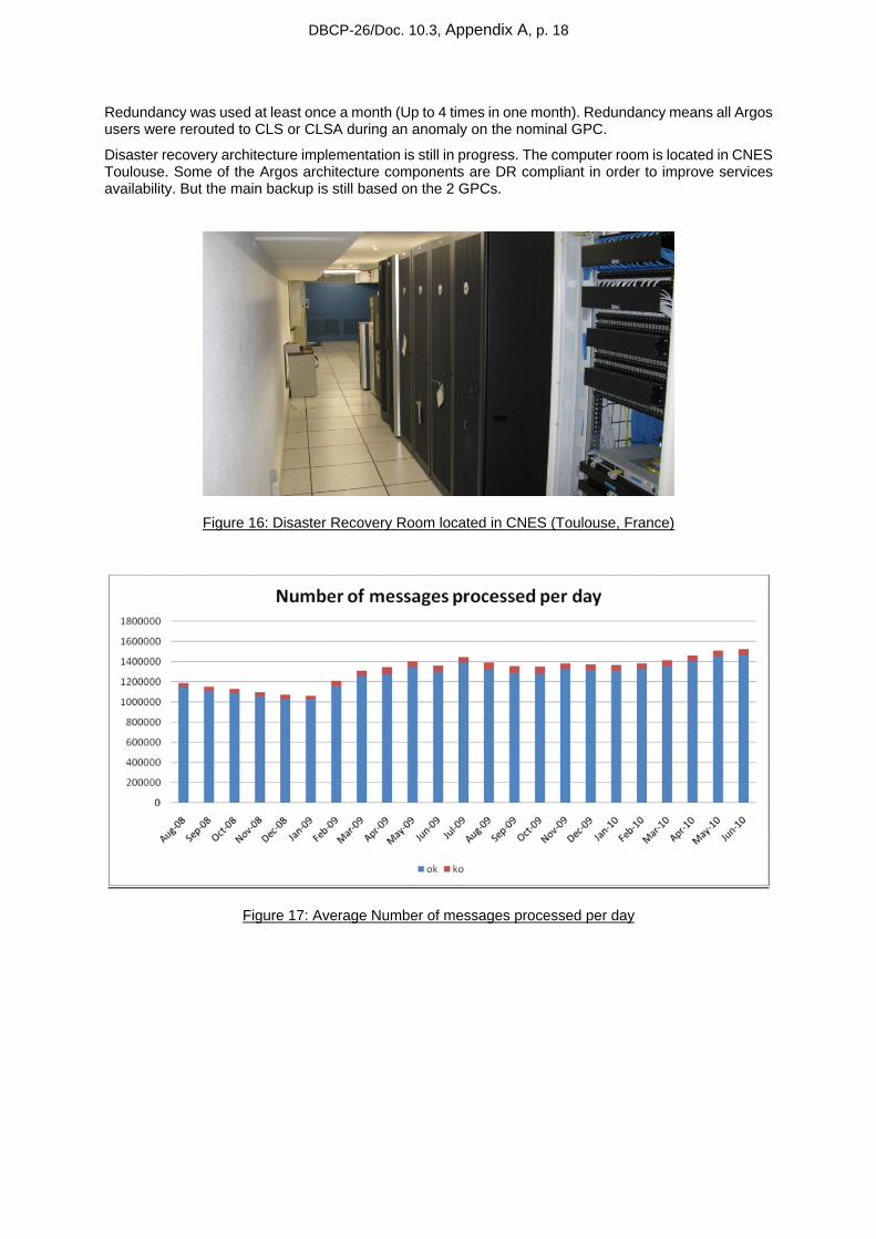
Disaster recovery architecture implementation is still in progress. The computer room is located in CNES Toulouse. Some of the Argos architecture components are DR compliant in order to improve services availability. But the main backup is still based on the 2 GPCs.
Figure 16: Disaster Recovery Room located in CNES (Toulouse, France)
Figure 17: Average Number of messages processed per day

DBCP-26/Doc. 10.3, Appendix A, p. 19
Figure 18: Data Available in 1 hour
Percentage of data available in 1 hour means which percentage of raw data has been processed before 1 hour or less after it’s recording on board the Argos Instrument (i.e. real-time spacecraft global coverage per spacecraft).
We can see the increase of MA data availability with the implementation of the HRPT Metop compatible network since September-09 (Athens, Lannion, Svalbard, Maspalomas, Moscow, Gander, Edmonton, Wallops …).
NOAA N and M, operational satellites, get a better coverage than NK and NL.
NP and NN are on the same orbit plane and there was HRPT frequency Conflict during co-visibility data reception over Real-time Station (NN going down on the graph).
10th November 2009, HRPT transmitter on NOAA-18 (NN) was changed from STX2 (1702.5 MHz, LHCP) to STX3 (1707 MHz, RHCP) to fix this co visibility issue. (NN going up again on the graph)
3.3.2. System improvements
As every year, several software improvements were implemented in 2009 and for the first half of 2010 in order to satisfy the user requirements. These application improvements are:
• Implementation of the 6-digit platform identification number
By now using 6 digits instead of 5 to encode the identification number of each platform, we can assign all available id numbers. This implementation, which is operational since March 30th 2010, required a very long period of validation.

DBCP-26/Doc. 10.3, Appendix A, p. 20
• Surveillance of the satellites housekeeping telemetry
The module of surveillance of the Argos instruments housekeeping parameters is implemented allowing the CLS operators to check that the instruments are in good working order. This surveillance also allows making statistics about the long term functioning of the Argos instruments.
• Initialization of the Argos-3 PMTs location
When a PMT is waking up after a long period of non activity, it doesn't know its location which is a real problem to compute the satellite pass predictions and to transmit only when it is useful. To fix this difficulty, a specific protocol has been implemented between the PMT and the DMMC (Downlink Messaging Management Center). First, the PMT sends a specific request asking to the DMMC "Where am I?". In fact, this request is a series of low rate messages which are used first to identify the location request and then to compute the location of the PMT. Once the location is computed, the DMMC sends it to the PMT.
• Development of the Argos-3 downlink simulator
Without a simulator of the Argos-3 downlink, the correction or the improvement of a DMMC software functionality is complex and takes a long time because the satellites have to be used to test and to validate! Simulating the downlink, the debugging / tuning of the software is easier and above all shorter in time of validation.
• Consolidation of the Downlink Messaging Management center (DMMC)
2009 has been an intensive validation period for the DMMC in order to make it strong and reliable.
• Access to the JTA reports through the Argos web site
According to the request issued during the last JTA, reports are now available through the Argos web site. Different access rights are granted depending of the user profile. A ROC can access to the report of the country whose he is the representative while a user has only access to the part of the report relative to his platforms.
Figure 19: Account activity menu on ArgosWeb
• Improvement of the Argos web functionalities
DBCP-26/Doc. 10.3, Appendix A, p. 21
Cartographic tools have been added to the Argos web site: Course, Estimated Time of Arrival, trajectories, locations of the observations, KML exported files compatible with Google Earth’s Time Bar.
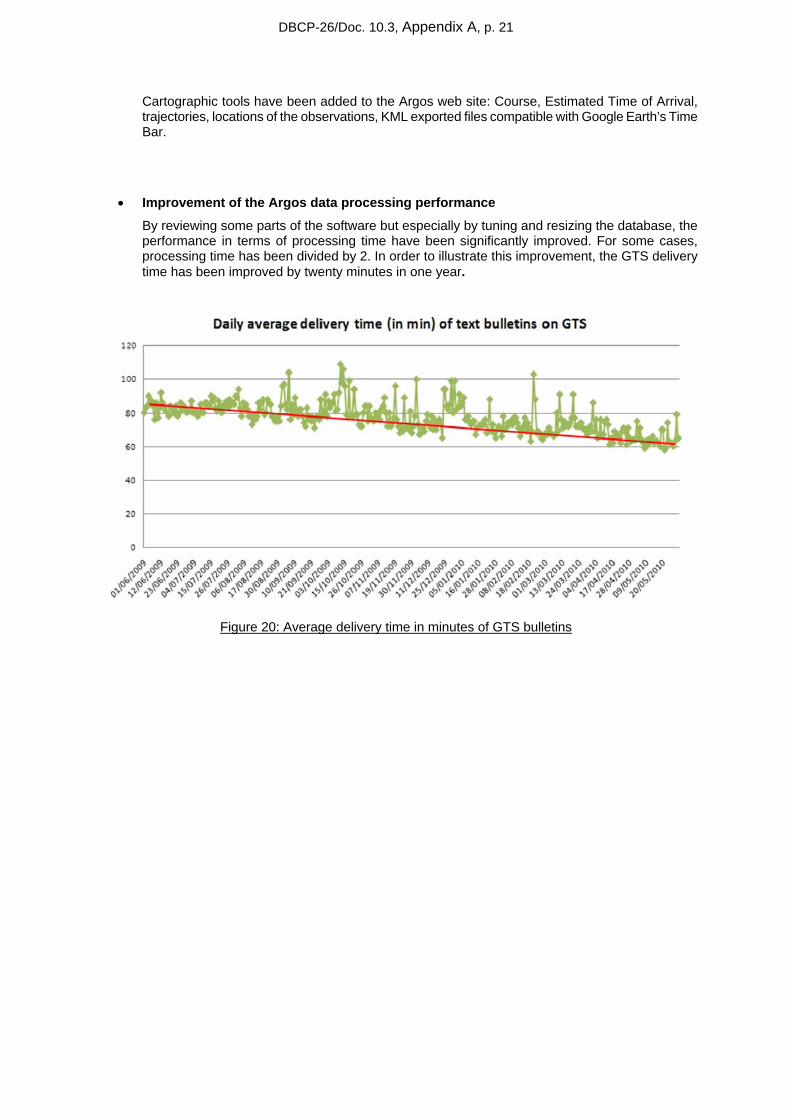
• Improvement of the Argos data processing performance
By reviewing some parts of the software but especially by tuning and resizing the database, the performance in terms of processing time have been significantly improved. For some cases, processing time has been divided by 2. In order to illustrate this improvement, the GTS delivery time has been improved by twenty minutes in one year.
Figure 20: Average delivery time in minutes of GTS bulletins
DBCP-26/Doc. 10.3, Appendix A, p. 22
• Implementation of a new Argos distribution format : XML
The new xml distribution provides a more complete (XML contains all diagnostic data) and flexible format (the XML is self-descriptive) for Argos Data. XML is also easily compatible with most user applications and it offers the possibility to retrieve both raw and processed data in the same file.
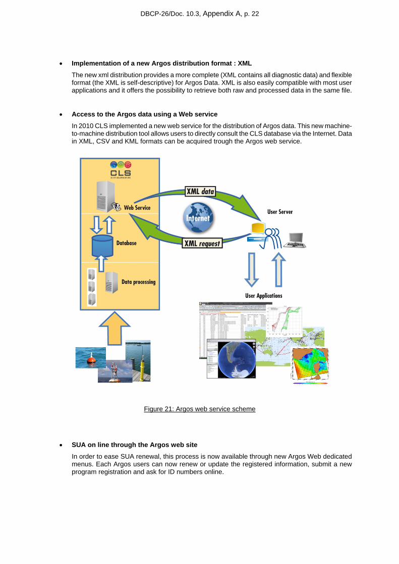
• Access to the Argos data using a Web service
In 2010 CLS implemented a new web service for the distribution of Argos data. This new machine-to-machine distribution tool allows users to directly consult the CLS database via the Internet. Data in XML, CSV and KML formats can be acquired trough the Argos web service.
Figure 21: Argos web service scheme
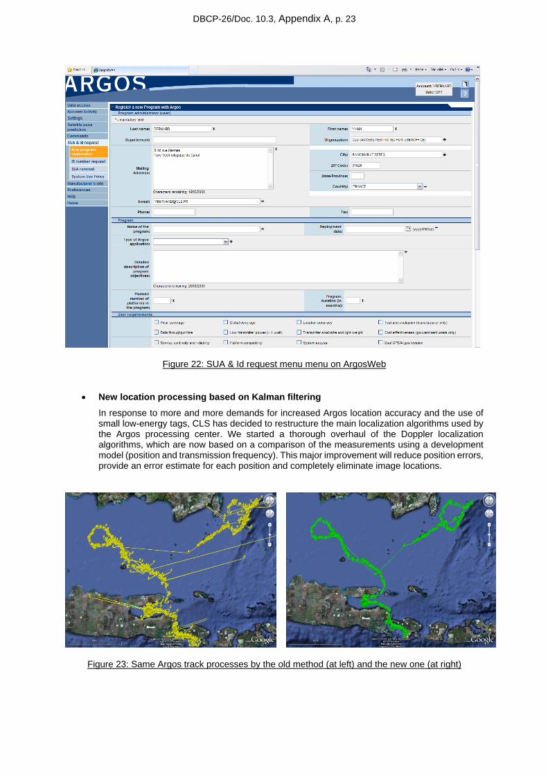
• SUA on line through the Argos web site
In order to ease SUA renewal, this process is now available through new Argos Web dedicated menus. Each Argos users can now renew or update the registered information, submit a new program registration and ask for ID numbers online.
DBCP-26/Doc. 10.3, Appendix A, p. 23
Figure 22: SUA & Id request menu menu on ArgosWeb
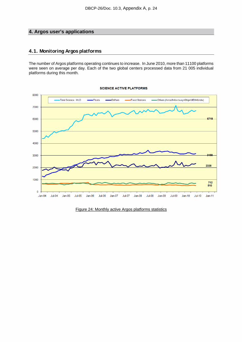
• New location processing based on Kalman filtering
In response to more and more demands for increased Argos location accuracy and the use of small low-energy tags, CLS has decided to restructure the main localization algorithms used by the Argos processing center. We started a thorough overhaul of the Doppler localization algorithms, which are now based on a comparison of the measurements using a development model (position and transmission frequency). This major improvement will reduce position errors, provide an error estimate for each position and completely eliminate image locations.
Figure 23: Same Argos track processes by the old method (at left) and the new one (at right)
DBCP-26/Doc. 10.3, Appendix A, p. 24
4. Argos user’s applications
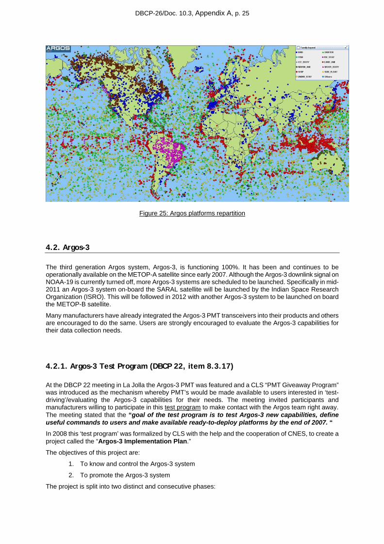
4.1. Monitoring Argos platforms
The number of Argos platforms operating continues to increase. In June 2010, more than 11100 platforms were seen on average per day. Each of the two global centers processed data from 21 005 individual platforms during this month.
Figure 24: Monthly active Argos platforms statistics
DBCP-26/Doc. 10.3, Appendix A, p. 25
Figure 25: Argos platforms repartition
4.2. Argos-3
The third generation Argos system, Argos-3, is functioning 100%. It has been and continues to be operationally available on the METOP-A satellite since early 2007. Although the Argos-3 downlink signal on NOAA-19 is currently turned off, more Argos-3 systems are scheduled to be launched. Specifically in mid-2011 an Argos-3 system on-board the SARAL satellite will be launched by the Indian Space Research Organization (ISRO). This will be followed in 2012 with another Argos-3 system to be launched on board the METOP-B satellite.
Many manufacturers have already integrated the Argos-3 PMT transceivers into their products and others are encouraged to do the same. Users are strongly encouraged to evaluate the Argos-3 capabilities for their data collection needs.
4.2.1. Argos-3 Test Program (DBCP 22, item 8.3.17)
At the DBCP 22 meeting in La Jolla the Argos-3 PMT was featured and a CLS “PMT Giveaway Program” was introduced as the mechanism whereby PMT’s would be made available to users interested in ‘test-driving’/evaluating the Argos-3 capabilities for their needs. The meeting invited participants and manufacturers willing to participate in this test program to make contact with the Argos team right away. The meeting stated that the “goal of the test program is to test Argos-3 new capabilities, define useful commands to users and make available ready-to-deploy platforms by the end of 2007. “
In 2008 this ‘test program’ was formalized by CLS with the help and the cooperation of CNES, to create a project called the “Argos-3 Implementation Plan.”
The objectives of this project are:
1. To know and control the Argos-3 system
2. To promote the Argos-3 system
The project is split into two distinct and consecutive phases:
DBCP-26/Doc. 10.3, Appendix A, p. 26
A first phase, called Evaluation phase, has the following objectives:
- knowing and controlling the system by deploying a network of Argos-3 reference platforms
- pointing out, from a user point of view, the advantages and the disadvantages of the system
- getting all the elements to objectively promote the system
- developing Argos-3 platform prototypes which are representative of the user applications in order to validate optimized usage scenario of transmission and take advantage of the new Argos-3 functionalities
A second phase, called Promotion phase, has the following objectives:
- making aware, encouraging, involving and convincing both users and manufacturers to use the Argos-3 system
- developing operational user platforms (Argo floats, drifting buoys, animal platforms), using the experience gained from the Argos-3 platform prototypes, This includes development contracts with manufacturers.
- making these operational platforms available for the users in order to include them in organized pilot projects
- monitoring these Argos-3 platforms for at least 9 months or more and comparing their performance with similar Argos-2 platforms
- organizing an Argos-3 forum at which the results of the promotion phase will be presented to the Argos user community
The first phase is nearly completed. Prototypes of profiling floats are still under development
The second phase started in 2009. 600 Kenwood PMTs have been sold to Argos platform manufacturers.
Four manufacturers have completed the implementation of the Argos-3 PMT into their drifters: Clearwater, Marlin-Yug, Metocean and Pacific Gyre. These drifting buoys use the interactive data collection mode with Argos-3 and the “pseudo-ack” mode with Argos-2 (message transmitted N times under one satellite pass) since the PMT modem calculates satellite pass predictions. Preliminary studies showed that these improvements can reduce message transmissions by as much as 75% thereby increasing the buoys’ life expectancy.
4.2.2. DBCP Pilot Project for the Evaluation of Argos-3 Technology
The objectives of the Project are to:
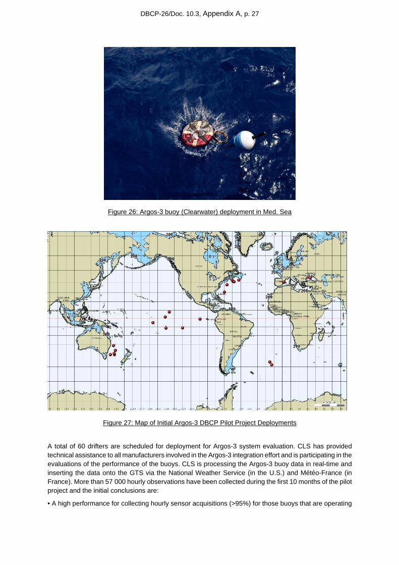
i) Independently and objectively evaluate Argos-3 for use by the global data buoy community. ii) Foster Argos-3 integration by buoy manufacturers. iii) Provide Argos-3 equipped drifting buoys to the community for evaluation. The first Argos-3 buoys
were deployed during the summer of 2009. At this time 24 Argos-3 buoys have been deployed in Pacific, Atlantic oceans, Black and Mediterranean Sea in order to test Argos-3 capabilities all over the world Thanks to Dr. Luca Centurioni (Scripps Institution of Oceanography), the chairman of the Argos-3 Pilot Project steering team, ship opportunities were well coordinated for deployment of the drifters by interested users (see Fig 27).
DBCP-26/Doc. 10.3, Appendix A, p. 27
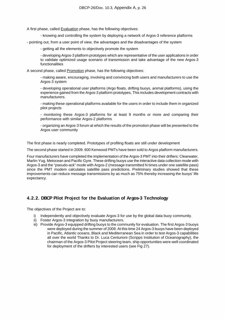
IMEDEA
Figure 26: Argos-3 buoy (Clearwater) deployment in Med. Sea
Figure 27: Map of Initial Argos-3 DBCP Pilot Project Deployments
A total of 60 drifters are scheduled for deployment for Argos-3 system evaluation. CLS has provided technical assistance to all manufacturers involved in the Argos-3 integration effort and is participating in the evaluations of the performance of the buoys. CLS is processing the Argos-3 buoy data in real-time and inserting the data onto the GTS via the National Weather Service (in the U.S.) and Météo-France (in France). More than 57 000 hourly observations have been collected during the first 10 months of the pilot project and the initial conclusions are:
• A high performance for collecting hourly sensor acquisitions (>95%) for those buoys that are operating
DBCP-26/Doc. 10.3, Appendix A, p. 28
• A large reduction (~75%) of the power consumption used for the data transmission, allowing a reduction in the size of the battery pack and/or increasing the drifter lifetime,
• Improved synoptic measurements (on average, more than 22 hourly observation collected per day),
• Optimization of the transmission leading to a better use of the satellite network and then better performance for users,
• Secure uplink transmission with an automatic checksum control,
• Remote commands via the Argos-3 downlink way to change the mission parameters.
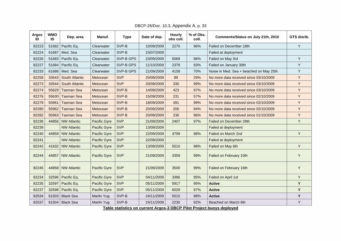
Please find in Annexes chapter a table with detailed statistics for each Argos-3 buoy currently deployed in the pilot project.
A full report of the Argos-3 Pilot Project will be provided by Dr. Centurioni.
4.3. Data Timeliness
Minimizing the elapsed time between when a meteorological/oceanographic observation is collected and when it is inserted onto the Global Telecommunications system (GTS) is a high priority requirement of the DBCP community. By establishing operational regional satellite receiving stations at critical locations the data transmitted to the Argos system, and then immediately retransmitted by the satellite to the ground in real-time, can be received by CLS and disseminated within a very short period of time.
CLS has been managing an evolving network of regional receiving stations for many years responding primarily to the expressed needs of the DBCP community for timeliness of their data. An update of the current efforts and plans is given below.
4.3.1. Indian Ocean Delays (DBCP 24, item 8.4 (iv))
Improving the Argos data timeliness continues to be a high priority for CLS, particularly in the Indian Ocean. The Hyderabad HRPT antenna has been the subject of special attention and with strong cooperation from the operator, INCOIS, the antenna performance has improved dramatically (85%) from 2009 to 2010. The Hyderabad station has been also selected by CLS to be upgraded as part of the Argos real-time stations upgrade project (see 4.3.3 below for more details).
Similarly, the Reunion Island antenna performance is also increased by 67% from 2009 to 2010.
Lastly, on July 27, 2010 CLS began receiving operational datasets from the EUMETSAT EARS antenna located in Muscat, Oman for satellites N-15, N-17, N-18, N-19, and METOP-A.
These three antennas (Hyderabad, Reunion and Muscat) will provide nearly 100% real-time coverage of the critical Indian Ocean region.
4.3.2. Real-Time Monitoring for GTS Data and Timeliness (DBCP 23, item 8.6.2.19)
CLS is monitoring 7/7 24/24 the GTS processing system with real-time operational surveillance on the processing modules, the quality of the data and the system performance (time to process the data, number and size of bulletins)
DBCP-26/Doc. 10.3, Appendix A, p. 29
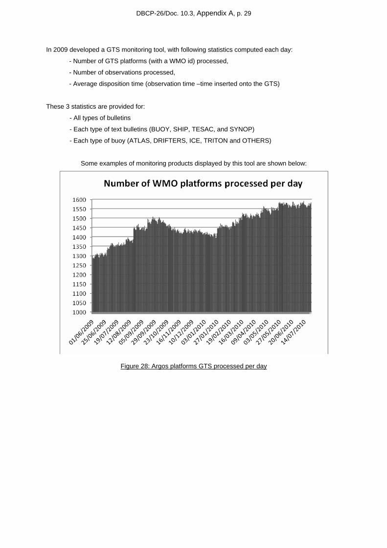
In 2009 developed a GTS monitoring tool, with following statistics computed each day:
- Number of GTS platforms (with a WMO id) processed,
- Number of observations processed,
- Average disposition time (observation time –time inserted onto the GTS)
These 3 statistics are provided for:
- All types of bulletins
- Each type of text bulletins (BUOY, SHIP, TESAC, and SYNOP)
- Each type of buoy (ATLAS, DRIFTERS, ICE, TRITON and OTHERS)
Some examples of monitoring products displayed by this tool are shown below:
Figure 28: Argos platforms GTS processed per day
DBCP-26/Doc. 10.3, Appendix A, p. 30
Figure 29: Argos drifters GTS processed per day
Figure 30: Number of GTS text bulletins produced by CLS per day
DBCP-26/Doc. 10.3, Appendix A, p. 31
Figure 31: Daily average delivery time for all Argos GTS platforms processed by CLS
It’s important to note that in one year the average GTS delivery time has been improved by 20 min. This improvement is due to:
• A sixth Argos operational satellite in August 2009 (NOAA NP)
• Improvements on CLS Argos-GTS processing system
• Optimum management of settings on processing templates
In 2010, CLS has developed improvements on this GTS monitoring tool with same statistics provided now by ocean basin. This tool is in course of validation and first results will be presented at the DBCP XXVI session in Oban, Scotland.
4.3.3. CLS Real-Time Antenna Upgrade Project – Responding to DBCP Requirements
Please refer to Section 3.2.2.1 for the details of this project.
Recall that Step 5 of this project is:
Procuring and installing new ground stations (around two)
Two is an approximate figure and must be confirmed during the first-phase system study. The new stations, which will join the existing network, will be installed in spots where they are most likely to improve performance for users (geographical coverage, density of beacons in area, real-time advantages, etc.)
Issuing the invitation to tender, selecting the contractor and negotiating station procurement contracts
Preparing installation sites
Installing the stations
DBCP-26/Doc. 10.3, Appendix A, p. 32
Conducting test, validation and acceptance activities
In response to the DBCP requests for increased LUT coverage in the Indian Ocean and the South Atlantic CLS has made the decision that one of the new ground stations referenced above will be installed in cooperation with the South African Weather Service (SAWS) on either Gough Island or Tristan de Cunha Island in the South Atlantic. This will substantially improve the Argos real-time geographical coverage in the South Atlantic Ocean and bring to a minimum the time delays currently experienced with buoy observations in this region being inserted onto the GTS.
Recall also, (above in Section 4.3.1) the connection has been made to the EARS antenna in Muscat, Oman. This antenna in combination with the Hyderabad and Reunion antennas, both of which have substantially improved performance in 2010, will provide nearly 100% coverage of the Indian Ocean.
5. Annexes
DBCP-26/Doc. 10.3, Appendix A, p. 33
Argos ID
WMO ID Dep. area Manuf. Type Date of dep. Hourly
obs coll. % of Obs.
coll. Comments/Status on July 21th, 2010 GTS disrib.
82223 51682 Pacific Eq. Clearwater SVP-B 10/09/2009 2270 96% Failed on December 18th Y
82224 61687 Med. Sea Clearwater SVP-B 23/07/2009 Failed at deployment
82226 51683 Pacific Eq. Clearwater SVP-B GPS 23/09/2009 5069 96% Failed on May 3rd Y
82227 51684 Pacific Eq. Clearwater SVP-B GPS 11/10/2009 2378 93% Failed on January 30th Y
82233 61688 Med. Sea Clearwater SVP-B GPS 21/09/2009 4158 70% Noise in Med. Sea + beached on May 25th Y
82258 33543 South Atlantic Metocean SVP 20/09/2009 89 29% No more data received since 03/10/2009 Y
82273 33544 South Atlantic Metocean SVP 20/09/2009 330 99% No more data received since 03/10/2009 Y
82274 55629 Tasman Sea Metocean SVP-B 14/09/2009 423 97% No more data received since 03/10/2009 Y
82276 55630 Tasman Sea Metocean SVP-B 15/09/2009 231 57% No more data received since 02/10/2009 Y
82279 55961 Tasman Sea Metocean SVP-B 18/09/2009 391 99% No more data received since 02/10/2009 Y
82280 55962 Tasman Sea Metocean SVP-B 20/09/2009 206 94% No more data received since 02/10/2009 Y
82282 55963 Tasman Sea Metocean SVP-B 20/09/2009 236 96% No more data received since 01/10/2009 Y
82236 44856 NW Atlantic Pacific Gyre SVP 21/09/2009 2407 97% Failed on December 28th Y
82239 NW Atlantic Pacific Gyre SVP 13/09/2009 Failed at deployment
82240 44859 NW Atlantic Pacific Gyre SVP 22/09/2009 3799 98% Failed on March 2nd Y
82241 NW Atlantic Pacific Gyre SVP 22/09/2009 Failed at deployment
82242 41632 NW Atlantic Pacific Gyre SVP 13/09/2009 5510 98% Failed on May 6th Y
82244 44857 NW Atlantic Pacific Gyre SVP 21/09/2009 3359 99% Failed on February 10th Y
82245 44858 NW Atlantic Pacific Gyre SVP 21/09/2009 3500 99% Failed on February 16th Y
82234 32596 Pacific Eq. Pacific Gyre SVP 04/11/2009 3386 95% Failed on April 1st Y
82235 32597 Pacific Eq. Pacific Gyre SVP 05/11/2009 5917 95% Active Y 82237 32598 Pacific Eq. Pacific Gyre SVP 05/11/2009 6029 97% Active Y 82534 61503 Black Sea Marlin Yug SVP-B 24/11/2009 5015 88% Active Y 82537 61504 Black Sea Marlin Yug SVP-B 24/11/2009 2230 92% Beached on March 6th Y
Table statistics on current Argos-3 DBCP Pilot Project buoys deployed

DBCP-26/Doc. 10.3, Appendix A, p. 34
DBCP-26/Doc. 10.3, Appendix A, p. 35
DBCP-26/Doc. 10.3, Appendix A, p. 36