Integration of New Geologic Mapping and Satellite-Derived ...
12
U.S. Department of the Interior U.S. Geological Survey Scientific Investigations Report 2012–5058 Integration of New Geologic Mapping and Satellite-Derived Quartz Mapping Yields Insights into the Structure of the Roberts Mountains Allochthon Applicable to Assessments for Concealed Carlin-Type Gold Deposits
Transcript of Integration of New Geologic Mapping and Satellite-Derived ...

U.S. Department of the InteriorU.S. Geological Survey
Scientific Investigations Report 2012–5058
Integration of New Geologic Mapping and Satellite-Derived Quartz Mapping Yields Insights into the Structure of the Roberts Mountains Allochthon Applicable to Assessments for Concealed Carlin-Type Gold Deposits

Cover. Northern Independence Mountains of northern Nevada. High peaks are composed of Valmy Formation quartzite (photograph by Christopher S. Holm-Denoma).

Integration of New Geologic Mapping and Satellite-Derived Quartz Mapping Yields Insights into the Structure of the Roberts Mountains Allochthon Applicable to Assessments for Concealed Carlin-Type Gold Deposits By Christopher S. Holm-Denoma, Albert H. Hofstra, Barnaby W. Rockwell, and Paula J. Noble
Scientific Investigations Report 2012–5058
U.S. Department of the InteriorU.S. Geological Survey

U.S. Department of the InteriorKEN SALAZAR, Secretary
U.S. Geological SurveyMarcia K. McNutt, Director
U.S. Geological Survey, Reston, Virginia: 2012
For more information on the USGS—the Federal source for science about the Earth, its natural and living resources, natural hazards, and the environment, visit http://www.usgs.gov or call 1-888-ASK-USGS
For an overview of USGS information products, including maps, imagery, and publications, visit http://www.usgs.gov/pubprod
To order this and other USGS information products, visit http://store.usgs.gov
Any use of trade, product, or firm names is for descriptive purposes only and does not imply endorsement by the U.S. Government.
Although this report is in the public domain, permission must be secured from the individual copyright owners to reproduce any copyrighted materials contained within this report.
Suggested citation:Holm-Denoma, C.S., Hofstra, A.H., Rockwell, B.W., and Noble, P.J., 2012, Integration of new geologic mapping and satellite-derived quartz mapping yields insights into the structure of the Roberts Mountains allochthon applicable to assessments for concealed Carlin-type gold deposits: U.S. Geological Survey Scientific Investigations Report 2012–5058, 5 p.

iii
Contents
Abstract ...........................................................................................................................................................1Introduction.....................................................................................................................................................1Geologic Background....................................................................................................................................1Remote Sensing (ASTER) Quartz Mapping ................................................................................................2Exploration for Concealed Gold Deposits ..................................................................................................2Conclusions.....................................................................................................................................................4Acknowledgments .........................................................................................................................................4References Cited............................................................................................................................................5
Figures
1. Panoramic image of northern Independence Mountains overlain with major geologic features ..........................................................................................................................2
2. Map of study area showing ASTER quartz map overlain on a digital geologic map of part of northeastern Nevada .........................................................................3
3. Schematic geologic cross section of the Shoshone Mountains ..........................................4

iv
Multiply By To obtain
Length
meter (m) 3.281 foot (ft) kilometer (km) 0.6214 mile (mi)
Conversion Factors[Measurements in this report are given in metric units except elevation is given in feet for ease when referring to U.S. Geological Survey topographic maps of the study areas. Conversion factors are provided below]

Abstract
Geologic mapping and remote sensing across north-cen-tral Nevada enable recognition of a thick sheet of Middle and Upper Ordovician Valmy Formation quartzite that structur-ally overlies folded and faulted Ordovician through Devonian stratigraphic units of the Roberts Mountains allochthon.
In the northern Independence Mountains and nearby Double Mountain area, the Valmy Formation is in fault contact with Ordovician through Silurian, predominantly clastic, sedimentary rocks of the Roberts Mountains allochthon that were deformed prior to, or during, emplacement of the Valmy thrust sheet. Similar structural relations are recognized discon-tinuously for 200 kilometers along the strike of the Roberts Mountains allochthon in mapping guided by regional remote-sensing-based (ASTER) quartz maps.
Overall thicknesses of deformed Roberts Mountains allochthon units between the base of the Valmy and the top of underlying carbonate rocks that host large Carlin-type gold deposits varies on the order of hundreds of meters but is not known to exceed 700 meters. The base of the Valmy thrust sheet is a complimentary datum in natural resource exploration and mineral resource assessment for concealed Carlin-type gold deposits.
Introduction
The Great Basin physiographic province is the premier gold mining region in the Nation. Most of the gold currently being produced is from Eocene Carlin-type gold deposits hosted in permeable reactive lower Paleozoic miogeoclinal carbonate rocks. These rocks are exposed in erosional win-dows through less permeable coeval eugeoclinal siliciclastic rocks of the Roberts Mountains allochthon (Hofstra and Cline, 2000). The Roberts Mountains allochthon was assembled as a regionally extensive fold and thrust belt during the Early Mis-sissippian Antler and Permian Humboldt orogenies.
Most Carlin-type gold deposits exposed in windows at the surface have been found. Current exploration involves drilling to depths of 1–2 km through adjacent areas of the Roberts Mountains allochthon and through thick Tertiary volcanic successions that cover calcareous host rocks. An improved understanding of the thickness and internal structure of the Roberts Mountains allochthon would benefit natural resource exploration and mineral resource assessment for concealed Carlin-type gold deposits.
Geologic Background
The Roberts Mountains allochthon is composed of complexly deformed, relatively monotonous successions of interbedded shale, chert, and quartzite with minor greenstone and limestone that make it difficult to document stratigraphic and structural relations (for example, see Holm-Denoma and others, 2011; Noble and Finney, 1999). Fortunately, in the Independence Mountains and Double Mountain area of north-ern Nevada, we have identified a coherent marker—the thick-bedded quartzite of the Middle to Upper Ordovician Valmy Formation (Churkin and Kay, 1967) that is in thrust-fault contact with quartz-poor successions in the Roberts Mountains allochthon (fig. 1). Emplacement of the Valmy Formation by thrust faulting is considered to be post-deformation of the underlying quartz-poor successions of the Roberts Mountains allochthon due to the existence of folds that are noncoaxial to each other above and below the fault (Holm-Denoma and oth-ers, 2011). These structural and timing relations suggest that the Roberts Mountains allochthon is a composite stratigraphic terrane assembled along the Cordilleran margin during two late Paleozoic contractional orogenies (Antler and Humboldt orogenies) (Ketner, 1977).
Similar relations have been described in the Tuscarora Mountains (Theodore and others, 2004) and observed in areas identified using remote-sensing-based quartz mapping (see discussion in Remote Sensing (ASTER) Quartz Mapping
Integration of New Geologic Mapping and Satellite-Derived Quartz Mapping Yields Insights into the Structure of the Roberts Mountains Allochthon Applicable to Assessments for Concealed Carlin-Type Gold Deposits
By Christopher S. Holm-Denoma, Albert H. Hofstra, Barnaby W. Rockwell, and Paula J. Noble
2 Integration of New Geologic Mapping and Satellite-Derived Quartz Mapping
section). In total, the Valmy Formation thrust sheet is recog-nized discontinuously for 200 km along strike of the Roberts Mountains allochthon and is an important datum because the overall thicknesses of Roberts Mountains allochthon between it and underlying Carlin-type gold deposits host rocks is typi-cally ≤600 m.
Remote Sensing (ASTER) Quartz Mapping
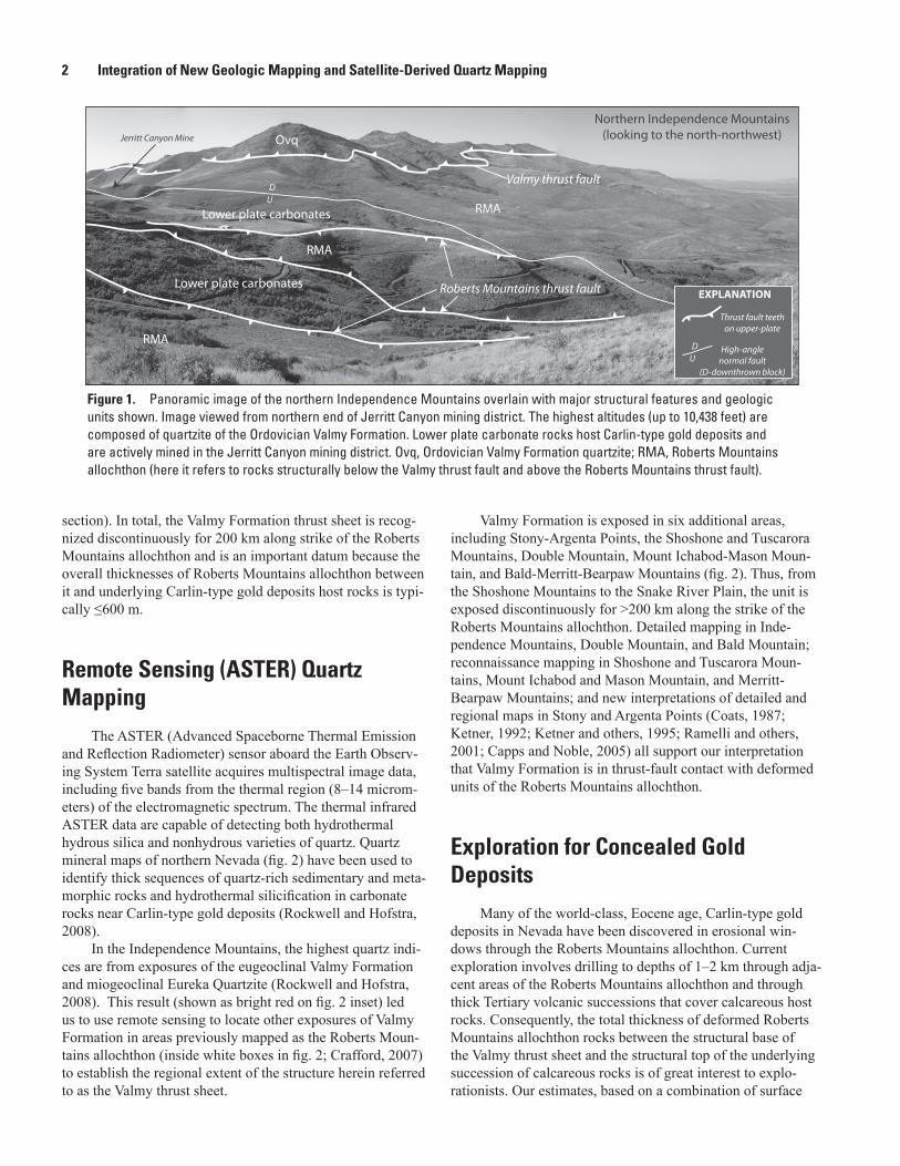
The ASTER (Advanced Spaceborne Thermal Emission and Reflection Radiometer) sensor aboard the Earth Observ-ing System Terra satellite acquires multispectral image data, including five bands from the thermal region (8–14 microm-eters) of the electromagnetic spectrum. The thermal infrared ASTER data are capable of detecting both hydrothermal hydrous silica and nonhydrous varieties of quartz. Quartz mineral maps of northern Nevada (fig. 2) have been used to identify thick sequences of quartz-rich sedimentary and meta-morphic rocks and hydrothermal silicification in carbonate rocks near Carlin-type gold deposits (Rockwell and Hofstra, 2008).
In the Independence Mountains, the highest quartz indi-ces are from exposures of the eugeoclinal Valmy Formation and miogeoclinal Eureka Quartzite (Rockwell and Hofstra, 2008). This result (shown as bright red on fig. 2 inset) led us to use remote sensing to locate other exposures of Valmy Formation in areas previously mapped as the Roberts Moun-tains allochthon (inside white boxes in fig. 2; Crafford, 2007) to establish the regional extent of the structure herein referred to as the Valmy thrust sheet.
Valmy Formation is exposed in six additional areas, including Stony-Argenta Points, the Shoshone and Tuscarora Mountains, Double Mountain, Mount Ichabod-Mason Moun-tain, and Bald-Merritt-Bearpaw Mountains (fig. 2). Thus, from the Shoshone Mountains to the Snake River Plain, the unit is exposed discontinuously for >200 km along the strike of the Roberts Mountains allochthon. Detailed mapping in Inde-pendence Mountains, Double Mountain, and Bald Mountain; reconnaissance mapping in Shoshone and Tuscarora Moun-tains, Mount Ichabod and Mason Mountain, and Merritt-Bearpaw Mountains; and new interpretations of detailed and regional maps in Stony and Argenta Points (Coats, 1987; Ketner, 1992; Ketner and others, 1995; Ramelli and others, 2001; Capps and Noble, 2005) all support our interpretation that Valmy Formation is in thrust-fault contact with deformed units of the Roberts Mountains allochthon.
Exploration for Concealed Gold Deposits
Many of the world-class, Eocene age, Carlin-type gold deposits in Nevada have been discovered in erosional win-dows through the Roberts Mountains allochthon. Current exploration involves drilling to depths of 1–2 km through adja-cent areas of the Roberts Mountains allochthon and through thick Tertiary volcanic successions that cover calcareous host rocks. Consequently, the total thickness of deformed Roberts Mountains allochthon rocks between the structural base of the Valmy thrust sheet and the structural top of the underlying succession of calcareous rocks is of great interest to explo-rationists. Our estimates, based on a combination of surface
Ovq
Northern Independence Mountains(looking to the north-northwest)
RMA
Valmy thrust faultD
U
Jerritt Canyon Mine
RMA
RMA
Lower plate carbonates
Lower plate carbonates Roberts Mountains thrust fault
Thrust fault teethon upper-plate
DU
High-anglenormal fault
(D-downthrown block)
EXPLANATION
Figure 1. Panoramic image of the northern Independence Mountains overlain with major structural features and geologic units shown. Image viewed from northern end of Jerritt Canyon mining district. The highest altitudes (up to 10,438 feet) are composed of quartzite of the Ordovician Valmy Formation. Lower plate carbonate rocks host Carlin-type gold deposits and are actively mined in the Jerritt Canyon mining district. Ovq, Ordovician Valmy Formation quartzite; RMA, Roberts Mountains allochthon (here it refers to rocks structurally below the Valmy thrust fault and above the Roberts Mountains thrust fault).

Exploration for Concealed Gold Deposits 3
Figure 2. Map of study area showing ASTER (Advanced Spaceborne Thermal Emission and Reflection Radiometer) quartz map overlain on a digital Nevada State geological map from Crafford (2007) and a shaded-relief digital-elevation model. Detected quartz is shown in red. White outlined areas are identified as containing Valmy Formation quartzite detected by ASTER mapping. Thickness, in meters (m), of Roberts Mountains allochthon below Valmy Formation is shown for Double Mountain, Independence Mountains, and Shoshone Mountains areas. Other geological and anthropogenic phenomena that have high quartz indices include alluvium, other quartzite units, disturbed areas, and to a lesser degree, cherts and other silica-rich units. Inset—Detailed geologic map of the Independence Mountains area; white lines are known rock-unit contacts and dark-gray lines are exposed faults.
((((
((((
((((
((((
((((
((((
((((
((((
((((
(( (( ((((
!
!
!
!
!
!
!
!! !
!!
!
!
!
!!
!
!
!
!
!
!
!
!
!!
!
!
!
!
!
!
!
!
!
!
!!
!
!
!
!
!
!!
!
!
!
!
!
!
!
!
!
!
!
!
!
!!
!
!
!
!!
!
!
!
!
!
! !
!
!
!
!
!
!
!
!
!
!
!!
!
!!
!
!
!
!
!!
!
!
!!
!!
!
!
!
!
!
!
!
!
!
!
!
!
!
!!
!
!
!
!!!
!!
!
!
!
!
!
!!
!
!
!
!
!
115°30'116°00'116°30'117°00'42°00'
41°30'
41°00'
40°30'
EXPLANATIONDisplayed primary lithologies (and
secondary) from Crafford (2007)
Chert (shale, quartzite)
OtherPlaya
( Roberts Mountains thrust fault (teeth on upperplate)ASTER-derived quartz mineral idex
Carlin-type gold deposit
Felsic-intermediatevolcanic rocksMafic volcanic rocks
Carbonate rocks
Sandstone or conglomerate
Felsic-intermediateplutonic rocks
Shale (limestone, quartzite/chert conglomerate)
Quartzite
!
ShoshoneMountains
TuscaroraMountains
IndependenceMountains
DoubleMountain
Mount Ichabod/Mason Mountain
Bald-Merritt-Bearpaw
Mountains
Stony-ArgentaPoints areas(
(
((
Studyarea
RobertsMountains
thrust fault
!
!
!
!
!
!
!
!
!
!
!
!
!
!
!
!
!
!
!
!
116°00'116°10'
Devonian radiolarian locality
Valmy Formationquartzite
Disturbed areas:Jerritt Canyon Mine
Eureka Quartzite
Valmy Formation quartzite
INSET: INDEPENDENCE MOUNTAINS STUDY AREA
<60 m
~600 m
~450 m
Figure 2. Map of study area showing ASTER (Advanced Spaceborne Thermal Emission and Reflection Radiometer) quartz map overlain on a digital Nevada State geological map from Crafford (2007) and a shaded-relief digital-elevation model. Detected quartz is shown in red. White outlined areas are identified as containing Valmy Formation quartzite detected by ASTER mapping. Other geological and anthropogenic phenomena that have high quartz indices include alluvium, other quartzite units, disturbed areas, and to a lesser degree, cherts and other silica-rich units. Inset—Detailed geologic map of the Independence Mountains area; white lines are known rock-unit contacts and dark-gray lines are exposed faults.
0
0
2 4 KILOMETERS
2 MILES
41°30'
41°20'
0
50
5 10 15
10
20 25 30 KILOMETERS
15 MILES

4 Integration of New Geologic Mapping and Satellite-Derived Quartz Mapping
mapping and drill data, suggest the Roberts Mountains alloch-thon ranges from 150–600 m thick. Such thicknesses are much less than those suggested by previous workers (for example, Madrid and others, 1992, estimate a minimum thickness of the Roberts Mountains allochthon of 5 km); however, variations on the order of hundreds of meters are likely due to tectonic thinning and thickening. Double Mountain and the Shoshone Mountains are two areas where drilling has penetrated the Valmy Formation, Roberts Mountains allochthon beneath the Valmy thrust fault, and into lower plate, Carlin-type gold-bearing host rocks. In the Double Mountain area, a single drill hole penetrated 150 m of Valmy Formation and 450 m of Roberts Mountains allochthon below the Valmy Formation before reaching the lower plate rocks (Capps and Noble, 2005; R.C. Capps, written commun., 2010). In the Shoshone Moun-tains, west of the Gold Acres and Cortez-Pipeline properties, approximately 70 m of Valmy Formation and 605 m of sub-Valmy Formation Roberts Mountains allochthon were drilled before reaching the lower plate ore-hosting carbonates (fig. 3) (O’Donnell, 2006). In the Jerritt Canyon mining district of the northern Independence Mountains, drill holes that penetrate bedrock nearest to the structural level of the Valmy thrust sheet went through as much as 600 m of Roberts Mountains allochthon rocks beneath the Valmy thrust fault prior to reach-ing lower plate ore-hosting carbonates. Therefore, recognition of windows through the Valmy thrust sheet and klippe of the Valmy thrust sheet is needed in the large areas previously mapped as Ordovician through Devonian upper plate rocks to identify permissive tracts where concealed Carlin-type gold deposits may be reached by drilling. Further, the Valmy For-mation was relatively resistant to weathering and erosion and persisted as topographically high features through the Tertiary, whereas paleovalleys that formed in other units were filled by alluvium and volcanic material. These resistant exposures may be useful guides for exploration of concealed Carlin-type gold
deposits in frontier areas, including Bald-Merritt-Bearpaw Mountains and Mount Ichabod and Mason Mountain (fig. 1).
Conclusions
ASTER-based quartz maps of northern Nevada helped us locate the Valmy Formation. Detailed geologic mapping of the Valmy Formation and structurally lower units allowed us to recognize structural and stratigraphic discontinuities below the Valmy Formation. Thus, the Valmy Formation is in fault contact with other deformed Ordovician through Devonian units of the Roberts Mountains allochthon along strike for more than 200 km.
Quartzites of the Valmy Formation and its structural base are an essential datum in future exploration for Carlin-type gold deposits because the thicknesses of Roberts Mountains allochthon units below it generally are less than 700 m; thus, subjacent carbonate host rocks may be within reach of drilling. The prominent exposures of the Valmy thrust sheet in areas otherwise covered by volcanic rocks and alluvium may also identify areas where carbonate rocks are accessible by drilling.
Acknowledgments
This research has been funded by the USGS Mendenhall Research Fellowship Program. Cooperation from a number of mining and exploration companies, most notably Yukon-Nevada Gold Corp., Cordex Exploration Co., and Gateway Gold Corp., provided access to property and data and helped advance this research. Also, we would like to acknowledge R.C. Capps for sharing data and knowledge from the Double Mountain area. The manuscript was improved by reviews by K.I. Lund and F.G. Poole.
Figure 3. Schematic geologic cross section of the Shoshone Mountains (modified from O’Donnell, 2006 and Columbus Gold Corporation Utah Clipper Property schematic cross section [accessed November 19, 2010, at http://www.columbusgoldcorp.com/s/Maps.asp?Reportid=124371]). Historical and modern drilling help constrain thicknesses of units confined between the Valmy and Roberts Mountains thrust faults. Gray pins represent historical drill holes. UUT-3 penetrates the Valmy thrust sheet, the Roberts Mountains allochthon below the Valmy thrust fault, and into the lower plate carbonates. There is approximately 600 meters (2,000 feet) of Roberts Mountains allochthon below the Valmy thrust fault in the southern Shoshone Mountains. Relative locations of historical mines (Elder and Gold Acres) and modern mines (Pipeline) are shown. Half arrows show relative sense of displacement along the Valmy and Roberts Mountains thrust faults. Near-vertical black lines represent high-angle normal faults.
7,000’
5,000’
3,000’ 5,000 FEETROBERTS MOUNTAINS THRUST FAULT
VALMY THRUST FAULT
Roberts Mountains allochthon
Lower plate carbonates
UTAH STOCK
GOLD ACRES STOCK
ELDER MINEPIPELINE
MINE
GOLD ACRESMINE
UUT-3FEET

References Cited 5
References Cited
Capps, R.C., and Noble, P.J., 2005, Geologic setting of gold mineralization at the Double Mountain prospect, northern Adobe Range, Elko County, Nevada, in Rhoden, H.N., Steininger, R.C., and Vikre, P.G., eds., Window to the World—Symposium proceedings: Reno, Nev., Geological Society of Nevada, p. 483–496.
Churkin, Michael, Jr., and Kay, Marshall, 1967, Graptolite-bearing Ordovician siliceous and volcanic rocks, northern Independence Range, Nevada: Geological Society of America Bulletin, v. 74, p. 651–668.
Coats, R.R., 1987, Geology of Elko County, Nevada: Nevada Bureau of Mines and Geology Bulletin 101, 112 p.
Crafford, A.E.J., 2007, Geologic map of Nevada: U.S. Geo-logical Survey Data Series 249, scale 1:250,000, available at http://pubs.usgs.gov/ds/2007/249.
Hofstra, A.H., and Cline, J.S., 2000, Characteristics and models for Carlin-type gold deposits: Reviews in Economic Geology, v. 13, p. 163–220.
Holm-Denoma, C.S., Hofstra, A.H., Noble, P.J., and Leslie, S.A., 2011, Kinematics and stratigraphy of the Roberts Mountains allochthon in the Independence Mountains, northern Nevada, in Steininger, Roger, and Pennell, Bill, eds., Great Basin evolution and metallogeny—Symposium proceedings: Reno, Nev., Geological Society of Nevada, p. 1039–1054.
Ketner, K.B., 1977, Late Paleozoic orogeny and sedimenta-tion, southern California, Nevada, Idaho, and Montana, in Stewart, J.H., Stevens, C.H., and Fritsche, A.E., eds., Paleo-zoic paleogeography of the Western United States—Pacific Coast paleogeography symposium 1: The Pacific Section, SEPM, p. 363–369.
Ketner, K.B., 1992, Preliminary geologic map of the Mount Ichabod area, Elko County, Nevada: U.S. Geological Sur-vey Professional Paper 92–580, scale 1:24,000.
Ketner, K.B., Repetski, J.E., Wardlaw, B.R., and Stamm, R.G., 1995, Geologic map of the Rowland-Bearpaw Mountain area, Elko County, Nevada: U.S. Geological Survey Miscel-laneous Investigation Series Map I–2536, scale 1:24,000.
Madrid, R.J., Poole, F.G., and Wrucke, C.T., 1992, Rocks of the Antler orogeny—The Roberts Mountains allochthon, in Burchfiel, B.C., Lipman, P.W., and Zoback, M.L., eds., The Cordilleran orogen: Conterminous U.S.: Boulder, Colo., Geological Society of America, Geology of North America, v. G-3, p. 28–34.
Noble, P.J., and Finney, S.C., 1999, Recognition of fine-scale imbricate thrusts in lower Paleozoic orogenic belts—An example from the Roberts Mountains allochthon, Nevada: Geology, v. 27, p. 543–546.
O’Donnell, Megan, 2006, Report on the Utah Clipper prop-erty, Lander County, Nevada: Vancouver, B.C., Report for the Columbus Gold Corporation, accessed November 19, 2010, at http://www.columbusgoldcorp.co/i/pdf/techrep-2006-01-24-UtahClipper.pdf.
Ramelli, A.R., House, P.K., Wrucke, C.T., and John, D.A., 2001, Geologic map of the Stony Point quadrangle, Lander County, Nevada: Nevada Bureau of Mines and Geology Map 131, scale 1:24,000.
Rockwell, B.W., and Hofstra, A.H., 2008, Identification of quartz and carbonate minerals across northern Nevada using ASTER thermal infrared emissivity data—Implications for geologic mapping and mineral resource investigations in well-studied and frontier areas: Geosphere, v. 4, no. 1, p. 218–246.
Theodore, T.G., Berger, V.I., Singer, D.A., Harris, A.G., and Stevens, C.H., 2004, Synthrusting deposition of the Penn-sylvanian and Permian Strathearn Formation, northern Carlin trend, Nevada: Sedimentary Geology, v. 165, p. 1–28.
Publishing support provided by: Denver Publishing Service Center
For more information concerning this publication, contact:Center Director, USGS Central Mineral and Environmental Resources
Science CenterBox 25046, Mail Stop 973Denver, CO 80225(303) 236-1562
Or visit the Central Mineral and Environmental Resources Science Center Web site at: http://minerals.cr.usgs.gov/

Holm
-Denom
a and others—Integration of N
ew G
eologic Mapping and Satellite-D
erived Quartz M
apping—Scientific Invesetigations Report 2012–5058