Satellite Derived Bathymetry Performance and Production
9
NEW PATHS. NEW APPROACHES Satellite Derived Bathymetry Performance and Production Véronique Jégat IIC Technologies Shachak Pe’eri, CCOM-JHC UNH Ricardo Freire, CCOM-JHC UNH Anthony Klemm, NOAA John Nyberg, NOAA 2016 Canadian Hydrographic Conference – Conférence Hydrographique du Canada 2016 Halifax, NS May 16-19, 2016 – Halifax, N.É. du 16 au 19 mai 2016
Transcript of Satellite Derived Bathymetry Performance and Production

NEW PATHS. NEW APPROACHES
Satellite Derived
Bathymetry
Performance and
Production
Véronique JégatIIC Technologies
Shachak Pe’eri, CCOM-JHC UNH
Ricardo Freire, CCOM-JHC UNH
Anthony Klemm, NOAA
John Nyberg, NOAA2016 Canadian Hydrographic Conference – Conférence Hydrographique du Canada 2016
Halifax, NS May 16-19, 2016 – Halifax, N.É. du 16 au 19 mai 2016

NEW PATHS. NEW APPROACHES
• Another tool to the
hydrographer
• High value for: Planning
Chart QC
Added chart contents:• Remote shallow areas
• No other recent source data
2
Satellite Derived Bathymetry
Single beam
Multibeam
LIDARSDB

NEW PATHS. NEW APPROACHES
Satellite Derived Bathymetry
3
You are here
Hartlen Pt, NS, Canada
2km
SDB, ERS LIDAR, ERS

NEW PATHS. NEW APPROACHES
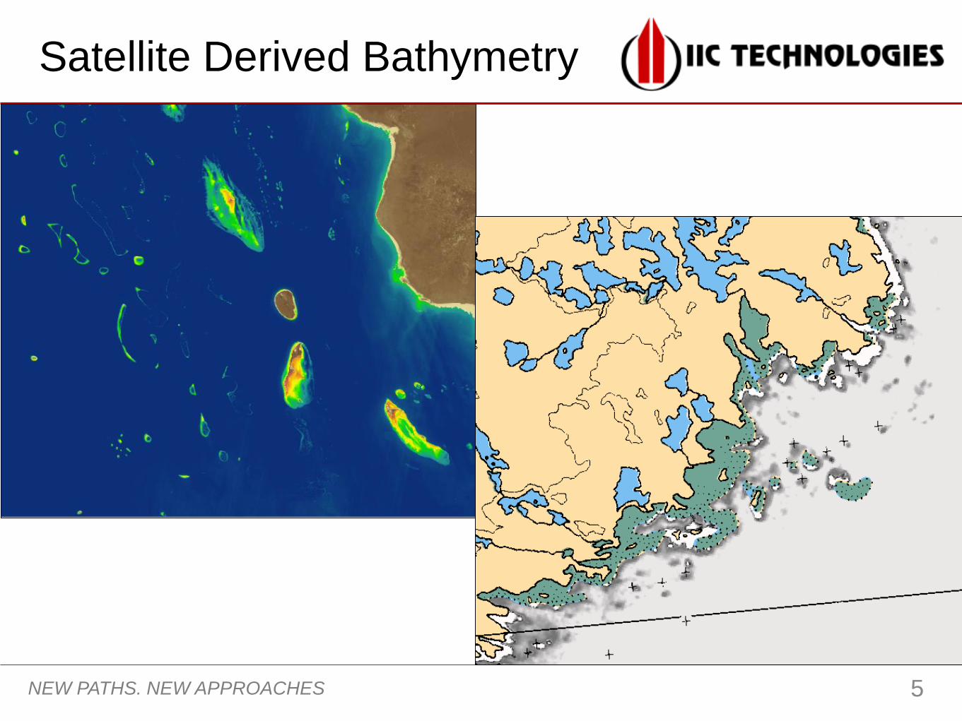
Satellite Derived bathymetry
4
Cloud cover
Real feature
Visible on both images
April 2015Biological growth May 2015
Visible Ice/ water turbidity
February 2015
Halifax
15km
NEW PATHS. NEW APPROACHES
Satellite Derived Bathymetry
5

NEW PATHS. NEW APPROACHES
• You can do it (GEBCO Cook book)
6 simple steps
Standard GIS tools
Publicly - available satellite imagery
(multispectral)
Easy steps for a trained
hydrographer
• Professional Services
Large volume processing faster
Augmented skill resources
Expertise support
Consulting
6
Who can do it ?

NEW PATHS. NEW APPROACHES
SDB Policies
• NOAA implementation Policies – NOAA
Nautical Chart Manual
Procedures in place
Support IHO for
developing nations
activities
Coastal Area
Misleading chart data or
dynamic seabed
No critical under-keel clearance
requirement
No recent survey
(acoustic or ALB)
SDB
7

NEW PATHS. NEW APPROACHES
SDB Products
• Cartographic
Representation Approximate depth curves
CATZOC “C”• Full area search not
achieved, depth anomalies
may be expected
• Low accuracy survey
• Uncertainties (Coming
Soon)
8

NEW PATHS. NEW APPROACHES
• Dynamic area Temporal
changes in
channels
Changing
coastline
9
Thank You
Landsat – Apr 2015 vs. legacy chart 4236
1km