Integrating Marine Information and Products using the Canadian Geospatial Data Infrastructure (CGDI)...
18
Integrating Marine Information Integrating Marine Information and Products using the and Products using the Canadian Geospatial Data Canadian Geospatial Data Infrastructure (CGDI) Infrastructure (CGDI) Patrice Cousineau Patrice Cousineau Fisheries and Oceans Fisheries and Oceans Canada Canada Marine Environmental Data Marine Environmental Data Service Service International Conference on Marine Biodiversity Data International Conference on Marine Biodiversity Data Management Management Hamburg, Germany Hamburg, Germany 29 November – 1 December 2004 29 November – 1 December 2004
-
Upload
prosper-gibbs -
Category
Documents
-
view
215 -
download
0
Transcript of Integrating Marine Information and Products using the Canadian Geospatial Data Infrastructure (CGDI)...
Integrating Marine Information and Integrating Marine Information and Products using the Canadian Geospatial Products using the Canadian Geospatial Data Infrastructure (CGDI)Data Infrastructure (CGDI)
Patrice CousineauPatrice CousineauFisheries and Oceans CanadaFisheries and Oceans Canada
Marine Environmental Data ServiceMarine Environmental Data Service
International Conference on Marine Biodiversity Data ManagementInternational Conference on Marine Biodiversity Data ManagementHamburg, GermanyHamburg, Germany29 November – 1 December 200429 November – 1 December 2004

Presentation OutlinePresentation Outline
National Registry of Aquatic Animal Health National Registry of Aquatic Animal Health (NRAAH)(NRAAH)
DFO GeoPortal / GeoBrowserDFO GeoPortal / GeoBrowser CGDI / GeoConnectionsCGDI / GeoConnections Possible Next StepsPossible Next Steps

NRAAH - OverviewNRAAH - Overview
Objective:Objective: Healthy and productive aquatic resources Healthy and productive aquatic resources
Components:Components: International TradeInternational Trade Certification and Regulatory ControlCertification and Regulatory Control Hazard Identification / Risk AssessmentHazard Identification / Risk Assessment Quality Assurance and ControlQuality Assurance and Control Emergency Response / Contingency PlanningEmergency Response / Contingency Planning Surveillance and ZoningSurveillance and Zoning

NRAAH – Zoning RequirementsNRAAH – Zoning Requirements
Record presence/absence of notifiable pathogensRecord presence/absence of notifiable pathogens Create management zones (infected, pathogen-free Create management zones (infected, pathogen-free
and surveillance) based on biological, physical and surveillance) based on biological, physical and geographical characteristics of each pathogen and geographical characteristics of each pathogen and its susceptible hostsand its susceptible hosts
Protect and maintain pathogen-free zones through Protect and maintain pathogen-free zones through regulatory control and targeted surveillance regulatory control and targeted surveillance programs based on risk assessmentprograms based on risk assessment
Make zones freely available to the general publicMake zones freely available to the general public

NRAAH - System ArchitectureNRAAH - System Architecture Distributed database and Distributed database and
transactionstransactions Filterable data layersFilterable data layers Web map serverWeb map server Graphical features editorGraphical features editor Thick/thin web browsersThick/thin web browsers Discovery serviceDiscovery service Role-based securityRole-based security Auditing and Auditing and
synchronizationsynchronization

NRAAH Web ApplicationNRAAH Web Application
Sample date and geographic locationSample date and geographic location Presence/absence of pathogensPresence/absence of pathogens Number/type of specimens examinedNumber/type of specimens examined Laboratory contact informationLaboratory contact information Case history trackingCase history tracking
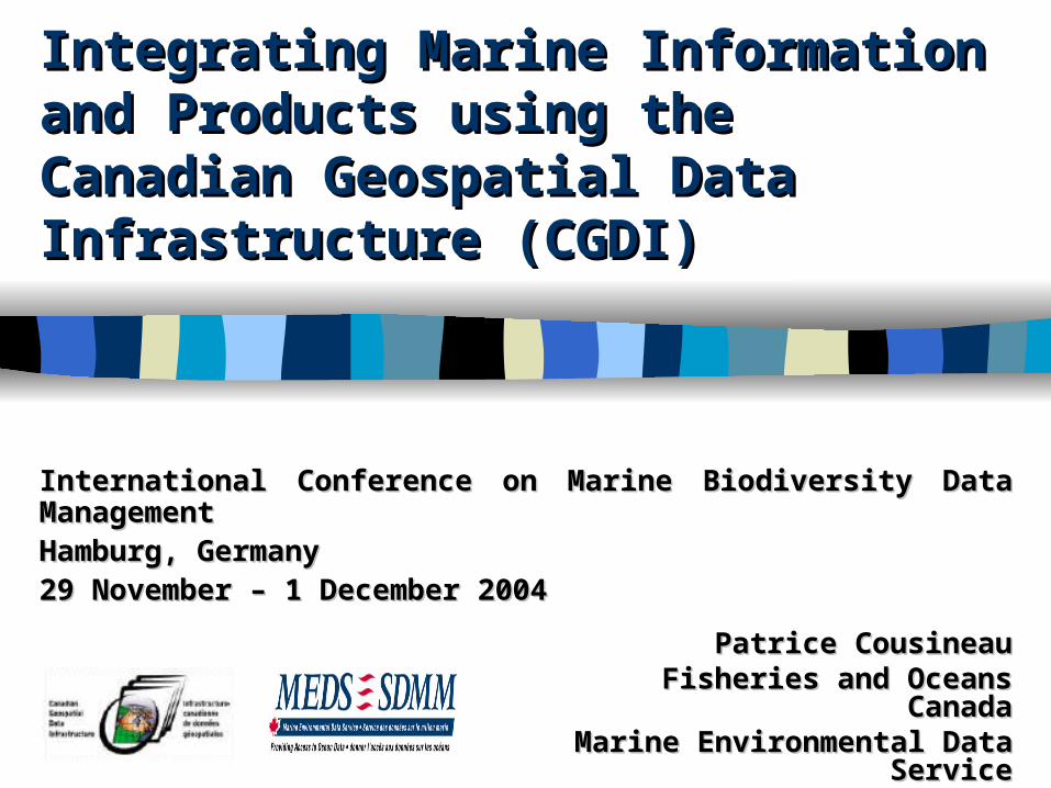
NRAAH Web Application Pt. 2NRAAH Web Application Pt. 2
Powerful database query enginePowerful database query engine IntuitiveIntuitive paged list navigationpaged list navigation Enhanced sorting and filteringEnhanced sorting and filtering

Graphical Feature Editor (GFE)Graphical Feature Editor (GFE)
Selectable map layersSelectable map layers Capability to create, edit or Capability to create, edit or
delete zones for any pathogendelete zones for any pathogen
Snap-to point editingSnap-to point editing Point locations can also be Point locations can also be
entered manuallyentered manually

GeoBrowserGeoBrowser
Pre-defined views for Pre-defined views for each pathogeneach pathogen
Clickable map objects Clickable map objects link to more detailslink to more details
Scale-dependant map Scale-dependant map features in legendfeatures in legend
Separate layer for Separate layer for foundation data, zones foundation data, zones and case resultsand case results

Web Map Service (WMS)Web Map Service (WMS)http://atlas.gc.ca http://nfis.org

Web-Based MappingWeb-Based Mapping Display multiple layers Display multiple layers
of geographic data of geographic data within a single web within a single web applicationapplication
Support for raster, Support for raster, vector, and other datavector, and other data
Query and update Query and update informationinformation
Discover, access and Discover, access and retrieve views from retrieve views from multiple serversmultiple servers

CGDI - ArchitectureCGDI - Architecture
ApplicationsApplications
U.S.NSDI
EuropeanGII
AustralianSDI
OtherSDI
International SDIsInternational SDIs
DataDataData
ProvidersProviders
Services
LIO
MGDI
AltaLIS OtherCanadian
SDIs
LDBC

CGDI - Standards & ProtocolsCGDI - Standards & Protocols
Visualization:Visualization: Web Map Service (WMS)Web Map Service (WMS) Presentation: Presentation: Styled Layer Descriptor (SLD)Styled Layer Descriptor (SLD) Storage: Storage: Web Map Context (WMC)Web Map Context (WMC) Manipulation: Manipulation: Web Feature Service (WFS)Web Feature Service (WFS) Encoding: Encoding: Geography Markup Language (GML)Geography Markup Language (GML) Query: Query: Filter EncodingFilter Encoding Access: Access: GeoData Discovery Service (Catalogue)GeoData Discovery Service (Catalogue) Description: Description: Content Standard for Digital Geospatial Content Standard for Digital Geospatial
Metadata (CSDGM)Metadata (CSDGM)

CGDI - Discovery PortalCGDI - Discovery Portalhttp://geodiscover.cgdi.ca

CGDI - Web Services ApplicationCGDI - Web Services Application
httphttp
httphttp httphttp
httphttp

Possible Next StepsPossible Next Steps
Hosting of a Web Map Server and geospatial Hosting of a Web Map Server and geospatial database at Marine Environmental Data Service.database at Marine Environmental Data Service.
Adding an embedded map visualization Adding an embedded map visualization component into the NRAAH web application.component into the NRAAH web application.
Providing on-the-fly mapping of user query results Providing on-the-fly mapping of user query results into the NRAAH web application.into the NRAAH web application.
Loading of all historical health data and establish Loading of all historical health data and establish management zones for every listed pathogen.management zones for every listed pathogen.
Partnering with NOAA and USDA to integrate US Partnering with NOAA and USDA to integrate US aquatic animal health data in the CGDI.aquatic animal health data in the CGDI.

InformationInformation
Canadian Geospatial Data Infrastructure (CGDI) Don Vachon: [email protected] Pierre Lafond: [email protected]
National Registry of Aquatic Animal Health (NRAAH) Sharon McGladdery: [email protected] Richard Zurbrigg: [email protected]
Marine Environmental Data Service (MEDS) Robert Keeley: [email protected] Patrice Cousineau: [email protected]

Questions? - Fragen?Questions? - Fragen?
Thank you. Have a nice day!Thank you. Have a nice day!--
Danke. Haben Sie einen netten Tag!Danke. Haben Sie einen netten Tag!