Importance of Policies and Legal Instruments for the ... fileBrasil Y INDE 2008 CONCAR/CINDE Canadá...
23
UNITED NATIONS E/CONF.100/IP.16 ECONOMIC AND SOCIAL COUNCIL Eighteenth United Nations Regional Cartographic Conference for Asia and the Pacific Bangkok, 26-29 October 2009 Item 7(b) of the provisional agenda Invited Papers Importance of Policies and Legal Instruments for the Building of Spatial Data Infrastructures in the Americas * * Prepared by Luiz Paulo Fortes, PC-IDEA President
Transcript of Importance of Policies and Legal Instruments for the ... fileBrasil Y INDE 2008 CONCAR/CINDE Canadá...

UNITED NATIONS E/CONF.100/IP.16 ECONOMIC AND SOCIAL COUNCIL Eighteenth United Nations Regional Cartographic Conference for Asia and the Pacific Bangkok, 26-29 October 2009 Item 7(b) of the provisional agenda Invited Papers
Importance of Policies and Legal Instruments for the Building of Spatial Data Infrastructures in the Americas*
* Prepared by Luiz Paulo Fortes, PC-IDEA President

Importance of policies and legal instruments for the building of spatial data infrastructures in the Americas
Naciones Unidas – CP-IDEA
18th United Nations Regional Cartographic Conference for Asia and the Pacific
26-29 October 2009, Bangkok, Thailand
Luiz Paulo Souto Fortes, PhD
President of PC-IDEA

PC-IDEA
ORIGIN
Recommendation that emanated from the Sixth United Nations Regional Cartographic Conference for the Americas - New York, 1997. The creation of PC-IDEA was agreed upon by 21 countries of the Americas in a meeting held in Bogota – Colombia, on the 29th of February of 2000.
OBJECTIVE
To promote the development of national spatial data infrastructures in the Americas.The regional infrastructure initiative must be aligned with the national initiatives.

THE COMMITTEE´S MEMBER COUNTRIES
Argentina Belize Bolivia Brasil
ChileCanada Colombia Costa Rica
Cuba Ecuador El Salvador United States
Guatemala Guyana Honduras Jamaica
Mexico Nicaragua Panama Paraguay
Peru Dominican Republic
Uruguay Venezuela

President(Brazil)
Luiz Paulo Souto Fortes
Executive Secretariat (Brazil)
Valéria Araújo
Vocal South America
(Chile)Cristian Aqueveque
Iglesias
Vocal Caribe(Cuba)Eloy Luís
Alum Ortiz (Cor.)
VocalCentral America(Guatemala)
Ronald Estuardo
Arango Ordoñez
STEERING BOARD 2009 ‐ 2013
Vocal North America (USA)
Ivan DeLoatch
Vice President (Mexico)
Mario A. Reyes Ibarra

SDI Definitions The Geospatial Data Infrastructure for the Americas is the collection of fundamental geospatial data, the standards that enable their integration, the mechanisms that facilitate access to and use of these data, the policies and principles that ensure their compatibility among the PC-IDEA´s member countries.
PC-IDEA
“Collection of integrated technologies, policies, mechanisms and procedures for coordination and monitoring, standards and agreements, necessary to regulate the production, storage, access, sharing, dissemination and use of geospatial data from the federal, state, districtal and municipal levels.”
Presidential Decree 6666/08 (Brasil)
The term “Spatial Data Infrastructure” (SDI) is often used to denote the relevant base collection of technologies, policies and institutional arrangements that facilitate the availability of and access to spatial data. The SDI provides a basis for spatial data discovery, evaluation, and application for users and providers within all levels of government, the commercial sector, the non-profit sector, academia and by citizens in general.
SDI Cookbook – Version 2.0 (GSDI)

CGDI / Canada, ANZLIC / Australia and New Zealand
IEDG / Ecuador, NSDI / USA – revised
1995
1996
2000
2001
2002
2003
2004
SNIG / Portugal
NSDI / USA
ICDE / Colombia
IDEE / Spain
INSPIRE/ Europe, IDERC / Cuba
IDEMEX / Mexico, SNIT/ Chile
2006
INDE / Brasil2008
Timeline for some national and continental SDI´s

• What is the current status of America´s SDI initiatives ?
• Which countries have a Legal Milestone, which ones don´t and how have their SDI developments been affected by that ?
• Is the availability of a Legal Milestone essential for the success of a SDI implementation ?
• What key issues should be addressed by a Legal Milestone that can make the difference on behalf of a successful SDI implementation ?
Questions to address

Questionnaire based SurveyDesigned and applied by PC-IDEA, started on Aug 2008, with the objective of assessing the current status of the Spatial Data Infrastructures (SDI) of the PC-IDEA´s member countries; the goal is to improve the development of the national SDI´s.
Survey structure
Organization
Geospatial Data
Legal Framework
Budgeting
Standardization
Vision and Challenges
Que
stio
nnai
re S
ectio
ns

Questionnaires
1. Argentina2. Belize3. Bolivia4. Brasil5. Canada
6. Chile7. Colombia8. Costa Rica9. Cuba10. Ecuador
Of the 24 PC-IDEA´s member countries, the following 17 have responded to the survey:
11. El Salvador12. Guatemala13. Guyana14. Jamaica15. Mexico
71%29%
Entregados
No Entregados
16. Panama17. Uruguay
Delivered
Not delivered

Which countries have a SDI specific legal milestone?
YES NO
50%
Country Have SDI? (Y/N) SDI Legal
FrameworkInstitution
Management
Argentina NComitê exectivo, Técnico e de Representantes
BelizeN
Departmento de Levantamentos de terras
Bolivia NBrasil Y INDE 2008 CONCAR/CINDE
Canadá Y CGDICCOG - Conselho Canadense de Geomática
Chile Y SNIT 2006 SNIT
Colômbia Y ICDE 2000 IGACCosta Rica N INDG IGN
Cuba Y IDERC (GEOCUBA)
2003CIDERC
Ecuador Y IEDG 2006 CONAGE SENPLADES
El Salvador N IGCN / CNR
Estados Unidos * Y NSDI 1994 e 2004 FGDC
Guatemala Y SNIG 2001 IGN e SEGEPLANGuyana YHonduras * NJamaica Y NSDMD 1992 NSDMDMéxico Y IDEMEX 2006 INEGINicaragua * N INETERPanamá N IGNTGParaguay * NPerú * Y IDEP 2003 e 2007República Dominicana * N
Uruguay S 2008 CAHSIGVenezuela * N
* - neither replied to the PC-IDEA questionnaire, information searched on the internet(Estados Unidos, Honduras, Nicaragua, Paraguay, Perú, República Dominicana e Venezuela)

Which countries have SDI standards
and services?
Country Metadata Standarts
Data Standarts
Quality Control
Agreements Partinerships
Argentina Y Y Y NBelize Y N YBolivia Y Y YBrasil Y Y Y YCanadá Y Y Y YChile Y Y Y YColômbia Y Y Y YCosta Rica N N Y YCuba Y Y Y YEcuador Y Y Y YEl Salvador Y YUSA Y Y Y YGuatemala Y Y Y YGuyana N YHondurasJamaica Y Y YMéxico Y Y Y YNicaraguaPanamá Y Y YParaguayPerúRep DomUruguay Y Y YVenezuela

Which countries have capacity building and communication plans?
Country Trainnig Plan Communication PlanArgentina N NBelize N NBolivia Y NBrasil Y YCanadá Y YChile Y YColômbia Y YCosta Rica Y NCuba Y YEcuador YEl Salvador Y Estados Unidos Y YGuatemala Y NGuyana Y NHondurasJamaica Y NMéxico YNicaraguaPanamáParaguayPerúRepública DominicanaUruguay Y Y Venezuela
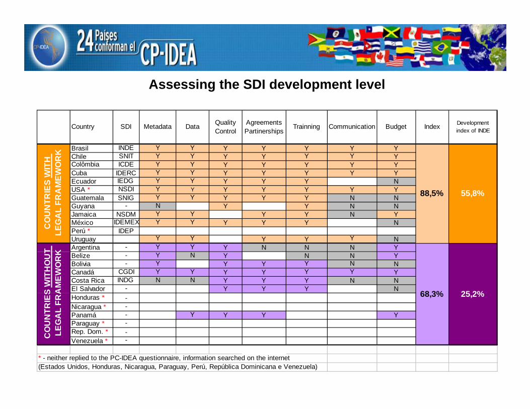
Assessing the SDI development level
Country SDI Metadata Data Quality Control
Agreements Partinerships
Trainning Communication Budget Index Development index of INDE
Brasil INDE Y Y Y Y Y Y YChile SNIT Y Y Y Y Y Y YColômbia ICDE Y Y Y Y Y Y YCuba IDERC Y Y Y Y Y Y YEcuador IEDG Y Y Y Y Y NUSA * NSDI Y Y Y Y Y Y YGuatemala SNIG Y Y Y Y Y N NGuyana - N Y Y N NJamaica NSDM Y Y Y Y N YMéxico IDEMEX Y Y Y Y Y NPerú * IDEPUruguay Y Y Y Y Y NArgentina - Y Y Y N N N YBelize - Y N Y N N YBolivia - Y Y Y Y N NCanadá CGDI Y Y Y Y Y Y YCosta Rica INDG N N Y Y Y N NEl Salvador - Y Y Y NHonduras * -Nicaragua * -Panamá - Y Y Y YParaguay * -Rep. Dom. * -Venezuela * -
* - neither replied to the PC-IDEA questionnaire, information searched on the internet(Estados Unidos, Honduras, Nicaragua, Paraguay, Perú, República Dominicana e Venezuela)
55,8%
25,2%
CO
UN
TRIE
S W
ITH
OU
T LE
GA
L FR
AM
EWO
RK
CO
UN
TRIE
S W
ITH
LE
GA
L FR
AM
EWO
RK
88,5%
68,3%

√ What is the current status of America´s SDI initiatives ?
√ Which countries have a Legal Milestone, which ones don´t and how have their SDI developments been affected by that ?
√ Is the availability of a Legal Milestone essential for the success of a SDI implementation ?
→ What key issues should be addressed by a Legal Milestone that can make the difference on behalf of a successful SDI implementation ?
Questions to address

What key issues should be addressed by a Legal Milestone that can make the difference on behalf of a successful SDI implementation ?
• Definitions
• Roles and responsibilities of the various actors
• Steering and management entities
• Rules and standards
• Sharing of geospatial data and metadata: duty or recommendation?
• Budgeting source(s)
• Deadlines for making data, metadata and services available
• Statement of the need for a SDI implementation plan

INDE´s Definitions(According to Brazil´s Presidential Decree 6666/08)
I - Geospatial data or information (GI)
II - Geospatial metadata
III - National Spatial Data Infrastructure - INDE
IV - Brazilian Directory of Geospatial Data - DBDG
V - Brazilian Portal of Geospatial Data – “SIG Brasil”
VI - Official geospatial data
VII - Data protected by confidentiality legislation

♣ CONCAR ** - homologates standards and specifications for both the INDE and the National Cartographic System; defines the directives for the DBDG´s implementation; ensures that the DBDG will comply with the Interoperability Standards of e-Government adopted by the Brazilian government; promotes the development of software solutions based on open source code, freely distributed; coordinates the implementation of the DBDG according to the ACTION PLAN for the INDE´s implementation
♣ Ministry of Planning, Budgeting and Administration –formalizes the partnerships and agreements for GI sharing
Roles and responsibilities of the various actors (Brazil´s INDE)
♣ Federal actors - GI producers and maintainers: data sharing is mandatory for these
♣ IBGE * - administrates the DBDG; builds, launches, operatee and mantains the SIG Brasil portal; disseminates the procedures for electronic access to the distributed data and metadata warehouses, and for the use of the related services; applies for and manages the INDE´s budget
* IBGE is the Brazilian Institute of Geography and Statistics
** CONCAR is the National Commission of Cartography

Sharing of geospatial data and metadata: duty or recommendation?
The sharing and dissemination of geospatial data and their metadata is mandatory for all of the federal government´s branches and entities, but voluntary for the public institutions and those of the state, municipal and districtal levels.

Budgeting request and management
IBGE has the duty to apply to the Ministry of Planning, Budgeting and Administration, the request for financial resources in support of the INDE´s implementation and maintenance.
CONCAR has been assigned the duty of
...submitting to the Ministry of Planning, Budgeting and Administration, within 180 days from the Decree´s publication, an ACTION PLAN to guide the INDE´s implementation.

Deadlines for making data, metadata and services availableThe INDE´s Action Plan must address the following issues:
• The deadline for the full implementation of the DBDG and the SIG Brasil geoportal
• The deadline for CONCAR to homologate standards and specifications for geospatial metadata
• The deadline for the GI producers and maintainers of the government´s federal sector to make their GI asset´s metadata available to CONCAR, and to store these metadata in their respective servers (for publication through the SIG Brasil geoportal)
• The deadline for the beginning of publication of geospatial metadata, and for the SIG Brasil geoportal to start offering its related services (for data discovery and access)
• The rules for the publication, through the INDE, of metadata concerning new projects or the acquisition of geospatial data
• An estimation of the financial resources required for the INDE´s implementation, based on the assessment of IBGE, including the DBDG and the SIG Brasil needs,the development of standards, dissemination of the INDE´s enterprise, capacity building and the promotion of partnerships with governmental organizations of all levels

Statement of the need for a SDI implementation plan
Key issues such as • roles and functions of the various actors
• implementation deadlines
• cost estimates
• technical recommendations on data and metadata
• rules, standards and protocols to ensure data and services interoperability
• organizational and managerial aspects
• capacity building plan
• communication plan, etc.
can and should be properly addressed through a SDI Implementation Plan
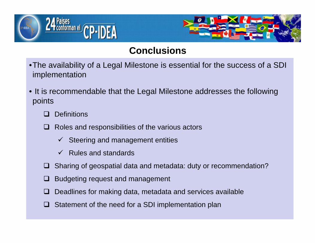
Conclusions•The availability of a Legal Milestone is essential for the success of a SDI implementation
• It is recommendable that the Legal Milestone addresses the following points
Definitions
Roles and responsibilities of the various actors
Steering and management entities
Rules and standards
Sharing of geospatial data and metadata: duty or recommendation?
Budgeting request and management
Deadlines for making data, metadata and services available
Statement of the need for a SDI implementation plan

![· 17/1, S*.vara] Colony Kuk de Layout Shii Ezra] Nathu Moiak CYO Shri D G. Old Sù-avan Snit. Neel]a Vishal Slim-ma 221, Jmpatha Nua Road Snit. Natasha Shukla Balaji Constmcfion](https://static.fdocuments.in/doc/165x107/5eb4c1bc2dbc3a5a2853d966/171-svara-colony-kuk-de-layout-shii-ezra-nathu-moiak-cyo-shri-d-g-old-s-avan.jpg)