Instructions for Completing the Shoreland Application ... · Shoreland Application Worksheet....
22
Instructions for Completing the Shoreland Application Worksheet
-
Upload
duongduong -
Category
Documents
-
view
214 -
download
0
Transcript of Instructions for Completing the Shoreland Application ... · Shoreland Application Worksheet....

Instructions for Completing the Shoreland Application Worksheet

Always ensure you’re
using the most current
version of the permit
application form.

3
Determine the Pre-Construction Impervious Area
of the lot within the Protected Shoreland
Determine the area of the primary structure including all roof overhangs and attached decks. Include all gravel driveways and
walkways.
Include all parking areas, walkways and stairways.
Determine the areas of all accessory structures such as sheds, patios, gazebos, walkways and stairs.

Separate each structure/
impervious area as best
possible.

Total Pre-Construction
Impervious Area within
the Protected Shoreland
Determine the area of
each Structure/
Impervious Area within
the Protected Shoreland

6
Determine the area of the new, larger primary structure. Include roof overhangs and attached decks.
Determine the Post-Construction Impervious
Area of the lot within the Protected Shoreland
Notice the removal of a shed.
Include all gravel driveways and walkways.
Include all parking areas, walkways and stairways.
Determine the areas of all accessory structures such as sheds, patios, gazebos, walkways and stairs.

Total Post-Construction
Impervious Area within
the Protected Shoreland
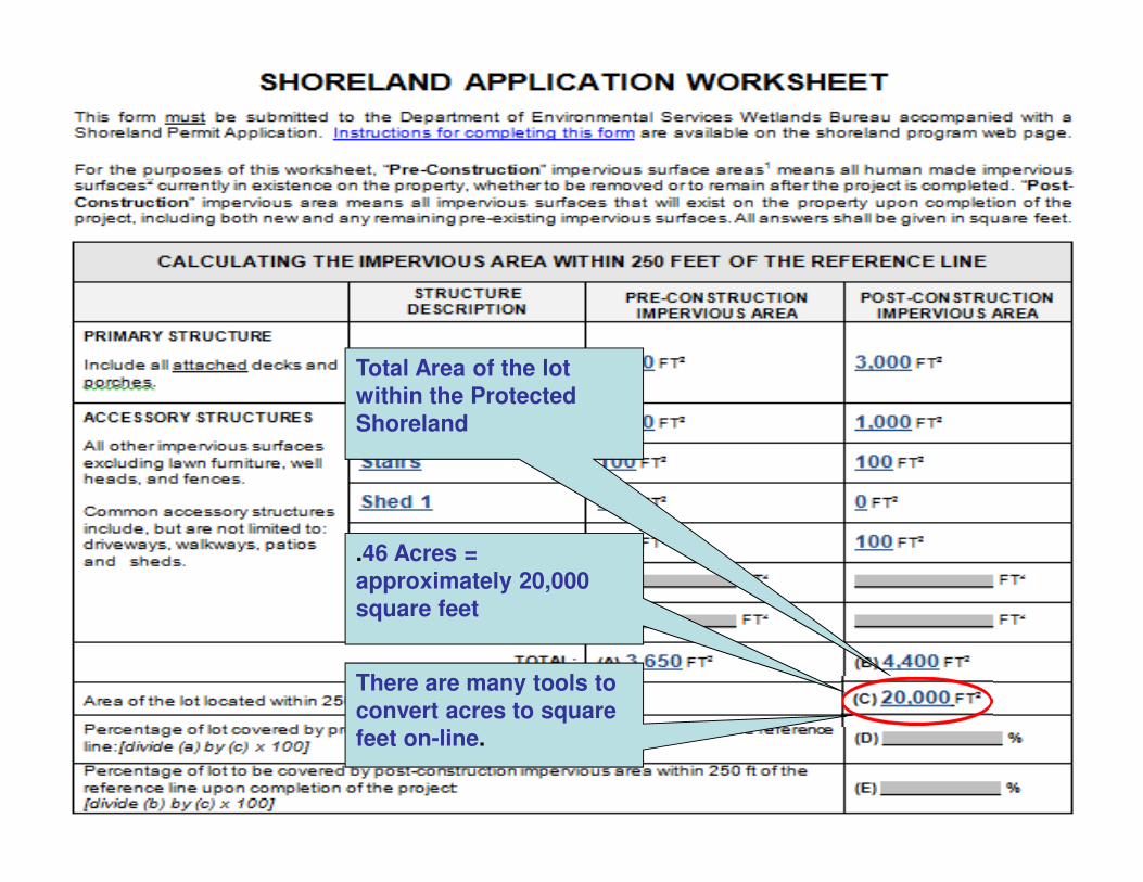
Total Area of the lot
within the Protected
Shoreland
.46 Acres =
approximately 20,000
square feet
There are many tools to
convert acres to square
feet on-line.

Percentage of the lot
within the Protected
Shoreland covered by
Pre-Construction
impervious Area.
Percentage of the lot
within the Protected
Shoreland covered by
Post-Construction
impervious Area.
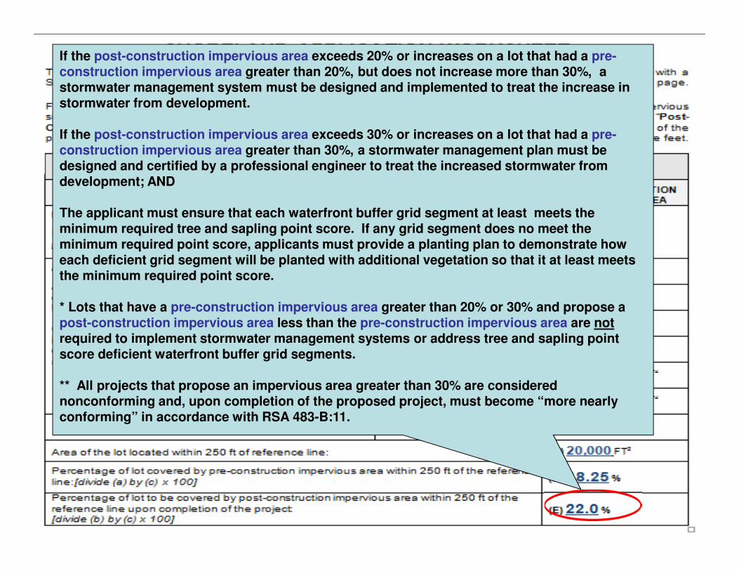
If the post-construction impervious area exceeds 20% or increases on a lot that had a pre-construction impervious area greater than 20%, but does not increase more than 30%, a stormwater management system must be designed and implemented to treat the increase in stormwater from development.
If the post-construction impervious area exceeds 30% or increases on a lot that had a pre-construction impervious area greater than 30%, a stormwater management plan must be designed and certified by a professional engineer to treat the increased stormwater from development; AND
The applicant must ensure that each waterfront buffer grid segment at least meets the minimum required tree and sapling point score. If any grid segment does no meet the minimum required point score, applicants must provide a planting plan to demonstrate how each deficient grid segment will be planted with additional vegetation so that it at least meets the minimum required point score.
* Lots that have a pre-construction impervious area greater than 20% or 30% and propose a post-construction impervious area less than the pre-construction impervious area are not required to implement stormwater management systems or address tree and sapling point score deficient waterfront buffer grid segments.
** All projects that propose an impervious area greater than 30% are considered nonconforming and, upon completion of the proposed project, must become “more nearly conforming” in accordance with RSA 483-B:11.
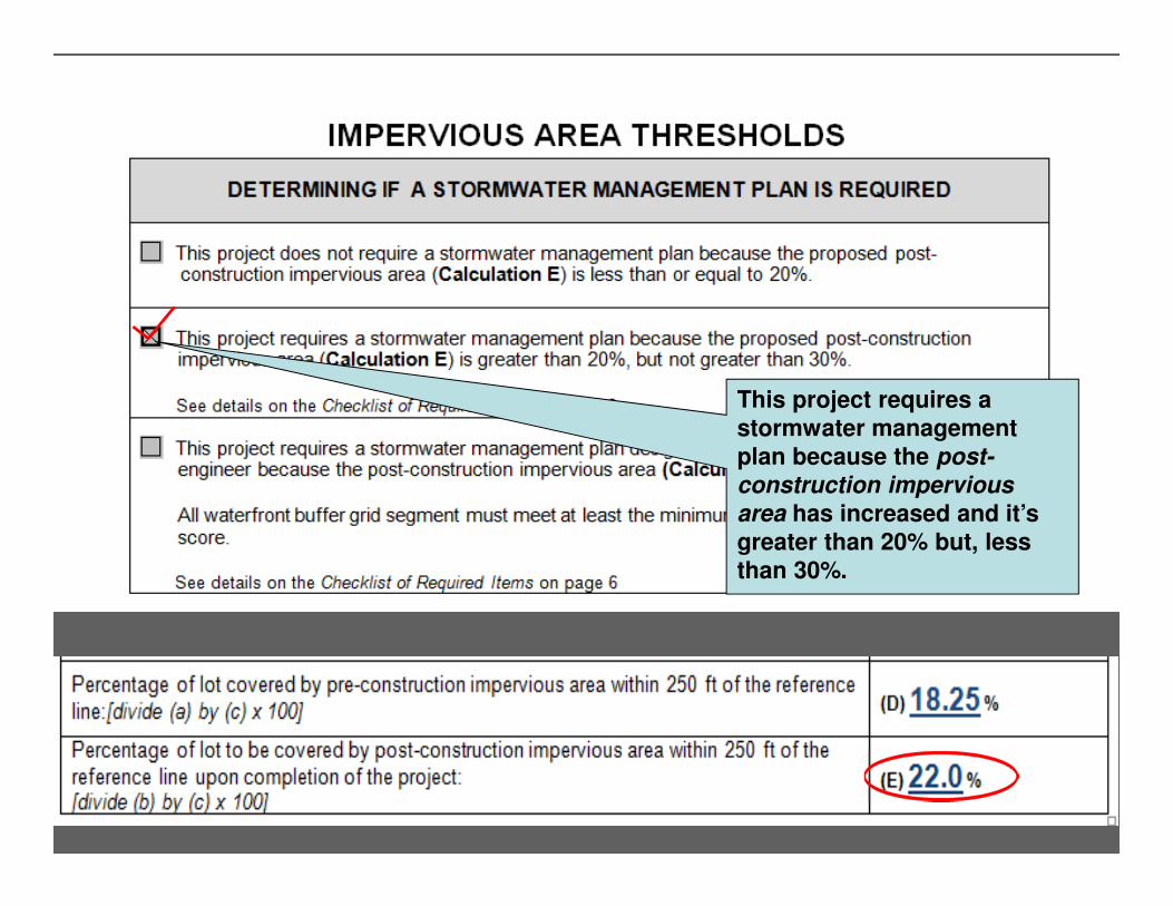
This project requires a
stormwater management
plan because the post-
construction impervious
area has increased and it’s
greater than 20% but, less
than 30%.

Reference line
50 feet
150 feet
250 feet
Calculating the Area to Remain in an “Unaltered
State”.
“Unaltered State” means vegetation, including
ground cover and the leafy duff layer, allowed to
grow without cutting, limbing, trimming, pruning
and mowing or other activities except as needed
for plant health and maintenance.

Reference line
50 feet
150 feet
250 feet
The “Unaltered State” requirement pertains to the vegetation removal limitations between 50 feet and 150 feet from the
reference line.
25% of this area must remain in an
“unaltered state.”
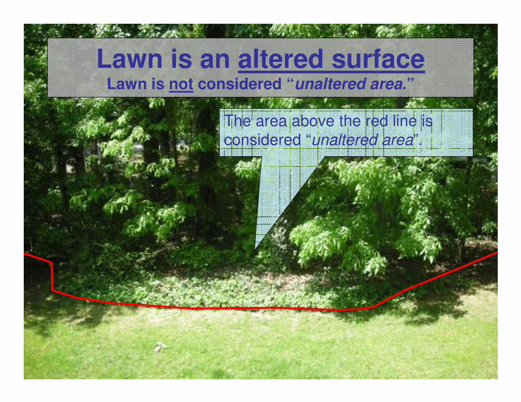
Lawn is an altered surfaceLawn is not considered “unaltered area.”
The area above the red line is
considered “unaltered area”.

Reference line
50 feet
150 feet
250 Feet
Provided 25% of the area between 50
feet and 150 feet remains unaltered, it
is permissible to allow multiple areas
to remain in an unaltered state.
15%
10%

Determining the Values of Sections “F” and ”G”.

Reference line
50 feet
150 feet
250 feet
Determining the Value of Section “F”
In this example, the yellow area is the only region that exists in an
“unaltered state.” The area shaded in yellow = 2,000 Square.
This is the value of “F”
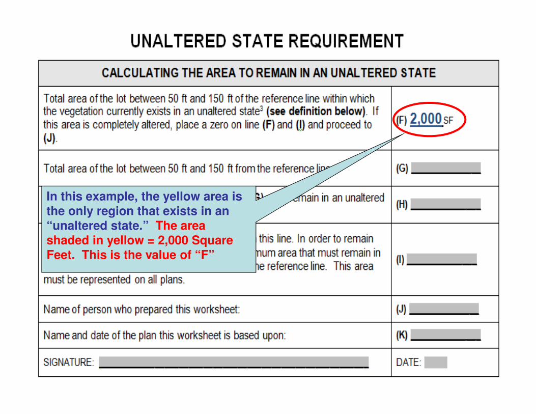
In this example, the yellow area is
the only region that exists in an “unaltered state.” The area
shaded in yellow = 2,000 Square
Feet. This is the value of “F”

Reference line
50 feet
150 feet
250 feet
Determining the Value of Section “G”
In this example, the area shaded light green is the total
area of the lot between 50 feet and 150 feet from the reference
line. The area shaded light
green = the value of “G”

In this example, the area
shaded light green is the total area of the lot between 50 feet
and 150 feet from the reference
line. The area shaded light green = the value of “G”

[.25 x 10,000 SF = 2,500 SF]

[.25 x 0,000 = 2,500]
The smaller of line (F) and line
(H) = 2,000 Square Feet. This is the minimum area between 50
feet and 150 feet from the
reference line that must remain in an unaltered state.