
Shoreland Management Program Assessment
51
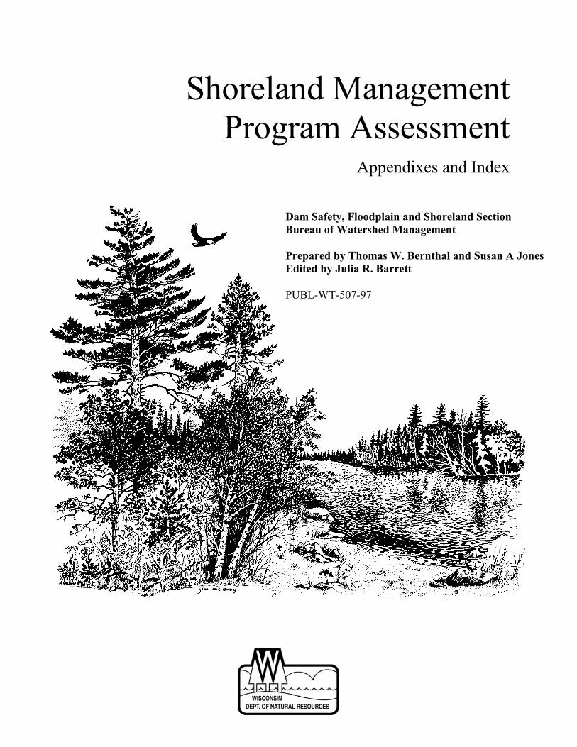
Shoreland Management Program Assessment Appendixes and Index Dam Safety, Floodplain and Shoreland Section Bureau of Watershed Management Prepared by Thomas W. Bernthal and Susan A Jones Edited by Julia R. Barrett PUBL-WT-507-97
Transcript of Shoreland Management Program Assessment
Shoreland ManagementProgram Assessment
Appendixes and Index
Dam Safety, Floodplain and Shoreland SectionBureau of Watershed Management
Prepared by Thomas W. Bernthal and Susan A JonesEdited by Julia R. Barrett
PUBL-WT-507-97

Shoreland Management Program Assessment
Appendixes and Index
A Study by the Wisconsin Department of Natural ResourcesShoreland Management Program
Dam Safety, Floodplain and Shoreland SectionBureau of Watershed Management
Prepared by Thomas W. Bernthal and Susan A. JonesEdited by Julia R. Barrett
PUBL-WT-507-97
First Printing: May 1998
T(cpopw
NTBNHHJS
This project has been funded wholly or in part by the U.S. Environmental Protection Agencyunder assistance agreements CD 985063-01-0 and CD 985235-01-0 to the WisconsinDepartment of Natural Resources. The contents of this document do not necessarily reflect theviews and policies of the Environmental Protection Agency, nor does mention of trade namesor commercial products constitute endorsement or recommendation for use.
his document is a companion to the Shoreland Management Program AssessmentPUBL-WT-506-97), which is a broad assessment of the program’s effectiveness in light ofurrent waterfront development patterns and trends, issues of administrative effectiveness, androgram history. The Shoreland Management Program Assessment concludes wit ha listingf policy issues and options relative to NR 115, the administrative rule for the shorelandrogram, and possible initiatives to meet the challenge of preserving the natural amenities andildlife habitat values along developed shorelands.
atural Resources Board Secretary’s Staffrygve A. Solberg, Chair George E. Meyer, Secretaryetty Jo Nelson, Vice-Chair Darrell Bazzell, Deputy Secretaryeal W. Schneider, Secretary Howard S. Druckenmiller, Executive Assistanterbert F. Behnkeoward S. Poulson
ames E. Tiefenthaler, Jr.tephan D. Willett
APPENDIX ATOOLS FOR TOMORROW: ALTERNATIVE
PLANNING AND ZONING STRATEGY
TABLE OF CONTENTS
Introduction................................................................................................................................. A-1
Maine Phosphorus Allocation Method for Subdivision Review ............................................... A-2
Minnesota’s Classification System and Minimum Shoreland Standards ................................... A-4
Town of Wascott Lakes' Plan ..................................................................................................... A-7
Minnesota’s Cluster Development Standards: Planned Unit Development ............................... A-9
Baltimore County Buffer Ordinance......................................................................................... A-11
City of Boulder, Colorado Wetland Protection Ordinance....................................................... A-13
Conservation Subdivision Design: A Variation on Cluster Development................................ A-15
Other Planning Resources and References ............................................................................... A-17
Stormwater Management ..................................................................................................... A-17
Cooperating Agreements Between Local Agencies............................................................. A-18
Voluntary Conservation: Conservation Easements and Land Acquisition .......................... A-18
Wetland Protection Planning Tools Linked to s. 404 Permit Programs .............................. A-19
Page A-1
APPENDIX ATOOLS FOR TOMORROW: ALTERNATIVE PLANNING
AND ZONING STRATEGIES
Introduction
This section is presented in two parts. The first part contains brief overviews of strategies beingused around the country at the state or local level to address the same issues described in thereport. These overviews are accompanied by comments on the feasibility of using thesestrategies in Wisconsin. It also contains notes about some innovative approaches presented I theplanning literature. The intent is to provide an outline of some potential tools for local and statedecision-makers, rather than to describe these strategies in detail. The reader is advised to referdirectly to the source documents and their authors to get a more complete understanding of howthese strategies are implemented.
The second part contains notes on key planning and zoning references in both the regulatory andvoluntary conservation arenas and some more models with very brief comments describing theirpotential usefulness for Wisconsin.
Page A-2
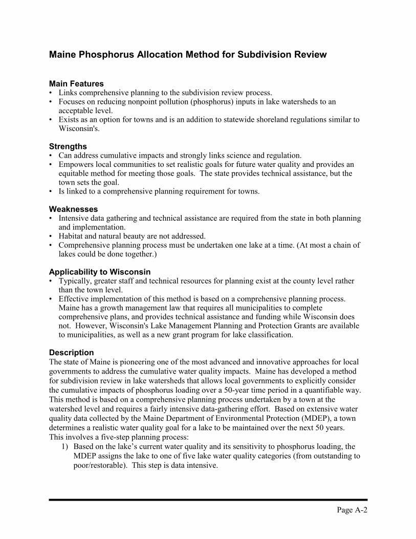
Maine Phosphorus Allocation Method for Subdivision Review
Main Features• Links comprehensive planning to the subdivision review process.• Focuses on reducing nonpoint pollution (phosphorus) inputs in lake watersheds to an
acceptable level.• Exists as an option for towns and is an addition to statewide shoreland regulations similar to
Wisconsin's.
Strengths• Can address cumulative impacts and strongly links science and regulation.• Empowers local communities to set realistic goals for future water quality and provides an
equitable method for meeting those goals. The state provides technical assistance, but thetown sets the goal.
• Is linked to a comprehensive planning requirement for towns.
Weaknesses• Intensive data gathering and technical assistance are required from the state in both planning
and implementation.• Habitat and natural beauty are not addressed.• Comprehensive planning process must be undertaken one lake at a time. (At most a chain of
lakes could be done together.)
Applicability to Wisconsin• Typically, greater staff and technical resources for planning exist at the county level rather
than the town level. • Effective implementation of this method is based on a comprehensive planning process.
Maine has a growth management law that requires all municipalities to completecomprehensive plans, and provides technical assistance and funding while Wisconsin doesnot. However, Wisconsin's Lake Management Planning and Protection Grants are availableto municipalities, as well as a new grant program for lake classification.
DescriptionThe state of Maine is pioneering one of the most advanced and innovative approaches for localgovernments to address the cumulative water quality impacts. Maine has developed a methodfor subdivision review in lake watersheds that allows local governments to explicitly considerthe cumulative impacts of phosphorus loading over a 50-year time period in a quantifiable way.This method is based on a comprehensive planning process undertaken by a town at thewatershed level and requires a fairly intensive data-gathering effort. Based on extensive waterquality data collected by the Maine Department of Environmental Protection (MDEP), a towndetermines a realistic water quality goal for a lake to be maintained over the next 50 years.This involves a five-step planning process:
1) Based on the lake’s current water quality and its sensitivity to phosphorus loading, theMDEP assigns the lake to one of five lake water quality categories (from outstanding topoor/restorable). This step is data intensive.
Page A-3
2) Based on the water quality goal the town desires to maintain and current developmentpressure, the town selects a lake protection level (low, medium, high).
3) Combining the lake water quality and lake protection categories, an acceptable increasein lake phosphorus concentration due to development in the watershed is set. Thisrepresents the cumulative amount of phosphorus increase the town is willing to acceptover the next 50 years.
4) The town must then estimate the future area to be developed based on eliminating alreadydeveloped acreage and unsuitable acreage (wetlands and steep slopes shown on USGSmaps) and projected growth in the watershed.
5) The future area to be developed is divided by the acceptable phosphorus increase to yielda per-acre phosphorus allocation, the maximum allowable amount of phosphorus that canbe exported from each acre of land in future development. This number becomes thebasis for the development review process.
ImplementationThe town may draft a special Lake Protection Ordinance, amend existing ordinances, or createnew shoreland, subdivision, and/or site plan review ordinances to implement the phosphoruscontrol method. The method can be implemented through nonregulatory pathways as well. Forinstance, the locations of public facilities can be chosen to direct development to nonstressedareas.
New subdivision proposals must be designed not to exceed the phosphorus export allocation.The developer is free to choose from a number of phosphorus control methods to meet theallocation: reducing road widths and lengths, reducing the number of lots, limiting vegetationremoval, providing permanent buffer strips (through deed restrictions) in proper locations,constructing wet detention ponds, and constructing infiltration systems. The phosphorus exportfor a subdivision is calculated based on available information on soils, topography andvegetation, and phosphorus export coefficients developed for these conditions, and treatmentfactors assigned to the various design options.
Further Information
Sources:• Phosphorus Control in Lake Watersheds: A Technical Guide to Evaluating New
Development• Comprehensive Planning for Lake Watersheds• Implementation Strategies for Lake Water Quality Protection
Available from:Maine Department of Environmental ProtectionDivision of Environmental Evaluation & Lake StudiesTechnical Assistance UnitState House Station #17Augusta, ME 04333(207) 289-3901
Contact:Jeff Dennis, Maine DEP, (207) 287-7847
Page A-4
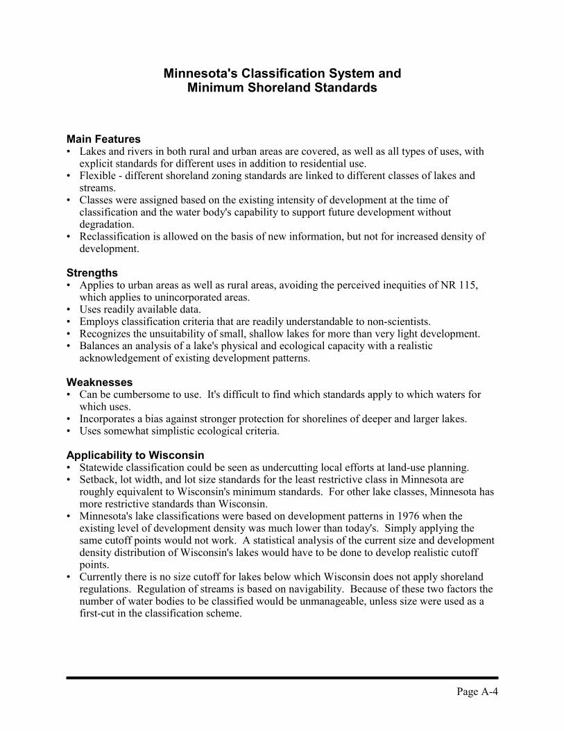
Minnesota's Classification System andMinimum Shoreland Standards
Main Features• Lakes and rivers in both rural and urban areas are covered, as well as all types of uses, with
explicit standards for different uses in addition to residential use. • Flexible - different shoreland zoning standards are linked to different classes of lakes and
streams.• Classes were assigned based on the existing intensity of development at the time of
classification and the water body's capability to support future development withoutdegradation.
• Reclassification is allowed on the basis of new information, but not for increased density ofdevelopment.
Strengths• Applies to urban areas as well as rural areas, avoiding the perceived inequities of NR 115,
which applies to unincorporated areas. • Uses readily available data.• Employs classification criteria that are readily understandable to non-scientists.• Recognizes the unsuitability of small, shallow lakes for more than very light development.• Balances an analysis of a lake's physical and ecological capacity with a realistic
acknowledgement of existing development patterns.
Weaknesses• Can be cumbersome to use. It's difficult to find which standards apply to which waters for
which uses.• Incorporates a bias against stronger protection for shorelines of deeper and larger lakes.• Uses somewhat simplistic ecological criteria.
Applicability to Wisconsin• Statewide classification could be seen as undercutting local efforts at land-use planning.• Setback, lot width, and lot size standards for the least restrictive class in Minnesota are
roughly equivalent to Wisconsin's minimum standards. For other lake classes, Minnesota hasmore restrictive standards than Wisconsin.
• Minnesota's lake classifications were based on development patterns in 1976 when theexisting level of development density was much lower than today's. Simply applying thesame cutoff points would not work. A statistical analysis of the current size and developmentdensity distribution of Wisconsin's lakes would have to be done to develop realistic cutoffpoints.
• Currently there is no size cutoff for lakes below which Wisconsin does not apply shorelandregulations. Regulation of streams is based on navigability. Because of these two factors thenumber of water bodies to be classified would be unmanageable, unless size were used as afirst-cut in the classification scheme.

Page A-5
DescriptionMinnesota has a shoreland regulation program quite similar to Wisconsin's in terms of the typeof regulatory standards involved. Unlike Wisconsin, Minnesota has employed a classificationsystem that provides a more flexible regulatory system recognizing the varied character of itspublic waters. Minnesota uses three shoreland management classes for lakes and five classes forrivers:
Lakes� Natural Environment - Very low existing density (in 1976, when classification was
done), small size (<150 acres) or high crowding potential (<60 acres per mile of shoreline),shallow (<15-feet deep) with winterkill of fish likely, and shoreland consisting of mostlywetland soils and shrub vegetation. The intent was to have strict standards to steerdevelopment away from areas that were currently lightly developed and had high potentialfor experiencing strong negative impacts.
� Recreational Development - Light or moderate existing density, moderate crowdingpotential (60-225 acres per mile of shoreline), not shallow (over 15-feet deep), fishery notdominated by bullhead/panfish, and shoreland consisting of mostly forested upland soils.These lakes were not likely to have limiting soil conditions for on-site sewage systems, anddo not have eutrophic conditions. Therefore, they were thought to be capable of sustaininga moderate level of development.
� General Development - All lakes with high existing density or lakes with moderateexisting density with the same physical and fishery conditions as recreational developmentlakes but low crowding potential (>225 acres per mile of shoreline). The rationale was thatfor lakes with high existing densities, regulations aimed at reducing future developmentdensity are likely to be ineffective. Lakes with a low crowding potential can supportdenser development.
Rivers and River Segments� Remote - Located in roadless, forested, sparsely populated areas. Land use is forestry and
low-intensity recreation.� Forested - Located in forested, sparsely to moderately populated areas with some roads.
Predominant land uses are forestry, recreation, and seasonal residential.� Transition - Middle reaches of rivers in Minnesota and Mississippi river valleys. Land
cover includes a mix of broadly forested, forested riparian strips, cultivated, and pasture.Some seasonal and year-round residential development, widely varying recreational use.
� Agricultural - Located in well-roaded, intensively cultivated areas with some pasture andsmall forested areas. Overall recreational use is low and residential use is not common.
� Urban - Located in or adjacent to major cities. Recreational use is common, but varieswidely.
� Tributary - Watercourses mapped in the Protected Waters Inventory, but not assigned toanother class.
Some of the common standards are presented in the following table.

Page A-6
A Partial List of Minnesota Statewide Minimum Shoreland Standards
Lake Class Lake Shoreland Standards
(Riparian Lots)
Lot Width (ft) Lot Area (ft2) Structure Setback (ft) Shore Impact Zone (ft)
unsewered sewered unsewered sewered unsewered sewered unsewered sewered
NaturalEnvironment
200 125 80,000 40,000 150 150 75 75
Recreational 150 75 40,000 20,000 100 75 50 37.5
GeneralDevelopment
100 75 20,000 15,000 75 50 37.5 25
River ClassRiver Shoreland Standards
(Riparian Lots)
Remote 300 not applicable 200 100
Forested 200 150 75
Transition 250 150 75
Agricultural 150 unsewered sewered unsewered sewered
100 50 50 25
unsewered sewered unsewered sewered unsewered seweredUrban and
tributary 100 75 100 50 50 25
Further Information
Sources:� Shoreland Management Classification System for Public Waters: Supplementary Report No. 1� Statewide Standards for Management of Shoreland Areas – Effective Date: July 3, 1989
Available from:Minnesota Department of Natural ResourcesDivision of Waters – Shoreland Management Program500 Lafayette Road, St. Paul, MN 55155-4033(612) 296-9226
Contact:Ed Fick, Minnesota DNR, (612) 296-0528

Page A-7
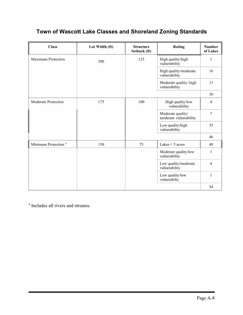
Town of Wascott Lakes' Plan
The development of the plan is described in The Local Resource-Regulation Connection: APractical Approach for Incorporating a Concept of Resource Carrying-Capacity Into LocalLand Use Programs (1981). The project was sponsored by the Northwest District ZoningAdministrators' Association in cooperation with University of Wisconsin-Extension state andlocal land-use specialists with assistance and data from Wisconsin Department of NaturalResources. The plan calls for a sliding scale of lot area and width standards based on "quality andvulnerability" of individual lakes. This is a very good source for outlining the purpose andjustification for lake classification that is tied to different standards for different classes. Theconcept of “carrying capacity” of a water body is used as the basis for the degree ofprotection offered through zoning. Waters with lower carrying capacity (i.e., greatervulnerability) should have more protective zoning standards in the shoreland. Criteria areused that can be quantified with existing information available for the entire range of watersto be classified. This leads to more simplistic criteria but allows all the lakes in a region tobe classified. This kind of classification is a science-based land-use planning tool and not ascientific taxonomy of lake types.
The vulnerability rating is based on lake size, maximum depth, shoreland development factor(irregularity of shoreline), and flushing potential (landlocked or not). The quality rating isbased on fish composition and fishery problems – that , is best professional judgment onwinterkill, carp problems, and excessive fertility. The quality rating also encompasses bestprofessional judgment on algal growth, alkalinity, and pH. The result is a classification system that places all lakes larger than 5 acres in the town into oneof three categories. Lakes smaller than 5 acres and rivers and streams automatically receive aminimum level of protection.
Page A-8
Town of Wascott Lake Classes and Shoreland Zoning Standards
Class Lot Width (ft) StructureSetback (ft)
Rating Numberof Lakes
Maximum Protection 200 125 High quality/highvulnerability
1
High quality/moderatevulnerability
16
Moderate quality/ highvulnerability
13
30
Moderate Protection 175 100 High quality/lowvulnerability
4
Moderate quality/moderate vulnerability
7
Low quality/highvulnerability
35
46
Minimum Protection a 150 75 Lakes < 5 acres 48
Moderate quality/lowvulnerability
1
Low quality/moderatevulnerability
4
Low quality/lowvulnerabilty
1
54
a Includes all rivers and streams.

Page A-9
Minnesota's Cluster Development Standards:Planned Unit Development
Main Features• Requires permanent protection of open-space, greater setbacks, and restoration of shoreline
vegetation as a trade-off for greater building density. Strengths• Promotes a style of development that shows promise as a method to protect natural shore
cover while maintaining profitability for the developer.
Weaknesses• Has not been widely used in Minnesota; the primary use has been for conversions or
remodeling of nonconforming resort properties.
Applicability to Wisconsin• Could provide a template for developing more complete cluster development standards with
an incentive (e.g., greater density) to the developer in return for better shoreland protection.Provides a mechanism for promoting conservation subdivision design by establishingstandards for regulating such subdivisions in shoreland areas.
• Wisconsin's 1985 Shoreland Zoning Model Ordinance provides suggested cluster standards,but these are not codified in NR 115. Major suggested features in Wisconsin’s modelordinance are:- Process is a limited rezoning to set up a Residential Planned Unit Development (RPUD)
Zoning District, not through a variance. - District must be >40 acres.- Land not used for lots and streets must be dedicated in perpetuity as open space.- Total density cannot exceed that which would result from current size, width, and setback
standards. No incentive is provided.- Shore clear-cut area can increase to 100 feet of frontage.
DescriptionMinnesota also has Commercial PUD standards in which the impervious area is less than 25%.The RPUDs include:• Open-Space Requirements
� More than 50% open and pervious space is maintained.� Recreation areas count as open space; areas between buildings count as open space.� Fifty percent of the open space must be in a continuous block of water frontage, which
must be left in an undisturbed condition.� Unsuitable areas (wetlands, bluffs, cemeteries, etc.) must be left as open space.� Open space is protected by permanent legal means (e.g., deed restriction, permanent
easement, public dedication, or restrictive covenant) that limit alteration of topography andvegetation and prohibit commercial use.
• Setbacks� Increases in density require 50% increased setbacks or 25% + mitigation acceptable to
local government.

Page A-10
• Centralization of Facilities- Sewer or central on-site system wastewater treatment system is preferred.- Recreational facilities – such as docks, boat launches, piers, swimming areas - must be
centralized in a suitable (slope, soil, water depth, etc.) area. Boat spaces are limited to oneper riparian dwelling unit.
• Review Process- Local government may approve a project through conditional use permit and/or preliminary
plat approval taking the comments of the Minnesota DNR area hydrologist intoconsideration. After being reviewed by area hydrologist, who sends a draft approval ordenial to Land Use Management Section, the director of Division of Waters makes the finaldecision.
• Conversion to RPUD - used for resorts- Deficiencies corrected where reasonable.- Erosion and vegetative cover problems must be remediated.- No increase in density is allowed.
Allowable Density Increases By Tier
Development Tier Allowable Density IncreaseAbove Normal Standards
Riparian 50% (1.5)
Second tier 100%
Third and beyond (density increases can betransferred from inner tier to outer tier) 200%
Further Information
Source:• Statewide Standards for Management of Shoreland Areas - Effective Date: July 3, 1989;
Section 6120.3800 Planned Unit Development
Available from:Minnesota Department of Natural ResourcesDivision of Waters - Shoreland Management Program500 Lafayette RoadSt. Paul, MN 55155-4033(612) 296-9226
Contact: Ed Fick, Minnesota DNR, (612) 296-0528
Page A-11
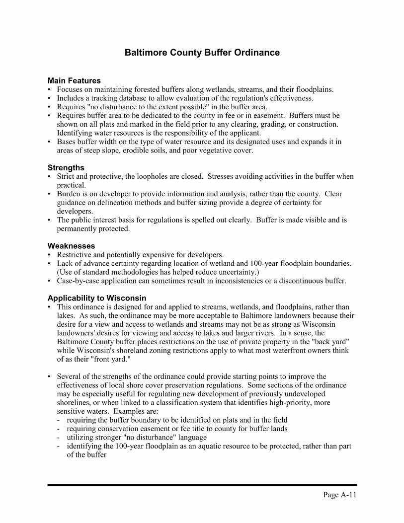
Baltimore County Buffer Ordinance
Main Features• Focuses on maintaining forested buffers along wetlands, streams, and their floodplains.• Includes a tracking database to allow evaluation of the regulation's effectiveness.• Requires "no disturbance to the extent possible" in the buffer area.• Requires buffer area to be dedicated to the county in fee or in easement. Buffers must be
shown on all plats and marked in the field prior to any clearing, grading, or construction.Identifying water resources is the responsibility of the applicant.
• Bases buffer width on the type of water resource and its designated uses and expands it inareas of steep slope, erodible soils, and poor vegetative cover.
Strengths• Strict and protective, the loopholes are closed. Stresses avoiding activities in the buffer when
practical.• Burden is on developer to provide information and analysis, rather than the county. Clear
guidance on delineation methods and buffer sizing provide a degree of certainty fordevelopers.
• The public interest basis for regulations is spelled out clearly. Buffer is made visible and ispermanently protected.
Weaknesses• Restrictive and potentially expensive for developers.• Lack of advance certainty regarding location of wetland and 100-year floodplain boundaries.
(Use of standard methodologies has helped reduce uncertainty.)• Case-by-case application can sometimes result in inconsistencies or a discontinuous buffer.
Applicability to Wisconsin• This ordinance is designed for and applied to streams, wetlands, and floodplains, rather than
lakes. As such, the ordinance may be more acceptable to Baltimore landowners because theirdesire for a view and access to wetlands and streams may not be as strong as Wisconsinlandowners' desires for viewing and access to lakes and larger rivers. In a sense, theBaltimore County buffer places restrictions on the use of private property in the "back yard"while Wisconsin's shoreland zoning restrictions apply to what most waterfront owners thinkof as their "front yard."
• Several of the strengths of the ordinance could provide starting points to improve theeffectiveness of local shore cover preservation regulations. Some sections of the ordinancemay be especially useful for regulating new development of previously undevelopedshorelines, or when linked to a classification system that identifies high-priority, moresensitive waters. Examples are:- requiring the buffer boundary to be identified on plats and in the field- requiring conservation easement or fee title to county for buffer lands- utilizing stronger "no disturbance" language- identifying the 100-year floodplain as an aquatic resource to be protected, rather than part
of the buffer
Page A-12
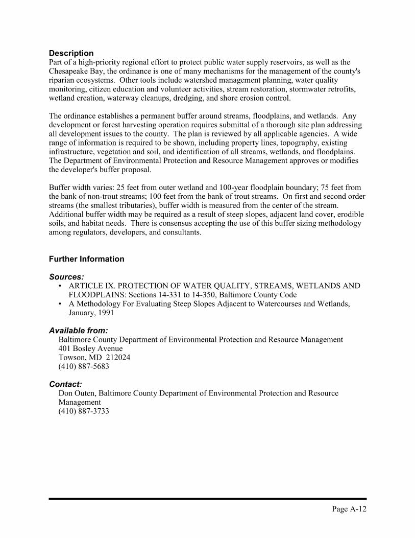
DescriptionPart of a high-priority regional effort to protect public water supply reservoirs, as well as theChesapeake Bay, the ordinance is one of many mechanisms for the management of the county'sriparian ecosystems. Other tools include watershed management planning, water qualitymonitoring, citizen education and volunteer activities, stream restoration, stormwater retrofits,wetland creation, waterway cleanups, dredging, and shore erosion control.
The ordinance establishes a permanent buffer around streams, floodplains, and wetlands. Anydevelopment or forest harvesting operation requires submittal of a thorough site plan addressingall development issues to the county. The plan is reviewed by all applicable agencies. A widerange of information is required to be shown, including property lines, topography, existinginfrastructure, vegetation and soil, and identification of all streams, wetlands, and floodplains.The Department of Environmental Protection and Resource Management approves or modifiesthe developer's buffer proposal.
Buffer width varies: 25 feet from outer wetland and 100-year floodplain boundary; 75 feet fromthe bank of non-trout streams; 100 feet from the bank of trout streams. On first and second orderstreams (the smallest tributaries), buffer width is measured from the center of the stream.Additional buffer width may be required as a result of steep slopes, adjacent land cover, erodiblesoils, and habitat needs. There is consensus accepting the use of this buffer sizing methodologyamong regulators, developers, and consultants.
Further Information
Sources:• ARTICLE IX. PROTECTION OF WATER QUALITY, STREAMS, WETLANDS AND
FLOODPLAINS: Sections 14-331 to 14-350, Baltimore County Code• A Methodology For Evaluating Steep Slopes Adjacent to Watercourses and Wetlands,
January, 1991
Available from:Baltimore County Department of Environmental Protection and Resource Management401 Bosley AvenueTowson, MD 212024 (410) 887-5683
Contact: Don Outen, Baltimore County Department of Environmental Protection and ResourceManagement(410) 887-3733
Page A-13
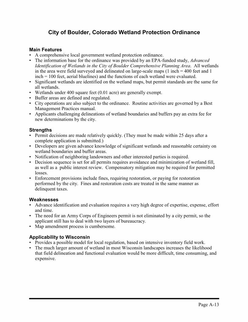
City of Boulder, Colorado Wetland Protection Ordinance
Main Features• A comprehensive local government wetland protection ordinance.• The information base for the ordinance was provided by an EPA-funded study, Advanced
Identification of Wetlands in the City of Boulder Comprehensive Planning Area. All wetlandsin the area were field surveyed and delineated on large-scale maps (1 inch = 400 feet and 1inch = 100 feet, aerial bluelines) and the functions of each wetland were evaluated.
• Significant wetlands are identified on the wetland maps, but permit standards are the same forall wetlands.
• Wetlands under 400 square feet (0.01 acre) are generally exempt.• Buffer areas are defined and regulated.• City operations are also subject to the ordinance. Routine activities are governed by a Best
Management Practices manual.• Applicants challenging delineations of wetland boundaries and buffers pay an extra fee for
new determinations by the city.
Strengths• Permit decisions are made relatively quickly. (They must be made within 25 days after a
complete application is submitted.)• Developers are given advance knowledge of significant wetlands and reasonable certainty on
wetland boundaries and buffer areas.• Notification of neighboring landowners and other interested parties is required.• Decision sequence is set for all permits requires avoidance and minimization of wetland fill,
as well as a public interest review. Compensatory mitigation may be required for permittedlosses.
• Enforcement provisions include fines, requiring restoration, or paying for restorationperformed by the city. Fines and restoration costs are treated in the same manner asdelinquent taxes.
Weaknesses• Advance identification and evaluation requires a very high degree of expertise, expense, effort
and time.• The need for an Army Corps of Engineers permit is not eliminated by a city permit, so the
applicant still has to deal with two layers of bureaucracy.• Map amendment process is cumbersome.
Applicability to Wisconsin• Provides a possible model for local regulation, based on intensive inventory field work.• The much larger amount of wetland in most Wisconsin landscapes increases the likelihood
that field delineation and functional evaluation would be more difficult, time consuming, andexpensive.
Page A-14
Further Information
Sources:� Advanced Identification for Wetlands n the City of Boulder Comprehensive Planning Area� City of Boulder Wetlands Protection Ordinance� City of Boulder Wetlands Protection Ordinance: Guidance for Wetland Permit
Applications� City of Boulder Wetlands Protection Program Best Management Practices
Available from:City of Boulder Department of Community Planning and DevelopmentPO Box 791, Boulder, CO 80306(303) 441-3270
Page A-15
Conservation Subdivision Design: A Variation Cluster Development
by Randall Arendt
Randall Arendt is vice president of conservation planning at the Natural Lands Trust, based inMedia, Pennsylvania. The Natural Lands Trust is a nonprofit regional land trust, and Arendt'swork in conservation subdivision design is part of the trust's efforts to help municipalities addsignificant land protection standards to their existing land-use ordinances.
Main Features• Subdivision design allows for the same density of development as traditional subdivision
design but typically results in 50% and 70% of the land remaining as open-space land.• Preserves water resources and other natural features by designing around them.• Stormwater quantity and quality impacts can be significantly reduced due to less impervious
area.
Strengths• Economic: Takes advantage of the value of wetlands, streams, and other natural areas as site
amenities that enhance property values in the new development. Often requires lessinfrastructure cost because of the groupings of home sites.
• Ecological: Creates significant amounts of contiguous open-space land that can be utilizedfor the protection or enhancement of wildlife habitat and other open-space resource values.Can easily be incorporated into a network of open-space corridor lands which can be essentialfor area-sensitive wildlife species and protecting genetic diversity.
• Quality of Life: Creates more interesting developments by designing around and capitalizingon the natural and unique human-built features of the landscape. Potential for significant areafor passive and active recreation lands. Clustering houses fosters a neighborhood/communityenvironment.
Weaknesses• Conservation subdivision design is often not permitted under current local zoning and
subdivision design requirement, due to street width and lot size requirements.• This design approach appears to have been most commonly been utilized for up-scale
developments and has not been well tested on subdivisions designed for individuals withlower to moderate income levels.
• The design approach often automatically utilizes the density allowed under conventionalsubdivision design when calculating the allowed number of total dwellings.
Applicability to Wisconsin• In certain cases it may be desirable to step back and evaluate whether that density is
appropriate.• May require some modification of local zoning and subdivision design requirements (to allow
narrower streets for instance). Otherwise, likely to be permitted under existing regulatoryframework. Provides an excellent opportunity to avoid further fragmenting of the landscape.
Page A-16
• In a waterfront setting, impacts to the immediate shore and near-shore would make it unwiseto increase the density of waterfront lots or increase the number of owners holding riparianrights. Any decrease in lot widths should be for nonriparian lots only.
• Specific cluster development standards should be developed that allow the environmentalbenefits of this type of subdivision design to be achieved while ensuring that shore cover andnear-shore habitat are adequately protected.
DescriptionRandall Arendt describes conservation subdivision design as a four-step process. The first stepis to identify the conservation areas on the property. These include both the areas limited todevelopment by current regulations and environmental constraints and those "unprotectedelements of the natural and cultural landscape that deserve to be spared" from development. Thebalance of the site defines the potential development areas. The next step is locating house sites,which for marketing and quality-of-life reasons are placed in proximity to the conservation areas.The third step is to determine the layout of local street access to the homes and the location offootpaths to connect the various parts of the neighborhood and to access the natural features inthe open-space areas. In this approach, drawing in the lot lines is the last step.
Further Information
Sources:• Conservation Subdivision Design by Randall Arendt• Rural By Design by Randall Arendt• SEWRPC Planning Guide No. 7, Rural Cluster Development Guide
Contact:Monica DrewnianySoutheastern Wisconsin Regional Planning CommissionPO Box 1607Waukesha, WI 53187(414) 547-6721, ext. 253
Page A-17
Other Good Planning Resources and References
Stormwater Management
DRAFT Model Stormwater Management Zoning Ordinance - Wisconsin Department ofNatural Resources.This draft model ordinance was prepared by Department of Natural Resources staff as a startingpoint for public discussion and input. A final version of the model ordinance is not yet complete.Nevertheless, the draft model ordinance can provide a template for municipalities seeking abetter approach to stormwater problems. Counties, cities, towns, and villages are all givenexplicit authority to regulate stormwater through a comprehensive stormwater managementzoning ordinance. Although the primary users of such ordinances are likely to be incorporatedmunicipalities, stormwater management is critical to mitigating the impacts of urbanization onstreams and the impacts of backlot development around lakes, which may remainunincorporated.
The draft model ordinance offers standards for controlling the water quality impacts and waterquantity impacts of development proposals. The ordinance focuses on impacts from the increasein connected impervious areas associated with development. Technical guidelines for designingstormwater management practices are to be published by the University of Wisconsin -Extension in The Wisconsin Stormwater Manual. Part Two: Technical Design Guidelines forStormwater BMP's.
The draft model ordinance also contains a commentary section summarizing the backgroundinformation and the rationale behind each ordinance provision. This section provides anexcellent discussion of the mechanisms and impacts of increases in impervious surface area onsurface and ground water quality, local drainage problems, local and regional flooding, anddegradation of physical habitat in streams and wetlands.
Available from:John Pfender, Runoff Management Practices SectionBureau of Watershed Management, DNRPO Box 7921Madison, WI 53707 (608) 266-9266
Site Planning for Urban Stream Protection - Center for Watershed ProtectionThis manual describes an approach to development design that protects streams by reducingimpervious cover. It contains a summary of the research linking impervious cover to streamquality and outlines the planning and implementation steps needed to institute a watershed-basedzoning strategy at the local level. Some specific practices associated with cluster design aredescribed including urban stream buffers, alternative street and parking lot design, and otherinnovative stormwater management practices. The manual is intended for use by municipalofficials, landscape architects, planners, and engineers.
Available from:Center for Watershed Protection8737 Colesville Rd., Suite 300, Silver Spring, MD 20910(301) 589-1890
Page A-18
Cooperating Agreements Between Local Agencies
Working Agreement Between Walworth County Land Conservation Committee andWalworth County Park and Planning CommissionConfusion arising from overlapping jurisdiction on many projects in rapidly developing countieshas created the need to outline the roles of land conservation departments, who typically engagein implementing soil and water conservation programs and nonpoint pollution reductionpractices in both rural and urban areas, and zoning and planning departments that administer thezoning code. By developing a working agreement or memorandum of understanding, countyagencies can streamline regulatory processes and resolve conflicts over jurisdiction. Perhaps themost important advantage to be gained is the ability to utilize available staff technical expertisemost efficiently.
Walworth County uses its working agreement to direct the technical expertise of landconservation staff in soil erosion and stormwater management toward zoning applications suchas conditional use permits. This should provide some workload relief for zoning staff and ensurea good review. Walworth County also consolidates zoning, sanitation, and erosion controlreviews so that a consistent response is given to an application.
Walworth County Land Disturbance Erosion Control and Stormwater ManagementOrdinanceThis ordinance is focused on controlling erosion and stormwater runoff during construction anddoes not address long-term stormwater management to a significant degree. An importantfeature of the ordinance is that it applies to any land-disturbing activity in the shoreland zone.This allows erosion control standards for shoreland construction to be routinely handled throughthe land conservation department, rather than requiring a conditional use permit.
Voluntary Conservation: Conservation Easements and Land Acquisition
The Conservation Easement Handbook, by Janet Diehl and Thomas S. Barrett,principal authors. Published by the Land Trust Exchange and the Trust for PublicLand, 1988This is a valuable how-to manual covering the legal, marketing, tax, acquisition, monitoring, andenforcement aspects of conservation easements held by nonprofit organizations and publicagencies. It includes many sample checklists and forms covering these aspects and a modelconservation easement document with extensive commentary on each section of the model.
Doing Deals: A Guide to Buying Land for Conservation, by The Trust for PublicLand. Published by the Land Trust Alliance and the Trust for Public Land, 1995This book provides a guide for Land Trusts and other conservation organizations on the entireprocess of selecting and acquiring land.
Gathering WatersThis is a land conservation organization that assists land owners, land trusts, and communities intheir efforts to protect Wisconsin's land and water resources. It provides technical assistance inestablishing conservation easements and a variety of other conservation options available tolandowners.

Page A-19
Contact:Brian HotzGathering Waters633 West Main St.Madison, WI 53707608/251-9131
Wetland Protection Planning Tools Linked to s. 404 Permit ProgramsThree types of wetland planning projects authorized under the Clean Water Act are noted here.Their purpose, with varying degrees of emphasis, is to provide better scientific information in aregion to improve the basis for regulatory decision making and to increase the predictability ofregulatory programs. Through these planning processes, a better assessment of cumulativeimpacts is sought to attain better overall wetland protection while reducing the uncertainty ofpermit-by-permit decision making.
Advanced Identification, initiated by U.S. Environmental Protection AgencyThe United States Environmental Protection Agency (USEPA) and the United States ArmyCorps of Engineers (USACE) can initiate the Advanced Identification (ADID) process whenrequested by a state or local agency. ADIDs usually involve and intensive wetlands inventory,as well as mapping and a characterization of each wetland's functions. Regional USEPA officesuse this information to designate areas as suitable or unsuitable for disposal of fill. The processinvolves opportunities for public and agency review and comment. ADIDs can streamline theregulatory process by providing agencies with a preliminary indication of wetland functionalvalue based on a suitable/unsuitable determination. However, the ADID determination does notguarantee the outcome of a future permit decision.
Examples: Chiwaukee Prairie ADID, Town of Norway (Wind Lake)
Special Area Management Plan, initiated by the USACELike an ADID, a Special Area Management Plan (SAMP) requires interagency cooperationbetween USACE, USEPA, and state and local government. It involves intensive delineation andfunctional evaluation based on field work. A SAMP differs from an ADID in that it is designedto produce definite regulatory results by producing - in advance of permit applications - local,state, and federal (USACE general permits) approvals for fill in identified wetland areas andidentification of wetland areas the are to be restricted from approval by local, state, and federal(Clean Water Act 404(c)) authorities. Some wetland areas may not be slated for either protectionor fill. Any future permit applications for these areas will be evaluated through the individualpermit process. However, some SAMPs produce only advisory designations of suitability orunsuitability for fill.
Unlike an ADID, the SAMP must consider both resource protection and economic growth. ASAMP is even more resource intensive and costly than an ADID. Generally, this level of effortis reserved for environmentally sensitive areas that are under strong development pressure. Allparties are required to agree in advance on how the SAMP results will be used.
Example: City of Superior SAMP

Page A-20
Special Wetland Inventory Studies, initiated by USEPAA Special Wetland Inventory Study (SWIS) provides a database of scientific information on aregion's wetlands and is not specifically tied to a regulatory outcome. However, the SWIS stillprovides a streamlining of the regulatory process by providing a wealth of accessible data tomany county, state, and federal agencies as well as academic institutions and conservationgroups.
Example: Green Bay SWIS
Page B-1
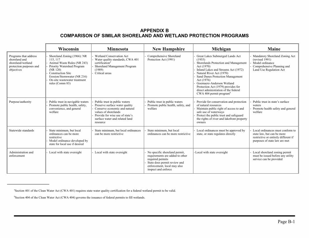
APPENDIX BCOMPARISON OF SIMILAR SHORELAND AND WETLAND PROTECTION PROGRAMS
Wisconsin Minnesota New Hampshire Michigan MainePrograms that addressshoreland andshoreland/wetlandprotection purposes andobjectives
- Shoreland Zoning (1966): NR115, 117
- Animal Waste Rules (NR 243)- Priority Watershed Program
(NR 120)- Construction Site
Erosion/Stormwater (NR 216)- On-site wastewater treatment
rules (Comm 83)
- Wetland Conservation Act- Water quality standards, CWA 401
certificationa
- Shoreland Management Program(1989)
- Critical areas
- Comprehensive ShorelandProtection Act (1991)
- Great Lakes Submerged Lands Act(1955)
- Shorelands Protection and ManagementAct (1970)
- Inland Lakes and Streams Act (1972)- Natural River Act (1970)- Sand Dunes Protection Management
Act (1976)- Goemaere-Anderson Wetland
Protection Act (1979) provides fordirect administration of the federalCWA 404 permit programb
- Mandatory Shoreland Zoning Act(revised 1991)
- Model ordinance- Comprehensive Planning and
Land Use Regulation Act
Purpose/authority - Public trust in navigable waters- Promote public health, safety,
convenience, and generalwelfare
- Public trust in public waters- Preserve surface water quality- Conserve economic and natural
values of shorelands- Provide for wise use of state’s
surface water and related landresource
- Public trust in public waters- Promote public health, safety, and
welfare
- Provide for conservation and protectionof natural resources
- Maintain public right of access to andsafe use of waterways
- Protect the public trust and safeguardthe rights of river and lakefront propertyowners
- Public trust in state’s surfacewaters
- Promote health safety and generalwelfare
Statewide standards - State minimum, but localordinances can be morerestrictive
- Model ordinance developed bystate for local use if desired
- State minimum, but local ordinancescan be more restrictive
- State minimum, but localordinances can be more restrictive
- Local ordinances must be approved bystate, or state regulates directly
- Local ordinances must conform tostate law, but can be morerestrictive or entirely different ifpurposes of state law are met
Administration andenforcement
- Local with state oversight - Local with state oversight - No specific shoreland permit,requirements are added to otherrequired permits
- State does permit review andenforcement, local may alsoinspect and enforce
- Local with state oversight - Local shoreland zoning permitmust be issued before any utilityservice can be provided
aSection 401 of the Clean Water Act (CWA 401) requires state water quality certification for a federal wetland permit to be valid.
bSection 404 of the Clean Water Act (CWA 404) governs the issuance of federal permits to fill wetlands.
Page B-2
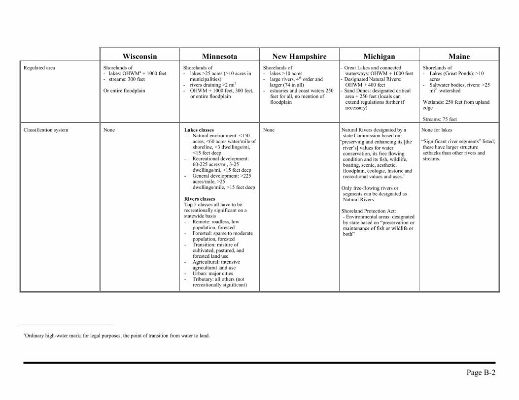
Wisconsin Minnesota New Hampshire Michigan MaineRegulated area Shorelands of
- lakes: OHWMa + 1000 feet- streams: 300 feet
Or entire floodplain
Shorelands of- lakes >25 acres (>10 acres in
municipalities)- rivers draining >2 mi2
- OHWM + 1000 feet, 300 feet,or entire floodplain
Shorelands of- lakes >10 acres- large rivers, 4th order and
larger (74 in all)- estuaries and coast waters 250
feet for all, no mention offloodplain
- Great Lakes and connectedwaterways: OHWM + 1000 feet
- Designated Natural Rivers:OHWM + 400 feet
- Sand Dunes: designated criticalarea + 250 feet (locals canextend regulations further ifnecessary)
Shorelands of- Lakes (Great Ponds): >10
acres- Saltwater bodies, rivers: >25
mi2 watershed
Wetlands: 250 feet from uplandedge
Streams: 75 feet
Classification system None Lakes classes- Natural environment: <150
acres, <60 acres water/mile ofshoreline, <3 dwellings/mi,<15 feet deep
- Recreational development:60-225 acres/mi, 3-25dwellings/mi, >15 feet deep
- General development: >225acres/mile, >25dwellings/mile, >15 feet deep
Rivers classesTop 5 classes all have to berecreationally significant on astatewide basis- Remote: roadless, low
population, forested- Forested: sparse to moderate
population, forested- Transition: misture of
cultivated, pastured, andforested land use
- Agricultural: intensiveagricultural land use
- Urban: major cities- Tributary: all others (not
recreationally significant)
None Natural Rivers designated by astate Commission based on:
“preserving and enhancing its �theriver’s� values for waterconservation, its free flowingcondition and its fish, wildlife,boating, scenic, aesthetic,floodplain, ecologic, historic andrecreational values and uses.”
Only free-flowing rivers orsegments can be designated asNatural Rivers
Shoreland Protection Act:- Environmental areas: designatedby state based on “preservation ormaintenance of fish or wildlife orboth”
None for lakes
“Significant river segments” listed;these have larger structuresetbacks than other rivers andstreams.
aOrdinary high-water mark; for legal purposes, the point of transition from water to land.
Page B-3
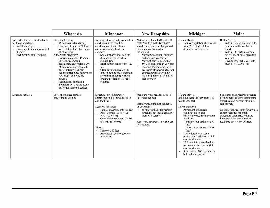
Wisconsin Minnesota New Hampshire Michigan MaineVegetated buffer zones (setbacks)for these objectives:- wildlife useage- screening to maintain natural
beauty- sediment/nutrient trapping
Shoreland zoning:- 35-foot restricted cutting
zone: no clearcuts >30 feet inany 100 feet for entire rangeof objectives
Other state programs:- Priority Watershed Program:
66-foot streambankeasements, new variable 20-70 foot riparian vegetatedbuffer interim BMP forsediment trapping, removal ofrow crops, and wildlifebenefits
- Agricultural ShorelandZoning (DATCP): 25 feet +buffer for same objectives
Varying setbacks and permitted orconditional uses based oncombination of water bodyclassification and land-usecategory- Shore impact zone: half the
distance of the structuresetback line
- Bluff impact zone: bluff + 20feet
- Clear-cutting not allowed;limited cutting must maintainscreening, shading of rivers;grading restrictions, BMPsrequired
Natural woodland buffer of 150feet: “healthy, well-distributedstand” (including shrubs, groundcover and roots) must bemaintained- May remove fallen, diseased,
and noxious vegetation- May not harvest more than
50% of basal area in 20 years- Clearing for construction of
accessory structures, etc., notcounted toward 50% limit
- No stump removal within 50feet of water
Natural Rivers:- Natural vegetation strip varies
from 25 feet to 100 feetdepending on the river
Buffer Areas:- Within 75 feet: no clear-cuts,
maintain well-distributedstand
- Within 100 feet: maximumcut = 40% of basal area (treevolume)
- Beyond 100 feet: clear-cutsmust be < 10,000 feet2
Structure setbacks 75-foot structure setbackStructure no defined
Structure: any building orappurtenance except utility linesand facilities
Setbacks for lakes:- Natural environment: 150 feet- Recreational: 100 feet (75
feet, if sewered)- General development: 75 feet
(50 feet, if sewered)
Rivers:- Remote: 200 feet- All others: 100 feet (50 feet,
if sewered)
Structure: very broadly defined(excludes fences)
Primary structure: not incidentalor accessory- 50=foot setback for primary
structure, but locals can havetheir own setback
Accessory structures: not subjectto a setback
Natural Rivers:Building setbacks vary from 100feet to 200 feet
Shorelands Act:- Permanent structures:
buildings an on-sitewastewater treatment systemfacilities:
small = foundation <3500feet2
large = foundation >3500feet2
- These definitions relateprimarily to setbacks in higherosion risk areas
- 30-foot minimum setback topermanent structure in higherosion risk areas
- Structures <1200 feet2 can bebuilt without permit
Structures and principal structuredefined same as New Hampshire(structure and primary structure,respectively)
No principal structures for any useexcept facilities for smalleducation, scientific, or natureinterpretation are allowed inResource Protection Districts
Page B-4
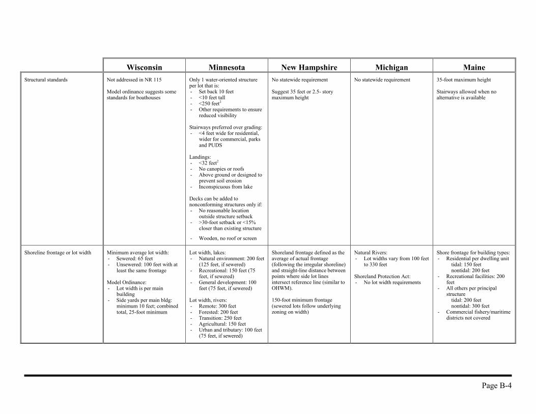
Wisconsin Minnesota New Hampshire Michigan MaineStructural standards Not addressed in NR 115
Model ordinance suggests somestandards for boathouses
Only 1 water-oriented structureper lot that is:- Set back 10 feet- <10 feet tall- <250 feet2
- Other requirements to ensurereduced visibility
Stairways preferred over grading:- <4 feet wide for residential,
wider for commercial, parksand PUDS
Landings:- <32 feet2
- No canopies or roofs- Above ground or designed to
prevent soil erosion- Inconspicuous from lake
Decks can be added tononconforming structures only if:- No reasonable location
outside structure setback- >30-foot setback or <15%
closer than existing structure
- Wooden, no roof or screen
No statewide requirement
Suggest 35 feet or 2.5- storymaximum height
No statewide requirement 35-foot maximum height
Stairways allowed when noalternative is available
Shoreline frontage or lot width Minimum average lot width:- Sewered: 65 feet- Unsewered: 100 feet with at
least the same frontage
Model Ordinance:- Lot width is per main
building- Side yards per main bldg:
minimum 10 feet; combinedtotal, 25-foot minimum
Lot width, lakes:- Natural environment: 200 feet
(125 feet, if sewered)- Recreational: 150 feet (75
feet, if sewered)- General development: 100
feet (75 feet, if sewered)
Lot width, rivers:- Remote: 300 feet- Forested: 200 feet- Transition: 250 feet- Agricultural: 150 feet- Urban and tributary: 100 feet
(75 feet, if sewered)
Shoreland frontage defined as theaverage of actual frontage(following the irregular shoreline)and straight-line distance betweenpoints where side lot linesintersect reference line (similar toOHWM).
150-foot minimum frontage(sewered lots follow underlyingzoning on width)
Natural Rivers:- Lot widths vary from 100 feet
to 330 feet
Shoreland Protection Act:- No lot width requirements
Shore frontage for building types:- Residential per dwelling unit
tidal: 150 feet nontidal: 200 feet
- Recreational facilities: 200feet
- All others per principalstructure
tidal: 200 feetnontidal: 300 feet
- Commercial fishery/maritimedistricts not covered
Page B-5
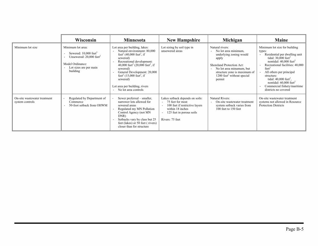
Wisconsin Minnesota New Hampshire Michigan MaineMinimum lot size Minimum lot area:
- Sewered: 10,000 feet2
- Unsewered: 20,000 feet2
Model Ordinance:- Lot sizes are per main
building
Lot area per building, lakes:- Natural environment: 80,000
feet2 (40,000 feet2, ifsewered)
- Recreational development:40,000 feet2 (20,000 feet2, ifsewered)
- General Development: 20,000feet2 (15,000 feet2, ifsewered)
Lot area per building, rivers- No lot area controls
Lot sizing by soil type inunsewered areas
Natural rivers:- No lot area minimum,
underlying zoning wouldapply
Shoreland Protection Act:- No lot area minumum, but
structure zone is maximum of1200 feet2 without specialpermit
Minimum lot size for buildingtypes:- Residential per dwelling unit
tidal: 30,000 feet2
nontidal: 40,000 feet2
- Recreational facilities: 40,000feet2
- All others per principalstructure:
tidal: 40,000 feet2,nontidal: 60,000 feet2
- Commercial fishery/maritimedistricts no covered
On-site wastewater treatmentsystem controls
- Regulated by Department ofCommerce
- 50-foot setback from OHWM
- Sewer preferred – smaller,narrower lots allowed forsewered areas
- Regulated my MN PollutionControl Agency (not MNDNR)
- Setbacks vary by class but 25feet (lakes) or 50 feet ( rivers)closer than for structure
Lakes setback depends on soils:- 75 feet for most- 100 feet if restrictive layers
within 18 inches- 125 feet in porous soils
Rivers: 75 feet
Natural Rivers:- On-site wastewater treatment
system setback varies from100 feet to 150 feet
On-site wastewater treatmentsystems not allowed in ResourceProtection Districts
Page B-6
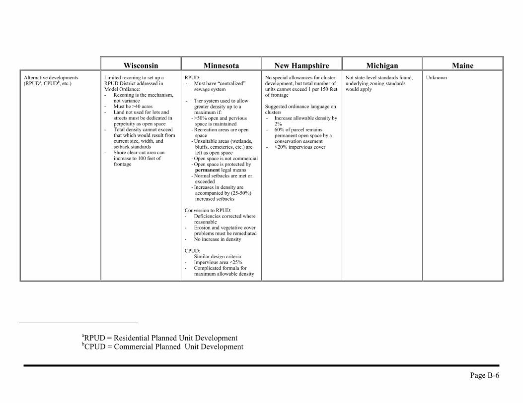
Wisconsin Minnesota New Hampshire Michigan MaineAlternative developments(RPUDa, CPUDb, etc.)
Limited rezoning to set up aRPUD District addressed inModel Ordiance:- Rezoning is the mechanism,
not variance- Must be >40 acres- Land not used for lots and
streets must be dedicated inperpetuity as open space
- Total density cannot exceedthat which would result fromcurrent size, width, andsetback standards
- Shore clear-cut area canincrease to 100 feet offrontage
RPUD:- Must have “centralized”
sewage system
- Tier system used to allowgreater density up to amaximum if:
- >50% open and perviousspace is maintained
- Recreation areas are openspace
- Unsuitable areas (wetlands,bluffs, cemeteries, etc.) areleft as open space
- Open space is not commercial- Open space is protected by
permanent legal means- Normal setbacks are met or
exceeded- Increases in density are
accompanied by (25-50%)increased setbacks
Conversion to RPUD:- Deficiencies corrected where
reasonable- Erosion and vegetative cover
problems must be remediated- No increase in density
CPUD:- Similar design criteria- Impervious area <25%- Complicated formula for
maximum allowable density
No special allowances for clusterdevelopment, but total number ofunits cannot exceed 1 per 150 feetof frontage
Suggested ordinance language onclusters- Increase allowable density by
2%- 60% of parcel remains
permanent open space by aconservation easement
- <20% impervious cover
Not state-level standards found,underlying zoning standardswould apply
Unknown
aRPUD = Residential Planned Unit DevelopmentbCPUD = Commercial Planned Unit Development
Page B-7
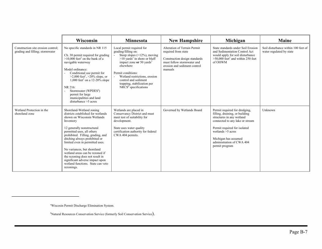
Wisconsin Minnesota New Hampshire Michigan MaineConstruction site erosion control;grading and filling; stormwater
No specific standards in NR 115
Ch. 30 permit required for grading>10,000 feet2 on the bank of anavigable waterway
Model ordinance:- Conditional use permit for
>2,000 feet2, >20% slope, or1,000 feet2 on a 12-20% slope
NR 216:- Stormwater (WPDESa)
permit for largemunicipalities and landdisturbance >5 acres
Local permit required forgrading/filling on:- Steep slopes (>12%), moving
>10 yards3 in shore or bluffimpact zone or 50 yards3
elsewhere
Permit conditions:- Wetland restrictions, erosion
control and sedimenttrapping, stabilization perNRCSb specifications
Alteration of Terrain Permitrequired from state
Construction design standardsmust follow stormwater anderosion and sediment controlmanuals
State standards under Soil Erosionand Sedimentation Control Actwould apply for soil disturbance>50,000 feet2 and within 250 feetof OHWM
Soil disturbance within 100 feet ofwater regulated by state
Wetland Protection in theshoreland zone
Shoreland-Wetland zoningdistricts established for wetlandsshown on Wisconsin WetlandsInventory
12 generally nonstructuralpermitted uses, all othersprohibited. Filling, grading, andditching always prohibited orlimited even in permitted uses.
No variances, but shorelandwetland areas can be rezoned ifthe rezoning does not result insignificant adverse impact uponwetland functions. State can vetorezonings.
Wetlands are placed inConservancy District and mustmeet test of suitability fordevelopment.
State uses water qualitycertification authority for federalCWA 404 permits.
Governed by Wetlands Board Permit required for dredging,filling, draining, or buildingstructures in any wetlandconnected to any lake or stream
Permit required for isolatedwetlands >5 acres
Michigan has assumedadministration of CWA 404permit program
Unknown
aWiscosin Permit Discharge Elimination System.
bNatural Resources Conservation Service (formerly Soil Conservation Service).

Page B-8
Wisconsin Minnesota New Hampshire Michigan MaineForestry standards 35-foot vegetative cutting
restriction zone applies
Forestry BMP Manual containsvoluntary standards for riparianmanagement zones (RMZ):- RMZ=35 feet from non-
navigable and navigableintermittent streams: noequipment within 15 feetunless ground frozen or dry
- RMZ=100 feet from lakesand navigable perennialstreams: no equipment within50 feet, leave 60 feet2, >5inches DBHa, well-distributed
Forestry activities must complywith both- Minnesota Nonpoint
Pollution Assessment -Forestry
- Water Quality in ForestManagement BMPs inMinnesota
See vegetated buffer standards Not researched See vegetated buffer standards
Agricultural standards Not spelled out in NR 115
Agricultural shoreland zoning insome counties
For agricultural uses:- Shore impact zone = 50 feet
from OHWM- Must have permanent
vegetation or have NRCSapproved conservation plan
Feedlot standards:- 300-foot setback;
nonconforming feedlots mayonly expand landward
Not researched Not researched Not researched
aDiameter at breast height: measurement used in forestry.

Page B-9
Wisconsin Minnesota New Hampshire Michigan MaineKey features of interest toWisconsin
Allows flexibility for localconditions:- Other standards for specific
water can be written as partof a comprehensive planningeffort
- Nonconforming uses in urbanareas can justify relaxedstandards
- Can trade off stricterstandards in one area forrelaxed standards in another
- Any of these changes must beapproved by the state andjustified
Impervious cover <25% on anyshoreland lot
Suggest impervious cover <20%in model ordinance
Model zoning ordinancesdeveloped by state. Locals canchoose from a menu of differentzoning methods:- Partial zoning (interim
method)- Separate district (specific and
focused but uses existingmechanisms)
- Overlay district (fits in withexisting land-use plan)
Comprehensive planning andsubdivision review using thephosphorus allocation method; seeAppendix A for description
Staffing for shoreland program - 30 water managementspecialists throughout state
- 72 county zoningadministrators
- 2 central office planners
- 23 area hydrologiststhroughout state
- 1 central office- 85 county code administrators- 160 cities
Unknown Unknown Unknown
Page C-1
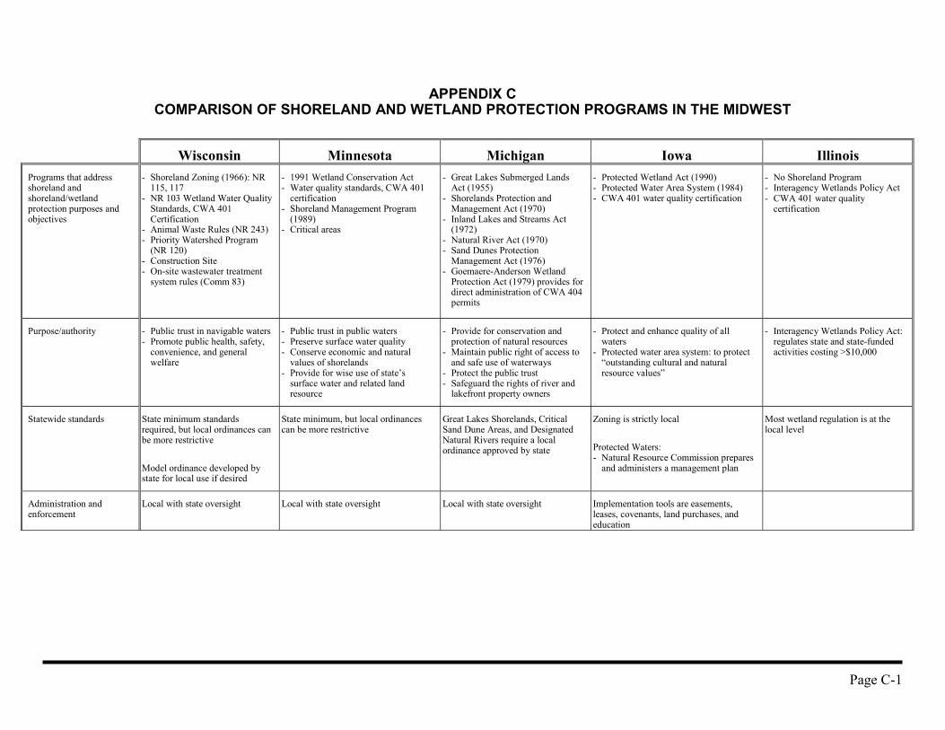
APPENDIX CCOMPARISON OF SHORELAND AND WETLAND PROTECTION PROGRAMS IN THE MIDWEST
Wisconsin Minnesota Michigan Iowa IllinoisPrograms that addressshoreland andshoreland/wetlandprotection purposes andobjectives
- Shoreland Zoning (1966): NR115, 117
- NR 103 Wetland Water QualityStandards, CWA 401Certification
- Animal Waste Rules (NR 243)- Priority Watershed Program
(NR 120)- Construction Site- On-site wastewater treatment
system rules (Comm 83)
- 1991 Wetland Conservation Act- Water quality standards, CWA 401
certification- Shoreland Management Program
(1989)- Critical areas
- Great Lakes Submerged LandsAct (1955)
- Shorelands Protection andManagement Act (1970)
- Inland Lakes and Streams Act(1972)
- Natural River Act (1970)- Sand Dunes Protection
Management Act (1976)- Goemaere-Anderson Wetland
Protection Act (1979) provides fordirect administration of CWA 404permits
- Protected Wetland Act (1990)- Protected Water Area System (1984)- CWA 401 water quality certification
- No Shoreland Program- Interagency Wetlands Policy Act- CWA 401 water quality
certification
Purpose/authority - Public trust in navigable waters- Promote public health, safety,
convenience, and generalwelfare
- Public trust in public waters- Preserve surface water quality- Conserve economic and natural
values of shorelands- Provide for wise use of state’s
surface water and related landresource
- Provide for conservation andprotection of natural resources
- Maintain public right of access toand safe use of waterways
- Protect the public trust- Safeguard the rights of river and
lakefront property owners
- Protect and enhance quality of allwaters
- Protected water area system: to protect“outstanding cultural and naturalresource values”
- Interagency Wetlands Policy Act:regulates state and state-fundedactivities costing >$10,000
Statewide standards State minimum standardsrequired, but local ordinances canbe more restrictive
Model ordinance developed bystate for local use if desired
State minimum, but local ordinancescan be more restrictive
Great Lakes Shorelands, CriticalSand Dune Areas, and DesignatedNatural Rivers require a localordinance approved by state
Zoning is strictly local
Protected Waters:- Natural Resource Commission prepares
and administers a management plan
Most wetland regulation is at thelocal level
Administration andenforcement
Local with state oversight Local with state oversight Local with state oversight Implementation tools are easements,leases, covenants, land purchases, andeducation
Page C-2
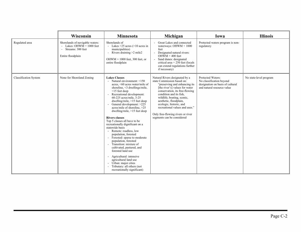
Wisconsin Minnesota Michigan Iowa IllinoisRegulated area Shorelands of navigable waters:
- Lakes: OHWM + 1000 feet- Streams: 300 feet
Entire floodplain
Shorelands of - Lakes >25 acres (>10 acres in
municipalities)- Rivers draining >2 mile2
OHWM + 1000 feet, 300 feet, orentire floodplain
- Great Lakes and connectedwaterways: OHWM + 1000feet
- Designated natural rivers:OHWM + 400 feet
- Sand dunes: designatedcritical area + 250 feet (localscan extend regulations furtherif necessary)
Protected waters program is non-regulatory
Classification System None for Shoreland Zoning Lakes Classes- Natural environment: <150
acres, <60 acres water/mile ofshoreline, <3 dwellings/mile,<15 feet deep
- Recreational development:60-225 acres/mile, 3-25dwelling/mile, >15 feet deep
- General development: >225acres/mile of shoreline, >25dwelling/mile, >15 feet deep
Rivers classesTop 5 classes all have to berecreationally dignificant on astatewide basis- Remote: roadless, low
population, forested- Forested: sparse to moderate
population, forested- Transition: mixture of
cultivated, pastured, andforested land use
- Agricultural: intensiveagricultural land use
- Urban: major cities- Tributary: all others (not
recreationally significant)
Natural Rivers designated by astate Commission based on:
“preserving and enhancing its[the river’s] values for waterconservation, its free-flowingcondition and its fish,wildlife, boating, scenic,aesthetic, floodplain,ecologic, historic, andrecreational values and uses.”
Only free-flowing rivers or riversegments can be considered
Protected Waters:No classification beyonddesignation on basis of culturaland natural resource value
No state-level program
Page C-3
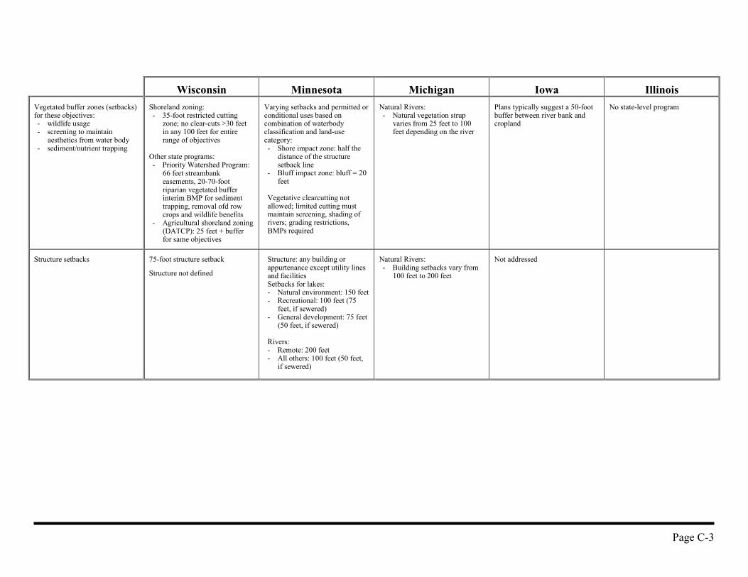
Wisconsin Minnesota Michigan Iowa IllinoisVegetated buffer zones (setbacks)for these objectives:- wildlife usage- screening to maintain
aesthetics from water body- sediment/nutrient trapping
Shoreland zoning:- 35-foot restricted cutting
zone; no clear-cuts >30 feetin any 100 feet for entirerange of objectives
Other state programs:- Priority Watershed Program:
66 feet streambankeasements, 20-70-footriparian vegetated bufferinterim BMP for sedimenttrapping, removal ofd rowcrops and wildlife benefits
- Agricultural shoreland zoning(DATCP): 25 feet + bufferfor same objectives
Varying setbacks and permitted orconditional uses based oncombination of waterbodyclassification and land-usecategory:- Shore impact zone: half the
distance of the structuresetback line
- Bluff impact zone: bluff = 20feet
Vegetative clearcutting notallowed; limited cutting mustmaintain screening, shading ofrivers; grading restrictions,BMPs required
Natural Rivers:- Natural vegetation strup
varies from 25 feet to 100feet depending on the river
Plans typically suggest a 50-footbuffer between river bank andcropland
No state-level program
Structure setbacks 75-foot structure setback
Structure not defined
Structure: any building orappurtenance except utility linesand facilitiesSetbacks for lakes:- Natural environment: 150 feet- Recreational: 100 feet (75
feet, if sewered)- General development: 75 feet
(50 feet, if sewered)
Rivers:- Remote: 200 feet- All others: 100 feet (50 feet,
if sewered)
Natural Rivers:- Building setbacks vary from
100 feet to 200 feet
Not addressed
Page C-4
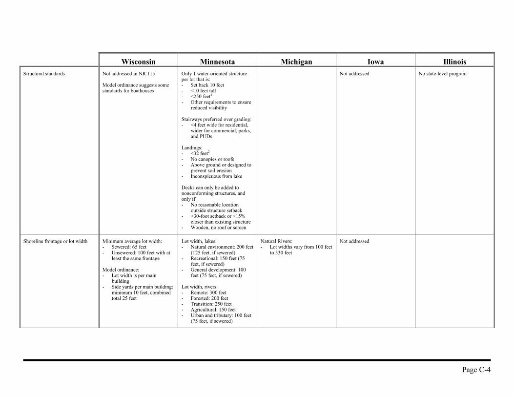
Wisconsin Minnesota Michigan Iowa IllinoisStructural standards Not addressed in NR 115
Model ordinance suggests somestandards for boathouses
Only 1 water-oriented structureper lot that is:- Set back 10 feet- <10 feet tall- <250 feet2
- Other requirements to ensurereduced visibility
Stairways preferred over grading:- <4 feet wide for residential,
wider for commercial, parks,and PUDs
Landings:- <32 feet2
- No canopies or roofs- Above ground or designed to
prevent soil erosion- Inconspicuous from lake
Decks can only be added tononconforming structures, andonly if:- No reasonable location
outside structure setback- >30-foot setback or <15%
closer than existing structure- Wooden, no roof or screen
Not addressed No state-level program
Shoreline frontage or lot width Minimum average lot width:- Sewered: 65 feet- Unsewered: 100 feet with at
least the same frontage
Model ordinance:- Lot width is per main
building- Side yards per main building:
minimum 10 feet, combinedtotal 25 feet
Lot width, lakes:- Natural environment: 200 feet
(125 feet, if sewered)- Recreational: 150 feet (75
feet, if sewered)- General development: 100
feet (75 feet, if sewered)
Lot width, rivers:- Remote: 300 feet- Forested: 200 feet- Transition: 250 feet- Agricultural: 150 feet- Urban and tributary: 100 feet
(75 feet, if sewered)
Natural Rivers:- Lot widths vary from 100 feet
to 330 feet
Not addressed
Page C-5
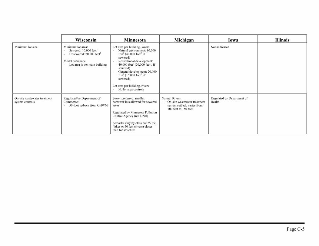
Wisconsin Minnesota Michigan Iowa IllinoisMinimum lot size Minimum lot area:
- Sewered: 10,000 feet2
- Unsewered: 20,000 feet2
Model ordinance:- Lot area is per main building
Lot area per building, lakes:- Natural environment: 80,000
feet2 (40,000 feet2, ifsewered)
- Recreational development:40,000 feet2 (20,000 feet2, ifsewered)
- General development: 20,000feet2 (15,000 feet2, ifsewered)
Lot area per building, rivers:- No lot area controls
Not addressed
On-site wastewater treatmentsystem controls
Regulated by Department ofCommerce:- 50-foot setback from OHWM
Sewer preferred: smaller,narrower lots allowed for seweredareas
Regulated by Minnesota PollutionControl Agency (not DNR)
Setbacks vary by class but 25 feet(lakes or 50 feet (rivers) closerthan for structure
Natural Rivers:- On-site wastewater treatment
system setback varies from100 feet to 150 feet
Regulated by Department ofHealth
Page C-6
Wisconsin Minnesota Michigan Iowa IllinoisAltermative developments(RPUD, CPUD, etc.)
Limited rezoning to set up aRPUD
District addressed in ModelOrdinance:- Rezoning is the mechanism,
not variance- Must be >40 acres- Land not used for lots and
streets must be dedicated inperpetuity as open space
- Total density cannot exceedthat which would result fromcurrent size, width, andsetback standards
- Shore clear-cut area canincrease to 100 feet offrontage
RPUD:- Must have “centralized”
sewage system- Tier system used to allow
greater density, up to amaximum, if:- >50% open and pervious
space is maintained- Recreation areas count as
open space- Unsuitable areas (wetlands,
bluffs, cemeteries, etc.) areleft as open space
- Open space is notcommercial
- Open space is protected bypermanent legal means
- Normal setbacks are met orexceeded
- Increases in density areaccompanied by (25-50%)increased setbacks
Conversion to RPUD:- Deficiencies corrected where
reasonable- Erosion and vegetative cover
problems must be remediated- No increase in density
CPUD:- Similar design criteria- Impervious area <25%- Complicated formula for
maximum allowable density
Unknown Unknown
Page C-7
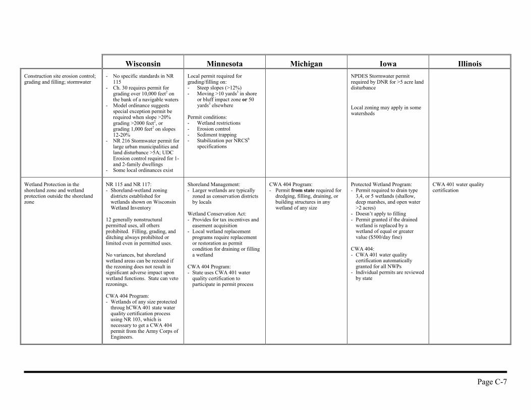
Wisconsin Minnesota Michigan Iowa IllinoisConstruction site erosion control;grading and filling; stormwater
- No specific standards in NR115
- Ch. 30 requires permit forgrading over 10,000 feet2 onthe bank of a navigable waters
- Model ordinance suggestsspecial exception permit berequired when slope >20%grading >2000 feet2, orgrading 1,000 feet2 on slopes12-20%
- NR 216 Stormwater permit forlarge urban municipalities andland disturbance >5A; UDCErosion control required for 1-and 2-family dwellings
- Some local ordinances exist
Local permit required forgrading/filling on:- Steep slopes (>12%)- Moving >10 yards3 in shore
or bluff impact zone or 50yards3 elsewhere
Permit conditions:- Wetland restrictions- Erosion control- Sediment trapping- Stabilization per NRCSb
specifications
NPDES Stormwater permitrequired by DNR for >5 acre landdisturbance
Local zoning may apply in somewatersheds
Wetland Protection in theshoreland zone and wetlandprotection outside the shorelandzone
NR 115 and NR 117:- Shoreland-wetland zoning
districts established forwetlands shown on WisconsinWetland Inventory
12 generally nonstructuralpermitted uses, all othersprohibited. Filling, grading, andditching always prohibited orlimited even in permitted uses.
No variances, but shorelandwetland areas can be rezoned ifthe rezoning does not result insignificant adverse impact uponwetland functions. State can vetorezonings.
CWA 404 Program:- Wetlands of any size protected
throug hCWA 401 state waterquality certification processusing NR 103, which isnecessary to get a CWA 404permit from the Army Corps ofEngineers.
Shoreland Management:- Larger wetlands are typically
zoned as conservation districtsby locals
Wetland Conservation Act:- Provides for tax incentives and
easement acquisition- Local wetland replacement
programs require replacementor restoration as permitcondition for draining or fillinga wetland
CWA 404 Program:- State uses CWA 401 water
quality certification toparticipate in permit process
CWA 404 Program:- Permit from state required for
dredging, filling, draining, orbuilding structures in anywetland of any size
Protected Wetland Program:- Permit required to drain type
3,4, or 5 wetlands (shallow,deep marshes, and open water>2 acres)
- Doesn’t apply to filling- Permit granted if the drained
wetland is replaced by awetland of equal or greatervalue ($500/day fine)
CWA 404:- CWA 401 water quality
certification automaticallygranted for all NWPs
- Individual permits are reviewedby state
CWA 401 water qualitycertification
Page C-8
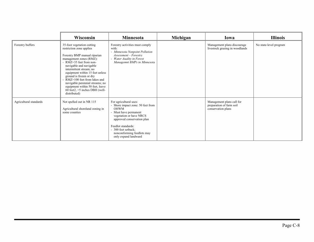
Wisconsin Minnesota Michigan Iowa IllinoisForestry buffers 35-foot vegetation cutting
restriction zone applies
Forestry BMP manual riparianmanagement zones (RMZ):- RMZ=35 feet from non-
navigable and navigableintermittent stream; noequipment within 15 feet unlessground is frozen or dry
- RMZ=100 feet from lakes andnavigable perennial streams; noequipment within 50 feet, leave60 feet2, >5 inches DBH (well-distributed)
Forestry activities must complywith:- Minnesota Nonpoint Pollution
Assessment – Forestry- Water Auality in Forest
Managemnt BMPs in Minnesota
Management plans discouragelivestock grazing in woodlands
No state-level program
Agricultural standards Not spelled out in NR 115
Agricultural shoreland zoning insome counties
For agricultural uses:- Shore impact zone: 50 feet from
OHWM- Must have permanent
vegetation or have NRCSapproved conservation plan
Feedlot standards:- 300 feet setback;
nonconforming feedlots mayonly expand landward
Management plans call forpreparation of farm soilconservation plans
Page C-9
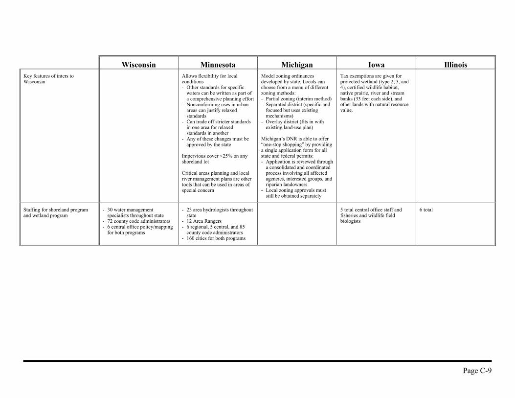
Wisconsin Minnesota Michigan Iowa IllinoisKey features of inters toWisconsin
Allows flexibility for localconditions- Other standards for specific
waters can be written as part ofa comprehensive planning effort
- Nonconforming uses in urbanareas can justify relaxedstandards
- Can trade off stricter standardsin one area for relaxedstandards in another
- Any of these changes must beapproved by the state
Impervious cover <25% on anyshoreland lot
Critical areas planning and localriver management plans are othertools that can be used in areas ofspecial concern
Model zoning ordinancesdeveloped by state. Locals canchoose from a menu of differentzoning methods:- Partial zoning (interim method)- Separated district (specific and
focused but uses existingmechanisms)
- Overlay district (fits in withexisting land-use plan)
Michigan’s DNR is able to offer“one-stop shopping” by providinga single application form for allstate and federal permits:- Application is reviewed through
a consolidated and coordinatedprocess involving all affectedagencies, interested groups, andriparian landowners
- Local zoning approvals muststill be obtained separately
Tax exemptions are given forprotected wetland (type 2, 3, and4), certified wildlife habitat,native prairie, river and streambanks (33 feet each side), andother lands with natural resourcevalue.
Staffing for shoreland programand wetland program
- 30 water managementspecialists throughout state
- 72 county code administrators- 6 central office policy/mapping
for both programs
- 23 area hydrologists throughoutstate
- 12 Area Rangers- 6 regional, 5 central, and 85
county code administrators- 160 cities for both programs
5 total central office staff andfisheries and wildlife fieldbiologists
6 total
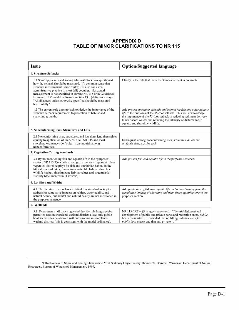
Page D-1
APPENDIX DTABLE OF MINOR CLARIFICATIONS TO NR 115
Issue Option/Suggested language 1. Structure Setbacks
1.1 Some applicants and zoning administrators have questionedhow the setback should be measured. It's common sense thatstructure measurement is horizontal; it is also consistentadministrative practice in most (all) counties. Horizontalmeasurement is not specified in current NR 115 or in Guidebook.However, 1985 model ordinance section 13.0 (definitions) says:"All distances unless otherwise specified should be measuredhorizontally."
Clarify in the rule that the setback measurement is horizontal.
1.2 The current rule does not acknowledge the importance of thestructure setback requirement to protection of habitat andspawning grounds.
Add protect spawning grounds and habitat for fish and other aquaticlife to the purposes of the 75-foot setback. This will acknowledgethe importance of the 75-foot setback in reducing sediment deliveryto near shore waters and reducing the intensity of disturbance toaquatic and shoreline wildlife.
2. Nonconforming Uses, Structures and Lots
2.1 Nonconforming uses, structures, and lots don't lend themselvesequally to application of the 50% rule. NR 115 and localshoreland ordinances don't clearly distinguish amongnonconformities.
Distinguish among nonconforming uses, structures, & lots andestablish standards for each.
3. Vegetative Cutting Standards
3.1 By not mentioning fish and aquatic life in the "purposes"section, NR 115(3)(c) fails to recognize the very important role avegetated shoreline plays for fish and amphibian habitat in thelittoral zones of lakes, in-stream aquatic life habitat, shorelinewildlife habitat, riparian zone habitat values and streambankstability (documented in lit reviewa).
Add protect fish and aquatic life to the purposes sentence.
4. Lot Sizes and Widths
4.1 The literature review has identified this standard as key toaddressing cumulative impacts on habitat, water quality, andnatural beauty, but habitat and natural beauty are not mentioned inthe purposes sentence.
Add protection of fish and aquatic life and natural beauty from thecumulative impacts of shoreline and near-shore modifications to thepurposes section.
5. Wetlands
5.1 Department staff have suggested that the rule language forpermitted uses in shoreland-wetland districts allow only publicboat access sites be allowed without rezoning in shoreland-wetland districts (this is consistent with the model ordinance).
NR 115.05(2)(c)(9) suggested reword: "The establishment anddevelopment of public and private parks and recreation areas, publicboat access sites, . . . provided that no filling is done except forpublic boat access and that any private . . ."
aEffectiveness of Shoreland Zoning Standards to Meet Statutory Objectives by Thomas W. Bernthal. Wisconsin Department of NaturalResources, Bureau of Watershed Management, 1997.
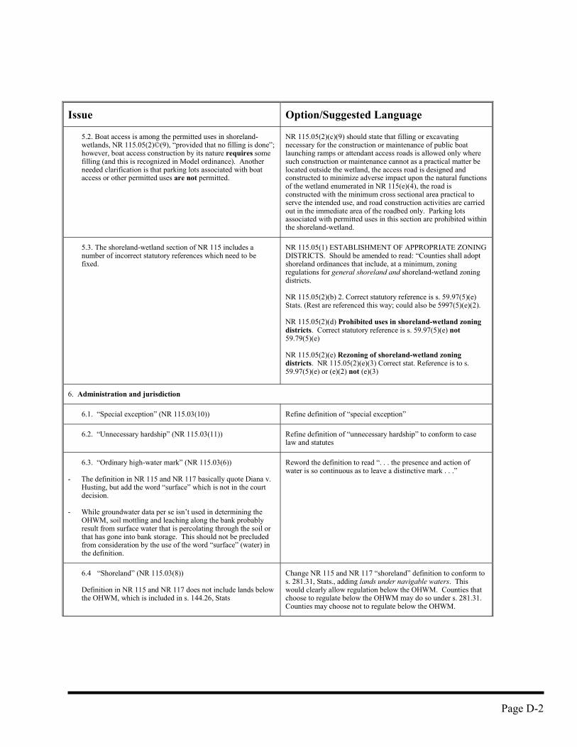
Page D-2
Issue Option/Suggested Language
5.2. Boat access is among the permitted uses in shoreland-wetlands, NR 115.05(2)©(9), “provided that no filling is done”;however, boat access construction by its nature requires somefilling (and this is recognized in Model ordinance). Anotherneeded clarification is that parking lots associated with boataccess or other permitted uses are not permitted.
NR 115.05(2)(c)(9) should state that filling or excavatingnecessary for the construction or maintenance of public boatlaunching ramps or attendant access roads is allowed only wheresuch construction or maintenance cannot as a practical matter belocated outside the wetland, the access road is designed andconstructed to minimize adverse impact upon the natural functionsof the wetland enumerated in NR 115(e)(4), the road isconstructed with the minimum cross sectional area practical toserve the intended use, and road construction activities are carriedout in the immediate area of the roadbed only. Parking lotsassociated with permitted uses in this section are prohibited withinthe shoreland-wetland.
5.3. The shoreland-wetland section of NR 115 includes anumber of incorrect statutory references which need to befixed.
NR 115.05(1) ESTABLISHMENT OF APPROPRIATE ZONINGDISTRICTS. Should be amended to read: “Counties shall adoptshoreland ordinances that include, at a minimum, zoningregulations for general shoreland and shoreland-wetland zoningdistricts.
NR 115.05(2)(b) 2. Correct statutory reference is s. 59.97(5)(e)Stats. (Rest are referenced this way; could also be 5997(5)(e)(2).
NR 115.05(2)(d) Prohibited uses in shoreland-wetland zoningdistricts. Correct statutory reference is s. 59.97(5)(e) not59.79(5)(e)
NR 115.05(2)(e) Rezoning of shoreland-wetland zoningdistricts. NR 115.05(2)(e)(3) Correct stat. Reference is to s.59.97(5)(e) or (e)(2) not (e)(3)
6. Administration and jurisdiction
6.1. “Special exception” (NR 115.03(10)) Refine definition of “special exception”
6.2. “Unnecessary hardship” (NR 115.03(11)) Refine definition of “unnecessary hardship” to conform to caselaw and statutes
6.3. “Ordinary high-water mark” (NR 115.03(6))
- The definition in NR 115 and NR 117 basically quote Diana v.Husting, but add the word “surface” which is not in the courtdecision.
- While groundwater data per se isn’t used in determining theOHWM, soil mottling and leaching along the bank probablyresult from surface water that is percolating through the soil orthat has gone into bank storage. This should not be precludedfrom consideration by the use of the word “surface” (water) inthe definition.
Reword the definition to read “. . . the presence and action ofwater is so continuous as to leave a distinctive mark . . .”
6.4 “Shoreland” (NR 115.03(8))
Definition in NR 115 and NR 117 does not include lands belowthe OHWM, which is included in s. 144.26, Stats
Change NR 115 and NR 117 “shoreland” definition to conform tos. 281.31, Stats., adding lands under navigable waters. Thiswould clearly allow regulation below the OHWM. Counties thatchoose to regulate below the OHWM may do so under s. 281.31.Counties may choose not to regulate below the OHWM.
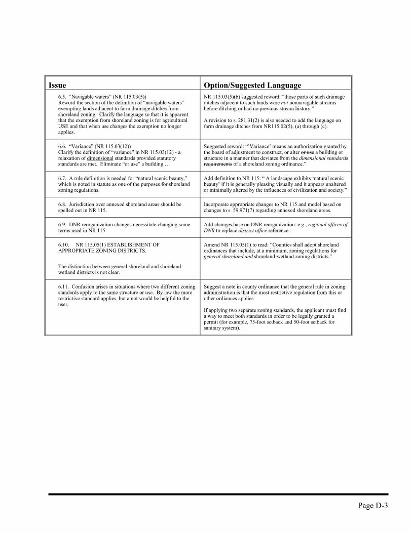
Page D-3
Issue Option/Suggested Language6.5. “Navigable waters” (NR 115.03(5))Reword the section of the definition of “navigable waters”exempting lands adjacent to farm drainage ditches fromshoreland zoning. Clarify the language so that it is apparentthat the exemption from shoreland zoning is for agriculturalUSE and that when use changes the exemption no longerapplies.
NR 115.03(5)(b) suggested reword: “those parts of such drainageditches adjacent to such lands were not nonnavigable streamsbefore ditching or had no previous stream history.”
A revision to s. 281.31(2) is also needed to add the language onfarm drainage ditches from NR115.02(5), (a) through (c).
6.6. “Variance” (NR 115.03(12))Clarify the definition of “variance” in NR 115.03(12) - arelaxation of dimensional standards provided statutorystandards are met. Eliminate “or use” a building …
Suggested reword: “’Variance’ means an authorization granted bythe board of adjustment to construct, or alter or use a building orstructure in a manner that deviates from the dimensional standardsrequirements of a shoreland zoning ordinance.”
6.7. A rule definition is needed for “natural scenic beauty,”which is noted in statute as one of the purposes for shorelandzoning regulations.
Add definition to NR 115: “ A landscape exhibits ‘natural scenicbeauty’ if it is generally pleasing visually and it appears unalteredor minimally altered by the influences of civilization and society.”
6.8. Jurisdiction over annexed shoreland areas should bespelled out in NR 115.
Incorporate appropriate changes to NR 115 and model based onchanges to s. 59.971(7) regarding annexed shoreland areas.
6.9. DNR reorganization changes necessitate changing someterms used in NR 115
Add changes base on DNR reorganization: e.g., regional offices ofDNR to replace district office reference.
6.10. NR 115.05(1) ESTABLISHMENT OFAPPROPRIATE ZONING DISTRICTS.
The distinction between general shoreland and shoreland-wetland districts is not clear.
Amend NR 115.05(1) to read: “Counties shall adopt shorelandordinances that include, at a minimum, zoning regulations forgeneral shoreland and shoreland-wetland zoning districts.”
6.11. Confusion arises in situations where two different zoningstandards apply to the same structure or use. By law the morerestrictive standard applies, but a not would be helpful to theuser.
Suggest a note in county ordinance that the general rule in zoningadministration is that the most restrictive regulation from this orother ordiances applies
If applying two separate zoning standards, the applicant must finda way to meet both standards in order to be legally granted apermit (for example, 75-foot setback and 50-foot setback forsanitary system).
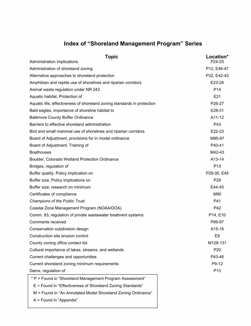
Index of “Shoreland Management Program” Series
Topic Location*Administration implications P24-25Administration of shoreland zoning P12, E46-47Alternative approaches to shoreland protection P32, E42-43Amphibian and reptile use of shorelines and riparian corridors E23-26Animal waste regulation under NR 243 P14Aquatic habitat, Protection of E21Aquatic life, effectiveness of shoreland zoning standards in protection P26-27Bald eagles, importance of shoreline habitat to E28-31Baltimore County Buffer Ordinance A11-12Barriers to effective shoreland administration P43Bird and small mammal use of shorelines and riparian corridors E22-23Board of Adjustment, provisions for in model ordinance M95-97Board of Adjustment, Training of P40-41Boathouses M42-43Boulder, Colorado Wetland Protection Ordinance A13-14Bridges, regulation of P13Buffer quality, Policy implication on P29-30, E45Buffer size, Policy implications on P29Buffer size, research on minimum E44-45Certificates of compliance M90Champions of the Public Trust P41Coastal Zone Management Program (NOAA/DOA) P42Comm. 83, regulation of private wastewater treatment systems P14, E10Comments received P89-97Conservation subdivision design A15-16Construction site erosion control E9County zoning office contact list M128-131Cultural importance of lakes, streams, and wetlands P20Current challenges and opportunities P43-46Current shoreland zoning minimum requirements P9-12Dams, regulation of P13
* P = Found in “Shoreland Management Program Assessment”
E = Found in “Effectiveness of Shoreland Zoning Standards”
M = Found in “An Annotated Model Shoreland Zoning Ordinance”
A = Found in “Appendix”
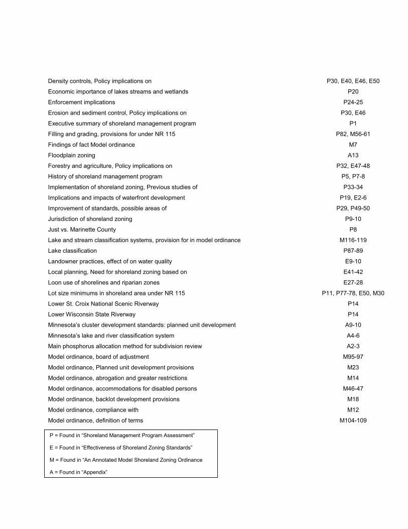
Density controls, Policy implications on P30, E40, E46, E50
Economic importance of lakes streams and wetlands P20
Enforcement implications P24-25
Erosion and sediment control, Policy implications on P30, E46
Executive summary of shoreland management program P1
Filling and grading, provisions for under NR 115 P82, M56-61
Findings of fact Model ordinance M7
Floodplain zoning A13
Forestry and agriculture, Policy implications on P32, E47-48
History of shoreland management program P5, P7-8
Implementation of shoreland zoning, Previous studies of P33-34
Implications and impacts of waterfront development P19, E2-6
Improvement of standards, possible areas of P29, P49-50
Jurisdiction of shoreland zoning P9-10
Just vs. Marinette County P8
Lake and stream classification systems, provision for in model ordinance M116-119
Lake classification P87-89
Landowner practices, effect of on water quality E9-10
Local planning, Need for shoreland zoning based on E41-42
Loon use of shorelines and riparian zones E27-28
Lot size minimums in shoreland area under NR 115 P11, P77-78, E50, M30
Lower St. Croix National Scenic Riverway P14
Lower Wisconsin State Riverway P14
Minnesota’s cluster development standards: planned unit development A9-10
Minnesota’s lake and river classification system A4-6
Main phosphorus allocation method for subdivision review A2-3
Model ordinance, board of adjustment M95-97
Model ordinance, Planned unit development provisions M23
Model ordinance, abrogation and greater restrictions M14
Model ordinance, accommodations for disabled persons M46-47
Model ordinance, backlot development provisions M18
Model ordinance, compliance with M12
Model ordinance, definition of terms M104-109
P = Found in “Shoreland Management Program Assessment”
E = Found in “Effectiveness of Shoreland Zoning Standards”
M = Found in “An Annotated Model Shoreland Zoning Ordinance
A = Found in “Appendix”
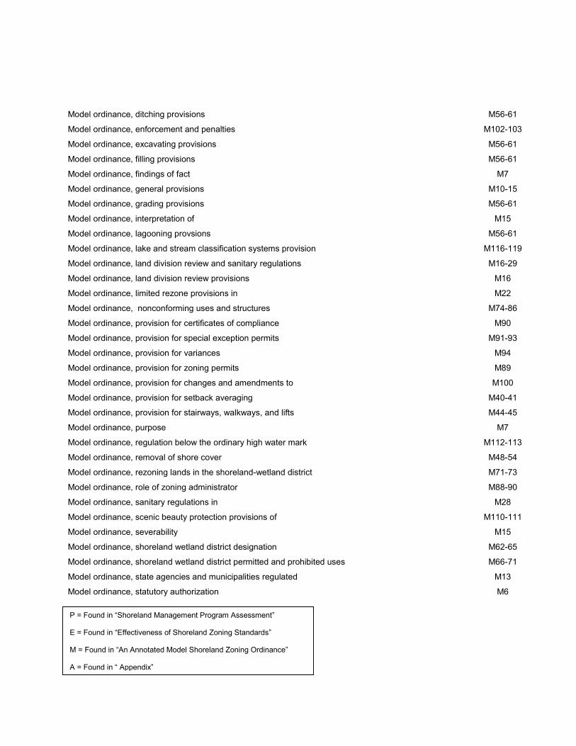
Model ordinance, ditching provisions M56-61
Model ordinance, enforcement and penalties M102-103
Model ordinance, excavating provisions M56-61
Model ordinance, filling provisions M56-61
Model ordinance, findings of fact M7
Model ordinance, general provisions M10-15
Model ordinance, grading provisions M56-61
Model ordinance, interpretation of M15
Model ordinance, lagooning provsions M56-61
Model ordinance, lake and stream classification systems provision M116-119
Model ordinance, land division review and sanitary regulations M16-29
Model ordinance, land division review provisions M16
Model ordinance, limited rezone provisions in M22
Model ordinance, nonconforming uses and structures M74-86
Model ordinance, provision for certificates of compliance M90
Model ordinance, provision for special exception permits M91-93
Model ordinance, provision for variances M94
Model ordinance, provision for zoning permits M89
Model ordinance, provision for changes and amendments to M100
Model ordinance, provision for setback averaging M40-41
Model ordinance, provision for stairways, walkways, and lifts M44-45
Model ordinance, purpose M7
Model ordinance, regulation below the ordinary high water mark M112-113
Model ordinance, removal of shore cover M48-54
Model ordinance, rezoning lands in the shoreland-wetland district M71-73
Model ordinance, role of zoning administrator M88-90
Model ordinance, sanitary regulations in M28
Model ordinance, scenic beauty protection provisions of M110-111
Model ordinance, severability M15
Model ordinance, shoreland wetland district designation M62-65
Model ordinance, shoreland wetland district permitted and prohibited uses M66-71
Model ordinance, state agencies and municipalities regulated M13
Model ordinance, statutory authorization M6
P = Found in “Shoreland Management Program Assessment”
E = Found in “Effectiveness of Shoreland Zoning Standards”
M = Found in “An Annotated Model Shoreland Zoning Ordinance”
A = Found in “ Appendix”
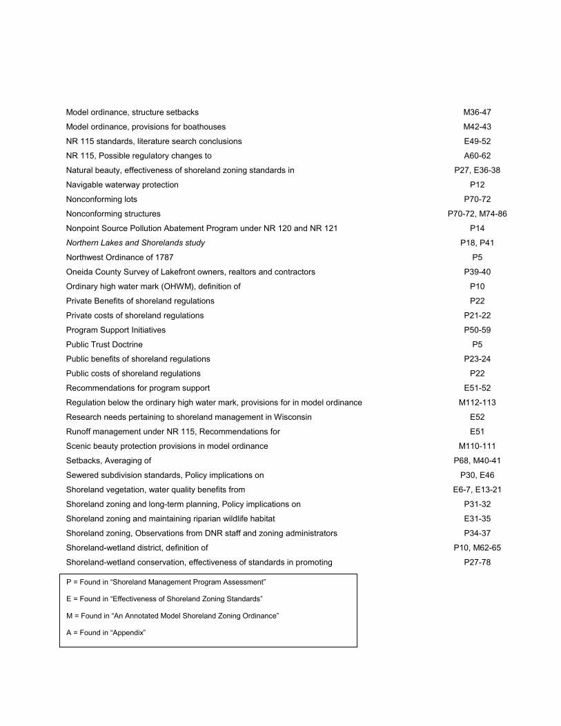
Model ordinance, structure setbacks M36-47
Model ordinance, provisions for boathouses M42-43
NR 115 standards, literature search conclusions E49-52
NR 115, Possible regulatory changes to A60-62
Natural beauty, effectiveness of shoreland zoning standards in P27, E36-38
Navigable waterway protection P12
Nonconforming lots P70-72
Nonconforming structures P70-72, M74-86
Nonpoint Source Pollution Abatement Program under NR 120 and NR 121 P14
Northern Lakes and Shorelands study P18, P41
Northwest Ordinance of 1787 P5
Oneida County Survey of Lakefront owners, realtors and contractors P39-40
Ordinary high water mark (OHWM), definition of P10
Private Benefits of shoreland regulations P22
Private costs of shoreland regulations P21-22
Program Support Initiatives P50-59
Public Trust Doctrine P5
Public benefits of shoreland regulations P23-24
Public costs of shoreland regulations P22
Recommendations for program support E51-52
Regulation below the ordinary high water mark, provisions for in model ordinance M112-113
Research needs pertaining to shoreland management in Wisconsin E52
Runoff management under NR 115, Recommendations for E51
Scenic beauty protection provisions in model ordinance M110-111
Setbacks, Averaging of P68, M40-41
Sewered subdivision standards, Policy implications on P30, E46
Shoreland vegetation, water quality benefits from E6-7, E13-21
Shoreland zoning and long-term planning, Policy implications on P31-32
Shoreland zoning and maintaining riparian wildlife habitat E31-35
Shoreland zoning, Observations from DNR staff and zoning administrators P34-37
Shoreland-wetland district, definition of P10, M62-65
Shoreland-wetland conservation, effectiveness of standards in promoting P27-78
P = Found in “Shoreland Management Program Assessment”
E = Found in “Effectiveness of Shoreland Zoning Standards”
M = Found in “An Annotated Model Shoreland Zoning Ordinance”
A = Found in “Appendix”
Special exception permits M91-93
State Platting Regulations (Ch 236, Wis. Stats.) P15
Statutory authorization, Model ordinance M6
Stormwater Management and Construction Site Erosion Control (NR 216) P15
Structure setbacks P63-69, M36-47
Structure setbacks under NR 115 P11, E49-50
Trends in waterfront development P17
Town of Wascott Lakes Plan A7-8
UW-Extension Local Government Center P41
Uniform Dwelling Code (Comm 21.125) P15
University of Wisconsin – Extension Urban and Regional Planning P96
Variance M94
Vegetative cutting provisions under NR 115 P11, P72-76, E50
WDNR Actions to improve program implementation, Recent P40-43
Water quality protection functions provided by NR 115 E5-6
Water quality protection, Policy implications for E11-12
Waterfront development trends and need for shoreland regulations P6
Waterfront owners, Attitudes and characteristics of P37-39
Waterfront users, Attitudes and characteristics of P37-39
Weaknesses in the shoreland zoning regulations P37
Wetland water quality standards P13
Wetlands, Policy implications on P30-31, P79-81, E45-46
Why Protect Shoreland Areas? P41
Wisconsin Association of Lakes P93, P96
Wisconsin Builders Association P92, P95-96
Wisconsin County Code Administrators P93, P96
Wisconsin Lakes Partnership, UW-Extension Component of P41, P96
Wisconsin Paper Industry P92
Wisconsin Wetland Inventory P8
Zoning Administrator, role of in model ordinance M88-90
Zoning permits M89
P = Found in “Shoreland Management Program Assessment”
E = Found in “Effectiveness of Shoreland Zoning Standards”
M = Found in “An Annotated Model Shoreland Zoning Ordinance”
A = Found in “Appendix”