INFORM Newsletter 2016inform.vgt.vito.be/files/documents/INFORM-Newsletter _ Dec2016.pdf ·...
20
INFORM Newsletter 2016
Transcript of INFORM Newsletter 2016inform.vgt.vito.be/files/documents/INFORM-Newsletter _ Dec2016.pdf ·...
INFORMNewsletter 2016

Content
- News from ESA on Sentinels
- Third Year Progress
- Campaigns 2016
- Contribution to User Requirements for Next Generation
Copernicus Satellites
- Publications
- Past Events
- Upcoming Events
News from ESA on Sentinels
© VITO
- Planned launch of Sentinel-2BMarch 2017
The second Sentinel-2 satellite, Sentinel-2B, is planned for launch in March 2017.
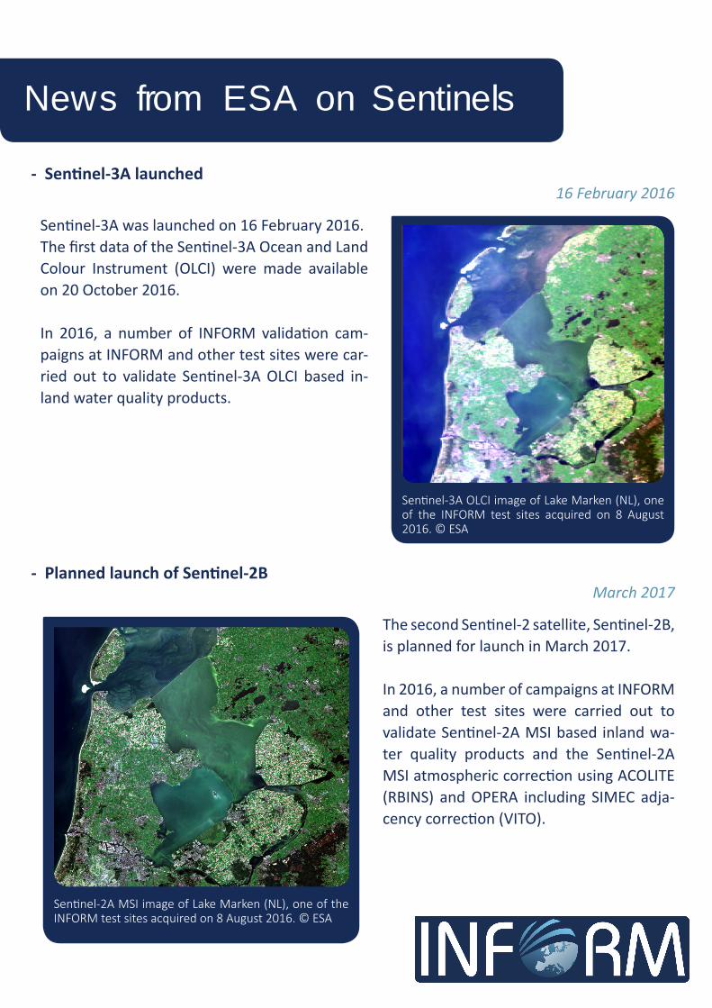
In 2016, a number of campaigns at INFORM and other test sites were carried out to validate Sentinel-2A MSI based inland wa-ter quality products and the Sentinel-2A MSI atmospheric correction using ACOLITE (RBINS) and OPERA including SIMEC adja-cency correction (VITO).
Sentinel-2A MSI image of Lake Marken (NL), one of the INFORM test sites acquired on 8 August 2016. © ESA
- Sentinel-3A launched16 February 2016
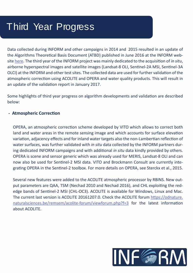
Sentinel-3A was launched on 16 February 2016. The first data of the Sentinel-3A Ocean and Land Colour Instrument (OLCI) were made available on 20 October 2016.
In 2016, a number of INFORM validation cam-paigns at INFORM and other test sites were car-ried out to validate Sentinel-3A OLCI based in-land water quality products.
Sentinel-3A OLCI image of Lake Marken (NL), one of the INFORM test sites acquired on 8 August 2016. © ESA
Third Year Progress
Data collected during INFORM and other campaigns in 2014 and 2015 resulted in an update of the Algorithms Theoretical Basis Document (ATBD) published in June 2016 at the INFORM web-site here. The third year of the INFORM project was mainly dedicated to the acquisition of in situ, airborne hyperspectral images and satellite images (Landsat-8 OLI, Sentinel-2A MSI, Sentinel-3A OLCI) at the INFORM and other test sites. The collected data are used for further validation of the atmospheric correction using ACOLITE and OPERA and water quality products. This will result in an update of the validation report in January 2017.
Some highlights of third year progress on algorithm developments and validation are described below:
- Atmospheric Correction
OPERA, an atmospheric correction scheme developed by VITO which allows to correct both land and water areas in the remote sensing image and which accounts for surface elevation variation, adjacency effects and for inland water targets also the non-Lambertian reflection of water surfaces, was further validated with in situ data collected by the INFORM partners dur-ing dedicated INFORM campaigns and with additional in situ data kindly provided by others. OPERA is scene and sensor generic which was already used for MERIS, Landsat-8 OLI and can now also be used for Sentinel-2 MSI data. VITO and Brockmann Consult are currently inte-grating OPERA in the Sentinel-2 toolbox. For more details on OPERA, see Sterckx et al., 2015.
Several new features were added to the ACOLITE atmospheric processor by RBINS. New out-put parameters are QAA, TSM (Nechad 2010 and Nechad 2016), and CHL exploiting the red-edge bands of Sentinel-2 MSI (CHL-OC3). ACOLITE is available for Windows, Linux and Mac. The current last version is ACOLITE 20161207.0. Check the ACOLITE forum https://odnature.naturalsciences.be/remsem/acolite-forum/viewforum.php?f=3 for the latest information about ACOLITE.

Maps of predominant groups of phytoplankton in Mantua Lakes produced from Sentinel-2 MSI data. The yellow stars indicate the in situ sampling stations. © CNR-IREA
Third Year Progress
- Phytoplankton Functional Types
For phytoplankton pigment (Chl-a, phycocyanin, phycoerythrin and carotenoids) the approach previously used for APEX data was adapted and used for Sentinel-2 MSI images in eutrophic lakes (Mantua) and lagoon (Curonia). Moreover, the bio-optical model has been initially pa-rameterized in order to derive Chl-a concentration for Lake Balaton. The integration of the semi-empirical adaptive algorithm and the bio-optical model for the estimation of the Chl-a concentration in Lake Mantua from Sentinel-2 MSI images is shown here.The validation of the Chl-a obtained from the Sentinel-2 MSI product was found to be (r2 0.92; MAE 4.21; rRMSE 17.77%; n=26). The PFT maps have also been validated with phytoplankton cell counts and found to be in agreement.
Maps of Chl-a in Mantua Lakes for four dates produced from Sentinel-2 MSI. The maps show a Chl-a con-centration gradient from upstream to downstream, moving from lotic to lentic waters. © CNR-IREA
Third Year Progress
- Macrophytes
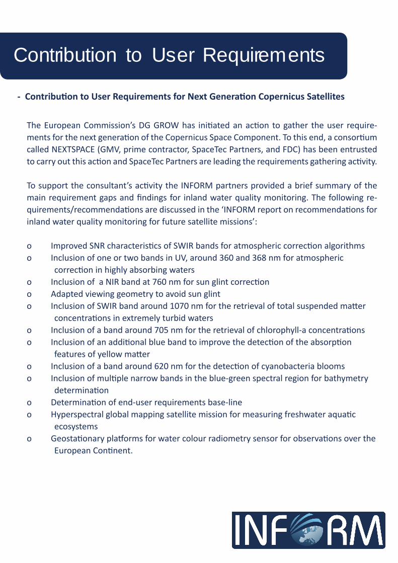
The algorithms for mapping macrophyte biophysical parameters (fractional cover, LAI, bio-mass and canopy Chl-a concentration) were adapted and recalibrated for Sentinel-2 MSI spec-tral characteristics, and were then tested over selected study areas. Plant morpho-functional data collected in situ during the 2016 growing season (June-September) over the Mantua lakes system and Kis Balaton water reservoir system were used to validate community type maps (Villa et al., 2015) and biophysical parameters maps produced using INFORM algorithms.Macrophyte products were derived using 2016 Landsat-8 OLI and Sentinel-2 MSI data over additional study areas: Nemunas river delta (Lithuania), Lac du Grand Lieu (France) and Small Island of Braila (Romania).
- TSM and Turbidity
The TSM algorithm of Nechad et al. (2010) was recalibrated for use in Lake Balaton (Hungary) due to the difference of inherent optical properties (IOPs) of the lake sediments compared to the IOPs of sediments found in the North Sea which were originally used to develop the Nechad et al. (2010) algorithm. In situ measurements showed the back scatter coefficient of sediments found in Lake Balaton to be significantly higher compared to the North Sea situa-tion. The regional TSM product is made available in the ACOLITE product portfolio. Nechad (2010) was also used to derive TSM maps of Lake Marken in the Netherlands which were validated against in situ measurements per-formed by VITO and U STIRLING (r2=0.67; n=9).
Macrophyte biophysical parameters maps produced from Sentinel-2 MSI data acquired on 28 July 2016 over Man-tua lakes system: a) fractional cover (fC), and b) above water biomass. © CNR-IREA

Third Year Progress
- Algorithm for comparison of biogeochemical model output & Earth Observation data
VITO developed in collaboration with Deltares, the INFORM modelling partner, an algorithm to compare water quality models with Earth Observation (EO) data in order to further en-hance the water quality modelling and the EO products. The algorithm (a set of Matlab rou-tines) compares the outcome of the water quality model to EO products and evaluates the quality of the results based on selected statistical indicators. The base for this work are the Delft3D WAQ model and the MERIS based Earth Observation data of Total Suspended Matter and Chl-a of Lake Marken for the year 2006. After further testing in 2017, the EO-model com-parison Matlab routines will be made available in the OpenEarth repository https://publicwi-ki.deltares.nl/display/OET/OpenEarth.
- Attenuation and Euphotic Depth
RBINS worked on adapting the quasi-analytical algorithm (QAA) to be used with new and up-coming sensors, such as Landsat-8 OLI and Sentinel-2 MSI for inland water cases. They have refined the QAA by recalibrating the empirical relationships and performing a spectral shift to the data to simulate MERIS-like bands from the Landsat-8 OLI and Sentinel-2 MSI data. The adapted QAA has been implemented to ACOLITE enabling the generation of a variety of Kd products from Landsat-8 OLI data and Sentinel-2 MSI data in the future.
TSM map based on Nechad (2010) of Lake Marken on 8/9/2016 (left) and 15/9/2016 (right) produced after at-mospheric correc-tion of Sentinel-2 MSI image with OP-ERA © VITO (source Sentinel-2 MSI ESA)
- Contribution to User Requirements for Next Generation Copernicus Satellites
The European Commission’s DG GROW has initiated an action to gather the user require-ments for the next generation of the Copernicus Space Component. To this end, a consortium called NEXTSPACE (GMV, prime contractor, SpaceTec Partners, and FDC) has been entrusted to carry out this action and SpaceTec Partners are leading the requirements gathering activity.
To support the consultant’s activity the INFORM partners provided a brief summary of the main requirement gaps and findings for inland water quality monitoring. The following re-quirements/recommendations are discussed in the ‘INFORM report on recommendations for inland water quality monitoring for future satellite missions’:
o Improved SNR characteristics of SWIR bands for atmospheric correction algorithmso Inclusion of one or two bands in UV, around 360 and 368 nm for atmospheric correction in highly absorbing waterso Inclusion of a NIR band at 760 nm for sun glint correctiono Adapted viewing geometry to avoid sun glinto Inclusion of SWIR band around 1070 nm for the retrieval of total suspended matter concentrations in extremely turbid waterso Inclusion of a band around 705 nm for the retrieval of chlorophyll-a concentrationso Inclusion of an additional blue band to improve the detection of the absorption features of yellow mattero Inclusion of a band around 620 nm for the detection of cyanobacteria bloomso Inclusion of multiple narrow bands in the blue-green spectral region for bathymetry determinationo Determination of end-user requirements base-lineo Hyperspectral global mapping satellite mission for measuring freshwater aquatic ecosystemso Geostationary platforms for water colour radiometry sensor for observations over the European Continent.
Contribution to User Requirements

Campaigns 2016
In 2016, two field campaigns were organized on 24-25 August 2016 in the Curonian Lagoon concurrent with Sentinel-2 acquisition. One of the major testing campaigns with acquisition of in situ data concurrent with airborne APEX imaging spectrometer acquisitions (partly fund-ed by EUFAR) and satellite acquisitions took place from 1 September to 2 September 2016 at the Curonian Lagoon. Field campaigns were organized by Klaipeda University with collabora-tion and participation of CNR.The objectives of the APEX campaign were: - to acquire APEX imagery in support of INFORM atmospheric correction and water quality algorithm development; - to provide in situ data (optical and biogeochemical) in support of the validation of APEX-based products; - to provide in situ data (optical and biogeochemical) in support of the validation of Landsat-8 OLI, Sentinel-2 MSI or Sentinel-3 OLCI.
During 24 August 2016 one image of Sentinel-2 and during 1 September 2016 one image of Sentinel-3 concurrent with field sampling are available for further research.
The CNR team made in situ subsurface irradiance reflectance and remote-sensing reflectance measurements with a WISP-3 and SpectralEvolution on 31 August and 1-2 September 2016.
- Campaigns @ Curonian Lagoon, LithuaniaAugust-September 2016
In 2016 several field campaigns concurrent with satellite acquisition and at the Curonian Lagoon (Lithuania) also concurrent with APEX airborne imaging spectrometer acquisition were conduct-ed in Lake Balaton and Kis-Balaton (Hungary), Lake Marken (the Netherlands), Venice Lagoon, Mantua Lakes, Lake Garda and Po river (Italy), Loch Lomond and Loch Leven (UK), Danube Delta (Romania) and Black Sea. The data will be used for the validation of the atmospherically cor-rected images and water quality products derived from Landsat-8 OLI, Sentinel-2 MSI, Sentinel-3 OLCI and APEX images as well as for re-calibration of the biogeochemical models of Lake Balaton and Lake Marken.

Campaigns 2016
Left: Picture of the Curonian Lagoon water during the September 2016 field campaign. © KURight: Scum formation in the Curonian Lagoon as captured by the APEX airborne imaging spectrometer on 1 September 2016. © VITO
Laboratory analysis of collected water samples for Chl-a and phycocyanin concentration, CDOM, SPM, SPIM, SPOM, DOC, absorption by phytoplankton and non-algal particles, were performed by Klaipeda University. Chl-a of ‘spectral’ algal groups were measured in situ using fluorometer FluoroProbe II (bbe Moldaenke GmbH).
Left: Collecting Rrs spectra with the WISP-3 (Water Insight) instrument in the Curonian Lagoon on 1 September 2016. © KURight: Secchi disc depth measurements in the Curonian Lagoon during the September 2016 field campaign. © KU

Several field campaigns were organized at Lake Marken by VITO, the University of Stirling, Deltares and Rijkswaterstaat to further validate the OPERA atmospheric correction (including adjacency correction) and water quality products based on Sentinel-2 MSI, and to further calibrate the biogeochemical module BLOOM of the DELFT-3D WAQ modelling software suite developed by Deltares for Lake Marken.
On 26 August vertical profile and grid-based measurements of turbidity and Chl-a at Hoorn- sche Hop (in the western part of Lake Marken) were performed for further calibration of the biogeochemical BLOOM module and for comparison of in situ YSI6600V2 turbidity/Chl-a with lab HACH turbidity/Chl-a measurements.
On 8 September field spectroradiometer measurements were acquired from a fixed loca-tion near Hoornsche Hop concurrent with water samples for Chl-a retrieval, Total Suspended Matter (TSM) concentration and turbidity measurements. In addition, sun photometer meas-urements were performed in Hoorn for retrieval of the atmospheric correction parameters aerosol optical thickness and water vapor concentration. Water samples were acquired from a fixed location near Lelystadhaven (in the eastern part of Lake Marken). Water samples were collected 15’ before, during and 15’ after Sentinel-3 and Sentinel-2 overpasses over Lake Marken.
On 14-16 September a team led by the University of Stirling acquired remote-sensing reflec-tances and inherent optical properties measurements at 16 stations located over a biogeo-chemical gradient on Lake Marken for validation of Sentinel-2 MSI and Sentinel-3 OLCI data. Large volume water samples were collected from the surface and analysed for Chl-a and other phytoplankton pigments, TSM, turbidity and CDOM. Depth profiles of chlorophyll and CDOM fluorescence and turbidity were also obtained and shipborne sun photometer meas-urements were collected to support atmospheric correction.
Campaigns 2016
- Campaigns @ Lake Marken, The NetherlandsAugust-September 2016

Campaigns 2016
Collecting Rrs spectra with the ASD FieldSpec FR instrument in Lake Marken on 8 September 2016. © VITO
Left: Measuring Chl-a, turbidity and pH in Lake Marken on 26 August 2016. © VITO Right: Optical measurements at Lake Marken, September 2016. © U STIRLING
In 2016, one field campaign was conducted by CNR and BLI on 21 and 22 July 2016, concur-rent with Landsat-8 and Sentinel-2 overpasses, respectively.The CNR team made in situ remote-sensing reflectance and subsurface irradiance reflectance with an ASD FieldSpec FR and SpectralEvolution spectroradiometer.
- Campaigns @ Lake Balaton and Kis Balaton, HungaryJuly 2016

Campaigns 2016
- Campaigns @ Lake Balaton and Kis Balaton, HungaryJuly 2016
Water samples were collected from 10 validation stations in Lake Balaton for the analysis of bio-optical and biogeochemical parameters in the laboratory. Water temperature and con-ductivity were measured in situ by a multiparameter probe. Secchi disk depth was also meas-ured. The collected water samples were analyzed in the BLI laboratory for determination of Chl-a, TSM and CDOM.
Macrophyte samples were collected in 11 stations from Kis-Balaton and the dry weight bio-mass determined in the BLI laboratory. In addition, subsamples of the macrophytes were retained for pigment (Chl-a and carotenoids) analyses.
- Campaigns @ Mantua Lakes, ItalyJune-September 2016
In 2016, five field campaigns were conducted by CNR from June to September (8 and 21 June, 11 and 28 July, 19 September) in Mantua Lakes (5 stations) concurrent with Landsat-8 OLI (8 June and 19 September) and Sentinel-2 (in all dates) overpasses. The CNR team made in situ remote-sensing reflectance and subsurface irradiance reflectance with an ASD FieldSpec FR, SpectralEvolution, and WISP-3 spectroradiometers. Inherent opti-cal properties (aphyto, aNAP, aCDOM, bb) and water quality parameters (Chl-a, TSM, nutri-ents) were also measured for validation purposes. Moreover, phytoplankton samples were collected for identification and counts by microscopy, and pigment determination and quan-tification by HPLC. Macrophyte canopy reflectance was measured in situ for three species (Nelumbo nucifera, Trapa natans and Nuphar lutea; 2 sites and 3 replicates) and subsamples were collected for leaf reflectance, biomass, and pigments (chlorophyll and carotenoids) measurements.
Collecting remote-sensing reflectance spectra with Spectral-Evolution on 28 July 2016, and plot of T. natans in Mantua Lakes. © CNR

Publications
For a list of INFORM-related peer-reviewed papers and conference papers, see the INFORM website (http://www.copernicus-inform.eu/content/publications).
Papers (after the end of the journal embargo period) can also be accessed from the FP7 INFORM project community in the ZENODO repository (https://zenodo.org/collection/user-fp7inform) which is linked to the OpenAIRE repository.
https://zenodo.org/collection/user-fp7inform
Past Events
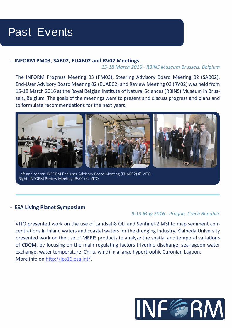
- INFORM PM03, SAB02, EUAB02 and RV02 Meetings15-18 March 2016 - RBINS Museum Brussels, Belgium
The INFORM Progress Meeting 03 (PM03), Steering Advisory Board Meeting 02 (SAB02), End-User Advisory Board Meeting 02 (EUAB02) and Review Meeting 02 (RV02) was held from 15-18 March 2016 at the Royal Belgian Institute of Natural Sciences (RBINS) Museum in Brus-sels, Belgium. The goals of the meetings were to present and discuss progress and plans and to formulate recommendations for the next years.
- ESA Living Planet Symposium9-13 May 2016 - Prague, Czech Republic
VITO presented work on the use of Landsat-8 OLI and Sentinel-2 MSI to map sediment con-centrations in inland waters and coastal waters for the dredging industry. Klaipeda University presented work on the use of MERIS products to analyze the spatial and temporal variations of CDOM, by focusing on the main regulating factors (riverine discharge, sea-lagoon water exchange, water temperature, Chl-a, wind) in a large hypertrophic Curonian Lagoon. More info on http://lps16.esa.int/.
Left and center: INFORM End-user Advisory Board Meeting (EUAB02) © VITORight: INFORM Review Meeting (RV02) © VITO

Past Events
- European Space Solutions 30 May - 3 June 2016 - The Hague, The Netherlands
VITO participated in the 4th edition of European Space Solutions hosted by the Government of the Netherlands with an INFORM stand in the Copernicus Earth Observation village and an oral presentation. http://www.european-space-solutions.eu/
- GEO AquaWatch Meeting8-10 June 2016 - Koblenz, Germany
A GEO AquaWatch, the GEO Water Quality Community of Practice, meeting was held in con-junction with the GEO Integrated Global Water Cycle Observation annual meeting. VITO pre-sented the status of the INFORM project at the joint meeting. For information on GEO Aqua-Watch and the new GEO AquaWatch flyer, see http://www.geo-water-quality.org/home.
Left and center: INFORM stand at the Earth Observation village of ESS2016.Right: VITO presenting EO for water quality in support of the dredging industry at the River Deltas session of ESS2016.
- EU Research & Innovation in Support to the Earth Observation Market21-22 September 2016 - Brussels, Belgium
VITO gave an oral presentation on the use of drone-based and EO-based water quality prod-ucts in support of the dredging industry.
- 13th Water Forum 14 October 2016 - Gent, Belgium
VITO presented the INFORM and other EO- and drone-based water quality project results at the Flemish Water Forum attended by water managers and environmental agencies.

- ISSI Workshop on Exploring the Earth’s Ecosystem on a Global Scale; Requirements, Capabilities & Directions in Space-Borne Imaging Spectroscopy
21-25 November 2016 - Bern, Switzerland
VITO and CNR were both invited to give a presentation on Inland and Coastal Water Quality Products from Imaging Spectroscopy at the ISSI Workshop. http://www.issibern.ch/workshops/earthecosystem/
Klaipeda University presenting their work on the Curonian La-goon at S2VT. © VITO
- INFORM PM04 Meeting30 November 2016 – CNR, Rome, Italy
The INFORM Progress Meeting 04 (PM04) was held on 30 November 2016 at CNR, Rome, Italy.
The goals of the meeting were to present and discuss
- 1st Sentinel-2 Validation Team Workshop28-29 November 2016 – ESA-ESRIN, Italy
VITO presented the OPERA atmospheric correction and val-idation results for Landsat-8 OLI and Sentinel-2 MSI.
Several posters were presented by VITO, CNR, KU, PML and RBINS on validation activities.http://esaconferencebureau.com/2016-events/16c20/presentations
progress of the third year and the activities planned for the fourth year like the demonstration activities and the INFORM Results Uptake Workshop.
Past Events

Upcoming Events
CNR submitted an abstract for an oral presentation entitled ‘Potential retrieval of phytoplank-ton pigments in optically complex waters from FLEX/Sentinel-3 Tandem Mission’.More info on http://www.earsel.org/SIG/IS/workshops/10-IS-Workshop/index.php.
- 10th EARSeL SIG Imaging Spectroscopy Workshop19-21 April 2017 – Zürich, Switzerland
- 10th Symposium for European Freshwater Sciences2-7 July 2017 – Olomouc, Czech Republic
BLI is planning to attend SEFS. More info on http://www.sefs10.cz/
- INFORM Results Uptake WorkshopAutumn-Winter 2017 - TBC
The INFORM project partners are organizing a 2-day INFORM Results Uptake Workshop for end-users (e.g. water managers, environmental agencies, …), industry, space agencies and researchers.
- ASLO Aquatic Sciences Meeting26 February-3 March 2017 – Honolulu, Hawaii
CNR, U STIRLING and PML together with US and Chinese research institutes organize a session entitled ‘Global Remote Sensing of Inland Water’ on 28 February 2017 to discuss all aspects of remote sensing of inland water research and their global relevance.https://www.sgmeet.com/aslo/honolulu2017/

- Vlaamse Instelling voor Technologisch Onderzoek N.V. (VITO), Belgium - Consiglio Nazionale Delle Ricerche (CNR), Italy - EOMAP GmbH & Co.KG, Germany - The University of Stirling (U STIRLING), United Kingdom - Institut Royal des Sciences Naturelles de Belgique / Koninklijk Belgisch Instituut voor Natuurwetenschappen (RBINS), Belgium - Stichting Deltares (Deltares), the Netherlands - Plymouth Marine Laboratory (PML), United Kingdom - Magyar Tudomanyos Akademia Okologiai Kutatokozpont (MTA OK), Hungary - Klaipedos Universitetas (KU), Lithuania
Partners

INFORM Project CoordinatorDr. Ils ReusenTel.: +32 14 33 68 62E-mail: [email protected]
VITORemote SensingBoeretang 200BE-2400 MolBelgiumremotesensing.vito.be | [email protected]
www.copernicus-inform.eu