IGTF 2016 / ASPRS ANNUAL MEETING … 2016 / ASPRS ANNUAL MEETING PRELIMINARY PROGRAM Venue: Fort...
35
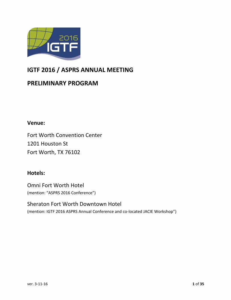
ver. 3-11-16 1 of 35 IGTF 2016 / ASPRS ANNUAL MEETING PRELIMINARY PROGRAM Venue: Fort Worth Convention Center 1201 Houston St Fort Worth, TX 76102 Hotels: Omni Fort Worth Hotel (mention: “ASPRS 2016 Conference”) Sheraton Fort Worth Downtown Hotel (mention: IGTF 2016 ASPRS Annual Conference and co-located JACIE Workshop”)
Transcript of IGTF 2016 / ASPRS ANNUAL MEETING … 2016 / ASPRS ANNUAL MEETING PRELIMINARY PROGRAM Venue: Fort...
ver. 3-11-16 1 of 35
IGTF 2016 / ASPRS ANNUAL MEETING
PRELIMINARY PROGRAM
Venue:
Fort Worth Convention Center
1201 Houston St
Fort Worth, TX 76102
Hotels:
Omni Fort Worth Hotel (mention: “ASPRS 2016 Conference”)
Sheraton Fort Worth Downtown Hotel (mention: IGTF 2016 ASPRS Annual Conference and co-located JACIE Workshop”)

ver. 3-11-16 2 of 35
MONDAY PROGRAM, APRIL 11, 2016
ASPRS and JACIE Registration Registration April 11 07:30 - 17:00 13th Street Lobby Registration Moderator 1: 265
Standards Committee Joint with Forensics Group Business Meeting April 11 08:00 - 09:00 102 Moderator 1: 276
IGTF 2016 Exhibit Hall Business Meeting April 11 08:00 - 18:00 CC Exhibit Hall A
WS#153 Utilizing Cloud Computing for Geospatial Applications Workshop April 11 08:30 - 10:15 103 B
08:30 - 10:15
UTILIZING CLOUD COMPUTING FOR GEOSPATIAL APPLICATIONS B. Vander Jagt.
WS#168 Remote Sensing of Vegetation Workshop April 11 08:30 - 10:30 204 A
08:30 - 10:15 Remote Sensing of Vegetation C. Olson.
WS#116 Object Based Image Analysis Approach for Extraction Workshop

ver. 3-11-16 3 of 35
April 11 08:30 - 10:30 104
08:30 - 10:15
Object Based Image Analysis approach for extraction of Urban Tree Canopy I. Rizvi.
WS#173 Calibrating Film Digital Sensors for Today's RS Workshop April 11 08:30 - 12:30 103 A
08:30 - 12:30
Calibrating Film and Digital Sensors for Today’s Remote Sensing Business Q. Abdullah, D. Light.
WS#23 Field Data Collection Techniques for Development RS Workshop April 11 08:30 - 12:30 203 A
08:30 - 12:30
Field Data Collection Techniques for the Development of Remote Sensing Ground Truth, Including "the Most Accurate, Least Expensive, and Most Easily Applied" Method. K. Stumpf, S. Romberg.
WS#32 Hyperspectral and Extended Multispectral RS Workshop April 11 08:30 - 12:30 203 B
08:30 - 12:30
Hyperspectral and Extended Multispectral Remote Sensing: Phenomenology, Sensor Systems, and Data Processing W. Farrand.
WS#76 UAV Data Georeferencing: State-of-the-Art/New Trends Workshop April 11 08:30 - 12:30 203 C
08:30 - 12:30
Workshop Title: UAV Data Georeferencing: State-of-the-Art and New Trends J. Hutton, M. Mostafa.
Awards Committee Meeting Business Meeting April 11

ver. 3-11-16 4 of 35
09:00 - 11:00 102 Moderator 1: 274
WS#122 WorldDEM:The New Global Elevation Solution-data Workshop April 11 10:30 - 12:30 204 A
10:30 - 12:30
WorldDEM: The new global elevation solution - data acquisition, processing and use-cases J. Collins.
WS#127 Empowering 3D GIS From Drone Imagery and Lidar Workshop April 11 10:30 - 12:30 104
10:30 - 12:30 Empowering 3D GIS from Drone Imagery and Lidar S. Moorish, S. Snow.
WS#297 Utilizing Cloud Computing for Geospatial Applications Workshop April 11 10:30 - 12:30 103 B
10:30 - 12:30
UTILIZING CLOUD COMPUTING FOR GEOSPATIAL APPLICATIONS B. Vander Jagt.
Data Preservation and Archiving Committee (DPAC) Meeting Business Meeting April 11 11:00 - 12:00 102 Moderator 1: 276
PAD Defense and Intelligence, (D&I) Committee Meeting Business Meeting April 11 11:30 - 12:30 201 A Moderator 1: 175
Lidar Division, (LD) Committee Meeting

ver. 3-11-16 5 of 35
Business Meeting April 11 12:00 - 13:00 102 Moderator 1: 276
Photogrammetric Applications Division, (PAD) Meeting Business Meeting April 11 12:30 - 13:30 201 A Moderator 1: 276
Professional Practice Division, (PPD) Meeting Business Meeting April 11 13:00 - 14:00 102 Moderator 1: 276
ver. 3-11-16 6 of 35
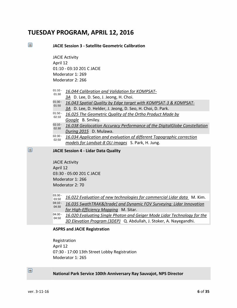
TUESDAY PROGRAM, APRIL 12, 2016
JACIE Session 3 - Satellite Geometric Calibration
JACIE Activity April 12 01:10 - 03:10 201 C JACIE Moderator 1: 269 Moderator 2: 266 01:10 - 01:30
16.044 Calibration and Validation for KOMPSAT-3A D. Lee, D. Seo, J. Jeong, H. Choi.
01:30 - 01:50
16.043 Spatial Quality by Edge target with KOMPSAT-3 & KOMPSAT-3A D. Lee, D. Helder, J. Jeong, D. Seo, H. Choi, D. Park.
01:50 - 02:10
16.025 The Geometric Quality of the Ortho Product Made by Google B. Smiley.
02:10 - 02:30
16.038 Geolocation Accuracy Performance of the DigitalGlobe Constellation During 2015 D. Mulawa.
02:30 - 02:50
16.034 Application and evaluation of different Topographic correction models for Landsat-8 OLI images S. Park, H. Jung.
JACIE Session 4 - Lidar Data Quality
JACIE Activity April 12 03:30 - 05:00 201 C JACIE Moderator 1: 266 Moderator 2: 70 03:30 - 03:50 16.022 Evaluation of new technologies for commercial Lidar data M. Kim. 04:10 - 04:30
16.035 SwathTRAK&[trade] and Dynamic FOV Surveying: Lidar Innovation for High-Efficiency Mapping M. Sitar.
04:30 - 04:50
16.020 Evaluating Single Photon and Geiger Mode Lidar Technology for the 3D Elevation Program (3DEP) Q. Abdullah, J. Stoker, A. Nayegandhi.
ASPRS and JACIE Registration Registration April 12 07:30 - 17:00 13th Street Lobby Registration Moderator 1: 265
National Park Service 100th Anniversary Ray Sauvajot, NPS Director

ver. 3-11-16 7 of 35
Plenary Session April 12 08:00 - 09:00 CC Ballroom B
00:00 - 00:00
Ray Sauvajot, Director Resource Stewardship and Science 100th Anniversary National Park Service Keynote J. Lenczowski, M. Hauck.
JACIE Session 1 - U.S. Agency Talks w/ Q&A
JACIE Activity April 12 08:00 - 09:50 201 C JACIE Moderator 1: 70 Moderator 2: 263 08:00 - 08:20 Welcome Address G. Stensaas. 08:20 - 08:40 Agency Talks with Questions and Answers G. Bethel. 08:40 - 09:00 Agency Talk M. Goldberg. 09:00 - 09:20 Session 1 K. Thome.
Special Outreach Session: Earth's Landscape Features: Identification and Change
Analysis through Remote Sensing Frontier Day STEM Activity April 12 08:30 - 16:00 Region 11 Ed Service Center by Invitation Only Contact [email protected] Moderator 1: 52 Moderator 2: 58 08:30 - 16:00
Earth's Landscape Features: Identification and Change Analysis through Remote Sensing R. Dodge.
Morning Refreshments Social Function April 12 09:30 - 10:00 CC Exhibit Hall A Moderator 1: 265 Moderator 2: 280
Spectroscopy and plant monitoring

ver. 3-11-16 8 of 35
Oral Slide-Based April 12 10:00 - 11:30 202 C
10:00 - 10:22
Hyperspectral remote-sensing estimation of rice leaf water content A. Filippi, L. Tarpley, B. Güneralp, E. Guenther.
10:22 - 10:44
Ozone stress detection using field hyperspectral spectroscopy and plant biophysical variables of several plants grown in ozone gardens G. Sataer, A. Ghulam, M. Maimaitiyiming, A. Bozzolo, K. Belina, J. Fishman.
10:44 - 11:06
Using Spectroscopy Remote Sensing to Assess Stress Factors of Vegetation Water Content on Black Needlerush in the Florida Everglades D. Selch, C. Zhang.
11:06 - 11:28
Quantitative characterization of within-leaf spatial variability of narrow-band vegetation index values for rice leaves E. Guenther, A. Filippi, L. Tarpley, B. Guneralp.
GEOBIA
Oral Slide-Based April 12 10:00 - 11:30 204 A
10:00 - 10:22
Mapping Urban Land Cover to assess Sea-Level Rise Vulnerable Areas - A Comparison of Classification Models for Aerial and LiDAR Data Fusion. N. Gamboa, C. Zhang.
10:22 - 10:44
GIS Analysis of GEOBIA and Multi-Sensor Based High Spatial Resolution Land Cover Mapping of Hall County Georgia J. Sharma, J. Nolan, J. Dees, B. Bennett.
10:44 - 11:06
An object-based image analysis approach for mapping salt marsh habitats for the state of Rhode Island C. Robinson, R. Weber, E. Morris, N. Herold, K. Raposa.
11:06 - 11:28
Random Forest classi?cation of wetland communities using geomorphometry, quad-polarimetric SAR, lidar and optical remote sensing data O. Ahmed, M. Stefanuk, E. Skeries, S. Franklin.
Remote Sensing the Urban Environment
Oral Slide-Based April 12 10:00 - 11:30 202 D
10:00 - 10:22
Analysis and Monitoring of the Urban Landscape using Sentinel-1 Imagery F. Warmate, C. Rizos, J. Trinder.
10:22 - 10:44 Urban Tree Structure Parameter Retrieval from Aerial Stereo Imaging,

ver. 3-11-16 9 of 35
LiDAR, InSAR and Polarimetric InSAR S. Hartling, A. Ghulam, B. Bira, B. Marshall, J. Carron, G. Sataer.
10:44 - 11:06
Monitoring Annual Urban Growth in Northwest Arkansas with A 20-year Landsat Record R. Reynolds, L. Liang.
11:06 - 11:28
Validating Percent Impervious Surface Cover Estimates from Landsat-based Land Cover Data J. Parent.
Advanced Lidar Applications and Analysis I
Oral Slide-Based April 12 10:00 - 11:30 103 B Moderator 1: 69 10:00 - 10:15
Automatic extraction of poles from terrestrial laser scanning data of electrical substation sites M. Arastounia, D. Lichti.
10:15 - 10:30
A Min-cut Approach to Building Detection from Airborne Lidar Point Clouds S. Ural, J. Shan.
10:30 - 10:45
VERTICAL ACCURACY ASSESSMENT OF IMAGE-BASED RECONSTRUCTED 3D POINT CLOUDS WITH RESPECT TO HORIZONTAL GROUND SAMPLING DISTANCE F. Javadnejad, M. Gillins, D. Gillins.
10:45 - 11:00
Extraction of 3D road assets using a low-cost mobile mapping system S. Nagarajan, N. Sairam.
11:00 - 11:15
A semi-automatic method to Hydro-flatten LiDAR data S. Deshpande, A. Yilmaz.
Monitoring and Mapping of Natural Resources and Hazards
Oral Slide-Based April 12 10:00 - 11:30 104
10:00 - 10:18
Assessment of landslide vulnerability using neural network models and logistic regression M. Lee, J. Yoon, J. Lee.
10:36 - 10:54 Recent glacier recession in California P. Inamdar, S. Ambinakudige. 10:54 - 11:12
SEASONAL VEGETATION INDICIES AND SURFACE TEMPERATURE CORRELATION AND APPLICATION IN MODELLING DROUGHT SEVERITY H. Tran, J. Campbell.
11:12 - 11:30
Fast Mapping of Burned Lands from RapidEye Satellite Imagery for the Bureau of Land Management C. Lopez, C. Cole, E. Liu, N. Morton, S. Ahmed.
11:30 - 11:48
Motioning and studying rapid development of natural hazards along receding lake environments using laser scanning data S. Filin, R. Arav, Y. Avni.

ver. 3-11-16 10 of 35
IGTF 2016 Exhibit Hall Business Meeting April 12 10:00 - 18:00 CC Exhibit Hall A
Joint ASPRS/JACIE Session 2 - New Space Panel JACIE Activity April 12 10:10 - 12:10 201 C JACIE Moderator 1: 268 Moderator 2: 266
ASPRS Membership Lunch and Society Status Plenary Session April 12 12:00 - 13:00 13th Street Lobby Registration Moderator 1: 98 Moderator 2: 243
Considerations for lidar use in Sea Level Rise and Carbon Stock Estimation
Oral Slide-Based April 12 13:00 - 14:30 202 B
13:00 - 13:25
Accuracy of Measuring Tree Height Using Airborne LiDAR and Terrestrial Laser Scanner and Its effect on Estimating Forest Biomass and Carbon Stock in Ayer Hitam Tropical Rain Forest, Malaysia O. Sadadi, Y. Hussin, H. Kloosterman.
13:25 - 13:50
Terrestrial Laser Scanning to Support Carbon Estimation in Nature Conservation Area: A case Study of Haagse Bos and Snippert Forest, Netherlands R. Primasatya, Y. Hussin, L. van Leeuwen.
13:50 - 14:15
Utilizing LiDAR elevation measurements of soil substrate in coastal conservation and management: Some critical issues H. Cooper, C. Zhang.
14:15 - 14:40
Neural Network Approach for Predicting TLS Measurement Error within Marshes C. Nguyen, M. Starek, P. Tissot.
Aquatic Applications of UAS
Oral Slide-Based

ver. 3-11-16 11 of 35
April 12 13:00 - 14:30 202 D Moderator 1: 157 13:00 - 13:00
Pixel- and object-based classification of wetlands using unmanned air system Imagery A. Abd-Elrahman, R. Pande-chhetri, T. Liu, J. Morton, V. Wilhelm.
13:00 - 13:00
Measuring the nearshore recovery of seabird islands with aerial and satellite imagery L. Rankin.
13:00 - 13:00
Application of small Unmanned Systems (sUAS) for Monitoring Impaired and Restored Louisiana Barrier Islands
F. Yrle, B. Ramachandran, G. LaFleur Jr.. 13:00 - 13:00 Riparian Areas Inventory Utilizing RBDM v3.1 S. Abood.
STDS_1.
Geospatial Standards Developments Technical Session April 12 13:00 - 14:30 203 A Moderator 1: 46 13:00 - 13:20
Assimilation of the National Elevation Dataset and Launch of the 3D Elevation Program into the U.S. Geological Survey Spatial Data Infrastructure S. Arundel.
13:20 - 13:40
PITFALLS IN VOLUME MEASUREMENT USING PHOTOGRAMMETRIC METHODS B. Vander Jagt, O. Mora.
13:40 - 14:00
Next Steps in Point Cloud Data Standards - an OGC Perspective S. Simmons.
14:00 - 14:20
ASPRS Aerial Data Catalog: The Source for Finding Aerial Collections J. Faundeen.
Student Advisory Council, (SAC) Session
Oral Slide-Based April 12 13:00 - 14:30 Please choose an option below Moderator 1: 38 13:00 - 13:15
Object-based Classifications of an Urban Estuary: Pre and Post Natural Disturbance A. Campbell, Y. Wang.
13:15 - 13:30
Feature-based approach for the registration of push-broom imagery with existing orthophotos W. Xiong, A. Habib.
13:30 - 13:45
Mapping forest leaf dry matter and specific leaf area from hyperspectral Image A. Ali, R. Darvishzadeh, A. Skidmore, I. vanDuren, S. Holzwarth, J. Muel
ver. 3-11-16 12 of 35
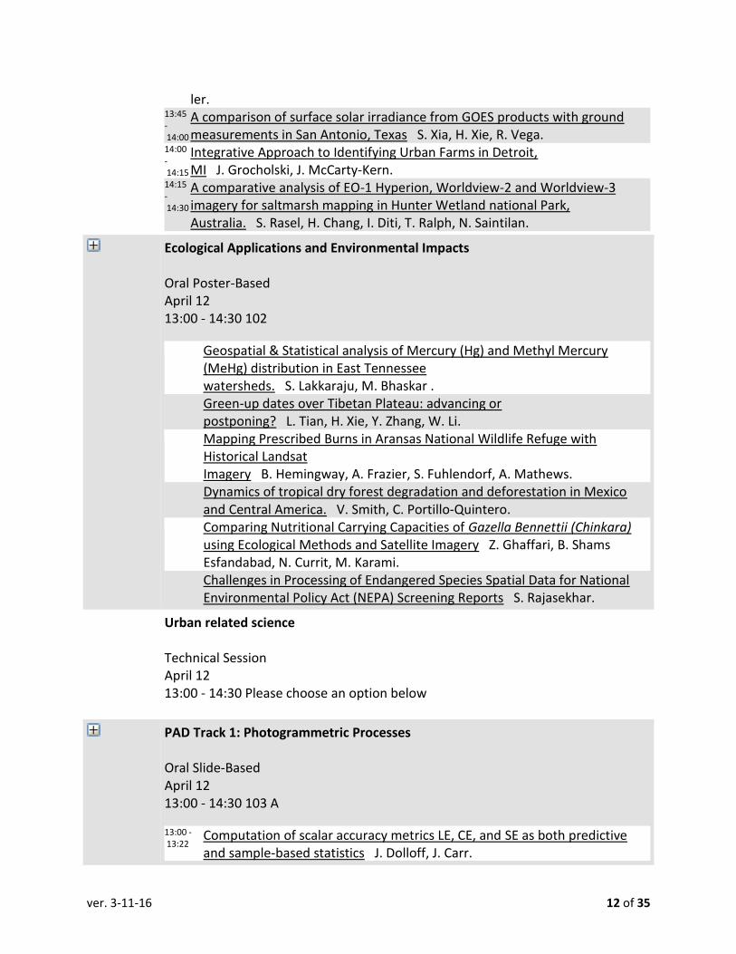
ler. 13:45 - 14:00
A comparison of surface solar irradiance from GOES products with ground measurements in San Antonio, Texas S. Xia, H. Xie, R. Vega.
14:00 - 14:15
Integrative Approach to Identifying Urban Farms in Detroit, MI J. Grocholski, J. McCarty-Kern.
14:15 - 14:30
A comparative analysis of EO-1 Hyperion, Worldview-2 and Worldview-3 imagery for saltmarsh mapping in Hunter Wetland national Park, Australia. S. Rasel, H. Chang, I. Diti, T. Ralph, N. Saintilan.
Ecological Applications and Environmental Impacts
Oral Poster-Based April 12 13:00 - 14:30 102
Geospatial & Statistical analysis of Mercury (Hg) and Methyl Mercury (MeHg) distribution in East Tennessee watersheds. S. Lakkaraju, M. Bhaskar .
Green-up dates over Tibetan Plateau: advancing or postponing? L. Tian, H. Xie, Y. Zhang, W. Li.
Mapping Prescribed Burns in Aransas National Wildlife Refuge with Historical Landsat Imagery B. Hemingway, A. Frazier, S. Fuhlendorf, A. Mathews.
Dynamics of tropical dry forest degradation and deforestation in Mexico and Central America. V. Smith, C. Portillo-Quintero.
Comparing Nutritional Carrying Capacities of Gazella Bennettii (Chinkara) using Ecological Methods and Satellite Imagery Z. Ghaffari, B. Shams Esfandabad, N. Currit, M. Karami.
Challenges in Processing of Endangered Species Spatial Data for National Environmental Policy Act (NEPA) Screening Reports S. Rajasekhar.
Urban related science Technical Session April 12 13:00 - 14:30 Please choose an option below
PAD Track 1: Photogrammetric Processes
Oral Slide-Based April 12 13:00 - 14:30 103 A
13:00 - 13:22
Computation of scalar accuracy metrics LE, CE, and SE as both predictive and sample-based statistics J. Dolloff, J. Carr.

ver. 3-11-16 13 of 35
13:22 - 13:44 The Generic Frame-Sequence Model H. Theiss, J. Dolloff, A. Braun. 13:44 - 14:06 OpenCL Based Bundle Adjustment for Large Terrestrial Data S. He, R. Lai. 14:28 - 14:50
Camera Pose Estimation for Mobile Localization Using Building Information Models and a Single View Image of a Scene. P. Robbins, G. Sohn.
Time Series and GEOBIA in GIS Analysis
Oral Slide-Based April 12 13:00 - 14:30
13:00 - 13:18 Cross Satellite Time Series Crop Classification M. Teke, Y. Yardimci. 13:18 - 13:36
Object-Based Change Detection for Time-Series SAR Data Stack K. Lin, D. Perissin.
13:36 - 13:54
An Automated Approach in Detecting and Attributing Forest Disturbance Types L. Liang, T. Hawbaker, Z. Zhu, X. Li, P. Gong.
13:54 - 14:12
Assessment of pan sharpening algorithm for mapping mangroves ecosystem by incorporating object based image analysis N. Shahzad, S. Ahmad.
14:12 - 14:30
Real-time streaming data on penguin abundance and distribution using very high spatial resolution satellite imagery C. Witharana, H. Lynch.
Afternoon Refreshments Social Function April 12 14:30 - 15:00 CC Exhibit Hall A Moderator 1: 265 Moderator 2: 280
Professor Larry Mayer, UNH
Plenary Session April 12 15:00 - 16:00 CC Ballroom B
00:00 - 00:00 Professor Larry Mayer, UNH J. Lenczowski, M. Hauck.
PAD Track 2: Indoor Navigation
Oral Slide-Based April 12 15:00 - 16:30 103 A

ver. 3-11-16 14 of 35
15:00 - 15:00
A constraint-based integrated approach for fusing GPS, INS, and camera/video data for achieving highly accurate 3D models using smartphone and tablets M. Morgan.
15:00 - 15:00
Automated Relative Orientation for Indoor Mapping with Prior Trajectory Information F. He, A. Habib.
15:00 - 15:00
ENHANCEMENT OF TRAJECTORY ESTIMATION FOR A MULTI-CAMERA INDOOR MAPPING SYSTEM USING CONSTRAINED SYSTEM MOTION R. Benziger, A. Habib.
Exhibitors opening with Hors d'oeuvre and Cash Bar Social Function April 12 17:30 - 19:30 CC Exhibit Hall A Moderator 1: 265 Moderator 2: 280

ver. 3-11-16 15 of 35
WEDNESDAY PROGRAM, APRIL 13, 2016
JACIE Session 7 - Radiometric Calibration JACIE Activity April 13 01:10 - 03:10 201 C JACIE Moderator 1: 271 Moderator 2: 269 01:10 - 01:30
16.010 Reducing the Size and Complexity of Full-Aperture Radiometric Calibrators on Thermal Imaging Satellites M. Pagnutti, R. Ryan.
01:30 - 01:50
16.026 Uncertainty Analysis for the Radiometric Calibration Test Site (RadCaTS) at Railroad Valley, Nevada J. Czapla-Myers, K. Thome, T. Scanlon, E. Woolliams, A. Banks, A. Dilo, B. Wenny.
01:50 - 02:10
16.027 RadCalNet: A prototype radiometric calibration network for Earth observing imagers B. Wenny, M. Bouvet, K. Thome, J. Czapla-Myers, N. Fox, P. Goryl, P. Henry, A. Meygret, C. Li, L. Ma, L. Tang, E. Woolliams.
02:10 - 02:30
16.029 Use of automated in-situ measurements for sensor harmonization K. Thome, B. Wenny, J. Czapla-Myers.
02:30 - 02:50
16.036 Application Of The Specular Array Radiometric Calibration (SPARC) Method For The Vicarious Calibration Of Landsat Sensors S. Schiller.
Student/Employee Meet and Greet Social Function April 13 03:00 - 04:00 103 B Moderator 1: 38
JACIE Session 8 - Satellite Calibration and Techniques JACIE Activity April 13 03:30 - 05:00 201 C JACIE Moderator 1: 271 Moderator 2: 269 03:30 - 03:50
16.006 Radiometric Calibration of the Planet Labs PlanetScope Constellation J. Kyle, A. Collison, A. Jumpasut, A. Lee, A. Shrestha.
03:50 - 04:10
16.007 Pre-launch Calibration of the Planet Labs PlanetScope Constellation J. Warga, W. Krantz, N. Konidaris.
04:10 - 04:30 16.004 Reconstruction of effective point-spread functions (PSF) in natural satellite

ver. 3-11-16 16 of 35
images I. Zuleta. 04:30 - 04:50
16.031 A 1st Principles Approach for Absolute Radiometric Calibration Using Pseudo Invariant Calibration Sites D. Helder.
ASPRS and JACIE Registration Registration April 13 07:00 - 17:00 13th Street Lobby Registration Moderator 1: 265
Peter Highman,Director NGA Reaserch Plenary Session April 13 08:00 - 09:00 CC Ballroom B
00:00 - 00:00 Peter Highman, Director of NGA Research J. Lenczowski, M. Hauck.
Past Presidents Breakfast Private Function April 13 08:00 - 10:00 Omni Hotel Moderator 1: 265 Moderator 2: 48
IGTF 2016 Exhibit Hall Business Meeting April 13 08:00 - 18:00 CC Exhibit Hall A
JACIE Session 5 - Hi Resolution Satellite Assessment JACIE Activity April 13 08:10 - 09:50 201 C JACIE Moderator 1: 270 Moderator 2: 271 08:10 - 08:30
16.012 WorldView-3 Geolocation Accuracy and Band Co-Registration Analysis P. Bresnahan, R. Powers, L. Vazquez.
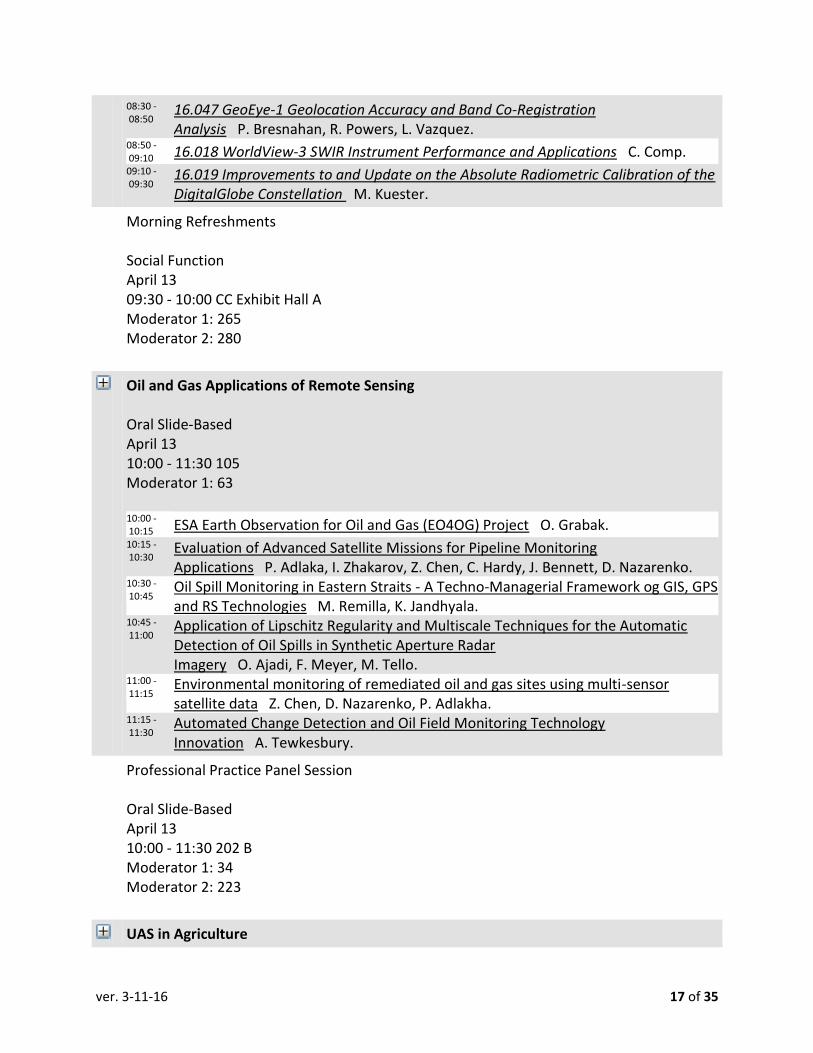
ver. 3-11-16 17 of 35
08:30 - 08:50
16.047 GeoEye-1 Geolocation Accuracy and Band Co-Registration Analysis P. Bresnahan, R. Powers, L. Vazquez.
08:50 - 09:10 16.018 WorldView-3 SWIR Instrument Performance and Applications C. Comp. 09:10 - 09:30
16.019 Improvements to and Update on the Absolute Radiometric Calibration of the DigitalGlobe Constellation M. Kuester.
Morning Refreshments Social Function April 13 09:30 - 10:00 CC Exhibit Hall A Moderator 1: 265 Moderator 2: 280
Oil and Gas Applications of Remote Sensing Oral Slide-Based April 13 10:00 - 11:30 105 Moderator 1: 63 10:00 - 10:15 ESA Earth Observation for Oil and Gas (EO4OG) Project O. Grabak. 10:15 - 10:30
Evaluation of Advanced Satellite Missions for Pipeline Monitoring Applications P. Adlaka, I. Zhakarov, Z. Chen, C. Hardy, J. Bennett, D. Nazarenko.
10:30 - 10:45
Oil Spill Monitoring in Eastern Straits - A Techno-Managerial Framework og GIS, GPS and RS Technologies M. Remilla, K. Jandhyala.
10:45 - 11:00
Application of Lipschitz Regularity and Multiscale Techniques for the Automatic Detection of Oil Spills in Synthetic Aperture Radar Imagery O. Ajadi, F. Meyer, M. Tello.
11:00 - 11:15
Environmental monitoring of remediated oil and gas sites using multi-sensor satellite data Z. Chen, D. Nazarenko, P. Adlakha.
11:15 - 11:30
Automated Change Detection and Oil Field Monitoring Technology Innovation A. Tewkesbury.
Professional Practice Panel Session Oral Slide-Based April 13 10:00 - 11:30 202 B Moderator 1: 34 Moderator 2: 223
UAS in Agriculture
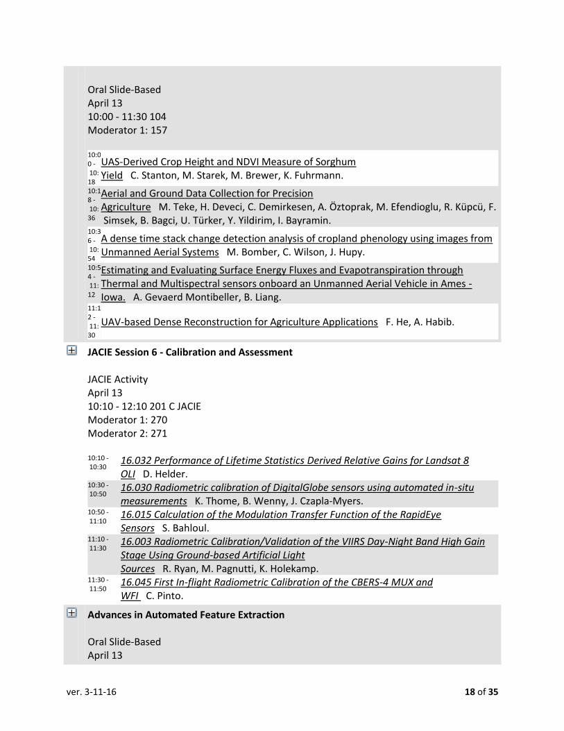
ver. 3-11-16 18 of 35
Oral Slide-Based April 13 10:00 - 11:30 104 Moderator 1: 157 10:00 - 10:18
UAS-Derived Crop Height and NDVI Measure of Sorghum Yield C. Stanton, M. Starek, M. Brewer, K. Fuhrmann.
10:18 - 10:36
Aerial and Ground Data Collection for Precision Agriculture M. Teke, H. Deveci, C. Demirkesen, A. Öztoprak, M. Efendioglu, R. Küpcü, F. Simsek, B. Bagci, U. Türker, Y. Yildirim, I. Bayramin.
10:36 - 10:54
A dense time stack change detection analysis of cropland phenology using images from Unmanned Aerial Systems M. Bomber, C. Wilson, J. Hupy.
10:54 - 11:12
Estimating and Evaluating Surface Energy Fluxes and Evapotranspiration through Thermal and Multispectral sensors onboard an Unmanned Aerial Vehicle in Ames - Iowa. A. Gevaerd Montibeller, B. Liang.
11:12 - 11:30
UAV-based Dense Reconstruction for Agriculture Applications F. He, A. Habib.
JACIE Session 6 - Calibration and Assessment JACIE Activity April 13 10:10 - 12:10 201 C JACIE Moderator 1: 270 Moderator 2: 271 10:10 - 10:30
16.032 Performance of Lifetime Statistics Derived Relative Gains for Landsat 8 OLI D. Helder.
10:30 - 10:50
16.030 Radiometric calibration of DigitalGlobe sensors using automated in-situ measurements K. Thome, B. Wenny, J. Czapla-Myers.
10:50 - 11:10
16.015 Calculation of the Modulation Transfer Function of the RapidEye Sensors S. Bahloul.
11:10 - 11:30
16.003 Radiometric Calibration/Validation of the VIIRS Day-Night Band High Gain Stage Using Ground-based Artificial Light Sources R. Ryan, M. Pagnutti, K. Holekamp.
11:30 - 11:50
16.045 First In-flight Radiometric Calibration of the CBERS-4 MUX and WFI C. Pinto.
Advances in Automated Feature Extraction Oral Slide-Based April 13
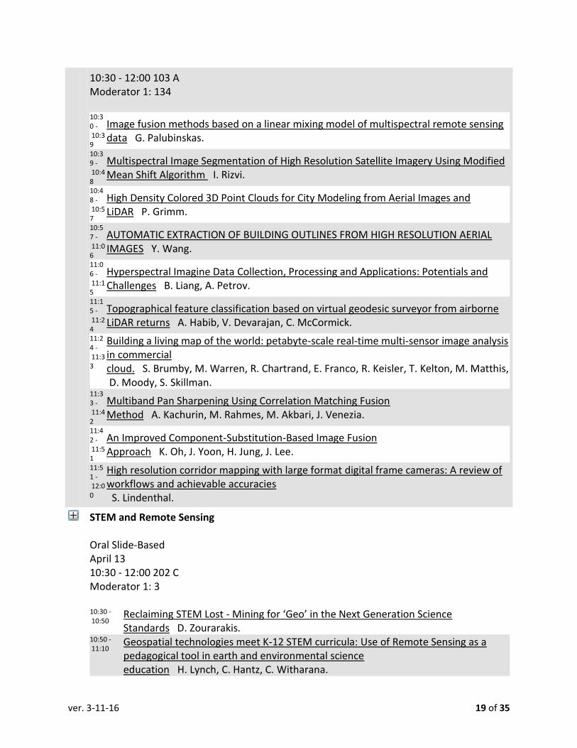
ver. 3-11-16 19 of 35
10:30 - 12:00 103 A Moderator 1: 134 10:30 - 10:39
Image fusion methods based on a linear mixing model of multispectral remote sensing data G. Palubinskas.
10:39 - 10:48
Multispectral Image Segmentation of High Resolution Satellite Imagery Using Modified Mean Shift Algorithm I. Rizvi.
10:48 - 10:57
High Density Colored 3D Point Clouds for City Modeling from Aerial Images and LiDAR P. Grimm.
10:57 - 11:06
AUTOMATIC EXTRACTION OF BUILDING OUTLINES FROM HIGH RESOLUTION AERIAL IMAGES Y. Wang.
11:06 - 11:15
Hyperspectral Imagine Data Collection, Processing and Applications: Potentials and Challenges B. Liang, A. Petrov.
11:15 - 11:24
Topographical feature classification based on virtual geodesic surveyor from airborne LiDAR returns A. Habib, V. Devarajan, C. McCormick.
11:24 - 11:33
Building a living map of the world: petabyte-scale real-time multi-sensor image analysis in commercial cloud. S. Brumby, M. Warren, R. Chartrand, E. Franco, R. Keisler, T. Kelton, M. Matthis, D. Moody, S. Skillman.
11:33 - 11:42
Multiband Pan Sharpening Using Correlation Matching Fusion Method A. Kachurin, M. Rahmes, M. Akbari, J. Venezia.
11:42 - 11:51
An Improved Component-Substitution-Based Image Fusion Approach K. Oh, J. Yoon, H. Jung, J. Lee.
11:51 - 12:00
High resolution corridor mapping with large format digital frame cameras: A review of workflows and achievable accuracies S. Lindenthal.
STEM and Remote Sensing Oral Slide-Based April 13 10:30 - 12:00 202 C Moderator 1: 3 10:30 - 10:50
Reclaiming STEM Lost - Mining for ‘Geo’ in the Next Generation Science Standards D. Zourarakis.
10:50 - 11:10
Geospatial technologies meet K-12 STEM curricula: Use of Remote Sensing as a pedagogical tool in earth and environmental science education H. Lynch, C. Hantz, C. Witharana.

ver. 3-11-16 20 of 35
11:10 - 11:30
Applying 3-D Virtual Modeling for Visualization and Analyses in Geoscience Research and Education at the Community College and University Level T. Urbanski, L. White, C. Aiken.
11:30 - 11:50
Employing remote sensing tools in academia for Ramsay fold classification on a 3D virtual model as one example of utilizing virtual models of geology T. Savage, A. Webber, C. Aiken.
ASPRS Foundation Board of Trustees Meeting Private Function April 13 11:00 - 14:00 Sheraton Hotel Moderator 1: 265 Moderator 2: 273
Lunch with Exhibitors Social Function April 13 12:00 - 13:00 CC Exhibit Hall A Moderator 1: 265 Moderator 2: 280
Geological Applications of Remote Sensing Oral Slide-Based April 13 13:00 - 14:30 105 Moderator 1: 63 13:00 - 13:15
Space-Based Monitoring and Characterization of Active Geothermal Reservoirs M. Aly.
13:15 - 13:30
Hyperspectral Detection and Mapping of Black Rock Coatings near Smelters D. Leverington, M. Schindler.
13:30 - 13:45
Determination of mineral abundance in beach sands using spectroscopic data and traditional methods of sand composition and grain size analysis M. Smith, C. Zhang, A. Oleinik.
13:45 - 14:00
Remote detection of carbonatites in regions of sedimentary carbonate using an index of carbonate ion absorption bands E. Shavers, A. Ghulam, J. Encarnacion.
14:00 - 14:15
Digitization of fractures using photorealistic surface models of fault zones in Fish Lake Valley, California R. Aguilar, T. Savage, C. Aiken.
14:15 - 14:30
The Application of an Unmanned Aerial Vehicle for Acquiring High Resolution 3D Data of Saltation Features in the Buda and Devil’s River

ver. 3-11-16 21 of 35
Limestone A. McKee, L. White, C. Frederick.
Advanced Lidar Applications and Analysis II Oral Slide-Based April 13 13:00 - 14:30 104 Moderator 1: 69 13:00 - 13:15
Classification of High-Dimensional Rasterized LiDAR Datasets Using Evolutionary Computation H. Momm, E. Snapp.
13:15 - 13:30
Data Gap Classification for Terrestrial Lidar Derived Digital Elevation Models M. O'Banion, M. Eddy, M. Olsen.
13:30 - 13:45
High-resolution Lidar Observations of Rookery Islands in the Upper Laguna Madre to Define a Monitoring Benchmark M. Schwind, M. Starek.
13:45 - 14:00 Geometry-Based Classification of Point Clouds Y. Lin, A. Habib. 14:00 - 14:15
Performance analysis of a multi-resolution algorithm for large scale water-body surface mapping using elevation and intensity of LiDAR data. P. Acharjee, C. McCormick, V. Devarajan.
Emerging Lidar Technology I Oral Slide-Based April 13 13:00 - 14:30 104 Moderator 1: 69 13:00 - 13:15
The use of LiDAR and geospatial modeling for trail design automation P. Sawall, C. Wilson.
13:15 - 13:30
THE ADVANTAGES of USING MOBILE LIDAR OVER OTHER PLATFORMS for TRANSPORTATION PROJECTS T. Stentz.
13:30 - 13:45
Improving the Efficiency of Handling High Density LIDAR Point Clouds in GIS Platforms N. Sairam, S. Nagarajan.
13:45 - 14:00
Building Identification and Reconstruction from Point Cloud Data Y. Lin, Z. Guo, A. Habib.
14:00 - 14:15
Coastal Zone Mapping and Imaging Lidar (CZMIL) Survey Results over Gatun Lake, Panama M. Sitar, V. Ramnath.
Primary Data Acquisition Oral Slide-Based April 13 13:00 - 14:30 202 B
13:00 - Integrating point clouds to support heritage protection and VR/AR

ver. 3-11-16 22 of 35
13:20 applications G. Bodo, K. Hadzijanisz, B. Laki, R. Lovas, D. Surina, B. Szabo, B. Vari, A. Feher.
13:20 - 13:40
Performance Analysis of Motion Estimation of Taxiing Aircraft from LiDAR Point Clouds Z. Koppanyi, C. Toth, G. Jozkow.
13:40 - 14:00
Cultural Landscape Documentation with 3D Point Cloud Methods In the Southeastern United States T. Jordan, C. Goetcheus, M. Madden.
14:00 - 14:20
Mapping agricultural land use by integrating high resolution remote sensing imagery with multi-temporal Landsat data Q. Lei.
14:20 - 14:40
Supporting rock-fall risk analysis of cliff faces by terrestrial laser scanning and UAV imagery T. Lovas, A. Somogyi, B. Molnar, A. Torok.
Mapping with UAS Oral Slide-Based April 13 13:00 - 14:30 202 D Moderator 1: 157 13:00 - 13:00 Principles of Remote Sensing and Mapping using Drones M. Tully. 13:00 - 13:00
Using UAS with Consumer Cameras for Sub-Centimeter Survey Point Measurements R. Day.
13:00 - 13:00
Synchronization Method for low-cost UAV 3D Mapping System M. Elbahnasawy, T. Shamseldin, A. Habib.
PAD Track 3: Photogrammetry & Point Clouds Oral Slide-Based April 13 13:00 - 14:30 103 B
13:00 - 13:00
The Acquisition, Assembly, and Display of High Resolution PhotoRealistic Models of Geological Outcrops Using Terrestrial LiDAR and DSLR Cameras with Case Histories from Saudi Arabia and West Texas L. White, M. Alfarhan, J. Cliine, C. Aiken.
13:00 - 13:00
Collecting 3D information from Orthoimages Using Orthoiamge Elevation Synchronous Model J. Zhu, x. xiong.
13:00 - 13:00
Assessing Sun Glint Correction on Structure from Motion Photogrammetry for Shallow Water Bathymetric Mapping B. Nazeri, M. Starek.
6th Annual GeoLeague Challange: NPS 100 Year Anniversary Technical Session April 13 13:00 - 15:00 202 D Moderator 1: 78 Moderator 2: 267

ver. 3-11-16 23 of 35
15:00 - 15:20 The 6th Annual ASPRS SAC GeoLeague Challenge C. Remillard, A. Aragón .
WS#139 Small Unammed Aerial Systems (SUAS) Operations Workshop April 13 13:00 - 17:00 103 A
13:00 - 17:00 Small Unmanned Aerial Systems (SUAS) Operations E. Freeborn, D. Prall.
Afternoon Refreshments Social Function April 13 14:30 - 15:00 CC Exhibit Hall A Moderator 1: 265 Moderator 2: 280
Professor Keith Cunningham; University of Alaska, Fairbanks Plenary Session April 13 15:00 - 16:00 CC Ballroom B
00:00 - 00:00
Professor Keith Cunningham University of Alaska, Fairbanks J. Lenczowski, M. Hauck.
Emerging Lidar Technology II Oral Poster-Based April 13 15:00 - 16:30 202 D Moderator 1: 44 Surveying & Georeferencing Historical Buildings using Laser
Scanners L. Landaverde, M. Algasem, A. Elaksher. LiDAR-based Solar Mapping for Distributed Solar Plant Design and Grid Integration
in San Antonio, Texas H. Xie, T. Le, D. Kholdi, B. Dong, R. Vega. Combined bundle adjustment of multiple LiDAR strips and aerial images using
straight lines X. Xiong, Z. Zuo, Z. Liu, Y. Zhang. THREE DIMENSIONAL URBAN BUILDING DETECTION USING LiDAR
DATA I. I, D. NIDHAMANURI , . A.M. The use of high density filtered LiDAR and optically derived land use information in

ver. 3-11-16 24 of 35
modeling surface water quality: The case of a metropolitan catchment C. Wilson. SwathTRAK&[trade] and Dynamic FOV Surveying: Lidar Innovation for High-
Efficiency Mapping M. Sitar.
Multiple Scales of Urbanization and Urban Planning Oral Slide-Based April 13 15:00 - 16:30 202 B
15:00 - 15:18
Adaptive Region Merging Segmentation of Airborne Imagery for Roof Condition Assessment F. Wang, J. kerekes, Y. Wang.
15:18 - 15:36
SLOPE-BASED TERRAIN FILTERING FOR BUILDING DETECTION IN REMOTELY SENSED VHR IMAGES A. Suliman, Y. Zhang, R. Al-Tahir.
15:36 - 15:54
Merging Data from Multiple Platforms for Transportation Projects: Advantages and Challenges S. Ellefson.
15:54 - 16:12
Studying urbanization and land cover land use change in developing countries: the status, causes and impacts Q. Zhang.
16:12 - 16:30
A comparison of the urban expansions and their driving factors of two border cities: Laredo in the US and Nuevo Laredo in Mexico C. Zhao, J. Jensen, B. Zhan.
Enablers and Examples of Tracking Land Cover Change and Status Technical Session April 13 15:00 - 16:30 103 B Moderator 1: 48 15:00 - 15:18 Capture and Use of Geospatial Provenance in Mainstream GIS J. Tullis, R. Linck. 15:18 - 15:36 Evaluating Urban Agriculture's NDVI Signature T. Parece, J. Campbell. 15:36 - 15:54
Preparing for "what3words" as True Big Data Meets Unique Pixels - an NLCD Pixel Grid Index for Kentucky D. Zourarakis.
15:54 - 16:12
Land Cover Change Analysis for Assateague Island National Seashore Post Hurricane Sandy H. Grybas, R. Congalton.
16:12 - 16:30
Biodiversity Response to Industrialization and Human Expansion as seen in Land Cover Change within the Western Ghats in the Hassan District S. Prakash, T. Howard, S. Bettadpur, T. Ramamoorthy.
PAD Poster Session Oral Poster-Based April 13 15:00 - 16:30 102

ver. 3-11-16 25 of 35
THURSDAY PROGRAM, APRIL 14, 2016
JACIE Session 11 -Camera and Sensor Calibration JACIE Activity April 14 01:10 - 03:10 201 C JACIE Moderator 1: 266 Moderator 2: 70 01:10 - 01:35
16.042 KOMPSAT-3A Geometric Cal/Val & Quality Assessment D. Seo, J. Jeong, D. Lee, H. Choi.
01:35 - 02:00
16.002 LEICA DMC III Geometric in Flight Calibration and Practical Experiences C. Mueller.
02:00 - 02:25 16.009 Update on UltraCam Aerial Sensor Technology M. Gruber, A. Wiechert. 02:25 - 03:00 16.046 Launch of TripleSat Constellation and its Products and Services W. Sun.
JACIE Session 12 - Future of Earth Observation JACIE Activity April 14 03:30 - 05:00 201 C JACIE Moderator 1: 70 Moderator 2: 263 03:30 - 03:30
16.017 Evaluating remote sensing data impacts from the bottom up – A USGS example Z. Wu, G. Snyder, G. Stensaas, B. Quirk, c. Vadnais, P. Doucette.
03:30 - 03:30 16.024 An Update on Spaceborne Remote Sensing J. Christopherson.
Lightning Discussions Frontier Day STEM Activity April 14 05:00 - 07:00 Moderator 1: 267
ASPRS and JACIE Registration Registration April 14 07:30 - 16:00 13th Street Lobby Registration Moderator 1: 265

ver. 3-11-16 26 of 35
Panel Discussion: Education Tools and Lessons to Improve Remote Sensing and GIS Workflows Technical Session April 14 08:00 - 09:30 103 B Moderator 1: 57 Moderator 2: 23 08:00 - 09:30
Educational Tools and Lessons to Improve Remote Sensing and GIS Workflows T. Mueller.
08:00 - 09:30 Standards Based Learning Activities R. Dodge. 08:00 - 09:30 Online Tool for K-12 Using USGS Earthshots P. van Benthem. 08:00 - 09:30
Remote Sensing in Higher Education: The Impetus for Revisiting Content and Pedagogy J. Sharma.
08:00 - 09:30 Increasing Collaboration for Student Workflows J. Tullis.
IGTF 2016 Exhibit Hall Business Meeting April 14 08:00 - 18:00 CC Exhibit Hall A
JACIE Session 9 - Hyperspectral Systems and Processing JACIE Activity April 14 08:10 - 09:50 201 C JACIE Moderator 1: 272 Moderator 2: 268 08:10 - 08:30
16.008 Building High Performance MUSES Processing Systems in Amazon Web Services L. Graham.
08:30 - 08:50
16.013 Teledyne’s Multi-User System for Earth Sensing (MUSES) R. Perkins.
08:50 - 09:10
16.014 Imaging Spectroscopy Applications using the DESIS Hyperspectral Instrument on MUSES. R. Perkins.
09:10 - 09:30
16.005 Image Products from the new hyperspectral sensor DESIS J. Avbelj, E. Carmona, A. Eckardt, B. Gerasch, B. Günther, G. Kerr, H. Krawczyk, D. Krutz, A. Makarau, R. Müller, I. Walter.

ver. 3-11-16 27 of 35
WS#16 Remote Sensing Using ArcGIS 10.X Workshop April 14 08:30 - 12:30 103 A
08:30 - 12:30 Remote Sensing Using ArcGIS 10.x T. Parece.
Morning Refreshments Social Function April 14 09:30 - 10:00 CC Exhibit Hall A Moderator 1: 265 Moderator 2: 280
Supporting Disasters and First Responders Technical Session April 14 10:00 - 11:30 105 Moderator 1: 242 10:00 - 10:00
Rectification of Opportunistic Low-altitude Airborne Imagery for Disasters (ROLAID) P. Pope.
10:00 - 10:00
Veracity of Structured and Unstructured Big Data - A Case Study of Emergency Management B. Kar, Z. Chen.
10:00 - 10:00
Automating Accident Scene Reconstruction Using UAS based Photogrammetric Reconstruction and Orthophotos B. Vander Jagt.
10:00 - 10:00 Disaster and First Responders Support T. Idol. 10:00 - 10:00 Standards for Disaster Mitigation and Response S. Simmons. 10:00 - 10:00
An Interoperable Internet of Things Solution for Emergency Management based on the OGC SensorThings API Standard S. Liang.
Lidar Standards, Specifications and Best Practices Oral Slide-Based April 14 10:00 - 11:30 202 B Moderator 1: 44 10:00 - 10:15
U.S. Geological Survey Elevation-Hydrography Breakline Specifications C. Archuleta, H. Heidemann, S. Terziotti, K. Yamamoto.

ver. 3-11-16 28 of 35
10:15 - 10:30
Comparative Analysis of Different LiDAR System Calibration Techniques M. Miller, A. Habib.
10:30 - 10:45
Geometric Quality Assessment of Lidar Data Based on Swath Overlap A. Sampath, G. Stensaas, H. Heidemann.
10:45 - 11:00 Updates on the USGS NGP Lidar Base Specification H. Heidemann.
Digital Camera Calibration Oral Slide-Based April 14 10:00 - 11:30 201 A
10:00 - 10:20
AN STUDY ON OBLIQUE CAMERA SYSTEMS CALIBRATION AND THE STABILITY OF THEIR PARAMETERS R. Passini, K. Jacobsen, D. Day, W. Weaver.
10:20 - 10:40 Detecting street lights by depth imagery B. Molnar, A. barsi, T. Lovas, A. Somogyi. 10:40 - 11:00 UltraCam Aerial Sensor Calibration and Validation M. Gruber, M. Muick. 11:00 - 11:20 Quantifying Surface Reflectance Using a Low-Cost Camera System J. Lehnert.
Water Monitoring Oral Slide-Based April 14 10:00 - 11:30 103 B
10:00 - 10:18 MODIS derived vegetation Index for drought detection in the Southwest US Z. Wu. 10:18 - 10:36
Satellite imagery for actual ET estimation using surface energy balance algorithm M. Khan, C. Stockle, R. Allen, R. Trezza.
10:36 - 10:54 On the recurrent Sargassum blooms in the Central Atlantic M. Wang, C. Hu. 10:54 - 11:12
Geospatial analysis of the role of agricultural practices on hypoxic zone development in the Mississippi River Delta: A multitemporal perspectives S. Behrens, C. Wilson.
11:12 - 11:30
Estimation of Variability in Water Resources in the Major River Basins of the World Using Satellite Data J. Fayne, V. Lakshmi.
JACIE Session 10 - Calibration Processes and Data JACIE Activity April 14 10:10 - 12:10 201 C JACIE Moderator 1: 272 Moderator 2: 268 10:35 - 11:00 16.041 The Move Toward Analysis Ready Data and the opportunities/challenges
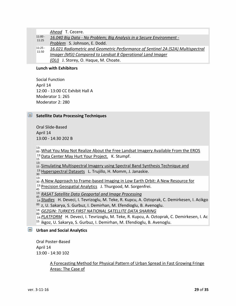
ver. 3-11-16 29 of 35
Ahead T. Cecere. 11:00 - 11:25
16.040 Big Data - No Problem; Big Analysis in a Secure Environment - Problem S. Johnson, E. Dodd.
11:25 - 11:50
16.021 Radiometric and Geometric Performance of Sentinel 2A (S2A) Multispectral Imager (MSI) Compared to Landsat 8 Operational Land Imager (OLI) J. Storey, O. Haque, M. Choate.
Lunch with Exhibitors Social Function April 14 12:00 - 13:00 CC Exhibit Hall A Moderator 1: 265 Moderator 2: 280
Satellite Data Processing Techniques Oral Slide-Based April 14 13:00 - 14:30 202 B
13:00 - 13:15
What You May Not Realize About the Free Landsat Imagery Available From the EROS Data Center May Hurt Your Project. K. Stumpf.
13:15 - 13:30
Simulating Multispectral Imagery using Spectral Band Synthesis Technique and Hyperspectral Datasets L. Trujillo, H. Momm, J. Janaskie.
13:30 - 13:45
A New Approach to Frame-based Imaging in Low Earth Orbit: A New Resource for Precision Geospatial Analytics J. Thurgood, M. Sorgenfrei.
13:45 - 14:00
RASAT Satellite Data Geoportal and Image Processing Studies H. Deveci, I. Tevrizoglu, M. Teke, R. Kupcu, A. Oztoprak, C. Demirkesen, I. Acikgoz, U. Sakarya, S. Gurbuz, I. Demirhan, M. Efendioglu, B. Avenoglu.
14:00 - 14:15
GEZGIN: TURKEYS FIRST NATIONAL SATELLITE DATA SHARING PLATFORM H. Deveci, I. Tevrizoglu, M. Teke, R. Kupcu, A. Oztoprak, C. Demirkesen, I. Acikgoz, U. Sakarya, S. Gurbuz, I. Demirhan, M. Efendioglu, B. Avenoglu.
Urban and Social Analytics Oral Poster-Based April 14 13:00 - 14:30 102
A Forecasting Method for Physical Pattern of Urban Spread in Fast Growing Fringe Areas: The Case of
ver. 3-11-16 30 of 35
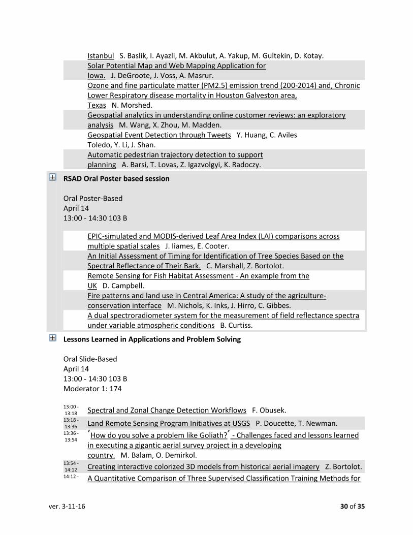
Istanbul S. Baslik, I. Ayazli, M. Akbulut, A. Yakup, M. Gultekin, D. Kotay. Solar Potential Map and Web Mapping Application for
Iowa. J. DeGroote, J. Voss, A. Masrur. Ozone and fine particulate matter (PM2.5) emission trend (200-2014) and, Chronic
Lower Respiratory disease mortality in Houston Galveston area, Texas N. Morshed.
Geospatial analytics in understanding online customer reviews: an exploratory analysis M. Wang, X. Zhou, M. Madden.
Geospatial Event Detection through Tweets Y. Huang, C. Aviles Toledo, Y. Li, J. Shan.
Automatic pedestrian trajectory detection to support planning A. Barsi, T. Lovas, Z. Igazvolgyi, K. Radoczy.
RSAD Oral Poster based session Oral Poster-Based April 14 13:00 - 14:30 103 B
EPIC-simulated and MODIS-derived Leaf Area Index (LAI) comparisons across multiple spatial scales J. Iiames, E. Cooter.
An Initial Assessment of Timing for Identification of Tree Species Based on the Spectral Reflectance of Their Bark. C. Marshall, Z. Bortolot.
Remote Sensing for Fish Habitat Assessment - An example from the UK D. Campbell.
Fire patterns and land use in Central America: A study of the agriculture-conservation interface M. Nichols, K. Inks, J. Hirro, C. Gibbes.
A dual spectroradiometer system for the measurement of field reflectance spectra under variable atmospheric conditions B. Curtiss.
Lessons Learned in Applications and Problem Solving Oral Slide-Based April 14 13:00 - 14:30 103 B Moderator 1: 174 13:00 - 13:18 Spectral and Zonal Change Detection Workflows F. Obusek. 13:18 - 13:36 Land Remote Sensing Program Initiatives at USGS P. Doucette, T. Newman. 13:36 - 13:54
How do you solve a problem like Goliath? - Challenges faced and lessons learned in executing a gigantic aerial survey project in a developing country. M. Balam, O. Demirkol.
13:54 - 14:12 Creating interactive colorized 3D models from historical aerial imagery Z. Bortolot. 14:12 - A Quantitative Comparison of Three Supervised Classification Training Methods for

ver. 3-11-16 31 of 35
14:30 Optimizing Land Cover Accuracy F. Smith, M. Datta, J. Liedtke.
PAD Track 4: Registration techniques Oral Slide-Based April 14 13:00 - 14:30 105
13:00 - 13:00 Portable LiDAR, VLP-16 Processing Y. Ahn, K. Huh, S. Nagarajan , J. Hong, K. Bang. 13:00 - 13:00
Generation of autogen areas based on high-resolution satellite imagery W. Krzywda, J. Wozniak, M. Kedzierski, A. Fryskowska.
WS#236 Making Drones Work for You! Workshop April 14 13:00 - 17:00 103 A
13:00 - 17:00 Making Drones Work for You! E. Freeborn, D. Prall.
Afternoon Refreshments Social Function April 14 14:30 - 15:00 CC Exhibit Hall A Moderator 1: 265 Moderator 2: 280
Miami Vice - SA/CA Meeting Business Meeting April 14 15:00 - 15:00 105 Moderator 1: 2 Moderator 2: 281
Dr. Jyotika Virmani XPRIZE Plenary Session April 14 15:00 - 16:00 CC Ballroom B
00:00 - 00:00 Dr. Jyotika Virmani, XPRIZE J. Lenczowski, M. Hauck.

ver. 3-11-16 32 of 35
Remote Sensing Applications Grab-bag Oral Slide-Based April 14 15:00 - 16:30 103 B
15:00 - 15:15
Riparian Vegetation Change (1972-2014) in the Okavango Delta, Botswana A. Makati.
15:15 - 15:30
Consistent Land Surface Temperature Data Generation from Irregularly Spaced Landsat Imagery P. Fu, Q. Weng.
15:30 - 15:45
Identifying Tree Hazards to Utility Infrastructure Using Terrain Optimized Airborne LiDAR J. Parent.
15:45 - 16:00
Cañon La Lagartera mangrove forest: Spatial analysis of land cover change in Jiquilisco, El Salvador. C. Gibbes, J. Miller.
16:00 - 16:15 Estimation of Surface Moisture in Urban Areas Y. Jiang, Q. Weng.
Exhibitors' Hors d'oeuvre Reception and Cash Bar Social Function April 14 17:30 - 19:30 CC Exhibit Hall A Moderator 1: 265 Moderator 2: 280

ver. 3-11-16 33 of 35
FRIDAY PROGRAM, APRIL 15, 2016
6. IGTF Registration and Frontier Day Registration April 15 07:00 - 14:00 13th Street Lobby Registration Moderator 1: 265
Frontier Day Keynote Kevin Gambold, CEO Unmanned Experts Frontier Day Business Activity April 15 08:00 - 08:40 203 A Moderator 1: 54 08:00 - 08:30 Kevin Gambold, CEO Unmanned Experts J. Lenczowski, M. Hauck.
IGTF 2016 Exhibit Hall Business Meeting April 15 08:00 - 15:00 CC Exhibit Hall A
Frontier Day Industry Speaker O&G Frontier Day Business Activity April 15 08:40 - 09:00 Moderator 1: 54
Frontier Day ASPRS Speaker O&G Frontier Day Business Activity April 15 09:00 - 09:20 Moderator 1: 54
Frontier Day Industry Speaker Public Safety Frontier Day Business Activity April 15

ver. 3-11-16 34 of 35
09:20 - 09:40 Moderator 1: 140
Frontier Day ASPRS Speaker Public Safety Frontier Day Business Activity April 15 09:40 - 10:00 Moderator 1: 140
Frontier Day Industry Speaker Smart Cities Frontier Day Business Activity April 15 10:00 - 10:20 Moderator 1: 54
Frontier Day ASPRS Speaker Smart Cities Frontier Day Business Activity April 15 10:00 - 10:20 Moderator 1: 54
Geo Internet of Things Frontier Day Business Activity April 15 12:00 - 13:00 Moderator 1: 54 12:00 - 12:50
Building Location-intelligent Internet of Things Innovations with Open Geospatial Consortium SensorThings API S. Liang.
Environmental Monitoring for O&G Frontier Day Business Activity April 15 12:00 - 13:00 Moderator 1: 54 12:00 - 12:50 Environmental Monitoring of Oil and Gas Sites Using Satellite

ver. 3-11-16 35 of 35
Imagery D. Nazarenko.
Point Clouds: More than a picture, worth much more than 1000 words! Frontier Day Business Activity April 15 12:00 - 14:00 Moderator 1: 54 12:00 - 14:00
Point Clouds: More than a Picture, Much More than 1000 Words! F. Obusek, J. Mostowy.
Public Safety Track Frontier Day Business Activity April 15 12:00 - 15:00 Moderator 1: 140
3D Culvert Scanning Frontier Day Business Activity April 15 13:00 - 14:00 Moderator 1: 54 13:00 - 13:50
Photogrammetry based 3D Culvert Scanning System J. Jung, A. Chang, H. Seo, L. William.
Pipeline Monitoring with Satellite Imagery Frontier Day Business Activity April 15 13:00 - 14:00 Moderator 1: 54