Carlin-Type Gold Deposits in Nevada - Nevada Bureau of Mines
0361-0128/06/3579/347-37 $6.00 347
IntroductionTHE 60-KM-LONG Carlin trend is the most important of sev-eral major gold-producing areas of north-central Nevada andcontains the greatest concentration of Carlin-type gold de-posits in the world. Gold production, reserves, and resourcesfrom the sedimentary rock-hosted or Carlin-type deposits ofthe Carlin trend are estimated to exceed 3,800 metric tons (t),or more than 60 percent of past production and reserves from
all such deposits in the Great Basin (Hofstra and Cline, 2000;Cline et al., 2005). The deposits of the trend are hostedmainly in Paleozoic sedimentary rocks, particularly Devonianand Silurian carbonate rocks. Other host rocks include calc-silicate hornfels derived from Devonian and Silurian carbon-ate rocks, Silurian and Ordovician chert and argillite, andJurassic and Eocene intrusive rocks. Eocene dikes are theyoungest ore-bearing rocks of the trend (Ressel et al., 2000a,b).
The Carlin trend and Carlin-type deposits have been in-tensely studied for about 40 years (Hausen and Kerr, 1968;Radtke et al., 1980; Bakken, 1990; Kuehn and Rose, 1992;
Igneous Geology of the Carlin Trend, Nevada: Development of the Eocene Plutonic Complex and Significance for Carlin-Type Gold Deposits
MICHAEL W. RESSEL*Department of Geological Sciences, University of Nevada, Reno, Nevada 89557-0088
AND CHRISTOPHER D. HENRY†
Nevada Bureau of Mines and Geology, University of Nevada, Reno, Nevada 89557-0088
AbstractThe Carlin trend contains the largest concentration of Carlin-type gold deposits in the world. Two major con-
troversies about these giant gold deposits have been their age, which is now firmly established as Eocene, andthe source of heat, fluids, and metals, which remains debated. We present data that demonstrate an intense pe-riod of Eocene magmatism coincided in time and space with deposit formation and was arguably the primaryheat source. Geologic studies over the last 40 years have emphasized the stratigraphy and structure of Paleo-zoic sedimentary rocks, which are the major ore hosts. However, four igneous episodes affected the Carlintrend, in the Jurassic, Cretaceous, Eocene, and Miocene. A Jurassic diorite-granodiorite laccolith and relateddikes were emplaced at about 158 Ma in the northern Carlin trend. A Cretaceous granite intruded the north-central part of the trend at 112 Ma. Abundant Eocene dikes intruded along most of the trend and were ac-companied by lavas in a large volcanic field along the southwest edge of the trend between ~40 and 36 Ma.Miocene rhyolite lavas erupted just west of and across the southern part of the trend at ~15 Ma.
Exposed Eocene rocks consist predominantly of silicic to intermediate dikes, lavas, and epizonal intrusions,which we interpret to be sourced from a large Eocene plutonic complex underlying the Carlin trend. Eocenedikes are present in most deposits, are generally altered, but, with a few exceptions, were poor ore hosts. Dis-tinct Eocene igneous suites, which are restricted to specific areas of the trend, are from north to south: (1) 40.3to 39.0 Ma rhyolite to dacite dikes in the northern Carlin trend, centered approximately on the Betze-Post de-posit and the richest part of the trend; (2) 37.6 Ma porphyritic rhyolite dikes including those that host ore atthe Beast deposit; (3) 38.6 Ma intermediate to silicic intrusions of Welches Canyon; (4) 38.1 to 37.4 Ma an-desite to dacite lavas and shallow intrusions of the Emigrant Pass volcanic field; (5) 36.2 Ma rhyolite dikes inthe Emigrant Pass field that are indistinguishable from the 37.6 Ma suite except for age and location; and (6)~37.5 Ma rhyolite to dacite intrusions and lavas of the southern Carlin trend (Rain subdistrict). Additionally, afew basaltic andesite dikes were emplaced at 37.8 Ma near Dee in the northernmost part of the trend and at38.2 Ma near Rain.
The petrography, distribution, and age of the Eocene igneous suites and aeromagnetic data indicate thateach suite is underlain by a major, silicic pluton. The longer lived suites require either multiple plutons or long-lived magma chambers. All Eocene dikes cannot have come from any single magma chamber, for example,from a chamber beneath the Welches Canyon intrusions as proposed by some. In this case, some igneous suiteswould have been emplaced only 12 to 15 km north of the northern edge of the source pluton, would not havebeen emplaced above or symmetrically around the source pluton, and would be distinct in age from the pro-posed source pluton. These requirements are not consistent with the distribution and age of the igneous suites.
The combined data for the Eocene igneous rocks require a plutonic complex about 50 km long (north-south), essentially coincident with the northern and central Carlin trend, and between 12 and 23 km across,underlying an area of ~1,000 km2. This complex was emplaced over ~4 million years that coincided with theformation of the Carlin-type deposits of the Carlin trend. Although many factors contributed to the formationof the deposits and the Carlin trend, magmatic heat was abundant in the right place and at the right time togenerate the deposits. The Carlin trend may be the largest concentration of Carlin-type deposits because theEocene igneous episode there was the largest and longest lived of the Great Basin.
† Corresponding author: e-mail, [email protected]*Present address: Newmont Mining Corporation, 337 W. Commercial
Street, Elko, Nevada 89801.
©2006 Society of Economic Geologists, Inc.Economic Geology, v. 101, pp. 347–383
Arehart et al., 1993; Hofstra and Cline, 2000; Cline et al.,2005). Two major controversies have surrounded the origin ofthese deposits. The first was the age of formation, which wasvariously interpreted as Mesozoic (~117 Ma; Arehart et al.,1993), Eocene (~40 Ma; Seedorff, 1991; McKee et al., 1995;Thorman et al., 1995; Emsbo et al., 1996; Henry and Boden,1998b; Henry and Ressel, 2000a; Ressel et al., 2000a), orMiocene (~15 Ma; Radtke et al., 1980). Abundant data in thelast 10 years unequivocally demonstrate an Eocene age(Emsbo et al., 1996; Leonardson and Rahn, 1996; Phinisey etal., 1996; Groff et al., 1997; Hall et al., 1997, 2000; Hofstra etal., 1999; Hofstra and Cline, 2000; Johnston, 2000; Ressel etal., 2000a, b; Tretbar et al., 2000; Arehart et al., 2003;Chakurian et al., 2003; Cline et al., 2005).
The second controversy, which remains unresolved and is asubject of this paper, is the source of heat, fluids, and metalsfor the deposits. Models for the generation of Carlin-type de-posits in the Great Basin include (1) an entirely amagmaticorigin (Ilchik and Barton, 1997; Seedorff, 1991; Hofstra andCline, 2000; Seedorff and Barton, 2004) involving deep cir-culation of meteoric water under high geothermal gradientsdriven by extension and large-scale (102–103 km3) leaching ofrocks in the middle and upper crust; (2) a mixing of deep,gold-bearing metamorphic fluids with meteoric fluids (See-dorf, 1991; Arehart, 1996; Hofstra and Cline, 2000; Tosdal etal., 2003a, Cline et al., 2005), possibly along crustal-scalefaults; (3) a partly magmatic origin in which Eocene magma-tism was the heat source but not necessarily the source ofmetals (Henry and Boden, 1998b; Henry and Ressel, 2000a;Ressel et al., 2000a, b); (4) a strictly magmatic origin (Sillitoeand Bonham, 1990; Johnston, 2003; Johnston and Ressel,2004) for ore components and heat; and (5) a leaching of goldfrom Paleozoic sedimentary exhalative Pb-Zn-Ag-Au depositsin carbonate host rocks (Emsbo et al., 1999, 2003).
Stable isotope and other geochemical compositions of hy-drothermal fluids indicate the dominance of meteoric fluidsin some Carlin-type deposits and magmatic or deep meta-morphic fluids in others (Hofstra and Cline, 2000; Cline et al.,2003, 2005). Hydrogen and oxygen isotope compositions ofore-related kaolinite from the Deep Star deposit of the north-ern Carlin trend indicate that a gold-bearing, magmatic ordeep metamorphic fluid mixed with meteoric water (Heitt etal., 2003). Although sulfur isotope compositions indicate sed-imentary sources for most sulfur (Hofstra and Cline, 2000),compositions of ore-related pyrite in part of the giant Betze-Post (Goldstrike) deposit are typical of a magmatic source(Kesler et al., 2003).
Some of the controversy about the origin of the depositsarises because early studies focused on the Paleozoic hostrocks (Evans and Mullens, 1976; Radtke et al., 1980; Radtke,1985, Bakken, 1990; Kuehn and Rose, 1992), and the highlyaltered and weathered igneous rocks in the upper parts of de-posits were difficult to recognize. This gave the impressionthat igneous rocks were insignificant or even absent. In fact,intrusive rocks, particularly Eocene and Jurassic dikes, areubiquitous features of deposits of the Carlin trend, and foursignificant episodes of magmatism have affected the rocks ofthe trend. These are (1) Jurassic diorite, rhyolite, and lam-prophyre intrusions; (2) Cretaceous granite intrusion; (3)Eocene silicic to intermediate intrusions and volcanism; and
(4) Miocene rhyolitic volcanism. A fifth episode of Paleozoicbasaltic volcanism was limited to the allochthon of theRoberts Mountains thrust and is excluded from this discus-sion because the basalts are not rooted in the Carlin trend andgenerally distant from ore deposits. Intrusive rocks played im-portant roles in nearly all deposits by localizing ore due totheir contrasting physical and hydrologic properties with sed-imentary hosts and their association with high-angle faults.The intrusive rocks provide key age constraints on magma-tism, mineralization, and the structural history of the districtand information on the depths at which the deposits formed.
This paper builds on our previous work on the Beast andMeikle-Griffin deposits of the northern Carlin trend (Resselet al., 2000a, b) and a regional overview of Eocene magma-tism (Henry and Ressel, 2000a). Here, we characterize andcontrast Jurassic, Cretaceous, Eocene, and Miocene igneousrocks by providing comprehensive data about their age, em-placement style, extent, volume, mineralogy, and composi-tion. Of particular importance are Jurassic and Eocene intru-sions, which are spatially associated with all of the more than40 gold deposits of the Carlin trend (Teal and Jackson, 1997).Dikes of these suites intruded structures that also controlledore fluids. No Cretaceous or Miocene intrusions are recog-nized in any deposit. Although we discuss all igneous rocks,we emphasize the Eocene magmatic pulse because of itsclose spatial and temporal association with gold deposition.
Regional Geologic SettingThe Carlin trend is located in the northern Great Basin,
which is part of the Basin and Range province of westernNorth America (Fig. 1). The trend lies near the Proterozoicrifted margin of the North American craton (DePaolo andFarmer, 1984; Wooden et al., 1998; Tosdal et al., 2000). Theplate margin underwent multiple episodes of contraction be-ginning in the Late Devonian-Early Mississippian and con-tinuing into the early Mesozoic. During the earliest episode,deep-water marine rocks deposited west of the plate edgewere thrust over autochthonous or parautochthonous shelf-and slope-facies marine rocks along the regional RobertsMountains thrust (e.g., Roberts, 1964). Subsequent contrac-tion in the Paleozoic produced a series of accretionary wedgesthat stacked sequentially westward, although thrusting con-tinued far inland as well.
Mesozoic, particularly Cretaceous, granitic rocks are abun-dant in western Nevada, part of the great chain of Cordilleranbatholiths of western North America that are broadly con-temporaneous with subduction. Plutons diminish in abun-dance eastward and crop out only in scattered ranges innortheastern Nevada (Barton, 1996). Additional plutons mayunderlie Cenozoic cover. The largest Jurassic igneous centerin eastern Nevada is in the Cortez Mountains (Fig. 1), whereboth intrusions and associated volcanic rocks are present.Other Jurassic plutons include those of the northern FishCreek Mountains (Emmons and Eng, 1995), Ruby Mountains(Howard et al., 1979), Buffalo Mountain (Erickson et al.,1978), and the Goldstrike intrusion in the Carlin trend (Are-hart et al., 1993). U-Pb and 40Ar/39Ar ages focus narrowlyaround 158 to 159 Ma (Mortensen et al., 2000; Table 1). Theoldest biotite K-Ar ages, which are presumed to be most reli-able given the likelihood of Ar loss, are indistinguishable
348 RESSEL AND HENRY
0361-0128/98/000/000-00 $6.00 348

within their large uncertainties from the U-Pb and 40Ar/39Arages. Cretaceous intrusions are less common than Jurassic in-trusions in northeast Nevada (Fig. 1) but have a much widerage range from ~86 to 112 Ma. The largest Cretaceous plutonis in the Osgood Mountains (Groff et al., 1997), and otherplutons are present in the Edna Mountains (Erickson et al.,1978), at Battle Mountain (Theodore et al., 1973; Theodore,2000), and in the Carlin trend (Evans, 1980; Mortensen et al.,2000). Deeply emplaced Cretaceous granites are common inthe Ruby Mountains but are not shown in Figure 1 becausethey are sills that are complexly interleaved with Paleozoicrocks (Snoke et al., 1997; Howard, 2000).
Magmatism resumed in the Eocene in the northern GreatBasin with widespread eruption of high K, calc-alkaline vol-canic rocks and emplacement of shallow intrusions. This ac-tivity was part of much more extensive Eocene magmatismthat swept southward as east-west belts from southern BritishColumbia beginning at about 54 Ma and reaching Nevada atabout 43 Ma (Christiansen and Yeats, 1992; Henry and Res-sel, 2000a). Eocene magmatism was contemporaneous withsubduction along the west coast of North America andbroadly with the onset of crustal extension. However, this ac-tivity was far inboard of the plate margin, and the east-westbelts were perpendicular to the plate margin, unlike typical
IGNEOUS GEOLOGY OF THE CARLIN TREND, NEVADA 349
0361-0128/98/000/000-00 $6.00 349
FIG. 1. Geologic map of northeastern Nevada (modified from Stewart and Carlson, 1976, 1978), showing the Carlin trend,major Carlin-type and other gold deposits, and ages of major Jurassic, Cretaceous, and Eocene intrusions and volcanic rocks.U-Pb and 40Ar/39Ar ages are in larger type; K-Ar ages, most of which are on biotite, are in smaller type. Jurassic intrusions inthis and adjacent areas have ages that cluster tightly at ~158 Ma. Cretaceous intrusions have a wider range of ages between112 and 86 Ma. Sources: Armstrong (1970), Erickson et al. (1978), Kistler et al. (1981), Emmons and Eng (1995), Mortensenet al. (2000), Theodore (2000), Castor et al. (2003), Sloan et al. (2003), this study. EP = Emigrant Pass volcanic field, G =Goldstrike mine, NC = northern Carlin trend, Q = Gold Quarry mine, WC = Welches Canyon.

350 RESSEL AND HENRY
0361-0128/98/000/000-00 $6.00 350
TAB
LE
1. 4
0 Ar/
39A
r an
d U
-Pb
Age
Dat
a fo
r Ig
neou
s R
ocks
of t
he C
arlin
Tre
nd
n A
ge4
Sam
ple
no.1
Ref
.R
ock
type
, loc
atio
nW
. lon
gN
. lat
Min
eral
Age
Met
hod
(%39
Ar3
)(M
a)±1
σiso
chro
n±1
σ40
/36
±1σ
MSW
Dto
tal g
as±1
σ
Jura
ssic
roc
ks
Gol
dstr
ike
and
rela
ted
intr
usio
ns96
-M-2
076
Gol
dstr
ike
dior
iteTi
tani
teU
-Pb,
ran
ge,
159.
14.
4th
ree
206 P
b/23
8 U a
ges
96-M
-209
6M
onzo
nite
sill
Zirc
onU
-Pb,
low
er in
terc
ept
157.
70.
4E
X-2
4C6
Rhy
olite
dik
e, M
eikl
eZi
rcon
U-P
b, m
ean,
15
9.3
4.2
two
207 P
b/20
6 Pb
ages
GSS
-12
Gol
dstr
ike
dior
ite11
6°21
.8'
40°5
8.3'
Bio
tite
Step
hea
ting
wtd
mea
n96
159.
91.
7N
A15
8.6
GSS
-12
Gol
dstr
ike
dior
ite11
6°21
.8'
40°5
8.3'
Hor
nble
nde
Step
hea
ting
wtd
mea
n72
160.
82.
1N
A16
2.4
GSS
-22
Gol
dstr
ike
dior
ite11
6°21
.8'
40°5
8.3'
Bio
tite
Step
hea
ting
wtd
mea
n94
160.
21.
7N
A15
7.7
97-Z
ia-7
11
Mic
rodi
orite
, 11
6°21
.4'
40°5
6.5'
Mat
rix
Step
hea
ting
dist
urbe
d~1
59N
M13
9.8
0.80
Zia
clai
ms
98-Z
ia-9
11
Rhy
olite
, Zia
cla
ims
116°
23.2
'40
°56.
7'B
iotit
eSt
ep h
eatin
gpl
atea
u86
.915
7.4
0.3
157.
60.
228
63
5.5
Lan
-34L
11
Rhy
olite
dik
e,
116°
21.7
'40
°55.
35'
Seri
cite
/St
ep h
eatin
gdi
stur
bed
111
NM
Lan
tern
min
eal
bite
Lam
prop
hyre
dik
es18
6804
3 Ph
logo
pite
11
6°19
.25'
40°4
7.4'
H
ornb
lend
e St
ep h
eatin
gpl
atea
u47
.315
8.9
0.2
NA
lam
prop
hyre
I-
5 4
Phlo
gopi
te
116°
22.0
' 40
°57.
2'
Phlo
gopi
te
Step
hea
ting
plat
eau
93.0
16
3.9
1.1
165.
710
.316
07
lam
prop
hyre
B
5-95
-11
7H
ornb
lend
e 11
6°21
.75'
40°5
7.7'
Hor
nble
nde
Step
hea
ting
dist
urbe
d31
.016
7.4
2.4
NM
210.
03.
3la
mpr
ophy
re
Intr
usio
ns o
f the
Dee
min
e ar
ea94
B50
/49/
8Ph
logo
pite
11
6°25
.6'
41°0
2.35
'B
iotit
eSt
ep h
eatin
gdi
stur
bed
>148
.7N
AD
D58
lam
prop
hyre
DC
-95-
2-21
462
1A
ltere
d Ju
rass
ic d
ike
116°
25.6
'41
°02.
25'
Bio
tite
Step
hea
ting
dist
urbe
d15
7.2
152
437
648
025
714
81
BR
S-4C
-119
021
Alte
red
dike
11
6°25
.55'
41
°02.
5'
Seri
cite
St
ep h
eatin
gdi
stur
bed
143
145
1020
842
53
140
1B
RS-
4C-1
4102
1 A
ltere
d ba
salti
c di
ke
116°
25.5
5'
41°0
2.5'
W
r (il
lite)
Step
hea
ting
dist
urbe
d10
6N
M
Cre
tace
ous
rock
sR
S-1
(H97
-23)
6R
ichm
ond
gran
ite11
6°18
.5'
40°5
1.06
'Zi
rcon
U-P
b, m
ean
112.
40.
6tw
o 20
6 Pb/
238 U
age
s
Eoc
ene
rock
sN
orth
ern
Car
lin tr
end
Plag
iocl
ase-
biot
ite±q
uart
z rh
yolit
eB
P-21
1G
olds
trik
e pi
t11
6°21
.9'
40°
58.6
'B
iotit
eSt
ep h
eatin
gpl
atea
u98
.539
.32
0.11
39.2
60.
0530
81
1139
.34
0.20
BP-
211
Gol
dstr
ike
pit
116°
21.9
'40
°58
.6'
Plag
iocl
ase
Step
hea
ting
dist
urbe
d55
.138
.35
0.19
38.7
10.
0831
31
2243
.98
7.70
BP-
211
Gol
dstr
ike
pit
116°
21.9
'40
°58
.6'
Mat
rix
Step
hea
ting
no p
late
auex
cess
Ar
NM
DSU
-192
-906
21
Dee
p St
ar11
6°21
.7'
40°5
7.5'
Bio
tite
Step
hea
ting
dist
urbe
d65
.839
.84
0.26
40.0
30.
3830
050
160
39.9
00.
20H
00-5
021
Gen
esis
pit
116°
21.7
'40
°57.
2'B
iotit
eSt
ep h
eatin
gdi
stur
bed
58.2
39.3
0.2
38.8
10.
2968
324
00.
045
39.6
90.
20I-
134
Gen
esis
pit
116°
22.1
'40
°56.
8'B
iotit
eSt
ep h
eatin
gpl
atea
u10
040
.30.
240
.22.
031
021
Plag
iocl
ase-
biot
ite-h
ornb
lend
e da
cite
96-M
-208
6Po
st-B
etze
pit
Zirc
onU
-Pb,
low
er in
terc
ept
37.8
2.1
G11
-12-
16
Dac
ite d
ike,
Gri
ffin
Zirc
onU
-Pb,
ran
ge
38.1
0.8
206 P
b/23
8 U a
ges
G11
-005
-4-4
921
1G
riff
in d
epos
it11
6°22
.4'
40°5
9.8'
Bio
tite
Step
hea
ting
plat
eau
76.9
39.4
60.
0839
.58
0.05
270
23.
539
.54
0.11
H00
-462
1Po
st-B
etze
pit
116°
21.9
'40
°58.
7'H
ornb
lend
eSt
ep h
eatin
gpl
atea
u69
.538
.95
0.22
39.0
30.
2330
013
11.6
39.6
60.
22H
00-4
921
Post
-Bet
ze p
it11
6°22
.0'
40°5
8.75
'B
iotit
eSt
ep h
eatin
gw
td m
ean
66.5
40.1
30.
2139
.81.
238
419
013
40.1
20.
21PO
D-1
2Po
st-B
etze
pit
116°
22.0
'40
°58.
7'B
iotit
eSt
ep h
eatin
gw
td m
ean
9539
.50.
4N
A39
.3

IGNEOUS GEOLOGY OF THE CARLIN TREND, NEVADA 351
0361-0128/98/000/000-00 $6.00 351
Aph
yric
rhy
olite
DSU
-150
-106
21
Dee
p St
ar, c
ore
116°
21.7
'40
°57.
8'M
atri
xSt
ep h
eatin
gw
td m
ean
59.6
39.1
50.
2639
.07
0.33
228.
08.
02.
536
.75
0.22
DS-
131
1D
eep
Star
116°
21.7
'40
°57.
8'M
atri
xSt
ep h
eatin
gdi
stur
bed
38.9
80.
0528
21
43D
S-15
0-10
511,
9D
eep
Star
, cor
e11
6°21
.7'
40°5
7.8'
Mat
rix
Step
hea
ting
dist
urbe
d~3
838
.27
0.05
176
249
36.9
40.
70
Bas
altic
and
esite
98 D
ee-8
21
Dik
e, D
ee m
ine
116°
25.6
'41
°02.
0'M
atri
xSt
ep h
eatin
gpl
atea
u61
.437
.80
0.21
37.7
30.
1729
5.3
3.8
40.1
30.
21
Plag
iocl
ase-
biot
ite-h
ornb
lend
e-qu
artz
±san
idin
e rh
yolit
eB
ST 1
141
1B
east
pit
116°
21.3
'40
°56.
4'Sa
nidi
neSi
ngle
cry
stal
wtd
mea
n14
37.5
80.
06B
ST 1
141
1B
east
pit
““
Sani
dine
Step
hea
ting
plat
eau
72.6
37.6
10.
0637
.63
0.17
BST
-301
1B
east
pit
116°
21.3
'40
°56.
5'B
iotit
eSt
ep h
eatin
gpl
atea
u60
.537
.55
0.07
37.7
60.
0530
02
9.4
37.6
60.
20R
ich-
101
1R
ichm
ond
Mtn
116°
18.2
'40
°51.
8'Sa
nidi
neSi
ngle
cry
stal
wtd
mea
n15
37.5
80.
05H
97-2
2b1
1W
elch
es C
anyo
n11
6°18
.4'
40°4
8.0'
Sani
dine
Sing
le c
ryst
alw
td m
ean
1437
.43
0.06
Wel
ches
Can
yon
- R
ichm
ond
Mou
ntai
n ar
eaH
97-2
111
Plag
iocl
ase-
biot
ite-
116°
19.2
'40
°47.
4'H
ornb
lend
eSt
ep h
eatin
gpl
atea
u88
.338
.59
0.17
38.8
40.
1130
03
538
.45
0.70
horn
blen
de d
acite
WC
-311
1G
rano
dior
ite11
6°17
.9'
40°4
7.7'
Plag
iocl
ase
Step
hea
ting
plat
eau
61.7
38.5
90.
1238
.74
0.08
308
229
39.1
80.
15W
C-1
062
1Pl
ag-b
iot-
hbl-q
tz d
acite
116°
19.5
5'40
°50.
6'B
iotit
eSt
ep h
eatin
gdi
stur
bed
43.1
2.1
278
100
543
39.4
90.
23
Em
igra
nt P
ass
Volc
anic
Fie
ld
Porp
hyri
tic (
plag
iocl
ase-
biot
ite-h
ornb
lend
e-qu
artz
±san
idin
e) r
hyol
ite d
ikes
H98
-102
11
Porp
hyri
tic d
acite
116°
17.1
'40
°44.
7'Pl
agio
clas
eSi
ngle
cry
stal
wtd
mea
n33
36.4
50.
09H
98-8
711
Porp
hyri
tic r
hyol
ite11
6°19
.1'
40°4
3.0'
Sani
dine
Sing
le c
ryst
alw
td m
ean
1436
.21
0.04
H98
-611
1Po
rphy
ritic
rhy
olite
116°
19.8
'40
°40.
8'Sa
nidi
neSi
ngle
cry
stal
wtd
mea
n15
36.1
20.
04
Bob
Cre
ek la
va (
horn
blen
de b
asal
tic a
ndes
ite)
H98
-21C
11
Rhy
olite
incl
usio
n11
6°21
.0'
40°4
0.7'
Sani
dine
Sing
le c
ryst
alw
td m
ean
1537
.06
0.04
H98
-201
1Po
rphy
ritic
and
esite
116°
20.7
'40
°40.
8'H
ornb
lend
eSt
ep h
eatin
gpl
atea
u90
.637
.43
0.10
37.5
90.
1028
65
4.7
37.4
40.
49
Mac
k C
reek
lava
s (p
lagi
ocla
se-h
ornb
lend
e da
cite
-and
esite
)H
98-7
811
Porp
hyri
tic d
acite
116°
21.8
'40
°42.
7'H
ornb
lend
eSt
ep h
eatin
gpl
atea
u50
.337
.56
0.18
37.8
80.
0926
93
6.3
33.7
90.
25H
98-7
811
Porp
hyri
tic d
acite
116°
21.8
'40
°42.
7'Pl
agio
clas
eSi
ngle
cry
stal
wtd
mea
n34
37.3
10.
12H
98-9
5C1
1Po
rphy
ritic
dac
ite11
6°19
.6'
40°4
4.9'
Sani
dine
Sing
le c
ryst
alw
td m
ean
1537
.83
0.05
H98
-95C
11
Porp
hyri
tic d
acite
116°
19.6
'40
°44.
9'H
ornb
lend
eSt
ep h
eatin
gpl
atea
u76
.637
.84
0.10
37.9
00.
0629
02
2.6
37.0
40.
70
Mac
k C
reek
intr
usio
ns (
plag
iocl
ase-
horn
blen
de d
acite
-and
esite
), B
obs
Fla
t Qua
dran
gle
H98
-11
1Po
rphy
ritic
dac
ite11
6°24
.8'
40°4
1.6'
Hor
nble
nde
Step
hea
ting
plat
eau
95.1
37.6
40.
1837
.73
0.15
291
53.
437
.65
0.46
EM
-N22
1Po
rphy
ritic
dac
ite11
6°27
.2'
40°4
2.7'
Hor
nble
nde
Step
hea
ting
plat
eau
62.8
38.1
10.
2137
.93
0.31
302
2023
38.5
00.
21Pr
imea
ux la
vas
(pla
gioc
lase
-hor
nble
nde-
pyro
xene
and
esite
-dac
ite)
H98
-271
1C
oars
e ho
rnbl
ende
11
6°16
.5'
40°3
9.0'
Hor
nble
nde
Step
hea
ting
plat
eau
92.4
37.8
50.
1338
.16
0.08
255
42
36.2
60.
23an
desi
teH
98-1
091
1H
ornb
lend
e an
desi
te
116°
17.5
'40
°43.
5'H
ornb
lend
eSt
ep h
eatin
gpl
atea
u93
.138
.06
0.12
38.1
30.
0928
05
2.2
37.1
41.
10in
trus
ion
Rai
n-R
ailr
oad
Are
a (s
outh
ern
Car
lin tr
end)
RC
R-9
-676
5M
onzo
nite
por
phyr
y di
ke, E
mig
rant
Sp
ring
sZi
rcon
U-P
b SH
RIM
P11
37.5
0.8
RC
R-6
2-21
512
1B
asal
tic a
ndes
ite d
ike
116°
2.4'
40°3
8.4'
Mat
rix
Step
hea
ting
wtd
mea
n56
.338
.21
0.20
37.8
1.2
378
7322
039
.42
0.20
RC
R-6
1-20
922
1Po
rphy
ritic
dio
rite
dik
e11
6°2.
4'40
°38.
4'B
iotit
eSt
ep h
eatin
gw
td m
ean
97.5
39.0
60.
2039
.13
0.18
294
1327
38.6
00.
20N
EP-
441
1B
iotit
e qu
artz
-fel
dspa
r 11
6°0.
5'40
°30.
5'Sa
nidi
neSi
ngle
cry
stal
wtd
mea
n14
37.3
80.
08in
trus
ion
TAB
LE
1. (
Con
t.)
n A
ge4
Sam
ple
no.1
Ref
.R
ock
type
, loc
atio
nW
. lon
gN
. lat
Min
eral
Age
Met
hod
(%39
Ar3
)(M
a)±1
σiso
chro
n±1
σ40
/36
±1σ
MSW
Dto
tal g
as±1
σ

continental volcanic arcs. Humphreys (1995) interpreted anorigin of magmatism related to foundering of a formerly shal-lowly dipping, subducted Farallon slab. He proposed that theslab detached along east-west lines near the United-Canadaand United States-Mexico borders and sank in the middle.The detached ends pulled towards this sinking middle, andasthenosphere welled up in their wake. Magmas were gener-ated by pressure-release melting of the asthenosphere, andthis magmatism propagated southward across the northwest-ern United States.
Whatever their tectonic setting, Eocene igneous rocks areabundant throughout northeastern Nevada (Fig. 1; Brooks etal., 1995a, b; Henry and Boden, 1998; Henry and Ressel,2000a, b; Castor et al., 2003). Most centers in northeasternNevada are dominated by andesite to dacite lavas, with lesserrhyolite lava and ash-flow tuff, and subvolcanic intrusions.The largest, most diverse volcanic center is the Tuscarora vol-canic field, which was active between 40.1 and 39.5 Ma(Henry and Boden, 1998a; Castor et al., 2003). Other majorEocene intrusive and volcanic areas of northeastern Nevadainclude the Emigrant Pass volcanic field adjacent to the Car-lin trend (Henry and Faulds, 1999), the Robinson Mountainvolcanic field south of the Carlin trend (Smith and Ketner,1978), the numerous Au-Cu–related porphyries at BattleMountain (Theodore, 2000), hypabyssal intrusions and re-lated volcanic rocks in the southern Independence Mountains(Ketner, 1998; Henry and Ressel, 2000b), and volcanic andintrusive rocks of the Jerritt Canyon gold district in the Inde-pendence Mountains (Phinisey et al., 1996; Hofstra et al.,1999).
Middle Miocene volcanism was focused in the northernNevada rift (Fig. 1), a 500-km-long, north-northwest–strikingmagnetic anomaly that lies west of the Carlin trend. The riftis characterized by numerous rhyolitic and basaltic eruptivecenters, most of which were active between 16 and 14 Ma(Zoback et al., 1994; John et al., 2000; Wallace, 2003a).Miocene rocks of the rift host numerous epithermal Au-Agdeposits (John and Wallace, 2000; John, 2001; John et al.,2003; Wallace, 2003b). Miocene rhyolite lavas and tuffaceoussedimentary rocks are widespread in northern Nevada, in-cluding within and adjacent to the Carlin trend.
Episodic Cenozoic extension in northeastern Nevada was,in part, contemporaneous with Eocene and Miocene magma-tism (John et al., 2000; Henry et al., 2001). Earliest extensionprobably generated the Elko basin and other Eocene basinsat about 46 Ma (Henry et al., 2001; Haynes et al., 2002, 2003)and therefore predates Eocene magmatism. Near the Carlintrend, the extensional history and geometry are best known inthe Emigrant Pass volcanic field (Fig. 2; Henry and Faulds,1999; Henry et al., 2001), where episodes of extension arerecognized (1) in the Eocene to generate the Elko basin (~46Ma: Haynes et al., 2002), (2) following deposition of Elkobasin deposits and preceding 38 to 36 Ma volcanism, (3) be-tween 25 and 15 Ma, and (4) at about 15 Ma, contemporane-ous with development of the northern Nevada rift (John et al.,2000). The greatest amount of extension probably occurred inthe episode between 25 and 15 Ma, which may correlate withthe time of most rapid cooling and inferred uplift of the RubyMountains core complex at 23 Ma (McGrew and Snee, 1994).Eocene and late Oligocene (25 Ma) volcanic rocks are tilted
352 RESSEL AND HENRY
0361-0128/98/000/000-00 $6.00 352
99-D
J-31
21
Rhy
olite
intr
usio
n11
5°53
.3'
40°2
3.5'
Sani
dine
Sing
le c
ryst
alw
td m
ean
937
.51
0.19
99-D
J-40
21
Rhy
olite
ash
-flo
w tu
ff11
5°53
.9'
40°2
7.8'
Sani
dine
Sing
le c
ryst
alw
td m
ean
937
.70
0.19
Mio
cene
roc
ks99
-468
21
Rhy
olite
lava
, 11
6°16
.1'
40°4
2.7'
Sani
dine
Sing
le c
ryst
alw
td m
ean
1215
.32
0.04
Mar
ys M
ount
ain
1 D
ata
from
this
stu
dy, s
ampl
e an
alyz
ed a
t the
New
Mex
ico
Geo
chro
nolo
gica
l Res
earc
h L
abor
ator
y (m
etho
dolo
gy in
McI
ntos
h et
al.,
200
3)2
Dat
a fr
om th
is s
tudy
, sam
ple
anal
yzed
at t
he N
evad
a ls
otop
e G
eoch
rono
logy
Lab
orat
ory
(Jus
tet a
nd S
pell,
200
1; L
eavi
tt e
t al.,
200
4); s
ourc
es o
f dat
a: 1
= th
is s
tudy
; 2 =
Are
hart
et a
l. (1
993)
; 3
= E
msb
o et
al.
1996
; 4 =
Far
mer
(N
ewm
ont G
old
Com
pany
unp
ub. r
epor
t, 19
96);
5 =
S. G
arw
in in
Lon
go e
t al.
(200
2); 6
= M
orte
nsen
et a
l. (2
000)
; 7 =
Oro
bona
(19
96);
8 =
The
odor
e et
al.
(199
8); 9
= H
eitt
et a
l. (2
003)
3n
= nu
mbe
r of
sin
gle
grai
ns a
naly
zed;
%39
Ar
= pe
rcen
t 39 A
r us
ed in
pla
teau
4A
ges
in it
alic
s ar
e be
st e
stim
ates
of e
mpl
acem
ent a
geN
otes
: NA
= n
ot a
vaila
ble;
NM
= is
ochr
on c
alcu
latio
n di
d no
t giv
e a
mea
ning
ful a
ge40
Ar/
39A
r ag
es fo
r al
l sam
ples
, inc
ludi
ng th
ose
from
oth
er s
tudi
es, w
ere
calc
ulat
ed o
r re
calc
ulat
ed w
ith a
mon
itor
age
of 2
8.02
Ma
for
Fis
h C
anyo
n sa
nidi
ne (
Ren
ne e
t al.,
199
8;)
sam
ples
I-5
and
I-
13 w
ere
anal
yzed
at t
he M
assa
chus
etts
Ins
titut
e of
Tec
hnol
ogy
and
give
the
olde
st a
ppar
ent E
ocen
e an
d Ju
rass
ic a
ges,
res
pect
ivel
y; e
ither
thes
e ag
es a
re d
istin
ctly
old
er th
an a
ges
dete
rmin
ed e
lse-
whe
re o
r w
e ha
ve n
ot c
orre
ctly
allo
wed
for
a di
ffer
ent m
onito
r ag
e; d
ecay
con
stan
ts a
nd is
otop
ic a
bund
ance
s af
ter
Stei
ger
and
Jäge
r (1
977)
; λβ
= 4.
963
×10
–10
yr–1
; λε+
ε’=
0.58
1 ×
10–1
0yr
–1; 4
0 K/K
=1.
167
×10
–4
TAB
LE
1. (
Con
t.)
n A
ge4
Sam
ple
no.1
Ref
.R
ock
type
, loc
atio
nW
. lon
gN
. lat
Min
eral
Age
Met
hod
(%39
Ar3
)(M
a)±1
σiso
chro
n±1
σ40
/36
±1σ
MSW
Dto
tal g
as±1
σ
IGNEOUS GEOLOGY OF THE CARLIN TREND, NEVADA 353
0361-0128/98/000/000-00 $6.00 353
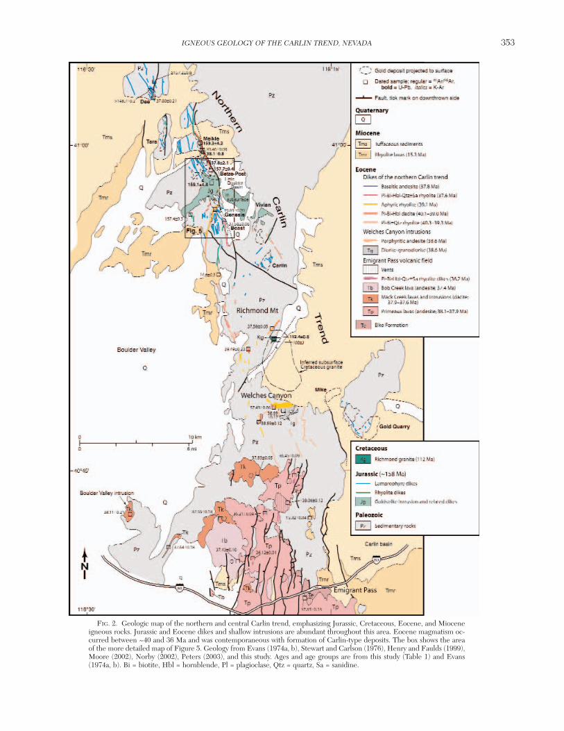
FIG. 2. Geologic map of the northern and central Carlin trend, emphasizing Jurassic, Cretaceous, Eocene, and Mioceneigneous rocks. Jurassic and Eocene dikes and shallow intrusions are abundant throughout this area. Eocene magmatism oc-curred between ~40 and 36 Ma and was contemporaneous with formation of Carlin-type deposits. The box shows the areaof the more detailed map of Figure 5. Geology from Evans (1974a, b), Stewart and Carlson (1976), Henry and Faulds (1999),Moore (2002), Norby (2002), Peters (2003), and this study. Ages and age groups are from this study (Table 1) and Evans(1974a, b). Bi = biotite, Hbl = hornblende, Pl = plagioclase, Qtz = quartz, Sa = sanidine.

as much as 30° to the east by numerous north- to north-north-east–striking normal faults in the Emigrant Pass field (Figs.1–2). However, these faults and tilts die out northward intothe northern Carlin trend. Paleozoic to Cenozoic structuraland stratigraphic features are negligibly tilted in the trend, in-dicating only minor total extension there.
General GeochronologyWe present 33 new and 22 published 40Ar/39Ar dates as well
as seven published U-Pb dates of igneous rocks of the Carlintrend (Table 1). The Appendix provides analytical methodsand general interpretation of the 40Ar/39Ar ages.
Modern 40Ar/39Ar and U-Pb dating demonstrates that mag-matism in the Carlin trend occurred in four distinct pulses at~158, 112, 40 to 36, and ~15 Ma (Figs. 3–4, Table 1;Mortensen et al., 2000; Ressel et al., 2000a, b). Early K-Ardates of Mesozoic igneous rocks in the Carlin trend scatterwidely (Fig. 3) and appear to indicate protracted magmatism.This scatter resulted from reheating of older intrusions,mostly the Jurassic Goldstrike intrusion, by younger igneousactivity, and hydrothermal alteration, which produced inter-growths of secondary minerals such as chlorite. Reheating in-duced partial Ar loss from biotite, the most commonly datedphase. K-Ar dates on the Goldstrike intrusion range from 149Ma (Hausen et al., 1983), only slightly younger than the trueage of 158 Ma (Mortensen et al., 2000), to as young as 78 Ma(Morton et al., 1977). In contrast, most early K-Ar dates ofEocene and Miocene volcanic rocks closely match the morerecent work, probably because reheating by younger igneousactivity was negligible.
Jurassic Intrusions (~158 Ma)
Goldstrike laccolith and sills
Jurassic intrusions consist of the mainly quartz dioriteGoldstrike laccolith and related sills and mostly northwest-striking lamprophyre and rhyolite dikes (Figs. 2, 5–7; Tables2–3). These intrusions appear to have been emplaced during
a short interval at ~158 Ma (Table 1). Outcrop, drill, andmine data demonstrate that the tabular, gently southwest-dipping Goldstrike body was emplaced along and below theRoberts Mountains thrust and other low-angle structures.The Goldstrike intrusion extends at least 2.5 km from itssouthwestern limit, where it is more than 600 m thick, to thePost fault, where it is ~300 to 350 m thick (Fig. 2; Leonard-son and Rahn, 1996; Bettles, 2002). The buried Little Boul-der Basin intrusion is a probable continuation east of thePost fault; here, the top of the intrusion is in upper platerocks (i.e., above the Roberts Mountains thrust). A series ofquartz diorite sills (Vivian sills) crop out still farther south-east in the main fault block of the Tuscarora Mountains (Fig.2), where they intrude allochthonous rocks well above theRoberts Mountains thrust (Mohling, 2002). Intrusions in allthree areas are of similar rock that most likely formed a sin-gle contiguous body that cut up section to the east (Dunbar,2001; Chakurian et al., 2003). If so, this intrusion underlies~7 km2; with an average thickness of 400 m, total volume isabout 3 km3. The Goldstrike laccolith was most likely fedfrom a deeper magma chamber, the depth and size of whichare unknown.
The Goldstrike body is dominantly quartz diorite (Fig. 7)but is crudely zoned, from mostly granodiorite along thesouthern or upper margin to a main mass of diorite andquartz diorite, with irregular segregations of gabbro mostabundant along the northern or lower margin. Numerousporphyritic diorite to monzonite sills and other apophyses arepresent, especially along the northeast margin of the Gold-strike body in the Betze-Post deposit (Bettles, 2002).
The composite Goldstrike intrusion has a relatively weakmagnetic anomaly and an extensive diopside hornfels andmarble halo (Hildenbrand and Kucks, 1988; Bettles, 2002).The weak anomaly probably reflects the tabular form of therelatively magnetite-rich rocks and is strongest near its west-ern, thickest end, which probably marks a feeder. The meta-morphic halo is widest, ≥1 km, above the southern or uppermargin near the Genesis mine (Fig. 2).
354 RESSEL AND HENRY
0361-0128/98/000/000-00 $6.00 354
FIG. 3. Histograms of isotopic ages of igneous rocks of the Carlin trend. Early K-Ar dating suggested a wide range of ac-tivity in the Mesozoic. More precise 40Ar/39Ar and U-Pb dating demonstrate that igneous activity was concentrated in fourdistinct episodes at ~158, 112, 40 to 36, and 15 Ma. Data from Table 1 and Evans (1980), Hausen et al. (1983), andMortensen et al. (2000).

IGNEOUS GEOLOGY OF THE CARLIN TREND, NEVADA 355
0361-0128/98/000/000-00 $6.00 355
FIG. 4. Representative 40Ar/39Ar age spectra, isochrons, and single crystal analyses. Additional spectra are presented inRessel et al. (2000a, b). Bi = biotite, Hbl = hornblende, Pl = plagioclase, Qtz = quartz, Sa = sanidine. A. 98-Zia-9, biotitefrom a rhyodacite dike, Zia claims. The mostly flat spectrum gives a plateau age of 157.4 ± 0.3 Ma. Low apparent ages fromlow-temperature steps suggest minor reheating and Ar loss. B. DC-95-2-2146, biotite from an altered dike, Dee mine. Thebest age estimate from this slightly disturbed spectrum is about 157 Ma, corresponding to the two oldest steps. Low ages atlow temperature probably reflect Ar loss from reheating. C. BRS-4C-1190, sericite from an altered dike, Dee mine. The rel-atively disturbed spectrum indicates a probable alteration age greater than 143 Ma, the age of the highest temperature steps,and significant Ar loss. D. H00-50, biotite from a rhyolite dike, Genesis mine. The dropping spectrum suggests 39Ar loss fromrecoil, probably related to minor chloritization of the biotite. The total gas age of ~39.7 Ma is probably the best estimate ofemplacement. E. DSU-192-906, biotite from a rhyolite dike, Deep Star mine. The irregular spectrum probably indicates 39Arloss from recoil, probably related to minor chloritization. The best age estimate is 40.0 Ma from the isochron (Fig. 5F), whichis consistent with a total gas age of 39.9 Ma. F. DSU-192-906, biotite from a rhyolite dike, Deep Star mine. The isochron in-dicates an age of ~40.0 Ma. G. H00-46, hornblende from a dacite dike, Goldstrike mine. The flat spectrum gives a plateauage of 38.95 ± 0.22 Ma, which is consistent with the isochron age of 39.03 ± 0.23 Ma. H. DSU-150-106, whole-rock sampleof aphyric rhyolite, Deep Star mine. The disturbed spectrum probably reflects poor Ar retention and 39Ar recoil from thefine matrix of potassium feldspar and quartz.

356 RESSEL AND HENRY
0361-0128/98/000/000-00 $6.00 356
FIG. 4. (Cont.) Although somewhat arbitrary, the best age estimate appears to be 39.15 ± 0.26 Ma, a weighted mean ofthe four steps in bold. This is supported by an indistinguishable isochron age of 39.07 ± 0.33 Ma. I. BST 114, sanidine froma rhyolite dike, Beast mine. The well behaved, flat spectrum gives an age of 37.61 ± 0.11 Ma, which is consistent with agesof 37.58 ± 0.06 Ma from a single crystal analysis of the same sample and 37.55 ± 0.07 Ma from step heating of biotite (Res-sel et al., 2000a). J. WC-31, plagioclase from a granodiorite, Welches Canyon. The slightly disturbed spectrum gives a plateauage of 38.59 ± 0.17 Ma, which is consistent with the isochron age of 38.74 ± 0.08 Ma. Isochron data suggest minor excess Ar.K. H98-95C, hornblende from a dacite lava, Emigrant Pass volcanic field. The plateau age of 37.84 ± 0.10 Ma agrees wellwith a single crystal sanidine age of 37.83 ± 0.05 Ma from the same sample (Fig. 5L). L. H98-95C, sanidine from a dacitelava, Emigrant Pass volcanic field. Analyses of 15 single grains of sanidine give a weighted mean age of 37.83 ± 0.05 Ma. M..H98-87, sanidine from a rhyolite dike, Emigrant Pass volcanic field. Analyses of 14 single grains of sanidine give a weightedmean age of 36.21 ± 0.04 Ma. One age of ~35.2 Ma on a plagioclase grain, indicated by low K/Ca, was discarded. N. RCR-62-2151, matrix of a basaltic andesite dike, Rain mine. The slightly disturbed, dropping spectrum probably indicates 39Ar lossfrom the fine-grained matrix. The best age estimates are ~38.2 Ma, a weighted mean of four steps from the relatively flatpart of the spectrum, and ~37.8 Ma from the isochron. O. RCR-61-2092, biotite from a diorite dike, Rain mine. The slightlyirregular spectrum gives a weighted mean age of 39.06 ± 0.20 Ma, in good agreement with the isochron age of 39.13 ± 0.18Ma (P). P. RCR-61-2092, biotite from a diorite dike, Rain mine. The isochron indicates an age of 39.1 Ma.
IGNEOUS GEOLOGY OF THE CARLIN TREND, NEVADA 357
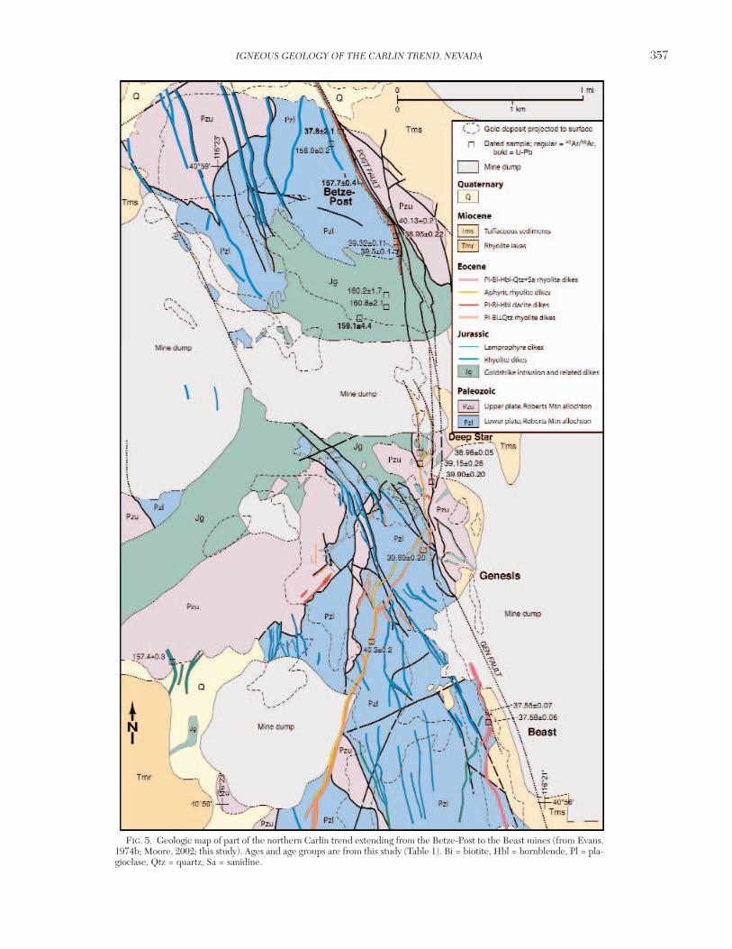
0361-0128/98/000/000-00 $6.00 357
FIG. 5. Geologic map of part of the northern Carlin trend extending from the Betze-Post to the Beast mines (from Evans,1974b; Moore, 2002; this study). Ages and age groups are from this study (Table 1). Bi = biotite, Hbl = hornblende, Pl = pla-gioclase, Qtz = quartz, Sa = sanidine.

Lamprophyre dikes
Porphyritic mafic dikes are abundant in the Carlin trend asa northwest-trending, 3- to 4-km-wide swarm extendingnearly 25 km from south of the Carlin mine to north of the
Dee mine. These dikes are concentrated near the Goldstrikeintrusion. Individual dikes are 0.1 to 2 m wide, generally highangle, and as much as 1 km long. The rocks are highly por-phyritic, lack feldspar phenocrysts, and contain at least onehydrous mafic phenocryst, either magnesian amphibole or
358 RESSEL AND HENRY
0361-0128/98/000/000-00 $6.00 358
FIG. 6. Total alkalis (Na2O + K2O) vs. SiO2 and K2O vs. SiO2 diagrams, illustrating the range of compositions of the fourigneous suites of the Carlin trend. A. Total alkalis vs. SiO2 for Eocene rocks. B. K2O vs. SiO2 for Eocene rocks. C. Total al-kalis vs. SiO2 for Jurassic, Cretaceous, and Miocene rocks. D. K2O vs. SiO2 for Jurassic, Cretaceous, and Miocene rocks.Low total alkalis in Eocene and Jurassic rocks reflect Na loss due to alteration. The field of compositions of rocks from theEmigrant Pass is probably the best indication of prealteration compositions of Eocene dikes of the northern Carlin trend.Miocene rhyolite and Cretaceous granite have undergone little alteration because they postdate Carlin-type mineralizationand are away from areas of mineralization, respectively. Age groups are from this study (Table 1). Rock classifications fromPeccerillo and Taylor (1976) and LeBas et al. (1986). Data: Table 3 and M.W. Ressel and C.D. Henry, unpub. Bi = biotite,Hbl = hornblende, Pl = plagioclase, Qtz = quartz, Sa = sanidine.
FIG. 7. Photographs of representative igneous rocks. Large divisions on the scale are 1 cm; fine divisions are 1 mm. A.Equigranular intermediate rocks of the Goldstrike laccolith (158 Ma). The upper sample is plagioclase-hornblende-biotite-quartz granodiorite from the southern, upper part of the laccolith at the North Star mine. The lower sample is plagioclase-hornblende-clinopyroxene-biotite diorite from the central part of the laccolith at the Goldstrike mine. B. Phlogopite-phyriclamprophyre (158 Ma) from a dike at the Goldstrike mine. The large dark minerals are clinopyroxene and hornblende(?) al-tered to a mixture of chlorite and carbonate minerals. The groundmass consists of potassium feldspar, phlogopite, and lesserquartz. C. Quartz-sericite–altered, finely porphyritic rhyolite (158 Ma) from a dike at the Meikle mine. The white mineralsare plagioclase phenocrysts altered to sericite. Other phenocrysts not resolvable in the image are biotite altered to sericiteand rare quartz. D. Coarse-grained granite (112 Ma) from the Richmond stock, which contains large phenocrysts of perthite(pe) and quartz (gray), with smaller grains of plagioclase (white) and sparse biotite (black). E. Finely porphyritic (plagioclase-biotite ± quartz) rhyolite (40.3–39.3 Ma) with brown glassy matrix from a dike at the Goldstrike mine. F. Weakly clay altered,porphyritic (plagioclase-biotite-hornblende) dacite (40.1–39.0 Ma) from a dike at the Goldstrike mine. Conspicuous horn-blende phenocrysts (hbl) are altered to montmorillonite and calcite, whereas biotite (bi) is unaltered. G. Aphyric rhyolite(39.1 Ma) from a dike at the Deep Star mine. The sample on the left consists of flow-banded, hydrated red glass that char-acterizes margins of dikes; the sample on the right is from the devitrified core of a dike, which consists mainly of spheruliticpotassium feldspar and quartz intergrowths. H. Argillically altered porphyritic (plagioclase-biotite-hornblende-quartz-sani-dine) rhyolite (37.6 Ma) from a thick dike at the Beast mine. The large sanidine (sa) phenocryst is altered to kaolinite andbarite; biotite (bi) phenocrysts are fresh; qtz = quartz phenocryst. I. Basaltic andesite (37.8 Ma) from the Dee mine. Phe-nocrysts consist of plagioclase (pl), clinopyroxene (px), and altered olivine (ol) in a holocrystalline matrix. J. Flow-banded rhy-olite (~15 Ma) from a lava flow west of the Carlin mine. Sparse phenocrysts consist of sanidine, quartz, and fayalitic olivine.

IGNEOUS GEOLOGY OF THE CARLIN TREND, NEVADA 359
0361-0128/98/000/000-00 $6.00 359

phlogopite (Fig. 7), and therefore are defined as lampro-phyres; this definition has no genetic implication. Phlogopiticlamprophyres contain alkali feldspar in their groundmasswhereas amphibole-bearing lamprophyres contain plagio-clase in the groundmass. Aligned phlogopite commonly im-parts a distinct foliation.
Porphyritic (plagioclase-biotite ± quartz) rhyolite dikes
Abundant, finely porphyritic rhyolite dikes form a north-west-striking swarm centered on and within ~5 km of the
Goldstrike intrusion. Individual dikes are as much as 15 mwide and as much as 2 km long.
Geochronology
U-Pb and 40Ar/39Ar dates on Jurassic intrusions suggest em-placement during a narrow time span around 158 Ma (Table 1;Figs. 2–5). The best U-Pb date is a lower intercept age of 157.7± 0.4 from five zircon fractions from a monzonite sill related tothe Goldstrike intrusion in the Betze-Post mine (Mortensen etal., 2000). Less precise U-Pb dates on the Goldstrike diorite
360 RESSEL AND HENRY
0361-0128/98/000/000-00 $6.00 360
TABLE 2. Characteristics of Jurassic, Cretaceous, and Miocene Igneous Rocks of the Carlin Trend.
Phenocrysts or Distinguishing Unit Rock type Texture phaneritic mineralogy Age (Ma) features Extent
MioceneSparsely porphyritic High silica Porphyritic, Qtz: 0–2%, 1–4 mm 14.6 (K-Ar) Sparsely porphyritic, Widespread in sa-qtz-ol-px rhyolite rhyolite aphanitic, flow- sa: 2–3%, 1–3 mm ol-phyric lava and morthern Carlin lava and associated banded, locally Ol (fayalite): nonwelded fall/surge trend along porous, glassy tuff glassy ≤1%, 2–4 mm tuff; commonly eastern flank of
Px (orthopyroxene): glassy, flow-banded, Boulder Valley ≤1, 2–4 mm locally lithophysal
Sparsely porphyritic Rhyolite to Sparsely Qtz: <0–2%, <3 mm 15.3 Sparsely porphyritic, Widespread in sa-qtz±bi±px high silica porphyritic, Sa:1–2%, <3 mm commonly flow- southern Carlin rhyolite lava and rhyolite aphanitic, flow- Bi: <1%, <2 mm banded lava and fall/ trend, west, east, associated tuff banded, locally Px: <15, <2 mm surge tuff and south of Gold
glassy Quarry mine
CretaceousCoarse-grained Granite Coarsely Pl: 45–55%, 0.4–1 cm 112 Coarse-grained, with Small stock at granite phaneritic, with Qtz: 20–30%, 0.2–0.8 cm large Kf phenocrysts; Richmond
Kf phenocrysts Kf: 20–30%, 0.4–2 cm locally dikes and Mountain, 0.4 Bi: <7%, 0.03–0.6 cm small pods of aplite- km2 outcrop;
pegmatite possibly ~20 km2
subsurface
JurassicGoldstrike dioritic Diorite, lesser Main phase: Pl: 45–65%, 4–10mm ~158 Medium-grained, Laccoliths and laccolith and satellite gabbro near equigranular, Kf: 0–15%, 4–10 mm compositionally other sill-like intrusions base, medium grained Hbl: 10–20%, 5–10 mm zoned, equigranular intrusions at
granodiorite, phaneritic; locally Bi: 0–10%, 2–8 mm granitoid; intermediate Goldstrike, Little tonalite pl-hbl porphyritic Px: 0–10%, 2–10 mm compositions Boulder Basin, common at top and fine grained Qtz: 1–15%, 2–10 mm predominate and Vivian areas;
~7 km2 total
Qtz-bi-hbl diorite Porphyritic Moderately Bi: 0–25%, 1–8 mm ~158 Strongly porphyritic 1–10 m wide, dikes and sills quartz diorite to coarsely Hbl: 0–20%, 1–8 mm bi- or hbl-phyric NW-striking
porphyritic Qtz: <2%, with dikes with distinctive dikes/sills reaction rims quartz xenocrysts(?) centered on
Goldstrike and satellite intrusions
Lamprophyre dikes Lamprophyre Finely to coarsely Phl: 0–40%, 1–8 mm ~158 Sparsely porphyritic; NW-striking dike porphyritic, Hbl: 0–40%, 1–8 mm lack of pl swarm centered aphanitic Qtz: <2%, 1–4 mm, phenocrysts; on Goldstrike and
with reaction rims commonly glassy satellite intrusionsOl: <1%, 2–4 mmPx: <1%, 2–4 mm
Finely porphyritic Rhyolite Finely porphyritic, Pl: 5–8%, 1–3 mm ~158 Finely porphyritic, 1–15 m wide rhyolite dikes aphanitic Bi: 1–3%, 1–3 mm aphanitic; distinctive dikes within ±5
Qtz: 0–1%, 1–3 mm sodic alteration km radius of assemblage Goldstrike
intrusion
Abbreviations: bi = biotite, hbl = hornblende, Kf = potassium feldspar, ol = olivine, phl = phlogopite, pl = plagioclase, px = pyroxene, qtz = quartz, sa =sanidine
and a rhyolite dike are 159.1 ± 4.4 and 159.3 ± 4.2 Ma. Most40Ar/39Ar ages range from 157.4 ± 0.3 to 160.8 ± 2.1 Ma andoverlap with the U-Pb ages within analytical uncertainty. Rela-tive ages among the Jurassic rocks are sparse, but porphyriticrhyolite cuts diorite and lamprophyre dikes at Meikle, Beast,and nearby deposits (Bettles, 2002). Among K-Ar ages, those oflamprophyres most closely match the modern U-Pb and40Ar/39Ar ages, which indicate they cooled rapidly followingemplacement and have not been significantly reheated (Fig. 3).
Chemical composition
A thorough petrogenetic study of Carlin trend igneousrocks is beyond the scope of this report and will be difficultbecause of the alteration. Almost all igneous rocks of thenorthern Carlin trend are altered to some degree. Argilliza-tion leading to some alkali loss is particularly common(Drews-Armitage et al., 1996; Leonardson and Rahn, 1996;Ressel et al., 2000a, b). Nevertheless, total alkali/SiO2 andK2O/SiO2 variations allow rock classification (LeBas et al.,1986) and comparison of the different suites (Fig. 6). How-ever, we also use rare earth elements (REE), which are rela-tively immobile during hydrothermal alteration (Fig. 8).
Jurassic rocks contain from ~51 to 77 percent SiO2 (Fig. 6,Table 3). SiO2 concentrations fall into three groups thatmatch the three rock types. The least altered samples of lam-prophyre contain 51 to 55 percent SiO2, samples of the Gold-strike diorite mostly contain 57 to 59 percent SiO2 with therelated but volumetrically less significant granodiorites con-taining about 66 percent SiO2, and rhyolite dikes contain 71to 77 percent SiO2. As with most Mesozoic and younger ig-neous rocks in the interior of the Great Basin, Jurassic rocksare moderately alkalic (Fig. 6).
All Jurassic rocks have steep, concave-upward REE pat-terns (Fig. 8). Despite being the most mafic Jurassic rocktype, lamprophyres have the highest concentrations, espe-cially of LREE, and the greatest variation in concentrationsdespite negligible variation in, or relationship to, SiO2. REEconcentrations of Goldstrike rocks largely overlap with thoseof the lamprophyres and generally increase with increasingSiO2, which makes a simple genetic tie between the two un-likely. Rhyolites have the lowest REE concentrations, whichgenerally decrease with SiO2.
Cretaceous “Richmond” Granite and Aplite-Pegmatite (112 Ma)
The only Cretaceous rock in the Carlin trend is a coarse-grained granite that intruded and thermally metamorphosedPaleozoic quartzite and limestone on the south flank of Rich-mond Mountain (Fig. 2). The rock is true granite, with 75percent SiO2 (Fig. 6; Table 3) and characterized by phe-nocrysts of perthite up to 2 cm across (Fig. 7). Aplite is com-mon as a border phase and as dikes cutting the main body;pegmatite pods are also common. Concordant 206Pb/238U agesof two zircon fractions demonstrate intrusion at 112.4 ± 0.6Ma (Table 1, Fig. 2; Mortensen et al., 2000). A biotite K-Arage of 108 ± 3 Ma (Evans, 1974b) suggests relatively rapidcooling after emplacement at no more than moderate depthand negligible reheating.
Outcrop area is small, ~0.4 km2, but aeromagnetic data,the coarseness of the intrusion, a broad zone of thermally
metamorphosed rock around it, and K-Ar ages of hornfelsminerals at the Mike composite Cu-Au deposit indicate thatthe Richmond granite may underlie an area of as much as 20km2 (Fig. 2). A positive aeromagnetic anomaly extends south-eastward from the granite to within 1.8 km of the deposit, butdistinguishing the magnetic anomaly of the Richmond granitefrom that associated with the Eocene Welches Canyon intru-sions is uncertain (Norby and Orobona, 2002). K-Ar ages ofreplacement K-feldspar of 107 ± 2 and 111 ± 2 Ma from, re-spectively, an altered lamprophyre dike and Paleozoic silt-stone in the Mike deposit (Branham and Arkell, 1995; Norbyand Orobona, 2002) indicate that hornfels developed con-temporaneously with the Richmond intrusion. Implication ofthese data for the extent of the Richmond intrusion is com-plicated because Paleozoic rocks surrounding the EoceneWelches Canyon intrusions are also thermally altered (Evans,1974b). Also, Evans (1974b) mapped several dikes around theRichmond intrusion as Cretaceous, but our 40Ar/39Ar datesand petrographic comparison demonstrate that all of theseare Eocene in age.
Eocene Igneous Rocks of the Carlin Trend (40–36 Ma)The most abundant igneous rocks in and around the Carlin
trend are Eocene dikes, small stocks, and lavas (Figs. 2, 5; Ta-bles 1, 4). Eocene rocks include (1) abundant, mostly rhyolitedikes in the northern Carlin trend from the Carlin depositnorth to the Dee deposit, (2) small andesite to rhyolite stocksand dikes in Welches Canyon, (3) abundant andesite to dacitelavas and rhyolite dikes of the Emigrant Pass volcanic field,and (4) basaltic andesite to rhyolite dikes in the southern Car-lin trend near the Rain mine. Isotopic ages indicate nearlycontinuous magmatism that generally migrated southwardbetween 40 and 36 Ma (Table 1, Fig. 2).
Eocene dikes of the northern Carlin trend (40.3–37.6 Ma)
Eocene dikes range from high SiO2 rhyolite to dacite, withminor basaltic andesite at the Dee deposit. These dikes in-trude several major ore-controlling structures, including thePost fault zone and the Dee fault (Teal and Jackson, 1997;Dobak et al., 2002; this study). Commonly, the north-north-west–striking, steeply dipping dikes and faults are the imme-diate hanging wall to ore, but Eocene dikes locally host ore atthe Meikle-Griffin, Betze-Post, and Beast deposits (Ressel etal., 2000a, b).
Five types of dikes are recognized based on phenocryst as-semblage and age (Tables 1, 4): (1) finely porphyritic (plagio-clase-biotite ± quartz) rhyolite (~40.3–39.3 Ma); (2) por-phyritic (plagioclase-biotite-hornblende) dacite (~40.1–39.0Ma); (3) aphyric, high silica rhyolite (~39.1 Ma); (4) olivine-phyric basaltic andesite (~37.8 Ma); and (5) coarsely por-phyritic (plagioclase-biotite-hornblende-quartz ± sanidine)rhyolite (~37.6 Ma).
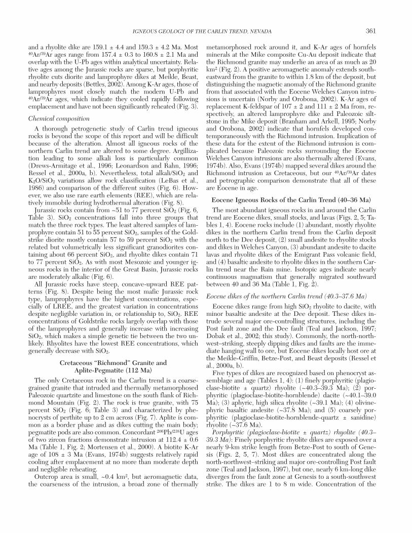
Porphyritic (plagioclase-biotite ± quartz) rhyolite (40.3–39.3 Ma): Finely porphyritic rhyolite dikes are exposed over anearly 9-km strike length from Betze-Post to south of Gene-sis (Figs. 2, 5, 7). Most dikes are concentrated along thenorth-northwest–striking and major ore-controlling Post faultzone (Teal and Jackson, 1997), but one, nearly 6 km-long dikediverges from the fault zone at Genesis to a south-southweststrike. The dikes are 1 to 8 m wide. Concentration of the
IGNEOUS GEOLOGY OF THE CARLIN TREND, NEVADA 361
0361-0128/98/000/000-00 $6.00 361
362 RESSEL AND HENRY
0361-0128/98/000/000-00 $6.00 362
TABLE 3. Representative Chemical Analyses of Least Altered Miocene, Eocene, Cretaceous,
Age Miocene EoceneRhyolite lavas and tuffs Dikes of the northern Carlin trend
Basaltic Pl-bi-hbl Rock type1 Rhyolite Rhyolite Rhyolite andesite dacite Pl-bi-qtz rhyolite
CD96 PNC Sample no. LAN-65 H98-112 H98-14 10C-1455 213-1787 GEN-2 BP-2No. in Figure 6 1 2 3 4 5 6 7Sample type Outcrop Outcrop Outcrop Core Core Pit PitLatitude 40°54.42' 40°39.8' 40°39.8' 40°59.5' 40°58.0' 40°56.85' 40°58.6'Longitude 116°22.15' 116°21.4' 116°15.6' 116°24.9' 116°22.0' 116°22.05' 116°21.9'Occurrence Lava Tuff Lava Dike Dike Dike Dike
Hydrated Hydrated Hydrated Moderate Mild Hydrated Alteration glass glass glass clay clay glassAnalyses2 U, N W, C W U, C U, A U, A U, A
SiO2 74.27 76.03 74.94 55.24 66.06 71.59 72.01TiO2 0.26 0.30 0.28 1.28 0.39 0.32 0.29Al2O3 12.45 12.05 13.35 16.83 16.34 15.82 15.81FeO3 2.95 2.34 1.41 6.71 2.97 2.11 2.17MnO 0.06 0.06 0.03 0.07 0.11 0.07 0.06MgO 0.11 0.52 0.05 4.85 1.61 1.42 0.74CaO 0.86 0.92 1.07 9.12 8.13 2.12 2.73Na2O 3.51 2.53 2.49 3.01 0.39 1.82 2.18K2O 5.50 5.22 6.27 2.39 3.79 4.60 3.88P2O5 0.02 0.04 0.11 0.50 0.21 0.13 0.13LOI 0.05 1.98 4.76 3.99 3.08Total4 99.53 96.59 98.80 99.06 100.17 100.44
Sc 1 1 6V 8 8 13 185 40 8 <5Cr <1 1 29 13 24 Co 3 7.8 27 4.1 2.9 2.4 Ni 5 0.7 9 87 <10 <10 <10Cu 7.0 36.5 4 26 <10 <10 <10Zn 145 108 53 525 56 43 50Ga 20 24 16 19 19 19 18 As 3.6 4.4 209 51 <5 39Rb 180 158 279 62 139 154 99 Sr 13 61 127 641 107 145 592 Y 84.0 86 42 21 19.0 18 18.0 Zr 577 528 213 173 186 158 146 Nb 44 46.5 29.3 15 16 19 19 Mo 15.0 4.64 1.7 2.1 1.7 2.0 Sb 0.2 0.62 11 7.8 0.5 44.0 Ba 140 1006 826 1076 931 1085 1395La 120 71.3 47 42 44.0 43 44.0 Ce 200 146.5 103 83 75.0 81 83.0 Pr 17.5 9.6 9.0 8.7 8.8 Nd 99 67.8 35 31.0 30 30.0 Sm 15.0 14 6.4 5.4 5.1 4.9 Eu 1.3 1.4 1.7 1.2 1.14 1.1 Gd 14 5.3 4.0 3.8 3.9 Tb 2.3 2.2 0.7 0.6 0.6 0.6 Dy 13.3 3.6 3.0 2.8 2.9 Ho 2.9 0.6 0.5 0.5 0.5 Er 8.5 1.8 1.7 1.6 1.6 Tm 1.2 0.25 0.25 0.24 0.23 Yb 9.5 7.9 1.6 1.5 1.5 1.5 Lu 1.43 1.2 0.23 0.22 0.23 0.25 Hf 19.0 16.7 4.6 4.8 4.6 4.3 Ta 3.25 0.9 1.2 1.65 1.7 W 6.0 1 1.3 1.6 1.3 Tl 1.16 0.6 6.0 0.9 2.0 Pb 32.0 25 24 26 21.0 18 30.0 Bi 0.77 0.4 1.9 0.6 1.7 Th 19.0 18 19 9.3 10.0 12 12.0 U 5.8 5.7 1.9 3.6 4 5.2

IGNEOUS GEOLOGY OF THE CARLIN TREND, NEVADA 363
0361-0128/98/000/000-00 $6.00 363
and Jurassic Igneous Rocks In and Adjacent to the Carlin Trend, Northeastern Nevada
Welches Canyon intrusions
Pl-bi-hbl Pl-bi-hbl-qtz±sa rhyolite Aphyric rhyolite Diorite andesite–dacite
DSU-BST-130 RICH-10 H97-22A 143-30 DS-1 WC-31 H97-21 WC-3
8 9 10 11 12 13 14 15Pit Outcrop Outcrop Core Underground Outcrop Outcrop Outcrop
40°56.37' 40°51.8' 40°47.9' 40°57.7' 40°57.7' 40°47.73' 40°47.4' 40°47.75'116°21.40' 116°18.2' 116°18.4' 116°21.7' 116°21.7' 116°17.92' 116°19.1' 116°18.08'
Dike Dike Dike Dike Dike Intrusion Dike DikeMild Mild Hydrated clay clay Fresh Devitrified glass Fresh Fresh FreshU, N U, N W, C U, N U, N U W, C U, A
71.21 77.33 72.59 76.98 75.09 61.28 62.64 64.960.31 0.21 0.30 0.07 0.05 0.83 0.74 0.59
15.19 14.72 14.66 14.09 14.64 17.34 17.14 17.482.05 1.58 1.88 0.88 0.86 5.79 5.34 3.711.37 0.06 0.04 0.09 0.09 0.13 0.13 0.083.10 0.55 0.84 0.68 0.06 2.33 2.41 1.132.25 0.52 2.99 0.99 1.57 5.47 5.08 4.270.10 0.46 2.20 1.07 2.39 3.88 3.66 4.354.32 4.45 4.38 5.12 5.18 2.62 2.54 3.200.11 0.11 0.13 0.04 0.05 0.32 0.33 0.227.13 3.40 4.97 8.14 0.48 0.23
100.09 99.33 97.33 99.38 98.93 98.09 98.83
5 2 6 2 2 1446 20 22 2 8 93 47
2 1 632 11.1 <1 18.7 7.5
9 5 1.1 2 2 1.6 355 <2 3.9 2 1 9.9 35
52 25 45 28 44 105 4023 18 29 13 20.5 20
12.8 1.3 17.0 32.0 <0.2 <5149 289 139 150 299 61 9358 55 328 91 862 725 67310.0 16 14 20.0 50.0 18 23.0
69 133 72 72 158 19913 17.2 29 13.3 15
<2 4 0.62 3.0 6.0 0.91 2.67.6 3.9 0.91 1.8 6.5 0.08 0.4
1100 723 1406 640 1300 1180 1261 107027.6 25 36.9 12.0 12.0 39.1 48.051.0 36 67.8 23.0 23.0 73.5 90.0
7.4 8.8 10.118.0 21 26.6 9.0 9.0 34.5 37.03.5 3 4.8 2.5 2.5 6.8 6.41.0 0.8 0.8 0.6 0.5 1.6 1.6
4.1 5.8 5.0<0.5 0.6 0.4 <0.5 <0.5 0.6 0.7
2.2 3.3 3.70.3 0.6 0.71.2 1.9 2.20.1 0.2 0.33
1.1 2.1 1.1 1.8 2.2 1.7 1.90.17 0.2 0.1 0.30 0.26 0.2 0.30
1 2.1 2.0 2.0 1.9 5.61.0 0 1.34 2.3 2.4 1.12 1.23.0 1.0
0.7 0.14 0.430.0 27 30 28.0 21.0 19 16.0
0.27 <0.01 0.313.8 11 13 4.9 4.9 9 13.05.7 10 5.4 6.3 6.4 2.1 3.6

364 RESSEL AND HENRY
0361-0128/98/000/000-00 $6.00 364
TABLE 3
Emigrant Pass volcanic field
Bob Creek lava Primeaux lavas Mack Creek lavas Late porphyriticHbl andesite Pl-px±hbl andesite–dacite Pl-bi-hbl andesite–dacite Pl-bi-hbl-qtz±sa rhyolite
H98-20 H98-27 H98-68 H98-101 H98-97 H98-1 H98-96 H98-56 H98-102Emigrant Pass analyses shown as field of data, not as individual samples, on Fig. 6
Outcrop Outcrop Outcrop Outcrop Outcrop Outcrop Outcrop Outcrop Outcrop40°40.8' 40°39.0' 40°41.6' 40°45.1' 40°44.5' 40°41.6' 40°44.7' 40°42.2' 40°44.7'116°20.7' 116°16.5' 116°20.0' 116°17.1' 116°20.0' 116°24.8' 116°20.7' 116°18.1' 116°17.1'
Lava Lava Lava Lava Lava Intrusion Lava Dike DikeFresh Fresh Fresh Fresh Fresh Fresh Fresh Fresh FreshW, C W, C W, C W, C W, C W, C W, C W, C W, C
57.89 60.30 63.61 65.88 59.76 65.11 67.10 68.53 71.451.20 0.94 0.78 0.64 0.98 0.73 0.62 0.46 0.41
16.10 17.26 16.67 16.75 16.83 15.98 15.20 16.07 14.537.79 6.15 5.03 4.14 6.86 4.55 3.73 2.70 2.090.13 0.11 0.12 0.09 0.10 0.11 0.09 0.04 0.053.37 2.65 2.08 1.05 2.84 2.29 1.87 1.18 1.157.72 6.01 4.88 3.99 6.46 4.68 3.99 2.96 3.232.98 4.12 3.75 3.92 3.36 2.97 3.20 3.77 3.512.37 2.15 2.80 3.28 2.52 3.32 4.00 4.09 3.400.43 0.32 0.28 0.25 0.31 0.27 0.20 0.21 0.16
99.16 99.32 98.63 99.77 98.77 97.68 98.80 99.22 99.60
24 19 13 12 17 8 12 4 3202 148 106 67 156 97 89 49 5294 7 4 2 41 19 20 6 1026.2 20.7 21.1 13.3 21.7 19.9 23.9 15.5 23.130.4 3.9 3.3 2 24.5 6.8 10.3 9.2 5.69.7 6.2 7.9 5.3 19.2 23 12.5 6.3 4.8
83 85 82 67 92 89 68 88 4820.6 21 21.8 21.8 23.3 20.2 20.4 21.6 18.953.7 2.9 0.6 2.2 1 7.2 4.5 2.9 3.3
38 56 71 94 64 86 113 111 133839 892 699 668 740 565 528 536 51625 19 21 21 22 20 18 14 11
174 203 196 191 149 181 152 143 11513.5 12.4 14.7 20.6 13.9 14.8 17.0 14.8 12.80.43 1.49 0.96 1.1 1.15 1.32 2.76 1.27 0.70.48 0.55 0.11 0.13 0.2 1.12 0.46 0.55 0.49
981 1217 1326 1134 1122 1424 1084 1713 100737.8 43.3 44.5 42.3 31 40.1 30.6 31.4 25.775.3 78.6 82.8 77.9 58 74.2 57.1 58.8 46.48.6 9.2 9.4 9 7.5 8.5 6.5 6.5 5.5
36.4 35.4 34.5 34 31.4 31.8 25.9 25.3 19.96.5 6 6.2 5.8 5.9 5.7 4.4 4.1 3.41.7 1.6 1.6 1.4 1.6 1.5 1.1 1 0.86.1 5.5 5.6 5.3 5.5 5.2 4.1 3.8 3.10.8 0.7 0.7 0.7 0.7 0.7 0.5 0.4 0.34.7 3.6 3.7 3.5 3.9 3.4 2.8 2.3 1.80.9 0.7 0.7 0.6 0.8 0.6 0.5 0.4 0.32.6 1.9 2.1 2 2.1 1.9 1.6 1.2 10.3 0.2 0.2 0.2 0.3 0.2 0.2 0.1 0.12.1 1.6 1.8 1.7 1.8 1.7 1.5 1 0.90.3 0.2 0.3 0.2 0.2 0.2 0.2 0.1 0.14.7 5.6 2.8 5.1 3.4 2.2 4 3.1 2.20.85 0.93 1.44 1.47 0.86 1.86 2.11 1.56 1.91
0.12 0.28 0.38 0.39 0.2 0.46 0.71 0.58 0.576 12 16 17 16 18 24 22 200.02 0.03 0.01 0.08 0.02 0.05 0.2 0.12 0.097 10 12 11 7 12 12 9 71.5 2 2.2 3.8 2.2 3.7 6.7 4.6 3.1
1 Bi = biotite, hbl = hornblende, phl = phlogopite, pl = plagioclase, px = pyroxene, qtz = quartz, sa = sanidine2 Analytical methods: A = ICP/MS at Actlabs, C = ICP/MS and ICP/AES at ALS Chemex, N = INAA at XRAL Laboratories (SGS Canada), U = XRF at 3 Total Fe reported as FeO4 Total before normalization to 100% anhydrous
Age
Rock type1
Sample no.No. in Figure 6Sample typeLatitudeLongitudeOccurrenceAlterationAnalyses2
SiO2
TiO2
Al2O3
FeO3
MnOMgOCaONa2OK2OP2O5
LOITotal4
ScVCrCoNiCuZnGaAsRbSrYZrNbMoSbBaLaCePrNdSmEuGdTbDyHoErTmYbLuHfTaWTlPbBiThU

IGNEOUS GEOLOGY OF THE CARLIN TREND, NEVADA 365
0361-0128/98/000/000-00 $6.00 365
(Cont.)
Cretaceous JurassicRichmond Lamprophyre dikes Goldstrike and related intrusions Rhyolite dikeintrusion
dikes–dacite Granite Phl lamprophyre Hbl lamprophyre Diorite Diorite Diorite Granodiorite Pl-bi±qtz rhyoliteH98-61 RICH-1 GEN-3 DS-40 TURF-11 NS-1 98-ZIA-7 GEN-2-1534 98-Zia-9
16 17 18 19 20 21 22 23Outcrop Outcrop pit underground Outcrop pit Outcrop core Outcrop40°40.8' 40°51'05" 40°57'00" 40°51.67' 40°56.97' 40°57.42' 40°56.47' 40°57.5' 40°56.18'116°19.8' 116°18'25" 116°21'40" 116°21.75' 116°18.95' 116°21.47' 116°21.40' 116°22.0' 116°23.22'
Dike intrusion Dike Dike Intrusion Intrusion Intrusion Dike DikeFresh Fresh Chlorite/carbonate Mild epidote Slight propylitic Fresh Fresh Fresh FreshW, C U, A U, A U, N U, N U, A U, N U, N U, N
74.78 75.04 52.69 53.85 53.47 58.01 60.43 66.44 73.570.23 0.17 1.04 1.08 1.05 0.94 0.99 0.80 0.21
13.49 13.73 12.27 13.85 13.17 15.95 18.02 15.38 15.231.47 1.32 7.93 7.69 8.76 6.26 5.94 3.88 1.020.03 0.03 0.09 0.13 0.12 0.11 0.11 0.05 0.030.28 0.41 11.42 9.98 11.12 6.40 2.47 2.04 0.361.61 1.16 9.29 8.25 7.71 6.77 5.70 3.42 1.673.54 3.21 2.69 2.76 1.92 3.07 3.32 3.08 3.764.46 4.86 2.03 2.04 2.36 2.22 2.74 4.72 4.060.10 0.08 0.54 0.38 0.32 0.27 0.29 0.19 0.09
0.62 8.28 0.10 0.70 0.04 2.15 0.7299.52 100.69 99.40 98.96 96.73 98.51 99.05 97.56
4 21 19 11 9 49 7 185 181 146 164 127 82 24 1
18.2 1.6 43 35 24 21 10 9.0 1.0 1.1 37 211 327 88 31 2 30 26 2.9 280 144 36 16 <10 9 24 11
44 14 58 66 81 67 68 44 15718.1 16 16 12 17 19 20 18 12 1.6 <5 9.0 4.6 2.5 <5 1.7 8.1 3.9
154 285 68 54 59 72 93 167 99 316 202 1398 1200 771 1012 844 501 50719 16.0 27.0 21.0 23 28.0 32.0 31.0 30.0
175 112 182 234 203 191 270 340 15118.3 29 9 14 22 15 25 26 251.93 1.0 0.8 4.0 <1 1.4 8.0 4.0 8.00.33 0.2 1.6 0.4 0.4 0.5 0.1 1.8 0.8
1146 482 1390 1242 960 826 938 666 206242.2 34.0 133.0 76.0 52 56.0 60.0 94.0 58.075.1 62.0 265.0 150.0 100 113.0 89.0 140.0 93.08.3 6.0 28.3 13.3
29.1 19.0 107.0 55.0 30 50.0 39.0 49.0 36.04.9 2.9 18.0 9.2 6.4 8.9 6.4 7.7 4.91 0.5 4.3 3.1 2 2.2 1.9 1.8 1.64.4 2.1 12.0 6.70.6 0.3 1.3 <0.5 0.8 0.9 0.8 <0.5 <0.52.8 1.8 5.2 4.90.5 0.4 0.8 0.91.6 1.3 2.4 2.70.2 0.28 0.26 0.371.4 2.0 1.6 1.8 2.4 2.3 2.5 2.1 2.30.2 0.40 0.24 0.30 0.38 0.35 0.47 0.45 0.343.5 3.7 5.0 6.0 7 5.4 7.0 13.0 6.02.46 3.4 0.7 1.4 1 1.1 1.5 2.2 1.8
23 0.9 <1 <1 1.0 <1 <1 <10.87 1.6 0.3 0.3
21 15.0 8.0 19.0 12 16.0 18.0 18.0 44.00.01 45.0 1.1 0.5
16 41 32 13 12 12 11 29 134.7 14.0 5.2 3.0 3.5 2.3 3.6 8.7 4.3
University of Nevada, Reno, W = XRF at Washington State University; all analyses normalized to 100% anhydrous

366 RESSEL AND HENRY
0361-0128/98/000/000-00 $6.00 366
FIG. 8. Chondrite-normalized rare earth element patterns for rocks of the Carlin trend (normalization values from An-ders and Grevesse, 1989). Bi = biotite, Hbl = hornblende, Pl = plagioclase, Qtz = quartz, Sa = sanidine. A.-C. Jurassic rocks.LREE concentrations generally increase with increasing SiO2 in the Goldstrike diorite and related rocks. Number labels atLa are wt percent SiO2 for the most and least silicic samples. Lamprophyres have the highest REE concentrations of anyJurassic rocks. LREE generally decrease with increasing SiO2 in rhyolite (labels at La), with one anomalous sample. D.Miocene rhyolite and Cretaceous granite. Biotite rhyolite was analyzed by XRF only, and only La and Ce were determined.E.-M. Eocene rocks. Irregular HREE patterns are due to the low concentrations of odd atomic number elements (Tb, Ho,Tm, and Lu), which were near detection limits. A trend through the even-numbered elements (Gd, Dy, Er, and Yb) is prob-ably more representative of the patterns.
dikes along the Post fault zone and merging of the long dikewith the fault zone suggest that intrusion and fault movementwere coeval. Composite dikes in which porphyritic rhyoliteadjoins porphyritic dacite or aphyric rhyolite are common.
Porphyritic rhyolite dikes are among the oldest Eocenedikes of the Carlin trend. 40Ar/39Ar ages of biotite from foursamples range from 40.3 ± 0.2 Ma at Genesis to 39.32 ± 0.11Ma at Betze-Post (Table 1). The oldest and youngest samplesalso have the flattest and, what we consider, the most reliableage spectra and are supported by similar isochron ages. Twoother samples have disturbed, decreasing spectra, the trueage of which, other than ~39-40 Ma, are difficult to interpret(Fig. 4). Weighted mean, isochron, and total gas ages agreerelatively well at about 39.9 Ma for sample DSU-190-906.The three age calculations do not agree as well for sampleH00-50. Its total gas age of 39.7 ± 0.2 Ma is slightly youngerthan the 40.3 ± 0.2 Ma age on what appears to be the same
dike. Emplacement of similar rhyolite dikes may have contin-ued for ~1 m.y.
Porphyritic (plagioclase-biotite-hornblende) dacite (40.1–39.0 Ma): Porphyritic dacite dikes are abundant in a 5-km-long belt between Meikle and Betze-Post where they paralleland intrude the Post fault zone. Dacite dikes are presentmostly north of the porphyritic rhyolite dikes, but the twotypes occur together, commonly as composite dikes, in theBetze-Post deposit. The presence of large euhedral horn-blende phenocrysts is a distinguishing feature. In all but oneexposure, hornblende is altered to rims of biotite and cores ofcalcite and smectite but is recognizable by its shape (Fig. 7).
40Ar/39Ar biotite ages range from 39.46 ± 0.08 Ma in theGriffin deposit to 40.13 ± 0.21 Ma in Betze-Post. Hornblendefrom the one location where it was unaltered gives a youngerplateau age of 38.95 ± 0.22 Ma, which is supported by anisochron age of 39.03 ± 0.23 Ma. Relatively imprecise U-Pb
IGNEOUS GEOLOGY OF THE CARLIN TREND, NEVADA 367
0361-0128/98/000/000-00 $6.00 367
FIG. 8. (Cont.)

368 RESSEL AND HENRY
0361-0128/98/000/000-00 $6.00 368
TABLE 4. Characteristics of Eocene Igneous Rocks of the Carlin Trend, Northeastern Nevada
Distinguishing Unit Rock type Texture Phenocrysts Age features Extent; volume
Northern Carlin trendPorphyritic Low silica Coarsely Pl: 5–15%, 1–6 mm 37.6 Ma Ore host at Beast; 3-km-long dike at (pl-bi-hbl-qtz ± sa) rhyolite to porphyritic, Qtz: 1–2%, 1–4 mm identical to late Beast mine;rhyolite dikes high silica aphanitic Sa: 0–2%, 1–15 mm porphyritic dikes of several dikes to
dacite Bi: 1–3%, 1–4 mm Emigrant Pass; southHbl: 1–4, 1–2 mm
Basaltic andesite Basalt to Sparsely Pl: <0–1%, <5 mm 37.8 Ma Dense mafic dikes; Several dikes dikes basaltic porphyritic, Px:1–2%, <3 mm altered, weakly near Dee and
andesite aphanitic Ol: 3%, <3 mm mineralized at Dee Goldstrike deposits
Aphyric rhyolite High silica Aphyric Sparse microlites of ~39.1 Ma Commonly glassy; Several dikes; dikes rhyolite feldspar, Fe-rich locally altered ± total 8 km long
pyroxene, and zircon mineralizedPorphyritic Dacite Finely to coarsely Pl: 15%, 1–6 mm 40.1–39.0 Ma Hbl ghosts altered to ≥5-k-m-long (pl-bi-hbl) porphyritic, Bi: 2%, 1–5 mm bi rims and smectite- swarm from dacite dikes aphanitic Hbl: 3–5%, 2–10 mm calcite cores; host Betze-Post to
Qtz: 0–1%, <3 mm ore at Griffin and MeikleMeikle; altered at Betze-Post
Finely porphyritc Rhyolite Finely Pl: 5–7%; 1–2 mm 40.3–39.3 Ma Sparsely porphyritic; Abundant dikes (pl-bi ± qtz) porphyritic, Bi: 2–4%; 1–3 mm commonly glassy along Post fault rhyolite dikes aphanitic Qtz: 0–1%; 1–2 mm system
Welches CanyonAphyric rhyolite Rhyolite Aphyric Post 38.6 Ma, Flow-banded, partly Small volcanic dome and dikes pre 37.4 Ma glassy but clay-altered dome and
abundant dikesPorphyritic andesite Andesite to Strongly Pl: 5–15%, 1–6 mm 38.6 Ma Aphanitic, locally Abundant N and to dacite dacite porphyritic, Qtz: 1–2%, 1–4 mm glassy, mostly NE dikes
aphanitic Sa: 0–4%, 1–15 mm coarsely porphyriticBi: 1–3%, 1–4 mmHbl: 1–4, 1–2 mm
Microdiorite (Tg) Diorite Fine-grained, Pl: 55–60% 38.6 Ma Fine-grained, 1-km2 stock; equigranular, Px: 15–20% equigranular, south side of phaneritic Altered hbl: 10% intermediate Welches Canyon
Qtz: 10% intrusion; propylitized
Emigrant Pass volcanic fieldPorphyritic Rhyolite to Coarsely Pl: 5–15%, 1–6 mm 36.2 Ma Coarsely ~10-km-long belt(pl-bi-hbl-qtz ± sa) high silica porphyritic Qtz: 1–2%, 1–4 mm porphyriticrhyolite-dacite dikes dacite Sa: 0–2%, 1–15 mm
Bi: 1–3%, 1–4 mmHbl: 1–4, 1–2 mm
Bob Creek lava (Tb) Andesite Porphyritic Hbl: 12%, 1–8 mm 37.4 Ma Hbl>>pl 30 km2; 3 km3
(57% SiO2) Px: 3–5%; 1 mmPl: trace; ≤1cm
Mack Creek lavas Dacite Coarsely Pl: 15–30%, 1–5 mm 37.9–37.6 Ma Abundantly to ~12 km2;and intrusions (Tk) porphyritic Hbl: 6–10%, 1–7 mm moderately and ~5 km3
Bi: 3%, ≤3 mm coarsely Qtz: 0–3%, 1–3 mm porphyritic domes Px: 1–3%, 1 mm
Primeaux lavas Andesite Finely, abundantly Pl: 16–30%, ≤2 mm 38.1–37.9 Ma Finely porphyritic 75 km2; ~30 km3
(Tp) porphyritic Hbl: 4–10%, 1–8 mm andesite, but Px: 1–4%, ≤1 mm coarse hbl Bi: 0–2%, ≤3 mm
Rain-RailroadDiorite and basaltic Andesite to Porphyritic, Pl: 5–10%; 1–3 mm 39.1, 38.2 Ma Mafic porphyritic Several dikes; andesite dikes basaltic aphanitic Px: 1–3%; 1 mm dikes; mostly highly several km long
andesite Pl: <1 %; 2 mm altered along at and NW of Altered hbl: <2%; 2 mm Rain fault Rain
Porphyritic Rhyolite to Coarsely Pl: 5–15%, 1–6 mm 37.5–37.4Ma Nearly identical to 1-km2 porphyry (pl-bi-hbl-qtz ± sa) dacite porphyritic Qtz: 1–2%, 1–4 mm coarsely porphyritic stock at Railroad rhyolite stock and Sa: 0–2%, 1–15 mm rhyolite dikes of and radial dikes; dikes Bi: 1–3%, 1–4 mm Carlin trend also dikes at
Hbl: 1–4, 1–2 mm Emigrant Springs
Abbreviations: bi = biotite, hbl = hornblende, ol = olivine, pl = plagioclase, px = pyroxene, qtz = quartz, sa = sanidine

zircon ages of 37.8 ± 2.1 Ma from Betze-Post and 38.1 ± 0.8Ma from Griffin (Mortensen et al., 2000) overlap with thehornblende age. Emplacement of these dikes probablyspanned from ~40.1 to 39.0 Ma.
Aphyric rhyolite (39.1 Ma): Aphyric, glassy to devitrified,high SiO2 rhyolite dikes are widely distributed in the DeepStar and Genesis mines, the western and southern flanks ofRichmond Mountain, and in Welches Canyon. A larger (~1km2), probably extrusive body of aphyric rhyolite is present inWelches Canyon. A swarm of aphyric rhyolite dikes intrudesalong the Post and parallel faults in the Deep Star mine.From crosscutting relationships, Dunbar (2001) and Heitt etal. (2003) suggested that two stages of aphyric rhyolite wereemplaced closely in time and bracket the age of high-grade(>30 g/t) gold mineralization at Deep Star.
The dikes are distinguished by their lack of phenocrysts,prominent flow bands, green to red-brown glassy margins,and white felsitic cores (Fig. 7). Dikes range in width from 0.5to 12 m. Thin dikes are entirely glassy. Cores of thick dikes aredevitrified to a spherulitic and granophryic mix of sanidineand quartz.
The very fine grained, devitrified matrix and lack of phe-nocrysts have made a precise age of the aphyric rhyolites dif-ficult to obtain (Ressel et al., 2000a; Heitt et al., 2003). Poorretention of radiogenic 40Ar and redistribution of 39Ar by re-coil, the kinetic energy imparted on a 39Ar atom by emissionof a proton during irradiation, are problems for very finegrained samples such as devitrified rhyolite. The best esti-mates of the emplacement age are 39.15 ± 0.26 Ma (sampleDSU-150-106, Table 1, Fig. 4), which provided the flattestspectra of the three analyzed samples and is supported by anindistinguishable isochron age (39.07 ± 0.33 Ma) and anisochron age of 38.98 ± 0.05 on sample DS-13. Petrographi-cally similar, aphyric rhyolites around Richmond Mountainand in Welches Canyon are included in this group in Figure2 but are undated and need not be the same age as the dateddikes in the Carlin trend.
Basaltic andesite (37.8 Ma): The only mafic Eocene intru-sions in the northern Carlin trend are basaltic andesites at theDee mine and covered by Miocene rocks about 2 km west ofthe Betze-Post mine. The dikes at Dee intruded along thenorth-striking, west-dipping Dee fault, the major ore-control-ling structure (Dobak et al., 2002). A relatively fresh, podlikeintrusion in the immediate footwall of the Dee fault containssparse phenocrysts of calcic plagioclase, olivine, and clinopy-roxene (Fig. 7). Matrix from a sample of this body yieldedgood plateau and isochron ages of 37.80 ± 0.21 and 37.73 ±0.17 Ma (Table 1, Fig. 2), indicating that mineralization atDee postdated ~37.8 Ma.
Porphyritic (plagioclase-biotite-hornblende-quartz ± sani-dine) rhyolite and dacite (37.6 Ma): Dikes of coarsely por-phyritic, low SiO2 rhyolite and high SiO2 dacite form a dis-continuous, 16-km-long belt from the Beast deposit, wherethey host ore, southward to Welches Canyon (Figs. 2, 5–6: Res-sel et al., 2000a). Coarse phenocrysts (e.g., biotite up to 1 cmand sanidine to 2 cm; Fig. 7) are particularly distinctive. Petro-graphically similar dikes are found in almost all Eocene igneouscenters in Nevada (Ressel et al., 2000a; Castor et al., 2003).
In the northern Carlin trend, these dikes were emplacedalong and parallel to the north-northwest–striking Gen,
Beast, and other faults that make up the Post fault zone inthat area. The dike at the Beast mine is one of the largest, atleast 3 km long and as much as 55 m wide, and containedabout half the ore mined there (Ressel et al., 2000a). Coarselyporphyritic dikes have nearly indistinguishable 40Ar/39Ar agesof 37.58 ± 0.06 Ma at the Beast mine, 37.58 ± 0.05 Ma atRichmond Mountain, and 37.43 ± 0.06 Ma in WelchesCanyon (Table 1; Figs. 2, 5). The dike at Richmond Mountainwas one of those mapped as Cretaceous by Evans (1974b).
Geochemistry: Almost all dikes of the Carlin trend are rhy-olite or dacite with 66 to 77 percent SiO2; the few basaltic an-desites have ~55 percent (Fig. 6; Tables 3–4). All dikes aremoderately alkalic, similar to Jurassic rocks. This is well illus-trated by the K2O/SiO2 plot, but Na2O loss due to alterationof plagioclase has distorted total alkali/SiO2 trends. The rela-tively unaltered rocks of the Emigrant Pass volcanic field areprobably the best indicators of prealteration alkali contents ofthe dikes.
Major oxide and REE concentrations of the differentsuites of dikes support our field, petrographic, and age sub-divisions (Figs. 6, 8). With the exception of the plagioclase-biotite ± quartz and plagioclase-biotite-hornblende-quartz ±sanidine rhyolites, the different dikes have distinct SiO2 con-tents, which are consistent with their petrographic charac-teristics. Apparent variations in SiO2 may partly relate to al-teration. For example, analyzed SiO2 contents in six dacitesrange from 66 to 70.5 percent, but REE concentrations arealmost indistinguishable, with steep slopes and small Euanomalies (Fig. 8). The dacites and basaltic andesites havethe highest REE concentrations, although the difference ismostly in LREE. Progressively more silicic rocks have pro-gressively lower LREE concentrations and generally largerEu anomalies. The plagioclase-biotite ± quartz and plagio-clase-biotite-hornblende-quartz ± sanidine rhyolites againoverlap. Eocene rocks have distinctly lower REE, especiallyLREE, concentrations than do Jurassic Goldstrike intrusionsor lamprophyres.
Igneous rocks of Welches Canyon
Eocene intrusions of Welches Canyon are distinguished asa separate group because they include the northernmost oc-currence of larger, stocklike intrusions (Fig. 2) and rangefrom rhyolite through andesite, a wider compositional rangethan dikes of the northern Carlin trend (Fig. 6, Table 3).Eocene rocks fall into three categories: aphyric rhyolite, por-phyritic andesite-dacite, and fine-grained diorite-granodior-ite. Aphyric rhyolites in Welches Canyon are similar to thedikes in the northern Carlin trend but are discussed sepa-rately because they are 10 km south of the northern cluster,include one much larger intrusion or volcanic dome, and areprobably a different age.
Aphyric rhyolite (~38 Ma): Aphyric rhyolite dikes are com-mon in a 10-km belt from north of the Cretaceous Richmondgranite to south of the larger body in Welches Canyon (Fig.2). Most dikes are single bodies a few meters wide, but thenorthernmost dike is part of a composite body together withthe 37.6 Ma porphyritic rhyolite. The large (~1 km2) body inWelches Canyon has steep flanks, contains a carapace brecciaon its eastern flank, and has widespread curvilinear joints or“ramp” structures. These features suggest it may be a volcanic
IGNEOUS GEOLOGY OF THE CARLIN TREND, NEVADA 369
0361-0128/98/000/000-00 $6.00 369

dome. If so, it is the northernmost Eocene volcanic rock nearthe Carlin trend and thus could mark the closest recognizedEocene paleosurface. If it is intrusive, it must have underlainthe surface by no more than ~200 m, based on the elevationof the Eocene paleosurface marked by Emigrant Pass vol-canic rocks just to the south. This body must be younger than38.6 Ma, the age of the fine-grained diorite it cuts, and olderthan 37.4 Ma, the age of a porphyritic rhyolite dike that cutsit.
Fine-grained diorite-granodiorite (38.6 Ma): A small intru-sion consisting of fine-grained diorite and lesser granodioriteunderlies an area of about 0.9 km2 in Welches Canyon adja-cent to the body of aphyric rhyolite (Fig. 2). Plagioclase fromgranodiorite yielded an 40Ar/39Ar age of 38.59 ± 0.12 Ma(Table 1). Most of the diorite has undergone a higher degreeof hydrothermal alteration than the adjacent rhyolite, whichsuggests that the diorite is older.
Porphyritic (plagioclase-biotite-hornblende) andesite-dacite(38.6 Ma): One thick (200 m) and numerous thinner dikes ofporphyritic andesite and dacite cut upper plate Paleozoicrocks around Welches Canyon. The dikes are similar miner-alogically to fine-grained diorite, but are strongly porphyriticand locally glassy. Hornblende from the largest porphyriticandesite dike in Welches Canyon yielded an 40Ar/39Ar age of38.59 ± 0.17 Ma, which is identical to the age of the diorite-granodiorite. Both rocks are slightly older than the oldestunits of the Emigrant Pass field (~38.1 Ma) just 4 km to thesouth and fall within the 39.1 to 37.6 Ma hiatus in magmatismof the northern Carlin trend.
Geochemistry: Most Welches Canyon intrusions have be-tween 61 and 65 percent SiO2 and are distinctly less silicicthan dikes of the Carlin trend (Fig. 6). The aphyric rhyolite inWelches Canyon is probably compositionally similar to theaphyric rhyolites of the Carlin trend but was not analyzed.Most Welches Canyon intrusions are less altered than are theCarlin dikes, which is apparent on the total alkali/SiO2 plot.REE concentrations of Welches Canyon rocks vary onlyslightly but appear to increase with increasing SiO2 and aresimilar to those of the Carlin trend dacites, which they re-semble in composition and mineralogy (Fig. 8).
Emigrant Pass volcanic field (38.1–37.4, 36.2 Ma)
In contrast to the dikes and small intrusions of the northernCarlin trend and Welches Canyon, lavas, their eruptive vents,and a few shallow intrusions and dikes dominate the Emi-grant Pass field (Fig. 2). Also, in contrast to the Carlin trenddikes, rocks of the Emigrant Pass field are dominantly an-desite to dacite, with lesser rhyolite (Fig. 6). The rocks are di-vided into four sequences on the basis of stratigraphy, age,petrography, and composition (Tables 1, 3–4; Henry andFaulds, 1999). From oldest to youngest, these are thePrimeaux andesite lavas (38.1–37.9 Ma), Mack Creek dacitelavas (37.9–37.6 Ma), Bob Creek andesite lava (37.4 Ma), andlate porphyritic rhyolite and dacite dikes (36.2 Ma). ThePrimeaux and Mack Creek lavas, which constitute the great-est volume, are composite units made up of numerous indi-vidual lava flows.
The Primeaux lavas are mostly finely and abundantly por-phyritic andesite with lesser dacite (60–65% SiO2, with most≤63%). The lavas continue ~6 km south of the area shown in
Figure 2. They average 300 to 400 m in thickness in themapped area and have an estimated volume of at least 30 km3.Thick, massive bodies with concentric vertical flow foliationsand concentric flow bands in surrounding lavas indicate thelocations of at least six vents that fed the lavas. Hornblende40Ar/39Ar plateau and isochron ages on the oldest andyoungest parts based on field relationships are 38.1 to 37.9Ma (Table 1).
The Mack Creek lavas, the younger of the two major se-quences, are abundantly and more coarsely porphyritic dacitewith lesser andesite (60–67% SiO2, one sample <63% SiO2).The more silicic magmas generated relatively localized, thicklava domes, which are restricted to the western parts of thevolcanic field. Vents are recognized within the outcrop of twoof the domes, and the thick, northeast-striking dike in thewestern part probably fed lava nearby to the east. The Boul-der Valley intrusion (Fig. 2) also may have fed now erodedlavas. The total volume of preserved eruptive rocks is ~5 km3.40Ar/39Ar dates on two lava domes and the two western intru-sions range from ~38.1 to 37.6 Ma (Table 1).
The 37.4 Ma Bob Creek lava is a single, extensive andesitelava characterized by ~10 to12 vol percent hornblende phe-nocrysts and almost no plagioclase phenocrysts. At ~57 per-cent SiO2, the Bob Creek lava is the most mafic igneous rockin the Emigrant Pass field. It erupted from a vent in the west-ern part of the volcanic field, extended over an area of ap-proximately 30 km2, and is as much as 120 m thick.
The late, porphyritic rhyolite to dacite dikes form two dis-continuous, north-northeast–striking belts through the cen-tral and northeastern part of the volcanic field. The westernbelt consists mostly of coarsely porphyritic rhyolite, whereasthe eastern belt is mostly dacite. The western belt dikes arepetrographically and compositionally indistinguishable fromthe 37.6 Ma rhyolite dikes of the northern Carlin trend but,at ~36.2 Ma, are distinctly younger.
Our 40Ar/39Ar dating indicates that the Primeaux, MackCreek, and Bob Creek lavas and associated intrusions wereemplaced nearly continuously over a period of about 700,000yr. The distribution of identified vents and shallow intrusionssuggests an underlying pluton of at least 20 × 12 km.
The two pulses in the Emigrant Pass volcanic field are com-positionally distinct, with SiO2 concentrations ranging from57 to 67 percent in the older Primeaux, Mack Creek, and BobCreek lavas and from 69 to 75 percent in the late, porphyriticrhyolite-dacite dikes (Fig. 6, Tables 3–4). Emigrant Pass rocksare unaltered, which is demonstrated by the narrow trends inthe total alkali/SiO2 and K2O/SiO2 plots (Fig. 6). Despite thewide range of SiO2 concentrations, rocks of the Emigrant Passfield vary little in REE concentrations (Fig. 8). For example,SiO2 in the Primeaux lavas varies by almost 6 wt percent butLa varies only 38 to 46 ppm and does not correlate with SiO2.The late, porphyritic rhyolite-dacite dikes, which are similarin field and petrographic characteristics to the plagioclase-bi-otie-hornblende-quartz ± sanidine rhyolite dikes of the Car-lin trend, are also indistinguishable in major oxides and REE(Table 3, Fig. 8).
Intrusions of the Rain-Railroad area (39.1, 38.2, 37.5 Ma)
The Rain subdistrict, including the Rain mine and Emi-grant deposit, constitutes the southern Carlin trend, which is
370 RESSEL AND HENRY
0361-0128/98/000/000-00 $6.00 370
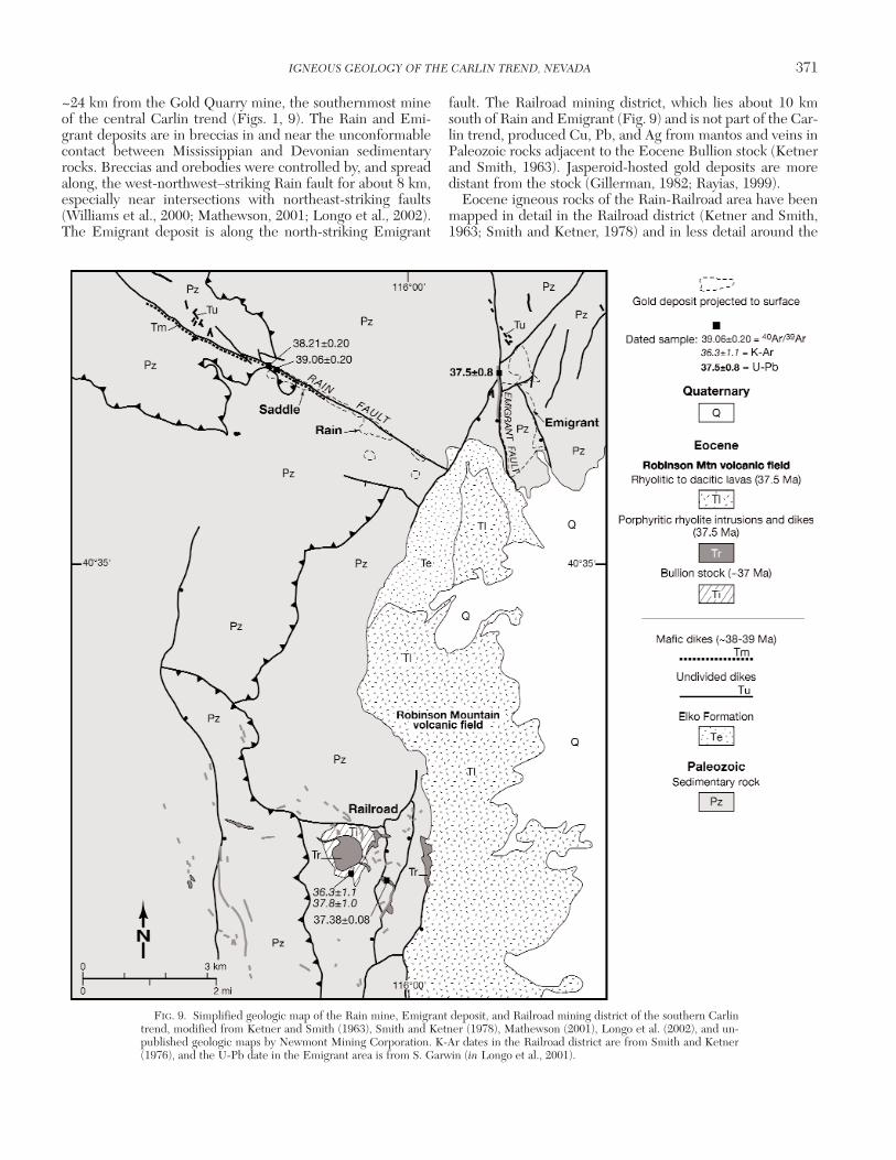
~24 km from the Gold Quarry mine, the southernmost mineof the central Carlin trend (Figs. 1, 9). The Rain and Emi-grant deposits are in breccias in and near the unconformablecontact between Mississippian and Devonian sedimentaryrocks. Breccias and orebodies were controlled by, and spreadalong, the west-northwest–striking Rain fault for about 8 km,especially near intersections with northeast-striking faults(Williams et al., 2000; Mathewson, 2001; Longo et al., 2002).The Emigrant deposit is along the north-striking Emigrant
fault. The Railroad mining district, which lies about 10 kmsouth of Rain and Emigrant (Fig. 9) and is not part of the Car-lin trend, produced Cu, Pb, and Ag from mantos and veins inPaleozoic rocks adjacent to the Eocene Bullion stock (Ketnerand Smith, 1963). Jasperoid-hosted gold deposits are moredistant from the stock (Gillerman, 1982; Rayias, 1999).
Eocene igneous rocks of the Rain-Railroad area have beenmapped in detail in the Railroad district (Ketner and Smith,1963; Smith and Ketner, 1978) and in less detail around the
IGNEOUS GEOLOGY OF THE CARLIN TREND, NEVADA 371
0361-0128/98/000/000-00 $6.00 371
FIG. 9. Simplified geologic map of the Rain mine, Emigrant deposit, and Railroad mining district of the southern Carlintrend, modified from Ketner and Smith (1963), Smith and Ketner (1978), Mathewson (2001), Longo et al. (2002), and un-published geologic maps by Newmont Mining Corporation. K-Ar dates in the Railroad district are from Smith and Ketner(1976), and the U-Pb date in the Emigrant area is from S. Garwin (in Longo et al., 2001).

Rain and Emigrant deposits (Longo et al., 2002). We identifytwo major packages on the basis of petrography and age (Figs.1, 9). These are basaltic andesite to porphyritic diorite dikesthat intruded along the Rain fault and the large RobinsonMountain volcanic field. The latter consists of a granitic stockin the Railroad district, porphyritic rhyolite to dacite dikesand small stocks around the Railroad district and Emigrantdeposit, and porphyritic rhyolite to dacite lavas and tuffs,probably extrusive equivalents of the dikes (Figs. 1, 9). Manydikes around Rain are too altered to be characterized with anyconfidence and are shown as undivided in Figure 9.
Mafic dikes along the Rain fault are variably altered and lo-cally host ore (Shallow, 1999; Longo et al., 2002). Less altereddikes are identifiable as basaltic andesite and porphyritic dior-ite, with altered to partly preserved phenocrysts of olivine, py-roxene and/or hornblende, and biotite. The least altered rocksare weakly propylitized but more typically are altered to clayand iron oxides at and near the surface and to clay and ironsulfides at depth. These dikes were initially interpreted asJurassic lamprophyres because of their mafic phenocrysts(Longo et al., 2002), but our dating indicates that they areEocene.
Two less altered dikes intersected in core from the Saddledeposit along the Rain fault were dated (Table 1; Figs. 4, 9).Biotite from a porphyritic diorite that contains fresh biotiteand partly altered pyroxene and hornblende phenocrystsgives a slightly disturbed spectrum with a weighted mean ageof 39.06 ± 0.20 Ma. This is supported by an isochron age of39.13 ± 0.18 Ma, so reasonably indicates the time of em-placement.
The second dike, a porphyritic basaltic andesite, containsaltered pyroxene and olivine phenocrysts in a groundmass ofrelatively fresh plagioclase. The dike has been propyliticallyaltered with abundant carbonate and about 0.5 vol percentpyrite. A separate of the matrix, with altered phenocrysts,pyrite, and carbonate removed, yielded a disturbed, dropping40Ar/39Ar age spectrum with ages ranging from ~41 to 37.8Ma that probably indicates recoil. A weighted mean of theflattest, low-temperature part of the spectrum gives an ap-parent age of 38.21 ± 0.20 Ma (Table 1); an isochron of allsteps gives an age of 37.8 ± 1.2 Ma. These data most likely in-dicate emplacement but possibly alteration at ~38 Ma.
The granitic Bullion stock of the Railroad district andRobinson Mountain field is cut by an inner stock and numer-ous dikes of porphyritic rhyolite to dacite, which extend asmuch as 4 km from the stock. The porphyritic dikes containlarge phenocrysts of plagioclase, biotite, hornblende, quartz,±sanidine and are petrographically similar to the coarsely por-phyritic rhyolites of the northern Carlin trend and EmigrantPass field. K-Ar ages of 36.3 ± 1.1 and 37.8 ± 1.0 Ma on rhy-olite (Smith and Ketner, 1976) are confirmed by our sanidinedate of 37.38 ± 0.08 Ma (Table 1); another hypabyssal intru-sion or lava dome farther south in the Robinson field has anage of 37.51 ± 0.19 Ma (Fig. 1, Table 1). Porphyritic rhyolitedikes, termed monzonite porphyry in Longo et al. (2001), arealso present in the Emigrant deposit. Longo et al. (2002) re-ported a zircon U/Pb SHRIMP age on one dike of 37.5 ± 0.8Ma, which is indistinguishable from our dates (Fig. 9, Table1). The area between Railroad and Emigrant has not beenmapped in detail, and additional dikes may be present.
Numerous lavas and some ash-flow tuffs of coarsely por-phyritic rhyolite to dacite, petrographically similar to thedikes at Railroad and Emigrant, make a thick pile that extendsfrom Emigrant to more than 30 km south of the Railroad dis-trict (Figs. 1, 9). One of the tuffs gives a 40Ar/39Ar age of 37.70± 0.19 Ma (Table 1). This age and the petrographic similarityare consistent with the volcanic rocks being extrusive equiva-lents of the intrusions.
Mineralization at Rain postdates ~38.0 Ma, the age of theyounger of the two dikes. That dike contains pyrite, and Asand Sb have been added to both dikes. From similar data,Longo et al. (2002) concluded that mineralization at the Em-igrant deposit postdates the 37.5 Ma porphyritic rhyolite.
Miocene Rhyolite (15 Ma)Middle Miocene, sparsely porphyritic, rhyolite lavas are
present along the west edge of the northern Carlin trend andbetween the Emigrant Pass volcanic field and the Rain sub-district (Fig. 2). The lavas disappear beneath middle Miocenetuffaceous sedimentary rocks and Quaternary deposits inboth areas, westward into Boulder Valley from the northernCarlin trend and eastward beneath the Carlin basin in thesouth. The northern sequence of flows thickens from only afew meters in the east, nearest the trend, to hundreds of me-ters to the west under Boulder Valley. The southern flowsthicken eastward beneath the Carlin basin and southeastwardto the southeastern corner (Fig. 2). Rhyolitic, pyroclastic-falldeposits are common in the lower parts of the Miocene strati-graphic sequence throughout the Carlin trend. Some tuffs arerelated to the rhyolite lavas, although Fleck et al. (1998) sug-gested that others erupted from sources in southwesternIdaho.
No sources are recognized for these lavas within the Carlintrend. The source of the northern flows could be buried be-neath Boulder Valley. The source of the southern flows isprobably beneath their thickest pile in the southeast. One ofthe southern flows east of the Emigrant Pass volcanic fieldgives a 40Ar/39Ar age on sanidine of 15.32 ± 0.08 Ma (Table 1).The northern flows have a K-Ar sanidine date of 14.6 ± 0.3Ma (Evans, 1974b).
Both northern and southern rhyolite lavas contain 74 to 76wt percent SiO2, but they are petrographically and composi-tionally distinct (Fig. 6, Table 3). The northern lavas havesparse phenocrysts of olivine and Fe-rich pyroxene accompa-nying sanidine and quartz. They also have high Fe, Zr, Nb,and REE. Concentrations of the LREE are as high as in theJurassic lamprophyres, but the Miocene rocks have higherHREE and large Eu anomalies (Fig. 8). A pyroclastic-fall de-posit within Miocene sedimentary rocks at the southwesternedge of the Emigrant Pass volcanic field has the same chem-ical signature and probably is related to the lavas. Southernlavas are more typical rhyolites with phenocrysts of biotite ac-companying sanidine and quartz and having lower concentra-tions of Fe, Zr, Nb, and REE. Both compositional types arepresent near Ivanhoe, but only the Fe-rich rhyolites are pre-sent in the northern Nevada rift near Midas (Wallace, 1993,2003a; John et al., 2000). Miocene mafic to intermediatelavas, although abundant in the northern Nevada rift just 20km to the west (John et al., 2000, 2003; John, 2001), are ab-sent within the Carlin trend.
372 RESSEL AND HENRY
0361-0128/98/000/000-00 $6.00 372

Aeromagnetic DataAirborne magnetic data used in this study were acquired in
18 surveys flown between 1983 and 1999 for Newmont Min-ing Corporation, using inhouse and commercial helicopter-based cesium vapor magnetometers. In general, flight lineswere east-west and spaced between 100 and 400 m, and sur-vey altitudes ranged from 45 to 100 m. Corrections to totalfield data were made for diurnal and other variations in theEarth’s field at the time of the survey. The data were thenmerged and the total field reprocessed. For this study, up-ward continuation of the composite magnetic data was usedto better define anomalies at deeper levels. The method in-volves a two-fold transformation; first, raw surface data aremodeled to the approximate depth of an anomaly, then pro-jected to the surface (i.e., upward continuation; Dobrin andSavit, 1988). The effect of upward continuation is to amplifydeeper sourced anomalies that otherwise would be poten-tially masked by higher level anomalies. Figures 10 and 11show magnetic data upward continuation to 2,000 m for thenorthern and central Carlin trend and Rain area-southernCarlin trend, respectively. The significance of these data isdiscussed below.
Discussion
Temporal association of mineralization and Eocene magmatism in the Carlin trend
It is well established that Carlin-type deposits in the GreatBasin formed in the Eocene, and dating in the Carlin trendsubstantiates that conclusion (Fig. 12). Arehart et al. (2003)determined an Rb-Sr age of 39.8 ± 0.6 Ma on galkhaite, a lateore-stage sulfosalt mineral from the Rodeo deposit north ofBetze-Post. Coarse 2M1 illite replacing biotite phenocrysts inplagioclase-biotite-hornblende dacite at the Griffin (Meikle)deposit gave a complex 40Ar/39Ar spectrum; the best interpre-tation of its age is 39.6 ± 0.9 Ma from an isochron that used 84percent of the released gas (Ressel et al., 2000b). Heitt et al.(2003) interpreted mineralization at Deep Star to be brack-eted at ~39.1 Ma by two closely spaced stages of intrusion ofaphyric rhyolite. Mineralization postdates 40.1 to 39.0 Madikes at Betze-Post, a 39.5 Ma dike at Griffin (Meikle), a 37.8Ma dike at Dee, and a 37.6 Ma dike at Beast. These data sug-gest multiple episodes of mineralization that were contempo-raneous with the multiple episodes of Eocene intrusion in thenorthern Carlin trend (Fig. 12). Episodes of mineralization in-clude at least an older, ~39 to 40 Ma episode in the northernBetze-Post area, contemporaneous with the dikes there, and ayounger episode after 37.6 Ma at Beast, no older than the dikethere. Also, because mineralized Eocene dikes are present inalmost all deposits, probably no mineralization occurred be-fore ~40 Ma. An obvious question is what was special aboutthe late Eocene and particularly about Eocene magmatism.Below we suggest that a series of large, partly deep-seated plu-tons underlie the Carlin trend and were primary heat sourcesto drive the large hydrothermal systems of the trend.
Number, size, and depth of emplacement of interpreted Eocene plutons
Henry and Ressel (2000a) noted that the abundant, Eocene,porphyritic, silicic dikes require the presence of an underlying
plutonic complex. The large, positive aeromagnetic anomalycentered on the Emigrant Pass volcanic field (Hildenbrandand Kucks, 1988) is one major indicator of that plutonic com-plex (Grauch, 1996; Ressel et al., 2000a, 2001), and aeromag-netic data presented here strengthen that conclusion (Fig.10). Silicic magmas represented by the dikes require largemagma chambers to develop, either by differentiation ofmantle-derived, basaltic magmas, by crustal melting or, morecommonly, by a combination of differentiation and crustalmelting-assimilation (Barker, 1981; Hildreth, 1981; Barnes etal., 2001). Therefore, we interpret the exposed dikes to beminor apophyses from an underlying plutonic complex. Suitesof dikes determined from the age and petrographic data areareally restricted (Fig. 2). All Eocene dikes cannot have comefrom a single chamber or only from the complex indicated bythe aeromagnetic anomaly centered on the Emigrant Passvolcanic field and Welches Canyon (see below). For example,the dikes in the Betze-Post area did not emanate fromWelches Canyon. This would have required that individualsuites of dikes only be emplaced 12 to 15 km north of thenorthern edge of the source pluton and not above it or sym-metrically around it, and that they be a different age than thesource pluton.
The age and distribution of Eocene dikes and volcanic rocksrequire a minimum of five or six plutons that mostly young to-ward the south (Figs. 10, 13). The oldest one or two plutonsare inferred from the distribution of the three oldest suites ofdikes of the northern Carlin trend: 40.3 to 39.3 Ma plagio-clase-biotite ± quartz rhyolites, 40.1 to 39.0 Ma plagioclase-bi-otite-hornblende dacites, and the ~39.1 Ma aphyric rhyolites.The nearly continuous span of ages allows for either multiplemagma chambers or a single, long-lived (≥1 m.y.) chamber.Either would have been centered beneath the Betze-Post de-posit and the richest part of the Carlin trend (Figs. 10, 13). Wesuggest two plutons because the aphyric rhyolites are distinctlydifferent from the porphyritic rocks. The composite plutonswould have a diameter of about 10 km if the dikes rose verti-cally from them. Because even large crustal magma chamberscool rapidly, a long-lived system would require periodic re-plenishment by basaltic magma to remain molten (Cathles etal., 1997). A better understanding of the geochemical-isotopiccharacteristics and petrogenesis of the three suites of dikeswould help evaluate these alternatives.
The aeromagnetic data are consistent with two or threeplutons beneath the northern Carlin trend (Fig. 10). Positiveanomaly A underlies the Jurassic Goldstrike intrusion and isdiscussed below. Anomaly B (the barbell-shaped body in Fig.10) is itself composite and lies along the margin and just northof the pluton inferred from dike distributions only. The closeproximity of the dike-inferred body to the aeromagneticanomaly suggests that the latter marks a pluton or plutonsthat fed the dikes. The composite nature of anomaly B is con-sistent with the possibility of a composite or long-lived source.The low magnitude of the anomaly suggests that the pluton orplutons are relatively deep (Fig. 13).
The 37.6 Ma plagioclase-biotite-hornblende-quartz ± sani-dine rhyolites require a third major source (Fig. 10). Thesedikes extend over a distance of about 18 km along the north-ern Carlin trend and are the most extensive of any of the sili-cic dikes of the trend. Their distribution is comparable to the
IGNEOUS GEOLOGY OF THE CARLIN TREND, NEVADA 373
0361-0128/98/000/000-00 $6.00 373

374 RESSEL AND HENRY
0361-0128/98/000/000-00 $6.00 374

distribution of petrographically similar dikes around severalEocene igneous centers where a central stock is exposed (e.g.,Tuscarora or Swales Mountain: Evans and Ketner, 1971; Henryand Ressel, 2000b; Ressel et al., 2001a; Castor et al., 2003).However, the central stock in these examples is interpreted tobe a small (≤3 km2), shallow apophysis above a deeper, mainchamber. The 37.6 Ma pluton in the northern Carlin trend con-ceivably underlies and is represented by the northern part ofthe large, positive aeromagnetic anomaly C, which is about inthe middle of the dike distribution. Alternatively, a deep and/orrelatively nonmagnetic pluton could be disguised beneath theassociated negative anomaly D north of anomaly C.
Multiple plutons also presumably underlie the 38.6 MaWelches Canyon intrusions, the 38.1 to 37.4 Ma EmigrantPass volcanic field, and the 36.2 Ma plagioclase-biotite-horn-blende-quartz ± sanidine rhyolite dikes of the Emigrant Passfield (Figs. 10, 13). The spatial separation and different agesof the Welches Canyon intrusions and the Emigrant Pass vol-canic field require separate bodies. The inferred plutonic sys-tem underlying the Emigrant Pass volcanic field, which wasactive from ~38.1 to 37.4 Ma, could be either long-lived orcomposite. The distribution of subvolcanic intrusions and lavavents and the association with much of positive magneticanomaly C (Fig. 10) suggest that the underlying plutonic sys-tem is at least 20 km across, east to west. The 36.2 Ma rhyo-lite dikes in the Emigrant Pass field are thought to be relatedto the youngest pluton of the Carlin trend. Their separationby ~1 m.y. from the rest of the field with no intervening ac-tivity indicates that they did not arise from a single, long-livedchamber that fed both systems. Their similarity to the 37.6Ma dikes demonstrates the need for precise dating to distin-guish events in areas of complex magmatism.
The Welches Canyon and Emigrant Pass rocks fall withinthe areas of the positive aeromagnetic anomaly of Hilden-brand and Kucks (1988) and the similar, upward continuedanomaly C of Figure 10. The amplitude of anomaly C, thesteep gradients at its margins, and the separate highs C1 andC2 within the anomaly indicate a shallow composite pluton(Grauch, 1996). Anomaly C1 is centered on the WelchesCanyon intrusions, which are often referred to as “the Eocenepluton” of the northern Carlin trend (Chakurian et al., 2003;Emsbo et al., 2003; Hofstra et al., 2003). However, as shown
here, the exposed Welches Canyon intrusions are shallow,porphyritic rocks, most likely minor apophyses of a larger andonly moderately deeper body shown by the aeromagneticdata. Moreover, the Welches Canyon intrusions are distinctlyyounger than the dikes of the Betze-Post area and cannothave been their source. Anomaly C2 coincides with severalvents of the Emigrant Pass field and with the 36.2 Ma dikes.
The relatively large, subvolcanic intrusions in WelchesCanyon, Boulder Valley, and throughout the Emigrant Passvolcanic field, the presence and abundance of lavas in theEmigrant Pass field, and the amplitude and sharp boundaryof the associated aeromagnetic anomaly are consistent withshallow magma chambers. In contrast, the pluton(s) beneaththe northern Carlin trend were probably emplaced at greaterdepth (Figs. 10, 13). The fact that only dikes are present inthe north and that anomaly B has a lower amplitude supporta deeper body.
The Rain deposits of the southern Carlin trend lie ~8 kmnorth of a ~10-km-diam, positive aeromagnetic anomaly 1 to2 km southwest of the 37.4 Ma Bullion stock (Fig. 11).Hildenbrand and Kucks (1988) and Grauch (1996) inter-preted this anomaly to reflect another major, underlying plu-ton. Aeromagnetic data that are not upward continued showa V-shaped pattern, with highs coinciding with the stock andthe northwest-trending rhyolite dike swarm west of the stock.We interpret the 37.5 Ma porphyritic rhyolite dike at the Em-igrant deposit, which also lies ~8 km north of the anomaly, tobe related to the pluton represented by this anomaly. This in-terpreted pluton could have provided heat to generate theCarlin-type deposits at Rain.
The significance of the 37.8 Ma basaltic andesite at Deeand the 38.2 Ma basaltic andesite at Rain is less certain, be-cause mafic magmas do not require crustal magma chambers.Mafic rocks of Eocene age are found elsewhere only in theJerritt Canyon Carlin-type district (Fig. 2; Phinisey et al.,1996). This scarcity may reflect the difficulty that mafic mag-mas have in propagating through low-density, silicic magmachambers (Hildreth, 1981). Mafic magmas can appear aftersilicic magmatism has ended in an area or on the flanks of sili-cic centers, such as in the modern Cascade Range.
The distribution of dikes and aeromagnetic anomalies inthe northern and central Carlin trend suggests that an
IGNEOUS GEOLOGY OF THE CARLIN TREND, NEVADA 375
0361-0128/98/000/000-00 $6.00 375
FIG. 10. Geologic map of the northern and central Carlin trend from Figure 2, showing aeromagnetic data upward con-tinued to 2,000 m (Newmont Mining Corp.) and Eocene plutons (dashed lines labeled by age) inferred from the age, pet-rography, and distribution of Eocene dikes (see text for detailed discussion). We interpret the positive magnetic anomaliesin the northern Carlin trend to indicate composite plutons at depth. Anomaly A coincides with the postulated feeder zonefor the Jurassic Goldstrike laccolith sill. The barbell-shaped anomaly B is interpreted to indicate a deep-seated pluton or plu-tons, the map location of which partly overlaps with the position of a deep pluton inferred from dike data. Although it is im-possible to determine the age of the pluton represented by anomaly B, the close proximity of the anomaly to the dike-inter-preted body suggests that the anomaly marks an Eocene pluton or plutons that fed the dikes. The low magnitude of theanomaly suggests that the pluton or plutons are relatively deep. The large age range of the dike-interpreted pluton (40.3–39.0Ma) indicates that it was composite or long-lived. The large, positive aeromagnetic anomaly C extending from RichmondMountain to Emigrant Pass coincides closely with the aeromagnetic anomaly indicated by regional data (dotted outline:Hildenbrand and Kucks, 1988; Grauch, 1996). The large magnitude of this anomaly and the separate highs within it (C1 andC2) support the interpretation of relatively shallow, composite plutons that fed the Welches Canyon intrusions, the EmigrantPass volcanic field, and the 36.2 Ma dike swarm. The associated, negative aeromagnetic anomaly D north of this positiveanomaly could conceal a deep-seated pluton beneath the magnetic low. Airborne magnetic data were acquired in 18 surveysflown between 1983 and 1999 for Newmont Mining Corporation using inhouse and commercial helicopter-based cesiumvapor magnetometers. See “Aeromagnetic Data” for further explanation.

Eocene plutonic complex underlies an area about 50 kmnorth-south and between 12 and 23 km across (i.e., possibly1,000 km2; Figs. 10, 13). The thickness of the complex or ofindividual plutons is unknown, but magnetotelluric data
suggest thicknesses of 10 km or more (Rodriguez, 1998).Thus, possibly 10,000 km3 or more of Eocene magma wereemplaced beneath the northern and central Carlin trend be-tween about 40 and 36 Ma.
376 RESSEL AND HENRY
0361-0128/98/000/000-00 $6.00 376
FIG. 11. Geologic map of the Rain mine area of the southern Carlin trend from Figure 9, with aeromagnetic data upwardcontinued to 2,000 m (Newmont Mining Corporation). The distribution of dikes and aeromagnetic data indicate a large (~10km diam) intrusion centered southwest of the Railroad district. The Bullion stock and porphyritic rhyolite dikes are inter-preted to be apophyses from this larger intrusion. Airborne magnetic data from Newmont Mining Corporation; see section“Aeromagnetic Data.”
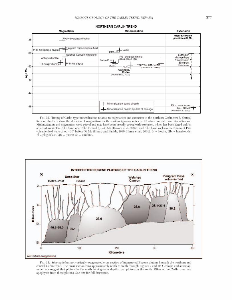
IGNEOUS GEOLOGY OF THE CARLIN TREND, NEVADA 377
0361-0128/98/000/000-00 $6.00 377
FIG. 12. Timing of Carlin-type mineralization relative to magmatism and extension in the northern Carlin trend. Verticallines on the bars show the duration of magmatism for the various igneous suites or 1σ values for dates on mineralization.Mineralization and magmatism were coeval and may have been broadly coeval with extension, which has been dated only inadjacent areas. The Elko basin near Elko formed by ~46 Ma (Haynes et al., 2002), and Elko basin rocks in the Emigrant Passvolcanic field were tilted ~10° before 38 Ma (Henry and Faulds, 1999; Henry et al., 2001). Bi = biotite, Hbl = hornblende,Pl = plagioclase, Qtz = quartz, Sa = sanidine.
FIG. 13. Schematic but not vertically exaggerated cross section of interpreted Eocene plutons beneath the northern andcentral Carlin trend. The cross section runs approximately north to south through Figures 2 and 10. Geologic and aeromag-netic data suggest that plutons in the north lie at greater depths than plutons in the south. Dikes of the Carlin trend areapophyses from these plutons. See text for full discussion.
Implications of fission-track data for plutons
Chakurian et al. (2003) and Tosdal et al. (2003b) deter-mined apatite fission-track ages of samples in and around theCarlin trend. Three samples from within the area of the large,aeromagnetic anomaly C were reset at 37 to 38 Ma (for ex-ample, a sample from the Cretaceous Richmond stock gave afission-track age of 37.8 Ma), and one was reset at 28 Ma(Chakurian et al., 2003). Only one of these samples is close toa known Carlin-type deposit. In contrast, only two of 19 ap-atite samples from the northern Carlin trend outside theanomaly were similarly reset. One of three samples from theCarlin deposit gave a fisson-track age of 40.9 Ma (one was18.6 Ma), and one of two samples from the Betze-Post de-posit gave an age of 35.5 Ma. All other samples, most of whichwere from Carlin-type deposits, gave ages ranging from 56.1to 129 Ma.
Although Chakurian et al. (2003) interpreted the fission-track data to indicate the time of gold mineralization, the dataindicate only the time of heating to 110° to 135°C longenough to anneal fission tracks (Green et al., 1989). The dis-tribution of ages implies that conductive, convective, or com-bined heating around the shallow, Eocene plutons of theWelches Canyon-Emigrant Pass area reset the fission-trackages to the time of intrusion. In contrast, heating by the Car-lin-type hydrothermal systems alone was insufficient to resetages. Although maximum hydrothermal temperatures in thenorthern Carlin trend are estimated to have been ~240°C(Hofstra and Cline, 2000), hydrothermal heating apparentlywas of insufficient duration to reset the apatite fission-trackages, even within major deposits, to the Eocene age of min-eralization. The deep Eocene plutons indicated by our workalso were apparently too deep to heat country rock aroundthe northern deposits sufficiently to reset the fission-trackages.
Depth of pluton emplacement
Although the southern plutons beneath Welches Canyonand the Emigrant Pass volcanic field appear to have been em-placed at shallower depths than the northern plutons, theirabsolute depths are less certain (Fig. 13). Based on the steepgradients at the margins of aeromagnetic anomaly C (Grauch,1996), resetting of apatite fission-track ages (Chakurian et al.,2003), and the high-temperature, skarn-type alterationaround the Welches Canyon stocks, we infer that the south-ern plutons are no more than about 3 km below the presentsurface.
In the northern Carlin trend, the presence of abundant rhy-olite dikes above the inferred plutons probably precludes asource much deeper than about 8 to 10 km, which is the max-imum lateral distance that similar rhyolite dikes extend fromrelated plutons in northeastern Nevada (Ressel et al., 2000a).The association of aeromagnetic anomalies with all inferredplutons also suggests that they cannot be extremely deep.Quantitative modeling of the fission-track data of Chakurianet al. (2003) to estimate a combined maximum size, depth,and temperature of the plutons is probably possible but be-yond the scope of this report.
The 36 Ma Harrison Pass pluton in the Ruby Mountainshas a very low magnetite content (Barnes et al., 2001) and no
associated aeromagnetic anomaly (Hildenbrand and Kucks,1988). This composite intrusion is estimated to have beenemplaced at ~12 km (Barnes et al., 2001) and is otherwise agood analog to our postulated deep plutons.
Jurassic and Cretaceous plutons
The clustering of Jurassic dikes around the Goldstrike lac-colith may also indicate the presence of a deeper pluton be-neath the laccolith. This interpretation is supported by posi-tive aeromagnetic anomaly A, which suggests a feederbeneath the southwestern end of the Goldstrike laccolith(Fig. 10). The Jurassic rocks exhibit two significant differ-ences from the Eocene rocks. Jurassic magmatism was moremafic, dominated by the Goldstrike diorite and lamprophyredikes, although rhyolite dikes are also present. Jurassic mag-matism also may have been temporally restricted, both in theCarlin trend and more regionally (Mortensen et al., 2000; thisstudy). All Jurassic intrusions in the Carlin trend could haveemanated from a single magma body that was centered be-neath the Goldstrike laccolith.
From aeromagnetic and other data (see Cretaceous Rich-mond Granite, above) we infer that a Cretaceous pluton un-derlies an area in the northeastern part of anomaly C (Fig.10). Distinguishing the magnetic contribution of Eocene andCretaceous rocks in this area is difficult.
Depth of formation of Carlin-type deposits
Henry and Ressel (2000a) argued on structural groundsthat the tops of deposits of the northern Carlin trend proba-bly formed at paleodepths no greater than about 1 km. Thepresent-day elevation of the Eocene-Paleozoic unconformityin the Emigrant Pass volcanic field marks the Eocene paleo-surface. Extrapolating the paleosurface northward into thenorthern Carlin trend must allow for relative displacementson intervening structures. The only major post-Eocene struc-ture along this northward projection is the northeast-strikingnormal fault between Welches Canyon and the Cretaceousgranite outcrop (Fig. 2). This fault has a maximum displace-ment of ~2 km at its northeast end (Evans, 1974a, b), but dis-placement diminishes to the southwest on a line between thenorthern Carlin trend and Emigrant Pass. This extrapolationsuggests that the Eocene paleosurface was not much higherthan the present-day surface in the northern Carlin trend. Al-lowing for uncertainty in this structural reconstruction, thetops of most major orebodies (not the deepest recognizedmineralization) probably formed no deeper than about 1 km.Apatite fission-track and U-Th/He data confirm this interpre-tation (Haynes et al., 2003; Hickey et al., 2003). These dataindicate that the present-day surface in the northern Carlintrend lies 500 to 1,500 m below the ~42 Ma paleosurface.Given the vertical range of mineralization, Hickey et al.(2003) and Haynes et al. (2003) concluded that Carlin-typedeposits formed at depths between 500 and 2,200 m. Thesedepths are in the shallower range of estimates of 1 to 6.5 kmbased on fluid inclusion data (Hofstra and Cline, 2000).
Relevance of Eocene plutons for models of the origin of Carlin-type deposits
In the most recent review of Carlin-type deposits, Cline etal. (2005, p. 451) suggested that “deep, primitive fluids” were
378 RESSEL AND HENRY
0361-0128/98/000/000-00 $6.00 378

generated through lower crustal melting and metamorphismand that “Such fluids were likely incorporated in deep crustalmelts that rose buoyantly and ultimately exsolved hydrother-mal fluids, possibly containing gold” (p. 451-452).Our datademonstrate that large volumes of magma were most likelypresent and were a probable heat source for Carlin-type de-posits of the Carlin trend, although we do not address thesource of gold. Although Cline et al. (2005) suggested only aregional-scale association of Carlin-type deposits and Eocenemagmatism in northern Nevada, we suggest a very close spa-tial and temporal association between inferred plutons of theCarlin trend and the gold deposits.
Thorough study of the igneous rocks of the three othermajor Carlin-type districts in Nevada, Cortez-Pipeline, JerrittCanyon, and Getchell-Twin Creeks, is needed to evaluatethese models. Eocene volcanic or intrusive rocks coeval withthe time of mineralization are known in two of the three dis-tricts. At Cortez, 35 Ma, hydrothermally altered, porphyriticrhyolite dikes are variably interpreted as pre- or postmineral(Wells et al., 1969; McCormack and Hays, 1996; Mortensenet al., 2000). Eocene lavas and dikes are present at JerrittCanyon, and some dikes are mineralized (Hofstra et al., 1999;C.D. Henry, unpub. data). Eocene intrusions have not beenfound in the Getchell trend, but ~41 Ma rhyolite and dacitelavas and tuffs crop out within 6 km of the trend, and the in-tervening area is covered by Quaternary deposits (Wallace,1993; Henry and Ressel, 2000; Laravie, 2005).
AcknowledgmentsWork contributing to this report was supported by the Cen-
ter for Research in Economic Geology (Mackay School ofMines, University of Nevada, Reno) and by the U.S. Geolog-ical Survey through STATEMAP Agreement 98-HQ-AG-2036. Barrick Goldstrike Mines and Newmont Mining Cor-poration provided additional funds for 40Ar/39Ar dating.40Ar/39Ar dating was done at the New Mexico GeochronologyResearch Laboratory and the Nevada Isotope GeochronologyLaboratory. We thank Bill McIntosh, Matt Heizler, Lisa Pe-ters, and Rich Esser at New Mexico Tech and Terry Spell andKathy Zanetti at the University of Nevada Las Vegas for guid-ance. Newmont Mining Company generously allowed the useof their proprietary aeromagnetic data, and discussions withMark Goldie greatly helped to explain the significance ofthese data. We thank Steve Garwin for data and discussionabout the U-Pb SHRIMP date at the Emigrant deposit.David John and Richard Tosdal generously contributed sam-ples from the Robinson volcanic field and Railroad mine area.Reviews of an early draft by Stephen Castor, Jonathan Price,and Tommy Thompson and of the submitted manuscript byJean Cline, Charles Cunningham, and Ross Sherlock greatlyimproved the content and clarity of this report.
February 3, 2005; March 16, 2006
REFERENCESAnders, E., and Grevesse, N., 1989, Abundances of the elements: Meteoritic
and solar: Geochimica et Cosmochimica Acta, v. 53, p. 197–214.Arehart, G.B., 1996, Characteristics and origin of sediment-hosted gold de-
posits: A review: Ore Geology Reviews, v. 11, p. 383–403.Arehart, G.B., Foland, K.A., Naeser, C.W., and Kesler, S.E., 1993, 40Ar/39Ar,
K-Ar, and fission-track geochronology of sediment-hosted disseminated
gold deposits at Post/Betze, Carlin trend, northeastern Nevada: ECONOMICGEOLOGY, v. 88, p. 622–646.
Arehart, G.B., Chakurian, A.M., Tretbar, D.R., Christensen, J.N., McInnes,B.A., and Donelick, R.A., 2003, Evaluation of radioisotope dating of Car-lin-type deposits in the Great Basin, western North America, and implica-tions for deposit genesis: ECONOMIC GEOLOGY, v. 98, p. 225–248.
Armstrong, R.L., 1970, Geochronology of Tertiary igneous rocks, easternBasin and Range province, western Utah, eastern Nevada, and vicinity,U.S.A.: Geochimica et Cosmochimica Acta, v. 34, p. 203–232.
Bakken, B.M., 1990, Gold mineralization, wall-rock alteration, and the geo-chemical evolution of the hydrothermal system in the main orebody, Car-lin mine, Nevada: Unpublished Ph.D. thesis, California, Stanford Univer-sity, 283 p.
Barker, F., 1981, Introduction to special issue on granites and rhyolites: Acommentary for the nonspecialist: Journal of Geophysical Research, v. 86,p. 10131–10135.
Barnes, C.G., Burton, B.R., Burling, T.C., Wright, J.E., and Karlsson, H.R.,2001, Petrology and geochemistry of the late Eocene Harrison Pass pluton,Ruby Mountains core complex, Northeastern Nevada: Journal of Petrology,v. 42, p. 901–929.
Barton, M.D., 1996, Granitic magmatism and metallogeny of southwesternNorth America: Geological Society of America Special Paper 315, p.261–280.
Bettles, K., 2002, Exploration and geology, 1962–2002, at the Goldstrikeproperty: Nevada Bureau of Mines and Geology Bulletin 111, p. 54–75.
Branham, A., and Arkell, B., 1995, The Mike gold-copper deposit, Carlintrend, Nevada, in Hagni, R.D., ed., Process Mineralogy XIII: Applicationsto beneficiation problems, pyrometallurical products, advanced mineralog-ical techniques, precious metals, environmental concerns, ceramic mater-ial, hydrometallurgy and minerals exploration: Warrendale, PA, Minerals,Metals, and Materials Society, p. 204–211.
Brooks, W.E., Thorman, W.E., and Snee, L.W., 1995a, The 40Ar/39Ar ages andtectonic setting of the middle Eocene northeast Nevada volcanic field:Journal of Geophysical Research, v. 100, p. 10,403–10,416.
Brooks, W.E., Thorman, W.E., Snee, L.W., Nutt, C.W., Potter, C.J., and Du-biel, R.F., 1995b, Summary of chemical analyses and 40Ar/39Ar-spectra datafor Eocene volcanic rocks from the central part of the northeast Nevadavolcanic field: U.S. Geological Survey Bulletin 1988–K, p. K1–K33.
Castor, S.B., Boden, D.R., Henry, C.D., Cline, J.S., Hofstra, A.H., McIntosh,W.C., Tosdal, R.M., Wooden, J.P., 2003, Geology of the Eocene Tuscaroravolcanic-hosted, epithermal precious metal district, Elko County, Nevada:ECONOMIC GEOLOGY, v. 98, p. 339–366.
Cathles, L.M., Erendi, A.H.J., and Barrie, T., 1997, How long can a hy-drothermal system be sustained by a single intrusive event?: ECONOMICGEOLOGY, v. 92, p. 766–771.
Cebula, G.T., Kunk, M.J., Mehnert, H.H., Naeser, C.W., Obradovich,J.D., and Sutter, J.F., 1986, The Fish Canyon Tuff, a potential standardfor the 40Ar/39Ar and fission-track dating methods: Terra Cognita, v. 6,p. 139–140.
Chakurian, A.M., Arehart, G.B., Donelick, R.A., Zhang, X., and Reiners,P.W., 2003, Timing constraints of gold mineralization along the Carlin trendutilizing apatite fission-track, 40Ar/39Ar, and apatite (U-Th)/He methods:ECONOMIC GEOLOGY, v. 98, p. 1159–1171.
Christiansen, R.L., and Yeats, R.S., 1992, Post-Laramide geology of the U. S.Cordilleran region: Geological Society of America Decade in North Amer-ican Geology Series, v. G-3, p. 261–406.
Cline, J.S., Shields, D., Riciputi, L., Fayek, M., Copp, T.L., Muntean, J., andHofstra, A.H., 2003, Trace element and isotope microanalyses support adeep ore fluid source at the Getchell Carlin-type gold deposit, northernNevada [abs.]: Geological Society of America Abstracts with Programs, v.35, no. 6, p. 358.
Cline, J.S., Hofstra, A.H., Muntean, J.L., Tosdal, R.M., and Hickey, K.A.,2005, Carlin-type gold deposits in Nevada: Critical geologic characteristicsand viable models: ECONOMIC GEOLOGY 100TH ANNIVERSARY VOLUME, p.451–484.
DePaolo, D.J., and Farmer, G.L., 1984, Isotopic data bearing on the origin ofMesozoic and Tertiary granitic rocks in the Western United States: Philo-sophical Transactions of the Royal Society of London, Series A, v. 310, p.743–753.
DiVincenzo, G., Viti, C., and Rocchi, S.,2003, The effect of chlorite interlay-ering on 40Ar-39Ar biotite dating: an 40Ar-39Ar laser-probe and TEM investi-gations of variably chloritised biotites: Contributions to Mineralogy andPetrology, v. 145, p. 643–658.
IGNEOUS GEOLOGY OF THE CARLIN TREND, NEVADA 379
0361-0128/98/000/000-00 $6.00 379

Dobak, P.J., Arbonies, D., Hipsely, R., and Visher, M., 2002, Geology of theStorm gold deposits: Nevada Bureau of Mines and Geology Bulletin 111, p.46–53.
Dobrin, M.B., and Savit, C.H., 1988, Introduction to geophysical prospect-ing, 4th ed.: New York, McGraw Hill Book Company, 867 p.
Drews-Armitage, S.P., Romberger, S.B., and Whitney, C.G., 1996, Clay al-teration and gold deposition in the Genesis and Blue Start deposits, EurekaCounty, Nevada: ECONOMIC GEOLOGY, v. 91, p. 1383–1393.
Dunbar, W., 2001, A structural model of mineralization at Deep Star, Carlintrend, Nevada: Geological Society of Nevada Special Publication 33, p.243–261.
Emmons, D.L., and Eng, T.L., 1995, Geologic map of the McCoy mining dis-trict, Lander county, Nevada: Nevada Bureau of Mines and Geology Map103, scale 1:12,000, p. 1–12.
Emsbo, P., Hofstra, A., Park, D., Zimmerman, J.M., and Snee, L., 1996, Amid-Tertiary age constraint on alteration and mineralization in igneousdikes on the Goldstrike property, Carlin trend, Nevada [abs.]: GeologicalSociety of America Abstracts with Programs, v. 28, no. 7, p. A-476.
Emsbo, P., Hutchinson, R.W., Hofstra, A.H., Volk, J.A., Bettles, K.H.,Baschuk, G.J., and Johnson, C.A., 1999, Syngenetic Au on the Carlin trend:Implications for Carlin-type deposits: Geology, v. 27, p. 59–62. 2000, Pro-ceedings, p. 46.
Emsbo, P., Hofstra, A.H., Lauha, E.A., Griffin, G.L., and Hutchinson, R.W.,2003, Origin of high-grade gold ore, source of ore fluid components, andgenesis of the Meikle and neighboring Carlin-type deposits, northern Car-lin trend, Nevada: ECONOMIC GEOLOGY, v. 98, p. 1069–1105.
Erickson, R.L., Silberman, M.L., and Marsh, S.P., 1978, Age and composi-tion of igneous rocks, Edna Mountain Quadrangle, Humboldt County,Nevada: U.S. Geological Survey Journal of Research, v. 6, p. 727–743.
Evans, J.G., 1974a, Geologic map of the Welches Canyon quadrangle, Eu-reka County, Nevada: U.S. Geological Survey Geologic Quadrangle MapGQ-1117, scale 1:24,000.
——1974b, Geologic map of the Rodeo Creek Northeast quadrangle, Eu-reka County, Nevada: U.S. Geological Survey Geological Quadrangle MapGQ-1116, scale 1:24,000.
——1980, Geology of the Rodeo Creek NE and Welches Canyon quadran-gles, Eureka County, Nevada: U.S. Geological Survey Bulletin 1473, 81 p.
Evans, J.G., and Ketner, K.B., 1971, Geologic map of the Swales MountainQuadrangle and part of the Adobe Summit Quadrangle, Elko County,Nevada: U.S. Geological Survey Miscellaneous Investigations Map I-667,1:24,000.
Evans, J.G., and Mullens, T.E., 1976, Bootstrap Window, Elko and EurekaCounties, Nevada: U.S. Geological Survey Journal of Research, v .4, p.119–125.
Fleck, R.J., Sutter, J.F., and Elliott, D.H., 1977, Interpretation of discordant40Ar/39Ar age-spectra of Mesozoic tholeiites from Antarctica: Geochimica etCosmochimica Acta, v. 41, p. 15–32.
Fleck, R.J., Theodore, T.G., Sarna-Wojcicki, A., and Meyer, C.E., 1998, Ageand possible source of air-fall tuffs of the Miocene Carlin Formation, north-ern Carlin trend: U.S. Geological Survey Open-File Report 98–338, p.176–192.
Gillerman, V. S., 1982, Tungsten and copper skarns of the Railroad miningdistrict, Nevada: Unpublished Ph.D. dissertation, California, University ofCalifornia, Berkeley, 195 p.
Grauch, V.J.S., 1996, Magnetically interpreted, granitoid plutonic bodies inNevada: Nevada Bureau of Mines and Geology Open-File Report 96–2, p.7-1–7-16.
Green, P.F., Duddy, I.R., Laslett, G.M., Hegarty, K.A., Gleadow, A.J.W., andLovering, J.F., 1989, Thermal annealing of fission tracks in apatite: 4.Quantitative modeling techniques and extension to geological time scales:Chemical Geology, v. 79, p. 155–182.
Groff, J.A., Heizler, M.T., McIntosh, W.C., and Norman, D.I., 1997,40Ar/39Ar dating and mineral paragenesis for Carlin-type gold depositsalong the Getchell trend, Nevada: Evidence for Cretaceous and Tertiarygold mineralization: ECONOMIC GEOLOGY, v. 92, p. 601–622.
Hall, C.M., Simon, G., and Kesler, S.E., 1997, Age of mineralization at theTwin Creeks SHMG Deposit, Nevada: Society of Economic GeologistsGuidebook Series, v. 28, p. 151–154.
Hall, C.M., Kesler, S.E., Simon, G., and Fortuna, J., 2000, Overlapping Cre-taceous and Eocene alteration, Twin Creeks Carlin-type deposit: ECO-NOMIC GEOLOGY, v. 95, p. 1739–1752.
Hausen, D.M., and Kerr, P.E., 1968, Fine gold occurrence at Carlin, Nevada, inRidge, J.D., ed., Ore deposits of the United States, 1933–1967 (Graton-Sales
volume): New York, American Institute of Mining and Metallurgial Engi-neers, v. 1, p. 908–940.
Hausen, D.M., Ekburg, C., and Kula, F., 1983, Geochemical and XRD-com-puter logging method for lithologic ore type classification of Carlin-typegold ores, in Hagni, R.D., ed., Process Mineralogy II. Applications in Met-allurgy, Ceramics, and Geology: American Institute of Mining Engineers,p. 421–450.
Haynes, S.R., Hickey, K.A., Mortensen, J.K., and Tosdal, R.M., 2002, Onsetof extension in the Basin and Range: Basin analysis of the Eocene ElkoFormation, NE Nevada [abs.]: Geological Society of American Abstractswith Programs, v. 34, no. 6, p. 83.
Haynes, S.R., Hickey, K.A., and Tosdal, R.M., 2003, Golden highs and soggybottoms: The link between Eocene paleogeography and gold deposition,northern Carlin trend, Nevada [abs.]: Geological Society of American Ab-stracts with Programs, v. 35, no. 6, p. 235–236.
Heitt, D.G., Dunbar, W.G., Thompson, T.B., and Jackson, R.G., 2003, Geol-ogy and geochemistry of the Deep Star gold deposit, Carlin trend, Nevada:ECONOMIC GEOLOGY, v. 98, p. 1107–1135.
Henry, C.D., and Boden, D.R., 1998a, Geologic map of the Mount Blitzenquadrangle, Elko County, northeastern Nevada: Nevada Bureau of Minesand Geology Map 110, scale 1:24,000.
——1998b, Eocene magmatism: The heat source for Carlin-type gold de-posits of northern Nevada: Geology, v. 26, p. 1067–1070.
Henry, C.D., and Faulds, J.E., 1999, Geologic map of the Emigrant PassQuadrangle, Nevada: Nevada Bureau of Mines and Geology Open-File Re-port 99-9, scale: 1:24,000.
Henry, C.D., and Ressel, M.W., 2000a, Eocene magmatism of northeasternNevada: The smoking gun for Carlin-type gold deposits: Geological Societyof Nevada, Geology and Ore Deposits 2000: The Great Basin and BeyondSymposium, Reno/Sparks, Nevada, May 15-18, 2000, Proceedings, p.365–388.
——2000b, Eocene magmatism and its role in generating sediment-hostedgold deposits of the Carlin trend: Geological Society of Nevada, Geologyand Ore Deposits 2000: The Great Basin and Beyond Symposium,Reno/Sparks, Nevada, May 15-18, 2000, Field Trip Guidebook 4, 223 p.
Henry, C.D., Faulds, J.E., Boden, D.R., and Ressel, M.W., 2001, Timing andstyles of Cenozoic extension near the Carlin trend, northeastern Nevada:Implications for the formation of Carlin-type gold deposits: Geological So-ciety of Nevada Special Publication 33, p. 115–128.
Hickey, K.A., Donelick, R.A., Tosdal, R.M., and McInnes, B.I.A., 2003,Restoration of the Eocene landscape in the Carlin-Jerritt Canyon miningdistrict: Constraining depth of mineralization for Carlin-type Au-depositsusing low-temperature apatite thermochronology [abs.]: Geological Societyof American Abstracts with Programs, v. 35, no. 6, p. 358.
Hildenbrand, T.G., and Kucks, R.P., 1988, Total intensity magnetic anomalymap of Nevada: Nevada Bureau of Mines and Geology Map 93A, scale:1:750,000.
Hildreth, W., 1981, Gradients in silicic magma chambers: Implications forlithospheric magmatism: Journal of Geophysical Research, v. 86, p.10153–10192.
Hofstra, A.H., and Cline, J.S., 2000, Characteristics and models for Carlin-type gold deposits: Reviews in Economic Geology, v. 13, p. 163–220.
Hofstra, A.H., Snee, L.W., Rye, R.O., Folger, H.W., Phinisey, J.D., Loranger,R.J., Dahl, A.R., Naeser, C.W., Stein, H.J., and Lewchuk, M., 1999, Ageconstraints on Jerritt Canyon and other Carlin-type gold deposits in thewestern United States—relationship to mid-Tertiary extension and mag-matism: ECONOMIC GEOLOGY, v. 94, p. 769–802.
Hofstra, A.H., John, D.A., and Theodore, T.G., 2003, A special issue devotedto gold deposits in northern Nevada: Part 2. Carlin-type deposits, Preface:ECONOMIC GEOLOGY, v. 98, p. 1063–1067.
Howard, K.A., 2000, Geologic map of the Lamoille Quadrangle, Elko County,Nevada: Nevada Bureau of Mines and Geology Geologic Map 125, 1:24,000.
Howard, K.A., Kistler, R.W., Snoke, A.W., and Willden, R., 1979, Geologicmap of the Ruby Mountains, Nevada: U.S. Geological Survey Map I-1136,scale 1:125,000.
Humphreys, E.D., 1995, Post-Laramide removal of the Farallon slab, west-ern United States: Geology, v. 23, p. 987–990.
Ilchik, R.P., and Barton, M.D., 1997, An amagmatic origin of Carlin-typegold deposits: ECONOMIC GEOLOGY, v. 92, p. 269–288.
John, D.A., 2001, Miocene and early Pliocene epithermal gold-silver depositsin the northern Great Basin, western United States: Characteristics, distri-bution, and relationship to magmatism: ECONOMIC GEOLOGY, v. 96, p.1827–1853.
380 RESSEL AND HENRY
0361-0128/98/000/000-00 $6.00 380
John, D.A., and Wallace, A.R., 2000, Epithermal gold-silver deposits relatedto the northern Nevada rift: Geological Society of Nevada, Geology andOre Deposits 2000: The Great Basin and Beyond Symposium,Reno/Sparks, Nevada, May 15-18, 2000, Proceedings, p. 155–175.
John, D.A., Wallace, A.R., Ponce, D.A., Fleck, R.B., and Conrad, J.E., 2000,New perspectives on the geology and origin of the northern Nevada rift:Geological Society of Nevada, Geology and Ore Deposits 2000: The GreatBasin and Beyond Symposium, Reno/Sparks, Nevada, May 15-18, 2000,Proceedings, p. 127–154.
John, D.A., Hofstra, A.H., Fleck, R.J., Brummer, J.E., and Saderholm, E.C.,2003,
Geologic setting and genesis of the Mule Canyon low-sulfidation epithermalgold-silver deposit, north-central Nevada: ECONOMIC GEOLOGY, v. 98, p.425–463.
Johnston, M.K., 2000, Hypogene alteration and ore characteristics at theCove gold-silver deposit, Lander County, Nevada: Geological Society ofNevada, Geology and Ore Deposits 2000: The Great Basin and BeyondSymposium, Reno/Sparks, Nevada, May 15-18, 2000, Proceedings, p.621–641.
——2003, Geology of the Cove Mine, Lander County, Nevada, and a geneticmodel for the McCoy-Cove magmatic-hydrothermal system: UnpublishedPh.D. dissertation, University of Nevada, Reno, 353 p.
Johnston, M.K., and Ressel, M.W., 2004, Carlin-type and distal-disseminatedAu-Ag deposits: Related distal expressions of Eocene intrusive centers innorth-central Nevada: Society of Economic Geologists Newsletter 59, p.12–14.
Justet, L., and Spell, T.L., 2001, Effusive eruptions from a large shallowmagma chamber: The Bearhead Rhyolite, Jemez volcanic field, New Mex-ico: Journal of Volcanology and Geothermal Research, v. 107, p. 241–264.
Kesler, S.E., Fortuna, J., Ye, Z., Alt, J.C., Core, D.P., Zohar, P., Borhauer, J.,and Chryssoulis, S.L., 2003, Evaluation of the role of sulfidation in deposi-tion of gold, Screamer section of the Betze-Post Carlin-type deposit,Nevada: ECONOMIC GEOLOGY, v. 98, p. 1137–1157.
Ketner, K.B., 1998, Geologic map of the southern Independence Mountains,Elko County, Nevada: U.S. Geological Survey Geologic Investigations I-2629, scale 1:24,000.
Ketner, K.B., and Smith, J.F., Jr., 1963, Geology of the Railroad mining dis-trict, Elko County, Nevada: U.S. Geological Survey Bulletin 1162–B, p.B1–B27.
Kistler, R.W., Ghent, E.D., and O’Neil, J.R., 1981, Petrogenesis of two-micagranites in the Ruby Mountains, Nevada: Journal of Geophysical Research,v. 86, p. 10591–10606.
Kuehn, C.A., and Rose, A.W., 1992, Geology and geochemistry of wall-rockalteration at the Carlin gold deposit, Nevada: ECONOMIC GEOLOGY, v. 87, p.1697–1721.
Laravie, J.A., 2005, Geologic map of the Kelly Creek area, Humboldt, Elko,and Lander Counties, Nevada: Nevada Bureau of Mines and GeologyOpen-File Report 05-1, scale 1:24,000.
Leavitt, E.D., Spell, T.L., Goldstrand, P.M., and Arehart, G.B., 2004,Geochronology of the Midas low-sulfidation epithermal gold-silver deposit,Elko County, Nevada: ECONOMIC GEOLOGY, v. 99, p. 1665–1686.
Le Bas, M.J., Le Maitre, R.W., Streckeisen, A., and Zanettin, B., 1986, Achemical classification of volcanic rocks based on the total alkali-silica dia-gram: Journal of Petrology, v. 27, p. 745–750.
Leonardson, R.W., and Rahn, J.E., 1996, Geology of the Betze-Post gold de-posits, Eureka County, Nevada: Geological Society of Nevada, Geology andOre Deposits of the American Cordillera Symposium, Reno/Sparks,Nevada, April, 1995, Proceedings, p. 61–94.
Longo, A.A., Thompson, T.B., and Harlan, J.B., 2002, Geologic overview ofthe Rain subdistrict: Nevada Bureau of Mines and Geology Bulletin 111, p.168–189.
Mathewson, D., 2001, Tectono-stratigraphic setting for the Rain district golddeposits, Carlin trend, Nevada: Geological Society of Nevada Special Pub-lication 33, p. 90–109.
McCormack, J.K., and Hays, R.C., Jr., 1996, Crescent Valley: A model for re-construction of district mineralization in the Basin and Range: GeologicalSociety of Nevada, Geology and Ore Deposits of the American CordilleraSymposium, Reno/Sparks, Nevada, April, 1995, Proceedings, p. 635–646.
McDougall, I., and Harrison, T.M., 1988, Geochronology and ther-mochronology by the 40Ar/39Ar method: Oxford Monographs on Geologyand Geophysics 9, 212 p.
McGrew, A.J., and Snee, L.W., 1994, 40Ar/39Ar thermochronologic con-straints on the tectonothermal evolution of the northern East Humboldt
Range metamorphic core complex, Nevada: Tectonophysics, v. 238, p.425–450.
McIntosh, W.C., Sutter, J.F., Chapin, C.E., and Kedzie, L.L., 1990, High-precision 40Ar/39Ar sanidine geochronology of ignimbrites in the Mogollon-Datil volcanic field, southwestern New Mexico: Bulletin of Volcanology, v.52, p. 584–601.
McIntosh, W.C., Heizler, M., Peters, L., and Esser, R., 2003, 40Ar/39Argeochronology at the New Mexico Bureau of Geology and Mineral Re-sources: New Mexico Bureau of Geology and Mineral Resources Open FileReport OF-AR-1, 10 p.
McKee, E.H., Moring, B.C., and Huber, D.R., 1995, Cenozoic volcanic rocksand Cenozoic mineral deposits of Nevada: U.S. Geological Survey Open-file Report 95–248.
Mohling, J., 2002, Geology and gold mineralization of the Turf deposit:Nevada Bureau of Mines and Geology Bulletin 111, p. 91–105.
Moore, S., 2002, Geology of the northern Carlin trend: Nevada Bureau ofMines and Geology Bulletin 111, scale 1:24,000.
Mortensen, J.K., Thompson, J.F.H., and Tosdal, R.M., 2000, U-Pb age con-straints on magmatism and mineralization in the northern Great Basin,Nevada: Geological Society of Nevada, Geology and Ore Deposits 2000:The Great Basin and Beyond Symposium, Reno/Sparks, Nevada, May 15-18, 2000, Proceedings, p. 419–438.
Morton, J.L., Silberman, M.L., Bonham, H.F., Jr., Garside, L.J., and Noble,D.C., 1977, K-Ar ages of volcanic rocks, plutonic rocks, and ore deposits inNevada and eastern California—determinations run under the USGS-Nevada Bureau of Mines and Geology Cooperative Program: Isochron/West, no. 20, p. 19–29.
Norby, J.W., 2002, Geology of the Maggie Creek district, Carlin trend, Eu-reka County, Nevada: Nevada Bureau of Mines and Geology Bulletin 111,scale 1:18,000.
Norby, J.W., and Orobona, M.J.T., 2002, Geology and mineral systems of theMike deposit: Nevada Bureau of Mines and Geology Bulletin 111, p.143–167.
Orobona, M.J.T., 1996, Structural setting of the Bluestar subdistrict: Impli-cations for the origin of the Carlin trend, Eureka County, Nevada: Unpub-lished M.S. thesis, Kingston, Ontario, Queens University, 207 p.
Peccerillo, A., and Taylor, S.R., 1976, Geochemistry of Eocene calc-alkalinevolcanic rocks from the Kastamonu area, northern Turkey: Contributions toMineralogy and Petrology, v. 58, p. 63–81.
Peters, S.G., 2003, Geologic map of the Bobs Flat Quadrangle, EurekaCounty, Nevada: Nevada Bureau of Mines and Geology Map 138, scale1:24,000.
Phinisey, J. D., Hofstra, A. H., Snee, L. W., Roberts, T. T., Dahl, A. R., andLoranger, R. J., 1996, Evidence for multiple episodes of igneous and hy-drothermal activity and constraints on the timing of gold mineralization,Jerritt Canyon district, Elko County, Nevada: Geological Society ofNevada, Geology and Ore Deposits of the American Cordillera Sympo-sium, Reno/Sparks, Nevada, April, 1995, Proceedings, p. 15–39.
Radtke, A.S., 1985, Geology of the Carlin gold deposit, Nevada: U. S. Geo-logical Survey Professional Paper 1267, 124 p.
Radtke, A.S., Rye, R.O., and Dickson, F.W., 1980, Geology and stable iso-topes of the Carlin gold deposit, Nevada: ECONOMIC GEOLOGY, v. 75, p.641–672.
Rayias, A.C., 1999, Stratigraphy, structural geology, alteration, and geochem-istry of the northeastern Railroad district, Elko County, Nevada: Unpub-lished M.S. thesis, University of Nevada, Reno, 180 p.
Renne, P.R., Swisher, C.C., Deino, A.L., Karner, D.B., Owens, T.L., and De-Paolo, D.J., 1998, Intercalibration of standards, absolute ages and uncer-tainties in 40Ar/39Ar dating: Chemical Geology, v. 145, p. 117–152.
Ressel, M.W., Noble, D.C., Henry, C.D., and Trudel, W.S., 2000a, Dike-hosted ores of the Beast deposit and the importance of Eocene magmatismin gold mineralization of the Carlin trend, Nevada: ECONOMIC GEOLOGY, v.95, p. 1417–1444.
——2001, Dike-hosted ores of the Beast deposit and the importance ofEocene magmatism in gold mineralization of the Carlin trend, Nevada—areply: ECONOMIC GEOLOGY, v. 96, p. 666–668.
Ressel, M.W., Noble, D.C., Volk, J.A., Lamb, J.B., Park, D.E., Conrad,J.E., Heizler, M.T., and Mortensen, J.K., 2000b, Precious-metal miner-alization in Eocene dikes at Griffin and Meikle: Bearing on the age andorigin of gold deposits of the Carlin trend, Nevada: Geological Societyof Nevada, Geology and Ore Deposits 2000: The Great Basin and Be-yond Symposium, Reno/Sparks, Nevada, May 15-18, 2000, Proceedings,p. 79–101.
IGNEOUS GEOLOGY OF THE CARLIN TREND, NEVADA 381
0361-0128/98/000/000-00 $6.00 381

Roberts, R.J., 1964, Stratigraphy and structure of the Antler Peak quadran-gle, Humboldt and Lander Counties, Nevada: U.S. Geological Survey Pro-fessional Paper 459–A, 93 p.
Rodriguez, B.D., 1998, Regional crustal structure beneath the Carlin trend,Nevada based on deep electrical geophysical measurements: U.S. Geolog-ical Survey Open-File Report 98-338, p. 15–19.
Seedorff, E., 1991, Magmatism, extension, and ore deposits of Eocene toHolocene age in the Great Basin—mutual effects and preliminary pro-posed genetic relationships, in Raines, S, G.L., Lisle, R.E., Schafer, R.W.,and Wilkinson, W.H., eds., Geology and ore deposits of the Great Basin:Symposium proceedings: Reno, Geological Society of Nevada, p. 133–178.
Seedorff, E., and Barton, M.D., 2004, Enigmatic origin of Carlin-type de-posits: an amagmatic solution?: Society of Economic Geologists Newsletter59, p. 14–18.
Shallow, L.J., 1999, Refractory ores at the Rain mine, Nevada: Structuralcontrols, wallrock alteration, petrography, and geochemistry: UnpublishedM.S. thesis, University of Nevada, Reno, 150 p.
Sillitoe, R.H., and Bonham, H.F., Jr., 1990, Sediment-hosted gold deposits:Distal products of magmatic-hydrothermal systems: Geology, v. 18, p.157–161.
Sloan, J., Henry, C.D., Hopkins, M., and Ludington, S., 2003, Revision ofNational Geochronological Database: U.S. Geological Survey Open-FileReport 03–236, http://wrgis.wr.usgs.gov/open-file/of03–236/.
Smith, J.F., Jr., and Ketner, K.B., 1976, Stratigraphy of post-Paleozoic rocksand summary of resources in the Carlin-Piñon Range area, Nevada: U.S.Geological Survey Professional Paper 867–B, 48 p.
——1978, Geologic map of the Carlin-Piñon Range area, Elko and EurekaCounties, Nevada: U.S. Geological Survey Miscellaneous InvestigationsMap I-1028.
Snoke, A.W., Howard, K.A., McGrew, A.J., Burton, B.R., Barnes, C.G., Pe-ters, M.T., and Wright, J.E., 1997, The grand tour of the Ruby-East Hum-boldt metamorphic core complex, northeastern Nevada: Brigham YoungUniversity Geological Studies, v. 42, p. 1, p. 225–269.
Steiger, R.H., and Jäger, E., 1977, Subcommission on geochronology: Con-vention on the use of decay constants in geo- and cosmochronology: Earthand Planetary Science Letters, v. 36, p. 359–362.
Stewart, J.H., and Carlson, J. E., 1976, Geologic map of north-centralNevada: Nevada Bureau of Mines and Geology Map 50, scale 1:250,000.
——1978, Geologic map of Nevada: U.S. Geological Survey in collaborationwith Nevada Bureau of Mines and Geology, scale: 1:500,000.
Teal, L., and Jackson, M., 1997, Geologic overview of the Carlin trend golddeposits and descriptions of recent deep discoveries: Society of EconomicGeologists Newsletter 31, p. 1, 13–25.
Theodore, T.G., 2000, Geology of pluton-related gold mineralization at Bat-tle Mountain, Nevada: Tucson, Arizona, Center for Mineral ResourcesMonographs in Mineral Resource Science 2, 271 p.
Theodore, T.G., Silberman, M.L., and Blake, D.W., 1973, Geochemistry andpotassium-argon ages of plutonic rocks in the Battle Mountain mining dis-trict, Lander County, Nevada: U.S. Geological Survey Professional Paper798–A, 24 p.
Theodore, T.G., Armstrong, A.K., Harris, A.G., Stevens, C.H., and Tosdal,R.M., 1998, Geology of the northern terminus of the Carlin trend, Nevada:Links between crustal shortening during the Late Paleozoic Humboldtorogeny and northeast-striking faults, in Tosdal, R.M., ed., Contributions tothe Au metallogeny of northern Nevada: U.S. Geological Survey Open-fileReport 98-338, p. 69–105.
Thorman, C.H., Brooks, W.E., Snee, L.W., Hofstra, A.H., Christensen, O.D.,and Wilton, D.T., 1995, Eocene-Oligocene model for Carlin-type depositsin northern Nevada [abs.], Geological Society of Nevada, Geology and OreDeposits of the American Cordillera Symposium, Reno/Sparks, Nevada,April, 1995, Proceedings, p. 75.
Tosdal, R.M., Wooden, J.L., and Kistler, R.W., 2000, Geometry of the Neo-proterozoic continental breakup, and implications for location of Nevadanmineral belts: Geological Society of Nevada, Geology and Ore Deposits2000: The Great Basin and Beyond Symposium, Reno/Sparks, Nevada,May 15-18, 2000, Proceedings, p. 451–466.
Tosdal, R.M., Cline, J.S., Fanning, C.M., and Wooden, J.L., 2003a, Lead inthe Getchell-Turquoise Ridge Carlin-type gold deposits from the perspec-tive of potential igneous and sedimentary rock sources in northern Nevada:Implications for fluid and metal sources: ECONOMIC GEOLOGY, v. 98, p.1189–1211.
Tosdal, R.M., Hickey, K.A., Donelick, R.A., Arehart, G.A., and Chakurian,A.M., 2003b, Distinguishing hydrothermal events using apatite fission-track thermochronology; implications for Au-mineralisation in the Carlin-Jerritt Canyon region, northern Nevada [abs.]: Geological Society of Amer-ica Abstracts with Programs, v. 35, no. 6 p. 402.
Tretbar, D.R., Arehart, G.B., and Christensen, J.N., 2000, Dating gold depo-sition in a Carlin-type gold deposit using Rb/Sr methods on the mineralgalkhaite: Geology, v. 28, p. 947–950.
Wallace, A.R., 1993, Geologic map of the Snowstorm Mountains and vicinity,Elko and Humboldt Counties, Nevada: U.S. Geological Survey Miscella-neous Investigation Series Map I-2394, scale 1:50,000.
——2003a, Geologic map of the Willow Creek Reservoir SE Quadrangle,Elko, Eureka, and Lander Counties, Nevada: Nevada Bureau of Mines andGeology Map 136, 1:24,000, 15 p.
——2003b, Geology of the Ivanhoe Hg-Au district, northern Nevada: Influ-ence of Miocene volcanism, lakes, and active faulting on epithermal min-eralization: ECONOMIC GEOLOGY, v. 98 p. 409–424.
Wells, J.D., Stoiser, L.R., and Elliot, J.E., 1969, Geology and geochemistry ofthe Cortez gold deposit: ECONOMIC GEOLOGY, v. 64, p. 526–537.
Williams, C.L., Thompson, T.B., Powell, J.L., and Dunbar, W., 2000, Gold-bearing breccias of the Rain mine, Carlin trend, Nevada: ECONOMIC GE-OLOGY, v. 95, p. 391–404.
Wooden, J.L., Kistler, R.W., and Tosdal, R.M., 1998, Pb isotopic mapping ofcrustal structure in the northern Great Basin and relationships to Au de-posit trends: U.S. Geological Survey Open-File Report 98-338, p. 20–33.
Zoback, M.L., McKee, E.H., Blakely, R.J., and Thompson, G.A., 1994, Thenorthern Nevada rift: Regional tectonomagmatic relations and middleMiocene stress direction: Geological Society of America Bulletin, v. 106, p.371–382.
382 RESSEL AND HENRY
0361-0128/98/000/000-00 $6.00 382

40Ar/39Ar MethodologySamples for 40Ar/39Ar analysis were crushed in a cone
crusher, then sieved to appropriate mesh size (20–40 for sani-dine in all separates and for plagioclase in samples H98-78and H98-102; 60–80 for hornblende, biotite, sericite, and allother plagioclase separates). Minerals were concentratedwith a magnetic separator followed by heavy liquids. Sanidineand plagioclase were leached with 5 percent HF for 1 h. Finalsamples were handpicked for maximum purity, which wasgreater than 99 percent for all samples.
The Nevada Isotope Geochronology Laboratory and theNew Mexico Geochronological Research Laboratory usemostly similar methods. Samples were irradiated at the Nu-clear Science Center reactor at Texas A&M University for 7to 14 h (Justet and Spell, 2001; McIntosh et al., 2003; Leavittet al., 2004). Sanidine from Fish Canyon Tuff was the moni-tor of neutron fluence at both labs. Nevada uses an assignedage of 27.9 Ma (Cebula et al., 1986), whereas New Mexicouses 28.02 Ma (Renne et al., 1998). All ages reported here, in-cluding those from other laboratories, were recalculated to28.02 Ma to allow direct comparison. However, see the foot-note of Table 1. Single sanidine or plagioclase grains werefused with a CO2 laser. Other samples were heated in amolybdenum resistance furnace. Extracted gases were puri-fied with SAES GP-50 getters. Argon was analyzed with aMass Analyzer Products (MAP) model 215-50 mass spec-trometer operated in static mode.
Calculation and General Interpretation of 40Ar/39Ar Ages40Ar/39Ar ages were calculated several ways. Single crystal
ages are the weighted mean of nine to 15 grains (sanidine)to as many as 34 grains (plagioclase) and are displayed as ageprobability diagrams (Fig. 4L). Individual analyses were dis-carded if they were obvious xenocrysts or had low 39Ar con-tents or radiogenic yields. Ages for step-heated sampleswere determined by the age spectrum (plateau), inverseisochron, or total gas methods. A plateau age is defined as
three contiguous steps that agree within analytical uncer-tainty and contain at least 50 percent of the released 39Ar(Fleck et al., 1977). This method assumes that any trapped Arhas an atmospheric 40Ar/36Ar value of 295.5. Inverse isochronanalysis (Fig. 4F, P) tests for the presence of excess Ar (i.e.,trapped Ar with a nonatmospheric 40Ar/36Ar value: Mc-Dougall and Harrison, 1988). Agreement between plateauand isochron ages, which is the case for almost all our sam-ples, is strong evidence that the age of the sample is correct.Because the dated rocks cooled rapidly following eruption orshallow intrusion as dikes, the ages are interpreted to be thoseof eruption or intrusion.
All ages from this study agree with stratigraphic relation-ships in the Emigrant Pass volcanic field and with the fewcrosscutting relationships of dikes. Among phenocrysts inrapidly cooled igneous rocks, single crystal analysis of sani-dine provides the most precise ages (McIntosh et al., 1990,2003). Single crystal or step-heating ages of inclusion-freeplagioclase phenocrysts are less precise, in large part becauseof their much lower K content, but generally agree within un-certainties with sanidine ages from the same or related rocks(Table 1). Hornblende also provides consistent but less pre-cise ages than does sanidine (see also Castor et al., 2003).
Many of the modern 40Ar/39Ar dates in the Carlin trend areon biotite (Fig. 4), in part because it commonly survived al-teration in rocks where feldspar and hornblende phenocrystswere destroyed. However, many biotite spectra are disturbed,which suggests that minor alteration, not always observable inhand specimen or thin section, has affected Ar retention andrelease. This interpretation is consistent with experimentalstudies that show that biotite with submicroscopic chloritelayers gives hump-shaped spectra with meaningless old andyoung ages (DiVincenzo et al., 2003). In some cases, total gasages of these disturbed biotites approximate emplacementage. We consider flat spectra of biotite to reliably indicateage, but the emplacement age of samples that give hump-shaped or otherwise disturbed spectra cannot be determinedas precisely.
IGNEOUS GEOLOGY OF THE CARLIN TREND, NEVADA 383
0361-0128/98/000/000-00 $6.00 383
APPENDIX

0361-0128/98/000/000-00 $6.00 384