Geologic Cross Section I–I Through the Appalachian Basin ...

I I I I I I I I I I I I I I I I I I I
CONSTRUCTION, GEOLOGIC LOG, AND AQUIFER
TESTS OF THE PUAKUKUI SPRINGS MONITOR WELL
(STATE WELL 2-5626 .. 01), LIHUE, KAUAI, HAWAII
u.s. GEOLOGICAL SURVEY
Open-File Report 97-39
Prepared in cooperation with the
COUNTY OF KAUAI DEPARTMENT OF WATER

I I I I I I I I I I I I I I I I I I I
CONSTRUCTION, GEOLOGIC LOG, AND AQUIFER
TESTS OF THE PUAKUKUI SPRINGS MONITOR WELL
(STATE WELL 2-5626-01), LIHUE, KAUAI, HAWAII
By Stephen B. Gingerich and Scot K. Izuka
u.s. GEOLOGICAL SURVEY
Open-File Report 97-39
Prepared in cooperation with the
COUNTY OF KAUAI DEPARTMENT OF WATER
Honolulu, Hawaii 1997

U.S. DEPARTMENT OF THE INTERIOR
BRUCE BABBITT, Secretary
U.S. GEOLOGICAL SURVEY
Gordon P. Eaton, Director
The use of firm, trade, and brand names in this report is for identification purposes only and does not constitute endorsement by the U.S. Geological Survey.
For additional information write to:
District Chief
U.S. Geological Survey
677 Ala Moana Blvd., Suite 415
Honolulu, HI 96813
Copies of this report can be purchased from:
U.S. Geological Survey
Branch of Information Services
Box 25286
Denver CO 80225-0286
I I I I I I I I I I I I I I I I I I I

I I CONTENTS
I I I I I I I I I I I I I I I I I
Abstract ................................................ , ......................................... .
Introduction. . . . . . . . . . . . . . . . . . . . . . . . . . . . . . . . . . . . . . . . . . . . . . . . . . . . . . . . . . . . . . . . . . . . . . . . . . . . . . . . . . . . . . . 1
Setting ........................... " .. . . .. . . . . . . . . . . . .. . . . . . . . . . . . . .. . .. . . . . . . . . . . . . . . . . . . . . . 3
Location ......................................................... '" ..................... " . 3 Acknowledgments. . . . . . . . . . . . . . . . . . . . . . . . . . . . . . . . . . . . . . . . . . . . . . . . . . . . . . . . . . . . . . . . . . . . . . . . . . . . 5
Drilling Methods and History . . . . . . . . . . . . . . . . . . . . . . . . . . . . . . . . . . . . . . . . . . . . . . . . . . . . . . . . . . . . . . . . . . . . . . . . . 5
Geologic Log ........................... " ...................... " . . . . . . . .. . . . . . . .. . . . . . . . . . . . . . . . . 5
Aquifer Tests. . . . . . . . . . . . . . . . . . . . . . . . . . . . . . . . . . . . . . . . . . . . . . . . . . . . . . . . . . . . . . . . . . . . . . . . . . . . . . . . . . . . . . 8
Summary......................................................................................... 8
References Cited . . . . . . . . . . . . . . . . . . . . . . . . . . . . . . . . . . . . . . . . . . . . . . . . . . . . . . . . . . . . . . . . . . . . . . . . . . . . . . . . . .. 11
Appendices. . . . . . . . . . . . . .. . .. . .. . . . . . . . . . . . . . .. . .. . .. . . . . .. . .. . . . . . . . .. . . . . . . . . . . . . . . . . . . .. . . . . . .. 12
FIGURES
1-2. Maps showing:
1. Location of the Puakukui Springs monitor well (State well 2-5626-01) and existing wells in the Lihue basin, Kauai, Hawaii. . . . . . . . . . . . . . . . . . . . . . . . . . . . . . . . . . . . . . . . . . . . . . . . . . . . . . . . . 2
2. Geology of the Lihue basin area, Kauai, Hawaii. . . . . . . . . . . . . . . . . . . . . . . . . . . . . . . . . . . . . . . . . . . . . . . . 4
3-4. Drawings showing:
3. Construction details of the Puakukui Springs monitor well (State well 2-5626-01), Kauai, Hawaii.. . . . . . . 6
4. Geologic log and caliper-arm extension with depth in the Puakukui Springs monitor well (State well 2-5626-01), Kauai, Hawaii. . . . . . . . . . . . . . . . . . . . . . . . . . . . . . . . . . . . . . . . . . . . . . . . . . . . . 7
5-6. Graphs showing:
5. Drawdown with time during step-drawdown aquifer test (December I, 1995), Puakukui Springs monitor well (State well 2-5626-01), Kauai, Hawaii. . . . . . . . . . . . . . . . . . . . . . . . . . . . . . . . . . . . 9
6. Drawdown with time during 7-day sustained-rate aquifer test (December 4-11, 1995), Puakukui Springs monitor well (State well 2-5626-01), Kauai, Hawaii. . . . . . . . . . . . . . . . . . . . . . . . . . . . . . . . . . .. 10
TABLES
1. Location, elevation, and State number of the Puakukui Springs monitor well, Kauai, Hawaii ................... .
2. Summary of construction of the Puakukui Springs monitor well (State we112-5626-01), Kauai, Hawaii .......... .
3. Step-drawdown aquifer-test results, Puakukui Springs monitor well (State well 2-5626-01), Kauai, Hawaii ....... .
CONVERSION FACTORS, ABBREVIATIONS, AND VERTICAL DATUM
Multiply
inch (in.) foot (ft)
cubic foot per minute (ft3/min) gallon per minute (gal/min)
mile, statute (mi)
By
2.54 0.3048 0.02832 3.785 1.609
To obtain
centimeter meter cubic meter per minute liter per minute kilometer
Contents
3
5
8
iii
Other Useful Conversions
1 ft3/s = 448.8 gaVmin
1 ft3/s = 0.6463 MgaVd
Vertical datum
All elevations in this report are referenced relative to mean sea level.
Abbreviation:
IlSlcm, microsiemens per centimeter at 25 degrees Celsius.
iv Construction, Geologic Log, and Aquifer Tests, Puakukui Springs Monitor Well, Lihue, Kauai, Hawaii
I I I I I I I I I I I I I I I I I I I

I I I I I I I I I I I I I I I I I I I
Construction, Geologic Log, and Aquifer Tests of the Puakukui Springs Monitor Well
9
(State Well 2-5626-01), Lihue, Kauai, Hawaii
By Stephen B. Gingerich and Scot K. Izuka
Abstract
The Pllakukui Springs monitor well, located along the southern edge of the Lihue basin on the northern slope of Haupu Ridge, was drilled in 1995 and tested to study the hydrology and geology in an area where no other well information is available. The well was drilled from a ground elevation of 484 feet above sea level and penetrated 802 feet of alluvium and mafic lava flows. The water level in the well remained constant at an elevation of about 173 feet throughout the well construction.
Step-drawdown and 7 -day sustained-rate pumping tests were conducted to test aquifer properties. The maximum draw down measured in the well during 7 days of sustained pumping at an average rate of 306 gallons per minute was 13.09 feet from an initial water-level elevation of 169.40 feet above sea level. Well loss, analyzed from the stepdrawdown data, was estimated to be 3.56 feet. A marked increase in the draw down at about 2,000 minutes into the sustained-rate test is apparent from the drawdown data. The temperature and specific conductance of the pumped water remained steady throughout the test.
INTRODUCTION
The Lihue basin is the center of population, government, and industry for Kauai. Recent population growth in the basin has greatly increased the demand for water in the area. The economic setback caused by Hurricane Iniki in 1993 slowed growth on Kauai and may
have kept the water supply from reaching a critical stage; however, an ample water supply is needed for the island's economic recovery. Pre-Iniki studies placed Lihue's supply at the highest priority in Kauai's water plans (Commission on Water Resources Management, 1990).
The Puakukui Springs monitor well (State well 2-5626-01) is one of six monitor wells drilled in the period from April 1995 to April 1996 by the U.S. Geological Survey (USGS) in cooperation with the County of Kauai Department of Water to study the availability of ground water in the southern Lihue basin (fig. 1). The six monitor wells were sited in areas where no wells had been drilled and no subsurface information was available. Five of the six monitor wells were drilled in the central part of the Lihue basin. The sixth well, the Puakukui Springs monitor well, was drilled in the southern part of the basin. The Puakukui Springs monitor well is more than 1 mi from the nearest pumping wells in the Lihue basin and provides data for defining the regional ground-water system of the Lihue basin. The Department of Water considers the Puakukui Springs area as a potential site for future ground-water exploration and development.
The objectives of this study were met by analysis of data collected during and after the drilling operation. These data included (1) the driller's description ofthe well-construction details and the drilling history, (2) water levels monitored as the well was deepened, (3) a description of the geology from rock chips (cuttings) brought to the surface during drilling, and (4) the stepdrawdown and 7-day aquifer tests. This report documents the location, drilling history, construction details, geologic log, and aquifer-test results of the Puakukui Springs monitor well.
Introduction 1

22°05'
22°
21°55'
159°30' 159°25' 159°20'
Base modiied from U.S. Geological Survey digiIaI data, 1 :24,000, 1983, AIl8<S equal8A18 projection, sIlI1dard paraReIs 21"55'010" and 22°10'20", central meridan 159"32'30". Relief from U.S. Geological Survey digUlelevation models, 1 :250,000
EXPLANA nON
BOUNDARY OF LmUE BASIN
0 MONITOR WELL
• EXISTING WELL
~i:i=;1" SWAMP - SPRING
Figure 1. Location of the Puakukui Springs monitor well (State well 2-5626-01) and existing wells in the Lihue basin, Kauai, Hawaii.
2 Construction, Geologic Log, and Aquifer Tests, Puakukui Springs Monitor Well, Lihue, Kauai, Hawaii
I I I I I I I I I I I I I I I

I I I I I,
I
1" I
r;w..Y.
I I I
f.'i
I ,.",~,
I I I I I I I
Setting
The Puakukui Springs monitor well (State well 2-5626-01) is located along the southern edge of the Lihue basin, a large depression bounded on the west by the high mountains of central Kauai, on the south by Haupu Ridge, and on the north by the Makaleha Mountains (fig. 1). The area has undergone substantial stream erosion, weathering, and faulting followed by rejuvenated, sporadic, scattered volcanism. Two major stratigraphic units are found in the Lihue basin (fig. 2): (1) the Waimea Canyon Basalt of Pliocene and Miocene (?)
, age which was erupted during the main shield-volcanobuilding stage of Kauai and forms the bulk of the island including the mountains surrounding the Lihue basin, '
. and (2) the Koloa Volcanics of Pleistocene and Pliocene age which include the rejuvenated-stage volcanic lava flows and sedimentary units that partly cover and fill the floor of the basin (Hinds, 1930; Steams, 1946; Macdonald and others, 1960). Both the Waimea Canyon Basalt and the Koloa Volcanics have been given formational rank (Langenheim and Clague, 1987).
Kilohana Volcano, in the center of the southern half of the Lihue basin, is a prominent edifice of the Koloa Volcanics. Macdonald and others (1960) described the Lihue basin as a subsidiary caldera that fonned to the east of a central main caldera of the Kauai shield volcano. Steams (1946) described the basin as the result of advanced stream erosion and the coalescing of many amphitheater-headed valleys. Numerous subsequent geologic investigations include a gravity survey '(Kivroy, and others, 1965), petrologic and geochemical analyses (Macdonald, 1968; Feigenson, 1984; Clague and Dalrymple, 1988; Maaloe and others, 1992), and radiometric dating (Clague and Dalrymple, 1988). These studies have advanced the understanding of the geology of Kauai, yet the origin of the Lihue basin remains an enigma.
Ground-water exploration in the Lihue basin has been only moderately successful, owing in part to the basin's complex ground-water hydrology. Most of the ground water in the Lihue basin is developed from wells in the Koloa Volcanics, which cover almost the entire basin floor. The Koloa Volcanics are generally considered to have low to moderate permeablIities (Macdonald and others, 1960), but specific capacities of wells in this unit are highly variable. Water levels during drilling in many of these wells declined with depth in the aquifer, indicating substantial vertical head gradi-
ents. At the base of the Koloa Volcanics and resting unconformably on the underlying Waimea Canyon ~asalt, are the we~thered rocks and sedimentary deposIts that formed dunng the period of erosion between the shield-volcano eruptions and the rejuvenated volcanism. These deposits probably have low permeabilities and may retard the flow of water between the Koloa Volcanics and the Waimea Canyon Basalt.
The Waimea Canyon Basalt in the Lihue basin is represented by the Napali Member, the thick accumulations of thin lava flows that formed on the flank of the Kauai shield volcano. In western Kauai, the Napali Member is extensive and forms the most permeable aquifer on Kauai, but in the Lihue basin, the Napali Member crops out only in the mountains encircling the basin. It is not certain whether any of the wells drilled thus far in the center of the basin have penetrated the Koloa Volcanics and into the underlying Napali Member. Therefore, the thickness ofthe Koloa Volcanics and the hydrologic properties of the underlying Napali Member are unknown.
Location
The Puakukui Springs monitor well (State well 2-5626-01) is located along the southern edge of the Lihue basin among sugarcane fields on the north slope of Haupu Ridge. The site is on the east shoulder of a sugar plantation road near the northern entrance to the McBryde tunnel, about 2 mi south of the intersection of the plantation road with State Route 50. The well was assigned the well number 2-5626-01 by the State of Hawaii Commission on Water Resources Management using the State well numbering system (table 1).
Table 1. Location, elevation, and State number of the Puakukui Springs monitor well, Kauai, Hawaii [Datum is mean sea level]
Latitude Longitude Ground elevation at brass plate in concrete
pad Measuring-point elevation at top of 4-inch
well casing
Distance and direction from Lihue Distance and direction from nearest
shoreline State well number
21 0 56'3O"N 159°26'51 "W 484.58 feet
485.40 feet
5.7 miles southwest 3.8 miles northwest
2-5626-01
Introduction 3

22°05'
22°
21°55'
159°30' 159°25'
Base modIied from U.S. Geological SuMy digiIaI data, 1:24.000,1983. Allers equal ...... projection. stMdaId parallels 21 "55'40" and 22°10'20., central merician 159"32'30" EXPLANATION
1'1 SEDIMENTARY DEPOSITS (Holocene, Pleistocene, and Pliocene)
KOLOA VOLCANICS (Pleistocene and Pliocene)
WAIMEA CANYON BASALT (Pliocene and Miocene?)
Olokele Member (Pliocene)
Haupu Member (Pliocene)
Napali Member (Pliocene and Miocene?)
o
•
159°20'
GEOLOGIC CONTACT--Dashed where approximate
BOUNDARY OF LIHUE BASIN
MONITOR WELL
EXISTING WELL
Figure 2. Geology of the Lihue basin area, Kauai, Hawaii (modified from Macdonald and others, 1960).
4 Construction, Geologic Log, and Aquifer Tests, Puakukui Springs Monitor Well, Lihue, Kauai, Hawaii
I I I I I I I I I I I I I I I I I I I
I I I I I I I I I I I I I I I I I I I
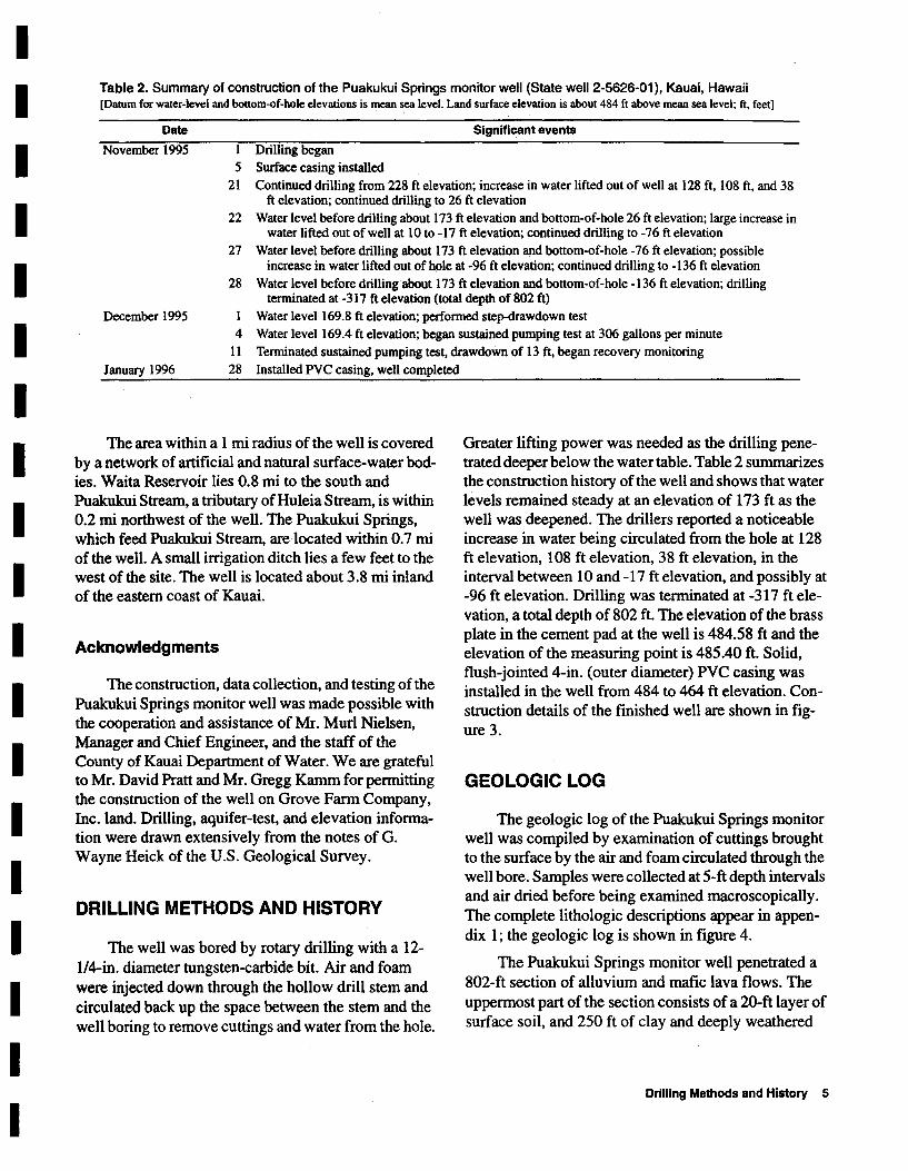
Table 2. Summary of construction of the Puakukui Springs monitor well (State well 2-5626-01), Kauai, Hawaii [Datum for water-level and bottom-of-hole elevations is mean sea level. Land surface elevation is about 484 ft above mean sea level; ft, feet]
Date Significant events
November 1995 1 Drilling began 5 Surface casing installed
21 Continued drilling from 228 ft elevation; increase in water lifted out of well at 128 ft, 108 ft, and 38 ft elevation; continued drilling to 26 ft elevation
22 Water level before drilling about 173 ft elevation and bottom-of-hole 26 ft elevation; large increase in water lifted out of well at 10 to -17 ft elevation; continued drilling to -76 ft elevation
27 Water level before drilling about 173 ft elevation ~d bottom-of-hole -76 ft elevation; possible increase in water lifted out of hole at -96 ft elevation; continued drilling to -136 ft elevation
28 Water level before drilling about 173 ft elevation and bottom-of-hole -136 ft elevation; drilling terminated at -317 ft elevation (total depth of 802 ft)
December 1995 Water level 169.8 ft elevation; performed step-drawdown test 4
11 January 1996 28
Water level 169.4 ft elevation; began sustained pumping test at 306 gallons per minute Terminated sustained pumping test, drawdown of 13 ft, began recovery monitoring Installed PVC casing, well completed
The area within a 1 mi radius of the well is covered by a network of artificial and natural surface-water bodies. Waita Reservoir lies 0.8 mi to the south and Puakukui Stream, a tributary of Hu1eia Stream, is within 0.2 mi northwest of the well. The Puakukui Springs, which feed Puakukui Stream, are located within 0.7 mi of the well. A small irrigation ditch lies a few feet to the west of the site. The well is located about 3.8 mi inland of the eastern coast of Kauai.
Acknowledgments
The construction, data collection, and testing of the Puakukui Springs monitor well was made possible with the cooperation and assistance of Mr. Mud Nielsen, Manager and Chief Engineer, and the staff of the County of Kauai Department of Water. We are grateful to Mr. David Pratt and Mr. Gregg Kamm for permitting the construction of the well on Grove Farm Company, Inc. land. Drilling, aquifer-test, and elevation information were drawn extensively from the notes of G. Wayne Heick of the U.S. Geological Survey.
DRILLING METHODS AND HISTORY
The well was bored by rotary drilling with a 12-114-in. diameter tungsten-carbide bit. Air and foam were injected down through the hollow drill stem and circulated back up the space between the stem and the well boring to remove cuttings and water from the hole.
Greater lifting power was needed as the drilling penetrated deeper below the water table. Table 2 summarizes the construction history of the well and shows that water levels remained steady at an elevation of 173 ft as the well was deepened. The drillers reported a noticeable increase in water being circulated from the hole at 128 ft elevation, 108 ft elevation, 38 ft elevation, in the interval between 10 and -17 ft elevation, and possibly at -96 ft elevation. Drilling was terminated at -317 ft elevation, a total depth of 802 ft. The elevation of the brass plate in the cement pad at the well is 484.58 ft and the elevation of the measuring point is 485.40 ft. Solid, flush-jointed 4-in. (outer diameter) PVC casing was installed in the well from 484 to 464 ft elevation. Construction details of the finished well are shown in figure 3.
GEOLOGIC LOG
The geologic log of the Puakukui Springs monitor well was compiled by examination of cuttings brought to the surface by the air and foam circulated through the well bore. Samples were collected at 5-ft depth intervals and air dried before being examined macroscopically. The complete lithologic descriptions appear in appendix I; the geologic log is shown in figure 4.
The Puakukui Springs monitor well penetrated a 802-ft section of alluvium and mafic lava flows. The uppermost part of the section consists of a 20-ft layer of surface soil, and 250 ft of clay and deeply weathered
Drilling Methods and History 5

485.40 feet elevation: top of inner casing
484 to 464 feet elevation: 4-inch inner diameter PVC
casing, solid wall
484 to 464 feet elevation: cement and bentonite seal
between inner and outer casing
485 to 228 feet elevation: 12.25-inch outer diameter
steel surface casing
485 to 228 feet elevation: cement grout between
rock and surface casing
228 to -317 feet elevation: open hole
Not to scale
:~ .. : " "
4-inch concrete pad (4 feet by 4 feet)
Brass plate H...,..,...,...,.-f.-:-...... -!':"I (elevation 484.58 feet)
•• 'D' ~~n~~/'l<"" Ground surface
.: ::
:;":: .t--"'----'-'-I .. :: - 464 feet
. - 228 feet
-169.8 feet - water level (December 1, 1995)
/ :=~r.:::~- Mean sea level (datum)
- -317 feet - bottom of hole
Figure 3_ Construction details of the Puakukui Springs monitor well (State well 2-5626-01), Kauai, Hawaii.
6 Construction, Geologic Log, and Aquifer Tests, Puakukui Springs Monitor Well, Lihue, Kauai, Hawaii
I I I I I I I I I I I I I I I I I I I

I I I I I I I I I I I I I I I I I I I
CALIPER LOG
Bottom of well casing
12 14 16 18 20
CALIPER-ARM EXTENSION, IN INCHES
ELEVATION, IN FEET ABOVE
MEAN SEA LEVEL
-400-
-300-
-200-
-100-
- 0-
--100-
--200-
--300-
GEOLOGIC LOG
IWnl.lfMlrIWIVd - Water increase trYI-IrNHI'WII'IM - Water increase
IYI.II~WWI- Water increase
~M+1f'rQI ] Water increase
WJ.+1W.I1"l't'1W - Water increase
EXPLANA nON
.. SOIL
tmI!ml MAFIC ROCK
tall SCORIA
t------j MUD OR CLAY
Figure 4. Geologic log and caliper-arm extension with depth in the Puakukui Springs monitor well (State well 2-5626-01), Kauai, Hawaii.
Geologic Log 7
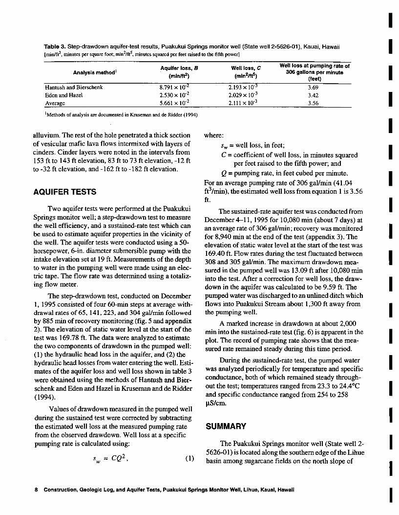
Table 3. Step-drawdown aquifer-test results, Puakukui Springs monitor well (State well 2-5626-01), Kauai, Hawaii [minlft2, minutes per square foot; min2/ft5, minutes squared per feet raised to the fifth power]
Analysis method1
Hantush and Bierschenk
Eden and Hazel
Average
Aquifer loss, B (minift2)
8.791 x 10⁻²
2.530 x 10⁻²
5.661 x 10⁻²
1 Methods of analysis are documented in Kruseman and de Ridder (1994)
alluvium. The rest of the hole penetrated a thick section of vesicular mafic lava flows intermixed with layers of cinders. Cinder layers were noted in the intervals from 153 ft to 143 ft elevation, 83 ft to 73 ft elevation, -12 ft to -32 ft elevation, and -162 ft to -182 ft elevation.
AQUIFER TESTS
Two aquifer tests were performed at the Puakukui Springs monitor well; a step-drawdown test to measure the well efficiency, and a sustained-rate test which can be used to estimate aquifer properties in the vicinity of the well. The aquifer tests were conducted using a 50-horsepower, 6-in. diameter submersible pump with the intake elevation set at 19 ft. Measurements of the depth to water in the pumping well were made using an electric tape. The flow rate was determined using a totalizing flow meter.
The step-drawdown test, conducted on December 1, 1995 consisted of four 60-min steps at average withdrawal rates of 65,141,223, and 304 gal/min followed by 885 min of recovery monitoring (fig. 5 and appendix 2). The elevation of static water level at the start of the test was 169.78 ft. The data were analyzed to estimate the two components of drawdown in the pumped well: (1) the hydraulic head loss in the aquifer, and (2) the hydraulic head losses from water entering the well. Estimates of the aquifer loss and well loss shown in table 3 were obtained using the methods of Hantush and Bierschenk and Eden and Hazel in Kruseman and de Ridder (1994).
Values of drawdown measured in the pumped well during the sustained test were corrected by subtracting the estimated well loss at the measured pumping rate from the observed drawdown. Well loss at a specific pumping rate is calculated using:
S = CQ2, w (1)
where:
Well loss, C (min21ft5)
2.193 x 10⁻³
2.029 x 10⁻³
2.111 x 10⁻³
Well loss at pumping rate of 306 gallons per minute
(feet)
3.69
3.42
3.56
Sw = well loss, in feet;
C = coefficient of well loss, in minutes squared per feet raised to the fifth power; and
Q = pumping rate, in feet cubed per minute.
For an average pumping rate of 306 gal/min (41.04 ft3/min), the estimated well loss from equation 1 is 3.56 ft.
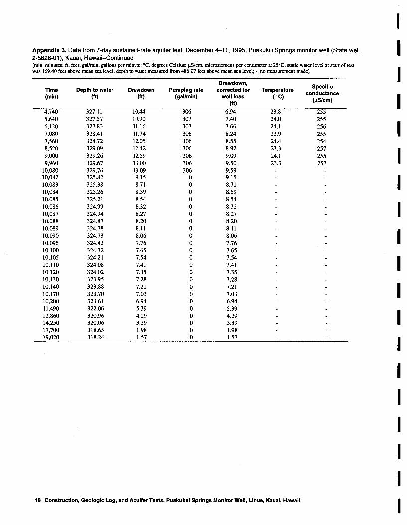
The sustained-rate aquifer test was conducted from December 4-11, 1995 for 10,080 min (about 7 days) at an average rate of 306 gal/min; recovery was monitored for 8,940 min at the end of the test (appendix 3). The elevation of static water level at the start of the test was 169.40 ft. Flow rates during the test fluctuated between 308 and 305 gal/min. The maximum drawdown measured in the pumped well was 13.09 ft after 10,080 min into the test. After a correction for well loss, the drawdown in the aquifer was calculated to be 9.59 ft. The pumped water was discharged to an unlined ditch which flows into Puakukui Stream about 1,300 ft away from the pumping well.
A marked increase in drawdown at about 2,000 min into the sustained-rate test (fig. 6) is apparent in the plot. The record of pumping rate shows that the measured rate remained steady during this time period.
During the sustained-rate test, the pumped water was analyzed periodically for temperature and specific conductance, both of which remained steady throughout the test; temperatures ranged from 23.3 to 24.4°C and specific conductance ranged from 254 to 258 J.l.Slcm.
SUMMARY
The Puakukui Springs monitor well (State well 2-5626-01) is located along the southern edge of the Lihue basin among sugarcane fields on the north slope of
8 Construction, Geologie Log, and Aquifer Tests, Puakukul Springs Monitor Well, Lihue, Kauai, Hawaii
I I I I I I I I I I I I I I I I I I I

I I
w 400 Zl--=> ·z ~ ~ 300
I «a: a: w (!) 0. 200 Zm o::z
I ~ ~ 100 0.«
(!)
0
I o ,- -'--1 ----.- , "I ' "I ' , 'I I I I I I.
0.5 l- • , I 1.0 ~ .. . .... . , •
•• ...... I •• • •
I 1.5 • • • • • I • 2.0 • • • •
I ..... • 2.5
tu • I
w 3.0 u. •
~ Z·
3.5 • • I ~ •
0 , ~ 4.0 • a: \
I 0 0 4.5 w • > • a: • w m 5.0
I CO 0
5.5,
I 6.0 l- • • •
I 6St ~ 7.0 ,
I 7.5 l-
I 8.0 I I , I , " , I I , "I , I , " , I I , I , " , I 0.1 0.2 0.5 2 5 10 20 50 100 200 500 1,000 2,000
TIME, IN MINUTES
I Figure 5. Drawdown with time during step-drawdown aquifer test (December 1, 1995), Puakukui Springs
I monitor well (State well 2-5626-01), Kauai, Hawaii.
Summary 9
I

I 400 I w
Z~ -:::> -Z w- 300 ~~ <a: I a: W (!)Q. 200 Zen o::z ~O
100 I :::>....J Q.~ Recovery
(!)
0
0 I I I I I I I I I I 1 - -
• I 2 - • -
3r - I •
4L - I ! • ~ W sl - I W LL • Z • Z
! 6 - -
3:
\ I 0 0
~ 7 ,
a: • I 0 I 0 • ill 8 - •• I -> a: • W I en
I III 9 - • 0 -•• •
• 10 - - I • • 11 - • -• I • 12 f-- • -
• I • 13 I- " -
14 I I I I I I I I 1 I 0 2,000 4,000 6,000 8,000 10,000 12,000 14,000 16,000 18,000 20,000
TIME, IN MINUTES
I Figure 6. Drawdown with time during 7-day sustained-rate aquifer test (December 4-11, 1995), Puakukui
I Springs monitor well (State well 2-5626-01), Kauai, Hawaii.
10 Construction, Geologic Log, and Aquifer Tests, Puakukui Springs Monitor Well, Lihue, Kauai, Hawaii
I

I I I I I I I I I I I I I I I I I I I
Haupu Ridge. The well was constructed during the period from November 1, 1995 to January 28, 1996 to study the hydrology and geology in an area where no other well information is available. The brass plate in the cement pad at the well has an elevation of 484.58 feet and the well is 802 feet deep (bottom is at -317 feet elevation) and has a boring diameter of 12 inches. Flush-jointed 4-inch (outer diameter) PVC casing, perforated below the water table, was installed in the top 20 feet of the hole.
During drilling, water levels remained steady at about 173 feet elevation as the hole was deepened. The drillers reported a noticeable increase in water being circulated from the hole at 128 feet elevation, 108 feet elevation, 38 feet elevation, in the interval between 10 and -17 feet elevation, and possibly at -96 feet elevation. The Puakukui Springs monitor well penetrated a 802-foot section of alluvium and mafic lava flows.
Step-drawdown and 7 -day sustained-pumping-rate tests were conducted to test aquifer properties. The maximum drawdown measured in the pumped well was 13.09 feet (initial water-level elevation was 169.40 feet) during 7 days of sustained pumping at an average rate of 306 gallons per minute. Well loss, analyzed from the step-drawdown data was estimated to be 3.56 feet for an average pumping rate of 306 gallons per minute. The temperature and specific conductance of the pumped water remained steady throughout the test.
REFERENCES CITED
Clague, D.A., and Dalrymple, G.B., 1988, Age and petrology of alkalic post-shield and rejuvenated stage lava from Kauai, Hawaii: Contributions to Mineralogy and Petrology,v.99,p.202-218.
Commission on Water Resource Management, 1990, State water resources protection plan: prepared by George A.L. Yuen and Associates for the Hawaii State Department of Land and Natural Resources, variously paginated.
Feigenson, M.D., 1984, Geochemistry ofKauai volcanics and a mixing model for the origin of Hawaiian alkali basalts: Contributions to Mineralogy and Petrology, v. 87, p. 109-119.
Hinds, N., 1930, The geology of Kauai and Niihau: Bernice Pauahi Bishop Museum Bulletin 71,103 p.
Kivroy, H.L., Baker, M., and Moe, B.B., 1965, A reconnaissance gravity survey of the island of Kauai: Pacific Science,v.19,p.354-358.
Kruseman, G.P., and de Ridder, N.A., 1994, Analysis and evaluation of pumping test data (2nd ed.): Wageningen, The Netherlands, International Institute for Land Reclamation and Improvement, 377 p.
Langenheim, V.A.M., and Clague, D.A., 1987, Stratigraphic framework of volcanic rocks of the Hawaiian Islands, in Decker, R.W., and others, eds., Volcanism in Hawaii: u.S. Geological Survey Professional Paper 1350, v. 1, p.55-84.
Maaloe, S., James, S., and Smedley, D., 1992, The Koloa volcanic suite of Kauai, Hawaii: Journal of Petrology, part 4,v.33,p.761-748.
Macdonald, G.A., 1968, Composition and origin of Hawaiian lavas: Geological Society of America Memoirs, v. 116, p.477-522.
Macdonald, G.A., Davis, D.A., and Cox, D.C., 1960, Geology and ground-water resources of the island of Kauai, Hawaii: Hawaii Division of Hydrography Bulletin 13, 212 p.
Steams, H.T., 1946, Geology of the Hawaiian Islands: Hawaii Division of Hydrography Bulletin 8, 112 p.
References Cited 11

I Appendix 1. Lithologic descriptions of drill cuttings from Puakukui Springs monitor well (State well 2-5626-01), Kauai, Hawaii [Datum is mean sea level; depth measured from 483 feet above sea level] I
Elevation Depth Sample description 1 I (feet) (feet)
483 to 478 0 to 5 loose soil 478 to 473 5 to 10 loose soil
I 473 to 468 10 to 15 no sample 468 to 463 15 to 20 loose soil 463 to 458 20 to 25 red-brown, sticky clay 458 to 453 25 to 30 red-brown, sticky clay
I 453 to 448 30 to 35 red-brown, sticky clay 448 to 443 35 to 40 red-brown, sticky clay 443 to 438 40 to 45 red-brown, sticky clay 438 to 433 45 to 50 red-brown, sticky clay
I 433 to 428 50 to 55 red-brown, sticky clay 428 to 423 55 to 60 red-brown, sticky clay 423 to 418 60 to 65 red-brown, sticky clay 418 to 413 65 to 70 red-brown, sticky clay
I 413 to 408 70 to 75 red-brown, sticky clay 408 to 403 75 to 80 red-brown, sticky clay 403 to 398 80 to 85 red-brown, sticky clay 398 to 393 85 to 90 red-brown, sticky clay
I 393 to 388 90 to 95 red-brown, sticky clay 388 to 383 95 to 100 red-brown, sticky clay 383 to 378 100 to 105 red-brown, sticky clay 378 to 373 105 to llO red-brown, sticky clay
I 373 to 368 llO to ll5 red-brown, sticky clay 368 to 363 ll5 to 120 red-brown, sticky clay 363 to 358 120 to 125 red-brown, sticky clay 358 to 353 125 to 130 red-brown, sticky clay 353 to 348 130 to 135 red-brown, sticky clay I 348 to 343 135 to 140 red-brown, sticky clay 343 to 338 140 to 145 red-brown, sticky clay 338 to 333 145 to 150 red-brown, sticky clay 333 to 328 150 to 155 red-brown, sticky clay I 328 to 323 155 to 160 red-brown, sticky clay 323 to 318 160 to 165 red-brown, sticky clay 318 to 313 165 to 170 red-brown, sticky clay 313 to 308 170 to 175 red-brown, sticky clay I 308 to 303 175 to 180 red-brown, sticky clay 303 to 298 180 to 185 red-brown, sticky clay 298 to 293 185 to 190 red-brown, sticky clay 293 to 288 190 to 195 red-brown, sticky clay
I 288 to 283 195 to 200 red-brown, sticky clay 283 to 278 200 to 205 no sample 278 to 273 205 to 210 red-brown, sticky clay 273 to 268 210 to 215 red-brown, sticky clay
I 268 to 263 215 to 220 red-brown, sticky clay 263 to 258 220 to 225 red-brown, sticky clay 258 to 253 225 to 230 red-brown, sticky clay 253 to 248 230 to 235 red-brown, sticky clay
I 248 to 243 235 to 240 red-brown, sticky clay 243 to 238 240 to 245 red-brown, sticky clay 238 to 233 245 to 250 dark-brown clay and weathered gravel 233 to 228 250 to 255 no sample
I 228 to 223 255 to 260 no sample 223 to 218 260 to 265 dark-brown clay and weathered gravel 218 to 213 265 to 270 dark-brown clay and weathered gravel 213 to 208 270 to 275 light-brownish-grey, weathered mafic rock
I 208 to 203 275 to 280 light-brownish-grey, weathered mafic rock 203 to 198 280 to 285 light-brownish-grey, weathered mafic rock 198 to 193 285 to 290 light-grey, weathered mafic rock 193 to 188 290 to 295 light-grey, weathered mafic rock
I 12 Construction, Geologic Log, and Aquifer Tests, Puakukui Springs Monitor Well, Lihue, Kauai, Hawaii
I

I I Appendix 1. Lithologic descriptions of drill cuttings from Puakukui Springs monitor well (State well 2-5626-01 ), Kauai, Hawaii
--Continued [Datum is mean sea level; depth measured from 483 feet above sea level]
I Elevation Depth
Sample description 1 (feet) (feet)
188 to 183 295 to 300 light-grey, weathered mafic rock 183 to 178 300 to 305 light-grey, weathered mafic rock
I 178 to 173 305 to 310 light-grey, weathered mafic rock 173 to 168 310 to 315 light-grey, weathered mafic rock 168 to 163 315 to 320 light-grey, weathered mafic rock 163 to 158 320 to "325 light-grey, moderately weathered, vesicular mafic rock
I 158 to 153 325 to 330 light-grey, moderately weathered, vesicular mafic rock 153 to 148 330 to 335 grey to reddish-grey, vesicular, aphyric mafic rock 148 to 143 335 to 340 grey to reddish-grey, vesicular, aphyric mafic rock 143 to 138 340 to 345 light-grey, moderately weathered, vesicular mafic rock
I 138 to 133 345 to 350 medium-grey, vesicular, aphyric mafic rock 133 to 128 350 to 355 medium-grey, vesicular, aphyric mafic rock 128 to 123 355 to 360 medium-grey, vesicular, apbyric mafic rock 123 to 118 360 to 365 brownish-dark-grey, vesicular, aphyric mafic rock
I 118 to 113 365 to 370 brownish-dark-grey, vesicular, aphyric mafic rock 113 to 108 370 to 375 brownish-dark-grey, vesicular, aphyric mafic rock 108 to 103 375 to 380 brownish-dark-grey, vesicular, aphyric mafic rock 103 to 98 380 to 385 dark-grey, vesicular, aphyric mafic rock
I 98 to 93 385 to 390 brownish-dark-grey, vesicular, aphyric mafic rock 93 to 88 390 to 395 brownish-dark-grey, vesicular, aphyric mafic rock 88 to 83 395 to 400 brownish-dark-grey, vesicular, aphyric mafic rock 83 to 78 400 to 405 dark-grey to red-brown, highly vesicular mafic rock
I 78 to 73 405 to 410 dark-grey to red-brown, highly vesicular mafic rock 73 to 68 410 to 415 yellowish-grey, weathered, vesicular mafic rock 68 to 63 415 to 420 yellowish-grey, weathered, vesicular mafic rock 63 to 58 420 to 425 dark-grey to reddish-grey, vesicular mafic rock 58 to 53 425 to 430 light-grey, weathered, vesicular mafic rock
I 53 to 48 430 to 435 light-grey, weathered, vesicular mafic rock 48 to 43 435 to 440 dark-grey to reddish-grey, vesicular mafic rock 43 to 38 440 to 445 dark-grey to reddish-grey, vesicular mafic rock 38 to 33 445 to 450 dark-grey to reddish-grey, vesicular mafic rock
I 33 to 28 450 to 455 dark-grey to reddish-grey, vesicular mafic rock 28 to 23 455 to 460 dark-grey to reddish-grey, vesicular mafic rock 23 to 18 460 to 465 dark-grey to reddish-grey, vesicular mafic rock 18 to 13 465 to 470 medium-grey, partly weathered, vesicular mafic rock
I 13 to 8 470 to 475 medium-grey, partly weathered, vesicular mafic rock 8 to 3 475 to 480 dark-grey, unweathered, vesicular mafic rock 3 to -2 480 to 485 dark-grey, unweathered, vesicular mafic rock
-2 to -7 485 to 490 dark-grey, unweathered. vesicular mafic rock
I -7 to -12 490 to 495 dark-grey, unweathered, vesicular mafic rock -12 to -17 495 to 500 red-grey, vesicular mafic rock -17 to -22 500 to 505 red-grey, vesicular mafic rock -22 to -27 505 to 510 red-grey, vesicular mafic rock
I -27 to -32 510 to 515 red-grey to brown-grey, vesicular mafic rock -32 to -37 515 to 520 medium-brownish-grey, slightly weathered, vesicular mafic rock -37 to -42 520 to 525 medium-brownish-grey, slightly weathered, vesicular mafic rock -42 to -47 525 to 530 medium-brownish-grey, slightly weathered, vesicular mafic rock
I -47 to -52 530 to 535 medium-brownish-grey, slightly weathered, vesicular mafic rock -52 to -57 535 to 540 medium-brownish-grey, slightly weathered, vesicular mafic rock -57 to -62 540 to 545 grey, unweathered mafic rock with rounded vesicles and some olivine -62 to -67 545 to 550 grey, unweathered mafic rock with rounded vesicles and some olivine
I -67 to -72 550 to 555 grey, unweathered mafic rock with rounded vesicles and some olivine -72 to -77 555 to 560 light-grey, dense, slightly vesicular olivine mafic rock -77 to -82 560 to 565 light-grey, dense, slightly vesicular olivine mafic rock -82 to -87 565 to 570 light-grey, dense, slightly vesicular olivine mafic rock
I -87 to -92 570 to 575 dark-grey to reddish-dark-grey, vesicular mafic rock -92 to -97 575 to 580 dark-grey to reddish-dark-grey, vesicular mafic rock -97 to -102 580 to 585 dark-grey to reddish-dark-grey, vesicular mafic rock
-102 to -107 585 to 590 dark-grey to reddish-dark-grey, vesicular mafic rock
I Appendices 13
I

I Appendix 1. Lithologic descriptions of drill cuttings from Puakukui Springs monitor well (State well 2-5626-01), Kauai, Hawaii I --Continued [Datum is mean sea level; depth measured from 483 feet above sea level]
Elevation Depth Sample description 1 I (feet) (feet)
-107 to -112 590 to 595 dark-grey to readish-dark-grey, vesicular mafic rock -112 to -117 595 to 600 dark-grey to reddish-dark-grey, vesicular mafic rock
I -117 to -122 600 to 605 dark-grey to reddish-dark-grey, vesicular mafic rock -122 to -127 605 to 610 dark-grey to reddish-dark-grey, vesicular mafic rock -127 to -132 610 to 615 dark-grey to reddish-dark-grey, vesicular mafic rock -132 to -137 615 to 620 dark-grey to reddish-dark-grey, vesicular mafic rock
I -137 to -142 620 to 625 dark-grey to reddish-dark-grey, vesicular mafic rock -142 to -147 625 to 630 light-grey, weathered, vesicular mafic rock -147 to -152 630 to 635 light-grey, weathered, vesicular mafic rock -152 to -157 635 to 640 dark-grey to reddish-grey, vesicular, aphyric mafic rock
I -157 to -162 640 to 645 dark-grey to reddish-grey, vesicular, aphyric mafic rock -162 to -167 645 to 650 dark-grey to reddish-grey, vesicular, aphyric mafic rock -167 to -172 650 to 655 dark-grey to reddish-grey, vesicular, aphyric mafic rock -172 to -177 655 to 660 brownish-grey, slightly weathered, vesicular mafic rock
I -177 to -182 660 to 665 grey, unweathered, vesicular mafic rock -182 to -187 665 to 670 dark-reddish-brown scoria -187 to -192 670 to 675 dark-reddish-brown scoria -192 to -197 675 to 680 red-grey scoria
I -197 to -202 680 to 685 red-grey scoria -202 to -207 685 to 690 medium-grey, moderately vesicular, olivine mafic rock -207 to -212 690 to 695 medium-grey, moderately vesicular olivine mafic rock -212 to -217 695 to 700 dark-reddish-brown scoria
I -217 to -222 700 to 705 dark-grey to red grey, vesicular mafic rock -222 to -227 705 to 710 dark-grey to red grey, vesicular mafic rock -227 to -232 710 to 715 dark-grey to red grey, vesicular mafic rock -232 to -237 715 to 720 dark-grey to red grey, vesicular mafic rock -237 to -242 720 to 725 light-grey, weathered, vesicular mafic rock I -242 to -247 725 to 730 red-grey scoria -247 to -252 730 to 735 red-grey scoria -252 to -257 735 to 740 dark-grey, vesicular, olivine mafic rock -257 to -262 740 to 745 dark-grey, vesicular, olivine mafic rock I -262 to -267 745 to 750 brownish-dark-grey, slightly weathered mafic rock -267 to -272 750 to 755 brownish-dark-grey, slightly weathered mafic rock -272 to -277 755 to 760 medium-dark-grey, vesicular mafic rock -277 to -282 760 to 765 medium-dark-grey, vesicular mafic rock I -282 to -287 765 to 770 brownish-grey, slightly weathered, vesicular mafic rock -287 to -292 770 to 775 grey, vesicular mafic rock -292 to -297 775 to 780 brownish-grey, slightly weathered, vesicular mafic rock -297 to -302 780 to 785 brownish-grey, vesicular mafic rock I -302 to -307 785 to 790 brownish-grey, slightly weathered, vesicular mafic rock -307 to -312 790 to 795 brownish-grey, slightly weathered, vesicular mafic rock -312 to -317 795 to 800 light- to medium-grey, slightly weathered, vesicular mafic rock -317 to -322 800 to 805 brownish-grey. slightly weathered, vesicular mafic rock I 1 Cuttings from rotary drilling lifted by air, foam, and polymer; sample repository: U.S. Geological Survey, Hawaii District office; Date of logging: Feb-
ruary.I996
I I I I
14 Construction, Geologic Log, and Aquifer Tests, Puakukui Springs Monitor Well. Lihue, Kauai. Hawaii I

I I Appendix 2. Data from step-drawdown aquifer test, December 1, 1995, Puakukui Springs monitor well (State well
2-5626-01), Kauai, Hawaii
I [min. minutes; ft. feet; gallmin. gallons per minute; depth to water measured from 486.07 ft above mean sea level; -, no measurement made]
nme Depth to water Drawdown Pumping rate (min) (ft) (ft) (gaUrnln)
0 316.29 0 0
I 0.5 319.32 3.03 100 1 317.91 1.62 100 2 317.85 1.56 68 3 317.55 1.26 88
I 4 317.48 1.19 100 5 317.36 1.07 100 6 317.43 1.14 180 7 317.53 1.24 150
I 8 317.33 1.04 120 9 317.35 1.06 128
10 317.31 1.02 110 11 317.30 1.01 110
I 12 317.28 0.99 55 13 317.35 1.06 76 14 317.24 0.95 76 15 317.23 0.94 66
I 20 317.26 0.97 68 25 317.19 0.90 64 30 317.21 0.92 66 35 317.19 0.90 68
I 40 317.19 0.90 66 50 317.19 0.90 65 60 317.19 0.90 65 61 317.25 0.96 128
I 62 317.79 1.50 116 63 317.88 1.59 116 64 317.80 1.51 116 65 318.09 1.80 132
I 66 318.26 1.97 148 67 318.27 1.98 148 68 318.23 1.94 132 69 318.28 1.99 132
I 70 318.25 1.96 120 71 318.42 2.13 140 72 318.62 2.33 148 73 318.54 2.25 148 74 318.68 2.39 148
I 75 318.62 2.33 148 80 318.66 2.37 146 85 318.63 2.34 143 90 318.63 2.34 142
I 100 318.65 2.36 143 110 318.67 2.38 141 120 318.71 2.42 141 121 319.75 3.46
I 122 319.94 3.65 208 123 320.05 3.76 124 320.09 3.80 125 320.09 3.80
I 126 320.12 3.83 127 320.13 3.84 220 128 320.11 3.82 208 129 320.27 3.98 236
I 130 320.45 4.16 131 320.50 4.21 220 132 320.53 4.24 133 320.52 4.23
I Appendices 15
I

Appendix 2. Data from step-drawdown aquifer test, December 1, 1995, Puakukui Springs monitor well (State well 2-5626-01), Kauai, Hawaii--Continued [min, minutes; ft, feet; gal/min, gallons per minute; depth to water measured from 486.07 ft above mean sea level; -, no measurement made]
Time (min) 134 135 140 145 150 160 170 180 181 182 183 184 185 186 187 188 189 190 191 192 193 194 195 200 205 210 220 230 240 241 242 243 244 245 246 247 248 249 250 255 260 265 270 280 290 300
1,125
Depth to water (ft)
320.53 320.54 320.61 320.59 320.82 320.93 320.94 321.05 322.31 322.49 322.59 322.68 322.72 322.78 322.84 322.91 322.96 323.00 322.98 322.97 322.98 322.99 323.02 323.05 323.11 323.15 323.29 323.33 323.36 319.74 319.05 318.63 318.43 318.28 318.04 317.96 317.81 317.67 317.64 317.31 317.23 317.13 317.00 316.94 316.84 316.81 316.38
Drawdown (ft) 4.24 4.25 4.32 4.30 4.53 4.64 4.65 4.76 6.02 6.20 6.30 6.39 6.43 6.49 6.55 6.62 6.67 6.71 6.69 6.68 6.69 6.70 6.73 6.76 6.82 6.86 7.00 7.04 7.07 3.45 2.76 2.34 2.14 1.99 1.75 1.67 1.52 1.38 1.35 1.02 0.94 0.84 0.71 0.65 0.55 0.52 0.09
Pumping rate (gal/min)
224 228
222 226
307 305
303
305
305
305 304 304 304
o o o o o o o o o o o o o o o o o o
16 Construction, Geologic Log, and Aquifer Tests, Puakukui Springs Monitor Well, Lihue, Kauai, Hawaii
I I I I I I I I I I I I I I I I I I I

J J Appendix 3. Data from 7 -day sustained-rate aquifer test; December 4-11, 1995, Puakukui Springs monitor well (State well
2-5626-01), Kauai, Hawaii
I [min, minutes; ft, feet; gallmin, gallons per minute; °C, degrees Celsius; JlS/cm, microsiemens per centimeter at 25°C; static water level at start of test was 169.40 feet above mean sea level; depth to water measured from 486.07 feet above mean sea level; -, no measurement made]
Drawdown, Specific
Time Depth to water Drawdown Pumping rate corrected for Temperature conductance
I (min) (ft) (ft) (gal/min) well loss (0 C) (J1S/cm)
(ft)
0 316.67 0 0 0
I 0.25 319.35 2.68 -0.82 0.5 319.77 3.10 -0.40 1 319.95 3.28 307 -0.22 2 320.31 3.64 0.14
I 3 320.75 4.08 0.58 4 320.91 4.24 0.74 5 321.01 4.34 0.84 6 321.13 4.46 305 0.96
I 7 321.31 4.64 1.14 8 321.47 4.80 1.30 9 321.63 4.96 1.46
I 10 321.54 4.87 305 1.37 11 321.67 5.00 1.50 12 321.76 5.09 1.59 13 321.82 5.15 1.65
I 14 321.90 5.23 1.73 15 321.98 5.31 305 1.81 20 322.12 5.45 1.95 25 322.37 5.70 2.20
I 30 322.39 5.72 2.22 35 322.43 5.76 2.26 40 322.53 5.86 2.36
I 50 322.69 6.02 306 2.52 60 322.72 6.05 307 2.55 70 322.73 6.06 2.56 80 322.81 6.14 307 2.64
I 90 322.89 6.22 307 2.72
100 322.91 6.24 2.74 120 323.00 6.33 307 2.83 140 323.07 6.40 307 2.90 23.9 258
I 160 323.09 6.42 307 2.92 180 323.16 6.49 308 2.99 210 323.26 6.59 306 3.09 240 323.32 6.65 306 3.15
I 300 323.46 6.79 307 3.29 23.8 258 360 323.57 6.90 307 3.40 420 323.55 6.88 308 3.38 23.6 257
I 480 323.69 7.02 308 3.52 780 323.99 7.32 308 3.82
1,320 324.51 7.84 307 4.34 23.6 256 1,440 324.69 8.02 307 4.52
I 1,680 324.77 8.10 307 4.60 24.0 256 1,920 324.94 8.27 307 4.77 23.6 256 2,760 325.66 8.99 307 5.49 23.6 256
I 3,000 325.84 9.17 306 5.67 3,240 325.95 9.28 307 5.78 24.0 254 4,200 326.44 9.77 307 6.27 23.7 255 4,500 326.91 10.24 306 6.74
I Appendices 17
I
Appendix 3. Data from 7-day sustained-rate aquifer test, December 4-11, 1995, Puakukui Springs monitor well (State well 2-5626-01), Kauai, Hawaii--Continued [min, minutes; ft, feet; gal/min, gallons per minute; °C, degrees Celsius; J1S/cm, microsiernens per centimeter at 25°C; static water level at start of test was 169.40 feet above mean sea level; depth to water measured from 486.07 feet above mean sea level; -, no measurement made]
Drawdown, Specific
Time Depth to water Drawdown Pumping rate corrected for Temperature conductance
(min) (tt) (tt) (gal/min) well loss eC) (J1S/cm) (tt)
4,740 327.11 10.44 306 6.94 23.8 255 5,640 327.57 10.90 307 7.40 24.0 255 6,120 327.83 11.16 307 7.66 24.1 256 7,080 328.41 11.74 306 8.24 23.9 255 7,560 328.72 12.05 306 8.55 24.4 254 8,520 329.09 12.42 306 8.92 23.3 257 9,000 329.26 12.59 ·306 9.09 24.1 255 9,960 329.67 13.00 306 9.50 23.3 257
10,080 329.76 13.09 306 9.59 10,082 325.82 9.15 0 9.15 10,083 325.38 8.71 0 8.71 10,084 325.26 8.59 0 8.59 10,085 325.21 8.54 0 8.54 10,086 324.99 8.32 0 8.32 10,087 324.94 8.27 0 8.27 10,088 324.87 8.20 0 8.20 10,089 324.78 8.11 0 8.11 10,090 324.73 8.06 0 8.06 10,095 324.43 7.76 0 7.76 10,100 324.32 7.65 0 7.65 10,105 324.21 7.54 0 7.54 10,110 324.08 7.41 0 7.41 10,120 324.02 7.35 0 7.35 10,130 323.95 7.28 0 7.28 10,140 323.88 7.21 0 7.21 10,170 323.70 7.03 0 7.03 10,200 323.61 6.94 0 6.94 11,490 322.06 5.39 0 5.39 12,860 320.96 4.29 0 4.29 14,250 320.06 3.39 0 3.39 17,700 318.65 1.98 0 1.98 19,020 318.24 1.57 0 1.57
18 Construction, Geologic Log, and Aquifer Tests, Puakukui Springs Monitor Well, Lihue, Kauai, Hawaii
, I I I I I I I I I I I I I I I I I I