Geologic Map of the Edwards Aquifer In Northern Medina … · GEOLOGIC MAP OF THE EDWARDS AQUIFER...
23
U.S. Department of the Interior U.S. Geological Survey Open-File Report 2006-1372 Geologic Map of the Edwards Aquifer In Northern Medina and Northeastern Uvalde Counties, South-central Texas
Transcript of Geologic Map of the Edwards Aquifer In Northern Medina … · GEOLOGIC MAP OF THE EDWARDS AQUIFER...
U.S. Department of the InteriorU.S. Geological Survey
Open-File Report 2006-1372
Geologic Map of the Edwards Aquifer In Northern Medina and Northeastern Uvalde Counties, South-central Texas
GEOLOGIC MAP OF THE EDWARDS AQUIFER IN NORTHERN MEDINA AND NORTHEASTERN UVALDE COUNTIES, SOUTH-CENTRAL TEXAS
By Allan K. Clark1, Jason R. Faith1, Charles D. Blome2, and Diana E. Pedraza1
OPEN-FILE REPORT 2006-1372
1U.S. Geological Survey, San Antonio, TX 78249 2U.S. Geological Survey, Denver, CO 80225
U.S. DEPARTMENT OF THE INTERIOR U.S. GEOLOGICAL SURVEY
1
U.S. Department of the Interior
.S. Geological Survey
.S. Geological Survey, Reston, Virginia 2006
or product and ordering information: /pubprod/
or more information on the USGS—the Federal source for science about the Earth,
DIRK KEMPTHORNE, Secretary UMark D. Myers, Director U FWorld Wide Web: http://www.usgs.govTelephone: 1-888-ASK-USGS FIts natural and living resources, natural hazards, and the environment: World Wide Web: http://www.usgs.gov/ Telephone 1-888-ASK-USGS Any use of trade, product, or firm names is for descriptive purposes only and does
ssion must be secured from
Not imply endorsement by the U.S. Government
lthough this report is in the public domain, permiAthe individual copyright owners to reproduce any copyrighted material contained within this report.
2
Contents
Page
Introduction 4
Spatial Datasets 5
Geologic Framework 6
Depositional Setting 6
Balcones Fault Zone 7
General Stratigraphy 7
Description of Map Units 11
Quaternary and Upper Tertiary Stratigraphy 11
Upper Cretaceous Stratigraphy 12
Lower Cretaceous Stratigraphy 15
Acknowledgments 20
References Cited 20
Plate
Geologic map of the Edwards aquifer in northern Medina and northeastern
Uvalde Counties, south-central Texas
Figure
1. Map showing the study area and the southern segment of the Edwards
aquifer 4
3
GEOLOGIC MAP OF THE EDWARDS AQUIFER IN NORTHERN MEDINA AND NORTHEASTERN UVALDE COUNTIES, SOUTH-CENTRAL TEXAS
By Allan K. Clark1, Jason R. Faith1, Charles D. Blome2, and Diana E. Pedraza1
INTRODUCTION
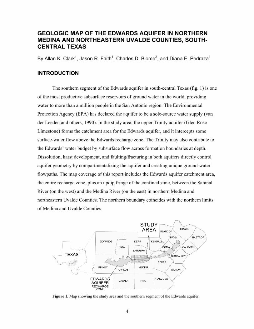
The southern segment of the Edwards aquifer in south-central Texas (fig. 1) is one
of the most productive subsurface reservoirs of ground water in the world, providing
water to more than a million people in the San Antonio region. The Environmental
Protection Agency (EPA) has declared the aquifer to be a sole-source water supply (van
der Leeden and others, 1990). In the study area, the upper Trinity aquifer (Glen Rose
Limestone) forms the catchment area for the Edwards aquifer, and it intercepts some
surface-water flow above the Edwards recharge zone. The Trinity may also contribute to
the Edwards’ water budget by subsurface flow across formation boundaries at depth.
Dissolution, karst development, and faulting/fracturing in both aquifers directly control
aquifer geometry by compartmentalizing the aquifer and creating unique ground-water
flowpaths. The map coverage of this report includes the Edwards aquifer catchment area,
the entire recharge zone, plus an updip fringe of the confined zone, between the Sabinal
River (on the west) and the Medina River (on the east) in northern Medina and
northeastern Uvalde Counties. The northern boundary coincides with the northern limits
of Medina and Uvalde Counties.
Figure 1. Map showing the study area and the southern segment of the Edwards aquifer.
4
The geology of the Edwards aquifer in the northeast part of the recharge area is
characterized by the Kainer and Person Formations, which are subdivided into seven
informal hydrostratigraphic units. In the area west of San Antonio in Medina, Uvalde and
Kinney Counties, significant facies changes exist across the Devils River trend reefal
facies (Maclay and Small, 1984, plate 1). About ninety percent of the study area is
underlain by the Georgetown and Devils River Formations.
The Devils River Formation yields large quantities of irrigation water to fertile
bottomland areas of Medina and Uvalde Counties, where the success of farming and
ranching activities has long depended upon water from the Edwards aquifer. The
remaining ten percent of the study area includes the southwestern margin of the San
Marcos platform (plate 1), where the Edwards aquifer consists of the Edwards Group
(Rose, 1972).
The Balcones fault zone, the principal structural feature in the region, is
characterized by an en-echelon network of high-angle, southwest- to northeast-trending
faults that vertically displace the Lower Cretaceous rocks of the Edwards aquifer. These
faults, together with local karst features, are largely responsible for the complexity of the
ground-water flow system in the study area.
The U.S. Geological Survey (USGS), in cooperation with the San Antonio Water
System (SAWS), began a project in 2001 to better delineate the geology and ground-
water flow paths in northern Medina and northeastern Uvalde Counties. The purpose of
this mapping is to improve the understanding of the geologic framework and
hydrogeologic setting of the Edwards aquifer.
SPATIAL DATASETS
All digital spatial datasets generated during the study are stored as Universal
Transverse Mercator (UTM) projections with a horizontal datum of North American
Datum 1983 (NAD83). The surface raster datasets have the aforementioned horizontal
5
projection but reference the North American Vertical Datum 1988 (NAVD 88). GIS
datasets used in this report have Federal Geographic Data Committee (FGDC)-compliant
content-level metadata (Federal Geographic Data Committee, 1994).
GEOLOGIC FRAMEWORK
The geologic framework in south-central Texas is complicated by three primary
factors that affect the hydrogeologic setting of the Edwards aquifer. These factors
include, but are not limited to, lithofacies transition, complex faulting, and karst
development. These factors have individually and interactively affected the evolution and
subsequent productivity of the Edwards aquifer since meteoric waters first entered the
ground-water system.
Depositional Setting
The Lower Cretaceous rocks that comprise the Edwards aquifer were deposited
upon the landward margin of the Comanche continental shelf which was sheltered from
storm waves and deep ocean currents by the Stuart City reef trend in the ancestral Gulf of
Mexico (pl. 1, inset). Subsidence across a tectonic hinge line (Smith, 1981) that skirted
the southern edge of this carbonate shelf kept most of the study area submerged within a
curved bank of reefal growth known as the Devils River trend. Greater rates of
subsidence south of the hinge line caused fundamental differences between rocks
deposited within the Devils River trend and those deposited in deeper water inside the
Maverick Basin (Smith and others, 2000). Depositional environments inside the
Maverick Basin were effectively isolated from those elsewhere on the Comanche shelf by
the Devils River trend, which today contains the Devils River Formation (Miller, 1984, p.
17–21).
Concurrent with deposition inside the Maverick Basin, the Devils River trend
facies (plate 1, inset), now an area of partly to completely dolomitized miliolid- and
rudist-bearing limestones, formed around the western, northern, and eastern margins of
the Maverick Basin (Lozo and Smith, 1964, p. 291–297). Nodular, burrowed, dolomitic,
and evaporitic rock sequences that make up the lower parts of the Devils River Formation
6
were deposited in partly restricted, tidal flat environments somewhat similar to those over
the San Marcos and central Texas platforms (Miller, 1984). In contrast, upper parts of the
Devils River Formation formed in mostly open, shallow marine environments of
moderate to high energy and under relatively unrestricted circulation that enhanced the
growth of rudist bioherms and biostromes.
Following tectonic uplift, subaerial exposure, and erosion near the end of Early
Cretaceous time, south-central Texas was again submerged during a major marine
transgression. By the beginning of Late Cretaceous time, the Stuart City reef had been
breached (Rose, 1972, p. 17), the Maverick Basin was no longer subsiding, and the
Devils River trend was no longer an active reef complex. Depositional environments
associated with the Maverick Basin, Devils River trend, and San Marcos platform were
finally curtailed as south-central Texas was blanketed by Del Rio Clay deposits (Smith
and others, 2000).
Balcones Fault Zone
During Late Oligocene through Early Miocene time, large-scale normal faulting
created the Balcones fault zone, within which 3,000 feet of Cretaceous strata were
significantly faulted and fractured. The resulting fault blocks were downthrown and
rotated differentially in a southwest-to-northeast-trending, en-echelon arrangement
(Maclay, 1995, p. 8–12). The fractures associated with the high-angle, mostly down-to-
the-south faults, facilitated the percolation of carbon dioxide-enriched meteoric water,
which increased the solubility of allochems (fossil parts, intraclasts, pellets, and oolites),
evaporites (principally anhydrite and gypsum), and other unstable minerals (such as
aragonite and high-magnesium calcite). The two cross-sections on plate 1 illustrate the
displacement of aquifer-bearing rock units across faults and the steep north-to-south
down-dip gradient.
General Stratigraphy
Current delineation of the lithostratigraphic and hydrostratigraphic subdivisions
comprising the Edwards aquifer in the study area is the result of numerous studies by the
7
petroleum industry, academic institutions, and government agencies. Stratigraphic details
not discussed in the section entitled “Descriptions of Map Units” are summarized below,
from bottom (geologically oldest) to top (youngest).
The upper member of the Glen Rose Limestone is of Early Cretaceous age and
forms the lower confining unit of the Edwards aquifer (Maclay and Small, 1984). The
upper member of the Glen Rose Limestone, which ranges from 200 to 300 feet thick in
the study area, conformably underlies the Devils River Formation in the Devils River
trend and the Edwards Group in the San Marcos platform.
The Devils River Formation in the Devils River trend is stratigraphically
equivalent to the Edwards Group (Kainer and Person Formations or Fort Terrett and
Segovia Formations) in the San Marcos platform and Edwards Plateau, respectively.
Although the lateral transition between the Devils River Formation and the Kainer and
Person Formations is gradational, the Devils River Formation lacks the distinguishing
characteristics that allowed its Kainer and Person Formation counterparts to be
informally subdivided into as many as nine hydrostratigraphic units (Lozo and Smith,
1964). This lack of distinguishing characteristics within the Devils River Formation
results from a transition in depositional environments between relatively shallow parts of
the Comanche shelf toward the northeast and the relatively deep Maverick Basin to the
southwest (Smith and others, 2000). Differences between the shelf and basin
environments increased rapidly as rates of subsidence accelerated south of the tectonic
hinge line. Consequently, the stratigraphic differences between the Devils River
Formation and the laterally adjacent eastern counterparts of the San Marcos platform
increase upward from the base.
Although the scarcity of marker beds has impeded separation of the Devils River
Formation into more than an informal recognition of lower and upper parts, Miller (1984)
and Clark (2002) have attempted to informally divide the lower part into basal nodular,
burrowed, dolomitic, and Kirschberg evaporite hydrostratigraphic units. The lower 60-70
feet of Miller’s subdivided section in northern Uvalde County consists of rocks
resembling the basal nodular member of the Fort Terrett Formation (Rose, 1972, p. 32–
8
34) and Kainer Formation of the central Texas and San Marcos platforms, respectively.
Miller’s basal nodular unit is overlain by 30-40 feet of thin- to massive-bedded, burrowed
mudstone. Upward from its base, this mudstone sequence becomes thicker bedded and
less burrowed and contains chert that can be traced laterally as either nodules or thin beds
into the Fort Terrett and the Kainer Formations (Clark, 2003). Miller’s burrowed unit is
overlain by roughly 150 feet of partially to completely dolomitized, rudist-bearing
wackestone and grainstone, which he equated to the dolomitic member of the Fort Terrett
and Kainer Formations. Approximately 60 feet of highly leached, recrystallized,
brecciated, dark-gray, sparry limestone characterizes what Miller (1984) mapped as the
Kirschberg evaporite member in outcrops of the Devils River Formation in northern
Uvalde County.
Whereas Miller (1984, p. 13) considered the lower part of the Devils River
Formation to be “...laterally continuous with and indistinguishable from the Fort Terrett
Formation,” he found the upper part to be “quite different” from stratigraphically
equivalent rocks to the north. The upper 160–250 feet of the Devils River Formation
typically consists of light-gray wackestone, packstone, miliolid grainstone, and rudist
boundstone. Biohermal rudist (caprinid, radiolitid, and Chondrodonta) mounds are found
in the uppermost 50 feet. Shell-fragment wackestones and grainstones, recrystallized and
calichified limestone, and irregular nodules or thin beds of chert are scattered throughout
and are abundant locally (Miller, 1984, p. 17). Fossilized caprinids, as well as several
varieties of rudists, are present locally where they commonly form packstone or
boundstone and have been replaced by chert (Clark, 2003).
The Edwards Group south of the Colorado River was defined to include the
Kainer and Person Formations over the San Marcos platform and the Fort Terrett and
Segovia Formations over the central Texas platform (Rose, 1972, p. 18). These strata are
stratigraphically equivalent to the Fredericksburg Group of central Texas (Adkins, 1933,
p. 322), which includes the Walnut, Comanche Peak, and Edwards Limestone Formations
north of the Colorado River (Lozo, 1959).
9
In the San Marcos platform, the Kainer Formation consists of, from oldest to
youngest, the: (1) basal nodular, (2) dolomitic, (3) Kirschberg evaporite, and (4)
grainstone hydrostratigraphic members. Marine deposits of the basal nodular member
conformably overlie the Glen Rose Limestone and are predominantly composed of
shaley, nodular, and fossiliferous mudstone to wackestone, the nodular nature of which
results from the compaction of highly bioturbated sediment (Shinn and others, 1977). The
intertidal and supratidal mudstones of the chert-bearing dolomitic member grade upward
into supratidal, evaporitic, crystalline limestones of the Kirschberg evaporite member.
The Kirschberg grades upward into miliolid grainstones of the erosionally resistant
grainstone member of predominately shallow marine origin.
The Person Formation is composed of, from oldest to youngest, the: (1) regional
dense, (2) leached and collapsed (undivided), and (3) cyclic and marine (undivided)
hydrostratigraphic members. The regional dense member is a dense, easily recognized
argillaceous mudstone (Small, 1985). The overlying leached and collapsed member is
composed largely of dolomitic biomicrite, burrowed mudstone, and crystalline limestone
with local occurrences of collapsed breccia, chert, and stromatolitic limestone. Because
the cyclic and marine member (locally crossbedded, upward-grading cycles of mudstone,
packstone, and miliolid grainstone) has not been identified in the study area, it is assumed
that it was removed by erosion prior to deposition of the overlying Georgetown
Formation (Rose, 1972, p. 23–25).
The upper confining unit of the Edwards aquifer in the study area is composed
mostly of impermeable, interbedded shale, siltstone, limestone, chalk, and marl of Late
Cretaceous age. From oldest-to-youngest, these rocks include the Georgetown Formation
(Clark and Clark, study in progress), Del Rio Clay, Buda Limestone, Eagle Ford Group,
Austin Group, Anacacho Limestone, and Escondido Formation. The Georgetown
Formation unconformably overlies the Person Formation in the San Marcos platform area
and the Devils River Formation in the Devils River trend. Typically, the Georgetown
Formation consists of reddish-brown, gray to light-tan, marly limestone and contains the
brachiopod Waconella wacoensis (formerly Kingena wacoensis). Ranging from 0 to
about 20 feet thick in the study area, the Georgetown Formation formed atop an eroded
10
surface of Lower Cretaceous rocks in an open-shelf depositional environment
characterized by deeper water than was typical during deposition of the underlying
Edwards Group (Rose, 1972).
The Del Rio Clay consists of bluish-green to yellowish-brown clay and thin beds
of impermeable limestone; iron nodules and the fossil oyster Ilymatogyra arietina
[formerly Exogyra arietina (Roemer, 1849)] are abundant locally. The Buda Limestone
consists of buff to light-gray, dense mudstone (Dunham, 1962), which weathers from a
smooth gray to a grayish white, with a nodular appearance, typically ensuring that its
contact with the underlying Del Rio Clay is distinct and easily recognized. The Eagle
Ford Group consists of brown, flaggy, locally petroliferous, sandy shale and argillaceous
limestone. The Austin Group is composed of massive, chalky, locally marly, generally
fossiliferous mudstone that commonly contains the fossil oyster Gryphaea aucella. The
Anacacho Limestone, exposed west of Verde Creek and south of the Seco Creek and
Lincoln faults, consists of massive mudstone or packstone with interbedded bentonitic
clay. The Escondido Formation, exposed south of the Haby Crossing fault in the extreme
southeastern part of the study area, consists of fine-grained sandstone with interbedded
shale, clay, and pyroclastic material.
DESCRIPTION OF MAP UNITS
Quaternary and Upper Tertiary Stratigraphy
Qal Alluvium (Quaternary)—Alluvium is comprised of unconsolidated gravel, sand,
silt, and clay along streams and rivers that are inundated regularly. The
gravel contains mostly limestone and chert. Low terrace deposits found
along minor drainages include some local outcrops that have been
subdivided by Collins (1997c)
Ql Leona Formation (Pleistocene)—The Leona Formation is composed of
lenticular beds of sand, gravel, silt, and clay. The pebbles and cobbles in
11
the Leona predominantly contain limestone with some chert. Coarser
gravels are present near the base of the formation with silt increasing
upwards. The Leona is locally a prolific ground-water source and has rare
cavern development and variable (low to high) porosity due to the poor
sorting in the gravels. Locally, silt and clay cement significantly reduces
the permeability. In general, the formation is thickest near the stream
channels or older abandoned meander channels. Ranges in thickness from
a few feet to 8 feet
QTu Uvalde Gravel, older alluvium (Quaternary and Upper Tertiary)—Mostly
gravel and sand with some silt and clay. Well-rounded, pebble- to cobble-
sized gravels are common with few boulders. The unit contains mostly
chert and limestone pebbles and cobbles, commonly cemented by caliche.
Deposits typically cap topographically high areas. The precise age of the
unit is unknown but is estimated to be approximately Quaternary to late
Tertiary in age. Thickness ranges from several feet to more than 10 feet
Upper Cretaceous Stratigraphy
Kes Escondido Formation—Exposed south of the Haby Crossing fault in the extreme
southeastern part of the study area, the Escondido consists of fine-grained
sandstone, with interbedded shale, clay, and pyroclastic material. Unit also
includes a thin (as much as ~30 feet) lower marl and mudstone unit called
the Corsicana Marl. Outcrops are not common. Thickness ranges from 550
to 900 feet
Kac Anacacho Limestone—Exposed west of Verde Creek and south of the Seco
Creek and Lincoln faults. Typically consists of massive mudstone or
packstone with interbedded bentonitic clay. Grain-rich limestone is
common. Light gray to white in outcrop view, thin- to thick-bedded,
12
glauconitic, and contains fossil fragments. Thickness ranges from 240 to
500 feet
Kan Navarro and Taylor Groups, undivided—Lithologic similarity makes the
Navarro and Taylor difficult to differentiate in many areas. Mapped only
in the San Marcos Platform where the unit contains gray to brown clay
and marly limestone. Very low porosity and permeability, with no cavern
development. The groups are sometimes considered confining units in the
Edwards aquifer region (Hanson and Small, 1995). Thickness averages
600 feet
Ka Austin Group— Commonly called the Austin Chalk, it is composed of massive,
chalky, locally marly, generally fossiliferous mudstone. It is identified in
the field as white, chalky limestone (microgranular calcite) containing the
fossil oyster Gryphaea aucella, abundant Inoceramus prisms, minor
foraminifera and ostracode tests as well as echinoid debris. The chalky
mudstone forms ledges and alternates with marl and locally with
bentonitic seams. Glauconitic pyrite nodules partly weathered to limonite
are also found. Thick caliche is common on the surfaces of most outcrops.
Thickness ranges from 135 to 200 feet.
The Austin Group is generally referred to as an Edwards aquifer-confining
unit. However, there is local occurrence of ground water associated with
its fractures. There is minor cavern development and low to moderate
porosity and permeability. Forms thick black soil with juniper and live oak
in low-relief areas
Kef Eagle Ford Group—Consists of brown, flaggy petroliferous (locally), sandy
shale and argillaceous limestone. The upper part contains limestone and
shale and is dark gray in color. Limestone is generally light, yellowish
brown, flaggy, and occurs in beds as thick as 4 feet. The lower part of the
13
unit contains silty, brown, laminated siltstone and weathers easily, forming
flat to gently rolling topography. Is known as lignite by local drillers.
Thickness ranges from 15 to 40 feet.
No cavern development is evident and the primary porosity has been lost,
thereby reducing permeability. Outcrops are rare in the mapped area and
are generally covered with dark-brown soil. Strata at slope break of the
Eagle Ford/Buda contact are commonly fossiliferous with oysters,
ostracodes, foraminifers, fish bones, teeth, and Inoceramus prisms present
Kb Buda Limestone— Consists of light-gray to pale-orange mudstone, which
weathers dark gray to brown, and buff to light-gray, dense mudstone,
which weathers from a gray to a grayish-white, nodular appearance.
Commonly contains calcite-filled veins and is glauconitic and locally
fossiliferous with abundant shell fragments. Unit is thinner bedded and
argillaceous near its upper contact. The upper contact with the Eagle Ford
Formation is disconformable, sharp, conspicuous, and outcrops as resistant
caps on hills. Lower part of formation contains soft, chalky limestone.
Thickness ranges from 40 to 56 feet.
The Buda Limestone weathers to form thin, red-brown soil containing
rounded cobbles of limestone, and is less glauconitic and iron-oxide-
stained than the older Georgetown Formation (Collins, 1997a, 1997b,
1997c, 1998, 1999a, 1999b). The Buda also contains more fossil
gastropods than the Austin Group in addition to burrows filled with chalky
marl. The Buda fossils include abundant pelecypods, foraminifers,
ostracodes, serpulids, echinoid spines, and bryozoans. Locally, solitary
corals and green algae are also found. The unit has minor karst features
with low porosity
14
Kdr Del Rio Clay—Consists of bluish-green to yellow-brown clay with thin beds of
impermeable limestone; iron nodules and the fossil oyster Ilymatogyra
arietina [formerly Exogyra arietina (Roemer, 1849)] are abundant locally.
The Del Rio becomes less calcareous and more gypsiferous up section and
weathers light to yellowish gray. The unit is slope forming or under
hanging where slumped below the overlying Buda Limestone. Upper
contact is gradational with the Buda Limestone. Lower contact is
gradational with the Devils River Formation or Georgetown Formation
(where present). Thickness ranges from 15 to 60 feet.
The unit contains highly expansive soil, has no significant porosity or
permeability or recognized cavern development, and is the primary upper
confining unit of the Edwards aquifer system. Unweathered Del Rio Clay
is composed of kaolinite, illite, and lesser amounts of montmorillonite
(Collins, 2000). Water tanks for livestock are commonly found on
outcrops
Lower Cretaceous Stratigraphy
Kg Georgetown Formation—Reddish-brown, gray to light-tan, marly limestone
containing the brachiopod Waconella wacoensis (formerly Kingena
wacoensis). Unconformably overlies the Person Formation throughout the
San Marcos platform and the Devils River Formation where it occurs in
the Devils River trend. Thickness ranges from 0 to about 20 feet
San Marcos platform facies
The Person and Kainer Formations of the Edwards Group were divided into nine
informal lithostratigraphic units by Rose (1972). These units, including the Georgetown
Formation, were further modified by Maclay and Small (1976) into eight informal
15
hydrostratigraphic members that comprised the Edwards aquifer. Current mapping (Clark
and Clark, in progress) recommend moving the Georgetown Formation into the upper
confining unit of the Edwards aquifer. The Person and Kainer Formations are not
included as map units in this report.
Person Formation—Consists of variably burrowed mudstone, grainstone and
crystalline limestone. The formation also contains collapsed breccia,
dolomitized biomicrite, and stromatolitic limestone. Chert is locally
abundant and common fossils include pelecypods, gastropods, and
rudistids (Collins, 2000). Thickness ranges from 170 to 180 feet
Kpcm Cyclic and marine member—Comprised of chert-bearing mudstone to
packstone and miliolid grainstone. It weathers to massive, light-tan
outcrops with scattered Toucasia present. The cyclic and marine member
is hydrologically one of the most productive hydrostratigraphic units
because of its large number of subsurface caverns associated with
incipient karstification. The very permeable cyclic and marine unit has
laterally extensive, fabric and non-fabric selective porosity (Small and
Hanson, 1994; Stein and Ozuna, 1995). Thickness ranges from 10 to 100
feet
Kplc Leached and collapsed member—Considered the most cavernous in the San
Marcos platform facies. It is a crystalline limestone (mudstone to
grainstone-rich) with lesser amounts of chert, collapsed breccia, and
isolated stromatolitic limestone. The leached and collapsed unit is
identified in the field by bioturbated iron-stained beds separated by
massive limestone beds and the presence of the fossil coral, Montastrea
sp. The unit is classified as having non-fabric-selective porosity and high
permeability rates (Small and Hanson, 1994). Thickness ranges from 70 to
100 feet
16
Kprd Regional dense member—Comprised of argillaceous mudstone that is
considered a major barrier to vertical ground-water flow in the Edwards
aquifer. Small and Clark (2000, p. 4) reported the occurrence of wispy
iron-oxide stains and stated that the unit is susceptible to erosion. Very
few caverns have been found, but vertical fracture enlargement does occur
locally in this non-fabric selective porosity, low permeability unit (Small
and Hanson, 1994). Thickness ranges from 16 to 24 feet
Kainer Formation—Contains lithologies that range from mudstones to miliolid
grainstones to crystalline limestone. Much of the formation is fossiliferous
and is typified by rudistid-rich mudstones and wackestones that grade into
dolomitic mudstones with evaporites and miliolid grainstones. Other fossil
groups include oysters and gastropods (Rose, 1972; Abbott, 1977). Chert
occurs throughout the unit in varying amounts but is locally abundant
(Collins, 2000). Thickness ranges from 250 to over 300 feet
Kkg Grainstone member—Contains white, chert-bearing, miliolid grainstone,
mudstone to wackestone. Cross-bedding and ripple marks can be found in
the grainstone. Cavern development is rare to nonexistent throughout the
unit. Classified as having non-fabric selective porosity and low
permeability as a result of recrystallization (Stein and Ozuna, 1995; Small
and Clark, 2000). Thickness ranges from 50 to 60 feet
Kkke Kirschberg evaporite member—Consists of highly altered crystalline
limestone, chalky mudstone, and chert. Identified by boxwork voids with
neospar and travertine framing. Extensive cavern development throughout
the unit makes the Kirschberg evaporite one of the most porous (mostly
fabric-selective porosity) and permeable members of the Kainer
Formation. No common fossils are identified within this unit (Stein and
Ozuna, 1995). Thickness ranges from 50 to 60 feet
17
Kkd Dolomitic member—Mudstone to grainstone, and crystalline limestone with
chert. Cavern development is directly related to faults, fractures, and
bedding planes. Exhibits non-fabric selective porosity except where
solution along bedding planes yields water. The massively bedded
dolomitic unit weathers to light gray in outcrop and has abundant
Toucasia sp. (Stein and Ozuna, 1995; Small and Clark, 2000). Thickness
ranges from 110 to 140 feet
Kkbn Basal nodular member—Considered regionally to be a lower confining unit, it
is locally water bearing through dissolution along bedding planes. Shaley,
nodular limestone, burrowed mudstone to wackestone with minor lateral
cavern development at the surface and exhibits non-fabric selective
porosity. Commonly identified in the field as containing black rotund
bodies (“brb’s”) and the occurrence of miliolids, gastropods, and Exogyra
texana (Stein and Ozuna, 1995; Clark, 2003). Thickness ranges from 20 to
70 feet
Devils River trend facies
Kdvr Devils River Formation—Unit is chronostratigraphically equivalent to the
Edwards Group (Kainer and Person Formations or Fort Terrett and
Segovia Formations) over the San Marcos and central Texas platforms,
respectively. Although the lateral transition between the Devils River
Formation and the Kainer and Person Formations is gradational, the
Devils River Formation lacks the distinguishing characteristics that have
allowed its Kainer and Person counterparts to be subdivided (informally)
into as many as seven different hydrostratigraphic members (Lozo and
Smith, 1964; Maclay and Small, 1976). Thickness ranges from
approximately 450 feet near the facies transition of the San Marcos
18
Platform to approximately 550 feet near the Sabinal River in eastern
Uvalde County
Kgru upper member of the Glen Rose Limestone—Contains alternating beds of
light-gray to yellowish-brown limestone, dolomitic limestone, and
argillaceous limestone and marl. Carbonate textural fabrics include
wackestone, packstone, and grainstone. The upper member of the Glen
Rose Limestone unconformably underlies the Devils River Formation in
the Devils River trend and the Edwards Group over the San Marcos
platform. Comprises the catchment area of the Edwards aquifer in outcrop
and is the lower confining unit in the subsurface (Maclay and Small,
1984). It contains minor evaporite layers and sedimentary structures
indicating upward-shoaling cycles. Some intervals of disturbed bedding
and collapse breccia are also present and possibly were created by
evaporite dissolution. Thickness ranges from approximately 200 to 300
feet in northern Medina County.
This unit can typically be identified on the outcrop from a characteristic
“stair-step” topography that results from the preferential weathering of its
relatively nonresistant intervals of marl as opposed to the comparatively
resistant layers of limestone and dolostone (Stricklin and others, 1971, p.
23). The unit is locally burrowed and produces honeycomb porosity in
some areas. Fossil evidence includes sparse casts of marine faunas,
specifically molluscan steinkerns (Protocardia texana and others),
rudistids, oysters, echinoids, gastropods (Tylostoma sp., Turitella sp.), the
foraminifera Orbitolina minuta, as well as local dinosaur tracks.
Surface cavern development associated with faults and fractures and some
water production along evaporite beds have been noted, but are rare.
Possesses mostly nonfabric-selective porosity and generally low
permeability (Small and Clark, 2000; Clark, 2003)
19
ACKNOWLEDGMENTS
The authors would like to thank the cooperator; the San Antonio Water System
(SAWS) for their support, especially the personnel of the Hydrologic Studies and
Assessment section and the Water Quality section. The personnel of the SAWS aided in
obtaining rights of easement for monitor wells and for surveying the drill sites. We would
also like to thank Mr. Tom Gonzales (SAWS) for logging the monitor wells. Special
thanks are extended to property owners in the study area and to the County of Medina for
allowing the USGS to drill monitoring wells on their property. Thanks are extended to
Mr. John Waugh (SAWS), Mr. Kirk Nixon (SAWS), and Richard Saathoff and his family
for their interest and patience during drilling operations on their ranch.
REFERENCES CITED
Abbott, P.L., 1977, Effect of Balcones faults on groundwater movement, south central Texas:
Texas Journal of Science, v. 29, no. 1 and 2, p. 5–14.
Adkins, W.S., 1933, The Mesozoic Systems in Texas, in The geology of Texas, v. I, Stratigraphy:
Austin, University of Texas, Bureau of Economic Geology Bulletin 3232, p. 239–518.
Clark, A.K., 2002, Geologic Framework and Hydrogeologic Characteristics of the Edwards
Group Outcropping in Northern Uvalde County, Texas: San Antonio, Texas, University
of Texas at San Antonio, M.S. thesis, p. 416.
_______ 2003, Geologic framework and hydrogeologic characteristics of the Edwards Aquifer,
Uvalde County, Texas, U.S. Geological Survey Water-Resources Investigations Report
03–4010, 10 p.
Collins, E.W., 1997a, Geologic map of the Timber Creek quadrangle: Austin, Tex., University of
Texas, Bureau of Economic Geology, scale 1:24,000.
______ 1997b, Geologic map of the Twin Hollow quadrangle: Austin, Tex., University of Texas,
Bureau of Economic Geology, scale 1:24,000.
______ 1997c, Geologic map of the Texas Mountain quadrangle: Austin, Tex., University of
Texas, Bureau of Economic Geology, scale 1:24,000.
20
______ 1998, Geologic map of the Sabinal NE quadrangle: Austin, Tex., University of Texas,
Bureau of Economic Geology, scale 1:24,000.
______ 1999a, Geologic map of the Comanche Waterhole quadrangle: Austin, Tex., University
of Texas, Bureau of Economic Geology, scale 1:24,000.
______ 1999b, Geologic map of the Flatrock Crossing quadrangle: Austin, Tex., University of
Texas, Bureau of Economic Geology, scale 1:24,000.
______ 2000, Geologic map of the New Braunfels, Texas 30x60 minute quadrangle: Geologic
framework of an urban-growth corridor along the Edwards aquifer, south-central Texas:
Bureau of Economic Geology, Miscellaneous Map no. 39, map with 28 p. text.
Dunham, R.J., 1962, Classification of carbonate rocks according to depositional texture, in
Classification of Carbonate Rocks Symposium: American Association of Petroleum
Geologists Memoir 1, p. 108–121.
Federal Geographic Data Committee, 1994, Content standards for digital geospatial metadata
(June 8): Washington, D.C., Federal Geographic Data Committee.
Hanson, J.A., and Small, T.A., 1995, Geologic framework and hydrogeologic characteristics of
the Edwards aquifer outcrop, Hays County, Texas: U.S. Geological Survey Water-
Resources Investigations Report 95–4265, 10 p.
Lozo, F.E., Jr., 1959, Stratigraphic relations of the Edwards Limestone and associated formations
in north-central Texas, in Symposium on Edwards Limestone in Central Texas:
University of Texas, Bureau of Economic Geology Publication 5905, p. 1–19.
Lozo, F.E., Jr., and Smith, C.I., 1964, Revision of Comanche Cretaceous stratigraphic
nomenclature, southern Edwards Plateau, southwest Texas: Gulf Coast Association of
Geological Societies Transactions, v. 14, p. 285–306.
Maclay, R.W., 1995, Geology and hydrology of the Edwards aquifer in the San Antonio area,
Texas: U.S. Geological Survey Water-Resources Investigations Report 95–4186, 64 p.
Maclay, R. W., and Small, T. A., 1976, Progress report on the geology of the Edwards aquifer,
San Antonio area, Texas, and preliminary interpretation of borehole geophysical and
laboratory data on carbonate rocks: U.S. Geological Survey Open-File Report 76-627, 65
p.
Maclay, R.W., and Small, T.A., 1984, Carbonate geology and hydrology of the Edwards aquifer
in the San Antonio area, Texas: U.S. Geological Survey Open-File Report 83–537, 72 p.
Miller, B.C., 1984, Physical stratigraphy and facies analysis, Lower Cretaceous, Maverick basin
and Devils River trend, Uvalde and Real Counties, Texas, in Smith, C.L., ed.,
Stratigraphy and structure of the Maverick basin and Devils River trend, Lower
21
Cretaceous, southwest Texas -- A field guide and related papers: South Texas Geological
Society, p. 3-33.
Roemer, Ferdinand, 1849, Texas, Mit besonderer Rücksicht auf deutche Auswanderung und die
physischen Verhältnisse des Landes nach eigener Beobachtung geschildert: Adolph
Marcus, Bonn, 464 p., 1 map.
Rose, P.R., 1972, Edwards Group, surface and subsurface, central Texas: Austin, University of
Texas, Bureau of Economic Geology Report of Investigations 74, 198 p.
Shinn, E.A., Halley, R.B., Hudson, J.H., and Lidz, B.H., 1977, Limestone compaction: An
enigma: Geology, vol. 5. p. 21–24.
Small, T. A., 1985, Identification and tabulation of geological contacts in the Edwards aquifer,
San Antonio area, Texas: Texas Department of Water Resources LP-199, 54 p.
Small, T.A., and Clark, A.K., 2000, Geologic framework and hydrogeologic characteristics of the
Edwards aquifer outcrop, Medina County, Texas: U.S. Geological Survey Water-
Resources Investigations Report 00–4195, 10 p.
Small, T.A., and Hanson, J.A., 1994, Geologic framework and hydrogeologic characteristics of
the Edwards aquifer outcrop, Comal County, Texas: U.S. Geological Survey Water-
Resources Investigations Report 94-4117.
Smith, C. I., 1981, Review of the geologic setting, stratigraphy, and facies distribution of the
Lower Cretaceous in northern Mexico, in Smith, C.I., and Brown, J.B., eds., Lower
Cretaceous stratigraphy and structure, northern Mexico Field trip guidebook: West Texas
Geological Society Publication 81-74, p. 1-27.
Smith, C.I., Brown, J.B., and Lozo, F.E., 2000, Regional Stratigraphic Cross Sections, Comanche
Cretaceous (Fredericksburg- Washita Division), Edwards and Stockton Plateaus, West
Texas: Interpretation of Sedimentary Facies, Depositional Cycles, and Tectonics: Bureau
of Economic Geology, Cross Sections (CS) 0011, 39 p.
Stein, W.G., and Ozuna, G.B., 1995, Geologic framework and hydrogeologic characteristics of
the Edwards aquifer recharge zone, Bexar County, Texas: U.S. Geological Survey Water-
Resources Investigations Report 95-4030.
Stricklin, F.L., Jr., Smith, C.I., and Lozo, F.E., 1971, Stratigraphy of Lower Cretaceous Trinity
deposits of central Texas: Austin, University of Texas, Bureau of Economic Geology
Report of Investigations 71, 63 p.
van der Leeden, F., Troise, F.L., and Todd, D.K., 1990, The water encyclopedia: Chelsea, Mich.,
Lewis Publishers, Inc., p. 808.
22


![References Blome, C.D., Faith, J.R., Smith, B.D., Collins, E.W., Clark, A.R., and Ozuna, G.B [2005] Geologic mapping of the Edwards and Trinity aquifer.](https://static.fdocuments.in/doc/165x107/56649f345503460f94c50d84/references-blome-cd-faith-jr-smith-bd-collins-ew-clark-ar.jpg)