Document
22
Propiedades de las imágenes EO-1 ALI Pan- Sharpening
-
Upload
luis-melillo -
Category
Documents
-
view
213 -
download
0
description
http://www.cathalac.org/cursos/Curso_Teledeteccion/Presentaciones/Martes/03_pan_sharpening_ALI.pdf
Transcript of Document

Propiedades de las imágenes
EO-1 ALIEO-1 ALIPan- Sharpening
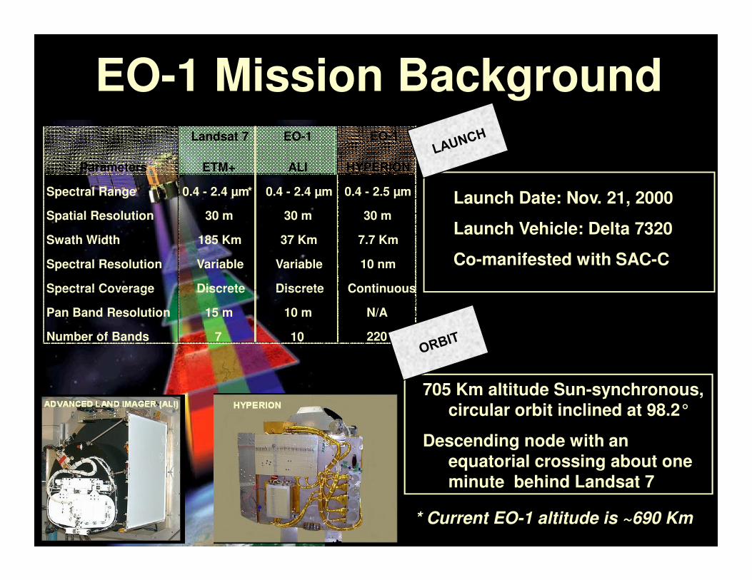
EO-1 Mission BackgroundLandsat 7 EO-1
Parameters ETM+ ALI HYPERION
Spectral Range 0.4 - 2.4 µm * 0.4 - 2.4 µm 0.4 - 2.5 µm
Spatial Resolution 30 m 30 m 30 m
Swath Width 185 Km 37 Km 7.7 Km
Spectral Resolution Variable Variable 10 nm
Spectral Coverage Discrete Discrete Continuous
EO-1
Launch Date: Nov. 21, 2000
Launch Vehicle: Delta 7320
Co-manifested with SAC-C
Spectral Coverage Discrete Discrete Continuous
Pan Band Resolution 15 m 10 m N/A
Number of Bands 7 10 220
* Current EO-1 altitude is ~690 Km
705 Km altitude Sun-synchronous, circular orbit inclined at 98.2°
Descending node with an equatorial crossing about one minute behind Landsat 7
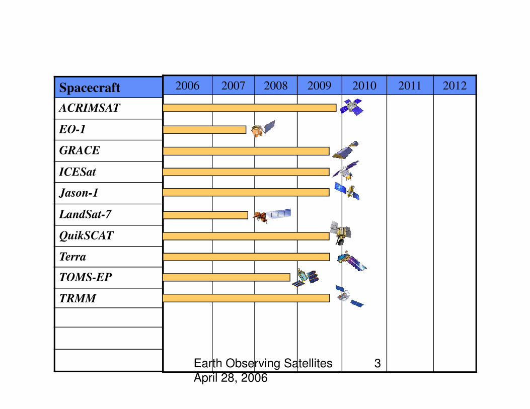
Spacecraft
ACRIMSAT
EO-1
GRACE
ICESat
Jason-1
2006 2007 2008 2009 2010 2011 2012
Flight Missions in “extended period”
Earth Observing Satellites
April 28, 2006
3
LandSat-7
QuikSCAT
Terra
TOMS-EP
TRMM
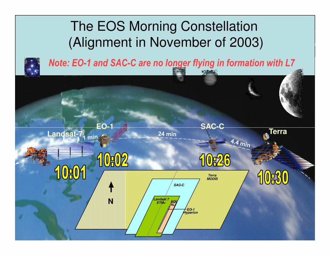
EO-1 SAC-CTerra
The EOS Morning Constellation(Alignment in November of 2003)
Note: EO-1 and SAC-C are no longer flying in formation with L7
Landsat-7EO-1 SAC-C
Terra
NLandsat 7
ETM+
EO-1Atmospheric
Corrector
SAC-C
TerraMODIS
EO-1Hyperion
EO-1ALI
N Landsat 7ETM+
SAC--C
TerraMODIS
EO---1Hyperion
EO-1ALI
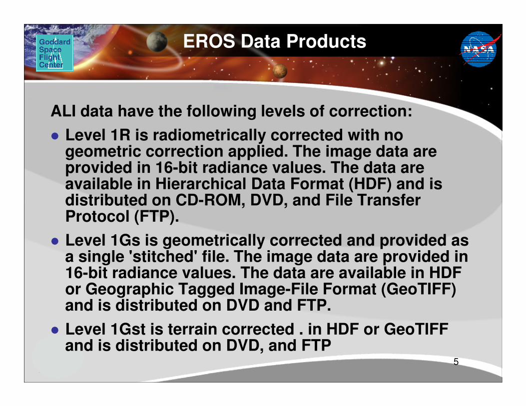
EROS Data Products
ALI data have the following levels of correction:
� Level 1R is radiometrically corrected with no geometric correction applied. The image data are provided in 16-bit radiance values. The data are available in Hierarchical Data Format (HDF) and is distributed on CD-ROM, DVD, and File Transfer
5
distributed on CD-ROM, DVD, and File Transfer Protocol (FTP).
� Level 1Gs is geometrically corrected and provided as a single 'stitched' file. The image data are provided in 16-bit radiance values. The data are available in HDF or Geographic Tagged Image-File Format (GeoTIFF) and is distributed on DVD and FTP.
� Level 1Gst is terrain corrected . in HDF or GeoTIFF and is distributed on DVD, and FTP

Sep ’99 – NRO selection start
Jan ’00 – first SVT Meeting
Nov 21, 2000 EO-1 Launch
Dec ‘00 – first SVT data collects
EO-1 Science Validation Team
(SVT) on The Fast Track
EO-1 SVT Milestonesfrom the Team Selection to
the Special Issue Publication
EO-1 Science Validation Team
(SVT) on The Fast Track
EO-1 Science Validation Team
(SVT) on The Fast Track
Dec ‘00 – first SVT data collects
Dec ’01 – “final” data collects
start analysis phase
Sept ‘02 – end of SVT funding
Nov ’02 – final SVT Meeting
Dec ’02 – submit manuscripts
Jun ’03 – last revisions due

Investigator Research Topics (continued)
Principal InvestigatorResearch Topic
Boardman, J. W., AIG, ColoradoEcological Applications in Yellowstone National Park
Cassady, P. E., Boeing, WashingtonCommercial Applications
Biggar, S. F., University of ArizonaRadiometric and Spatial Evaluation of ALI and Hyperion
Carlson, B. E., NASA /GISS, New YorkAtmospheric Correction
Meyer, D. J., EDC, South DakotaIntegrated Assessment of EO-1 and Landsat Instrument Suites
Smith, J. A., NASA GSFC, MarylandCanopy Temperature Estimation
Kieffer, H., USGS, Flagstaff, AZLunar Calibration
Carlson, B. E., NASA /GISS, New YorkAtmospheric Correction
Goetz, A. F. H., University of ColoradoAtmospheric Correction and Sparse Vegetation Mapping
Jupp, D. L. B., CSRIO, AustraliaAustralian Hyperspectral Calibration and Validation Sites
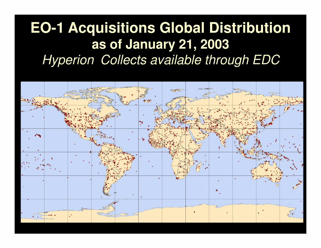
EO-1 Acquisitions Global Distributionas of January 21, 2003
Hyperion Collects available through EDC
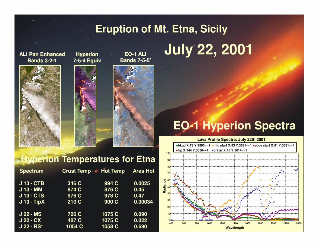
Eruption of Mt. Etna, Sicily
EO-1 Hyperion Spectra
ALI Pan Enhanced
Bands 3-2-1
EO-1 ALI
Bands 7-5-5’Hyperion
7-5-4 Equiv
ALI Pan Enhanced
Bands 3-2-1
EO-1 ALI
Bands 7-5-5’Hyperion
7-5-4 Equiv
July 22, 2001
9
Lava Profile Spectra: July 22th 2001
0
10
20
30
40
50
60
70
80
90
100
400 600 800 1000 1200 1400 1600 1800 2000 2200 2400
Wavelength
Rad
ian
ce
bkgd X:73 Y:3593~~1 mid start X:53 Y:3631~~1 edge start X:51 Y:3631~~1
tip X:144 Y:3656~~1 crater X:45 Y:3614~~1
Spectrum Crust Temp Hot Temp Area Hot
J 13 - CTB 346 C 994 C 0.0025J 13 - MM 874 C 876 C 0.45J 13 - CTS 976 C 978 C 0.47J 13 - TipX 210 C 900 C 0.00034
J 22 - MS 726 C 1075 C 0.090J 22 - CX 487 C 1075 C 0.022J 22 - RS* 1054 C 1058 C 0.690
EO-1 Hyperion Spectra
Hyperion Temperatures for Etna

Pan Sharpened
ALI Real Color
Pearl HarborDecember 19, 2000

Hyperion Spectra Extracted from Area of FireHyperion Views Tucson Wildfires - July 3, 2003
Active Fire Fresh Burn
Vegetation Natural Landscape
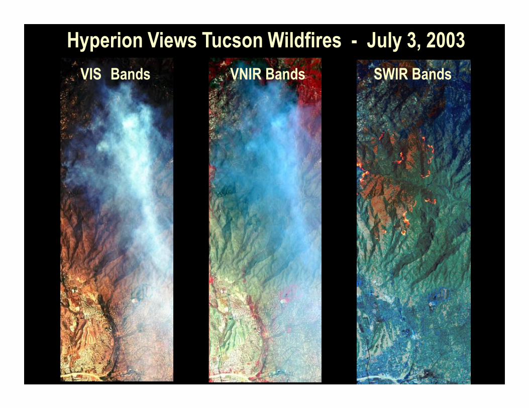
Hyperion Views Tucson Wildfires - July 3, 2003
SWIR BandsVNIR BandsVIS Bands
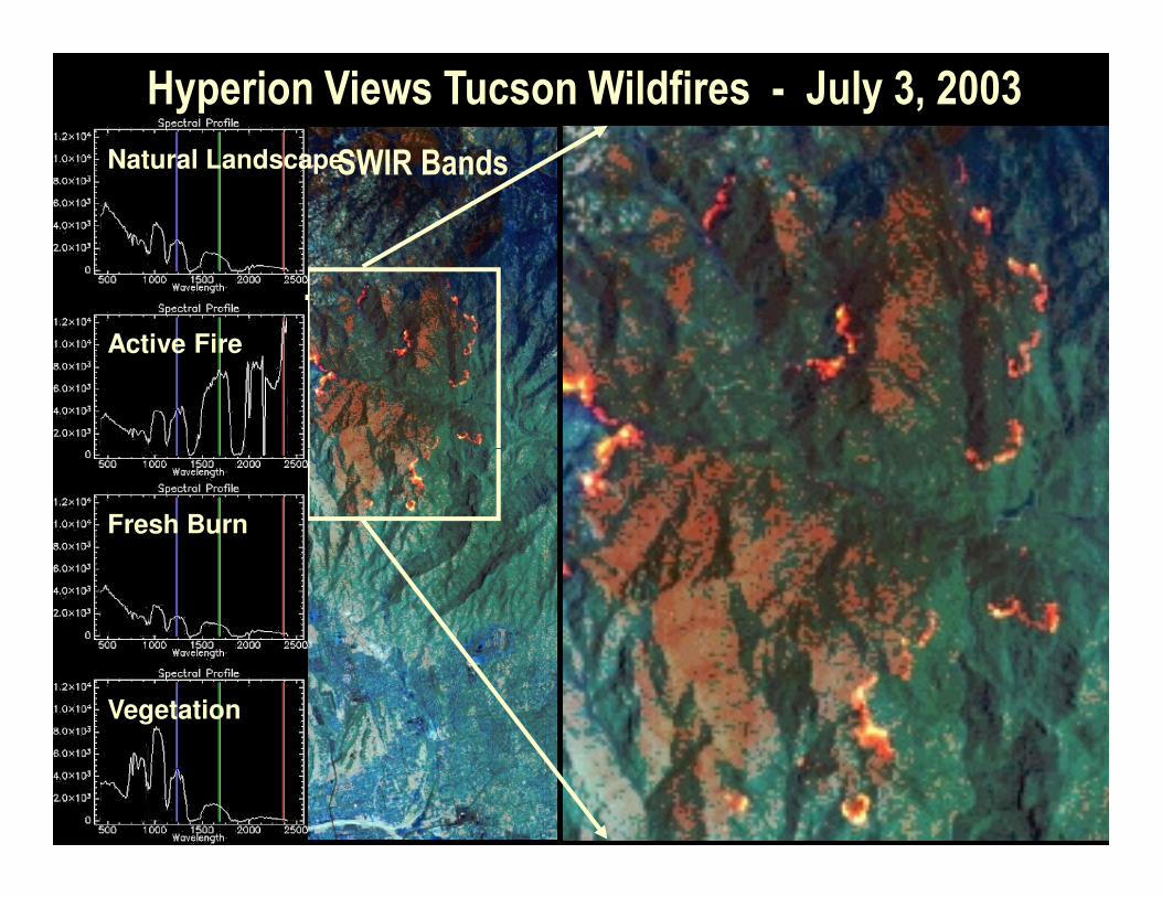
Hyperion Views Tucson Wildfires - July 3, 2003
SWIR BandsNatural Landscape
Active Fire
Fresh Burn
Vegetation

Forest Structure and Chemistry in the Brazilian Amazon:Forest Structure and Chemistry in the Brazilian Amazon:
First-ever Dating of Logging Activity Using Biophysics-Biochemistry Info Available from Hyperion
2 Yr Old Forest Regrowth(Mod. Canopy H2O, High Slash)
4 Yr Old Forest Regrowth(High Canopy H2O, Persisting Slash)
New Logging(High Soil and Slash)
Primary Forest(High Canopy H2O, Low Slash)
Green Pasture Areas(High Surface Litter)
Exposed Soil Canopy Water Underlying Surface Litter/Slash
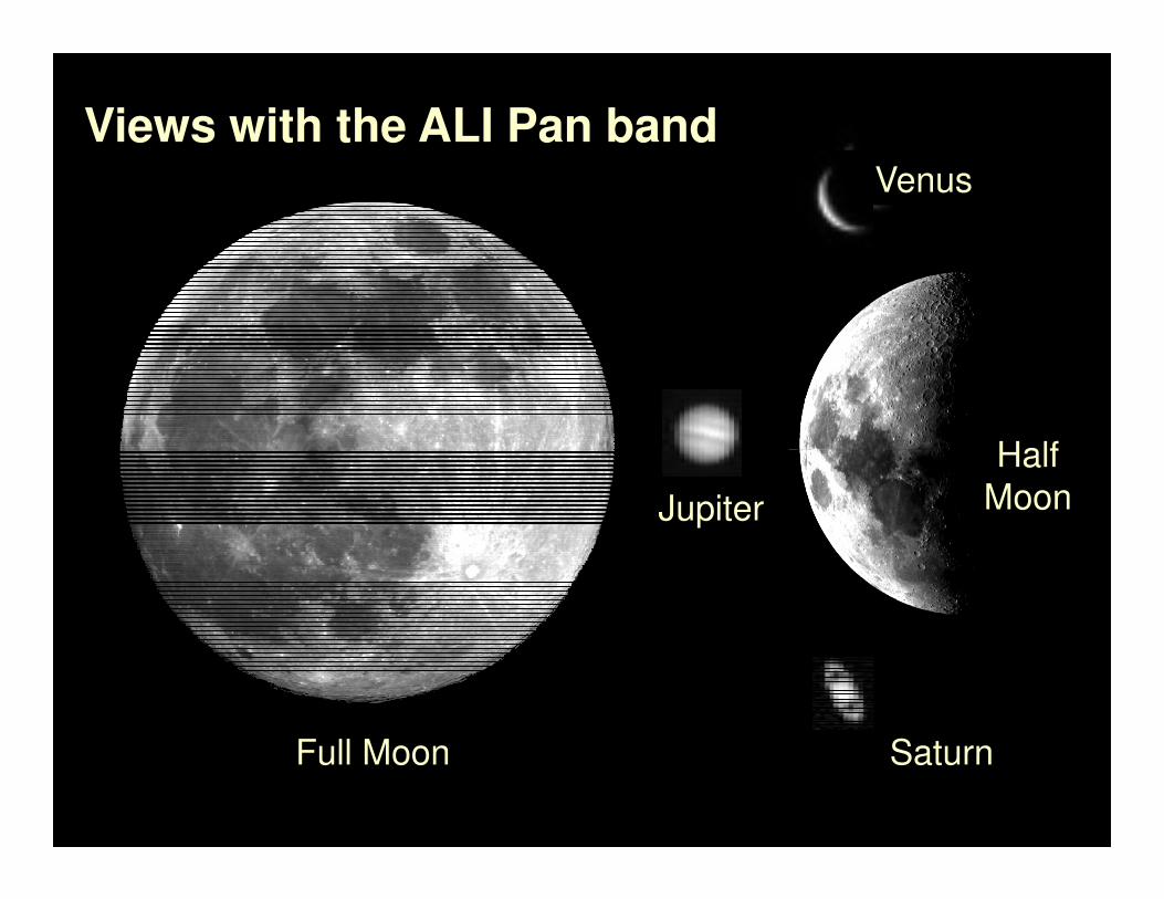
Half
Venus
Views with the ALI Pan band
Saturn
Half
MoonJupiter
Full Moon
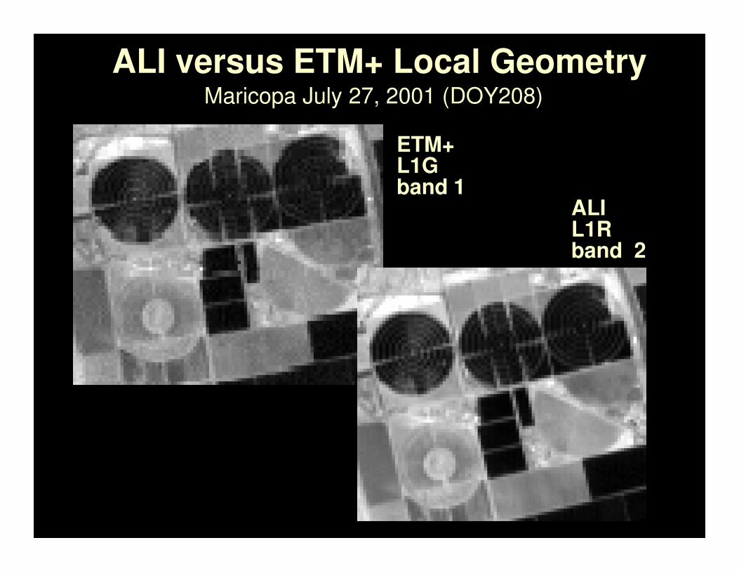
ALI versus ETM+ Local Geometry
ETM+L1Gband 1
Maricopa July 27, 2001 (DOY208)
ALIL1Rband 2

Sensor EOSensor EO--1 Imagen ALI1 Imagen ALI

Bandas EspectralesBandas Espectrales

PanPan-- SharpeningSharpening

Pan Sharpening
• Pan sharpening is a process by which the resolution of multispectral thematic data is
artificially increased by using intensity values from higher resolution panchromatic
data.
• The panchromatic intensity data may be a derived data set or an “as collected”
raster.
• Pan sharpening allows merging data from different sensors.
Multispectral 30m Panchromatic 15m Multispectral 15m