Home | City of Belmont
16
Transcript of Home | City of Belmont

.
.
...................................................................................................................................................................................................
.
.
.
.
.~ z
.~ o
.~ u
.~ a..
.~ I
’"
o
.0 >- ...J
.~ I
’"
.~ "
.~ ’"
u..
.~ <{ a:
.~’"
.~ >
o
.~"
.0 z
u
.~ a..
I
.~ o
z
.~ o
.; <{
o
.~ w
>
.~ Z
.~ <{ w
.~ o w
.~ f- w
.0
.
GREG ROWE I & associatesfOCUSED ON ACHIEVEMENT
CONTENTS- - - - _ - - -
-_ --~__=_ -= =-. _:-: -
~ -..::..-=_-=....:: _::.=...::. --=_- _
~_- -
=-=-_-=- _:::: =_ -=-~_ _........-:.=.. I
1.0
1.1
1.2
1.3
1.4
1.5
2.0
2.1
2.2
PART I - INTRODUCTION ........................................................................................................................................
4
Purpose and Scope of Document .............................................................................................................................. 4
Background to Document...............................................................................................................................................4
Overarching Objectives of the DAP .........................................................................................................................5
Structure of the DAP..........................................................................................................................................................5
Approval Process ..................................................................................................................................................................6
PART 2 - SITE AND CONTEXTUAL ANALYSIS...........................................................................................7
Location/OAP Boundary ................................................................................................................................................... 7
Site Analysis .............................................................................................................................................................................. 7
2.2.1 The Context Plan Explained...........................................................................................................................................................7
2.2.2 Landform Plans Explained ................................................................................................................................................................9
3.0
3.1
PART 3 - DEVELOPMENT REQUIREMENTS ................................................................................................ 10
Residential Design Code Designation and Dwelling Mix........................................................................... 10
3.1.1 General Development Requirements..............................................................................................................................."’" 10
Design Element I - Maximum Building Envelope (MBE) and Massing Diagram .......................... 12
3.2.1 General Acceptable Development Criteria.......................................................................................................................12
3.2.2 Site Specific Acceptable Development Criteria............................................................................................................... 13
Boundary Setback Requirements.............................................................................................................................. 14
3.3.1 General Acceptable Development Criteria.......................................................................................................................14
3.3.2 Site Specific Acceptable Development Criteria............................................................................................................... 15
Building Height & Appearance ................................................................................................................................... 16
3.4.1 General Acceptable Development Criteria.......................................................................................................................17
3.4.2 Site Specific Acceptable Development Criteria............................................................................................................... 17
Plot Ratio................................................................................................................................................................................. I 8
3.2
3.3
3.4
3.5
3.6
3.5.1 General Acceptable Development Criteria ....................................................................................................................... 18
Vehicle Access, Parking and End of Trip Facilities........................................................................................... 19
3.6.1 General Acceptable Development Criteria....................................................................................................................... 19
Passive Surveillance and Public Realm Considerations ................................................................................
21
3.7.1 General Acceptable Development Criteria .......................................................................................................................21
3.7.2 Site Specific Acceptable Development Criteria...............................................................................................................26
Overshadowing ................................................................................................................................................................... 27
3.8.1 General Acceptable Development Criteria.......................................................................................................................27
Waste Collection ...............................................................................................................................................................
28
3.7
3.8
3.9
...................................................................................................................................................................................................................................................................................... DETAILED AREA PLAN RIVERSDALE ROAD NORTH PRECINCT
._
J


.
.
. ..................................................................................................................................................................................................
GREG ROWE I & associates fOCUSED ON ACHIEVEMENT
.
.
.
.
._J
<(
z
.w..
Vl
0
0
.L
0U
.3:w..
"-
.f-"-
cc
IN
0
.-
0
>-_J
.::l
N-
I~
."-
M
en
"
.~
"-
M
en
w..
.LU
cc
<(cc
.l?
"
N
-
.0
N
>
0
.;"
.0z
u
.~"-
I
.~0Z
.~0CC
.~<(
0
.~LU
>
.~Z
.~<(LU
.~0LU
.~f-LU
.0
.
1.0 Part I - Introduction
1.1 Purpose and Scope of Document
This document is a Detailed Area Plan (DAP) to guide the fine grain design of development in the Riversdale Road
North Precinct (RRNP) of The Springs. The DAP is to be used by landowners and proponents to guide the
preparation of development applications, and by decision-makers in determining such applications for land within the
Precinct.
The City of Belmont and WA Planning Commission have previously adopted The Springs Structure Plan (SSP) for
broader level guidance of subdivision and development across The Springs project area. Section 6.2.3 of the SSP
requires that as a precursor to development a DAP is prepared for lots adjacent to Cracknell Park and within the
wider Riversdale Road North Precinct (RRNP). This DAP document satisfies such requirement of the SSP.
The SSP states that a DAP may be prepared for the whole of the Precinct or a portion of the Precinct to the
satisfaction of the City of Belmont and the Western Australian Planning Commission. This DAP has been prepared
for (and will apply to) the entire Riversdale North Precinct (excluding lots that do not form part of The Springs Structure Plan area). The Riversdale North Precinct is identified in Figure I - Location Plan. A number of existing
strata complexes on the nOlih side of Riversdale Road (east of Cracknell Park & west of Brighton Road) are located
outside of The Springs Structure Plan area and therefore not included in this DAP.
This DAP represents the next layer of design guidance for the Riversdale Road North Precinct and will be seen as the
enabling document for the implementation of the objectives of The Springs Structure Plan and Design Guidelines.
Although the DAP is to be given a higher weight in determining applications, the provisions of the Design Guidelines
must also be given regard where a matter is not dealt with by the DAP. Where there is any ambiguity or conflict
between the DAP and the Design Guidelines the DAP shall prevail.
1 .2 Background to Document
The Springs Structure Plan identifies that the following matters are to be addressed through a Detailed Area Plan:
(for land abutting Cracknell Park)
)) Setbacks from the public open space;
)) Requirement for habitable rooms to overlook the public open space;
)) Visually permeable fencing; and
)) Acceptable intrusions into the setback area.
...................................................................................................................................................................................................................................................................................... DETAILED AREA PLAN RIVERSDALE ROAD NORTH PRECINCT
.4

.
.
. ..................................................................................................................................................................................................
GREG ROWE I & associates
.
.
.
.
.-’
<(
z
.LL
V>
0
0
.~u
.s:LL
a..
.f-a..
oc
I
N
.0
-
0
>--’
.:J
N-
’"
.~
.~ U’l
LL
.~ <( oc
.~
.~ >
o
.~
FOCUSED ON ACHIEVEMENT
(for the remainder of the Precinct)
>> Creation and preservation of significant sight lines (or view corridors) to and from the Swan River,
>> Overshadowing;
>> Control of building bulk via setbacks;
>> Response to topography;
>> Articulation of podium and tower elements; and
>> Address to street and public realm.
1.3 Overarching Objectives of the DAP
In light of the matters to be addressed as per The Springs Structure Plan, the objectives of this DAP are to:
>> Act as a mechanism for the establishment of appropriate development standards and design guidance for the Riversdale Road North Precinct.
"
>> Maintain visual connections and an appropriate interface between The Springs Special Development Precinct and Swan River.
N
>> Maximise passive visual surveillance of public spaces surrounding the RRNP.
>> Minimise overshadowing of development sites and public spaces.
>> Create buildings that make a positive contribution to the locality.
>> Develop an easy to understand and implementable planning framework.
"
1.4 Structure of the DAP
. f-u z
In order to achieve its objectives the DAP is structured in the following manner.
u
.~ a..
I
.~ o
Z
.~ o
.; <(
o
.~ ill
>
.~ z
.~ <( ill
.~ o ill
.~ f- ill
.0
>> Part I - Introductory (procedural context for the DAP/description of its purpose)
>> Part 2 - Site and Contextual Analysis (a summary of planning/design influences based on the attributes
of the site and its surrounds)
>> Part 3 - Development Requirements (the design requirements and standards that development
applications must demonstrably achieve).
Part 3 is the most critical element of the DAP. It has been structured to provide procedural and decision making
certainty while building in an appropriate level of design flexibility.
To achieve this, Part 3 addresses specific Design Elements as follows:
>> Residential Design Code Designation and Dwelling Mix
>> Maximum Building Envelopes and Massing
>> Boundary Setbacks
>> Building Height
.
...................................................................................................................................................................................................................................................................................... DETAILED AREA PLAN RIVERSDALE ROAD NORTH PRECINCT 5
.

.
.
. ..................................................................................................................................................................................................
GREG ROWE I & associates
.
.
.
.
.;;: z
u...
.o
.~ u
.~ Q..
.~ I
(’oJ
.~ >- -’
.~ I
a-.
.~
.~ U’)
u...
.~ <( cr:
.~(’oJ
.~ >
o
.~
.tJ z
u
.~ Q..
I
.~ o z
.~ o
.; <(
o
.~ w
>
.~ Z
.~ <( w
.~ o w
.~ f- w
.0
FOCUSED ON ACHIEVEMENT
)) Plot Ratio
)) Access and parking
)) Passive Surveillance and the Public Realm
)) Overshadowing
)) Waste Collection
)) Acoustic Separation
A set of Development Objectives have been prepared for each of these Design Elements. In order to demonstrate
compliance with the Development Objectives and encourage a streamlined approval process, development proposals must satisfy the Acceptable Development Criteria for each Design Element. The Acceptable Development Criteria
are a series of standards that are considered as appropriate for development in the Riversdale Road North Precinct.
Meeting these criteria means that a proponent has demonstrated a development outcome that clearly meets the
Development Objective and is consistent with the WA Planning Commission and City of Belmont’s vision for the
Riversdale Road North Precinct.
"
1.5 Approval Process
The following steps represent the progression of a development application on land covered by this DAP:
"
I. Proponent develops conceptual drawings for discussion with the City in line with the DAP. Proponents are
also encouraged to discuss the proposal with the Swan River Trust;
2. Proponents are encouraged to seek feedback on the proposal through lodgement of a ’Preliminary
Development Application’ for preliminary advice by the City’s Development Control Group prior to formal
lodgement; 3. City of Belmont considers and provides advice to the proponent on the suitability of the proposal and any
issues/concerns;
4. Proponent finalises concept drawings, advancing them to development plans. 5. Development plans and justification report are lodged with the City of Belmont. Justification report (via a
checklist against this DAP or other means) demonstrate manner in which the objectives of this DAP have
been met.
6. Standard Scheme processes for determining applications for development approval. including (where variations from this DAP are proposed) public advertising and referTal to the Swan River T rust in accordance
with MRS Clause 30A(2)(b). 7. Application determined by City of Belmont or a Development Assessment Panel within the legislative
timeframes.
8. Appeal/review rights apply.
.
...................................................................................................................................................................................................................................................................................... DETAILED AREA PLAN RIVERSDALE ROAD NORTH PRECINCT 6
.
.
.
. ..................................................................................................................................................................................................
GREG ROWE I & associates FOCUSED ON ACHIEVEA1E.NT
.
.
.
.
.-’
<(
Z
.w..
(/)
0
0
.~U
.~u...
a..
.I-a..
CC
I’"
.0-
0
>--’
.::J
r:i-
Ia--
."-
M
(/)
"
.~ en
u...
.~ <( CC
.~
.~ >
o
.~
.tJ z
u
.~ a..
I
.~ o z
.~ o
.; <(
o
.~ LU
>
.~ Z
.~ <( LU
.~ o LU
.~ I- LU
.0
.
2.0 Part 2 - Site and Contextual Analysis
2.1 Location/DAP Boundary The subject site is located in the Municipality of the City of Belmont approximately 2.5 kilometres east of the Perth
Central Area. Refer Figure I.
The land is situated in the Riversdale Road North Precinct of The Springs. The DAP applies to an area bounded by
the Swan River foreshore to the north, Riversdale Road to the south, the Graham Farmer Freeway to the west and
private allotments to the east.
Figure I also illustrates the extent of the DAP.
2.2 Site Analysis To illustrate the attributes of the RRN P this section of the report includes the following:
)) A Context Plan (a plan illustrating the opportunities and issues associated with the site and its surrounds) at
Figure 2; and
)) Cross-Sections of Existing Landform (to illustrate the relationship between levels at the front and rear of the
properties for the purposes of calculating and determining an appropriate building height - the location of the
cross-sections are shown on the Context Plan) at Figure 3.
’"
2.2.1 The Context Plan Explained
"
Existing Development
Sites I and 2 are vacant. Site 3 is developed for single residential development. The western extent of Site 4 is
developed for single residential but the remainder of the site area is vacant. Site 5 is developed as a single residence.
Public Open Space is located centrally within the Precinct at Cracknell Park. Site 6 is vacant and is bounded by high
density residential on both sides.
Proposed (Surrounding) Development
Land to the south of RRNP is designated in the SSP for a mix of High Density Residential, Mixed Use and Medium
Density Residential. Density increases from east to west across the Structure Plan Area with those areas adjacent to
the Graham Farmer Freeway being most ’intense.’ Heights earmarked for land south of RRNP range from 6 metres to
30 metres (minimum for landmark site on corner of Great Eastern Highway and Graham Farmer Freeway - height
may be greater at detailed design phase).
The RRNP is in an inner city location and a high amenity area. Such areas can support higher densities and more
intense development outcomes, including height. This is reflected in / is consistent with the spine of tower
development extending eastwards from the Perth central area along the river, through to the East Perth
...................................................................................................................................................................................................................................................................................... DETAILED AREA PLAN RIVERSDALE ROAD NORTH PRECINCT 7
.___ ____
J

---.:~~ c ’-.~~
, "
" ~
N:\TOWNPLANNING\5000-5999\5356\DRAFrlNG\DETAII EDAREAPLAN\INDESIGN\535602 I 101 FIGURE I LOCATIONPLANJNDDMAR20 II,
’
, ’ " ’!
I I .--
l
I
I
I
t
Boundary of Riversdale Road North Precinct
, Development Site Boundaries
Development Site
..
,f’(:r1!~::-~_r ."
."" " , --- "’) ’"
.
. I
.
.
Figure I. Location Plan Riversdale Road North Precinct Aerial photography captured and supplied by NEARMAP (not to scale)
OJ GREG ROWE & associates
FOCUSED ON ACHIEVEMENT

.
.
.
.
.
.
.
.
.
.
.
.
.
.
.
.
.
.
.
.
.
.
.
.
.
.
.
.
.
.
. I
.I
. I
. I
~3XXl-~AIJD’NJE9CN5356l211~11
SWAN RIVER
PERTH CENTRAL AREA
2.5KM WEST
~ ---""’.....
_
O-:==:F--;\L~
\~\ \r~
~.=::
) ,(
~ "I ~
[, "
I
\,r "
f (
~\ /( /
Y’""
::.
\,
’~ ~
~ ~
A,~ ~~ ~~
~"z, ~).
u
~~ ~ ~~
~~~"r .;. O~
~~$’ (:j
~~
\ ~ ,
LEGEND
--Boundary of Riversdale Road North Precinct
14 I Primary view potential ~..~ Physical access opportunites to and fromSwan River, Cracknell Park, Brighton Road
View potential to River and City fromand (potentially) dual use path at Graham
I ,,"J Farmer Freeway.Precinct (private)
Primary (public) view corridor111111111 North/south open space and visual link
~........
Incidental (potential via setbacks) viewPublic open space
~
corridor * Landmark potential
Interface with foreshore to accomodate
development requirements (ie siteworks) while achieving survelliance and demarcation
of public/private realm.VJ]]J
Development site boundaries
Development site UJJJJPodium (front) zone to interface with
development to south/achieve appropriate scale to street to promote solar/breeze access.
ill.. .. Cross-section locations (refer to figure 3)
Contours Interface with Cracknell Park to achieve
survelliance and appropriate demarcation of
public/private realm.
UIJJo Existing trees/specimens as per
Arbor Study 2006~ry-,"’,.~r:’
~-~=-’-.",,-,-2,
. __.4 iif4
__
.._L +_AGE .
.1. -. Wl_W!$::;;!&4_~mt!f3iii ..c~ s, W. -=-,49 _
_A . 147M. .<:>;to",,",.f@_~ _LQ;i_ 4t.4fMI!_{-..f!fb&;;3~P.;:;.$&.x_.! ...,-’-’"’"_?_....!!t#J..4;s;a;-,@t 1Ji$!i... A44k1 ;. M_I’miiW.;;;;;_........,.’-"""’lI:" .__
S.; #_$!!kf"+"L4!NYNthiif.22!25, m’__IM:
Figure 2. Riversdale Road North Precinct Detailed Area Plan Site Analysis Context Plan (Scale I: 1800)
11 ’\ GREG ROWE I & associates ~ FOCUSED ON ACHIEVEMENT

.. N:\TOWNPLANNING\5000-5999\5379IDRAFTING~NDESlGN\5379061201F1GURE3DETAILAREAPLAN.INDDJUN2012
.
.
.
.
.
.
.
.
.
.
.
.
.
.
.
.
.
.
.
.
.
.
.
.
.
.
.
.
.
.- I
. I . , . r
NOTES
A. Illustrative Front Building Zone (Podium) to
achieve human scale.
I
10m SEl]BA
1 :
I
10m SETBACK
1 iB. Illustrative Central Building Zone (Tower)
to take advantage of views, minimise over-
shadowing, maximise inner city location and
reflect existing pattern of development along
River. I CONCEPTUAL CROSS-SECTION A-A (SITE I) I CONCEPTUAL CROSS-SECTION B-B (SITE 4)C. Illustrative Rear Building Zone to achieve
human scale to foreshore and survelliance.
_= .
=’ ~
= =~~ ~
~, ~
~
.
~o~l ~..:
Cj) ~:LEGEND
;;~ ~O[~t~~~ ,f, "1- I" ~
-.:.-
~ vr.~
.~
I ,~F/22l Conceptual
Rear Building Zone (max 3 stories &
rooftop terrace)
18888] Conceptual Central Building Zone
~ Conceptual Front Building Zone
~~I Potential landmark site (eastern edge of site 5)
* Potential landmark site Natural ground level
Riversdale Road
o~ ~..y .<-~ ~’7 ((’~~~~
~J. A,~ ’SI
.J INSET A - CONTOURS AND SECTION LOCATION (SCALE 1:2500)
y40.5m
Metropolitan Region Scheme Parks and Recreation
Reserve
~ Development site . . Section marker
10m SETBACK10m SETBACK
I
1 i I
I
1- - DII Level of Riversdale Road
I CONCEPTUAL CROSS-SECTION 0-0 (SITE 6)CONCEPTUAL CROSS-SECTION C-C (SITE 5)
Figure 3. Riversdale Road North Precinct Detailed Area Plan Cross Section (Scale I: 1500)
(1) GREG ROWE FOCUSED ON ACHIEVEMENT
& associates

.
.
. ..................................................................................................................................................................................................
GREG ROWE I & associates FOCUSED ON ACHIEVEMENT
.
.
.
.
.-’
<(
z
u..
.Vl
0
0
.L
0U
.3:u..
"-
.I-"-
cc
I(’J
0
.-
0
>--’
:::l
.;:<-
Icr-
.,..._
M
Vl
"
.cr-
,..._
M
Vl
u..
.w
cc
<(cc
.l?
"
(’J-
.~>
0
.;"
.tJz
u
.~I
.~0Z
.~0CC
.~<(
0
.~w
2:
.~z
<(
.~<(w
.~0w
.~I-w
.0
.
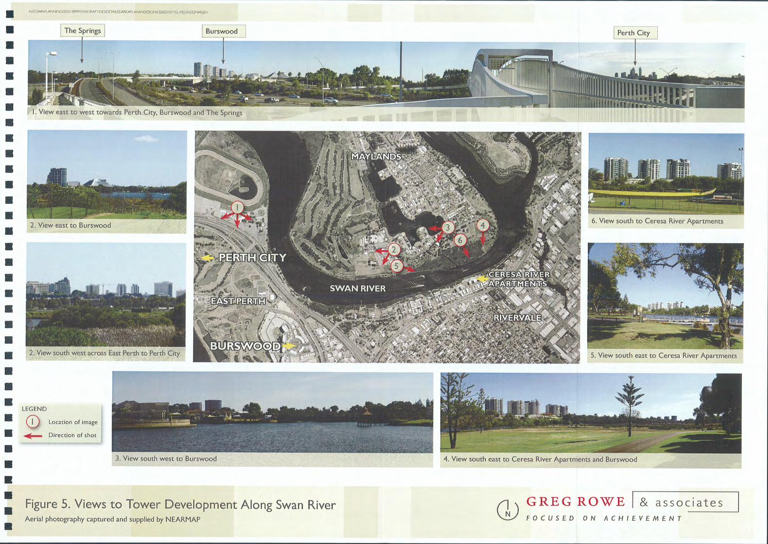
Redevelopment Area (in projects such as Waterbank), Burswood and to Ascot Waters. This pattern of development is illustrated at Figure 4.
Height in RRNP may also effectively bookend the eastern gateway to the City across Graham Farmer Freeway. Burswood provides the western context for such development and The Springs to the east would complete this
pattern.
Well articulated residential towers would reflect existing views and aspects to locality from the River, foreshore areas
and adjacent suburbs as illustrated by the photographs at Figure 5.
The RRNP development should create an iconic entry point to the City.
Open Space
The RRNP includes Cracknell Park, which provides important passive recreation opportunities to nearby residents and
workers. It will play an even more important role as the land surrounding the Park develops over time and demand
for recreation space increases. The Park also provides a visual and physical link between development in The Springs and the Swan River.
Cracknell Park is the northern-most component of a north-south parkland link along Hawksburn Road through to the
River.
Views
The primary consideration is the protection and enhancement of views between (to and through) the various
components of the public realm - footpaths, roads, parks - and the foreshore. Secondary views towards the River
from development on the south of Riversdale Road and users of Riversdale Road may be provided incidentally
through the RRNP by way of side building setbacks.
Views are comprised of a number of elements and are not limited in definition to providing a view to the Swan River
from private land. Indeed, because of site topography, views to water may not be available from development sites
south of Riversdale Road. There are other, equally positive, contributions the RRNP may make to the locality. Views,
in the context of the RRN P mean:
>> Location and orientation of buildings within the Precinct to take advantage of its setting - this includes
aspect to the Swan River, City and parkland areas.
>> Providing aspect to and surveillance of the public realm, including the street and open space.
>> Potential for landmark buildings at important junctions.
>> Maintenance and edging of primary view corridors through Cracknell Park.
>> Framing of incidental view corridors from southern Precincts within The Springs, towards the Swan
River ’valley.’ Framing is achieved by built form edges to setback areas. The ability to maintain view
corridors through each Development Site is impacted upon by factors such as the size and shape of the
lot.
>> The cumulative impact of development when viewed from the Swan River and the Maylands Peninsula
into the Springs Precinct.
...................................................................................................................................................................................................................................................................................... DETAILED AREA PLAN RIVERSDALE ROAD NORTH PRECINCT 8
.

N:\TOWN PLANNINGI5000-599915356IDRAFTINGIDETAILED AREA PLANIINDESIGNI5356 021101 FIGURE 4.INDD MAR 2011
Perth City Central Park: 51
I
.
.
. ,
Figure 4. Tower Development in the Swan River Context OJ GREG ROWE & associates
Aerial photography captured and supplied by NEARMAP FOCUSED ON ACHIEVEMENT
N:\TOWTWLANNINGI5OOO-5999\5356IDRAFTINGIDETAlLEDAREAPlANIJNDESIGN\53SW2110IFlGURES.INDDMAR2011.
.
.
.
.
.
.
.
.
.
.
.
.
.
.
.
.
.
.
.
.
.
.
.
.
.
.
.
.
.
.
.
. i
.
The Springs I
C’I
Burswoocl
I. View east to west towards Perth City, Burswood and The Springs
2. View east to Burswood
r-- - - - - - - - -
I
2. View south west across East Perth to Perth City
LEGEND
CD Location of image
~ Direction of shot
._~L-~~~I
3. View south west to Burswood
I Perth City
, .
6. View south to Ceresa River Apartments
5. View south east to Ceresa River Apartments
4. View south east to Ceresa River Apartments and Burswood
Figure 5. Views to Tower Development Along Swan River Aerial photography captured and supplied by NEARMAP
GJGREG ROWE & associates
FOCUSED ON ACHIEVEMENT

.
.
. ..................................................................................................................................................................................................
GREG ROWE I & associates FOCUSED ON ACHIEVEMENT
.
.
.
.
....J
<(
Z
.u..
Vl
0
0
.L
0U
.:s:u..
a.
.f-a.
ee
Ir<
0
.-
0
>-...J
::J
.;:::i’-
I
~
."-
M
Vl
"
.~
"-
M
Vl
u..
.w
ee
<(ee
.(.?
"
r<
-
.0
r<
>
0
.~"
.t:iz
u
.~a.
I
.~0Z
.~0ee
.~<(
0
.~w
>
.~Z
.~<(w
.~0w
.~f-w
.0
.
Movement
Vehicular access to the site will be via Riversdale Road. No vehicular access is available from the Freeway.
Pedestrian and cycle paths exist or" will be implemented adjacent to the Graham Fanmer Freeway, in the Swan River
foreshore reserve and through Cracknell Park.
Heritage
The Municipal Heritage Inventory identifies Site 5 as accommodating a ’character residence.’ This is no impediment to
the development of the Site, however, as the residence is:
’Significant but not essential to an understanding of the history of the district.’
As such the strategy for the residence is to:
’Photographically record the place prior to any major redevelopment or demolition.’
Topography
See section 2.2.2 below.
2.2.2 Landform Plans Explained
All Development Sites, to varying degrees, slope downwards from south to north, with the highest points being at
Riversdale Road boundaries and the lowest points being at the Swan River. This presents a number of issues:
a) The point from which building heights are measured must be carefully considered.
b) Development shall utilise the natural topography to allow development within the Maximum Building
Envelope (MBE) while minimising scale impacts.
c) Development at foreshore’s edge will need to be carefully considered to ensure that it does not produce an
over-emphasised or inappropriate sense of scale adjacent to the foreshore area
d) There may be a level of retaining at the foreshore edge. This must be done in a manner that delineates the
public/private realm and accommodates development while achieving as much passive surveillance (of the
foreshore) as practical.
The result of the varying topography of the site (from north to south) shall be to implement individual ’height zones’
(Front, Central and Rear Development Zones) across each Site. These zones take into account the differing ground
levels at the Front, Central and Rear sections of the Sites.
...................................................................................................................................................................................................................................................................................... DETAILED AREA PLAN RIVERSDALE ROAD NORTH PRECINCT 9
.

.
.
. ..................................................................................................................................................................................................
GREG ROWE I & associates
.
.
.
.
. -;j_ z
u..
.~ o
. ~ u
. ~ (l._
. ~ I
,...,
o
.0 >- ...J
.~I
cr--
.~
.~ U’)
u..
. ~ a::
.~,...,
.0
,...,
>
0
.z
U’)
"
.f-
U
Z
U
.LU
a::(l._
I
.f-
a::
0Z
.0<{
0a::
.LU
...J
<(
0
.V)
a::
LU
>
.a::
"
Z
.<{...J
(l._
<{LU
.a::
<{
0LU
.~f-LU
.0
FOCUSED ON ACHIEVEMENT
3.0 Part 3 - Development RequirementsThis section of the DAP contains the development requirements that are applicable either to the entire RRNP or to a
specific Development Site within the RRNP. They have been developed in the context of a set of Development
Objectives and a Design Rationale (context and response) aimed at achieving those Objectives.
The MBE’s (building envelopes) referred to in this section are at Appendix I.
3.1 Residential Design Code Designation and Dwelling Mix
Development Objectives: To reflect the development potential of the site whilst ensuring that -
}} all development is sympathetic to the Swan River foreshore, surrounding precinct and local context
and;
}} A diversity of dwelling types is provided.
Design Rationale:
"
The Riversdale North Precinct is identified within The Springs Local Structure Plan as having a dual residential
density code of R I 00/160. The high density nature of the site is attributed to its inner city location and high levels
of amenity, however due to its proximity to the Swan River foreshore it is imperative that development is
designed in a manner that is sympathetic to its surrounds.
The R I 00 density code is considered appropriate as a base density code for the Riversdale Road North Precinct.
However, it is recognised that this is an area that will be undergoing extensive redevelopment.
Therefore, a flexible R I OOIR 160 dual coding provides opportunity for developments to be considered with a
density above the R I 00 base coding where it can be demonstrated that it meets the set performance criteria (as identified in Part 3.1.1 of this DAP and Part 5 of the City of Belmont Local Planning Policy No.7 (LPP7): The
Springs Design Guidelines) to the satisfaction of the decision making body. Compliance with this Performance Criteria indicates that the proposal is of a superior design standard and meets the Development Objectives and
intent of The Springs Structure Plan. The Springs Structure Plan contains provisions relating to the minimum
provision of 60m2 and 90m2 dwellings in precincts across The Springs project area. This is intended to promote a
diversity of housing types at The Springs and to achieve diversity in demographics
3.1 .1 General Development Requirements
>} The base density code applying to the RRNP is R I 00.
>> The decision-making authority may support an increase in density above R I 00, to a maximum of
density of R 160 where, in the opinion of the decision-making authority, the development meets the
following criteria:
Is sited such that it will provide appropriate view corridors and informal surveillance of the street
and/or other public spaces; and
.
...................................................................................................................................................................................................................................................................................... DETAILED AREA PLAN RIVERS DALE ROAD NORTH PRECINCT 10
.

.
.
. ..................................................................................................................................................................................................
GREG ROWE I & associates FOCUSED ON ACHIEVEMENT
.
.
.
.
....J
<{
Z
.u..
V)
0
0
.L
0U
.5u..
a..
.I-a..
er:
I’"
.0
-
0
>-...J
.::J
;:::;--
Ia--
.r--
M
V)
"
.a-
r--
M
V)
u..
.LlJ
er:
<{er:
.CJ
"
’"
-
.0
’"
> ))0
.zV)
"
.I-
U
Z
U
.LlJ
er:a..
I
.f-er:
0Z
.0<{
0er:
.LlJ
...J
<{
0
.en
er:
LlJ
~
.~z
.~<{LU
.~0LlJ
.~f-LU
.0
Is of an exceptional urban design standard and built form that will enhance the desired
streetscape. In order to achieve this, the design will incorporate high quality building materials,
architectural detailing and complementary colour scheme; and
Is oriented to provide maximum direct winter sunlight and ventilation to the development and to
adjoining properties while maintaining privacy; and
Will not overshadow adjacent properties and those on the south side of Riversdale Road by
more than 50% during mid-winter; and
Provides a demonstrable amenity of direct benefit to the City of Belmont. This may include but is
not limited to: provision of affordable housing, street art, courtyards, arbors, fountains, street
fumiture, rooftop gardens, landscaped pedestrian/cyclist corridors or pathways, localised exterior
lighting of pathways, and textured pedestrian surface treatments, etc; and
Provides well designed frontages oriented towards Riversdale Road and the Swan River
foreshore that use landscaping or fencing treatments to establish boundaries between private and public space in an understated manner so as to maintain security without discouraging
pedestrian activity; and
Provides a demonstrable commitment to sustainability principles; and/or
Has regard for the history associated with the site and incorporates elements which reflect this
history. This may include but is not limited to public art, photographic displays, creative re-use of
existing heritage structures or features, etc.
Development proposals are to be consistent with The Springs Local Structure Plan and provide:
o A minimum of 15% of the dwellings being a maximum of 60m2 in plot ratio floor space; and
o A minimum of 15% of the number of dwellings being a maximum of 90m2 in plot ratio
floor area.
.
...................................................................................................................................................................................................................................................................................... DETAILED AREA PLAN RIVERS DALE ROAD NORTH PRECINCT II
. --
I