HIGHWAY THROUGH HISTORY - aberdeencity.gov.uk · Text by Kirsty Dingwall (Headland Archaeology (UK)...
100
Transcript of HIGHWAY THROUGH HISTORY - aberdeencity.gov.uk · Text by Kirsty Dingwall (Headland Archaeology (UK)...
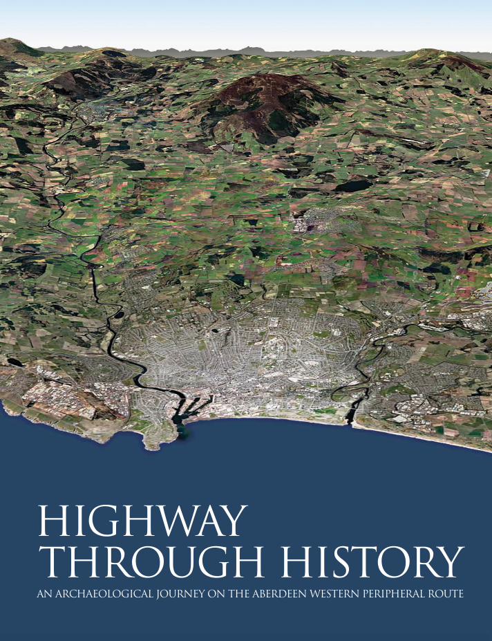

HIGHWAY THROUGH HISTORYAN ARCHAEOLOGICAL JOURNEY ON THE ABERDEEN WESTERN PERIPHERAL ROUTE
Published by Headland Archaeology (UK) Ltd

Published in 2018 by Headland Archaeology (UK) Ltd
Headland Archaeology (UK) Ltd13 Jane Street
Edinburgh EH6 5HET 0131 467 7705
Headland Archaeology (UK) Ltd is a registered company SC342945
British Library Cataloguing-in-Publication DataA catalogue record for this book is available from the British Library
ISBN 978-0-9556419-4-7
Copyright © Headland Archaeology (UK) Ltd, 2018.Contains OS data © Crown copyright and database right 2018.
All rights reserved. No part of this publication may be reproduced, stored in or introduced into a retrieval system, or transmitted, in any form, or by any means (electronic, mechanical, photocopying, recording or otherwise) without the prior written permission of the publisher. Any person who does any unauthorised
act in relation to this publication may be liable to criminal prosecution and civil claims for damages.
Text by Kirsty Dingwall (Headland Archaeology (UK) Ltd), John Shepherd
Edited by Dr Christopher Lowe, Luke Craddock-Bennett (Headland Archaeology (UK) Ltd)
Designed by Caroline Norrman, Mano Kapazoglou (Headland Archaeology (UK) Ltd)
Photos by Headland Archaeology (UK) Ltd, Jürgen van Wessel
Printed in Great Britain by Bell & Bain Ltd, Glasgow
This publication was funded by Transport Scotland jointly with Aberdeen City and Aberdeenshire Councils.


Contents
FOREWORD VII
INTRODUCTION 1
THE AWPR/B-T ROUTE 7
THE END OF THE ICE AGE AND EARLIEST EVIDENCE FOR HUMAN ACTIVITY C13,000 bc – 4000 bc 13
The anatomy of a pit 18
Stone tools 26
MANAGING RESOURCES AND BUILDING HOMES IN THE NEOLITHIC 4000 bc – 2500 bc 35
The broken pot 36
Radiocarbon-dating 42
LIFE, DEATH AND RELIGION IN THE CHALCOLITHIC AND BRONZE AGE 2500 bc – 800 bc 47
Timber settings, avenues and lines of posts: how do we interpret the features we find? 50
Cropmarks 56
The anatomy of a roundhouse 62
IRON AGE AND ROMAN 71
The anatomy of a post-hole 72
Dating the ovens 81
THE SIGNIFICANCE OF THE ARCHAEOLOGY OF THE AWPR/B-T SCHEME 87


Foreword
The route for the Aberdeen Western Peripheral Route Balmedie to Tipperty (AWPR/B-T) project crosses an area of Aberdeen City and Aberdeenshire where few archaeological remains had been discovered. In advance of the project’s main construction works, archaeologists carried out a desk study, surveys and detailed investigatory work at a number of locations where there was archaeological potential.
The artefacts unearthed show that stone tools from after the last Ice Age some 14,000 years ago were found at Milltimber. At the same locality, 90 bread ovens were discovered. These were almost certainly made by the Roman army and dating to the time of invasion, which was led by the Roman General named Gnaeus Julius Agricola late in the First Century AD.
In the time between the stone tools and the bread ovens, Mesolithic pits had been dug, possibly to trap animals, Neolithic camps and hearths were constructed, and sporadic activity occurred up to the arrival of the Romans.
There were a number of other interesting finds along the route, including Bronze Age settlements, Iron Age houses and evidence for iron smelting. Gathering all this information allows a better understanding of the history and culture of the north east as well as the whole of Scotland through the ages.
This booklet gives a flavour of the fascinating new archaeological discoveries found along the route.
A full report will be available in 2019.
I would like to offer my thanks and congratulations to all who have worked on this archaeological programme which was supported by the project funding partners, Transport Scotland, Aberdeen City Council and Aberdeenshire Council.
Roy Brannen
Chief Executive, Transport Scotland

Introduction
Welcome to this book, which provides an explanation of what has been found during the archaeological excavations along the route of the Aberdeen Western Peripheral Route/Balmedie to Tipperty (AWPR/B-T). We are sure you might have some questions before we begin.
Q How can anything survive under the ground after so many centuries of farming and building?
Much of the modern landscape is only 250 or so years old, but beneath it lies an archaeologically-rich collection of material that tells us the story of people in these parts from the Palaeolithic, 14,700 years ago, up to the present day. A great deal has been lost over the centuries and millennia as the land is worked and built on, but there is often enough surviving that lets us see what was once there, even back in the Palaeolithic when the region was very sparsely populated.
Some archaeological features might still be visible. There might be a dip or a hump in the ground that could be the remains of something that used to be there – a ditch or mound. Generally, the archaeology is hidden beneath the topsoil.
Q How does it get to be ‘underground’ so that it has to be dug up?
What we commonly refer to as topsoil naturally accumulates as a result of vegetation breaking down over time. This is due to a variety of factors such as the weather, bacteria and fungus, and also small animals such as insects and worms. In the same way that food and garden waste thrown on a compost heap breaks down and turns into compost, grasses, plants and trees which cover the ground die off and decay, forming the soil that we see today in fields across the countryside.
Human activity in the past might include erection of buildings made of timber and thatch or peat, pits dug into the ground which result in upcast material around them, or areas which were given over to agriculture and the soil turned over and further enriched by manure. Once these features or structures go out
1
INTRODUCTION

of use and are abandoned, they gradually collapse and their remains spread out, and holes in the ground fill up as the rain and wind washes or blows the surrounding material into them. Any organic remains will also start to break down, forming further soil. Gradually the visible evidence of the structures starts to disappear, just forming lumps and bumps in the ground. If the ground is then subject to agricultural activity, such as ploughing, even these lumps might not survive as the ground surface gets gradually smoothed out.
In rural situations such as the AWPR/B-T route, in most cases, the topsoil is only a few tens of centimetres deep and any archaeology lies just beneath the surface.
Q How does a project such as this start?
Under the Roads Scotland Act, large road schemes such as the AWPR/B-T are required to go through the Environmental Impact Assessment (EIA) process, culminating in the preparation of an Environmental Statement. The purpose of the EIA process is to identify and assess potential impacts of a proposed scheme on a range of environmental topics such as noise, air quality, water, ecology and cultural heritage. Cultural heritage includes archaeological sites, historic buildings and historic landscapes. Throughout this process archaeologists working on behalf of Transport Scotland consult with national and local government archaeologists.
Where it is not possible for a road scheme to be designed to avoid impacts, mitigation measures to record archaeological sites, historic buildings and historic landscapes before their removal by the road scheme are identified by and committed to within the Environmental Statement.
The proposed scheme, including the Environmental Statement, is examined at a Local Public Inquiry, and if all is in order the scheme and identified mitigation is consented by the Scottish Ministers.
Q What is done next to get more detail?
While some investigations will have been undertaken to inform the EIA, once the scheme has been consented and the land for the scheme has been bought, the archaeological investigations can begin in earnest. Techniques that do not involve digging up the ground are used first. This is usually geophysics, where a
2
INTRODUCTION
range of technical equipment is used to look into the ground without disturbing anything.
Magnetometry was the technique used on the AWPR/B-T route. Natural geological layers mostly have a fixed magnetic field. A machine – a magnetometer - can detect this and record it. But when that natural geology is disturbed – by a river, burrowing animals or holes dug by humans - then the magnetic field will have been disturbed and so the readings will not be the same. The data can be produced in graphic form and the archaeologists can start to see a plan of what is there.
After the completion of the geophysical survey, where ground conditions were suitable, trial trenching of the AWPR/B-T was undertaken. This included possible archaeological sites identified by the geophysical survey, the areas around these, and areas where no archaeological sites were identified. Trial trenching involves excavating a number of archaeological trenches and undertaking exploratory excavations of archaeological remains identified to provide more information on them.
Once this information has been analysed, a decision is made about where excavation is required.
Q How is a site excavated?
Archaeological excavation is a very careful process, but that doesn’t mean only using paintbrushes and tiny picks to investigate it. Mechanical excavators are used to remove the topsoil over large areas. Once the topsoil is removed, then the archaeologists use mattocks, shovels and trowels to clean up the stripped ground and check if any archaeology is present. They are looking for patches of soil which appear different from either the topsoil or the geological deposits below that. Every action in the past has the potential to leave behind evidence in the ground and that might result in soils of different colours or made up of different material; clay, silt, gravel or combinations of these. Sometimes deposits appear burnt, sometimes they contain lots of organic matter making them appear black. All of this forms part of the stratigraphic record that is at the heart of archaeology.
When something very detailed or delicate is found then smaller tools will be used. A flint scatter, such as the one described later in this book at Milltimber, requires a more careful approach. The soil might even be excavated in 1m squares with everything being very carefully examined by hand so that nothing
3
INTRODUCTION
is missed. On most sites, soil samples are also taken for closer analysis, sieving it and washing it which makes any organic remains float to the top of the water. That is how small animal, insect and burnt plant remains are found and collected.
Pollen can also be found, which can tell us about the past environment and what crops, vegetation or ground cover were present when the layer was formed. Soil samples for pollen are removed to a laboratory so that the pollen can be separated from the soil that contains it. This is specialist work which cannot be done on site.
During an excavation, a thorough record is made of what is found. What can be seen is described, measured, photographed and surveyed. This is what is called ‘preservation by record’. When archaeology is left in the ground it is called ‘preservation in situ’. Once the excavation is completed all the records of what was found are studied in greater detail, along with the soil and finds that came out of the ground. This phase, known as post-excavation assessment and analysis, takes much longer than the excavation itself.
Q How can you tell how old things are?
First of all, there is what we call ‘relative dating’, when it is possible to tell that one thing is earlier or later than another. If one layer in the stratigraphy is physically on top of another, then it must be later than the one underneath. Questions about what is the latest or earliest layers are always being asked during the excavation process.
The second type of dating that is used is called ‘absolute dating’. That is when a variety of evidence is employed to date exactly when something happened. Many of the features found on this project contained pottery or lithic material. Experts study this material in detail and, by comparing it with other sites which have the same types of material and have been dated independently, it is possible to establish a date range for the feature.
Further back in time it gets harder to use artefacts to date sites. We then rely on other more scientific approaches, such as radiocarbon dating.
4
INTRODUCTION
Q Are the results just about the things past people left behind?
It is important to remember that archaeologists study past societies through the things which have been left behind, be that the remains of collapsed buildings or the rubbish they threw away. However, they are always mindful that they are looking for the people of the past. Broken pots and tools can tell us what activities people were carrying out, evidence of structures shows us what their buildings looked like. Plant remains tell us something about their diet and potentially what kind of crops they were growing for food or fodder; similarly, animal bones provide an insight into their farming or hunting practices. Understanding how people treated their dead can even give us an impression of their spiritual attitudes. Ultimately archaeology is all about telling the story of the people of an area.
Transport Scotland, jointly with Aberdeen City and Aberdeenshire Councils, has funded all of the archaeological work that has been done along the route of the AWPR/B-T.
5
INTRODUCTION
Goval
BANCHORY
Peterculter
INVERURIE
ABERDEEN
STONEHAVEN
MilltimberNether Beanshill
Gairnhill
Chapel of Stoneywood
Standingstones
Kingswells
Balmedie
KintoreWester Hatton
Blackdog
Middle�eld
Tipperty
Crathes
DYCE
River DonRiver Don
River DeeRiver Dee
NORTH SEANORTH SEA
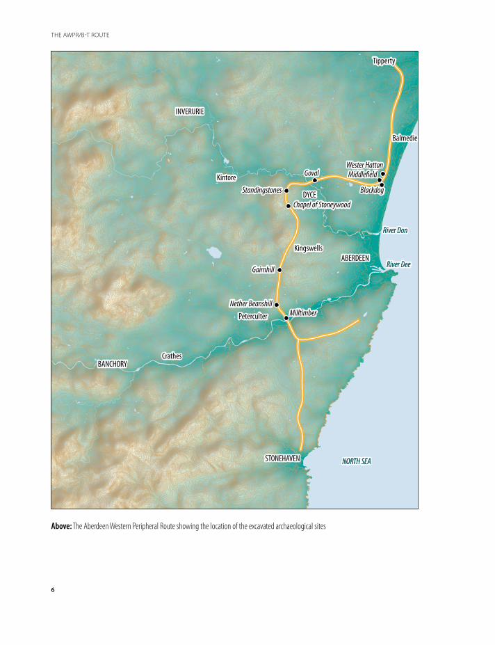
Above: The Aberdeen Western Peripheral Route showing the location of the excavated archaeological sites
6
THE AWPR/B-T ROUTE
Chapter 1
The AWPR/B-T Route
Plans for a bypass route for Aberdeen were first mooted in the 1950s, with several possible routes proposed, including an eastern route with a bridge over the harbour. By the 1960s these plans had come to nothing and the idea went quiet for decades. In the early years of the new millennium, Scottish Ministers announced new plans for a bypass, subsequently approved in late 2009. The aim was to improve travel in the Aberdeen area by constructing an entirely new road around the western periphery of the city.
The route loops around the city, breaking away from the A90 in the south, close to the bustling town of Stonehaven, running across the moors to the south of the River Dee, skirting to the west of the city’s suburbs at Kingswells and Dyce, before rejoining the A90 near the coast to the north of Aberdeen where there are wide open views out over the North Sea. Across the 58km scheme, a variety of different types of landscape, altitudes and communities were encountered.
7
THE AWPR/B-T ROUTE
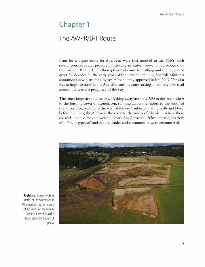
Right: Aerial view (looking north) of the excavations at
Milltimber, on the north bank of the River Dee. The current
line of the river lies to the south below the bottom of
photo
Archaeological sites were identified across five different types of landscape along the route:
1. On the banks of the River Dee. Excavations revealed an extensive, complex and rich archaeological landscape representing at least eleven separate phases of activity and potentially as many as 15,000 years of human interaction at this one location. The role the river played in shaping the valley, influencing the resources available and both restricting and enhancing the land available for people to live in and exploit was key to this archaeological resource.
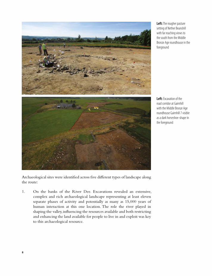
Left: The rougher pasture setting of Nether Beanshill with far reaching views to the south from the Middle Bronze Age roundhouse in the foreground
Left: Excavation of the road corridor at Gairnhill with the Middle Bronze Age roundhouse Gairnhill 7 visible as a dark horseshoe-shape in the foreground
8
2. The road line travelling north from the River Dee Crossing at Milltimber, beyond the river terraces into the areas of rougher pasture, before descending into the valley of the River Don. Three sites of archaeological activity were uncovered along this c10km stretch; at Nether Beanshill and Gairnhill in the south, and Chapel of Stoneywood in the north. Prehistoric remains from these sites included a single pit dated to the Neolithic, an Early Bronze Age burnt mound, a Middle Bronze Age cremation cemetery and nine middle to Late Bronze Age roundhouses.
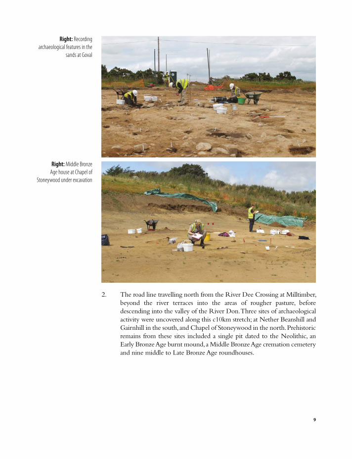
Right: Middle Bronze Age house at Chapel of
Stoneywood under excavation
Right: Recording archaeological features in the
sands at Goval
9
3. At Goval, along the section of the road between the north bank of the River Don and the A947 Dyce-Old Meldrum road. This section crosses the southern flank of the Hill of Goval, an area of undulating rough pasture and arable ground overlooked by Goval Farm. Prehistoric activity is represented by several isolated Middle-Later Neolithic pits, the remains of a Middle Bronze Age roundhouse, a second roundhouse and metalworking furnace dated to the Middle Iron Age, and a kiln of slightly later Middle Iron Age date.
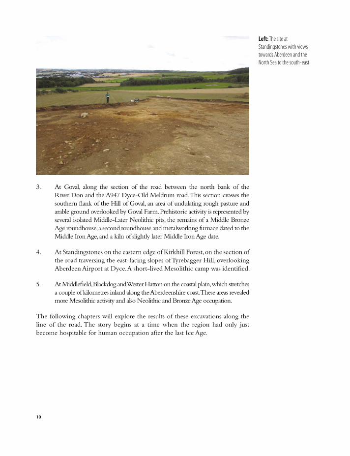
4. At Standingstones on the eastern edge of Kirkhill Forest, on the section of the road traversing the east-facing slopes of Tyrebagger Hill, overlooking Aberdeen Airport at Dyce. A short-lived Mesolithic camp was identified.
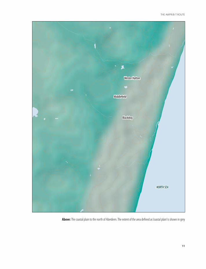
5. At Middlefield, Blackdog and Wester Hatton on the coastal plain, which stretches a couple of kilometres inland along the Aberdeenshire coast. These areas revealed more Mesolithic activity and also Neolithic and Bronze Age occupation.
The following chapters will explore the results of these excavations along the line of the road. The story begins at a time when the region had only just become hospitable for human occupation after the last Ice Age.
10
Left: The site at Standingstones with views towards Aberdeen and the North Sea to the south-east
Wester Hatton
Middle�eld
Blackdog
NORTH SEANORTH SEA
GR
EA
T B
RI T
AIN
C O N T I N E N TA L E
UR O
P E
Above: The coastal plain to the north of Aberdeen. The extent of the area defined as ‘coastal plain’ is shown in grey
11
THE AWPR/B-T ROUTE
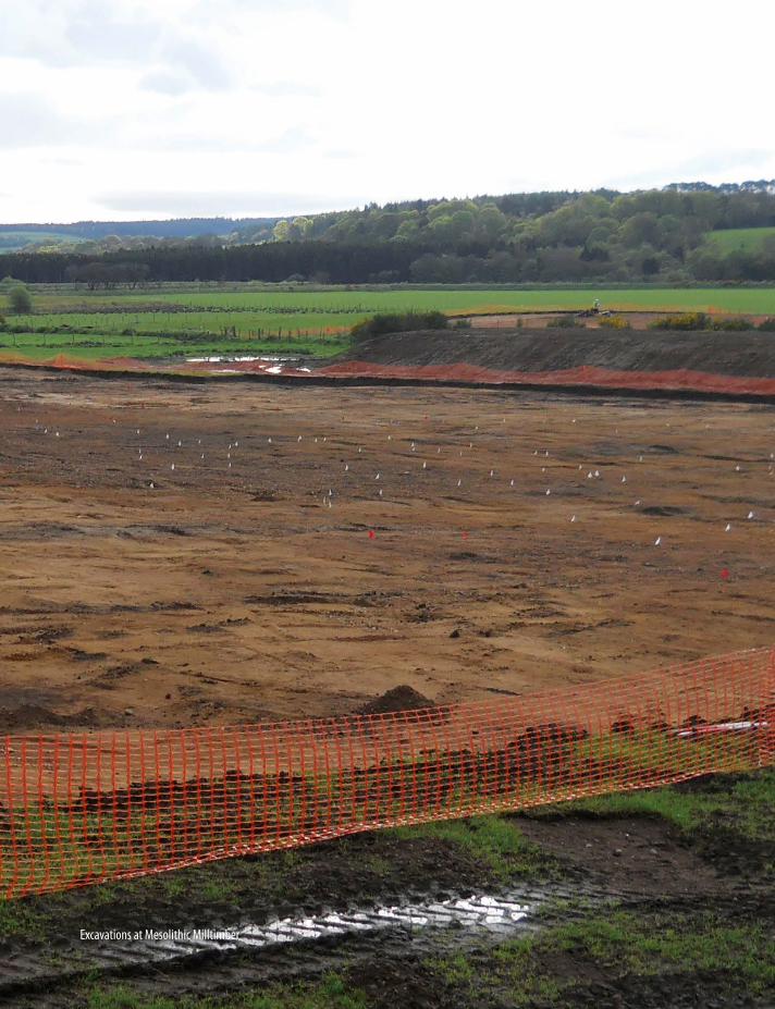
Excavations at Mesolithic Milltimber

Chapter 2
The end of the Ice Age and earliest evidence for human activity c13,000 bc – 4000 bc
When the caves of Lascaux in France were being painted, about 20,000 years ago, with dramatic images of horses, bison and other animals familiar to the artists, the ice sheets and glaciers of the last Ice Age were still slowly retreating over Scotland. These ice sheets had first started to cover the land and seas from around 2.85 million years ago during what is known as the Quaternary glaciation, and were up to 1km thick across the area now forming Aberdeenshire. As the ice sheets melted and the glaciers retreated, they scoured out mountain ranges and created distinctive valleys with rounded profiles. At the same time, the melting ice deposited glacial drift material comprising rock, gravel, sand and clay further downstream.
What we now know as Aberdeenshire was still physically linked to the rest of continental Europe, with the connecting landmass known as Doggerland, an area occupied by humans for hunting and gathering of resources. As the ice sheets melted and sea levels rose, this land gradually became inundated (Illus 9). By around 6500 bc, the land bridge between Britain and the continent had been lost.
With the thawing of the ice and the retreat of the glaciers, a new and warmer climate spread from the south, but the conditions did not change into a comfortable new climatic norm. The period from 14,000 to 6,000 years ago was marked by remarkable transformations in terms of the environment. The loss of Doggerland under rising sea levels, which also isolated the Shetland and Orkney island groups, would have had a significant impact on the lives of the mobile groups of hunter-gatherers in north-west Europe. The environment was a very challenging one for the earliest inhabitants of the region. As hunter-gatherers, they would have in-depth knowledge of the resources available in specific areas at certain times of year, based on the migratory routes of their prey, the seasonality of readily available fruit and forage supplies, and even the weather which would allow favourable conditions for activities in certain areas. Any major changes to environmental factors would heavily influence their understanding and appreciation of their world.
13
THE END OF THE ICE AGE AND EARLIEST EVIDENCE FOR HUMAN ACTIVITY C13,000 BC – 4000 BC

This comparatively recent and climatically variable landscape in Scotland is the one which the first humans would enter as early as 13,000 bc, as suggested by finds made on the west side of Scotland, discovered at Rubha Port an t-Seilich on the west coast of the island of Islay. This was a remarkable discovery made in 2013 on a site that first came to light when a herd of pigs rooting in the ground unearthed Mesolithic tools, dated between 10,500 and 5,800 years ago. The excavations that followed revealed further tools dating back three thousand
Wester Hatton
Balmedie
DO
GG
E R L A N D
I R E L A ND
GR
EA
T B
RI T
AIN
A T L A N T I C OC E A N
NORWEGIAN TRENCH
DOGGER BANK
(present)
ICE SHEET16,000 BC
ICE SHEET16,000 BC
C O N T I N E N TA L E
UR O
P E
NORTH SEA (present)
land areaabove sea level
16,000 BC
8,000 BC
7,000 BC
present
Above: The original extent of Doggerland. Gradually as the ice sheets melted and the sea rose, what was originally dry land became inundated
14
THE END OF THE ICE AGE AND EARLIEST EVIDENCE FOR HUMAN ACTIVITY C13,000 BC – 4000 BC
1000010000 60006000 41004100UPPER PALAEOLITHIC EARLY MESOLITHIC LATE MESOLITHIC
between 13,000 and 10,000 bc Milltimber lithic production
c8000 – 7000 bc Milltimber and Blackdog
hunting pits
years before the Mesolithic. Scrapers used for cleaning animal skins and points for hunting had very close similarities with finds from the Ahrensburgian culture, named after material found in north-west Germany, which dated from the end of the last Ice Age. Similar material has also been found in Sweden and Denmark, which might be evidence of the extent to which they moved around the North Sea basin which would still have been largely dry land at this time.
On the eastern side of the country, the earliest humans in the region left very little evidence made up of just a few flint scatters, in places such as the haughs of the Rivers Dee and Ythan and also on the coastal sands of Forvie and Corbin. These are the remains of toolkits for the manufacture of bone fish-spears and other hunting tools and equipment. Earliest humans, then, are present but quite elusive in north-east Scotland.
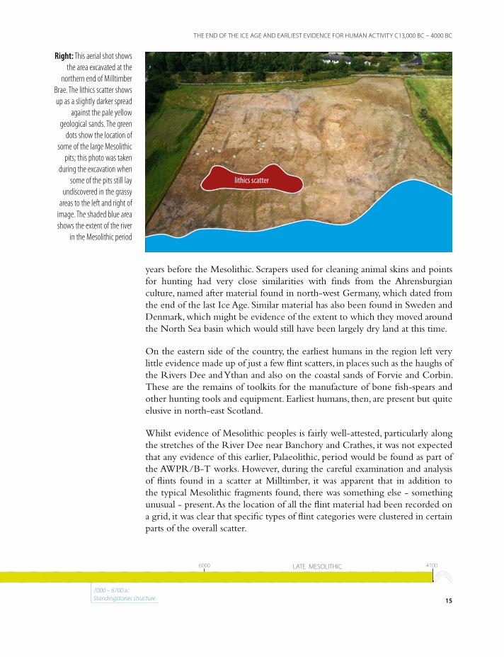
Whilst evidence of Mesolithic peoples is fairly well-attested, particularly along the stretches of the River Dee near Banchory and Crathes, it was not expected that any evidence of this earlier, Palaeolithic, period would be found as part of the AWPR/B-T works. However, during the careful examination and analysis of flints found in a scatter at Milltimber, it was apparent that in addition to the typical Mesolithic fragments found, there was something else - something unusual - present. As the location of all the flint material had been recorded on a grid, it was clear that specific types of flint categories were clustered in certain parts of the overall scatter.
lithics scatter
Right: This aerial shot shows the area excavated at the
northern end of Milltimber Brae. The lithics scatter shows up as a slightly darker spread
against the pale yellow geological sands. The green
dots show the location of some of the large Mesolithic
pits; this photo was taken during the excavation when
some of the pits still lay undiscovered in the grassy
areas to the left and right of image. The shaded blue area shows the extent of the river
in the Mesolithic period
15
THE END OF THE ICE AGE AND EARLIEST EVIDENCE FOR HUMAN ACTIVITY C13,000 BC – 4000 BC
1000010000 60006000 41004100UPPER PALAEOLITHIC EARLY MESOLITHIC LATE MESOLITHIC
7000 – 6700 bc Standingstones structure
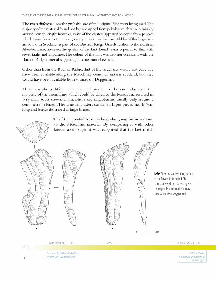
The main difference was the probable size of the original flint cores being used. The majority of the material found had been knapped from pebbles which were originally around 6cm in length; however, some of the clusters appeared to come from pebbles which were closer to 15cm long, nearly three times the size. Pebbles of this larger size are found in Scotland, as part of the Buchan Ridge Gravels further to the north in Aberdeenshire; however, the quality of the flint found seems superior to this, with fewer faults and impurities. The colour of the flint was also not consistent with the Buchan Ridge material, suggesting it came from elsewhere.
Other than from the Buchan Ridge, flint of the larger size would not generally have been available along the Mesolithic coasts of eastern Scotland, but they would have been available from sources on Doggerland.
There was also a difference in the end product of the same clusters – the majority of the assemblage which could be dated to the Mesolithic resulted in very small tools known as microliths and microburins, usually only around a centimetre in length. The unusual clusters contained larger pieces, nearly 9cm long and better described as large blades.
All of this pointed to something else going on in addition to the Mesolithic material. By comparing it with other known assemblages, it was recognised that the best match
2cm2cm00
Left: Pieces of worked flint, dating to the Palaeolithic period. The comparatively large size suggests the original source material may have come from Doggerland
16
THE END OF THE ICE AGE AND EARLIEST EVIDENCE FOR HUMAN ACTIVITY C13,000 BC – 4000 BC
1000010000 60006000 41004100UPPER PALAEOLITHIC EARLY MESOLITHIC LATE MESOLITHIC
between 13,000 and 10,000 bc Milltimber lithic production
c8000 – 7000 bc Milltimber and Blackdog
hunting pits
was from Upper Palaeolithic industries (ie from 13,000 bc to 10,000 bc) on the north-west European mainland, such as has been found around Ahrensburg and Hamburg in north-west Germany. The similarities with this material allow us to suggest that the people who made the tools and left the waste at Milltimber were members of a nomadic society, used to crossing the expanses of Doggerland and the eastern coast of what is now Britain, and ranging up into the north-east of Scotland while following herds for hunting and finding other resources.
This is an important discovery that helps push back the length of time that humans have been present in the area now known as Aberdeenshire by almost three thousand years.
Although the Milltimber flint scatter contained a small but significant proportion of Upper Palaeolithic material, most of the flint dated to the Mesolithic, the period immediately following the Upper Palaeolithic and which spans around four thousand years from 8000 bc to 4000 bc.
The Mesolithic was a time of considerable change in the landscape of northern Britain. From 10,000 bc onwards, rising sea levels from melting ice sheets began to inundate Doggerland, making any crossing by land impossible and any crossing by boat extremely challenging. Although still living a hunter-gatherer lifestyle, ranging over wide areas to follow hunting trails, collect specific foods (such as berries, tubers and nuts) and locate other resources such as flint pebbles, the extent they travelled may have been much smaller than in previous millennia.
There were also more immediate, sometimes catastrophic, events which befell Mesolithic societies. A tsunami occurred around 6150 bc, associated with massive underwater landslides off the north-west coast of Norway known as the Storegga Slides. The tsunami would have devastated coastal populations on the eastern seaboard, comprising north-east England and east Scotland today. Evidence of this has been found in the form of tsunami deposits discovered at heights of 20m above sea level in many places. To make matters worse, this event occurred during a major cooling episode that happened just over 8,000 years ago. Combined with the ongoing sea level rise, the landscape of north-east Scotland would have been continually changing over the 4,000 years which we define as the Mesolithic.
Changes in tool technology and manufacture are the key indicators that differentiate the Upper Palaeolithic from the Mesolithic, but precisely how this relates to the movement of people is unclear. The earliest Mesolithic technologies, known as Broad Blade industry, define what is happening in England at this time but in Scotland the picture is more complex with both chronological and regional divides. Later Narrow Blade technologies date from the middle of the
17
THE END OF THE ICE AGE AND EARLIEST EVIDENCE FOR HUMAN ACTIVITY C13,000 BC – 4000 BC
1000010000 60006000 41004100UPPER PALAEOLITHIC EARLY MESOLITHIC LATE MESOLITHIC
7000 – 6700 bc Standingstones structure
18
THE ANATOMY OF A PIT
The anatomy of a pit
Any pit which has been dug into the ground can reveal a great deal of information to the archaeologist. Not
only will the size and shape of the feature suggest how it might have been used, but the deposits which are found within it also give valuable insight into its function.
The very act of digging a pit begs the question ‘why?’ There are many reasons why holes might be dug in the ground; for example, to bury or dispose of something. In this case, the thing being disposed of could be routine rubbish – the debris of everyday life – or it could be something more special, such as a body or the remains of a cremation. These would be described as rubbish pits or as graves or cremation burials, depending on what was found in them. A pit might be dug to extract material – the sands, gravels, clay and flint nodules in the ground. In these cases, we
would call the feature a quarry pit and think of it as the by-product of the quarrying activity. Pits are also dug to hold things for storage. Medieval towns sometimes have pits that are lined with barrels and sealed with clay to make them watertight. These could then be used to store fresh water or keep fish alive until the time came to eat them. Finally, some pits are dug with the intention of being left open, but not for storage; other processes or actions are intended. The Mesolithic hunting traps at Milltimber would be an example of this; other examples could include cooking pits, tanning and brewing pits or pits which were intended to demarcate an area or location.
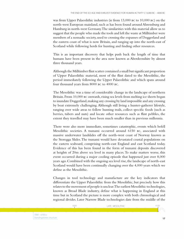
In each of these cases, the way the pit has filled up can be very informative. Frequently, regardless of the final function, loose material will collect at the bottom very quickly, forming a thin layer at the base. If the
Left: The layered sequence of deposits in this pit indicates that it had filled up over time, with sand and silt washing or blowing in gradually
19
THE ANATOMY OF A PIT
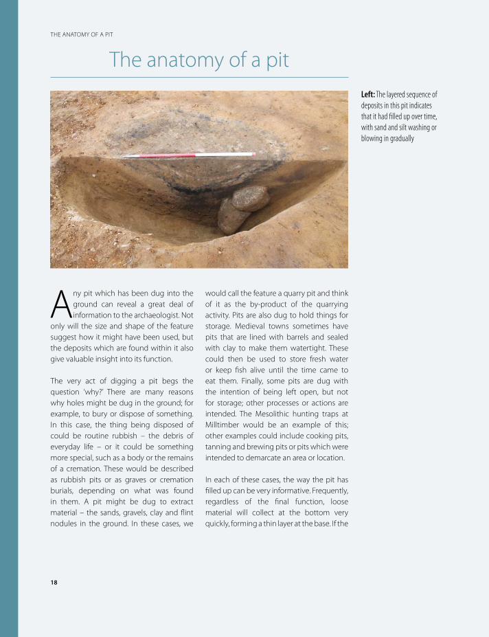
pit is being used to dispose of something, the deposits will have been thrown back in very rapidly and will be very mixed up; however, if the pit has been left open and filled up over time, a series of dished layers will form, either from material eroding from the surrounding geology, or washing/blowing in from above. The amount of food waste, fire debris, plant remains and other organic material in the fills will make each individual layer more or less brown and ‘soily’, which also help the archaeologist to understand the origin of the material.
Material such as charcoal, burnt seeds and artefacts found within the pits can help to
date them, but understanding the origin of the layer is important in confirming how ‘secure’ the dating might be. Small pieces of charcoal or seeds from the surrounding area may have washed in to the fill at a much later date, or artefacts from an earlier period may have become incorporated into deposits which were used to fill in a hole. Even burrowing by animals such as rabbits or worms can mean that material from elsewhere is transported into a pit. The archaeologist has to question the origin of each category of material found in a pit before they decide whether the material can be considered secure and is worth dating.
Right: The deposits in this pit are much more mixed up
and patchy; this tells us it was filled in rapidly and likely
deliberately backfilled
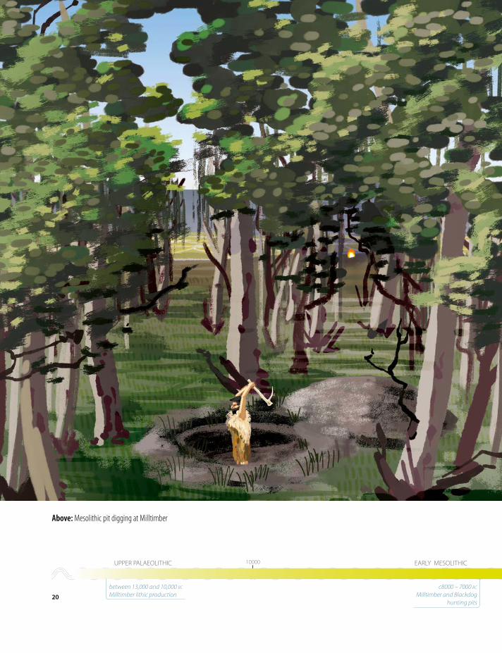
Above: Mesolithic pit digging at Milltimber
20
THE END OF THE ICE AGE AND EARLIEST EVIDENCE FOR HUMAN ACTIVITY C13,000 BC – 4000 BC
1000010000 60006000 41004100UPPER PALAEOLITHIC EARLY MESOLITHIC LATE MESOLITHIC
between 13,000 and 10,000 bc Milltimber lithic production
c8000 – 7000 bc Milltimber and Blackdog
hunting pits
ninth millennium bc in Scotland, several thousand years before they emerge further to the south.
Much of the evidence for the Mesolithic in Scotland comes from coastal and riverine sites. No doubt those communities were able to find a rich resource to survive and they likely used boats to move up and down the coast, although no direct evidence has yet been found. It is interesting that the limited evidence so far of Mesolithic groups further inland is closely tied to the line of the Dee and its tributaries, emphasizing the importance of the river as one of the major routes for movement.
An important feature of this period, in Scotland in particular, is the growing body of evidence for the remains of structures. In the last decade or so, a small but notable number of sites has been identified along the eastern coastline, in East Lothian, along the Forth, into Fife and even down as far as Northumberland. These all comprise small structures, almost tent-like in nature. There have been some indications from Northumberland that the site there may have been semi-permanent and relatively long-lived; however, the majority of these sites are best viewed as temporary camps.
The fragmentary remains of a building at Standingstones is likely to be one of these temporary shelters. Its location, fairly far up on the slopes overlooking Dyce, is relatively unusual as these have more commonly been found in coastal situations. A compelling reason for its location could be to do with the specifics of the resources that groups were trying to exploit – perhaps particularly fertile hunting grounds, or even just close to an area with ripe nuts or berries at the time of year it was used. Either way, a handful of people stopped here, erected a small shelter, had a fire and certainly undertook some ‘running repairs’ to their flint tools and weapons while they were there.
The Milltimber Mesolithic pitsAlthough Mesolithic structures have been found in Scotland, they remain rare. Far more typical are scattered pits in the ground, often difficult to recognize and containing very few or no artefacts. These kinds of features can only be dated through scientific methods such as radiocarbon dating, and this was the case at Milltimber. Twenty-four large pits were found, all showing very strong similarities in terms of their size, use, infill and abandonment. Although we would categorise them all as Mesolithic in date from the radiocarbon results, their dates of digging and use seem to spread over four millennia, from around 8200 bc to 4500 bc, as distant in time from one to another as we are today from the Bronze Age. Understanding why these were dug so similar in form and presumably for the same reason over such a long period of time is a challenge.
21
THE END OF THE ICE AGE AND EARLIEST EVIDENCE FOR HUMAN ACTIVITY C13,000 BC – 4000 BC
1000010000 60006000 41004100UPPER PALAEOLITHIC EARLY MESOLITHIC LATE MESOLITHIC
7000 – 6700 bc Standingstones structure
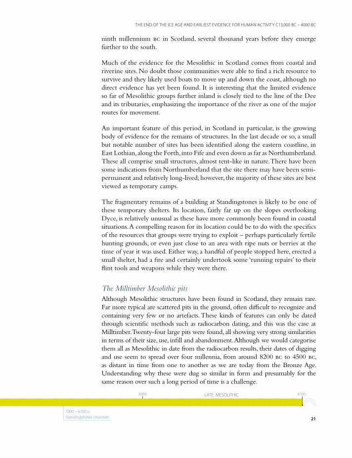
The pits were all about 2m deep and equally large across; they would have taken even a couple of people many hours to dig. The tools available to Mesolithic people were not the most sophisticated – effectively they just modified elk or deer antlers (either found discarded in the forest or from animals they had hunted) into makeshift pickaxes. Although no direct evidence of these tools was found on this project they are well known from other parts of Scotland. The pick would be used to loosen the sand and gravel material which makes up the geology in this area, and then baskets or other organic containers used to lift the debris up to the edge of the pit. Antler picks are relatively effective for digging, but it would still be a slow process, not lightly undertaken.
It doesn’t appear that the pits were then deliberately backfilled – we can tell this as the geological material from the sides and above has eroded back into the open hole and filled it in, rather than them being filled with large amounts of dumped material. The infill of the pits was almost identical to the surrounding geology and could only be distinguished as a slightly wetter and darker halo in the ground. From this we can infer that the original use of the pits involved them being open – the hole in the ground was the point, rather than burying or containing something. It was only when they were abandoned that the edges started to collapse and fill up.
Charcoal layer (black) representingreuse in the Early Neolithic
Layers of consolidation followingpit abandonment
Layers of sand and gravel
Left: A section dug through one of the Milltimber pits shows how they had largely filled up as a result of slumping of the geological gravels which they were cut into. This also shows how large they were – the vertical red and white scale is 2m long, the height of a tall human
22
THE END OF THE ICE AGE AND EARLIEST EVIDENCE FOR HUMAN ACTIVITY C13,000 BC – 4000 BC
1000010000 60006000 41004100UPPER PALAEOLITHIC EARLY MESOLITHIC LATE MESOLITHIC
between 13,000 and 10,000 bc Milltimber lithic production
c8000 – 7000 bc Milltimber and Blackdog
hunting pits

Another strand of evidence (or lack of it) which helps our understanding is that very few artefacts or ecofacts (environmental remains) were found within the pits. Although we can’t be conclusive, this suggests that the groups weren’t using the pits to store things in; we would expect some remnants of this to survive if they were.
The key distinguishing factors of the pits appear to be their size and location. They are nearly as deep as a person and would be a struggle to get in and out of. Although some of the pits have a ledge on one side which might help with this, they don’t seem to have been routinely used in this fashion.
Although the pits at Milltimber currently lie around 800m from the edge of the river, 10,000 years ago the river covered a much wider area – it was a series of shallow, braided channels that would have covered most of what is now the flat valley floor along the Dee. The pits would have been a handful of metres from the edge of these river channels, although probably within the forest which covered the valley slopes.
The most likely possibility for the pits is that they were deliberately placed along game trails on the edge of the forest – well-worn animal routes, for aurochs, red and roe deer, brown bears, wolves, elks and wild boar leading to the river’s edge. The pits would be disguised or covered in some way, and the animals would either accidentally fall into the traps or might even have been deliberately driven into them during a hunt.
step
Right: A flatter section at the edge of some of the pits
just above waist height might have acted as a step to assist
in getting out of the hole
23
THE END OF THE ICE AGE AND EARLIEST EVIDENCE FOR HUMAN ACTIVITY C13,000 BC – 4000 BC
1000010000 60006000 41004100UPPER PALAEOLITHIC EARLY MESOLITHIC LATE MESOLITHIC
7000 – 6700 bc Standingstones structure

Hunting-traps for large animals of early prehistoric date are known from Scandinavia, and in particular, there is evidence of them being used in groups to funnel animals towards the traps. Five hunting traps from Almemoen to the north-west of Oslo date from 6500 bc – 5500 bc, the dating coming from charcoal deposits at the base of the pits. They were used in combination with rough fences which channeled the animals into the area of the pits.
Three further similar pits were also found on the AWPR/B-T scheme some 17km to the north-east at Blackdog. These were also located along a noticeable slope and contained similar deposits. There was no obvious, immediately local water source but a similar function is possible. There are also a number of other sites in Aberdeenshire where pits with a similar appearance have been found, and these have been interpreted in a range of ways, from pits for dumping rubbish in to celestial calendars. In truth, these features are not well understood and more examples will need to be found to fully appreciate their function.
The Milltimber Mesolithic flint scatterThe site at Milltimber also produced a scatter of flint material, fragments of flint that had been left behind after the manufacture of tools, as well as some tools themselves. To the archaeologist, this kind of material is good evidence of humans settling – albeit for a short period of time – in an area and working there, preparing their tools for all manner of activities required for everyday living.
Left: One of the pits from Blackdog prior to excavation, showing how they stand out as a dark circle against the orange sand
24
THE END OF THE ICE AGE AND EARLIEST EVIDENCE FOR HUMAN ACTIVITY C13,000 BC – 4000 BC
1000010000 60006000 41004100UPPER PALAEOLITHIC EARLY MESOLITHIC LATE MESOLITHIC
between 13,000 and 10,000 bc Milltimber lithic production
c8000 – 7000 bc Milltimber and Blackdog
hunting pits
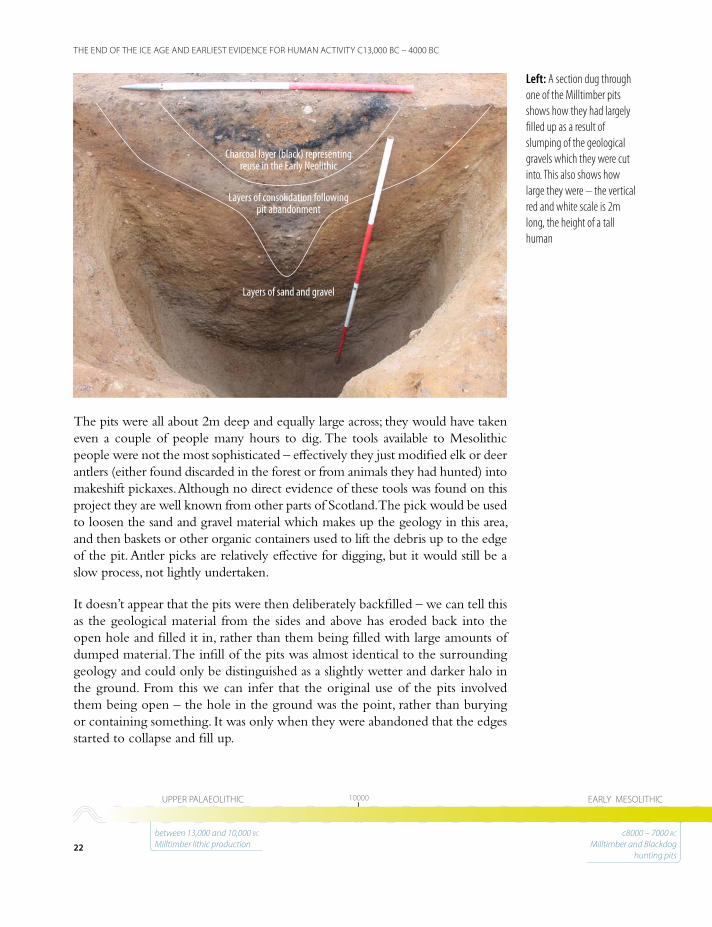
Much of the flint material is evidence of short-term, Late Mesolithic activities or visits during which the focus was on the production of microblades and microliths, probably to replace lost and damaged microlith inserts in composite hunting tools and weaponry, supplemented by small numbers of other possibly subsistence-related implements (mainly scrapers and truncated pieces/knives). There were six concentrations of flints within the overall scatter and the distribution patterns, as well as the almost complete absence of structural evidence, suggest that these may represent individual hunter-gatherer open-air sites, rather than visits involving sophisticated structures or light shelters such as at Standingstones. It is possible that the difference between the numbers of artefacts recovered from each concentration, as well as the density of the burnt flint, indicates visits to the area of varying duration, or that the concentrations may represent the remains left by different sets of activities.
2cm2cm00
microliths
microburins
cores
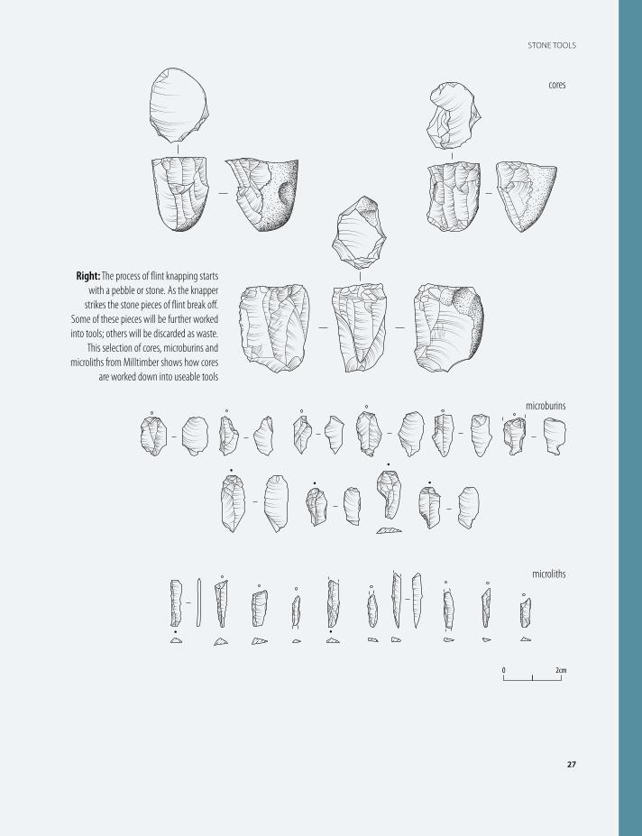
Right: These drawings of a selection of the lithics
recovered during the excavations show how small the Mesolithic material is in
comparison to that of the Palaeolithic
25
THE END OF THE ICE AGE AND EARLIEST EVIDENCE FOR HUMAN ACTIVITY C13,000 BC – 4000 BC
1000010000 60006000 41004100UPPER PALAEOLITHIC EARLY MESOLITHIC LATE MESOLITHIC
7000 – 6700 bc Standingstones structure
26
STONE TOOLS
Stone tools
In the early prehistoric period, stone was one of the most valuable and useful materials. It was an absolutely essential
part of life before metal became routinely used and it gives its name to the old, middle and new Stone Age periods that archaeologists refer to as the Palaeolithic, Mesolithic and Neolithic. Stone could be used to make almost any tool imaginable, not just arrows and axes, and over the years techniques were developed which led to many creative inventions.
Tools were created by chipping away parts of a stone until the desired shape was created. Archaeologists call this type of
manufacture ‘knapping’. Particular types of stone are better to knap than others due to their flaking properties; flint or flint-like stone knaps best but other materials such as quartz might also be used.
Tools would be created by a very specific set of steps. The process began with stones collected from gravel outcrops, beaches and river beds – although by the Neolithic they were deliberately quarrying stone. The knapper would strike the stone, breaking pieces off and exposing the flint material within, giving them a ‘core’; a piece of flint ready to be further worked into a particular type of tool. Further strikes to the edge of
Left: Stone tools are often so small that they are not easily recognised by eye. Archaeologists use techniques such as sieving deposits from a site to ensure that all of this small material is collected and retained for further analysis
27
STONE TOOLS
2cm2cm00
microliths
microburins
cores
Right: The process of flint knapping starts with a pebble or stone. As the knapper
strikes the stone pieces of flint break off. Some of these pieces will be further worked into tools; others will be discarded as waste.
This selection of cores, microburins and microliths from Milltimber shows how cores
are worked down into useable tools

28
STONE TOOLS
the core would result in smaller pieces of flint breaking off, some of which would be further refined and turned into tools, and others would be thrown away as waste.
For archaeologists it is important to collect all the lithic material found at an archaeological site, not just the finished tools, as having all the parts shows us how the tools were made. Understanding the process by which they were created can tell us far more about the society than just the final product. For example, comparing the shape of pieces of flint and piecing them back together into the original core can show details such as the period they date from, whether the knapper was left- or right-handed, how experienced they were, and whether they were undertaking the work routinely or not.
Examining the tools created can reveal to archaeologists what period they belong to, such as the Palaeolithic, Mesolithic or Neolithic. Just as we have changes in technology today, there were changes in stone technology throughout the Stone Age. The tools also reveal what kind of activities were being carried out. The main uses for stone tools were for scraping, cutting, chopping and sawing, as well as for making projectiles. It is important to remember that during the Palaeolithic and Mesolithic many of these tools would have been used together and hafted onto handles and shafts. These elements rarely survive in Britain, although occasionally residue or marks can be seen on the flint where hafting was present.
0 5cm
Left: A typical selection of cores arranged around a hammerstone, which would have been used to flake pieces of flint from the cores
29
STONE TOOLS
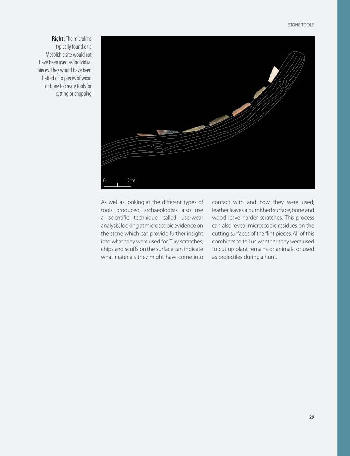
As well as looking at the different types of tools produced, archaeologists also use a scientific technique called ‘use-wear analysis’, looking at microscopic evidence on the stone which can provide further insight into what they were used for. Tiny scratches, chips and scuffs on the surface can indicate what materials they might have come into
contact with and how they were used; leather leaves a burnished surface, bone and wood leave harder scratches. This process can also reveal microscopic residues on the cutting surfaces of the flint pieces. All of this combines to tell us whether they were used to cut up plant remains or animals, or used as projectiles during a hunt.
0 2cm
Right: The microliths typically found on a
Mesolithic site would not have been used as individual
pieces. They would have been hafted onto pieces of wood
or bone to create tools for cutting or chopping
It is likely that the Mesolithic inhabitants at the Milltimber site were exploiting the natural resources in the area - the woodland, the fauna and the river itself. The long period of time over which these activities took place suggests that Milltimber was a location that people preferred and came back to.
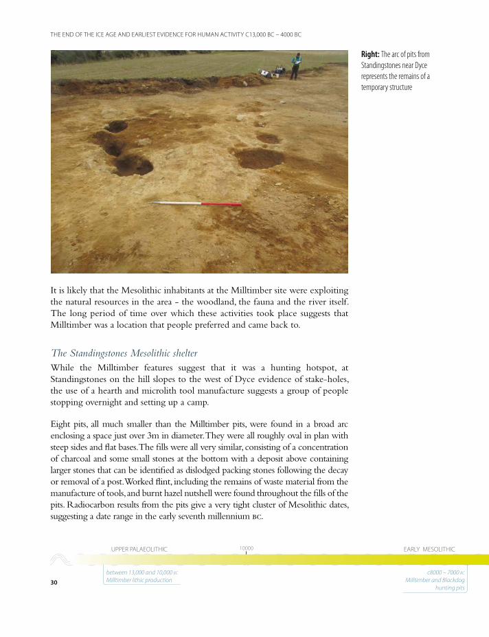
The Standingstones Mesolithic shelterWhile the Milltimber features suggest that it was a hunting hotspot, at Standingstones on the hill slopes to the west of Dyce evidence of stake-holes, the use of a hearth and microlith tool manufacture suggests a group of people stopping overnight and setting up a camp.
Eight pits, all much smaller than the Milltimber pits, were found in a broad arc enclosing a space just over 3m in diameter. They were all roughly oval in plan with steep sides and flat bases. The fills were all very similar, consisting of a concentration of charcoal and some small stones at the bottom with a deposit above containing larger stones that can be identified as dislodged packing stones following the decay or removal of a post. Worked flint, including the remains of waste material from the manufacture of tools, and burnt hazel nutshell were found throughout the fills of the pits. Radiocarbon results from the pits give a very tight cluster of Mesolithic dates, suggesting a date range in the early seventh millennium bc.
Right: The arc of pits from Standingstones near Dyce represents the remains of a temporary structure
30
THE END OF THE ICE AGE AND EARLIEST EVIDENCE FOR HUMAN ACTIVITY C13,000 BC – 4000 BC
1000010000 60006000 41004100UPPER PALAEOLITHIC EARLY MESOLITHIC LATE MESOLITHIC
between 13,000 and 10,000 bc Milltimber lithic production
c8000 – 7000 bc Milltimber and Blackdog
hunting pits
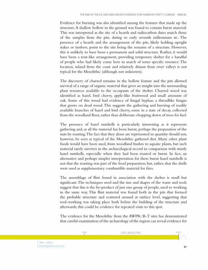
Evidence for burning was also identified among the features that made up the structure. A shallow hollow in the ground was found to contain burnt material. This was interpreted as the site of a hearth and radiocarbon dates match those of the samples from the pits, dating to early seventh millennium bc. The presence of a hearth and the arrangement of the pits, likely holding upright stakes or timbers, point to the site being the remains of a structure. However, this is unlikely to have been a permanent and solid structure. Rather, it would have been a tent-like arrangement, providing temporary shelter for a handful of people who had likely come here in search of some specific resource. The location, inland from the coast and relatively distant from river valleys is not typical for the Mesolithic (although not unknown).
The discovery of charred remains in the hollow feature and the pits allowed survival of a range of organic material that gives an insight into the surrounding plant resources available to the occupants of the shelter. Charred wood was identified as hazel, bird cherry, apple-like fruitwood and small amounts of oak. Some of this wood had evidence of fungal hyphae, a threadlike fungus that grows on dead wood. This suggests the gathering and burning of readily available branches of hazel and bird cherry, some in a state of decay, collected from the woodland floor, rather than deliberate chopping down of trees for fuel.
The presence of hazel nutshells is particularly interesting as it represents gathering and, as all the material has been burnt, perhaps the preparation of the nuts by roasting. The fact that they alone are represented in quantity should not, however, be seen as typical of the Mesolithic gathered diet. Many other plant foods would have been used, from woodland bushes to aquatic plants, but such material rarely survives in the archaeological record in comparison with sturdy hazel nutshells, especially when they had been roasted or burnt. In fact, an alternative and perhaps simpler interpretation for these burnt hazel nutshells is not that the roasting was part of the food preparation; but, rather, that the shells were used as supplementary combustible material for fires.
The assemblage of flint found in association with the shelter is small but significant. The techniques used and the size and shapes of the waste and tools suggest that this is the by-product of just one group of people, used to working in the same way. This flint material was found both in the pits that formed the probable structure and scattered around at surface level, suggesting that tool-working was taking place both before the building of the structure and afterwards; this could be evidence for repeated visits to this spot.
The evidence for the Mesolithic from the AWPR/B-T sites has demonstrated that careful examination of the archaeology of the region can reveal evidence for
31
THE END OF THE ICE AGE AND EARLIEST EVIDENCE FOR HUMAN ACTIVITY C13,000 BC – 4000 BC
1000010000 60006000 41004100UPPER PALAEOLITHIC EARLY MESOLITHIC LATE MESOLITHIC
7000 – 6700 bc Standingstones structure

Above: Making camp at Standingstones: Mesolithic knapping, pit digging and fire kindling
32
THE END OF THE ICE AGE AND EARLIEST EVIDENCE FOR HUMAN ACTIVITY C13,000 BC – 4000 BC
1000010000 60006000 41004100UPPER PALAEOLITHIC EARLY MESOLITHIC LATE MESOLITHIC
between 13,000 and 10,000 bc Milltimber lithic production
c8000 – 7000 bc Milltimber and Blackdog
hunting pits
its earliest human occupants. The Mesolithic, often surviving as just the slightest of features and small assemblages of flint, is much more evident than might be assumed; it is also more complex than might be expected. These hunter-gatherers were intimately connected to their landscape and would have had a thorough understanding of its potential; where animals were and when, where the best plants and fruits grew and when, and even when certain locations were more or less pleasant in specific weather conditions. With such awareness of the larger aspects of the landscape, we can also assume that they would have been aware of the more comfortable parts of the overall terrain, even those free of bugs and biting insects, for example.
The people who inhabited our region were not stumbling erratically around the local hills and valleys. They had a keen awareness of their environment and made use of it for their own survival, adapting raw materials to make the tools to improve their chances of survival. They also appear to have created features in the ground to aid their efforts to catch their prey. They were organised and knew what they needed to do to survive.
In addition, the careful study of the Mesolithic data has demonstrated at Milltimber that earlier material can be hidden among it. The late Upper Palaeolithic settlers at Milltimber appear to have focused on the production of large blades from ‘opposed-platform cores’, and some tools and tool fragments suggest that these blanks may have been intended for points, which may have formed tips and/or edges for hunting tools made up of a number of flint elements held in place on wooden shafts or handles. In general, the Mesolithic concentrations are dominated by waste from the production of smaller tools, microblades and microliths/microburins. Most of the non-microlithic implements may be Palaeolithic.
The presence of Palaeolithic material is extremely important, adding to the small but significant body of evidence demonstrating that early man’s exploitation of the landscape in this part of eastern Scotland began some three thousand years earlier than previously known.
33
THE END OF THE ICE AGE AND EARLIEST EVIDENCE FOR HUMAN ACTIVITY C13,000 BC – 4000 BC
1000010000 60006000 41004100UPPER PALAEOLITHIC EARLY MESOLITHIC LATE MESOLITHIC
7000 – 6700 bc Standingstones structure

Neolithic pit from Goval
Chapter 3
Managing resources and building homes in the Neolithic 4000 bc – 2500 bc
The key difference between the Mesolithic and the Neolithic is the gradual change from nomadic hunter-gathering groups to sedentary, agricultural communities. It is a key development in changing societies as, over time, the dependence of hunter-gatherers on the resources of the environment in which they lived gradually diminished, as they increasingly managed their surroundings into landscapes which suited their own needs.
In Scotland, there is no abrupt end to the Mesolithic and no rapid transition. Rather, it has happened gradually over generations, perhaps over several hundred years. The current preferred theory is that the changes began with just a few farmers who would have had very little impact upon the landscape as a whole. In time, farming gained in favour and there was a degree of competition for available agricultural land and creation of new space, leading to chopping trees down for land clearance. This required an important piece of equipment – the axe. Scotland was still extensively covered in forest at the beginning of the Neolithic, although considerable inroads had been made into clearing large areas and removing portions of forest.
Evidence for the Neolithic was found on a number of sites along the AWPR/B-T route, adding significantly to our knowledge about this important period. At Blackdog and Milltimber, pits were dug in the same places as the Mesolithic pits; at Milltimber, there is a structure and three alignments of post-holes and hearths which have been broadly radiocarbon-dated to the period c4000 bc - 3700 bc; and at Goval and Wester Hatton there are pits, evidently for rubbish disposal, dating from the middle of the Neolithic period to the end.
At Blackdog, three of the large Mesolithic pits were either reopened, or more likely new pits dug in the hollows left by the partially backfilled earlier features. Of particular interest is the presence in one of the Neolithic pits of a near- complete carinated bowl. Was it thrown in as part of a ritual act or was it simply rubbish? It appears to have been placed in the ground with some care, unlike broken bowls which have tossed away.
35
MANAGING RESOURCES AND BUILDING HOMES IN THE NEOLITHIC 4000 BC – 2500 BC
36
THE BROKEN POT
The broken pot
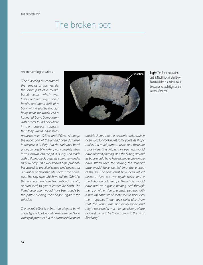
An archaeologist writes:
“The Blackdog pit contained the remains of two vessels; the lower part of a round-based vessel, which was laminated with very ancient breaks, and about 60% of a bowl with a slightly angular body, what we would call a ‘carinated’ bowl. Comparison with others found elsewhere in the north-east suggests that they would have been made between 3950 bc and 3700 bc. Although the upper part of the pit had been disturbed in the past, it is likely that the carinated bowl, although possibly broken, was complete when it was thrown into the pit. It is very well made with a flaring neck, a gentle carination and a shallow belly. It is a well-known type, probably because of its practical shape, and appears at a number of Neolithic sites across the north-east. The clay type, which we call the ‘fabric’, is thin and hard and has been rubbed smooth, or burnished, to give a leather-like finish. The fluted decoration would have been made by the potter pushing their fingers against the soft clay.
The overall effect is a fine, thin, elegant bowl. These types of pot would have been used for a variety of purposes but the burnt residue on its
outside shows that this example had certainly been used for cooking at some point. Its shape makes it a multi-purpose vessel and there are some interesting details: the open neck would have allowed pouring, and the fluting around its body would have helped keep a grip on the bowl. When used for cooking the rounded base would have nestled into the embers of the fire. The bowl must have been valued because there are two repair holes, and a third abandoned attempt. These holes would have had an organic binding tied through them, on either side of a crack, perhaps with a natural adhesive of some sort to help keep them together. These repair holes also show that the vessel was not newly-made and might have had a much longer history of use before it came to be thrown away in the pit at Blackdog.”
carination Right: The fluted decoration on this Neolithic carinated bowl from Blackdog is subtle but can be seen as vertical ridges on the interior of the pot
Excavations at Milltimber

0 2cm
0 1cm
Left: Leaf-shaped arrowheads of early to middle Neolithic date were found at both Milltimber and Wester Hatton. The one from Western Hatton (on the right) has snapped in half
Left: The early Neolithic pottery from Milltimber is very fragmentary. Although it was found in the same types of deposit as the carinated bowl from Blackdog, this pottery appears to be rubbish that has been thrown away rather than deliberately deposited
38
MANAGING RESOURCES AND BUILDING HOMES IN THE NEOLITHIC 4000 BC – 2500 BC
41004100 35003500 30003000 24502450EARLY NEOLITHIC MIDDLE NEOLITHIC LATE NEOLITHIC
3900 – 3700 bc Milltimber structure, reuse of hunting pits, Milltimber drying racks and Milltimber hearths
3500 – 3350 bc Goval pits
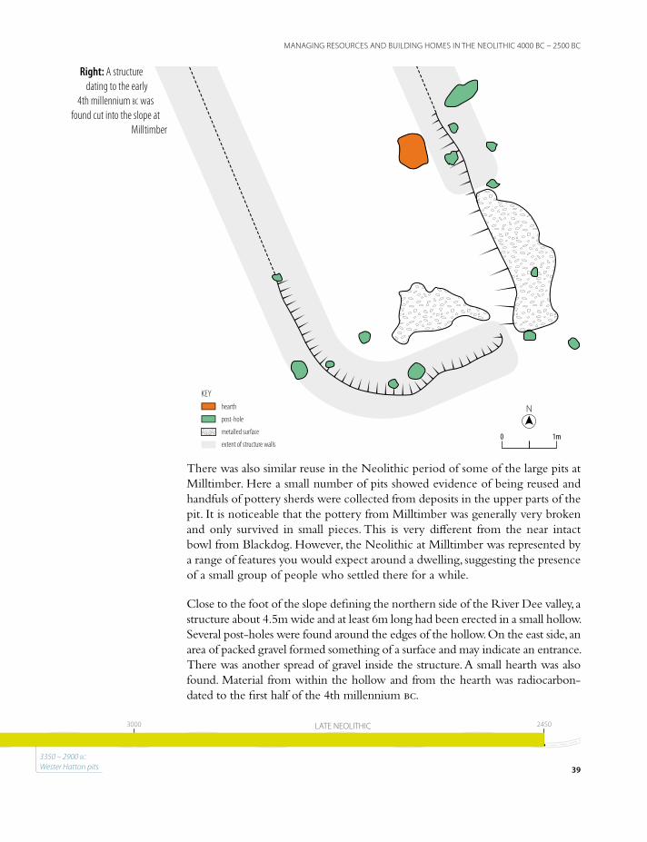
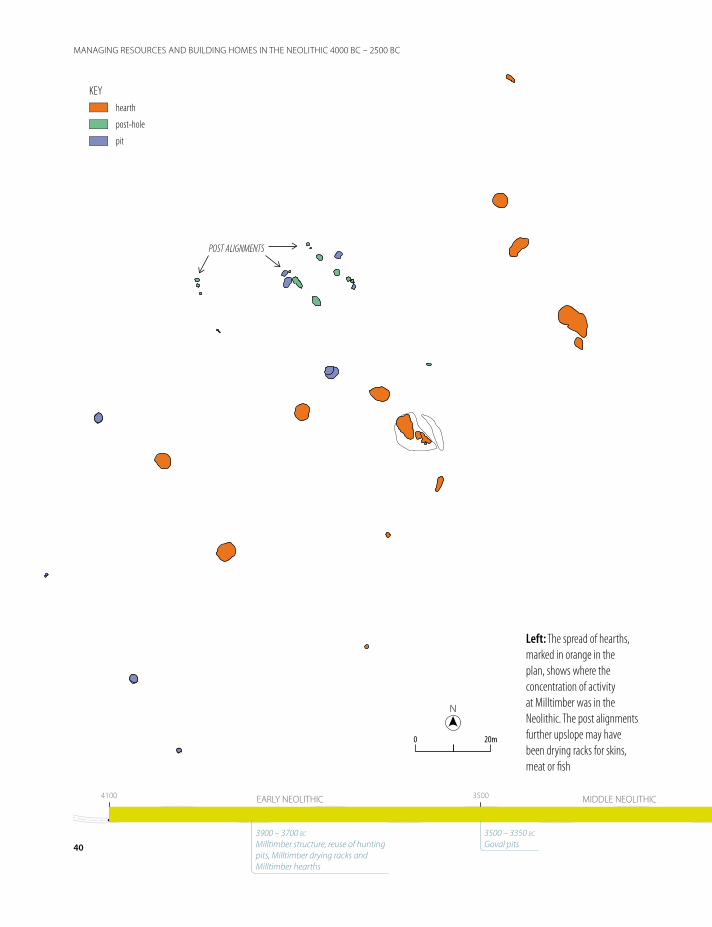
There was also similar reuse in the Neolithic period of some of the large pits at Milltimber. Here a small number of pits showed evidence of being reused and handfuls of pottery sherds were collected from deposits in the upper parts of the pit. It is noticeable that the pottery from Milltimber was generally very broken and only survived in small pieces. This is very different from the near intact bowl from Blackdog. However, the Neolithic at Milltimber was represented by a range of features you would expect around a dwelling, suggesting the presence of a small group of people who settled there for a while.
Close to the foot of the slope defining the northern side of the River Dee valley, a structure about 4.5m wide and at least 6m long had been erected in a small hollow. Several post-holes were found around the edges of the hollow. On the east side, an area of packed gravel formed something of a surface and may indicate an entrance. There was another spread of gravel inside the structure. A small hearth was also found. Material from within the hollow and from the hearth was radiocarbon-dated to the first half of the 4th millennium bc.
KEYhearth
post-hole
metalled surface
extent of structure walls
NN
1m1m00
Right: A structure dating to the early
4th millennium bc was found cut into the slope at
Milltimber
39
MANAGING RESOURCES AND BUILDING HOMES IN THE NEOLITHIC 4000 BC – 2500 BC
41004100 35003500 30003000 24502450EARLY NEOLITHIC MIDDLE NEOLITHIC LATE NEOLITHIC
3350 – 2900 bc Wester Hatton pits
NN
20m20m00
KEYhearth
post-hole
pit
POST ALIGNMENTS
Left: The spread of hearths, marked in orange in the plan, shows where the concentration of activity at Milltimber was in the Neolithic. The post alignments further upslope may have been drying racks for skins, meat or fish
40
MANAGING RESOURCES AND BUILDING HOMES IN THE NEOLITHIC 4000 BC – 2500 BC
41004100 35003500 30003000 24502450EARLY NEOLITHIC MIDDLE NEOLITHIC LATE NEOLITHIC
3900 – 3700 bc Milltimber structure, reuse of hunting pits, Milltimber drying racks and Milltimber hearths
3500 – 3350 bc Goval pits
There was little evidence of domestic activity within the structure but outside lay another hearth and a leaf-shaped arrowhead was found, along with fragments from a carinated bowl, similar to that from the pit at Blackdog. These are consistent with the radiocarbon dates from inside the structure.
The issue of recognising small or isolated domestic structures of this kind in Neolithic Scotland is one that has been much discussed by archaeologists. However, there are now several reasonable comparative examples that have some of the elements seen in the building at Milltimber. Kinbeachie on the Black Isle was excavated in the late 1990s and a building recorded there measured roughly 7m by 4m, aligned south-west to north-east and located on a low ridge overlooking the Cromarty Firth. The situation at Milltimber – cut into the slope of the hill, is somewhat different, but the proportions and construction methods are broadly similar.
A short distance downstream from Milltimber, at Garthdee Road on the northern bank of the River Dee, an irregular, roughly oval structure was recorded in 2005. It was defined by shallow post-pits and contained a notable amount of artefacts and environmental data. It had a date range of 3800 bc – 3650 bc, broadly contemporary with the date range of the Milltimber structure. Both were similar in their ‘roughness’ – these do not appear to be long-standing buildings in use for more than a few years.
Interpretations of the structure at Garthdee have revolved around its chronological relationship with much larger timber halls upstream at Crathes and Balbridie, and further afield at sites such as Claish in Stirlingshire, where it has been suggested that the large timber halls represent communal living, with the smaller, more typically ‘domestic’ structures representing the normal building techniques which had presumably developed from structures of earlier periods.
The structure is quite reminiscent of the Mesolithic structure found at Standingstones and described in the previous chapter. The significant, but scant, evidence found there suggested just a short-term encampment of some sort. However, there is additional information here at Milltimber, contemporary with this early Neolithic structure, which points to the area being more frequently utilized during the later period.
Around 75m to the west of the structure, there were three lines of post-holes, very roughly parallel and aligned north-west to south-east. The post-holes contained charcoal which could be dated to 3950 bc – 3715 bc, Early Neolithic in date and possibly contemporary with the structure.
41
MANAGING RESOURCES AND BUILDING HOMES IN THE NEOLITHIC 4000 BC – 2500 BC
41004100 35003500 30003000 24502450EARLY NEOLITHIC MIDDLE NEOLITHIC LATE NEOLITHIC
3350 – 2900 bc Wester Hatton pits
42
RADIOCARBON-DATING
Radiocarbon-dating
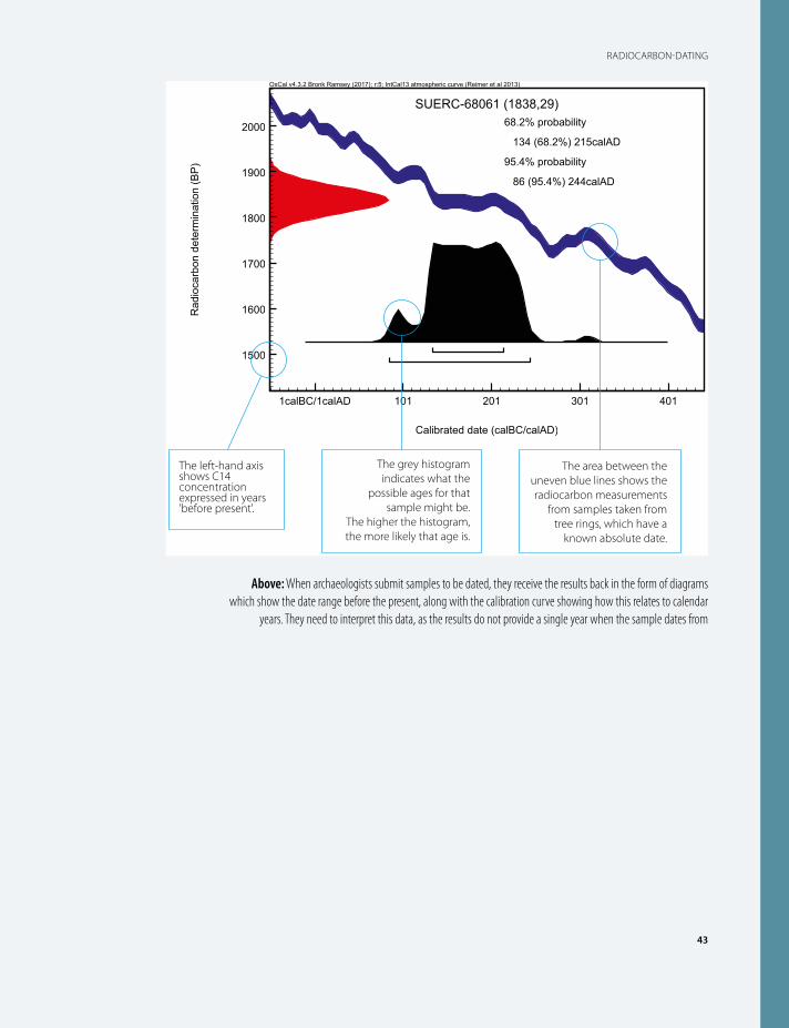
The use of radiocarbon-dating on this project was critical to determining the dates when many of the features
discovered on the various sites were being used in the past. It is probably one of the best known and most commonly used of the scientific dating methods in archaeology, popularly known as C14-dating after the carbon isotope which the method measures.
In the late 1940s it was discovered that a tiny part of carbon atoms, as small as one in a million, are of the mildly radioactive C14 isotope. All organic matter has this isotope as part of their natural growth system and is absorbed as the living organism takes in fresh carbon. When it dies no more fresh carbon is taken in and the amount of C14 gradually declines. This happens at a measurable rate so when an organic sample (often of charcoal, bone or nutshell) is analysed and the amount of C14 measured against other carbon material, a date when the organism stopped taking in fresh carbon can be measured.
The method can measure up to 10,000 years ago with a reasonable degree of reliability and can even give useful information up to 40,000 years ago.
There is one main problem with this method. The amount of C14 in the environment has varied over time and this can skew the results, making a sample appear older or younger than it really is. When archaeologists realized this, they used another independent dating method – dendrochronology or tree-ring dating – to ‘calibrate’ the results against known dates. A base series of measurements using both methods has provided a reference chart, known as a ‘calibration curve’, against which new samples can be calibrated.
Even using the calibration curve, any sample can only be identified as a range of dates, often several hundred years long. This is why archaeologists can’t necessarily pinpoint activity in the prehistoric period to a specific year or even decade. The results are also expressed in terms of probability, with the likelihood of a sample dating to a certain period reducing as the date range narrows.
43
RADIOCARBON-DATING
SUERC-68061 (1838,29)68.2% probability
134 (68.2%) 215calAD
95.4% probability
86 (95.4%) 244calAD
1calBC/1calAD 101 201 301 401
Calibrated date (calBC/calAD)
1500
1600
1700
1800
1900
2000
Rad
ioca
rbon
det
erm
inat
ion
(BP
)
OxCal v4.3.2 Bronk Ramsey (2017); r:5; IntCal13 atmospheric curve (Reimer et al 2013)
The area between the uneven blue lines shows the radiocarbon measurements
from samples taken from tree rings, which have a
known absolute date.
The grey histogram indicates what the
possible ages for that sample might be.
The higher the histogram, the more likely that age is.
The left-hand axis shows C14 concentration expressed in years 'before present'.
Above: When archaeologists submit samples to be dated, they receive the results back in the form of diagrams which show the date range before the present, along with the calibration curve showing how this relates to calendar
years. They need to interpret this data, as the results do not provide a single year when the sample dates from
3500 – 3350 bc Goval pits44
41004100 35003500 30003000 24502450EARLY NEOLITHIC MIDDLE NEOLITHIC LATE NEOLITHIC
3900 – 3700 bc Milltimber structure, reuse of hunting pits, Milltimber drying racks and Milltimber hearths
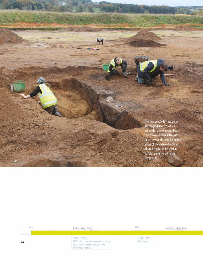
The two people further away are digging hearths which utilise the shelter created by a tree throw –where a tree has fallen over and created a hollow. Some of the charcoal remnants of the hearth can be seen as dark layers in the pit in the foreground
The post alignments are located on a slight but noticeable slope, and it seems highly unlikely they form a structure of the same type as that at the east of the excavation. The linear arrangement is more typical of fence-lines or enclosures, but the short lengths of each line makes this unlikely. The fact that the alignments are roughly parallel may suggest that the north-west to south-east arrangement was of importance. Could the alignments be drying racks, taking advantage of breezes funneling up and down the river valley? Although these kinds of features do not necessarily imply permanence of settlement, they do point to the domestic character of the activities taking place.
The lines of post-holes alone suggest some level of settlement going on here during the Early Neolithic, but one further piece of important evidence is the presence of 11 hearths, radiocarbon-dated to between 3900 bc and 3700 bc. The presence of these hearths spread across the north of the excavation area can be taken as evidence of further structures, the remains of which have simply not survived. Perhaps the reason there is no evidence for them is that they were flimsier, temporary structures. The material from the hearths seems to be fairly typical of general domestic waste, and there is clear evidence of in situ burning.
The evidence from these sites, therefore, corresponds comfortably with a picture of people settling and managing their local environment. It is not possible to say how intensive this was. The period is still many generations long - the dating of the hearths, for example, spreads over 200 years - but there is the overall impression of a significant increase in activity in the region.
45
MANAGING RESOURCES AND BUILDING HOMES IN THE NEOLITHIC 4000 BC – 2500 BC
41004100 35003500 30003000 24502450EARLY NEOLITHIC MIDDLE NEOLITHIC LATE NEOLITHIC
3350 – 2900 bc Wester Hatton pits
Excavations at Wester Hatton
Chapter 4
Life, death and religion in the Chalcolithic and Bronze Age 2500 bc – 800 bc
Just as there was no immediate transition from the Mesolithic to Neolithic, equally there was not an immediate introduction of bronze working into the north-east of Scotland. Indeed, there is no artefactual evidence at all for those materials from the AWPR/B-T scheme, and it is only radiocarbon-dating that allows us to define features as Bronze Age in date. Throughout this period, the inhabitants of the region were still using stone tools, along with bone and wood.
Across the British Isles, initially copper tools were made before it was discovered that adding tin to copper formed bronze, a much harder metal. This period in the development of human technology is called the Chalcolithic, from the Greek word for copper, and refers to a discrete transitional phase between the Neolithic and the Bronze Age. However, this period is also marked by the appearance of elements of the Beaker culture, which spread from continental Europe, likely brought by incomers.
One particular feature of the Chalcolithic was a tradition of constructing timber and pit-defined avenues. These are generally interpreted as structures that would be the focal points for large gatherings. Exactly what these gatherings were for is not precisely known; religious events are the most plausible, as there is compelling evidence that these large structures were erected in the landscape with an awareness of the night sky and certain positions of the sun.
A possible example of such a timber setting, comprising lines and pairs of post-holes arranged in four groups, was found at Milltimber. The overall alignment of the monument is from the south-west to north-east, roughly 65m long and up to 20m wide.
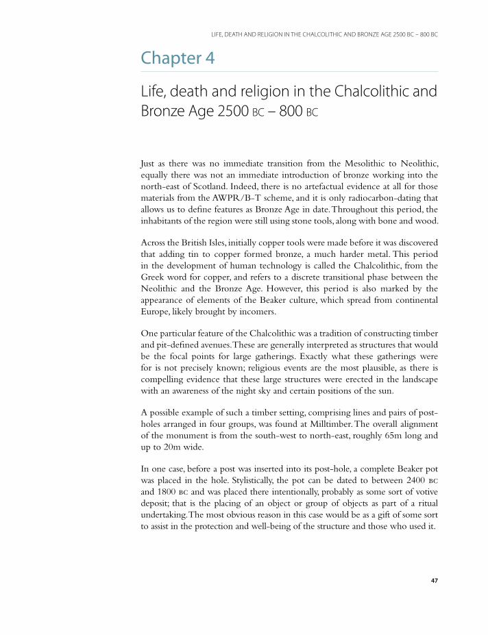
In one case, before a post was inserted into its post-hole, a complete Beaker pot was placed in the hole. Stylistically, the pot can be dated to between 2400 bc and 1800 bc and was placed there intentionally, probably as some sort of votive deposit; that is the placing of an object or group of objects as part of a ritual undertaking. The most obvious reason in this case would be as a gift of some sort to assist in the protection and well-being of the structure and those who used it.
47
LIFE, DEATH AND RELIGION IN THE CHALCOLITHIC AND BRONZE AGE 2500 BC – 800 BC

Most of the other examples of this kind of avenue found in Scotland have only been discovered as cropmarks. Few have been excavated and this provides an additional challenge when comparing and contrasting new discoveries with this kind of information. Until the interpretations are tested by excavation, we cannot be certain the interpretations are correct. Excavation will not necessarily confirm a proposed interpretation. Only two avenues have been excavated, and both (one from Forteviot and another from elsewhere in Perthshire) form part of a large palisaded (fenced) enclosure. As such, they do not present suitable comparisons for the Milltimber arrangements.
Avenues consisting of pits rather than post-holes are also known and have been found at Holm Farm in Dumfries and Galloway and Upper Largie in Kilmartin Glen, Argyll. Both of these are again considerably larger than the one here, but the arrangement and alignment of the rows, curving slightly over their length, is similar.
NN
10m10m00KEY
post-hole
TIMBER SETTING
Left: The timber setting at Milltimber comprises a series of lines and pairs of post-holes, spread over 65m. Radiocarbon-dating suggests it was built between 2500 bc and 2200 bc
48
LIFE, DEATH AND RELIGION IN THE CHALCOLITHIC AND BRONZE AGE 2500 BC – 800 BC
15501550 11501150 800800CHALCOLITHIC EARLY BRONZE AGE MIDDLE BRONZE AGE LATE BRONZE AGE24502450 22002200
2500 – 2200 bc Deposition of Milltimber Beaker
2100 – 1900 bc Gairnhill Burnt Mound
1600 – 1300 bc Nether Beanshill roundhouse
and cemetery
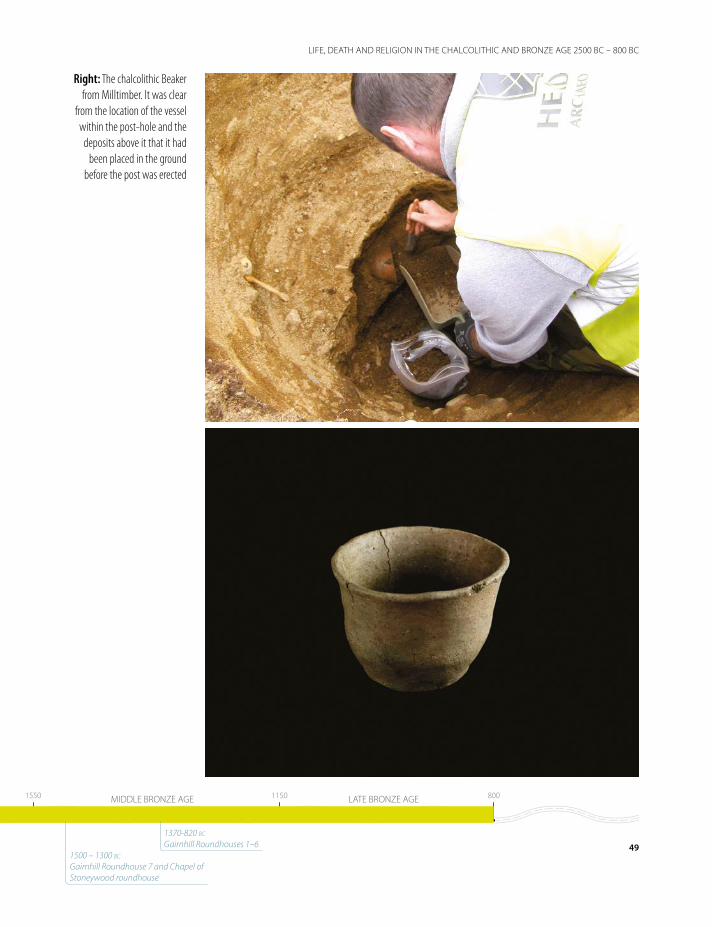
Right: The chalcolithic Beaker from Milltimber. It was clear
from the location of the vessel within the post-hole and the
deposits above it that it had been placed in the ground
before the post was erected
49
LIFE, DEATH AND RELIGION IN THE CHALCOLITHIC AND BRONZE AGE 2500 BC – 800 BC
15501550 11501150 800800CHALCOLITHIC EARLY BRONZE AGE MIDDLE BRONZE AGE LATE BRONZE AGE24502450 22002200
1370-820 bc Gairnhill Roundhouses 1–6
1500 – 1300 bc Gairnhill Roundhouse 7 and Chapel of Stoneywood roundhouse
50
TIMBER SETTINGS, AVENUES AND LINES OF POSTS: HOW DO WE INTERPRET THE FEATURES WE FIND?
Timber settings, avenues and lines of posts: how do we
interpret the features we find?
The lines of posts at Milltimber date to between 2500 bc – 2000 bc. The Beaker placed in one post-hole is also considered to be a foundation deposit and is of a style dating to between 2400 and 1800 bc, which fits with this date range.
As archaeologists, as well as simply dating groups of features and assigning them to a period, we also have to try and interpret them, proposing theories as to how they may have been used. By doing this, we gain an understanding of the wider society at that point in the past; what activities were taking place, how people viewed their surroundings and what was important to them.
Throughout the 20th century and in recent years, the range of types of sites known across Britain has grown exponentially as a result of excavation and survey, including geophysical and cropmark surveys, so that we now have a much-enhanced body of material with which to compare and contrast newly-found features or sites.
The challenge of interpreting features is in matching the layout and specifics to sites that are already known. If they don’t closely match previous examples, does that mean we have identified an alternative
version of the same thing, does it represent a particularly early or late example of the same thing, or is it something completely different? To some extent this is one of the difficulties with understanding the Chalcolithic lines of posts at Milltimber.
We know what date they are and we can be fairly confident that they were all constructed as part of a single coherent structure. The distances between the post-holes, both individually and as groups, make it highly unlikely that the groups were roofed or belong to a building. The layout implies that they are aligned from south-west to north-east, and that this is an important aspect of their function.
There are a number of known sites which show some close comparisons with this arrangement. One such example are the trapezoidal timber monuments which date to the Early Neolithic (as much as 1,500 years earlier), which look somewhat similar to the groups of post at the north-east end of the Milltimber arrangement. However, crucially, none of the 13 examples recorded in Scotland has been excavated. Therefore, ascribing these types of sites to the Early Neolithic or even that they were timber monuments is by no means certain.
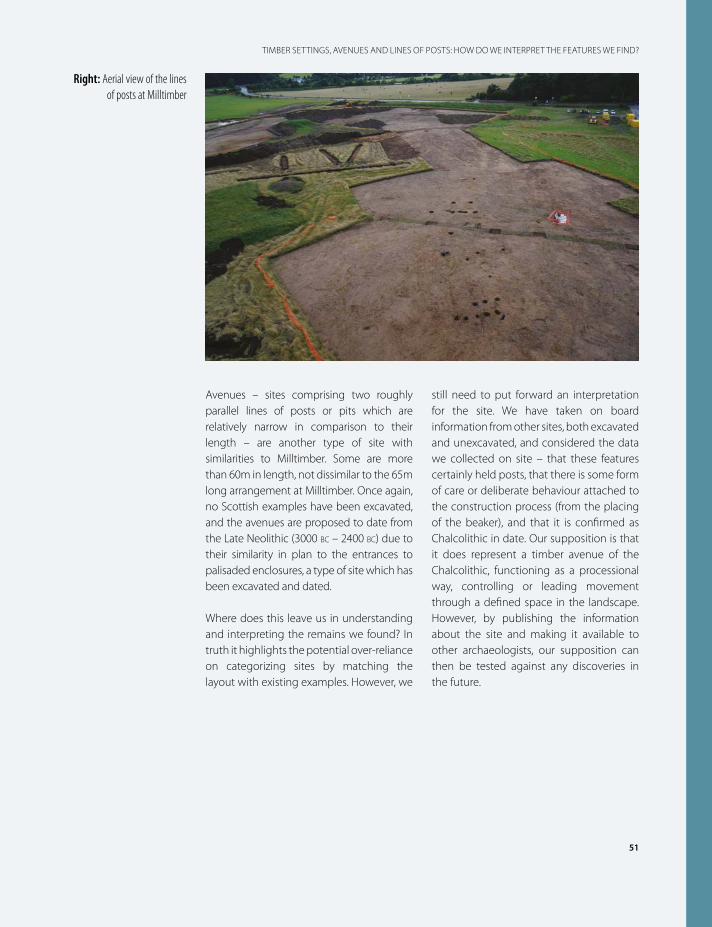
51
TIMBER SETTINGS, AVENUES AND LINES OF POSTS: HOW DO WE INTERPRET THE FEATURES WE FIND?
Avenues – sites comprising two roughly parallel lines of posts or pits which are relatively narrow in comparison to their length – are another type of site with similarities to Milltimber. Some are more than 60m in length, not dissimilar to the 65m long arrangement at Milltimber. Once again, no Scottish examples have been excavated, and the avenues are proposed to date from the Late Neolithic (3000 bc – 2400 bc) due to their similarity in plan to the entrances to palisaded enclosures, a type of site which has been excavated and dated.
Where does this leave us in understanding and interpreting the remains we found? In truth it highlights the potential over-reliance on categorizing sites by matching the layout with existing examples. However, we
still need to put forward an interpretation for the site. We have taken on board information from other sites, both excavated and unexcavated, and considered the data we collected on site – that these features certainly held posts, that there is some form of care or deliberate behaviour attached to the construction process (from the placing of the beaker), and that it is confirmed as Chalcolithic in date. Our supposition is that it does represent a timber avenue of the Chalcolithic, functioning as a processional way, controlling or leading movement through a defined space in the landscape. However, by publishing the information about the site and making it available to other archaeologists, our supposition can then be tested against any discoveries in the future.
Right: Aerial view of the lines of posts at Milltimber
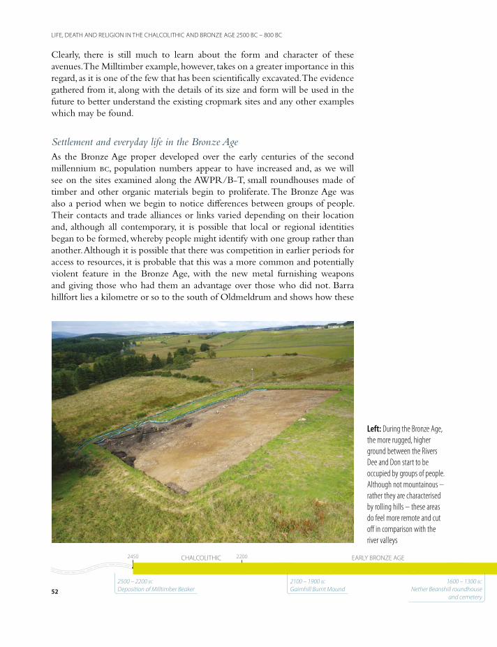
Clearly, there is still much to learn about the form and character of these avenues. The Milltimber example, however, takes on a greater importance in this regard, as it is one of the few that has been scientifically excavated. The evidence gathered from it, along with the details of its size and form will be used in the future to better understand the existing cropmark sites and any other examples which may be found.
Settlement and everyday life in the Bronze AgeAs the Bronze Age proper developed over the early centuries of the second millennium bc, population numbers appear to have increased and, as we will see on the sites examined along the AWPR/B-T, small roundhouses made of timber and other organic materials begin to proliferate. The Bronze Age was also a period when we begin to notice differences between groups of people. Their contacts and trade alliances or links varied depending on their location and, although all contemporary, it is possible that local or regional identities began to be formed, whereby people might identify with one group rather than another. Although it is possible that there was competition in earlier periods for access to resources, it is probable that this was a more common and potentially violent feature in the Bronze Age, with the new metal furnishing weapons and giving those who had them an advantage over those who did not. Barra hillfort lies a kilometre or so to the south of Oldmeldrum and shows how these
Left: During the Bronze Age, the more rugged, higher ground between the Rivers Dee and Don start to be occupied by groups of people. Although not mountainous – rather they are characterised by rolling hills – these areas do feel more remote and cut off in comparison with the river valleys
52
LIFE, DEATH AND RELIGION IN THE CHALCOLITHIC AND BRONZE AGE 2500 BC – 800 BC
15501550 11501150 800800CHALCOLITHIC EARLY BRONZE AGE MIDDLE BRONZE AGE LATE BRONZE AGE24502450 22002200
2500 – 2200 bc Deposition of Milltimber Beaker
2100 – 1900 bc Gairnhill Burnt Mound
1600 – 1300 bc Nether Beanshill roundhouse
and cemetery
locations represent a collective effort to create a place for defence and safety that continues through to the Iron Age. Excavation has shown that the ramparts were likely constructed in the Early Bronze Age, but radiocarbon dates from the latter part of the first millennium bc have been confirmed from the fill of a ditch on the interior; although it was constructed potentially 1500 years earlier it was still in use in the Iron Age.
The higher ground was not much occupied in the earlier periods. In the Bronze Age, on the other hand, it is an entirely different matter; an Early Bronze Age burnt mound, nine Middle and Late Bronze Age buildings with associated pits, post-holes and ancillary features, and a Middle Bronze Age cremation cemetery were all found on the higher ground between the Rivers Dee and Don. This activity is best described as periodic rather than continuous; the radiocarbon dates from these sites contain gaps in the record. The interpretation of activity at Gairnhill and Nether Beanshill gives a good indication of this potentially somewhat spasmodic sequence of events.
This activity starts at Gairnhill with the construction of a burnt mound (a mound of charcoal and fire-cracked stones, the result of repeatedly heating stones to heat water) sometime between 2100 bc and 1900 bc. After this, the site appears to have been abandoned and there is a gap of at least 300 years in the record before the roundhouse and cemetery at Nether Beanshill were established sometime between 1600 bc and 1300 bc. At roughly the same time, apparently isolated buildings were constructed and inhabited at Gairnhill (Roundhouse 7) and Chapel of Stoneywood. The sites at Nether Beanshill and Chapel of Stoneywood were abandoned by 1200 bc, at the same time that the small settlement formed of Gairnhill Roundhouses 1 to 6 was just starting to be established.
It is difficult to estimate the duration of the later Bronze Age settlement at Gairnhill, something which illustrates the challenges of using radiocarbon dating. Dates from the structures overlap extensively, are roughly contemporary and span a period from 1370 bc to 820 bc. The dates could suggest that Gairnhill Roundhouse 6 was the earliest and Roundhouse 5 the latest, however there is no physical reason that all six buildings could not have been occupied at the same time – there is space for them all. What we can be reasonably confident of is that by around 800 bc the landscape at Gairnhill was once again relatively empty.
The Gairnhill Burnt MoundThe Gairnhill burnt mound was in use between 2100 bc and 1900 bc. It consisted of a spread of firing debris, a rectangular wood-lined trough with structural wooden elements preserved in the wet conditions on site and other
53
LIFE, DEATH AND RELIGION IN THE CHALCOLITHIC AND BRONZE AGE 2500 BC – 800 BC
15501550 11501150 800800CHALCOLITHIC EARLY BRONZE AGE MIDDLE BRONZE AGE LATE BRONZE AGE24502450 22002200
1370-820 bc Gairnhill Roundhouses 1–6
1500 – 1300 bc Gairnhill Roundhouse 7 and Chapel of Stoneywood roundhouse

features around the edge of the mound. It is generally accepted that burnt mounds are formed from the heating of stones that are then placed in a container holding water in order to heat it. This is an incredibly efficient way of heating large volumes of water. The stones crack and fragment from the heat and are discarded onto the mound, along with any charred debris from the fire itself.
Although only 13 examples of burnt mounds are known in north-east Scotland including this one, it is estimated that there are over 1900 throughout the country as a whole. Most are known from surface surveys, discovered as crescent-shaped mounds of fire-cracked stones and charcoal close to water-courses. They are concentrated mainly in the Northern Isles, with a second concentration in southern and south-western Scotland. The true number is likely to be considerably higher because, as the results at Gairnhill show, more mounds may be hidden beneath the surface.
Traditionally, burnt mounds were thought to be cooking and feasting sites, perhaps related to hunting parties, but the lack of animal bone evidence and normal domestic detritus from these mounds means that this idea has somewhat fallen out of favour. There is still much debate, and current interpretations include sweat lodges or saunas, textile and leather production sites, woodworking, including boat building, and most recently brewing. Many of these functions
Left: The burnt mound at Gairnhill was formed of a spread of charcoal-rich silts, mixed up with large amounts of stone which had been heated and cracked as a result
54
LIFE, DEATH AND RELIGION IN THE CHALCOLITHIC AND BRONZE AGE 2500 BC – 800 BC
15501550 11501150 800800CHALCOLITHIC EARLY BRONZE AGE MIDDLE BRONZE AGE LATE BRONZE AGE24502450 22002200
2500 – 2200 bc Deposition of Milltimber Beaker
2100 – 1900 bc Gairnhill Burnt Mound
1600 – 1300 bc Nether Beanshill roundhouse
and cemetery

ABERDEEN
EAST DENS
KEMNAY FORREST
BURRELDALES
PIKETILLUM
TAYLOCH
BELNAGLACKMILLHUIE HILL
BIRKFORD
DRY BURN
BALRONALD
GALLOWS HILLDRUMQUHIL BURN
GAIRNHILL
NN
10km0KEY
burnt mound
Above: Distribution of burnt mounds in north-east Scotland. Only a comparatively small number are known from this area, with most concentrated in the Northern Isles or in the south-west of the country
55
LIFE, DEATH AND RELIGION IN THE CHALCOLITHIC AND BRONZE AGE 2500 BC – 800 BC
15501550 11501150 800800CHALCOLITHIC EARLY BRONZE AGE MIDDLE BRONZE AGE LATE BRONZE AGE24502450 22002200
1370-820 bc Gairnhill Roundhouses 1–6
1500 – 1300 bc Gairnhill Roundhouse 7 and Chapel of Stoneywood roundhouse
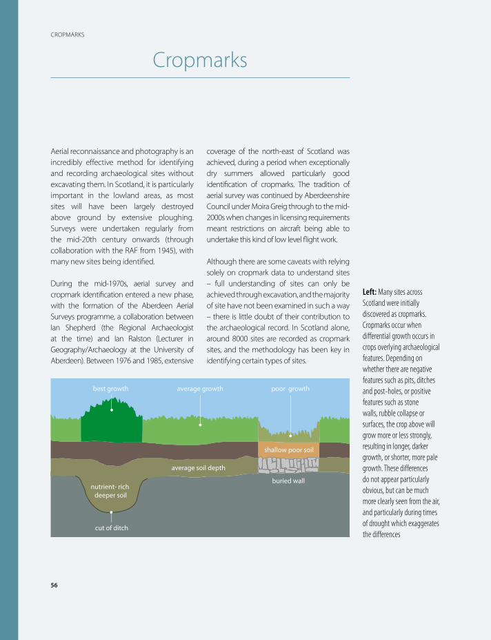
56
CROPMARKS
Cropmarks
Aerial reconnaissance and photography is an incredibly effective method for identifying and recording archaeological sites without excavating them. In Scotland, it is particularly important in the lowland areas, as most sites will have been largely destroyed above ground by extensive ploughing. Surveys were undertaken regularly from the mid-20th century onwards (through collaboration with the RAF from 1945), with many new sites being identified.
During the mid-1970s, aerial survey and cropmark identification entered a new phase, with the formation of the Aberdeen Aerial Surveys programme, a collaboration between Ian Shepherd (the Regional Archaeologist at the time) and Ian Ralston (Lecturer in Geography/Archaeology at the University of Aberdeen). Between 1976 and 1985, extensive
coverage of the north-east of Scotland was achieved, during a period when exceptionally dry summers allowed particularly good identification of cropmarks. The tradition of aerial survey was continued by Aberdeenshire Council under Moira Greig through to the mid-2000s when changes in licensing requirements meant restrictions on aircraft being able to undertake this kind of low level flight work.
Although there are some caveats with relying solely on cropmark data to understand sites – full understanding of sites can only be achieved through excavation, and the majority of site have not been examined in such a way – there is little doubt of their contribution to the archaeological record. In Scotland alone, around 8000 sites are recorded as cropmark sites, and the methodology has been key in identifying certain types of sites.
best growth average growth poor growth
cut of ditch
average soil depth
shallow poor soil
buried wallnutrient- rich
deeper soil
Left: Many sites across Scotland were initially discovered as cropmarks. Cropmarks occur when differential growth occurs in crops overlying archaeological features. Depending on whether there are negative features such as pits, ditches and post-holes, or positive features such as stone walls, rubble collapse or surfaces, the crop above will grow more or less strongly, resulting in longer, darker growth, or shorter, more pale growth. These differences do not appear particularly obvious, but can be much more clearly seen from the air, and particularly during times of drought which exaggerates the differences
Using soil to protect artefact found on site
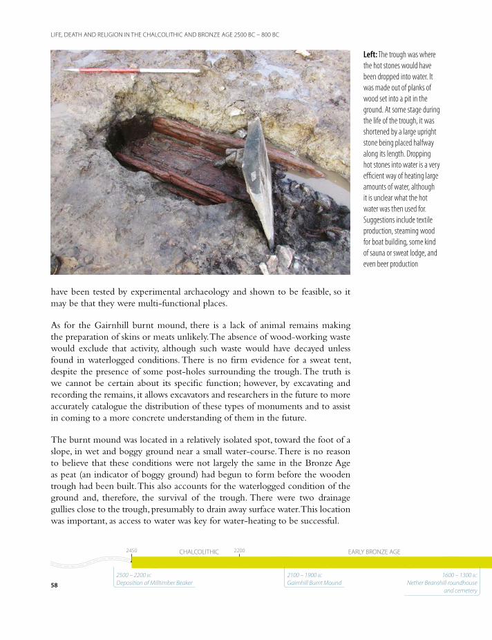
have been tested by experimental archaeology and shown to be feasible, so it may be that they were multi-functional places.
As for the Gairnhill burnt mound, there is a lack of animal remains making the preparation of skins or meats unlikely. The absence of wood-working waste would exclude that activity, although such waste would have decayed unless found in waterlogged conditions. There is no firm evidence for a sweat tent, despite the presence of some post-holes surrounding the trough. The truth is we cannot be certain about its specific function; however, by excavating and recording the remains, it allows excavators and researchers in the future to more accurately catalogue the distribution of these types of monuments and to assist in coming to a more concrete understanding of them in the future.
The burnt mound was located in a relatively isolated spot, toward the foot of a slope, in wet and boggy ground near a small water-course. There is no reason to believe that these conditions were not largely the same in the Bronze Age as peat (an indicator of boggy ground) had begun to form before the wooden trough had been built. This also accounts for the waterlogged condition of the ground and, therefore, the survival of the trough. There were two drainage gullies close to the trough, presumably to drain away surface water. This location was important, as access to water was key for water-heating to be successful.
Left: The trough was where the hot stones would have been dropped into water. It was made out of planks of wood set into a pit in the ground. At some stage during the life of the trough, it was shortened by a large upright stone being placed halfway along its length. Dropping hot stones into water is a very efficient way of heating large amounts of water, although it is unclear what the hot water was then used for. Suggestions include textile production, steaming wood for boat building, some kind of sauna or sweat lodge, and even beer production
58
LIFE, DEATH AND RELIGION IN THE CHALCOLITHIC AND BRONZE AGE 2500 BC – 800 BC
15501550 11501150 800800CHALCOLITHIC EARLY BRONZE AGE MIDDLE BRONZE AGE LATE BRONZE AGE24502450 22002200
2500 – 2200 bc Deposition of Milltimber Beaker
2100 – 1900 bc Gairnhill Burnt Mound
1600 – 1300 bc Nether Beanshill roundhouse
and cemetery

In general, those that have been examined in detail are in isolated positions with no obvious occupation site nearby. The group of Late Bronze Age huts also found at Gairnhill are located a few hundred metres away, not too distant, but they are at least 600, and possibly as much as 1000 years later. They were not contemporary at all. A contemporary settlement may be nearby, outside the limits of the road scheme. A tantalizing hint of this was the discovery among the Late Bronze Age Gairnhill buildings of a plano-convex knife that is typical of the Early Bronze Age, the date of the burnt mound.
Bronze Age SettlementsThe excavations at Nether Beanshill, Gairnhill and Chapel of Stoneywood uncovered nine previously unknown Middle to Late Bronze Age roundhouses, spread across the lower slopes of the upland landscape between the Dee and Don valleys. In recent years, many single and clustered roundhouse sites have been found in north-east Scotland, with several large developer-funded excavations building a more detailed picture of Bronze Age settlement patterns; more than
Right: The Nether Beanshill roundhouse was the earliest
example found on the scheme. Following removal of
the topsoil, roundhouses can be recognised by dark silty deposits in a characteristic
arc or horseshoe shape. These ditches defining the inside of
the structure are often filled with stones which may have
collapsed from the outer walls, or have been used as
rough paving
59
LIFE, DEATH AND RELIGION IN THE CHALCOLITHIC AND BRONZE AGE 2500 BC – 800 BC
15501550 11501150 800800CHALCOLITHIC EARLY BRONZE AGE MIDDLE BRONZE AGE LATE BRONZE AGE24502450 22002200
1370-820 bc Gairnhill Roundhouses 1–6
1500 – 1300 bc Gairnhill Roundhouse 7 and Chapel of Stoneywood roundhouse
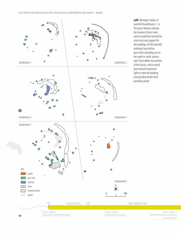
KEYhearth
post-hole
ovoid pit
stone
metalled surface
spread
NN
10m10m00
ROUNDHOUSE 1 ROUNDHOUSE 2
ROUNDHOUSE 3
ROUNDHOUSE 5
ROUNDHOUSE 6
ROUNDHOUSE 4
Left: Montage of plans of Gairnhill Roundhouses 1–6. The green features indicate the location of post-holes which would have formed the main structural support for the buildings. All the Gairnhill buildings have further post-holes extending out on the south or south-eastern side. These define the porches of the houses, which would have allowed maximum light to enter the building, and provided shelter from prevailing winds
60
LIFE, DEATH AND RELIGION IN THE CHALCOLITHIC AND BRONZE AGE 2500 BC – 800 BC
15501550 11501150 800800CHALCOLITHIC EARLY BRONZE AGE MIDDLE BRONZE AGE LATE BRONZE AGE24502450 22002200
2500 – 2200 bc Deposition of Milltimber Beaker
2100 – 1900 bc Gairnhill Burnt Mound
1600 – 1300 bc Nether Beanshill roundhouse
and cemetery
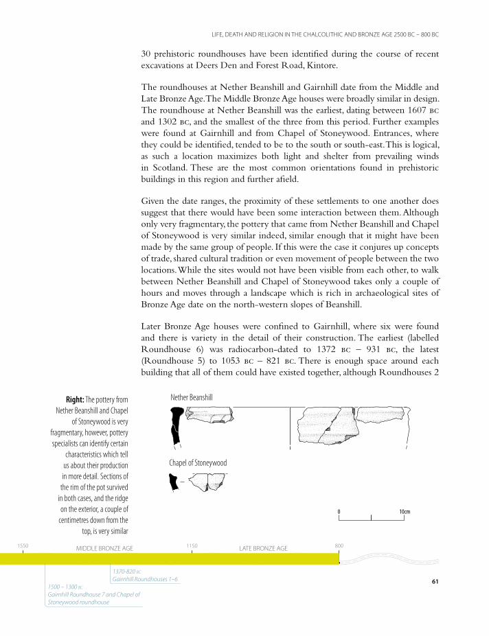
30 prehistoric roundhouses have been identified during the course of recent excavations at Deers Den and Forest Road, Kintore.
The roundhouses at Nether Beanshill and Gairnhill date from the Middle and Late Bronze Age. The Middle Bronze Age houses were broadly similar in design. The roundhouse at Nether Beanshill was the earliest, dating between 1607 bc and 1302 bc, and the smallest of the three from this period. Further examples were found at Gairnhill and from Chapel of Stoneywood. Entrances, where they could be identified, tended to be to the south or south-east. This is logical, as such a location maximizes both light and shelter from prevailing winds in Scotland. These are the most common orientations found in prehistoric buildings in this region and further afield.
Given the date ranges, the proximity of these settlements to one another does suggest that there would have been some interaction between them. Although only very fragmentary, the pottery that came from Nether Beanshill and Chapel of Stoneywood is very similar indeed, similar enough that it might have been made by the same group of people. If this were the case it conjures up concepts of trade, shared cultural tradition or even movement of people between the two locations. While the sites would not have been visible from each other, to walk between Nether Beanshill and Chapel of Stoneywood takes only a couple of hours and moves through a landscape which is rich in archaeological sites of Bronze Age date on the north-western slopes of Beanshill.
Later Bronze Age houses were confined to Gairnhill, where six were found and there is variety in the detail of their construction. The earliest (labelled Roundhouse 6) was radiocarbon-dated to 1372 bc – 931 bc, the latest (Roundhouse 5) to 1053 bc – 821 bc. There is enough space around each building that all of them could have existed together, although Roundhouses 2
10cm10cm00
Chapel of Stoneywood
Nether BeanshillRight: The pottery from Nether Beanshill and Chapel
of Stoneywood is very fragmentary, however, pottery specialists can identify certain
characteristics which tell us about their production in more detail. Sections of
the rim of the pot survived in both cases, and the ridge on the exterior, a couple of
centimetres down from the top, is very similar
61
LIFE, DEATH AND RELIGION IN THE CHALCOLITHIC AND BRONZE AGE 2500 BC – 800 BC
15501550 11501150 800800CHALCOLITHIC EARLY BRONZE AGE MIDDLE BRONZE AGE LATE BRONZE AGE24502450 22002200
1370-820 bc Gairnhill Roundhouses 1–6
1500 – 1300 bc Gairnhill Roundhouse 7 and Chapel of Stoneywood roundhouse

62
THE ANATOMY OF A ROUNDHOUSE
The anatomy of a roundhouse
A roundhouse is a circular building with a conical roof and cylindrical walls, which together form a robust and
stable structure. This form of construction was one that was prevalent across all of Britain for thousands of years. Roundhouses can have different method of construction but on the AWPR-/B-T scheme they are usually formed of an internal ring of posts which carries the weight of the roof and is the main structural support for the building.
Stability is provided by ring-beams – a circle of horizontal timber which secures the top of the posts and which the sloping rafters can rest on. The walls of the structure might
be formed of either banked material (earth, turf and stone), or panels of wattle covered in clay. Sometimes these panels sit within a circular groove known as a ring-groove; evidence for panels can be seen when the ring-groove takes on a sub-circular and more angular appearance (e.g. Gairnhill Roundhouse 1).
Inside the structure, there is often a hollow mirroring the circumference of the walls. Sometimes these hollows contain large stones, which might have been used as rough paving. The hollows usually are a result of occupation of the structure – worn out from the floor surface as people or animals
Left: Stones are often found in the ring-ditches of roundhouses – the hollows which mirror their circumference. In some situations it is clear that they are forming paving, but in others they are simply the result of the collapse of the surrounding walls

63
THE ANATOMY OF A ROUNDHOUSE
moved around the space. Stake-holes and smaller post-holes can indicate where internal partitions were constructed, potentially dividing up the space into areas for eating, sleeping, food productions or animals.
Often, no evidence of a hearth is seen during a roundhouse excavation, but this does not
mean one was not present. Hearths might have been deliberately located on top of flat stones to ensure the fire didn’t spread. In the absence of any other evidence, this can make it difficult to say whether a structure was used as a dwelling, a workshop or a byre.
A
B
NN
4m4m00
POST RING
POST RING
Right: Plan of the structure at Nether Beanshill. The green line shown in A highlights the ring of post-holes
which would have provided the main structural support for the roof. These may have been linked at the top by horizontal timbers which would have formed a
more rigid structure. The line of posts shown in B may represent the outer wall
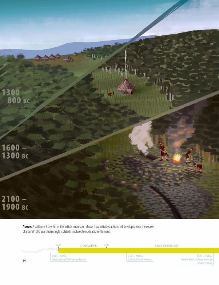
Above: A settlement over time: this artist’s impression shows how activities at Gairnhill developed over the course of around 1000 years from single isolated structures to nucleated settlements
64
LIFE, DEATH AND RELIGION IN THE CHALCOLITHIC AND BRONZE AGE 2500 BC – 800 BC
15501550 11501150 800800CHALCOLITHIC EARLY BRONZE AGE MIDDLE BRONZE AGE LATE BRONZE AGE24502450 22002200
2500 – 2200 bc Deposition of Milltimber Beaker
2100 – 1900 bc Gairnhill Burnt Mound
1600 – 1300 bc Nether Beanshill roundhouse
and cemetery
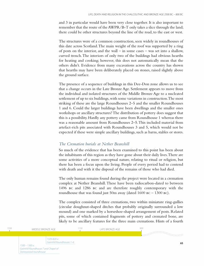
and 3 in particular would have been very close together. It is also important to remember that the route of the AWPR/B-T only takes a slice through the land; there could be other structures beyond the line of the road, to the east or west.
The structures were of a common construction, seen widely in roundhouses of this date across Scotland. The main weight of the roof was supported by a ring of posts on the interior, and the wall – in some cases – was set into a shallow, curved trench. The interiors of only two of the buildings had obvious hearths for heating and cooking; however, this does not automatically mean that the others didn’t. Evidence from many excavations across the country has shown that hearths may have been deliberately placed on stones, raised slightly above the ground surface.
The presence of a sequence of buildings in this Dee-Don zone allows us to see that a change occurs in the Late Bronze Age. Settlement appears to move from the individual and isolated structures of the Middle Bronze Age to a nucleated settlement of up to six buildings, with some variations in construction. The most striking of these are the large Roundhouses 2–5 and the smaller Roundhouses 1 and 6. Could the larger buildings have been dwellings and the smaller ones workshops or ancillary structures? The distribution of pottery does suggest that this is a possibility. Hardly any pottery came from Roundhouse 1 whereas there was a reasonable amount from Roundhouses 2–5. This included material from artefact-rich pits associated with Roundhouses 3 and 5, which would not be expected if these were simple ancillary buildings, such as barns, stables or stores.
The Cremation burials at Nether BeanshillSo much of the evidence that has been examined to this point has been about the inhabitants of this region as they have gone about their daily lives. There are some activities of a more conceptual nature, relating to ritual or religion, but there has been a focus upon the living. People of every period had to contend with death and with it the disposal of the remains of those who had died.
The only human remains found during the project were located in a cremation complex at Nether Beanshill. These have been radiocarbon-dated to between 1496 bc and 1286 bc and are therefore roughly contemporary with the roundhouse that was found just 50m away (dated 1600 bc – 1300 bc).
The complex consisted of three cremations, two within miniature ring-gullies (circular doughnut-shaped ditches that probably originally surrounded a low mound) and one marked by a horseshoe-shaped arrangement of posts. Related pits, some of which contained fragments of pottery and cremated bone, are likely to be ancillary features for the three main cremations. Hints of a fourth
65
LIFE, DEATH AND RELIGION IN THE CHALCOLITHIC AND BRONZE AGE 2500 BC – 800 BC
15501550 11501150 800800CHALCOLITHIC EARLY BRONZE AGE MIDDLE BRONZE AGE LATE BRONZE AGE24502450 22002200
1370-820 bc Gairnhill Roundhouses 1–6
1500 – 1300 bc Gairnhill Roundhouse 7 and Chapel of Stoneywood roundhouse
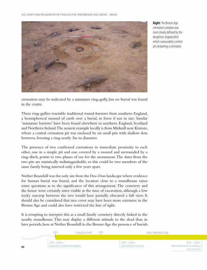
cremation may be indicated by a miniature ring-gully, but no burial was found in the centre.
These ring-gullies resemble traditional round-barrows from southern England, a hemispherical mound of earth over a burial, in form if not in size. Similar ‘miniature barrows’ have been found elsewhere in northern England, Scotland and Northern Ireland. The nearest example locally is from Midmill near Kintore, where a central cremation pit was enclosed by six small pits with shallow slots between, forming a ring nearly 3m in diameter.
The presence of two confirmed cremations in immediate proximity to each other, one in a simple pit and one covered by a mound and surrounded by a ring-ditch, points to two phases of use for the monument. The dates from the two pits are statistically indistinguishable, so this could be two members of the same family being interred only a few years apart.
Nether Beanshill was the only site from the Dee-Don landscape where evidence for human burial was found, and the location close to a roundhouse raises some questions as to the significance of this arrangement. The cemetery and the house were certainly inter-visible at the time of excavation, although a low rocky outcrop between the two would have partially obscured a full view. It should also be considered that tree cover may have been more extensive in the Bronze Age and could also have restricted the line of sight.
It is tempting to interpret this as a small family cemetery directly linked to the nearby roundhouse. This may display a different attitude to the dead than in later periods; here at Nether Beanshill in the Bronze Age the presence of burials
Right: The Bronze Age cremation complex was most clearly defined by the doughnut-shaped ditch which surrounded a central pit containing a cremation
66
LIFE, DEATH AND RELIGION IN THE CHALCOLITHIC AND BRONZE AGE 2500 BC – 800 BC
15501550 11501150 800800CHALCOLITHIC EARLY BRONZE AGE MIDDLE BRONZE AGE LATE BRONZE AGE24502450 22002200 15501550 11501150 800800CHALCOLITHIC EARLY BRONZE AGE MIDDLE BRONZE AGE LATE BRONZE AGE24502450 22002200
2500 – 2200 bc Deposition of Milltimber Beaker
2100 – 1900 bc Gairnhill Burnt Mound
1600 – 1300 bc Nether Beanshill roundhouse
and cemetery

Left: It is relatively rare to find pots in situ during excavation, but cremation burials are one
of the more likely situations. When cremation urns are
found, they have to be carefully excavated, wrapped
up on site, and then taken back to the laboratory to
be examined in detail. The Nether Beanshill cremation was found to be sitting on
top of a flat slab placed in the base of the pit, and using 3D photography techniques, we were able to create a digital
model of the surviving parts of it
67
LIFE, DEATH AND RELIGION IN THE CHALCOLITHIC AND BRONZE AGE 2500 BC – 800 BC
15501550 11501150 800800CHALCOLITHIC EARLY BRONZE AGE MIDDLE BRONZE AGE LATE BRONZE AGE24502450 22002200 15501550 11501150 800800CHALCOLITHIC EARLY BRONZE AGE MIDDLE BRONZE AGE LATE BRONZE AGE24502450 22002200
1370-820 bc Gairnhill Roundhouses 1–6
1500 – 1300 bc Gairnhill Roundhouse 7 and Chapel of Stoneywood roundhouse
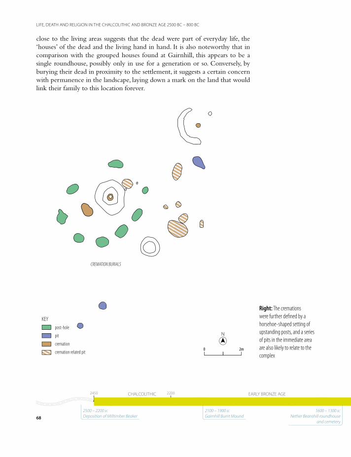
close to the living areas suggests that the dead were part of everyday life, the ‘houses’ of the dead and the living hand in hand. It is also noteworthy that in comparison with the grouped houses found at Gairnhill, this appears to be a single roundhouse, possibly only in use for a generation or so. Conversely, by burying their dead in proximity to the settlement, it suggests a certain concern with permanence in the landscape, laying down a mark on the land that would link their family to this location forever.
NN
2m2m00
KEYpost-hole
pit
cremation
cremation related pit
CREMATION BURIALS
Right: The cremations were further defined by a horsehoe-shaped setting of upstanding posts, and a series of pits in the immediate area are also likely to relate to the complex
68
LIFE, DEATH AND RELIGION IN THE CHALCOLITHIC AND BRONZE AGE 2500 BC – 800 BC
15501550 11501150 800800CHALCOLITHIC EARLY BRONZE AGE MIDDLE BRONZE AGE LATE BRONZE AGE24502450 22002200
2500 – 2200 bc Deposition of Milltimber Beaker
2100 – 1900 bc Gairnhill Burnt Mound
1600 – 1300 bc Nether Beanshill roundhouse
and cemetery

Above: An artist’s impression of the Nether Beanshill cremation complex suggests the first (unmounded) burial being marked by an oval post arrangement
69
LIFE, DEATH AND RELIGION IN THE CHALCOLITHIC AND BRONZE AGE 2500 BC – 800 BC
15501550 11501150 800800CHALCOLITHIC EARLY BRONZE AGE MIDDLE BRONZE AGE LATE BRONZE AGE24502450 22002200
1370-820 bc Gairnhill Roundhouses 1–6
1500 – 1300 bc Gairnhill Roundhouse 7 and Chapel of Stoneywood roundhouse
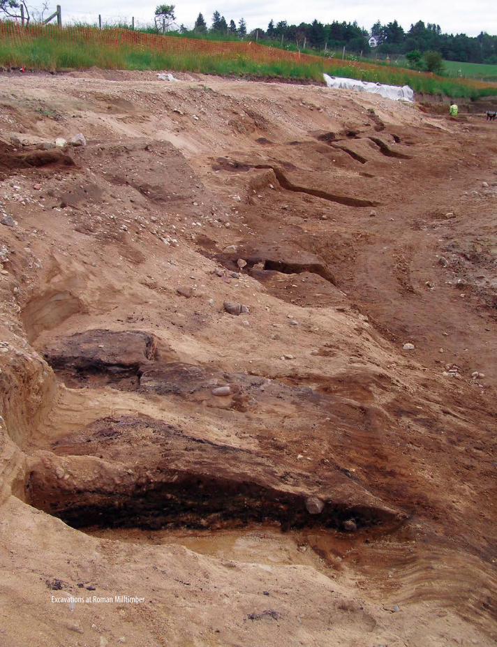
Excavations at Roman Milltimber
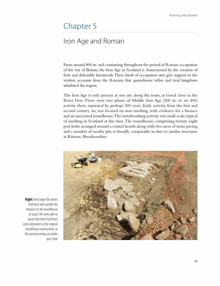
Chapter 5
Iron Age and Roman
From around 800 bc and continuing throughout the period of Roman occupation of the rest of Britain, the Iron Age in Scotland is characterised by the creation of forts and defensible farmsteads. These kinds of occupation sites give support to the written accounts from the Romans that quarrelsome tribes and rival kingdoms inhabited the region.
The Iron Age is only present at one site along the route, at Goval close to the River Don. There were two phases of Middle Iron Age (200 bc to ad 400) activity there, separated by perhaps 200 years. Early activity, from the first and second century ad, was focused on iron smelting, with evidence for a furnace and an associated roundhouse. The metalworking activity was small-scale, typical of smelting in Scotland at this time. The roundhouse, comprising twenty-eight post holes arranged around a central hearth along with two areas of stone paving and a number of nearby pits, is broadly comparable in date to similar structures at Kintore, Aberdeenshire.
Right: Very large flat stones had been laid outside the
entrance to the roundhouse at Goval. We were able to
prove that there had been some alteration to the original
roundhouse construction, as this paving overlay an earlier
post-hole
71
IRON AGE AND ROMAN

72
THE ANATOMY OF A POST-HOLE
The anatomy of a post-hole
A post-hole is essentially a pit that has been dug to hold a post. The hole is dug out, the post inserted, perhaps
propped or packed with stones to make it more upright or stand more firmly, and then the soil excavated from the pit is rammed back into the hole. The presence of groups of post-holes usually means that there are structures present – they might be arranged in circles or rectangles and indicate where the wall lines of buildings might have been.
In addition to showing the layout of a building, individual post-holes can be used to understand how the building was constructed in the first place, and then what happened to it when it was no longer in use.
Although an abandoned building might be left to fall into ruins, good timbers, already seasoned and cut to a manageable size, would be an important resource to keep hold of. As a result, posts were sometimes removed from their post-holes when the structure was abandoned, leaving a void in the centre of the hole; material subsequently filling the void can be distinguished from the original fill by its looser, less compacted nature. Depending on the extent to which the structure was repaired over the course of its lifetime, several generations may have passed between the original construction and its abandonment. Material falling or washing into the void could be considerably later than when the post was originally erected.
post in situ post-pipe post-hole
Left: The different way posts survive or decay can tell archaeologists a great deal about how the structure was built and then abandoned
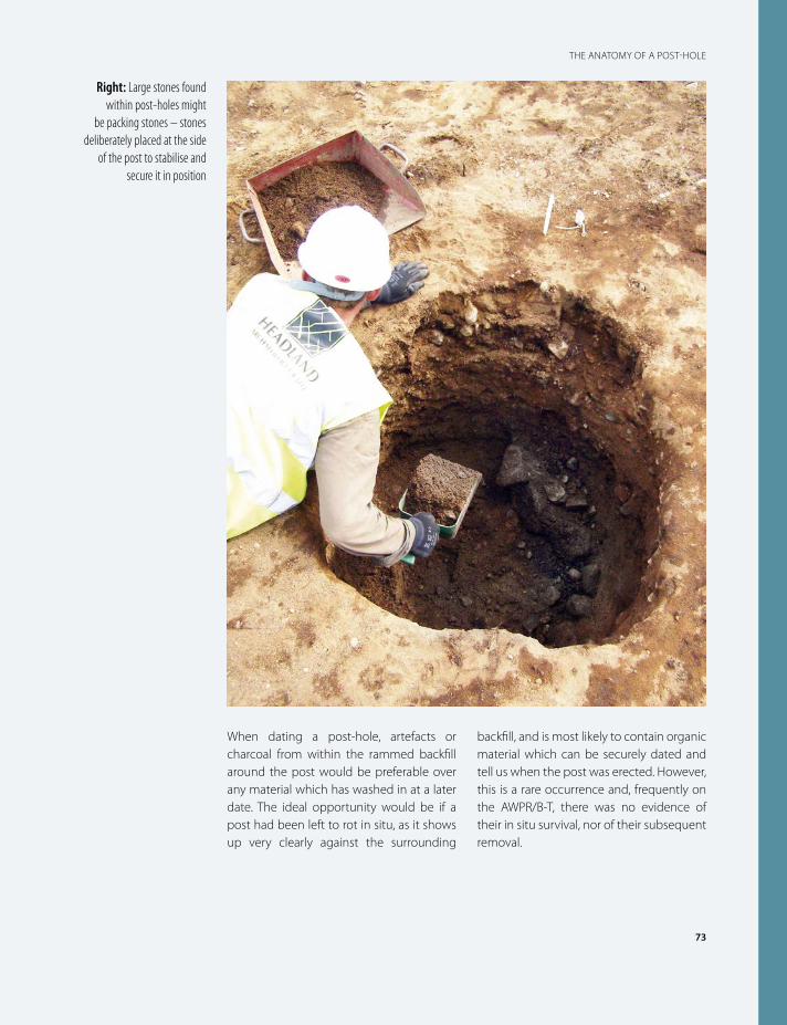
73
THE ANATOMY OF A POST-HOLE
When dating a post-hole, artefacts or charcoal from within the rammed backfill around the post would be preferable over any material which has washed in at a later date. The ideal opportunity would be if a post had been left to rot in situ, as it shows up very clearly against the surrounding
backfill, and is most likely to contain organic material which can be securely dated and tell us when the post was erected. However, this is a rare occurrence and, frequently on the AWPR/B-T, there was no evidence of their in situ survival, nor of their subsequent removal.
Right: Large stones found within post-holes might
be packing stones – stones deliberately placed at the side
of the post to stabilise and secure it in position
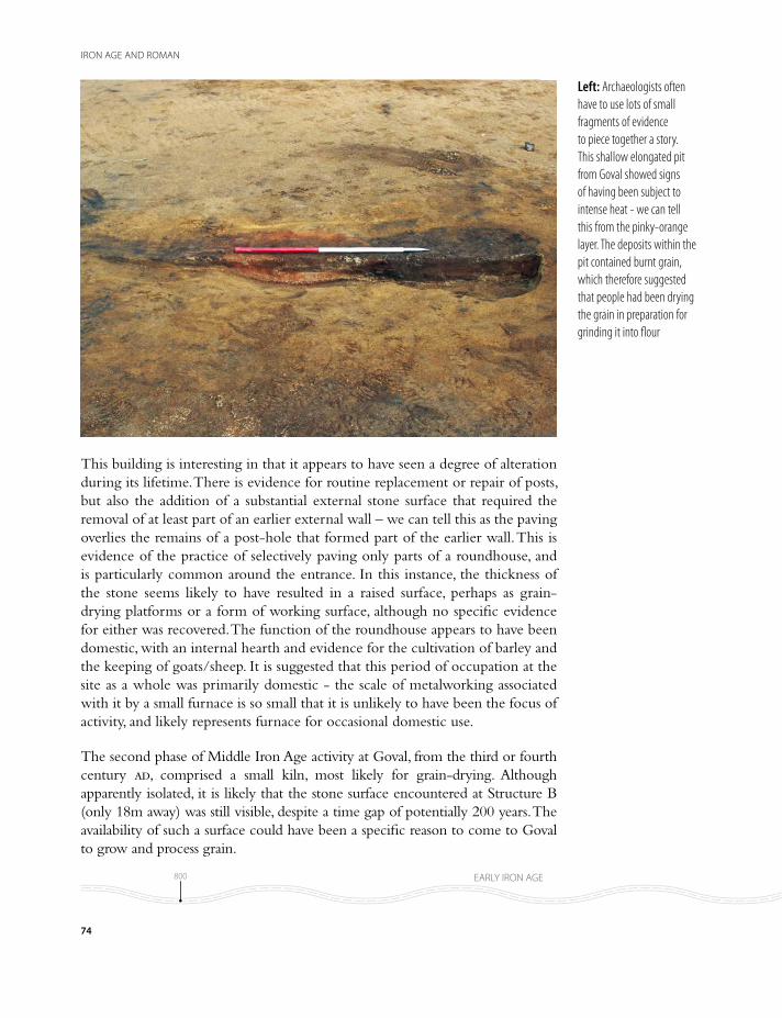
This building is interesting in that it appears to have seen a degree of alteration during its lifetime. There is evidence for routine replacement or repair of posts, but also the addition of a substantial external stone surface that required the removal of at least part of an earlier external wall – we can tell this as the paving overlies the remains of a post-hole that formed part of the earlier wall. This is evidence of the practice of selectively paving only parts of a roundhouse, and is particularly common around the entrance. In this instance, the thickness of the stone seems likely to have resulted in a raised surface, perhaps as grain-drying platforms or a form of working surface, although no specific evidence for either was recovered. The function of the roundhouse appears to have been domestic, with an internal hearth and evidence for the cultivation of barley and the keeping of goats/sheep. It is suggested that this period of occupation at the site as a whole was primarily domestic - the scale of metalworking associated with it by a small furnace is so small that it is unlikely to have been the focus of activity, and likely represents furnace for occasional domestic use.
The second phase of Middle Iron Age activity at Goval, from the third or fourth century ad, comprised a small kiln, most likely for grain-drying. Although apparently isolated, it is likely that the stone surface encountered at Structure B (only 18m away) was still visible, despite a time gap of potentially 200 years. The availability of such a surface could have been a specific reason to come to Goval to grow and process grain.
Left: Archaeologists often have to use lots of small fragments of evidence to piece together a story. This shallow elongated pit from Goval showed signs of having been subject to intense heat - we can tell this from the pinky-orange layer. The deposits within the pit contained burnt grain, which therefore suggested that people had been drying the grain in preparation for grinding it into flour
74
IRON AGE AND ROMAN
800800 100/200 BC100/200 BC 300/400300/400
AD 43AD 43 410410
EARLY IRON AGE
ROMAN
MIDDLE IRON AGE LATE IRON AGE
00
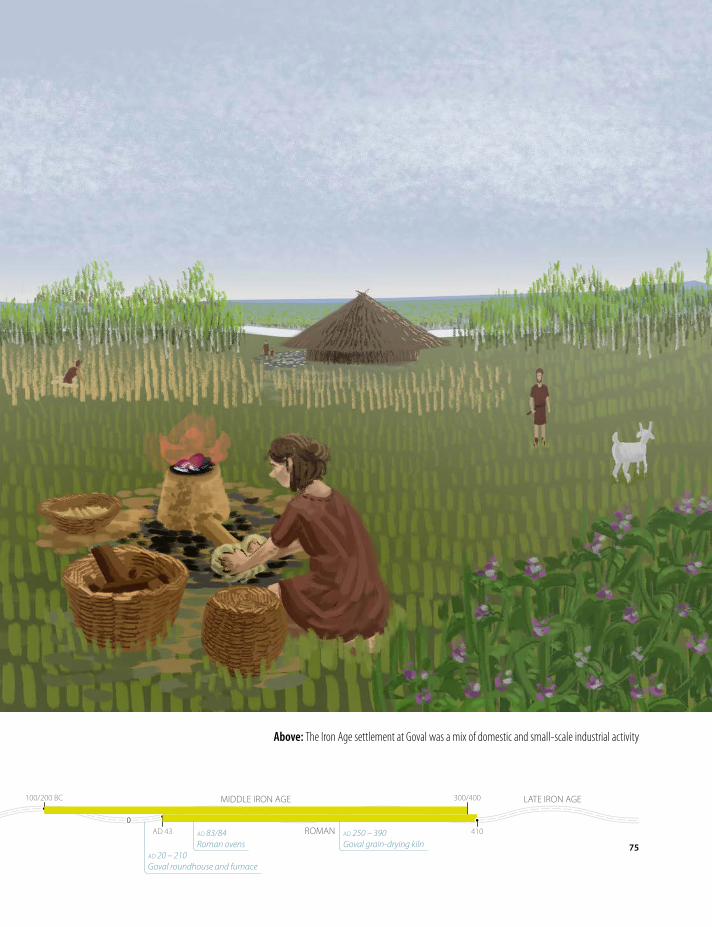
Above: The Iron Age settlement at Goval was a mix of domestic and small-scale industrial activity
75
IRON AGE AND ROMAN
800800 100/200 BC100/200 BC 300/400300/400
AD 43AD 43 410410
EARLY IRON AGE
ROMAN
MIDDLE IRON AGE LATE IRON AGE
00
ad 20 – 210 Goval roundhouse and furnace
ad 83/84 Roman ovens
ad 250 – 390 Goval grain-drying kiln

The Roman invasionDuring what is broadly defined as the Middle Iron Age period in Scotland, the arrival of the Roman army in the 80s ad would have caused a major disruption to life in the north-east. The dates of the earliest phases at Goval are too broad to be able to state with any confidence whether they would have interacted with the Romans, and the site is distant enough from what we know of the army’s movements and camps in this area that it is unlikely. However, there is no doubt that communities throughout the area would have been disrupted and suffered loss of life through warfare. This would have led to changes in the distribution of farmsteads and other activities.
The Roman presence in Britain started a generation earlier. In ad 43, during the reign of the Emperor Claudius, the Roman army invaded Britain. It was a campaign that gave the promise of political prestige for the emperor and the potential of rich rewards from the country – grain, slaves, raw materials of tin, lead, silver and even some gold. In the immediate aftermath of invasion, the north-east of Scotland was little troubled by the presence of Romans far to the south, but by the early 70s ad, they were moving north.
In the late 70s, Gnaeus Julius Agricola was appointed Governor of the Province of Britannia. We know a great deal about him, his career and also his military campaigns beyond the former territories of the Brigantes into Scotland as his son-in-law, the historian Tacitus, recorded them. The next phase of the archaeology found on the AWPR/B-T, specifically an extraordinary plethora
Left: The ovens were dug into a hollow which was the remains of an old, dried up water channel. Archaeologists refer to these as palaeochannels and they can be mapped and dated to show how river-courses have changed over time. The earlier route of the river is shown in blue
76
IRON AGE AND ROMAN
800800 100/200 BC100/200 BC 300/400300/400
AD 43AD 43 410410
EARLY IRON AGE
ROMAN
MIDDLE IRON AGE LATE IRON AGE
00
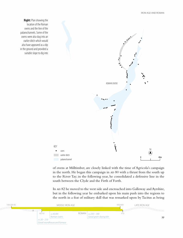
of ovens at Milltimber, are closely linked with the time of Agricola’s campaign in the north. He began this campaign in ad 80 with a thrust from the south up to the River Tay; in the following year, he consolidated a defensive line in the south between the Clyde and the Firth of Forth.
In ad 82 he moved to the west side and encroached into Galloway and Ayrshire, but in the following year he embarked upon his main push into the regions to the north in a feat of military skill that was remarked upon by Tacitus as being
NN
40m40m00
KEYoven
earlier ditch
palaeochannel
ROMAN OVENS
Right: Plan showing the location of the Roman
ovens and the line of the palaeochannels. Some of the ovens were also dug into an
earlier ditch which would also have appeared as a dip
in the ground and provided a suitable slope to dig into
77
IRON AGE AND ROMAN
800800 100/200 BC100/200 BC 300/400300/400
AD 43AD 43 410410
EARLY IRON AGE
ROMAN
MIDDLE IRON AGE LATE IRON AGE
00
ad 20 – 210 Goval roundhouse and furnace
ad 83/84 Roman ovens
ad 250 – 390 Goval grain-drying kiln
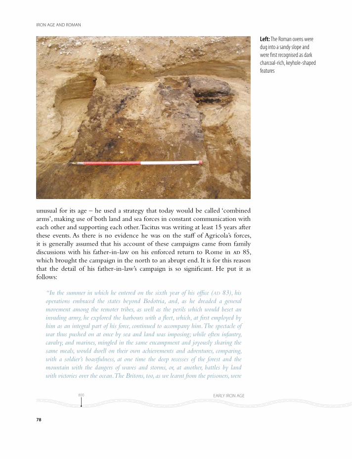
unusual for its age – he used a strategy that today would be called ‘combined arms’, making use of both land and sea forces in constant communication with each other and supporting each other. Tacitus was writing at least 15 years after these events. As there is no evidence he was on the staff of Agricola’s forces, it is generally assumed that his account of these campaigns came from family discussions with his father-in-law on his enforced return to Rome in ad 85, which brought the campaign in the north to an abrupt end. It is for this reason that the detail of his father-in-law’s campaign is so significant. He put it as follows:
“In the summer in which he entered on the sixth year of his office (ad 83), his operations embraced the states beyond Bodotria, and, as he dreaded a general movement among the remoter tribes, as well as the perils which would beset an invading army, he explored the harbours with a fleet, which, at first employed by him as an integral part of his force, continued to accompany him. The spectacle of war thus pushed on at once by sea and land was imposing; while often infantry, cavalry, and marines, mingled in the same encampment and joyously sharing the same meals, would dwell on their own achievements and adventures, comparing, with a soldier’s boastfulness, at one time the deep recesses of the forest and the mountain with the dangers of waves and storms, or, at another, battles by land with victories over the ocean. The Britons, too, as we learnt from the prisoners, were
Left: The Roman ovens were dug into a sandy slope and were first recognised as dark charcoal-rich, keyhole-shaped features
78
IRON AGE AND ROMAN
800800 100/200 BC100/200 BC 300/400300/400
AD 43AD 43 410410
EARLY IRON AGE
ROMAN
MIDDLE IRON AGE LATE IRON AGE
00

confounded by the sight of a fleet, as if, now that their inmost seas were penetrated, the conquered had their last refuge closed to them.”
In ad 84, the following year, Agricola was in a position to enter the north-east in strength, supported by the fleet covering his march northwards and supplying him along the east coast. He defeated the Caledonii at a place called Mons Graupius, somewhere in the region of Bennachie in north-west Aberdeenshire, and then proceeded to the Moray Firth.
It is in this context - the combined arms approach of ad 83/84 - that we now turn our attention to the archaeology of Milltimber once again, which produced an extraordinary group of ninety ovens that, according to the scientific dating evidence, belong to the period of Agricola’s campaigns in this region.
The remains of the ovens were identified on the valley floor, 200m to the south of the earlier prehistoric remains. The features were found in association with former water-courses or palaeochannels that were completely dry and would have been covered in vegetation. The builders of these ovens positioned themselves within hollows of the channels and the ovens were dug into the banks. The banks allowed a convenient height at which to create the chambers in which was burnt a mixture of material, such as gorse, broom, heather, birch, hazel, oak – in fact, any combustible material that was close to hand.
head of ovenhead of oven
head of oven
head of oven
Right: The regimented layout of the ovens in groups was
one of the indications that this was activity on an industrial
scale
79
IRON AGE AND ROMAN
800800 100/200 BC100/200 BC 300/400300/400
AD 43AD 43 410410
EARLY IRON AGE
ROMAN
MIDDLE IRON AGE LATE IRON AGE
00
ad 20 – 210 Goval roundhouse and furnace
ad 83/84 Roman ovens
ad 250 – 390 Goval grain-drying kiln

Above: The Romans would have used whatever scrub and branches were easily available to hand as fuel for the ovens. Documentary evidence tells us that a group of eight men (known as a conturburnium) would be responsible for producing their own bread
80
IRON AGE AND ROMAN
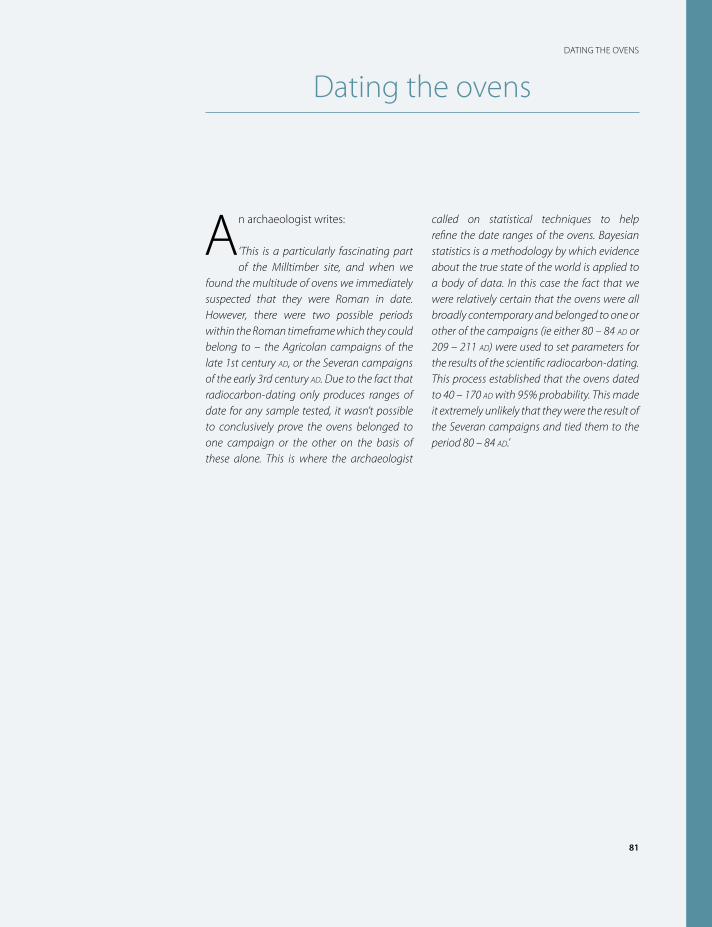
81
DATING THE OVENS
Dating the ovens
An archaeologist writes:
‘This is a particularly fascinating part of the Milltimber site, and when we
found the multitude of ovens we immediately suspected that they were Roman in date. However, there were two possible periods within the Roman timeframe which they could belong to – the Agricolan campaigns of the late 1st century ad, or the Severan campaigns of the early 3rd century ad. Due to the fact that radiocarbon-dating only produces ranges of date for any sample tested, it wasn’t possible to conclusively prove the ovens belonged to one campaign or the other on the basis of these alone. This is where the archaeologist
called on statistical techniques to help refine the date ranges of the ovens. Bayesian statistics is a methodology by which evidence about the true state of the world is applied to a body of data. In this case the fact that we were relatively certain that the ovens were all broadly contemporary and belonged to one or other of the campaigns (ie either 80 – 84 ad or 209 – 211 ad) were used to set parameters for the results of the scientific radiocarbon-dating. This process established that the ovens dated to 40 – 170 ad with 95% probability. This made it extremely unlikely that they were the result of the Severan campaigns and tied them to the period 80 – 84 ad.’
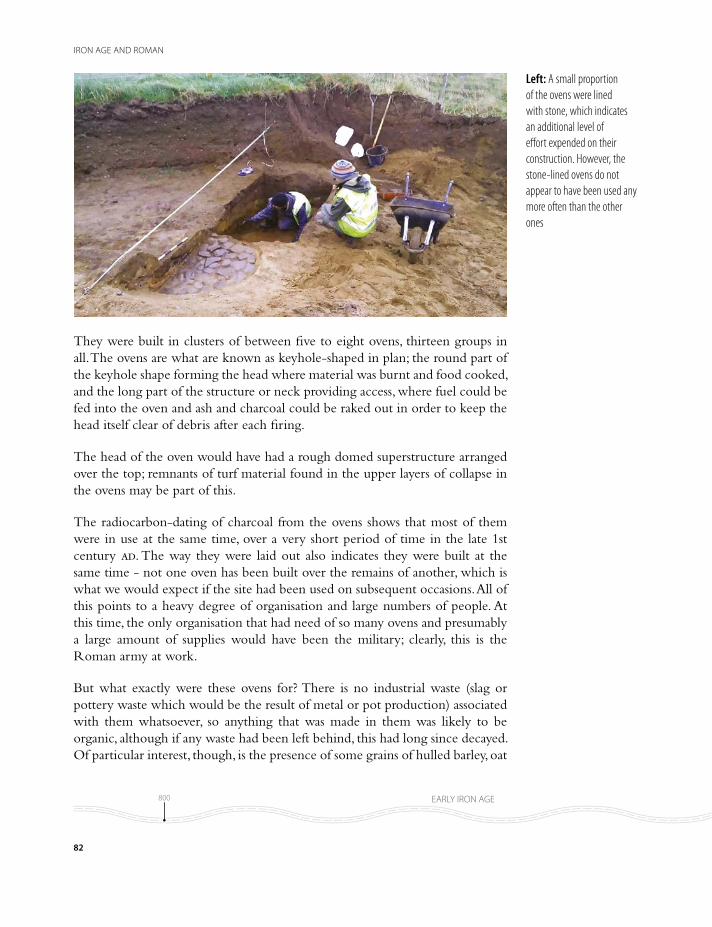
They were built in clusters of between five to eight ovens, thirteen groups in all. The ovens are what are known as keyhole-shaped in plan; the round part of the keyhole shape forming the head where material was burnt and food cooked, and the long part of the structure or neck providing access, where fuel could be fed into the oven and ash and charcoal could be raked out in order to keep the head itself clear of debris after each firing.
The head of the oven would have had a rough domed superstructure arranged over the top; remnants of turf material found in the upper layers of collapse in the ovens may be part of this.
The radiocarbon-dating of charcoal from the ovens shows that most of them were in use at the same time, over a very short period of time in the late 1st century ad. The way they were laid out also indicates they were built at the same time - not one oven has been built over the remains of another, which is what we would expect if the site had been used on subsequent occasions. All of this points to a heavy degree of organisation and large numbers of people. At this time, the only organisation that had need of so many ovens and presumably a large amount of supplies would have been the military; clearly, this is the Roman army at work.
But what exactly were these ovens for? There is no industrial waste (slag or pottery waste which would be the result of metal or pot production) associated with them whatsoever, so anything that was made in them was likely to be organic, although if any waste had been left behind, this had long since decayed. Of particular interest, though, is the presence of some grains of hulled barley, oat
Left: A small proportion of the ovens were lined with stone, which indicates an additional level of effort expended on their construction. However, the stone-lined ovens do not appear to have been used any more often than the other ones
82
IRON AGE AND ROMAN
800800 100/200 BC100/200 BC 300/400300/400
AD 43AD 43 410410
EARLY IRON AGE
ROMAN
MIDDLE IRON AGE LATE IRON AGE
00
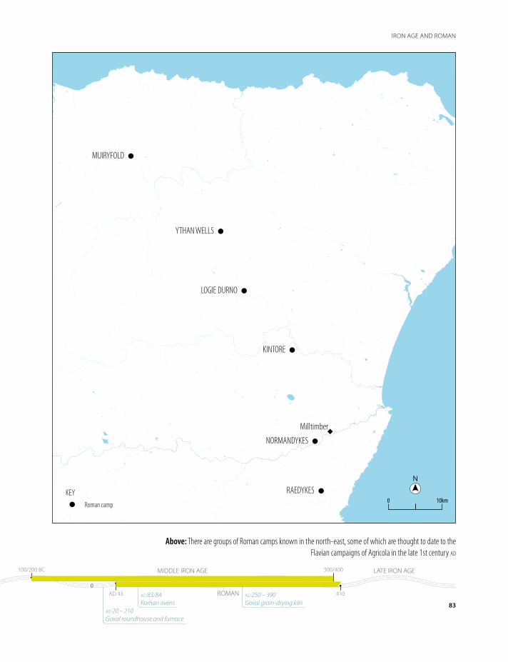
NN
10km0KEY
Roman camp
NORMANDYKES
Milltimber
LOGIE DURNO
YTHAN WELLS
MUIRYFOLD
RAEDYKES
KINTORE
Above: There are groups of Roman camps known in the north-east, some of which are thought to date to the Flavian campaigns of Agricola in the late 1st century ad
83
IRON AGE AND ROMAN
800800 100/200 BC100/200 BC 300/400300/400
AD 43AD 43 410410
EARLY IRON AGE
ROMAN
MIDDLE IRON AGE LATE IRON AGE
00
ad 20 – 210 Goval roundhouse and furnace
ad 83/84 Roman ovens
ad 250 – 390 Goval grain-drying kiln
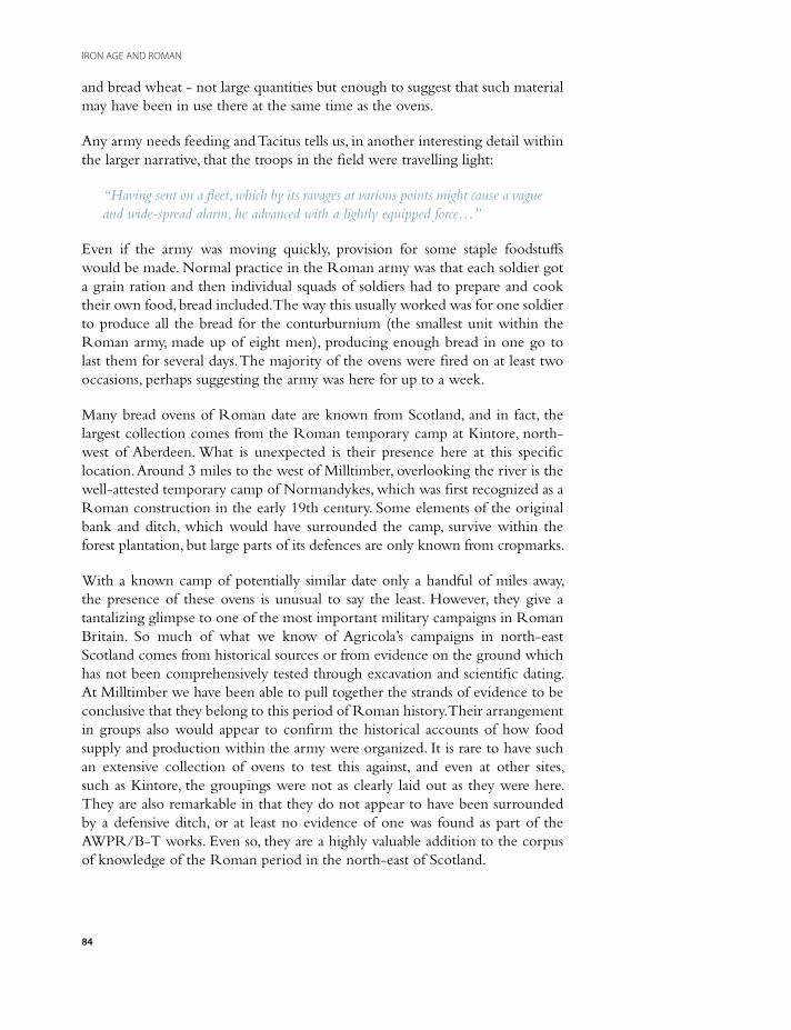
and bread wheat - not large quantities but enough to suggest that such material may have been in use there at the same time as the ovens.
Any army needs feeding and Tacitus tells us, in another interesting detail within the larger narrative, that the troops in the field were travelling light:
“Having sent on a fleet, which by its ravages at various points might cause a vague and wide-spread alarm, he advanced with a lightly equipped force…”
Even if the army was moving quickly, provision for some staple foodstuffs would be made. Normal practice in the Roman army was that each soldier got a grain ration and then individual squads of soldiers had to prepare and cook their own food, bread included. The way this usually worked was for one soldier to produce all the bread for the conturburnium (the smallest unit within the Roman army, made up of eight men), producing enough bread in one go to last them for several days. The majority of the ovens were fired on at least two occasions, perhaps suggesting the army was here for up to a week.
Many bread ovens of Roman date are known from Scotland, and in fact, the largest collection comes from the Roman temporary camp at Kintore, north-west of Aberdeen. What is unexpected is their presence here at this specific location. Around 3 miles to the west of Milltimber, overlooking the river is the well-attested temporary camp of Normandykes, which was first recognized as a Roman construction in the early 19th century. Some elements of the original bank and ditch, which would have surrounded the camp, survive within the forest plantation, but large parts of its defences are only known from cropmarks.
With a known camp of potentially similar date only a handful of miles away, the presence of these ovens is unusual to say the least. However, they give a tantalizing glimpse to one of the most important military campaigns in Roman Britain. So much of what we know of Agricola’s campaigns in north-east Scotland comes from historical sources or from evidence on the ground which has not been comprehensively tested through excavation and scientific dating. At Milltimber we have been able to pull together the strands of evidence to be conclusive that they belong to this period of Roman history. Their arrangement in groups also would appear to confirm the historical accounts of how food supply and production within the army were organized. It is rare to have such an extensive collection of ovens to test this against, and even at other sites, such as Kintore, the groupings were not as clearly laid out as they were here. They are also remarkable in that they do not appear to have been surrounded by a defensive ditch, or at least no evidence of one was found as part of the AWPR/B-T works. Even so, they are a highly valuable addition to the corpus of knowledge of the Roman period in the north-east of Scotland.
84
IRON AGE AND ROMAN

Topsoil stripping
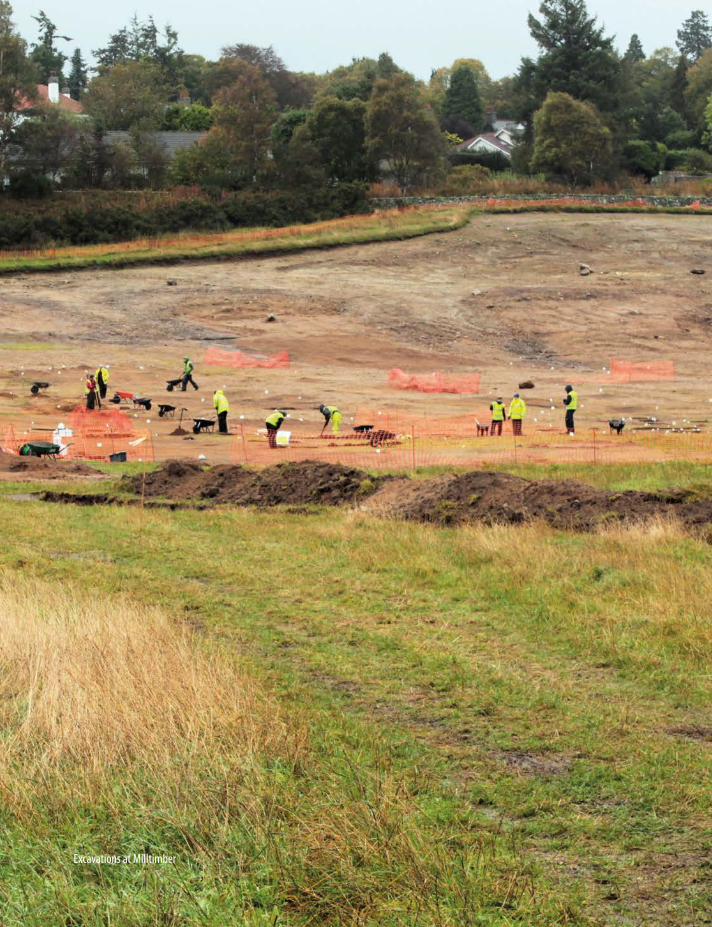
86
IRON AGE AND ROMAN
Excavations at Milltimber
The significance of the archaeology of the AWPR/B-T scheme
The Aberdeen Western Peripheral Route excavations have illustrated just what can be found and learnt when we have the opportunity to go out and look for it. In terms of the great land mass of Scotland, the excavation corridor of the AWPR/B-T covered a tiny area of the whole. However, even within such a limited area, the layers of history have been peeled back and evidence has emerged to push back the story of humankind in north-east Scotland by 3,000 years.
The archaeological timeline of the AWPR/B-T is framed by two significant discoveries. The earliest of these, evidence for Palaeolithic tool making at Milltimber, dates to a time when ice sheets still covered parts of Britain and our ‘island’ was still connected to mainland Europe. Although the identification of these tools gives only a tantalising glimpse of the inhabitants, it opens up avenues of research and investigation for the future. The methods by which they were identified, within a flint assemblage of later date, is also of considerable significance for how specialists excavate and record flint spreads.
Some 10,000 years after humans were knapping flint at Milltimber, the Roman Army was on the march along the eastern coast of Scotland. The dates and some of the details of the campaign are recorded by Roman historians, but little concrete evidence for the campaign has been identified on the ground, until now. The sheer number of ovens identified at Milltimber, when considered alongside their date and location, leaves little doubt that they relate to the movement of the Roman army through Aberdeenshire. There is always a temptation for archaeologists to seek a historical ‘event’ which we can link to the features we uncover, and occasionally to push our interpretations too far. There are, however, rare occasions, such as with the Milltimber ovens, where the historical accounts and the archaeological record collide, and a little piece is added to our knowledge, shining a light on the dim and distant past.
87
THE SIGNIFICANCE OF THE ARCHAEOLOGY OF THE AWPR/B-T SCHEME

The Aberdeen Western Peripheral Route/Balmedie to Tipperty project, also known as the Aberdeen Bypass, is a major infrastructure project in the north-east of Scotland. The construction of the new road around the western limits of the city of Aberdeen and its surrounds provided an excellent opportunity to examine the archaeology of the region.
One of the unique aspects of the project was that asa linear development, it cut across a variety of different types of landscape, many of which had rarely been investigated until now. Sites were identified dating from the very earliest period of human activity in the north-east of Scotland, right through to the recent past. This includes the discovery of previously unknown remains dating to the Upper Late Palaeolithic on the banks of the River Dee and evidence of structures and deposits of the Mesolithic and Neolithic across the whole scheme. Evidence of changes in settlement patterns were seen through a range of structures across the whole scheme, dating from the Bronze Age, and the presence of a large group of bread ovens at Milltimber provided clues to the activities of the Roman Army in the late 1st century AD.
This book provides a synthesis of the most exciting discoveries, explaining how they fit into our wider understanding of the archaeology of the region and relating them back to the landscape as it changed around them over the millennia. It also describes some of the techniques that archaeologists use to investigate the archaeology in the ground, and looks at how we analyse and interpret the results to bring different strands of evidence together and tell the story of the lives of the people of the region.
Published by Headland Archaeology (UK) Ltd13 Jane Street, Edinburgh EH6 5HE© Headland Archaeology (UK) Ltd