GTA West Corridor Environmental Assessment of Evaluation Factors and... · unless authorized by...
16
GTA West Corridor Environmental Assessment Terms of Reference August 2015 Page 1 GTA West Corridor Environmental Assessment Updated (August 2015) Summary of Evaluation Factors and Criteria for Alternative Methods
-
Upload
nguyenduong -
Category
Documents
-
view
216 -
download
0
Transcript of GTA West Corridor Environmental Assessment of Evaluation Factors and... · unless authorized by...
GTA West Corridor Environmental Assessment Terms of Reference
August 2015 Page 1
GTA West Corridor
Environmental Assessment
Updated (August 2015)
Summary of Evaluation Factors and Criteria for Alternative Methods
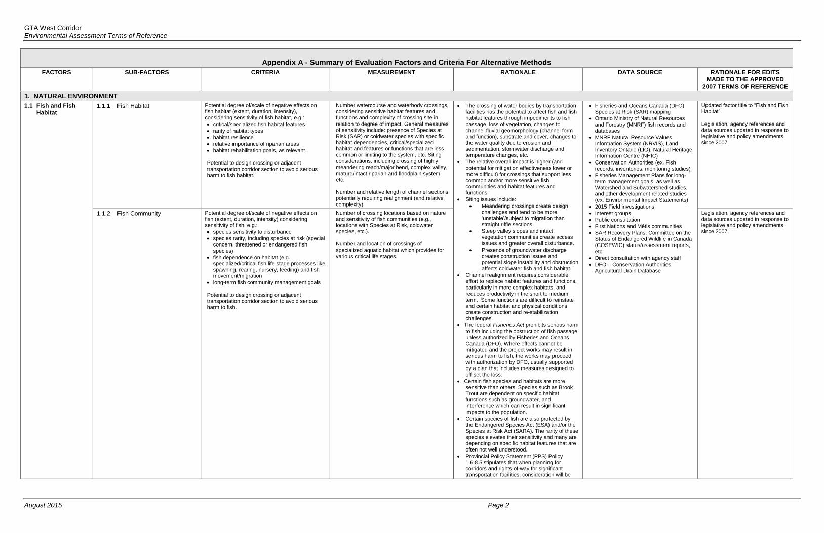
GTA West Corridor Environmental Assessment Terms of Reference
August 2015 Page 2
Appendix A - Summary of Evaluation Factors and Criteria For Alternative Methods
FACTORS SUB-FACTORS CRITERIA MEASUREMENT RATIONALE DATA SOURCE RATIONALE FOR EDITS MADE TO THE APPROVED
2007 TERMS OF REFERENCE
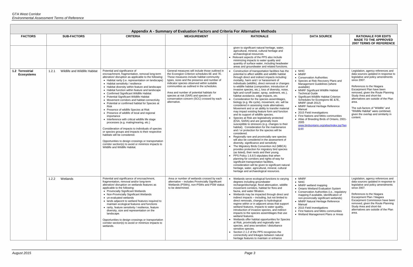
1. NATURAL ENVIRONMENT
1.1 Fish and Fish Habitat
1.1.1 Fish Habitat
Potential degree of/scale of negative effects on fish habitat (extent, duration, intensity), considering sensitivity of fish habitat, e.g.:
critical/specialized fish habitat features
rarity of habitat types
habitat resilience
relative importance of riparian areas
habitat rehabilitation goals, as relevant Potential to design crossing or adjacent transportation corridor section to avoid serious harm to fish habitat.
Number watercourse and waterbody crossings, considering sensitive habitat features and functions and complexity of crossing site in relation to degree of impact. General measures of sensitivity include: presence of Species at Risk (SAR) or coldwater species with specific habitat dependencies, critical/specialized habitat and features or functions that are less common or limiting to the system, etc. Siting considerations, including crossing of highly meandering reach/major bend, complex valley, mature/intact riparian and floodplain system etc. Number and relative length of channel sections potentially requiring realignment (and relative complexity).
The crossing of water bodies by transportation facilities has the potential to affect fish and fish habitat features through impediments to fish passage, loss of vegetation, changes to channel fluvial geomorphology (channel form and function), substrate and cover, changes to the water quality due to erosion and sedimentation, stormwater discharge and temperature changes, etc.
The relative overall impact is higher (and potential for mitigation effectiveness lower or more difficult) for crossings that support less common and/or more sensitive fish communities and habitat features and functions.
Siting issues include:
Meandering crossings create design challenges and tend to be more ‘unstable’/subject to migration than straight riffle sections.
Steep valley slopes and intact vegetation communities create access issues and greater overall disturbance.
Presence of groundwater discharge creates construction issues and potential slope instability and obstruction affects coldwater fish and fish habitat.
Channel realignment requires considerable effort to replace habitat features and functions, particularly in more complex habitats, and reduces productivity in the short to medium term. Some functions are difficult to reinstate and certain habitat and physical conditions create construction and re-stabilization challenges.
The federal Fisheries Act prohibits serious harm to fish including the obstruction of fish passage unless authorized by Fisheries and Oceans Canada (DFO). Where effects cannot be mitigated and the project works may result in serious harm to fish, the works may proceed with authorization by DFO, usually supported by a plan that includes measures designed to off-set the loss.
Certain fish species and habitats are more sensitive than others. Species such as Brook Trout are dependent on specific habitat functions such as groundwater, and interference which can result in significant impacts to the population.
Certain species of fish are also protected by the Endangered Species Act (ESA) and/or the Species at Risk Act (SARA). The rarity of these species elevates their sensitivity and many are depending on specific habitat features that are often not well understood.
Provincial Policy Statement (PPS) Policy 1.6.8.5 stipulates that when planning for corridors and rights-of-way for significant transportation facilities, consideration will be
Fisheries and Oceans Canada (DFO) Species at Risk (SAR) mapping
Ontario Ministry of Natural Resources and Forestry (MNRF) fish records and databases
MNRF Natural Resource Values Information System (NRVIS), Land Inventory Ontario (LIO), Natural Heritage Information Centre (NHIC)
Conservation Authorities (ex. Fish records, inventories, monitoring studies)
Fisheries Management Plans for long-term management goals, as well as Watershed and Subwatershed studies, and other development related studies (ex. Environmental Impact Statements)
2015 Field investigations
Interest groups
Public consultation
First Nations and Métis communities
SAR Recovery Plans, Committee on the Status of Endangered Wildlife in Canada (COSEWIC) status/assessment reports, etc.
Direct consultation with agency staff
DFO – Conservation Authorities Agricultural Drain Database
Updated factor title to “Fish and Fish Habitat”. Legislation, agency references and data sources updated in response to legislative and policy amendments since 2007.
1.1.2 Fish Community
Potential degree of/scale of negative effects on fish (extent, duration, intensity) considering sensitivity of fish, e.g.:
species sensitivity to disturbance
species rarity, including species at risk (special concern, threatened or endangered fish species)
fish dependence on habitat (e.g. specialized/critical fish life stage processes like spawning, rearing, nursery, feeding) and fish movement/migration
long-term fish community management goals Potential to design crossing or adjacent transportation corridor section to avoid serious harm to fish.
Number of crossing locations based on nature and sensitivity of fish communities (e.g., locations with Species at Risk, coldwater species, etc.). Number and location of crossings of specialized aquatic habitat which provides for various critical life stages.
Legislation, agency references and data sources updated in response to legislative and policy amendments since 2007.
GTA West Corridor Environmental Assessment Terms of Reference
August 2015 Page 3
Appendix A - Summary of Evaluation Factors and Criteria For Alternative Methods
FACTORS SUB-FACTORS CRITERIA MEASUREMENT RATIONALE DATA SOURCE RATIONALE FOR EDITS MADE TO THE APPROVED
2007 TERMS OF REFERENCE
given to significant natural heritage, water, agricultural, mineral, cultural heritage and archaeological resources.
Relevant aspects of the PPS also include minimizing impacts to water quality and quantity of surface water, including headwater areas and groundwater and related functions.
1.2 Terrestrial Ecosystems
1.2.1 Wildlife and Wildlife Habitat Potential and significance of encroachment, fragmentation, removal long-term alteration/ disruption as applicable to the following:
Habitat rarity (i.e. representation on landscape)
Habitat sensitivity / resilience
Habitat diversity within feature and landscape
Habitat function within feature and landscape
Confirmed Significant Wildlife Habitat
Potential Significant Wildlife Habitat
Movement corridors and habitat connectivity
Potential or confirmed habitat for Species at Risk
Presence of wildlife Species at Risk
Presence of wildlife of local and regional importance
Interference with critical wildlife life stage processes (e.g. mating/rearing, etc.)
Consideration of impacts to individuals of species or species groups and impacts to their respective habitats will be considered. Opportunities to design crossings or transportation corridor section(s) to avoid or minimize impacts to Wildlife and Wildlife Habitat.
General measures will include those outlined in the Ecoregion Criterion schedules 6E and 7E. These measures include habitat community types, sizes and the presence and number of indicator species observed within suitable communities as outlined in the schedules. Area and number of potential habitats for species at risk (SAR) and species of conservation concern (SCC) crossed by each alternative.
Construction of transportation facilities has the potential to affect wildlife and wildlife habitat through direct and indirect impacts including: mortality, harm and / or harassment of individuals (wildlife), direct removal or changes to wildlife habitat (composition, introduction of invasive species, etc.), loss of diversity, noise, light and runoff (water, spray, sediment, etc.), habitat avoidance, edge impacts, etc.
Consideration for the species assemblages, biology (e.g. life cycle), movement, etc. will be considered in assessing route alternatives. Movement and or an ability to transfer material may impact existing feature form and function and its support of wildlife species.
Species at Risk are legislatively protected (ESA, SARA) and are generally more susceptible to stressors (e.g. changes to their habitat). Consideration for the maintenance and / or protection for the species will be considered.
Regionally rare and provincially rare species will also be considered in the assessment of diversity, significance and sensitivity
The Migratory Birds Convention Act (MBCA) provides protection for migratory bird species (as listed), their nests and their young.
PPS Policy 1.6.8.5 stipulates that when planning for corridors and rights-of-way for significant transportation facilities, consideration will be given to significant natural heritage, water, agricultural, mineral, cultural heritage and archaeological resources.
NHIC
MNRF
Conservation Authorities
Species at Risk Recovery Plans and Management Guidelines (where available)
MNRF Significant Wildlife Habitat Technical Guide
Significant Wildlife Habitat Criterion Schedules for Ecoregions 6E &7E, MNRF (draft 2012)
MNRF Natural Heritage Reference Manual
2015 Field investigations
First Nations and Métis communities
Atlas of Breeding Birds of Ontario, 2001-2005 www.birdsontario.org/atlas/index.jsp?lang-en
Legislation, agency references and data sources updated in response to legislative and policy amendments since 2007. References to the Niagara Escarpment Plan have been removed, given the Route Planning Study Area and short-list alternatives are outside of the Plan area. The sub-factors of “Wildlife” and “Wildlife Habitat” were combined, given the overlap and similarity in content.
1.2.2 Wetlands Potential and significance of encroachment, fragmentation, removal and/or long-term alteration/ disruption on wetlands features as applicable to the following:
Provincially Significant Wetlands
Non-Provincially Significant Wetlands
un-evaluated wetlands
lands adjacent to wetland features required to maintain ecological features and functions
rarity, feature sensitivity / resilience, feature diversity, size and representation on the landscape.
Opportunities to design crossings or transportation corridor section(s) to avoid or minimize impacts to wetlands.
Area or number of wetlands crossed by each alternative – includes Provincially Significant Wetlands (PSWs), non-PSWs and PSW status to be determined.
Wetlands serve ecological functions to varying degrees including groundwater recharge/discharge, flood attenuation, wildlife movement corridors, habitat for flora and fauna, and water filtration.
Wetlands may be impacted through direct and indirect impacts – including, but not limited to direct removals, changes to hydrological regime within or in adjacent areas that support wetland features, impacts to water quality, introduction of invasive species, and indirect impacts to the species assemblages that use wetland features.
Wetlands offer habitat opportunities for Species at Risk, provincially and regionally rare species, and area sensitive / disturbance sensitive species.
Section 2.1.2 of the PPS recognizes the connectivity and linkages between natural heritage features to maintain or enhance
MNRF
NHIC
MNRF wetland mapping
Ontario Wetland Evaluation System
Conservation Authorities (i.e., regulatory mapping if available, identification of non-provincially significant wetlands)
MNRF Natural Heritage Reference Manual
2015 Field investigations First Nations and Métis communities Wetland Management Plans or Areas
Legislation, agency references and data sources updated in response to legislative and policy amendments since 2007. References to the Niagara Escarpment Plan / Niagara Escarpment Commission have been removed, given the Route Planning Study Area and short-list alternatives are outside of the Plan area.

GTA West Corridor Environmental Assessment Terms of Reference
August 2015 Page 4
Appendix A - Summary of Evaluation Factors and Criteria For Alternative Methods
FACTORS SUB-FACTORS CRITERIA MEASUREMENT RATIONALE DATA SOURCE RATIONALE FOR EDITS MADE TO THE APPROVED
2007 TERMS OF REFERENCE
natural heritage systems where possible, including groundwater and surface water connectivity with natural heritage features and functions.
PPS Policy 1.6.8.5 stipulates that when planning for corridors and rights-of-way for significant transportation facilities, consideration will be given to significant natural heritage, water, agricultural, mineral, cultural heritage and archaeological resources.
1.2.3 Woodlands and Vegetation Potential and significance of encroachment, fragmentation, removal and the long-term alteration/ disruption as applicable to the following:
significant woodlands
significant valley lands
rarity, feature sensitivity/resilience, feature diversity, size and representation on the landscape
individuals/populations or habitats for vegetation Species at Risk
individuals / populations or significant habitat representation for vegetation species of provincial or regional / local conservation
Opportunities to design crossings or highway section(s) to avoid or minimize impacts to woodlands and other vegetation.
Area of impact on significant woodlands, large intact habitat blocks, and associated wildlife habitat.
Area of vegetation patches not associated with woodlands but may provide habitat for specialized species, (i.e. grassland birds, early-successional significant wildlife habitat, etc.).
Woodlands serve ecological functions to varying degrees including providing multi-trophic habitat for wildlife, soil stability, carbon cycling, etc.
Woodlands may be impacted through direct and indirect impacts – including, but not limited to direct removals, changes to lot size, fragmentation, introduction of invasive species, and indirect impacts to the species assemblages that use woodland features.
Portions of the study area are located within the Carolinian Zone and may have important representations of Carolinian species assemblages.
Small degraded, isolated remnant woodlots and wetlands can have ecological value.
Large natural and relatively undisturbed features have high ecological sensitivity and value.
Woodlands and other vegetation communities (e.g. prairies / grasslands) offer habitat opportunities for Species at Risk, provincially and regionally rare species, and area sensitive / disturbance-sensitive species.
NHIC
LIO / NRVIS
MNRF
MNR Natural Heritage Reference Manual (2010)
Conservation Authorities
Significant Wildlife Habitat Technical Guide
Management Plans
2015 Field investigations First Nations and Métis communities Vegetation management,
rehabilitation/research program sites
Legislation, agency references and data sources updated in response to legislative and policy amendments since 2007. References to the Niagara Escarpment Plan have been removed, given the Route Planning Study Area and short-list alternatives are outside of the Plan area.
1.2.4 Designated/Special/ Natural Areas
Potential and significance of encroachment, fragmentation and removal, and long-term alteration/ disruption as applicable to the following:
purpose / rationale for original designation (i.e. relative potential to affect the core feature / function designated);
impact to the designated feature / function;
change in area character/ aesthetics of the features / area;
impact to the overall designation (i.e. does the impact potential effect the purpose of the designation).
Designated natural areas, such as heritage rivers, Environmentally Significant Areas (ESAs), Environmentally Sensitive Policy Areas, Areas of Natural and Scientific Interest (ANSIs), Natural Heritage System(s), conservation lands (e.g. management tracts, reserves); and the designated special areas of national parks, provincial parks, conservation areas, etc.
Numbers or areas of ESAs, ANSIs, Greenbelt areas affected by each route alternative
Elements of the features and functions may be captured under other criteria, however specific consideration must be given to designated areas as they may represent as a whole: o High quality examples of life or earth
science features o A connected system designed for the
maintenance or enhancement of natural features and functions at a regional or provincial scale
o Recognition of the area relative to historic, aboriginal and/or social importance
Designated features have already been evaluated against a set of criteria to determine their significance at scale (municipal, provincial, federal), and due consideration should be made for these features within the evaluation of alternatives.
PPS Policy 1.6.8.5 stipulates that when planning for corridors and rights-of-way for significant transportation facilities, consideration will be given to significant natural heritage, water, agricultural, mineral, cultural heritage and archaeological resources.
Identified by municipality, Conservation Authority, MNRF, Interest Groups or other background sources
Bird Studies Canada
Significant Wildlife Habitat Technical Guide
MNRF Natural Heritage Reference Manual
Greenbelt Plan
Oak Ridges Moraine
First Nations and Métis communities 2015 Field investigations
Legislation and agency references updated in response to legislative and policy amendments since 2007. References to the Niagara Escarpment Plan have been removed, given the Route Planning Study Area and short-list alternatives are outside of the Plan area.
GTA West Corridor Environmental Assessment Terms of Reference
August 2015 Page 5
Appendix A - Summary of Evaluation Factors and Criteria For Alternative Methods
FACTORS SUB-FACTORS CRITERIA MEASUREMENT RATIONALE DATA SOURCE RATIONALE FOR EDITS MADE TO THE APPROVED
2007 TERMS OF REFERENCE
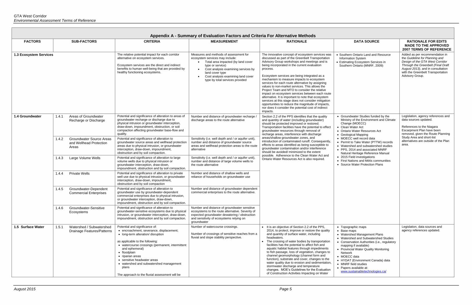
1.3 Ecosystem Services The relative potential impact for each corridor alternative on ecosystem services. Ecosystem services are the direct and indirect benefits to human well-being that are provided by healthy functioning ecosystems.
Measures and methods of assessment for ecosystem services may include:
Total area impacted (by land cover type or service)
Cost analysis examining services by land cover type
Cost analysis examining land cover type by total services provided
The innovative concept of ecosystem services was discussed as part of the Greenbelt Transportation Advisory Group workshops and meetings and is being incorporated in the current evaluation process. Ecosystem services are being integrated as a mechanism to measure impacts to ecosystem services for each route alternative by assigning values to non-market services. This allows the Project Team and MTO to consider the relative impact on ecosystem services between each route alternative. It is important to note that ecosystem services at this stage does not consider mitigation opportunities to reduce the magnitude of impacts, nor does it consider the potential cost of indirect impacts.
Southern Ontario Land and Resource Information System
Estimating Ecosystem Services in Southern Ontario (MNRF, 2009)
Added as per recommendation in the Guideline for Planning and Design of the GTA West Corridor Through the Greenbelt (Final Draft August 2013), and in consultation with the Greenbelt Transportation Advisory Group.
1.4 Groundwater 1.4.1 Areas of Groundwater Recharge or Discharge
Potential and significance of alteration to areas of groundwater recharge or discharge due to physical intrusion or groundwater interception, draw-down, impoundment, obstruction, or soil compaction affecting groundwater base-flow and quality.
Number and distance of groundwater recharge / discharge areas to the route alternative
Section 2.2 of the PPS identifies that the quality and quantity of water (including groundwater) should be protected improved or restored. Transportation facilities have the potential to effect groundwater resources through removal of recharge areas, interference with discharge areas/shallow groundwater zones, and introduction of contaminated runoff. Consequently, effects to areas identified as being susceptible to groundwater contamination and/or interference should be avoided/ minimized to the extent possible. Adherence to the Clean Water Act and Ontario Water Resources Act is also required.
Groundwater Studies funded by the Ministry of the Environment and Climate Change (MOECC)
Clean Water Act
Ontario Water Resources Act
Geological Mapping
MOECC well record data
Permit to Take Water (PTTW) records
Watershed and subwatershed studies
PPS, 2014 and associated MNRF Natural Heritage Reference Manual
2015 Field investigations First Nations and Métis communities Source Water Protection Plans
Legislation, agency references and data sources updated. References to the Niagara Escarpment Plan have been removed, given the Route Planning Study Area and short-list alternatives are outside of the Plan area.
1.4.2 Groundwater Source Areas and Wellhead Protection Areas
Potential and significance of alteration to groundwater source areas and wellhead protection areas due to physical intrusion, or groundwater interception, draw-down, impoundment, obstruction and by soil compaction.
Sensitivity (i.e. well depth and / or aquifer unit), number and distance of groundwater source areas and wellhead protection areas to the route alternative
1.4.3 Large Volume Wells Potential and significance of alteration to large volume wells due to physical intrusion or groundwater interception, draw-down, impoundment, obstruction and by soil compaction.
Sensitivity (i.e. well depth and / or aquifer unit), number and distance of large volume wells to the route alternative
1.4.4 Private Wells Potential and significance of alteration to private well use due to physical intrusion, or groundwater interception, draw-down, impoundment, obstruction and by soil compaction
Number and distance of shallow wells and reliance of households on groundwater use
1.4.5 Groundwater-Dependent Commercial Enterprises
Potential and significance of alteration to groundwater use by groundwater-dependent commercial enterprises due to physical intrusion, or groundwater interception, draw-down, impoundment, obstruction and by soil compaction.
Number and distance of groundwater dependent commercial enterprises to the route alternative.
1.4.6 Groundwater-Sensitive Ecosystems
Potential and significance of alteration to groundwater-sensitive ecosystems due to physical intrusion, or groundwater interception, draw-down, impoundment, obstruction and by soil compaction.
Number and distance of groundwater sensitive ecosystems to the route alternative. Severity of expected groundwater dewatering / obstruction and sensitivity of ecosystems relying on groundwater
1.5 Surface Water 1.5.1 Watershed / Subwatershed Drainage Features/Patterns
Potential and significance of:
encroachment, severance, displacement;
long-term alteration/ disruption as applicable to the following:
watercourse crossings (permanent, intermittent and ephemeral)
floodplain
riparian areas
sensitive headwater areas watershed and subwatershed management
plans The approach to the fluvial assessment will be
Number of watercourse crossings. Number of crossings of sensitive reaches from a fluvial and slope stability perspective.
It is an objective of Section 2.2 of the PPS, 2014, to protect, improve or restore the quality and quantity of surface water, including headwaters.
The crossing of water bodies by transportation facilities has the potential to affect fish and aquatic habitat features through impediments to fish passage, loss of vegetation, changes to channel geomorphology (channel form and function), substrate and cover, changes to the water quality due to erosion and sedimentation, stormwater discharge and temperature changes. MOE’s Guidelines for the Evaluation of Construction Activities Impacting on Water
Topographic maps
Base maps
Watershed Management Plans
Watershed and Subwatershed Studies
Conservation Authorities (i.e., regulatory mapping if available)
Provincial Water Quality Monitoring Network
MOECC data
HYDAT (Environment Canada) data
MNRF field studies
Papers available at: www.sustainabletechnologies.ca/
Legislation, data sources and agency references updated.
GTA West Corridor Environmental Assessment Terms of Reference
August 2015 Page 6
Appendix A - Summary of Evaluation Factors and Criteria For Alternative Methods
FACTORS SUB-FACTORS CRITERIA MEASUREMENT RATIONALE DATA SOURCE RATIONALE FOR EDITS MADE TO THE APPROVED
2007 TERMS OF REFERENCE
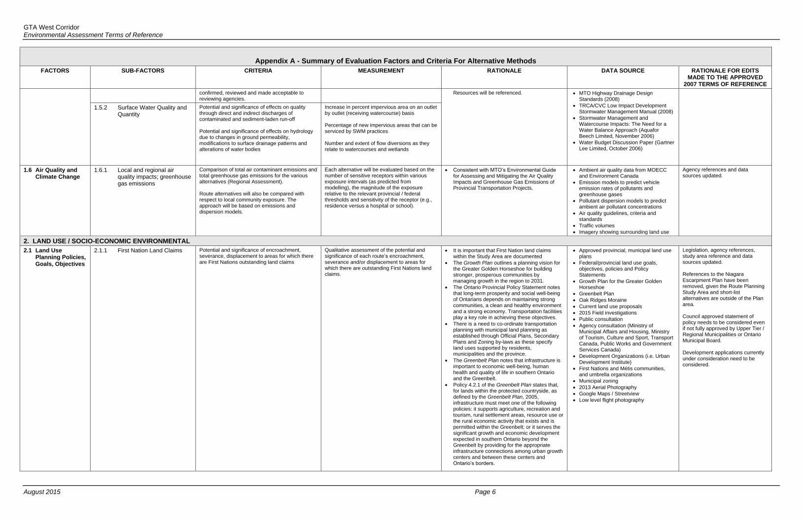
confirmed, reviewed and made acceptable to reviewing agencies.
Resources will be referenced. MTO Highway Drainage Design Standards (2008)
TRCA/CVC Low Impact Development Stormwater Management Manual (2008)
Stormwater Management and Watercourse Impacts: The Need for a Water Balance Approach (Aquafor Beech Limited, November 2006)
Water Budget Discussion Paper (Gartner Lee Limited, October 2006)
1.5.2 Surface Water Quality and Quantity
Potential and significance of effects on quality through direct and indirect discharges of contaminated and sediment-laden run-off Potential and significance of effects on hydrology due to changes in ground permeability, modifications to surface drainage patterns and alterations of water bodies
Increase in percent impervious area on an outlet by outlet (receiving watercourse) basis Percentage of new impervious areas that can be serviced by SWM practices Number and extent of flow diversions as they relate to watercourses and wetlands
1.6 Air Quality and Climate Change
1.6.1 Local and regional air quality impacts; greenhouse gas emissions
Comparison of total air contaminant emissions and total greenhouse gas emissions for the various alternatives (Regional Assessment). Route alternatives will also be compared with respect to local community exposure. The approach will be based on emissions and dispersion models.
Each alternative will be evaluated based on the number of sensitive receptors within various exposure intervals (as predicted from modelling), the magnitude of the exposure relative to the relevant provincial / federal thresholds and sensitivity of the receptor (e.g., residence versus a hospital or school).
Consistent with MTO’s Environmental Guide for Assessing and Mitigating the Air Quality Impacts and Greenhouse Gas Emissions of Provincial Transportation Projects,
Ambient air quality data from MOECC and Environment Canada
Emission models to predict vehicle emission rates of pollutants and greenhouse gases
Pollutant dispersion models to predict ambient air pollutant concentrations
Air quality guidelines, criteria and standards
Traffic volumes Imagery showing surrounding land use
Agency references and data sources updated.
2. LAND USE / SOCIO-ECONOMIC ENVIRONMENTAL
2.1 Land Use Planning Policies, Goals, Objectives
2.1.1 First Nation Land Claims Potential and significance of encroachment, severance, displacement to areas for which there are First Nations outstanding land claims
Qualitative assessment of the potential and significance of each route’s encroachment, severance and/or displacement to areas for which there are outstanding First Nations land claims.
It is important that First Nation land claims within the Study Area are documented
The Growth Plan outlines a planning vision for the Greater Golden Horseshoe for building stronger, prosperous communities by managing growth in the region to 2031.
The Ontario Provincial Policy Statement notes that long-term prosperity and social well-being of Ontarians depends on maintaining strong communities, a clean and healthy environment and a strong economy. Transportation facilities play a key role in achieving these objectives.
There is a need to co-ordinate transportation planning with municipal land planning as established through Official Plans, Secondary Plans and Zoning by-laws as these specify land uses supported by residents, municipalities and the province.
The Greenbelt Plan notes that infrastructure is important to economic well-being, human health and quality of life in southern Ontario and the Greenbelt.
Policy 4.2.1 of the Greenbelt Plan states that, for lands within the protected countryside, as defined by the Greenbelt Plan, 2005, infrastructure must meet one of the following policies: it supports agriculture, recreation and tourism, rural settlement areas, resource use or the rural economic activity that exists and is permitted within the Greenbelt; or it serves the significant growth and economic development expected in southern Ontario beyond the Greenbelt by providing for the appropriate infrastructure connections among urban growth centers and between these centers and Ontario’s borders.
Approved provincial, municipal land use plans
Federal/provincial land use goals, objectives, policies and Policy Statements
Growth Plan for the Greater Golden Horseshoe
Greenbelt Plan
Oak Ridges Moraine
Current land use proposals
2015 Field investigations
Public consultation
Agency consultation (Ministry of Municipal Affairs and Housing, Ministry of Tourism, Culture and Sport, Transport Canada, Public Works and Government Services Canada)
Development Organizations (i.e. Urban Development Institute)
First Nations and Métis communities, and umbrella organizations
Municipal zoning 2013 Aerial Photography Google Maps / Streetview Low level flight photography
Legislation, agency references, study area reference and data sources updated. References to the Niagara Escarpment Plan have been removed, given the Route Planning Study Area and short-list alternatives are outside of the Plan area. Council approved statement of policy needs to be considered even if not fully approved by Upper Tier / Regional Municipalities or Ontario Municipal Board. Development applications currently under consideration need to be considered.
GTA West Corridor Environmental Assessment Terms of Reference
August 2015 Page 7
Appendix A - Summary of Evaluation Factors and Criteria For Alternative Methods
FACTORS SUB-FACTORS CRITERIA MEASUREMENT RATIONALE DATA SOURCE RATIONALE FOR EDITS MADE TO THE APPROVED
2007 TERMS OF REFERENCE
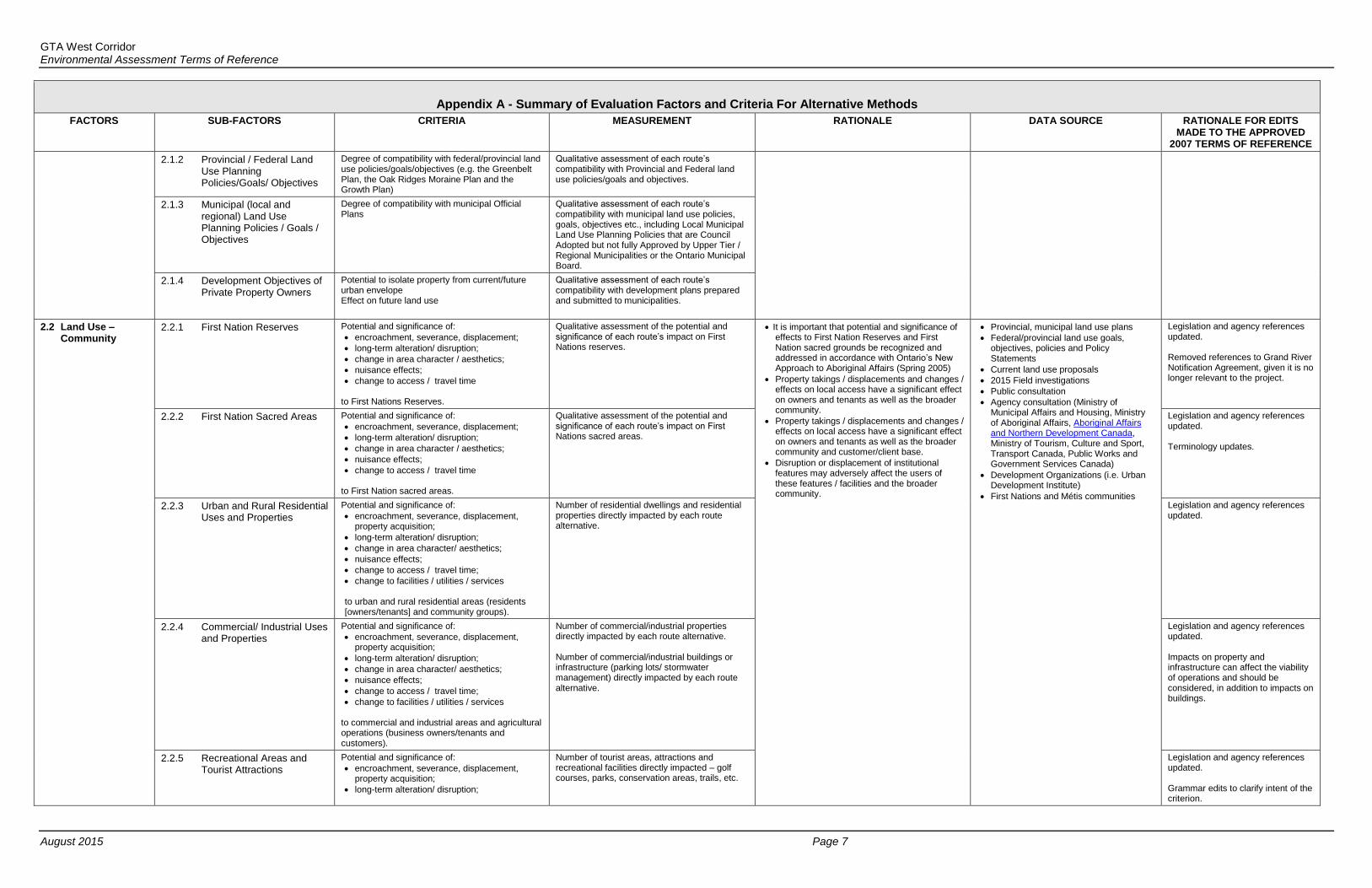
2.1.2 Provincial / Federal Land Use Planning Policies/Goals/ Objectives
Degree of compatibility with federal/provincial land use policies/goals/objectives (e.g. the Greenbelt Plan, the Oak Ridges Moraine Plan and the Growth Plan)
Qualitative assessment of each route’s compatibility with Provincial and Federal land use policies/goals and objectives.
2.1.3 Municipal (local and regional) Land Use Planning Policies / Goals / Objectives
Degree of compatibility with municipal Official Plans
Qualitative assessment of each route’s compatibility with municipal land use policies, goals, objectives etc., including Local Municipal Land Use Planning Policies that are Council Adopted but not fully Approved by Upper Tier / Regional Municipalities or the Ontario Municipal Board.
2.1.4 Development Objectives of Private Property Owners
Potential to isolate property from current/future urban envelope Effect on future land use
Qualitative assessment of each route’s compatibility with development plans prepared and submitted to municipalities.
2.2 Land Use – Community
2.2.1 First Nation Reserves Potential and significance of:
encroachment, severance, displacement;
long-term alteration/ disruption;
change in area character / aesthetics;
nuisance effects;
change to access / travel time to First Nations Reserves.
Qualitative assessment of the potential and significance of each route’s impact on First Nations reserves.
It is important that potential and significance of effects to First Nation Reserves and First Nation sacred grounds be recognized and addressed in accordance with Ontario’s New Approach to Aboriginal Affairs (Spring 2005)
Property takings / displacements and changes / effects on local access have a significant effect on owners and tenants as well as the broader community.
Property takings / displacements and changes / effects on local access have a significant effect on owners and tenants as well as the broader community and customer/client base.
Disruption or displacement of institutional features may adversely affect the users of these features / facilities and the broader community.
Provincial, municipal land use plans
Federal/provincial land use goals, objectives, policies and Policy Statements
Current land use proposals
2015 Field investigations
Public consultation
Agency consultation (Ministry of Municipal Affairs and Housing, Ministry of Aboriginal Affairs, Aboriginal Affairs and Northern Development Canada, Ministry of Tourism, Culture and Sport, Transport Canada, Public Works and Government Services Canada)
Development Organizations (i.e. Urban Development Institute)
First Nations and Métis communities
Legislation and agency references updated. Removed references to Grand River Notification Agreement, given it is no longer relevant to the project.
2.2.2 First Nation Sacred Areas Potential and significance of:
encroachment, severance, displacement;
long-term alteration/ disruption;
change in area character / aesthetics;
nuisance effects;
change to access / travel time to First Nation sacred areas.
Qualitative assessment of the potential and significance of each route’s impact on First Nations sacred areas.
Legislation and agency references updated. Terminology updates.
2.2.3 Urban and Rural Residential Uses and Properties
Potential and significance of:
encroachment, severance, displacement, property acquisition;
long-term alteration/ disruption;
change in area character/ aesthetics;
nuisance effects;
change to access / travel time;
change to facilities / utilities / services to urban and rural residential areas (residents [owners/tenants] and community groups).
Number of residential dwellings and residential properties directly impacted by each route alternative.
Legislation and agency references updated.
2.2.4 Commercial/ Industrial Uses and Properties
Potential and significance of:
encroachment, severance, displacement, property acquisition;
long-term alteration/ disruption;
change in area character/ aesthetics;
nuisance effects;
change to access / travel time;
change to facilities / utilities / services to commercial and industrial areas and agricultural operations (business owners/tenants and customers).
Number of commercial/industrial properties directly impacted by each route alternative. Number of commercial/industrial buildings or infrastructure (parking lots/ stormwater management) directly impacted by each route alternative.
Legislation and agency references updated. Impacts on property and infrastructure can affect the viability of operations and should be considered, in addition to impacts on buildings.
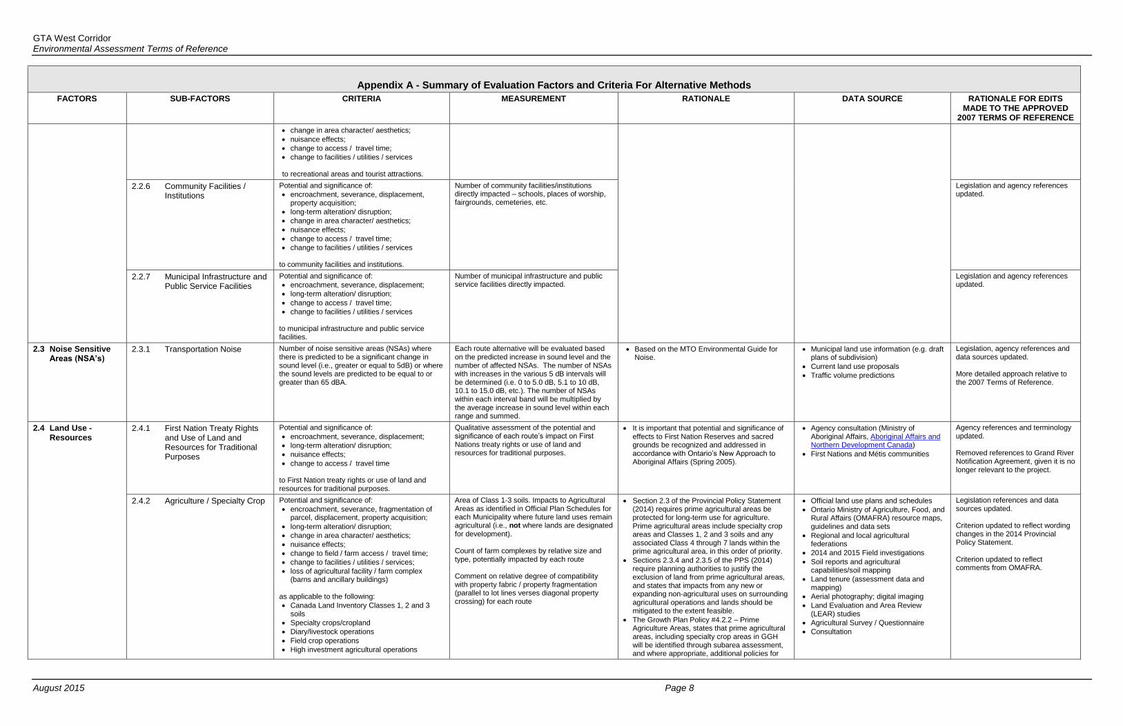
2.2.5 Recreational Areas and Tourist Attractions
Potential and significance of:
encroachment, severance, displacement, property acquisition;
long-term alteration/ disruption;
Number of tourist areas, attractions and recreational facilities directly impacted – golf courses, parks, conservation areas, trails, etc.
Legislation and agency references updated. Grammar edits to clarify intent of the criterion.
GTA West Corridor Environmental Assessment Terms of Reference
August 2015 Page 8
Appendix A - Summary of Evaluation Factors and Criteria For Alternative Methods
FACTORS SUB-FACTORS CRITERIA MEASUREMENT RATIONALE DATA SOURCE RATIONALE FOR EDITS MADE TO THE APPROVED
2007 TERMS OF REFERENCE
change in area character/ aesthetics;
nuisance effects;
change to access / travel time;
change to facilities / utilities / services to recreational areas and tourist attractions.
2.2.6 Community Facilities / Institutions
Potential and significance of:
encroachment, severance, displacement, property acquisition;
long-term alteration/ disruption;
change in area character/ aesthetics;
nuisance effects;
change to access / travel time;
change to facilities / utilities / services to community facilities and institutions.
Number of community facilities/institutions directly impacted – schools, places of worship, fairgrounds, cemeteries, etc.
Legislation and agency references updated.
2.2.7 Municipal Infrastructure and Public Service Facilities
Potential and significance of:
encroachment, severance, displacement;
long-term alteration/ disruption;
change to access / travel time;
change to facilities / utilities / services to municipal infrastructure and public service facilities.
Number of municipal infrastructure and public service facilities directly impacted.
Legislation and agency references updated.
2.3 Noise Sensitive Areas (NSA’s)
2.3.1 Transportation Noise Number of noise sensitive areas (NSAs) where there is predicted to be a significant change in sound level (i.e., greater or equal to 5dB) or where the sound levels are predicted to be equal to or greater than 65 dBA.
Each route alternative will be evaluated based on the predicted increase in sound level and the number of affected NSAs. The number of NSAs with increases in the various 5 dB intervals will be determined (i.e. 0 to 5.0 dB, 5.1 to 10 dB, 10.1 to 15.0 dB, etc.). The number of NSAs within each interval band will be multiplied by the average increase in sound level within each range and summed.
Based on the MTO Environmental Guide for Noise.
Municipal land use information (e.g. draft plans of subdivision)
Current land use proposals
Traffic volume predictions
Legislation, agency references and data sources updated. More detailed approach relative to the 2007 Terms of Reference.
2.4 Land Use - Resources
2.4.1 First Nation Treaty Rights and Use of Land and Resources for Traditional Purposes
Potential and significance of:
encroachment, severance, displacement;
long-term alteration/ disruption;
nuisance effects;
change to access / travel time to First Nation treaty rights or use of land and resources for traditional purposes.
Qualitative assessment of the potential and significance of each route’s impact on First Nations treaty rights or use of land and resources for traditional purposes.
It is important that potential and significance of effects to First Nation Reserves and sacred grounds be recognized and addressed in accordance with Ontario’s New Approach to Aboriginal Affairs (Spring 2005).
Agency consultation (Ministry of Aboriginal Affairs, Aboriginal Affairs and Northern Development Canada)
First Nations and Métis communities
Agency references and terminology updated. Removed references to Grand River Notification Agreement, given it is no longer relevant to the project.
2.4.2 Agriculture / Specialty Crop Potential and significance of:
encroachment, severance, fragmentation of parcel, displacement, property acquisition;
long-term alteration/ disruption;
change in area character/ aesthetics;
nuisance effects;
change to field / farm access / travel time;
change to facilities / utilities / services;
loss of agricultural facility / farm complex (barns and ancillary buildings)
as applicable to the following:
Canada Land Inventory Classes 1, 2 and 3 soils
Specialty crops/cropland
Diary/livestock operations
Field crop operations
High investment agricultural operations
Area of Class 1-3 soils. Impacts to Agricultural Areas as identified in Official Plan Schedules for each Municipality where future land uses remain agricultural (i.e., not where lands are designated for development). Count of farm complexes by relative size and type, potentially impacted by each route Comment on relative degree of compatibility with property fabric / property fragmentation (parallel to lot lines verses diagonal property crossing) for each route
Section 2.3 of the Provincial Policy Statement (2014) requires prime agricultural areas be protected for long-term use for agriculture. Prime agricultural areas include specialty crop areas and Classes 1, 2 and 3 soils and any associated Class 4 through 7 lands within the prime agricultural area, in this order of priority.
Sections 2.3.4 and 2.3.5 of the PPS (2014) require planning authorities to justify the exclusion of land from prime agricultural areas, and states that impacts from any new or expanding non-agricultural uses on surrounding agricultural operations and lands should be mitigated to the extent feasible.
The Growth Plan Policy #4.2.2 – Prime Agriculture Areas, states that prime agricultural areas, including specialty crop areas in GGH will be identified through subarea assessment, and where appropriate, additional policies for
Official land use plans and schedules
Ontario Ministry of Agriculture, Food, and Rural Affairs (OMAFRA) resource maps, guidelines and data sets
Regional and local agricultural federations
2014 and 2015 Field investigations
Soil reports and agricultural capabilities/soil mapping
Land tenure (assessment data and mapping)
Aerial photography; digital imaging Land Evaluation and Area Review
(LEAR) studies Agricultural Survey / Questionnaire Consultation
Legislation references and data sources updated. Criterion updated to reflect wording changes in the 2014 Provincial Policy Statement. Criterion updated to reflect comments from OMAFRA.

GTA West Corridor Environmental Assessment Terms of Reference
August 2015 Page 9
Appendix A - Summary of Evaluation Factors and Criteria For Alternative Methods
FACTORS SUB-FACTORS CRITERIA MEASUREMENT RATIONALE DATA SOURCE RATIONALE FOR EDITS MADE TO THE APPROVED
2007 TERMS OF REFERENCE
Established agricultural farm communities their protection will be developed.
2.4.3 Recreation Potential and significance of:
encroachment, severance, displacement, property acquisition;
long-term alteration/ disruption;
change in area character/ aesthetics;
nuisance effects;
change to access / travel time;
change to facilities / utilities / services to parks, designated open space and recreational areas.
Number of properties impacted. Quantitative impact of encroachments, severances and displacements. Qualitative assessment of changes to access/travel time, character and aesthetics and disruption.
Disruption or displacement of recreational / community features may adversely affect the users of the facility/feature. Parks are generally lands in public ownership aimed at preserving significant and sometimes unique components of the environment, and providing recreational opportunities. These areas should be avoided to the extent possible however, in some cases, transportation facilities can be situated along park boundaries without adversely affecting the park. Frequently, parks are isolated islands surrounded by development and as such they can function as wildlife refuge areas or may facilitate wildlife movement opportunities. PPS, 2014, Policy 1.5.1 states that healthy active communities shall be promoted by considering the effects of planning decisions on provincial parks, conservation reserves and conservation areas.
Official land use plans
MNRF resource maps
MNRF
Interest Groups
Municipal plans
Consultation with municipal and regional governments
Consultation with Ministry of Tourism, Culture and Sport, Ontario Parks and Conservation Authorities
Legislation and agency references updated. References to the Niagara Escarpment Plan and Bruce Trail Association have been removed, given the Route Planning Study Area and short-list alternatives are outside of the Plan area and do not impact the Bruce Trail.
2.4.4 Aggregate and Mineral Resources
Potential and significance of:
encroachment, severance, displacement, property acquisition;
long-term alteration/ disruption;
change to facilities / utilities / services to past (e.g. mine hazards and former mining operations) and current/future extraction of aggregate and mineral resources.
Number of existing or future aggregate resources areas directly impacted.
Sections 2.4 and 2.5 of the Provincial Policy Statement have the objective of protecting mineral and aggregate resources for the long term. The policy statement makes provisions for the protection of both known deposits and areas of potential.
The Growth Plan Policy #4.2.3 – Mineral Aggregate Resources, states that through sub-area assessment, the Ministries of Public Infrastructure Renewal and Natural Resources will work with municipalities and stakeholders to identify significant mineral aggregate resources for the GGH, and to develop a long-term strategy.
MTO adheres to requirements of the Aggregates Resources Act to protect aggregate resources while minimizing sterilization of mineral aggregate resources as much as possible.
MNRF Mapping
GIS Mapping Ministry of Northern Development and
Mines (MNDM) – Ontario Geological Survey (OGS) mapping and other databases
local MNDM – OGS technical expertise
Agency references updated. Changes to access/travel time to goods movement are captured in the Transportation section.
2.5 Major Utility Transmission Corridors and Pipelines
2.5.1 Major Existing Utility Transmission Corridors and Pipelines
Potential and significance of:
encroachment, severance, displacement;
long-term alteration/ disruption;
change to facilities / utilities / services to major existing and proposed utility transmission corridors and pipelines (e.g. railroads, hydro, gas, oil).
Number of major impacts and qualitative assessment of challenges associated with direct impacts to existing utility transmission corridors and pipelines.
Utility corridors are subject to regulations from owners and governing authorities for operation of utilities including National Energy Board, Ontario Energy Board, Transport Canada, Railway Safety Act, etc.
Consultation with utility providers, operators and regulatory authorities.
Updated to differentiate between existing and proposed utility transmission corridors and pipelines, as a result of proposals within the study area.
2.5.2 Major Proposed Utility Transmission Corridors and Pipelines
Qualitative assessment of challenges associated with direct impacts to proposed utility transmission corridors and pipelines.
Consultation with utility providers, operators and regulatory authorities.
Review of the status of plans for proposed utility transmission corridors and pipelines.
2.6 Contaminated Property and Waste Management Potential and significance of:
encroachment, severance, displacement;
long-term alteration/disruption;
change to access / travel time;
change to facilities / utilities / services to contaminated property and waste management (e.g. Landfills, Hazardous Waste Sites, “Brownfield” Areas, other known contaminated
Property contamination: Number of potential contaminated properties to be impacted by the project in urban areas:
- Direct impacts – corridor impacting part or all of property;
- Indirect impacts – highway footprint adjacent to all or part of property
Number of potential contaminated properties to
Localized significant sources of property contamination can be associated with operating and closed waste disposal sites, the latter being of more significance due to their difficulty in accurately locating them. Consideration should be given to avoiding/ minimizing impacts to waste disposal sites including the fill areas themselves and the “Contaminant Attenuation Zone” (buffer area)”
2015 Field investigations
EcoLog ERIS Database Search
MOECC electronic registry for Records of Site Condition
MOECC Waste Disposal Site Inventory
Technical Standards & Safety Authority
Aerial Photographs
Municipal Directories and Assessment Maps
Agency references and data sources updated.

GTA West Corridor Environmental Assessment Terms of Reference
August 2015 Page 10
Appendix A - Summary of Evaluation Factors and Criteria For Alternative Methods
FACTORS SUB-FACTORS CRITERIA MEASUREMENT RATIONALE DATA SOURCE RATIONALE FOR EDITS MADE TO THE APPROVED
2007 TERMS OF REFERENCE
sites, and high-risk contamination areas). be impacted by the project in rural areas: - Direct impacts – corridor impacting
part or all of property; - Indirect impacts – corridor adjacent to
all or part of property Waste management: Number of known operating and / or closed waste management facilities (e.g., transfer stations, wastewater treatment plants, waste disposal sites, landfills)
lands surrounding the fill areas.
There is the potential that some of the lands in the project area may be contaminated due to the nature of existing and historical land use especially in older commercial/industrial areas and in areas with heavy industrial activity. Sources of potential property contamination in rural areas are most commonly associated with service stations; isolated pockets of commercial/industrial areas; unknown fill areas; scrap yards and other high-risk land uses. Potential effects to these areas should be avoided / minimized to the extent possible.
OBM and NTS Mapping
Historical Plans, Soils, Hydrogeological and Geological Maps
Libraries, Historical Archives, Land Registry Offices and Municipal Offices
2.7 Landscape Composition
2.7.1 Terrain Potential and significance of alterations to significant topography, landform and land uses.
Scale and significance of change to terrain and its function:
Topographic character
Drainage patterns
Connectivity of recreational uses
Connectivity of greenways and natural features due to landform changes
Land-use patterns
The factor-specific study area encompasses all landscaping conditions within the proposed right-of-way, plus the surrounding viewshed. The new transportation corridor can utilize existing landforms along with horizontal and vertical deflection, to enhance the quality of highway design, aesthetics and driver experience Alterations to terrain have the potential for positive and negative impacts to and from:
Natural geomorphologic landforms, waterscapes, or vistas
Ecosystem function
Man-made features
Noise and light pollution
Agricultural operations
Recreation and commuter movement
2015 Field investigations
Mapping, aerial imagery and GIS data
Information on route options and impacts
MTO Environmental Reference for Highway Design, Section 3
Greenbelt Plan
Habitat, land use, recreation and socio-economic information and evaluation
Interest Groups
Public consultation
Data sources updated. References to the Niagara Escarpment Plan have been removed, given the Route Planning Study Area and short-list alternatives are outside of the Plan area. Revisions provide better distinction between sub-factors and measurement criteria. 2007 Terms of Reference excluded physical impacts to the landscape and its function. Terrain and Vegetation sub-factors were added to reflect potential bio-physical alterations of a route. 2007 Terms of Reference sub-factors (2.7.1 Scenic Composition, and 2.7.3 Scenic Value of Views/Vistas From the Transportation Facility) were measuring the same impact. These have been combined into the Aesthetic sub-factor. 2007 Terms of Reference sub-factor 2.7.2 Sensitive Viewer Groups is renamed as “Visual Impact” and is measured from sensitive receptors. The bio-physical measurements are new as they were excluded from the 2007 Terms of Reference.
2.7.2 Vegetation Potential and significance of impacts of alterations to flora along the corridor and its boundaries. Overall connectivity of greenways and vegetation communities.
Potential and significance of change to vegetation form and function:
vegetation stands and masses
vegetation relative to fisheries habitat
rare /significant vegetative species;
impact on vegetative cover relative to forest viability
impact on linear vegetation communities and connections
The new transportation corridor can have significant positive and negative impacts to the immediate and surrounding landscape and vegetation communities, which must be considered as integrated and interdependent systems. Alterations to vegetation have the potential for positive and negative impacts to and from:
Vegetation communities
Tree stands
Important specimens
2.7.3 Visual Impacts Potential and significance of impacts of alterations to the appearance of the landscape when viewed from outside the corridor and its boundaries.
Potential and significance of change to vistas/outlooks for sensitive viewers who are located at key receptor locations:
Landscape Absorptivity
Spatial dominance of landscape alterations
The new transportation corridor can utilize existing landscape features along with horizontal and vertical deflection, to enhance the quality of highway design, aesthetics and driver experience Alterations to the landscape have the potential for positive and negative impacts to and from:
Density and proximity of surrounding dwellings.
Views and quality of visual experience
Viewer sensitivity
Creek and river valleys and their terrain
2.7.4 Aesthetics
Potential and significance of impacts of alterations to the aesthetic quality of the project along the corridor and its boundaries.
Potential and significance of change to scenic composition (total aesthetic value of landscape components). Kinesthetic perception of:
Form of alignment which conveys sense of landscape integration and compatibility
The new transportation corridor can utilize existing landscape features along with horizontal and vertical deflection, to enhance the quality of highway design, aesthetics and driver experience Alterations to the landscape have the potential for

GTA West Corridor Environmental Assessment Terms of Reference
August 2015 Page 11
Appendix A - Summary of Evaluation Factors and Criteria For Alternative Methods
FACTORS SUB-FACTORS CRITERIA MEASUREMENT RATIONALE DATA SOURCE RATIONALE FOR EDITS MADE TO THE APPROVED
2007 TERMS OF REFERENCE
Impact to potential views and vistas available to the corridor’s users
positive and negative impacts to and from:
Visual effects on adjacent land use and effects on the visual experiences for users of the facility.
Significance of views from the highway and sensitivity of views to the highway
Visual impact on the open landscape Culturally/visually significant vegetation and built works (walls, architectural, existing infrastructure)
The surrounding context can positively and negatively impact the new transportation corridor including construction, user experience, aesthetics and safety.
3. CULTURAL ENVIRONMENT
3.1 Built Heritage and Cultural Heritage Landscapes
3.1.1 Built Heritage Resources (BHR) - These resources may be identified through designation or heritage conservation easement under the Ontario Heritage Act, listed by local, provincial or federal jurisdictions, or identified as potential Heritage Resources as part of the Environmental Assessment process
Potential and significance of:
encroachment, severance, displacement, property acquisition;
long-term alteration/ disruption;
change in area character/ aesthetics;
temporary vibration related effects to built heritage structures;
permanent obstruction of significant views or vistas;
shadows from any new proposed structures (i.e. bridges);
audible or atmospheric elements that may lead to impact ( i.e. dust particles from construction activity);
nuisance effects;
change to access / travel time;
change to facilities / utilities / services
to BHRs and Cultural Heritage Landscapes (CHLs) of local, provincial or national cultural heritage value or interest including Ontario Heritage Foundation easements properties.
Number of identified properties being impacted that are designated under the Ontario Heritage Act (OHA), Listed on municipal Heritage Registers, and identified as part of the MTO EA process) which refers to properties pre-screened as having cultural heritage significance potential. Number of identified or potential heritage bridge and culvert structures being impacted. Number of identified and/or potential cultural heritage landscapes, such as agricultural complexes, cemeteries, hedgerows, etc. being impacted.
A new transportation facility may result in the loss of built heritage resources and cultural heritage landscapes resulting in the removal of significant heritage features which contribute to the character of an area.
The effectiveness of proposed conservation, mitigation or avoidance measures should be evaluated on the basis of established principles, MTO environmental standards and practices for heritage conservation, as well as compliance to the Ontario Heritage Act Standards and Guidelines for Conservation of Provincial Heritage Properties.
Historical mapping and aerial photographs, municipal, provincial and federal inventories, listings, plaques, easements and designations of National Historic Sites and under the Ontario Heritage Act.
Input from other factor areas
Consultation with municipal and regional heritage planning staff or designates, Municipal Heritage Committees (formerly referred to as Local Architectural Advisory Committees - LACACS), historical societies and other heritage groups as necessary
Consultation with local heritage organizations, historical societies and other groups knowledgeable about local cultural heritage
Consultation with Ministry of Tourism, Culture and Sport and Ontario Heritage Trust,
2015 Field investigations
Municipal heritage inventories for designated and listed built heritage structures
Relevant municipal or provincial heritage and/or archaeological assessment reports related to the subject area.
Legislation and guidelines from Ontario Heritage Act, Environmental Assessment Act, Planning Act and Provincial Policy Statements
Grammar edits. Agency references and data sources updated. References to the Niagara Escarpment Plan / Niagara Escarpment Commission have been removed, given the Route Planning Study Area and short-list alternatives are outside of the Plan area. Given “Areas of Historic 19
th Century
Settlement” are considered Cultural Heritage Landscapes, the criterion was consolidated into 3.1.3.
GTA West Corridor Environmental Assessment Terms of Reference
August 2015 Page 12
Appendix A - Summary of Evaluation Factors and Criteria For Alternative Methods
FACTORS SUB-FACTORS CRITERIA MEASUREMENT RATIONALE DATA SOURCE RATIONALE FOR EDITS MADE TO THE APPROVED
2007 TERMS OF REFERENCE
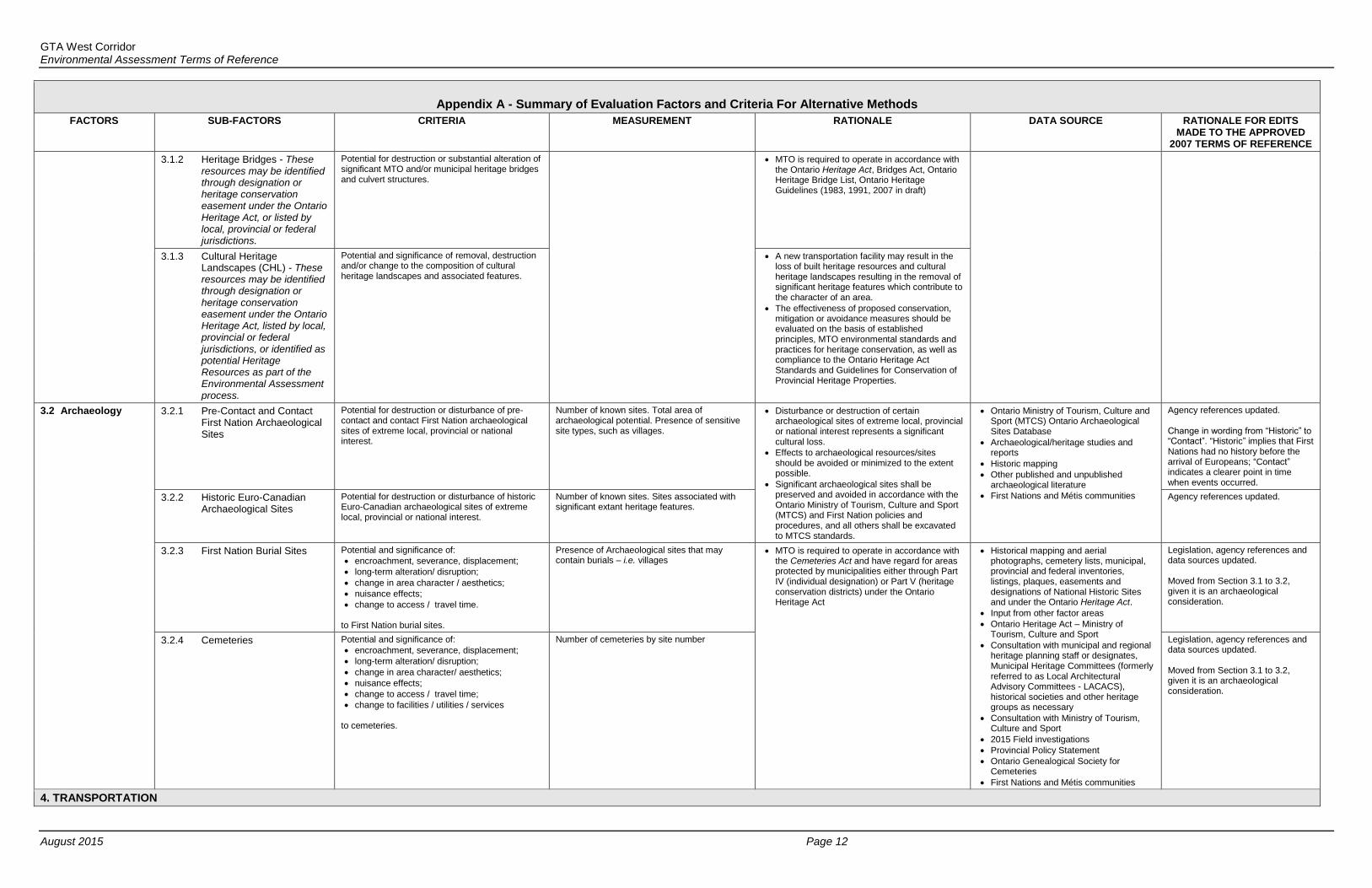
3.1.2 Heritage Bridges - These resources may be identified through designation or heritage conservation easement under the Ontario Heritage Act, or listed by local, provincial or federal jurisdictions.
Potential for destruction or substantial alteration of significant MTO and/or municipal heritage bridges and culvert structures.
MTO is required to operate in accordance with the Ontario Heritage Act, Bridges Act, Ontario Heritage Bridge List, Ontario Heritage Guidelines (1983, 1991, 2007 in draft)
3.1.3 Cultural Heritage Landscapes (CHL) - These resources may be identified through designation or heritage conservation easement under the Ontario Heritage Act, listed by local, provincial or federal jurisdictions, or identified as potential Heritage Resources as part of the Environmental Assessment process.
Potential and significance of removal, destruction and/or change to the composition of cultural heritage landscapes and associated features.
A new transportation facility may result in the loss of built heritage resources and cultural heritage landscapes resulting in the removal of significant heritage features which contribute to the character of an area.
The effectiveness of proposed conservation, mitigation or avoidance measures should be evaluated on the basis of established principles, MTO environmental standards and practices for heritage conservation, as well as compliance to the Ontario Heritage Act Standards and Guidelines for Conservation of Provincial Heritage Properties.
3.2 Archaeology 3.2.1 Pre-Contact and Contact First Nation Archaeological Sites
Potential for destruction or disturbance of pre-contact and contact First Nation archaeological sites of extreme local, provincial or national interest.
Number of known sites. Total area of archaeological potential. Presence of sensitive site types, such as villages.
Disturbance or destruction of certain archaeological sites of extreme local, provincial or national interest represents a significant cultural loss.
Effects to archaeological resources/sites should be avoided or minimized to the extent possible.
Significant archaeological sites shall be preserved and avoided in accordance with the Ontario Ministry of Tourism, Culture and Sport (MTCS) and First Nation policies and procedures, and all others shall be excavated to MTCS standards.
Ontario Ministry of Tourism, Culture and Sport (MTCS) Ontario Archaeological Sites Database
Archaeological/heritage studies and reports
Historic mapping
Other published and unpublished archaeological literature
First Nations and Métis communities
Agency references updated. Change in wording from “Historic” to “Contact”. “Historic” implies that First Nations had no history before the arrival of Europeans; “Contact” indicates a clearer point in time when events occurred.
3.2.2 Historic Euro-Canadian Archaeological Sites
Potential for destruction or disturbance of historic Euro-Canadian archaeological sites of extreme local, provincial or national interest.
Number of known sites. Sites associated with significant extant heritage features.
Agency references updated.
3.2.3 First Nation Burial Sites Potential and significance of:
encroachment, severance, displacement;
long-term alteration/ disruption;
change in area character / aesthetics;
nuisance effects;
change to access / travel time.
to First Nation burial sites.
Presence of Archaeological sites that may contain burials – i.e. villages
MTO is required to operate in accordance with the Cemeteries Act and have regard for areas protected by municipalities either through Part IV (individual designation) or Part V (heritage conservation districts) under the Ontario Heritage Act
Historical mapping and aerial photographs, cemetery lists, municipal, provincial and federal inventories, listings, plaques, easements and designations of National Historic Sites and under the Ontario Heritage Act.
Input from other factor areas
Ontario Heritage Act – Ministry of Tourism, Culture and Sport
Consultation with municipal and regional heritage planning staff or designates, Municipal Heritage Committees (formerly referred to as Local Architectural Advisory Committees - LACACS), historical societies and other heritage groups as necessary
Consultation with Ministry of Tourism, Culture and Sport
2015 Field investigations
Provincial Policy Statement
Ontario Genealogical Society for Cemeteries
First Nations and Métis communities
Legislation, agency references and data sources updated. Moved from Section 3.1 to 3.2, given it is an archaeological consideration.
3.2.4 Cemeteries Potential and significance of:
encroachment, severance, displacement;
long-term alteration/ disruption;
change in area character/ aesthetics;
nuisance effects;
change to access / travel time;
change to facilities / utilities / services to cemeteries.
Number of cemeteries by site number Legislation, agency references and data sources updated. Moved from Section 3.1 to 3.2, given it is an archaeological consideration.
4. TRANSPORTATION
GTA West Corridor Environmental Assessment Terms of Reference
August 2015 Page 13
Appendix A - Summary of Evaluation Factors and Criteria For Alternative Methods
FACTORS SUB-FACTORS CRITERIA MEASUREMENT RATIONALE DATA SOURCE RATIONALE FOR EDITS MADE TO THE APPROVED
2007 TERMS OF REFERENCE
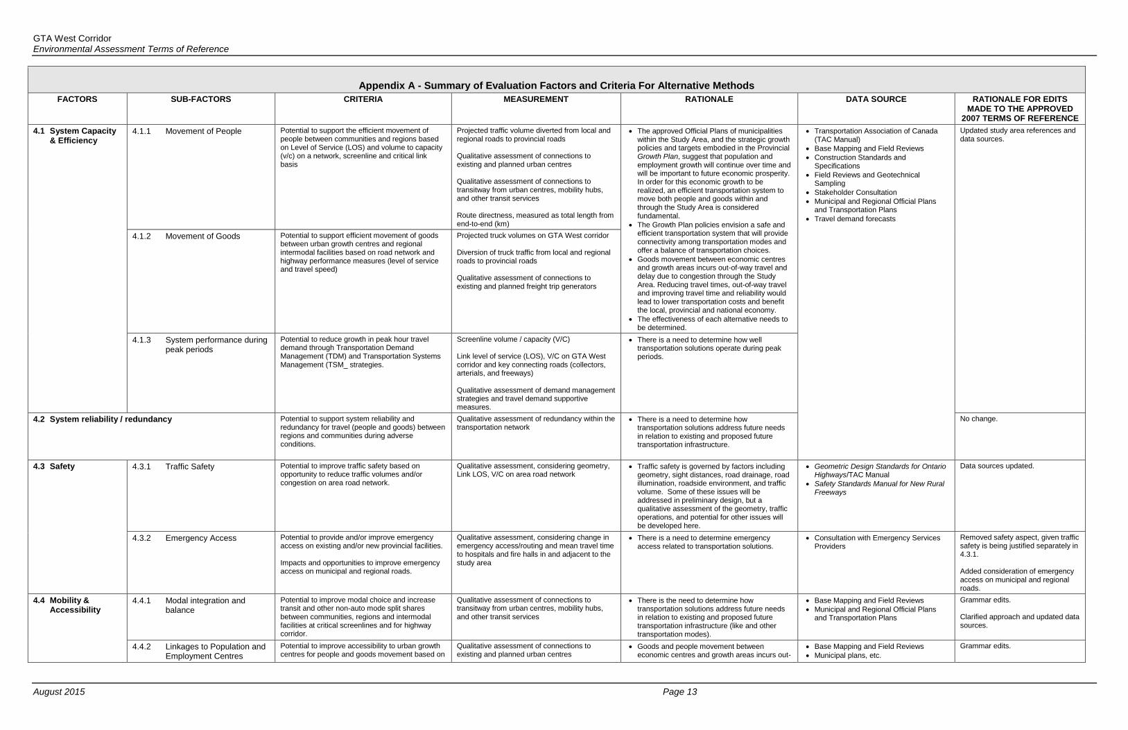
4.1 System Capacity & Efficiency
4.1.1 Movement of People Potential to support the efficient movement of people between communities and regions based on Level of Service (LOS) and volume to capacity (v/c) on a network, screenline and critical link basis
Projected traffic volume diverted from local and regional roads to provincial roads Qualitative assessment of connections to existing and planned urban centres Qualitative assessment of connections to transitway from urban centres, mobility hubs, and other transit services Route directness, measured as total length from end-to-end (km)
The approved Official Plans of municipalities within the Study Area, and the strategic growth policies and targets embodied in the Provincial Growth Plan, suggest that population and employment growth will continue over time and will be important to future economic prosperity. In order for this economic growth to be realized, an efficient transportation system to move both people and goods within and through the Study Area is considered fundamental.
The Growth Plan policies envision a safe and efficient transportation system that will provide connectivity among transportation modes and offer a balance of transportation choices.
Goods movement between economic centres and growth areas incurs out-of-way travel and delay due to congestion through the Study Area. Reducing travel times, out-of-way travel and improving travel time and reliability would lead to lower transportation costs and benefit the local, provincial and national economy.
The effectiveness of each alternative needs to be determined.
Transportation Association of Canada (TAC Manual)
Base Mapping and Field Reviews Construction Standards and
Specifications
Field Reviews and Geotechnical Sampling
Stakeholder Consultation Municipal and Regional Official Plans
and Transportation Plans Travel demand forecasts
Updated study area references and data sources.
4.1.2 Movement of Goods Potential to support efficient movement of goods between urban growth centres and regional intermodal facilities based on road network and highway performance measures (level of service and travel speed)
Projected truck volumes on GTA West corridor Diversion of truck traffic from local and regional roads to provincial roads Qualitative assessment of connections to existing and planned freight trip generators
4.1.3 System performance during peak periods
Potential to reduce growth in peak hour travel demand through Transportation Demand Management (TDM) and Transportation Systems Management (TSM_ strategies.
Screenline volume / capacity (V/C) Link level of service (LOS), V/C on GTA West corridor and key connecting roads (collectors, arterials, and freeways) Qualitative assessment of demand management strategies and travel demand supportive measures.
There is a need to determine how well transportation solutions operate during peak periods.
4.2 System reliability / redundancy Potential to support system reliability and redundancy for travel (people and goods) between regions and communities during adverse conditions.
Qualitative assessment of redundancy within the transportation network
There is a need to determine how transportation solutions address future needs in relation to existing and proposed future transportation infrastructure.
No change.
4.3 Safety 4.3.1 Traffic Safety Potential to improve traffic safety based on opportunity to reduce traffic volumes and/or congestion on area road network.
Qualitative assessment, considering geometry, Link LOS, V/C on area road network
Traffic safety is governed by factors including geometry, sight distances, road drainage, road illumination, roadside environment, and traffic volume. Some of these issues will be addressed in preliminary design, but a qualitative assessment of the geometry, traffic operations, and potential for other issues will be developed here.
Geometric Design Standards for Ontario Highways/TAC Manual
Safety Standards Manual for New Rural Freeways
Data sources updated.
4.3.2 Emergency Access Potential to provide and/or improve emergency access on existing and/or new provincial facilities. Impacts and opportunities to improve emergency access on municipal and regional roads.
Qualitative assessment, considering change in emergency access/routing and mean travel time to hospitals and fire halls in and adjacent to the study area
There is a need to determine emergency access related to transportation solutions.
Consultation with Emergency Services Providers
Removed safety aspect, given traffic safety is being justified separately in 4.3.1. Added consideration of emergency access on municipal and regional roads.
4.4 Mobility & Accessibility
4.4.1 Modal integration and balance
Potential to improve modal choice and increase transit and other non-auto mode split shares between communities, regions and intermodal facilities at critical screenlines and for highway corridor.
Qualitative assessment of connections to transitway from urban centres, mobility hubs, and other transit services
There is the need to determine how transportation solutions address future needs in relation to existing and proposed future transportation infrastructure (like and other transportation modes).
Base Mapping and Field Reviews
Municipal and Regional Official Plans and Transportation Plans
Grammar edits. Clarified approach and updated data sources.
4.4.2 Linkages to Population and Employment Centres
Potential to improve accessibility to urban growth centres for people and goods movement based on
Qualitative assessment of connections to existing and planned urban centres
Goods and people movement between economic centres and growth areas incurs out-
Base Mapping and Field Reviews
Municipal plans, etc.
Grammar edits.

GTA West Corridor Environmental Assessment Terms of Reference
August 2015 Page 14
Appendix A - Summary of Evaluation Factors and Criteria For Alternative Methods
FACTORS SUB-FACTORS CRITERIA MEASUREMENT RATIONALE DATA SOURCE RATIONALE FOR EDITS MADE TO THE APPROVED
2007 TERMS OF REFERENCE
transportation network continuity and connectivity of-way travel and delay due to congestion through the Study Area. Reducing travel times, out-of-way travel and improving travel time and reliability would lead to lower transportation costs, enhance attractiveness of transit services, and benefit the local, provincial and national economy.
Clarified approach and updated data sources. Updated study area reference.
4.4.3 Recreation and Tourism Travel
Potential to support recreation and tourism travel within and to/from the Study Area by provision of higher order network (roads and transit) continuity and connectivity and through network performance indicators (level of service, vehicle to capacity ratio, travel speed)
Qualitative assessment of connections to identified tourism trip generators (i.e. tourism destinations) Link LOS, V/C on GTA West corridor and key connecting roads (collectors, arterials, and freeways)
Policy 4.2.1 of the Greenbelt Plan states that, for lands within the protected countryside, as defined by the Greenbelt Plan, 2005, infrastructure must meet one of the following policies;
i) it supports agriculture, recreation and tourism, rural settlement areas, resource use or the rural economic activity that exists and is permitted within the Greenbelt; or
ii) it serves the significant growth and economic development expected in southern Ontario beyond the Greenbelt by providing for the appropriate infrastructure connections among urban growth centers and between these centers and Ontario’s borders.
Consultation with Ministry of Tourism, Culture and Sport, Ontario Parks and Conservation Authorities
Stakeholder input
Consultation with Community Groups
Mapping
Agency and study area references updated. References to the Niagara Escarpment Plan and Bruce Trail Association have been removed, given the Route Planning Study Area and short-list alternatives are outside of the Plan area and do not impact the Bruce Trail.
4.4.4 Accommodation for pedestrians, cyclists, snowmobiles, and specialized vehicles
Potential to accommodate pedestrians, cyclists within critical travel corridors in urbanized areas and snowmobiles in recognized rural trails; and specialized vehicles such as farm equipment in rural agricultural areas
Qualitative assessment of opportunities for accommodation of pedestrians, cyclists, snowmobiles and specialized vehicles at grade separated crossings of the GTA West corridor
Disruption to community activities may affect quality of life for residents, businesses (including agricultural businesses) and community groups including local pedestrian and cycling facilities.
Identify opportunities to improve active transportation connections to urban growth centres, transit hubs, and communities
Identify opportunities to improve active transportation facilities.
Stakeholder input
Consultation with Community Groups and Municipal Active Transportation Staff
MTO Ontario Bikeways Design Manual
Ontario Traffic Manual Book 18
Municipal active transportation plans
Data sources updated. Criterion updated to include consideration of specialized vehicles (such as farm equipment).
4.5 Network Compatibility
4.5.1 Network connectivity Potential to improve provincial network connectivity within and to/from the Study Area.
Compatibility with Municipal/Regional existing/planned key transportation corridors and potential interchange locations. Impacts to local road network (realignments, service roads, cul-de-sacs). Compatibility and proximity to Municipal/Regional existing/planned transit initiatives, including rail and bus routes and transit stations.
There is the need to determine how transportation solutions address future needs in relation to existing and proposed future transportation infrastructure (like and other transportation modes).
Consultation with Local Municipalities and Transportation Service Providers
Municipal plans, etc.
Updated study area reference and data sources.
4.5.2 Flexibility for future expansion
Potential to address future transportation needs beyond the forecasted planning horizons.
Qualitative assessment of opportunities for future expansion of the corridor and potential for future connections to the provincial freeway and transitway network
There is a need to determine the flexibility of transportation solutions to address future needs beyond the forecasted planning horizon.
Base Mapping and Field Reviews
Municipal and Regional Official Plans and Transportation Plans
Consultation with Local Municipalities and Transportation Service Providers
Clarified approach and updated data sources.
4.6 Engineering 4.6.1 Constructability Potential ease of implementation considering feasibility/difficulty of physical, property or environmental constraints
Significant features that may impact construction (including route length, number and lengths of bridges, crossing of/proximity to utilities (i.e., Hydro Corridors, TCPL).
Physical conditions and staging issues can affect the feasibility of implementing transportation solutions.
Geometric Design Standards for Ontario Highways/TAC Manual
Utility Design Guidelines (i.e. TCPL)
Geotechnical field surveys
Data sources updated.
4.6.2 Compliance with design criteria
Conformity to applicable provincial safety and design standards.
Ability of the route to meet the geometric design standards (i.e. interchange spacing, horizontal and vertical curves).
Transportation agencies have developed design standards to ensure that safety objectives are reflected in all new / expanded infrastructure.
Geometric Design Standards for Ontario Highways/TAC Manual
Safety Standards Manual for New Rural Freeways
Data sources updated.

GTA West Corridor Environmental Assessment Terms of Reference
August 2015 Page 15
Appendix A - Summary of Evaluation Factors and Criteria For Alternative Methods
FACTORS SUB-FACTORS CRITERIA MEASUREMENT RATIONALE DATA SOURCE RATIONALE FOR EDITS MADE TO THE APPROVED
2007 TERMS OF REFERENCE
4.7 Construction Cost Relative road construction cost, excluding property and engineering costs
Parametric cost estimate – Quantitative construction cost based on unit cost per kilometre of new corridor.
There is a need to identify the costs associated with possible transportation solutions. Construction costs can influence the feasibility of a given alternative.
Cost data
Base Mapping and Field Reviews No change
4.8 Traffic Operations Potential effects on traffic operations due to factors such as design features, private access, and transportation network connections
Qualitative assessment, considering spacing between interchanges; location of and proximity between ramp terminal intersections and adjacent intersections; and impacts to local road network
The effectiveness (i.e. level of service) of each alternative needs to be determined.
Transportation agencies have developed design standards to ensure that safety objectives are reflected in all new / expanded infrastructure.
Geometric Design Standards for Ontario Highways
Transportation Association of Canada (TAC Manual)
Base Mapping and Field Reviews
Data sources updated.

GTA West Corridor Environmental Assessment Terms of Reference
June 24, 2015 Page 16