Green Infrastructure Strategy - Derby City Council | Derby ... · PDF fileDuring June and July...
84
es rby Green Infrastructure Strategy Volume 6 Strategic GI Network for the Nottingham Principal Urban Area and Sub-Regional Centres 2010
Transcript of Green Infrastructure Strategy - Derby City Council | Derby ... · PDF fileDuring June and July...

es
rby
Green Infrastructure Strategy Volume 6
Strategic GI Network for the Nottingham Principal Urban Area
and Sub-Regional Centres
2010

2010 6Cs GI Strategy
Volume 6: Strategic GI Network for the Nottingham Principal Urban Area and Sub-Regional Centres
CONTENTS Foreword Strategy Structure 1.0 INTRODUCTION 1.1 Study Area and Context 1.2 Scope 1.3 Key Documents 2.0 STRATEGIC GREEN INFRASTRUCTURE ASSETS, NEEDS AND OPPORTUNITIES 2.1 Existing Strategic Green Infrastructure Assets 2.2 Strategic Green Infrastructure Needs 2.3 Strategic Public Benefits of Green Infrastructure Provision 2.4 Strategic Green Infrastructure Opportunities 3.0 STRATEGIC GREEN INFRASTRUCTURE NETWORK 3.1 General 3.2 Sub-Regional Green Infrastructure 3.3 City-Scale Green Infrastructure 3.4 Delivering the Green Infrastructure Network FIGURES
1.1 Study Area and Context 2.1 Biodiversity – Existing Strategic Assets (Natural Greenspace) 2.2 Access and Recreation – Existing Strategic Assets 2.3 Open Space and Green Wedges - Existing Strategic Assets 2.4 Landscape Character and Historic Environment – Existing Strategic Assets 2.5 Strategic GI Assets 2.6 Strategic GI Needs – Accessible Natural Greenspace Deficiencies 2.7 Strategic Public Benefits of GI Provision 2.8 Strategic Opportunities for Enhancing Connectivity of the Greenspace
Network for Biodiversity 2.9 Strategic Opportunities for Enhancing Accessibility of the Greenspace
Network for People 3.1a Strategic GI Network – Existing GI Assets 3.1b Strategic GI Network – Proposed GI Corridors and Zones 3.1c The Overall Strategic GI Network APPENDICES
A1 Record of Stakeholder Consultation A2 Sources of GI Asset Mapping Data Used for Volume 6 A3 PPG17 Open Space Datasets & Overarching Typology Methodology A4 Derbyshire Landscape Character Guidance within the Study Area A5 Biodiversity Needs and Opportunities by Broad Habitat Type A6 Examples of Opportunity Areas

FOREWORD
The East Midlands region faces an unprecedented scale of growth over the coming years, especially in the 6C’s sub-region. In light of the scale and number of new houses that are planned, we recognised the need to develop a strategic approach to provision of Green Infrastructure (GI) as an environmental life support system for healthy communities and ecosystems. We wanted to maximise the potential of GI to bring about multifunctional holistic solutions to achieve wide ranging environmental, economic and social benefits, including climate change adaptation and mitigation.
The 6C’s partnership have been working together with key players across the area for the last two years to produce this exciting and important Strategy. The challenge is now to deliver and manage GI along with the “grey infrastructure” needed to support sustainable communities in the sub-region. This Strategy represents a major step forward to achieve this by:
• Giving the strategic spatial framework needed to safeguard, manage, and extend networks of GI in local planning documents;
• Showing how the benefits of GI to economics, climate change, health, biodiversity and landscape can be realised;
• Significantly reducing the amount of data required to produce local policy documents; and
• Identifying funding sources and mechanisms for the delivery of GI and the priorities for investment.
I cannot commend enough the monumental achievement of the 6Cs Strategic GI Project Board, and also the overall 6Cs Partnership, in producing this sub-regional GI Strategy.
It provides a framework for all those working to plan and deliver sustainable development, and GI delivery in particular, within the sub-region and elsewhere around the East Midlands Region over the forthcoming years. Alison Hepworth Chair, 6Cs Strategic GI Project Board

VOLUME 2ACTION PLAN
Projects and initiatives to deliver theSub-Regional GI Network
Key actions required to deliver the Strategic Objectives: promotion, advocacy and partnership working
STRATEGYLong-term vision for the strategic GI network across the 6Cs Sub-Region
DELIVERYImplementation of the Strategy to be reviewed regularly to refl ect changing priorities and emerging delivery opportunities
Technical reports providing the evidence
base to inform the fram
ework.
STRATEGY STRUCTURE
VOLUME 6STRATEGIC GI NETWORK
NOTTINGHAM
VOLUME 5STRATEGIC GI NETWORK
LEICESTER
VOLUME 4STRATEGIC GI NETWORK
DERBY
VOLUME 3BASELINE REVIEW ANDSTRATEGIC GI AUDIT
VOLUME 1SUB-REGIONAL STRATEGIC
FRAMEWORK

2010 1 6Cs GI Strategy
Volume 6: Strategic GI Network for the Nottingham Principal Urban Area and Sub-Regional Centres
1.0 INTRODUCTION
1.1 Study Area and Context
1.1.1 Figure 1.1 shows the Study Area for the Nottingham Principal Urban Area and the Sub-
Regional Centres of Hucknall and Ilkeston Strategic GI Network.
1.1.2 This report should be read in conjunction with:
• Volume 1: The Sub-Regional Strategic Framework (particularly Section 3.0 – The Shared Vision, Section 4.0 - The Strategic Green Infrastructure Network, and Section 5.0 - The Delivery Framework);
• Volume 2: The Action Plan; • Volume 3: The Baseline Information Review and Strategic GI Audit for the sub-region; • Volume 4: The Strategic Green Infrastructure Network for the Derby Principal Urban Area
and the Sub-Regional Centre Swadlincote; and • Volume 5: The Strategic Green Infrastructure Network for the Leicester Principal Urban
Area and the Sub-Regional Centres of Coalville, Hinckley (including Barwell and Earl Shilton), Loughborough (including Shepshed), Market Harborough, and Melton Mowbray.
1.1.3 The locations of strategic growth within the Greater Nottingham Housing Market Area (HMA)
will have an impact on the prioritisation of resources and investment in the proposed GI
Network. The current position with regards to the planning of strategic development sites within
the HMA is summarised below as at April 20101.
1.1.4 The Greater Nottingham authorities (Ashfield, Broxtowe, Erewash, Gedling, Nottingham City and
Rushcliffe) supported by Nottinghamshire and Derbyshire County Councils, have been working
together to develop aligned Core Strategies2. Potential locations for Sustainable Urban
Extensions have been identified in a Sustainable Urban Extension Study3. During June and July
2009, the authorities undertook public and stakeholder consultation on an ‘Issues and Options’
Report. This sought comments on a number of alternatives to shape future development within
Greater Nottingham. The councils have considered the consultation responses and government
guidance and have developed an extensive technical evidence base (including for example flood
risk and housing need studies) to draw up a more detailed strategic ‘Option for Consultation’.
Ashfield District Council will consult on a separate ‘Preferred Option’ report covering the whole
of the Ashfield area. The Greater Nottingham Core Strategy’s ‘Option for Consultation’ report
sets out an overall spatial vision for Greater Nottingham and strategic policies, and sets out a
number of strategic sites and sustainable urban extensions which could accommodate the
1 See Section 1.3 of Volume 2 for updated information. 2 For more detail visit http://www. gngrowthpoint.com. 3 Sustainable Urban Extension Study for Greater Nottingham (Tribal Urban Studios, June 2008).
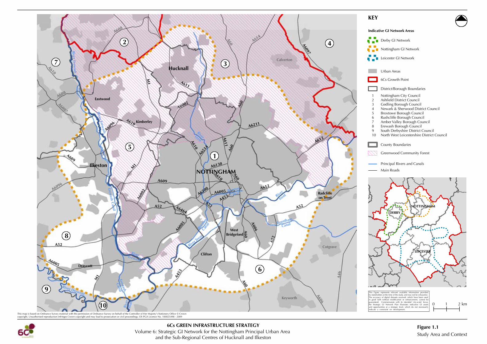
Ilkeston
Calverton
Radcliffeon Trent
Cotgrave
Keyworth
Clifton
Draycott
Hucknall
NOTTINGHAM
WestBridgeford
Kimberley
Eastwood
0 1 2 km
This map is based on Ordnance Survey material with the permission of Ordnance Survey on behalf of the Controller of Her Majesty’s Stationery Office © Crowncopyright. Unauthorised reproduction infringes Crown copyright and may lead to prosecution or civil proceedings. OS PGA Licence No. 100025498 - 2009
KEY
LEICESTER
DERBY
NOTTINGHAM
Study Area and ContextFigure 1.1
3
1
2 4
5
6
7
8
9
10
Principal Rivers and Canals
Main Roads
River Erewash
River Erewash
Erewash C
anal
RiverErewash
Erewash
Canal
River T
rent
River
Trent
Grantham
Canal
Rive
rSo
ar
River Derwent
A6514
A6211
A612
A612
A60
A611
A60
A52
A52
A60
A606
A610
A610
A609
A6200
A52A52
A6005
A6464
A610
A600
2
A6002
A60
A60 A614
A611
A6097
M1
M1
A608
A610
A6007
A608
A6096
A609
A6096
A52
A6005
M1 A4
53
A60
A606
A46
A453
A6130
A6005
Urban Areas
District/Borough Boundaries
6Cs Growth Point
Nottingham City CouncilAshfield District CouncilGedling Borough CouncilNewark & Sherwood District CouncilBroxtowe Borough CouncilRushcliffe Borough CouncilAmber Valley Borough CouncilErewash Borough CouncilSouth Derbyshire District CouncilNorth West Leicestershire District Council
12345678910
County Boundaries
Derby GI Network
Nottingham GI Network
Leicester GI Network
Indicative GI Network Areas
Greenwood Community Forest
RiverLeen
Volume 6: Strategic GI Network for the Nottingham Principal Urban Areaand the Sub-Regional Centres of Hucknall and Ilkeston
6Cs GREEN INFRASTRUCTURE STRATEGY
This Figure represents relevant available information providedby stakeholders at the time of the study, and may not be exhaustive.The accuracy of digital datasets received, which have been usedin good faith without modification or enhancement, cannot beguaranteed. Commensurate with its intended ‘city-scale’ focus,the Strategic GI Network Plan illustrates indicative GI assetsand opportunities at a strategic level, which do not necessarilyindicate a constraint on development.
Beeston
CanalBe
esto
nCan
al

2010 2 6Cs GI Strategy
Volume 6: Strategic GI Network for the Nottingham Principal Urban Area and Sub-Regional Centres
housing growth targets required by the East Midlands Regional Plan. Consultation for the
‘Option for Consultation’ report ended in April 2010.
1.2 Scope
1.2.1 The Strategic GI Network report comprises the following:
• Assessment of Strategic GI Assets, Needs and Opportunities – drawing on the Stage 1 GI
audit, enhanced by selected relevant additional data as appropriate; and
• Strategic GI Network – a ‘key diagram’ type plan, plus supporting explanatory text,
identifying a proposed ‘aspirational’ multifunctional strategic GI network that connects
communities and wildlife at the sub-regional and City-Scales. It is intended to help focus
attention on land that needs to be safeguarded, managed or secured in positive ways to
create a multifunctional network of greenspaces and assets for which investment can deliver
the greatest range of benefits.
1.3 Key Documents
1.3.1 The key documents that have informed the development of the Nottingham Principal Urban
Area and the Sub-Regional Centres of Hucknall and Ilkeston Strategic GI Network are:
• Ashfield Greenspace Strategy (2008) (this includes a PPG17 Open pace Assessment) • Broxtowe Greenspace Audit and Strategy 2009-2019 (2008) (this includes a PPG17 Open
Space Assessment) • Derbyshire Rights of Way Improvement Plan 2007-2012 • East Derbyshire Greenway Strategy (1998, currently under review) • Erewash Borough Council PPG17 Open Space Study (2007) • Erewash Draft Greenspace Strategy (2007) • Gedling Borough Council PPG17 Open Space Study (2004) • Greater Nottingham Landscape Character Assessment (2009) • Greenwood Strategic Plan (2000) • Lowland Derbyshire Biodiversity Action Plan, Delivery Plan 2008-2010 (2008) • Nottingham City Council Breathing Space strategic Framework for the Management of
Nottingham’s Open and Green Spaces 2007-2017 • Nottingham City Council Corridors to the Countryside Project -Strategy for the River Leen
(1998) • Nottingham City Council Local Transport Plan for Greater Nottingham/Rights of Way
Improvement Plan 2006/7 - 2010/11 ( 2007) • Nottingham City Council Outdoor Sports Strategy (draft 2009) • Nottingham City Council Play Strategy 2007-2012 • Nottingham City Council PPG17 Open Space Study (Draft final, 2009) • Nottingham Gateway Green Infrastructure Strategy (work in progress) • Nottinghamshire Local Biodiversity Action Plan (1998) • Nottinghamshire Rights of Way Improvement Plan 2007-2012 • River Trent to Cotgrave Green Infrastructure Masterplan (Draft, 2009) • Rushcliffe Borough Council PPG17 Open Space Study (date unknown)

2010 3 6Cs GI Strategy
Volume 6: Strategic GI Network for the Nottingham Principal Urban Area and Sub-Regional Centres
• The Landscape Character of Derbyshire (2003) • The Nottinghamshire Landscape Guidelines (1997) • Trent River Park Vision and Action Plan (2008).

2010 4 6Cs GI Strategy
Volume 6: Strategic GI Network for the Nottingham Principal Urban Area and Sub-Regional Centres
2.0 STRATEGIC GREEN INFRASTRUCTURE ASSETS, NEEDS AND OPPORTUNITIES
2.1 Existing Strategic Green Infrastructure Assets
2.1.1 Figures 2.1 to 2.5 show existing strategic GI assets that form the ‘backbone’ or underlying
framework for the Nottingham Principal Urban Area and the Sub-Regional Centres of Hucknall
and Ilkeston Strategic GI Network. The mapping is based on the datasets used in the Stage 1
work, enhanced where appropriate by selected relevant additional datasets identified in
consultation with local stakeholders4.
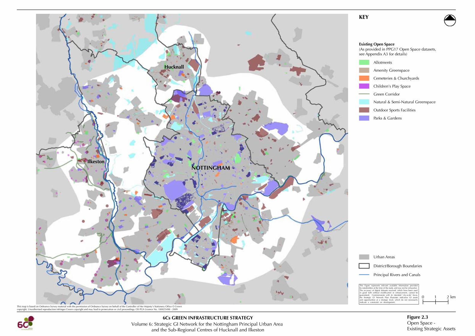
2.1.2 A key source of additional data used is the PPG17 Open Space datasets provided by the local
authorities, where available (see Figure 2.3). Appendix A3 provides details of the PPG17
datasets provided, and the methodology for consolidating these into a consistent open space
typology for the purposes of this study.
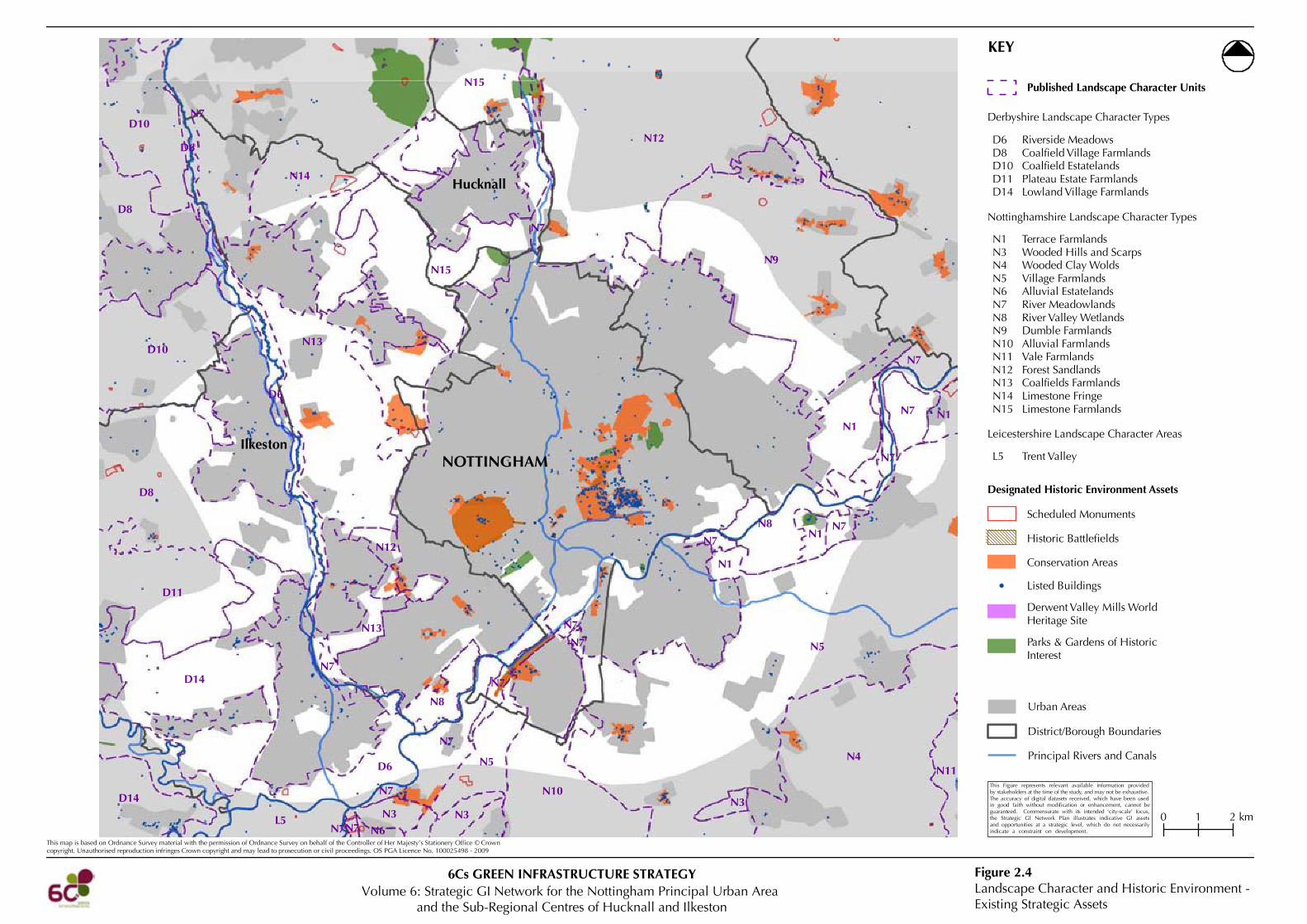
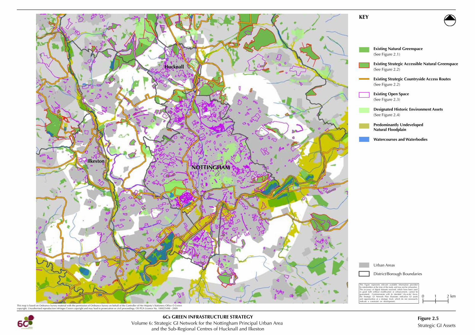
2.1.3 The distribution and extent of existing strategic GI assets in and around the Study Area is shown
on Figure 2.5. These assets include:
• Existing natural greenspace5; • Existing strategic accessible natural greenspace6; • Existing strategic countryside access routes7; • Existing open space8 and green wedges9; • Historic environment assets10; • Watercourses and waterbodies11; and
4 A record of stakeholder consultation is provided Appendix A1. Sources of GI asset mapping data used in the Strategic GI Network for the Nottingham Principal Urban Area and the Sub-Regional Centres of Hucknall and Ilkeston are provided in Appendix A2. 5 For the purposes of the mapping methodology presented in this report, ‘natural greenspace’ is defined as: land, water or geological features that have been colonised by plants and animals and are dominated by natural processes (as defined by English Nature in Accessible Natural Greenspace in Towns and Cities). 6 For the purposes of the mapping methodology presented in this report, ‘strategic accessible natural greenspace’ is defined as natural greenspace greater than 2ha in size that is normally available for public access on foot, providing opportunities for open access for informal recreational activities. 7 For the purposes of the mapping methodology presented in this report, ‘strategic countryside access routes’ are defined as: linear, generally off-road and car free routes, that are normally available for public access on foot, horseback or by cycle providing opportunities to access the countryside for informal recreation activities It should be noted that Public Rights of Way have been considered to inform needs and opportunities. However, for presentational purposes they have not been mapped as part of the existing strategic GI assets. 8 For the purposes of the mapping methodology presented in this report, ‘open space’ is defined as: parks and gardens, amenity greenspaces, natural and semi-natural greenspaces, green corridors, cemeteries and churchyards, allotments, children’s play space and outdoor sports facilities. 9 Green wedges are not necessarily covered by PPG17 Open Space datasets. However, following stakeholder consultation, they have been included (where available) on Figure 2.3. The Green Wedge areas deliver, or have the potential to deliver, a range of GI functions and benefits in close proximity to urban communities. Such benefits, either existing or potential, will vary from one area to another. It should be noted that the Regional Plan requires that Green Wedges be reviewed for their suitability. It should therefore not be assumed that all of the Green Wedges will be retained in their current form. 10 For the purposes of the mapping methodology presented in this report, ‘historic environment assets’ are defined as designated historic environment assets including: scheduled monuments, historic battlefields, conservation areas, listed buildings, world heritage sites, and parks and gardens of historic interest. 11 For the purposes of the mapping methodology presented in this report, ‘watercourses and waterbodies’ are as defined by the meridian datasets for ‘Lakes’ and ‘Rivers’.

Ilkeston
Hucknall
NOTTINGHAM
This map is based on Ordnance Survey material with the permission of Ordnance Survey on behalf of the Controller of Her Majesty’s Stationery Office © Crowncopyright. Unauthorised reproduction infringes Crown copyright and may lead to prosecution or civil proceedings. OS PGA Licence No. 100025498 - 2009
KEY
Biodiversity - Existing Strategic Assets(Natural Greenspace)
Figure 2.1
Principal Rivers and Canals
Urban Areas
District/Borough Boundaries
Volume 6: Strategic GI Network for the Nottingham Principal Urban Areaand the Sub-Regional Centres of Hucknall and Ilkeston
6Cs GREEN INFRASTRUCTURE STRATEGY
This Figure represents relevant available information providedby stakeholders at the time of the study, and may not be exhaustive.The accuracy of digital datasets received, which have been usedin good faith without modification or enhancement, cannot beguaranteed. Commensurate with its intended ‘city-scale’ focus,the Strategic GI Network Plan illustrates indicative GI assetsand opportunities at a strategic level, which do not necessarilyindicate a constraint on development.
0 1 2 km
Woodland and Trees
National Inventory of Woodland and Trees
Natural/Semi-Natural Habitats
Coastal and Floodplain GrazingMarsh
Eutrophic Standing Waters
Lowland Calcareous Grassland
Lowland Dry Acid Grassland
Lowland Fen
Lowland Heathland
Lowland Meadows
Lowland Mixed DeciduousWoodlandOpen Mosaic Habitats onPreviously Developed Land
Reedbed
Wood-Pasture and Parkland
Purple Moor Grassand Rush-Pastures
(based on Wildlife Trust and NaturalEngland BAP Priority Habitat data)
Designated Areas
Sites of Special Scientific Interest
Local Nature Reserves
Local Wildlife Sites
Wildlife Trust Nature Reserves(with Public Access)

Ilkeston
Hucknall
NOTTINGHAM
This map is based on Ordnance Survey material with the permission of Ordnance Survey on behalf of the Controller of Her Majesty’s Stationery Office © Crowncopyright. Unauthorised reproduction infringes Crown copyright and may lead to prosecution or civil proceedings. OS PGA Licence No. 100025498 - 2009
KEY
Access & Recreation -Existing Strategic Assets
Figure 2.2
Principal Rivers and Canals
Urban Areas
District/Borough Boundaries
Volume 6: Strategic GI Network for the Nottingham Principal Urban Areaand the Sub-Regional Centres of Hucknall and Ilkeston
6Cs GREEN INFRASTRUCTURE STRATEGY
0 1 2 km
This Figure represents relevant available information providedby stakeholders at the time of the study, and may not be exhaustive.The accuracy of digital datasets received, which have been usedin good faith without modification or enhancement, cannot beguaranteed. Commensurate with its intended ‘city-scale’ focus,the Strategic GI Network Plan illustrates indicative GI assetsand opportunities at a strategic level, which do not necessarilyindicate a constraint on development.
Cycle Network
Public Rights of Way Network
Navigable Waterways (indicative)
Promoted Recreational Routes
Existing Strategic Countryside Access Routes
Public Rights of Way Network
Linear, generally off-road and car free routes, that are normallyavailable for public access on foot, horseback or by cycleproviding opportunities to access the countryside for informalrecreation activities.
Greenways (within Derbyhire)
Greenways (shown in the Trent River ParkVision & Action Plan, digitised by CBA)
Open Access Land and Wildlife TrustNature Reserves with Public Access
Accessible Woodland
National Trust Land with Open Access
Country Parks
Land greater than 2ha in size that is normally available for publicaccess on foot, providing opportunities for open access for informalrecreational activities.
Existing Strategic Accessible Natural Greenspace
Ilkeston
Hucknall
NOTTINGHAM
This map is based on Ordnance Survey material with the permission of Ordnance Survey on behalf of the Controller of Her Majesty’s Stationery Office © Crowncopyright. Unauthorised reproduction infringes Crown copyright and may lead to prosecution or civil proceedings. OS PGA Licence No. 100025498 - 2009
KEY
Open Space -Existing Strategic Assets
Figure 2.3
Allotments
Amenity Greenspace
Cemeteries & Churchyards
Children's Play Space
Natural & Semi-Natural Greenspace
Outdoor Sports Facilities
Parks & Gardens
Principal Rivers and Canals
Urban Areas
District/Borough Boundaries
Volume 6: Strategic GI Network for the Nottingham Principal Urban Areaand the Sub-Regional Centres of Hucknall and Ilkeston
6Cs GREEN INFRASTRUCTURE STRATEGY
Green Corridor
0 1 2 km
This Figure represents relevant available information providedby stakeholders at the time of the study, and may not be exhaustive.The accuracy of digital datasets received, which have been usedin good faith without modification or enhancement, cannot beguaranteed. Commensurate with its intended ‘city-scale’ focus,the Strategic GI Network Plan illustrates indicative GI assetsand opportunities at a strategic level, which do not necessarilyindicate a constraint on development.
Existing Open Space(As provided in PPG17 Open Space datasets,see Appendix A3 for details)
Ilkeston
Hucknall
NOTTINGHAM
N5
N9
N12
N4
N13
N15
N15
N10
N1
N7
N8
N7
N5
N14
N7
N8
N7
N3
N13
N12
N11
N3
N1
N1
N1
N7
N3
N7
N7
N7
N7
N7
N7
N6
N7
N7
N7N7
N7
L5
D8
D14
D6
D10
D11
D10
D8
D14
D6
D6
This map is based on Ordnance Survey material with the permission of Ordnance Survey on behalf of the Controller of Her Majesty’s Stationery Office © Crowncopyright. Unauthorised reproduction infringes Crown copyright and may lead to prosecution or civil proceedings. OS PGA Licence No. 100025498 - 2009
KEY
Published Landscape Character Units
Leicestershire Landscape Character Areas
Nottinghamshire Landscape Character Types
N1N3N4N5N6N7N8N9N10N11N12N13N14N15
Terrace FarmlandsWooded Hills and ScarpsWooded Clay WoldsVillage FarmlandsAlluvial EstatelandsRiver MeadowlandsRiver Valley WetlandsDumble FarmlandsAlluvial FarmlandsVale FarmlandsForest SandlandsCoalfields FarmlandsLimestone FringeLimestone Farmlands
Scheduled Monuments
Listed Buildings
Derwent Valley Mills WorldHeritage Site
Parks & Gardens of HistoricInterest
Conservation Areas
Historic Battlefields
Designated Historic Environment Assets
L5 Trent Valley
Derbyshire Landscape Character Types
D6D8D10D11D14
Riverside MeadowsCoalfield Village FarmlandsCoalfield EstatelandsPlateau Estate FarmlandsLowland Village Farmlands
Landscape Character and Historic Environment -Existing Strategic Assets
Figure 2.4
Principal Rivers and Canals
Urban Areas
District/Borough Boundaries
Volume 6: Strategic GI Network for the Nottingham Principal Urban Areaand the Sub-Regional Centres of Hucknall and Ilkeston
6Cs GREEN INFRASTRUCTURE STRATEGY
0 1 2 km
This Figure represents relevant available information providedby stakeholders at the time of the study, and may not be exhaustive.The accuracy of digital datasets received, which have been usedin good faith without modification or enhancement, cannot beguaranteed. Commensurate with its intended ‘city-scale’ focus,the Strategic GI Network Plan illustrates indicative GI assetsand opportunities at a strategic level, which do not necessarilyindicate a constraint on development.
Ilkeston
Hucknall
NOTTINGHAM
This map is based on Ordnance Survey material with the permission of Ordnance Survey on behalf of the Controller of Her Majesty’s Stationery Office © Crowncopyright. Unauthorised reproduction infringes Crown copyright and may lead to prosecution or civil proceedings. OS PGA Licence No. 100025498 - 2009
KEY
Strategic GI AssetsFigure 2.5
Existing Strategic Accessible Natural Greenspace
Existing Natural Greenspace
Designated Historic Environment Assets
Existing Strategic Countryside Access Routes
(See Figure 2.1)
(See Figure 2.2)
(See Figure 2.2)
(See Figure 2.4)
Existing Open Space(See Figure 2.3)
Predominantly UndevelopedNatural Floodplain
Watercourses and Waterbodies
District/Borough Boundaries
Urban Areas
Volume 6: Strategic GI Network for the Nottingham Principal Urban Areaand the Sub-Regional Centres of Hucknall and Ilkeston
6Cs GREEN INFRASTRUCTURE STRATEGY
0 1 2 km
This Figure represents relevant available information providedby stakeholders at the time of the study, and may not be exhaustive.The accuracy of digital datasets received, which have been usedin good faith without modification or enhancement, cannot beguaranteed. Commensurate with its intended ‘city-scale’ focus,the Strategic GI Network Plan illustrates indicative GI assetsand opportunities at a strategic level, which do not necessarilyindicate a constraint on development.

2010 5 6Cs GI Strategy
Volume 6: Strategic GI Network for the Nottingham Principal Urban Area and Sub-Regional Centres
• Predominantly undeveloped natural floodplain12.
2.2 Strategic Green Infrastructure Needs
Accessible Natural Greenspace Deficiencies
2.2.1 Based on the assessment of accessible natural greenspace provision undertaken in Stage 1,
Figure 2.6 identifies the location and distribution of different sizes of strategic accessible
natural greenspace sites13 and their respective catchments based on Natural England’s
Accessible Natural Greenspace Standard14 (ANGSt) model. Although designed primarily for
use in the urban context, the ANGSt model can also be used to assess how accessible natural
greenspace in the wider countryside contributes to levels of provision for both urban and rural
communities. Applying the Standard enables a consistent comparison to be made between the
levels of accessible natural greenspace available to people across the sub-region.
2.2.2 It is important to recognise the strategic role of accessible agricultural landscapes in the wider
countryside beyond the specific sites of accessible natural greenspace considered in this report.
Key areas with deficiencies of accessible natural greenspace within the Study Area are:
Nottingham
• Deficiency of sites over 2ha (within 300m of inhabitants) for almost all of Nottingham’s population. Residents in small discrete areas have access to sites;
• Deficiency of sites over 20ha (within 2km of inhabitants) for populations living in central Nottingham, its southern tip and parts in the east and west;
• Deficiency of sites over 100ha (within 5km of inhabitants) for populations living in the eastern part of Nottingham;
• Deficiency of sites over 500ha (within 10km of inhabitants) for all of Nottingham’s population.
Hucknall
• Deficiency of sites over 2ha (within 300m of inhabitants) for a large proportion of Hucknall’s population. Some residents living in the north-west, a small area in the east and south have access to a site;
• Deficiency of sites over 20ha (within 2km of inhabitants) for populations living in the south-western tip of Hucknall; and
• Deficiency of sites over 500ha (within 10km of inhabitants) for all of Hucknall’s population.
12 For the purposes of this Study, the natural floodplain (the extent of the floodplain if there were no flood defences or certain other manmade structures and channel improvements), is shown only in predominantly undeveloped areas outside of the main settlements. 13 Strategic accessible natural greenspace sites shown on Figure 2.6 represent available information provided by stakeholders at the time of the Study and may not be exhaustive. 14 Providing Accessible Natural Greenspaces in Towns and Cities: A Practical Guide to Assessing the Resource and Implementing Local Standards for Provision (English Nature, 2003)

This map is based on Ordnance Survey material with the permission of Ordnance Survey on behalf of the Controller of Her Majesty’s Stationery Office © Crowncopyright. Unauthorised reproduction infringes Crown copyright and may lead to prosecution or civil proceedings. OS PGA Licence No. 100025498 - 2009
KEY
300m catchment - all accessible naturalgreenspace
2km catchment - accessible naturalgreenspace >20ha
5km catchment - accessible naturalgreenspace >100ha
10km catchment - accessible naturalgreenspace >500ha
Accessible Natural Greenspace Catchments
Existing Strategic Accessible Natural Greenspace
Land greater than 2ha in size largely outside urban areasthat is normally available for public access on foot, providingopportunities for open access for informal recreational activities.
2km Catchment - Accessible natural greenspace > 20ha300m Catchment - All accessible natural greenspace
10km Catchment - Accessible natural greenspace > 500ha5km Catchment - Accessible natural greenspace > 100ha
Strategic GI Needs - AccessibleNatural Greenspace Deficiencies
Figure 2.6
NOTTINGHAMIlkeston
Hucknall
NOTTINGHAMIlkeston
Hucknall
NOTTINGHAMIlkeston
Hucknall
NOTTINGHAMIlkeston
Hucknall
Nottingham GI Network
Principal Rivers and Canals
Urban Areas
District/Borough Boundaries
Volume 6: Strategic GI Network for the Nottingham Principal Urban Areaand the Sub-Regional Centres of Hucknall and Ilkeston
6Cs GREEN INFRASTRUCTURE STRATEGY
0 2 4 km
This Figure represents relevant available information providedby stakeholders at the time of the study, and may not be exhaustive.The accuracy of digital datasets received, which have been usedin good faith without modification or enhancement, cannot beguaranteed. Commensurate with its intended ‘city-scale’ focus,the Strategic GI Network Plan illustrates indicative GI assetsand opportunities at a strategic level, which do not necessarilyindicate a constraint on development.
2010 6 6Cs GI Strategy
Volume 6: Strategic GI Network for the Nottingham Principal Urban Area and Sub-Regional Centres
Ilkeston
• Deficiency of sites over 2ha (within 300m of inhabitants) for almost all of Ilkeston’s population. Residents in discrete areas north-east and north-west have access to sites;
• Deficiency of sites over 20ha (within 2km of inhabitants) for populations living in the southern half of Ilkeston;
• Deficiency of sites over 500ha (within 10km of inhabitants) for all of Ilkeston’s population.
Other Settlements
• Deficiency of sites over 2ha (within 300m of inhabitants) for almost all other settlement’s populations. Residents in small discrete areas around the Study Area have access to sites (e.g. in north-east Eastwood and south Clifton);
• Deficiency of sites over 20ha (within 2km of inhabitants) for almost all other settlement’s populations. Residents in north-east Eastwood, south-west Radcliffe-on-Trent, east Bassingfield, east and west Clifton, and Barton-in-Fabis have access to sites;
• Deficiency of sites over 100ha (within 5km of inhabitants) for populations living in north-west Long Eaton and south Stanton-by-Dale;
• Deficiency of sites over 500ha (within 10km of inhabitants) for all other settlement’s populations.
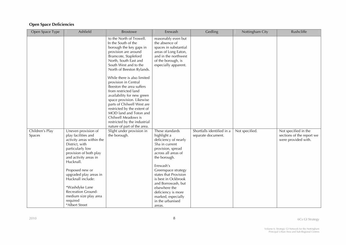
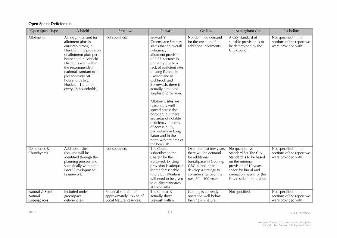
Open Space Deficiencies
2.2.3 Relevant PPG17 studies have highlighted varying deficiencies in open space across the
Nottingham Principal Urban Area and the Sub-Regional Centres of Hucknall and Ilkeston
Strategic GI Network area. Shortfalls in open space provision for areas within the Study Area
and its environs, as described in individual PPG17 studies, are provided in the following table.
The distribution of existing open spaces (using PPG17 open space datasets) is shown on Figure
2.3.
Rights of Way Needs
2.2.4 Needs identified in the Nottingham City, Nottinghamshire, Derby City and Derbyshire’s Rights
of Way Improvement Plans include the following:
Nottingham City Rights of Way Improvement Plan
• Provide a safe and user friendly environment to encourage more people to walk to their
destination and continue to improve existing paths and create new paths wherever possible; • Provide a safe and user friendly environment to encourage more people to cycle to their
destination and continue to improve existing paths and create new paths wherever possible; • Provide a safe and user friendly environment so people can enjoy horse riding and continue
to improve existing paths and create new paths wherever possible; • Where possible ensure all paths are accessible by people with limited mobility, the blind,
and partially sighted.

Open Space Deficiencies
2010 7 6Cs GI Strategy
Volume 6: Strategic GI Network for the Nottingham Principal Urban Area and Sub-Regional Centres
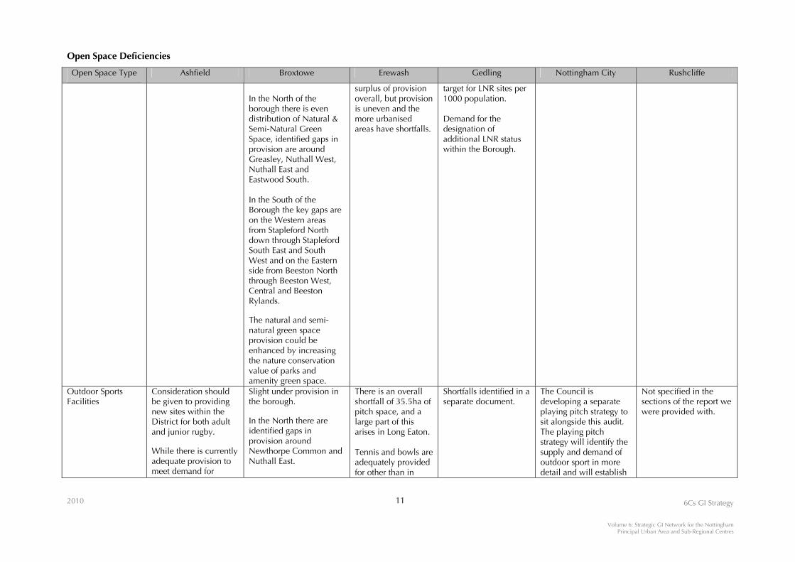
Open Space Type Ashfield Broxtowe Erewash Gedling Nottingham City Rushcliffe
Parks & Gardens Greenspace deficiencies in Hucknall (all types): *North East Hucknall-Vaughan Estate *Watnall Road area *Ogle Street area *Hucknall town centre *Top end of Butlers Hill*South Hucknall-Nottingham Road *Watnall Road, south west edge of Hucknall *Common Lane-Beauvale Estate
There is a good distribution of Parks and Gardens in the North with notable exceptions around Newthorpe Common, Greasley and Nuthall East. The neighbouring Broxtowe Country Park (Nottingham City Council) does not fill a gap in provision for the Nuthall East Estates and as a result there is an identified need to work with Nottingham City Council to improve access to the country park by establishing safe and usable links to the Nuthall East catchment. In the M1 rural corridor there is a lack of provision around the Trowell area.
Shortfall in all areas of the borough. Issues of accessibility in all parts of the borough. (Erewash’s Greenspace Strategy states: The standard generates a deficiency of over 42 hectares of park space across Erewash, and a deficit in all four areas. The deficit is most marked in Ilkeston, where over 17ha of additional space are needed, but is also prominent in the rural area where a deficit of over 10 hectares is indicated.)
Identification of a shortfall of one additional park to service the urban fringe. Funding for Gedling Colliery site has been secured; issue around land transfer agreements associated with the development of the colliery yard. The site is currently safe, for current purpose (i.e. no public access) but will require improvement work to allow greater access.
Not specified. Not specified in the sections of the report we were provided with.
Amenity Greenspace
Included under greenspace deficiencies.
In the north of the borough there are identified gaps in provision around most of Eastwood South, the area to the South of Awsworth and the Nuthall East area. While the M1 rural corridor has a low population density there is also limited provision
There is an overall deficiency of 38ha in Erewash, but most of this is in Long Eaton. In Ilkeston, provision is almost at the required level. Erewash’s Greenspace strategy states that the distribution is
No identified demand for additional amenity greenspace.
Not specified. Not specified in the sections of the report we were provided with.
Open Space Deficiencies
2010 8 6Cs GI Strategy
Volume 6: Strategic GI Network for the Nottingham Principal Urban Area and Sub-Regional Centres
Open Space Type Ashfield Broxtowe Erewash Gedling Nottingham City Rushcliffe
to the North of Trowell. In the South of the borough the key gaps in provision are around Bramcote, Stapleford North, South East and South West and to the North of Beeston Rylands. While there is also limited provision in Central Beeston the area suffers from restricted land availability for new green space provision. Likewise parts of Chilwell West are restricted by the extent of MOD land and Toton and Chilwell Meadows is restricted by the industrial nature of part of the area.
reasonably even but the absence of spaces in substantial areas of Long Eaton, and in the northwest of the borough, is especially apparent.
Children’s Play Spaces
Uneven provision of play facilities and activity areas within the District, with particularly low provision of both play and activity areas in Hucknall. Proposed new or upgraded play areas in Hucknall include: *Washdyke Lane Recreation Ground- medium size play area required *Albert Street
Slight under provision in the borough.
These standards highlight a deficiency of nearly 5ha in current provision, spread across all areas of the borough. Erewash’s Greenspace strategy states that Provision is best in Ockbrook and Borrowash, but elsewhere the deficiency is more marked, especially in the urbanised areas.
Shortfalls identified in a separate document.
Not specified. Not specified in the sections of the report we were provided with.

Open Space Deficiencies
2010 9 6Cs GI Strategy
Volume 6: Strategic GI Network for the Nottingham Principal Urban Area and Sub-Regional Centres
Open Space Type Ashfield Broxtowe Erewash Gedling Nottingham City Rushcliffe
Recreation Ground- re-site and upgrade to medium size play area *Nabbs Lane-Upgrade from medium to large size play area *Milton Rise- replace small play area *Titchfield Park-upgrade from medium to large (Destination site) play area Priority sites for potential new or upgraded young people’s facilities in Hucknall include: *The Ranges or Washdyke Lane Recreation Ground -new facility required: e.g. goalposts or a kickwall *Common Farm or Polperro Lagoon -e.g. five a side goal posts or a kickwall *Nabbs Lane- additional facilities required, e.g activity equipment. (Note: all locations and suggested provision will be subject to further investigation and consultation)
Open Space Deficiencies
2010 10 6Cs GI Strategy
Volume 6: Strategic GI Network for the Nottingham Principal Urban Area and Sub-Regional Centres
Open Space Type Ashfield Broxtowe Erewash Gedling Nottingham City Rushcliffe
Allotments Although demand for allotment plots is currently strong in Hucknall, the provision of allotment plots per household in Ashfield District is well within the recommended national standard of 1 plot for every 50 households (e.g. Hucknall 1 plot for every 28 households).
Not specified. Erewash’s Greenspace Strategy states that an overall deficiency in allotment provision of 2.63 hectares is primarily due to a lack of sufficient sites in Long Eaton. In Ilkeston and in Ockbrook and Borrowash, there is actually a modest surplus of provision. Allotment sites are reasonably well-spread across the borough, but there are areas of notable deficiency in terms of accessibility, particularly in Long Eaton and in the north western area of the borough.
No identified demand for the creation of additional allotments
A City standard of suitable provision is to be determined by the City Council.
Not specified in the sections of the report we were provided with.
Cemeteries & Churchyards
Additional sites required will be identified through the planning process and specifically within the Local Development Framework.
Not specified. The Council subscribes to the Charter for the Bereaved. Existing provision is adequate for the foreseeable future but attention will need to be given to quality standards at some sites.
Over the next few years there will be demand for additional burialspace in Gedling. GBC is looking to develop a strategy to consider sites over the next 50 – 100 years.
No quantitative Standard Set The City Standard is to be based on the minimal provision of 10 years space for burial and cremation needs for the City resident population.
Not specified in the sections of the report we were provided with.
Natural & Semi-Natural Greenspaces
Included under greenspace deficiencies.
Potential shortfall of approximately 38.7ha of Local Nature Reserves.
The standards actually show Erewash with a
Gedling is currently operating well below the English nature
Not specified. Not specified in the sections of the report we were provided with.
Open Space Deficiencies
2010 11 6Cs GI Strategy
Volume 6: Strategic GI Network for the Nottingham Principal Urban Area and Sub-Regional Centres
Open Space Type Ashfield Broxtowe Erewash Gedling Nottingham City Rushcliffe
In the North of the borough there is even distribution of Natural & Semi-Natural Green Space, identified gaps in provision are around Greasley, Nuthall West, Nuthall East and Eastwood South. In the South of the Borough the key gaps are on the Western areas from Stapleford North down through Stapleford South East and South West and on the Eastern side from Beeston North through Beeston West, Central and Beeston Rylands. The natural and semi-natural green space provision could be enhanced by increasing the nature conservation value of parks and amenity green space.
surplus of provision overall, but provision is uneven and the more urbanised areas have shortfalls.
target for LNR sites per 1000 population. Demand for the designation of additional LNR status within the Borough.
Outdoor Sports Facilities
Consideration should be given to providing new sites within the District for both adult and junior rugby. While there is currently adequate provision to meet demand for
Slight under provision in the borough. In the North there are identified gaps in provision around Newthorpe Common and Nuthall East.
There is an overall shortfall of 35.5ha of pitch space, and a large part of this arises in Long Eaton. Tennis and bowls are adequately provided for other than in
Shortfalls identified in a separate document.
The Council is developing a separate playing pitch strategy to sit alongside this audit. The playing pitch strategy will identify the supply and demand of outdoor sport in more detail and will establish
Not specified in the sections of the report we were provided with.

Open Space Deficiencies
2010 12 6Cs GI Strategy
Volume 6: Strategic GI Network for the Nottingham Principal Urban Area and Sub-Regional Centres
Open Space Type Ashfield Broxtowe Erewash Gedling Nottingham City Rushcliffe
hockey within the district, there is a growing demand for good quality, floodlit, all weather pitches for other pitch-based sport. Current deficiency in Hucknall of mini soccer and cricket pitches
In the South there are isolated gaps around Beeston West and North of Toton.
Ockbrook/ Borrowash.
provision standards based on local need identified through the Sport England ‘Towards a level playing field methodology.
Green Corridors Not specified. Treated as a sub-type of the Natural and Semi-Natural Greenspaces category
Not specified Demand for networks to link up at least the major open spaces within the Borough. Rights of way shortfalls have been identified in Ravenshead, Linby, Newstead and Papplewick. Demand has been identified for the creation of additional cycleways and improved links to pedestrian crossings
Not specified. Not specified in the sections of the report we were provided with.

2010 13 6Cs GI Strategy
Volume 6: Strategic GI Network for the Nottingham Principal Urban Area and Sub-Regional Centres
Nottinghamshire Rights of Way Improvement Plan
• Protect, maintain and seek to enhance the network for all lawful users;
• Improve access to the network for all, including those with visual impairment and mobility problems, by adopting the principle of the least restrictive option;
• Develop accessible multi-user routes;
• Develop circular routes designed to BT ‘Countryside for All standards’; • Improve the safety and connectivity of the metalled road network with the rights of way
network including schemes to provide safe routes to schools and provision of safe crossing points with the road network.
Derbyshire Rights of Way Improvement Plan
• Improve the provision of routes for bridleway users; • Improve the provision of circular or connected routes; • Provide more easy access routes; • Continue with the development of the greenway programme for the county; • Improve the management of recreational motorised vehicles in the countryside; • Promote routes identified as easy access paths; and • Encourage the production of new promoted routes.
2.2.5 A greenway strategy has been produced by Derbyshire County Council for East Derbyshire
(1998). The strategy provides a basis for the development of a network of greenways
throughout the county, helping to meet the need for the development of the greenway
programme identified in the Derbyshire Rights of Way Improvement Plan.
Landscape Character Needs
2.2.6 The Nottinghamshire Landscape Guidelines (1997), the Greater Nottingham Landscape
Character Assessment (2009) and the Derbyshire Landscape Character Assessment (2003)
provide guidelines for protecting and enhancing the character of the landscape within the
Study Area, taking into account historic landscape character considerations. The guidelines are
a response to the identified need to sustain and enhance the condition of landscapes
throughout the Study Area.
2.2.7 The following Nottinghamshire landscape character types (see Figure 2.4) fall within the Study
Area:
• Terrace Farmlands (N1) • Wooded Clay Wolds (N4) • Village Farmlands (N5) • River Meadowlands (N7)

2010 14 6Cs GI Strategy
Volume 6: Strategic GI Network for the Nottingham Principal Urban Area and Sub-Regional Centres
• River Valley Wetlands (N8) • Dumble Farmlands (N9) • Alluvial Farmlands (N10) • Forestry Sandlands (N12) • Coalfields Farmlands (N13) • Limestone Fringe (N14) • Limestone Farmlands (N15)
2.2.8 The following Derbyshire landscape character types (see Figure 2.4) fall within the Study Area:
• Riverside Meadow (D6) • Coalfields Village Farmlands (D8) • Coalfield Estatelands (D10) • Plateau Estate Farmlands (D11) • Lowland Village Farmlands (D14)
2.2.9 Planting and Management Guidelines Strategies for the Derbyshire landscape character types
can be found in Appendix A4. Further guidance on strategies for individual landscape
character types can be found in the Derbyshire Landscape Character Assessment (Derbyshire
County Council, 2003)15 and Appendix A4 of the Baseline Information Review and Strategic GI
Audit Report (Volume 3 of the 6Cs GI Strategy).
2.2.10 Derbyshire County Council has developed an approach for identifying strategic opportunities
for GI based on analysis of historic landscape character and biodiversity assets. Subject to
availability of appropriate historic landscape characterisation data, this approach could be
applied within this Study Area to achieve a consistent analysis of historic environment GI
resources across the 6Cs sub-region.
Biodiversity Needs
2.2.11 The relevant Biodiversity Action Plans (BAPs) provide targets and actions in response to
identified needs for enhancing and extending habitat species of nature conservation value
within the Study Area. See Section 2.4 for further details.
2.3 Strategic Public Benefits of Green Infrastructure Provision
2.3.1 It is increasingly recognised that investment in GI such as accessible greenspace networks and
other ‘green assets’ can provide a wide range of multiple public benefits for both rural and
urban communities. The East Midlands Public Benefit Mapping Project16 gathered evidence
15 The Derbyshire Landscape Character Assessment (Derbyshire County Council, 2003) is available to download from: http://www.derbyshire.gov.uk/environment/conservation/landscapecharacter/default.asp. 16 Green Infrastructure for the East Midlands – A Public Benefit Mapping Project (East Midlands Regional Assembly, 2006).

2010 15 6Cs GI Strategy
Volume 6: Strategic GI Network for the Nottingham Principal Urban Area and Sub-Regional Centres
from 27 different sectors, all relevant to the East Midlands Integrated Regional Strategy’s
objectives, in order to map where:
• There is the greatest need for the public benefits GI brings; • There is the greatest opportunity for GI to support sustainable economic growth; • Such needs and opportunities can be met in parallel; and • Greatest multiple public benefit in terms of social, environmental, economic and multiples
outcomes exist.
2.3.2 The East Midland’s public benefit maps provide a strategic overview of where investment in GI is
most likely to deliver greatest public benefit in the region. It should be noted that these maps
should be considered in the context of the East Midlands Public Benefit Mapping Project as a
whole, in particular in relation to the Project’s constraints and limitations17. The public benefits
mapping can help target actions in relation to:
• Provision of new or enhanced GI for areas of present and future deficit; �� • Management of existing GI resources to increase their usefulness (multifunctionality); • Conservation of key GI resources which contribute to the region’s environmental
infrastructure; and • Improving connectivity of existing GI resources where they are presently fragmented.
2.3.3 The areas with greatest potential to provide combined multiple public benefits (emphasising
top 30% environmental benefits) from investment in GI provision within the Study Area are
shown on Figure 2.718. Key areas include:
• An area north west of Hucknall; • A substantial part of Nottingham; • A substantial area west of Nottingham, including Ilkeston and Long Eaton; • Discrete areas east of Nottingham; • The Trent corridor.
2.4 Strategic Green Infrastructure Opportunities
Strategic Opportunities for Enhancing Connectivity of the Greenspace Network for Biodiversity
2.4.1 Opportunities for enhancing connectivity of the greenspace network for biodiversity have been
identified based on the mapping exercises undertaken for the Stage 1 Strategic GI Audit and
subsequent consultation exercises.
17 Green infrastructure for the East Midlands – A Public Benefit Mapping Project can be downloaded from http://www.emra.gov.uk/publications/housing-planning-and-transport/environment/green-infrastructure-in-the-east-midlands-a-public-benefit-mapping-project. 18 Map 31C ‘Combined Multiple Public Benefit Emphasising Top 30% Environmental Benefits' was taken from the Green Infrastructure for the East Midlands – A Public Benefit Mapping Project (East Midlands Regional Assembly, 2006). Reproduced with the permission of the East Midland Regional Assembly.

This map is based on Ordnance Survey material with the permission of Ordnance Survey on behalf of the Controller of Her Majesty’s Stationary Office © Crowncopyright. Unauthorised reproduction infringes Crown copyright and may lead to prosecution or civil proceedings. OS PGA Licence No. 100025498 - 2009
Figure 2.7Strategic Public Benefitsof GI Provision
10 2 km
KEY
Potential for Combined Multiple Public Benefits
NOTTINGHAM
Hucknall
Ilkeston
Principal Rivers and Canals
District/Borough Boundaries
Urban Areas
High
Low
(As per Map 31c of the Green Infrastructurefor the East Midlands - A Public Benefit Mapping Project,East Midlands Regional Assembly, 2006)
6Cs GREEN INFRASTRUCTURE STRATEGYVolume 6: Strategic GI Network for the Nottingham Principal Urban Area
and the Sub-Regional Centres of Hucknall and Ilkeston
This Figure represents relevant available information providedby stakeholders at the time of the study, and may not be exhaustive.The accuracy of digital datasets received, which have been usedin good faith without modification or enhancement, cannot beguaranteed. Commensurate with its intended ‘city-scale’ focus,the Strategic GI Network Plan illustrates indicative GI assetsand opportunities at a strategic level, which do not necessarilyindicate a constraint on development. n

2010 16 6Cs GI Strategy
Volume 6: Strategic GI Network for the Nottingham Principal Urban Area and Sub-Regional Centres
2.4.2 Opportunities for habitat creation, restoration, extension and enhancement have been
identified with reference to targets and actions set out in the Nottinghamshire Local
Biodiversity Action Plan19 (LBAP20). The targets and actions set out in the LBAPs are a response
to identified needs for maintaining, enhancing and extending the geographical range of habitats
considered important for their biodiversity value. The opportunities described below are,
therefore, intended to help meet the needs identified in the LBAPs by providing a focus for
where habitat creation, restoration, extension or enhancement could be targeted and delivered
through practical action.
2.4.3 It is recognised that the LBAPs cover areas that are geographically larger than the Nottingham
Principal Urban Area and the Sub-Regional Centres of Hucknall and Ilkeston Strategic GI
Network Study Area, and therefore the opportunities set out below are not intended to deliver
all the targets and actions assigned to each habitat type within each LBAPs. Nevertheless, the
majority of some habitat types, for example; woodlands, rivers and streams and open standing
water, fall within the Study Area and therefore opportunities for these habitat types could
deliver a correspondingly large proportion of the biodiversity action plan targets. Conversely,
habitats such as heathland, calcareous and acid grasslands may not be so significantly
represented in the Study Area, being predominantly restricted to areas within the north and
north-west of the area, and therefore opportunities for extending and enhancing these habitats
may be correspondingly smaller.
2.4.4 The time period for the current delivery plan for the Lowland Derbyshire and Nottingham
LBAPs is due to complete in 2010 - 2012. It is anticipated that the opportunities identified
could provide a focus for future Nottinghamshire LBAP targets and actions, to ensure an
integrated approach to future biodiversity action planning for this area of south
Nottinghamshire.
2.4.5 Figure 2.8 provides an overview of the strategic opportunities for enhancing connectivity of
greenspace for wildlife in relation to broad habitat types. The figure illustrates the distribution
of existing habitats and identifies strategic opportunities based on site suitability for the creation
of new, or restoration of existing, areas of habitat. Opportunities for biodiversity enhancement
were selected on the basis of two criteria: i) where fragmented areas of existing semi-natural
habitat could be linked by the extension or creation of new areas of habitat, thus forming
larger, more stable habitat mosaics, or ii) where there were no areas of existing semi-natural
habitat (e.g. around Tollerton or north east Nottingham) but the creation of new habitats would
help to bridge gaps in the current resource and provide linkages between and around urban
fringes and the wider countryside.
19 Nottinghamshire Local Biodiversity Action Plan (1998). 20 Additionally, the Lowland Derbyshire Biodiversity Action Plan has also been considered.

Ilkeston
Hucknall
NOTTINGHAM
This map is based on Ordnance Survey material with the permission of Ordnance Survey on behalf of the Controller of Her Majesty’s Stationery Office © Crowncopyright. Unauthorised reproduction infringes Crown copyright and may lead to prosecution or civil proceedings. OS PGA Licence No. 100025498 - 2009
KEY
Strategic Opportunities for Enhancing Connectivityof the Greenspace Network for Biodiversity
Figure 2.8
8a
97
3
5
4
1
6 8b
12345678a8b9
North HucknallRiver Leen east of HucknallEastwood - Hucknall - Kimberley GapSouth HucknallNorth-East Nottingham to Lambley GapSouth IlkestonRiver ErewashRiver Trent at West BridgfordRiver Trent at Holme PierrepointWest Tollerton
Existing Natural/Semi-Natural Greenspaces(Priority Habitats)
Strategic Opportunity Areas(See Appendix A5 for details)
Principal Rivers and Canals
Urban Areas
District/Borough Boundaries
Volume 6: Strategic GI Network for the Nottingham Principal Urban Areaand the Sub-Regional Centres of Hucknall and Ilkeston
6Cs GREEN INFRASTRUCTURE STRATEGY
2
0 1 2 km
This Figure represents relevant available information providedby stakeholders at the time of the study, and may not be exhaustive.The accuracy of digital datasets received, which have been usedin good faith without modification or enhancement, cannot beguaranteed. Commensurate with its intended ‘city-scale’ focus,the Strategic GI Network Plan illustrates indicative GI assetsand opportunities at a strategic level, which do not necessarilyindicate a constraint on development.

2010 17 6Cs GI Strategy
Volume 6: Strategic GI Network for the Nottingham Principal Urban Area and Sub-Regional Centres
2.4.6 Opportunities for enhancing connectivity of the greenspace network in the Study Area are set
out by broad habitat type in Appendix A5. These include:
• Woodland; • Wood pasture and parkland; • Grasslands and heathland; • Fen and reedbeds; • Rivers and streams; • Eutrophic and mesotrophic standing open waters; • Open mosaic habitats on previously developed land; and • Hedgerows, field margins, buffer strips and arable field margins.
Strategic Opportunities for Enhancing Accessibility of the Greenspace Network for People
2.4.7 Strategic opportunities for enhancing the connectivity of the greenspace network for people are
illustrated in Figure 2.9. Opportunities for new/enhanced access linkages in the form of
strategic multi-user greenways are identified. Greenways do not have any status in law. They
can be defined as ‘largely off-highway routes for shared use by people of all abilities on foot,
bike or horseback, for commuting, play or leisure; connecting people to facilities and open
spaces in and around towns, cities and the countryside’21. Greenways are especially valuable
for wheelchair users, battery powered scooters, and buggies. In many cases they utilise
existing bridleways or restricted byways with full legal rights for such usage. In other cases,
greenways can be permissive routes, owned and managed by a local authority or voluntary
organisation such as Sustrans, which the public have permission to use in appropriate ways.
2.4.8 Because of their nature as broad through routes, greenways can include street furniture,
sculpture, interpretive panels, and act as havens for wildlife along the verges, with overhanging
shrubs or trees. They also have significant potential to replace many local car journeys, both as
green walking and cycling routes. The proposed greenway network provides key access routes
from Nottingham, Hucknall and Ilkeston linking with surrounding villages and further beyond
to recreational sites in the wider countryside. They can be designed as integral parts of
sustainable urban extensions. Natural England has published a best practice Greenway
Handbook22 aimed at helping practitioners plan, design and create off-road routes to meet the
needs of walkers, cyclists23 and/or horse riders for informal recreation and commuting
purposes. Proposals for new greenways should complement improvements to the existing
rights of way network. A best practice example for greenways is included in the GI Guide for
the East Midlands24.
21 As defined by Natural England: http://www.countryside.gov.uk/LAR/Recreation/Greenways/index.asp (accessed June 2009). 22 Natural England’s best practice Greenway Handbook is available to download from the following website: http://www.countryside.gov.uk/LAR/Recreation/Greenways/index.asp (accessed May 2009). 23 For the purposes of this study, Greenways are not intended to be used for meeting demands for provision of formal competitive off-road cycling. 24 GI Guide for the East Midlands (EMGIN, 2008): Case Study 12 – Trent Valley Greenway, Long Eaton, Derbyshire.

NOTTINGHAMIlkeston
Hucknall
This map is based on Ordnance Survey material with the permission of Ordnance Survey on behalf of the Controller of Her Majesty’s Stationery Office © Crowncopyright. Unauthorised reproduction infringes Crown copyright and may lead to prosecution or civil proceedings. OS PGA Licence No. 100025498 - 2009
KEY
Existing Strategic Accessible NaturalGreenspace
Strategic Open Space
Cycle Network
Navigable Waterways (indicative)
Promoted Recreational Routes
Existing Strategic Countryside Access RoutesLinear, generally off-road and car free routes, that are normallyavailable for public access on foot, horseback or by cycleproviding opportunities to access the countryside for informalrecreation activities.
Greenways
Strategic Opportunities for Enhancing Accessibilityof the Greenspace Network for People
Figure 2.9
12
34
56
7
1
1
5
8
9
10
1112
13 14
1516
1718
19
22 2324
25
7
2
7
3
5
5
20
19
26
28
29
27
18
21
3
Volume 6: Strategic GI Network for the Nottingham Principal Urban Areaand the Sub-Regional Centres of Hucknall and Ilkeston
6Cs GREEN INFRASTRUCTURE STRATEGY
Public Rights of Way Network
Public Rights of Way Network
Opportunities for New/Enhanced AccessLinkages
Proposed Trent to Cotgrave Canal Link(preferred route)
Proposed Greenways21
0 1 2 km
Principal Rivers and Canals
Urban Areas
District/Borough Boundaries
This Figure represents relevant available information providedby stakeholders at the time of the study, and may not be exhaustive.The accuracy of digital datasets received, which have been usedin good faith without modification or enhancement, cannot beguaranteed. Commensurate with its intended ‘city-scale’ focus,the Strategic GI Network Plan illustrates indicative GI assetsand opportunities at a strategic level, which do not necessarilyindicate a constraint on development.

2010 18 6Cs GI Strategy
Volume 6: Strategic GI Network for the Nottingham Principal Urban Area and Sub-Regional Centres
2.4.9 Derbyshire County Council’s East Derbyshire Greenway strategy outlines proposals for the
development of a strategic network of greenways. This network links directly into settlements
and to the public transport interchanges, continues through communities to join other routes,
and provides a linear transport route from settlements into the wider countryside or to demand
destinations. The underlying objectives of Derbyshire County Council’s proposed greenway
network corresponds with the aspirations for the 6Cs GI Strategy and the Nottingham Principal
Urban Area and the Sub-Regional Centres of Hucknall and Ilkeston Strategic GI Network Plan.
In agreement with Derbyshire County Council, existing greenways have been included in
Figure 2.2 and 2.9.
2.4.10 The concept of providing multi-user routes or greenways also forms part of the visions for both
the Trent to Cotgrave Link Masterplan (Draft, 2009) and the Trent River Park (2008), and is
promoted by the Nottinghamshire Rights of Way Improvement Plan. For the purposes of this
Study, an aspirational network of potential greenways is shown on Figure 2.9, taking into
account greenway aspirations identified during stakeholder consultation and in relevant
reports/masterplans.
2.4.11 Opportunities for new multi-user greenways include:
1. Long Eaton to Ilkeston, and Ironville 2. Eastwood to Hucknall and Mansfield 3. North-east Nottingham to Bestwood Village, Hucknall and Newstead 4. River Leen north of Bestwood Village, to Hucknall and towards Ravenshead 5. River Erewash (south of Long Eaton) to River Leen, Nottingham, south-east Hucknall and Sansom Wood 6. Calverton towards Southwell 7. South-east Hucknall to north Kimberley, Eastwood, Heanor, and Shipley Country Park 8. North-east Eastwood to High Park Woods 9. North-west Nottingham to Hucknall 10. North-east Nottingham to Woodborough and Calverton 11. North-east Ilkeston to east Eastwood 12. West Nottingham to east Kimberley 13. West Hallam to Mapperley and Shipley Country Park 14. Stoke Bardolph to Burton Joyce 15. West Ilkeston to West Hallam and towards Little Eaton 16. Stapleford to Kimberley and Eastwood 17. Colwick Country Park Gap 18. Cotgrave Country Park to Holme Pierrepont, and Adbolton 19. River Trent to the Grantham Canal, Cotgrave Country Park and towards Cropwell Bishop 20. Proposed Trent to Cotgrave Canal link to West Bridgford 21. Breaston to Long Eaton and Erewash Canal 22. Attenborough to Long Eaton 23. Ruddington to West Bridgford and River Trent 24. Keyworth to Tollerton and Edwalton 25. Normanton-on-the-Wolds to Cotgrave and Cotgrave Country Park 26. Barton-in-Fabis to Clifton and River Trent 27. Long Eaton to River Soar and towards Keyworth 28. Ruddington towards Loughborough 29. Keyworth towards Melton Mowbray

2010 19 6Cs GI Strategy
Volume 6: Strategic GI Network for the Nottingham Principal Urban Area and Sub-Regional Centres
3.0 STRATEGIC GREEN INFRASTRUCTURE NETWORK
3.1 General
3.1.1 This section brings together and integrates the analysis of GI assets, opportunities and needs
within the Study Area set out in Section 2.0 to identify a proposed ‘aspirational’
multifunctional strategic GI Network for the Nottingham Principal Urban Area and the Sub-
Regional Centres of Hucknall and Ilkeston.
3.1.2 The purpose of the strategic GI Network is to provide the conceptual perspective or ‘bigger
picture’ for the delivery of large-scale GI within the Study Area that connects communities and
wildlife at the sub-regional and city-scales. It is intended to help focus attention or priority on
land that needs to be safeguarded, managed or secured in positive ways to create a
multifunctional network of greenspaces and assets for which investment can deliver the
greatest range of benefits. It is not a rigid approach; the Strategic GI Network is intended to be
flexible and responsive to opportunities - such as changing land ownership, community
aspirations, access to funding, development opportunities, policy considerations etc - that may
change priorities for investment over time.
3.1.3 The intention is to ensure that the integrity of the overall Strategic GI Network is not
compromised by inappropriate development and land management. This means that there
needs to be flexibility, and in cases where there is an unavoidable need to trade off existing GI
assets to meet social and economic needs, this should be offset by mitigation and
compensation measures to enhance the functionality of other GI assets elsewhere within the
Strategic GI Network. However, some semi-natural habitats, such as ancient woodlands, are
irreplaceable and need protection. Where development is planned within or in close proximity
to a GI corridor, it should become an integral feature to the design and ‘identity’ of the
development site to ensure that the connectivity of the network for both public benefit and
biodiversity is retained and enhanced.
3.1.4 The proposed Strategic GI Network provides a spatial context for the delivery of the overall
Vision for GI in the 6Cs sub-region related to the Nottingham Principal Urban Area and the
Sub-Regional Centres of Hucknall and Ilkeston.
Setting Priorities for Green Infrastructure Investment
3.1.5 The GI concept applies across the whole of the Study Area, and it can occur at any scale.
However, the proposed Nottingham Principal Urban Area and the Sub-Regional Centres of
Hucknall and Ilkeston Strategic GI Network identifies locations where targeting investment in
2010 20 6Cs GI Strategy
Volume 6: Strategic GI Network for the Nottingham Principal Urban Area and Sub-Regional Centres
GI is most likely to deliver multiple benefits across a range of key environmental, social and
economic policy areas.
3.1.6 The main priorities are considered to be:
• To focus investment on GI provision and management to address current deficits of provision/needs;
• To meet the GI needs of communities in and around the 6Cs sub-region who are likely to experience major growth-related pressures in the period to 2026;
• To protect, enhance and manage existing valuable GI assets that are under current or future pressure, in particular accessible natural greenspaces, biodiversity sites and river valleys/wetlands.
3.1.7 In response to the above, the proposed overall Strategic GI Network for the Nottingham
Principal Urban Area and the Sub-Regional Centres of Hucknall and Ilkeston shown on Figure
3.1c identifies broadly defined corridors and zones, within which it is recommended that
investment in new and enhanced GI provision be prioritised and delivered over the next 15-20
years. These corridors and zones reflect the identified opportunities and needs for enhancing
the connectivity and accessibility of the greenspace network for biodiversity and public benefit
at the sub-regional and City-Scales. They provide the context for development of GI initiatives
and projects that would provide, in many cases, multiple functions and benefits to meet a
range of social, economic and environmental needs. GI related proposals within and adjacent
to the corridors and zones would focus on the enhancement and restoration of existing GI
assets, as well as the creation of new resources.
3.1.8 Existing strategic GI assets which form the backbone of the proposed overall Strategic GI
Network for the Nottingham Principal Urban Area and the Sub-Regional Centres of Hucknall
and Ilkeston are shown combined on Figure 3.1a. Following stakeholder consultation,
examples of existing GI Destinations25 have been included on Figure 3.1a.
3.2 Sub-Regional Green Infrastructure
Sub-Regional Green Infrastructure Corridors
3.2.1 The Sub-Regional Corridors identified on Figure 3.1b generally reflect significant wildlife
habitat corridors/areas that link with Strategic GI in surrounding areas at the sub-regional level,
and have an important role to play in maintaining the overall integrity of the 6Cs GI Network in
the long term. They comprise a mosaic of land uses, natural, built heritage and archaeological
25 The GI Destinations included on Figure 3.1a were chosen based on them being well known GI sites/visitor destinations.

#
##
#
#
#
# # #
#
#
NOTTINGHAMIlkeston
Hucknall
987
6
5
4
3
2
1
11
10
This map is based on Ordnance Survey material with the permission of Ordnance Survey on behalf of the Controller of Her Majesty’s Stationery Office © Crowncopyright. Unauthorised reproduction infringes Crown copyright and may lead to prosecution or civil proceedings. OS PGA Licence No. 100025498 - 2009
KEY
Strategic GI Network -Existing GI Assets
Figure 3.1a
LEICESTER
DERBY
NOTTINGHAM
Strategic GI Network Study Areas for the Three Citieswithin the 6Cs Sub-Region
Existing Urban Areas
Combined Existing Strategic Green InfrastructureAssets(See Figure 2.5)
Examples of Green Infrastructure Destinations
High Park WoodMill Lakes Country ParkBestwood Country ParkBulwell Hall ParkBulwell ForestShipley Country ParkWollaton ParkColwick Country ParkHolme Pierrpoint National Water SportsCentre and Country ParkAttenborough Nature ReserveRushcliffe Country Park
123456789
1011
#1
Volume 6: Strategic GI Network for the Nottingham Principal Urban Areaand the Sub-Regional Centres of Hucknall and Ilkeston
6Cs GREEN INFRASTRUCTURE STRATEGY
0 1 2 km
This Figure represents relevant available information providedby stakeholders at the time of the study, and may not be exhaustive.The accuracy of digital datasets received, which have been usedin good faith without modification or enhancement, cannot beguaranteed. Commensurate with its intended ‘city-scale’ focus,the Strategic GI Network Plan illustrates indicative GI assetsand opportunities at a strategic level, which do not necessarilyindicate a constraint on development.

NOTTINGHAMIlkeston
Hucknall
This map is based on Ordnance Survey material with the permission of Ordnance Survey on behalf of the Controller of Her Majesty’s Stationery Office © Crowncopyright. Unauthorised reproduction infringes Crown copyright and may lead to prosecution or civil proceedings. OS PGA Licence No. 100025498 - 2009
K
J
AB
B
B
K
B
LEICESTER
DERBY
NOTTINGHAM
Strategic GI Network Study Areas for the Three Citieswithin the 6Cs Sub-Region
KEY
B
B
Strategic GI Network -Proposed GI Corridors & Zones
Figure 3.1b
Sub-Regional Green Infrastructure Corridors
Volume 6: Strategic GI Network for the Nottingham Principal Urban Areaand the Sub-Regional Centres of Hucknall and Ilkeston
6Cs GREEN INFRASTRUCTURE STRATEGY
0 1 2 km
This Figure represents relevant available information providedby stakeholders at the time of the study, and may not be exhaustive.The accuracy of digital datasets received, which have been usedin good faith without modification or enhancement, cannot beguaranteed. Commensurate with its intended ‘city-scale’ focus,the Strategic GI Network Plan illustrates indicative GI assetsand opportunities at a strategic level, which do not necessarilyindicate a constraint on development.
City-Scale Green Infrastructure Corridors(See Figure 2.9)
Urban Fringe Green InfrastructureEnhancement Zones
Existing Urban Areas
AB
J
K
- Derwent Strategic River Corridor- Trent Strategic River Corridor and River Leen, Grantham Canal, Trent & Mersey Canal and Beeston Canal)- Erewash Strategic River Corridor and Erewash Canal- Greenwood Community Forest

NOTTINGHAMIlkeston
Hucknall
This map is based on Ordnance Survey material with the permission of Ordnance Survey on behalf of the Controller of Her Majesty’s Stationery Office © Crowncopyright. Unauthorised reproduction infringes Crown copyright and may lead to prosecution or civil proceedings. OS PGA Licence No. 100025498 - 2009
KEY
LEICESTER
DERBY
NOTTINGHAM
Strategic GI Network Study Areas for the Three Citieswithin the 6Cs Sub-Region
The Overall Strategic GI NetworkFigure 3.1c
City-Scale Green Infrastructure Corridors(See Figure 2.9)
Urban Fringe Green InfrastructureEnhancement Zones
Sub-Regional Green Infrastructure Corridors(See Figure 3.1b)
Volume 6: Strategic GI Network for the Nottingham Principal Urban Areaand the Sub-Regional Centres of Hucknall and Ilkeston
6Cs GREEN INFRASTRUCTURE STRATEGY
Combined Existing Strategic Green InfrastructureAssets(See Figure 2.5)
Existing Urban Areas
0 1 2 km
This Figure represents relevant available information providedby stakeholders at the time of the study, and may not be exhaustive.The accuracy of digital datasets received, which have been usedin good faith without modification or enhancement, cannot beguaranteed. Commensurate with its intended ‘city-scale’ focus,the Strategic GI Network Plan illustrates indicative GI assetsand opportunities at a strategic level, which do not necessarilyindicate a constraint on development.

2010 21 6Cs GI Strategy
Volume 6: Strategic GI Network for the Nottingham Principal Urban Area and Sub-Regional Centres
resources and settlements, and are intended to become fully multifunctional zones with the
ability or potential to deliver the following key GI ‘functions’:
• Access and Movement – linking settlements to their hinterland, destinations and the wider strategic access network. The corridors provide sustainable links through attractive green routes with clear way marking and other relevant facilities. They also provide opportunities to enhance the management, presentation, accessibility and interpretation of greenspace;
• Biodiversity – providing a focus for the enhancement and linkage of the biodiversity resource;
• Mitigation of flood risk, enhancement of water management and other natural process roles; • Enhancement and promotion of landscape and urban character to celebrate the
distinctiveness of these different corridors; • Enhancement and promotion of heritage and cultural assets; and • Enhancement and promotion of recreation and leisure, providing connections between
communities, accessible greenspace and other destinations.
3.2.2 The Sub-Regional GI Corridors form the backbone of the 6Cs GI Network and provide the core
of the proposed Strategic GI Network for the Nottingham Principal Urban Area and the Sub-
Regional Centres of Hucknall and Ilkeston. They are:
B – Trent Strategic River Corridor and River Leen, Grantham Canal, Trent & Mersey Canal,
and Beeston Canal
Key Landscape Characteristics26
Terrace Farmlands (described as part of the Trent Washland group) “A flat low-lying agricultural A flat low-lying agricultural landscape characterised by a traditional pattern of hedged fields and nucleated village settlements“. - Broad flat river terraces - Regular pattern of medium-to large-sized fields, breaking down and becoming open in many areas - Hedgerow trees main component of tree cover, ash the principle species - Willow pollards - Predominantly arable with permanent pasture around settlements and roads - Nucleated villages with traditional red brick and pantile roofed buildings - Large power stations - Sand and gravel quarries River Meadowlands A and B (described as part of the Trent Washland group) “A flat low-lying riverine landscape characterised by alluvial meadows, grazing animals and remnant wetland vegetation“. - Meandering river channels, often defined by flood banks - Sparsely populated with few buildings - Permanent pasture and flood meadow - Steep wooded bluffs - Willow holts - Long sinuous hedges - Pollarded willows - Regular pattern of medium to large size arable fields, breaking down and becoming open in many areas - Hedgerow trees main component of tree cover
26 Information provided by individual Landscape Character Type as described in the Nottinghamshire Landscape Guidelines (Nottinghamshire County Council, 1997). This information is now superseded by information contained in the Greater Nottingham Landscape Character Assessment (2009), which was not available at the time of the Study.
2010 22 6Cs GI Strategy
Volume 6: Strategic GI Network for the Nottingham Principal Urban Area and Sub-Regional Centres
River Valley Wetlands (described as part of the Trent Washland group) “A diverse range of highly modified landscapes created by sand and gravel extraction”.
- Actively worked areas with disturbed ground and dry voids - Flooded workings with large areas of open water - Wetland habitats at different stages of maturity - Recreational developments for water sports, country parks etc - Areas of restored agricultural land, often poorly landscaped
Limestone Farmlands (described as part of the Magnesian Limestone group) “A gently rolling, and in places urbanised agricultural landscape, characterised by large hedged fields, estate woodlands and small limestone villages”.
- Gently rolling limestone escarpment - Fertile soils supporting productive arable farmland - Regular pattern of large hedged fields - Large estate woodlands and belts of trees - Views often framed by wooded skylines - Nucleated pattern of small stone villages - Limestone buildings with orange pantile roofs - Large self-contained mining settlements - Mine sites with associated pit heaps and railway lines
River Meadowlands (described as part of the Magnesian Limestone group) “Narrow, in places incised, river corridors, defined by grazing meadows and riverside trees”.
- Narrow alluvial flood plains - Meandering river channels - Marginal aquatic and bankside vegetation - Grazing meadows with patches of wet grassland - Riparian trees and scrub - Sinuous boundary hedgerows - Relic mills constructed from local limestone
Village Farmlands (described as part of the South Nottinghamshire Farmland group) “A gently rolling agricultural landscape with a simple pattern of large arable fields and village settlements“.
- Gently rolling topography - Simple pattern of large arable fields - Neatly trimmed hawthorn hedges - Nucleated villages with traditional red brick and pantile roofed buildings - Suburbanised commuter villages and small towns - Small-scale pastoral landscapes along village edges
Alluvial Farmlands (described as part of the South Nottinghamshire Farmland group) “Flat, low-lying, uninhabited and often inaccessible landscapes with a strong sense of space, characterised by open areas of farmland and a remnant pattern of large hedged fields.”
- Flat low-lying topography - Seasonally wet alluvial and peaty soils - Open, spacious views, sometimes enclosed by rising ground - Remnant pattern of large hedged fields defined by thorn hedges or ditches - Small broad leaved plantations - Absence of farmsteads or other buildings Key Biodiversity Features, Designated Heritage Features and Settlements • Biodiversity – floodplain grazing marsh, open mosaic habitats (on previously developed
land), lowland mixed deciduous woodland, lowland meadows, rivers and streams, reedbed, eutrophic standing water and lowland fen.
• Cultural heritage features – a number of scheduled monuments, conservation areas in a number of settlements including Thrumpton, north-west Clifton, and southern Nottingham; Holme Pierrepoint Hall Historic Park and Garden, Nottingham’s historic core adjacent;

2010 23 6Cs GI Strategy
Volume 6: Strategic GI Network for the Nottingham Principal Urban Area and Sub-Regional Centres
• Settlements – Thrumpton, Barton-in-Fabis, north-west Clifton, southern parts of Nottingham, a corridor running through Nottingham south to north, Bestwood Village, south-east Hucknall, Holme Pierrepont, Shelford, and south-west Radcliffe-on-Trent.
• Geodiversity – Nottingham City and surrounds have a number of key RIGS/Local Geological Sites in the Lenton Sandstone, Nottingham Castle Sandstone, both as exposures and the numerous caves, and the Mercia Mudstone Group.
Key Opportunities for Delivering GI Benefits • Access and movement – potential to establish traffic free multi-user greenways e.g. linking
the communities of Clifton, Nottingham and Radcliffe-on-Trent to one another and to the River Trent and GI assets such Colwick Country Park, or linking communities in Nottingham to Hucknall along the River Leen;
• Biodiversity – opportunities for river corridor habitat management, creation, restoration and extension e.g. for floodplain grazing marsh, open mosaic habitats (on previously developed land), lowland mixed deciduous woodland, lowland meadows, rivers and streams, reedbed, eutrophic standing water and lowland fen;
• Natural processes – opportunities to manage flood risk through appropriate land management;
• Cultural heritage – opportunities to enhance the management, presentation, accessibility and interpretation of historic environment assets, e.g. Holme Pierrepont Hall Historic Park and Garden;
• Landscape – opportunities to enhance the character and distinctiveness of the landscape through positive landscape intervention measures and active land management action informed by Landscape Character Assessments e.g. conserve and restore the continuity and distinctive pastoral character of the river meadowlands landscape.
J – Erewash Strategic River Corridor and Erewash Canal
Key Landscape Characteristics27
Coalfield Farmlands (described as part of the South Nottinghamshire Coalfield group) 28 “A densely settled, industrial landscape characterised by mining settlements and pit heaps, intermixed with pastoral farmland”.
- Varied undulating topography - Closely spaced mining settlements - Pockets of pastoral farmland - Small to medium-sized hedged fields - Network of narrow winding lanes - Mine sites, pit heaps and disused railway lines - Rows of red brick terrace housing - Scattered, small broad-leaved woodlands River Meadowlands (described as part of the South Nottinghamshire Coalfiedls group) 29 “A narrow, pastoral river corridor landscape, in places contained by settlement edges, pit heaps and railway embankments.”
- Narrow alluvial floodplain - Meandering river channel
27 Information provided by individual Landscape Character Type 28 Information from the Nottinghamshire Landscape Guidelines (Nottinghamshire County Council, 1997). This information is now superseded by information contained in the Greater Nottingham Landscape Character Assessment (2009), which was not available at the time of the Study. 29 Information from the Nottinghamshire Landscape Guidelines (Nottinghamshire County Council, 1997). This information is now superseded by information contained in the Greater Nottingham Landscape Character Assessment (2009), which was not available at the time of the Study.

2010 24 6Cs GI Strategy
Volume 6: Strategic GI Network for the Nottingham Principal Urban Area and Sub-Regional Centres
- Views often contained by built development and railway embankments - Permanent pastures grazed by cattle and horses - Patches of wet grassland and marsh - Riverside alders and scrub - Bushy hawthorn and willow hedgerows
Coalfield Village Farmlands30
“A broad industrial landscape characterised by many pit villages, dairy farming and small woodlands.”
- Gently undulating landform - Dairy farming with pasture and localised arable cropping - Relict ancient semi-natural woodland, copses and linear tree-belts - Dense streamline trees and scattered hedgerow trees - Towns and villages on ridge lines surrounded by remnant medieval strip fields - Network of small irregular lanes between larger urban roads - Small villages with sandstone buildings expanded by red brick former mining terraces and ribbon
development - Primary habitats: ancient and species rich hedgerows, veteran trees, neutral grassland, standing open
waters and canals, and rivers and streams - Secondary habitats: ancient and semi natural broadleaved woodland, lowland parkland, cereal field
margins, rush pasture, reedbeds, and lowland dry acid grassland.
Coalfield Estatelands31 “A heavily industrialised and urbanised landscape characterised by many mining settlements, parkland, woodland and dairy farming.”
- Gently undulating landform - Dairy farming dominated by pasture - Plantation woodlands, tree belts and coverts - Fields of medium size defined by hedgerows - Extensive areas of existing and relict parkland - Occasional country houses with associated parkland trees - Villages and towns with red brick former mining terraces and ribbon development - Primary habitats: ancient and semi natural broadleaved woodland, lowland parkland, wet woodland,
veteran trees, ancient and species rich hedgerows, neutral grassland, standing open waters and canals, and rivers and streams
- Secondary habitats: cereal field margins, rush pasture, and reedbeds.
Riverside Meadows32 “A flat, riverside landscape characterised by dairy farming, wetland, watercourse trees and a legacy of industrial heritage.”
- Narrow rivers meander along flood plains of variable width - Remnant riverside vegetation, wetland and unimproved grassland - Dairy farming dominated by pasture - Dense tree cover along river channels - Scattered tree cover along boundaries - Strong association with transport routes due to the presence of canals, railway lines and roads - Primary habitats: wet woodland, floodplain grazing marsh, rush pasture, reedbeds, lowland fen
meadows, neutral grassland, standing open waters and canals, and rivers and streams
Key Biodiversity Features, Designated Heritage Features and Settlements • Natural features – floodplain grazing marsh, open mosaic habitats (on previously developed
land), lowland mixed deciduous woodland (including wet woodland), rivers and streams, and eutrophic standing water;
• Cultural heritage features – conservation area in Cossall adjacent;
30 Information from the Landscape Character of Derbyshire (Derbyshire County Council, 2003). 31 Information from the Landscape Character of Derbyshire (Derbyshire County Council, 2003). 32 Information from the Landscape Character of Derbyshire (Derbyshire County Council, 2003).

2010 25 6Cs GI Strategy
Volume 6: Strategic GI Network for the Nottingham Principal Urban Area and Sub-Regional Centres
• Settlements – a corridor through Long Eaton, east Ilkeston, east Heanor, east Ironville, and west Jacksdale.
Key Opportunities for Delivering GI Benefits • Access and movement – potential to establish traffic free multi-user greenways e.g. linking
the communities of Long Eaton, Ilkeston and Ironville to one another and to the River Erewash and Erewash Canal;
• Biodiversity – opportunities for river corridor habitat management, creation, restoration and extension e.g. floodplain grazing marsh, open mosaic habitats (on previously developed land), lowland mixed deciduous woodland (including wet woodland), rivers and streams, eutrophic standing water, lowland meadows, reedbed, and lowland fen;
• Natural processes – opportunities to manage flood risk through appropriate land management e.g. flood management works on the River Trent around southern Long Eaton;
• Cultural heritage – opportunities to enhance the management, presentation, accessibility and interpretation of historic environment assets, e.g. nearby Cossall historic village;
• Landscape – opportunities to enhance the character and distinctiveness of the landscape through positive landscape intervention measures and active land management action informed by Landscape Character Assessments e.g. restore and enhance the visual and ecological continuity of the river corridor.
K – Greenwood Community Forest Key Landscape Characteristics33 Forest Sandlands (described as part of the Sherwood group) “An undulating, well-wooded and in places industrialised landscape characterised by large arable fields, pine plantations and remnants of semi-natural woodland and heath”.
- Dissected undulating topography - Frequent views of wooded skylines - Strong heathy character reflected in the widespread occurrence of bracken, gorse and broom species - Geometric pattern of large-scale arable fields - Planned layout of straight roads - Neatly trimmed hawthorn hedgerows - Large pine plantations - Mining settlement and associated spoil heaps - Scrubby semi-natural woodland and heaths with ancient-stag headed oaks
Dumble Farmlands (described as part of the Mid Nottinghamshire Farmland group) “A distinctively rolling landscape characterised by mixed agriculture, wooded dumble valleys and a well-defined pattern of hedged fields.”
- Steeply rolling topography - Well-defined pattern of hedged fields - Meandering tree-lined dumble valleys - Mixed agriculture - Scattered small woodlands, sometimes ancient in origin - Expanded commuter settlements and small traditional villages - Busy commuter roads and quiet country lanes - Orchards
Limestone Farmlands (described as part of the Magnesian Limestone group) “A gently rolling, and in places urbanised agricultural landscape, characterised by large hedged fields, estate woodlands and small limestone villages.”
33 Information provided by individual Landscape Character Type as per the Nottinghamshire Landscape Guidelines (Nottinghamshire County Council, 1997). This information is now superseded by information contained in the Greater Nottingham Landscape Character Assessment (2009), which was not available at the time of the Study.

2010 26 6Cs GI Strategy
Volume 6: Strategic GI Network for the Nottingham Principal Urban Area and Sub-Regional Centres
- Gently rolling limestone escarpment - Fertile soils supporting productive arable farmland - Regular pattern of large hedged fields - Large estate woodlands and belts of trees - Views often framed by wooded skylines - Nucleated pattern of small stone villages - Limestone buildings with orange pantile roofs - Large self-contained mining settlements - Mine sites with associated pit heaps and railway lines
Coalfield Farmlands (described as part of the Nottinghamshire Coalfield group) “A densely settled, industrial landscape characterised by mining settlements and pit heaps, intermixed with pastoral farmland.”
- Varied undulating topography - Closely spaced mining settlements - Pockets of pastoral farmland - Small to medium-sized hedged fields - Network of narrow winding lanes - Mine sites, pit heaps and disused railway lines - Rows of red brick terrace housing - Scattered, small broad-leaved woodlands
Terrace Farmlands (described as part of the Trent Washland group) “A flat low-lying agricultural landscape characterised by a traditional pattern of hedged fields and nucleated village settlements “
- Broad flat river terraces - Regular pattern of medium-to large-sized fields, breaking down and becoming open in many areas - Hedgerow trees main component of tree cover, ash the principle species - Willow pollards - Predominantly arable with permanent pasture around settlements and roads - Nucleated villages with traditional red brick and pantile roofed buildings - Large power stations - Sand and gravel quarries River Meadowlands (described as part of the Trent Washland group) “A flat low-lying riverine landscape characterised by alluvial meadows, grazing animals and remnant wetland vegetation.”
- Meandering river channels, often defined by flood banks - Sparsely populated with few buildings - Permanent pasture and flood meadow - Steep wooded bluffs - Willow holts - Long sinuous hedges - Pollarded willows - Regular pattern of medium to large size arable fields, breaking down and becoming open in many areas - Hedgerow trees main component of tree cover
Key Biodiversity Features, Designated Heritage Features and Settlements • Biodiversity – open mosaic habitats (on previously developed land), lowland mixed
deciduous woodland, lowland meadows, eutrophic standing water, rivers and streams, floodplain grazing marsh, and lowland dry acid grassland;
• Cultural heritage features – a number of scheduled monuments, conservation areas in a number of settlements including Attenborough, Cossall, Kimberley, Eastwood, Brinsley, Bagthorpe, Stapleford, Hucknall, Papplewick, Bestwood Village, Calverton, Woodborough, Lambley; Papplewick Hall, Bestwood Pumping station, Annesley Hall and Newstead Abbey Historic Parks and Gardens;
• Settlements – Attenborough, Hucknall Village, Bulwell, Brinsley, Jacksdale, Bagthorpe, Selston, Sutton-in-Ashfield, Eastwood, Awsworth, Cossall, Kimberley, Trowell, Stapleford,

2010 27 6Cs GI Strategy
Volume 6: Strategic GI Network for the Nottingham Principal Urban Area and Sub-Regional Centres
Newstead, Papplewick, Bestwood Village, north Nottingham, Calverton, Woodborough, Lambley, Burton Joyce, and Stoke Bardolph.
Key Opportunities for Delivering GI Benefits
• Access and movement – potential to establish traffic free multi-user greenways e.g. linking the communities of Nottingham and Calverton to one another and to strategic GI assets such as Epperstone Park, or linking communities to Sherwood Forest;
• Biodiversity – opportunities for landscape-scale habitat management,, creation, restoration and extension e.g. for open mosaic habitats (on previously developed land), lowland mixed deciduous woodland, lowland meadows, eutrophic standing water, lowland dry acid grassland, and lowland heath;
• Natural processes – opportunities for water management through appropriate land management e.g. nitrate management work on Greenwood Community Forest farms;
• Cultural heritage – opportunities to enhance the management, presentation, accessibility and interpretation of historic environment assets, e.g. Annesley Hall and Newstead Abbey Historic Parks and Gardens;
• Landscape – opportunities to enhance the character and distinctiveness of the landscape through positive landscape intervention measures and active land management action informed by Landscape Character Assessments e.g. conserve and strengthen the distinctive heathy and well-wooded character of the landscape.
Urban Fringe GI Enhancement Zones
3.2.3 Taking into account the 6Cs sub-region’s existing demographic patterns, and the spatial
pattern of changes in population arising from the future growth proposed under the
Government’s Sustainable Communities Plan and the East Midlands Regional Plan, the
countryside in and around Nottingham, Hucknall and Ilkeston has greatest demand, and
therefore need, for enhanced provision of existing and new GI. These broad zones include
areas of land that represent a significant resource for urban communities in the sub-region,
comprising dynamic and complex mosaics of land uses and habitats. They are the immediate
landscape setting for Principal Urban areas and Sub-Regional Centres, have a critical role to
play in linking town and country, and will experience major planned growth. By their
definition, Sustainable Urban Extensions are likely to be located within these areas. Existing GI
resources in such areas are already experiencing urban edge issues, and are therefore likely to
come under increasing pressure in the future.
3.2.4 In recognition of their strategic importance for delivery of GI from a sub regional perspective,
the countryside in and around Nottingham, Hucknall and Ilkeston has been defined as Urban
Fringe Green Infrastructure Enhancement Zones (see Figure 3.1b): The indicative extent of
the Zones defined on Figure 3.1b is generic, and is simply intended to schematically illustrate
the transition between urban and rural land uses around the Principal Urban Areas and Sub-
Regional Centres.

2010 28 6Cs GI Strategy
Volume 6: Strategic GI Network for the Nottingham Principal Urban Area and Sub-Regional Centres
3.2.5 Through investment in GI provision, the Urban Fringe Green Infrastructure Enhancement Zones
have the ability or potential to deliver a range of economic, environmental and social benefits
related to the following GI themes or functions34:
• A bridge to the country - linking housing, schools, health centres and hospitals, bus and train stations in urban centres to the existing/enhanced access network to connect with accessible greenspaces in the wider countryside;
• A gateway to cities and towns - providing an improved image, experience and sense of place through investment in an improved environmental quality for public rights of way and spaces;
• A health centre - contributing to health improvements and well-being through schools, hospitals and health centres promoting opportunities to access greenspaces for exercise as part of health programmes;
• An outdoor classroom - opportunities to provide environmental education through parks, nature reserves and farm-based activities;
• A recycling and renewable energy centre - helping address climate change through sustainable management of waste, water and pollution, production of energy crops and creation of woodland to act as carbon sinks;
• A productive landscape – recognising the role of urban fringe farmland in food production, processing of local produce and retail (farm shops) for urban areas;
• A cultural legacy - increasing awareness of historic features in the urban fringe landscape and how they contribute to sense of place for local communities;
• A place for sustainable living - ensuring that future development links with the urban area and addresses issues such as fly-tipping, indistinct boundaries, poor accessibility, fragmented landscapes, etc;
• An engine for regeneration – providing quality of life benefits through opportunities for community involvement through volunteering or gaining new skills in environmental improvement work, particularly within areas of multiple deprivation; and
• A nature reserve - strengthening biodiversity, geological and geomorphological conservation management for sites in and around urban areas.
3.2.6 Within the Urban Fringe Green Infrastructure Enhancement Zones, land is widely used by
urban communities as a resource for informal, and often unauthorised, recreation leading to
conflicts with other land uses. Additionally, the poor permeability of some built up areas can
be a barrier to accessing the surrounding countryside. These Zones would benefit from the
adoption of a strategic and co-ordinated approach to managing access for urban communities
into the surrounding countryside. It is envisaged that the Urban Fringe Green Infrastructure
Enhancement Zones would encompass a network of interlinked and multifunctional
greenspaces that connect with city/town centres, public transport nodes, and major
employment and residential areas, including new sustainable urban extensions. A careful
balance will need to be struck between creation of new GI and the need to safeguard existing
natural and cultural features that contribute to the character and value of the wider agricultural
landscape.
3.2.7 Urban Fringe GI Enhancement Zones have an important role to play in relation to improving
linkages and connectivity between Principal Urban Areas/Sub-Regional Centres and the wider
34 Key functions as described in Countryside Agency’s vision for the Countryside in and around Towns (2005)
2010 29 6Cs GI Strategy
Volume 6: Strategic GI Network for the Nottingham Principal Urban Area and Sub-Regional Centres
GI network of Sub-Regional and City-Scale GI Corridors. In particular, Sustainable Urban
Extensions will need to protect the integrity of the wider GI network, and support existing
urban areas, by maintaining and enhancing GI within the Urban Fringe GI Enhancement
Zones. Further work is required at the local level to identify specific opportunities for
integrating GI provision into local development and delivery plans within individual Zones.
3.3 City-Scale Green Infrastructure
3.3.1 A network of City-Scale GI Corridors is proposed (see Figure 3.1b) linking up settlements,
strategic GI assets, and Sub-Regional Corridors. In many cases, the City-Scale GI Corridors
extend into the urban areas, providing key elements of the Urban Fringe GI Enhancement
Zones. While these corridors are indicative, they demonstrate the priority that should be given
to achieving a connected network of green access links within and between urban areas.
Typically, the City-Scale GI Corridors follow existing and proposed greenways and are key to
enabling doorstep to countryside connections within the overall Strategic GI Network. They
comprise a mosaic of land uses, natural and built heritage resources and settlements and have
the primary aim of providing access and movement linkages for people. With investment,
these GI Corridors are intended to deliver one or more of the ‘functions’ of a Sub-Regional
Corridor as described above in paragraph 3.2.1.
3.3.2 Within the context of the Sub-Regional and City-Scale GI Corridors and Urban Fringe Green
Infrastructure Enhancement Zones, are opportunity areas for new and enhanced localised GI.
Examples of opportunity areas are provided in Appendix A6 (it should be noted that the list of
examples provided is not exhaustive). The opportunity areas are intended to be multifunctional
and help towards delivering a range of public benefits. They focus on opportunities for the
enhancement and restoration of existing GI assets, as well as the creation of new resources (the
latter could include one or a combination of appropriate greenspaces, e.g. parks, allotments,
semi-natural greenspaces, and/or children’s play areas).
3.4 Delivering the Green Infrastructure Network
3.4.1 This report promotes a strategic network for guiding the delivery of GI provision for the
Nottingham Principal Urban Area and the Sub-Regional Centres of Hucknall and Ilkeston
within the context of the proposed vision and delivery framework set out in the Strategic
Framework.

2010 6Cs GI Strategy
Volume 6: Strategic GI Network for the Nottingham Principal Urban Area and Sub-Regional Centres
APPENDIX A1 RECORD OF STAKEHOLDER CONSULTATION

2010 6Cs GI Strategy
Volume 6: Strategic GI Network for the Nottingham Principal Urban Area and Sub-Regional Centres
RECORD OF STAKEHOLDER CONSULTATION
Targeted stakeholder meeting held on the 19th August 2009, 10am - 1.00pm at Glenfield Parish Council to review Volume 6: Strategic GI Network for the Nottingham Principal Urban Area and the Sub-Regional Centres of Hucknall and Ilkeston.
Attendees
Name Job Title Organisation David Lepper Government Relations
Specialist Natural England
Matt Gregory HMA Planning Manager Notts HMA Lisa Bell Principal Planning Officer Ashfield District Council Andy Hinchley Projects Officer Ashfield District Council Malcolm Marshall Countryside Funding Officer Greenways – Derbyshire County
Council James Dymond Parks and Open Spaces
Development Manager Nottingham City Council
Heather Stokes Services Manager Conservation
Nottinghamshire County Council
Andy Wickham Conservation Nottinghamshire County Council Nic Wort Project Development Officer Greenwood Community Forest Ian McDonald Planning Policy Officer Gedling Borough Council Liz Newman Planning & Conservation
Advisor Natural England
Pete Jarman Rights of Way Manager Nottinghamshire County Council Niles Holroyde Planning Policy Officer Nottingham City Council
Apologies
Name Job Title Organisation Tim Crawford Parks and Environment
Manager Broxtowe Borough Council
Steve Jones Team Manager Countryside Access
Nottinghamshire County Council
Key Messages • More ‘local colour’ needed to be added to the corridor descriptions so that the document sounded
less generic and more 6Cs specific – the suggestion was that this could be based on landscape character information.
• There needed to be a clear separation between ‘evidence’ and ‘strategy’ in the way the document was structured so that the link between the evidence base and the recommendations being made could be logically followed.
• A number of people felt that the inclusion of the Biodiversity Opportunity Maps in the Stage 2 reports was confusing and they could not see how the links between Stage 1 (that did not include these Bio Opportunity Maps) and Stage 2 had been made. The suggestion was to remove these Biodiversity Opportunity Maps from Stage 2.
• There should be flexibility between the level of information and detail contained within each Strategic GI Network report so that local information and work could inform the Stage 2 Reports and be incorporated where appropriate. This will result in subtle differences between the 3 sections opposed to the guiding principle of Stage 1 being that data and information needed to be of a consistent nature across the 6Cs sub-region as a whole. But we still need to be clear that this is a strategic document.
• Opportunity Areas to be removed from Figure 3.1 but descriptions to remain within the Report text. • Within each Strategic GI Network report, the spatial relationship between the study area and the
whole of the 6Cs sub-region and between each Study Area needs to be shown.

2010 6Cs GI Strategy
Volume 6: Strategic GI Network for the Nottingham Principal Urban Area and Sub-Regional Centres
• Urban fringe areas were identified as key but people found it hard to find the corresponding section within the report that made reference to them.
• The term ‘local’ corridors and opportunity areas needed to be amended. • There needs to be a clear message that the proposed network and opportunity areas are not intended
to be restrictive in any way and allows flexibility in terms of delivery. This ‘message’ will be made clearer if the ‘local’ corridors identified on the figure 2.9 are broadened and ‘smoothed out’.
• The extent of the floodplain (defined by the EA indicative floodplain dataset) shown on Figure 2.5 needs to be amended. It was suggested that this dataset is switched on first and the urban area dataset switched on top.
• Figure 3.1 is to be complemented by 2 additional maps; one to show the existing GI assets, one to show just the conceptual GI network and Fig 3.1 will remain to show the two combined.

2010 6Cs GI Strategy
Volume 6: Strategic GI Network for the Nottingham Principal Urban Area and Sub-Regional Centres
APPENDIX A2 SOURCES OF GI ASSET MAPPING DATA FOR VOLUME 6

2010 6Cs GI Strategy
Volume 6: Strategic GI Network for the Nottingham Principal Urban Area and Sub-Regional Centres
SOURCES OF GI ASSET MAPPING DATA USED FOR VOLUME 6 Strategic GI Network for the Nottingham Principal Urban Area and the Sub-Regional Centres of Hucknall and Ilkeston
Datasets used in the preparation of the Stage 2 Baseline Information Review and GI Audit are subject to licence arrangements with the individual suppliers and are subject to copyright. Requests for data should be addressed to the appropriate suppliers.
Dataset Owner Data Source/Supplier
BASE MAPPING
6Cs sub-region Boundary 6Cs Strategic GI Board Sharon Jefferies, 6Cs Growth Point GI Development Co-ordinator Leicestershire County Council County Hall (room 500) Glenfield LE3 8TE
GI Network Boundaries Indicative boundaries created by Chris Blandford Associates
Chris Blandford Associates
Meridian data - A Roads - County Council
Region - District Council
Region - Dula region
(settlements) - Motorways - Rail Lines - Rivers
Ordnance Survey Richard Venables Forestry Commission Operational Support Mapping and Geographic Information Unit Silvan House 231 Corstorphine Road Edinburgh EH12 7AT
BIODIVERSITY NETWORK MAPPING
Sites of Special Scientific Interest (SSSIs)
Natural England Brian Crumley Natural England Data Services Science Services Team Northminster House Peterborough PE1 1UA
National Biodiversity Action Plan Priority Habitats
Natural England/Derbyshire Wildlife Trust
See above
Local Nature Reserves Natural England See above Derbyshire Local Wildlife Sites (LWS)
Derbyshire Wildlife Trust Derbyshire Wildlife Trust East Mill Bridgefoot Belper Derbyshire DE4 5EH
Leicestershire Local Wildlife Sites (LWS)
Leicestershire Wildlife Trust Leicestershire Environmental Resources Centre (LERC) Holly Hayes 216 Birstall Road Birstall Leicestershire LE4 4DG
Nottinghamshire Local Wildlife Sites (LWS)
Nottinghamshire Biological Record Centre
Rob Johnson Natural History Museum Wollaton Park Nottingham Nottinghamshire

2010 6Cs GI Strategy
Volume 6: Strategic GI Network for the Nottingham Principal Urban Area and Sub-Regional Centres
Dataset Owner Data Source/Supplier
NG8 2AE Derbyshire Wildlife Trust Nature Reserves
Derbyshire Wildlife Trust Ann Hall Conservation Technical Assistant Derbyshire Wildlife Trust East Mill Bridgefoot Belper Derbyshire DE56 1XH
Leicestershire Wildlife Trust Nature Reserves
Leicestershire and Rutland Wildlife Trust
Andy Lear Conservation Officer Leicestershire and Rutland Wildlife Trust Brocks Hill Environment Centre Washbrook Lane Oadby, LE2 5JJ
Nottinghamshire Wildlife Trust Nature Reserves
Nottinghamshire Wildlife Trust Gary Craggs Conservation Administrator Conservation Policy and Planning Nottinghamshire Wildlife Trust The Old Ragged School Brook Street Nottingham, NG1 1EA
ACCESS PROVISION NETWORK MAPPING
National Trails Natural England Brian Crumley Natural England Data Services Science Services Team Northminster House Peterborough PE1 1UA
Access Land (includes Registered Common Land)
Natural England Multi-Agency Geographic Information for the Countryside (www.magic.gov.uk)
Derbyshire Rights of Way Derbyshire County Council Kerry Turner Derbyshire County Council
Derbyshire Promoted Routes
Derbyshire County Council Wayne Bexton Greenways & Countryside Officer Derbyshire Countryside Service Derbyshire County Council County Hall Matlock DE4 3AG
Derbyshire Greenways (built and proposed)
Derbyshire County Council Anna Chapman Derbyshire Countryside Service Derbyshire County Council County Hall Matlock DE4 3AG
Leicestershire Rights of Way
Leicestershire County Council Edwin McWilliam Leicestershire County Council County Hall (room 500) Glenfield LE3 8TE
Leicestershire Long Distance Promoted Paths
Leicestershire County Council Edwin McWilliam Leicestershire County Council County Hall (room 500) Glenfield LE3 8TE
Nottingham City Rights of Way
Nottingham City Council Kieran Fitzsimmons GIS Analyst

2010 6Cs GI Strategy
Volume 6: Strategic GI Network for the Nottingham Principal Urban Area and Sub-Regional Centres
Dataset Owner Data Source/Supplier
Geographical Information Services Environment and Regeneration Nottingham City Council Exchange Buildings Smithy Row Nottingham NG1 2BS
Nottinghamshire Rights of Way
Nottinghamshire County Council See above
Nottinghamshire Promoted Routes
Nottinghamshire County Council See above
Existing greenways within the Trent River Park
Indicative boundaries created by Chris Blandford Associates
Chris Blandford Associates
Derbyshire Country Parks Derbyshire County Council Kerry Turner Derbyshire Countryside Service Derbyshire County Council County Hall Matlock DE4 3AG
Nottinghamshire Country Parks/Green Estates
Indicative Boundary created by CBA Chris Blandford Associates
Nottingham Green Estates Nottinghamshire County Council Gareth Austin Nottinghamshire County Council Trent Bridge House Fox Road West Bridgford Nottingham NG2 6BJ
National Trust Land - 24 hr Open Access and Limited Access Land Datasets
National Trust Mike Renow-Clarke The National Trust Heelis Kemble Drive Swindon SN2 2NA
Forestry Commission Woodland
Forestry Commission Graham Bull Woodland Surveys Unit Biometrics, Surveys and Statistics Division Forest Research Northern Research Station Roslin Midlothian EH25 9SY Scotland
National Inventory of Woodland and Trees (NIWT)
Forestry Commission Forest Research Northern Research Station Roslin Midlothian EH25 9SY
Woodland Trust Access Land
Woodland Trust The Woodland Trust Autumn Park Dysart Road Grantham Lincolnshire NG31 6LL
Nottingham City National Cycle Routes
Nottingham City Council Kieran Fitzsimmons GIS Analyst Geographical Information Services Environment and Regeneration Nottingham City Council Exchange Buildings Smithy Row Nottingham

2010 6Cs GI Strategy
Volume 6: Strategic GI Network for the Nottingham Principal Urban Area and Sub-Regional Centres
Dataset Owner Data Source/Supplier
NG1 2BS
Nottinghamshire Sustrans Nottinghamshire County Council Nottinghamshire County Council Trent Bridge House Fox Road West Bridgford Nottingham NG2 6BJ
Derbyshire Cycle Routes Derbyshire County Council Derbyshire County Council County Hall Matlock DE4 3AG
Extent of Navigable River British Waterways British Waterways ENVIRONMENTAL CHARACTER AND LOCAL DISTINCTIVENESS MAPPING
Parks and Gardens of Historic Interest
English Heritage Multi-Agency Geographic Information for the Countryside (www.magic.gov.uk)
Scheduled Monuments English Heritage See above World Heritage Sites English Heritage Multi-Agency Geographic Information for
the Countryside (www.magic.gov.uk) Listed Buildings English Heritage Multi-Agency Geographic Information for
the Countryside (www.magic.gov.uk) Battlefields English Heritage Multi-Agency Geographic Information for
the Countryside (www.magic.gov.uk)
Conservation Areas - Nottinghamshire
Nottinghamshire County Council Nottinghamshire County Council Trent Bridge House Fox Road West Bridgford Nottingham NG2 6BJ
Conservation Areas - Derbyshire
Derbyshire County Council Derbyshire County Council County Hall Matlock DE4 3AG
Derbyshire CC Landscape Character Types
Derbyshire County Council Derbyshire County Council County Hall Matlock DE4 3AG
Nottinghamshire CC Landscape Character Types
Nottinghamshire County Council Nottinghamshire County Council Trent Bridge House Fox Road West Bridgford Nottingham NG2 6BJ
Leicestershire CC Landscape Character Areas
Leicestershire County Council Leicestershire County Council County Hall (room 500) Glenfield LE3 8TE
ENVIRONMENTAL SYSTEMS AND NATURAL RESOURCES MAPING
Indicative Floodplain Environment Agency Environment Agency Sapphire East 550 Steetsbrook Road Solihull B91 1QT
2010 6Cs GI Strategy
Volume 6: Strategic GI Network for the Nottingham Principal Urban Area and Sub-Regional Centres
Dataset Owner Data Source/Supplier
PPG17 OPEN SPACE, SPORT & RECREATION MAPPING
Ashfield District Council PPG17 Study
Ashfield District Council Ashfield District Council Urban Road Kirkby-in-Ashfield Nottingham NG17 8DA
Broxtowe Borough Council PPG17 Study
Broxtowe Borough Council Broxtowe Borough Council Foster Av Beeston Nottingham NG9 1AB
Gedling Borough Council PPG17 Study
Gedling Borough Council Gedling Borough Council Civic Centre Arnot Hill Pk Arnold Nottingham NG5 6LU
Erewash Borough Council PPG17 Study
Erewash Borough Council Adam Reddish Erewash Borough Council Policy and Development Section Directorate of Regeneration & Community Town Hall Ilkeston DE7 5RP
Nottingham City Council PPG 17 Study
Nottingham City Council James Dymond Parks & Open spaces Development ManagerCommunity & Culture Nottingham City Council
Rushcliffe Borough Council PPG17 Study
Rushcliffe Borough Council Rushcliffe Borough Council Civic Centre Pavilion Rd West Bridgford Nottingham NG2 5FE

2010 6Cs GI Strategy
Volume 6: Strategic GI Network for the Nottingham Principal Urban Area and Sub-Regional Centres
APPENDIX A3 PPG17 OPEN SPACE DATASETS &
OVERARCHING TYPOLOGY METHODOLOGY

2010 6Cs GI Strategy
Volume 6: Strategic GI Network for the Nottingham Principal Urban Area and Sub-Regional Centres
PPG17 OPEN SPACE DATASETS AND OVERARCHING TYPOLOGY METHODOLOGY
It was agreed that the Stage 1 GI audit would be enhanced at Stage 2, using selected relevant additional data as appropriate. PPG17 Open Space studies, which categorise open space sites by type (such as allotments, parks and gardens and children’s play spaces) were identified as key to providing datasets to enhance the Stage 1 work. Figure 2.3 has been enhanced using relevant datasets/GIS shapefiles, where available, from such studies. With regards to the Strategic GI Network for the Nottingham Principal Urban Area and the Sub-Regional Centres of Hucknall and Ilkeston, PPG17 Open Space studies and their datasets/GIS shapefiles were requested from the following local authorities:
• Ashfield District Council; • Gedling Borough Council; • Broxtowe Borough Council; • Erewash Borough Council; • Nottingham City Council; and • Rushcliffe Borough Council.
Types chosen by individual local authorities to categorise their sites vary and are not all relevant to enhancing the GI networks. It was thus necessary to define an overarching set of types, appropriate to enhancing the Stage 1 GI audit, in which to organise types provided. The Green Infrastructure Guide for the East Midlands35 describes green infrastructure assets as ‘consisting of public and private assets, with and without public access in urban and rural locations, including:
• Allotments • Amenity space, including communal green spaces within housing areas • Green corridors and hedgerows, ditches, disused railways, verges • Brownfield and Greenfield sites • Urban parks and gardens • Registered commons and village town greens • Children’s play space • Natural and semi-natural habitat for wildlife • Playing fields • Cemeteries • Pocket parks • Country parks • Woodland • Historic parks and gardens and historic landscapes • Nature reserves • Sites of Special Scientific Interest and Scheduled Monuments • Locally designated heritage sites, including county wildlife sites • Waterways and water bodies, including flooded quarries • Development sites with potential for open space links • Land in agri-environment management • Public rights of way, cycleways and other recreational routes’.
Based on the above and the green infrastructure typology proposed in Natural England’s Green Infrastructure Guidance (2009), the following typology was used to categorise open space datasets provided by individual local authorities. Definitions for individual open space types vary between PPG17 Open Space studies. The definition for each type provided below thus takes into account all definitions provided for the type in relevant PPG17 Open Space studies, as shown in the following tables.
35 The Green Infrastructure Guide for the East Midlands (East Midlands Green Infrastructure Network, 2008)
2010 6Cs GI Strategy
Volume 6: Strategic GI Network for the Nottingham Principal Urban Area and Sub-Regional Centres
• Parks and Gardens – including urban parks, country parks, and formal gardens • Amenity greenspaces (most commonly but not exclusively in housing areas) – including informal
recreation spaces, housing green spaces, village greens, urban commons, green roofs, and other incidental space
• Natural and semi-natural greenspaces – including woodland and scrub, grassland (e.g. downland and meadow), heath and moor, wetlands, open and running water, wasteland and disturbed ground, bare rock habitats (e.g. cliffs and quarries)
• Green Corridors – including rivers and canal banks, road and rail corridors, cycling routes, pedestrian paths, and rights of way
• Cemeteries and Churchyards • Allotments • Children’s Play Space – including play and youth facility areas such as equipped playgrounds, youth
shelters, BMX and skateboard parks, ball courts, Multi-Use Games Areas, and other more informal areas
• Outdoor Sports Facilities – including natural and artificial surfaces used for sports and recreation. Examples include recreational grounds, sports pitches, school and other institutional playing fields athletic tracks, bowling greens, tennis courts, golf courses, and other outdoor sports area.

2010 6Cs GI Strategy
Volume 6: Strategic GI Network for the Nottingham Principal Urban Area and Sub-Regional Centres
PARKS AND GARDENS Definition Amber Valley “Accessible, high quality opportunities for informal recreation and community events” - including urban parks, country parks and
formal gardens. Ashfield Town parks - Large areas of urban green space designed and managed for public enjoyment, providing a range of landscape
elements, recreational opportunities and facilities. Main focal green spaces for towns or large neighbourhoods. ------------------------------------------------------------------------------------------------------------------------------------------------------------------------ Formal gardens - Areas of historic designed green space combining a variety of landscape and horticultural elements. Usually associated with historic buildings or estates rather than urban residential environments. May have restricted access.
Blaby For the purpose of this study all sites including recreation grounds, parks, and formal gardens have been placed under a single classification called Parks, Gardens and Recreation Grounds. They take on many forms, and may embrace a wide range of functions, including:
• Informal recreation and outdoor sport. • Play space of many kinds (including for sport and children’s play). • Providing attractive walks to work. • Offering landscape and amenity features. • Areas of formal planting. • Providing areas for ‘events’. • Providing habitats for wildlife.
Broxtowe “Accessible, high quality opportunities for informal recreation and community events” - including urban parks, country parks and formal gardens.
Charnwood No data/ PPG17 in progress Derby City No data/ PPG17 in progress Erewash Parks are essentially local provision to be accessed fairly spontaneously, and on foot, so there is an expectation that they should
be sufficiently local to allow this. Gedling “Accessible, high quality opportunities for informal recreation and community events” - including urban parks, country parks and
formal gardens. Harborough This type of open space includes urban parks, formal gardens and country parks that provide opportunities for various informal
recreation and community events. Hinckley and Bosworth “Accessible, high quality opportunities for informal recreation and community events” - including urban parks, country parks and
formal gardens. Leicester City Public parks and gardens take on many forms, and may embrace a wide range of functions, including:
• Informal recreation and outdoor sport • Play space of many kinds (including for sport and children’s play) • Providing attractive walks to work

2010 6Cs GI Strategy
Volume 6: Strategic GI Network for the Nottingham Principal Urban Area and Sub-Regional Centres
• Offering landscape and amenity features • Providing areas for ‘events’ • Providing habitats for wildlife. Parks are more than simply recreational space- they are a composition of features the combined value of which might be seen as greater than that of the constituent parts.
Melton “Accessible, high quality opportunities for informal recreation and community events” - including urban parks, country parks and formal gardens.
North West Leicestershire The decision where to place parks and open spaces is based on factors such as the scale of the site, its function, its location and the facilities that are available.
Nottingham City Accessible, high quality opportunities for informal recreation and community events. Oadby and Wigston For the purpose of this study all sites including recreation grounds, parks, and formal gardens have been placed under a single
classification called Parks and Recreation Grounds. They take on many forms, and may embrace a wide range of functions, including:
• Informal recreation and outdoor sport. • Play space of many kinds (including for sport and children’s play). • Providing attractive walks to work. • Offering landscape and amenity features. • Areas of formal planting. • Providing areas for ‘events’. • Providing habitats for wildlife.
Rushcliffe We only have part of the report. No definition in the part of the report which we hold. South Derbyshire “Accessible, high quality opportunities for informal recreation and community events.” including urban parks, country parks and
formal gardens.
AMENITY GREEN SPACE Definition Amber Valley “Opportunities for informal activities close to home or work or enhancement of the appearance of residential or other areas”. Ashfield (neighbourhood greenspaces)
Recreation Grounds - spaces providing some formal recreational opportunities (a football pitch and sometimes a playground) and limited landscape elements. Local small green spaces- small green spaces providing opportunities for informal or passive recreation close to home or work. Semi-private space - spaces which are publicly accessible, but physically associated with adjacent buildings. Includes green space around flats. ----------------------------------------------------------------------------------------------------------------------------------------------------------------------- Incidental green space - green space providing limited recreational opportunities due to size or lack of facilities, but offering a

2010 6Cs GI Strategy
Volume 6: Strategic GI Network for the Nottingham Principal Urban Area and Sub-Regional Centres
visual break in a built up area. Includes, for example, large verges. Blaby (informal open space) The category is considered to include those spaces open to free and spontaneous use by the public, but neither laid out nor
managed for a specific function such as a park, public playing field or recreation ground; nor managed as a natural or semi-natural habitat. These areas of open space will be of varied size, but are likely to share the following characteristics:
• Unlikely to be physically demarcated by walls or fences. • Predominantly lain down to (mown) grass. • Unlikely to have identifiable entrance points (unlike parks). • Unlikely to have planted flower beds or other formal planted layouts, although they may have shrub and tree planting. • Generally no other recreational facilities and fixtures (such as play equipment or ball courts), although there may be items such
as litter bins and benches. Examples might include both small and larger informal grassed areas in housing estates and general recreation spaces. They can serve a variety of functions dependent on their size, shape, location and topography. Some may be used for informal recreation activities, while others by themselves, or else collectively, contribute to the overall visual amenity of an area.
Broxtowe Opportunities for informal activities close to home or work or enhancement of the appearance of residential or other areas. Including amenity spaces, verges and roundabouts.
Charnwood No data/ PPG17 in progress. Derby City No data/ PPG17 in progress. Erewash This is informal space in urban areas, normally in or around housing developments, that can help to create a more attractive
townscape and that is often used for play and other recreation. Gedling “Opportunities for informal activities close to home or work or enhancement of the appearance of residential or other areas”. Harborough This type of open space is most commonly found in housing areas. It includes informal recreation spaces and greenspaces in and
around housing with its primary purpose to provide opportunities for informal activities close to home or work or enhancement of the appearance of residential or other areas.
Hinckley and Bosworth “Opportunities for informal activities close to home or work or enhancement of the appearance of residential or other areas”. Leicester City It is quite difficult to offer a practical definition of Informal Green Space/Amenity green space compared with other types of open
space covered by this study. The category is considered to include those spaces open to free and spontaneous use by the public, but neither laid out and or managed for a specific function such as a park, public playing field or recreation ground; nor managed as a natural or semi-natural habitat. These areas of open space will be of varied size, but are likely to share the following characteristics:
• Unlikely to be physically demarcated by walls or fences. • Predominantly laid out to mown grass. • Unlikely to have identifiable entrance points (unlike parks). • Unlikely to have planted flower beds or other formal planted layouts, although they may have shrub and tree planting.

2010 6Cs GI Strategy
Volume 6: Strategic GI Network for the Nottingham Principal Urban Area and Sub-Regional Centres
• Generally no other recreational facilities and fixtures (such as play equipment or ball courts), although there may be items such as litter bins and benches.
Examples might include both small and larger informal grassed areas in housing estates and general recreation spaces. They can serve a variety of functions dependent on their size, shape, location and topography. Some may be used for informal recreation activities, while others by themselves, or else collectively, contribute to the overall visual amenity of an area. However, as a general rule such spaces will not include highway verges and other incidental open space that does not fall within the definition of recreational open space contained within Section 1. The exception to this the above ‘working’ definition of Informal Green Space is through the inclusion of churchyards within this heading which, apart from their primary purpose, do serve an important visual and amenity function.
Melton “Opportunities for informal activities close to home or work or enhancement of the appearance of residential or other areas”. North West Leicestershire Not included. Nottingham City Supplementary open greenspace that enhances the appearance of the City Oadby and Wigston The category is considered to include those spaces open to free and spontaneous use by the public, but neither laid out nor
managed for a specific function such as a park, public playing field or recreation ground; nor managed as a natural or semi-natural habitat. These areas of open space will be of varied size, but are likely to share the following characteristics:
• Unlikely to be physically demarcated by walls or fences. • Predominantly lain down to (mown) grass. • Unlikely to have identifiable entrance points (unlike parks). • Unlikely to have planted flower beds or other formal planted layouts, although they may have shrub and tree planting. • Generally no other recreational facilities and fixtures (such as play equipment or ball courts), although there may be items such
as litter bins and benches. Examples might include both small and larger informal grassed areas in housing estates and general recreation spaces. They can serve a variety of functions dependent on their size, shape, location and topography. Some may be used for informal recreation activities, while others by themselves, or else collectively, contribute to the overall visual amenity of an area..
Rushcliffe We only have part of the report. No definition in the part of the report which we hold. South Derbyshire “Opportunities for informal activities close to home or work or enhancement of the appearance of residential or other areas”.
NATURAL/SEMI-NATURAL
Definition
Amber Valley Natural and semi natural greenspaces, including urban woodland. Ashfield (sub groups shown separately)
Country parks - Areas of managed semi-natural green space which combine ecological habitats with opportunities for passive recreation and a range of public facilities (such as visitor) centres, cafes and toilets)

2010 6Cs GI Strategy
Volume 6: Strategic GI Network for the Nottingham Principal Urban Area and Sub-Regional Centres
Informal woodland - Areas of accessible woodland with opportunities for passive recreation but limited or no facilities. --------------------------------------------------------------------------------------------------------------------------------------------------------------------- Other natural and semi natural spaces - Areas of green space with a predominantly natural characteristic and incorporating a variety of potential ecological habitats. Includes areas of grassland and wetland. Provide opportunities for passive recreation but limited facilities. ---------------------------------------------------------------------------------------------------------------------------------------------------------------------Restored landscapes - Areas of formerly industrial land being restored to a semi-natural state. Commonly take the form of planted spoil heaps creating a distinctive landscape feature defined by the relief of the land. As sites mature, they will tend to become informal woodland or country parks. --------------------------------------------------------------------------------------------------------------------------------------------------------------------Reservoirs - Spaces dominated by large water bodies, but providing accessible semi-natural green space at its margins.
Blaby For the purpose of this study (Accessible) Natural Green Space covers a variety of spaces including meadows, river floodplain, woodland and copse all of which share a trait of having natural characteristics and wildlife value, but which are also open to public use and enjoyment. Research elsewhere and (more importantly) the local consultation for this study have identified the value attached to such space for recreation and emotional well-being. A sense of ‘closeness to nature’ with its attendant benefits for people is something that is all too easily lost in urban areas. (Accessible) Natural Green Spaces should be viewed as important a component of community infrastructure in planning for new development as other forms of open space or ‘built’ recreation facilities. (Accessible) Natural Green Spaces can make important contributions towards local Biodiversity Action Plan targets and can also raise awareness of biodiversity values and issues. Some sites will have statutory rights or permissive codes allowing the public to wander in these sites. Others may have defined Rights of Way or permissive routes running through them. For the remainder of sites there may be some access on a managed basis. Although many natural spaces may not be ‘accessible’ in the sense that they cannot be entered and used by the general community, they can be appreciated from a distance, and contribute to visual amenity. Natural Greenspace with limited public access (e.g. RSPB reserves) have been mapped where known.
Broxtowe Wildlife conservation, bio-diversity and environmental education and awareness. Includes:
• Grassland • Tree Planted Areas • Woodlands • Wetlands • Scrubland • Rivers, Canals and Waterways • Green Corridors
Charnwood No data/ PPG17 in progress. Derby City No data/ PPG17 in progress.

2010 6Cs GI Strategy
Volume 6: Strategic GI Network for the Nottingham Principal Urban Area and Sub-Regional Centres
Erewash The study is confined to those spaces that are accessible to the public. They serve not only as habitats for plants and animals but can also provide leisure and play opportunities. Several of these spaces are protected by formal designation.
Gedling “Wildlife conservation, biodiversity and environmental education and awareness” - including woodlands, urban forestry, scrub, grasslands (e.g. downlands, commons and meadows) wetlands, open and running water, wastelands and derelict open land and rock areas (e.g. cliffs, quarries and pits).
Harborough This type of open space includes woodlands, urban forestry, scrub, grasslands (e.g. downlands, commons, meadows), wetlands, open and running water, nature reserves and wastelands with a primary purpose of wildlife conservation and bio-diversity.
Hinckley and Bosworth “Wildlife conservation, biodiversity and environmental education and awareness” - including woodlands, urban forestry, scrub, grasslands (e.g. downlands, commons and meadows) wetlands, open and running water, wastelands and derelict open land and rock areas (e.g. cliffs, quarries and pits).
Leicester City (ANG) For the purpose of this study Accessible Natural Green Space covers a variety of spaces including meadows, river floodplain, woodland, copse all of which share a trait of being managed primarily for wildlife value but which are also open to public use and enjoyment. Research elsewhere and (more importantly) the local consultation for this study have identified the value attached to such space for recreation and emotional well-being. A sense of ‘closeness to nature’ with its attendant benefits for people is something that is all too easily lost in urban areas. Accessible natural green spaces should be viewed as important a component of community infrastructure in planning for new development as other forms of open space or ‘built’ recreation facilities. Accessible natural green spaces can make important contributions towards local Biodiversity targets and have particular value in helping to raise awareness of natural habitats. Many of the Natural Green Spaces are within parks, cemeteries, or other types of open space, and in these cases Natural Green Space is listed as a secondary type in the tables within the ward profiles.
Melton “Wildlife conservation, biodiversity and environmental education and awareness” - including woodlands, urban forestry, scrub, grasslands (e.g. downlands, commons and meadows) wetlands, open and running water, wastelands and derelict open land and rock areas (e.g. cliffs, quarries and pits).
North West Leicestershire Not included. Nottingham City Sites for wildlife conservation, biodiversity, environmental education and awareness Oadby and Wigston For the purpose of this study (Accessible) Natural Green Space covers a variety of spaces including meadows, river floodplain,
woodland and copse all of which share a trait of having natural characteristics and wildlife value, but which are also open to public use and enjoyment. Research elsewhere and (more importantly) the local consultation for this study have identified the value attached to such space for recreation and emotional well-being. A sense of ‘closeness to nature’ with its attendant benefits for people is something that is all too easily lost in urban areas. (Accessible) Natural Green Spaces should be viewed as important a component of community infrastructure in planning for new development as other forms of open space or ‘built’ recreation facilities. (Accessible) Natural Green Spaces can make important contributions towards local Biodiversity Action Plan targets and can also raise awareness of biodiversity values and issues. Some sites will have statutory rights or permissive codes allowing the public to wander in these sites. Others may have defined

2010 6Cs GI Strategy
Volume 6: Strategic GI Network for the Nottingham Principal Urban Area and Sub-Regional Centres
Rights of Way or permissive routes running through them. For the remainder of sites there may be some access on a managed basis. Although many natural spaces may not be ‘accessible’ in the sense that they cannot be entered and used by the general community, they can be appreciated from a distance, and contribute to visual amenity. Natural Greenspace with limited public access (e.g. RSPB reserves) have been mapped where known.
Rushcliffe We only have part of the report. No definition in the part of the report which we hold. South Derbyshire Previous studies have assessed green corridors and semi natural greenspaces. These typologies have, therefore, not been covered
in this report.
GREEN CORRIDORS Definition Amber Valley “Walking, cycling or horse riding, whether for leisure purposes or travel” - including river and canal banks, cycleways, and rights
of way Ashfield (green routes) Walking or cycling routes - linear green spaces providing surfaced paths for walking and/or cycling, but limited open space for
other activities. River corridors - Linear green spaces forming the margins of a river or canal.
Blaby Not included. Broxtowe Not included. Charnwood No data/ PPG17 in progress. Derby City No data/ PPG17 in progress. Erewash Not included. Gedling “Walking, cycling or horse riding, whether for leisure purposes or travel” - including river and canal banks, cycleways, and rights
of way. Harborough This open space type includes towpaths along canals and riverbanks, cycleways, rights of way and disused railway lines with the
primary purpose to provide opportunities for walking, cycling and horse riding whether for leisure purposes or travel and opportunities for wildlife migration.
Hinckley and Bosworth “Walking, cycling or horse riding, whether for leisure purposes or travel” - including river and canal banks, cycleways, and rights of way.
Leicester City The main links are essentially a combination of open space identified as Natural and Semi Natural Green Space, and Parks. Walking and cycling are continually identified by national surveys as major recreation activities in their own right, but are also endemic to everyday ‘healthy living’ (such as walking or cycling to work, the shops, or school). As activities they should be encouraged as a means of making both recreation and utility trips. Green recreational corridors will also include:
• The local public Rights of Way network • Promoted long distance footpaths and cycleways • Permissive routes.

2010 6Cs GI Strategy
Volume 6: Strategic GI Network for the Nottingham Principal Urban Area and Sub-Regional Centres
It is also recognised that some of these routes (especially in urban areas) will also serve as utility routes and can also be of significant ecological value. Links between City and countryside are important for accessing the wider rights of way network and quiet lanes, and can help to reduce car usage.
Melton “Walking, cycling or horse riding, whether for leisure purposes or travel” - including river and canal banks, cycleways, and rights of way.
North West Leicestershire Not included Nottingham City Not included. Oadby and Wigston Not included. Rushcliffe We only have part of the report. No definition in the part of the report which we hold. South Derbyshire Previous studies have assessed green corridors and semi natural greenspaces. These typologies have, therefore, not been covered
in this report. Allotments - This includes all forms of allotments with a primary purpose to provide opportunities for people to grow their own produce as part of the long-term promotion of sustainability, health and social inclusion. This type of open space may also include urban farms and community gardens. Cemeteries and Churchyards - Cemeteries, disused churchyards and other burial grounds. Children’s Play Space – including play and youth facility areas such as equipped playgrounds, youth shelters, BMX and skateboard parks, ball courts, Multi-Use Games Areas, and other more informal areas. Outdoor Sports Facilities – including natural and artificial surfaces used for sports and recreation. Examples include recreational grounds, sports pitches, school and other institutional playing fields athletic tracks, bowling greens, tennis courts, golf courses, and other outdoor sports area.

2010 6Cs GI Strategy
Volume 6: Strategic GI Network for the Nottingham Principal Urban Area and Sub-Regional Centres
Datasets/GIS shapefiles received from individual local authorities are provided in the following tables. Information is also provided regarding whether the data was used, if not the reason for not using it, and the type it was categorised into within the overarching typology.
Ashfield District Coucil Data received Used/Not
used Justification for not using it
Type
Allotments Used N/A Allotment Cemeteries/churchyard Used N/A Cemeteries & Churchyard Civic Greenspace Not Used No attributes to
classify these sites N/A
Country Park Used N/A Parks & Gardens Cricket Ground Used N/A Outdoor Sports Facilities Football Grounds Used N/A Outdoor Sports Facilities Formal Gardens Used N/A Parks & Gardens Gold Course Used N/A Outdoor Sports Facilities Informal woodland Used N/A Natural & Semi-Natural
Greenspace Local Small Green Space Used N/A Amenity Greenspace Other Not Used No attributes to
classify these sites N/A
Other Amenity Greenspace Used N/A Amenity Greenspace Other Natural & Semi-Natural Green Space
Used N/A Natural &Semi-Natural Greenspace
Other Sports Area Used N/A Outdoor Sports Facilities Recreation Ground Used N/A Outdoor Sports Facilities Reservoir Used N/A Natural & Semi-Natural
Greenspace Restored Landscape Used N/A Natural & Semi-Natural
Greenspace River Used N/A Natural and Semi-Natural
Greenspace School Playing Field Used N/A Outdoor Sports Facilities Semi-Private Space Used N/A Amenity Greenspace Parks Used N/A Parks & Gardens Walking/Cycling Route Used N/A Green Corridor
Broxtowe Borough Council Data received Used/Not
used Justification for not using it
Type
Allotments Used N/A Allotment Amenity Green Space Used N/A Amenity Greenspace Cemeteries, closed Churchyards
Used N/A Cemeteries & Churchyards
Civic Space Not used Not part of the typology of GI assets
N/A
Future Potential Sites Not used Not part of the typology of GI assets
N/A
Institutional Not used Not part of the typology of GI assets
N/A
Natural & Semi-Natural Green Space
Used N/A Natural & Semi-Natural Greenspace
Outdoor Sports Facilities Used N/A Outdoor Sports Facilities

2010 6Cs GI Strategy
Volume 6: Strategic GI Network for the Nottingham Principal Urban Area and Sub-Regional Centres
Parks &Gardens Used N/A Parks & Gardens
Erewash Borough Council Data received Used/Not
used Justification Type
Bowling Used N/A Outdoor Sports Facilities Gold Clubs Used N/A Outdoor Sports Facilities MUGAs Used N/A Children’s’ Play Space Play Area Used N/A Children’s’ Play Space Synthetic Pitches Not Used Not included
because of its artificial surface
N/A
Tennis Used N/A Outdoor Sports Facilities Green Corridor Used N/A Green corridors Allotment Asoc Managed Used N/A Allotment Allotment Council Owned Used N/A Allotment Cemeteries Used N/A Cemeteries and Churchyards Parks Used N/A Parks and Gardens Pitches Used N/A Outdoor Sports Facilities Wild406 Not Used Could not be used
as drawn as lines and not polygons
N/A
Gedling Borough Council Data received Used/Not
used Justification for not using it
Type
Gedling Colliery Park Used N/A Parks & Gardens Trentside Path Used N/A Green Corridor School Grounds and Playing Fields
Used N/A Outdoor Sports Facilities
Public Open Space Not used No attributes to classify these sites
N/A
Private Open Space Not used No attributes to classify these sites
N/A
Important Open space in CA Not used Not part of the typology of GI assets
N/A
Golf Courses Used N/A Outdoor Sports Facilities Ancient Woodland Used N/A Natural & Semi-Natural
Greenspace Allotments Used N/A Allotment Other Not used Not part of the
typology of GI assets
N/A
Nottingham City Council Data received Used/Not
used Justification for not using it
Type
Agricultural Not used Not part of the typology of GI assets
N/A
Allotments & Community Gardens
Used N/A Allotments
Amenity Greenspace Used N/A Amenity Greenspace Cemeteries & Disused Used N/A Cemeteries and Churchyards

2010 6Cs GI Strategy
Volume 6: Strategic GI Network for the Nottingham Principal Urban Area and Sub-Regional Centres
Churchyards Institutional Not used Insufficient
attributes to classify some of the sites
N/A
Natural & Semi-Natural Used N/A Natural & Semi-Natural Greenspace
Outdoor Sports Facility Used N/A Outdoor Sports Facilities Parks & Gardens Used N/A Parks & Gardens Provision for Children & Young People
Used N/A Children’s’ Play Space
Rushcliffe Borough Council Data received Used/Not
used Justification for not using it
Type
Provision for Children & Young People
Used N/A Children’s Play Space
Allotments Used N/A Allotment Amenity Green Spaces Used N/A Amenity Greenspace Churchyard & Cemeteries Used N/A Cemeteries & Churchyard Country Parks Used N/A Parks & Gardens Green Corridors Used N/A Green Corridor Natural & Semi-Natural Greenspaces
Used N/A Natural & Semi-Natural Greenspaces
Outdoor Sports Facilities Used N/A Outdoor Sports Facilities Parks & Gardens Used N/A Parks & Gardens

2010 6Cs GI Strategy
Volume 6: Strategic GI Network for the Nottingham Principal Urban Area and Sub-Regional Centres
APPENDIX A4 DERBYSHIRE LANDSCAPE CHARACTER GUIDANCE WITHIN THE STUDY AREA

2010 6Cs GI Strategy
Volume 6: Strategic GI Network for the Nottingham Principal Urban Area and Sub-Regional Centres
DERBYSHIRE LANDSCAPE CHARACTER GUIDANCE WITHIN THE STUDY AREA A number of Derbyshire Landscape Character Types fall within the Study Area, for which planting and management guidelines, summarised below, have been written. Landscape is a fundamental GI asset and the landscape character types defined by the Derbyshire Landscape Character Type descriptions form strategic baseline information for part of the Study Area. The planting and management guidelines below can be used to inform the delivery of GI by the conservation, enhancement, and management of existing landscape and habitat assets or the creation of new ones. It should be noted that woodland and tree cover is just one aspect of landscape character. Further guidance on strategies for individual landscape character types can be found in the Derbyshire Landscape Character Assessment (Derbyshire County Council, 2003) and Appendix A4 of the Baseline Information Review and Strategic GI Audit Report (Volume 3 of the 6Cs GI Strategy). Below is a summary table of the National Character Areas which fall within the Study Area (see Figure 1) and their relative subdivisions into County Landscape Character Types by Derbyshire County Council. Reference numbers can be cross-referenced to Figure 2.4 within the main report. Full strategies for each landscape character types are presented in “The Landscape Character of Derbyshire” published by Derbyshire County Council (2003). This report can be downloaded on: http://www.derbyshire.gov.uk/environment/conservation/landscapecharacter/default.asp. National Character Area CBE Refs County Landscape Types Notts, Derbys and Yorks Coalfield D8 Coalfield Village Farmlands D11 Plateau Estate Farmlands D6 Riverside Meadows D10 Coalfield Estatelands Trent Valley Washlands D14 Lowland Village Farmlands D6 Riverside Meadows
Planting and Management Guidelines for each landscape character type. Below are planting and management guidelines extracts for each landscape character type which falls within the Study Area, taken from “The Landscape Character of Derbyshire” published by Derbyshire County Council (2003). These provide baseline information on tree and woodland character at a strategic level but also provide guidance for more detailed GI work, such as management or new planting, and can be read in tandem with the BAP woodland targets (see Appendix A6). It should be noted that specific site conditions and requirements will apply to any detailed GI work. Nottingham, South Derbyshire & Yorkshire Coalfield Coalfield Village Farmlands D8 A small-scale landscape of small organic woodlands, some of ancient origin, copses and linear tree belts with scattered hedgerow and dense watercourse trees. Primary woodland character: Thinly scattered small woodlands Primary tree character: Thinly scattered hedgerow trees and dense watercourse trees. Woodland vision: Densely scattered small woodlands Tree vision: Densely scattered hedgerow trees and dense watercourse trees Typical woodland size range: 0.5 - 10 ha small Woodland pattern: Organic • Small scale woodland planting. • Re-establish and enhance physical links between existing isolated woodland and hedgerows. • Ensure the management and enhancement of hedgerow trees - through selection and natural
regeneration, or by planting. • Encourage the management of scrub and secondary woodland to link with existing habitats and
woodland.


2010 6Cs GI Strategy
Volume 6: Strategic GI Network for the Nottingham Principal Urban Area and Sub-Regional Centres
• Enhance the visual and ecological continuity of river corridors by management, natural regeneration, or by planting.
• Ensure the conservation and management of mature/veteran trees within hedgerows. Nottingham, South Derbyshire & Yorkshire Coalfield Plateau Estate Farmlands D11 An upstanding plateau of thinly scattered small plantations and coverts with scattered hedgerow and watercourse trees, and localised amenity trees. Primary woodland character: Thinly scattered small plantations Primary tree character: Thinly scattered hedgerow trees, scattered watercourse trees and localised amenity tree groups. Woodland vision: Thinly scattered small plantations Tree vision: Thinly scattered hedgerow trees, scattered watercourse trees and localised amenity tree groups. Typical woodland size range: 0.5 - 5 ha small Woodland pattern: Regular plantations • Small scale woodland planting. • Re-establish and enhance physical links between existing isolated woodland and hedgerows. • Ensure the management and enhancement of hedgerow trees - through selection and natural
regeneration, or by planting. • Conserve and enhance the tree groups that occur within and around rural settlements and isolated
farmsteads. • Conserve and renew ornamental plantations and individual parkland trees. • Ensure the conservation and management of mature/veteran trees within hedgerows. Nottingham, South Derbyshire & Yorkshire Coalfield Riverside Meadows D6 An open floodplain with scattered watercourse trees. Primary woodland character: Unwooded Primary tree character: Dense watercourse trees. Woodland vision: Occasional small wet woodlands Tree vision: Dense watercourse trees. Typical woodland size range: 0.5 - 5 ha small Woodland pattern: Organic / linear • Ensure the use of indigenous tree and shrub species, including a proportion of large, long lived
species. • Ensure a balance is maintained between new woodland planting and areas of nature conservation
value. • Enhance the visual and ecological continuity of river corridors by management, natural regeneration
and planting of riparian trees. Nottingham, South Derbyshire & Yorkshire Coalfield Coalfield Estatelands D10 A well wooded, urbanised, estate landscape of small to medium plantations, coverts and tree belts with scattered hedgerow, dense watercourse and localised amenity tree groups, including parkland trees. Primary woodland character: Thinly scattered small plantations Primary tree character: Thinly scattered hedgerow trees, dense watercourse trees and localised amenity tree groups. Woodland vision: Densely scattered small woodlands Tree vision: Densely scattered hedgerow trees, dense watercourse trees and localised amenity tree groups. Typical woodland size range: 0.5 - 15 ha small-medium

2010 6Cs GI Strategy
Volume 6: Strategic GI Network for the Nottingham Principal Urban Area and Sub-Regional Centres
Woodland pattern: Regular plantations • Small-medium scale woodland planting. • Conserve and restore all ancient woodland sites and restock with locally occurring native species. • Promote linked extensions to ancient woodland by natural regeneration and planting. • Re-establish and enhance physical links between existing isolated woodland and hedgerows. • Ensure the management and enhancement of hedgerow trees - through selection and natural
regeneration, or by planting. • Conserve and enhance the tree groups that occur within and around rural settlements and isolated
farmsteads. • Enhance the visual and ecological continuity of river corridors by management, natural regeneration
and planting of riparian trees. • Conserve and renew ornamental plantations and individual parkland trees.
Trent Valley Washlands Lowland Village Farmlands D14 Open, mixed farming landscape with thinly scattered plantations and hedgerow trees. Primary woodland character: Thinly scattered small plantations Primary tree character: Thinly scattered hedgerow trees Woodland vision: Thinly scattered small plantations Tree vision: Thinly scattered hedgerow trees Typical woodland size range: 0.5 - 10ha small Woodland pattern: Regular plantations • Ensure the use of indigenous tree and shrub species, including a proportion of large, long lived
species. • Conserve and enhance the tree groups that occur within and around rural settlements and isolated
farmsteads. • Encourage the continuing practice of pollarding to maintain the traditional riparian character of the
landscape. • Ensure new woodland does not conflict with features (e.g. ridge and furrow) that help to define
landscape character. Trent Valley Washlands Riverside Meadows D15 A broad, open floodplain with scattered hedgerow and watercourse trees. Primary woodland character: Unwooded Primary tree character: Thinly scattered hedgerow trees and dense watercourse trees. Woodland vision: Occasional wet woodlands. Tree vision: Thinly scattered hedgerow trees and dense watercourse trees. Typical woodland size range: 0.5 - 5 ha small Woodland pattern: Organic / linear • Ensure the use of indigenous tree and shrub species, including a proportion of large, long lived
species. • Ensure a balance is maintained between new woodland planting and areas of nature conservation
value. • Enhance the visual and ecological continuity of river corridors by management, natural regeneration
and planting of riparian trees. • Encourage the continuing practice of pollarding to maintain the traditional riparian character of the
landscape.

2010 6Cs GI Strategy
Volume 6: Strategic GI Network for the Nottingham Principal Urban Area and Sub-Regional Centres
APPENDIX A5 BIODIVERSITY NEEDS AND OPPORTUNITIES
BY BROAD HABITAT TYPE

2010 6Cs GI Strategy
Volume 6: Strategic GI Network for the Nottingham Principal Urban Area and Sub-Regional Centres
BIODIVERSITY NEEDS AND OPPORTUNITIES BY BROAD HABITAT TYPE Opportunities for enhancing connectivity of the natural greenspace network in the Study Area are set out below by broad habitat type. Opportunity areas have been identified as either i) general search areas e.g. River Trent, quarries etc., or ii) specific locations within general search areas where opportunities for extending or enhancing known existing areas of semi-natural habitat have been identified. The codes in brackets relate to Figure 2.8: Woodland Resource Although not all woodlands included within the NIWT are classified as BAP habitats, the data has been included as part of the resource audit because they will provide some value for woodland biodiversity. Analysis of the data shows that the SArea supports the following woodland resource: Table W1: Woodland Resource for the Study Area
Woodland Type: Biodiversity Action Plan
Woodland Type: National Inventory of woodland and trees (NIWT)
Area (ha) (BAP woodland)
Area (ha) (NIWT woodland)
Total Area (ha)
Lowland mixed deciduous woodland
529
Wet woodland
44
Broadleaved 578 Coniferous 32 Mixed 139 Young trees 71 Shrub 4
Felled
31
Totals 573 855 1,428 Biodiversity Action Plan Targets Table W2: Woodland BAP Targets for Nottinghamshire
Action Target Increase area of mixed ash dominated woodland Woodland Creation Increase extent of open areas (planted coniferous woodland)
Positive Management Enhance (70% by 2010; 100% by 2015) (mixed ash dominated woodland) Improve condition of relict habitat (16ha by 2010) (mixed ash dominated woodland) Maintain extent of oak-birch woodland Maintain and improve (100% by 2010) (wet broadleaved woodland) Develop conservation value through restructuring and diversification (planted coniferous woodland)
Increase diversity of native species (planted coniferous woodland) Opportunities The woodland resource for the Study Area is predominantly concentrated to the north and north-west of Nottingham. Opportunities for creating new, and extending and linking existing, woodlands should be considered in the following areas: • North Hucknall (1): Lowland mixed deciduous woodland; wet woodland;

2010 6Cs GI Strategy
Volume 6: Strategic GI Network for the Nottingham Principal Urban Area and Sub-Regional Centres
• Eastwood-Hucknall-Kimberley Gap (3): Lowland mixed deciduous woodland; • South Hucknall (4): Lowland mixed deciduous woodland; • NE Nottingham-Lambley Gap (5); Lowland mixed deciduous woodland • South Ilkeston (6): Lowland mixed deciduous woodland and wet woodland; • River Erewash (7): Lowland mixed deciduous woodland and wet woodland; • River Trent at Holme Pierrepont (8b): Lowland mixed deciduous woodland and wet woodland; • West Tollerton (9): Lowland mixed deciduous woodland. Wood pasture and parkland Resource Wood Pasture and Parkland within the Study Area, is predominantly associated with Wollaton Park, Strelley Hall Park and Stanton Hall Parkland. Table WP1: Wood Pasture and Parkland Resource for the Study Area
Habitat Type Area (ha) Wood Pasture and Parkland 245
Biodiversity Action Plan Targets Table WP2: Wood Pasture and Parkland BAP Targets for Nottinghamshire
Action Target Habitat Creation 150ha
Maintain extent and favourable condition of habitat Restoration management on 30% of undesignated wood pasture and parkland
Positive Management
Pollard appropriate oaks Opportunities Opportunities for creating, restoring and extending wood pasture and parkland should be centred on: • Wollaton Park; • Strelley Hall Park; • Stanton Hall Parkland. Grasslands and Heathland Resource Table G1: Grassland and Heathland Resource for the Study Area
Habitat Type Area (ha) Floodplain grazing marsh 41 Lowland meadow (neutral grassland) 383 Calcareous grassland 22 Acid grassland 80 Lowland heath -
Biodiversity Action Plan Targets Table G2: Grassland and Heathland BAP Targets for Nottinghamshire
Habitat Type Action Target Habitat creation / restoration Increase area of lowland wet grassland Lowland wet
grassland (Floodplain Restoration Improve condition of relict habitat

2010 6Cs GI Strategy
Volume 6: Strategic GI Network for the Nottingham Principal Urban Area and Sub-Regional Centres
Habitat Type Action Target (211ha by 2010; 1910ha by 2015) grazing marsh / wet
meadow) Sympathetic management 660ha by 2015 Recreation Increase area Restoration Improve condition of relict habitat
(800ha by 2010; 1264ha by 2015)
Lowland meadow (neutral grassland)
Sympathetic management 70% by 2010; 100% by 2015 Recreation Increase area Restoration Improve condition of relict habitat
(125ha by 2010; 175ha by 2015)
Calcareous grassland
Sympathetic management 70% by 2010; 100% by 2015 Recreation Increase area Restoration Improve condition of relict habitat
(500ha by 2010/15)
Acid grassland
Sympathetic management 80% by 2010; 100% by 2015 Creation Increase area Restoration Improve condition of relict habitat
(500ha by 2010/15)
Heathland
Sympathetic Management 80% by 2010; 100% by 2015 Opportunities Opportunities for creating, restoring and extending grasslands and heathland should be centred on: • North Hucknall (1): dry meadows, acid grassland, calcareous grassland; • Eastwood-Hucknall-Kimberley Gap (3): dry meadow; • South Hucknall (4): acid grassland, heath and calcareous grassland; • NE Nottingham-Lambley Gap (5): dry meadow; • South Ilkeston (6): dry meadow; • River Erewash (7): floodplain grazing marsh and wet meadows; • River Trent at West Bridgford (8a): floodplain grazing marsh and wet meadows; • River Trent at Holme Pierrepont (8b): floodplain grazing marsh and wet meadows; • West Tollerton (9): dry meadow; • River Leen east of Hucknall (2):wet meadows. Fen, Marsh, Swamp and Reedbeds Resource Table F1: Fen, Marsh, Swamp and Reedbed Resource for the Study Area
Habitat Type Area (ha) Fen, marsh and swamp 60 Reedbed 4.3
Biodiversity Action Plan Targets Table F2: Fen, Marsh, Swamp and Reedbed BAP Targets for Nottinghamshire
Habitat Type Action Target Creation Improve condition and increase area
(100ha by 2010/2015) Fen, marsh, swamp
Appropriate management Maintain and improve Habitat creation Improve existing and expand habitat
(200ha by 2010/2015) Reedbed
Appropriate management Maintain and improve (70% of total resource by 2010; 90% by 2015)

2010 6Cs GI Strategy
Volume 6: Strategic GI Network for the Nottingham Principal Urban Area and Sub-Regional Centres
Opportunities Opportunities for creating, restoring and extending fen, marsh, swamp and reedbeds should be centred on: • South Ilkeston (6): fen, reedbeds; • River Erewash (7): fen, reedbed; • River Trent at West Bridgford (8a): reedbeds; • River Trent at Holme Pierrepont (8b): fen, reedbeds. Rivers and Streams Resource Table R1: Rivers and Streams Resource for the Study Area
Habitat Type Area (km) Rivers and Streams 69.78
Biodiversity Action Plan Targets Table R2: Rivers and Streams BAP Targets for Nottinghamshire
Action Target Opportunities for restoring natural structure to stretches of main river
Restoration
Restore natural flow where possible Management / Enhancement 100km
Opportunities Opportunities for creating (buffer strips), restoring and managing rivers and streams should be centred on: • River Trent; • River Erewash; • Erewash Canal; • River Leen. Eutrophic and Mesotrophic Standing Waters Resource Table S1: Standing Open Water Resource for the Study Area
Habitat Type Area (ha) Standing Open Water 1,067
Biodiversity Action Plan Table S2: Standing Open Water BAP Targets Nottinghamshire
Action Target Creation 150 new ponds by 2010 Sympathetic management Improve management of habitats (50% of resource by 2010;
75% by 2015)
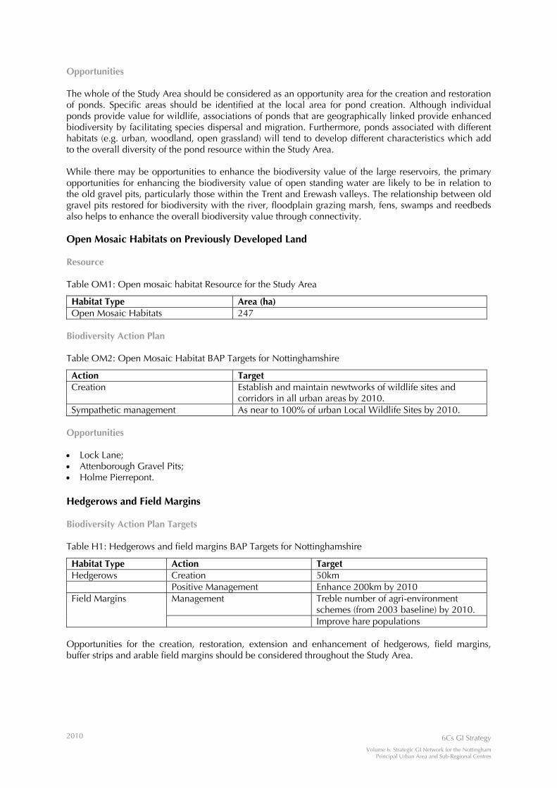
2010 6Cs GI Strategy
Volume 6: Strategic GI Network for the Nottingham Principal Urban Area and Sub-Regional Centres
Opportunities The whole of the Study Area should be considered as an opportunity area for the creation and restoration of ponds. Specific areas should be identified at the local area for pond creation. Although individual ponds provide value for wildlife, associations of ponds that are geographically linked provide enhanced biodiversity by facilitating species dispersal and migration. Furthermore, ponds associated with different habitats (e.g. urban, woodland, open grassland) will tend to develop different characteristics which add to the overall diversity of the pond resource within the Study Area. While there may be opportunities to enhance the biodiversity value of the large reservoirs, the primary opportunities for enhancing the biodiversity value of open standing water are likely to be in relation to the old gravel pits, particularly those within the Trent and Erewash valleys. The relationship between old gravel pits restored for biodiversity with the river, floodplain grazing marsh, fens, swamps and reedbeds also helps to enhance the overall biodiversity value through connectivity. Open Mosaic Habitats on Previously Developed Land Resource Table OM1: Open mosaic habitat Resource for the Study Area
Habitat Type Area (ha) Open Mosaic Habitats 247
Biodiversity Action Plan Table OM2: Open Mosaic Habitat BAP Targets for Nottinghamshire
Action Target Creation Establish and maintain newtworks of wildlife sites and
corridors in all urban areas by 2010. Sympathetic management As near to 100% of urban Local Wildlife Sites by 2010.
Opportunities • Lock Lane; • Attenborough Gravel Pits; • Holme Pierrepont. Hedgerows and Field Margins Biodiversity Action Plan Targets Table H1: Hedgerows and field margins BAP Targets for Nottinghamshire
Habitat Type Action Target Hedgerows Creation 50km Positive Management Enhance 200km by 2010
Management Treble number of agri-environment schemes (from 2003 baseline) by 2010.
Field Margins
Improve hare populations Opportunities for the creation, restoration, extension and enhancement of hedgerows, field margins, buffer strips and arable field margins should be considered throughout the Study Area.

2010 6Cs GI Strategy
Volume 6: Strategic GI Network for the Nottingham Principal Urban Area and Sub-Regional Centres
APPENDIX A6 EXAMPLES OF OPPORTUNITY AREAS

2010 6Cs GI Strategy
Volume 6: Strategic GI Network for the Nottingham Principal Urban Area and Sub-Regional Centres
EXAMPLES OF OPPORTUNITY AREAS Examples of opportunity areas for new and enhanced localised GI are provided below. It should be noted that the list of examples provided is not exhaustive. The opportunity areas are intended to be multifunctional and help towards delivering a range of public benefits. They focus on opportunities for the enhancement, restoration, and conservation of existing GI assets, as well as the creation of new resources (the latter could include one or a combination of appropriate greenspaces, e.g. parks, allotments, semi-natural greenspaces, and/or children play areas). The opportunity areas described below were identified through interpretation of the relationship between: • opportunities arising from the analysis of the GI resources (particularly in relation to the proposals for
developing ecological networks for wildlife and movement networks for people); • accessible natural greenspace deficiencies; • areas capable of delivering combined multiple public benefits; • stakeholder consultation; and • existing relevant strategies (e.g. the National Forest Delivery Strategy) North Hucknall Urban Fringe An area which offers opportunities to maintain and enhance the overall quality and diversity of landscape character, underpinned by the strategies developed for the limestone farmlands landscape character type. It provides opportunities for creating new and extending and linking existing lowland mixed deciduous woodland, and opportunities for creating, restoring and extending habitat types including dry meadow, acid grassland, and calcareous grassland. This area could connect with proposed City-Scale GI Corridors (e.g. proposed greenway linking north-east Nottingham to Bestwood Village, Hucknall & Newstead). It provides opportunities to enhance the management, presentation, accessibility and interpretation of historic environment assets such as Papplewick Hall Historic Park and Garden. As well as being in an area with high potential for delivering combined multiple public benefits through GI provision/enhancement, it could bridge a gap in the provision of large-scale accessible natural greenspace close to the growing urban areas of Nottingham and Hucknall and may also help to meet shortfalls in open space provision.
Hucknall to Eastwood Countryside Gap An area which offers opportunities to maintain and enhance the overall quality and diversity of landscape character, underpinned by the strategies developed for limestone farmlands and coalfields farmlands landscape character types. It provides opportunities for creating new, and extending and linking existing lowland mixed deciduous woodland, and for creating, restoring and extending dry meadow. This area could connect with a proposed City-Scale GI Corridor (e.g. proposed greenway linking Hucknall to north Kimberley, and Eastwood). As well as being in an area with high potential for delivering combined multiple public benefits through GI provision/enhancement, it could bridge a gap in the provision of accessible natural greenspace sites of varying sizes on the doorstep of communities including Eastwood, Hucknall, and Kimberley, and also within 2-10km of a broader range of communities. It may also help to meet shortfalls in open space provision. Nottingham Urban Fringe: North East Nottingham, Lambley and Calverton Countryside Gap An area which offers opportunities to maintain and enhance the overall quality and diversity of landscape character, underpinned by the strategies developed for the village farmlands landscape character type. It provides opportunities for creating new, and extending and linking existing lowland mixed deciduous woodland and for creating, restoring and extending dry meadow. This area could connect with a proposed City-Scale GI Corridor (e.g. proposed greenway linking Nottingham and Calverton). As well as being in an area with high potential for delivering combined multiple public benefits through GI provision/enhancement, it could bridge a gap in the provision of accessible natural greenspace sites of varying sizes on the doorstep of communities including Calverton, Lambley, and Nottingham, and also within 2-10km of a broader range of communities. It may also help to meet shortfalls in open space provision.
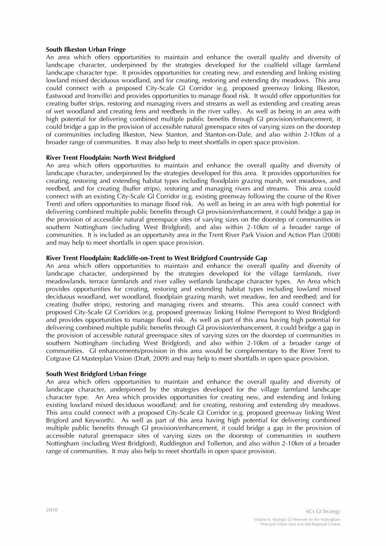
2010 6Cs GI Strategy
Volume 6: Strategic GI Network for the Nottingham Principal Urban Area and Sub-Regional Centres
South Ilkeston Urban Fringe An area which offers opportunities to maintain and enhance the overall quality and diversity of landscape character, underpinned by the strategies developed for the coalfield village farmland landscape character type. It provides opportunities for creating new, and extending and linking existing lowland mixed deciduous woodland, and for creating, restoring and extending dry meadows. This area could connect with a proposed City-Scale GI Corridor (e.g. proposed greenway linking Ilkeston, Eastwood and Ironville) and provides opportunities to manage flood risk. It would offer opportunities for creating buffer strips, restoring and managing rivers and streams as well as extending and creating areas of wet woodland and creating fens and reedbeds in the river valley. As well as being in an area with high potential for delivering combined multiple public benefits through GI provision/enhancement, it could bridge a gap in the provision of accessible natural greenspace sites of varying sizes on the doorstep of communities including Ilkeston, New Stanton, and Stanton-on-Dale, and also within 2-10km of a broader range of communities. It may also help to meet shortfalls in open space provision. River Trent Floodplain: North West Bridgford An area which offers opportunities to maintain and enhance the overall quality and diversity of landscape character, underpinned by the strategies developed for this area. It provides opportunities for creating, restoring and extending habitat types including floodplain grazing marsh, wet meadows, and reedbed, and for creating (buffer strips), restoring and managing rivers and streams. This area could connect with an existing City-Scale GI Corridor (e.g. existing greenway following the course of the River Trent) and offers opportunities to manage flood risk. As well as being in an area with high potential for delivering combined multiple public benefits through GI provision/enhancement, it could bridge a gap in the provision of accessible natural greenspace sites of varying sizes on the doorstep of communities in southern Nottingham (including West Bridgford), and also within 2-10km of a broader range of communities. It is included as an opportunity area in the Trent River Park Vision and Action Plan (2008) and may help to meet shortfalls in open space provision. River Trent Floodplain: Radcliffe-on-Trent to West Bridgford Countryside Gap An area which offers opportunities to maintain and enhance the overall quality and diversity of landscape character, underpinned by the strategies developed for the village farmlands, river meadowlands, terrace farmlands and river valley wetlands landscape character types. An Area which provides opportunities for creating, restoring and extending habitat types including lowland mixed deciduous woodland, wet woodland, floodplain grazing marsh, wet meadow, fen and reedbed; and for creating (buffer strips), restoring and managing rivers and streams. This area could connect with proposed City-Scale GI Corridors (e.g. proposed greenway linking Holme Pierrepont to West Bridgford) and provides opportunities to manage flood risk. As well as part of this area having high potential for delivering combined multiple public benefits through GI provision/enhancement, it could bridge a gap in the provision of accessible natural greenspace sites of varying sizes on the doorstep of communities in southern Nottingham (including West Bridgford), and also within 2-10km of a broader range of communities. GI enhancements/provision in this area would be complementary to the River Trent to Cotgrave GI Masterplan Vision (Draft, 2009) and may help to meet shortfalls in open space provision. South West Bridgford Urban Fringe An area which offers opportunities to maintain and enhance the overall quality and diversity of landscape character, underpinned by the strategies developed for the village farmland landscape character type. An Area which provides opportunities for creating new, and extending and linking existing lowland mixed deciduous woodland; and for creating, restoring and extending dry meadows. This area could connect with a proposed City-Scale GI Corridor (e.g. proposed greenway linking West Brigford and Keyworth). As well as part of this area having high potential for delivering combined multiple public benefits through GI provision/enhancement, it could bridge a gap in the provision of accessible natural greenspace sites of varying sizes on the doorstep of communities in southern Nottingham (including West Bridgford), Ruddington and Tollerton, and also within 2-10km of a broader range of communities. It may also help to meet shortfalls in open space provision.

www.emgin.co.uk/6Cs