Grain-Size Trend Analysis for the Determination of Non ... · PDF fileSediment Transport...
6
Journal of Coastal Research SI 51 95-100 West Palm Beach, Florida Summer 2010 Grain-Size Trend Analysis for the Determination of Non-Biogenic Sediment Transport Pathways on the Kwinte Bank (southern North Sea), in Relation to Sand Dredging Serafim E. Poulos 1* and Arnaud Ballay 1** INTRODUCTION The establishments of sediment transport direction is one of the major concerns in the study of sedimentary systems with- in the marine environment. The analysis of spatial changes in grain-size parameters (mean, sorting and skewness) is one of the methods used for the identification of net sediment trans- port pathways. The initial studies undertaken focused upon variations of an individual parameter, such as mean grain-size (e.g. PETTIJOHN, POTTER, and SIEVER, 1972). However, the use of a single parameter is not always diagnostic for sediment move- ment because, depending on the type of environment under consideration, grain-size parameters may increase or decrease down-drift. A major improvement in grain-size trend analysis was presented by MCLAREN (1981), who used a combination of the three main grain-size parameters: mean size, sorting and skewness. Subsequently, MCLAREN and BOWLES (1985) de- veloped a statistical treatment of the grain-size data, which provided a 1-D model of net sediment transport, as pathways. According to the McLaren model, although there are theoreti- cally 8 possible combinations of the above-mentioned statisti- cal parameters, only 2 combinations have a higher possibility of existing in natural environments, where sediment trans- port occurs in a downstream direction: (1) finer, better sorted and more negatively skewed; or (2) coarser, better sorted and more positively skewed. Subsequently, McLaren’s method has 1 Department of Geography and Climatology Faculty of Geology and Geoenvironment National and Kapodistrian University of Athens Panepistimioupolis, Zografou 15784 Athens, Greece * [email protected] ** EcoPlage 100 route de Clisson F44200 Nantes. France been used with satisfactory results as in the case of the Severn Estuary (UK) (MCLAREN et al., 1993), in a fjord of British Co- lumbia (MCLAREN, CRETNEY, and POWYS, 1993); this approach was eventually standarised, i.e. patented (MCLAREN, 2001). GAO and COLLINS (1992) re-examined the basic assumptions of the grain-size trend analysis; they argued that, although the two cases described previously may be the dominant ones, the presence of other factors can cause a high level of noise using the 1-D approach. These investigators have shown fur- ther that some trends occur in the transport direction, with a higher frequency of occurrence than in any other direction. For comparison, in the McLaren method, it is assumed that in the transport direction only certain types of trends can oc- cur, whilst others do not occur. Thus, these latter authors de- veloped an analytical procedure for grain-size data, based on a semi-quantitative filtering technique; this incorporates an adequate significance test and uses the combined trend of the two main cases (GAO and COLLINS, 1991, 1992 and 1994a). This procedure results in the calculation of a 2-D residual pattern of transport vectors. The present contribution presents a grain-size trend analy- sis, following the GAO and COLLINS (1992) procedure, for the Kwinte Bank in the Belgian part of the North Sea. This meth- od was adopted, primarily, as it is widely-accepted and has produced good results in tidal environments; and, secondarily, due to the fact that it has also been applied previously and successfully in the case of the Kwinte Bank (GAO et al., 1994). Within the context of the environmental impact of dredging activities, the present trend analysis is focused mainly upon ABSTRACT Grain-size trend analysis is applied to the determination of sediment transport pathways over the Kwinte Bank, southern North Sea; which had been subjected to intensive dredging, within the context of the environmental impact of dredging activities. On the basis of the results of grain-size trend analysis, focused mainly upon the transportation of the non-biogenic sedimentary material (<2 mm), it appears that: (i) there is a main sediment pathway over the western (bank crest) and central (dredged area) part of the bank directed toward the NE; whilst a secondary pathway is established over its eastern gently-sloping flank, having a SE direction. Further, the present analysis shows that the area of the central (dredged) depression acts more as a ‘by-passing’ zone rather than as a depo-centre for the non- biogenic sediments. Comparison undertaken with the results of an earlier investigation, for a non-dredged area at the northern end of the same bank, reveals that the depression due to dredging modifies significantly the sediment transport pathways; this may be attributed to a change in the seabed morphology which, in turn, modifies the near- bed hydrodynamics (related to tide and/or storm events). ADDITIONAL INDEX WORDS: linear sandbank, dredging effects, grain-size trend analysis, southern North Sea. DOI: 10.2112 / SI51-009.1 received 17 January 2007; accepted in revision 5 October 2007.
-
Upload
trinhkhanh -
Category
Documents
-
view
221 -
download
0
Transcript of Grain-Size Trend Analysis for the Determination of Non ... · PDF fileSediment Transport...
Journal of Coastal Research SI 51 95-100 West Palm Beach, Florida Summer 2010
Grain-Size Trend Analysis for the Determination of Non-Biogenic Sediment Transport Pathways on the Kwinte Bank (southern North Sea), in Relation to Sand DredgingSerafim E. Poulos1* and Arnaud Ballay1**
INTRoDucTIoN
The establishments of sediment transport direction is one of the major concerns in the study of sedimentary systems with-in the marine environment. The analysis of spatial changes in grain-size parameters (mean, sorting and skewness) is one of the methods used for the identification of net sediment trans-port pathways. The initial studies undertaken focused upon variations of an individual parameter, such as mean grain-size (e.g. Pettijohn, Potter, and Siever, 1972). However, the use of a single parameter is not always diagnostic for sediment move-ment because, depending on the type of environment under consideration, grain-size parameters may increase or decrease down-drift. A major improvement in grain-size trend analysis was presented by McLaren (1981), who used a combination of the three main grain-size parameters: mean size, sorting and skewness. Subsequently, McLaren and BowLeS (1985) de-veloped a statistical treatment of the grain-size data, which provided a 1-D model of net sediment transport, as pathways. According to the McLaren model, although there are theoreti-cally 8 possible combinations of the above-mentioned statisti-cal parameters, only 2 combinations have a higher possibility of existing in natural environments, where sediment trans-port occurs in a downstream direction: (1) finer, better sorted and more negatively skewed; or (2) coarser, better sorted and more positively skewed. Subsequently, McLaren’s method has
1 Department of Geography and Climatology Faculty of Geology and Geoenvironment National and Kapodistrian University of Athens Panepistimioupolis, Zografou 15784 Athens, Greece*[email protected]
** EcoPlage 100 route de Clisson F44200 Nantes. France
been used with satisfactory results as in the case of the Severn Estuary (UK) (McLaren et al., 1993), in a fjord of British Co-lumbia (McLaren, cretney, and PowyS, 1993); this approach was eventually standarised, i.e. patented (McLaren, 2001).
Gao and coLLinS (1992) re-examined the basic assumptions of the grain-size trend analysis; they argued that, although the two cases described previously may be the dominant ones, the presence of other factors can cause a high level of noise using the 1-D approach. These investigators have shown fur-ther that some trends occur in the transport direction, with a higher frequency of occurrence than in any other direction. For comparison, in the McLaren method, it is assumed that in the transport direction only certain types of trends can oc-cur, whilst others do not occur. Thus, these latter authors de-veloped an analytical procedure for grain-size data, based on a semi-quantitative filtering technique; this incorporates an adequate significance test and uses the combined trend of the two main cases (Gao and coLLinS, 1991, 1992 and 1994a). This procedure results in the calculation of a 2-D residual pattern of transport vectors.
The present contribution presents a grain-size trend analy-sis, following the Gao and coLLinS (1992) procedure, for the Kwinte Bank in the Belgian part of the North Sea. This meth-od was adopted, primarily, as it is widely-accepted and has produced good results in tidal environments; and, secondarily, due to the fact that it has also been applied previously and successfully in the case of the Kwinte Bank (Gao et al., 1994). Within the context of the environmental impact of dredging activities, the present trend analysis is focused mainly upon
ABSTRAcT
Grain-size trend analysis is applied to the determination of sediment transport pathways over the Kwinte Bank, southern North Sea; which had been subjected to intensive dredging, within the context of the environmental impact of dredging activities. On the basis of the results of grain-size trend analysis, focused mainly upon the transportation of the non-biogenic sedimentary material (<2 mm), it appears that: (i) there is a main sediment pathway over the western (bank crest) and central (dredged area) part of the bank directed toward the NE; whilst a secondary pathway is established over its eastern gently-sloping flank, having a SE direction. Further, the present analysis shows that the area of the central (dredged) depression acts more as a ‘by-passing’ zone rather than as a depo-centre for the non-biogenic sediments. Comparison undertaken with the results of an earlier investigation, for a non-dredged area at the northern end of the same bank, reveals that the depression due to dredging modifies significantly the sediment transport pathways; this may be attributed to a change in the seabed morphology which, in turn, modifies the near-bed hydrodynamics (related to tide and/or storm events).
ADDITIoNAL INDEX WoRDS: linear sandbank, dredging effects, grain-size trend analysis, southern North Sea.
DOI: 10.2112 / SI51-009.1 received 17 January 2007; accepted in revision 5 October 2007.

96 Poulos and Ballay
Journal of Coastal Research, Special Issue No. 51, 2010
the transportation of the non-biogenic sedimentary material, whose grain-sizes have been deduced from their settling veloc-ities. The findings of the present study are discussed further, within the context of the existing knowledge of the hydrody-namics, whilst the effect of dredging is examined through com-parison with earlier investigations undertaken on the Kwinte Bank (e.g. BeLLec et al., this volume; GareL, this volume; Gao et al., 1994; LanckneuS, 1989; and van den eynde et al., this volume).
ThE STuDy AREA
The present investigation concerns one of the sandbanks located off the Belgian coast, i.e. the Kwinte Bank (Figure 1.); this is one of a series of NE-SW trending linear sandbanks. These banks are some 10-20 m in height, overlain by water depths of less than 10 m, over their shallowest parts. Super-imposed upon these banks are N-NW / S-SE trending dunes (widths of several tens of metres and heights of up to 7 m) and megaripples, with spatially-variable asymmetric pat-terns. Such linear sandbanks are formed in an environment associated with strong currents. High-resolution reflection seismic surveys have revealed that the banks consist mainly of Holocene deposits, with the sands being supplied by the re-working of Tertiary and/or Pleistocene deposits (Liu, MiSSiaen, and henriet, 1992). The deposits lie on an erosional surface of Tertiary strata, whose upper layer is comprised mostly of gravely material. The formation of these sandbanks is related strongly to the existing hydrodynamic regime and, in particu-lar, to the tidal currents and storm waves; the former reach mean surface speeds of between 0.9 ms-1 and 1.2 ms-1 offshore of the Belgian coast (howarth and Proctor, 1992), whilst the latter can reach significant wave heights up to 5 m, with sig-nificant periods of 7 s (houthuyS, trenteSaux, and de woLf, 1994). Thus, storm waves restrict the vertical growth of the Flemish Banks to water depths of less than 5 m (MLLWS).
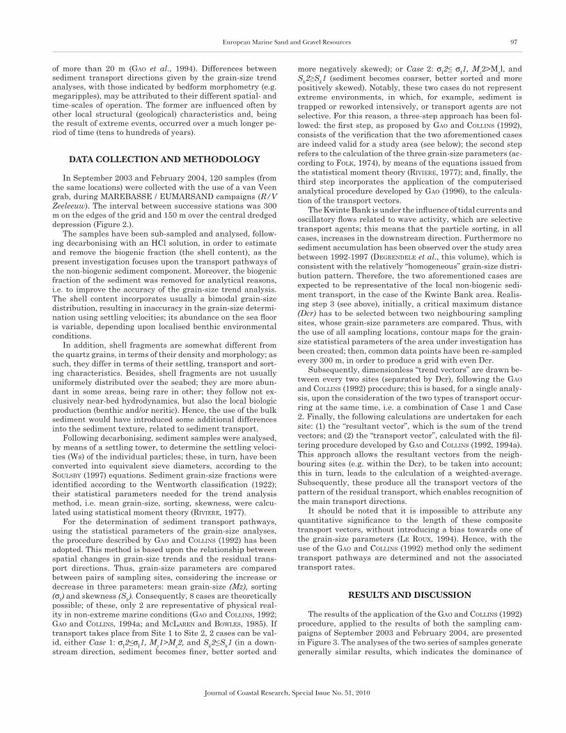
The present investigation is focused upon the central part of the Kwinte Bank (Figure 2.), which includes an elongated
depression (5 m deep, 700 m wide and 1 km long); this is the morphological result of intensive dredging identified in 1999, which subsequently lead to the decision of the Belgian Gov-ernment, in 2003, to stop dredging for a period of at least 3 years, hoping to the regeneration of the bank.
The bank itself has an asymmetric morphology; its crest lies along its western flank, which deepens to the WSW, with slopes of up to 5%. The crest itself lowers from the SW to NE, with water depths on both sides being deeper than 10 m. The eastern flank of the bank slopes are more gently (1.5-3%), to-wards the SE. Over this area, bedforms, such as sand waves and megaripples, are present extensively; they are of various wavelengths, heights, orientations and asymmetrical patterns. These bedforms consist mainly of well-sorted sands (200-400 μm), with a very small gravel fraction (LanckneuS, 1989). A detailed morpho-sedimentological analysis of the study area is presented elsewhere (BeLLec et al., this volume).
Some former studies undertaken into sediment transport pathways over the region have been undertaken; however, they were located over the northern part of this particular bank and did not include the central depression (Gao et al., 1994; LanckneuS, de Moor, and StoLk, 1994; and vanweSen-Beeck and LanckneuS, 2000). Analysis of the bed morphology indicates a general NE direction of sediment transport, coin-ciding with the direction of the flood currents (vanweSenBeeck and LanckneuS, 2000). The grain-size trend analysis, applied to the northern part of the Kwinte Bank, showed a similar direction for the western flank of the bank, whilst its eastern flank has a NW direction; this becomes SW, at water depths
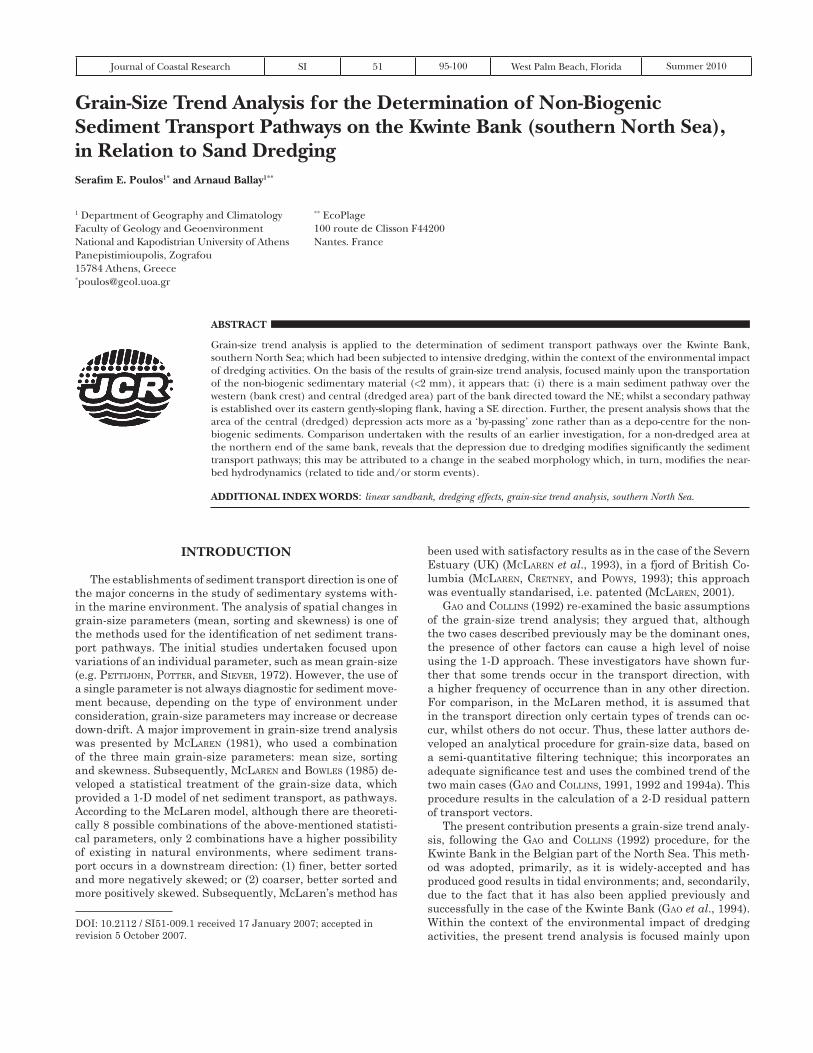
Figure 1. Geographical location of the Kwinte Bank, in relation to the North Sea (inset) and the Belgian Continental Shelf.
Figure 2. Morphological characteristics and sampling positions (for details, see text) of the Kwinte Bank.
European Marine Sand and Gravel Resources 97
Journal of Coastal Research, Special Issue No. 51, 2010
of more than 20 m (Gao et al., 1994). Differences between sediment transport directions given by the grain-size trend analyses, with those indicated by bedform morphometry (e.g. megaripples), may be attributed to their different spatial- and time-scales of operation. The former are influenced often by other local structural (geological) characteristics and, being the result of extreme events, occurred over a much longer pe-riod of time (tens to hundreds of years).
DATA coLLEcTIoN AND mEThoDoLoGy
In September 2003 and February 2004, 120 samples (from the same locations) were collected with the use of a van Veen grab, during MArEBASSE / EUMArSAND campaigns (R/V Zeeleeuw). The interval between successive stations was 300 m on the edges of the grid and 150 m over the central dredged depression (Figure 2.).
The samples have been sub-sampled and analysed, follow-ing decarbonising with an HCl solution, in order to estimate and remove the biogenic fraction (the shell content), as the present investigation focuses upon the transport pathways of the non-biogenic sediment component. Moreover, the biogenic fraction of the sediment was removed for analytical reasons, i.e. to improve the accuracy of the grain-size trend analysis. The shell content incorporates usually a bimodal grain-size distribution, resulting in inaccuracy in the grain-size determi-nation using settling velocities; its abundance on the sea floor is variable, depending upon localised benthic environmental conditions.
In addition, shell fragments are somewhat different from the quartz grains, in terms of their density and morphology; as such, they differ in terms of their settling, transport and sort-ing characteristics. Besides, shell fragments are not usually uniformely distributed over the seabed; they are more abun-dant in some areas, being rare in other; they follow not ex-clusively near-bed hydrodynamics, but also the local biologic production (benthic and/or neritic). Hence, the use of the bulk sediment would have introduced some additional differences into the sediment texture, related to sediment transport.
Following decarbonising, sediment samples were analysed, by means of a settling tower, to determine the settling veloci-ties (Ws) of the individual particles; these, in turn, have been converted into equivalent sieve diameters, according to the SouLSBy (1997) equations. Sediment grain-size fractions were identified according to the Wentworth classification (1922); their statistical parameters needed for the trend analysis method, i.e. mean grain-size, sorting, skewness, were calcu-lated using statistical moment theory (riviere, 1977).
For the determination of sediment transport pathways, using the statistical parameters of the grain-size analyses, the procedure described by Gao and coLLinS (1992) has been adopted. This method is based upon the relationship between spatial changes in grain-size trends and the residual trans-port directions. Thus, grain-size parameters are compared between pairs of sampling sites, considering the increase or decrease in three parameters: mean grain-size (Mz), sorting (σI) and skewness (Sk). Consequently, 8 cases are theoretically possible; of these, only 2 are representative of physical real-ity in non-extreme marine conditions (Gao and coLLinS, 1992; Gao and coLLinS, 1994a; and McLaren and BowLeS, 1985). If transport takes place from Site 1 to Site 2, 2 cases can be val-id, either Case 1: σI2≤σI1, Mz1>Mz2, and Sk2≤Sk1 (in a down-stream direction, sediment becomes finer, better sorted and
more negatively skewed); or Case 2: σI2≤ σI1, Mz2>Mzl, and Sk2≥Sk1 (sediment becomes coarser, better sorted and more positively skewed). Notably, these two cases do not represent extreme environments, in which, for example, sediment is trapped or reworked intensively, or transport agents are not selective. For this reason, a three-step approach has been fol-lowed: the first step, as proposed by Gao and coLLinS (1992), consists of the verification that the two aforementioned cases are indeed valid for a study area (see below); the second step refers to the calculation of the three grain-size parameters (ac-cording to FoLk, 1974), by means of the equations issued from the statistical moment theory (riviere, 1977); and, finally, the third step incorporates the application of the computerised analytical procedure developed by Gao (1996), to the calcula-tion of the transport vectors.
The Kwinte Bank is under the influence of tidal currents and oscillatory flows related to wave activity, which are selective transport agents; this means that the particle sorting, in all cases, increases in the downstream direction. Furthermore no sediment accumulation has been observed over the study area between 1992-1997 (deGrendeLe et al., this volume), which is consistent with the relatively “homogeneous” grain-size distri-bution pattern. Therefore, the two aforementioned cases are expected to be representative of the local non-biogenic sedi-ment transport, in the case of the Kwinte Bank area. realis-ing step 3 (see above), initially, a critical maximum distance (Dcr) has to be selected between two neighbouring sampling sites, whose grain-size parameters are compared. Thus, with the use of all sampling locations, contour maps for the grain-size statistical parameters of the area under investigation has been created; then, common data points have been re-sampled every 300 m, in order to produce a grid with even Dcr.
Subsequently, dimensionless “trend vectors” are drawn be-tween every two sites (separated by Dcr), following the Gao and coLLinS (1992) procedure; this is based, for a single analy-sis, upon the consideration of the two types of transport occur-ring at the same time, i.e. a combination of Case 1 and Case 2. Finally, the following calculations are undertaken for each site: (1) the “resultant vector”, which is the sum of the trend vectors; and (2) the “transport vector”, calculated with the fil-tering procedure developed by Gao and coLLinS (1992, 1994a). This approach allows the resultant vectors from the neigh-bouring sites (e.g. within the Dcr), to be taken into account; this in turn, leads to the calculation of a weighted-average. Subsequently, these produce all the transport vectors of the pattern of the residual transport, which enables recognition of the main transport directions.
It should be noted that it is impossible to attribute any quantitative significance to the length of these composite transport vectors, without introducing a bias towards one of the grain-size parameters (Le roux, 1994). Hence, with the use of the Gao and coLLinS (1992) method only the sediment transport pathways are determined and not the associated transport rates.
RESuLTS AND DIScuSSIoN
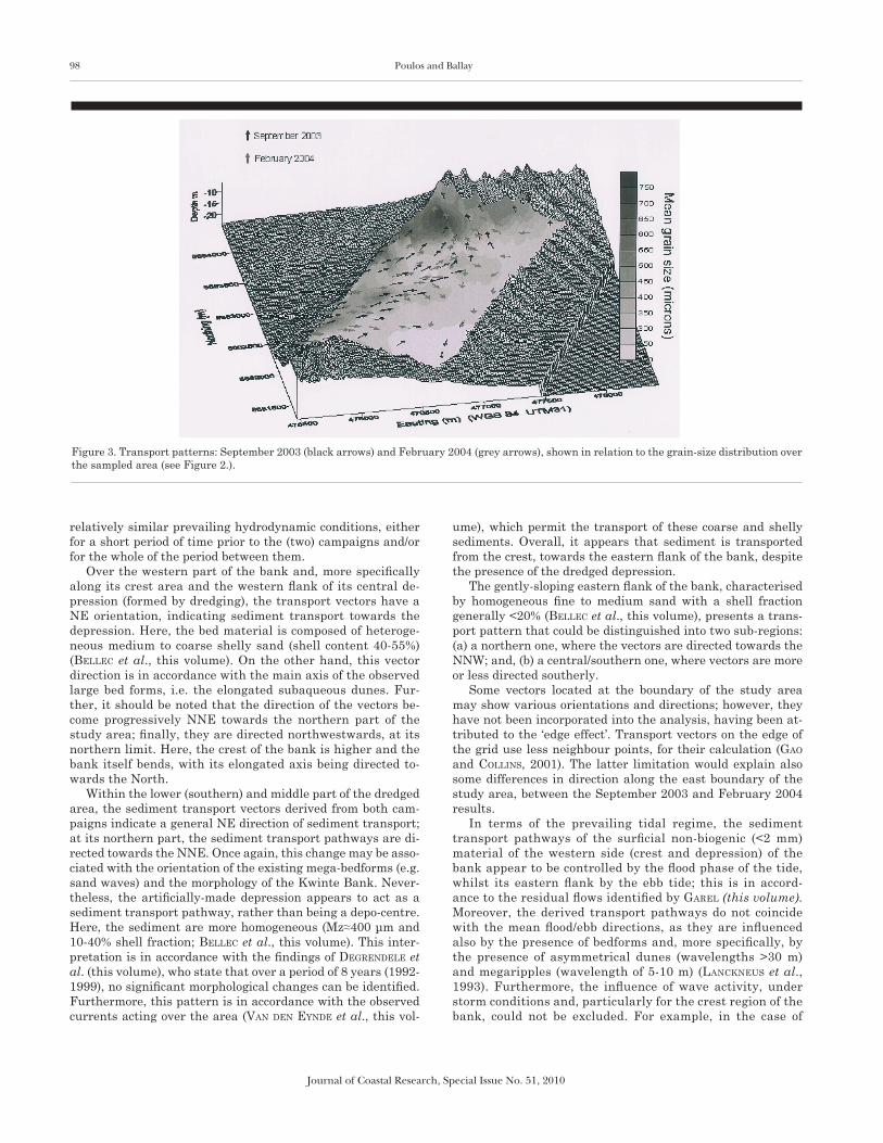
The results of the application of the Gao and coLLinS (1992) procedure, applied to the results of both the sampling cam-paigns of September 2003 and February 2004, are presented in Figure 3. The analyses of the two series of samples generate generally similar results, which indicates the dominance of
98 Poulos and Ballay
Journal of Coastal Research, Special Issue No. 51, 2010
relatively similar prevailing hydrodynamic conditions, either for a short period of time prior to the (two) campaigns and/or for the whole of the period between them.
Over the western part of the bank and, more specifically along its crest area and the western flank of its central de-pression (formed by dredging), the transport vectors have a NE orientation, indicating sediment transport towards the depression. Here, the bed material is composed of heteroge-neous medium to coarse shelly sand (shell content 40-55%) (BeLLec et al., this volume). On the other hand, this vector direction is in accordance with the main axis of the observed large bed forms, i.e. the elongated subaqueous dunes. Fur-ther, it should be noted that the direction of the vectors be-come progressively NNE towards the northern part of the study area; finally, they are directed northwestwards, at its northern limit. Here, the crest of the bank is higher and the bank itself bends, with its elongated axis being directed to-wards the North.
Within the lower (southern) and middle part of the dredged area, the sediment transport vectors derived from both cam-paigns indicate a general NE direction of sediment transport; at its northern part, the sediment transport pathways are di-rected towards the NNE. Once again, this change may be asso-ciated with the orientation of the existing mega-bedforms (e.g. sand waves) and the morphology of the Kwinte Bank. Never-theless, the artificially-made depression appears to act as a sediment transport pathway, rather than being a depo-centre. Here, the sediment are more homogeneous (Mz≈400 μm and 10-40% shell fraction; BeLLec et al., this volume). This inter-pretation is in accordance with the findings of deGrendeLe et al. (this volume), who state that over a period of 8 years (1992-1999), no significant morphological changes can be identified. Furthermore, this pattern is in accordance with the observed currents acting over the area (van den eynde et al., this vol-
ume), which permit the transport of these coarse and shelly sediments. Overall, it appears that sediment is transported from the crest, towards the eastern flank of the bank, despite the presence of the dredged depression.
The gently-sloping eastern flank of the bank, characterised by homogeneous fine to medium sand with a shell fraction generally <20% (BeLLec et al., this volume), presents a trans-port pattern that could be distinguished into two sub-regions: (a) a northern one, where the vectors are directed towards the NNW; and, (b) a central/southern one, where vectors are more or less directed southerly.
Some vectors located at the boundary of the study area may show various orientations and directions; however, they have not been incorporated into the analysis, having been at-tributed to the ‘edge effect’. Transport vectors on the edge of the grid use less neighbour points, for their calculation (Gao and coLLinS, 2001). The latter limitation would explain also some differences in direction along the east boundary of the study area, between the September 2003 and February 2004 results.
In terms of the prevailing tidal regime, the sediment transport pathways of the surficial non-biogenic (<2 mm) material of the western side (crest and depression) of the bank appear to be controlled by the flood phase of the tide, whilst its eastern flank by the ebb tide; this is in accord-ance to the residual flows identified by GareL (this volume). Moreover, the derived transport pathways do not coincide with the mean flood/ebb directions, as they are influenced also by the presence of bedforms and, more specifically, by the presence of asymmetrical dunes (wavelengths >30 m) and megaripples (wavelength of 5-10 m) (LanckneuS et al., 1993). Furthermore, the influence of wave activity, under storm conditions and, particularly for the crest region of the bank, could not be excluded. For example, in the case of
Figure 3. Transport patterns: September 2003 (black arrows) and February 2004 (grey arrows), shown in relation to the grain-size distribution over the sampled area (see Figure 2.).

European Marine Sand and Gravel Resources 99
Journal of Coastal Research, Special Issue No. 51, 2010
similar sandbanks in the Bristol Channel (UK), it has been established that the height of the banks is controlled by the storm conditions (Britton and Britton, 1980). The latter ob-servation is a matter for further investigation, relating to the combined effect of storms and tides.
Finally, if the findings of the present investigation are compared to those produced previously by Gao et al (1994), for the northern end of the Kwinte Bank (where sediment pathways are directed towards its crest, having an E-ESE direction along its steep western flank and NW along its eastern more gentle flank), on the assumption that the whole body of the bank is subjected to the same hydrody-namic (tidal) regime, then it may be concluded that the presence of the depression (due to dredging) has modified significantly the near-bed hydraulic regime (GareL, this vol-ume). This regime now favours the transport of sediment from the crest over the bank, towards its eastern flank. The pattern is in accordance with the observations made by de-GrendeLe et al. (this volume), where an overall lowering of the height of the bank (by ca. 0.5 m) has been identified, between 1992 and 1999.
coNcLuSIoNS
On the basis of grain-size trend analysis, the residual transportation pattern reveals that, on the western steeper slope and within the central depression of the bank, the prin-cipal transport pathway of the non-biogenic sandy material is directed towards the northeast. Further, it can be assumed that the relatively coarse (>500 μm) and less well-sorted (>1.2) sediment, within these two sedimentary provinces, are associated with erosion (and/or transportation) during the flood phase of the tide. However, wave action should not be excluded from the analysis. Over the eastern gently slop-ing part of the bank, characterised by medium sized (250-500 μm) sediments, an overall southerly transport pathway is identified; this is induced, most probably, by the ebb cur-rents; although these are weaker, they last longer and, as such, provides improved sorting (<1.0) of the sediments. In addition, the presence of the bedforms and the overall size of the bank appear to control the sediment transport pathways. Finally, the presence of the central depression appears to act as a ‘by-passing’ zone, rather than as a depo-centre for sedi-ments.
AcKNoWLEDGEmENTS
This study has been undertaken in accordance with the research objectives of the project EUMArSAND (“European Marine Sand and Gravel resources: Evaluation and Envi-ronmental Impact of Extraction”, Contract No. HPrN-CT-2002-00222). The authors thank Sophie Le Bot and Wendy Bonne for organising and performing the sampling cam-paigns, with the assistance of Samuel Deleu, Els Verfail-lie, Andrew Symonds and Déborah Idier. The authors thank Michael Collins, Xaris Plomaritis and Erwan Garel for their help during the grain-size analyses, at the School of Ocean and Earth Science in the University of Southampton. Thanks are extended also to Vera Van Lancker and Valérie Bellec, for the information provided and their constructive comments.
LITERATuRE cITED
BeLLec, V.; van Lancker V.; deGrendeLe K.; roche r.; Schotte P., and Le Bot S., this volume. Geo-environmental characterisation of the Kwinte Bank. Journal of Coastal Research,
Britton r.C. and Britton S.r., 1980. Sedimentary bed forms and lin-ear banks. In: coLLinS, M.B.; Banner, F.T.; tyLer, P.A.; wakefieLd, S.J., and jaMeS, A.E. (eds.), Industrialised Embaymants and their Environmental Problems. A case study for Swansea Bay. Pergamon Press, 177-191
deGrendeLe, k.; roche, M.; Schotte, P.; BeLLec, v., and van Lanck-er, V., this volume. Morphological evolution of the Kwinte Bank central depression after its closure. Journal of Coastal Re-search,
foLk, P.L., 1974. Petrology of Sedimentary Rocks. Austin, Texas: Hemphill Publishing Company, 183 p.
GareL, E., this volume. Hydrodynamics and bedload transport, dur-ing a tidal cycle (derived from ADCP measurements), across the Kwinte Bank. Journal of Coastal Research,
Gao, S. and coLLinS, M., 1991. A critique of the ‘‘McLaren Method’’ for defining sediment transport paths. Journal of Sedimentary Petrol-ogy, 61, 143-146.
Gao, S. and coLLinS M., 1992. Net Sediment transport patterns in-ferred from grain-size trends, based upon definition of transport vectors. Sedimentary Geology, 81(1/2), 47-60
Gao, S. and coLLinS, M., 1994a. Analysis of grain-size trends, for defin-ing sediment transport pathways in marine environments. Journal of Coastal Research, 10(1), 75-78.
Gao, S. and coLLinS, M., 1994b. Net sediment transport patterns in-ferred from grain-size trends, based upon definition of ‘‘transport Vectors’’ reply. Sedimentary Geology, 90, 171-185.
Gao, S.; coLLinS M.; LanckneuS j.; de Moor G., and van Lancker v., 1994. Grain-size trends associated with net sediment transport patterns: An example from the Belgian continental shelf. Marine Geology, 121, 171-185
Gao, S., 1996. A fortran program for grain size trend analysis to define net sediment transport pathways. Computers & Geosciences, 22(4), 449-452.
Gao, S. and coLLinS M., 2001. The use of grain-size trends in marine sediment dynamics: a review. Chinese Journal of Oceanology and Limnology, 19(3), 265-271.
howarth, M.J. and Proctor, r., 1992. Ship ADCP measurementsand tidal models of the North Sea. Continental Shelf Research, 12, 601-623
houthuyS, r.; trenteSaux, a., and de woLf, P., 1994. Storm influences on a tidal sandbank’s surface (Middelkerke Bank, southern North Sea). Marine Geology, 121, 23-41
LanckneuS, J., 1989. A comparative study of some characteristics of superficial sediments on the Flemish Banks. Int. Coll. Quat. Tert. Geology Southern Bight, North Sea, May 1984. Ministry of Eco-nomic Affairs-Belgian Geological Survey, 29-241.
LanckneuS, j.; de Moor, G.; de SchaePMeeSter, G.; MeyuS, i., and SPierS, v., 1992. residual sediment transport directions on a tidal sandbank. In: Comparison of the “McLaren Model” with bedform analysis. Bull. Belg. Ver. Aardr. Stud. (BEVAS) 2, pp. 425–446.
LanckneuS, j.; de Moor, G.; van Lancker, v., and de SchaePMeeSter, G., 1993. The use of the McLaren model for the determination of re-sidual transport directions on the Gootebank, southern North Sea: Progress in Belgian Oceanographic Research. Institute of Marine research and Air Sea Interaction (IrMA), Vol. 1, pp. 75–94.
LanckneuS, J.; de Moor, G., and StoLk, A., 1994. Environmen-tal setting, morphology and volumetric evolution of the Mid-delkerke Bank (southern North Sea). Marine Geology, 121(1-2), 1-21.
Le roux, J.P., 1994. An alternative approach to the identification of net sediment transport paths based on grain-size trends. Sedimen-tary Geology, 94, 97-107.
Liu, A.C.; MiSSiaen, T., and henriet, J.P., 1992. The morphology of the top-Tertiary erosion surface in the Belgian sector of the North Sea. Marine Geology, 105, 275-284.
McLaren, P.A., 1981. Interpretation of trends in grain-size measure-ments. Journal of Sedimentary Petrology, 51, 611-624.
McLaren, P.A. and BowLeS, D., 1985. The effects of sediment trans-port on grain-size distributions. Journal of Sedimentary Petrology, 55(4), 457-470.
McLaren, P., 2001. Sediment Trend Analysis (Sta (r)). Sea Technol-ogy, 42(3): 10-14.
McLaren, P. and BowLeS, d., 1991. A Critique of the Mclaren Method for Defining Sediment Transport Paths - Reply. Journal of Sedi-mentary Petrology, 61(1), 147.
McLaren, P.; coLLinS, M.B.; Gao, S., and PowyS, r.i.L., 1993. Sediment Dynamics of the Severn Estuary and Inner Bristol Channel. Jour-nal of the Geological Society, 150, 589-603.
McLaren, P.; cretney, w.j., and PowyS, r.i., 1993. Sediment Path-ways in a British-Columbia Fjord and Their relationship with Particle-Associated Contaminants. Journal of Coastal Research, 9(4), 1026-1043.
Pettijohn, f.G.; Potter P.d., and Siever, r., 1972. Sand and Sand-stone. New York: Springer, 618 p.
riviere, a., 1977. Methodes Granulometriques; Techniques et Inter-pritations. In: MaSSon, N. Paris (1977), 170p.
SouLSBy, r., 1997. Dynamics of marine sands: a manual for practical applications. London: Thomas Telford, 249 p.
van den eynde, D.; Giardino, A.; PortiLLa, J.; fettweiS, M.: francken, F., and MonBaLiu, J., this volume. Modelling the effects of sand extraction on the sediment transport due to tides on the Kwinte Bank. Journal of Coastal Research,
vanweSenBeeck, V. and LanckneuS, J., 2000. Sediment transport paths on a tidal sand bank: a comparison between the modified McLaren model and bedform analysis. Journal of Sedimentary Research, 70(3), 470-477.