GNSS/EGNOS services and applications in civil aviationgalileo.cs.telespazio.it/medusa/National...
44
GNSS/EGNOS services and applications in civil aviation Euromed GNSS II project/MEDUSA: Euromed GNSS II national workshop, Beirut, 26 November 2013 1 Euromed GNSS II project/MEDUSA: Lebanon national workshop
Transcript of GNSS/EGNOS services and applications in civil aviationgalileo.cs.telespazio.it/medusa/National...

GNSS/EGNOS services and applications
in civil aviation
Euromed GNSS II project/MEDUSA:
Euromed GNSS II national workshop, Beirut, 26 November 2013 1
Euromed GNSS II project/MEDUSA:
Lebanon national workshop

Index
EGNOS SoL operation in civil aviation
EGNOS benefits for civil aviation
EGNOS scenario in Europe for civil aviation
EGNOS in Europe: facts and figures
Euromed GNSS II national workshop, Beirut, 26 November 2013 2
EGNOS in Europe: facts and figures

EGNOS SoL operation in civil aviation
Euromed GNSS II national workshop, Beirut, 26 November 2013 3
EGNOS SoL operation in civil aviation

EGNOS SoL - main principles (1)
• Designed:
Compliant to APV- I
To support civil aviation operations down to LPV minima at any qualifying
runway (CAT-I)
To meet ICAO SARPs
Compliant to RTCA Minimum Operational Performance Standards (MOPS) for
airborne navigation equipment using the GPS augmented by SBAS
Euromed GNSS II national workshop, Beirut, 26 November 2013 4
airborne navigation equipment using the GPS augmented by SBAS
• Enabling Performance Based Navigation (PBN)
• Not requiring the installation (and maintenance) of ground-based landing
NAVAIDs
• Requiring certified avionics in accordance with ICAO SARPs
• Interoperable with other SBAS to enable aircraft seamless transitions between
SBAS systems and interoperable SBAS avionics

EGNOS SoL - main principles (2)
Euromed GNSS II national workshop, Beirut, 26 November 2013 5
ICAO operational requirements

PBN (Performance-Based Navigation) concept
ICAO PBN Manual/Doc. 9613 specifies RNAV or RNP performance requirements
for a certain operation in the context of a particular airspace concept, when
supported by NAVAIDs infrastructure Application: e.g.
operations, en-route,
approach, take-off,
landing
Infrastructure: Ground -
based NAVAIDs or Space-
RNAV x
RNP xWith on-board performance
Applications:
Euromed GNSS II national workshop, Beirut, 26 November 2013 6
based NAVAIDs or Space-
based NAVAIDs
supporting the application
(e.g. VOR, DME, GNSS,
avionics)
Specification:
performance indicators
value required for the
application using the
infrastructure
With on-board performance monitoring and alerting

Required for a navigation specification:
• Position accuracy - difference between a computed and a true position
• Integrity - measure of the trust that can be placed in the correctness of the
provided information
• Availability - the percentage of time that the positioning and integrity are
available and according to the required values (performances) under stated
conditions and within the specified coverage area
PBN performance indicators
Euromed GNSS II national workshop, Beirut, 26 November 2013 7
• Continuity - the capability to provide the positioning and integrity according to
the specified performances without non-scheduled interruptions during the
intended operation
• Time-to-alert - the maximum time allowed from the onset of a failure
condition up to the annunciation in the aircraft
RNP Approaches according to PBN
RNP APCH
Chart title: RNAV (GNSS)
Without Vertical guidance With Vertical guidance
LNAV LP LNAV/VNAV LPV
RNP AR APCH
Chart title: RNAV (RNP)
With Vertical guidance
LNAV/VNAV
Euromed GNSS II national workshop, Beirut, 26 November 2013 8
GPS NPA
expected
to be
flown with
CDFA
SBAS-based NPA
SBAS supported
Localiser
Performance
APV
Baro-VNAV
APV SBAS
SBAS supported
Localiser
Performance with
vertical guidance
PANS-OPS
TerminologyPBN Terminology Chart Minima Minimum Sensor
NPA RNP APCH down to LNAV (MDA) Basic GNSS
APV Baro-VNAV RNP APCH down to LNAV/VNAV (DA) Basic GNSS + Baro-VNAV
- RNP APCH down to LP (MDA) SBAS
APV SBAS RNP APCH down to LPV (DA) SBAS

ICAO Assembly Resolution A37-11
Urges all States to implement RNAV and RNP air traffic services (ATS) routes
and approach procedures in accordance with the ICAO PBN concept laid down
in the PBN manual (ICAO PBN Manual/Doc. 9613)
PBN benefits:
• Environment-friendly
• Improving safety
Euromed GNSS II national workshop, Beirut, 26 November 2013 9
• Improving safety
• Improving operating returns
• Increasing airspace capacity
• The global rollout
ICAO states that GNSS enables PBN and provides navigation guidance for all
phases of flight, from en-route to precision approach
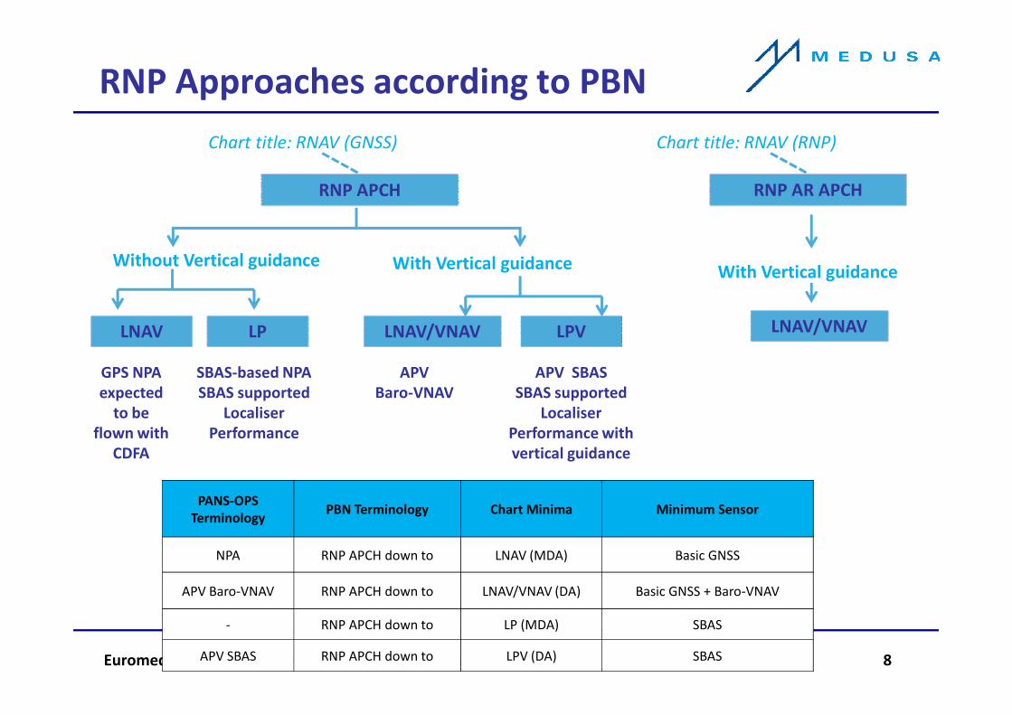
• ICAO Assembly (36th Assembly Oct 2007) resolutions:
Implementation of APVs (Baro-VNAV and/or augmented GNSS) for all
instrument runway ends, either as the primary approach or as a back-up for
precision approaches by 2016 with intermediate milestones:
–30% by 2010
–70% by 2014
APV as ICAO PBN strategy enabler
Euromed GNSS II national workshop, Beirut, 26 November 2013 10
• ICAO Assembly (37th Assembly Oct 2010) resolutions:
Implementation of straight-in LNAV only procedures, as an exception, for
instrument runways at aerodromes where there is no local altimeter setting
available and where there are no aircraft suitably equipped for APV operations
• Enabler for the future PBN IR (mandatory) objectives achievement

Integrity risk: the probability that the position
error is larger than the alert limit for the
intended operation and the user is not warned
within the time to alert (TTA)
Alert Limit: the error tolerance not to be
exceeded without issuing an alert. There is a
Horizontal and Vertical Alert Limits, HAL and VAL
for each operation
The Horizontal Protection Level (HPL) is
the radius of a circle in the horizontal
plane, centered at the true position,
which describes the region which is
assured to contain the indicated
horizontal position
The Vertical Protection Level (VPL) is the
half length of a segment on the vertical
axis with its center being at the true
SBAS integrity concept (1)
Euromed GNSS II national workshop, Beirut, 26 November 2013 11
Time To Alert: The maximum allowable time
elapsed from the onset of the system being out
of tolerance until the user is alerted
axis with its center being at the true
position, which describes the region
which is assured to contain the indicated
vertical position
HPE: Horizontal Position Error
VPE: Vertical Position Error
SYSTEM
SITUATIONS

True position
Computed position
H Alarm Limit H Protection Level (HPL)
VPLVAL
��
SBAS integrity concept (2)
Euromed GNSS II national workshop, Beirut, 26 November 2013 12

SBAS in ICAO’s approaches
LNAV
Euromed GNSS II national workshop, Beirut, 26 November 2013 13

SBAS in ICAO’s RNP approaches
Euromed GNSS II national workshop, Beirut, 26 November 2013 14
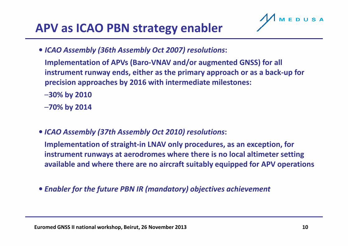
APCH NAVAIDs trade off
Non Precision Approaches (NPA)
Use Conventional Navigation: VOR, DME to
the MDH for VFR landing
Higher minima
CFIT risk
Precision Approaches (PA)
Use Instrument Landing system: ILS, GBAS.
Provide Lateral and Vertical guidance on
Lowest minima
Costly ground installation
Local coverage
Euromed GNSS II national workshop, Beirut, 26 November 2013 15
stabilised continuous descent path
Approach with Vertical Guidance (APV)
Use GNSS navigation and can use SBAS (LPV) or
baro-VNAV for the vertical guidance
Local coverage
Low minima
Cost effective
Balanced solutionEGNOS

APCH GNSS NAVAIDs trade off
GPS
GPS
Inertial/SBAS
400 – 600 ft DH
350 – 400 ft DH
EGNOS competitive space
NPA
LNAV/VNAV
LPV
Euromed GNSS II national workshop, Beirut, 26 November 2013 16
SBAS
GBAS
SBAS/GBAS
250 – 300 ft DH
200 ft DH
0 – 200 ft DH
LPV
GLS
CAT I-III
2 nm
1 nm
3/4 nm
1/2 nm
3º

EGNOS APV/CAT-I APCH benchmarking
Alert Limits
APV-I is
Today
Future
EGNOS
Euromed GNSS II national workshop, Beirut, 26 November 2013 17
ILS-CAT I minima ∼ 200 ft
APV-I (LPV) minima ∼250 ft
Accuracy
Procedure Minima
APV-I is
ILS look-alikeToday
Future

LPV is ILS look-alike
Crew reports Flying LPV is similar
and even more stable than ILS
Euromed GNSS II national workshop, Beirut, 26 November 2013 18
LPV Approach Real
Flight Trial
EGNOS benefits for civil aviation
Euromed GNSS II national workshop, Beirut, 26 November 2013 19
EGNOS benefits for civil aviation

EGNOS added value for civil aviation
• Back-up for conventional NAVAIDs
• Instrument approach capability for those airdromes or runways where ILS cost
is not justified, with a huge increase in safety
• Instrument navigation in those regions not covered by conventional ground
NAVAIDs
• Enabler of procedures with curved segments in air space scenarios with
particularly difficult constraints, facilitating solutions needed in the case of:
Euromed GNSS II national workshop, Beirut, 26 November 2013 20
Difficult orographic conditions in the terminal area
Environmental impact/protected zones (e.g. noise footprint impact
minimisation over urban areas, natural areas/parks protection)
Military or security air space restricted areas
Border areas between countries
• Enabler of optimised procedures for special applications, e.g. general and
business aviation, helicopters serving oil rigs

EGNOS costs vs benefits
for the civil aviation community
Benefits
Increased efficiency through the reduction in the number of Delays,
Diversions and Cancellations (DDCs)
Increased safety through the reduction of Controlled Flight Into
Terrain (CFIT)
Euromed GNSS II national workshop, Beirut, 26 November 2013 21
Costs
Avionics
Flight procedures
Phasing out of conventional NAVAIDs

EGNOS social benefits
Safety improvement: EGNOS enables APV approaches, providing significant
safety improvements at airports where approaches with vertical guidance are
currently not available (Non Precision Approaches NPA)
CFIT reduction of 75% (source: Eurocontrol)
Environmental impact reduction:
• Noise reduction in urban areas
Euromed GNSS II national workshop, Beirut, 26 November 2013 22
• Noise reduction in urban areas
• CO2 emissions reductions due to optimised routes and CDA (continuous
descent approach)

• DDCs reduction: lower minima makes landing possible with lower visibility levels
at airports not equipped with ILS (48% reduction ANSP/airlines estimate)
• Time and fuel savings: more flexible curved/segmented and continuous descent
approach procedures result in time/fuel savings
• Increased runway capacity: EGNOS has no critical/sensitive areas, reducing the
time between consecutive approach/departure aircraft operations. Approach
terrain constraints are also easier to overcome. ILS backup in case of failure
• Ground infrastructure cost savings: decommissioning of ground based NAVAIDs,
EGNOS economical benefits
Euromed GNSS II national workshop, Beirut, 26 November 2013 23
• Ground infrastructure cost savings: decommissioning of ground based NAVAIDs,
with expensive maintenance costs. Regional coverage enables operations in
areas with insufficient conventional NAVAIDs infrastructure
• Enhanced efficiency in air space use: supporting en-route and terminal area PBN
procedures, allows more aircraft to follow preferred trajectories
• Reduced costs for procedure compared to ILS (on other conventional NAVAIDs),
since periodic flight verifications are not required
• Reduced aircrew training costs when all approaches can be flown using vertical
guidance

EGNOS retrofitting for aircraft in service (1)
SBAS receiver
Integration
Installation
+
+
Number of aircraft××××
Euromed GNSS II national workshop, Beirut, 26 November 2013 24
Documentation
Certification
+
+
Crew training
Other cost
+
+

EGNOS retrofitting for aircraft in service (2)
EU certification process
Euromed GNSS II national workshop, Beirut, 26 November 2013 25

EGNOS scenario in Europe
Euromed GNSS II national workshop, Beirut, 26 November 2013 26
EGNOS scenario in Europe
for civil aviation

EGNOS SoL - Service Definition Document (SDD) (1)
• EGNOS SoL SDD describes the characteristics and conditions of access to the
service. Published on June 2013 (http://www.essp-
sas.eu/service_definition_documents)
• EGNOS Service Notices generated whenever there is any complementary
information to be provided to users that could affect the SoL SDD contents
(http://www.essp-sas.eu/service_notices)
Euromed GNSS II national workshop, Beirut, 26 November 2013 27

EGNOS SoL - Service Definition Document (SDD) (2)
• Establishes the European Framework for EGNOS SoL Service implementation in
civil aviation
• Regulated framework under Supervisory Authority oversight required for a
Safety of Life application (ref. EU Civil Aviation application Single European Sky -
SES):
ESSP SAS certified as ANSP
EGNOS System verified (Interoperability regulation)
Euromed GNSS II national workshop, Beirut, 26 November 2013 28
Need for EGNOS Working Agreements
• Freely offered for all phases of flight to:
Airspace Users (as defined by SES regulation) equipped with EGNOS certified
receivers (TSOS/ETSOs C144,C145 or C146)
Certified Air Navigation Service Providers (ANSPs) having signed an EGNOS
Working Agreement (EWA) with ESSP

EGNOS institutional and
service provision frame
EGNOS Service Provider [AENA, DGAC, ENAV,
European Commission
(customer)
ANSPsANSPs
Contract
Service
Design AuthorityDesign Authority
EWA
Euromed GNSS II national workshop, Beirut, 26 November 2013 29
Aeronautical
users
Aeronautical
users
DGAC, ENAV, NATS, NAV,
Skyguide, DFS]
EASA
Certification
Service
Procedures

EGNOS operational frame
National
Air
National
Air
EA
SA
EA
SA
Euromed GNSS II national workshop, Beirut, 26 November 2013 30
Air
Safety
Agency
Air
Safety
Agency
EA
SA
EA
SA
In Europe, EGNOS is subject to regulation/approval by “EASA system” (including
NSAs)

The need for a EWA
Euromed GNSS II national workshop, Beirut, 26 November 2013 31

EWA
WHO
Between the ANSP and the EGNOS Service Provider
WHY
To define roles and responsibilities for the actors involved
To formalize the working procedures and interface
WHAT (contents)
Contractual document (including liability)
Contingency coordination
Euromed GNSS II national workshop, Beirut, 26 November 2013 32
Contingency coordination
NOTAM proposal
Data recording
Collaborative decision making
Service commitment with reference to EGNOS SoL SDD Doc
Identification of the main focal points
Service arrangements
WHEN
As soon the procedures implementation process is defined and decided

MEDUSA assistance action in relation to EWA
For interested non-EU countries/Outcomes of the technical workshop @ ESSP
October 2013
• Institutional + regulatory action to be undertaken prior the negotiation and
the signature of EWA with ESSP
• Institutional action - bilateral discussion/dialogue between the State and
Europe
• Regulatory action - agreement concerning civil aviation safety
harmonisation/regulatory equivalence between the State and Single
Euromed GNSS II national workshop, Beirut, 26 November 2013 33
harmonisation/regulatory equivalence between the State and Single
European Sky relevant regulations
• No EWA negotiation with ESSP until the appropriate framework is defined.
The EWA will reflect the agreed framework
MEDUSA assistance action:
• Elaboration of a compliance matrix towards relevant requirements extracted
from current applicable SES regulations
• Case study: Tunisia (MASC ?)

EGNOS in Europe: facts and figures
Euromed GNSS II national workshop, Beirut, 26 November 2013 34
EGNOS in Europe: facts and figures

Status of EGNOS introduction in Europe (1)
LPV Implementation Plan for 2014
Euromed GNSS II national workshop, Beirut, 26 November 2013 35
Source: ESSP (October 2013)
APV-Baro procedures where EGNOS has been authorized for vertical guidance
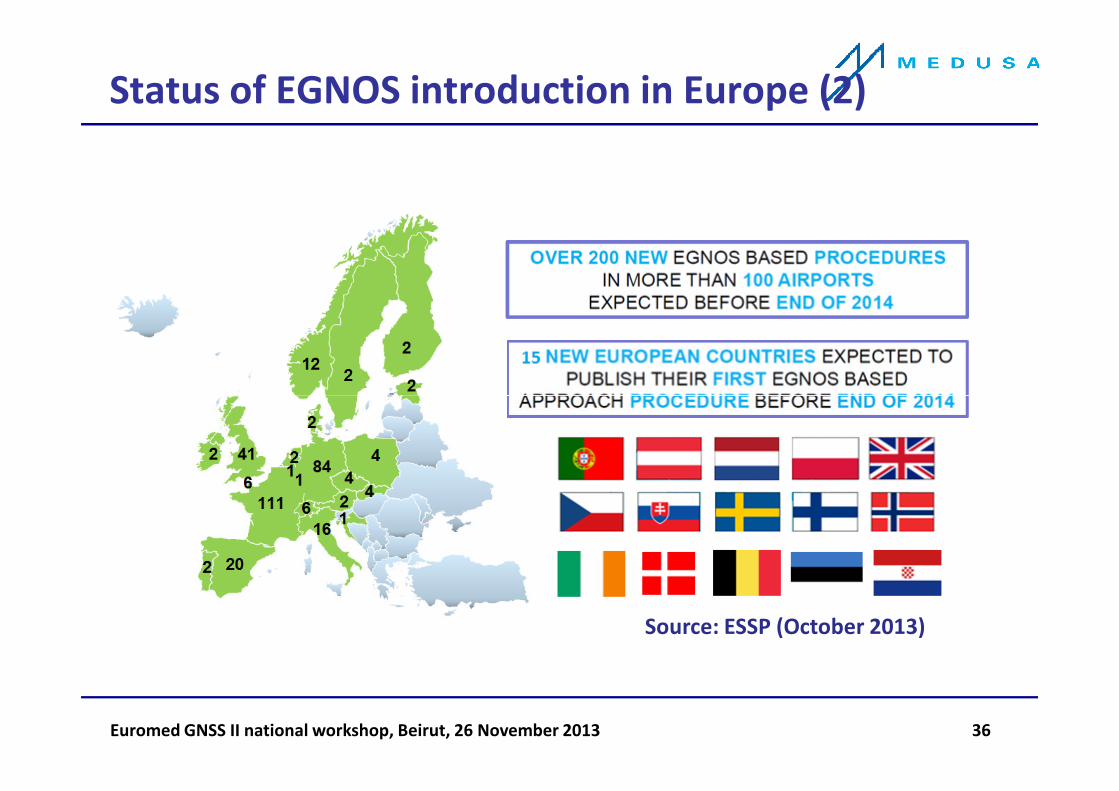
Status of EGNOS introduction in Europe (2)
Euromed GNSS II national workshop, Beirut, 26 November 2013 36
Source: ESSP (October 2013)

• Scenario at Valencia (Spain)
• Scenario at Saarbrücken (Germany)
• Scenario at Pamplona (Spain)
• Scenario at Egelsbach (Germany)
• EGNOS pioneer operators
Examples of real case applications/scenarios
of EGNOS use
Euromed GNSS II national workshop, Beirut, 26 November 2013 37
• EGNOS pioneer operators
• EGNOS pioneer airports

Valencia (Spain)
Aircraft model/operator: CRJ-1000NG/Air Nostrum (RC-GPS 4000S)
Scenario characteristics: urban noise restrictions
Expected date: Q1 2014
Demonstration objectives:
• Curved departure for RWY 12
• Curved approach (RF leg) prior (2 nm) to FAP
• and final transition to LPV RWY30
Euromed GNSS II national workshop, Beirut, 26 November 2013 38

Saarbrücken (Germany)
Aircraft model/operator: Cessna 340 /Navart (Garmin G1000)
Scenario characteristics: noise restrictions, terrain and airspace limitations (France border & ATC coordination)
Expected date: Q1 2014
Demonstration objectives:
• Assessment and introduction of RF legs prior to FAF with transition to LPV
• RNP AR avionics requirement analysis with minima equivalent to LPV
Euromed GNSS II national workshop, Beirut, 26 November 2013 39
equivalent to LPV
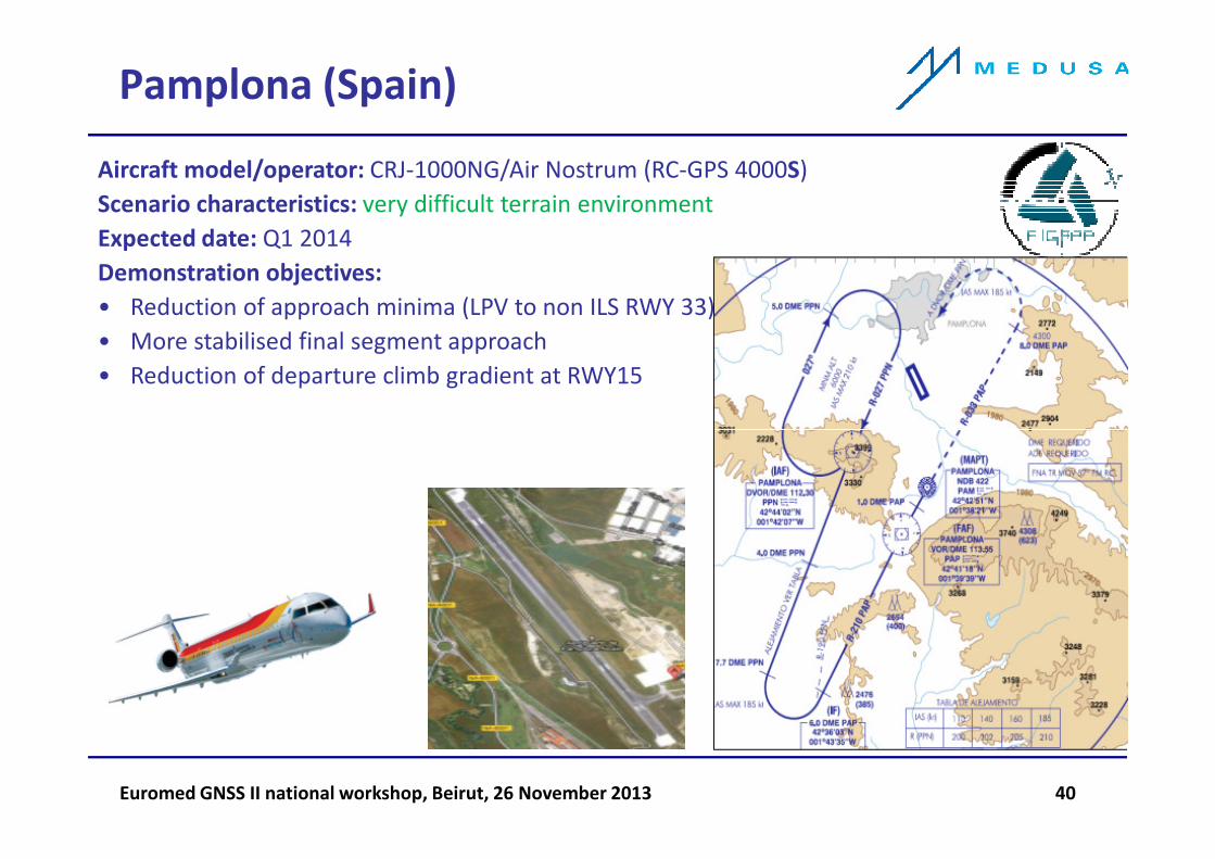
Pamplona (Spain)
Aircraft model/operator: CRJ-1000NG/Air Nostrum (RC-GPS 4000S)
Scenario characteristics: very difficult terrain environment
Expected date: Q1 2014
Demonstration objectives:
• Reduction of approach minima (LPV to non ILS RWY 33)
• More stabilised final segment approach
• Reduction of departure climb gradient at RWY15
Euromed GNSS II national workshop, Beirut, 26 November 2013 40
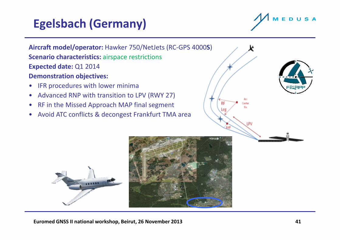
Egelsbach (Germany)
Aircraft model/operator: Hawker 750/NetJets (RC-GPS 4000S)
Scenario characteristics: airspace restrictions
Expected date: Q1 2014
Demonstration objectives:
• IFR procedures with lower minima
• Advanced RNP with transition to LPV (RWY 27)
• RF in the Missed Approach MAP final segment
• Avoid ATC conflicts & decongest Frankfurt TMA area
Euromed GNSS II national workshop, Beirut, 26 November 2013 41

EGNOS pioneer operators
+5x
8x 2x
2x
Euromed GNSS II national workshop, Beirut, 26 November 2013 42
+28 5 4 5
+42
+15x
8x 2x
2x
Thales
Rockwell Collins
Universal
Garmin
4 main avionics manufactures

Operators benefitting from EGNOS
Euromed GNSS II national workshop, Beirut, 26 November 2013 43
Source: GSA/EC

Thank you!
Questions?
Euromed GNSS II national workshop, Beirut, 26 November 2013 44