Glebe Hill Reserve Activity Plan Final compressed
70
Andrew North [email protected] Philip Barker [email protected] 163 Campbell Street Hobart TAS 7000 Telephone 03. 6231 9788 Facsimile 03. 6231 9877 Glebe Hill Bushland Reserve Activity Plan 2014 - 2018 2 nd April 2014 For Clarence City Council (CCC011)
Transcript of Glebe Hill Reserve Activity Plan Final compressed

Andrew North [email protected] Philip Barker [email protected]
163 Campbell Street Hobart TAS 7000 Telephone 03. 6231 9788 Facsimile 03. 6231 9877
Glebe Hill Bushland
Reserve Activity Plan
2014 - 2018
2nd April 2014
For Clarence City Council (CCC011)

Glebe Hill Bushland Reserve Activity Plan 2014 - 2018
North Barker Ecosystem Services April 2nd 2014 CCC011
i

Glebe Hill Bushland Reserve Activity Plan 2014 - 2018
North Barker Ecosystem Services April 2nd 2014 CCC011
ii
CONTENTS
1 INTRODUCTION ...........................................................................................................................1 2 OBJECTIVES ................................................................................................................................1 3 SITE DESCRIPTION......................................................................................................................1 4 RESERVE NATURAL VALUES ......................................................................................................3
4.1 Vegetation Communities ............................................................................................3
4.2 Native Flora .....................................................................................................................9
4.3 Threatened Flora ...........................................................................................................9
4.4 Fauna and Fauna Habitat ........................................................................................15
4.5 Threatened Fauna.......................................................................................................15
4.6 Landscape Setting and Connectivity....................................................................16
4.7 Aboriginal Heritage.....................................................................................................16
4.8 European Heritage......................................................................................................16
4.9 Recreation Values .......................................................................................................17
4.10 Education Values ........................................................................................................17 5 STAKEHOLDER CONSULTATION...............................................................................................19 6 PREVIOUS PLANS AND COMMITMENTS....................................................................................19
6.1 Nature Conservation Plans .......................................................................................19
6.2 Bushfire Management Plan ......................................................................................20 7 MANAGEMENT ISSUES AND RECOMMENDATIONS ...................................................................21 7.1 Weeds .............................................................................................................................21
7.2 Natural Regeneration and Revegetation ............................................................25
7.3 Fauna and Habitat Protection.................................................................................25
7.4 Vegetation and Fauna Monitoring ........................................................................26
7.5 Reserve Entrances .......................................................................................................27
7.6 Tracks ..............................................................................................................................30
7.7 Infrastructure .................................................................................................................31
7.8 Bushfire Management................................................................................................34
7.9 Community Participation and Awareness ...........................................................34
7.10 Review and Reporting ...............................................................................................35 8 IMPLEMENTATION PLAN ..........................................................................................................36 9 REFERENCES.............................................................................................................................43 APPENDIX 1 - VASCULAR PLANT SPECIES LIST................................................................................44 APPENDIX 2 - BIRD SPECIES LIST .....................................................................................................48 APPENDIX 3 - UNANTICIPATED DISCOVERY PLAN ...........................................................................49 APPENDIX 4 - STAKEHOLDER ISSUES SUMMARY..............................................................................51 APPENDIX 5 - WEED SPECIES DESCRIPTION AND CONTROL ...........................................................53 APPENDIX 6 - WEED PHOTOS............................................................................................................55 APPENDIX 7 - WEED CONTROL METHODS .......................................................................................58 APPENDIX 8 - GLEBE HILL BUSHFIRE MANAGEMENT PLAN - TABLE 8..........................................61 APPENDIX 9 - RESERVE ENTRANCES FOR LANDSCAPING ................................................................62 APPENDIX 10 - PEDESTRIAN ACCESS DESIGN ..................................................................................63 APPENDIX 11 - GLEBE HILL BUSHFIRE MANAGEMENT PLAN - VMU’S AND BURN SCHEDULE......64

Glebe Hill Bushland Reserve Activity Plan 2014 - 2018
North Barker Ecosystem Services April 2nd 2014 CCC011
1
1 INTRODUCTION
Glebe Hill Bushland Reserve is located on the eastern shore of Hobart in the suburb of
Howrah in south-east Tasmania. It occurs in the Clarence City Council.
Glebe Hill Bushland Reserve (henceforth known as the Reserve) is made up of two
land parcels, both of which are currently protected by conservation covenants under
the Tasmanian Nature Conservation Act 2002. The southern larger conservation
covenant is owned by the Clarence City Council (henceforth known as the Council),
the ownership being transferred to the Council as part of a previous adjacent
subdivision. The northern smaller and adjoining conservation covenant, currently
privately owned was also established as part of a subdivision. Ownership of this
covenant is also likely to be transferred to the Council. This Reserve Activity Plan
covers the land occupied by these two covenants in anticipation that they will in
future form part of the greater Glebe Hill Bushland Reserve.
This is the first Activity Plan to be prepared for Glebe Hill. Each conservation covenant
area has a corresponding Nature Conservation Plan that details management
prescriptions and describes activities and restrictions that will ensure that the
Reserve’s natural values are maintained and enhanced.
This Reserve Activity Plan for Glebe Hill Bushland Reserve is intended to document the
natural, cultural, recreational and other values of the reserve, and include an
implementation plan for proposed on-ground activities from 2014 to 2018.
2 OBJECTIVES
The objectives of the Glebe Hill Bushland Reserve Activity Plan are to:
• ensure the Reserve is sustainably managed to protect and enhance its
natural, cultural and social values;
• identify priority on-ground management activities to be undertaken within the
Reserve by Council, community groups and/or volunteers;
• encourage community involvement through raising awareness of the
Reserve’s values and encourage participation in activities to minimise threats
to these values.
3 S ITE DESCRIPTION
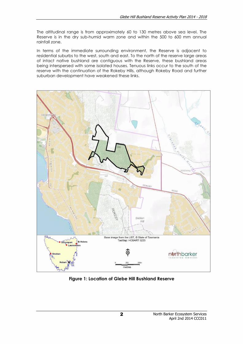
Glebe Hill Bushland Reserve, occupying around 22 hectares, is part of the low hills
locally known as the Rokeby Hills (Figure 1). It is situated within the South East
bioregion of Tasmania1.It is dominated by native vegetation, with a smaller section of
open grassed reserve on its eastern side. The terrain is centred on Glebe Hill, and
consists of the main hill and its lower slopes which are mainly of a gentle nature. The
underlying geology is predominantly composed of Permian mudstone, with a very
small section of dolerite occurring on the far eastern boundary.
1 IBRA5 - Peters & Thackway 1998
Glebe Hill Bushland Reserve Activity Plan 2014 - 2018
North Barker Ecosystem Services April 2nd 2014 CCC011
2
The altitudinal range is from approximately 60 to 130 metres above sea level. The
Reserve is in the dry sub-humid warm zone and within the 500 to 600 mm annual
rainfall zone.
In terms of the immediate surrounding environment, the Reserve is adjacent to
residential suburbs to the west, south and east. To the north of the reserve large areas
of intact native bushland are contiguous with the Reserve, these bushland areas
being interspersed with some isolated houses. Tenuous links occur to the south of the
reserve with the continuation of the Rokeby Hills, although Rokeby Road and further
suburban development have weakened these links.
Figure 1: Location of Glebe Hill Bushland Reserve

Glebe Hill Bushland Reserve Activity Plan 2014 - 2018
North Barker Ecosystem Services April 2nd 2014 CCC011
3
4 RESERVE NATURAL VALUES
4.1 Vegetation Communities
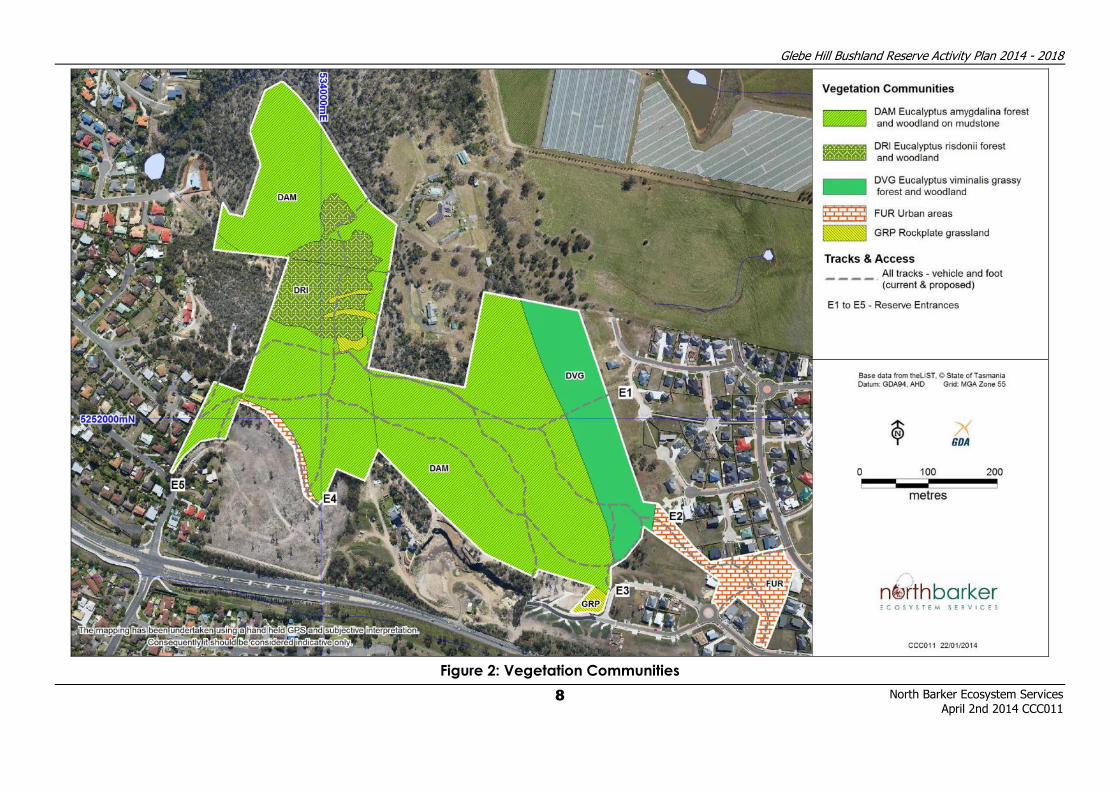
The Reserve is comprised of four native vegetation communities (TASVEG version 2.0):
• Eucalyptus amygdalina forest on mudstone (DAM)
• Eucalyptus risdonii forest and woodland (DRI)
• Eucalyptus viminalis grassy forest and woodland (DVG)
• Rockplate grassland (GRP)
The distribution of vegetation communities is shown in Figure 2.
Table 1: Extent and reservation status of the native vegetation communities recorded
in the study area.2
TASVEG
community
and extent in
study area
Pre 1750/
current
ha
Reservation
ha / %
Pre 1750 /
current
ha
Reservation
ha / %
Status
(JANIS)
Region TAS TAS South East South East
Eucalyptus
amygdalina
forest on
mudstone (DAM)
15.5 ha
69,100
41,500
11,500
28%
(current)
12,000
6,000
1,600
27%
(current)
Not
threatened
Eucalyptus risdonii
forest and
woodland (DRI)
1.9 ha
860
780
350
46%
(current)
860
780
350
46%
(current)
Rare
(threatened)
Eucalyptus
viminalis grassy
forest and
woodland (DVG)
2.6 ha
249,600
109,600
14,600
13%
127,300
68,100
8,300
12%
(current)
Not
threatened
Rockplate
grassland (GRP)
0.3 ha
NA
140
40
29%
NA
100
40
40%
(current)
Not
threatened
2 Knight 2012

Glebe Hill Bushland Reserve Activity Plan 2014 - 2018
North Barker Ecosystem Services April 2nd 2014 CCC011
4
Eucalyptus amygdalina forest on mudstone (DAM)
Eucalyptus amygdalina forest on mudstone (DAM) is the dominant vegetation community
within the Reserve covering approximately 15.5 hectares. It is found throughout the reserve on
mudstone soils. DAM is not threatened under the Tasmanian Nature Conservation Act 2002.
This community is comprised of two eucalypt species – the dominant eucalypt being white
gum (E. viminalis) with black peppermint (E. amygdalina) co/sub-dominant. The shrub layer is
dominated by bull oak (Allocasuarina littoralis), with silver wattle (Acacia dealbata), prickly
box (Bursaria spinosa) and native hop bush (Dodonaea viscosa) all frequent. The lower shrub
layer is diverse and includes a number of low growing and prostrate species including
peachberry (Lissanthe strigosa), broad leaf bitter pea (Daviesia latifolia), yellow everlasting
bush (Ozothamnus obcordatus) and native cranberry (Astroloma humifusum). Prominent
graminoids include sagg (Lomandra longifolia) and black anther flax lily (Dianella revoluta).
Native grasses include spear grass (Austrostipa spp.) and wallaby grass (Austrodanthonia spp.).
There is moderate diversity of native herbs.
The condition is predominantly good with some degradation through tracks, and some weed
infestations on the interface with suburban areas and previously the agricultural land.
Eucalyptus amygdalina forest on mudstone (DAM)

Glebe Hill Bushland Reserve Activity Plan 2014 - 2018
North Barker Ecosystem Services April 2nd 2014 CCC011
5
Eucalyptus risdonii forest and woodland (DRI)
Eucalyptus risdonii forest and woodland (DRI) is less abundant within the Reserve covering
approximately 1.9 hectares. It is found only on the upper west facing slopes of Glebe Hill, on
rockier, shallower mudstone soils. DRI is listed as threatened under the Tasmanian Nature
Conservation Act 20023 (NCA).
Risdon peppermint (Eucalyptus risdonii) is the dominant canopy species. There is a prominent
tall shrub layer that includes bull oak (Allocasuarina littoralis), native hop bush (Dodonaea
viscosa) and hairy dogwood (Pomaderris pilifera) over a diverse assemblage of low shrub that
include spreading wattle (Acacia genistifolia), yellow everlasting bush (Ozothamnus
obcordatus), matted bushpea (Pultenaea pedunculata), glandular pinkbells (Tetratheca
labillardierei), hop bitterpea (Daviesia latifolia), and common heath (Epacris impressa).
Relative abundances of these species vary across the slope, as does the understorey
dominance which is a mixture of native herbs, grasses and orchids.
The condition is predominantly good with little to no weed infestations.
Eucalyptus risdonii forest and woodland (DRI)
3 Schedule 3a NCA, 2002

Glebe Hill Bushland Reserve Activity Plan 2014 - 2018
North Barker Ecosystem Services April 2nd 2014 CCC011
6
Eucalyptus viminalis grassy forest and woodland (DVG)
Eucalyptus viminalis grassy forest and woodland (DVG) is less abundant within the Reserve
covering approximately 2.6 hectares. It is found only on the mid to lower east facing slopes of
Glebe Hill, where dolerite soils are dominant. Eucalyptus viminalis grassy forest and woodland is
not threatened under the Nature Conservation Act 2002. It is however considered to be locally
significant within the Clarence Municipality, with Table 1 highlighting the low reservation status
within the SE bioregion and Tasmania. As this community is not listed under any state legislation,
there may be a clearing bias towards it when developments are planned. This may lead to
excessive clearance of this community which may be detrimental in the long term, and
highlights the importance of conserving areas of DVG within council and other reserves.
This community consists of short mature regrowth trees of E. viminalis. There is a relatively sparse
tall shrub layer dominated by prickly box (Bursaria spinosa) and with occasional silver wattle
(Acacia dealbata), black wattle (A. mearnsii), drooping sheoak (Allocasuarina verticillata) and
native hop bush (Dodonaea viscosa). Low shrubs are scarce, with occasional occurrences of
Astroloma humifusum (native cranberry), Bossiaea prostrata (creeping bossiaea), Lissanthe
strigosa (peachberry heath) and Pimelea humilis (dwarf riceflower). Grasses dominate the
ground cover with Austrostipa sp. being most prominent with kangaroo grass (Themeda
triandra) and velvet tussockgrass (Poa rodwayi) also frequent. Graminoids and herbs are
insignificant, with fan sedge (Lepidosperma inops) and grassland woodsorrel (Oxalis
perennans) possibly being the most frequent species of the first and latter categories.
The condition is predominantly good with some typical agricultural weeds invading adjacent
to the interface with the previous agricultural land (now housing).
Eucalyptus viminalis grassy forest and woodland (DVG)

Glebe Hill Bushland Reserve Activity Plan 2014 - 2018
North Barker Ecosystem Services April 2nd 2014 CCC011
7
Rockplate grassland (GRP)
Immediately to the west of Glebe Hill small patches of rockplate grassland (GRP) occur,
covering approximately 0.3 hectares. Another small patch occurs on the south-eastern edge
of the Reserve. This grassland is likely to be disturbance induced as a result of vegetation
clearance for rough grazing or may be a consequence of shallow soils inhibiting tree
establishment. Rockplate grassland is not threatened under the Nature Conservation Act 2002.
This community is dominated by native species in particular Austrostipa spp. with kangaroo
grass (Themeda triandra) subdominant, and supports good populations of the chocolate lily
(Arthropodium strictum). Other frequent herbs are native flax (Linum marginale), scaly buttons
(Leptorhynchos squamatus) and trailing native-primrose (Goodenia lanata).
The condition is predominantly good with little to no weed infestations.
Rockplate grassland (GRP)
Glebe Hill Bushland Reserve Activity Plan 2014 - 2018
North Barker Ecosystem Services
April 2nd 2014 CCC011
8
Figure 2: Vegetation Communities

Glebe Hill Bushland Reserve Activity Plan 2014 - 2018
North Barker Ecosystem Services April 2nd 2014 CCC011
9
4.2 Native Flora
A total of 112 species of vascular plant have been recorded within the Reserve, including 16
introduced species. A full species list is given in Appendix 1.
4.3 Threatened Flora
Four native species recorded on site are listed as ‘rare’ under the Tasmanian Threatened
Species Protection Act 1995 (TSPA) (see Table 2). No nationally threatened species listed under
the Commonwealth Environment Protection & Biodiversity Conservation Act 1999 (EPBCA)
were recorded.
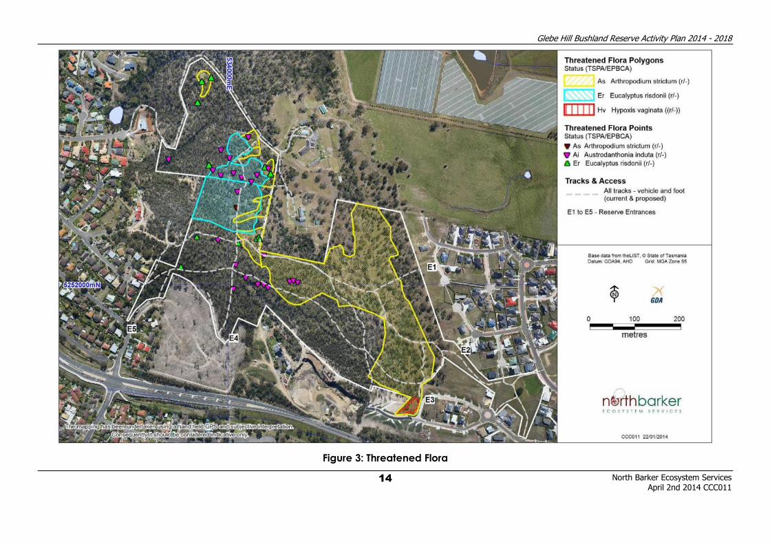
The distribution of threatened flora populations is shown in Figure 3.
Table 2: Threatened plant species recorded within the Reserve
Species Status4 TSPA / EPBCA
Population Estimate (2004-05) -
number of plants or area (ha)
Arthropodium strictum
Chocolate lily Rare / - 1.75 million plants
Eucalyptus risdonii
Risdon peppermint Rare / - 1.9 hectares
Hypoxis vaginata
Sheathing yellowstar Rare / - 13,000 plants
Rytidosperma indutum
Tall wallabygrass Rare / - 200 - 300 plants
Arthropodium strictum (chocolate lily) – Rare (TSPA)
Arthropodium strictum is an attractive lily with chocolate scented purple flowers, flowering in
spring, usually between October and December. It grows in open forest, dry hillsides, grassy
woodlands and grasslands, and occurs predominantly in the eastern half of Tasmania - in the
Hobart area, and the central and northern Midlands. There are however far fewer records in
southern Tasmania, although it is represented in Waverly Flora Park and other parts of the
Rokeby Hills.
A. strictum is represented by a very significant population within the Reserve. Plants are
distributed primarily in the eastern and central part of the reserve, but they also occur in
patches and as scattered individuals on the western side. Previous site surveys (A. North, 2004-
4 Tasmanian Threatened Species Protection Act 1995, Commonwealth Environment Protection and Biodiversity Conservation Act 1999.

Glebe Hill Bushland Reserve Activity Plan 2014 - 2018
North Barker Ecosystem Services April 2nd 2014 CCC011
10
05) have estimated the population as numbering approximately 1.75 million plants. These
numbers appear to be persisting, with an abundance of plants present in 2013.
Flowers of Arthropodium strictum
Mass of Arthropodium strictum flowers
Eucalyptus risdonii (Risdon peppermint) – Rare (TSPA)
Eucalyptus risdonii is a small tree that grows to between 3 and 8m, and has distinctly blue/grey
leaves, covered in a waxy white (glaucous) coating. Eucalyptus risdonii is a Tasmanian
endemic that is confined to the greater Hobart region and is found on the dry hills between
Mangalore and Rokeby where it occurs on the dry sunny crests and northwest facing upper
slopes on Permian mudstone soils.

Glebe Hill Bushland Reserve Activity Plan 2014 - 2018
North Barker Ecosystem Services April 2nd 2014 CCC011
11
Within the Reserve this species primarily occurs in the western part of the Reserve where it
occupies the upper west facing slope of Glebe Hill. It occurs as a significant stand occupying
approximately 1.9 hectares.
Fruit and leaves of Eucalyptus risdonii
Habit of Eucalyptus risdonii

Glebe Hill Bushland Reserve Activity Plan 2014 - 2018
North Barker Ecosystem Services April 2nd 2014 CCC011
12
Hypoxis vaginata subsp. vaginata (yellow sheathing star) – Rare (TSPA)
Hypoxis vaginata is a small perennial herb that has grass-like leaves and small bright yellow
flowers that open in early spring, usually in September and October. It grows in unimproved
wet native pastures and seepage areas in grassy woodland. It is found primarily in the Midlands
and the north of the state, but also occurs in the Hobart region.
Within the Reserve this species only occurs in the south eastern part of the Reserve where it
occupies an area of rockplate grassland. Previous site surveys (A. North, 2004-05) have
estimated the population as numbering approximately 13,000 plants.
Flowers and leaves of Hypoxis vaginata subsp. vaginata
Habitat of Hypoxis vaginata subsp. vaginata

Glebe Hill Bushland Reserve Activity Plan 2014 - 2018
North Barker Ecosystem Services April 2nd 2014 CCC011
13
Rytidosperma induta (tall wallabygrass) – Rare (TSPA)
Rytidosperma induta is an erect, tufted perennial grass that grows to approximately 120 cm
tall. It occurs on mudstone and dolerite in open, dry sclerophyll woodlands. It is found in the
Midlands, south-east and east coasts of the state and in many reserves in the greater Hobart
area. It is widespread on the Rokeby Hills and is known to occur in at least one formal reserve
nearby (Meehan Range), but is represented in many reserves in Hobart and Clarence
including Waverly Flora Park, Ridgeway Reserve, Knocklofty Reserve and the Domain.
Within the Reserve it occurs as scattered and occasional plants on the upper slopes particularly in the western half. It occurs in association with both the Eucalyptus risdonii forest
and woodland and the Eucalyptus amygdalina forest. Population estimates for this species
have not been formalised, however it is likely to be in the order of several hundred plants.
Flowering head of Rytidosperma induta
Glebe Hill Bushland Reserve Activity Plan 2014 - 2018
North Barker Ecosystem Services
April 2nd 2014 CCC011
14
Figure 3: Threatened Flora
Glebe Hill Bushland Reserve Activity Plan 2014 - 2018
North Barker Ecosystem Services April 2nd 2014 CCC011
15
4.4 Fauna and Fauna Habitat
The bushland in the Reserve forms part of an extensive area of dry forest that would provide a
range of habitat opportunities for smaller mammals, birds, reptiles and invertebrates. There is
plenty of dead wood and fallen timber and some trees contain small hollows providing
suitable habitat for hollow nesting birds and mammals. Patches of dense cover occur
throughout the site, particularly in the gullies and areas of thicker grass which would provide
shelter to mammals. There is little access to water in the form of creeks or standing water and
no dens or rocky outcrops have been observed during surveys. The relatively open nature of
much of the forest and woodland on site, particularly the grassy woodland areas provides
opportunities for grazing, hunting and foraging for many fauna species.
Wallabies, brushtail possums, bettongs, pademelons and eastern barred bandicoots have
been observed by local residents and in past surveys foraging both within the Reserve and the
adjacent agricultural land, along with common woodland bird species. Bird surveys
undertaken by Birds Tasmania in October 2013 recorded 17 species. Typical dry woodland bird
species were recorded, with no unusual or threatened species being observed. A complete
bird species list can be seen in Appendix 2.
4.5 Threatened Fauna
No threatened fauna records exist on the Natural Values Atlas (DPIPWE)5 for the Reserve;
however certain species have been recorded in the vicinity and could possibly occur within
the Reserve. The most likely species to occur within the Reserve are the eastern barred
bandicoot (Perameles gunnii) and the swift parrot (Lathamus discolor).
Eastern barred bandicoot (Perameles gunnii) - Vulnerable (EPBCA)
The eastern barred bandicoot is a small marsupial that inhabits grassland and grassy
woodland. It forages preferably in open grassy areas, but for shelter and nesting it requires a
dense ground cover of native tussock grasses, sedges and shrubs. They forage after dusk and
sleep during the day in grass-lined nests where the cover is thick.
The dry grassy woodland and forest present on the property is therefore potentially suitable for
this species, and it has been recorded in the vicinity although not in the Reserve itself. Eastern
barred bandicoots have been observed foraging in and adjacent to the Reserve by local
residents.
Swift parrot (Lathamus discolor) - Endangered (TSPA), Endangered (EPBCA)
The swift parrot is a small bright green parrot that migrates annually from Tasmania to mainland
Australia. The breeding range of the swift parrot is largely restricted to the east coast of
Tasmania within the range of the Tasmanian blue gum (Eucalyptus globulus). Swift parrots also
nest in hollows in old growth trees across a range of eucalypt species.
The study area is located within the core range of the species, and it has been recorded in the
vicinity although not in the Reserve itself. The Reserve is unlikely to provide any breeding
habitat for this species due to insufficient hollows of a suitable size. Whilst there are very few
blue gums, the Reserve could still be used for foraging particularly when the eucalypts on site
are flowering.
5 Natural Values Report #59274 30th October 2013 (DPIPWE)

Glebe Hill Bushland Reserve Activity Plan 2014 - 2018
North Barker Ecosystem Services April 2nd 2014 CCC011
16
4.6 Landscape Setting and Connectivity
The Reserve is a central component and link in an almost constant chain of native vegetation
forming the Rokeby Hills. The upper slopes and ridgeline of the Rokeby Hills remain as intact
bushland whilst the lower slopes and valleys have since European settlement succumbed to
agriculture or residential development. The Rokeby Hills historically would have been
connected to the north to the larger Meehan Range, however this link has been broken by
vegetation clearance largely for agriculture and more recently housing development.
In terms of the immediate surrounding environment, the Reserve is adjacent to residential
suburbs to the west, south and east. To the north of the reserve large areas of intact native
bushland (the continuation of the Rokeby Hills) are contiguous with the Reserve, these
bushland areas being interspersed with some isolated houses. Tenuous links occur to the south
of the reserve with the southern extension of the Rokeby Hills, although Rokeby Road and
further suburban development have weakened these links.
As a condition of the Glebe Hill suburban development to the east of the Reserve, a native
revegetation buffer has been created between the new suburb and intensive viticulture to the
north. This buffer is approximately 30m wide and forms a potential corridor between the
Reserve and native vegetation remnants along the Clarence Plains Rivulet. This corridor is more
likely to be of benefit to birds and invertebrates that can fly over Pass Road and associated
vehicles. Mammals and reptiles are much more susceptible to vehicle roadkill; hence the
corridor is likely to be more problematic. The benefits of having this corridor are likely to
outweigh the potential impacts from roadkill.
The location of landscape linkages can be seen in Figure 4.
4.7 Aboriginal Heritage
Aboriginal Heritage Tasmania (AHT) has completed a search of the Tasmanian Aboriginal Site
Index for the Reserve and has advised that there are no Aboriginal heritage sites recorded
within the reserve boundary. Previous reports indicate that the area has a low probability of
Aboriginal heritage being present (AHT, 2013).
All Aboriginal heritage is protected under the Aboriginal Relics Act 1975. If at any time during
works you suspect Aboriginal heritage, such as stone artefacts, cave/shelter sites, burial sites,
middens or other cultural material, cease works immediately and contact AHT for advice.
Appendix 3 details an Unanticipated Discovery Plan, which explains what steps should be
followed if any of the above items are discovered whilst working on a site. This plan should be
on hand during ground disturbing works, to aid in meeting requirements under the Act should
Aboriginal Heritage be uncovered.
4.8 European Heritage
Whilst the Glebe Hill area has an interesting and varied history since European settlement there
are no obvious heritage items that occur within the Reserve. No items from the Reserve are
listed on the Tasmanian Heritage Register. For those interested in the European history of the
area a book by Wendy Andrew “Footprints - The People and Places of Early Clarence Plains
and Rokeby” is an excellent resource.

Glebe Hill Bushland Reserve Activity Plan 2014 - 2018
North Barker Ecosystem Services April 2nd 2014 CCC011
17
4.9 Recreation Values
The Reserve is used for a range of recreational values by local residents, the primary one being
walking. Other activities include jogging, dog walking, bird watching and nature observation
and interaction. The Reserve is not currently classified by the Council with respect to its dog
exercising status. The Council dog management policy is currently under review and the status
of the Reserve with respect to dogs will be clarified after the review is complete. See Fauna
and Habitat Protection (section 6.3) for further information and management
recommendations.
4.10 Education Values
Educational activities that have occurred or do occur in the Reserve are unknown. There are
currently no Landcare/ Bushcare type groups operating within the Reserve. There are however
opportunities for the Reserve to be utilised in natural history or environmental teaching by local
schools With the newly arrived residents building homes on the slopes of Glebe Hill to the south
and east it is very timely to establish a local Landcare or ‘Friends of’ group.

Glebe Hill Bushland Reserve Activity Plan 2014 - 2018
North Barker Ecosystem Services
April 2nd 2014 CCC011
18
Figure 4: Landscape Setting and Connectivity

Glebe Hill Bushland Reserve Activity Plan 2014 - 2018
North Barker Ecosystem Services April 2nd 2014 CCC011
19
5 STAKEHOLDER CONSULTATION
A “Walk and Talk” meeting was held with interested local residents on Sunday 10th November
2013 between 3 and 5pm. Facilitated by the Council, the purpose of the meeting was to
discuss the Reserve and the purpose of the Reserve Activity Plan, whilst allowing residents to
provide input, discuss concerns or raise issues important to them. A total of twelve residents
attended this meeting, during which issues and Reserve values were discussed whilst walking
through the Reserve.
Following the “Walk and Talk”, attendees were invited to submit formal written responses.
Several major adjacent landholders who were unable to attend the “Walk and Talk” were
approached via phone or email. In all, fourteen residents provided written comments or
comments over phone or email. A summary of issues raised during this consultation is provided
in Appendix 4.
The Draft Glebe Hill Bushland Reserve Activity Plan 2014 - 2018 was released for community
consultation in early February 2014. Several submissions were received during this consultation
period. A Glebe Hill Bushland Reserve Report Card was developed as a key tool, aimed to
encourage feedback on the draft plan and was mailed out to interested residents and
stakeholders.
The feedback received during the consultation period has been considered and incorporated
in to the plan where appropriate. Issues raised that are not specifically related to the Reserve
and its management have been forwarded to the relevant Council staff where they will be
considered and addressed where possible.
6 PREVIOUS PLANS AND COMMITMENTS
6.1 Nature Conservation Plans
Glebe Hill Bushland Reserve is made up of two land parcels, both of which are currently
protected by conservation covenants under the Tasmanian Nature Conservation Act 2002.
Each conservation covenant area has a corresponding Nature Conservation Plan67 that details
management prescriptions and describes activities and restrictions that will ensure that the
Reserve’s natural values are maintained and enhanced. Under the covenant system, the
specific management objectives are:
• to maintain the structure of vegetation community and allow for regeneration of
native species under the proposed management regime;
• to implement appropriate fire regimes;
• to protect the habitat of threatened and/or priority species; and
• to eradicate or control weeds and feral animals and prevent any further
introductions of exotic species.
6 Nature Conservation Plan for Glebe Hill, Rokeby (August 2012)
7 Nature Conservation Plan for 50 Minno St, Howrah

Glebe Hill Bushland Reserve Activity Plan 2014 - 2018
North Barker Ecosystem Services April 2nd 2014 CCC011
20
There is an obligation under this system that the landowner will protect and enhance the
natural values of the Reserve, and implement management actions that aim to achieve this.
The success, or otherwise, of the management regimes will be monitored by DPIPWE8
Stewardship Officers, who can also offer advice on appropriate management and monitoring
techniques.
Management prescriptions and recommendations from the two Nature Conservation Plans are
relatively generic in nature and are in broad agreement and of a similar intent and nature to
the management recommendations that follow within this plan.
6.2 Bushfire Management Plan
The Glebe Hill Reserve Bushfire Management Plan (2012 - 2016)9 (BMP) is the first bushfire
management plan for the Reserve. It aims to lessen the risks posed by wildfires by minimising
the risk of fires starting in the Reserve, and minimising the risk of injury or damage to assets in
and surrounding the Reserve. The BMP also provides for the use of fire as a management tool
to:
• reduce bushfire hazard to protect assets from wildfires,
• maintain the long-term viability of the native vegetation in the reserve, and
• assist in the removal of weeds and the regeneration of degraded bushland.
With respect to this plan, one of the major implications of the BMP is the planned burning
program. The Council is responsible for the implementation of the BMP within the Reserve, and
hence the implementation of the planned burning program. Recommendations made within
the BMP in relation to planned burning, weed control, track maintenance and vegetation
clearance will overlap with many of the recommendations made within this plan. Even so, it is
recommended that the implementation of management actions recommended in this plan is
made in consultation with the BMP and vice versa.
In 2013 vegetation management units (VMU) 3 and 11 in the south-west and south-east of the
Reserve were burnt as part of the planned burning program. VMU 5 is programmed to be burnt
in 2014 when conditions are suitable10. VMU 11 is planned to be burned again in 2017,
otherwise no other VMU’s are scheduled to be burnt within the current BMP timeframe up to
2016. Following this the plan will be reviewed and more VMU’s may be scheduled for burning
post 2016.
In the event of a wildfire impacting on native vegetation within the Reserve, the
implementation plan (see Section 8) will need to be reviewed.
8 Department of Primary Industries, Water and Environment, Tasmania
9 AVK Environmental Management (2012) Bushfire Management Plan. Glebe Hill Reserve, Howrah. Clarence City Council.
10 pers. comm., Pat Marshall, CCC Fire Management Officer

Glebe Hill Bushland Reserve Activity Plan 2014 - 2018
North Barker Ecosystem Services April 2nd 2014 CCC011
21
7 MANAGEMENT ISSUES AND RECOMMENDATIONS
7.1 Weeds
Management of weeds is seen as one of the major issues needing to be addressed to maintain
the integrity of the natural values present within the Reserve. Weeds invade native vegetation
and out-compete or smother native species, resulting in the death or decline of native plants
and the fauna that depend on them. If weeds are not actively managed there will be a
gradual decline in the condition and diversity of species and a potential decline in threatened
flora populations and fauna habitat values.
Weeds in Tasmania can be listed nationally as Weeds of National Significance (WONS) or in
Tasmania as declared weeds under the Tasmanian Weed Management Act 1999 (WMA).
There is no legislative requirement for weeds listed as WONS to be controlled; however weeds
listed under the Tasmanian WMA as declared are legally required to be controlled by
landowners. It is therefore the responsibility of the Council to undertake the control of declared
weeds within the Reserve.
Weed Species Present
Most of the Reserve is in surprisingly good condition when it comes to weed invasion, however,
significant weed species do occur and some of the moister, south-east facing slopes and the
eastern boundary do have more serious weed infestations.
Five weed species listed as ‘declared weeds’ (D) under the Weed Management Act 1999
have been recorded in the Reserve. Three of these species are also listed as “Weeds of
National Significance” (WONS). 15 environmental weeds (E) were also recorded. Of the 20
weeds species recorded in the Reserve, 14 were found only on the two moist slope areas
which account for approximately 5% of the Reserve area. This highlights the localised nature
of most of the weed species within the Reserve.
Texas needle grass (Nassella leucotricha) is of particular concern. The lands to the immediate
east of Glebe Hill sloping down to Pass Road and the junction with Rokeby Road support the
first and currently only known infestation of this highly invasive weed in Tasmania. Although it
has been subject to targeted treatment since its discovery and a high level of concern from
the Weed Management Section at DPIPWE, plants continue to pop up at new sites. The risk of
an overlooked patch of plants seeding and spreading is high. It is known from the part of the
Reserve that extends into the residential subdivision to the east in ex-pasture. The occasional
plant has been recorded in and around the entrance to Glebe hill where it enters bushland.
This open grassy vegetation provides prime habitat for Texas needle grass where its
occurrence amongst native grasses would provide a considerable challenge to control.
Table 3 below details the weed species recorded. The distribution of weed species recorded is
shown in Figure 5. Further details on weed species recorded, photos of each species and
recommended control methods are given in Appendix 5, 6 and 7.
Weed Control
Apart from a few isolated occurrences, weeds in the Reserve are concentrated in three
general areas - the two south-east facing gullies and the eastern boundary. Historically, the

Glebe Hill Bushland Reserve Activity Plan 2014 - 2018
North Barker Ecosystem Services April 2nd 2014 CCC011
22
gully areas have contained larger infestations of weeds, but weed control has occurred here
as a condition of a previous adjacent subdivision. No further weed control work has taken
place in the reserve.
The current weed infestation level is considered to be quite manageable. It is recommended
to focus on all declared and environmental weeds together. Follow up control work will be
required on an annual basis, particularly in the gully areas that have contained a historically
high weed level, and also along the eastern boundary. Given an ongoing commitment it is
entirely feasible that the listed declared and environmental weeds can be “eradicated” from
the Reserve. Reinfestation from outside sources and the soil seed bank will always be an issue,
but future resources required to control weeds will be low and drop to a minimal annual
amount. Eventually an annual walk through of the Reserve and around its boundaries to
monitor for new weeds whilst doing some minor control work at previously controlled areas is all
that will be required.
Management of minor herbaceous and grassy weed species should only be considered once
all other declared and environmental weeds have been controlled and upon review of this
plan after five years.
Weed Control and Fire Management
It is recommended that weed control activities be integrated with the management burning
program recommended within the Glebe Hill Reserve BMP. Carried out incorrectly or without
proper planning, planned burning can exacerbate weed problems. As a part of Clarence City
Council’s Bushfire Management Strategy11, a set of guidelines has been developed to
integrate management burning with weed management to ensure that this does not happen.
These guidelines - Best Practice Management Guidelines12 - recommend the following in
relation to weed control:
• before planned burning;
• woody and herbaceous weeds in the areas to be burnt should be treated to
ensure infestations are root dead at the time of burning
• herbicide treatment should be carried out at least 3 months prior to the burn
to ensure that the chemical has penetrated into the root system, achieved a total kill of all tissue, and the plant has had time to desiccate prior to burning
• after planned burning (which is likely to stimulate weed germination);
• as soon as possible control weed seedlings before native seedlings germinate
• control regrowth from the stumps of regenerating woody weeds
Weed Education
One of the major sources of weeds in reserves that occur in a suburban setting comes from
suburban gardens. The establishment of new residences on the boundaries is likely to present
an increased level of threat from inappropriately disposed garden waste and by garden plants
naturalising into the reserve. Bird spread weeds are also likely to increase as gardens establish
11 AVK Environmental Management (2011) Bushfire Management Strategy for Council Owned and Controlled Land. Clarence City Council.
12 AVK Environmental Management (2011) Bushfire Management Strategy. Best Practice Management Guidelines. Clarence City Council.

Glebe Hill Bushland Reserve Activity Plan 2014 - 2018
North Barker Ecosystem Services April 2nd 2014 CCC011
23
and mature. The majority of weeds listed in Table 3 are considered to be garden escapes.
Garden plants can “escape” into the bush either from seeds or fruits that are transported into
the bush (e.g. blackberries by birds) or by garden cuttings and waste that are disposed of
illegally over the back or side fence. Highly invasive species are well documented and
resources are readily available that can help to inform people about this issue, and about
alternative plants that are available. It is recommended that the Council undertake an
awareness raising campaign with local residents about bushland weeds, garden escapes and
illegal dumping of garden waste.
Recommendations:
1. Control all declared and environmental weeds in an initial control effort.
2. Integrate weed control activities with the management burning program.
3. Undertake follow up control of weeds in areas previously treated.
4. In conjunction with weed control efforts, monitor the Reserve for new weed infestations.
5. Review weed management after five years of weed management activities.
6. Undertake an awareness raising campaign with local residents about bushland weeds.
Table 3: Environmental and declared weed species recorded within the Reserve
Common Name Scientific Name Status
blackberry Rubus fruticosus D, WONS
boneseed Chrysanthemoides monilifera subsp. monilifera D, WONS
Montpellier broom Genista monspessulana D, WONS
fennel Foeniculum vulgare D
slender thistle Carduus pycnocephalus and Carduus tenuiflorus D
aeonium Aeonium sp. E
bluebell creeper Billardiera heterophylla E
cotoneaster Cotoneaster sp. E
fuchsia Fuchsia magellanica E
garden geranium Geranium sp. E
grevillea Grevillea rosmarinifolia E
Himalayan firethorn Pyracantha sp. E
holly Ilex aquifolium E
mirror bush Coprosma repens E
radiata pine Pinus radiata E
red valerian Centranthus ruber E
sweet briar Rosa rubiginosa E
sweet pittosporum Pittosporum undulatum E
tagasaste Chamaecytisus palmensis E
Texas needle grass Nassella leucotricha E

Glebe Hill Bushland Reserve Activity Plan 2014 - 2018
North Barker Ecosystem Services
April 2nd 2014 CCC011
24
Figure 5: Weeds

Glebe Hill Bushland Reserve Activity Plan 2014 - 2018
North Barker Ecosystem Services April 2nd 2014 CCC011
25
7.2 Natural Regeneration and Revegetation
The native vegetation structure within the Reserve is largely intact and in what is considered to
be a natural state. Consequently revegetation activities are not considered necessary in any
part of the Reserve. The most disturbed areas occur where weed control activities have
occurred and will continue to occur. In these areas natural regeneration should be facilitated
by weed control activities and if managed correctly is the most efficient and cost effective
way of maintaining the structure of vegetation communities. Careful follow up weed control in
these areas must ensure regenerating native species are protected.
Bushfires can eliminate new recruits of trees and shrubs. It is preferable therefore to have an
uneven age range reflecting a mosaic of habitats. Patch burning can ensure fuel loads are
varied and losses of recruits are localised. Implementation of the Glebe Hill Reserve Bushfire
Management Plan will help to ensure this is maintained.
Recommendations:
7. Encourage natural regeneration of native species by undertaking initial weed control
and ensuring follow up control protects this regeneration.
8. Ensure the management burning program allows for ongoing recruitment of woody
vegetation.
7.3 Fauna and Habitat Protection
Section 4.4 describes the fauna and fauna habitat values of the Reserve, with the vegetation
considered to provide a range of habitat opportunities for smaller mammals, birds, reptiles and
invertebrates. A diversity of vegetation types, plant structures (e.g. logs, hollows) and terrain
(e.g. creeks, rocky outcrops) is considered ideal in providing a variety of habitat opportunities
for native fauna. Maintaining this diversity will provide the best opportunity for fauna to persist
and thrive.
The most likely impact to fauna habitat will come from uncontrolled bushfires in the Reserve,
particularly if the whole Reserve is burnt out in one fire event. Implementation of the Glebe Hill
Reserve BMP will help to ensure this does not happen by managing fuel loads and burning
different management units in different years. The plan takes in to account the need to have a
variety of different age structures of vegetation within the Reserve, and if implemented
correctly will ensure a mosaic of habitat types and regrowth levels over the Reserve.
Weed control activities will have a positive effect on fauna habitat values by maintaining the
vegetation composition and structure that native animals are adapted to and by not allowing
this to be altered by weed invasion.
Introduced predators, in particular suburban cats and dogs can have a large impact on the
native fauna populations in any reserve. Fauna can be killed or harassed to the point where
they abandon the habitat for more isolated remnants. Being adjacent to suburbs which are
increasing in the area increases the pressure on native fauna. Cats allowed to roam,
particularly at night can have a large impact on vulnerable species, while dogs walking off-
leash through the Reserve can chase small mammals, and their presence and smell can deter
or drive out some fauna species.

Glebe Hill Bushland Reserve Activity Plan 2014 - 2018
North Barker Ecosystem Services April 2nd 2014 CCC011
26
The Council has an ongoing commitment to responsible cat ownership, with the most
important part of this being keeping cats indoors overnight. Whilst this is not legally
enforceable, an awareness raising campaign could influence some local residents to better
manage their cats. Dogs are more of an issue when being walked off-leash through the
Reserve, if they are not under effective control. Classification of the Reserve by Council as to its
dog walking status is needed. The Council dog management policy is currently under review
and the status of the Reserve with respect to dogs will be clarified after the review is complete.
It is recommended that the Reserve be classified as a “dog under effective control” site. In
such an area effective dog control provisions apply - dogs may be exercised off a lead
provided they are, at all times, within sight and immediately responsive to an owners
commands.
Recommendations:
9. Ensure the management burning program takes into account fauna habitat
requirements.
10. Maintain fauna habitat values by implementing weed control.
11. Council to undertake an awareness raising campaign with local residents about
responsible cat and dog ownership within the Reserve.
12. Council to designate the Reserve as a “dog under effective control” site.
7.4 Vegetation and Fauna Monitoring
Monitoring of flora and fauna composition within the Reserve over time is an effective way of
assessing the health of an ecosystem, the effectiveness of current management activities and
to justify the allocation of resources. The most effective monitoring methods for the Reserve
are:
• vegetation monitoring plots
• photopoints
• resurvey weeds
• resurvey birds
The Glebe Hill Reserve Bushfire Management Plan recommends setting up vegetation
monitoring plots to assess the impacts of planned burning within the Reserve. In 2013
vegetation management units (VMU) 3 and 11 were burnt as part of the planned burning
program (see Appendix 11). VMU 5 is programmed to be burnt in 2014, while VMU 11 is
planned to be burned again in 2017. Additional VMU’s could be scheduled for burning after
the Bushfire Management Program is reviewed after 2016. The setting up of monitoring plots
should be organised in accordance with the burn schedule to ensure that burnt areas are
monitored prior to burning taking place. The VMU’s and burn schedule are included in
Appendix 11 for reference.
Vegetation monitoring plots can also be used to monitor changes in the vegetation over time.
Five monitoring plots should be set up within the Reserve; each in different vegetation
management units, and one in each vegetation community, with two in the larger DAM
community. Plots should be assessed using the vegetation condition analysis methodology.
Photopoints are fixed points from which a photograph is taken of a particular subject at
different times for comparison. They can be set up to monitor a particular weed species or to
Glebe Hill Bushland Reserve Activity Plan 2014 - 2018
North Barker Ecosystem Services April 2nd 2014 CCC011
27
monitor an important location, such as where a threatened flora population occurs or within a
threatened vegetation community. A photopoint should be set up at each vegetation
monitoring plot. Vegetation monitoring plots and photopoints should be set up before any
planned burning takes place, and be re-monitored in the first and fifth years after burning and
then every five years.
The vegetation condition analysis methodology has been created by the Vegetation Section
of DPIPWE to assess vegetation condition13. This methodology uses a scoring system to
objectively assess vegetation condition for different vegetation types across Tasmania.
Vegetation is scored according to attributes including the density of trees, species diversity,
species recruitment, landscape context and weeds. Once a site has been assessed and
assigned a vegetation condition score, this score should be used as a baseline for the site.
Future measurements of the vegetation condition score can then be compared to this
baseline to monitor changes in the score and hence changes in condition of the vegetation at
the site.
The current weed mapping within this plan gives a snap shot of the Reserve’s current weed
status. For monitoring purposes the survey process can simply be repeated at a later date, and
the abundance and distribution of weeds compared to see what the difference is. The current
bird species list can be used in a similar way, with a later survey being able to convey if the
species composition has changed. It is recommended that bird and weed surveys be
undertaken every five years.
Recommendations:
13. Set up five vegetation monitoring plots and photopoints before planned burning is
implemented
14. Re-monitor vegetation monitoring plots and photopoints in the first and fifth years after
burning and then every five years.
15. Undertake a weed survey every five years.
16. Undertake a bird survey every five years.
7.5 Reserve Entrances
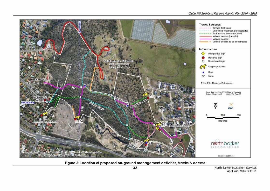
Public access to the Reserve is currently served from five entrances (E1 to E5) as shown on
Figure 6. The extent of use of each of these entrances is currently unknown. To better
understand the use by the public and to help to determine the most appropriate places for
future infrastructure improvements, it is recommended that a public use survey be carried out.
The five entrances are described in Table 4 below.
13 DPIPWE (2006) Tasveg Vegetation Condition Manual

Glebe Hill Bushland Reserve Activity Plan 2014 - 2018
North Barker Ecosystem Services April 2nd 2014 CCC011
28
Table 4: Reserve Entrances, Current Status and Recommendations
Reserve Entrance Status Recommendations
Entrance 1 (E1)
Betsy Mack
Entrance
(Betsy Mack
Place)
Has been landscaped as part of the Glebe
Hill Subdivision but in January 2014 was
poorly maintained and overgrown with
weeds. This is currently the entrance to
nowhere as no formal tracks run from this
entrance. This is aimed to be rectified with
the installation of the proposed Betsy Mack
Track. The track has been quite heavily
eroded from water runoff. Access is open
to bikes and trail bikes from adjacent
roads. Although this does not appear to
currently be a problem, a restriction of
access is recommended. Car parking is
available on adjacent streets.
• Install Reserve signage
(refer to Section 6.7 on
Infrastructure for
details)
• Install fencing and
stationary bike barrier.
Concept design
provided in Appendix
10.
• Maintain current
landscaping or
improve with local
native plantings
• Install dog waste bag
dispensers and bin
• Install water runoff
diverters on entrance
path
Entrance 2 (E2)
Wendy Andrew
Entrance
(Desailly Place
and Glebe Hill
Road)
Access to the Glebe Hill Track and
Highclere Track. Mown grass leads up to
the entrance, after which native
vegetation begins immediately. This
entrance has two lead ins, one from
Highclere Court and the other from the
mown grassy area leading to Glebe Hill
Road. Access is open to bikes and trail
bikes from adjacent roads Although this
does not appear to currently be a
problem, a restriction of access is
recommended. Access to emergency and
council vehicles is through removable
bollards at Highclere Court and Desailly
Place. Car parking is available in a public
car park on Glebe Hill Road.
• Install Reserve and
interpretive signage
• Initiate and implement
landscape plan
design (see Appendix
9)
• Install seating
• Install fencing and
stationary bike barrier.
Concept design
provided in Appendix
10.
• Install dog waste bag
dispensers and bin
Entrance 3 (E3)
Norfolk Drive
Entrance
Access to the Highclere Track. Consists of
stairs leading up from Norfolk Drive to a
track leading in to the Reserve. There has
been no landscape planting with exotic
and native grasses pre-dominating. Car
parking is available on adjacent streets.
Stairs provide a disincentive to bikes.
Further a restriction of access is not
recommended.
• Install Reserve signage
• Install seating above
stairs
• Install dog waste bag
dispensers and bin
Entrance 4 (E4) Access to the Highclere Track. Entrance to • Install Reserve signage

Glebe Hill Bushland Reserve Activity Plan 2014 - 2018
North Barker Ecosystem Services April 2nd 2014 CCC011
29
Reserve Entrance Status Recommendations
Watton Place
Entrance
a fire trail that is important access for fire
fighting crews in the event of a fire. It is
currently not landscaped; native
vegetation grows up to the entrance. Car
parking is available on adjacent streets.
• Maintain fire fighting
access but limit
vehicle access with a
steel lockable boom
gate.
• Install dog waste bag
dispensers and bin
Entrance 5 (E5)
Vienne Drive
Entrance
Currently accesses tracks running through
private property. It is intended that the
Glebe Hill Track be extended to this
entrance and possibly be a future link
through to the proposed Rokeby Hills Trail.
A limestone retaining wall and stairs lead in
to this obscure entrance. Without local
knowledge it may be unclear that this is
actually part of the reserve as it could
appear to be private property. Stairs are
the only barrier to bikes and trail bikes, but
as this does not appear to currently be a
problem, a restriction of access is not
recommended.
• Install Reserve signage
• Initiate and implement
landscape plan
design (see Appendix
9)
• Install dog waste bag
dispensers and bin
Mookara Street
Entrance
Is a narrow laneway running from Mookara
Street in to the Reserve, and it is
recommended that this access be left as is
except for the addition of a Reserve sign,
as it is currently unclear where this
pathway leads to.
• Install Reserve signage
Monique Street
Entrance
The Monique Street access is through
private property so is currently not
accessible. This access is relatively
overgrown and narrow in parts and is
blocked by a wire fence on the edge of
the Reserve. The formalisation of this
access is subject to negotiation with
landholders, but it could provide another
option for a through-track in the Reserve
and also another access option for fire
fighting crews. Negotiations with
landholders should be implemented to
facilitate this happening.
• Initiate negotiations
with landholders to
discuss access options
Entrance Landscaping
Landscape designs could be planned and implemented for two entrances into the Reserve -
the Wendy Andrew Entrance and the Vienne Drive Entrance. However any such works require
adequate funding for establishment and long term maintenance to succeed. All other
entrances to the Reserve are considered too minor for landscaping works and are likely to
require too much of a financial commitment.
Glebe Hill Bushland Reserve Activity Plan 2014 - 2018
North Barker Ecosystem Services April 2nd 2014 CCC011
30
Bearing these constraints in mind, the entrances where landscaping would most benefit the
Reserve have been highlighted. In doing this it is hoped that a process can be initiated,
properly budgeted, designed and implemented. Images of the two entrances are shown in
Appendix 9.
Recommendations:
17. Implement Reserve entrance recommendations for all as per this plan.
18. Undertake a reserve entrance public use survey.
19. Initiate and implement landscape designs for Wendy Andrew and Vienne Drive
Entrances.
7.6 Tracks
Tracks within the Reserve consist of upgraded vehicle tracks suitable for emergency vehicles,
old fire tracks suitable for 4WD vehicles, formal constructed walking tracks and informal walking
tracks. The predominant use of these tracks is by pedestrians, with occasional use by Council
maintenance vehicles.
The Glebe Hill Reserve Bushfire Management Plan requires that tracks be upgraded or
maintained to a certain standard to allow for emergency vehicle access in the event of a fire.
Track upgrades detailed in the BMP should be implemented. Vehicle tracks must be upgraded
to fire trail usage classes as described in Management Procedure 1 in the Best Management
Practices Guidelines Section of the Clarence Bushfire Management Strategy. Tracks can be
seen in Figure 6 and Section 3.1.2 of the BMP and are not repeated here. Table 8 also from this
plan is shown in Appendix 8 for reference. The implementation of these upgrades will also
benefit pedestrians by improving track stability and accessibility.
Upgrading of some walking tracks is recommended along with additional track
recommendations focusing on other sections of the Reserve (see Table 5). Walking track
upgrades are all to be constructed and maintained to Australian Standard (AS) Walking Track
Class 3, except for the Glebe Hill Track which is AS Walking Track Class 2. Full details of walking
track designs and specifications can be found in the following AS document - AS 2156.1-2001
Walking tracks - Classification and signage14.
Table 5: Track Upgrades
Track/ Location Issue Recommendations
Tracks GH1, GH2 & GH3*
(and associated tracks)
as detailed in the BMP.
Various non-compliance issues for
fire management track standards
• Implement track
upgrades and
maintenance as per the
recommendations in
Table 8 (see Appendix 8)
and Section 3.1.2 of BMP.
14 http://infostore.saiglobal.com/store/results2.aspx?searchType=simple&publisher=AS&keyword=walking+tracks

Glebe Hill Bushland Reserve Activity Plan 2014 - 2018
North Barker Ecosystem Services April 2nd 2014 CCC011
31
Track/ Location Issue Recommendations
Highclere Track and
associated side tracks
south of the Glebe Hill
Track
Informal foot track that needs
upgrading to a better and safer
standard.
• Upgrade foot track to a
minimum standard of
gravel walking track.
Betsy Mack Track No track exists currently. • Construct walking track
to a minimum standard
of gravel walking track.
Highclere Track to Vienne
Drive Entrance
No track exists currently. • Construct walking track
to a minimum standard
of walking track.
Tracks GH1 (and the
connector to GH2) &
Minor erosion issues exist on some
tracks.
• Install water runoff
diverters where water
erosion is most severe.
* - Track names GH1, GH2 and GH3 are from the BMP (BMP). The location of these tracks is shown on
Figure 6.
A proposal for a loop track running to the north of the Reserve connecting the north-western
part of the Reserve with the north-eastern part has been made. This is currently private
property and would need an agreement with the local landholders. All landholders to the
north of the Reserve were contacted regarding this issue and asked for comment. Comments
received are summarised in Appendix 4. Further negotiation is beyond the scope of this
project; however it is recommended that Council continue negotiations with key landholders.
Recommendations:
20. Implement track upgrade and maintenance recommendations as per this plan.
21. Negotiate with landholders re the feasibility of a northern loop track.
7.7 Infrastructure
There is currently no infrastructure within the Reserve itself in terms of seating, signage or any
other public information or facilities. A balance between providing infrastructure to facilitate
visitor access and retaining the natural amenity of the area needs to be found. Whilst certain
infrastructure will be recommended, it should be low key and minimalistic so that it is
unobtrusive where possible.
Members of the public who enjoy walking in native Reserves often enjoy sitting down on a seat
to enjoy views or take a break. There are currently no seats within the Reserve and it is
recommended that several seats are installed as per Figure 6. Similarly dog-walking is a
popular activity; however the negative of dog faeces both to humans and the natural
environment can be a problem. It is recommended that dog waste bag dispensers and bins
be placed at several of the reserve entrances to facilitate the responsible behaviour of dog
owners.
Information signage and trail direction signs are obvious in their absence in the Reserve. Unless
you know the tracks well it could be easy to misplace your location and not have direction

Glebe Hill Bushland Reserve Activity Plan 2014 - 2018
North Barker Ecosystem Services April 2nd 2014 CCC011
32
signs to help you out. There is also a lack of Reserve signage telling the public that they are
actually in the Reserve, and interpretive signs to educate and inform. To improve this situation
Table 6 below details the infrastructure that should be installed and where.
Table 6: Infrastructure
Infrastructure Type Details Locations
Seats • For the rest and relaxation of
the general public
• Should blend in to the
environment and be as vandal
proof as possible
• In four locations as per 3
Dog waste bag
dispensers and bins
• For the bagging and removal
of dog waste
• Install at each main entrance
(E1 to E5)
Trail direction signs • To be placed at track junctions
to assist in direction finding and
track location
• At all track intersections
Reserve signs • To include the following
information:
• Reserve name
• regulations (e.g. limitation
on trail bikes, dogs on or
off leash)
• At all entrances, including
Mookara St. Access
(excluding Monique St.
Access)
Interpretive signs • To include the following
information:
• track map
• Information on the history
and natural values of the
Reserve
• At entrance E2
Gates • steel lockable boom gate to
permit fire and maintenance
vehicle access but restrict other
vehicles
• At entrance E4
Recommendations:
22. Implement infrastructure upgrade recommendations as per this plan.
Glebe Hill Bushland Reserve Activity Plan 2014 - 2018
North Barker Ecosystem Services
April 2nd 2014 CCC011
33
Figure 6: Location of proposed on-ground management activities, tracks & access
Glebe Hill Bushland Reserve Activity Plan 2014 - 2018
North Barker Ecosystem Services April 2nd 2014 CCC011
34
7.8 Bushfire Management
Bushfire management is a critical issue in the Reserve, particularly due to the potential for loss
of assets and life, but it also has implications for flora and fauna management. The implications
and management of bushfire are thoroughly addressed in the Glebe Hill Reserve Bushfire
Management Plan (2012 - 2016)15 (BMP). Consequently the issue will not be addressed in detail
here, except to raise one particular management issue (see below).
One of the major recommendations of the BMP is the implementation of a planned burning
program, the responsibility of which rests with the Council. Recommendations made within the
BMP in relation to planned burning, weed control, track maintenance and vegetation
clearance should be implemented as documented. Many of these recommendations will
overlap with those made within this plan. Even so, it is recommended that the implementation
of management actions recommended in this plan is made in consultation with the BMP and
vice versa.
The timber fence constructed along the Reserve’s eastern and south-eastern boundary with
the newly constructed houses is a major fire hazard that occurs within the building protection
zone. In a bushfire event the combustion of this fence could pose further risks to the adjacent
houses. This risk could be substantially reduced by replacing the timber fence with a solid steel
(e.g. Colorbond) fence. Residents should be aware that their Bushfire Attack Level (BAL) ratings
for their homes are compromised by this wooden fence line, even though the Council is
maintaining the Tasmanian Fire Service Standard Asset Protection Zone in the adjoining
reserve. As a wooden rather than a metal fence line it also compromises the ecological
values of the bush adjoining the properties by requiring substantially more clearing of bushland
behind the highly combustible wooden fence lines compared to metal fence lines. The
Council aims to encourage the replacement of these fences to reduce the fire risk and the
level of management required.
Recommendations:
23. Implement the management actions recommended in the BMP in consultation with this
Plan.
24. Promote the major reduction in fire risks to neighbouring properties via wooden fence
replacement.
7.9 Community Participation and Awareness
It is very important to involve community in the activities and management of the Reserve to
instil a sense of ownership and value of the Reserve itself. If this is successful the Reserve
becomes an asset in the eyes of the community and local residents rather than a burden or a
threat.
To facilitate this Council needs to be active in promoting the Reserve and community
involvement in management and recreational activities. Many of the reserves in the Council
area have active community groups that focus on weed management and revegetation.
Such a group is an ideal way of engaging the community and involving people in the Reserve.
15 AVK Environmental Management (2012) Bushfire Management Plan. Glebe Hill Reserve, Howrah. Clarence City Council.

Glebe Hill Bushland Reserve Activity Plan 2014 - 2018
North Barker Ecosystem Services April 2nd 2014 CCC011
35
The most successful groups are driven by one or more highly motivated local residents, and the
formation of the group is usually initiated by these people. This is the preferred option. If initially
a motivated individual is not present, the Council can look to initiate the formation of a group
and drive it.
Several methods can be used to help raise awareness of the Reserve and its issues, including
the following;
• “walk and talk” field mornings to take people through the Reserve and highlight the
natural values, history, amenity and management issues of the Reserve
• A letter box drop to local residents with information on the Reserve and its issues. Issues
raised should include bushland weeds and garden plantings, garden waste dumping,
cats and dogs and their interaction with native fauna, trail bike riding etc. The “report
card” for the Reserve should also be sent out with this information.
• Actively support the formation of a Glebe Hill Bushland Reserve Landcare Group.
Alternatively seek a role for the Tranmere & Clarence Plains Landcare & Coastcare
Incorporated group
• install signage to inform people of the values of the Reserve (see Infrastructure section
for details)
Recommendations:
25. Facilitate the formation of a community group to undertake management activities
within the Reserve.
26. Organise an annual “walk and talk” within the Reserve.
27. Organise a letter box drop to highlight the Reserve report card and other management
issues. Enquire interest in participation on a Friends Of Glebe Hill Bushcare Group
28. Implement signage recommendations as per this plan.
7.10 Review and Reporting
A review of the Glebe Hill Bushland Reserve Activity Plan should be undertaken after five years
of the plan having been implemented. A thorough assessment of the recommendations and
progress made towards their implementation needs to be made. Additionally data collected
from vegetation monitoring plots, photopoints and weed and bird surveys needs to be
analysed and reported on to see if natural values are improving, declining or being
maintained. Finally recommendations need to be made as to the management priorities for
the next five years of the plan.
The Glebe Hill Bushfire Management Plan is due to be reviewed after 2016. This plan is due to
be reviewed after 2018. Since these plans intertwine in their objectives and some
recommended actions, and vegetation monitoring should be synchronised with the planned
burning program, it would be beneficial if the dates and time periods were more aligned.
Preferably this would involve the time periods aligning in the future and the reviews of both
documents occurring at the same time and with consultation occurring to ensure objectives,
actions and recommendations are complementary.

Glebe Hill Bushland Reserve Activity Plan 2014 - 2018
North Barker Ecosystem Services April 2nd 2014 CCC011
36
Recommendations:
29. Undertake a review and reporting process after five years of the operation of this plan.
30. Re-align time periods for the Bushfire Management Plan and the Reserve Activity Plan
so that they occur over the same time period and are complementary.
8 IMPLEMENTATION PLAN
The following implementation plan includes all of the recommendations made throughout the
Reserve Activity Plan. Each recommendation has an associated performance measure,
responsible organisation, and an estimated funding cost. Funding costs are estimates only and
due to changes in price over time should be revisited closer to the implementation date.
Recommendations have also been assigned a priority ranking based on the following system:
• Priority 1 - short term activities (6-12 months)
• Priority 2 - medium term activities (1-3 years)
• Priority 3 - long term activities (3-5 years)
The implementation plan should be used as a guide to the estimated costs and what order
tasks should be carried out in based on the priority order. If a community group is eventually
formed considerable cost savings could be made. Recommendations are aspirational and a
best case scenario given unlimited funding. Given that this is not the case; decisions will need
to be made as to what is achievable with the current resources. Alternative funding may need
to be sought in the form of government grants to make some of the recommendations
achievable.

Glebe Hill Bushland Reserve Activity Plan 2014 - 2018
North Barker Ecosystem Services
April 2nd 2014 CCC011
37
Table 7: Implementation Plan
Priority Recommendation
No. Action Performance Measure Responsibility
Estimated
Funding*
Weeds
1 1 Control all declared and environmental weeds in an
initial control effort
Initial control of weeds
completed
Council, contractor
or community group $2,400
1 2 Integrate weed control activities with the
management burning program
Planned burn areas have
weed control before and
after burn event
Council, contractor
or community group $600
2,3 3 Undertake follow up control of weeds in areas
previously treated
Areas previously treated
remain weed free
Council, contractor
or community group
$1,500 per
annum
2,3 4 In conjunction with weed control efforts, monitor the
Reserve for new weed infestations
Reserve remains free of
declared and
environmental weeds
Council, contractor
or community group
included in Rec.
No. 1 & 3
Regeneration and Revegetation
2,3 7
Encourage natural regeneration of native species by
undertaking initial weed control and ensuring follow
up control protects this regeneration
Native species are
regenerating in areas
treated for weeds
Council, contractor
or community group
included in Rec.
No. 1 & 3
2,3 8 Ensure the management burning program allows for
ongoing recruitment of woody vegetation
Native woody species are
regenerating and
persisting
Council, contractor
or community group
included in Rec.
No. 1 & 3
Fauna and Habitat Protection
1 9 Ensure the management burning program takes into
account fauna habitat requirements
A mosaic of habitat types
and regrowth levels has
resulted in the Reserve as a
Council or
contractor
NA - Funding
part of the fire
management

Glebe Hill Bushland Reserve Activity Plan 2014 - 2018
North Barker Ecosystem Services
April 2nd 2014 CCC011
38
Priority Recommendation
No. Action Performance Measure Responsibility
Estimated
Funding*
result of the planned burn
program
program
1 10 Maintain fauna habitat values by implementing weed
control
Weed control program
implemented
Council, contractor
or community group
included in Rec.
No. 1 & 3
2 11
Council to undertake an awareness raising campaign
with local residents about responsible cat and dog
ownership within the Reserve
Awareness raising
campaign implemented to
local residents
Council NA - Normal
council activity
2 12 Council to designate the Reserve as a “dog under
effective control” site
The Reserve is designated
as a “dog under effective
control” site under the
Council’s Dog
Management Policy and
listed on the Council
website
Council NA - Normal
council activity
Vegetation and Fauna Monitoring
1 13 Set up five vegetation monitoring plots and
photopoints before planned burning is implemented
Five vegetation monitoring
plots and photopoints set
up
Contractor
$2,000
(includes data
analysis and
basic reporting)
2,3 14
Re-monitor vegetation monitoring plots and
photopoints in the first and fifth years after burning
and then every five years
Five vegetation monitoring
plots and photopoints re-
monitored in the first and
fifth years after burning
and then every five years
Contractor
$1,500
(includes data
analysis and
basic reporting)
3 15 Undertake a weed survey every five years Weed survey completed
after fifth year Contractor
$1,500
(includes data
analysis and
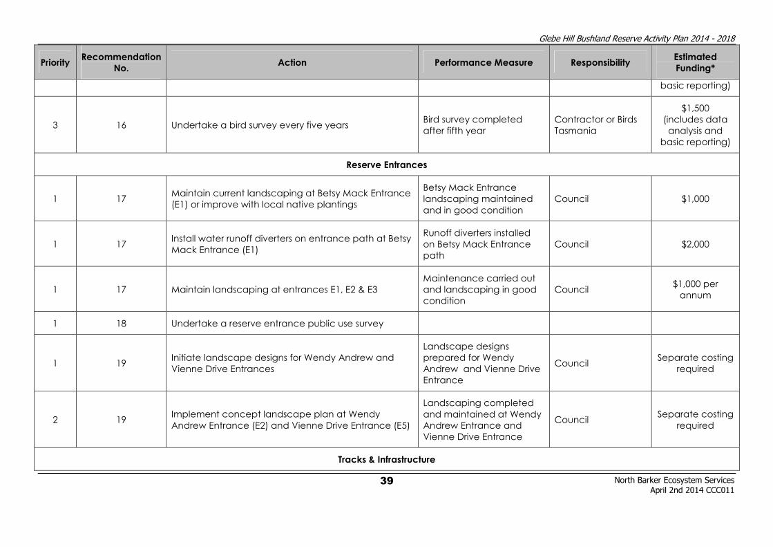
Glebe Hill Bushland Reserve Activity Plan 2014 - 2018
North Barker Ecosystem Services
April 2nd 2014 CCC011
39
Priority Recommendation
No. Action Performance Measure Responsibility
Estimated
Funding*
basic reporting)
3 16 Undertake a bird survey every five years Bird survey completed
after fifth year
Contractor or Birds
Tasmania
$1,500
(includes data
analysis and
basic reporting)
Reserve Entrances
1 17 Maintain current landscaping at Betsy Mack Entrance
(E1) or improve with local native plantings
Betsy Mack Entrance
landscaping maintained
and in good condition
Council $1,000
1 17 Install water runoff diverters on entrance path at Betsy
Mack Entrance (E1)
Runoff diverters installed
on Betsy Mack Entrance
path
Council $2,000
1 17 Maintain landscaping at entrances E1, E2 & E3
Maintenance carried out
and landscaping in good
condition
Council $1,000 per
annum
1 18 Undertake a reserve entrance public use survey
1 19 Initiate landscape designs for Wendy Andrew and
Vienne Drive Entrances
Landscape designs
prepared for Wendy
Andrew and Vienne Drive
Entrance
Council Separate costing
required
2 19 Implement concept landscape plan at Wendy
Andrew Entrance (E2) and Vienne Drive Entrance (E5)
Landscaping completed
and maintained at Wendy
Andrew Entrance and
Vienne Drive Entrance
Council Separate costing
required
Tracks & Infrastructure

Glebe Hill Bushland Reserve Activity Plan 2014 - 2018
North Barker Ecosystem Services
April 2nd 2014 CCC011
40
Priority Recommendation
No. Action Performance Measure Responsibility
Estimated
Funding*
1 20
Cost and implement track upgrades and
maintenance as per the recommendations in Table 8,
Figure 6 and Section 3.1.2 of the BMP
Track upgrades and
maintenance completed
Council or
contractor
Separate costing
required
2 20
Construct walking track to a minimum standard of
gravel walking track on those sections of the
Highclere Track and associated side tracks south of
the Glebe Hill Track
Track upgrades and
maintenance completed
on Highclere Track and
associated tracks
Council or
contractor $55,000
2 20 Construct Betsy Mack walking track to a minimum
standard of gravel walking track
Betsy Mack Track
constructed and
maintained
Council or
contractor $10,000
2 20
Construct Highclere Track to Vienne Drive Entrance
walking track to a minimum standard of gravel
walking track
Highclere Track to Vienne
Drive Entrance walking
track constructed and
maintained
Council or
contractor $23,000
3 20 Install water runoff diverters where water erosion is
most severe on GH1 and the connector to GH2
Water runoff diverters
installed
Council or
contractor $10,000
2 21 Negotiate with landholders re the feasibility of a
northern loop track
Negotiations undertaken
with landholders Council NA
2 22 Install seats at four locations as per Figure 6 Four seats installed Council or
contractor $8,000
2 22 Install dog waste bag dispensers and bins at each
reserve entrance
Five dog waste bag
dispensers and bins
installed
Council or
contractor $7,000
2 22 Install trail direction signs as per Figure 6 Six trail direction signs
installed
Council or
contractor $3,000

Glebe Hill Bushland Reserve Activity Plan 2014 - 2018
North Barker Ecosystem Services
April 2nd 2014 CCC011
41
Priority Recommendation
No. Action Performance Measure Responsibility
Estimated
Funding*
2 22 Install reserve signs at all entrances, including
Mookara St. Access (excluding Monique St. Access) Six reserve signs installed
Council or
contractor $9,000
2 22 Install interpretive signs at entrance E2 One interpretive sign
installed
Council or
contractor $3,000
2 22 Install steel lockable boom gate at entrance E4 One steel lockable boom
gate installed
Council or
contractor $10,000
Bushfire Management
1 23 Implement the management actions recommended
in the BMP in consultation with this Plan
Management actions
recommended in the BMP
implemented in
consultation with this Plan
Council NA
1 24
Promote the major reduction in fire risks to
neighbouring properties via wooden fence
replacement
Letters sent to landholders
with wooden fences
backing on to the Reserve
to raise the issue.
Council NA
Community Participation and Awareness
2 25 Facilitate the formation of a community group to
undertake management activities within the Reserve
Reserve community group
formed and active
Council or local
residents NA
2 26 Organise an annual “walk and talk” within the
Reserve
Annual “walk and talk”
completed Council NA
1 6, 27 Organise a letter box drop to highlight the Reserve
report card and other management issues Letter box drop completed Council NA
2 21, 28 Implement signage recommendations as per this plan Signage installed Council See above

Glebe Hill Bushland Reserve Activity Plan 2014 - 2018
North Barker Ecosystem Services
April 2nd 2014 CCC011
42
Priority Recommendation
No. Action Performance Measure Responsibility
Estimated
Funding*
Review and Reporting
3 5, 29 Undertake a review and reporting process after five
years of the operation of this plan
Review on the Reserve
Activity Plan completed
Council or
contractor $8,000
3 30
Re-align time periods for the BMP and the Reserve
Activity Plan so that they occur over the same time
period and are complementary
BMP and RAP occur over
same time period and are
complementary
Council or
contractor NA
* - all costs are GST exclusive

Glebe Hill Bushland Reserve Activity Plan 2014 - 2018
North Barker Ecosystem Services April 2nd 2014 CCC011
43
9 REFERENCES
Baker M.L. & de Salas M.F. (2013). A Census of the Vascular Plants of Tasmania & Index to the
Student's Flora of Tasmania and Flora of Tasmania Online. Tasmanian Herbarium,
Tasmanian Museum and Art Gallery.
AVK Environmental Management (2011) Bushfire Management Strategy for Council Owned
and Controlled Land. Clarence City Council.
AVK Environmental Management (2011) Bushfire Management Strategy. Best Practice
Management Guidelines. Clarence City Council.
AVK Environmental Management (2012) Bushfire Management Plan. Glebe Hill Reserve,
Howrah. Clarence City Council.
Bryant, S. & Jackson, J. (1999). Tasmania’s Threatened Fauna Handbook: what, where and how
to protect. Threatened Species Unit, Parks & Wildlife Service, Hobart.
Commonwealth of Australia (1999). Environment Protection and Biodiversity Conservation Act
1999. No. 91, 1999.
DPIPWE (2013). Natural Values Report #59274 (30th October 2013), DPIPWE, Natural Values
Atlas, Threatened Species Section, Department of Primary Industries, Parks, Water and
Environment, Hobart.
Harris, S & Kitchener, A. (2005). From Forest to Fjaeldmark: Descriptions of Tasmania’s
Vegetation. Department of Primary Industries, Water and Environment, Printing
Authority of Tasmania, Hobart.
Knight, R.I. (2012). Analysis of comprehensiveness of existing conservation reserves and
proposed additions to the Tasmanian forest reserves system. Report to the
Independent Verification Group for the Tasmanian Forests Intergovernmental
Agreement, February 2012. Natural Resource Planning, Hobart.
Marshall, Adam (2013). Personal Communication. Aboriginal Heritage Tasmania.
Marshall, Pat (2014). Personal Communication. Clarence City Council.
Michaels, K. (2006) A Manual for Assessing Vegetation Condition in Tasmania, Version 1.0.
Resource Management and Conservation, Department of Primary Industries, Water
and Environment, Hobart.
Peters, D. & Thackway, R. (1998) A New Biogeographic Regionalisation for Tasmania.
Tasmanian Parks and Wildlife Service, Hobart.
Tasmanian State Government (1995). Threatened Species Protection Act 1995. No.83 of 1995.
Government Printer, Hobart, Tasmania
Tasmanian State Government (1999). Weed Management Act 1999. No.105 of 1999.
Government Printer, Hobart, Tasmania.
Tasmanian State Government (2002). Nature Conservation Act 2002. No.63 of 2002.
Government Printer, Hobart, Tasmania.

Glebe Hill Bushland Reserve Activity Plan 2014 - 2018
North Barker Ecosystem Services April 2nd 2014 CCC011
44
APPENDIX 1 - VASCULAR PLANT SPECIES LIST
Status codes:
ORIGIN NATIONAL SCHEDULE STATE SCHEDULE
i - introduced EPBC Act 1999 TSP Act 1995
d - declared weed WM Act CR - critically endangered e - endangered
en - endemic to Tasmania EN - endangered v - vulnerable
t - within Australia, occurs only in Tas. VU - vulnerable r - rare
Name Common name Status
DICOTYLEDONAE
APIACEAE
Hydrocotyle foveolata yellow pennywort ASTERACEAE
Bedfordia salicina tasmanian blanketleaf en Brachyscome aculeata hill daisy Chrysanthemoides monilifera subsp. monilifera boneseed d Chrysocephalum apiculatum common everlasting Chrysocephalum semipapposum clustered everlasting Coronidium scorpioides curling everlasting Craspedia glauca common billybuttons en Euchiton collinus common cottonleaf Hypochoeris radicata rough catsear i Leptorhynchos nitidulus shiny buttons Leptorhynchos squamatus scaly buttons Ozothamnus obcordatus yellow everlastingbush Ozothamnus purpurascens columnar everlastingbush en Ozothamnus scutellifolius buttonleaf everlastingbush en Senecio glomeratus shortfruit purple fireweed Senecio hispidulus rough fireweed Senecio quadridentatus cotton fireweed
Sonchus oleraceus common sowthistle i CAMPANULACEAE
Wahlenbergia sp. bluebell CASUARINACEAE
Allocasuarina littoralis black sheoak
CRASSULACEAE
Crassula sieberiana stone-crop DILLENIACEAE
Hibbertia hirsuta hairy guineaflower en EPACRIDACEAE
Acrotriche serrulata ants delight Astroloma humifusum native cranberry Epacris impressa common heath Lissanthe strigosa peach berry EUPHORBIACEAE
Poranthera microphylla small poranthera

Glebe Hill Bushland Reserve Activity Plan 2014 - 2018
North Barker Ecosystem Services April 2nd 2014 CCC011
45
FABACEAE
Bossiaea prostrata creeping bossiaea Daviesia latifolia hop bitterpea Daviesia ulicifolia subsp. ulicifolia yellow spiky bitterpea
Dillwynia cinerascens grey parrotpea Pultenaea pedunculata matted bushpea GENTIANACEAE
Centaurium erythraea common centaury i GERANIACEAE
Geranium sp. native geranium GOODENIACEAE
Goodenia lanata trailing native-primrose
Goodenia ovata hop native-primrose HALORAGACEAE
Gonocarpus tetragynus common raspwort LAMIACEAE
Prostanthera lasianthos var. lasianthos christmas mintbush LAURACEAE
Cassytha pubescens downy dodderlaurel LINACEAE
Linum marginale native flax Linum trigynum french flax i MIMOSACEAE
Acacia baileyana cootamundra wattle i Acacia dealbata subsp. dealbata silver wattle Acacia genistifolia spreading wattle Acacia mearnsii black wattle Acacia melanoxylon blackwood MYRTACEAE
Eucalyptus amygdalina black peppermint en Eucalyptus globulus Tasmanian blue gum en
Eucalyptus risdonii risdon peppermint en r Eucalyptus viminalis subsp. viminalis white gum OXALIDACEAE
Oxalis perennans grassland woodsorrel
PITTOSPORACEAE
Bursaria spinosa subsp. spinosa prickly box Pittosporum undulatum sweet pittosporum i Rhytidosporum procumbens starry appleberry PLANTAGINACEAE
Plantago varia variable plantain POLYGALACEAE
Comesperma volubile blue lovecreeper PROTEACEAE
Grevillea rosmarinifolia grevillea i RHAMNACEAE
Pomaderris apetala common dogwood Pomaderris elliptica yellow dogwood

Glebe Hill Bushland Reserve Activity Plan 2014 - 2018
North Barker Ecosystem Services April 2nd 2014 CCC011
46
Pomaderris pilifera hairy dogwood ROSACEAE
Rosa rubiginosa sweet briar i
Rubus fruticosus blackberry d RUBIACEAE
Galium aparine cleavers i Opercularia varia variable stinkweed SANTALACEAE
Exocarpos cupressiformis common native-cherry SAPINDACEAE
Dodonaea viscosa subsp. spatulata broadleaf hopbush STYLIDIACEAE
Stylidium graminifolium narrowleaf triggerplant THYMELAEACEAE
Pimelea humilis dwarf riceflower TREMANDRACEAE
Tetratheca labillardierei glandular pinkbells VIOLACEAE
Viola hederacea ivyleaf violet
MONOCOTYLEDONAE
CYPERACEAE
Carex breviculmis shortstem sedge Lepidosperma gunnii narrow swordsedge Lepidosperma laterale variable swordsedge Schoenus apogon common bogsedge
JUNCACEAE
Juncus pallidus pale rush IRIDACEAE
Diplarrena moraea white flag-iris LILIACEAE
Arthropodium milleflorum pale vanilla-lily Arthropodium strictum chocolate lily r Dianella revoluta spreading flaxlily Thysanotus patersonii twining fringelily Wurmbea dioica subsp. dioica early nancy ORCHIDACEAE
Chiloglottis sp. bird orchid Diuris pardina leopard orchid
Pterostylis nutans nodding greenhood
Thelymitra rubra pink sun-orchid
Thelymitra sp. sun-orchid
POACEAE
Agrostis sp. blown grass Aira elegantissima delicate hairgrass Austrodanthonia caespitosa common wallabygrass Austrodanthonia setacea bristly wallabygrass Austrodanthonia sp. wallabygrass

Glebe Hill Bushland Reserve Activity Plan 2014 - 2018
North Barker Ecosystem Services April 2nd 2014 CCC011
47
Austrostipa mollis soft speargrass Austrostipa pubinodis tall speargrass Austrostipa rudis subsp. australis southern speargrass Austrostipa sp. speargrass Austrostipa stuposa corkscrew speargrass Briza maxima greater quaking-grass i Briza minor lesser quaking-grass i Cynosurus echinatus rough dogstail i Dactylis glomerata cocksfoot i Deyeuxia monticola mountain bentgrass Deyeuxia quadriseta reed bentgrass Dichelachne rara common plumegrass Ehrharta stipoides weeping grass Elymus scaber rough wheatgrass Holcus lanatus yorkshire fog i Poa rodwayi velvet tussockgrass Rytidosperma indutum tall wallabygrass r Themeda triandra kangaroo grass
XANTHORRHOEACEAE
Lomandra longifolia sagg
PTERIDOPHYTA
ASPIDIACEAE
Polystichum proliferum mother shieldfern DENNSTAEDTIACEAE
Pteridium esculentum bracken
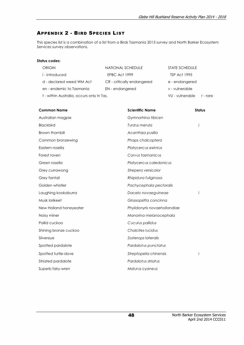
Glebe Hill Bushland Reserve Activity Plan 2014 - 2018
North Barker Ecosystem Services April 2nd 2014 CCC011
48
APPENDIX 2 - BIRD SPECIES LIST
This species list is a combination of a list from a Birds Tasmania 2013 survey and North Barker Ecosystem
Services survey observations.
Status codes:
ORIGIN NATIONAL SCHEDULE STATE SCHEDULE
i - introduced EPBC Act 1999 TSP Act 1995
d - declared weed WM Act CR - critically endangered e - endangered
en - endemic to Tasmania EN - endangered v - vulnerable
t - within Australia, occurs only in Tas. VU - vulnerable r - rare
Common Name Scientific Name Status
Australian magpie Gymnorhina tibicen
Blackbird Turdus merula i
Brown thornbill Acanthiza pusilla
Common bronzewing Phaps chalcoptera
Eastern rosella Platycercus eximius
Forest raven Corvus tasmanicus
Green rosella Platycercus caledonicus
Grey currawong Strepera versicolor
Grey fantail Rhipidura fuliginosa
Golden whistler Pachycephala pectoralis
Laughing kookaburra Dacelo novaeguineae i
Musk lorikeet Glossopsitta concinna
New Holland honeyeater Phylidonyris novaehollandiae
Noisy miner Manorina melanocephala
Pallid cuckoo Cuculus pallidus
Shining bronze cuckoo Chalcites lucidus
Silvereye Zosterops lateralis
Spotted pardalote Pardalotus punctatus
Spotted turtle-dove Streptopelia chinensis i
Striated pardalote Pardalotus striatus
Superb fairy-wren Malurus cyaneus

Glebe Hill Bushland Reserve Activity Plan 2014 - 2018
North Barker Ecosystem Services April 2nd 2014 CCC011
49
APPENDIX 3 - UNANTICIPATED DISCOVERY PLAN

Glebe Hill Bushland Reserve Activity Plan 2014 - 2018
North Barker Ecosystem Services April 2nd 2014 CCC011
50
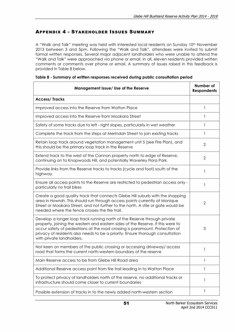
Glebe Hill Bushland Reserve Activity Plan 2014 - 2018
North Barker Ecosystem Services April 2nd 2014 CCC011
51
APPENDIX 4 - STAKEHOLDER ISSUES SUMMARY
A “Walk and Talk” meeting was held with interested local residents on Sunday 10th November
2013 between 3 and 5pm. Following the “Walk and Talk”, attendees were invited to submit
formal written responses. Several major adjacent landholders who were unable to attend the
“Walk and Talk” were approached via phone or email. In all, eleven residents provided written
comments or comments over phone or email. A summary of issues raised in this feedback is
provided in Table 8 below.
Table 8 - Summary of written responses received during public consultation period
Management Issue/ Use of the Reserve Number of
Respondents
Access/ Tracks
Improved access into the Reserve from Watton Place 1
Improved access into the Reserve from Mookara Street 1
Safety of some tracks due to left - right slopes, particularly in wet weather 1
Complete the track from the steps at Merindah Street to join existing tracks 1
Retain loop track around vegetation management unit 5 (see Fire Plan), and
this should be the primary loop track in the Reserve 2
Extend track to the west of the Cannon property north to edge of Reserve,
continuing on to Knopwoods Hill, and potentially Waverley Flora Park. 2
Provide links from the Reserve tracks to tracks (cycle and foot) south of the
highway. 1
Ensure all access points to the Reserve are restricted to pedestrian access only -
particularly no trail bikes 1
Create a good quality track that connects Glebe Hill suburb with the shopping
area in Howrah. This should run through access points currently at Monique
Street or Mookara Street, and not further to the north. A stile or gate would be
needed where the fence crosses the fire trail.
2
Develop a longer loop track running north of the Reserve through private
property, joining the western and eastern sides of the Reserve. If this were to
occur safety of pedestrians at the road crossing is paramount. Protection of
privacy of residents also needs to be a priority. Ensure thorough consultation
with private landholders.
3
Not keen on members of the public crossing or accessing driveway/ access
road that forms the current north-western boundary of the reserve 1
Main Reserve access to be from Glebe Hill Road area 1
Additional Reserve access point from fire trail leading in to Watton Place 1
To protect privacy of landholders north of the reserve, no additional tracks or
infrastructure should come closer to current boundaries 1
Possible extension of tracks in to the newly added north-western section 1

Glebe Hill Bushland Reserve Activity Plan 2014 - 2018
North Barker Ecosystem Services April 2nd 2014 CCC011
52
bearing in mind the steepness of this area
Consider possible track linkages across Pass Road and further in to the Meehan
Range and across South Arm Highway to public open space in the Rokeby Hills 1
Recreational Activities
Would like to use tracks for mountain biking 1
Would like to use area for “off leash” dog walking area 2
Mountain biking should not be allowed 1
Flora and Fauna
Retain natural feel of area 1
Protect remaining habitat and habitat for birds, fauna, native orchids etc 4
Implement a weed management strategy 2
Set up voluntary community group (Friends of/ Landcare) to assist with weed
control and other activities 1
Supports the concept of wildlife corridors, but concerned that the Pass Road
crossing would lead to wildlife casualties 1
Concerned about predation of fauna from suburban cats and dogs 1
Infrastructure
Installation of signage detailing the history of the area 2
Installation of signage detailing the natural values of the Reserve 1
Excluding tracks and signage, infrastructure should be kept to a minimum 1
Consider a style or even a gate at a couple of points along the line of the
fence installed by the contractor for the Glebe hill subdivision 1
Fire Management
Council to continue with hazard reduction burns and fuel reduction 2
Fuel reduction burns should be carried out in the newly added north-western
part of the Reserve 1
Ensure access to Desailly Court for fire vehicles and as an alternate escape
route for residents if unsafe to do so from the north 1

Glebe Hill Bushland Reserve Activity Plan 2014 - 2018
North Barker Ecosystem Services
April 2nd 2014 CCC011
53
APPENDIX 5 - WEED SPECIES DESCRIPTION AND CONTROL
Common Name Species Name Weed Status Life Form How Spread Control Methods Control Timing
aeonium Aeonium sp. Environmental succulent
seed, stem rooting,
vegetative
reproduction spray, dig out all year
blackberry Rubus fruticosus WONS, Declared
shrub/
scrambler
seed, stem rooting,
suckering
spray, cut & swab, stem
scrape all year
bluebell creeper Sollya heterophylla Environmental climber
seed, stem and root
fragments
hand pull seedlings, cut &
swab larger plants
spring/ summer/
autumn
boneseed
Chrysanthemoides
monilifera WONS, Declared shrub seed
hand pull seedlings, cut &
swab larger plants all year
Cape Leeuwin
wattle
Paraserianthes
lophantha Environmental shrub seed
hand pull seedlings, cut &
swab larger plants
spring/ summer/
autumn
cotoneaster Cotoneaster sp. Environmental shrub seed spray, cut & swab all year
fennel Foeniculum vulgare Declared herb seed spray, cut & swab
winter/ spring/
summer
fuschia Fuchsia magellanica Environmental shrub seed spray, cut & swab all year
garden geranium Geranium sp. Environmental shrub
seed, stem and root
fragments
hand pull seedlings, cut &
swab larger plants
spring/ summer/
autumn
grevillea Grevillea rosmarinifolia Environmental shrub seed cut & swab
spring/ summer/
autumn
Himalayan
firethorn Pyracantha sp. Environmental shrub seed, berries spread
by birds and water cut & swab spring/ summer/
autumn
holly Ilex aquifolium Environmental tree seed cut & swab
spring/ summer/
autumn
mirrorbush Coprosma repens Environmental shrub
seed, berries spread
by birds and water cut & swab
spring/ summer/
autumn
Montpellier
broom Genista monspessulana WONS, Declared shrub seed
hand pull seedlings, cut &
swab larger plants all year

Glebe Hill Bushland Reserve Activity Plan 2014 - 2018
North Barker Ecosystem Services
April 2nd 2014 CCC011
54
Common Name Species Name Weed Status Life Form How Spread Control Methods Control Timing
radiata pine Pinus radiata Environmental tree seed
hand pull seedlings, cut
down, ring bark all year
red valerian Centranthus ruber Environmental herb seed
hand pull, cut and swab
or spray
spring/ summer/
autumn
slender thistle
Carduus pycnocephalus
and Carduus tenuiflorus Declared herb seed hand pull, spray
winter/ spring/
summer
sweet briar Rosa rubiginosa Environmental shrub seed
spray, cut & swab, stem
scrape all year
sweet
pittosporum Pittosporum undulatum Environmental tree seed cut & swab, drill & fill all year
tagasaste
Chamaecytisus
palmensis Environmental tree seed cut & swab, drill & fill
spring/ summer/
autumn

Glebe Hill Bushland Reserve Activity Plan 2014 - 2018
North Barker Ecosystem Services April 2nd 2014 CCC011
55
APPENDIX 6 - WEED PHOTOS
blackberry (Rubus fruticosus) D, WONS
boneseed (Chrysanthemoides monilifera
subsp. monilifera) D, WONS
Montpellier broom (Genista monspessulana)
D, WONS
fennel (Foeniculum vulgare) D
slender thistle (Carduus pycnocephalus and
Carduus tenuiflorus) D
aeonium (Aeonium sp.) E

Glebe Hill Bushland Reserve Activity Plan 2014 - 2018
North Barker Ecosystem Services April 2nd 2014 CCC011
56
bluebell creeper (Billardiera heterophylla) E
cotoneaster (Cotoneaster sp.) E
fuschia (Fushcia magellanica) E
garden geranium (Geranium sp.) E
grevillea (Grevillea rosmarinifolia) E
Himalayan firethorn (Pyracantha sp.) E

Glebe Hill Bushland Reserve Activity Plan 2014 - 2018
North Barker Ecosystem Services April 2nd 2014 CCC011
57
holly (Ilex aquifolium) E
mirror bush (Coprosma repens) E
radiata pine (Pinus radiata) E
red valerian (Centranthus ruber) E
sweet briar (Rosa rubiginosa) E
sweet pittosporum (Pittosporum undulatum) E
tagasaste (Chamaecytisus palmensis) E
Texas needle grass (Nassella neesiana) E
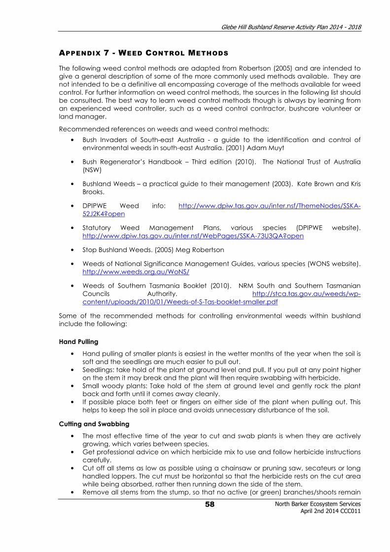
Glebe Hill Bushland Reserve Activity Plan 2014 - 2018
North Barker Ecosystem Services April 2nd 2014 CCC011
58
APPENDIX 7 - WEED CONTROL METHODS
The following weed control methods are adapted from Robertson (2005) and are intended to
give a general description of some of the more commonly used methods available. They are
not intended to be a definitive all encompassing coverage of the methods available for weed
control. For further information on weed control methods, the sources in the following list should
be consulted. The best way to learn weed control methods though is always by learning from
an experienced weed controller, such as a weed control contractor, bushcare volunteer or
land manager.
Recommended references on weeds and weed control methods:
• Bush Invaders of South-east Australia - a guide to the identification and control of
environmental weeds in south-east Australia. (2001) Adam Muyt
• Bush Regenerator’s Handbook – Third edition (2010). The National Trust of Australia
(NSW)
• Bushland Weeds – a practical guide to their management (2003). Kate Brown and Kris
Brooks.
• DPIPWE Weed info: http://www.dpiw.tas.gov.au/inter.nsf/ThemeNodes/SSKA-
52J2K4?open
• Statutory Weed Management Plans, various species (DPIPWE website).
http://www.dpiw.tas.gov.au/inter.nsf/WebPages/SSKA-73U3QA?open
• Stop Bushland Weeds. (2005) Meg Robertson
• Weeds of National Significance Management Guides, various species (WONS website).
http://www.weeds.org.au/WoNS/
• Weeds of Southern Tasmania Booklet (2010). NRM South and Southern Tasmanian
Councils Authority. http://stca.tas.gov.au/weeds/wp-
content/uploads/2010/01/Weeds-of-S-Tas-booklet-smaller.pdf
Some of the recommended methods for controlling environmental weeds within bushland
include the following:
Hand Pulling
• Hand pulling of smaller plants is easiest in the wetter months of the year when the soil is
soft and the seedlings are much easier to pull out.
• Seedlings: take hold of the plant at ground level and pull. If you pull at any point higher
on the stem it may break and the plant will then require swabbing with herbicide.
• Small woody plants: Take hold of the stem at ground level and gently rock the plant
back and forth until it comes away cleanly.
• If possible place both feet or fingers on either side of the plant when pulling out. This
helps to keep the soil in place and avoids unnecessary disturbance of the soil.
Cutting and Swabbing
• The most effective time of the year to cut and swab plants is when they are actively
growing, which varies between species.
• Get professional advice on which herbicide mix to use and follow herbicide instructions
carefully.
• Cut off all stems as low as possible using a chainsaw or pruning saw, secateurs or long
handled loppers. The cut must be horizontal so that the herbicide rests on the cut area
while being absorbed, rather then running down the side of the stem.
• Remove all stems from the stump, so that no active (or green) branches/shoots remain
Glebe Hill Bushland Reserve Activity Plan 2014 - 2018
North Barker Ecosystem Services April 2nd 2014 CCC011
59
no matter how small they are.
• Make extra cuts into the stump surface to expose the sapwood and provide more
surface area for the herbicide to penetrate. For trees with a lignotuber such as olives, it
helps to cut the stump deeply with an axe or machete.
• Liberally swab all cut surfaces immediately with the herbicide mixture. This must be
done preferably within half a minute, or immediately if possible. The cut surface can not
be allowed to dry out; otherwise the herbicide will be much less effective. Use a
paintbrush or squeeze bottle to apply the herbicide mixture. Add a dye to the
herbicide mixture that will help indicate where swabbing has already been done.
• The tissues that take up and move the poison are immediately under the bark layer, so
concentrate on applying the poison around the outer rim of the stump.
• Follow up your work. If the stumps re-sprout which can be common with some species,
then cut and swab or spray the new regrowth with the herbicide.
• Keep doing this until the plant dies. Large trees can take several poisonings before they
are killed.
Spraying
• The most effective time of the year to spray is when the plant is actively growing.
• Look for native plants and cover with plastic bags or sheeting while spraying. If there
are too many native plants amongst the weeds then this method should not be used.
• Get professional advice on which herbicide mix to use and follow herbicide instructions
carefully.
• Always read the label on the herbicide container, follow the instructions and wear
protective clothing. Dilute the mixture as recommended. Add a dye to the herbicide
mixture that will help to indicate where spraying has already been done.
• If spraying regrowth near creeks or other water bodies, do not spray herbicide in or
near the water, because it can have a negative effect on aquatic fauna such as frogs.
In such cases using Roundup Biactive is more desirable because it has less of an impact
on the aquatic fauna. It is preferable to use other more accurate methods such as
cutting and swabbing along creeklines.
• Surfactants can also be used when spraying plants such as blue periwinkle or ivy which
have a waxy leaf surface. A surfactant (e.g. Pulse) can be added to the herbicide mix
which will increase the uptake of the poison through the waxy leaf surface. Surfactants
should not be used on or near plants growing in water as they are suspected of
harming frogs and other aquatic life.
• Treat bulb plants when the old bulb is exhausted and before new bulbs have formed,
generally just before or during flowering. Poisoning at this stage will minimise the
chance that the plant will resprout in the next growing season.
• Where weeds have narrow vertical leaves, spraying might result in herbicide running off
or drifting onto non-target plants. In this situation, wipe on the herbicide mixture with a
weed wand, sponge or wick applicator.
Grubbing
• Grubbing is easiest in the wetter months of the year, between April and October, as the
soil is soft and the seedlings are much easier to grub out.
• The damage to the soil and adjacent native plants must be weighed up when
assessing whether or not to use this method.
• Using a grubber or a mattock, use a levering action to lift the base of the plant
including the tubers, or growing points, depending on the species.
• Remove the plant, making sure that all of the tubers or growing points are completely
removed. If part of this is left in the ground it may reshoot.
• If the base of the plant can not be dug out, it can be poisoned using the cut and swab
method.
• Follow up regularly. Any regrowth from underground roots can be sprayed with
herbicide or removed manually. Spot spray the plant when it is actively growing.

Glebe Hill Bushland Reserve Activity Plan 2014 - 2018
North Barker Ecosystem Services April 2nd 2014 CCC011
60
Hand Digging (dig out)
• Push a knife into the soil next to the plant, aiming towards the plant with the intention of
levering out the bulb or severing the root system, depending on the species.
• Repeat at right angles, then carefully remove the plant, and then repair any
disturbance to the soil or mulch by pressing down the bare soil.
Hand Paint/ Wipe
• This method is useful for species such as Watsonia, especially in areas where spraying
will cause off-target damage.
• Get professional advice on which herbicide mix to use and follow herbicide instructions
carefully.
• Hold the leaf of the plant with one hand and with the other paint the herbicide onto
the leaf using a paintbrush, sponge bottle or other applicator.
Slashing
• Aims to encourage the growth and seeding of native grasses, over the introduced
grasses which through slashing are unable to produce seed. Gradually if the
introduced grasses are stopped from seeding each year, the seed bank will be
reduced and fewer will germinate. In conjunction with this the native grasses are
allowed to seed, and with less competition from the introduced grasses, they will begin
to increase in numbers and dominate.
• Slashing should be done after the annual grasses have flowered and before their seeds
have matured. Most of the native perennial grasses flower later hence their seed set is
almost certain to still occur. As a general rule slashing of annual grasses should occur
between September and November, but will vary depending on the season, and
location. Slasher operators will need to interpret the readiness of annual grasses for
slashing through field inspections to ensure that it occurs at the correct time.
• Slasher operators need to have good plant identification skills to ensure that native
plants are not accidentally slashed. Slasher operators should attempt to avoid native
grasses in the process, although if some are accidentally cut, they should reshoot.
Other native plants should be avoided as they may not regenerate so well if slashed.
• As many annual grasses will reshoot, slashing may need to occur more than once.
• Slashing of perennial grasses to reduce biomass and seed set should be followed up by
spraying of the regrowth.

Glebe Hill Bushland Reserve Activity Plan 2014 - 2018
North Barker Ecosystem Services
April 2nd 2014 CCC011
61
APPENDIX 8 - GLEBE HILL BUSHFIRE MANAGEMENT PLAN - TABLE 8

Glebe Hill Bushland Reserve Activity Plan 2014 - 2018
North Barker Ecosystem Services April 2nd 2014 CCC011
62
APPENDIX 9 - RESERVE ENTRANCES FOR LANDSCAPING
Wendy Andrew Entrance
Vienne Drive Entrance
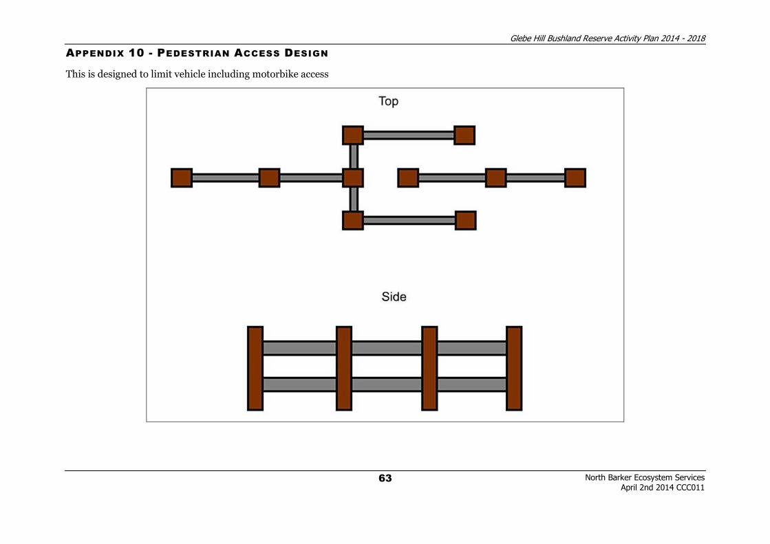
Glebe Hill Bushland Reserve Activity Plan 2014 - 2018
North Barker Ecosystem Services
April 2nd 2014 CCC011
63
APPENDIX 10 - PEDESTRIAN ACCESS DESIGN
This is designed to limit vehicle including motorbike access

Glebe Hill Bushland Reserve Activity Plan 2014 - 2018
North Barker Ecosystem Services
April 2nd 2014 CCC011
64
APPENDIX 11 - GLEBE HILL BUSHFIRE MANAGEMENT PLAN - VMU’S AND BURN SCHEDULE

Glebe Hill Bushland Reserve Activity Plan 2014 - 2018
North Barker Ecosystem Services April 2nd 2014 CCC011
65

Glebe Hill Bushland Reserve Activity Plan 2014 - 2018
North Barker Ecosystem Services April 2nd 2014 CCC011
66

Glebe Hill Bushland Reserve Activity Plan 2014 - 2018
North Barker Ecosystem Services April 2nd 2014 CCC011
67