
Geothermal Situation in Northeastern Greece
14
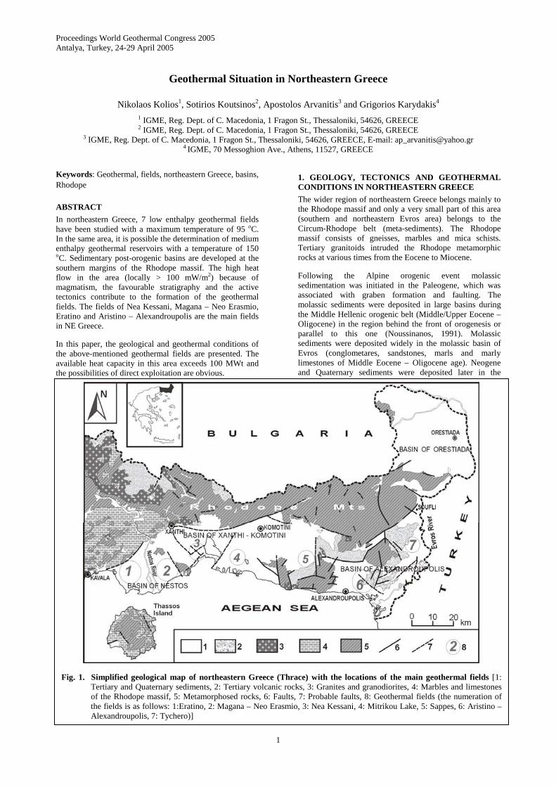
Proceedings World Geothermal Congress 2005 Antalya, Turkey, 24-29 April 2005 1 Fig. 1. Simplified geological map of northeastern Greece (Thrace) with the locations of the main geothermal fields [1: Tertiary and Quaternary sediments, 2: Tertiary volcanic rocks, 3: Granites and granodiorites, 4: Marbles and limestones of the Rhodope massif, 5: Metamorphosed rocks, 6: Faults, 7: Probable faults, 8: Geothermal fields (the numeration of the fields is as follows: 1:Eratino, 2: Magana – Neo Erasmio, 3: Nea Kessani, 4: Mitrikou Lake, 5: Sappes, 6: Aristino – Alexandroupolis, 7: Tychero)] Geothermal Situation in Northeastern Greece Nikolaos Kolios 1 , Sotirios Koutsinos 2 , Apostolos Arvanitis 3 and Grigorios Karydakis 4 1 IGME, Reg. Dept. of C. Macedonia, 1 Fragon St., Thessaloniki, 54626, GREECE 2 IGME, Reg. Dept. of C. Macedonia, 1 Fragon St., Thessaloniki, 54626, GREECE 3 IGME, Reg. Dept. of C. Macedonia, 1 Fragon St., Thessaloniki, 54626, GREECE, E-mail: [email protected] 4 IGME, 70 Messoghion Ave., Athens, 11527, GREECE Keywords: Geothermal, fields, northeastern Greece, basins, Rhodope ABSTRACT In northeastern Greece, 7 low enthalpy geothermal fields have been studied with a maximum temperature of 95 ο C. In the same area, it is possible the determination of medium enthalpy geothermal reservoirs with a temperature of 150 o C. Sedimentary post-orogenic basins are developed at the southern margins of the Rhodope massif. The high heat flow in the area (locally > 100 mW/m 2 ) because of magmatism, the favourable stratigraphy and the active tectonics contribute to the formation of the geothermal fields. The fields of Nea Kessani, Magana – Neo Erasmio, Eratino and Aristino – Alexandroupolis are the main fields in NE Greece. In this paper, the geological and geothermal conditions of the above-mentioned geothermal fields are presented. The available heat capacity in this area exceeds 100 MWt and the possibilities of direct exploitation are obvious. 1. GEOLOGY, TECTONICS AND GEOTHERMAL CONDITIONS IN NORTHEASTERN GREECE The wider region of northeastern Greece belongs mainly to the Rhodope massif and only a very small part of this area (southern and northeastern Evros area) belongs to the Circum-Rhodope belt (meta-sediments). The Rhodope massif consists of gneisses, marbles and mica schists. Tertiary granitoids intruded the Rhodope metamorphic rocks at various times from the Eocene to Miocene. Following the Alpine orogenic event molassic sedimentation was initiated in the Paleogene, which was associated with graben formation and faulting. The molassic sediments were deposited in large basins during the Middle Hellenic orogenic belt (Middle/Upper Eocene – Oligocene) in the region behind the front of orogenesis or parallel to this one (Noussinanos, 1991). Molassic sediments were deposited widely in the molassic basin of Evros (conglometares, sandstones, marls and marly limestones of Middle Eocene – Oligocene age). Neogene and Quaternary sediments were deposited later in the
Transcript of Geothermal Situation in Northeastern Greece
Proceedings World Geothermal Congress 2005 Antalya, Turkey, 24-29 April 2005
1
Fig. 1. Simplified geological map of northeastern Greece (Thrace) with the locations of the main geothermal fields [1: Tertiary and Quaternary sediments, 2: Tertiary volcanic rocks, 3: Granites and granodiorites, 4: Marbles and limestones of the Rhodope massif, 5: Metamorphosed rocks, 6: Faults, 7: Probable faults, 8: Geothermal fields (the numeration of the fields is as follows: 1:Eratino, 2: Magana – Neo Erasmio, 3: Nea Kessani, 4: Mitrikou Lake, 5: Sappes, 6: Aristino – Alexandroupolis, 7: Tychero)]
Geothermal Situation in Northeastern Greece
Nikolaos Kolios1, Sotirios Koutsinos2, Apostolos Arvanitis3 and Grigorios Karydakis4 1 IGME, Reg. Dept. of C. Macedonia, 1 Fragon St., Thessaloniki, 54626, GREECE 2 IGME, Reg. Dept. of C. Macedonia, 1 Fragon St., Thessaloniki, 54626, GREECE
3 IGME, Reg. Dept. of C. Macedonia, 1 Fragon St., Thessaloniki, 54626, GREECE, E-mail: [email protected] 4 IGME, 70 Messoghion Ave., Athens, 11527, GREECE
Keywords: Geothermal, fields, northeastern Greece, basins, Rhodope
ABSTRACT
In northeastern Greece, 7 low enthalpy geothermal fields have been studied with a maximum temperature of 95 οC. In the same area, it is possible the determination of medium enthalpy geothermal reservoirs with a temperature of 150 oC. Sedimentary post-orogenic basins are developed at the southern margins of the Rhodope massif. The high heat flow in the area (locally > 100 mW/m2) because of magmatism, the favourable stratigraphy and the active tectonics contribute to the formation of the geothermal fields. The fields of Nea Kessani, Magana – Neo Erasmio, Eratino and Aristino – Alexandroupolis are the main fields in NE Greece.
In this paper, the geological and geothermal conditions of the above-mentioned geothermal fields are presented. The available heat capacity in this area exceeds 100 MWt and the possibilities of direct exploitation are obvious.
1. GEOLOGY, TECTONICS AND GEOTHERMAL CONDITIONS IN NORTHEASTERN GREECE
The wider region of northeastern Greece belongs mainly to the Rhodope massif and only a very small part of this area (southern and northeastern Evros area) belongs to the Circum-Rhodope belt (meta-sediments). The Rhodope massif consists of gneisses, marbles and mica schists. Tertiary granitoids intruded the Rhodope metamorphic rocks at various times from the Eocene to Miocene.
Following the Alpine orogenic event molassic sedimentation was initiated in the Paleogene, which was associated with graben formation and faulting. The molassic sediments were deposited in large basins during the Middle Hellenic orogenic belt (Middle/Upper Eocene – Oligocene) in the region behind the front of orogenesis or parallel to this one (Noussinanos, 1991). Molassic sediments were deposited widely in the molassic basin of Evros (conglometares, sandstones, marls and marly limestones of Middle Eocene – Oligocene age). Neogene and Quaternary sediments were deposited later in the
Kolios et al.
2
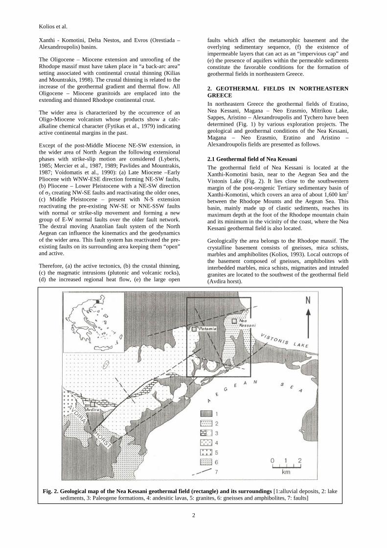
Fig. 2. Geological map of the Nea Kessani geothermal field (rectangle) and its surroundings [1:alluvial deposits, 2: lake sediments, 3: Paleogene formations, 4: andesitic lavas, 5: granites, 6: gneisses and amphibolites, 7: faults]
Xanthi - Komotini, Delta Nestos, and Evros (Orestiada – Alexandroupolis) basins.
The Oligocene – Miocene extension and unroofing of the Rhodope massif must have taken place in “a back-arc area” setting associated with continental crustal thinning (Kilias and Mountrakis, 1998). The crustal thinning is related to the increase of the geothermal gradient and thermal flow. All Oligocene – Miocene granitoids are emplaced into the extending and thinned Rhodope continental crust.
The wider area is characterized by the occurrence of an Oligo-Miocene volcanism whose products show a calc-alkaline chemical character (Fytikas et al., 1979) indicating active continental margins in the past.
Except of the post-Middle Miocene NE-SW extension, in the wider area of North Aegean the following extensional phases with strike-slip motion are considered (Lyberis, 1985; Mercier et al., 1987, 1989; Pavlides and Mountrakis, 1987; Voidomatis et al., 1990): (a) Late Miocene –Early Pliocene with WNW-ESE direction forming NE-SW faults, (b) Pliocene – Lower Pleistocene with a NE-SW direction of σ3 creating NW-SE faults and reactivating the older ones, (c) Middle Pleistocene – present with N-S extension reactivating the pre-existing NW-SE or NNE-SSW faults with normal or strike-slip movement and forming a new group of E-W normal faults over the older fault network. The dextral moving Anatolian fault system of the North Aegean can influence the kinematics and the geodynamics of the wider area. This fault system has reactivated the pre-existing faults on its surrounding area keeping them “open” and active.
Therefore, (a) the active tectonics, (b) the crustal thinning, (c) the magmatic intrusions (plutonic and volcanic rocks), (d) the increased regional heat flow, (e) the large open
faults which affect the metamorphic basement and the overlying sedimentary sequence, (f) the existence of impermeable layers that can act as an “impervious cap” and (e) the presence of aquifers within the permeable sediments constitute the favorable conditions for the formation of geothermal fields in northeastern Greece.
2. GEOTHERMAL FIELDS IN NORTHEASTERN GREECE
In northeastern Greece the geothermal fields of Eratino, Nea Kessani, Magana – Neo Erasmio, Mitrikou Lake, Sappes, Aristino – Alexandroupolis and Tychero have been determined (Fig. 1) by various exploration projects. The geological and geothermal conditions of the Nea Kessani, Magana – Neo Erasmio, Eratino and Aristino – Alexandroupolis fields are presented as follows.
2.1 Geothermal field of Nea Kessani
The geothermal field of Nea Kessani is located at the Xanthi-Komotini basin, near to the Aegean Sea and the Vistonis Lake (Fig. 2). It lies close to the southwestern margin of the post-orogenic Tertiary sedimentary basin of Xanthi-Komotini, which covers an area of about 1,600 km2 between the Rhodope Mounts and the Aegean Sea. This basin, mainly made up of clastic sediments, reaches its maximum depth at the foot of the Rhodope mountain chain and its minimum in the vicinity of the coast, where the Nea Kessani geothermal field is also located.
Geologically the area belongs to the Rhodope massif. The crystalline basement consists of gneisses, mica schists, marbles and amphibolites (Kolios, 1993). Local outcrops of the basement composed of gneisses, amphibolites with interbedded marbles, mica schists, migmatites and intruded granites are located to the southwest of the geothermal field (Avdira horst).

Kolios et al.
3
Fig. 4. Presentation of the values of chemical analyses of the geothermal waters from the Nea Kessani, Magana, Eratino and Aristino fields on a trilinear diagram according to Piper (1944)
During the Paleogene, molassic sediments were deposited over the highly fractured substratum. The Eocene – Oligocene sequence mainly consists of basal breccia and conglomerates, nummulitic limestomes and arkosic sandstones, which give way to flysch formation in the upper part of the sequence. These formations are overlain by Pliocene lacustrine sediments (marls, clays and sands) and Quaternary alluvial deposits (clays, sands, gravels).
During the Tertiary, as a result of the subduction of the African plate below the European one, an andesitic magmatism developed in the basin (Fytikas et al., 1985) with the emplacement of sub-volcanic rocks (24-30 Ma). Small intrusions of such rocks are interbedded within the clastic horizons in the area of the field.
Two major extensional fault systems striking N160o and N70o are formed from the Miocene on and they affect the basement and the overlying sediments. The most active is the N160o system, which is probably related to the movements of the North Aegean fault (Lyberis, 1985).
Because of the presence of the Genissea thermal springs with a total discharge of about 10 l/s and temperatures in the range 30-55oC an exploration geothermal project was launched. Twenty-six exploration and five production wells drilled by I.G.M.E. within an area of about 15 km2, most of them to depths of 100-500 m. A 1,000 m deep exploration well has been constructed in the central part of the field reached the substratum at 990 m below ground level drilling various productive aquifers from 300 m to the bottom hole. The drilling project has revealed the existence of a very important low enthalpy system in Greece. Recently two new production wells were drilled at 450 m yielding 38oC extended the known geothermal field southeastwards in the area of Porto Lagos. The thermal gradient in the area is many times higher than the normal one (up to the value of 38oC/100 m) and the whole area is characterized by a high heat flow (>200 mW/m2 in the field and >300 mW/m2 in the central part of the field). The maximum temperature registered within the wells is 82oC.
The main hot reservoir is located at shallow depth (300-400 m) with temperatures ranging from 75 to 80oC. It is made
up of Eocene – Oligocene clastic sediments overlain by a cap-rock of Oligocene flysch formations, Pliocene lacustrine sediments and Quaternary alluvial deposits. Sometimes, the alluvial deposits host aquifers with cold superficial waters. The top of the geothermal reservoir rises gradually from NE to SW. The minimum thickness (30 m) of the cover occurs in the vicinity of the Genissea thermal springs. The thermal fluids rising from depth flow towards the spring emergency zone where the water temperatures are higher and probably towards the periphery of the field where the temperatures are lower.
In the southern part of the geothermal field the hot aquifers are located at depths 120–200 m within the conglomerates having thickness more than 30 m. The water temperatures range from 40 to 80oC. In the northern part of the field the hot aquifers are located within the arkosic sandstones at depths 350-400 m with water temperatures of 75-80oC.
Fig. 3 illustrates the distribution of the isothermal curves at depths of 400 m. The isothermal curve corresponding to 70oC delineates the main area of the deep hydrothermal aquifer. The curves generally indicate abrupt decrease of the values westwards and progressive decrease northwards and southwards. The geothermal anomaly occurs mainly due to fault systems trending WSW-ENE and NNW-SSE.
Well production tests were performed utilizing all the available wells in order to define the hydrogeological characteristics of the field. The tests, carried out at constant flow rate, have revealed good interconnections among the various wells and a general increase in transmissivity (T) from NE to SW in the area (Grassi et al., 1996). Transmissivity, assessed by means of the Jacob straight-line method, was in the range of 3 x 10⁻³ to 1.2 x 10⁻² m2/s.
Considering that the computational geometrical volume of the geothermal reservoir within the sandstones is about 109 m3 (1.03 x 10⁹ ± 0.003%) and the average porosity of the formation is 20%, then the reserves are estimated in 2 x 10⁸ m3. Under the assumption that the temperature will be
Fig. 3. Distribution of the isothermal curves at depth of 400 m in the Nea Kessani geothermal field with the sites of the exploration wells (Kolios, 1993)
Kolios et al.
4
reduced by ∆t=5oC after 20 years of production, the thermal energy stored in the reservoir is calculated at Est = 1.37 x 10¹⁰ MJ. The useful thermal energy is estimated as 6.9 x 10⁹ MJ supposing that the percentage of discharge from the reserves is 50% and re-injection into the reservoir is performed after the use.
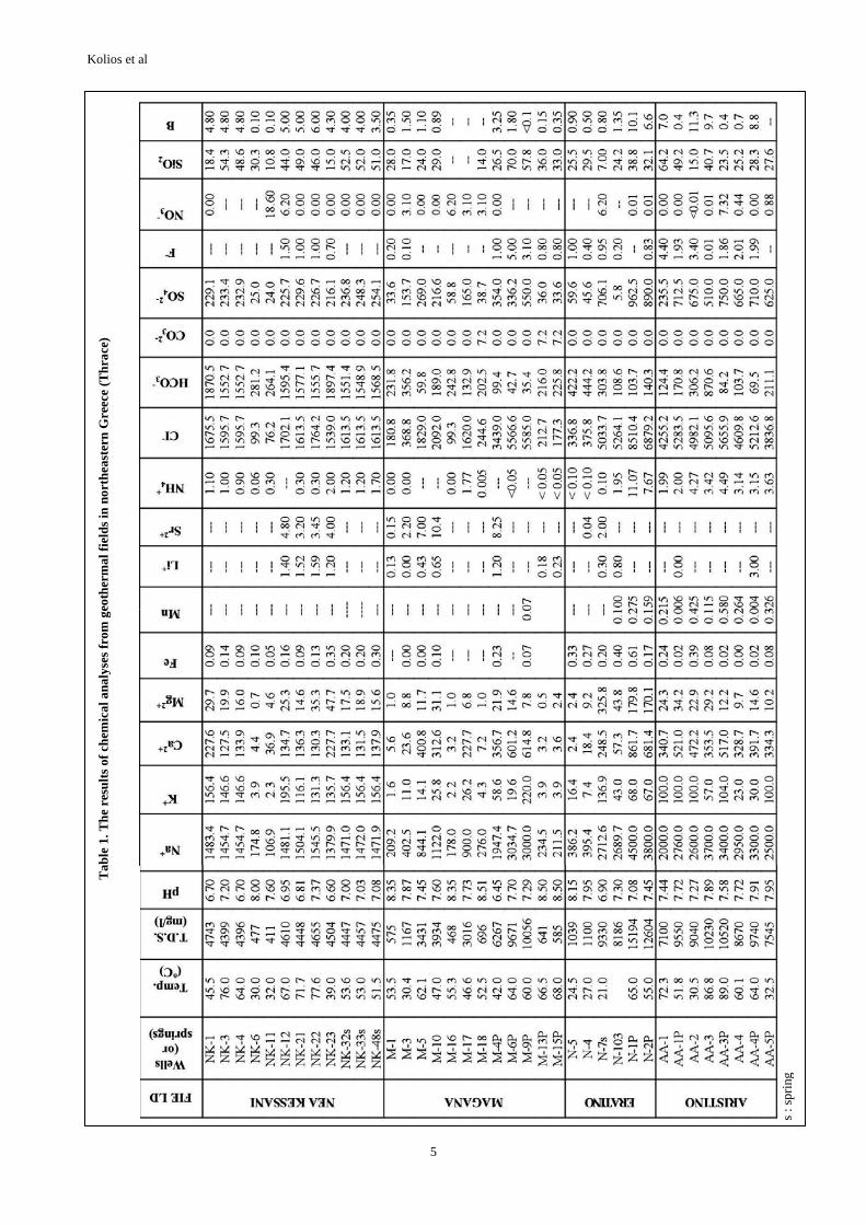
The waters in the Nea Kessani geothermal field (Table 1) are of the Na-CI/ΗCO3 and Na-HCO3 types (Fig. 4) according to Davis & DeWiest classification (1966). The geothermal wells tapping the arkosic reservoir as well as the thermal springs produce waters which are characterized as Na-CI/HCO3 in composition with TDS values between 4.4 and 4.7 g/l and by the presence of CO2. The samples are plotted on the boundary line separating Na-CI/HCO3 waters from Na-CI ones. Wells NK-6 and NK-11 in the northern part of the field produce low-salinity waters (TDS: 0.4-0.5 g/l) of the Na-HCO3 type without CO2. These samples are plotted very close to the field of Na-CI/HCO3 waters.
The relationships between B, temperature and CI for the different samples indicate that no significant mixing occurs between the geothermal reservoir waters and the superficial waters of the cap-rock aquifers. Therefore, there are no significant interconnections between the geothermal reservoir and the cover. The most striking characteristic of the thermal waters is that significant conductive cooling has occurred in both spring and well waters. This cooling occurs in different ways.
The classic geo-indicator cannot be relied upon the Nea Kessani geothermal waters because they fall in a field between immature waters and partially equilibrated ones (Grassi et al., 1996). The Na/Li geothermometer (Fouillac and Michard, 1981), because of its insensitivity to
secondary dissolution processes, should be a reliable temperature indicator for CO2-rich waters. Temperatures of about 75-80oC are obtained by using the Na/Li geothermometer (Andritsos et al., 1994; Grassi et al., 1996). A maximum temperature of about 110oC is estimated assuming a possible original quartz equilibration (Kolios, 1993). Generally the geothermal fluids of Nea Kessani probably undergo significant re-equilibration processes during their rise towards to the surface and/or during their circulation within the arkosic reservoir. Therefore, the available data cannot provide reliable geothermometric estimates for the deeper geothermal reservoir from which these fluids originate (Grassi et al., 1996).
Almost 2/3 of the total flow rate of the wells is gas, of which 98% mol/mol is CO2 (Andritsos et al., 1994). The 13C data indicate that the CO2 is derived from decomposition of marine carbonates, possibly the marbles of the Rhodope crystalline basement underlying the arkosic reservoir and may also affect the isotopic composition of the thermal waters. The deuterium content of the thermal waters indicates that the recharge areas for both the thermal circulation and deep aquifers of the cover should lie at an elevation of about 700 – 800 m probably in the Rhodope Mts. There is no important participation with waters coming from the Vistonis Lake or Aegean Sea. The thermal fluids of the Nea Kessani area are practically tritium-free indicating that they have resided underground for rather long times (>50 years). The CI- concentration, the absence of tritium and a deuterium content certainly suggest that the waters come from a regional circulation. An interesting positive 18O shift for the geothermal waters is exhibited as a result of: (a) probable water – rock exchange process at low temperatures entailing long contact times between water and rock, or (b) alternatively, contribution of deep-seated
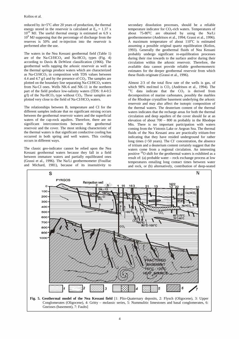
Fig. 5. Geothermal model of the Nea Kessani field [1: Plio-Quaternary deposits, 2: Flysch (Oligocene), 3: Upper Conglomerates (Oligocene), 4: Gritty – molassic series, 5: Nummulitic limestones and basal conglomerates, 6: Gneisses (basement), 7: Faults]
Kolios et al
5
Tab
le 1
. The
res
ults
of c
hem
ical
ana
lyse
s fr
om g
eoth
erm
al f
ield
s in
nor
thea
ster
n G
reec
e (T
hrac
e)
s
: spr
ing

Kolios et al.
6
high-temperature resources in the area, but at present there is no evidence of high temperature in the region (Kolios, 1993; Grassi et al., 1996).
Fig. 5 shows the geothermal model for the Nea Kessani field. It is characterized by rise of thermal fluids from depth as suggested by the reduced extensions of the hottest zone in the area and by the temperature distribution at depth in the arkosic reservoir. The fluids rise through a major fault system or along the intersection of the SSE-NNW and ENE-WSW fault systems from a deep reservoir. This deeper reservoir is probably made up of marbles of the Rhodope metamorphic basement. During their ascent, the thermal fluids enter the arkosic aquifer, which acts as a secondary shallow confined reservoir. There is little or no interconnection between the thermal reservoir and either the deep or shallow aquifers of the cap-rock. A small percentage of the hot water emerges in the Genissea thermal springs, where the thickness of the cover is reduced. Most of the hot water is cooled conductively as it flows through the arkosic reservoir towards the marginal parts of the field. The temperature distribution is homogeneous vertically within the reservoir. The water rising from depth probably undergoes significant chemical modifications during its ascent towards the surface because of its high CO2 content. Some changes in the pressure could be due to the changes in the viscosity and the density of the fluids associated with their temperature (Kolios, 1993; Grassi et al., 1996).
2.2 Geothermal field of Neo Erasmio – Magana
The area of Magana lies at the eastern edge of the Delta Nestos basin and west of the Avdira horst. At present 22 exploration boreholes and 6 production wells have been drilled by I.G.M.E. These resulted in defining a low enthalpy geothermal field covering an area of 15 km2. It is a
part of the Prinos – Delta Nestos sedimentary basin.
The Nestos basin covers an area of 450 km2 (onshore part of the basin) with an axis in ENE-WSW direction. It is separated from the Xanthi-Komotini basin by the Avdira-Fanari ridge (horst), which is composed of the metamorphosed rocks. The basin is bounded by two major faults in the N70o and N160o directions.
The Nestos sedimentary basin started its formation at the end of the Lower Miocene (Serravalian), after the main compressive phase of Eocene age. Sedimentation began with clastic – deltaic continental deposits alternating generally with fine-grained sandstones, mudstones and argillites. These were followed by conglomerates with intercalation of lignite (Middle – Upper Miocene). During the Upper Miocene the sedimentation continued with an evaporitic sequence consisting of anhydrites alternating with thin layers of sandstones, clays and marls (Proedrou, 1979). The Plio-Quaternary sediments are characterized by deltaic deposits lying unconformably over the previous series. These formations are composed of loose sandstones and clays at the basin margins and marine and lacustrine sediments in the central part of the basin. The total thickness of this sedimentary sequence is about 4,000 m (Lalechos and Savoyat, 1977).
In the region, a first extensional phase (Oligocene) created a first basin trending approximately N50o. This structure was dissected by successive extensional faults about N120-140o (Lyberis, 1985; Mercier at al., 1989). During Quaternary time, a new extensional regime with N-S tensional direction enhanced the present morphology and activated faults principally in the N70o direction. East of the Nestos River and the part of the basin between the Nestos River and the Magana village (Fig. 6) was a terrestrial environment with
Fig. 6. Geological map of the Neo Erasmio – Magana geothermal field

Kolios et al.
7
Fig. 7. Map of isothermal curves at the top of the geothermal reservoir in the Neo Erasmio – Magana geothermal field
en echelon faults.
Geologically the region belongs to the Rhodope massif. The crystalline basement is heavily fractured and it consists of migmatitic gneisses, gneisses and amphibolites. These metamorphosed rocks are exposed west and south of the Myrodato village and close to Avdira. A coarse-grained alterated granitic body intrudes these rocks (Fig. 6). The basement has been multiply deformed and metamorphosed during several tectonic episodes.
Some outcrops of the Paleogene molassic sediments constitute parts of the Avdira horst and are located at the western margins of the horst. They belong to the Xanthi-Komotini sedimentary basin. These mollasic sediments consist of arkosic sandstones, calcarenitic formations and nummulitic limestones. The Pliocene formations are exposed east of the Dekarcho village and they consist of alternations of sands and clays with layers and lenses of gravels. Generally, the area is covered with alluvial Holocene and littoral deposits composed of clays, sandy clays and gravels. Some sub-volcanic products having a basalt-andesite composition are located below the Pleistocene sediments in the vicinity of the Avdira horst.
The wider area of the geothermal field is defined by two major fault systems with N140-160o and N70o directions. Fig. 8 shows that west of the Magana village the basement is subsided gradually with low-angle dip at depths of 200-250 b.g.l. In the area of the Nea Erasmio village, the high-angle dipping normal faults with NNW-SSE direction cause the subsidence of the substratum at 400-450 m. The top of the basement is located at 1,000 m east of the Nestos River and 500 m southwards close to the Aegean coast.
The sedimentation is differentiated because of the paleo-geography and paleo-relief of the area. Two main litho-stratigraphic columns can be identified in the region associated with the subsidence of the substratum: (a) the columnar section of the upper fault block and (b) the columnar section of the lower block. The section of the upper block consists of: (i) Quaternary sands and clays (average thickness 20 m), (ii) red-brown silty clays with interbedded strata of gravels reflecting a fluvial – deltaic palaeoenvironment (average thickness 50 m), (iii) grey-beige sands and clays (average thickness 50 m), (iv) grey clays and sands with bits of fossils (Cardium) suggesting a deltaic – lacustrine depositional palaeoenvironment (average thickness 50 m), (v) grey – yellow sandstones with some intercalations of andesitic lavas (average thickness 80 m) and finally (vi) the crystalline basement (gneisses and granites) at depths of about 250 m. The lithostratigraphic column of the lower part is composed of: (i) Quaternary sands and clays (average thickness 20 m), (ii) red-brownish silty clays with interbedded strata of gravels reflecting a fluvial – deltaic palaeoenvironment (average thickness 90 m), (iii) grey clays and sands with bits of Elasmobranchii (Cardium) suggesting a deltaic – lacustrine depositional palaeoenvironment (average thickness 50 m), (iv) dark grey fine-grained sands and silts with intercalations of medium-grained sandstones rich in bits of Elasmobranchii indicating a deltaic or lacustrine palaeoenvironment (average thickness 80 m), (v) alternations of red-brownish silty sands, grey clays, medium-grained sandstones (average thickness 80 m), (vi) beige-yellowish biogenic limestones and consolidated calcarenitic formation supposing a lagoonal environment, (vii) basal conglomerates with intercalations of sands and silts representing a terrestrial palaeo-environment (average thickness 30 m), and finally
(viii) crystalline basement (gneisses) at depths of 400-450 m.
The geothermal field of Neo Erasmio – Magana is a characteristic example of low enthalpy field where the stratified aquifers are supplied by an active faults system that affects the substratum of the migmatitic gneisses. The geothermal reservoir is situated at depths between 200 and 400 m within the basal part of the post-alpine sedimentary sequence and mainly at the top of the metamorphic basement. The maximum depth of the 22 exploration boreholes drilled by I.G.M.E. reaches 500 m. The values of the geothermal gradient are very high (up to 25oC/100 m). The water temperatures range from 40 to 65oC. The maximum temperatures have been registered in the Ziloti village at depths of 400 m and close to the main supply zone along faults in the N160o direction. They extend along an E-W axis because of the lithostratigraphic conditions of the area and the development of permeable formations at the top of the basement. The higher values of the average thermal gradient are registered in the boreholes M-6 and M-9. Temperature inversion has been observed in these wells close to the basement, so the higher temperatures have been measured at depths shallower than the entire depth of the wells. Especially, in the borehole M-6 the maximum temperature of 64.3oC has been recorded at 170-180 m whereas the temperature at the bottom of the well (250 m) is 54oC (temperature inversion below 170-180 m). In the borehole M-9, the maximum temperature of 62oC has been registered at 200 m whereas the final temperature at the bottom (230 m) is 60.8oC. These temperature inversions indicate a lateral flow of the thermal fluids from an

Kolios et al.
8
undefined central system with maximum temperatures and differentiation in chemical composition. The same wells define an area with uplift of the isothermal curves.
The isothermal curves at the top of the geothermal reservoir in the Magana – Neo Erasmio field are illustrated in Fig. 7. The isothermal curve corresponding to 50oC delineates an area exceeding 3 km2. An abrupt decrease of temperature values is observed north of Neo Erasmio. A progressive decrease of temperature is ascertained eastwards. South of Neo Erasmio the picture is differentiated because of the presence of hot aquifers at depths of 300-400 m towards the coastal zone. Westwards the isothermal curves are open for temperatures over 60oC at about 500 m or at greater depths. Consequently the area of geothermal interest with good aquifers exceeds 10 km2 (probably up to 20 km2).
The geothermal waters in the Neo Erasmio – Magana field with TDS values between 0.57 and 10.1 g/l are classified into two main categories according to Davis & DeWiest (1966): Na-CI and Na-HCO3CI waters. The waters of the first group (M-4P, M-6P, M-9P, M-5, M-10, M-17, M-18) are brackish with high Na+ and CI- concentrations because of the Paleogene marine origin sandstones, which probably can preserve fossil saline thermal waters and brines. During their lateral flow the thermal waters enter these Paleogene aquifers and likely they are enriched in Na+ and CI- ions. These waters are located in the eastern part of the geothermal field. The waters (M-13P, M-15P, M-1, M-3, M-16) of the second group (Na-HCO3CI) are characterized by low salinities (between 0.57 and 1.17 g/l) and they are located mainly in the western part of the field.
Fig. 8 illustrates the geothermal model of the Neo Erasmio – Magana field. The thermal fluids rise through NNW-SSE trending major fault system in the area of the Neo Erasmio village from a deeper reservoir within the metamorphic basement. During their ascent the thermal fluids enter the Neogene conglomerates and the Paleogene sediments,
which act as confined reservoirs. So, the geothermal fluids have a lateral leakage towards the permeable formations causing an extension of the thermal anomaly in E-W direction.
2.3 Geothermal field of Eratino
An important geothermal anomaly has been discovered in a 40 km2 area on the west side of the Nestos River delta (Eratino – Chrysoupolis area). The basement of the area consists of metamorphic rocks of the Rhodope massif (mainly gneisses, amphibolites and marbles) and it has been multiply deformed and metamorphosed during several tectonic episodes. The sedimentation began with the accumulation of continental sediments of Lower Miocene age. In the upper part of the sequence, the presence of siltstones and mudstones of Plio-Quaternary age indicates the fluvial and lacustrine palaeoenvironment of the sedimentation. The paleogeographical and stratigraphical evolution of the Nestos basin has already been mentioned.
Three deep oil exploration boreholes (Ne-1, Ne-2 and Ne-3) have been studied. Additionally, one deep (760 m) geothermal exploration well (N-1G), 14 geothermal small diameter exploration boreholes (N1 to N14) of intermediate depth (300-550 m) and two production wells (N-1P, N-2P) have been constructed in this area.
The area is characterized by an elevated geothermal gradient, 3-4 times higher than the normal one. The anomalous area is well concealed by a thick (up to 550 m) impermeable sedimentary series and the geothermal potential is disguised by shallow aquifers with fresh meteoric superficial waters. Generally, the basement is characterized by high temperature creating high thermal gradient. For example, the temperature of 178oC at 4,000 m depth was registered within the exploration oil borehole Ne-2 (average thermal gradient 41oC/km). In the case of the geothermal exploration well NG-1 the temperature of
Fig. 8. The geothermal model of the Neo Erasmio – Magana field

Kolios et al.
9
122oC was measured at 1,377 m, which corresponds to an average gradient of 78oC/km. From the reflectance index of vitrinite in organic material in drilling cores, it is calculated that the region was heated to a maximum temperature of 270oC during the Serravalian because of the granitic intrusions into the sedimentary basin (Chiotis, 1984).
The geothermal anomaly is elongated along N140o direction and it coincides with the Eratino horst, which is a tectonic uplift of the basement southeast of the Eratino village. It appears furthermore that the anomaly is associated with an important N140o fault system that affects the substratum. On the basis of the seismic and gravimetric data the basement was revealed at depth of about 700 m in this horst. The entire area shows an intense geothermal anomaly with gradient values mainly in the range 80-100oC/km. The temperatures of 60.9oC at 430 m and 69.7oC at 530 m were recorded in the exploration boreholes N-2 and N-11 respectively (Fytikas and Kolios, 1992).
The exploration well N-1G was drilled in the zone of the highest thermal gradient (Fig. 10). It showed that: (a) The upper sedimentary sequence consists of 550 m of clays, marls, sands and conglomerates constituting the impermeable cover of a geothermal reservoir located just below, at 550 – 650 m depths. In this part, the thermal gradient is high (up to 120oC/km). (b) The reservoir formation consists mainly of sandstones, oolitic limestones, micro-conglomerates and cemented gravels (calcarenitic
formation) alternating with thin impermeable clay intercalations. The total thickness of these aquifers is estimated to be approximately 40 m containing geothermal fluids at 70oC heated probably by conduction. (c) The deepest Neogene sediments (650-760 m) consist mainly of basal conglomerates, which are impermeable due to their argillaceous matrix. (d) The crystalline basement (below 760 m) is intensively fractured and it is composed of gneisses and amphibolites with minor quartzites and mica schists. The permeability is low due to hydrothermal alteration and fillings of calcite and clay minerals. The Miocene sediments are absent in this area of the main geothermal interest.
The production wells N-1P and N-2P were drilled at depths of 655 m and 670 m respectively in the vicinity of the Eratino village during the period 2/12/1997 – 21/2/1998 (Fig. 10). The borehole N-1P has been constructed NW of Eratino and it drilled a sedimentary sequence composed of (a) clays and sands up to 340 m (alluvial and deltaic deposits), (b) grey-greenish clays and marls with thin intercalations of sands between 340 and 555 m and (c) calcarenitic formation with limestones, sandstones and intercalations of clays and marls at depths of 555-655 m. This latter constitutes a geothermal reservoir containing thermal waters at temperature of 75oC. This well produces artesian waters at a flow rate of 10 m3/h with water temperature 65oC. The borehole N-2P has been constructed at the SSE edge of the Eratino village and it drilled: (a)
Fig. 9. Simplified geological map of the Eratino geothermal field illustrating the top of the basement (1: borehole location, 2: marbles, 3: gneisses, 4: alluvial fans & conglomerates, 5: top of the basement)

Kolios et al.
10
Fig. 10. Isogradient map of the Neo Eratino geothermal field with the locations of the boreholes (1: isogradient curve of 5oC/100 m, 2: irrigation well, 3: oil borehole, 4: geothermal exploration boreholes, 5: geothermal production wells)
Fig. 11. Geothermal model of the Neo Eratino geothermal field (Fytikas and Kolios, 1992)
sands and clays up to 65 m (alluvial deposits), (b) clays alternating with gravels and sands between 65 and 305 m depth (deltaic deposits of Pleistocene age), (c) dark grey-
greenish clayey-marly series with very thin intercalations of sands (lacutrine-marine palaeonvironment) between 305 and 485 m depth, and (d) calcarenitic formations with oolitic and micritic limestones and calcareous and gritty horizons (neritic palaeoenvironment) between 485 and 670 m depth. The geothermal reservoir is located at 560 – 655 m containing thermal waters at a temperature of 75oC. The well produces artesian waters at a flow rate of 15 m3/h with water temperature 55oC.
On the basis of pumping tests in the wells N-1P and N-2P, it is sure that they produce about 300 m3/h geothermal waters. Considering that the area of the geothermal reservoir is 10 km2, its computational geometrical volume is about 7 x 10⁸ m3. The effective porosity of the formation is taken 25%. Under the assumption that the temperature will be reduced by ∆t=5oC after 20 years of production, the stored thermal energy is calculated at Est = 0.98 x 10¹³ KJ. The thermal capacity is estimated to be 15 MWt for both these wells.
The geothermal waters (N-1P, N-2P, N-103, N-7s) in the Eratino geothermal field belong to the Na-CI group according to Davis & De Wiest (1966) classification (Fig. 4). The water N-7s comes from a thermal spring and the sample N-103 comes from a borehole. All these thermal waters have deep circulation and they are derived from the transitional zone between the relatively shallow geothermal reservoir at 550 m and its cover. Their salinity is relatively high (8.2 – 15.2 g/l) due to enrichment with ions from marine – brackish sediments in which the waters circulated. In the same area, superficial waters at temperatures of 16-20oC with shallow circulation paths are of Ca-HCO3 type. Waters circulating in recent deltaic deposits to a maximum depth of 100 m are of Na-HCO3CI (samples N-4, N-5) or Na-HCO3 type and they are also of surface origin.

Kolios et al.
11
Fig. 11 illustrates the geothermal model of the area. On the western side of the sedimentary basin of the Nestos River two main hydrothermal targets exist: (a) the permeable zone in the lowest part of the sedimentary sequence (formation No.3) and (b) the fractured and permeable (carbonate?) parts of the metamorphic basement (formation No.5). Low enthalpy (70oC) geothermal fluids occur at 600 m depth (formation No.3) and medium enthalpy ones probably exist in the basement (formation No.5). These fluids have an equilibrium temperature of 150-180oC and probably constitute an important and extensive reservoir within the substratum. The existence of such a reservoir is necessary to justify the extended thermal anomaly covering an area of about 40 km2 in a region without active magmatism. The geology and lithology of the basement, together with the high values of the geothermal gradient indicate that: (a) the crystalline series acts as a cap for the hot hydrothermal system and (b) this reservoir is located at a depth of 1,500-1,800 m with a temperature in order of 150-180oC and should be the source which heats the overlying formations and the secondary reservoir by conduction. No well-defined fracture zone was encountered by borehole N-1G, in the center of the area of high thermal gradient, except for some small fractures in the altered lower marble – amphibolitic series (formation No.4) which are favorable for heat transfer (both conductive and convective) towards the sedimentary (secondary) reservoir (formation No.3).
2.4 Geothermal field of Aristino - Alexandroupolis
The area is located at the western margins of the Delta Evros huge sedimentary basin covering an area of about
700 km2. The Evros River and its tributaries flow within the basin, which extends within Turkey as well.
The basin occasionally reaches depths of 3,500 to 4,000 m and it is bounded by major faults. The Paleogene – Eocene sediments have been deposited unconformably upon the Mesozoic formations or to the west upon the gneisses, amphibolites and ophiolites of the Rhodope massif. The marine Paleogene sediments (average thickness of about 2,000 m) consist of sandstones, marls, limestones, polygenic volcanic breccia, tuffs and siltstones. The Neogene and Quaternary sediments (maximum thickness of 1,500 m) consist of clays, siltstones, sandstones, lignitic layers and in the upper section of the sedimentary sequence sands, sandstones and clays exist. The beginning of the marine Tertiary invasion in the Evros basin is suggested during the Middle Eocene (Lutetian).
Volcanic activity developed in the wider area during the Oligocene – Lower Miocene (33 to 23 Ma). In the region of Alexandroupolis and Soufli, the volcanic products mainly outcrop between the Evros River on the East and the Rhodope Massif on the North showing a calc-alkaline chemical character. Volcanics are mainly distributed to a NE-SW trending strip matching with one of the most important regional tectonic trends. The volcanic products consist of pyroclastics, tuffs and tuffites alternated with sediments of Priabonian and Oligocene age. Ignimbrites occur in the Dadia area. Domes and lava flows outcrop in the external part of the basin. Volcanic products have been affected by alteration processes. Two main fault systems in NNW-SSE and NNE-SSW directions controlled the spatial
Fig. 12. Geological map of the Aristino – Alexandroupolis geothermal field [1: Recent deposits (Pleistocene), 2: Lower and upper system of terrestrial terraces (Pleistocene), 3: Clays, sandy clays and conglomerates consisting of volcanics and tuffs (Neogene), 4: Sandstones, marls, clays and porous limestones indicating marine littoral facies (Neogene), 5: Upper volcano-sedimentary series (marls, sandstones, tuffs) and rhyolitic intrusions (Paleogene), 6: Upper clastic series (gritty – marly tuffs, sandstones, bioclastic limestones), 7: Dacitic andesites with pyroclastites locally altered (Upper Eocene – Oligocene), 8: Nummulitic limestones (Middle Eocene), 9: Basal clastic series with intercalations of sands and clays (Middle Eocene), 10: Flysch - basement (Mesozoic), 11: Fault, 12: Probable fault, 13: Road]
Kolios et al.
12
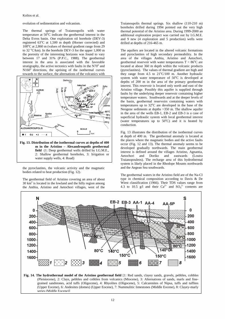
Fig. 13. Distribution of the isothermal curves at depths of 400 m in the Aristino – Alexandroupolis geothermal field (1: Deep geothermal wells drilled by I.G.M.E., 2: Shallow geothermal boreholes, 3: Irrigation or water supply wells, 4: Road)
evolution of sedimentation and volcanism.
The thermal springs of Traianoupolis with water temperature at 50oC indicate the geothermal interest in the Delta Evros basin. One exploration oil borehole (DEV-3) registered 63oC at 1,500 m depth (Horner corrected) and 108oC at 2,860 m (values of thermal gradient range from 29 to 32 oC/km). In the borehole DEV-3 for the upper 1,000 m the porosity of the interesting horizons was found to vary between 17 and 31% (P.P.C., 1988). The geothermal interest in the area is associated with the favorable stratigraphy, the active tectonics with faults in the N70o and N160o directions, the uprising of the isothermal curves towards to the surface, the alternations of the volcanics with
the pyroclastites, the volcanic activity and the magmatic bodies related to heat production (Fig. 12).
The geothermal field of Aristino covering an area of about 30 km2 is located in the lowland and the hilly region among the Anthia, Aristino and Aetochori villages, west of the
Traianoupolis thermal springs. Six shallow (110-210 m) boreholes drilled during 1994 pointed out the very high thermal potential of the Aristino area. During 1999-2000 an additional exploration project was carried out by I.G.M.E. and 9 new (4 exploration and 5 production) wells were drilled at depths of 216-465 m.
The aquifers are located in the altered volcanic formations and pyroclastites of high secondary permeability. In the area of the villages Anthia, Aristino and Aetochori, geothermal reservoir with water temperatures T > 86oC are located at about 360 m depth within the volcanic products (pyroclastites). The values of thermal gradient are high and they range from 4.5 to 21oC/100 m. Another hydraulic system with water temperature of 50oC is developed at depths of 200 m in the area of the primary geothermal interest. This reservoir is located only north and east of the Aristino village. Possibly this aquifer is supplied through faults by the underlying deeper reservoir containing higher temperature waters. Southwards and at the deeper levels of the basin, geothermal reservoirs containing waters with temperatures up to 32oC are developed in the base of the Neogene sediments at depths >350 m. The shallow aquifer in the area of the wells EB-1, EB-2 and EB-3 is a case of superficial hydraulic system with local geothermal interest (water temperatures up to 50oC) and it is heated by conduction.
Fig. 13 illustrates the distribution of the isothermal curves at depth of 400 m. The geothermal anomaly is located at the places where the magmatic bodies and the active faults occur (Fig. 12 and 13). The thermal anomaly seems to be developed gradually northwards. The main geothermal interest is defined around the villages Aristino, Agnantia, Aetochori and Doriko and eastwards (Loutra Traianopouleos). The recharge area of this hydrothermal system is likely placed in the Rhodope Mounts northwards and the Aegean Sea southwards.
The geothermal waters in the Aristino field are of the Na-CI type in chemical composition according to Davis & De Wiest classification (1966). Their TDS values range from 4.3 to 10.5 g/l and their Ca2+ and SO4
2- contents are
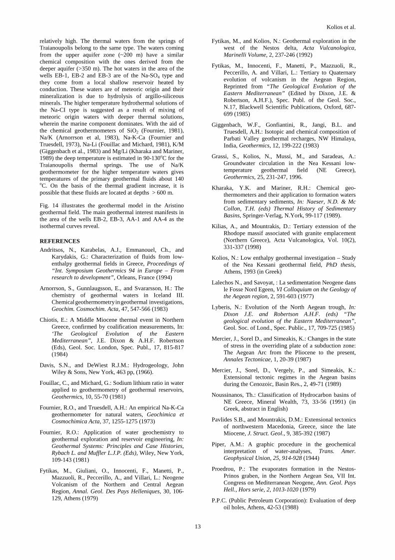
Fig. 14. The hydrothermal model of the Aristino geothermal field [1: Red sands, clayey sands, gravels, pebbles, cobbles (Pleistocene), 2: Clays, pebbles and cobbles from volcanics (Miocene), 3: Alternations of sands, marls and fine-grained sandstones, acid tuffs (Oligocene), 4: Rhyolites (Oligocene), 5: Calcarenites of Nipsa, tuffs and tuffites (Upper Eocene), 6: Andesites (domes) (Upper Eocene), 7: Nummulitic limestones (Middle Eocene), 8: Clayey-marly series (Middle Eocene)]
Kolios et al.
13
relatively high. The thermal waters from the springs of Traianoupolis belong to the same type. The waters coming from the upper aquifer zone (~200 m) have a similar chemical composition with the ones derived from the deeper aquifer (>350 m). The hot waters in the area of the wells EB-1, EB-2 and EB-3 are of the Na-SO4 type and they come from a local shallow reservoir heated by conduction. These waters are of meteoric origin and their mineralization is due to hydrolysis of argillo-siliceous minerals. The higher temperature hydrothermal solutions of the Na-CI type is suggested as a result of mixing of meteoric origin waters with deeper thermal solutions, wherein the marine component dominates. With the aid of the chemical geothermometers of SiO2 (Fournier, 1981), Na/K (Arnorrson et al, 1983), Na-K-Ca (Fournier and Truesdell, 1973), Na-Li (Fouillac and Michard, 1981), K/M (Giggenbach et al., 1983) and Mg/Li (Kharaka and Mariner, 1989) the deep temperature is estimated in 90-130οC for the Traianoupolis thermal springs. The use of Na/K geothermometer for the higher temperature waters gives temperatures of the primary geothermal fluids about 140 oC. On the basis of the thermal gradient increase, it is possible that these fluids are located at depths > 600 m.
Fig. 14 illustrates the geothermal model in the Aristino geothermal field. The main geothermal interest manifests in the area of the wells EB-2, EB-3, AA-1 and AA-4 as the isothermal curves reveal.
REFERENCES
Andritsos, N., Karabelas, A.J., Emmanouel, Ch., and Karydakis, G.: Characterization of fluids from low-enthalpy geothermal fields in Greece, Proceedings of “Int. Symposium Geothermics 94 in Europe – From research to development”, Orleans, France (1994)
Arnorrson, S., Gunnlaugsson, E., and Svararsson, H.: The chemistry of geothermal waters in Iceland III. Chemical geothermometry in geothermal investigations, Geochim. Cosmochim. Acta, 47, 547-566 (1983)
Chiotis, E.: A Middle Miocene thermal event in Northern Greece, confirmed by coalification measurements, In: ‘The Geological Evolution of the Eastern Mediterranean”, J.E. Dixon & A.H.F. Robertson (Eds), Geol. Soc. London, Spec. Publ., 17, 815-817 (1984)
Davis, S.N., and DeWiest R.J.M.: Hydrogeology, John Wiley & Sons, New York, 463 pp, (1966).
Fouillac, C., and Michard, G.: Sodium lithium ratio in water applied to geothermometry of geothermal reservoirs, Geothermics, 10, 55-70 (1981)
Fournier, R.O., and Truesdell, A.H.: An empirical Na-K-Ca geothermometer for natural waters, Geochimica et Cosmochimica Acta, 37, 1255-1275 (1973)
Fournier, R.O.: Application of water geochemistry to geothermal exploration and reservoir engineering, In: Geothermal Systems: Principles and Case Histories, Rybach L. and Muffler L.J.P. (Eds), Wiley, New York, 109-143 (1981)
Fytikas, M., Giuliani, O., Innocenti, F., Manetti, P., Mazzuoli, R., Peccerillo, A., and Villari, L.: Neogene Volcanism of the Northern and Central Aegean Region, Annal. Geol. Des Pays Helleniques, 30, 106-129, Athens (1979)
Fytikas, M., and Kolios, N.: Geothermal exploration in the west of the Nestos delta, Acta Vulcanologica, Marinelli Volume, 2, 237-246 (1992)
Fytikas, M., Innocenti, F., Manetti, P., Mazzuoli, R., Peccerillo, A. and Villari, L.: Tertiary to Quaternary evolution of volcanism in the Aegean Region, Reprinted from “The Geological Evolution of the Eastern Mediterranean” (Edited by Dixon, J.E. & Robertson, A.H.F.), Spec. Publ. of the Geol. Soc., N.17, Blackwell Scientific Publications, Oxford, 687-699 (1985)
Giggenbach, W.F., Gonfiantini, R., Jangi, B.L. and Truesdell, A.H.: Isotopic and chemical composition of Parbati Valley geothermal recharges, NW Himalaya, India, Geothermics, 12, 199-222 (1983)
Grassi, S., Kolios, N., Mussi, M., and Saradeas, A.: Groundwater circulation in the Nea Kessani low-temperature geothermal field (NE Greece), Geothermics, 25, 231-247, 1996.
Kharaka, Y.K. and Mariner, R.H.: Chemical geo-thermometers and their application to formation waters from sedimentary sediments, In: Naeser, N.D. & Mc Collon, T.H. (eds) Thermal History of Sedimentary Basins, Springer-Verlag, N.York, 99-117 (1989).
Kilias, A., and Mountrakis, D.: Tertiary extension of the Rhodope massif associated with granite emplacement (Northern Greece), Acta Vulcanologica, Vol. 10(2), 331-337 (1998)
Kolios, N.: Low enthalpy geothermal investigation – Study of the Nea Kessani geothermal field, PhD thesis, Athens, 1993 (in Greek)
Lalechos N., and Savoyat, : La sedimentation Neogene dans le Fosse Nord Egeen, VI Colloquium on the Geology of the Aegean region, 2, 591-603 (1977)
Lyberis, N.: Evolution of the North Aegean trough, In: Dixon J.E. and Robertson A.H.F. (eds) “The geological evolution of the Eastern Mediterranean”, Geol. Soc. of Lond., Spec. Public., 17, 709-725 (1985)
Mercier, J., Sorel D., and Simeakis, K.: Changes in the state of stress in the overriding plate of a subduction zone: The Aegean Arc from the Pliocene to the present, Annales Tectonicae, 1, 20-39 (1987)
Mercier, J., Sorel, D., Vergely, P., and Simeakis, K.: Extensional tectonic regimes in the Aegean basins during the Cenozoic, Basin Res., 2, 49-71 (1989)
Noussinanos, Th.: Classification of Hydrocarbon basins of NE Greece, Mineral Wealth, 73, 33-56 (1991) (in Greek, abstract in English)
Pavlides S.B., and Mountrakis, D.M.: Extensional tectonics of northwestern Macedonia, Greece, since the late Miocene, J. Struct. Geol., 9, 385-392 (1987)
Piper, A.M.: A graphic procedure in the geochemical interpretation of water-analyses, Trans. Amer. Geophysical Union, 25, 914-928 (1944)
Proedrou, P.: The evaporates formation in the Nestos-Prinos graben, in the Northern Aegean Sea, VII Int. Congress on Mediterranean Neogene, Ann. Geol. Pays Hell., Hors serie, 2, 1013-1020 (1979)
P.P.C. (Public Petroleum Corporation): Evaluation of deep oil holes, Athens, 42-53 (1988)

Kolios et al.
14
Voidomatis, Ph., Pavlides, S., and Papadopoulos, G. : Active deformation and seismic potential in the Serbo-
macedonian zone, northern Greece, Tectonophysics, 179, 1-9 (1990)