Full version of this section (pdf 599.2KB) - Prospectors and
18
e3 Plus: A FRAMEWORK FOR EXCELLENCE in ENVIRONMENTAL STEWARDSHIP RESPONSIBLE EXPLORATION CASE HISTORIES ES-CH-v1.0 Page 280 of 297 16.0 Case Histories The following case histories have been selected from submissions from EES users. They demonstrate the usefulness of the best practices outlined within the EES database and, in some cases, expand upon these practices. As always, we encourage users to submit additional case histories. Figure 58: Use the best practices of EES and the following case histories to ensure the beauty of the land is left undisturbed after exploration is complete. © BHPBilliton. 16.1 Drilling from Lake Ice Figure 59: Drilling at night from ice on Windy Lake, Sudbury, Ontario, Canada. © Graham Oxby
Transcript of Full version of this section (pdf 599.2KB) - Prospectors and

e3 Plus: A FRAMEWORK FOR EXCELLENCE in ENVIRONMENTAL STEWARDSHIP RESPONSIBLE EXPLORATION
CASE HISTORIES
ES-CH-v1.0 Page 280 of 297
16.0 Case Histories
The following case histories have been selected from submissions from EES users. They demonstrate the usefulness of the best practices outlined within the EES database and, in some cases, expand upon these practices. As always, we encourage users to submit additional case histories.
Figure 58: Use the best practices of EES and the following case histories to ensure the beauty of the land is left undisturbed after exploration is complete. © BHPBilliton.
16.1 Drilling from Lake Ice
Figure 59: Drilling at night from ice on Windy Lake, Sudbury, Ontario, Canada. © Graham Oxby

e3 Plus: A FRAMEWORK FOR EXCELLENCE in ENVIRONMENTAL STEWARDSHIP RESPONSIBLE EXPLORATION
CASE HISTORIES
ES-CH-v1.0 Page 281 of 297
Introduction
Wallbridge's Windy Lake Property is located near Levack, Ontario, Canada on the northwest edge of the Sudbury Igneous Complex. The property consists of the mineral rights under the lake. This and other properties are being explored in association with Lonmin Plc as the Sudbury Camp Joint Venture. Under terms of the joint venture, Lonmin is earning an interest in the properties. Wallbridge is the operator of the work programs. Although the Levack area some 5 kilometres to the east has seen extensive mining activity, the Windy Lake area has been largely undisturbed by this activity. No mining operations are visible from the lake. Windy Lake is a deep water, lake trout lake, with good water quality, over ten square kilometres in area. Mature trees surround the lake. Development on the lake is, for the most part, restricted to cottages with a lesser number of permanent residences and one golf course. Fishing in both summer and winter, boating, cross-country and water skiing, scuba diving, snowmobiling and sledding are among the popular recreational activities. Many local residents draw drinking water from the lake. The local residents are justifiably protective of this beautiful corner of Ontario. While the area is highly prospective for mineral discoveries, relatively little work has been done on or around the lake since the 1950's. Consequently, few of the people living in the area have never seen active exploration in the immediate area around the lake. Many of the people living on and using the lake were not predisposed to the prospect of mineral exploration and/or development. Concerns, suspicions and rumours abounded as to what impact mineral exploration might mean to the environment and quality of the lake. Stakeholder Concerns Wallbridge recognized early on that the concerns of the local residents had to be taken as seriously as the mineral potential if we were to be able to carry out a successful exploration program. The highest environmental standards had to be maintained and stakeholder concerns had to be addressed. The first step was a public meeting to announce our intentions, including an information session describing mineral exploration in general. The public was invited to present questions, concerns and suggestions. Many stakeholders attended the first public meeting. Their concerns were abundant, well articulated and persuasive. The attendees were however willing to listen to and consider the exploration proposal. As a result of that meeting, a committee of local representatives was formed to liaise with Wallbridge during our operations and look after the interests of the local stakeholders. The committee had members from no less than five stakeholder groups. To keep all residents informed as to our activities, we took out full-page information updates in the local newspaper on a biweekly basis. Initial Exploration Program Exploration proceeded in several phases. The first phase was an Audio-Magnetotelluric (AMT) survey on the lake, carried out in 2001. That survey involved taking readings on the ice using snowmobiles and using hand held Geographic Positioning Systems (GPS) for location. Other than skidoo tracks, there was no evidence of our presence on the lake. Subsequent magnetic and EM surveys were performed on the ice in the winter of 2002. This involved the establishment of a picket grid. Once the surveys were performed, the pickets were retrieved, once again leaving no evidence of our presence on the lake. A heavy snow that winter caused many of the pickets to be frozen into the ice, so the pickets were retrieved late in the winter.

e3 Plus: A FRAMEWORK FOR EXCELLENCE in ENVIRONMENTAL STEWARDSHIP RESPONSIBLE EXPLORATION
CASE HISTORIES
ES-CH-v1.0 Page 282 of 297
The winter of 2001-2002 was an unusually mild one. As a result, drilling was initiated from the shore in order to test some of the targets under the lake. Between March and December 2002, nine holes were drilled from land. These holes indicated the presence of favourable geology under the lake. It proved impossible to complete testing the entire area under the lake by drilling from shore. Drilling from the surface of the lake was required. Due to the depth of the lake (in excess of 100 m.) drilling from a barge with push-down legs was not feasible. 2002/2003 Ice Drilling Program
The Operations Plan
An operations plan was developed to test the geology under the northern part of the lake by drilling 10 holes from the ice. Rather than spread these holes out over many winters, it was decided to carry out all the drilling in one winter season should weather permit. This reduced the risk posed by unusually warm winters, such as 2001/2002, which did not generate enough ice to support the drilling rigs. A potentially short winter season left a very narrow window in which to complete the drilling program. Some holes were planned to be well over 1,000 meters deep. Being on the lake, it would be impractical, if not impossible to return to a partially completed deep drill hole. In order that the entire drilling program could be completed in a single season, the operations plan called for utilization of seven drill rigs. To our knowledge, that number of drills on a populated lake at one time is unprecedented in North America. Engineers from AMEC Earth and Environmental were contracted to help design and monitor the drilling. Boart Longyear, a company well experienced in drilling from the ice and with a good track record, was awarded the drilling contract. Sandwell Engineering of Calgary was contracted to design and monitor the ice pads for the drills. Together with this group of professionals, we developed the operations plan. Procedures were developed for every phase of the operation. Specific items addressed were:
1. Engineering and making ice pads that could support the weight of the drills, associated equipment and live loads.
2. Planning a safe means of moving equipment to and from the drill sites.
3. Rebuilding every drill with new seals and hoses to minimize the potential for leaks.
4. Equipping every drill with drip pans or double-walled tanks and absorbent pads wherever the possibility of a leak existed.
5. Planning safe movement of fuel and supplies to and from the drills.
6. Insulating every drill shack with sound absorbent material to minimize noise.
7. Equipping every drill with a muffler specifically designed for Windy Lake.
8. Using quadruple casing on the drill holes making a 4-times redundancy to ensure there would be no entry of drill water into the lake.
9. Filtering all cuttings from the drill water and re-cycling that same water back down the hole.
10. Eliminating the use of drilling additives, with the exception of a canola-based lubricant.
11. Equipping every drill with portable toilets.
12. Providing on site tours for local representatives and the general public.
13. Using helicopter support for moving drills and equipment.

e3 Plus: A FRAMEWORK FOR EXCELLENCE in ENVIRONMENTAL STEWARDSHIP RESPONSIBLE EXPLORATION
CASE HISTORIES
ES-CH-v1.0 Page 283 of 297
14. Regular monitoring and reporting by AMEC engineers.
15. Constant supervision of the drilling operations by Wallbridge staff.
16. Decommissioning of all drill sites.
The operations plan was then presented at a public information meeting. The response was generally favourable. The major concerns, as had been anticipated, were noise and the risk of pollution of the lake. These concerns were raised by a few people in attendance. Most seemed somewhat reassured the operations plan had fully addressed this issue.
Figure 60: Building the ice pads on Windy Lake. © Wallbridge
The Ice Drilling Program The Windy Lake on-ice drilling program was initiated on January 7th, 2003 and began with the mobilization of equipment and the construction of eleven ice pads including one extra pad for emergency helicopter evacuation. The program continued on a 24/7 basis until the final piece of equipment was removed from the lake surface on March 27th, 2003. Nearly seventy people from Wallbridge Mining, Sandwell Engineering and Boart Longyear were involved. Seven diamond drill rigs were engaged in the drilling. Nine drill holes were drilled from the ice surface, totalling 7,597 meters of drill core. One drill hole was abandoned due to technical difficulties in penetrating the overburden. Sandwell Engineering of Calgary, Alberta was employed for the construction of the eleven ice pads, each of which was unique in its design. In all cases, the pads were 60 meters in diameter and ranged from 100 to 140 cms. in average thickness. The outer rim thickness of the pads was 80% of design thickness, with the geometric centre 120% or more of design thickness. Two different methods were employed during the creation of the ice pads. The initial buildup of the pads was accomplished using typhoon pumps capable of pumping 2,300 litres of water per minute. The pumps were periodically repositioned to equalize the dispersion of water and the pour time was determined by temperature and weather conditions. The colder it was, the more flooding that took place. A waiting period between flooding allowed for freeze-up to occur. The second method of ice pad construction involved pumping water from the lake and spraying it into the air as a mist that falls as a freezing rain. The ice pad thickness and strength were measured
e3 Plus: A FRAMEWORK FOR EXCELLENCE in ENVIRONMENTAL STEWARDSHIP RESPONSIBLE EXPLORATION
CASE HISTORIES
ES-CH-v1.0 Page 284 of 297
and recorded daily throughout the winter operations. This method was only utilized in ideal conditions. If the air was too cold, the spray came down as sleet rather than freezing rain, which was not desired. Ideally, the droplets are only partially frozen such that bonding and compression take place at the surface, producing a strong useable product. Progress of the ice thickness was measured daily using pickets and test holes. Upon completion, the ice pads were encircled by red/orange snow fencing equipped with amber flashing lights.
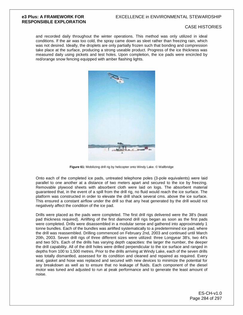
Figure 61: Mobilizing drill rig by helicopter onto Windy Lake. © Wallbridge
Onto each of the completed ice pads, untreated telephone poles (3-pole equivalents) were laid parallel to one another at a distance of two meters apart and secured to the ice by freezing. Removable plywood sheets with absorbent cloth were laid on logs. The absorbent material guaranteed that, in the event of a spill from the drill rig, no fluid would reach the ice surface. The platform was constructed in order to elevate the drill shack several cms. above the ice surface. This ensured a constant airflow under the drill so that any heat generated by the drill would not negatively affect the condition of the ice pad. Drills were placed as the pads were completed. The first drill rigs delivered were the 38's (least pad thickness required). Airlifting of the first diamond drill rigs began as soon as the first pads were completed. Drills were disassembled in a modular sense and gathered into approximately 1 tonne bundles. Each of the bundles was airlifted systematically to a predetermined ice pad, where the drill was reassembled. Drilling commenced on February 2nd, 2003 and continued until March 20th, 2003. Seven drill rigs of three different sizes were utilized: three Longyear 38's, two 44's and two 50's. Each of the drills has varying depth capacities: the larger the number, the deeper the drill capability. All of the drill holes were drilled perpendicular to the ice surface and ranged in depths from 100 to 1,500 metres. Prior to the drills arriving at Windy Lake, each of the seven drills was totally dismantled, assessed for its condition and cleaned and repaired as required. Every seal, gasket and hose was replaced and secured with new devices to minimize the potential for any breakdown as well as to ensure that no leakage of fluids. Each component of the diesel motor was tuned and adjusted to run at peak performance and to generate the least amount of noise.

e3 Plus: A FRAMEWORK FOR EXCELLENCE in ENVIRONMENTAL STEWARDSHIP RESPONSIBLE EXPLORATION
CASE HISTORIES
ES-CH-v1.0 Page 285 of 297
Enclosed drill shacks were constructed once the drill had been reassembled. Six-pound Fibrex acoustical board, designed to absorb sound generated by the machinery, lined interior walls. The acoustical board was held in place by chicken wire, thereby maximizing surface exposure essential for sound absorption. Four-foot high walled railings (also lined with 6-pound acoustical board) around the top of the drill shack were used as a safety railing feature as well as for sound reduction. In addition, half-inch rubber lining was used on all metal on metal contacts within the drill shack in order to help minimize noise. The drillers utilized rubber and plastic hammers in an effort to further reduce the noise generated by the drilling operation. Diesel engines were also fitted with specially designed muffler systems with a Fibrex lined baffle box. Drilling requires a substantial volume of water in order to cool the drill bit and clear rock chips generated as the drill bit penetrates into the rock. In a typical drill setup, drill water and rock chips are collected in a settling sump and the water is recycled back to the drill. The Windy Lake ice-drilling program utilized a closed system, allowing for no dispersion of materials. This was accomplished using a quadruple casing procedure. The first casing (H-size pipe) was suspended in the water to add rigidity to the inner pipes. The second casing (P-string) was lowered to the lake bottom and rotated to penetrate the lake bottom sediments and form an outer enclosure. When this casing was stabilized, a third smaller casing (N-string) was lowered through the center of the first two casings. At the same time, an outer plumbing system was attached to the outer larger casing in order to handle the drill water required to drill the internal casing into place. The N-string was then fitted with a diamond bit at the end capable of drilling into the bedrock below and establishing a permanent seal at the water-rock interface. When the N-string casing was properly secured and sealed, the smallest fourth casing (BW-string) was lowered through the N-string. The BQ-rod string, fitted with a regular coring bit, core tube and stabilizer was then lowered through to bedrock to continue drilling. The BQ-string was the only string that then rotated (cored). Within the drill shack, at the top of the quadruple casing, was a collection pan fitted with a sump pump feeding the cyclone. The cyclone separated drill water from rock chips, returning clean water back down the hole. Cyclone separated solids were collected in barrels and the liquid fraction directed to 2 or 3 settling tanks for additional cleaning. The final tank became the source of new drill water that was returned to the hole. The only time that lake water was used was to initially charge the system and then periodically to add water to increase volume with depth. The entire system was closed and there was no discharge into the lake. Rock chip cuttings were collected in the cyclone and emptied on a regular basis. The chips were placed in plastic-lined pails and transported off the ice to a dedicated container, which in turn was periodically collected by Day Environmental for disposal at a licensed disposal site. At the completion of the drill program, the remaining water in the closed system was decanted into containers and removed from site and disposed of in a similar manner as the rock chips.

e3 Plus: A FRAMEWORK FOR EXCELLENCE in ENVIRONMENTAL STEWARDSHIP RESPONSIBLE EXPLORATION
CASE HISTORIES
ES-CH-v1.0 Page 286 of 297
Figure 62: Aerial view of drill set-up, Windy Lake. © Wallbridge.
The main fuel storage for the drill program consisted of two 4,500-litre double-walled dyke tanks located adjacent to one another. These tanks were situated on the Windy Lake Gold Club, some 30 metres from the waterfront. A local licensed dealer periodically refilled the tanks. Each day, drill and heater fuel was pumped into two 450 litre certified Tidy Tanks. These smaller tanks were mounted in a "Monster Boggan" that served both as a means of transportation via ATV's and/or ski-doos to the drills as well as containment. Each drill site was equipped with a 700-litre stock tank, a tub-like container, which contained two standard 45-gallon drums, served as fuel tanks for the drill motor. Fuel feed lines, both internal and external, were tripled lined as a precaution to prevent leakage. Each drill shack was also equipped with an externally mounted dyke tank designed to service the internal heater. A trough lined with absorbent matting was located at the base of this tank to capture any spillage from the tank. All hose fittings were wrapped with absorbent material. Spill kits were located at all drill shacks as well as within the "Monster Boggan". Empty steel containers (one for oily waste and one for domestic waste) were located at each of the drill shacks for the disposable of all refuse. These containers were periodically transported by the "Monster Boggan" to the Windy Lake Golf Club site for disposal by a licensed carrier at a legal disposal site. Upon completion of the drill program, all drill holes were cemented and drill rods and related casings were removed from the lake surface and lifted to the shore in a manner similar to their delivery. All fluids (fuels, oils, lubricants and drill water), containers, refuse and related equipment used during the drilling operation were properly drained and removed from the ice utilizing pre-established procedures. All equipment was dismantled, packaged and airlifted to the pre-established marshalling yard then loaded and trucked from the site on a timely basis. Logs, pickets, fencing and flagging were totally removed, packaged and transported to the shore for proper disposal. All absorbent matting from under the drill shacks was removed and transported to shore for disposal at a licensed disposal site. Portable toilets and sewage related materials were removed in metal containments from the ice and disposed of by a contracted licensed carrier. All evidence of the ice operation was cleaned and disposed of in an appropriate manner. A consortium of Wallbridge representatives, Boart Longyear supervision, AMEC staff and a representative of the public agreed upon the "declaration of completion" for each drill site of the ice-drilling program. An engineer from AMEC Earth and Environmental monitored the drill program throughout its duration. Initial winter work involved the collection of (third pass) base-line water quality data on

e3 Plus: A FRAMEWORK FOR EXCELLENCE in ENVIRONMENTAL STEWARDSHIP RESPONSIBLE EXPLORATION
CASE HISTORIES
ES-CH-v1.0 Page 287 of 297
January 23rd, 2003 from six locations around the lake. A fourth set of samples was collected from the same six locations on April 3rd, 2003 following the completion of the drill program. Holes were drilled through the ice and the surrounding slush was allowed to freeze to ensure that the lake water samples were not contaminated by water ponded on top of the ice. Samples were submitted to Testmark Laboratories of Sudbury for chemical analyses. Pre and post water quality monitoring did not identify any increases in parameter concentrations associated with drilling activities. Total suspended solids and hydrocarbons remained below detection limits at all locations on both sampling occasions. Weekly inspections of all drill sites were also conducted by AMEC. These inspections involved noise abatement surveys, safety appraisals, compliance assessment and general housekeeping. Results and deficiencies were reported to Wallbridge and immediate remedial action was taken, as required. Representatives from the Ontario Ministry of the Environment conducted two separate field visits to observe the on-ice drilling operations. Feedback from the MOE following these visits was very positive. The on-ice drilling program was successfully completed in the winter of 2003. The measures employed in this program ensured that the local environment was unaffected, and no person was injured or property damaged.
16.2 Drilling in Environmentally Sensitive Tropical Areas
Figure 63: Can you spot where 5,000 meters of drilling was completed? For answer, see end of this case history. © Kluane Drilling.
In the mid to late 1990's, Energold Mining Ltd. planned a drilling program on the El Centenario gold prospect in central Dominican Republic, located approximately 75 km. northwest of Santo Domingo. (El Centenario is now defined as an epithermal deposit with a resource of 1.1 million tonnes grading 6.3 g/t Au.) Terrain and access were difficult and the planned program of shallow holes was relatively small. A forward-looking company, Energold wanted minimum disturbance in this environmentally sensitive area of dense tropical growth separated by areas with little

e3 Plus: A FRAMEWORK FOR EXCELLENCE in ENVIRONMENTAL STEWARDSHIP RESPONSIBLE EXPLORATION
CASE HISTORIES
ES-CH-v1.0 Page 288 of 297
vegetation and high visibility. All bids for drilling were inordinately expensive. Working with a private drilling company, Energold formed Kluane International Drilling Inc. (now 50% owned by Energold) to develop its own diamond drilling unit for the job. A lightweight, highly mobile, all hydraulic rig was selected. The program of 50 holes totalling 5,000 m. was efficiently completed with an all-in cost of US$72 per metre. Production averaged 28 m. per drill shift. Reclamation costs were very minimal and, as indicated by the accompanying photos, little if any physical evidence of the program remained after demobilization. The drilling program was audited by Cyprus/Amax and Kluane rigs modified to use a multiple engine concept were subsequently used by Cyprus on programs elsewhere in Central America, North America and Africa. Since then, these modular rigs have been used successfully in many other parts of the world where minimal environmental disturbance is required or desired and/or where access is difficult. As discussed below, a high altitude version is now available. In general, costs have been comparable to the original experience at El Centenario and productivity considerably improved.
Figure 64: Modular rig ready for mobilization to the project. © Kluane Drilling.

e3 Plus: A FRAMEWORK FOR EXCELLENCE in ENVIRONMENTAL STEWARDSHIP RESPONSIBLE EXPLORATION
CASE HISTORIES
ES-CH-v1.0 Page 289 of 297
Figure 65: Drill rig showing three tandem engines for increased portability with no loss of power. © Kluane Drilling.
The standard drilling rig is powered by three 25 HP Kohler 2-cylinder gasoline engines. With a total weight of 816 kg, the machine can be broken down or re-assembled in half an hour and the heaviest component is about 160 kg. It can be readily moved between holes (or to the project) manually or by burro or lightweight all-terrain vehicle. All equipment fits in a single 5-ton truck (or five pick-up loads). The all-hydraulic machine has a rated capacity of 450 m. (BTW rods) but holes as deep as 587 m. have been drilled. NTW is also available with a capacity of 300 m. as is, in some cases, HTW with a capacity of 150 m. The footprint of the drill site is approximately 4 x 4 m. A high altitude version of the rig is now available using three Kubota turbo-diesel engines (32 or 42 HP) and is slightly heavier at 1,100 kg. (The small footprint is particularly desirable in difficult alpine terrain.) Typically, the machine is operated by two trained Kluane drillers, two local helpers and 6 to 10 local labourers for moving. Equipment of this type, available from contractors such as Kluane, is especially suited for conducting small to medium-size drill programs at reasonable cost in environmentally sensitive and difficult to access projects in tropical, alpine and many other types of terrain throughout the world.

e3 Plus: A FRAMEWORK FOR EXCELLENCE in ENVIRONMENTAL STEWARDSHIP RESPONSIBLE EXPLORATION
CASE HISTORIES
ES-CH-v1.0 Page 290 of 297
Figure 66: Location of 5,000 meters of drilling as shown. © Kluane Drilling.
16.3 Value of EES in Permitting - A Case History from Brazil by Noranda/Falconbridge
Noranda was among the first companies, other than CVRD, to obtain exploration licenses inside the National Forests of the Carajas, Brazil. Access and mineral development in these areas are controlled through the government environmental agency IBAMA (Instituto Brasileiro de Meio Ambiente). These special reserves, usually covered with native rain forest, have been created by the federal government to avoid the degradation caused by undisciplined and illegal exploration and exploitation of its natural resources. With the recognized mineral endowment of the Carajas Province, the government has also however recognized the ability of the mining industry to produce sustainable economic and social development in these areas. The access and work permit application process has not yet been completely defined by IBAMA and each company in possession of mineral exploration licenses must rigorously demonstrate environmental and social responsibility by showing its exploration practices will have as little impact as possible. Noranda expects to receive its permits shortly, thanks in very large part to EES. Noranda's manager in Brazil realized that an application for initial reconnaissance exploration, hopefully leading to advanced drilling programs in this particular case, should include much more information than normal to facilitate the permitting process. As mentioned above, the local

e3 Plus: A FRAMEWORK FOR EXCELLENCE in ENVIRONMENTAL STEWARDSHIP RESPONSIBLE EXPLORATION
CASE HISTORIES
ES-CH-v1.0 Page 291 of 297
government department is not used to applications from major mining companies other than CVRD. Noranda turned to the PDAC's Excellence in: Environmental Stewardship in Exploration (EES) internet-based manual for help. EES has very detailed descriptions of acceptable and tested field operations from early-stage surveys to drilling. It includes clear and useful illustrations and diagrams. EES contains an enormous volume of detailed information describing almost all guidelines and best practices needed to produce these special applications for work in environmentally sensitive areas. In addition, Noranda's manager in Brazil feels that EES should be widely employed to provide basic professional development of local staff. This would reinforce the idea that well-thought out environmental planning for exploration activities would not only minimize the risk of future costly reclamation measures but also assist in building a solid and reliable reputation for Noranda with significant positive impact within the local community.
Figure 67: Preliminary exploration (auger drilling) in the rain forests of Carajas, Brazil. © Noranda/Falconbridge.
16.4 Reclamation of Steep Slope Access Roads - A Case History from AngloGold
Reclamation of mining land situated in hilly or mountainous terrain is often a daunting task. In North America, AngloGold staff have developed some novel approaches to reclamation of exploration tracks and mining haul roads. The Burns Basin area in the Independence Mountains, in the state of Nevada in the United States, is a beautiful area, with rocky outcrops and stands of aspen trees, home to deer, elk, mountain lion and the rare Northern Goshawk. The Burns Basin was part of the Jerritt Canyon mining project in Nevada. AngloGold's interest in Jerritt Canyon was sold to Queenstake Resources in 2003, but the mine was part of the AngloGold stable when the reclamation programme was initiated in 2001. Exploration drilling is required to prove the existence of a gold-bearing ore-body. With mountainous terrain comprising a large part of the mining lease, the construction of tracks, criss-crossing the hills, was necessary for drill rigs to access the desired drill locations. Unrehabilitated these tracks would leave a damaging scar on the hilly landscape. However, impressive rehabilitation of these tracks has been achieved, relatively inexpensively, using a

e3 Plus: A FRAMEWORK FOR EXCELLENCE in ENVIRONMENTAL STEWARDSHIP RESPONSIBLE EXPLORATION
CASE HISTORIES
ES-CH-v1.0 Page 292 of 297
excavator to remove the tracks. The area is then replanted with an indigenous grass seed mix, fertilised and left to recover. The photographs show how the original profile of the slope is restored by cutting-down the upper slope and pulling-up material from the down-slope. Having proved the existence of a viable gold-bearing ore-body, the mine is planned and haul roads are constructed to gain access to the mine pit. These haul roads must be capable of carrying 100 tonne dump trucks and are therefore a lot bigger than the exploration tracks. Jeff Campbell, Senior Environmental Coordinator, explains how haul roads are rehabilitated: "The topography in the Jerritt Canyon Project area often makes full recontour of haul roads a challenging undertaking. The existing slopes along the Burns Basin haul road range from 30% to 50%. Such steeply sloping areas used to receive only a partial recontour, leaving a small portion of the cut slope unreclaimed: this was because of the high costs of recontouring steeply sloping land. Previous experience at Jerritt Canyon has shown that haul road reclamation on moderate to steep slopes can be done in the range of US$12 to US$18 per linear foot (approximately 0.31 metres) of 80-foot (~25 metres) haul road. However, the Burns Basin haul road was a special case. The haul road is situated in the southwest portion of the Jerritt Canyon Project at an elevation of 7,900 feet (2,400 metres). Even though the approved reclamation plan for the haul road did not require full recontour of the road, our goal was to reclaim as much as possible back to original topography. There were a number of reasons for this, the first being that it is a beautiful portion of the Independence Mountains with rocky outcrops and significant aspen stands which are habitat for deer, elk, mountain lion, and Northern goshawk. Secondly, the Burns Basin haul road is situated high on a ridge which can be seen from most portions of the drainage basin area. Reclamation of portions of the primary haul road network began in the late summer of 2001. Approximately 12,000 feet (~3.6 kilometres) of 80-foot wide (~25 metres) haul road was recontoured to the original topography and re-seeded. This project represented the first significant attempt at the Jerritt Canyon Project for full recontour of haul roads in areas exceeding 30% side slope while keeping reclamation costs within a reasonable range. The 2001 Reclamation Programme was awarded to a local reclamation contractor in Elko, Nevada. After reviewing the project area and discussing the reclamation goals with AngloGold's Environmental Resources Department at Jerritt Canyon, the contractor decided to use two hydraulic excavators with two support dozers. The excavators consisted of one Caterpillar 345B and one 365B along with two D8 dozers. The recontouring process utilises the two excavators in tandem, with one excavator on a lower bench reaching to the toe of the fill slope and casting material to the second excavator on an upper bench where a portion of the material is moved in a second "pass" to a support dozer. Depending on the steepness of the topography, two, three, and sometimes four "passes" may be required to retrieve material from the toe of the fill slope and redistribute material to the top of the cut slope. One or two dozers have proved to be very effective in redistributing material brought up by the excavators to achieve a full recontour of the cut slope and for final shaping of the recontoured slope.

e3 Plus: A FRAMEWORK FOR EXCELLENCE in ENVIRONMENTAL STEWARDSHIP RESPONSIBLE EXPLORATION
CASE HISTORIES
ES-CH-v1.0 Page 293 of 297
Figure 68: Road reclamation usually involves two excavators working in tandem. The original slope is restored by cutting
down the upper slope and pulling up material from the lower slope. © AngloGold.
While this recontouring technique is not a new one, the challenge is to achieve a full recontour while maintaining a cost effective reclamation programme. Previous projects were not done to full recontour. The Burns Basin haul road was recontoured to original topography in areas of 30% to 50% side slopes for about US$17 per linear foot (costs quoted are $2001). Returning the land to its original contours represented only the first step of the project. After completion of the recontouring, the entire area was broadcast seeded and fertilised in the fall of 2001. The recontoured slopes were fertilised with 350 pounds per acre of inorganic fertiliser. Then, the reclamation seed mix, consisting of 22 species of grasses and shrubs, was broadcast and harrowed. In addition, 2,500 aspen seedlings, grown from seed collected at Jerritt Canyon, were planted in five areas along the Burns Basin haul road where aspen had been removed during the construction of the road. The aspen seedlings should accelerate the rejuvenation of the aspen stands along the haul road reclamation. In conclusion, Jeff points out that, even though overall cost was a consideration during this project, the primary goal was to achieve an aesthetically pleasing reclamation project in the Burns Basin area. Cost effective implementation of any reclamation project is enhanced when the contractor and/or equipment operator understands the reclamation goal and strives to meet that goal through genuine interest in the project and the final product. The steep slope reclamation of the Burns Basin haul road demonstrates a successful reclamation strategy, where neither the overall project economics nor the final reclamation goal were compromised to achieve the desired outcome.

e3 Plus: A FRAMEWORK FOR EXCELLENCE in ENVIRONMENTAL STEWARDSHIP RESPONSIBLE EXPLORATION
CASE HISTORIES
ES-CH-v1.0 Page 294 of 297
Figure 69: Reclaimed roads six months after restoration. Old exploration tracks are still Visible but indigenous grass seed will gradually mix with the neighbouring vegetation to largely eliminate any scarring. © AngloGold.
16.5 Community Engagement during Exploration in Brazil - A Case History from Gold Fields
Gold Fields Exploration concluded its exploration program on the Capanema Project, Para State, Brazil, in December 2003. In this remote region, far from professional medical help, economic opportunities and governmental assistance, the needs are basic and include health care, sanitation, access to drinking water, jobs, housing, education and infrastructure. Gold Fields´ presence created a sense of hope within communities suffering from a general lack of economic opportunity. Unfortunately, the Capanema project was closed before some of the planned programs were implemented. The exploration team was successful in creating a spirit of goodwill and cooperation with the community, and we learned about their many needs. The interaction with the community was honest and transparent. The community recognized the benefits and risks related to our activity, and all efforts were made to make them aware of the temporary nature of the exploration process. Most of the activity involved low-impact work, such as opening trenches for sample collection, as well as some drilling. We rehabilitated affected areas by refilling and restoring vegetation to all trenches and drill holes. Through engagement in an open, honest, and effective process of consultation and communication with the local community, throughout all stages of our operations, Gold Fields developed programs targeting their most urgent needs. This resulted in extensive support for the company's activities in the area. In addition to the remedying of the unavoidable environmental impact that results from exploration activities, our goals were the creation of both economic and environmental rewards, producing a net gain for the community.

e3 Plus: A FRAMEWORK FOR EXCELLENCE in ENVIRONMENTAL STEWARDSHIP RESPONSIBLE EXPLORATION
CASE HISTORIES
ES-CH-v1.0 Page 295 of 297
Figure 70: Acai plantation operated by local people and developed from seeds donated by Gold Fields. © Gold Fields
Gold Fields hired and trained local inhabitants, providing legal personal documentation and wages above the regional average. Some infrastructural improvements were initiated. Roads were repaired, benefiting the agricultural families, but after closure of operations their maintenance cannot be guaranteed. Water wells were planned in an attempt to help alleviate the chronic lack of potable water in the region. One was dug and remains operational, however the problem persists. The establishment of an Agricultural Cooperative for selling local produce was not successful. We were unable to continue providing mentorship and assistance in its administration and commercialization. Without our continuous presence in the area the demand for goods would not be sufficient to cover its costs. Thousands of açai seeds donated by Gold Fields to the local community were planted. The fruit is rich in iron and has a high export potential, and the plantation now remains under their responsibility and care. Gold Fields initiated a recycling education program to teach the economic and ecological benefits of selective waste collection, which continues at the primary level. At the end of the contract all the employees were dismissed according to Brazilian Labour Legislation with no reclamations. Our closure was completed respecting our environmental responsibilities. Revegetation has been successfully concluded.

e3 Plus: A FRAMEWORK FOR EXCELLENCE in ENVIRONMENTAL STEWARDSHIP RESPONSIBLE EXPLORATION
CASE HISTORIES
ES-CH-v1.0 Page 296 of 297
Figure 71: Area of trenching before reclamation. © Gold Fields.
Figure 72: Same area of trenching six months after reclamation. © Gold Fields
Conclusion - How could we improve future operations based on experiences? By nature, the exploration phase is temporary and its outcome is uncertain. While we seek to promote lasting benefits to the communities during the exploration phase that could be extended throughout and beyond closure, sustainable programs are best achieved through education. For

e3 Plus: A FRAMEWORK FOR EXCELLENCE in ENVIRONMENTAL STEWARDSHIP RESPONSIBLE EXPLORATION
CASE HISTORIES
ES-CH-v1.0 Page 297 of 297
this reason, programs requiring continuous assistance and economical/material support are best initiated in later phases, when a long term presence is foreseen.
Figure 73: Area of stripping and sampling before reclamation. © Gold Fields.
Figure 74: Same area of stripping and sampling six months after reclamation. © Gold Fields