Forest Fires in Mexico and Central América1 · PDF file... and the Caribbean account...
12
709 Proceedings of the Second International Symposium on Fire Economics, Planning, and Policy: A Global View Forest Fires in Mexico and Central América 1 Roberto Martínez Domínguez, 2 Dante Arturo Rodríguez Trejo 3 Abstract Mexico and Central America are rich in biodiversity and contain approximately 73,000,000 ha of forest land, including ecosystems adapted to, and influenced by, fire. Nevertheless, due to excessive number of fires occurring due to poverty and a lack of forestry culture, 43 percent of causes are linked to agricultural activities with an average of 21,000 fires which annually affect 677,000 ha in the region. In 1998, some 56,731 fires affected 2,330,000 ha. Forest fires contribute to deforestation and contamination as well as influencing global climatic change, among other negative impacts. There are around 17,500 permanent fire- fighters in the region with varying levels of resources and technologies for different fire management tasks. In general fire fighting resources in the region are insufficient, although there have been important advances in many cases, with relevant support from several countries. However, the future scenario is one of more fires. It will be necessary to intensify international collaboration and also the search for finance schemes, to increase human resources and materials, training, prevention detection and fire fighting. Other possible parallel activities are the use of alternative agricultural technologies instead of fire, particularly in the tropics, and ecological integrated fire management, in appropriate ecosystems and areas and with emphasis on community participation, with the support of universities and research institutes, as well as international agencies. Introduction México, Central America, and the Caribbean account for 29 countries with a surface area of 264,774,000 ha, of which 79,443,000 ha (30 percent) are forest land. The rate of deforestation varies according to the country, although in general it is high. The average for the region is about a 1,037.000 ha/per annum or 1.3 percent per annum (FAO 1999). The population is 161,448,000 inhabitants. Nevertheless, nine countries (Mexico, Belize, Guatemala, El Salvador, Nicaragua, Honduras, Costa Rica, Panama, and Cuba) account for almost 96 percent of the total surface area and 85 percent of the population. This paper will be based principally on those countries. The natural scenario Given the varied topography, with altitudes varying from sea level to 5,700 m, soils and climates, the region contains both tropical vegetation (such as the evergreen tropical forest, sub-evergreen tropical forest, deciduous tropical forest or savannah) 1 An abbreviated version of this paper was presented in the second international symposium on the economics of fire, planning, and policy: a global view, 19–22 April, Córdoba, Spain. 2 Deputy Director of Forest Fires, SEMARNAT-CONAFOR. Av. Progreso no. 5, México, D.F., MÉXICO. [email protected]. 3 Profesor-Investigador. Forest Science Division, Universidad Autónoma Chapingo, Chapingo, Edo. de México, C.P. 56230, MÉXICO. [email protected].
Transcript of Forest Fires in Mexico and Central América1 · PDF file... and the Caribbean account...

Proceedings of the Second International Symposium on Fire Economics, Planning, and Policy: A Global View
709
Proceedings of the Second International Symposium on Fire Economics, Planning, and Policy: A Global View
Forest Fires in Mexico and Central América1
Roberto Martínez Domínguez,2 Dante Arturo Rodríguez Trejo3
AbstractMexico and Central America are rich in biodiversity and contain approximately 73,000,000ha of forest land, including ecosystems adapted to, and influenced by, fire. Nevertheless, dueto excessive number of fires occurring due to poverty and a lack of forestry culture, 43 percent of causes are linked to agricultural activities with an average of 21,000 fires whichannually affect 677,000 ha in the region. In 1998, some 56,731 fires affected 2,330,000 ha.Forest fires contribute to deforestation and contamination as well as influencing globalclimatic change, among other negative impacts. There are around 17,500 permanent fire-fighters in the region with varying levels of resources and technologies for different firemanagement tasks. In general fire fighting resources in the region are insufficient, althoughthere have been important advances in many cases, with relevant support from severalcountries. However, the future scenario is one of more fires. It will be necessary to intensifyinternational collaboration and also the search for finance schemes, to increase humanresources and materials, training, prevention detection and fire fighting. Other possibleparallel activities are the use of alternative agricultural technologies instead of fire,particularly in the tropics, and ecological integrated fire management, in appropriateecosystems and areas and with emphasis on community participation, with the support ofuniversities and research institutes, as well as international agencies.
IntroductionMéxico, Central America, and the Caribbean account for 29 countries with a surfacearea of 264,774,000 ha, of which 79,443,000 ha (30 percent) are forest land. The rate of deforestation varies according to the country, although in general it is high. The average for the region is about a 1,037.000 ha/per annum or 1.3 percent per annum(FAO 1999). The population is 161,448,000 inhabitants.
Nevertheless, nine countries (Mexico, Belize, Guatemala, El Salvador, Nicaragua, Honduras, Costa Rica, Panama, and Cuba) account for almost 96 percent of the total surface area and 85 percent of the population. This paper will be basedprincipally on those countries.
The natural scenarioGiven the varied topography, with altitudes varying from sea level to 5,700 m, soils and climates, the region contains both tropical vegetation (such as the evergreentropical forest, sub-evergreen tropical forest, deciduous tropical forest or savannah)
1 An abbreviated version of this paper was presented in the second international symposium on the economics of fire, planning, and policy: a global view, 19–22 April, Córdoba, Spain. 2 Deputy Director of Forest Fires, SEMARNAT-CONAFOR. Av. Progreso no. 5, México, D.F., MÉXICO. [email protected]. 3 Profesor-Investigador. Forest Science Division, Universidad Autónoma Chapingo, Chapingo, Edo. de México, C.P. 56230, MÉXICO. [email protected].
710
Proceedings of the Second International Symposium on Fire Economics, Planning, and Policy: A Global ViewGENERAL TECHNICAL REPORT PSW-GTR-208 Proceedings of the Second International Symposium on Fire Economics, Planning, and Policy: A Global View
Session 1--Forest Fires in Mexico and Central America—Dominguez and Rodriguez
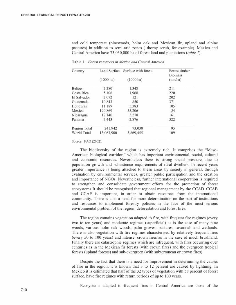
and cold temperate (pinewoods, holm oak and Mexican fir, upland and alpinepastures) in addition to semi-arid zones ( thorny scrub, for example). Mexico and Central America have 73,030,000 ha of forest land and plantations (table 1).
Table 1—Forest resources in Mexico and Central America._______________________________________________________________Country Land Surface Surface with forest Forest timber Biomass (1000 ha) (1000 ha) (ton/ha)_______________________________________________________________Belize 2,280 1,348 211Costa Rica 5,106 1,968 220El Salvador 2,072 121 202Guatemala 10,843 850 371Honduras 11,189 5,383 105Mexico 190,869 55,206 54Nicaragua 12,140 3,278 161Panama 7,443 2,876 322_______________________________________________________________Region Total 241,942 73,030 95World Total 13,063,900 3,869,455 109_______________________________________________________________Source: FAO (2002).
The biodiversity of the region is extremely rich. It comprises the “Meso-American biological corridor,” which has important environmental, social, cultural and economic resources. Nevertheless there is strong social pressure, due topopulation growth and subsistence requirements of rural dwellers. In recent yearsgreater importance is being attached to these areas by society in general, through evaluation by environmental services, greater public participation and the creationand importance of NGOs. Nevertheless, further international cooperation is required to strengthen and consolidate government efforts for the protection of forestecosystems It should be recognised that regional management by the CCAD_CCAB and CCAP is important, in order to obtain resources from the internationalcommunity. There is also a need for more determination on the part of institutionsand resources to implement forestry policies in the face of the most seriousenvironmental problem of the region: deforestation and forest fires.
The region contains vegetation adapted to fire, with frequent fire regimes (everytwo to ten years) and moderate regimes (superficial) as is the case of many pine woods, various holm oak woods, palm groves, pastures, savannah and wetlands.There is also vegetation with fire regimes characterised by relatively frequent fires (every 50 to 100 years) and intense, crown fires as in the case of much brushland. Finally there are catastrophic regimes which are infrequent, with fires occurring overcenturies as in the Mexican fir forests (with crown fires) and the evergreen tropicalforests (upland forests) and sub-evergreen (with subterranean or crown fires)
Despite the fact that there is a need for improvement in determining the causes of fire in the region, it is known that 3 to 12 percent are caused by lightning. InMexico it is estimated that half of the 32 types of vegetation with 58 percent of forest surface, have fire regimes with return periods of up to 100 years.
Ecosystems adapted to frequent fires in Central America are those of the
USDA Forest Service Gen. Tech. Rep. PSW-GTR-xxx. xxxx.
Proceedings of the Second International Symposium on Fire Economics, Planning, and Policy: A Global View
711
Proceedings of the Second International Symposium on Fire Economics, Planning, and Policy: A Global View
Session 1--Forest Fires in Mexico and Central America—Dominguz and Rodriguez
savannah, palm groves and pinewoods of Pinus tropicales, P. oocarpa and P.caribaea. In the case of Mexico, Rodríguez and Fulé (2003) mention 35 species of pine with variously adapted to fire.
History of anthropic fires in the region Due to its latitude, Mexico was the first place reached by ancient man some 40,000 years ago. From there he progressed to what are today the other countries of the region. Man used fire to clear a path in the thickets or to aid hunting by attractinggame to areas of re-growth. With the discovery of agriculture in Meso-America thousands of years ago, another use of fire arose, that of cleansing the forest cover toestablish cultivated crops. Over 3000 years ago the Olmecs and the Mayas evolved an efficient agricultural forest system for tropical areas, particularly those with stony shallow soils: the slash and burn method which, today, due to population increase as well as the atomisation of the land has reduced the period for which the land shouldlie fallow from several decades to two or three years, and it has now become asignificant deforesting agent causing a risk of fire in tropical zones. Subsequent European influence included fire causes relating to pasture and with more intenseexploitation of the forests. Currently the same fire causes prevail, i.e. agriculturalfires.
The social factorIn all the countries of this region there is a considerable rural population engaged in agricultural, fishing and forest activities. However, poverty levels have always beenhigh and have a tendency to rise. The Hemispheric Conference on Disaster Reductionin Costa Rica in 2001, reported that from 1990 to 1999 the number of those suffering absolute poverty in Latin America rose from 200,000,000 to 225,000,000. Twentypercent of those in the upper income bracket earn 20 times more than the poorest 20 percent , converting the region into world leader in terms of income inequality. Giventhe lack of options and forestry culture, the changes in the use of forest terrain into agricultural land, the burning of pastures and forests for the purpose of grazing(which in many cases may considered as overgrazing) and the practices of burning of agricultural land for the purposes of cleansing, fertilisation and disease control, as well fire used in slash and burn techniques, are very common and are the prime causeof forest fires.
In Mexico 41 percent of the surface area affected out of 32 statescorresponds to Chiapas and Oaxaca, which have the two lowest development levels in the country including services, education and class differences.
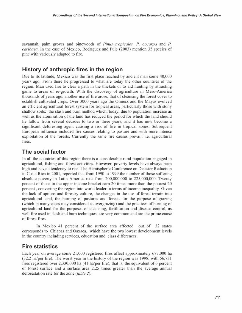
Fire statistics Each year on average some 21,000 registered fires affect approximately 677,000 ha(32.2 ha/per fire). The worst year in the history of the region was 1998, with 56,731fires registered over 2,330,000 ha (41 ha/per fire), that is, the equivalent of 3 percentof forest surface and a surface area 2.25 times greater than the average annualdeforestation rate for the zone (table 2).
USDA Forest Service Gen. Tech. Rep. PSW-GTR-xxx. xxxx.
712
Proceedings of the Second International Symposium on Fire Economics, Planning, and Policy: A Global ViewGENERAL TECHNICAL REPORT PSW-GTR-208 Proceedings of the Second International Symposium on Fire Economics, Planning, and Policy: A Global View
Session 1--Forest Fires in Mexico and Central America—Dominguez and Rodriguez
Table 2—Number of forest fires and surface area affected by fire and agricultural burningduring 1998 in México and Central America____________________________________________________________________Country Number of Affected Surface Total Fires Forest Affected Surface Surface by agricultural Affected Burning____________________________________________________________________Belize 656 22,960 16,400 39,360Costa Rica 1,511 52,885 37,775 90,660El Salvador 227 7,945 5,675 13,620Guatemala 10,906 381,710 272,500 654,210Honduras 9,594 335,790 239,850 575,640Nicaragua 15,196 531,860 379,900 911,760México 14,445 849,632 4,288,670 5,139,302Panama 4,196 146,860 104,900 251,760____________________________________________________________________Total 56,731 2,329,642 5,345,670 7,676,312Average 1998 7,091 291,205 668,209 959,539____________________________________________________________________ Source: Forest Fires in Central America Workshop San Pedro Sula, Honduras, June 1998.
The agricultural surface affected in that same year was in the order of 5,346,000 ha, for a registered total (forest fires and agricultural burning) of 7,680,000 ha burnt, i.e. a surface area burnt equivalent to more than the total surface area of Panama.
For the whole 12 months of the year fires occur in some part of the region, although most take place between January and May. April is the month of greatestrisk.
With regard to the causes, an average of 43 percent are related to agricultural activities (land cleansing, pasture burning to promote regrowth). Other important causes are smokers, bonfires, rubbish burning, deliberate fires due to disputes,hunters or other reasons, or to facilitate change of soil use which account for around 42 percent. Natural causes such as lightning vary between 3 to 12 percent according to the country. Forestry activity and other causes including unknown causes cover the remaining percentage.
One aspect of the impact of forest fire is an average emission of 1,000,000 ton CO2/per month during the fire risk period of the tropical zones of the region (Wei et al. 1990).
PreventionPhysical, educational, and legislative prevention is implemented with varying degreesof intensity in the different countries of the region. Distribution of posters, pamphletsand educational material for schools, illustrating preventive measures as well as press and radio and television messaging, in addition to documentaries, are commonmeasures, as are talks in schools and training and talks in rural communitiesincluding those at high risk. Opening of fire breaks is another common activity. In countries such as Honduras and México controlled burning is carried out.
USDA Forest Service Gen. Tech. Rep. PSW-GTR-xxx. xxxx.
Proceedings of the Second International Symposium on Fire Economics, Planning, and Policy: A Global View
713
Proceedings of the Second International Symposium on Fire Economics, Planning, and Policy: A Global View
Session 1--Forest Fires in Mexico and Central America—Dominguz and Rodriguez
Official Mexican Regulation on Fire Management, 6,846.89 printed works, televisionand radio broadcasts, 1,224 press, radio and television conferences and news bulletins, 4,359 activities extending to rural communities, 7,700 ha of controlledburning (mainly blacklines), 7,589 km of fire break control lines opened, and 6,656km of maintenance of control lines.
Fire-fighting resources In different parts of the region the following or partial means of detection are used:Civil participation, land detection (fixed and mobile), aerial and satellite detection. Mexico, for example, has 190 look out points. With respect to satellite detection, NOAA provides information on the region’s hot spots via internet. In the case ofMexico, CONABIO has formed close links with CONAFOR to provide detection of hot spots which are also carried out in Guatemala and which could extend to all ofCentral America. The Mexican SMN is beginning to provide a similar service inMexico.
There is no precise data for all the countries and some do not even have officialfire fighting teams with the work being carried out by volunteers. Between Mexico, Guatemala, Cuba and Costa Rica, there are 16,500 permanent fire fighting forces(Martínez 2002; SIPECIF 2002; Ramos 2003; Murullo 2002). It is estimated that the region has at least 17,500 permanent fire fighters of the principal agencies responsible.
The situation is also very variable in terms of material resources, in some casesthere is a lack of specialised equipment. In most countries however, althoughquantities vary, there is agricultural equipment, specialised manual tools, back packsprayers, protective clothing vehicles, and radio equipment. Some countries have portable meteorological monitors
The availability of land and air vehicles is also very variable. Cuba has PZL-M18 Dromeder air tankers and pump trailers (Ramos 2003). El Salvador has twohelicopters (Ibarra and Marroquín 2002). Honduras uses fire department tankers(AFE 2002).
As a more detailed example, different areas of México have almost 50,000 sets of manual and specialised tools, 3,663 specialised minor teams, 684 geopositioners 249 camps, 334 control centers, 898 vehicles for fire fighting teams, 2,786 radio equipment sets, 55 airships for detection, and 49 combat helicopters (Martínez 2002). Last year a dozen pump trailers were incorporated.
The amount spent on forest fire programmes amounts to 8,000,000 de Quetzales in Guatemala (SIPECIF 2002), 60,000,000 lempiras in Honduras, 191,600,000 pesos(including central operational costs, fire team salaries, temporary employmentprogramme, and administration operational costs) in México (Federal government only) (Martínez 2002), corresponding to US $987,654, US $3,348,214, and US $17,461,686, for a total of US $21,797,554 in these three countries.
Fire fighting organizationThe main fire fighting body in Mexico is CONAFOR, the federal government, with the participation of state and municipal governments. The Secretary of National
USDA Forest Service Gen. Tech. Rep. PSW-GTR-xxx. xxxx.
As an illustration, Mexico has 1,423 dissemination activities in the guise of the

714
Proceedings of the Second International Symposium on Fire Economics, Planning, and Policy: A Global ViewGENERAL TECHNICAL REPORT PSW-GTR-208 Proceedings of the Second International Symposium on Fire Economics, Planning, and Policy: A Global View
Session 1--Forest Fires in Mexico and Central America—Dominguez and Rodriguez
Defence also participates, as do the owners of forest land, forestry industryorganisations, forestry service professionals, agricultural producers, civil bodies (NGOs academics, businessmen, producers), rural confederations (including CNCand CCI,) all of whom, together with personnel from protected natural areas, make up the Forest Fire Prevention Programme.
Various institutional bodies are involved in fire fighting and fire prevention. InCosta Rica (Ministry of Environment and Energy, with the National Commission on Forest Fires), Cuba (Corps of Forest Rangers of the Ministry of Interior), Honduras(State Forestry Administration, COHDEFOR), Nicaragua (National ForestryInstitute), México (National Forestry Commission), and Panamá (NationalEnvironment Authority, with the National commission for fire fighting and prevention). Cases with various institutions include Belize (Forestry and ArmyDepartment), El Salvador (Fire fighting forces, National Emergency Committee), and Guatemala (National Plan for the Prevention and Control of Forest Fires of the Ministry of Environment and Natural Resources, Secretariat for ExecutiveCoordination of the Presidency, CONRED, Army, Nation Forestry Institute and the National Council for Protected Areas).
Almost all countries have a National Operations Center although not always at a state or provincial level.
Training and Education Training courses for instructors directed at technicians and professionals fromvarious Latin American countries and Spain delivered by the US Forestry Servicewith instructors from U.S.A. and Spain, and with the support of AID, in 1984 and 1985, in Marana, Arizona, were the basis of a chain reaction in Mexico which slowlystrengthened due to the interest of the federal area for prevention and control of forestfires and the continuing possible of participation of U.S.A., Spain, and Canada. Littleby little the level of competence of fire fighters was raised and the type and level ofcourses diversified.
Mexico currently holds an international course every year for 60 participantsfrom Mexico and other countries which has been held since 1990. There are coursesfor emergency management (basic or intermediate) for helibucket handlers, and also900 basic courses held annually for ejidos and communities, and a national course forNational Defence Forces in addition to two courses for Mexican Air Force pilots who receive certification from the USFS.
There has been a similar trend in other countries. In Guatemala, for instance, 103 courses of varying levels were held in 2002 (most of these were for forestry fire fighters, two for training instructors and one for emergency management)) (SIPECIF 2002). In Honduras, 28 courses were held the same year, three given by international trainers and 25 with national trainers (AFE 2002). In Nicaragua, 33 courses were heldannually between 1998 and 2002, training 226 technicians and instructors and 1,615fire fighters (INAFOR 2002).
Although with varying levels of proficiency, technical professional and postgraduate education covers the theme of forest fires in respect of various topics ata regional level. In the case of Mexico, all degree level institutions of forestry science offer a course in forestry protection or at least include the subject. For example, the Forestry Science Division of the Autonomous University of Chapingo holds a course
USDA Forest Service Gen. Tech. Rep. PSW-GTR-xxx. xxxx.
Proceedings of the Second International Symposium on Fire Economics, Planning, and Policy: A Global View
715
Proceedings of the Second International Symposium on Fire Economics, Planning, and Policy: A Global View
Session 1--Forest Fires in Mexico and Central America—Dominguz and Rodriguez
on Forestry Protection (which is a compulsory subject), and another on the Use of Fire (an optional subject). Since 2000 the postgraduate programme at the same university has held courses on the Ecology of Fire and the Restoration of Forest Ecosystems (from 2001) (which includes themes on fire management), and a special question on the theme of smoke from forest fires. Another program which offers courses related to the subject is UAAAN, with a course on forest fuel management.
ResearchResearch into the subject is increasing, particularly in terms of the ecology of fire,due largely to the interest of national or international researchers, although there is still much to be done. A case in point is the fact that Autonomous University ofChapingo, CONACYT, CONAFOR, the Government of Mexico City and the Community of Santo Tomás Ajusco, are carrying out a project on the ecology of fire and integral fire management in tall pine forests (Pinus hartwegii), known as the Ajusco Project (table 3). In addition the University of Guadalajara, the University of Washington and the INIFAP are carrying out another project with an ecological andsocial focus in the Manantlán Reserve, Jalisco, which includes the creation of stereoscopic guides for forest fuels.
Another field in which there has been active research is that of GIS and spatialstatistics applied to the problem of fires largely due to the efforts of CONABIO,INIFAP, the University of Colima, and the College of Postgraduates among others.
Table 3—The Ajusco project___________________________________________________________________________Antecedents. The Federal District has a surface area of 150,000 ha, 35,000 ha of whichcomprise pine woods, holm oak, Mexican fir, pasture, and zerophyte scrub. Among thepinewoods, the most notable is Pinus hartwegii, or upland pine (also present in Guatemala),found between 2,200 and 4,000 m above sea level. In terms of number of fires, the FederalDistrict on average is third at a national level, some years with more than 1,000 fires. Nevertheless, excellent fire fighting cover by the federal and Mexico city governments, andgood available access reduced the surface area affected to 20th position. Here the causes of fire are mixed, in rural areas relating to agricultural activities, principally pasture, and fires generated by the urban population, one of the most populated on the planet, (bonfires andsmokers) in addition to the pressure of growth of Mexico City and contamination. Since thisarea has an ecosystem well adapted to fire, which is of prime importance in terms ofconservation and restoration, and since it comprises high mountain terrain and includesendemic and status species, in addition to its problem of forest fires, it is an area of particularinterest in the application of the project. Some of the research for this project was also doneon this type of ecosystem in other parts of the Federal District or in the State of Mexico.___________________________________________________________________________Objective. The aim of the project was to contribute to use of fire which reconciles itsecological role in this ecosystem, enabling it to be used for moderate livestock purposesmaximising the positive impact of controlled low intensity fire (diversity of species, greatersecondary growth, recycling of nutrients, creation of seed beds, reduction of danger of forestfires, among others) and reduction of the negative impact of fire, which obviously has a moredramatic effect (death of trees, disease, deforestation, erosion, pollution ). As it continues to be an option for the rural land worker, it is hoped that in future he will contribute to the reduction of forest fires in the area. The project is being developed principally by researcherscarrying out their postgraduate theses and degrees.
Continued…
USDA Forest Service Gen. Tech. Rep. PSW-GTR-xxx. xxxx.

716
Proceedings of the Second International Symposium on Fire Economics, Planning, and Policy: A Global ViewGENERAL TECHNICAL REPORT PSW-GTR-208 Proceedings of the Second International Symposium on Fire Economics, Planning, and Policy: A Global View
Session 1--Forest Fires in Mexico and Central America—Dominguez and Rodriguez
Continuation…___________________________________________________________________________Methodology and Results. At 3,500 m above sea level, these were fringe areas with low intensity fires (in March) and experimental confined fires at the peak fire risk periods (May2002), and a test area was left unburned. Results were obtained for a year but at least three more years will be studied in order to analyse the duration of the effects found. Below themain results are detailed.
Behaviour of fire. The prescribed fire early in the period and early in the morning, againstthe wind, and at a gradient (55 percent) spread at no more than 1/min, with flame length of0.5 m. The flames of the fire at the hours of greatest risk and in full fire risk period, with thewind in favour and on a gradient, reached flame length of 6 to 8 m. and with propagationspeeds of up to 60 and 80 m/min.
Radial growth of P. hartwegii. The width and growth ring formed the year following the firewas greater than the test area when only the lower third of the crown was affected by the heatof the fire (an effect of natural pruning which eliminates the lower branches, which, havingless foliage are less efficient in photosynthesis, thus more is consumed than produced, as wellas fertilisation from the ashes). Those with brunt crowns from 33 percent to 66 percent hadnarrower growth rings than the test area. (González and Rodríguez,).
Survival and susceptibility to disease. The survival of young trees (from 2 to 6 m in height)was not statistically significant between the areas of prescribed burning in March and the testarea (96 percent in both cases ). In the May fires, survival was 48 percent although in mostdense areas this value was 0 percent due to greater accumulation of forest litter which, whenburned, transmitted greater temperatures to the superficial roots of the trees, thus killing them(Castro and Rodríguez,).
Wealth and diversity of species and species indicative of burned areas. In summer withthe rains which characterise the region, 12 herbaceous and shrub species were registered inthe test areas and 21 in the areas of controlled burning or of fires. The most dominant speciesand those indicative of the burned areas are: Penstemon gentianoides, Senecio callosus,Lupinus montanus, Eupatorium spp., and Senecio tolucanus (Martínez and Rodríguez 2003).In general the wealth of species is low due to the high altitude of the area.
Planting in burned areas. Initial survival (6 months on from planting) of trees of the speciesplanted in the treated areas did not significantly differ statistically between the test areas and those of the controlled fire in March (with 93 percent and 88 percent). The areas burned inMay had a lower level of survival (60 percent) (Ortega and Rodríguez 2003).
Smoke from fires. Emissions of NOX, SO2 , and CO were, respectively, 9.37 Kg/ha, 2.84Kg/ha, and 198.69 Kg/ha. Senecio cinerarioides, a species which appeared abundantly in many areas of the central region, affected by past fires in 1998, is the main cause of emissionsof these gases. If such areas are burned again they will contaminate more than they wouldhave if typical superficial fuels of these pinewoods had been burned. (Contreras et al. 2003).
Germination of Lupinus bilineatus. Seeds of this species remain dormant. Without treatmentat 20 °C during the day and 15 °C at night with 12 light hours only 18 percent germinate.With fire scarification it rises to 39 percent with significantly different statistics (Martínez andRodríguez,).___________________________________________________________________________
USDA Forest Service Gen. Tech. Rep. PSW-GTR-xxx. xxxx.
Proceedings of the Second International Symposium on Fire Economics, Planning, and Policy: A Global View
717
Proceedings of the Second International Symposium on Fire Economics, Planning, and Policy: A Global View
Session 1--Forest Fires in Mexico and Central America—Dominguz and Rodriguez
Existing projects and Initiatives These are as follows:
Meso-American Cooperation Programme. With the summit meeting of heads of states of the countries which are members of the Dialogue and decisionTuxtla IV.
Meso-American Biological Corridor for consolidation with the participation of PNUD, GEF, GTZ, DANIDA, CCAD and the governments of Mexico, Belize, Guatemala, El Salvador, Honduras, Nicaragua, Costa Rica, andPanama.
United Nations World Food Programme. For mobilization of voluntary brigades in Honduras.
Integrated Management of the Ecosystem in Indigenous Lands and of the in Central America. With the participation of the GEF.
World Bank Central American Geographic Information with the participationof CATIE and CIAT.
Regional Environmental Programme for Central America. Run by USAID.
Emerging Plan for the Prevention and Control of Forest Fires at a national level (INAB).
Training and Education Programme for Forest Fire Instructors (OFDA-AID).
Cooperation networksThese include:
British-Nicaraguan Cooperation (NOAA, MARENA, INAFOR). For the detection of hot spots using satellites.
Prevention and Control of Forest Fires in Meso-Amercia (CCAD-Tuxtla IV).
Inter-American Information Network on Biodiversity (IABIN).
Programme of hot spot detection using remote perception techniques. (CONABIO-CCAD).
Central American Alliance for Sustainable Development (ALIDES).
Working Group on Forest Fire Management (COFAN: U.S.A., Canada, and Mexico).
Future fire scenario The future scenario, while current levels of activities and resources are maintained, is one of more fires and greater surface areas affected. This is true given existing investigation into global warming (which results in higher temperatures, less
USDA Forest Service Gen. Tech. Rep. PSW-GTR-xxx. xxxx.

718
Proceedings of the Second International Symposium on Fire Economics, Planning, and Policy: A Global ViewGENERAL TECHNICAL REPORT PSW-GTR-208 Proceedings of the Second International Symposium on Fire Economics, Planning, and Policy: A Global View
Session 1--Forest Fires in Mexico and Central America—Dominguez and Rodriguez
humidity, the spread of more inflammable vegetation such as underbrush and pasture,reduction of forests, and greater presence of lighting on various areas of the planet) in addition to the effects of El Niño. In addition, given the fact that poverty is unlikelyto be resolved in the region, the result is a greater presence of natural and anthropicfire.
It should be recalled that if tropical forests, a mainstay of biodiversity, are affected by fires, this will lead to a greater risk of fire until these areas are progressively converted to savannah and pasture.
Dealing with the probable scenario Undoubtedly of prime importance in reducing the attack of fire is greater cooperationof agencies within the country itself and between countries, such as the search for financing schemes to reinforce prevention—pre-suppression and suppression withgreater human, material, technical, technological and financial resources. For example, among the goals for future international cooperation: establishing regional mechanisms to ensure the contribution of technical and financial resources from the international community, for the purpose of strengthening and consolidatinggovernment efforts in the countries of the region for planning, prevention, detectionand control of fires, which permits the training, and the formation of teams withspecialised equipment as well as establishing systems in response to emergencymanagement.
Another aspect is that of alternatives to fire in agricultural activity and the factthat it would be advisable to increase, particularly in tropical areas, slash and dig instead of slash and burn techniques. Another option is also greater incorporation ofwell-planned agricultural forest systems
However, there is an additional growing trend in various countries, through theinitiative of academics and technical experts and with participation or initiative of other nations which has two components. The first is linked to the ecological role of fire, that formidable adversary which can be temporarily vanquished, but which cannot be excluded from the planet, since it has been present in vegetation formillions of years and most of the land ecosystems have developed variouslydepending on the frequent presence of fire or rarely its influence. Efforts are beingmade in scientific research and on an operational scale for the use of fire forecological and forestry purposes.
It is also necessary to consider on one hand that man has frequently burnedvegetation to excess, lowering its resistance to fire and degrading it. On the other hand,the exclusion of fire leads to an accumulation of fuel which will make the next fire more intense, more dangerous, and with a greater negative impact; in addition to being more expensive and difficult to control. A happy medium would be ideal, such as using fire but with a technical and scientific basis.
For example, TNC is starting controlled fires for ecological purposes in reservessuch as La Amistad, Costa Rica; Madre de las Aguas, Dominican Republic, and Rio Bravo, Belize. In Mexico attempts are also being made in the ecological and integrated management of fire, via controlled burning of vegetation in fire regimeswhere fires are frequent but not intense and/or integrated fire management in the Parque Cumbres del Ajusco, and in reserves such as Manantlán, La Sepultura, LaEncrucijada, El Ocote, Sierra de los Ajos, and la Sierra de Arteaga, with the
USDA Forest Service Gen. Tech. Rep. PSW-GTR-xxx. xxxx.

Proceedings of the Second International Symposium on Fire Economics, Planning, and Policy: A Global View
719
Proceedings of the Second International Symposium on Fire Economics, Planning, and Policy: A Global View
Session 1--Forest Fires in Mexico and Central America—Dominguz and Rodriguez
Official Mexican Regulation on Fire Management, 6,846.89 printed works, televisionand radio broadcasts, 1,224 press, radio and television conferences and news bulletins, 4,359 activities extending to rural communities, 7,700 ha of controlledburning (mainly blacklines), 7,589 km of fire break control lines opened, and 6,656km of maintenance of control lines.
Fire-fighting resources In different parts of the region the following or partial means of detection are used:Civil participation, land detection (fixed and mobile), aerial and satellite detection. Mexico, for example, has 190 look out points. With respect to satellite detection, NOAA provides information on the region’s hot spots via internet. In the case ofMexico, CONABIO has formed close links with CONAFOR to provide detection of hot spots which are also carried out in Guatemala and which could extend to all ofCentral America. The Mexican SMN is beginning to provide a similar service inMexico.
There is no precise data for all the countries and some do not even have officialfire fighting teams with the work being carried out by volunteers. Between Mexico, Guatemala, Cuba and Costa Rica, there are 16,500 permanent fire fighting forces(Martínez 2002; SIPECIF 2002; Ramos 2003; Murullo 2002). It is estimated that the region has at least 17,500 permanent fire fighters of the principal agencies responsible.
The situation is also very variable in terms of material resources, in some casesthere is a lack of specialised equipment. In most countries however, althoughquantities vary, there is agricultural equipment, specialised manual tools, back packsprayers, protective clothing vehicles, and radio equipment. Some countries have portable meteorological monitors
The availability of land and air vehicles is also very variable. Cuba has PZL-M18 Dromeder air tankers and pump trailers (Ramos 2003). El Salvador has twohelicopters (Ibarra and Marroquín 2002). Honduras uses fire department tankers(AFE 2002).
As a more detailed example, different areas of México have almost 50,000 sets of manual and specialised tools, 3,663 specialised minor teams, 684 geopositioners 249 camps, 334 control centers, 898 vehicles for fire fighting teams, 2,786 radio equipment sets, 55 airships for detection, and 49 combat helicopters (Martínez 2002). Last year a dozen pump trailers were incorporated.
The amount spent on forest fire programmes amounts to 8,000,000 de Quetzales in Guatemala (SIPECIF 2002), 60,000,000 lempiras in Honduras, 191,600,000 pesos(including central operational costs, fire team salaries, temporary employmentprogramme, and administration operational costs) in México (Federal government only) (Martínez 2002), corresponding to US $987,654, US $3,348,214, and US $17,461,686, for a total of US $21,797,554 in these three countries.
Fire fighting organizationThe main fire fighting body in Mexico is CONAFOR, the federal government, with the participation of state and municipal governments. The Secretary of National
USDA Forest Service Gen. Tech. Rep. PSW-GTR-xxx. xxxx.
As an illustration, Mexico has 1,423 dissemination activities in the guise of the

720
Proceedings of the Second International Symposium on Fire Economics, Planning, and Policy: A Global ViewGENERAL TECHNICAL REPORT PSW-GTR-208
Session 1--Forest Fires in Mexico and Central America—Dominguez and Rodriguez
SIPECIF (Sistema Nacional de Prevención y Control de Incendios Forestales). 2002.Guatemala. 1ª Reunión mesoamericana de Incendios Forestales. Guatemala,Guatemala. Julio 2002.
Wei Min Hao, Mei-Huey, L., and Crutzen, P. J. 1990. Estimates of annual and regionalreleases of CO2 and other trace gases to the atmosphere from fires in the tropics,based on the FAO statistics for the period 1975-1980. In: Goldammer, J. G. (ed.). Firein the tropical biota. Berlin: Springer-Verlag.; 440-486.
USDA Forest Service Gen. Tech. Rep. PSW-GTR-xxx. xxxx.


![HighPerformanceTelcosen Latino América1]… · Wireline Revenues ... clientes con unas ... transformación de las áreas de operaciones para optimizar sus costes asociados..](https://static.fdocuments.in/doc/165x107/5a788fbe7f8b9a77438ed80f/highperformancetelcosen-latino-1wireline-revenues-clientes-con-unas-.jpg)