
FLOOD INVESTIGATION REPORT WINDMILL CLOSE, WOODFORD …
47
D S A DAVID SMITH ASSOCIATES Consulting Structural & Civil Engineers London Northampton Cirencester www.dsagroup.co.uk FLOOD INVESTIGATION REPORT WINDMILL CLOSE, WOODFORD 2 nd JANUARY 2016 Client: Flood & Water Management Team Planning Services Northamptonshire County Council County Hall, Room 271, Northampton NN1 1DN Prepared By: Richard Jones Date: 5 th May 2016 Reference: 17/21845 Revision: 03 VAT Registration No.: 670 8636 12 Eur Ing David Smith BSc(Hons), CEng, MICE, MIStructE, IMaPS, MFPWS, FCABE, ACIArb, Alison Smith Hitesh Jethwa BScEng(Hons), I.Eng, AMIStructE Steven Ainge BEng(Hons), IEng, AMIStructE Richard Jones HNC, TMICE, Eng.Tech, John Mills MA(Cantab), CEng, MICE, MIStructE London 16 Upper Woburn Place London WC1H 0AF 0203 7418098 [email protected] Northampton 8 Duncan Close Moulton Park Northampton NN3 6WL 01604 782620 [email protected] Cirencester Waterloo House The Waterloo Cirencester GL7 2PY 01285 657328 [email protected]
Transcript of FLOOD INVESTIGATION REPORT WINDMILL CLOSE, WOODFORD …

D S A
DAVID SMITH ASSOCIATES Consulting Structural & Civil Engineers
London Northampton Cirencester
www.dsagroup.co.uk
FLOOD INVESTIGATION REPORT
WINDMILL CLOSE, WOODFORD
2nd JANUARY 2016
Client: Flood & Water Management Team
Planning Services Northamptonshire County Council County Hall, Room 271, Northampton NN1 1DN
Prepared By: Richard Jones
Date: 5th May 2016
Reference: 17/21845
Revision: 03
VAT Registration No.: 670 8636 12
Eur Ing David Smith BSc(Hons), CEng, MICE, MIStructE, IMaPS, MFPWS, FCABE, ACIArb, Alison Smith
Hitesh Jethwa BScEng(Hons), I.Eng, AMIStructE Steven Ainge BEng(Hons), IEng, AMIStructE
Richard Jones HNC, TMICE, Eng.Tech, John Mills MA(Cantab), CEng, MICE, MIStructE
London
16 Upper Woburn Place
London
WC1H 0AF
0203 7418098
Northampton
8 Duncan Close Moulton
Park Northampton NN3
6WL
01604 782620
Cirencester
Waterloo House
The Waterloo
Cirencester GL7 2PY
01285 657328

REVISION SCHEDULE Northamptonshire County Council Flood Investigation Report Windmill Close, Woodford David Smith Associates Reference : 16/21845
Rev Date Details Author Checked Approved
01 14/03/16 Draft Report Richard Jones (David Smith Associates)
Josie Bateman (Senior Project Manager F&WM)
Josie Bateman (Senior Project Manager F&WM)
02 17/03/16 Draft report for stakeholder consultation
Richard Jones (David Smith Associates)
Josie Bateman (Senior Project Manager F&WM)
Josie Bateman (Senior Project Manager F&WM)
03 05/05/16 Revision following additional information/consultation
Richard Jones (David Smith Associates)
Josie Bateman (Senior Project Manager F&WM)
Josie Bateman (Senior Project Manager F&WM)

FOREWORD One of the roles of Northamptonshire County Council as the Lead Local Flood Authority (LLFA) is to carry out investigations into flooding incidents if they meet the set thresholds. The LFFA will:
Identify and explain the likely cause/s of flooding;
Identify which authorities, communities and individuals have relevant flood risk management powers and responsibilities;
Provide recommendations for each of those authorities, communities and individuals;
Outline whether those authorities, communities or individuals have or will exercise their powers or responsibilities in response to the flooding incident.
The LLFA cannot:
Resolve the flooding issues or provide designed solutions;
Force Authorities to undertake any of the recommended actions.
16/21210 Flood Incident Report Windmill Close, Woodford
CONTENTS EXECUTIVE SUMMARY ............................................................................................................................ 1 1. Introduction .................................................................................................................................... 3
1.1 Lead Local Flood Authority Investigation ................................................................................ 3
1.2 Flooding Incident .................................................................................................................... 4
1.3 Site Location ............................................................................................................................ 5
1.4 Drainage Systems .................................................................................................................... 6
2. Drainage History ............................................................................................................................. 7 2.1 Previous Flood Incidents ......................................................................................................... 7
2.2 Rainfall Analysis ...................................................................................................................... 8
3. Summary of Impacts and Findings .................................................................................................. 9 3.1 Areas of Flooding and Impacts ................................................................................................ 9
4. Conclusion ..................................................................................................................................... 10 5. Rights and Responsibilities............................................................................................................ 11
5.1 Communities and Residents ................................................................................................. 11
5.2 Lead Local Flood Authority (LLFA) ......................................................................................... 13
5.3 Highway Authority (Northamptonshire Highways) .............................................................. 13
5.4 Water Authority (Anglian Water Services) (AWS) ................................................................ 14
5.5 East Northamptonshire Council (ENC) .................................................................................. 14
5.6 Environment Agency (EA) ..................................................................................................... 15
5.7 Land Owners and Developers ............................................................................................... 15
6. Recommendations ........................................................................................................................ 16 6.1 General .................................................................................................................................. 16
6.2 Communities and Residents ................................................................................................. 16
6.3 Lead Local Flood Authority (LLFA) ......................................................................................... 18
6.4 Highway Authority (Northamptonshire Highways) .............................................................. 18
6.5 Water Authority (Anglian Water Services) (AWS) ................................................................ 18
6.6 East Northamptonshire Council (ENC) .................................................................................. 19
6.7 Land Owners and Developers ............................................................................................... 19
7. Disclaimer ...................................................................................................................................... 21 Acronyms .............................................................................................................................................. 22 Useful Links ........................................................................................................................................... 22 Useful Contacts ..................................................................................................................................... 23

16/21210 Flood Incident Report Windmill Close, Woodford
APPENDIX A ............................................................................................................................................. 1
Location Plan & Incident Plan ............................................................................................................. 1
APPENDIX B ............................................................................................................................................. 2 Flood Map for Planning ....................................................................................................................... 2
APPENDIX C ............................................................................................................................................. 4 Risk of Flooding from Surface Water .................................................................................................. 4
APPENDIX D ............................................................................................................................................. 6 Environment Agency Standard Notice ................................................................................................ 6
APPENDIX E ............................................................................................................................................. 7 Residents photographs from flood incident 2nd January 2016 ........................................................... 7
APPENDIX G ........................................................................................................................................... 10 Photographs from flood incident investigation 22nd January 2016 .................................................. 10

16/21845 Flood Incident Report Windmill Close, Woodford
1
EXECUTIVE SUMMARY
This Flood Investigation Report (FIR) has been completed by David Smith Associates on behalf of Northamptonshire County Council under its duties as the Lead Local Flood Authority (LLFA) in accordance with Section 19 of the Flood and Water Management Act 2010 (F&WMA). Statutory Context Section 19 of the F&WMA states that on becoming aware of a flood which meets certain pre-determined criteria, the LLFA must undertake a formal flood investigation in order to determine the relevant flood risk management authorities involved and which flood risk management functions have been, or should be taken to mitigate future flood risk. Where an authority carries out an investigation it must publish the results. Within the Northamptonshire Local Flood Risk Management Strategy the approved thresholds for undertaking a FIR are:
Northamptonshire LLFA thresholds for formal investigation: A formal flood investigation will be carried out if one or more of the following occurs:
Flooding has affected critical infrastructure for a period in excess of 3 hours from the onset of flooding;
Internal flooding of one property has been experienced on more than one occasion in the last 5 years;
Internal flooding of five properties in close proximity has been experienced during one single flood incident.
Definition of close proximity: Where it is reasonable to assume that the affected properties were flooded from the same source or interaction of sources. Definition of internal flooding: Where water crosses the threshold of a commercial or residential building.

16/21845 Flood Incident Report Windmill Close, Woodford
2
Definition of flooded properties Properties include both homes and businesses (this is a non-statutory definition used for the collection of data) Properties flooded: are those where it is considered that the property has been flooded internally, i.e. water has entered the property;
Basements and ground level floors are included;
Garages are included if in the fabric of the building. Garages adjacent or separate from the main building are not included;
Includes occupied static caravans and park homes, but not tents. This definition is based on homes, but includes businesses where water has entered the fabric of the buildings. Properties affected: are those where water has entered gardens or surrounding areas which restricts access, or where flooding has disrupted essential services to the property such as sewerage. For businesses this includes those where the flood waters are directly preventing them trading as usual.
Flooding Incident It was deemed necessary to complete a formal investigation into the flood incident at Windmill Close & Paddock Road, Woodford on 2nd January 2016. Flooding within the building envelope of one property has been experienced on more than one occasion in the last 5 years. This meets the threshold for investigation as set out above. Cause of Flooding The flooding that occurred at Windmill Close, Woodford was caused by moderate rainfall falling on a saturated catchment. Land drainage systems were unable to convey rainwater effectively. This led to excess surface water flowing over ground following natural contours to low points around private property. The localised layout of field ditches to the south of Windmill Close may have been altered purposefully or by natural means during or after the construction of housing which has led to surface water being directed towards private property. Main Findings Our main conclusion is that risk management authorities, the local community, and other groups, must continue to work together, sharing information and reports. Property owners should be made aware of the flood resistance and resilience measures available, and this information is provided on the NCC Flood Toolkit link below;
http://www.floodtoolkit.com/emergency/preparation/

16/21845 Flood Incident Report Windmill Close, Woodford
3
1. INTRODUCTION
1.1 Lead Local Flood Authority Investigation 1.1.1 Section 19 of the Flood and Water Management Act (F&WMA) states:
(1) On becoming aware of a flood in its area, a Lead Local Flood Authority must, to the extent that it considers it necessary or appropriate, investigate—
(a) which risk management authorities have relevant flood risk management
functions, and
(b) whether each of those risk management authorities has exercised, or is proposing to exercise, those functions in response to the flood.
(2) Where an authority carries out an investigation under subsection (1) it must—
(a) publish the results of its investigation, and
(b) notify any relevant risk management authorities. 1.1.2 Within the Northamptonshire Local Flood Risk Management Strategy the thresholds for
undertaking a Formal Investigation Report in the County have been determined as:
Northamptonshire LLFA thresholds for formal investigation: A formal flood investigation will be carried out if one or more of the following occurs:
Flooding has affected critical infrastructure for a period in excess of 3 hours from the onset of flooding;
Internal flooding of one property has been experienced on more than one occasion in the last 5 years;
Internal flooding of five properties in close proximity has been experienced during one single flood incident.
Definition of close proximity: Where it is reasonable to assume that the affected properties were flooded from the same source or interaction of sources. Definition of internal flooding: Where water crosses the threshold of a commercial or residential building.

16/21845 Flood Incident Report Windmill Close, Woodford
4
Definition of flooded properties Properties include both homes and businesses (this is a non-statutory definition used for the collection of data) Properties flooded: are those where it is considered that the property has been flooded internally, i.e. water has entered the property;
Basements and ground level floors are included;
Garages are included if in the fabric of the building. Garages adjacent or separate from the main building are not included;
Includes occupied static caravans and park homes, but not tents. This definition is based on homes, but includes businesses where water has entered the fabric of the buildings. Properties affected: are those where water has entered gardens or surrounding areas which restricts access, or where flooding has disrupted essential services to the property such as sewerage. For businesses this includes those where the flood waters are directly preventing them trading as usual.
1.2 Flooding Incident
1.2.1 It was deemed necessary to complete a formal investigation into a flood incident at Windmill Close, Woodford on 2nd January 2016. Flooding within the building envelope of one property has been experienced on more than one occasion in the last 5 years. This meets the threshold for investigation as set out above.
1.2.2 David Smith Associates undertook a Flood Incident Investigation on the 22nd January 2016.
Affected residents were spoken to regarding the flooding incident on 2nd January 2016, as well as previous and subsequent flooding incidents.

16/21845 Flood Incident Report Windmill Close, Woodford
5
1.3 Site Location
1.3.1 Woodford is situated in the east of Northamptonshire approximately 18 miles northeast of Northampton town centre, and two miles southwest of Thrapston town centre. See Appendix A.
1.3.2 Woodford is situated on a hill which falls to the north and east. Approximately 900 metres to the north is Alledge Brook, a tributary of the River Nene flowing west to east. Directly adjacent to the east of the village is the River Nene flowing south to north
1.3.3 Windmill Close is part of the Paddock Road housing development off Mill Road in the west of
the village. This housing development was completed in approx 2008/2009. 1.3.4 To the south of Windmill Close and Paddock Road are agricultural fields. To the west is an
unused area of scrub land overgrown with small native deciduous trees. 1.3.5 The catchment area contributing to the Windmill Close area extends across the agricultural
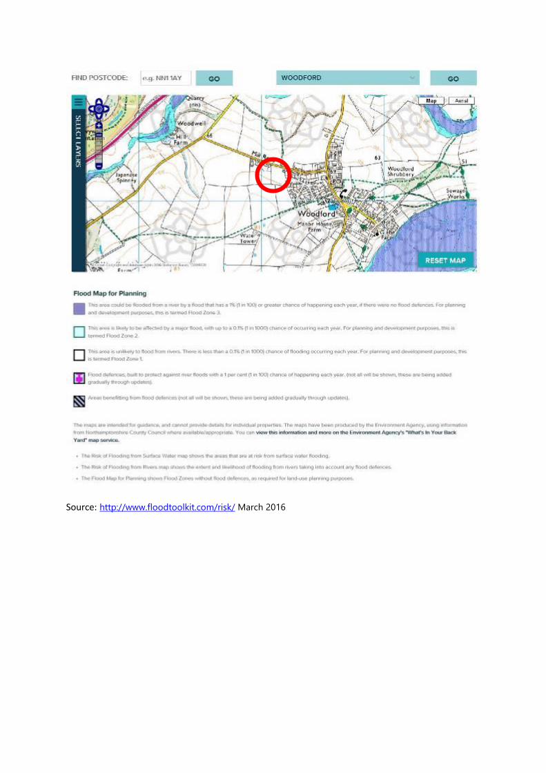
land approximately 400 metres to the southwest. 1.3.6 With reference to mapping on NCC’s Flood Toolkit website, Windmill Close is not shown to
be at risk of surface water or fluvial flooding. A localised area at high risk of surface water flooding is indicated to the rear of adjacent properties on Mill Road.

16/21845 Flood Incident Report Windmill Close, Woodford
6
1.4 Drainage Systems 1.4.1 Maps indicate that foul and surface water public sewers serve Windmill Close and Paddock
Road. These connect to public sewers on Mill Road to the north. It is understood that roofs and paved areas of Windmill Close and Paddock Road drain to this surface water sewer.
1.4.2 Maps indicate that a surface water public sewer manhole is indicated in front of No. 97 Mill Road, but no pipework is shown from this point.
1.4.3 To the south and southwest of Windmill Close, ditches exist on field boundaries of the agricultural fields. These flow from south to north, and from west to east bringing run-off from the fields towards the southwest corner of the Paddock Road housing development. The historic route of the ditch system from this point is unclear, with natural topography suggesting a route to the north or east.
1.4.4 The junction of the field ditches to the south of Windmill Close was seen to be in poor
condition with a high water level and no formal outlet. 1.4.5 From the southwest corner of the Paddock Road housing development, along the east
boundary of the scrub land, to the south boundary of No. 75 Mill Road, a shallow informal ditch has been recently excavated. This collects water from the field ditches to the south and allows it to flow along the east boundary of the scrub land. This informal ditch flows along the rear boundary of the properties affected by flooding.
1.4.6 An established ditch exists northeast of Paddock Road. The ditch receives water from the informal ditch in 1.4.3 and it continues to flow from south to north to a pipe in a brick headwall at Mill Road. The route of the pipe from this point has not been investigated.

16/21845 Flood Incident Report Windmill Close, Woodford
7
2. DRAINAGE HISTORY
2.1 Previous Flood Incidents
2.1.1 The following table lists flooding incidents that have been recorded in the area of the flood
incident:
Year Impact
2008/09 to 2012 No flood incidents recorded by residents.
2012 – December 2015
Surface water flooding affecting three properties on Windmill Close. Flow of surface water into rear gardens from scrub land at the west. 50mm depth of water in gardens and around house, flowing into air bricks. Flooding occurred approximately 5 times over this period. Ground and paving saturated/damp throughout most of year.
02/01/16
Surface water flooding affecting one property on Windmill Close. Flow of surface water into rear garden. 50mm depth of water in garden and around house, flowing into air bricks.
03/01/16
Surface water flooding affecting one property on Windmill Close. As 02/01/16.
07/01/16
Surface water flooding affecting one property on Windmill Close. As 02/01/16.
December 2015 - 11/01/16
Property on Mill Road. Water from ditch to the east overtopping and ponding on rear garden to approx 100mm depth.
9th March 2016
Flooding affecting one property on Mill Road, one property on Windmill Close and one property on Paddock Road. No internal flooding reported.

16/21845 Flood Incident Report Windmill Close, Woodford
8
2.2 Rainfall Analysis
2.2.1 The monthly rainfall total in the area for December 2015 was approximately 24% higher than the average recorded for December between 1981 and 2010. (Source: NCC Thrapston rain gauge, MET Office).
2.2.2 Brigstock rain station records that in the three days prior to 02/01/16, there was a total of 22.4mm rain. This is a considerable quantity of rainfall in three days when compared to the January average of 54mm.
2.2.3 On 02/01/16 10.8mm of rainfall was recorded over a period of 6 hours, which again is a
moderate quantity. 2.2.4 On 03/01/16 6mm of rainfall was recorded, and on 07/01/16 12mm of rainfall was recorded,
which are moderate quantities. 2.2.5 The source of rain station records is the Environment Agency. 2.2.6 Whilst the depths of rainfall recorded on the dates of reported flooding are only moderate,
this would have been on a saturated catchment which would lead to a greater volume of run-off occurring.

16/21845 Flood Incident Report Windmill Close, Woodford
9
3. SUMMARY OF IMPACTS AND FINDINGS
3.1 Areas of Flooding and Impacts
3.1.1 It was reported by affected residents of three properties on Windmill Close that between
2012 and December 2015 surface water runoff was witnessed flowing from scrub land beyond the rear boundary fence of their properties. The surface water flowed towards the rear of their houses and ponded at approximately 50mm depth in the gardens and around the houses. This flowed into air bricks
3.1.2 The flow of water emanated from the boundary ditches of the fields to the south and southwest.
3.1.3 The above flooding occurred approximately five times during that period. There was also the continual inconvenience of saturated ground and dampness in the rear gardens and other external areas around these houses. This led to residents reportedly taking action to excavate a ditch on the west side of the boundary fence to divert water away from their property, to flow to the north.
3.1.4 Following the excavation of the informal ditch on the west side of the boundary fence flooding has been experienced at one different property on Windmill Close and one property on Paddock Road on 02/01/16, 03/01/16 and 07/01/16. Surface water runoff was witnessed by the residents flowing from scrub land beyond the rear boundary fence of their properties.
3.1.5 Surface water flowed towards the rear of the properties on Windmill Close and Paddock
Road. This ponded at approximately 50mm depth in the gardens and around the houses. This flowed into air bricks of the houses and affected the garage of the property on Paddock Road.
3.1.6 The surface water flooding has led to the continual inconvenience of saturated ground and
dampness in the rear gardens and other external areas around the properties on Windmill Close and Paddock Road..
3.1.7 At the time of the flood investigation, the informal ditch on the west side of the boundary
fence at the southern end of Windmill Close had been extended by hand digging so that it joined the formal ditch further north.
3.1.8 At a property on Mill Road, surface water began to overtop a ditch to the east and flow into
the rear garden during December 2015 causing minor ponding. On 11/01/16 the overtopping suddenly increased and caused the pond to become much deeper and extend across the width of the garden. The ponding was in a depression several metres away from the south elevation of the house.

16/21845 Flood Incident Report Windmill Close, Woodford
10
4. CONCLUSION
4.1.1 The flooding that occurred in Windmill Close, Woodford, was caused by moderate rainfall
over a saturated catchment. Land drainage systems were unable to convey rainwater effectively to larger watercourses downstream of the Paddock Road housing estate. This led to excess surface water flowing over ground following natural contours to low points around private properties.
4.1.2 The localised layout of field ditches to the south of Windmill Close may have been altered purposefully or by natural means during or after the construction of housing which has led to historic flow routes becoming obscured and surface water being directed towards private property.
4.1.3 Temporary, informal drainage systems have been put in place by affected residents to
protect their properties, but further investigation, design and consents are required for a permanent solution to be found.
16/21845 Flood Incident Report Windmill Close, Woodford
11
5. RIGHTS AND RESPONSIBILITIES
5.1 Communities and Residents
5.1.1 Communities may consist of the Town or Parish Council, Flood Forum, Community Group
and affected residents, amongst others.
5.1.2 Woodford residents who are aware that they are at risk of flooding should take action to ensure that they and their properties are protected.
5.1.3 Community resilience is important in providing information and support to each other if flooding is anticipated. Actions taken can include signing up to Flood Warning Direct (if available), nominating a Community Flood Warden, producing a community flood plan, implementing property level protection and moving valuable items to higher ground.

16/21845 Flood Incident Report Windmill Close, Woodford
12
5.1.4 NCC holds a flood library covering various subjects, some of which relate to this Flood Incident. The relevant leaflets have been identified and are available at:
http://www.floodtoolkit.com/pdf-library/
No. Leaflet Title To Review
1 Agricultural Run-Off X
2 Ditch Clearance X
3 Flood Investigations X
4 Watercourse Management X
5 Flood Related Benefits of the Water Framework Directive
6 Reservoirs and Flooding
7 Funding for Flood Alleviation X
8 Roles and Responsibilities for Sewers X
9 Roles and Responsibilities for Highways X
10 Groundwater Flooding
11 What to do in a Flood Emergency X
12 How to Protect your Home X
13 Insurance and Flood Risk X
14 Using Experts for Flood Risk Assessment X
15 Riparian Ownership and Flood Risk X
16 Flood Defence Consenting X
17 Using Agricultural Land for Attenuation X
18 Enforcing Flood Risk Management
19 Flood Related Roles of Parish Councils and Communities X
20 Buying a House: Is there a Flood Risk?
21 Flood Warnings X
22 Neighbourhood Planning and Flood Risk
23 New Development and Emergency Flood Plans
24 Fisheries and Flooding
25 Flood Advice for Businesses X
26 Impacts of Flooding X
27 Together we can Reduce Flood Risk X
5.1.5 Anyone affected by flooding should try to document as much information about the incident
as possible using the Flood Incident Report Form, which can be found at:
https://www.floodtoolkit.com/emergency/report-flood/

16/21845 Flood Incident Report Windmill Close, Woodford
13
5.2 Lead Local Flood Authority (LLFA)
5.2.1 As stated within the introduction section, NCC as the LLFA has a responsibility to investigate flood incidents under Section 19 of the F&WMA.
5.2.2 The LLFA also has a responsibility to maintain a register of assets which have a significant effect on flooding from surface runoff, groundwater or ordinary watercourses (non-Main River) as detailed within Section 21 of the F&WMA. The register must contain a record about each structure or feature, including the ownership and state of repair. NCC is also required to keep a record of flooding hotspots across the county.
5.2.3 NCC’s practices relating to third party assets is to notify third party owners of their asset forming part of a flood risk system, and assist by advising third party owners on their condition and their responsibility to maintain the assets.
5.2.4 As Lead Local Flood Authority NCC will be looking for support from other authorities, communities and individual home owners to ensure flood incidents are reported, and any assets which have a significant effect on flood risk are recorded on the asset register.
5.2.5 While NCC can suggest possible causes of flooding in Woodford, and make recommendations to ensure flood risk is mitigated as far as possible, the F&WMA does not provide NCC with the mandate or funding to tackle identified causes of flooding or force Risk Management Authorities to undertake any recommended actions.
5.3 Highway Authority (Northamptonshire Highways)
5.3.1 NCC Highways have a duty to maintain the highway under Section 41 of the Highway Act 1980 but subject to the special defence in Section 58.
5.3.2 New highway drainage systems are designed to Highways England’s Design Manual for Roads and Bridges (Volume 4, Section 2). They are only required to be constructed to drain surface water run-off from within the highway catchment rather than from the wider catchment.
5.3.3 There are historic drainage systems in historic highway which can become the responsibility
of the Highway Authority due to dedication, as opposed to adoption. These drainage systems may not have been designed to any standard.

16/21845 Flood Incident Report Windmill Close, Woodford
14
5.4 Water Authority (Anglian Water Services) (AWS)
5.4.1 Water and sewerage companies are responsible for managing the risks of flooding from surface water, foul water or combined sewer systems. Public sewers are designed to protect properties from the risk of flooding in normal wet weather conditions. However, in extreme weather conditions there is a risk that sewer systems can become overwhelmed and result in sewer flooding.
5.4.2 Since October 2011, under the ‘Private Sewer Transfer’, AWS adopted piped systems on private land that serve more than one curtilage and were connected to a public sewer on 1st July 2011. Sewerage Undertakers have a duty, under Section 94 of the Water Industry Act 1991, to provide sewers for the drainage of buildings and associated paved areas within property boundaries.
5.4.3 Sewerage Undertakers are responsible for public sewers and lateral drains. A public sewer is a conduit, normally a pipe that is vested in a Water and Sewerage Company or predecessor, that drains two or more properties and conveys foul, surface water or combined sewage from one point to another, and discharges via a positive outfall.
5.4.4 There is no automatic right of connection for other sources of drainage to the public sewer network. Connection is therefore discretionary following an application to connect.
5.5 East Northamptonshire Council (ENC)
5.5.1 ENC has powers under Section 14 of the Land Drainage Act 1991 (LDA) to undertake flood risk management works on ordinary watercourses (non‐Main River) where deemed necessary.
5.5.2 Under Section 20 of the LDA, ENC have the powers to (by agreement of any person and at that person’s expense) carry out any drainage work which that person is entitled to carry out. Agreement may not be required in certain emergency or legally upheld situations.
5.5.3 ENC also has powers to serve notice on persons requiring them to carry out necessary works
to maintain the flow of ordinary watercourses under Section 25 of the LDA. 5.5.4 The above powers are subject to consent from NCC . 5.5.5 ENC are the Planning Authority and have a role in Building Control and the Building
Regulations.

16/21845 Flood Incident Report Windmill Close, Woodford
15
5.6 Environment Agency (EA)
5.6.1 The EA has a strategic overview responsibility under the F&WMA as well as permissive powers to carry out maintenance work on Main Rivers under Section 165 of the Water Resources Act 1991 (WRA). The River Nene and Alledge Brook near Woodford are Main Rivers, but these are not considered a factor in this flood incident.
5.6.2 The EA are statutory consultees of the Local Planning Authority.
5.7 Land Owners and Developers
5.7.1 Land owners are responsible for the drainage of their land and controlling any movement of sediment from their land. Legally, owners of lower-level ground have to accept natural land drainage from adjacent land at a higher level. The exception to this is where the owner of the higher level land has carried out “improvements” such that the run-off from the land cannot be considered “natural”.
5.7.2 Agricultural practices by land owners can be considered as “improvements” to the land, so that cultivation of crops or other land uses can take place. Mitigation works are required on improved land to account for the change in natural land drainage and changes to surface water run-off this can create.
5.7.3 Land owners and developers are responsible for working with the Local Planning Authority
to ensure that their development is completed in accordance with the Planning Permission and all conditions that have been imposed.
5.7.4 Advice for Developers is available on the Flood Toolkit.
http://www.floodtoolkit.com/planning/developers/
The leaflets detailed in 5.1.7 above should also be referred to.

16/21845 Flood Incident Report Windmill Close, Woodford
16
6. RECOMMENDATIONS
6.1 General 6.1.1 Listed below are the recommended course of actions emanating from this formal Flood
Investigation Report.
6.1.2 It is important to note that it is for the relevant responsible body or persons to assess each recommendation in terms of the legal obligation, resource implications, priority and cost/benefit analysis of undertaking such action.
6.1.3 The recommendations may be included within the Action Plan linked to the Local Flood Risk
Management Strategy or in the relevant risk management authority’s future work programmes, as appropriate.
6.2 Communities and Residents (e.g. Town/Parish Council, Flood Forum, Community Group, Land owners and affected
residents)
6.2.1 Review the library of information on the Flood Toolkit, detailed in 5.1.7 above.
6.2.2 Nominate a Community Flood Warden to help coordinate the following:
- Produce an overall plan of the catchment area, with the cooperation of all drainage system owners of surrounding properties. This can be used to plan a strategy of ownership, maintenance and improvements of existing drainage systems. This should form the basis of a Community Flood Plan. This plan should include as a minimum:
- Identification of any historic routes of drainage from the various catchment areas of the village, which could be reinstated or improved.
- Identification of riparian ownership and responsibilities for
field drainage systems such as ditches, culverted watercourses, and open watercourse sections.
- Identify any land uses within the catchment that may unduly
affect the normal flow of surface water.
- Preparing Household Emergency Plans for vulnerable properties in this area.
- Regularly inspecting ditches and pipework in the area of flood risk. Report blockages or other issues to the land owner and the LLFA.

16/21845 Flood Incident Report Windmill Close, Woodford
17
6.2.3 Explore options for property level protection and implement any recommendations. This
could include additional drainage at the rear of properties, self-sealing air bricks and flood
barriers;
Explore community wide solutions (e.g. attenuation areas, overflow routes, tree planting). Information on Flood Prevention measures for Home Owners, Communities and Businesses can be found on the Flood Toolkit http://www.floodtoolkit.com/risk/prevention/
6.2.4 Permanent measures such as installing floodgates, raising electrical sockets and fitting non-return valves on pipes can also be considered. NCC and the EA can provide advice on these matters and more information can be found at:
http://www.floodtoolkit.com/emergency/preparation/
6.2.5 Use the Flood Toolkit Funding Tool to find sponsors who may be willing to help fund
improvement projects.
http://www.floodtoolkit.com/risk/funding/
6.2.6 Continue to report flood incidents to the Lead Local Flood Authority at:
https://www.floodtoolkit.com/emergency/report-flood/
Endeavour to obtain as much evidence of flood events as possible, such as photographic and video evidence.
6.2.7 Have a Community Flood Risk Report carried out. These reports need to be prepared by a
suitably qualified Flood Risk Engineer. If you are considering hiring a professional, we would
recommend that you use the Buy With Confidence website.
https://www.buywithconfidence.gov.uk/
Alternatively, the Northamptonshire County Council Flood and Water Management Team
can prepare flood risk reports for your community. Email us at
[email protected] with the subject title “community flood risk
report for [name of your community]“. Two example Community Flood Risk Reports for the
villages of Brigstock and Geddington can be downloaded from the Flood Toolkit.
http://www.floodtoolkit.com/how-to-guides/community-project/
6.2.8 A Community Flood Risk Report could then be used to produce a more detailed Community
Flood Risk and Mitigation Investigation. This will find specific areas in the catchment that
could be improved or monitored to reduce flood risk. There are guides and leaflets to help
through this process, available on the Flood Toolkit.
http://www.floodtoolkit.com/how-to-guides/community-project/

16/21845 Flood Incident Report Windmill Close, Woodford
18
6.3 Lead Local Flood Authority (LLFA)
6.3.1 Work with NCC Emergency Planning and the Environment Agency to support the community
in the instatement and training of a community based Flood Warden.
6.3.2 Work with NCC Emergency Planning, the Environment Agency and other flood management authorities to support the community in the production of a Community Flood Plan and provide advice to residents on how to explore options for property level protection.
6.3.3 Inform owners of the drainage systems and watercourses within the overall surface water
catchment area of their legal responsibilities, and provide details of a recommended maintenance regime.
6.4 Highway Authority (Northamptonshire Highways) 6.4.2 Undertake regular highway drainage cleansing throughout Woodford, including the
carriageway channel. Identify and develop a detailed plan of their assets to share with the LLFA and the Community.
6.4.3 Assess the capacity of their assets and identify any areas with insufficient capacity for
draining runoff from the highway. Where this leads to flood risk to properties improvement works should be considered.
6.4.4 Assess the suitability of third party drainage systems accepting discharge from Highway
Drainage systems and report any unsatisfactory areas to the LLFA. 6.4.5 Work with other flood risk management authorities to clarify ownership of pipework in Mill
Road from the headwall at the end of the formal ditch west of Paddock Road. This will clarify responsibilities for investigating the route and condition of this pipework and carrying out maintenance as required.
6.5 Water Authority (Anglian Water Services) (AWS)
6.5.1 Assess the sources of water entering the public sewerage system.
6.5.2 Assess the capacity of their assets and identify any areas of insufficient capacity. Where this
leads to flood risk to properties improvement work should be considered.
6.5.3 Develop a detailed plan of their assets to share with the LLFA and the Community.
6.5.4 Work with other flood risk management authorities to clarify ownership of pipework in Mill Road from the headwall at the end of the formal ditch west of Paddock Road. This will clarify responsibilities for investigating the route and condition of this pipework and carrying out maintenance as required.

16/21845 Flood Incident Report Windmill Close, Woodford
19
6.6 East Northamptonshire Council (ENC) 6.6.2 Continue to consult with the Environment Agency and Lead Local Flood Authority as
required in respect of planning applications for new developments to reduce flood risk. Aim
to ensure that all works are carried out in accordance with the approved plans and
documents.
6.6.3 Review the planning policies relating to the Paddock Road/Windmill Close development,
together with the flood risk assessment and drainage design. Consider contacting the
developers to take action in the event that any items relating to surface water drainage and
flood risk are not evident or ineffective in the final development.
6.6.4 Undertake to utilise enforcement powers under Section 25 of the Land Drainage Act 1991 where it is considered that riparian owners are failing to maintain watercourses in their ownership.
6.6.5 Endeavour to assist other flood risk management authorities and land owners in the
preparation of a detailed plan of assets relating to drainage and flood risk, to share with the
LLFA and the Community. This should particularly include the historic land drainage routes
to the fields south of the flood incident.
6.6.6 Work with other flood risk management authorities to clarify ownership of pipework in Mill Road from the headwall at the end of the formal ditch west of Paddock Road. This will clarify responsibilities for investigating the route and condition of this pipework and carrying out maintenance as required.
6.7 Land Owners and Developers
6.7.1 Developers should work with local authorities to ensure all development is completed in accordance with approved plans and documents, and planning policy.
6.7.2 Land owners should undertake regular inspection and maintenance of their drainage
systems in accordance with a defined maintenance regime. Identify and develop a detailed
plan of their assets to share with the LLFA, other flood risk management authorities and the
Community. This should particularly include the historic land drainage routes to the fields
south of the flood incident.
6.7.3 Land owners should assess the capacity of their drainage systems and identify any areas
with insufficient capacity for the collection, conveyance, storage and disposal of surface
water. Where this could lead to runoff to the public highway or nuisance to third party
private property improvement works should be considered.
6.7.4 Review the library of information on the Flood Toolkit, detailed in 5.1.7 above.

16/21845 Flood Incident Report Windmill Close, Woodford
20
6.7.5 Agricultural Land owners should carry out works to their land to reduce surface water run-off.
These include following principles of good soil husbandry and providing land drainage
systems such as ditches.
The Single Payment Scheme, Cross Compliance Guidance for Soil Management, 2010 edition,
should be referred to:
https://www.gov.uk/government/uploads/system/uploads/attachment_data/file/320852/C
ross_Compliance_Guide_to_Soil_Management_2010_edition.pdf
These works help to retain the natural land drainage regime and provide the best soil
conditions for the continued agricultural use of the land.
Farmers in receipt of Common Agricultural Policy (CAP) payments are required to carry out a
Soil Protection Review which should identify any problems with soil erosion and runoff and
help identify solutions to the problem.
Examples of good practice for reducing surface water run-off from agricultural land are:
Ploughing fields in a perpendicular direction to the slope of the land, reducing the effect of channelling of water over the land when it rains;
Using techniques and machinery to limit compaction of soils;
Growing crops that match the capability of the land, particularly in relation to the timings of activities and not overworking soils through the year;
Providing new ditches, sub-soil drainage and outfalls, and re-instating and regularly maintaining existing. Old existing ditches may be completely filled and difficult to see. The type of soil make-up, type of flora and overall lie of the land can help to determine the routes of filled in historic ditches;
Preventing changes to the levels of the land that would cause channelling of surface water to a single point where this would not naturally occur.
It should be noted that following good practice for managing surface water run-off cannot completely remove the risks of natural land drainage and the associated quantities and flow routes of run-off that can cause flooding.

16/21845 Flood Incident Report Windmill Close, Woodford
21
7. DISCLAIMER
This report has been prepared as part of Northamptonshire County Council’s responsibilities under the Flood and Water Management Act 2010. It is intended to provide context and information to support the delivery of the local flood risk management strategy and should not be used for any other purpose. The findings of the report are based on a subjective assessment of the information available by those undertaking the investigation and therefore may not include all relevant information. As such it should not be considered as a definitive assessment of all factors that may have triggered or contributed to the flood event. Any recommended actions outlined in this FIR will be for the relevant responsible body or persons to assess in terms of resource implications, priority and cost/benefit analysis of the proposal. Moving forward, these may be included in the Action Plan linked to the Local Flood Risk Management Strategy or in the relevant risk management authority’s future work programme as appropriate. The opinions, conclusions and any recommendations in this Report are based on assumptions made by David Smith Associates and Northamptonshire County Council when preparing this report, including, but not limited to those key assumptions noted in the Report, including reliance on information provided by others. David Smith Associates and Northamptonshire County Council expressly disclaim responsibility for any error in, or omission from, this report arising from or in connection with any of the assumptions being incorrect. The opinions, conclusions and any recommendations in this report are based on conditions encountered and information reviewed at the time of preparation and David Smith Associates and Northamptonshire County Council expressly disclaim responsibility for any error in, or omission from, this report arising from or in connection with those opinions, conclusions and any recommendations. The implications for producing Flood Investigation Reports and any consequences of blight have been considered. The process of gaining insurance for a property and/or purchasing/selling a property and any flooding issues identified are considered a separate and legally binding process placed upon property owners and this is independent of and does not relate to the County Council highlighting flooding to properties at a street level. David Smith Associates and Northamptonshire County Council do not accept any liability for the use of this report or its contents by any third party.

16/21845 Flood Incident Report Windmill Close, Woodford
22
ACRONYMS
EA Environment Agency NCC Northamptonshire County Council ENC East Northamptonshire Council FIR Flood Investigation Report F&WMA Flood and Water Management Act 2010 LDA Land Drainage Act 1991 LLFA Lead Local Flood Authority WRA Water Resources Act 1991
USEFUL LINKS
Highways Act 1980: http://www.legislation.gov.uk/ukpga/1980/66/contents Water Resources Act 1991: http://www.legislation.gov.uk/ukpga/1991/57/contents Land Drainage Act 1991: http://www.legislation.gov.uk/ukpga/1991/59/contents EA - ‘Living on the Edge’ a guide to the rights and responsibilities of riverside occupation: https://www.gov.uk/government/publications/riverside-ownership-rights-and-responsibilities EA - Prepare your Property for Flooding: How to reduce flood damage Flood protection products and services https://www.gov.uk/government/publications/prepare-your-property-for-flooding
Northamptonshire County Council Flood and Water Management Web Pages:
http://www.floodtoolkit.com/
Northamptonshire County Council Local Flood Risk Management Strategy: http://www.floodtoolkit.com/wp-content/uploads/2014/12/Northamptonshire-LFRMS-Report-October-2014.pdf Flood and Water Management Act 2010 http://www.legislation.gov.uk/ukpga/2010/29/contents

16/21845 Flood Incident Report Windmill Close, Woodford
23
USEFUL CONTACTS
Northamptonshire County Council Highways: Tel: Street Doctor (Highways) 0300 126 1000 (24hrs) Website: http://www.northamptonshire.gov.uk/en/councilservices/Transport/roads/streetdoctor/
Email: [email protected] Emergency Planning: Tel: 0300 1261012 Email: [email protected] Flood and Water Management Team: Tel: 01604 366014 (Mon-Fri, 9am - 5pm) Email: [email protected] Environment Agency: General Tel: 08708 506 506 (Mon-Fri 8-6) Call charges apply. Incident Hotline: 0800 807060 (24 hrs) Floodline: 0345 988 1188 Email: [email protected] Website: www.environment-agency.gov.uk

16/21845 Flood Incident Report Windmill Close, Woodford
24
Anglian Water Emergency Tel: 03457 145145 (select option 1) Website: http://www.anglianwater.co.uk/household/water‐recycling‐services/sewers‐and‐drains/ East Northamptonshire Council Environmental Health Tel: 01832 742056 Tel: 01832 733530 Email: [email protected] Woodford Parish Council Email: [email protected] Website: http://www.woodfordpc.co.uk/
The Flood Toolkit “Who is responsible” page: http://www.floodtoolkit.com/contacts/

APPENDIX A
Location Plan & Incident Plan


APPENDIX B
Flood Map for Planning Northamptonshire County Council Flood Toolkit

APPENDIX C
Risk of Flooding from Surface Water Northamptonshire County Council Flood Toolkit

APPENDIX D
Environment Agency Standard Notice

89_07_SD02, Version 6
Contact: [email protected] 03708 506506
Standard notice [not for use with Special Data, Personal Data or unlicensed 3rd party rights]
Information warning We (The Environment Agency) do not promise that the Information supplied to You will always be accurate, free from viruses and other malicious or damaging code (if electronic), complete or up to date or that the Information will provide any particular facilities or functions or be suitable for any particular purpose. You must ensure that the Information meets your needs and are entirely responsible for the consequences of using the Information. Please also note any specific information warning or guidance supplied to you.
Permitted use
• The Information is protected by intellectual property rights and whilst you have certain statutory rights which include the right to read the Information, you are granted no additional use rights whatsoever unless you agree to the licence set out below.
• Commercial use of anything except EA OpenData is subject to payment of a £50 licence fee (+VAT) for each person seeking the benefit of the licence, except for use as an Environment Agency contractor or for approved media use.
• To activate this licence you do not need to contact us (unless you need to pay us a Commercial licence fee) but if you make any use in excess of your statutory rights you are deemed to accept the terms below.
Licence We grant you a worldwide, royalty-free (apart from the £50 licence fee for commercial use), perpetual, non-exclusive licence to use the Information subject to the conditions below.
You are free to:
copy, publish, distribute and transmit the Information
adapt the Information
exploit the Information commercially, for example, by combining it with other Information, or by including it in your own product or application
You must (where you do any of the above):
acknowledge the source of the Information by including the following attribution statement:
“Contains Environment Agency information © Environment Agency and database right”
ensure that you do not use the Information in a way that suggests any official status or that We endorse you or your use of the Information
ensure that you do not mislead others or misrepresent the Information or its source or use the Information in a way that is detrimental to the environment, including the risk of reduced future enhancement
ensure that your use of the Information does not breach the Data Protection Act 1998 or the Privacy and Electronic Communications (EC Directive) Regulations 2003
These are important conditions and if you fail to comply with them the rights granted to you under this licence, or any similar licence granted by us will end automatically.
No warranty The Information is licensed ‘as is’ and We exclude all representations, warranties, obligations and liabilities in relation to the Information to the maximum extent permitted by law. We are not liable for any errors or omissions in the Information and shall not be liable for any loss, injury or damage of any kind caused by its use. We do not guarantee the continued supply of the Information.
Governing Law This licence is governed by the laws of England and Wales.
Definitions “Information” means the information that is protected by copyright or by database right (for example, literary and artistic works, content, data and source code) offered for use under the terms of this licence. “Commercial” means: offering a product or service containing the Information, or any adaptation of it, for a charge, or internal use for any purpose, or offering a product or service based on the Information for indirect
commercial advantage, by an organisation that is primarily engaged in trade, commerce or a profession.

APPENDIX E
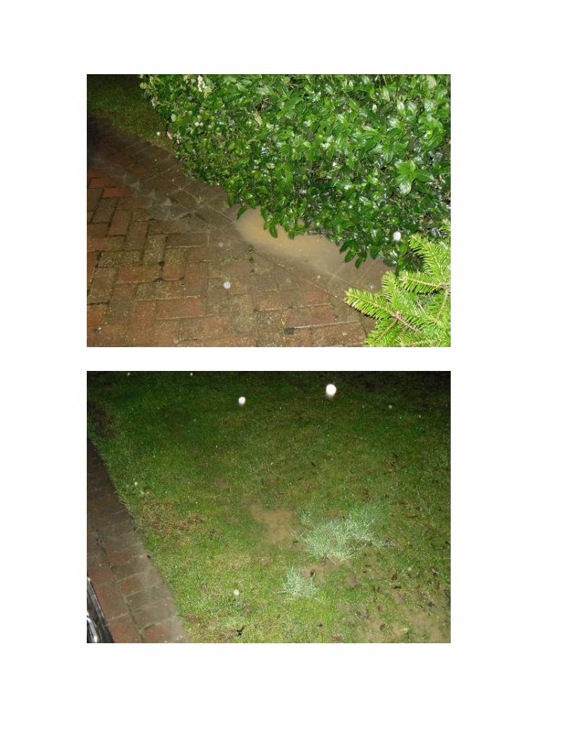
Residents photographs from flood incident 2nd January 2016 Property on Windmill Close


APPENDIX G
Photographs from flood incident investigation 22nd January 2016

Saturated catchment southwest of Windmill Close
Ponding of water in ditches south of Windmill Close

Flow of water from catchment into ditches south of Windmill Close
Informal temporary ditch to rear of properties on Windmill Close.

Informal temporary ditch to rear of properties on Windmill Close.
Informal temporary ditch to rear of properties on Windmill Close.

Informal temporary ditch to rear of properties on Paddock Road.
Ditch northeast of Paddock Road

Ditch northeast of Paddock Road
Headwall at north end of ditch northeast of Paddock Road

Sand bags at garage of property on Paddock Road.
Sandbags at rear of property on Windmill Close.