Tracking Lateral Stream Instability with Geo- Referencing Tools By Lana Potapova, E.I.T. .
Establishment geo-referencing system for mobile devices ...
18
September 2015 Session III Establishment geo-referencing system for mobile devices used in the Mexican 2014 Economic Censuses and perspectives of use for geo-referencing economic units from administrative registers
Transcript of Establishment geo-referencing system for mobile devices ...

September 2015
Session III
Establishment geo-referencing system for mobile devices used
in the Mexican 2014 Economic Censuses and perspectives of
use for geo-referencing economic units from administrative
registers

A geo-referenced Census
Directory
2009 Economic Censuses Results
+ Updates of administrative
registers
It was possible to:
• More efficiently control field operations
• Observe the changes that occured since the previous
censuses
• Update the exact location of each establishment
2015
2014 Economic Censuses
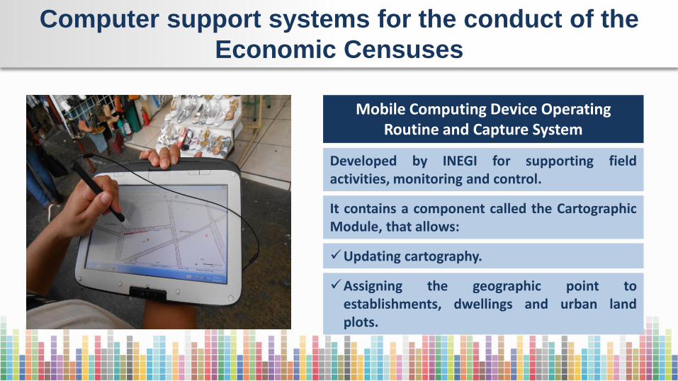
Computer support systems for the conduct of the
Economic Censuses
Mobile Computing Device Operating Routine and Capture System
Developed by INEGI for supporting field activities, monitoring and control.
It contains a component called the Cartographic Module, that allows:
Updating cartography.
Assigning the geographic point to establishments, dwellings and urban land plots.
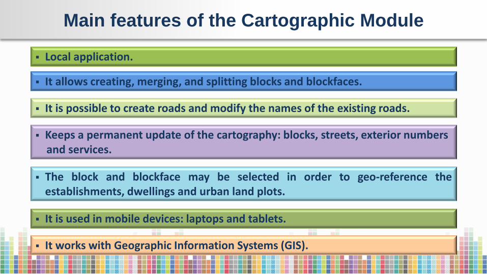
Main features of the Cartographic Module
It allows creating, merging, and splitting blocks and blockfaces.
It is possible to create roads and modify the names of the existing roads.
The block and blockface may be selected in order to geo-reference the establishments, dwellings and urban land plots.
It is used in mobile devices: laptops and tablets.
It works with Geographic Information Systems (GIS).
Keeps a permanent update of the cartography: blocks, streets, exterior numbers and services.
Local application.
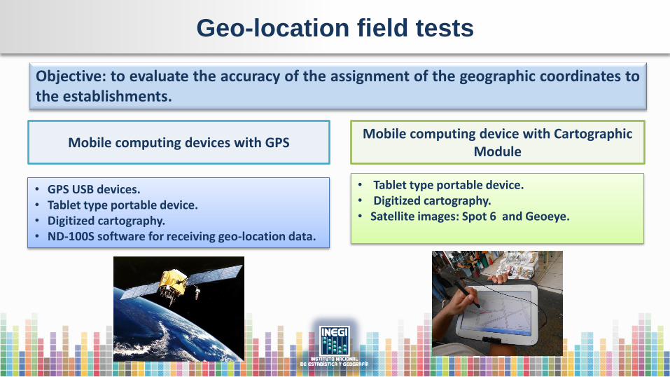
Geo-location field tests
Objective: to evaluate the accuracy of the assignment of the geographic coordinates to the establishments.
Mobile computing devices with GPS
• GPS USB devices. • Tablet type portable device. • Digitized cartography. • ND-100S software for receiving geo-location data.
Mobile computing device with Cartographic Module
• Tablet type portable device. • Digitized cartography. • Satellite images: Spot 6 and Geoeye.
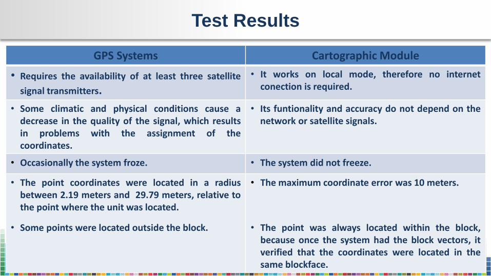
Test Results
GPS Systems Cartographic Module
• Requires the availability of at least three satellite
signal transmitters.
• It works on local mode, therefore no internet conection is required.
• Some climatic and physical conditions cause a decrease in the quality of the signal, which results in problems with the assignment of the coordinates.
• Its funtionality and accuracy do not depend on the network or satellite signals.
• Occasionally the system froze. • The system did not freeze.
• The point coordinates were located in a radius between 2.19 meters and 29.79 meters, relative to the point where the unit was located.
• Some points were located outside the block.
• The maximum coordinate error was 10 meters.
• The point was always located within the block, because once the system had the block vectors, it verified that the coordinates were located in the same blockface.
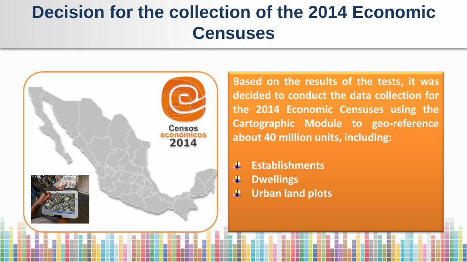
Decision for the collection of the 2014 Economic
Censuses
Based on the results of the tests, it was decided to conduct the data collection for the 2014 Economic Censuses using the Cartographic Module to geo-reference about 40 million units, including:
Establishments Dwellings Urban land plots
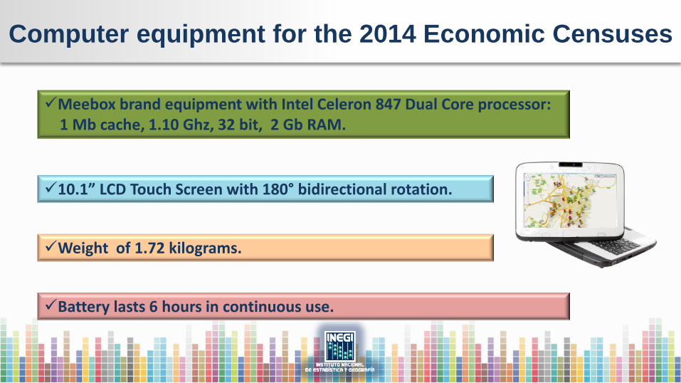
Computer equipment for the 2014 Economic Censuses
Meebox brand equipment with Intel Celeron 847 Dual Core processor: 1 Mb cache, 1.10 Ghz, 32 bit, 2 Gb RAM.
10.1” LCD Touch Screen with 180° bidirectional rotation.
Weight of 1.72 kilograms.
Battery lasts 6 hours in continuous use.

Geo-referencing procedure
Block
Three passes around the block 1. Cartographic updating.
2. Geo-referencing establishments, dwellings and urban land
plots and capture of establishments data.
3. Geo-referencing and capture of semi-fixed establishments.
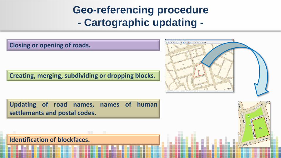
Geo-referencing procedure
- Cartographic updating -
Closing or opening of roads.
Creating, merging, subdividing or dropping blocks.
Updating of road names, names of human settlements and postal codes.
Identification of blockfaces.
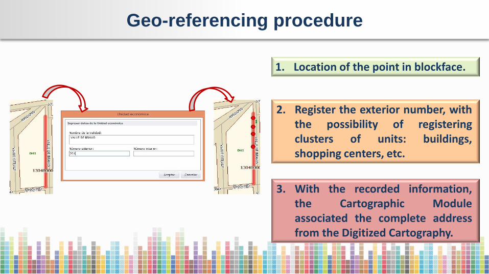
Geo-referencing procedure
1. Location of the point in blockface.
2. Register the exterior number, with the possibility of registering clusters of units: buildings, shopping centers, etc.
3. With the recorded information, the Cartographic Module associated the complete address from the Digitized Cartography.
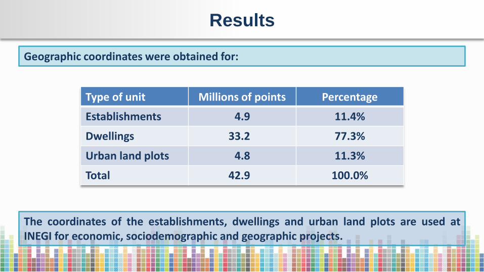
Results
Geographic coordinates were obtained for:
Type of unit Millions of points Percentage
Establishments 4.9 11.4%
Dwellings 33.2 77.3%
Urban land plots 4.8 11.3%
Total 42.9 100.0%
The coordinates of the establishments, dwellings and urban land plots are used at INEGI for economic, sociodemographic and geographic projects.

Problems encountered
A few problems were found in 0.35% of the points since they were lost during the
transmission, which were not possible to regeo-reference in the field since the
operation had already been concluded.
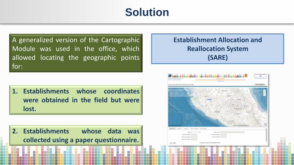
Solution
Establishment Allocation and Reallocation System
(SARE)
A generalized version of the Cartographic Module was used in the office, which allowed locating the geographic points for:
1. Establishments whose coordinates were obtained in the field but were lost.
2. Establishments whose data was collected using a paper questionnaire.

Features of SARE
It allows in-office geo-referencing the geographic point on digital cartography, based on address data.
It works with internet and has access to street view images.
It contains the layer of exterior numbers.
It is based on INEGI’s software platform.
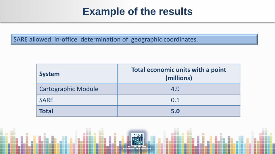
Example of the results
System Total economic units with a point
(millions)
Cartographic Module 4.9
SARE 0.1
Total 5.0
SARE allowed in-office determination of geographic coordinates.
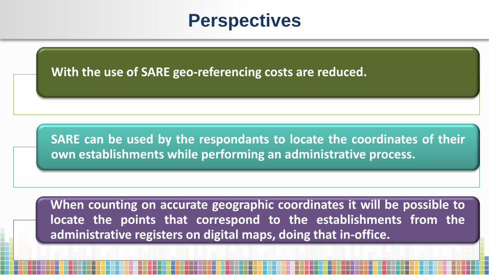
Perspectives
With the use of SARE geo-referencing costs are reduced.
SARE can be used by the respondants to locate the coordinates of their own establishments while performing an administrative process.
When counting on accurate geographic coordinates it will be possible to locate the points that correspond to the establishments from the administrative registers on digital maps, doing that in-office.

Conclusions
The Cartographic Module proved to be an accurate tool for geo-referencing units, since it reflects spatial reality on maps; however, its use is designed for field operations.
SARE, a generalized version of the Cartographic Module, represents an opportunity for in-office geo-referencing of the information from administrative registers .