D ESERT A NIMALS By : Alghaliah Abdullaziz Al hajri Grade 2/C.

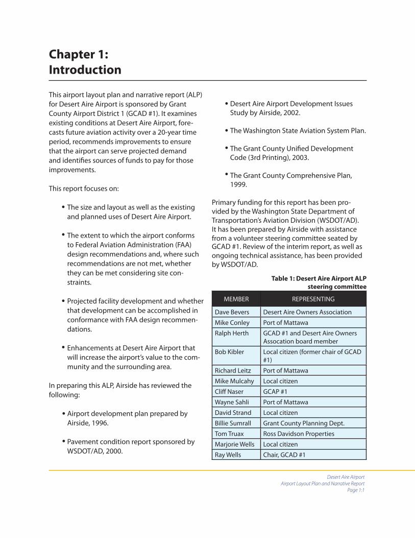
DESERT AIRE AIRPORT
AIRPORT LAYOUT PLAN AND NARRATIVE REPORT
JANUARY 2006
AIRSIDEP.O. BOX 287
GREENBANK, WA 98253 (360) 678-9249
Desert Aire Airport
Airport Layout Plan and Narrative Report
Page 1:1
Chapter 1:
Introduction
This airport layout plan and narrative report (ALP) for Desert Aire Airport is sponsored by Grant County Airport District 1 (GCAD #1). It examines existing conditions at Desert Aire Airport, fore-casts future aviation activity over a 20-year time period, recommends improvements to ensure that the airport can serve projected demand and identifi es sources of funds to pay for those improvements.
This report focuses on:
The size and layout as well as the existing and planned uses of Desert Aire Airport.
The extent to which the airport conforms to Federal Aviation Administration (FAA) design recommendations and, where such recommendations are not met, whether they can be met considering site con-straints.
Projected facility development and whether that development can be accomplished in conformance with FAA design recommen-dations.
Enhancements at Desert Aire Airport that will increase the airport’s value to the com-munity and the surrounding area.
In preparing this ALP, Airside has reviewed the following:
Airport development plan prepared by Airside, 1996.
Pavement condition report sponsored by WSDOT/AD, 2000.
Desert Aire Airport Development Issues Study by Airside, 2002.
The Washington State Aviation System Plan.
The Grant County Unifi ed Development Code (3rd Printing), 2003.
The Grant County Comprehensive Plan, 1999.
Primary funding for this report has been pro-vided by the Washington State Department of Transportation’s Aviation Division (WSDOT/AD). It has been prepared by Airside with assistance from a volunteer steering committee seated by
•
•
•
•
•
•
•
•
•
•
Table 1: Desert Aire Airport ALP
steering committee
MEMBER REPRESENTING
Dave Bevers Desert Aire Owners Association
Mike Conley Port of Mattawa
Ralph Herth GCAD #1 and Desert Aire Owners Assocation board member
Bob Kibler Local citizen (former chair of GCAD #1)
Richard Leitz Port of Mattawa
Mike Mulcahy Local citizen
Cliff Naser GCAP #1
Wayne Sahli Port of Mattawa
David Strand Local citizen
Billie Sumrall Grant County Planning Dept.
Tom Truax Ross Davidson Properties
Marjorie Wells Local citizen
Ray Wells Chair, GCAD #1
GCAD #1. Review of the interim report, as well as ongoing technical assistance, has been provided by WSDOT/AD.
Desert Aire Airport
Airport Layout Plan and Narrative Report
Page 1:2
In writing this report we have fol-lowed the guidelines of the Chicago Manual of Style and the AP Stylebook, the two most widely used stylebooks in American publishing. These style-books call for diff erent practices than are sometimes used in these kinds of plans, particularly with respect to capitalization of cities, as well as gov-ernment agencies and offi ces.
This ALP has been prepared according to WSDOT/AD guidelines contained in Appendix E of the aviation division’s Grant Procedures Manual.

CHAPTER PAGE
1 Introduction 1:1
2 Inventory and Current Activity 2:1
2.1 General 2:1
2.2 Socioeconomic Data 2:2
2.3 Land-use and planning 2:2
2.4 Airport site - general 2:4
2.5 Recent airport revitalization 2:4
2.6 Unique challenges and opportunities 2:4
2.7 Airport classifi cation – the ARC system 2:5
2.8 Existing airside facilities 2:7
2.9 Existing landside facilities 2:8
2.10 Comparison of existing conditions to FAA standards 2:9
2.11 Assessment of existing conditions relative to FAA standards 2:10
2.12 Information sources 2:13
3 Forecasts 3:1
3.1 Introduction 3:1
3.2 Terminology 3:1
3.3 Forecasting methods 3:2
3.4 Existing data 3:2
3.5 Forecasts 3:3
4 Facility Requirements and development alternatives 4:1
4.1 Introduction 4:1
4.2 Airport layout 4:1
4.3 Alternatives development 4:2
4.4 Projects and improvements 4:10
4.5 Hangar/tie-down development 4:13
4.6 Building restriction lines 4:13
4.7 Zoning and land use 4:15
5 Financial 5:1
5.1 General fi nancial information 5:1
5.2 Existing revenue and expenses 5:3
Table of Contents

PHOTOS PAGE
1 Cessna 182 2:6
2 Runway 10 painted graphic — west view 2:7
3 PAPI system — Runway 28 2:8
FIGURES
1 Existing conditions diagram 2:12
2 Grant County population growth 3:9
3 Forecast based aircraft 3:9
4 Forecast fl ight operations 3:9
5 Alternative 1 4:7
6 Alternative 2 4:8
7 Alternative 3 4:9
MAPS
1 Desert Aire Airport regional location 2:3
2 Desert Aire Airport site 2:4
TABLES
1 Desert Aire Airport ALP steering committee 1:1
2 Industry sectors 2:2
3 The ARC system 2:5
4 Airport data 2:6
5 Airport facility data 2:8
6 Comparison of FAA standards 2:10
7 FAA Form 5010 3:2
8 WSDOT/AD database 3:2
9 Based operational aircraft 3:3
10 Based aircraft annual operations 3:3
11 Grant County population 3:4
12 Additions to based aircraft and fl ight operations per period over the planning cycle
3:7
13 Forecast based aircraft 2005 - 2025 3:8
14 Forecast fl ight operations 2005 - 2025 3:8
15 Comparison of alternatives with FAA standards 4:5
16 Recommended improvements 4:14
17 Revenue 2002-2004 5:4
18 Expenses 2002-2004 and net fi nancial 5:4
19 20-year capital improvement program 5:5
20 CIP details 5:7
21 Capital expenditure by phase 5:12

DRAWINGS
T 1.1 Title sheet 6:1
C 1.1 Airport layout plan 6:2
C 1.2 Building area plan 6:3
C 1.3 Ultimate airport airspace plan 6:4
C 1.4 Ultimate airport airspace approach plan/profi le 6:5
C 1.5 Ultimate protection zone plan/profi le 6:6
C 1.6 Existing / ultimate land use and zoning 6:7
C 1.7 Exhibit A 6:8
APPENDIX
A1 Desert Aire Airport lease agreement 7:1
A2 Grant County Code Section 23.04.645 (Airport Safety Overlay) 7:11
A3 Grant County Code Section 23.08.030 (Development and use stan-dards)
7:15
A4 Runway length diagram (FAA AC 150/5325-4B) 7:17
A5 FAR Part 77.25 civil airport imaginary surfaces with WSDOT/AD dia-gram
7:18
A6 WSDOT/AD aviation land use compatibility program 7:21
A7 Northside taxiway construction estimate (Forsgren Associates Inc.) 7:24
A8 WSDOT/AD/FAA Runway Safety Grant Program 7:25
Desert Aire Airport
Airport Layout Plan and Narrative Report
Page 2:1
Chapter 2:
Inventory and Current Activity
2.1 GENERAL
Desert Aire
The community of Desert Aire is situated adjacent to the Columbia River in south-central Wash-ington State. Desert Aire is in southwest Grant County, approximately 55 miles northwest of the tri-cities of Pasco, Kennewick and Richland. The community is located 40 miles southwest of Moses Lake and 130 miles southeast of Seattle. Desert Aire is a planned unit development (PUD), organized according to Grant County statute. It has a number of amenities, including an adjacent 8,000-acre lake, formed on the Columbia River by the Priest Rapids Dam, and an 18-hole golf course. Desert Aire is adjacent to Washington State Highway 243.
Grant County
Grant County is in central Washington. The county consists of 2,675 square miles of land. It is the fourth-largest county in Washington. The county is bordered on the west by Douglas and Kittitas counties, on the southwest by Yakima County, on the south by Benton and Franklin counties, on the east by Adams and Lincoln counties and on the north by Okanogan County. Grant County is generally rural. Approximately 65 percent of the county is productive farmland. County topog-raphy ranges in elevation from 380 feet above sea level along the Columbia River to 2,882 feet above sea level at the crest of a hill near Quincy in the west part of the county.
The Port of Mattawa
The Port of Mattawa (Grant County District 3), located in Mattawa a few miles north of Desert Aire, plays a major role in industrial and com-mercial development in the region surrounding
Desert Aire Airport. The port has an industrial area, including a multi-purpose building used as a business incubator. The port serves as a catalyst in many development eff orts, including one to cre-ate additional wine growing in the region.
Desert Aire Airport
Desert Aire Airport is located east of the Colum-bia River immediately north of the Priest Rapids Dam. The airport is sited approximately in the center of the Desert Aire community and consists of 49.93 acres. Topography in the region sur-rounding the airport consists of rolling hills to the west across the Columbia River and slight rises in terrain to the east, which transition onto fl at farmland.
The airport is bounded on the west by the Co-lumbia River, on the east by Washington State Highway 243, on the south by private residences and on the north by property that is platted for private residences.
Desert Aire Airport is unique among Washington’s public-use airports in that it was originally devel-oped as a primary feature of the Desert Aire PUD and was a privately owned, private-use airport for 22 years before becoming publicly managed by District 1, which was organized in August 1994. District 1 operates the airport according to a 20-year lease agreement with the Desert Aire Own-ers Association (DAOA), which owns the property on which the airport is located. This lease agree-ment currently extends through August 2014. A copy of the lease agreement is included in the appendix to this document.
Climate
The climate in the Desert Aire area is the same as in most of Grant County. It is in Washington’s

Desert Aire Airport
Airport Layout Plan and Narrative Report
Page 2:2
Central Basin climatological region, which is semi-arid. Winters are cold. Summers are hot. The average annual temperature is 52 degrees Fahr-enheit. The mean maximum temperature is 89 de-grees Fahrenheit. Average annual rainfall in Grant County is 8.42 inches.
2.2 SOCIOECONOMIC DATA
Population
In 1910, one year after becoming a county, Grant County’s popu-lation was 8,698. Over the next 20 years the population was at times as low as 5,666. From 1930 to 1962 the county experienced rapid growth to over 54,000. Dur-ing the 1960s, Washington State followed a nationwide rural-to-ur-ban migration pattern. Population growth in Grant County slowed during this period. Population growth was erratic during the 1970s and 1980s. During the 1990s, county population in-creased considerably. Population in 2000 was 74,698.
Economy
Between 1969 and 1996, total employment in Grant County grew by 97 percent. Agriculture, includ-ing production, distribution and processing, is and has been for many years the anchor of Grant County’s economy, employing about 5,000 people. The only sectors employing larger numbers of people are services (6,272) and local government (5,533).
2.3 LAND-USE AND PLANNING
Desert Aire is located within the unincorporated area of Grant County. It continues to be devel-oped according to the Desert Aire Rural Village major development plan authorized by the county in December 2000. Elements of the master
plan include zoning districts titled Rural Village Residential, Rural Village Open Space Conserva-tion, Rural Village Residential, Rural Village Com-mercial and Rural Village Industrial. Grant County is the responsible agency for development and approval of the Grant County Comprehensive Plan and development regulations.
Industry sector Establishments Employees
Agriculture, forestry, fi shing and hunting 635 4,856
Mining * *
Utilities * *
Construction 226 753
Manufacturing 71 3,778
Wholsale trade 88 943
Retail trade 235 2,816
Transportation and warehous-ing 95 719
Information 16 176
Finance and insurance 58 417
Real estate, rental and leasing 63 217
Services 1,277 6,272
Federal government 12 615
State government 21 741
Local government 67 5,533
Not elsewhere classifi ed 10 119
Table 2: Industry sectors
Source: Washington State Employment Security Department.
Grant County Comprehensive plan, develop-
ment regulations and existing land uses
Grant County has made a consistent eff ort to protect public-use airports within the county through the adoption of comprehensive plan policies and development regulations. Policies and regulations have been codifi ed to protect its airports from adjacent incompatible develop-ment and to ensure that airports were protected as essential public facilities.

Desert Aire Airport
Airport Layout Plan and Narrative Report
Page 2:3
Map 1: Desert Aire regional location
Following is a brief de-scription of the applicable comprehensive plan poli-cies and development reg-ulations currently in eff ect. Complete texts of each of these documents may be found in the appendix to this narrative report. (See Appendix: Land-use and Zoning Documents.)
Comprehensive plan
policies
The Grant County Com-prehensive Plan describes public use airports and their importance in general terms. The inven-tory section of the plan incorrectly lists Desert Aire Airport as privately owned and operated.
Development regula-
tions
Grant County has two ordinances that protect public use airports within the County. These regula-tions apply to Desert Aire Airport.
Chapter 23.04.645 “Airport Safety Overlay (ASO)”
The purposes of the ASO are to protect critical airspace around public use airports from airspace obstructions and hazards, and to discourage incompatible land uses. This chapter recognizes Federal Air Regulation Part 77 “Objects Aff ecting Navigable Airspace.”
Chapter 23.08.030 “Performance and Use Stan-dards”The performance and use standards chapter pro-vides for future airport expansion and protects
airport facilities by establishing development standards. This chapter addresses such issues as setbacks, heights of structures, lot coverage, airport hazards, rights-of-way and parking.
Washington Growth Management Act
State legislation requires that all towns, cities and counties in which there is located a public use general aviation airport discourage incompat-ible development through comprehensive plan policies and consistent development regula-tions. This legislation is set forth in the Revised

Desert Aire Airport
Airport Layout Plan and Narrative Report
Page 2:4
Map 2: Desert Aire Airport site
Code of Washington (RCW 35.63.250, 35A.63.250, 36.70.547, and 36.70A.510). This legislation is ap-plicable to all GMA and non-GMA jurisdictions in the state.
Depending on airport characteristics, location and the amount of usable open space adjacent to a general aviation airport, incompatible land uses may include public assembly/large concentrations of people, res-idential density, intensity of nonresidential development, structure height, hazardous/explosive material, wildlife hazards, light/glare, air quality and electronic signals.
Grant County is planning under GMA RCW 36.70A.510. Code sections implemented by Grant County are in gen-eral conformance with the growth management act.
Recommendations relative to zoning and land use are contained in Chapter 4 of this report.
2.5 RECENT AIRPORT REVITALIZATION
During the last fi ve years, work that has been ac-complished on paved surfaces includes applica-tion of a seal coat to the parking apron, widening of the taxiway and crack sealing of paved sur-faces. Crack sealing of all paved surfaces is done routinely.
2.6 UNIQUE CHALLENGES AND OPPOR-
TUNITIES
To provide for a better understanding of informa-tion contained in following sections of this nar-rative it will be helpful at this juncture to discuss
additional details about unique conditions at Desert Aire Airport.
Eighteen property owners south of and adjacent to the airport’s property boundary have devel-oped taxilanes that connect to the airport’s paral-lel taxiway from their privately owned hangars.
2.4 AIRPORT SITE – GEN-
ERAL
Desert Aire Airport is located on a slight rise east of the Columbia River, south of the community of Mattawa.

Desert Aire Airport
Airport Layout Plan and Narrative Report
Page 2:5
These taxilanes, though privately constructed, are on airport property. Additional properties on the south side of the airport have the potential for direct airport access. (For a visual depiction of the airport’s property boundary and the location of these taxiways please refer to Figure 1 at the end of this chapter.)
Since lots at Desert Aire were initially off ered to the public in the early 1970s, 1,561 have been sold. It is estimated by the developer’s sales offi ce that 700 residences exist today. Recently, Desert Aire’s Division 9, Phases 5 and 6 - the so-called northside lots - have been off ered for sale. These remaining 89 lots, including 27 that are adjacent to the airport’s north property line, are the last that will be off ered to the public.
Desert Aire Airport has very little property available for commercial development and for construction of hangars and other attributes that would help GCAD #1 fund improvements and meet fi nancial match obligations for grants received from WSDOT/AD. However, the lots on the south side of the runway that have access to the airport’s taxiway or that potentially have such access, and the 27 lots in Division 9 north of the runway represent an opportunity to provide consistent income to the airport district if each of those lot owners are assessed modest annual fees for access to the airport. This is a reasonable and appropriate funding mechanism since the property owners adjacent to the airport are gain-ing the advantage of direct access to a publicly funded facility.
Both the Federal Aviation Administration (FAA) and, more pertinent to Desert Aire, WSDOT/AD have longstanding policies that discourage access to publicly funded airports from private property. Reasons for these policies are some-what complex. They include considerations related to insurance, liability, fees and fairness. In some cases, concerns of the FAA and WSDOT/AD have been mitigated by fee assessments, hold-
harmless agreements and other actions related to such access.
In June of this year, the GCAD #1 commissioners voted to impose access fees to owners of residen-tial lots that are adjacent to the airport. Mecha-nisms for their collection are currently being discussed. Such a fee structure would distribute airport fi nancial support among a large number of property owners who directly benefi t from airport access. The resulting steady and predict-able income from access fees will, if implemented, assist District 1 with its airport management responsibilities.
2.7 AIRPORT CLASSIFICATION – THE ARC
SYSTEM
Both the FAA and WSDOT/AD use what is termed the “airport reference code,” or ARC system, to categorize airports. The ARC system provides a method for applying dimensional safety and protection standards to airports according to the aircraft those airports generally serve. Dimension-al standards include such items as runway-to-taxi-way separation distances, sizes of runway safety areas (RSAs) and sizes of runway object-free areas (ROFAs). The ARC system uses the concept of a
AIRCRAFT APPROACH CATEGORY
APPROACH SPEED
AIRPLANE DESIGN GROUP
WINGSPAN
Category At or more than
Less than
Wing-span
At or more than
Less than
A 91 kts I 49’
B 91 kts 121 kts II 49’ 79’
C 121 kts 141 kts III 79’ 118’
D 141 kts 166 kts IV 118’ 171’
E 166 kts V 171’ 214’
VI 214’ 262’
Table 3: The ARC system
Source: FAA Advisory Circular 150/5300-13

Desert Aire Airport
Airport Layout Plan and Narrative Report
Page 2:6
Table 4: Airport data Name Desert Aire Airport
Location number M94
FAA Designation 26290.9.A
OwnerLessee
Desert Aire Owners AssocationGrant County Airport District #1
Range, township, county, city and state
22 E.W.M., 14N, Grant, Desert Aire, WA
Acreage 49.93 acres
Service level (on the NPIAS system) General aviation (GA)
Reference code existing A-I (Small)
Design aircraft Cessna 182
Elevation 570’
Reference point (location)NAD83 NAVD88
Latitude: N 48 deg. 41’ 14.1040”Longitude: W119 deg. 55’ 11.0140”
Mean maximum temperature 89 degrees
Approach category Visual
Navigation aids Wind indicator/rotating beacon/tetrahedron
Approach guidance PAPI - Runway 28
Wind coverage n/a
Photo 1: Cessna 182
critical aircraft, described as an air-craft that controls one or more airport design features based on the aircraft’s approach speed and wingspan. Five hundred annual itinerant operations are required for an aircraft to be consid-ered the critical aircraft for an airport.
Letter designations from A to E rep-resent fi ve aircraft approach speed categories ranging from less than 91 nautical miles per hour (knots) to 166 knots or more. Roman numeral desig-nations from I to VI represent aircraft wingspans of from less than 49 feet to 261 feet. There is a special designation, used in ARC categories A and B, for air-ports that serve aircraft weighing less than 12,500 pounds. This designation attaches the term “small” to the ARC let-ter/numeral combination.
The Washington State Continuous Air-port System Plan (WSCASP) database shows Desert Aire as having an ARC classifi cation of A-I (small). This catego-ry includes aircraft with approach speeds of 91 knots per hour or less, wingspans of less than 49 feet and weights under 12,500 pounds.
A review of Desert Aire Airport’s operations con-ducted for this plan confi rms that it does gener-ally serve aircraft in the A-I ARC category that weigh less than 12,500 pounds and that it primar-ily accommodates recreational fl ying.
A clear representative of this ARC category is the Cessna 182. The Cessna 182 has been in produc-tion for a number of years and has gone through
NPIAS
Desert Aire Airport is not listed on the National Plan of Integrated Airport Systems (NPIAS) and is therefore ineligible to apply for federal grant funds through the Federal Aviation Adminis-tration. The Washington State Department of Transportation’s Aviation Division is Desert Aire Airport’s primary source of grant funds.
Wind Coverage
Information regarding prevailing wind is not available from the National Oceanic and Atmo-spheric Administration (NOAA) for Desert Aire Air-port. Due to the absence of wind data a windrose is not provided in this plan. Local observers note
several attribute changes. It latest version has a wingspan of 36 feet, a maximum certifi ed takeoff weight of 3,100 pounds and an approach speed of less than 91 knots. The Cessna 182 is designat-ed in this plan as Desert Aire’s critical aircraft.

Desert Aire Airport
Airport Layout Plan and Narrative Report
Page 2:7
Photo 2: Runway 10 painted graphic -- west view
that prevailing winds are from the west/north-west and that, as with many areas of Washington, strong south winds are sometimes experienced. Since the runway is oriented almost directly east/west and prevailing winds are generally from the west/northwest pilots using Runway 28 experi-ence varying degrees of right-side quartering cross winds.
2.8 EXISTING AIRSIDE FACILITIES
Paved surfaces
Runway and taxiway
Desert Aire Airport has a single runway oriented on magnetic headings 010 and 280 degrees (Run-way 10/28). It is 3,665 feet long and 36 feet wide. The runway is constructed of asphalt and has a gross weight-bearing capacity of 6,000 pounds for aircraft with single-wheel main landing gear, according to a report published by Pavement Consultants Inc. in 2000. A 28-foot-wide full-length taxiway is located south of the runway. The runway-centerline-to-taxiway centerline distance is 194 feet.
The runway, taxiway and apron areas were rated as being in excellent condition in the 2000 pave-ment condition report and, although their condi-tions have degraded slightly, they are still rated as excellent in the draft of a report that will be published in early 2006.
Aircraft apron
An aircraft parking apron approximately 210 feet by 192 feet in size is located south of the taxiway at the west end of the airport. It is connected to both the end of Runway 10 and to the full-length taxiway. There are 16 aircraft parking spaces on this paved apron.
The aircraft apron has an information kiosk and telephone for the convenience of visiting pilots.
Pavement graphics
Pavement graphics include runway numerals, a white dashed centerline and hold lines at the three locations where the taxiway connects with
Taxiway refl ectors
Blue taxiway refl ectors are located throughout the taxiway system.
Wind tetrahedron
A wind tetrahedron is located east of mid-fi eld just north of the runway. The edge of the tetrahe-dron that is nearest to the runway is 56 feet from the runway’s centerline.
green threshold lights. All lights are mounted on in-ground base cans. The base cans are exposed above grade to varying degrees. An extra light at the mid-fi eld taxiway connector causes the num-ber of runway edge lights to be uneven.
Precision approach path indicator (PAPI)
A PAPI system that provides guidance during ap-proach and landing is located near the east end of the airport for use by pilots landing on Runway 28.
Wind indication
Desert Aire Airport has one lighted wind indica-tor. It is located north of the runway, east of mid-fi eld at a distance of 55 feet from the runway’s centerline.
Runway lights
The runway is equipped with 33 medium-inten-sity runway edge lights (MIRLs) and 12 split red/

Desert Aire Airport
Airport Layout Plan and Narrative Report
Page 2:8
Photo 3: PAPI system at Runway 28
2.9 EXISTING LANDSIDE FACILITIES
Structures
There are no structures within the property boundary of Desert Aire Airport.
Aircraft fuel
There is no fueling system at Desert Aire Airport.
Access road and vehicle parking
Access to the airport’s public apron is provided by Airport Way, which connects to Desert Aire Drive and ultimately to Washington State Highway 243.
Utilities
Electrical power connects to the airport at the PCL unit and at the parking apron at the west end of the airport.
Water/Sewage
There is no water delivery system and no public or self-contained sewage system within the prop-erty boundary of Desert Aire Airport. Airport maintenance equipment
No major vehicles or large items of equipment are dedicated for use at the airport.
Fencing
No fencing is installed at Desert Aire Airport.
Airport maintenance
Desert Aire Airport is primarily maintained by volunteer eff orts organized by the Desert Aire Airport Commission.
Airport feature Information
Runway
Dimensions 3,665’ x 36’
Gradient 1.1%
Surface Asphalt
Pavement strength 6,000 lbs per wheel
Marking End numerals -- center dashed lines
LIghting Edge (33)/threshold (6 per end)
Taxiway
Dimensions 3,524’ x 28’
Surface Asphalt
Marking Hold lines
Lighting/refl ectors Refl ectors
Aircraft parking apron
Dimensions 210’ x 192’
Surface Asphalt
Marking Tie-downs painted
Lighting/refl ectors None
Tie-downs 16
Fuel system
None
Table 5: Airport facility data
Airport rotating beacon/pilot controlled lighting
A rotating beacon is located south of the runway, east of mid-fi eld. It is co-located with equipment that facilitates pilot control of runway lighting (PCL).
Signage
Desert Aire Airport has retrorefl ective hold-line signs at each of the three connecting taxiways. In-formation signs are posted adjacent to the aircraft parking apron.

Desert Aire Airport
Airport Layout Plan and Narrative Report
Page 2:9
2.10 COMPARISON OF EXISTING CONDI-
TIONS TO FAA STANDARDS
An important aspect of this planning program is a comparison of FAA-recommended standards to existing conditions of Desert Aire Airport. Dimensional standards published by the FAA are intended to provide an acceptable level of airport safety. This section defi nes specifi c FAA standards and relates them to existing conditions.
Defi nitions relating to FAA standards has been obtained from FAA Advisory Circular (AC) 150/5300-13. Airport information is from the WSDOT/AD database and from on-site measure-ments and observations.
Standards defi nitions
Runway width – A runway width considered ad-equate to provide for safe aircraft operations.
Runway Safety Area (RSA) – A defi ned rectangular surface centered on a runway prepared or suit-able for reducing the risk of damage to airplanes in the event of an undershoot, overshoot or excursion from the runway.
Runway safety areas shall be: (1) cleared and graded and have no potentially hazardous ruts, humps, depressions or other surface variations; (2) drained by grading or storm sewers to pre-vent water accumulation; (3) capable, under dry conditions, of supporting snow removal equip-ment, aircraft rescue and fi refi ghting equipment, and the occasional passage of aircraft without causing structural damage to the aircraft; and (4) free of objects, except for objects that need to be located in the RSA because of their function. Objects higher than 3 inches above grade should be constructed, to the extent practicable, on low-impact resistant supports (frangible mounted structures) of the lowest practical height with the frangible point no higher than 3 inches above grade. Other objects, such as manholes, should
be constructed at grade. In no case should their height exceed 3 inches above grade.
Runway safety areas, including their conditions and their protection, are one of the highest priori-ties of both the FAA and WSDOT/AD.
Runway Object-Free Area (ROFA) – An area on the ground centered on a runway provided to en-hance the safety of aircraft operations by being free of objects, except for objects that need to be located within the ROFA for air navigation or aircraft ground maneuvering purposes.
Shoulder – An area adjacent to the edge of run-ways, taxiways or aprons providing a transition between pavement and the adjacent surface, support of aircraft running off the pavement, enhanced drainage and blast protection.
Taxiway Safety Area (TSA) – A defi ned rectangular surface centered on a taxiway prepared or suit-able for reducing the risk of damage to airplanes unintentionally departing from a taxiway.
Taxiway Object-Free Area (TOFA) – An area on the ground centered on a taxiway provided to enhance the safety of aircraft operations by being free of objects, except for objects that need to be located within the TOFA for air navigation or aircraft ground maneuvering purposes.
Runway-to-taxiway separation – A distance be-tween a runway centerline and an adjacent taxi-way centerline considered adequate to protect operating aircraft.
Runway centerline-to-holding-position marking – A distance considered adequate to provide protec-tion between aircraft using an active runway and aircraft waiting for takeoff from that runway.
Runway Protection Zone (RPZ) – RPZs enhance the protection of people and property on the

Desert Aire Airport
Airport Layout Plan and Narrative Report
Page 2:10
Comparison of FAA standards for A-1 (Small) airport
to existing conditions
FAA standard Dimension relative to Desert
Aire Airport
Existing condition at Desert Aire Airport
Runway length* 2,800’ (75%)3,300’ (95%)
3,900’ (100%)
3,665’
Runway width 60’ 36’
Runway safety area 120’x4,145’ 120’x4,000’District 1 does not have
control over all the property encompassed by the RSA. Grading and compacting are required. The lighted
wind indicator and elements of the wind tetrahedron are
within the RSA.
Runway object-free area 250’x4,145’ 250’x4,000’District 1 does not have
control over all the property ecompassed by the ROFA. The lighted wind indicator and elements of the wind tetrahedron are within the
ROFA.
Shoulder 10’ 10’
Taxiway width 25’ 28’
Taxiway safety area width 49’ 49’
Taxiway object-free area width
89’ 89’
Runway to taxiway separa-tion
150’ 194’
Runway centerline-to holding position marking
125’ 61’
Runway protection zone 250’x1,000’x450’ Portions of the RPZ are not under control of GCAD #1.
Runway centerline-to-aircraft parking area
125’ 202’
Table 6: Comparison of FAA standards
* Length of runway to accommodate 75 percent, 95 percent and 100 percent of a
group of aircraft weighing fewer than 12,500 pounds. Source, AC 150/5325-4A.
ground. This is achieved through airport owner control over RPZs. Owner control includes clear-ing of RPZ areas of incompatible objects and activities. Control is preferably exercised through the acquisition of suffi cient property interest in the RPZ.
Runway centerline-to-aircraft-parking area – A distance con-sidered suffi cient to protect operating aircraft, parked aircraft and activities occurring around parked aircraft.
2.11 ASSESSMENT OF
EXISTING CONDITIONS
RELATIVE TO FAA DESIGN
STANDARDS
Runway length
Desert Aire’s runway, according to FAA data, is able to accommo-date approximately 95 percent of the aircraft fl eet having maxi-mum certifi ed takeoff weights of less than 12,500 pounds. Infor-mation from the FAA’s computer model related to runway length versus aircraft that may be ac-commodated is contained in the appendix to this narrative.
Runway width
At 36 feet, the width of the airport’s runway is 24 feet less than the FAA standard.
Runway safety area
The runway safety area is not in conformance with the FAA standard due to rough terrain and locations of the lighted wind indicator and wind
tetrahedron. Portions of the RSA that are at each end of the runway are outside the airport’s prop-erty boundary.

Desert Aire Airport
Airport Layout Plan and Narrative Report
Page 2:11
Runway object-free area
The area encompassing the runway object-free area is in general conformance with the FAA standard. The lighted wind indicator and tetrahe-dron are, however, within the ROFA. Portions of the ROFA that are at each end of the runway are outside the airport’s property boundary.
Runway centerline-to-taxiway centerline
The FAA standard for A-1 (small) airports is 150 feet from runway centerline-to-taxiway center-line. This distance at Desert Aire Airport is 194 feet. This standard is exceeded by 44 feet.
Runway shoulder
The runway shoulder area of 10 feet is in general conformance with the relevant standard. Ad-ditional grading and compaction are required to fully meet this standard.
Taxiway hold-line standards
The FAA standard from runway centerline to hold line is 125 feet. The existing distance is 61 feet, considerably less than this standard.
Taxiway safety area
The airport controls all of the property that encompasses the taxiway safety area. This area should be graded and compacted in order to con-form to the taxiway safety area standard.
Taxiway object-free area
Desert Aire Airport is in compliance with the taxi-way object-free area standard.
Runway Protection Zone (RPZ)
The Runway 28 RPZ is in conformance with the FAA standard in terms of property use. Uses to which the RPZs are put should not generate large gatherings of people. The east end of the RPZ extends over Washington State Highway 243. The Runway 10 RPZ is also in general conformance with the standard. Approximately one-half of this
RPZ encompasses a portion of the Desert Aire Golf Course. Large portions of both RPZs are not under GCAD #1 control.
Runway centerline to aircraft parking
The north edge of the existing aircraft parking area is 202 feet from the runway centerline. The relevant standard is 125 feet. This standard is exceeded.

Desert Aire Airport
Airport Layout Plan and Narrative Report
Page 2:12
Figure 1: Existing conditions autocad diagram
Desert Aire Airport
Airport Layout Plan and Narrative Report
Page 2:13
2.12 INFORMATION SOURCES
Sources of information provided in this chapter include:
Washington State Department of Transpor-tation/Aviation Division airport database.
Federal Aviation Administration (FAA) Form 5010.
1996 airport development plan by Airside.
Pavement Consultants Inc. pavement report dated June 2000
Interviews with airport manager
•
•
•
•
•
Desert Aire Airport
Airport Layout Plan and Narrative Report
Page 3:1
Chapter 3:
Forecast
3.1 INTRODUCTION
This chapter forecasts numbers of based aircraft and annual aircraft operations at Desert Aire Airport in fi ve-year intervals over a 20-year plan-ning period. A future airport reference code (ARC) based on forecast data is identifi ed.
The forecasting process is an important one for a number of reasons. Forecasts will help District 1, in consideration of the requirements of the Port of Mattawa and Grant County, plan the airport’s future. Understanding future demand that may result from factors both within and outside of lo-cal infl uences will help these entities make better decisions about capital improvements.
Forecasts are also vital to the funding of those improvements. As stated, Washington State Aviation is Desert Aire Airport’s primary source of grant funds for the airport’s operational areas. Though the Aviation Division has made consider-able progress over the last few years with respect to the grant process and to the amount of funds available, it continues to have less money than is needed to meet project demands. Consequently, the division must carefully prioritize grants. Forecasts assist WSDOT/AD with these funding decisions.
Capital projects that are necessary to correct conditions that negatively impact safety and proj-ects that maintain investment in infrastructure, especially paved surfaces, should be funded as money is available regardless of forecasts. How-ever, major development that enhances airport operational capability will be made only after careful evaluation of necessity based on logically quantifi ed future need.
Forecasts are also important to organizations interested in fi nancing features of airports that
are not generally funded by WSDOT/AD. Both the Washington State Department of Commu-nity Trade and Development (CTED) and the U.S. Department of Commerce’s Economic Develop-ment Administration are fi nancial resources for projects, such as utility infrastructure and road construction, that are necessary to support devel-opment of airport-related and airport-compatible businesses on and adjacent to airport property. These entities, as well as the Port of Mattawa, are interested in funding projects that create jobs and that improve incomes.
It is a primary recommendation of this plan that, after it is published, District 1 update and com-municate its activity-level forecast as conditions indicate it is appropriate to do so. For instance, if a new manufacturing business that operates one or more aircraft moves to the area, the resulting increase in based aircraft and annual operations should be added to the forecast and communi-cated to WSDOT/AD. This will help Desert Aire Air-port maintain its appropriate place in the Aviation Division’s priority list. Also, this information will be useful during the next update to this airport layout plan. Forecasting by professionals has become a highly refi ned art but it is still, at best, guessing. Tracking and noting actual conditions that alter forecasts help refi ne this process.
3.2 TERMINOLOGY
Terms used in this section that require defi nition are:
Aircraft operation: A takeoff or a landing.
Local aircraft operation: Aircraft operating in an airport’s traffi c pattern or aircraft known to be departing to or arriving from local practice areas.
Itinerant aircraft operation: All other operations.

Desert Aire Airport
Airport Layout Plan and Narrative Report
Page 3:2
Table 7: FAA Form 5010
Fleet Mix
Based aircraft 2003Operations 2003
Single-engine 7 GA local 100
Multi-engine 0 GA itinerant 1,000
Turboprop 0 Air carrier 0
Glider 0 Air taxi 0
Ultralight 0 Commuter 0
Rotorcraft 0 Military 0
Total 7 Total 1,100
Source: FAA Form 5010.
Table 8: WSDOT/AD database
3.3 FORECASTING METHODS
To determine the most accurate forecast of future airport operations, this plan begins with quantify-ing existing conditions, including the numbers and types of based aircraft, estimating local and itinerant fl ight operations, and determining county and local population and other pertinent data. Next, factors that are likely to infl uence fu-ture demand are identifi ed. These factors include population projections for Grant County over the planning period as well as projections made by state agencies about economic development in the region served by Desert Aire Airport. Forecast information produced by WSDOT/AD and the FAA is also considered.
Other issues that may impact changes in airport activity are then evaluated. These include (1) development specifi c to the Mattawa/Desert Aire area, (2) Desert Aire Airport’s airport-based residential growth, (3) changes in pilot rules recently promulgated by the FAA and (4) the impacts of airport development.
For purposes of this narrative report, the term “based aircraft” refers to aircraft that are tied down on the airport’s existing apron or stored on private prop-erty adjacent to the airport and that have direct access to the airport’s taxiway.
3.4 EXISTING DATA Existing data about based aircraft and annual fl ight operations are available from three sources: the FAA’s Airport Master Record, also called Form 5010, last updated in April 2003; the WSDOT/Avia-tion Division database, last updated in 2002; and
data provided by the airport layout plan steering committee.
Information from these sources is shown in tables 7-9.
Fleet Mix Annual Operations
Based A/C Existing 2002
Projected 2005
Existing 2002
Projected 2005
Single-engine 7 10 GA local 100 150Multi-engine 0 0 GA itinerant 1,000 1,500Turboprop 0 0 Air carrier 0 0
Glider 0 0 Air taxi 0 60Ultralight 0 0 Commuter 0 0Rotorcraft 0 0 Military 0 60Total 7 10 Total 1,100 1,650
Source: Washington State Department of Transportation/Aviation Division WSCASP database.
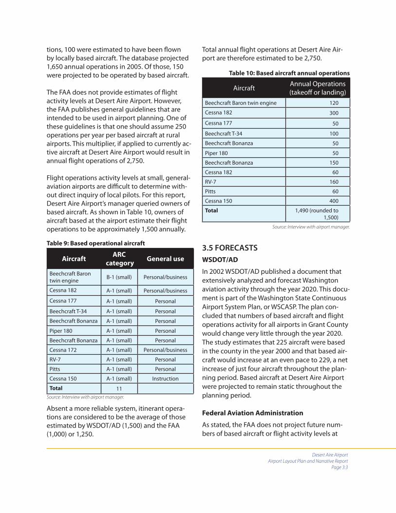
Determination of based aircraft baseline
Information provided by the airport manager, as shown in Table 9, will be used as the based aircraft baseline for this document. Eleven opera-tional aircraft are based at Desert Aire Airport.
Determination of fl ight operations activity
baseline
The WSDOT/AD database estimated a total of 1,100 annual operations in 2003. Of those opera-
Desert Aire Airport
Airport Layout Plan and Narrative Report
Page 3:3
Table 9: Based operational aircraft
AircraftARC
categoryGeneral use
Beechcraft Baron twin engine B-1 (small) Personal/business
Cessna 182 A-1 (small) Personal/business
Cessna 177 A-1 (small) Personal
Beechcraft T-34 A-1 (small) Personal
Beechcraft Bonanza A-1 (small) Personal
Piper 180 A-1 (small) Personal
Beechcraft Bonanza A-1 (small) Personal
Cessna 172 A-1 (small) Personal/business
RV-7 A-1 (small) Personal
Pitts A-1 (small) Personal
Cessna 150 A-1 (small) Instruction
Total 11Source: Interview with airport manager.
Aircraft Annual Operations (takeoff or landing)
Beechcraft Baron twin engine 120
Cessna 182 300
Cessna 177 50
Beechcraft T-34 100
Beechcraft Bonanza 50
Piper 180 50
Beechcraft Bonanza 150
Cessna 182 60
RV-7 160
Pitts 60
Cessna 150 400
Total 1,490 (rounded to 1,500)
Table 10: Based aircraft annual operations
Source: Interview with airport manager.
tions, 100 were estimated to have been fl own by locally based aircraft. The database projected 1,650 annual operations in 2005. Of those, 150 were projected to be operated by based aircraft.
The FAA does not provide estimates of fl ight activity levels at Desert Aire Airport. However, the FAA publishes general guidelines that are intended to be used in airport planning. One of these guidelines is that one should assume 250 operations per year per based aircraft at rural airports. This multiplier, if applied to currently ac-tive aircraft at Desert Aire Airport would result in annual fl ight operations of 2,750.
Flight operations activity levels at small, general-aviation airports are diffi cult to determine with-out direct inquiry of local pilots. For this report, Desert Aire Airport’s manager queried owners of based aircraft. As shown in Table 10, owners of aircraft based at the airport estimate their fl ight operations to be approximately 1,500 annually.
Absent a more reliable system, itinerant opera-tions are considered to be the average of those estimated by WSDOT/AD (1,500) and the FAA (1,000) or 1,250.
Total annual fl ight operations at Desert Aire Air-port are therefore estimated to be 2,750.
3.5 FORECASTS
WSDOT/AD
In 2002 WSDOT/AD published a document that extensively analyzed and forecast Washington aviation activity through the year 2020. This docu-ment is part of the Washington State Continuous Airport System Plan, or WSCASP. The plan con-cluded that numbers of based aircraft and fl ight operations activity for all airports in Grant County would change very little through the year 2020. The study estimates that 225 aircraft were based in the county in the year 2000 and that based air-craft would increase at an even pace to 229, a net increase of just four aircraft throughout the plan-ning period. Based aircraft at Desert Aire Airport were projected to remain static throughout the planning period.
Federal Aviation Administration
As stated, the FAA does not project future num-bers of based aircraft or fl ight activity levels at

Desert Aire Airport
Airport Layout Plan and Narrative Report
Page 3:4
Table 11: Grant County population
Year Population
1990 54,798
2000 74,698
2003 77,100
2005 87,238 (projected)
2010 96,502 (projected)
2015 104,523 (projected)
2020 111,029 (projected)Source: Offi ce of Financial Management, 2003.
Desert Aire Airport. The FAA does, however, pub-lish other useful forecasting information.
According to the FAA, the number of U.S.-based active general-aviation aircraft is expected to increase at an average annual growth rate of 0.5 percent through the year 2025. Most of this growth is attributed to business-type aircraft. Sin-gle-engine piston aircraft, those most applicable to Desert Aire Airport, are expected to increase in numbers at a rate of 0.2 percent. Flight hours are expected to increase at a faster rate than the aircraft fl eet, 1.5 percent annually through 2014 and then 1.2 percent annually through 2025. These modest numbers, when applied to Grant County and to Desert Aire Airport, seem to paral-lel estimates by WSDOT/AD.
Conclusions based on WSDOT/AD, FAA and
actual data
Projections by WSDOT/AD and the FAA indicate very limited growth in based aircraft and fl ight operations over the planning period.
Population and income projections
Grant County has experienced slow and at times erratic growth in population over the past de-cade. Washington State analysts project that the county’s population will continue to grow and do so more steadily into the foreseeable future. With a current population of 87,238 the county has 32,440 (59 percent) more people than it did in 1990. State analysts project that the county will gain another 23,791 people to over 111,000 by the year 2020.
Grant County has also experienced steady growth in household income. In current dollars, median household income has risen from $24,217 in 1990 to $36,083 in 2004. (Washington State Offi ce of Financial Management, “Median Household Income Estimates by County: 1989 to 2003 and Projection for 2004”). Per capita personal income in the county has risen from $19,408 in 1999 to $21,756 in 2003, according to the U.S. Depart-
ment of Commerce’s Bureau of Economic Analy-sis. (http://www.bea.doc.gov/bea/regional/reis/drill.cfm) While the average annual growth rate in personal income has been 7.7 percent since 1990, the rate has slowed in recent years, and managed only 3.4 percent in 2002-2003.
Though Grant County’s personal income growth rate has recently slowed, it is important to note that during the period from 1990 to 2003 it grew, in current dollars from $14,621 to $21,756. Aver-age income is less in Grant County than it is in more populated areas of Washington state but there is evidence of relatively consistent improve-ment.
If, as expected, Grant County’s population and in-come continue to grow they will almost certainly entail greater demands for airport services.
Additional factors
Airport forecasts should take into account specifi c local conditions and other factors to the extent that the information used is logical, reasonable and credible. The factors included in this section are considered to meet this test. These local con-ditions and factors relate to:
Growth in the Mattawa/Desert Aire areaDesert Aire’s developmentAlterations to FAA rules regarding pilots Airport improvements
••••

Desert Aire Airport
Airport Layout Plan and Narrative Report
Page 3:5
Growth in the Mattawa/Desert Aire area
The Port of Mattawa and other organizations are pursuing development of areas adjacent to Des-ert Aire and Mattawa. Much of this development is based on agriculture; some on light-industrial and high-technology industries.
The Port of Mattawa was formed in 1958. It ac-quired 53 acres west of Mattawa in the mid-1970s for future development. In 2000, on the 53-acre site, 6,800 square feet of incubator space was constructed to support new businesses. During the 2001-2003 time period two additional build-ings of 6,000 square feet each were built and are now fully occupied. Sewer, water and road construction projects valued at almost $400,000 that are necessary to support future development in the 53 acre site have been installed.
In the mid-1990s, 100 acres near Mattawa were acquired and developed by the port as an indus-trial park to support controlled atmosphere stor-age for the local fruit industry. Those 100 acres have been sold to private fi rms.
Over 5,000 acres of land have recently been dedi-cated to growing wine grapes. This development is representative of a trend to increasingly posi-tion the Mattawa/Desert Aire area as a premier wine growing region. Currently a new winery is being constructed in the port’s industrial park. It is anticipated that this wine growing region will have its own wine-region identity, a so-called ap-pellation.
Additionally, the port is currently engaged in leas-ing 53 acres of space south of Mattawa for light industrial uses.
EnCana, an energy development fi rm based in Calgary, Alberta is drilling a natural gas test well seven miles east of Mattawa. If this well justifi es activation of this potential gas fi eld, up to 50 wells could be established over the next fi ve-year period. If this area becomes a productive source
of natural gas, EnCana will ship the gas by pipe-line or truck, construct a combustion turbine generator for electrical production or accomplish some combination of both. This project is in its speculative stage. EnCana has drilling rights over 800,000 acres of property in several Washington counties within which it is investigating natural gas sources. Anticipated impact on forecast
Business development activities in the Mat-tawa/Desert Aire area are not likely to result in dramatic increases in airport activity. Agricultural and agricultural product storage facilities are not the kinds of businesses that have direct aviation connections except for spray activities and those, if they develop, will likely be based at private airfi elds. EnCana management stated during a recent interview that even if the Mattawa-area gas wells are developed it is unlikely that their ac-tivation will result in routine usage of Desert Aire Airport based on their experience in other areas.
Nevertheless, both general development activi-ties and the EnCana project are representative of increasing levels of attention by business inter-ests in the Mattawa/Desert Aire area. Growth and business development specifi cally oriented to the area around Desert Aire Airport is expected to have a minor but steady infl uence on based aircraft as well as local and itinerant fl ight opera-tions over the planning period.
This plan projects one additional locally based aircraft and an additional 100 local and 50 itiner-ant operations per year throughout the planning period that will be attributed to business devel-opment in the Mattawa/Desert Aire area.
Desert Aire’s development
Approximately 700 residences exist in the Desert Aire community. The population is estimated at 1,100. A number of lots that have been purchased have not yet been developed. Division 9, Phases 5 and 6, located north of the runway have been

Desert Aire Airport
Airport Layout Plan and Narrative Report
Page 3:6
platted for an additional 89 residences. Twenty-seven of the Division 9 residential lots will have direct access to the runway via a taxiway that the developer of Desert Aire has decided to fund. It is logical to assume that many of Desert Aire’s projected ultimate population of 4,500 to 5,000 will be focused on golf, aviation or both since the community’s golf course and airport are such predominant features of the planned unit devel-opment (PUD).
At the northeast corner of Desert Aire Airport is a six-acre, commercially zoned parcel that is owned by the Desert Aire Owners Association (DAOA). Consideration has been given to dedicating this area to airport use. Potential uses for this prop-erty, as more thoroughly explained in Chapter 4, would be aircraft tie-downs, storage hangars and airport-compatible commercial enterprises.
Anticipated impact on forecast
Growth in the community of Desert Aire will have a direct, moderate and steady impact on both based aircraft and fl ight operations over the planning period. The airpark-like setting of Desert Aire Airport allows for a more predictable link between population growth and airport activity levels than is experienced at most general avia-tion airports.
An additional two aircraft per year and an ad-ditional 300 local fl ight operations per year are predicted by this plan between the years 2005 to 2010. For the remainder of the planning period, one aircraft per year and 150 additional fl ight operations are forecast.
Alterations to FAA rules regarding pilots
Rules recently promulgated by the FAA allow owners of several categories of ultralight aircraft to register those aircraft in a new category called “light sport.” Light-sport aircraft are expected to substantially add to the numbers of based aircraft and fl ight operations at U.S. airports. It is logi-cal to assume that pilots in this category will, in
general, prefer to operate from airports such as Desert Aire that have low-activity levels, are non-towered and that have an abundance of adjacent, uncontrolled airspace. The light-sport category of aircraft seems to be particularly well suited to airports such as Desert Aire with its private access to a taxiway/runway system.
Anticipated impact on forecast
The sport-pilot category is expected to increase the based aircraft census by eight aircraft be-tween 2005 and 2025. Annual operations are expected to increase at a rate of 150 per based aircraft. Itinerant operations are expected to increase at a rate of 100 per fi ve-year cycle.
Airport Improvements
Though typical planning procedures call for air-port improvements, especially those that increase airport capacity, to be justifi ed by demand, it is logical to assume that improvements might have some impact on actually generating demand. The community of Desert Aire is attractive to those who enjoy relaxed lifestyles in sunny climates. It is also attractive to those who enjoy airpark-style living. It is logical to assume that capital improvements that cause Desert Aire Airport to be increasingly attractive, effi cient and functional will create additional demand on airports facili-ties and services.
It is, therefore, a conclusion of this narrative that alterations to the airport’s layout, operating fea-tures and operational capability are likely to have a general, supportive impact on the aircraft cen-sus as well as based and itinerant activity levels.
Basic layout improvements would include the full-length, northside taxiway mentioned earlier, a widened runway, additional tie-downs, han-gars and a fuel system. Operating features would include a precision approach path indicator (PAPI) system to serve Runway 10. These improvements are more fully explained in Chapter 4.

Desert Aire Airport
Airport Layout Plan and Narrative Report
Page 3:7
It is possible that Desert Aire Airport would increase its share of all aircraft based in Grant County if it were to improve the airport as de-scribed. Market share is not considered a major factor, however, because drive distances between Desert Aire Airport and other county airports are too extensive to assume that improvements will draw aircraft based elsewhere.
As indicated in Table 11, Grant County’s popula-tion in 1990 was 54,798. In 2005 it is estimated to be 87,238. It is expected to grow to 111,029 by the year 2020. This amounts to an average of approximately 1,874 additional people per year over the 30-year period. If this rate were projected to the year 2025, the last year of the time period addressed in this plan, the county will have a population of more than 120,000. Almost 33,000 residents, 38 percent, will have been added to Grant County between 2005 and 2025.
This raises a question about where this increased population will reside. Moses Lake is the largest city in the county, with 15,730 residents. The next largest city, Ephrata, has only 6,855 residents. The remainder of the county’s population is widely dispersed. Due to the county’s expected continu-ing focus on agricultural products and facilities to support them it is likely that the county’s popula-tion will continue to grow in a dispersed manner and that the Mattawa/Desert Aire region, external
of Desert Aire itself, will grow at least propor-tionately with the county as a whole. Airport improvements, though generally supportive of airport operations, are not considered by this forecast to impact numbers of based aircraft or fl ight operations.
Forecast of based aircraft and operations
Based aircraft
Eleven aircraft are currently based at Desert Aire Airport. Forecasts by WSDOT/AD and the FAA expect no growth. If this were the extent of our forecast we would assume that throughout the 20-year planning period Desert Aire Airport will continue to be home to about 12 to 15 aircraft. This plan, however, assumes that the factors iden-tifi ed earlier in this section will have an impact on the based aircraft census. The impacts of each of these factors on based aircraft over the plan-ning period are shown in Table 12. Table 13 shows these impacts cumulatively.
Annual operations
As explained earlier in this section, current annual fl ight operations resulting from both based and itinerant activity are assumed to be 2,750. Table 12 indicates the impacts each of the factors iden-tifi ed in this section are expected to amount to. Tables 13 and 14 apply these additions to fl ight operations over the planning period.
Table 12: Additions to based aircraft and annual fl ight operations over the planning period
Factor
2005-2010 2010-2015 2015-2020 2020-2025
Based
aircraft
Local
Ops
Itiner-
ant Ops
Based
aircraft
Local
ops
Itiner-
ant ops
Based
aircraft
Local
ops
Itiner-
ant ops
Based
aircraft
Local
ops
Itiner-
ant ops
Local growth 5 500 250 5 500 250 5 500 250 5 500 250
DA develop-ment
10 1,500 0 5 750 0 5 300 0 5 750 100
Sport pilot 2 300 100 2 300 100 2 300 100 2 300 100
Totals 17 2,300 350 12 1,550 350 12 1,550 350 12 1,550 350

Desert Aire Airport
Airport Layout Plan and Narrative Report
Page 3:8
Based aircraft by
type2005 (1) 2010 2015 2020 2025
Single-engine 10 26 37 49 61
Multi-engine 1 2 3 3 3
Helicopter 0 0 0 0 0
Total based aircraft 11 28 40 52 64
Average annual per-centage increase 31 9 6 5
Table 13: Forecast based aircraft 2005-2025
(1) Actual current
Table 14: Forecast annual fl ight operations 2005-2025
Operations 2005 (1) 2010 2015 2020 2025
Single-engine 2,630 5,150 6,925 8,825 10.725
Multi-engine 120 250 375 375 375
Helicopter 0 0 0 0 0
Total operations 2,750 5,400 7,300 9,200 11,100
Average annual percentage increase in total operations 19 7 5 4
Local operations 1,500 3,800 5,350 6,900 8,450
Average annual percentage increase in local operations 31 8 6 4
Itinerant operations 1,250 1,600 1,950 2,300 2,650
Average annual percent-age increase in itinerant operations
6 4 4 3
(1) Estimated current
The above tables and graphs indicate moderate growth of based aircraft and fl ight operations over the planning period. These forecasts are based on anticipated development activities by the Port of Mattawa, expected continuing popu-lation increases, expected advances in median household income, continuing development of lots with direct access to Desert Aire’s runway and changes in FAA rules regarding the light-sport category of aircraft. Growth in numbers of based aircraft and based aircraft fl ight operations is weighted in favor of the 2005 to 2010 time period due to the activation of Division 9 – the northside lots – and construction of the northside taxiway.
Airport fl eet mix
The fl eet mix at Desert Aire Airport is forecast to continue to be dominated by single-engine air-craft due to the airpark setting. Additions to the fl eet mix will be light-sport aircraft.
Airport reference code
Forecast aircraft continue to support an ARC category of A-I (small). Technological advances and sport pilot rules are not likely to change this designation.

Desert Aire Airport
Airport Layout Plan and Narrative Report
Page 3:9
1990 2000 2005 2010 2015 2020 2025
50
60
70
80
90
100
110Po
pula
tion
in th
ousa
nds
Year
Figure 2: Grant County Population Growth Estimated bythe Washington State Office of Financial Management in 2003
Figure 3: Forecast of Based Aircraft at Desert Aire Airport
Figure 4: Forecast of Annual Flight Operations at Desert Aire Airport
120
2
4
6
8
10
12
14
Thou
sand
s of
Flig
htO
pera
tions
Year
2015 2020 20252005 2010
Num
bers
of A
ircra
ft
Year
10
20
30
40
Single engine
Multi engine
Non-traditional
Total
2015 2020 20252005 2010
50
60
70
80
Desert Aire Airport
Airport Layout Plan and Narrative Report
Page 4:1
Chapter 4:
Facility requirements and development alternatives
4.1 INTRODUCTION
This chapter uses information from Chapters 2 and 3, data gathered during site visits, and sug-gestions from the ALP steering committee to develop a list of recommended improvements at Desert Aire Airport over the planning period. Projects listed are intended to increase safety, accommodate forecast demand and provide a transportation facility that is aesthetically pleas-ing and accommodating to local citizens and visitors. Information about the timing of projects is at the end of the chapter. Estimated expenses associated with recommendations are contained in Chapter 5.
As stated in Chapter 3, the Cessna 182 and the A-1 (small) group of aircraft it represents is identi-fi ed as the design aircraft throughout the plan-ning period. Additional kinds of aircraft that may use Desert Aire Airport are light sport aircraft and variations of aircraft based on advancing tech-nologies.
FAA recommendations related to design stan-dards that are contained in Advisory Circular 150/5300-13 have been applied.
4.2 AIRPORT LAYOUT
Runway length/width
The existing runway at Desert Aire Airport is 3,665 feet long and 36 feet wide. For small, single-en-gine aircraft this runway length is generally ad-equate. According to the FAA’s computer model, the airport is able to accommodate over 95 percent of the general aviation fl eet weighing less than 12,500 pounds. Runway width - at 36 feet - is 24 feet less than the FAA’s runway width design standard of 60 feet.
To put the “95 percent of the fl eet” comment in context, the A-1 (small) fl eet includes aircraft that weigh up to 12,500 pounds. Though it is an unusual inclusion, aircraft such as the Mitsubishi MU-2P, high-performance multi-engine turbo-prop are considered A-1 small aircraft. Most of the aircraft using the airport now and that are expected to use the airport in the future weigh considerably less and require less runway length than those few airplanes that are at the upper end of this category. Consequently, it is logical to assume that Desert Aire’s runway is long enough to accommodate nearly all of the A-1 (small) aircraft fl eet under most temperature and aircraft loading conditions.
Northside taxiway
The developer of Desert Aire stated in November 2005 that all 27 of the so-called northside lots are “spoken for.” He explained that he is holding deposits on each lot but cannot legally sell them until permission is provided by GCAD #1 for ac-cess to the runway. When asked what percentage of the anticipated lot owners will have aircraft he stated “most of them.” Airside and the developer determined that it is appropriately conservative to state in this plan that at least a majority of the lot owners plan to have or do have aircraft.
Development of a northside taxiway is, therefor, logical considering forecast increases of based aircraft, Desert Aire’s airpark-style layout, and the absence of airport property on which to construct tie-downs and hangars. A northside taxiway – which would be cosntructed primarily with the developer’s funds – would continue to facilitate Desert Aire’s storage of active aircraft on private property. Such storage and access are reasonable, considering the planned access fees mentioned in Chapter 3.

Desert Aire Airport
Airport Layout Plan and Narrative Report
Page 4:2
To provide a safety margin, the northside taxiway will be constructed so that its taxiway object-free area (TOFA) is approximately 3 feet south of the property boundaries of adjacent Division 9 lots. The distance between the northside taxiway centerline and the existing runway centerline will therefor be 134 feet, 16 feet less than the FAA recommended standard. This reduction in center-line-to-centerline distance is not considered to be a safety hazard and is anticipated to be tempo-rary as is explained further in this chapter.
4.3 ALTERNATIVES DEVELOPMENT
The overall conformation of Desert Aire Airport has been reviewed and discussions with the ALP steering committee regarding the existing and future airport layout have resulted in consider-ation of three development alternatives. Con-sidering the layout and site constraints at Desert Air Airport, there are few development options available to GCAD #1. The following might be bet-ter characterized as variations on development themes that would be determined by available funding. The alternatives are:
Alternative 1: Construct the northside taxi-way.
Alternative 2: Accomplish Alternative 1 and reconstruct the southside taxiway.
Alternative 3: Accomplish Alternatives 1 and 2. Move and widen the runway.
Serious consideration was not given to a “do-nothing” alternative. Choosing this alternative would leave Desert Aire Airport in its current con-fi guration including the absence of a northside taxiway. Future capital improvements would be focused on potential development of the six-acre parcel northeast of the airport for aircraft tie-downs and commercial uses. The six-acre parcel has not been legally transferred to GCAD #1 at this time and, though it is addressed in general in this plan, it is premature to assume that it will be fully under the control of GCAD #1 in the near
future. Consequently, doing nothing would mean that the Division 9 lots that are adjacent to the runway would not have runway access and would not have places to park aircraft except for the limited space available on the existing aircraft parking apron.
Leaving Desert Air in its present confi guration would have identifi able advantages and disad-vantages. Doing nothing would cost less than any of the three alternatives and it would reduce future aircraft noise levels because it would probably have the eff ect of inhibiting increases in activity. However, limiting Desert Aire Airport’s ability to meet anticipated demand is contrary to the intent of this plan. Also, failure to take action to meet demand will inhibit the ability of the airport to achieve a level of activity - a level of importance - that will help ensure its future.
It is important to note that this chapter not only recognizes Desert Aire’s airpark-style layout but works to accommodate its continuance. In this instance, one only has to look at the existing con-formation of the airport and its surroundings to understand that Desert Aire Airport is bounded by roads on all four sides, and that residences have co-existed with the airport for many years to determine that the only logical course of action is to support this airport’s development and help it meet demands that will be placed on it.
Further, maintaining the viability of small, gen-eral aviation airports both in terms of fi nances and community compatibility is often a chal-lenge. The recent proposal to apply access fees to adjacent properties at Desert Aire both recog-nizes that public funds are involved and has the potential to create a consistent level of income that many traditionally funded general aviation airports would welcome.
In the fi nal analysis, Desert Aire is positioned to serve general aviation interests in southwest Grant County even if its layout and operations are non-traditional as compared to most of Washing-ton’s publicly funded airports.
•
•
•

Desert Aire Airport
Airport Layout Plan and Narrative Report
Page 4:3
Following, therefore, are descriptions of specifi c alternatives intended to improve Desert Aire Airport, help it accommodate projected demand and ensure its future viability. Although called alternatives, these development options are more accurately progressive improvements that may be taken based on the amount of capital improve-ment funds that may be available.
Alternative 1 – Construct northside taxiway
With this alternative, a northside taxiway would be constructed. Its centerline would be 134 feet from the centerline of the existing runway. This would provide access for all 27 northside residen-tial lots and for the six-acre commercial property, if developed. As stated, the northside taxiway would be constructed with private funds. This plan, however, recommends involvement by Dis-trict 1 in the form of signs and refl ectors.
Assessment of this alternative
Advantages
Improved access to and use of Desert Aire Airport.
Increased ability of the airport to meet pro-jected demand.
Limited cost to GCAP #1 and WSDOT/AD
Disadvantages
Inability to fully meet the taxiway-to-run-way separation distance on the north side of the runway.
The runway would continue to be 24 feet less than the FAA recommended 60 foot width standard.
Alternative 2 – Construct the northside taxi-
way and reconstruct the southside taxiway
This alternative provides for construction of the northside taxiway as described in Alternative 1
and reconstruction of the southside taxiway. The south taxiway would be extended further west than its current end – at least to the west edge of the aircraft parking apron – allowing for a hold-ing area to be used by aircraft waiting to depart Runway 10. The south taxiway would also be extended east to create a more effi cient connec-tion to the end of Runway 28.
Assessment of this alternative
Advantages
Improved access to and use of Desert Aire Airport
Increased ability to meet projected de-mand.
Extensions, pullouts and holding areas would improve fl ow and effi ciency.
Disadvantages
Inability to meet FAA recommendations re-lated to runway width and runway-taxiway separation distance.
This alternative is more costly than Alterna-tive 1.
Alternative 3 – Accomplish alternative 2, move
and widen the runway
This alternative would encompass all taxiway construction described in alternatives 1 and 2. It would also move the runway centerline 16 feet south and reconstruct the runway to the FAA standard 60-foot width.
Assessment of this alternative
Advantages
Provision of a fully functional, good qual-ity, effi cient runway/taxiway system that, if cared for, would probably last the term addressed in this plan.
•
•
•
•
•
•
•
•
•
•
•
Desert Aire Airport
Airport Layout Plan and Narrative Report
Page 4:4
Ability to meet FAA recommendations related to runway width and runway-taxi-way separation distance between the north taxiway and the realigned runway.
Reconstruction of the runway would allow the west end to be elevated by approxi-mately 3 feet – enough to eliminate the pump house as the controlling obstruction for Runway 10.
Disadvantages
This is the most costly alternative.
Summary assessment
Alternative 1, construction of only a northside taxiway, is a functional concept. It would, howev-er, create a non-standard runway/taxiway separa-tion distance between the existing runway and taxiway over the long term. It would also result in continued operation of a runway that is less than the FAA standard width.
Alternative 2, construction/reconstruction of both taxiways, would provide for effi cient aircraft maneuvering throughout the taxiway system. It would also provide holding areas and turnouts to facilitate safe aircraft movements and reduce bot-tlenecks that would probably occur as additional access locations to the airport’s taxiway system are developed. Further, this alternative solves the problem of uneven, rough surfaces on the south taxiway that are the result of attempts to correct width problems created when the south taxiway was fi rst constructed.
This alternative is favored over Alternative 1.
Alternative 3, construction/reconstruction of both taxiways and reconstruction and relocation of the main runway bring the airport into full compli-ance with FAA airport design recommendations and provides a fully functional airport for the duration of the planning period.
Alternative 3 is chosen as the best long-term solu-tion for the Desert Aire runway/taxiway system.
Runway layout considerations
Alternative 3 indicates diff erent separation dis-tances from the center of the relocated runway to the north and south taxiways. This alternative in-dicates the runway centerline as being moved far enough south to conform to the FAA separation standard between it and the planned north side taxiway. Project engineering may result in moving the runway centerline further south.
Pullouts
Taxiway depictions contained in this plan show what are termed “pullouts,” or holding areas. These exist along both taxiways and at the ends of the taxiways. These will need further study during fi nal engineering of this project. The intent of these paved areas is to provide opportunities for taxiing aircraft to allow other aircraft traveling in the opposite direction to pass. These features will be necessary considering the number of ac-cess locations that will connect to the taxiways as growth occurs. These pullouts would not be necessary if the taxiways were wide enough for two-way aircraft traffi c but the cost of taxiways wide enough to accommodate opposing traffi c is not justifi ed.
Slope
The depiction of the runway in alternative 3 as well as on the airport layout plan show the east end being elevated 1 foot above its cur-rent elevation and the west end being elevated 3 feet above its current elevation. These runway end elevation adjustments will result in a runway gradient of 1 percent – similar to the existing gradient. Final engineering may reduce this slope somewhat by raising the west end further. To determine ultimate slope, impacts to a number of airport elements including the apron at the west end must be considered. For every foot the west end of the runway is raised, it will be 1 foot further above the elevation of the aircraft parking apron and adjacent taxiway locations. There will be a point at which raising the west end of the runway further will cause taxiway slopes connect-
•
•
•

Desert Aire Airport
Airport Layout Plan and Narrative Report
Page 4:5
ing the runway to other paved surfaces to be too steep for safe and effi cient aircraft movement.
The 3-foot elevation change of the west end of the runway as depicted herein is enough to allow removal of the pump house west of the runway as a controlling obstruction to the Runway 10 approach surface. Runway approach surfaces are components of so-called imaginary surfaces.
These surfaces are detailed in Federal Air Regula-tion (FAR) Part 77 “Objects Aff ecting Navigable Airspace.” A full explanation of FAR 77 is included in the appendix.
Table 15 reviews alternatives 1, 2 and 3 with re-spect to compliance with FAA design standards.
Table 15: Comparison of alternatives with FAA standards
FAA standard Alternative 1 Alternative 2 Alternative 3
Runway length 3,655’ 3,655’ 3,655’ 3,655’
Runway width standard 60’ 36’’ 36’ 60’
Taxiway widthStandard 25’
25’ North taxiway28’ South taxiway 25’ Both taxiways 25’ Both taxiways
Runway Saftey Area (RSA)120’ wide centered on the runway. Extends 240’ beyond each runway end.
Neither the RSA nor the ROFA would be impacted by choices made between these alternatives. Both the RSA and the ROFA are out of compliance due to several issues unrelated to this decision. These issues include location of the wind tetrahedron, location of the hold-line signs, surface preparation and grading, and a lack of control over the surface area included in these standards.Runway Object-Free Area (ROFA)
250’ wide centered on the runway. Extends 240’ beyond each runway end.
Taxiway safety area (TSA)49’ wide centered on the taxiway.
In compliance, provided grading and compacting are accomplished.
In compliance, provided grading and compacting are accomplished.
In compliance, provided grading and compacting are accomplished.
Taxiway Object-Free Area (TOFA)89’ wide centered on the taxiway. In compliance.
In compliance, provided alterations to the existing aircraft parking apron are made.
In compliance, provided alterations to the existing aircraft parking apron are made.
Runway/taxiway separation150’ 134’ (Not in compliance.) 134’ (Not in compliance.) 150’ (In compliance.)
Runway protection zone (RPZ) under owner controlLength 1,000’Width inner 250’Width outer 450’
As with the RSA and ROFA, the RPZ is not aff ected by this decision.
FAR Part 77 approach surface20:1 slope beginning 200’ from the ends of the paved runway surface.
No change. Slope still not obtained at Runway 10. Slope to be grained at Runway 28 by actions un-related to this alternative.
No change. Slope still not obtained at Runway 10. Slope to be grained at Run-way 28 by actions unrelated to this alternative.
Slope obtained at Runway 10. Slope to be gained at Runway 28 by actions unrelated to this alternative.
FAR Part 77 Transitional Surface7:1 slope beginning at the edge of FAR 77Primary surface Not aff ected. Not aff ected
Movement of the runway 16’ south will increase the height of the transi-tional surface slope at the northside property lines by about 2.5 feet. None of the existing structures south of the runway will penetrate the FAR Part 77 transitional surface.
Desert Aire Airport
Airport Layout Plan and Narrative Report
Page 4:6
RECOMMENDATIONS RELATED TO THE RUN-
WAY/TAXIWAY SYSTEM
1. The runway/taxiway confi guration iden-tifi ed in Alternative 3 is recommended for implementation. This confi guration will pro-vide complete access to the airport’s runway system, will ensure that major construction is done according to recommended standards and will provide good quality taxiways at an airport that is expected to have more than generally experienced taxiway use due to the airpark-style layout.
2. All future taxilanes constructed by private parties on airport property that provide for access from private aircraft parking areas or hangars should be constructed to a develop-ment standard that includes right-angle ap-proaches, width, corner radii, pavement type and striping. This will contribute to orderly development, safety and improved aesthetics at Desert Aire Airport.
3. During fi nal planning careful consideration should be given to the ultimate runway slope, runway end elevations and the location and design of so-called pullouts and holding areas.
4. Regardless of when future airport layout alterations are accomplished, steps should be taken to adjust the airport’s property bound-aries to ensure that GCAD #1 has control over the runway safety area, runway object-free area and, to the extent possible, both runway protection zones.
5. Runway hold lines and hold-line signs should be moved to locations 125 feet from the runway centerline. All hold lines should be painted to the 1 foot-width FAA standard.
6. The north taxiway should be constructed to the same design standard anticipated for the planned reconstruction of the south taxiway.
PHASING
Current state regulations do not allow WSDOT/AD to provide grants in excess of $250,000. Design, engineering and construction of a new taxiway/runway system as described in Alternative 3 will exceed that amount. Unless state regulations regarding maximum grant amounts are changed before implementation of this option, Alterna-tive 3 should be accomplished in three grants as indicated below. The northside taxiway is not included in this phasing plan since it is assumed that it will be constructed with private funds prior to other taxiway/runway construction.
Phasing plan
1. Design, engineering, specifi cations and contract documents for the runway/south taxiway system including grading, drainage, lighting, signage and other features.
2. Construction of the relocated runway including stub connections to connect to the north taxiway. This phase would include strip-ing and installation of all runway equipment.
3. Construction of full-length south taxiway, striping and installation of all taxiway fea-tures.

Desert Aire Airport
Airport Layout Plan and Narrative Report
Page 4:7
Alt 1 drawing

Desert Aire Airport
Airport Layout Plan and Narrative Report
Page 4:8
Alternative 2 drawing
Desert Aire Airport
Airport Layout Plan and Narrative Report
Page 4:9
Alternative 3 drawing

Desert Aire Airport
Airport Layout Plan and Narrative Report
Page 4:10
4.4 PROJECTS AND IMPROVEMENTS
PROJECTS 2006
Following is a list of prioritized projects recom-mended for completion during 2006.
A1. Expansion of property boundary
As indicated in this report the existing property boundary impacts GCAD #1’s control over critical airport operational areas. Expansion of the prop-erty boundary to include these areas is important to operational safety and future airport develop-ment. (Refer to drawing C.1, the airport layout plan.) During this process, determine whether the airport’s existing property boundary is consistent with the aircraft parking apron, especially at its south edge.
A2. Hold line improvement
Eradicate all existing hold lines. Paint new hold lines at a distance of 125 feet from centerline of the runway. Reinstall existing retrorefl ective hold-line signs on frangible mountings adjacent to and left of the hold lines while facing the runway. Ensure that the signs are mounted such that the non-frangible pipe supports extend no more than 2 inches above grade. Hold-line graphics should be yellow and in 1-foot widths rather than the existing 6-inch widths.
A3. Runway safety area, runway object-free area and FAR Part 77 primary surface enhancements
Eff orts to improve the RSA and Part 77 primary surface should be accomplished to the degree possible. These areas should be graded and compacted to conform to relevant FAA standards. The RSA is 120 feet wide, centered on the runway and extends 240 beyond each end. The FAR Part 77 primary surface extends 200 feet beyond the runway and is 250 wide centered on the runway. The runway object-free area is the same width as the primary surface but, as with the RSA, it extends 40 feet farther from the runway at both ends. Particular attention should be given to the area north of the end of Runway 28 where there is a rise in terrain.
Dismantle and relocate or remove the wind tetra-hedron. A portion of this feature is within the RSA. The entire feature is within the ROFA.
During this process install and chemically sta-bilize compacted top-course rock along edges of the runway to provide a transition from the runway edge to the runway safety area.
A4. Seal runway cracks
A5. Northside (Taxiway B) taxiway access stan-dards
Produce written and graphical standards for all future taxiways that will connect to the northside parallel taxiway. These include width, radii, pave-ment specifi cation, construction quality assur-ance, painted graphics and locations.
PROJECTS 2007-2010
Following is a list of projects recommended for the 2007-2011 time period. Table 16, which lists recommended projects throughout the 20-year planning period, depicts them in this fi ve-year time period in individual years.
2007
B1. Design and construct the northside taxiway
Though this is planned to be accomplished with private funds, close interaction with the airport commission will be required. Ensure that the taxi-way is planned and constructed to relevant stan-dards, that it is located properly, that appropriate pullouts and holding areas are included, that it is painted properly and that hold-line signage and refl ectors are installed.
GCAD #1 and WSDOT/AD should consider provid-ing taxiway refl ectors and hold-line signs through a grant since this taxiway will probably be used to provide access to the runway from the commer-cial area at the northeast corner of the airport.

Desert Aire Airport
Airport Layout Plan and Narrative Report
Page 4:11
Particular attention should be given to safety at any time that any construction activity is ac-complished within the runway object-free area. Notices to airmen (NOTAMS) should be fi led.
B2. Order taxiway refl ectors and hold-line signs for the northside taxiway
B3. Install equipment and paint northside taxiway
This includes installation of the taxiway refl ectors and hold line signs. Refl ector locations should consider potential taxiway access locations. Install refl ectors 5 feet from the taxiway’s edge.
B4. Off -airport signs
Signs should be installed at the entrance to Des-ert Aire from Washington State Highway 243 and the junction of Desert Aire Drive and Airport Way providing directions to the aircraft parking apron.
B5. Pursue transfer of the six-acre commercial site to GCAD #1.
B6. Plan, specify and develop bid and contract documents for Alternative 3
Planning for Alternative 3 development should be accomplished in time to have this project adver-tised by the spring of 2008.
2008
C1. Remove three aircraft parking spaces
When the south taxiway is extended to the west in order to connect it more completely with the runway’s south end, three aircraft parking spaces will be within the taxiway object-free area (TOFA). Abandon these spaces. They will be replaced after this time period.
C2. Reconstruct and lengthen the southside taxi-way (Taxiway A)
This project should extend the taxiway to the ends of the runway. The three taxiway connec-tors should not be included in this project since widening and moving the runway as indicated
during the following year would result in waste of pavement.
C3. Install Taxiway A refl ectors
Install refl ectors throughout the south taxiway system 5 feet from the taxiway’s edge.
C4. Paint Taxiway A centerline and hold lines, install hold-line signs
Ensure that the hold lines are 12 inches wide and that they and the hold-line signs are located 125 feet from the ultimate runway centerline as determined by detailed planning referred to in project B6.
2009
D1. Construct new runway
Reconstruct, move and widen the runway. Con-struct runway to Taxiway A connectors.
D2. Reinstall medium-intensity (MIRL) runway edge and threshold lights in existing base cans
Clean lenses, replacing as necessary, inspect wir-ing and ensure that the tops of the base cans are level and even with grade when reinstalled. Install all runway edge lights 10 feet from the runway’s edge.
D3. Paint runway and taxiway graphics, reinstall hold-line signs
These actions are necessary due to movement of the runway’s centerline.
D4. Relocate runway 28 PAPI
Reinstall the PAPI system to specifi cation. Con-crete supports should be no more than 3 inches above grade.
D5. Install runway 10 PAPI
Install a PAPI system to serve the approach to Runway 10.
Desert Aire Airport
Airport Layout Plan and Narrative Report
Page 4:12
D6. Install supplemental wind indicatorAs shown on the ALP, this indicator should be on an 8-foot support pole.
2010
E1. Six-acre site
If the six-acre site northeast of the airport is under GCAD #1 control, plan it to incorporate aircraft tie-downs, aircraft hangars, a fuel system, and commercial development. Work closely with the Port of Mattawa in this process. Phase develop-ment and consider non-aviation funding sources to supplement funds from WSDOT/AD.
2011
F1. Pave portion of six-acre site
Prepare aircraft tie-down portion of this site.
F2. Develop vehicle access and parking at the six-acre site
F3. Construct tie-downs
F4. Paved surface maintenance
Crack seal and provide high-quality seal coat – not a fog seal nor a slurry surface – to all paved surfaces. Repaint all runway and taxiway graphics.
PROJECTS 2012–2016
G1. Expand existing south side aircraft parking
As of this period there will be 13 aircraft tie-downs installed on the 192-foot-by-210-foot parking apron. This apron may be expanded as demand requires. The existing apron accom-modates 16 aircraft in 4,480 square yards. This amounts to about 280 square yards per aircraft, close to the FAA recommended 300 square yards per aircraft. Extension possibilities exist to the east, west and south as noted on the airport layout plan. This plan assumes an additional 5,770 square yards for aircraft tie-downs, which will ac-commodate a total of 26 aircraft. Approximately
12 vehicle parking spaces can be constructed on this site. (See drawing C.2.)
G2. Install additional tie-downs and hangars on six-acre site as required
G3. Install fuel system
G4. Construct multi-purpose terminal/ welcome center
This building will be used as a visitor center where those fl ying to the Desert Aire area can be accommodated in clean, comfortable and func-tional surroundings. This building will provide increased opportunities for the community of Desert Aire, the Port of Mattawa, local business interests and Grant County to display information about their individual and mutual economic de-velopment and tourism eff orts. This new structure would serve as the focal point for the airport.
G5. Install infrastructure as required
G6. Conduct paved surface maintenance as indi-cated in F4 at the end of this period
PROJECTS 2017–2021
H1. Additional fuel tank
Turbine aircraft in development even today will be able to use runways of about 3,000 feet long. A fuel system that is able to dispense Jet A fuel or new types of fuel that these aircraft will use should be installed as demand is identifi ed.
H2. Additional hangars, if demand exists
H3. Paved surface maintenance
As noted in F4 and G6.
PROJECTS 2022 – 2026
I1. Reconstruct all paved surfaces, if necessary
Desert Aire Airport
Airport Layout Plan and Narrative Report
Page 4:13
I2. Refi ne use of six-acre site
Improve this commercial area as necessary.
4.5 HANGAR/TIE-DOWN DEVELOPMENT
This section correlates development of hangars that are not on private property with anticipated hangar and tie-down demand.
Chapter 2 indicates that 11 aircraft are currently based at Desert Aire Airport. Chapter 3 predicts that at the end of the planning period, the year 2025, 64 aircraft will be based at the airport. Based aircraft are expected to reach the following levels by the following indicated years: 28 in 2010, 40 in 2015, 52 in 2020, and 64 in 2025.
Most of the aircraft that will be added to the Des-ert Aire based aircraft census will be accommo-dated on private property. Division 9, the north-side development, has 27 lots that have potential for direct access to the north side taxiway. As with the southside development, some of the north side lots will be combined – two lots into one. It is assumed that a total of 20 northside lots will be able to house aircraft on private property at full development.
It is further assumed that with additional south-side development of hangars a total of 30 aircraft will ultimately be accommodated. This amounts to a total of 50 aircraft that are estimated to be stored in private hangars at the end of the plan-ning period. This leaves District 1 in a position to plan for tie-down and hangars to store the remaining 14 based aircraft. The existence of the southside properties which do not yet have aircraft stored on them and the existing parking apron which has considerable unused capacity mean that accommodating the 14 aircraft is a mid-term rather than a near-term issue.
The existing aircraft parking apron’s 16 positions will be reduced to 13 when the southside taxiway (Taxiway A) is reconstructed during the 2007–
2011 time period. However this parking apron is scheduled to be expanded in the 2012–2016 time period to accommodate a total of 26 aircraft. This meets projected demand. It is likely, though, that individuals living north of the runway or those not living in Desert Aire who own aircraft will wish to have use of aircraft tie-downs and hangars in the northeast commercial area. The northeast commercial area is also the most logi-cal place for transient aircraft to park due to the planned fuel system and proximity to SR 243. Though projected demand, in terms of numbers of aircraft, will be met by private storage and by the existing west side parking apron there is jus-tifi cation for development of the parking apron in the east commercial area. It is assumed that demand will exist for these northside tie-downs and hangars by the 2012–2016 time period.
4.6 BUILDING RESTRICTION LINES (BRLS)
Building restriction lines (BRLs) are lines paral-lel to runways that are established to identify permissible locations for structures. Generally BRLs are located so that FAR Part 77 transitional surfaces will not be penetrated by planned struc-tures. Structure heights are typically considered to be 15 feet for planning purposes.
Transitional surfaces rise at a ratio of 7 to 1 (hori-zontal to vertical) perpendicular to an airport’s runway. Outward and upward slopes begin at another FAR 77 surface called the “primary sur-face” which, at Desert Aire Airport is 125 feet from centerline on both sides of the runway. Primary surfaces rise and decrease in elevation with the nearest point of the runway so diff erences in runway elevations relative to adjacent proposed building sites must be taken into consideration.
It should be noted that FAR 77 is not a legal restriction of structure heights. It is instead a federal regulation that identifi es a method for determining existing and proposed penetrations of airspace and their dispensation. Penetrations
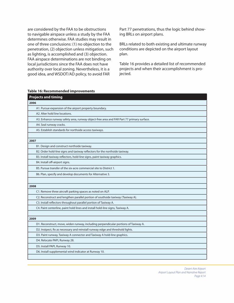
Desert Aire Airport
Airport Layout Plan and Narrative Report
Page 4:14
are considered by the FAA to be obstructions to navigable airspace unless a study by the FAA determines otherwise. FAA studies may result in one of three conclusions: (1) no objection to the penetration, (2) objection unless mitigation, such as lighting, is accomplished and (3) objection. FAA airspace determinations are not binding on local jurisdictions since the FAA does not have authority over local zoning. Nevertheless, it is a good idea, and WSDOT/AD policy, to avoid FAR
Part 77 penetrations, thus the logic behind show-ing BRLs on airport plans.
BRLs related to both existing and ultimate runway conditions are depicted on the airport layout plan.
Table 16 provides a detailed list of recommended projects and when their accomplishment is pro-jected.
Table 16: Recommended improvements
Projects and timing
2006
A1. Pursue expansion of the airport property boundary.
A2. Alter hold line locations.
A3. Enhance runway safety area, runway object-free area and FAR Part 77 primary surface.
A4. Seal runway cracks.
A5. Establish standards for northside access taxiways.
2007
B1. Design and construct northside taxiway.
B2. Order hold-line signs and taxiway refl ectors for the northside taxiway.
B3. Install taxiway refl ectors, hold-line signs, paint taxiway graphics.
B4. Install off -airport signs.
B5. Pursue transfer of the six-acre commercial site to District 1.
B6. Plan, specify and develop documents for Alternative 3.
2008
C1. Remove three aircraft parking spaces as noted on ALP.
C2. Reconstruct and lengthen parallel portion of southside taxiway (Taxiway A).
C3. Install refl ectors throughout parallel portion of Taxiway A.
C4. Paint centerline, paint hold lines and install hold-line signs, Taxiway A.
2009
D1. Reconstruct, move, widen runway, including perpendicular portions of Taxiway A.
D2. Instpect, fi x as necessary and reinstall runway edge and threshold lights.
D3. Paint runway, Taxiway A connector and Taxiway A hold-line graphics.
D4. Relocate PAPI, Runway 28.
D5. Install PAPI, Runway 10.
D6. Install supplemental wind indicator at Runway 10.

Desert Aire Airport
Airport Layout Plan and Narrative Report
Page 4:15
Projects and timing
2010
E1. Accomplish detailed planning of the six-acre commercial site, if under District 1 control.
2011
F1. Pave portion of commerical site to be used for aircraft tie-downs.
F2. Provide access and parking for vehicles at northside-based aircraft tie-downs.
F3. Construct northside-based aircraft tie-downs.
F4. Seal coat and repaint all taxiway, runway and apron surfaces.
2012-2016
G1. Expand existing aircraft parking.
G2. Install tie-downs and T-hangars, north side.
G3. Install fuel system.
G4. Construct new multi-purpose terminal/welcome center.
G5. Install infrastructure.
G6. Conduct paved surface maintenance.
2017-2021
H1. Add additional fuel tank and dispensing system, as necessary.
H2. Install additional hangars.
H3. Conduct paved surface maintenance.
2022-2026
I1. Reconstruct all paved surfaces.
I2. Refi ne six-acre site.
Table 16: Recommended improvements (continued)
4.7 ZONING AND LAND USE
It is recommended that this section be read while referring to drawings C 1.6, titled “Zoning and Land Use,” and C 1.7, titled “Exhibit A.”
Existing zoning
The property encompassing Desert Aire Airport consists of 49.93 acres. It is zoned “village indus-trial.” The six-acre site northeast of the airport — which has potential for airport-dependent, airport-related and airport-compatible develop-ment — is currently zoned “rural village commer-cial,” as are areas east and southeast of the airport, including areas that encompass portions of the
airport’s runway protection zone (RPZ), runway safety area (RSA), runway object-free area (ROFA) and FAR Part 77 Primary Surface. A portion of the commercially zoned area is used for the Desert Aire Senior Center. Large areas south and north of the airport’s boundary are zoned “rural village residential.” To the west of the airport, both east and west of Airport Way, is an area zoned “rural village open space.”
Existing land Use
Land northeast, east and southeast of the airport is currently categorized as “open space – unde-veloped.” East of the pathway used as a utility easement and west of highway 243 is an area

Desert Aire Airport
Airport Layout Plan and Narrative Report
Page 4:16
designated “agriculture.” South of the airport the land use designation is “residential.” North of the airport, the residentially zoned area is undevel-oped at this time and for purposes of this plan is termed “platted residential.” West of the airport, both east and west of Airport Way, the land use designation is “open space – undeveloped.”
Zoning and land-use recommendations
Addressing specifi c issues related to zoning and land use on Desert Aire Airport and the areas ad-jacent to it will increase safety and foster airport/community compatibility. Doing so soon after publication of this plan is particularly important since Grant County (according to a telephone conversation with an offi cial of the Grant County Planning Department in November 2005) is currently updating its comprehensive plan and development regulations. This airport layout plan recommends that during this process Grant County, GCAD #1 and WSDOT/AD work closely to ensure that the following actions are taken.
Alter applicable sections of the comprehen-sive plan to accurately state the airport’s publicly operated, open-to-the-public status.
Alter the zoning designation of the airport from “industrial” to “airport.” Develop this specifi c zoning classifi cation to provide for permitted, conditional and prohibited uses within the zone. Permitted uses should in-clude those features and structures normal-ly associated with a general aviation airport such as aircraft hangars, fuel systems, navi-gational aides, signs and terminal buildings. Include in this zoning classifi cation specifi c areas west and east of the airport that are important to the safety of aircraft opera-tions. Areas to the west should encompass property up to Airport Way. This zoning action will provide additional controls over the RSA, ROFA, RPZ and FAR Part 77 Primary Surface.
Zone the six-acre commercial parcel north-east of the airport as “airport commercial.” This area has the potential of being sup-portive of airport operations and a contrib-utor to the airport’s economic well-being. Features such as retail establishments and public services such as restaurants should be shown as “permitted uses.”
Initiate a process that informs purchasers of property within Desert Aire Rural Village that (1) their property is located adjacent to or within close proximity to Desert Aire Airport and that their property may be impacted by a variety of aviation activities. Note that such activities may include but are not limited to noise, vibration, chemical, odors, hours of operation, low overhead fl ights and other associated activities and (2) that the Federal Aviation Administration (FAA) establishes standards and notifi cation requirements for potential height hazards that may be caused by structures, building, trees and other objects aff ecting navigable air space through 14 CFR Federal Aviation Regulations (FAR) Part 77 Civil Aviation Imaginary Surfaces. Any questions relat-ing to structures, height hazards or ob-structions should be directed to the Grant County Planning Department or the FAA. (See the WSDOT/AD disclosure notice in the appendix to this plan)
Include in the transportation and policy elements of comprehensive plan a general overview of Desert Aire Airport. Reference should be made to the Desert Aire Airport Layout Plan and other applicable docu-ments. The updated comprehensive plan should include supporting maps and draw-ings including those that explain Federal Air Regulation Part 77 (FAR 77). Ensure that supporting comprehensive plan policies included in the transportation, recreation, and economic development
•
•
•
•
•
•

Desert Aire Airport
Airport Layout Plan and Narrative Report
Page 4:17
sections discourage incompatible develop-ment in the vicinity of the airport (with the exception at Desert Aire of existing and planned residences), and designate Desert Aire Airport as an essential public facility in a manner consistent with applicable state regulations.
Utility easement
As indicated in Chapter 2, and as noted on the airport layout plan diagram, an emergency ac-cess and utility easement is east of the runway and within the east RPZ. This plan assumes that there is no intention to develop this easement as a roadway. If that were done there would be a necessity to displace the landing threshold for Runway 28 by approximately 130 feet.

Desert Aire Airport
Airport Layout Plan and Narrative Report
Page 5:1
Chapter 5:
Financial
Chapter 4 contained information about airport improvements that are intended to meet forecast demand and increase safety, utility and effi ciency at Desert Aire Airport. This chapter identifi es the cost of those improvements and establishes a plan for paying for them. Also included in this chapter is data related to current and projected airport income and expenses.
5.1 GENERAL FINANCIAL INFORMATION
Cost estimates
Project cost estimates are in 2006 dollars. A 30 percent contingency has been incorporated into projects where applicable to cover engineering, administration and unforeseen circumstances. As this portion of this plan is updated, GCAP #1 will need to adjust the 2005-based dollar amounts as they are aff ected by infl ation. These estimates are for planning purposes only and should not be used as construction cost estimates.
The paving estimate for the northside taxiway (taxiway A) was provided by Forsgren Associates Inc. It is included in the appendix.
The following formulas were applied to estimates for other paved surfaces.
Base course and top course rock
Area to be paved times the depth of compacted rock @ .167 for 2-inch depth and .25 for 3-inch depth.
Class A/B asphalt (ACP)
A yield of 8.25 square yards per ton of asphalt is estimated for a 2-inch mat depth.
Organization
This CIP has been organized by identifying spe-cifi c projects that should be completed in 2006.
They include not only capital projects but admin-istrative actions, such as adjustment of Desert Aire Airport’s property boundary and establish-ment of specifi cations for Taxiway B access loca-tions, that will help the airport develop.
Projects recommended for the years 2007 through 2011 are listed in the individual years during which it is anticipated that they will be accomplished. Projects for the remaining time periods are listed in fi ve-year increments.
This CIP is intended to provide scheduling of projects as they are envisioned at this time. Projects recommended for the 2006-2011 time period are easier to plan than projects identifi ed for implementation 15 or 20 years from now. It is important to review and adjust this CIP on at least an annual basis.
Funding sources
This capital improvement program makes as-sumptions that some funding sources other than the Desert Aire Owners Association, the Port of Mattawa and WSDOT/AD will be available, espe-cially for structure and infrastructure projects. Actual availability of funds as identifi ed herein will depend on a number of factors, including the level of funds available to WSDOT/AD and to other agencies to distribute and the needs of other airports as compared to the needs of Desert Aire.
Planning ahead
A factor that plays a material role in the successful receipt of grant funds from WSDOT/AD and other sources, such as the Washington State Depart-ment of Community Trade and Development, is communication. Granting agencies are more like-

Desert Aire Airport
Airport Layout Plan and Narrative Report
Page 5:2
ly to respond positively to grant requests when they are given plenty of advance notice about intentions to apply for funds. This helps granting agencies to do their own advance planning. In-forming grant sources of plans three to four years in advance, and each year thereafter until funds are requested, is an eff ective strategy.
Third-party fi nancing
Airports often use third-party fi nancing for devel-opment of facilities that are to be used primarily by private businesses or organizations. Projects of this kind include hangars and industrial struc-tures. Some portions of this CIP identify no cost to GCAD #1 because of assumed third-party fi nanc-ing.
Rates and charges
It is very important at Desert Aire Airport, as with all airport facilities, that careful attention be paid to determinations of rates and charges. Small airports have limited abilities to collect revenue. It is often the case that fees that sponsors of small airports charge for based aircraft tie-downs, land leases, overnight tie-downs, fuel and other services are lower than what might be considered market value.
In some cases, fees – with the exception of those associated with fuel – are not charged at all. Clearly, sponsors of most small airports do not have the ability to collect revenue that is suffi -cient to pay for major capital improvements. It is important that airport sponsors do their best to maximize revenue while being cognizant of the ability of those engaged in general aviation to pay. In this way, airport sponsors can show that they are doing their best to contribute to the needs of their airports. Establishment of rates and charges should con-sider the potential of volunteerism. Eff orts by individuals who volunteer their time - by GCAD #1 commissioners, as an example - are very
important to Desert Aire Airport. It is important though to strike a fi scally sound balance between recognizing volunteer eff orts and charging rates that help airports remain fi nancially viable.
It is particularly important for airports such as Desert Aire to carefully consider the value of its property as it looks forward to growth and major capital improvements. A periodic review of air-port-related property lease fees is recommended. Fees should be adjusted to refl ect real market conditions.
Financing of this development program
WSDOT/ADThe Washington State Department of Transpor-tation’s Aviation Division is Desert Aire Airport’s primary source of grant funds for airside improve-ments. Airside improvements are those that relate to the runway/taxiway system, the aircraft park-ing apron and navigational aids, including sig-nage. Planning and engineering for projects that are eligible for WSDOT/AD construction grants are also eligible for grant funds.
For additional information about eligibility of projects for WSDOT/AD grants, as well as the division’s project priority system and application process, see their website http://www.wsdot.wa.gov/aviation/grants/default.htm. Under the Grant Program tab see the Grant Procedures Manual.
During a review of the fi nal draft of this narrative report WSDOT/AD made it clear that future grants from the aviation division would be considered only after (1) a new lease agreement between DAOA and GCAD#1 which extends the lease period to 20 years is implemented, (2) the Wash-ington State Attorney General has reviewed the lease and fi nds that it is legal for Washington state to provide airport aid grant funds to GCAD#1, (3) property necessary to bring Desert Aire Airport’s
Desert Aire Airport
Airport Layout Plan and Narrative Report
Page 5:3
CTED and EDA
Sources of grant funds for landside-related projects such as roads and utilities are the Wash-ington State Department of Community Trade and Development (CTED) and the United States Department of Commerce/Economic Develop-ment Administration (DOC/EDA). CTED’s contact information is:
Washington State Department of Community Trade and Economic DevelopmentRAAD BuildingMS: 42525128 – 10th AvenuePO box 42525Olympia, WA 98504Business and Project Development Offi ce(360) 725-4100
EDA’s contact information is:
United States Department of CommerceEconomic Development AdministrationJackson Federal Building, Room 1856915 Second AvenueSeattle, WA 98174(206) 220-7682
The Port of Mattawa
A continued close working relationship between the Port of Mattawa and GCAD #1 will be ben-efi cial to both. Desert Aire Airport represents a portal to the local area that will be increasingly important to business interests and, therefore, to the port’s mission. The port staff has extensive ex-perience working with funding agencies on capi-tal projects. Regular planning sessions intended to more fully develop policies, procedures, areas of interest and goals will help maximize this rela-tionship.
The 6-acre commercial site
This plan assumes that GCAD #1 will actively seek control over the 6-acre commercial site northeast of the airport. This site, if properly planned, could serve the interests of GCAD #1 and the Port of Mattawa.
The safety area grant program
WSDOT/AD has a grant program specifi cally designed to address runway safety-area im-provements; especially those improvements that reduce the likelihood of inadvertent runway incursions. Information about this program is in-cluded in the appendix to this plan. Projects such as hold-line repainting and hold-line sign installa-tion noted in Chapter 4 would qualify for funding under this specifi c program. This is an excellent program that targets a high-priority safety issue.
5.2 EXISTING REVENUE AND EXPENSES
Desert Aire Airport does not have revenue from sources such as fuel sales, hangar rent and land leases. Support funds are derived from the Desert Aire Owners Association and the Port of Mattawa. These are indicated in Table 17. Expenses are indicated in Table 18.
runway safety area and runway object-free area under the control of GCAD#1 are implemented (See Exhibit A – C1.7), and (4) a program that pro-vides for the payment of access fees by property owners who have direct access to the airport’s taxiway system is implemented.
Further, any potential fi nancial involvement by the aviation division in construction of, or provi-sion of equipment for, the north side taxiway (Taxiway B) would be conditioned on GCAD#1 control of Area 3 as depicted in Exhibit A and use of that property for airport-related purposes as shown in the building area plan. (See drawing C1.2)
Revenue/expense summary
During the period 2002-2004, expenses exceededrevenue by an average of $2,308 per year. Tables

Desert Aire Airport
Airport Layout Plan and Narrative Report
Page 5:4
Expense
category2002 2003 2004
Three-year
total
Three-year
average
Airport supplies $1,311 $356 $513 $2,180 $727
Weed control $448 $747 $592 $1,787 $596
Professional ser-vices $10,000 0 0 $10,000 $3,333
Community Airport Assoc. $115 $95 $285 $495 $165
Maintenance and improvements $513 $3,862 $8,518 $12,893 $4,298
Liability insurance $1,650 $1,650 $1,850 $5,150 $1,717
Election costs $233 $239 0 $472 $157
Utilities $228 $255 $259 $742 $247
Telephone $129 0 $335 $464 $155
Total expenses $14,627 $7,204 $12,352 $34,183 $11,395
Total revenue $14,969 $5,446 $6,842 $27,257 $9,086
Net income (loss) $343 ($1,758) ($5,510) ($6,925) ($2,308)
Table 18: Expenses 2002-2004 and net fi nacial
Source: GCAD #1.
Revenue
source2002 2003 2004
Three- year
total
Three-
year aver-
age
Desert Aire Owners Assoc. $2,500 $2,500 $2,500 $7,500 $2,500
WSDOT/AD $1,083 0 $3,288 $4,371 $1,457
Port of Ma-tawa $500 $2,500 $500 $3,500 $1,167
Fly-in break-fast $866 $446 $554 $1,886 $629
Grant County $10,000 0 0 $10,000 $3,333
Table 17: Revenue 2002-2004
Source: CDAD #1.
5.3 RECOMMENDED PROJECTS
This section estimates costs of projects included in Table 16, Chapter 4.
Minor maintenance expenses are not specifi cally identifi ed.
Table 19 indicates all projects over the 20-year planning period and identifi es planned sources of funds. Table 20 provides details about how proj-ect costs were calculated. Table 21 shows funds required by each source according to specifi c time periods.
17 and 18 include grant funds from WSDOT/AD and expenses associated with projects related to those funds.
County revenue of $10,000 listed in Table 17 and the professional services expense for the same amount listed in table 18 are related to a planning program which was conducted by GCAP #1 and was funded by Grant County.

Desert Aire Airport
Airport Layout Plan and Narrative Report
Page 5:5
Item Project Total CostWSDOT/
AD
Port of
Mattawa
Private
or other
grant
agency
Volunteer
labor,
materials
and equip-
ment
DAOA and/
or GCAP
#1
2006
A1 Expand airport property boundary $5,000 0 0 0 0 $5,000
A2 Alter hold line locations $600 $500 0 0 $50 $50
A3 Enhance runway safety area, runway object-free area and FAR Part 77 primary surface
$16,144 $15,337 0 0 $250 $557
A4 Seal runway cracks $750 $700 0 0 0 $50
A5 Establish standards for northside access taxiways $5,000 0 0 $4,000 0 $1,000
Subtotals $27,494 $16,537 0 $4,000 $300 $6,657
2007
B1 Design and construct taxiway B $230,900 $20,000 $6,135 $203,765 0 $1,000
B2 Order hold-line signs and taxiway refl ectors for the northside taxiway (Taxiway B)
$3,510 $3,100 0 0 0 $410
B3 Install taxiway refl ectors, hold-line signs, paint taxi-way B graphics
$5,300 $4,750 0 0 0 $550
B4 Install off -airport signs $432 0 0 0 0 $432
B5 Transfer control of the six-acre commercial site to GCAP #1
$3,000 0 0 0 0 $3,000
B6 Plan, specify and develop documents for Alternative 3 $70,000 $66,500 $2,000 0 0 $1,500
Subtotals $313,142 $94,350 $8,135 $203,765 0 $6,892
2008
C1 Remove three aircraft park-ing spaces as noted on ALP $100 0 0 0 0 $100
C2 Reconstruct and lengthen parallel portion of southside taxiway (Taxiway A)
$160,556 $152,000 $4,000 0 0 $4,556
C3 Install refl ectors throughout parallel portion of Taxiway A $2,890 $2,746 0 0 0 $144
C4 Paint center line, paint hold lines and install hold-line signs, Taxiway A
$4,000 $3,800 0 0 0 $200
Subtotals $167,546 $158,546 $4,000 0 0 $5,000
Table 19: 20-year capital improvement program

Desert Aire Airport
Airport Layout Plan and Narrative Report
Page 5:6
Item Project Total
cost
WSDOT/
AD
Port of
Mat-
tawa
Private
or other
grant
agency
Volunteer
labor,
materials
and equip-
ment
DAOA
and/or
GCAP #1
2009
D1 Reconstruct, move, widen runway, including perpen-dicular portions of Taxiway A
$321,615 $250,000 $61,615 0 0 $10,000
D2 Inspect, fi x as necessary and re-install runway edgeand threshold lights
$10,000 $9,500 0 0 0 $500
D3 Paint runway,Taxiway A connector and Taxiway A hold-line graphics
$5,000 $4,750 0 0 0 $250
D4 Relocate PAPI, Runway 28 $2,000 $1,900 0 0 $100 0
D5 Install PAPI, Runway 10 $12,000 $11,400 0 0 0 $600
D6 Install supplemental wind indicator, Runway 10 $2,000 $1,900 0 0 0 $100
Subtotals $352,615 $279,450 $61,615 0 $100 11,450
2010
E1 Accomplish detailed plan-ning of the six-acre com-mercial site if under GCAP #1 control
$5,000 0 $3,000 0 0 $2,000
Subtotals $5,000 0 $3,000 0 0 $2,000
2011
F1 Pave portion of commercial site to be used for aircraft tie-downs
$40,000 $38,000 $1,000 0 0 $1,000
F2 Provide access and parking for vechicles at northside based aircraft tie-downs (east end)
$30,000 0 $25,000 0 0 $5,000
F3 Construct northside based aircraft tie-downs (east end) $20,000 $19,000 $500 0 0 $500
F4 Seal coat and repaint all taxiway/runway and apron surfaces
$10,000 $9,500 0 0 0 $500
Subtotals $100,000 $66,500 $26,500 0 0 $7,000
2012-2016
G1 Expand existing aircraft parking $60,000 $57,000 $1,000 0 0 $2,000
G2 Install tie-downs and T-han-gars, north side $240,000 $50,000 $13,000 $175,000 0 $2,000
Table 19: 20-year capital improvement program (continued)

Desert Aire Airport
Airport Layout Plan and Narrative Report
Page 5:7
Item Project Total
cost
WSDOT/
AD
Port of
Mat-
tawa
Private
or other
grant
agency
Volunteer
labor,
materials
and equip-
ment
DAOA
and/or
GCAP #1
G3 Install fuel system $70,000 $40,000 $20,000 0 0 $10,000
G4 Construct new, multi-pur-pose terminal/welcome center
$240,000 0 $100,000 $100,000 0 $40,000
G5 Install infrastructure $50,000 $20,000 $25,000 0 0 $5,000
G6 Conduct paved surface maintenance $12,000 $11,400 0 0 0 $600
Subtotals $672,000 $178,400 $159,000 $275,000 0 $59,600
2017-2021
H1 Add additional fuel tank and dispensing system as necessary
$70,000 $40,000 $20,000 0 0 $10,000
H2 Install additional hangars $200,000 0 $10,000 $180,000 0 $10,000
H3 Conduct paved surface maintenance $12,000 $11,400 0 0 0 $600
Subtotals $282,000 $51,400 $30,000 $180,000 0 $20,600
2022-2026
I1 Overlay runway, Taxiway A, Taxiway B and westside aircraft paking apron
$398,800 $358,920 $20,000 0 0 $19,880
I2 Refi ne six-acre site $100,000 0 $70,000 $20,000 0 $10,000
Subtotals $498,800 $358,920 $90,000 $20,000 0 $29,880
Table 19: 20-year capital improvement program (continued)
Table 20: CIP details
Item Project Detail cost
A1 Expand airport property boundary
Estimated legal and recording fees $5,000
A2 Alter hold line locations
Remove and relocate existing hold lines — three locations $300
Eradicate existing hold lines — three locations $50
Paint hold lines — three locations $250
Subtotal $600
Funding totals in this table are for planning purposes only. No agency or department, including WSDOT/
AD, has committed to providing these funds.

Desert Aire Airport
Airport Layout Plan and Narrative Report
Page 5:8
Item Project Detail cost
A3 Enhance RSA, ROFA and primary surface
Grade and compact runway safety area and primary surface off ends of runway $5,000
Dismantle and remove tetrahedron $500
Apply stabilized top course rock (2,470 lineal yards, 6 lineal yards per cubic yard of material = 411 cubic yards or 616 tons of rock at $16.00 per ton = $9,856 $9,856
Sales tax on $9,856 $788
Subtotal $16,144
A4 Crack seal paved surfaces
Seal cracks $750
A5 Standards for Taxiway B access taxiways
Planning $5,000
Total for Section A $27,494
B1 Pave Taxiway B (12,251 square yards)
Design $21,764
Survey $20,000
Materials testing $10,000
Cut and fi ll (4,500 cubic yards @ $4.50) $20,250
Cut and waste (3,750 cubic yards @ $3.00) $11,250
Base course rock (1,900 tons @ $16.00) $30,400
Top course rock (1,300 tons @ $16.00) $20,800
Asphalt, Class A/B (1,425 tons @ $60.00) $85,500
Sales tax on materials of $136,700 $10,936
Subtotal $230,900
B2 Purchase Taxiway B equipment
Three hold-line signs @ $500 $1,500
50 refl ectors @ $35 $1,750
Sales tax on $3,250 $260
Subtotal $3,510
B3 Taxiway B equipment and painting
Install three hold-line signs $300
Install refl ectors $1,000
Paint centerline and hold lines $4,000
Subtotal $5,300
Table 20: CIP details (continued)

Desert Aire Airport
Airport Layout Plan and Narrative Report
Page 5:9
Item Project Detail cost
B4 Purchase/install off -airport signs
Two signs @ $200 each $400
Sales tax $32
Subtotal $432
B5 Transfer control of six-acre property
Estimated legal and recording fees $3,000
B6 Planning for Alternative 3
Design, survey, engineering for pavement, lights, graphics and equipment $70,000
Total for Section B $313,142
C1 Remove three aircraft parking aprons
Labor $100
C2 Reconstruct and lengthen parallel portion of Taxiway A (11,000 square yards, including pull-
outs)
Bid document review and adjustment (depends upon timing of project relative to accomplishment of B6 above) $5,000
Survey $10,000
Materials testing $3,000
Pulverize and stabilize esiting base to use as base for taxiway (10,963 square yards @ .75) $8,222
Cut and fi ll (500 cubic yards @ $4.50) $2,250
Base course rock (1,000 tons @ $16.00) $16,000
Top course rock (1,300 tons @ $16.00) $20,800
Asphalt, Class A/B (1,425 tons @ $60.00) $85,500
Sales tax on materials of $122,300 $9,784
Subtotal $160,556
C3 Install new refl ectors Taxiway A
Refl ectors (50 @ $35) $1,750
Installation $1,000
Sales tax on refl ectors $140
Subtotal $2,890
C4 Paint Taxiway A
Centerline and hold lines $4,000
Total $4,000
Total for Section C $167,546
Table 20: CIP details (continued)
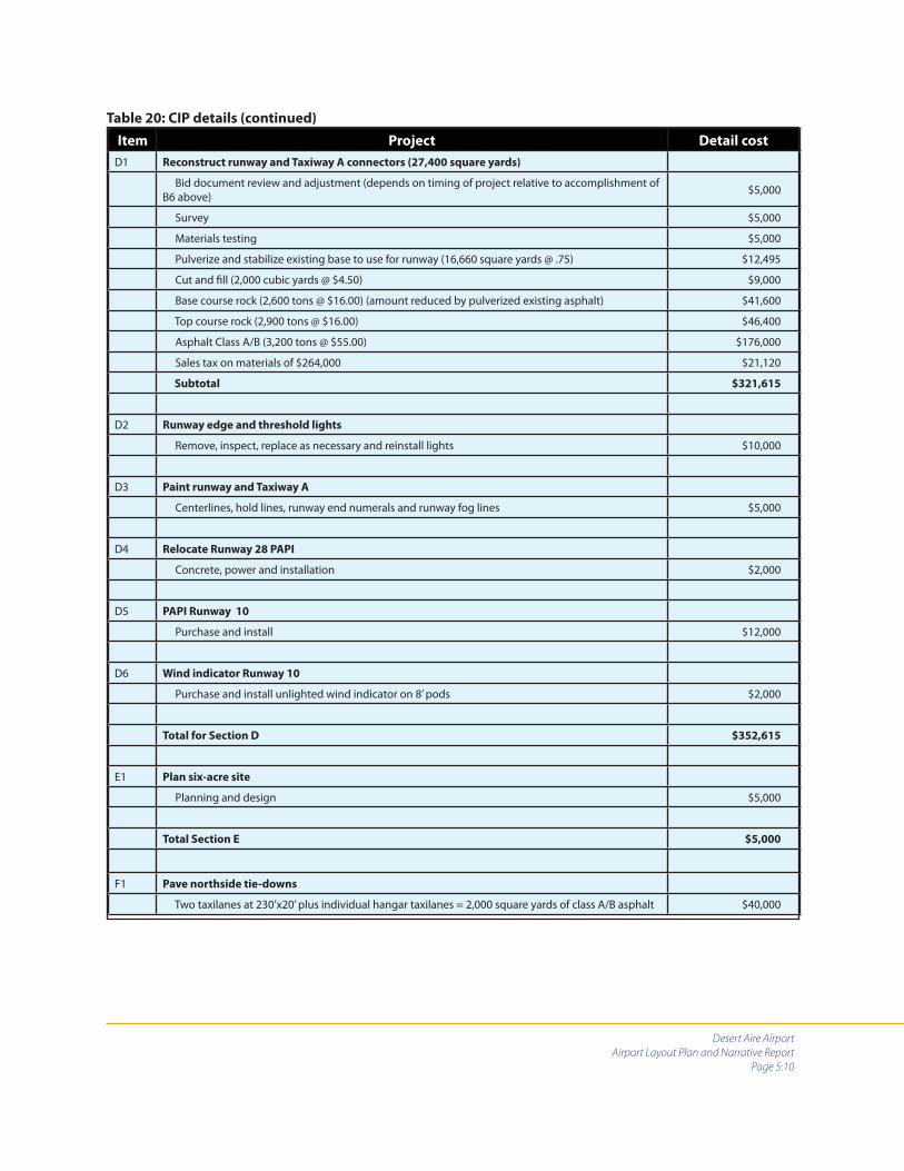
Desert Aire Airport
Airport Layout Plan and Narrative Report
Page 5:10
Item Project Detail cost
D1 Reconstruct runway and Taxiway A connectors (27,400 square yards)
Bid document review and adjustment (depends on timing of project relative to accomplishment of B6 above) $5,000
Survey $5,000
Materials testing $5,000
Pulverize and stabilize existing base to use for runway (16,660 square yards @ .75) $12,495
Cut and fi ll (2,000 cubic yards @ $4.50) $9,000
Base course rock (2,600 tons @ $16.00) (amount reduced by pulverized existing asphalt) $41,600
Top course rock (2,900 tons @ $16.00) $46,400
Asphalt Class A/B (3,200 tons @ $55.00) $176,000
Sales tax on materials of $264,000 $21,120
Subtotal $321,615
D2 Runway edge and threshold lights
Remove, inspect, replace as necessary and reinstall lights $10,000
D3 Paint runway and Taxiway A
Centerlines, hold lines, runway end numerals and runway fog lines $5,000
D4 Relocate Runway 28 PAPI
Concrete, power and installation $2,000
D5 PAPI Runway 10
Purchase and install $12,000
D6 Wind indicator Runway 10
Purchase and install unlighted wind indicator on 8’ pods $2,000
Total for Section D $352,615
E1 Plan six-acre site
Planning and design $5,000
Total Section E $5,000
F1 Pave northside tie-downs
Two taxilanes at 230’x20’ plus individual hangar taxilanes = 2,000 square yards of class A/B asphalt $40,000
Table 20: CIP details (continued)
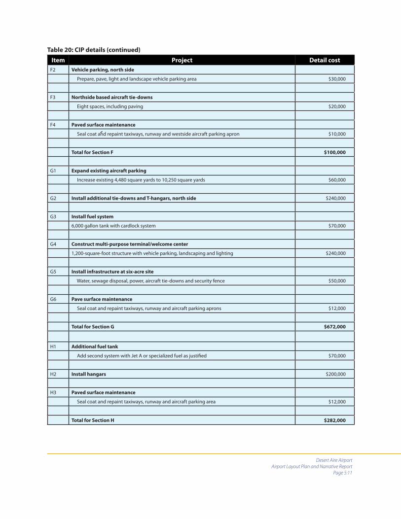
Desert Aire Airport
Airport Layout Plan and Narrative Report
Page 5:11
Item Project Detail cost
F2 Vehicle parking, north side
Prepare, pave, light and landscape vehicle parking area $30,000
F3 Northside based aircraft tie-downs
Eight spaces, including paving $20,000
F4 Paved surface maintenance
Seal coat and repaint taxiways, runway and westside aircraft parking apron $10,000
Total for Section F $100,000
G1 Expand existing aircraft parking
Increase existing 4,480 square yards to 10,250 square yards $60,000
G2 Install additional tie-downs and T-hangars, north side $240,000
G3 Install fuel system
6,000 gallon tank with cardlock system $70,000
G4 Construct multi-purpose terminal/welcome center
1,200-square-foot structure with vehicle parking, landscaping and lighting $240,000
G5 Install infrastructure at six-acre site
Water, sewage disposal, power, aircraft tie-downs and security fence $50,000
G6 Pave surface maintenance
Seal coat and repaint taxiways, runway and aircraft parking aprons $12,000
Total for Section G $672,000
H1 Additional fuel tank
Add second system with Jet A or specialized fuel as justifi ed $70,000
H2 Install hangars $200,000
H3 Paved surface maintenance
Seal coat and repaint taxiways, runway and aircraft parking area $12,000
Total for Section H $282,000
Table 20: CIP details (continued)

Desert Aire Airport
Airport Layout Plan and Narrative Report
Page 5:12
Item Project Detail cost
I1 Overlay runway, Taxiway A and Taxiway B
50,651 square yards @ 8.5 tons per square yard = 6,000 tons of asphalt @ $60.00) $360,000
Repaint $10,000
Sales tax on pavement $28,800
Subtotal $398,800
I2 Refi ne six-acre site
Complete build-out $100,000
Total for Section I $498,800
Table 20: CIP details (continued)
Table 21: Capital expenditure by phase
PhaseCIP total
cost
WSDOT/
AD
Port of
Mattawa
Private
or other
grant
agency
Volun-
teer
labor
DAOA
and/or
GCAP #1
2006 $27,494 $16,537 0 $4,000 $300 $6,657
2007 $313,142 $94,350 $8,135 $203,765 0 $6,892
2008 $167,546 $158,546 $4,000 0 0 $5,000
2009 $352,615 $279,450 $61,615 0 $100 $11,450
2010 $5,000 0 $3,000 0 0 $2,000
2011 $100,000 $66,500 $26,500 0 0 $7,000
2012-2016 $672,000 $178,400 $159,000 $275,000 0 $59,600
2017-2021 $282,000 $51,400 $30,000 $180,000 0 $20,600
2022-2026 $498,800 $358,920 $90,000 $20,000 0 $29,880
Totals $2,418,597 $1,204,103 $382,250 $682,765 $400 $149,079
Funding totals in this table are for planning purposes only. No agency or department, including WSDOT/AD, has committed to
providing these funds.