Environmental Study Report - Niagara Region
21
REGIONAL MUNICIPALITY OF NIAGARA Livingston Avenue Extension Environmental Assessment Environmental Study Report EXECUTIVE SUMMARY Draft: May 2020
Transcript of Environmental Study Report - Niagara Region
REGIONAL MUNICIPALITY OF NIAGARA Livingston Avenue Extension Environmental Assessment Environmental Study Report
EXECUTIVE SUMMARY
Draft: May 2020

This page intentionally left blank
Regional Municipality of Niagara Livingston Avenue Extension Environmental Assessment – EXECUTIVE SUMMARY Draft: May 2020
i
Table of Contents
Executive Summary .................................................................................... 1
Study and Public Engagement Process Overview ....................................................... 2 Getting Started: The Problem/Opportunity Statement ................................................. 5 Exploring the Options: Development and Evaluation of Alternative Solutions ............. 5 The Right Way Forward: Alternative Designs ............................................................ 10 Description of the Undertaking/Recommended Design ............................................. 12 Project Impacts and Mitigation Measures .................................................................. 14 Timing of Improvements to the Transportation Network ............................................ 16
Figures Figure ES0-1 Study Area.......................................................................................................... 1
Figure ES0-2 Study Process and Consultation Channels ........................................................ 2
Figure ES0-3 East-end Alignment Alternatives ...................................................................... 11
Figure ES0-4 Recommended Design Cross-Section ............................................................. 13
Tables Table ES0-1 Summary of Alternative Solutions Evaluation ...................................................... 9

Regional Municipality of Niagara Livingston Avenue Extension Environmental Assessment – EXECUTIVE SUMMARY Draft: May 2020
ii
This page intentionally left blank.
Executive Summary 1
Regional Municipality of Niagara Livingston Avenue Extension Environmental Assessment Appendix D - EXECUTIVE SUMMARY Draft: May 2020
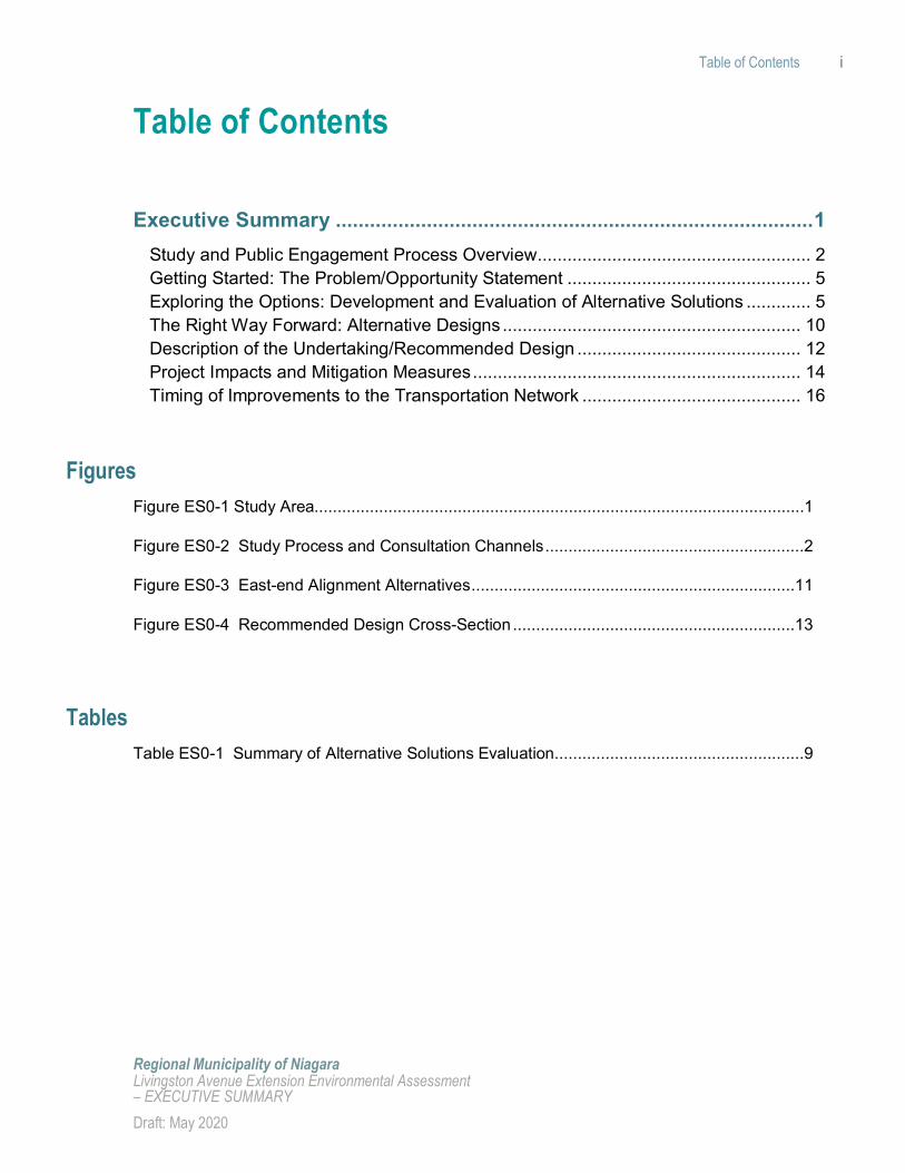
Executive Summary The Regional Municipality of Niagara (the Region) retained Dillon Consulting Limited (Dillon) in 2018 to complete an Environmental Assessment (EA) Study (hereafter referred to as the Study) to establish the need and solutions for improving east-west travel capacity in West Grimsby, given the projected population and employment growth targeted for 2041 and the planned Grimsby GO Transit Station, scheduled for opening in 2021. Figure ES0-1 illustrates the Study Area for the Livingston Avenue Extension EA.
A separate EA Study was initiated alongside this Study with a focus on Casablanca Boulevard, the Queen Elizabeth Way (QEW) interchange, and access to the GO Transit Station, titled the Casablanca Boulevard and GO Access EA (completed in March 2019).
Figure ES0-1 Study Area
Executive Summary 2
Regional Municipality of Niagara Livingston Avenue Extension Environmental Assessment Appendix D - EXECUTIVE SUMMARY Draft: May 2020
The purpose of this Study is to confirm and address the east-west transportation needs of the Town of Grimsby in the Study Area for a 20-year planning horizon. The projected population and employment growth coupled with the need to provide access to the lands south of the GO Transit Station south of the CN Railway creates additional demand on the east-west oriented network of service roads and Main Street West. Two key studies provided the foundation for the consideration of extending Livingston Avenue, and which specifically addressed the need for the Project, namely: Niagara Region Transportation Master Plan (TMP) 2017, and the Secondary Plan for the Grimsby GO Transit Station (2018). The Study was undertaken through the Municipal Class Environmental Assessment process as a Schedule ‘C’ Project, a category generally used for new facilities, as well as extensions and expansions of existing community facilities.
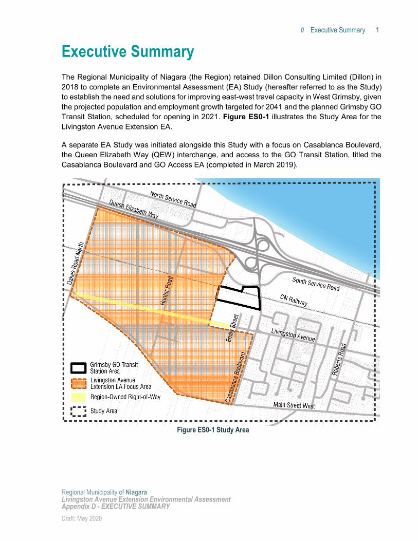
Study and Public Engagement Process Overview The number of steps were taken as part of the Study, as presented in Figure ES0-2:
Figure ES0-2 Study Process and Consultation Channels
Getting Started: A series of background studies were undertaken in order to create a basis for understanding the existing conditions as well as future development and traffic context in west Grimsby, including the following: transportation assessment, stormwater and drainage study; geotechnical investigation, natural heritage assessment; noise assessment; socio-economic assessment; cultural heritage assessment; and an archaeological assessment. The problem statement for the Study was also developed based on feedback received at PIC#1.
Exploring the Options: The identification of Alternative Solutions included a review of all east-west roadway corridors in the Study Area, and potential for improvements to these corridors to solve the identified problem and opportunities. The range of Alternative Solutions was presented at PIC#2.
The Right Way Forward: The Alternative Solutions were evaluated against a series of criteria to identify the Recommended Solution. The results of the evaluation, the recommended solution, and a series of alternative designs for various elements of the
Executive Summary 3
Regional Municipality of Niagara Livingston Avenue Extension Environmental Assessment Appendix D - EXECUTIVE SUMMARY Draft: May 2020
recommended road corridor were presented to the community at PIC#3. A Preferred Design was then developed at the conceptual level, to provide the basis for future detailed design work.
Consultation and engagement was undertaken at each step of the Study, and a range of engagement channels were utilized to obtain valuable local knowledge and feedback which could be considered in the planning and decision-making processes.
The overall objectives of the consultation program were to create general awareness of the Project to as many potentially interested as possible; and to generate an open and interactive approach to the EA planning process by creating opportunities for the public, Indigenous Communities and Organizations, government agencies and interest groups to provide comments and suggestions specifically related to the Project. As such, a number of activities were undertaken:
Development of a stakeholder contact list; Outreach to Indigenous Communities and Organizations; Development of a Project webpage on the Region’s website, which was updated
throughout the Study (https://www.niagararegion.ca/Projects/livingston-ea/default.aspx); Distribution of Project notices and mailings/emails through an E-Bulletin; Holding three Public Information Centres (PICs) on June 20th, 2018, May 28th, 2019, and
January 27th, 2020; Hosting an online survey posted on the Region’s website to obtain feedback on the design
of the Recommended Solution (extension of Livingston Avenue); Letters to Indigenous Communities providing notification of each of the PICs; Consultation with Regional and Town of Grimsby Elected Representatives; Consultation with the Town of Grimsby professional staff; Consultation with local and Provincial agencies, including the Ministry of Natural
Resources and Forestry (MNRF) and the Ministry of Environment, Conservation and Parks (MECP); and
Public release of the Environmental Study Report (ESR).
Comments received throughout the study were considered throughout the planning and decision-making processes and are summarized later in this ESR. Refinements were made to the Project as a result of the extensive consultation conducted. A summary of the key concerns and comments heard through the public engagement process is summarized below:
Natural Heritage:
• Natural environment and wildlife was a major concern noted by a number of residents in Grimsby. Concerns were around the loss of woodlot trees, wildlife and habitat, impacts to migration patterns, impacts related to climate change, and the irreversibility of impacts. The Irish Grove Woodlot was a key focus of concern, particularly with respect to tree removal, woodlot fragmentation, watercourse impacts, and habitat impacts;

Executive Summary 4
Regional Municipality of Niagara Livingston Avenue Extension Environmental Assessment Appendix D - EXECUTIVE SUMMARY Draft: May 2020
• It was suggested by some residents that if the Region were to extend Livingston Avenue in order to provide transportation connectivity, appropriate compensation should be provided for tree removal by replanting trees in another location or create a public park or conservation area;
• Stormwater management in the Focused Study Area was raised as an existing and potential future concern; and
• There was a perception that the potential extension of Livingston Avenue would have a significant impact on the environment while providing only a modest contribution, if any, to the transportation problem. Some residents commented that the Region should improve existing roads to support needed capacity, rather than build a new road through an environmentally sensitive area.
Transportation Assessment:
• Need for the Region to consider all alternatives for improving east-west capacity, and fully assess the potential for improvements to the South Service Road and Main Street West to solve future capacity constraints;
• Need for the extension of Livingston Avenue to support future east-west traffic flow, as this could help alleviate traffic on Main Street West, in addition to supporting access to the GO Station;
• Potential for better access to emergency services if the extension were completed, to support flexibility in alternative routes;
• Questions were raised about the future growth Projections for Grimsby, and whether an extension of Livingston Avenue is necessary to support future traffic demand. Conversely, some residents commented that Grimsby already has traffic issues and when the GO Station is built there will be extreme traffic jam issues, and were supportive of additional east-west capacity in the form of the Livingston Avenue extension;
• Suggestion to design for an improved streetscape; and
• Concerns regarding increased traffic on current dead end residential streets, namely Emily Street and Rosedale Street, if an extension of Livingston Avenue were carried forward.
Cultural Archaeological Heritage and Socio-Economic Assessment:
• Concern about the property value of homes on Emily Street;
• Impacts to properties with cultural heritage significance along Main Street West as well as concerns about the removal of heritage trees, should this road corridor be expanded; and
• Concerns about potential impacts to the baseball field at the Smith Public School where the Livingston Avenue right-of-way meets Oakes Road North.
The concerns raised were integrated into the development of the evaluation criteria for the Alternative Solutions, and those pertaining to the Alternative Designs and impact mitigation were carried forward to that stage of the Study.
Executive Summary 5
Regional Municipality of Niagara Livingston Avenue Extension Environmental Assessment Appendix D - EXECUTIVE SUMMARY Draft: May 2020
The following sections provide an overview of the analysis and results for each of these three phases of the Study.
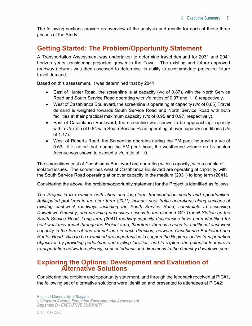
Getting Started: The Problem/Opportunity Statement A Transportation Assessment was undertaken to determine travel demand for 2031 and 2041 horizon years considering projected growth in the Town. The existing and future approved roadway network was then assessed to determine its ability to accommodate projected future travel demand.
Based on this assessment, it was determined that by 2041:
East of Hunter Road, the screenline is at capacity (v/c of 0.87), with the North Service Road and South Service Road operating with v/c ratios of 0.97 and 1.10 respectively.
West of Casablanca Boulevard, the screenline is operating at capacity (v/c of 0.85) Travel demand is weighted towards South Service Road and North Service Road with both facilities at their practical maximum capacity (v/c of 0.95 and 0.97, respectively).
East of Casablanca Boulevard, the screenline was shown to be approaching capacity with a v/c ratio of 0.84 with South Service Road operating at over capacity conditions (v/c of 1.17).
West of Roberts Road, the Screenline operates during the PM peak hour with a v/c of 0.63. It is noted that, during the AM peak hour, the westbound volume on Livingston Avenue was shown to exceed a v/c ratio of 1.0.
The screenlines east of Casablanca Boulevard are operating within capacity, with a couple of isolated issues. The screenlines west of Casablanca Boulevard are operating at capacity, with the South Service Road operating at or over capacity in the medium (2031) to long term (2041).
Considering the above, the problem/opportunity statement for the Project is identified as follows:
The Project is to examine both short and long-term transportation needs and opportunities. Anticipated problems in the near term (2021) include: poor traffic operations along sections of existing east-west roadways including the South Service Road; constraints to accessing Downtown Grimsby; and providing necessary access to the planned GO Transit Station on the South Service Road. Long-term (2041) roadway capacity deficiencies have been identified for east-west movement through the Project area, therefore, there is a need for additional east-west capacity in the form of one arterial lane in each direction, between Casablanca Boulevard and Hunter Road. Also to be examined are opportunities to support the Region’s active transportation objectives by providing pedestrian and cycling facilities, and to explore the potential to improve transportation network resiliency, connectedness and directness to the Grimsby downtown core.
Exploring the Options: Development and Evaluation of Alternative Solutions
Considering the problem and opportunity statement, and through the feedback received at PIC#1, the following set of alternative solutions were identified and presented to attendees at PIC#2:
Executive Summary 6
Regional Municipality of Niagara Livingston Avenue Extension Environmental Assessment Appendix D - EXECUTIVE SUMMARY Draft: May 2020
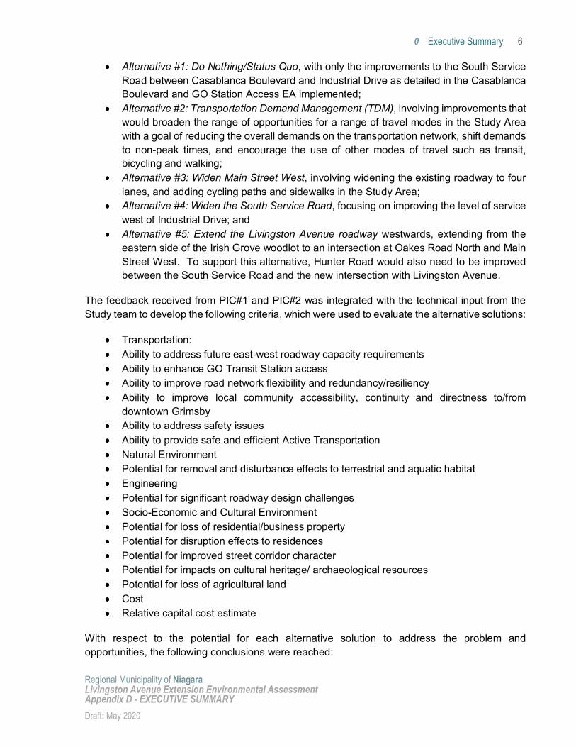
Alternative #1: Do Nothing/Status Quo, with only the improvements to the South Service Road between Casablanca Boulevard and Industrial Drive as detailed in the Casablanca Boulevard and GO Station Access EA implemented;
Alternative #2: Transportation Demand Management (TDM), involving improvements that would broaden the range of opportunities for a range of travel modes in the Study Area with a goal of reducing the overall demands on the transportation network, shift demands to non-peak times, and encourage the use of other modes of travel such as transit, bicycling and walking;
Alternative #3: Widen Main Street West, involving widening the existing roadway to four lanes, and adding cycling paths and sidewalks in the Study Area;
Alternative #4: Widen the South Service Road, focusing on improving the level of service west of Industrial Drive; and
Alternative #5: Extend the Livingston Avenue roadway westwards, extending from the eastern side of the Irish Grove woodlot to an intersection at Oakes Road North and Main Street West. To support this alternative, Hunter Road would also need to be improved between the South Service Road and the new intersection with Livingston Avenue.
The feedback received from PIC#1 and PIC#2 was integrated with the technical input from the Study team to develop the following criteria, which were used to evaluate the alternative solutions:
Transportation: Ability to address future east-west roadway capacity requirements Ability to enhance GO Transit Station access Ability to improve road network flexibility and redundancy/resiliency Ability to improve local community accessibility, continuity and directness to/from
downtown Grimsby Ability to address safety issues Ability to provide safe and efficient Active Transportation Natural Environment Potential for removal and disturbance effects to terrestrial and aquatic habitat Engineering Potential for significant roadway design challenges Socio-Economic and Cultural Environment Potential for loss of residential/business property Potential for disruption effects to residences Potential for improved street corridor character Potential for impacts on cultural heritage/ archaeological resources Potential for loss of agricultural land Cost Relative capital cost estimate
With respect to the potential for each alternative solution to address the problem and opportunities, the following conclusions were reached:
Executive Summary 7
Regional Municipality of Niagara Livingston Avenue Extension Environmental Assessment Appendix D - EXECUTIVE SUMMARY Draft: May 2020
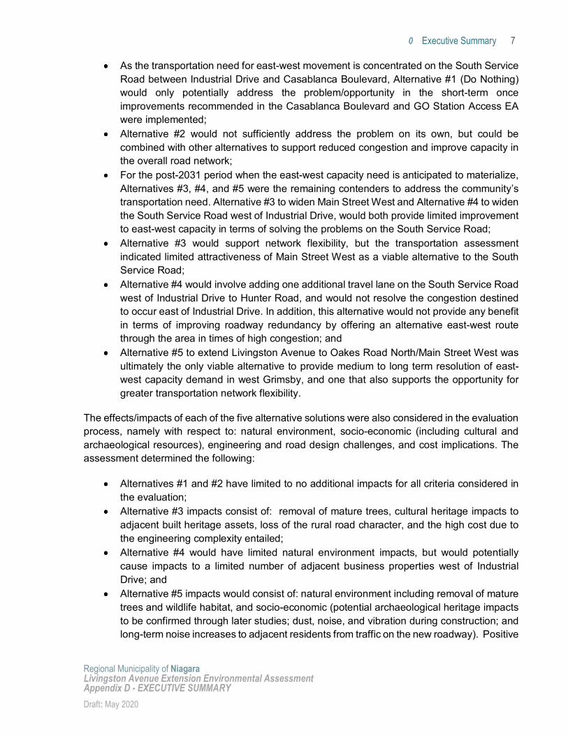
As the transportation need for east-west movement is concentrated on the South Service Road between Industrial Drive and Casablanca Boulevard, Alternative #1 (Do Nothing) would only potentially address the problem/opportunity in the short-term once improvements recommended in the Casablanca Boulevard and GO Station Access EA were implemented;
Alternative #2 would not sufficiently address the problem on its own, but could be combined with other alternatives to support reduced congestion and improve capacity in the overall road network;
For the post-2031 period when the east-west capacity need is anticipated to materialize, Alternatives #3, #4, and #5 were the remaining contenders to address the community’s transportation need. Alternative #3 to widen Main Street West and Alternative #4 to widen the South Service Road west of Industrial Drive, would both provide limited improvement to east-west capacity in terms of solving the problems on the South Service Road;
Alternative #3 would support network flexibility, but the transportation assessment indicated limited attractiveness of Main Street West as a viable alternative to the South Service Road;
Alternative #4 would involve adding one additional travel lane on the South Service Road west of Industrial Drive to Hunter Road, and would not resolve the congestion destined to occur east of Industrial Drive. In addition, this alternative would not provide any benefit in terms of improving roadway redundancy by offering an alternative east-west route through the area in times of high congestion; and
Alternative #5 to extend Livingston Avenue to Oakes Road North/Main Street West was ultimately the only viable alternative to provide medium to long term resolution of east-west capacity demand in west Grimsby, and one that also supports the opportunity for greater transportation network flexibility.
The effects/impacts of each of the five alternative solutions were also considered in the evaluation process, namely with respect to: natural environment, socio-economic (including cultural and archaeological resources), engineering and road design challenges, and cost implications. The assessment determined the following:
Alternatives #1 and #2 have limited to no additional impacts for all criteria considered in the evaluation;
Alternative #3 impacts consist of: removal of mature trees, cultural heritage impacts to adjacent built heritage assets, loss of the rural road character, and the high cost due to the engineering complexity entailed;
Alternative #4 would have limited natural environment impacts, but would potentially cause impacts to a limited number of adjacent business properties west of Industrial Drive; and
Alternative #5 impacts would consist of: natural environment including removal of mature trees and wildlife habitat, and socio-economic (potential archaeological heritage impacts to be confirmed through later studies; dust, noise, and vibration during construction; and long-term noise increases to adjacent residents from traffic on the new roadway). Positive
Executive Summary 8
Regional Municipality of Niagara Livingston Avenue Extension Environmental Assessment Appendix D - EXECUTIVE SUMMARY Draft: May 2020
impacts include: safer access to other modes of travel, less vehicular congestion on east-west corridors, and opportunities for complete street development and connectivity to Downtown Grimsby.
It was determined that the preferred solution would consist of a combination of alternative solutions to carry forward as indicated in Table ES0-1; namely, a combination of TDM measures, roadway operations improvements and additional roadway lanes using a phased approach of implementation over the 20-year timeframe. Alternative solutions #1 and #2 are recommended for implementation in the short term, and Alternative solutions #2 and #5 within the 20-year timeframe, once the community/traffic growth requires the additional roadway capacity (by approximately 2031).
Executive Summary 9
Regional Municipality of Niagara Livingston Avenue Extension Environmental Assessment Appendix D - EXECUTIVE SUMMARY Draft: May 2020
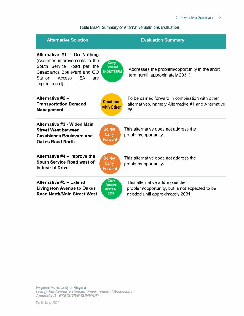
Table ES0-1 Summary of Alternative Solutions Evaluation
Alternative Solution Evaluation Summary
Alternative #1 – Do Nothing (Assumes improvements to the South Service Road per the Casablanca Boulevard and GO Station Access EA are implemented)
Addresses the problem/opportunity in the short term (untill approximately 2031).
Alternative #2 – Transportation Demand Management
To be carried forward in combination with other alternatives, namely Alternative #1 and Alternative #5.
Alternative #3 - Widen Main Street West between Casablanca Boulevard and Oakes Road North
This alternative does not address the problem/opportunity.
Alternative #4 – Improve the South Service Road west of Industrial Drive
This alternative does not address the problem/opportunity.
Alternative #5 – Extend Livingston Avenue to Oakes Road North/Main Street West
This alternative addresses the problem/opportunity, but is not expected to be needed until approximately 2031.
Executive Summary 10
Regional Municipality of Niagara Livingston Avenue Extension Environmental Assessment Appendix D - EXECUTIVE SUMMARY Draft: May 2020
The Right Way Forward: Alternative Designs The extension of Livingston Avenue was identified as the recommended solution to solve for the identified transportation problem in the medium to long-term, to be combined with transportation demand management measures. This combined alternative solution was brought forward into the next stage of the Study.
Alternative designs for the recommended solution were developed and evaluated using a range of criteria and in consideration of: study area baseline conditions, design issues and constraints identified with the preferred alternative solution, and public and stakeholder feedback received during the EA. Alternative designs were developed for each of the following project components:
East-end road extension alignment alternatives (East of Hunter Road); Cross-section alternatives through the Irish Grove Woodlot; Cross-section alternatives west of the Irish Woodlot to Oakes Road; and West End alignment/intersection alternatives.
Key issues identified through the consultation process (PIC#3 and the Winter 2020 online survey) that were considered in the development of the alternative designs included:
Need for access to Region-owned lands, intended for the Regional Multi-Modal Transportation Hub and potential GO Transit Station south parking lot;
Concerns about potential impacts to the natural environment during construction and for the long-term;
Concerns about impact on neighbouring residents and land uses due to nuisance effects from implementing the extension of Livingston Avenue, including noise, dust, vibrations, traffic, and lighting during construction and for the long-term;
Need for active transportation facilities (sidewalks and bike lanes) on at least one side of the corridor; and
Reduced road width and speed limits along the extension of Livingston Avenue.
The following section provides an overview of each of the Project components listed above and the alternative designs that were considered and evaluated.
East-end Alignment Alternatives (East of Hunter Road)
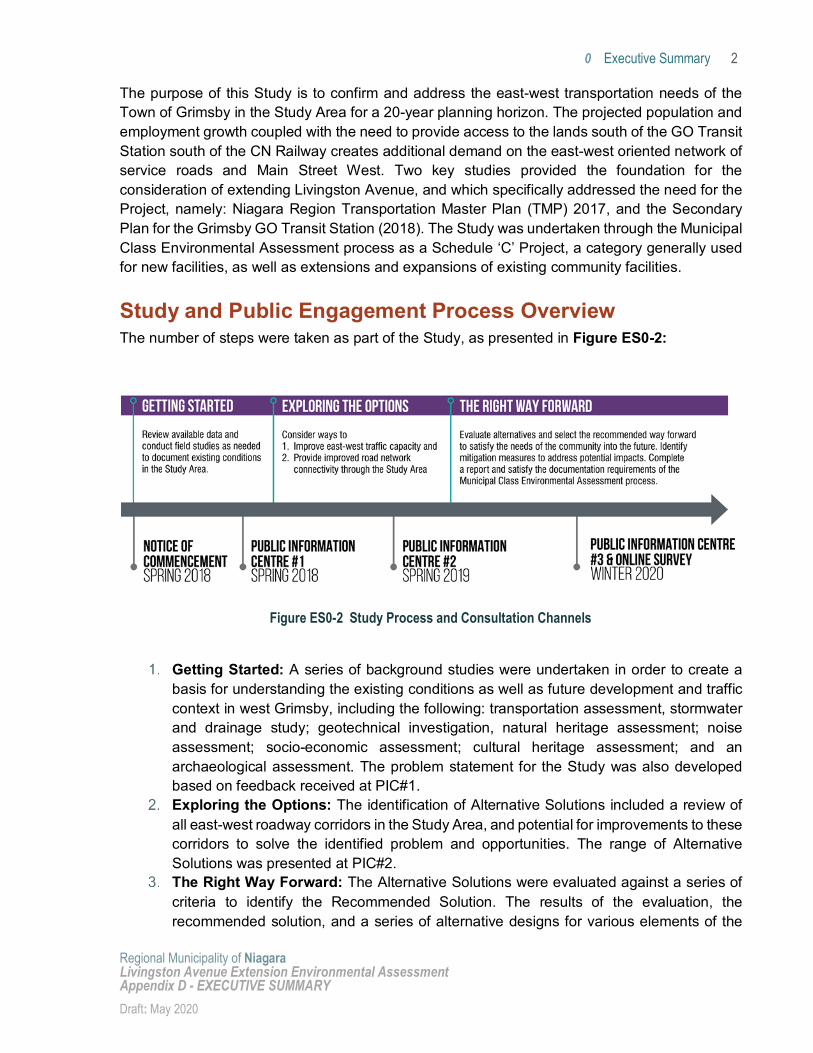
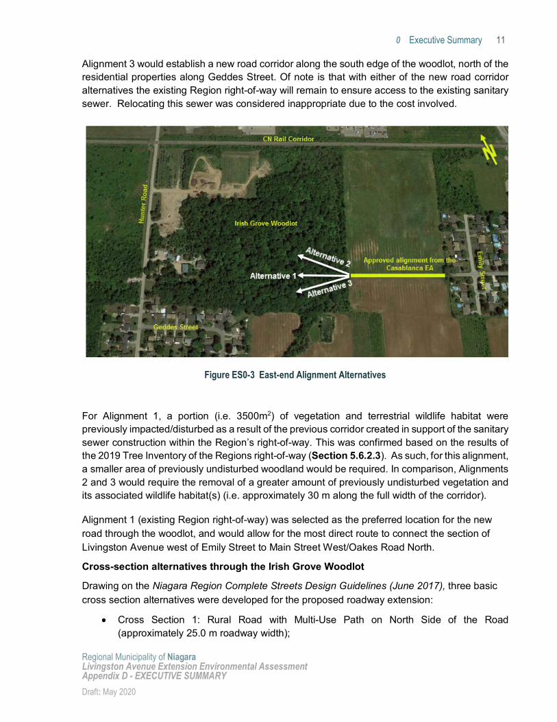
The following alignment alternatives east of Hunter Road/though the Irish Grove Woodlot were considered and evaluated (Figure ES0-3):
Alignment 1: Centred on the Region owned Livingston Avenue road allowance; Alignment 2: North of the Region owned Livingston Avenue road allowance; and Alignment 3: South of the Region owned Livingston Avenue road allowance (assumed to
be along the south edge of the woodlot).
Executive Summary 11
Regional Municipality of Niagara Livingston Avenue Extension Environmental Assessment Appendix D - EXECUTIVE SUMMARY Draft: May 2020
Alignment 3 would establish a new road corridor along the south edge of the woodlot, north of the residential properties along Geddes Street. Of note is that with either of the new road corridor alternatives the existing Region right-of-way will remain to ensure access to the existing sanitary sewer. Relocating this sewer was considered inappropriate due to the cost involved.
Figure ES0-3 East-end Alignment Alternatives
For Alignment 1, a portion (i.e. 3500m2) of vegetation and terrestrial wildlife habitat were previously impacted/disturbed as a result of the previous corridor created in support of the sanitary sewer construction within the Region’s right-of-way. This was confirmed based on the results of the 2019 Tree Inventory of the Regions right-of-way (Section 5.6.2.3). As such, for this alignment, a smaller area of previously undisturbed woodland would be required. In comparison, Alignments 2 and 3 would require the removal of a greater amount of previously undisturbed vegetation and its associated wildlife habitat(s) (i.e. approximately 30 m along the full width of the corridor).
Alignment 1 (existing Region right-of-way) was selected as the preferred location for the new road through the woodlot, and would allow for the most direct route to connect the section of Livingston Avenue west of Emily Street to Main Street West/Oakes Road North.
Cross-section alternatives through the Irish Grove Woodlot
Drawing on the Niagara Region Complete Streets Design Guidelines (June 2017), three basic cross section alternatives were developed for the proposed roadway extension:
Cross Section 1: Rural Road with Multi-Use Path on North Side of the Road (approximately 25.0 m roadway width);
Executive Summary 12
Regional Municipality of Niagara Livingston Avenue Extension Environmental Assessment Appendix D - EXECUTIVE SUMMARY Draft: May 2020
Cross Section 2: Urban Road with Multi-Use Pathway on the North Side (approximately 19.0 m roadway width); and
Cross Section 3: Urban Road with On-Road Bike Lanes and Sidewalk on North Side (approximately 20.8 m roadway width).
Cross Section #3 was selected as the preferred cross section for the new road through the woodlot (See Figure ES0-4 further below). This cross-section design provides the optimal balance for reducing the amount of existing woodlot vegetation requiring removal (just slightly more than Cross Section 2) while achieving the best level of service offered to pedestrians and cyclists.
Cross-section alternatives west of the Irish Woodlot to Oakes Road
Having established Cross Section 3 as the preferred design cross section through the woodlot, it is recommended that this treatment be also extended west of Hunter Road (although the rural treatment of Cross Section 1 could be considered). Adopting Option 3 will provide corridor consistency to the east and the west. Main Street, west of Oakes Road is an urban road with curbs and gutters with on-road bike lanes in each direction.
West End Alignment/Intersection Alternatives.
Four west-end alignment/intersection options were developed and evaluated:
Intersection 1 - Livingston Avenue as the Through Road (Main Street Tying in at a T-Intersection);
Intersection 2 - Main Street as the Through Road (Livingston Avenue Tying in at a T-Intersection);
Intersection 3 – Northern Roundabout; and Intersection 4 – Southern Roundabout.
Intersections 3 and 4 (Roundabout designs) were screened out due to property impacts and impacts to access points for residences and businesses along Main Street West. The remaining two designs, Intersection 1 and 2, were evaluated. Intersection 1 was selected as the preferred design, as this would allow for more seamless integration with the existing Main Street West/Oakes Road North intersection at the westerly terminus of the Livingston Avenue. Some driveway extensions would be needed to connect commercial properties that currently front onto Main Street West to the Livingston Avenue extension just east of Oakes Road North.
Description of the Undertaking/Recommended Design The design concept for the preferred alternative is described according to five general categories, namely: road traffic lanes and active transportation facilities, electrical and illumination, property, utilities, drainage/stormwater management, and construction staging and traffic management. The Niagara Region Complete Streets Design Guidelines (June 2017) were used as the starting point in determining the appropriate road standards. There was a desire for a design that
Executive Summary 13
Regional Municipality of Niagara Livingston Avenue Extension Environmental Assessment Appendix D - EXECUTIVE SUMMARY Draft: May 2020
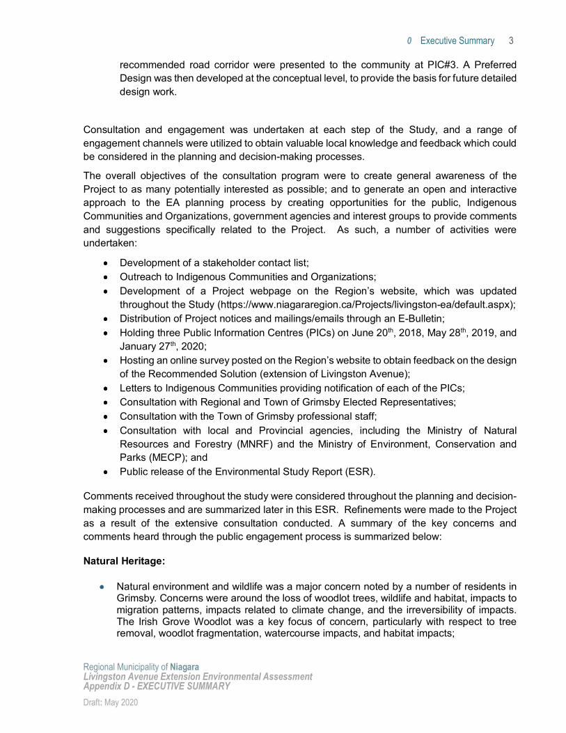
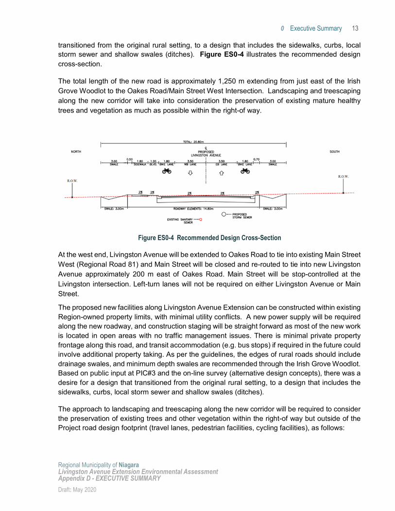
transitioned from the original rural setting, to a design that includes the sidewalks, curbs, local storm sewer and shallow swales (ditches). Figure ES0-4 illustrates the recommended design cross-section.
The total length of the new road is approximately 1,250 m extending from just east of the Irish Grove Woodlot to the Oakes Road/Main Street West Intersection. Landscaping and treescaping along the new corridor will take into consideration the preservation of existing mature healthy trees and vegetation as much as possible within the right-of way.
At the west end, Livingston Avenue will be extended to Oakes Road to tie into existing Main Street West (Regional Road 81) and Main Street will be closed and re-routed to tie into new Livingston Avenue approximately 200 m east of Oakes Road. Main Street will be stop-controlled at the Livingston intersection. Left-turn lanes will not be required on either Livingston Avenue or Main Street.
The proposed new facilities along Livingston Avenue Extension can be constructed within existing Region-owned property limits, with minimal utility conflicts. A new power supply will be required along the new roadway, and construction staging will be straight forward as most of the new work is located in open areas with no traffic management issues. There is minimal private property frontage along this road, and transit accommodation (e.g. bus stops) if required in the future could involve additional property taking. As per the guidelines, the edges of rural roads should include drainage swales, and minimum depth swales are recommended through the Irish Grove Woodlot. Based on public input at PIC#3 and the on-line survey (alternative design concepts), there was a desire for a design that transitioned from the original rural setting, to a design that includes the sidewalks, curbs, local storm sewer and shallow swales (ditches).
The approach to landscaping and treescaping along the new corridor will be required to consider the preservation of existing trees and other vegetation within the right-of way but outside of the Project road design footprint (travel lanes, pedestrian facilities, cycling facilities), as follows:
Figure ES0-4 Recommended Design Cross-Section
Executive Summary 14
Regional Municipality of Niagara Livingston Avenue Extension Environmental Assessment Appendix D - EXECUTIVE SUMMARY Draft: May 2020
Within the Irish Grove Woodlot: Trees that must be removed from the Project footprint will be compensated for. Every attempt will be made to preserve mature, healthy trees and vegetation within the right-of-way as part of detailed design and construction. New plantings will also be considered where possible, in addition to the design of bioswales to support greenscaping of the corridor.
West of the Irish Grove Woodlot: Existing trees that must be removed from the Project footprint will be compensated for. Additional landscape items should be considered in sections of the new corridor where appropriate such as new plantings and pedestrian amenities (e.g. benches).
To maintain existing drainage patterns, four culverts are proposed along the length of the Livingston Avenue Extension. Culvert 1 to direct flow to the Vine Road rear-yard intermittent drainage channel, Culvert 2 to ensure flow of the unnamed watercourse is not obstructed, Culvert 3 to convey the ditch drainage along Hunter Road; and Culvert 4 under Hunter Road, to convey stormwater from the catchment area to the west of Hunter Road and south of Livingston Avenue. There will also be a drainage swale along the north side of the proposed Livingston Avenue Extension which will be graded to convey stormwater flow from a small segment of the proposed Livingston Avenue right of way that cannot be captured by the storm sewer system on the road.
Construction staging of the works will be fairly straight forward as most of the new work is located in open fields, or wooded areas with no traffic management issues. Short-term, periodic detours/closures will likely be required on Hunter Road, Main Street West and Oakes Road.
Project Impacts and Mitigation Measures A number of impacts were identified that would result from the implementation of the Project as described above. These impacts are examined in detail in this ESR. Some of the key impacts and mitigation measures are summarized below.
Socio-economic effects were considered in terms of property and land use impacts, noise and air quality, property access, and agricultural land impacts:
Overall, limited property impacts are anticipated and are limited to the future intersection adjacent areas at Hunter Road and Oakes Road North/Main Street West, and the need to provide property access for properties just west of Oakes Road North along Main Street West. There may also be the need for some private land to accommodate required noise mitigation measures near Hunter Rd. which would be considered during detailed design. No agricultural land impacts are anticipated.
Residential receptors just east of Hunter Road, and residential receptors just east and west of the intersection of Oakes Road North/Main Street West were identified as having noise impacts that would warrant noise mitigation. The specific type of mitigation would be identified at the Detailed Design stage following the completion of the Study, in consultation with the affected property owners and in compliance with Ministry of Environment, Conservation and Parks guidelines.
Executive Summary 15
Regional Municipality of Niagara Livingston Avenue Extension Environmental Assessment Appendix D - EXECUTIVE SUMMARY Draft: May 2020
Cultural heritage and archaeological impacts identified included minimal impacts to three residences with heritage significance and two cultural heritage landscapes. These impacts would be mitigated through roadway design elements such as landscaping to provide a visual buffer against the extended road corridor for Livingston Avenue.
Members of the public expressed concerns in regards to potential natural environment effects from the Project including concerns related to the Irish Grove Woodlot and associated watercourse, such as tree removal, woodlot fragmentation, loss of Species of Conservation Concern (SCC) habitat and Significant Wildlife Habitat (SWH), habitat encroachment, sensory disturbances to wildlife, and potential to kill, harm, or otherwise harass species during and post-construction. To address the raised concerns and the identified project impacts, a number of mitigation measures were identified, including:
Limit the area of construction operations and the Project footprint through the Irish Grove Woodlot to reduce impacts to habitat. Avoid sensitive habitats and potential movement corridors to the extent possible;
Establish Tree Protection Zones (TPZs) during Detailed Design and show the TPZs on the contract drawings adjacent to proposed work areas in the Study Area to protect vegetation to be retained. Tree protection fences/barriers demarcate TPZs and protect existing trees along cut lines from equipment damage.
Schedule tree/vegetation clearing outside species active seasons: Bird active season: April 1 – August 15; and Bat active season: April 1 – October 30. Develop a tree compensation/re-planting plan during Detailed Design to compensate for
tree removals. Develop and implement an edge management plan. Disturbed areas should be re-vegetated as soon as possible. Implement best management practices to mitigate the potential for indirect impacts (e.g.
staging of equipment and stockpiling away from wooded areas). Sediment and erosion control measures (i.e. silt fencing) should be in place prior to
construction to avoid impacts (e.g. sediment loading) on adjacent natural features and minimize potential for encroachment into natural areas.
It is recommended that a Contractor Information Manual be prepared documenting the various wildlife species with the potential to be encountered during construction activities, as well as the steps to be taken in the event wildlife is encountered during construction.
Plant replacement trees during/following construction. Areas to be planted to be determined with input from landowners, the Town, the Region and and NPCA.
Complete a hazard assessment for the ash trees in and adjacent to the RoW, as there is the potential for the dead/dying ash trees to cause damage/injury or death to construction crew members and/or equipment.
Conduct wildlife sweeps prior to the commencement of work activities to determine if wildlife are present at the site and engaged in critical life processes (e.g. nesting, etc.);
Executive Summary 16
Regional Municipality of Niagara Livingston Avenue Extension Environmental Assessment Appendix D - EXECUTIVE SUMMARY Draft: May 2020
Following the wildlife sweep, the area of activity should be isolated to deter wildlife from entering the work space area;
Require Project contractor to install, monitor, and maintain appropriate muffling and maintenance of machinery and equipment, to mitigate noise impacts to wildlife;
Develop and implement a dust control plan; and Design the illumination through the Irish Grove Woodlot to be focused along the road
corridor and limit spillage and light pollution into the Woodlot.
The benefits associated with this Project primarily relate to the improvement of east-west traffic movement through West Grimsby, reducing congestion on the South Service Road and facilitating access to the GO Transit Station and Downtown Grimsby. The integration of complete street features including sidewalk and cycling facilities will support greater transportation demand management and integrated mobility opportunities along the corridor within the Focused Study Area.
Through the Class EA process, a preferred solution and design has been determined to address the identified problem and opportunity. The key benefit of the Project is that it will address the projected long-term roadway capacity deficiency within the Study Area, and supports improved regional transit infrastructure - the planned Grimsby GO Transit Station. Other benefits include improving roadway connectivity and directness to Downtown Grimsby, and providing roadway redundancy/resiliency to help manage incidents/delays/closures on other east-west roadways such as the QEW.
The main project adverse effects include long-term elevated noise levels for some residents and impacts to natural habitat, primarily the Irish Grove woodlot. In regards to the noise impacts, it is anticipated that with the committed noise mitigation measures, these impacts can be reduced to acceptable levels so as to not significantly disturb residents. Regarding the impacts to the natural environment, the Project will require the clearing of vegetation within the Region owned right-of-way. A portion of the right-of-way was previously cleared for the installation of the existing sewer line. Nevertheless, there will be a loss of habitat which cannot be avoided. The ESR includes many mitigation recommendations to reduce the extent of the woodlot impacts. Furthermore, the ESR includes a commitment to compensate the loss of trees with a tree planting program. The location and extent of the replanting program will be determined during the detailed design in consultation with the Conservation Authority.
On balance, with the mitigation and compensation commitments, the effects of the Project are considered to be reasonable considering the Project benefits.
Timing of Improvements to the Transportation Network As the Town of Grimsby and the surrounding area develop and major Projects are completed (e.g., opening of the GO Transit Station) there will be breakpoints where deficiencies in the transportation network will manifest and become clear. Given this, there are three clear stages
Executive Summary 17
Regional Municipality of Niagara Livingston Avenue Extension Environmental Assessment Appendix D - EXECUTIVE SUMMARY Draft: May 2020
over which the transportation network must be improved to ensure that mobility is maintained within the study area. These are described briefly below:
Opening of the Grimsby GO Transit Station – 2021: The opening of the GO Transit Station will have significant and immediate effects on the operation of the local road network, resulting in significant changes in daily travel patterns and time of travel decisions by local residents and others that find value in the new rail service. Resolution of these future issues requires immediate attention. This will involve the execution of the recommendations in the Casablanca Boulevard and GO Station Access EA (2019). As discussed earlier in this document, these improvements were assumed to be part of the base roadway network for this analysis.
South Service Road Congestion – 2031: With a functioning GO Transit Station and continued development of the area, congestion issues on the South Service Road will become more pronounced by 2031, even with the improvements to the South Service Road (widen it to a four-lane cross-section plus required auxiliary lanes in the vicinity of the GO Transit Station). Additional corridor capacity, provided by the Livingston Avenue Extension (recommended alternative), will be needed by 2031 to address mobility needs and issues in the broader east-west corridor from Main Street West to Casablanca Boulevard.