Draft North Blackpool Local Area Plan - CorkCity.ie · 8 2. Strategic Planning Context 2.1 The...
80
Transcript of Draft North Blackpool Local Area Plan - CorkCity.ie · 8 2. Strategic Planning Context 2.1 The...


Foreward
The Blackpool Valley as the traditional economic / industrial heart of the northside of the City has played a key role in the development of Cork City, and while older manufacturing
industries have declined, significant commercial and retail development has taken place in recent years.
The North Blackpool Local Area Plan sets out a vision for North Blackpool, ‘to develop its role as the economic and social heart of the northside of the city and gateway to the city’
in tandem with the objectives of the Farranferris Local Area Plan 2009 and the Blackpool Village Area Action Plan 2010.
The Plan is set within the national and regional planning context and amplifies the goals and objectives of the updated Cork Area Strategic Plan 2020 (CASP) and the Cork City
Development Plan 2009-2015.
In adopting the plan on 26th September 2011, the Council has agreed an integrated land use, transportation and urban design framework to facilitate the sustainable
redevelopment and rejuvenation of the area, over a six year timeframe but also sets out the longer term strategic development framework.
The preparation of the Plan involved an extensive process of consultation with the local community and key stakeholders and the active involvement of Members of the City
Council and Directorates within City Hall. We would like to thank all those who contributed to the preparation of the Plan, in particular the significant contribution of Council
Members, the staff of the Planning Directorate and the assistance of the Roads & Transportation Directorate and the Recreation, Amenity & Culture Directorate.
Cllr. Terry ShannonLord Mayor
Mr. Tim LuceyCity Manager

3
Table of Contents
Section Sub-section PageVision Statement 4
1 Introduction 5
2 Strategic Planning Context 8
3 Area-Wide Strategies Overall strategyLand-use strategyUrban design strategyMovement strategyPublic open space strategyLandscape strategyCommunity strategy
12
15
20
25
30
33
35
4 Sub-Area StrategiesDublin StreetDistrict Centre & adjoining landsDulux & adjoining landsMallow RdKilbarryCommons Ridge
38
39
45
52
55
58
60
5 Implementation Phasing 62
6 Appendices Strategic Environmental Assessment reportAppropriate Assessment reportStrategic Flood Risk Assessment report
64
69
74

4
Vision Statement
Blackpool will develop its role as the economic and social heart of the ‘northside’ and ‘gateway’ to the City and be a vibrant andattractive place to live, work and visit.
The following objectives will achieve this vision:
To create a high quality, vibrant, distinct and accessible mixed-use urban centre,
serving as an attractive northern gateway to the city and a desirable destination for
northside suburban communities, encompassing retail, commercial, employment
uses, residential neighbourhoods, community and recreational facilities.
To protect and improve residential neighbourhoods from detrimental traffic impacts,
creating a safe and attractive network of pedestrian/cyclist orientated streets and
spaces connecting communities to local services and amenities.
To support and sustain an integrated public transport interchange centred on a
commuter rail service and connecting bus services.
To respect and enhance the built heritage and architectural character of the area,
through the creation of a high quality public realm and high standards of building
design.
To preserve and enhance the sensitive and distinct landscape, visual character and
biodiversity of the area and in turn provide for recreational uses, open space and
amenity facilities.

5
1. Introduction
1.1 Cork City Council has prepared a draft Local Area Plan, (LAP) for the North
Blackpool area of the city, as proposed in the Cork City Development Plan 2009-
2015. The LAP provides for the development and rejuvenation of the north Blackpool
area over the six year LAP timeframe but also sets out the longer term strategic
development framework for the area.
1.2 The Blackpool valley is the traditional economic / industrial heart of the northside
of the city, but the current trend is of decline in the traditional manufacturing /
industrial sector. The study area of 60 hectares has significant potential to be
rejuvenated as the social and economic heart of the northside, making use of brown
field land such as the former Sunbeam Complex.
1.3 The purpose of the plan is to set out an integrated land use, transportation and
urban design framework to facilitate the sustainable redevelopment of the North
Blackpool area, centred on a high quality public transport hub at the proposed
Kilbarry/Blackpool commuter rail station.
The Study Area1.4 The plan study area includes the former Sunbeam site and adjoining lands,
Blackpool Shopping Centre and Retail Park, the Kilbarry rail site and Kilbarry IDA
industrial estate, extending northwards along Old Whitechurch Rd, southwards to the
North City Link Rd ‘fly-over,’ eastwards to Ballyvolane Rd, and west/northwest to
Commons Rd and Fitz’s Boreen (See Figure 1.1).
1.5 The area is characterised by a variety of land uses currently dominated by the
Blackpool Shopping Centre and Retail Park and the Dulux Paints Industrial complex.
There are small residential neighbourhoods on Redforge Rd, Mallow Rd, Dublin St /
Hill and Spring Lane. The physical geography is dominated by the relatively flat Bride
river valley with steep ridges either side. The valley floor is dissected by the N20
National Rd and the Mallow Rail-line. The context and constraints for the plan area
are summarized on Figure 1.2 and inform the area-wide and precinct strategies in
Sections 3 and 4.
Local area plan process1.6 Under the provisions of the Planning and Development Acts, a planning authority
may at any time and for any particular area within its functional area, prepare a local
area plan in respect of that area. Where appropriate, policies contained in City
Development Plans are developed in more detail at the local level through the
preparation of local area plans.
Figure 1.1 Local Area Plan Boundary

6
7
1.7 Consultation is a key element of the preparation of Local Area Plans. The Council
carried out a (preliminary / pre-draft plan) consultation exercise, between November
2009 and January 2010. A ‘consultation paper’ was prepared, which defined the plan
boundary and outlined a number of issues to stimulate discussion.
1.8 The Council advertised (Irish Examiner, 06/11/09) its intention to prepare a local
area plan for the North Blackpool area, and invited all interested parties to make
written submissions regarding the plan. The submission period ran between 6th
November and 18th December 2009, and was subsequently extended to 20th January
2010.
1.9 The consultation paper was distributed to Council Members, Council
Directorates, prescribed bodies and local stakeholders including businesses and
community groups, and written submissions were invited. The paper was also made
available to the public on the Council website and hard copies were distributed by
post on request.
1.10 The Council received 23 no. written submissions. The key issues raised are as
follows:
(a) to rezone lands, in order to permit ‘higher order’ uses such as retail and offices;
(b) to designate additional neighbourhood and local centres;
(c) to extend the plan boundary;
(d) to develop Kilbarry rail station and commuter rail service;
(e) to develop a quality public open space focused on the Bride river;
(f) to develop a local road network, and to protect the N20 road capacity;
(g) to develop safe and attractive pedestrian and cycle routes;
(h) to encourage higher density and strong urban form appropriate to a ‘District
Centre’
(i) to tackle dereliction at Thomas Davis Street/Spring Lane
1.11 Furthermore, a stakeholders workshop was held on 13th January 2010, in the
Blackpool Community Hall, Great William O’Brien Street. A total of 47 no. local
stakeholders were invited. 10 no. stakeholders attended.
1.12 The workshop group carried out a SWOT Analysis and discussed key issues
under the headings of land-use; transportation; urban design & public realm; the
relationship between Blackpool Village and North Blackpool; and heritage.
1.13 Additional issues identified (to the written submissions) included the need for
community, recreational and youth facilities, in tandem with population growth; the
opportunity for high standards in building design and use of ‘green’ building
technologies; and the need to address local traffic and access issues.
1.14 The draft plan has sought to address and resolve the said issues and develop a
strategy for the proper and sustainable development of the area. The draft plan is
structured as follows:
Section 1: Outlines the plan’s role
Section 2: Sets out the strategic planning context
Section 3: Outlines the area-wide strategies for the plan area
Section 4: Outlines the detailed strategies for the six precincts / sub-areas
Section 5: Implementation and phasing strategy
Appendices: Consideration of Appropriate Assessment Screening Report, Strategic
Environmental Assessment Screening Report, Strategic Flood Risk Assessment
Report

8
2. Strategic Planning Context
2.1 The North Blackpool Local Area Plan is part of a hierarchy of planning and
development guidance from national, regional and local level. Due regard has been
given to the following strategy documents and guidelines.
National Context and GuidelinesNational Spatial Strategy 2002-2020 (NSS)2.2 The NSS is a 20 year plan which aims to promote balanced regional
development within the State, establishing a framework of strategically located urban
centres or ‘Gateway’ cities, such as Cork City to be the focus for population and
economic growth within the south-west region.
National Development Plan 2007-2013 (NDP)2.3 The NDP entitled ‘Transforming Ireland - A Better Quality of Life for All,’ is a €184
billion investment program in economic and social transformation, driven largely by a
continuing increase in population, projected to reach over five million people by 2021.
The NDP sets out a strong framework for the promotion of regional development with
a particular focus on investment in Gateways such as Cork. Unfortunately the
slowdown in the economy has delayed delivery of significant infrastructure under the
Plan.
Cork Gateway2.4 Cork, with a population of 186,239 in 2006 (city and suburbs) is the largest urban
and economic centre in the South-West Region and is the designated Gateway City
in the region. The population of the City Council area dropped slightly from 123,062
in 2002 to 119,143 in 2006, while outlying areas recorded strong growth.
2.5 Cork’s strengths include its scale and status as the second largest city in the
State; a strong economic base with extensive FDI in ICT and pharmaceuticals;
strong third-level education facilities; a modern airport, significant port facilities, a
large hinterland with regionally important towns and an outstanding natural setting.
The key challenge for
Cork will be to significantly accelerate its rate of development and population growth,
focusing particularly the city centre, docklands and the Key Development areas of
Blackpool and Mahon.
Transport 21 - 2006-20152.6 Transport 21 is a €34 billion capital investment framework (2006 - 2015) for major
infrastructural projects under the National Development Plan, to develop Ireland’s
transport system, including national roads, rail and bus services, and regional
airports with the aim to increase accessibility, ensure sustainability, expand capacity,
increase use, enhance quality.
2.7 In respect of Cork, projects included the M8 Cork-Dublin Motorway, (completed);
the Atlantic Corridor linking Letterkenny to Waterford via Limerick, Mallow and Cork;
the Cork Suburban Commuter Rail service between Mallow and Midleton (Phase 1
completed), and new stations at Blarney, Kilbarry and Dunkettle (Phase 2).
Sustainable Development: A Strategy for Ireland, 19972.8 This Strategy provides a framework for the achievement of sustainable
development at local level. It identifies four key ways Development Plans can
contribute to the achievement of sustainability:
� To encourage efficient use of energy, transport and natural resources through
careful selection of development locations;
� To promote the most effective use of already developed areas;
� To secure protection and enhancement of the natural environment;

9
� To accommodate new development needs in an environmentally sustainable
way.
National Climate Change Strategy 2007-20122.9 The National Climate Change Strategy 2007 - 2012 sets out a range of
measures, building on those already in place under the first National Climate Change
Strategy (2000) to ensure Ireland reaches its target under the Kyoto Protocol. The
Strategy
provides a framework for action to reduce Ireland's greenhouse gas emissions
Smarter Travel A New Transport Policy for Ireland 2009 – 20202.10 A policy document outlining aims to Improve quality of life and accessibility to
transport for all; Improve economic competitiveness through maximizing the
efficiency of the transport system and alleviating congestion and infrastructural
bottlenecks; minimizing the negative impacts and reducing air pollutants and
greenhouse gas emissions; reduce travel demand and commuting by the private car;
and improve security of energy supply by reducing dependency on imported fossil
fuels.
Draft Lee CFRAMS Study2.11 Since 2004, national policy has shifted emphasis towards a catchment based
context for managing flood risk, with more proactive risk assessment and
management, and increased use of non-structural and flood impact mitigation
measures.
2.12 Catchment Flood Risk Assessment and Management Studies (CFRAMSs) and
Management Plans (CFRMPs) are at the core of this new policy for flood risk
management and the strategy.
2.13 The Lee Catchment Flood Risk Assessment Management Study (CFRAMS)
and the Draft Catchment Flood Risk Management Plan (CFRMP) have been
prepared by Halcrow Group Ireland Limited under the supervision of the OPW, in
conjunction with Cork City Council and Cork County Council. The study has identified
areas of flood risk and put forward measures for managing such risk.
The Planning & Flood Risk Management Guidelines for Planning Authorities 20092.14 These guidelines require the planning system at national, regional and local
levels to:
� Avoid development in areas at risk of flooding, particularly floodplains, unless
there are proven wider sustainability grounds that justify appropriate
development and where the flood risk can be reduced or managed to an
acceptable level without increasing flood risk elsewhere;
� Adopt a sequential approach to flood risk management when assessing the
location for new development based on avoidance, reduction and mitigation of
flood risk; and
� Incorporate flood risk assessment into the process of making decisions on
planning applications and planning appeals.
An assessment of flood risk in the study area, including the appropriate flood risk
map from the CFRAMS is outlined in the Appendix 3.
Strategic Environmental Assessment 2.15 The EU Directive 2001/42/EC on Strategic Environmental Assessment was
passed into Irish Law by means of the Planning and Development (SEA) Regulations
2004. The Directive requires all European Union member states to systematically
evaluate the likely significant environmental effects of implementing certain plans or
programmes before a decision is made to adopt the plan or programme. An SEA

10
screening process has been carried out for the study area and has concluded that an
SEA is not required for this local area plan (See Appendix 1)
Appropriate Assessment2.16 A screening process has been carried out to determine if an Appropriate
Assessment of the proposed local area plan pursuant to Article 6 (3) of the EU
habitats Directive 92/43/EEC is required. The screening report concluded a finding of
no significant effect. The report is contained in Appendix 2.
Regional Context:South West Regional Planning Guidelines 2010-2022 (RPG) 2.17 The RPG provides an overall spatial planning framework for the region to 2022
taking the NSS objectives to a regional level and supporting the strengthening the
Cork Gateway. The RPGs propose a target population for Cork City of 150,000 by
2022, an increase of 30,478 persons on the figure in 2006, reflecting the NSS
objective of expanding growth in the regions outside Dublin and the Mid-East.
Cork Area Strategic Plan 2020 (CASP) 2.18 The Cork Area Strategic Plan 2001-2020 (CASP) sets out a strategic plan for
the development of the Cork City Region to 2020. The key objectives include the
regeneration of Cork City, focused on the City Centre/ Docklands; the development
of Metropolitan Cork as an integrated unit, directing growth to the north and east of
city along the rail corridor, provision of an integrated transport system; infrastructure
provided in tandem with development; and the creation and maintenance of a high
quality environment.
CASP Update, 20092.19 The CASP Update aims to deliver an updated strategy to provide for a
significant enhancement in economic growth and accommodate a greater population
than originally envisaged in line with updated NSS targets. The updated strategy is
underpinned by key strategic targets in population, jobs and household formation.
Jobs, population and households targets2.20 The CASP Update sets targets for population growth in the CASP area of
110,404, household growth of 71,844 and employment growth of 45,021. The growth
targets for the city outlined in CASP are shown in Table 2.1 below. The CASP
Update focuses new growth in Cork city centre, docklands and selected suburban
locations, including Blackpool.
Table 2.1 CASP growth targets for Cork CityCork City Actual 2006 Target 2020 Growth 2006-2020
Population 119,522 150,000 30,478
Households 43,971 62,241 18,250
Employment 75,248 90,691 15,443
Local Context:Cork City Development Plan 2009-20152.22 The Cork City Development Plan 2009-2015 sets out the strategic development
framework for the city, focusing development on selected Key Development Areas
and District Centres. (See Figure 2.1 below).
2.23 These areas and centres will accommodate the majority of growth and
development within the city and will be complemented by an integrated high quality
public transport system. Blackpool is identified as a Key Development Area and it
also contains a District Retail Centre and a planned commuter rail station on the
Blarney to Midleton/Cobh rail line. The relevant City Development Plan policies are
outlined in more detail in Chapter 3 under the appropriate subject heading.

11
Figure 2.1 Cork City Development Strategy Diagram

12
3. Area-Wide Strategies
Overall Strategy3.1 Cork’s selected development strategy focuses on the ‘Key Development Areas’
of Docklands, Blackpool and South Mahon; and the ‘Key Centres’ of the City Centre,
Blackpool, Ballyvolane, Wilton, South Mahon and Douglas.
3.2 Blackpool is designated as a ‘key development area,’ a ‘key centre’ (district
centre) and a ‘gateway’ to the city. The over-riding objective for Blackpool is to create
a vibrant, high quality retail, residential and employment location served by an
integrated public transport system.
3.3 Blackpool is identified as a key employment location, and a second tier retail
centre. It complements the City Centre which is the focus for retail, cultural and
commercial activity and is the primary location for higher order general office
development (along with Docklands).
Population & Households3.4 The Updated Cork Area Strategic Plan 2001-2020 is underpinned by key
strategic targets in population, jobs and household formation. CASP goals relate to
the broad strategic areas of economic growth, social inclusion, environment,
balanced spatial development, urban renewal, transportation and infrastructure.
These have been incorporated into the City Development Plan and provide a
framework for the development of Blackpool
3.5 A target increase of 5,314 persons and 4,490 households has been set for the
north-east and north-west sectors of the city combined.
3.6 The population of the plan area has fallen by 4.7% between 2002 and 2006 and
is currently estimated to be in the region of 550 persons, concentrated at Dublin St /
Thomas Davis St / Spring Lane and the ‘upper’ Redforge Rd.
Table 3.1 CASP Update targets for 2020N-East & N-West Sectors 2006 2020 Target Net increase
Population 48,988 54,302 5,314
Households 18,042 22,532 4,490
Employment 18,908 21,408 2,500
3.7 Within the plan area current planning permissions have a combined capacity of
120 units or population of 288 persons, (based on a household size of 2.4). The
remaining sites within the plan area have a potential capacity of approximately 400
units, or population of 960 persons. Therefore, the plan area has the capacity to
accommodate in the region of 1250 persons.
3.8 The resident community needs to increase in order to achieve a vibrant urban
centre capable of sustaining local services and infrastructural developments. The
study area will be primarily an employment / commercial location but will be in the
region of 500 residential units. There is also capacity for more significant residential
development nearby, in particular on the undeveloped lands at Old Whitechurch Rd.
Economic StrategyEmployment3.9 The CASP Update economic strategy places strong emphasis on development of
brownfield sites in or near the City Centre as new employment locations. The city
centre continuing as the focus for retail, cultural and commercial activity. Docklands
is the prime brownfield location, suburban locations such as Blackpool / Kilbarry and
Mahon to provide a choice of locations to meet employment needs.

13
3.10 The CASP Update Economic Strategy envisages that a total of 45,021 net new
jobs by 2020 will be required to sustain the projected population target for the CASP
area, with 15,443 of these in the city. The target increase for the north-east and
north-west sectors is 2,500 jobs. (CASP).
3.11 The bulk of anticipated growth in the city will be in the services sector, office and
business and technology categories. The primary location for offices is the City
Centre and Docklands and is acceptable in District Centres and Business &
Technology zones. Commercial leisure uses and smaller scale health care services
are appropriate to the plan area.
3.12 It is policy to maintain and expand a diverse range of employment opportunities
in or accessible to areas with relatively high rates of unemployment and to protect
existing sites in industrial use.
3.13 It is envisaged that the future role of Blackpool is that as mixed-use core area
for employment and services on the Northside of the city, expanding on existing retail
and office based sectors. New development will include higher order office and
business & technology based industry, limited comparison / convenience retail,
leisure, personal and local services.
3.14 The Irish economy is in its third consecutive year of recession. The
standardised unemployment rate in December 2010 was 13.4%, (source CSO). GDP
is forecast to increase by 0.2% for 2010, while GNP is forecast to fall by -1.7%,
(source Central Bank), the divergence reflects strong growth in the export sector.
Given the current economic climate of weak domestic demand, the forecast of a
gradual economic recovery and the natural lag in employment growth, the CASP
targets are unlikely to be met within the short to medium term but remain valid in the
longer term. This plan will seek to retain existing employment in-situ and promote
the efficient use of underutilised lands to widen and strengthen the employment
base.
3.15 The capacity of the plan area for new development on ‘brownfield’ land is
significant and much of it is unlikely to be redeveloped within the Plan period. The
Plan however, gives an indicative framework for the medium to long term
development of these lands.
Retail Strategy3.16 The Cork City Retail Strategy sets out a six tier hierarchy of retail locations
determining quantum and location of new retail development. The City Centre is the
top tier centre followed by Dockland and the Suburban District Centres such as
Blackpool, followed by Neighbourhood centres and so on.
3.17 Cork City Centre is the primary centre for comparison goods. The suburban
District Centres are important convenience and comparison locations and should be
developed as mixed-use urban centres rather than stand alone shopping centres.
Comparison floorspace should be reasonably distributed within the suburbs on a 40 /
60 ratio for the northside / southside, respectively.
3.18 Neighbourhood centres should focus on food and convenience goods and a
limited range of comparison shops, local services and retail offices. The plan area
includes district centre and neighbourhood centre zonings.
3.19 The strategy forecasts that 26,630sq.m. net additional comparison floorspace is
required to meet the needs of the DoEHLG population targets for 2020. This equates
to10,652 sq.m. for the northside, allocated between Blackpool, Ballyvolane and a
possible third centre in the north-west sector of the city. The comparison floorspace
target has been substantially accounted for by recent permissions, (yet to be
implemented), so there is limited scope for further significant permissions in
Blackpool under the current retail strategy.
3.20 The city’s suburban allocation of retail warehouses is 18,690 sq.m. Suitable
locations for retail warehouses is at edge of town or district centres. There is in the

14
region of 8,000sq.m. of retail warehousing within the retail park and an additional
7,500 sq.m. retail warehousing permitted within the adjoining former Sunbeam lands.
Therefore, scope for further permissions is limited under the current retail strategy.
Key Objectives for Blackpool / Kilbarry 3.21 The Cork City Development Plan 2009-2015 in Section 14.12 outlines the Key
Objectives for the Blackpool / Kilbarry Development area as follows.
Key Objectives
� To upgrade and expand Blackpool District Centre by providing for a quality mix of uses to capitalize on the centre's strategic location and quality public transport infrastructure.
� To encourage and support the expansion of employment generating opportunities in the Kilbarry Industrial Estate in line with upgrades in public transport and roads infrastructure in the area.
� To achieve a sufficient density of development to sustain public transport and a vibrant mix of uses.
� To develop a coherent spatial structure, based on a hierarchy of linked streets and public spaces and determined by high quality urban design principles
� To promote the creation of a high quality public realm and establish a high standard of design in architecture and landscape architecture.
Area-wide strategies3.22 The area wide strategies for the plan are set out below under the headings of
land-use, urban design, movement, public open space & recreation, landscape, and
community services.

15
Land-Use Strategy
3.23 North Blackpool has witnessed significant commercial / retail development in
recent years including the Blackpool Shopping Centre and Retail Park. However,
significant ‘brownfield’ sites exist such as the former Sunbeam complex and the Cork
Metals site at Spring Lane.
3.24 The plan area is centred on the catchment of the Kilbarry rail station, including
Blackpool Shopping Centre, Retail Park, the former Sunbeam complex and the
Kilbarry (IDA) Business & Technology Park.
3.25 The planned redevelopment of the Kilbarry rail station and the commuter rail
service and Blackpool’s designation as a ‘key development area’ and ‘district centre’
provides a real opportunity to rejuvenate the Blackpool Valley, to create a modern,
vibrant, mixed-use urban centre, an attractive gateway to the city and destination for
north-side suburban communities.
Key Objectives
� To transform the retail dominated centre into a vibrant, mixed-use, urban centre with an appropriate balance of retail, residential, employment and leisure uses.
� To protect and improve existing residential neighbourhoods
� To create a network of linked public open spaces (along the River Bride) to enhance the quality of the environment
� To protect and improve the rural character and landscape value of the Commons Ridge
Land-Use Zoning ObjectivesDistrict Centre 3.26 The District Centre is made up of the Blackpool Shopping Centre, Retail Park,
Millfield Service Station and the former Sunbeam lands. The objective of the land-
use zoning is to provide for and/or improve district centres as mixed-use centres.
Intensification of the shopping centre lands, streetscape / public realm
improvements within the retail park and the redevelopment of the surface car park as
a civic square are objectives.
Figure 3.1 City Development Plan Zoning Map

16
3.27 The primary land use within the ‘district centre’ should continue to be
comparison and convenience retailing. Upper floor levels should be predominantly a
mix of residential and office based services . The ground floor level should be
occupied by complimentary commercial leisure uses, retail offices, and local
commercial and community services in order to animate buildings, streets and public
spaces.
Plate 3.1 Blackpool Shopping Centre Mall
3.28 In order to protect and consolidate existing residential communities, new
residential units should be focussed on the Mallow Rd - Redforge Rd area,
integrating with the adjoining residential zoned lands.
Residential, Local Services & Institutions
3.29 These lands include the northern side of the Mallow Rd, the eastern side of the
Redforge Rd, Spring Lane, Dublin Street, Dublin Hill and the upper slopes of the
Commons Ridge. The Objective is to protect and provide for residential uses, local
services, institutional uses, and civic uses. The residential zoning provides an
opportunity to redress the trend of population decline on the northside of the city.
3.30 The main objective for the Dublin St - Spring Lane and the Mallow Rd -
Redforge Rd areas is to create ‘self-sufficient’ residential neighbourhoods with
convenient and comfortable connections to local services, amenities and public
transport.
3.31 The residential zoning on the top of the Commons Ridge provides an
opportunity to forge new connections between ‘Fairhill’ and the District Centre, and to
increase supervision / surveillance over the landscape asset.
3.32 The rail embankment has no residential potential but has a visual amenity and
biodiversity value and should be refurbished as a landscaped pedestrian/cycle
access route to the planned station site. Whereas, the rail station lands accessed via
the Dublin Hill entrance has potential for office development.
Public Open Space3.33 Passive recreation and visual amenity will be provided for within the Public
Open Space zoning along the River Bride and Spring Lane and the Commons Ridge,
Landscape Preservation Zone. Additional amenity space will be provided by the
landscaped slope within the Dulux complex and the public squares within the district
centre.
17
Street Improvement Area & Neighbourhood Centre3.34 The Street Improvement Area of Thomas Davis St, Dublin St. and Spring Lane,
and the Neighbourhood Centre of Thomas Davis St. and Spring Lane should provide
for a mix of local retail, services and residential uses as part of the historic Blackpool
village.
Land-Use Strategy3.35 The Zoning Objectives Map No.6 has been amended by Variation No. 5 of the
City Development Plan, (adopted 26/09/11) in order to correspond with the land-use
concept strategy illustrated on Figure 3.2.
3.36 The material alterations to the City Development Plan Zoning Objectives Map
are illustrated on Figure 3.3.

18

19

20
Urban Design Strategy
3.37 North Blackpool, a prominent development / growth area is characterised by a
weak, incoherent urban structure, including under-utilised and vacant sites and
redundant industrial building stock.
3.38 Much of the plan area (north and western sectors) is poorly connected with its
surroundings due to the topographical and infrastructural barriers such as the
Commons Ridge, the rail embankment and the N20 & R635. (See Figure 3.4)
3.39 However, the urban structure is relatively strong in the Retail Park and the
Dublin Hill / Dublin St. area where buildings define the public realm and enclose or
screen private spaces.
3.40 The plan area should progressively develop / evolve into a fully functioning
mixed-use, higher density urban centre, in order to support and sustain the planned
commuter rail service. New development should build upon and enhance the key
qualities of the existing urban structure and landscape assets to create an attractive,
vibrant, urban environment at an appropriate scale / massing to its district centre and
gateway status.
3.41 The urban design strategy for the area is based on City Development Plan
Policy 16.3 as follows:
Policy 16.3 Creating a Legible CorkIt is the policy of the Council to make Cork a legible city by creating a legible and coherent spatial pattern, reinforcing an urban structure, creating new city spaces along the secondary green links focussed on tributary river corridors.
Figure 3.4 Design Analysis
Key Objectives
� To create a high quality modern built environment, establishing a distinct character and sense of place appropriate to a key development area and city gateway.
� To integrate the plan area with the surrounding suburbs through a coherent network of new routes connecting to the existing road network.
21
� To create a high quality public realm addressing the River Bride and the N20 with a strong urban form
� To protect and enhance the built heritage of the area
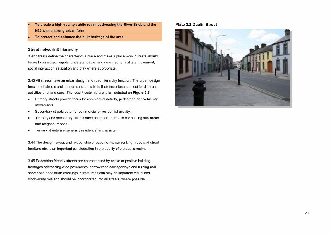
Street network & hierarchy3.42 Streets define the character of a place and make a place work. Streets should
be well connected, legible (understandable) and designed to facilitate movement,
social interaction, relaxation and play where appropriate.
3.43 All streets have an urban design and road hierarchy function. The urban design
function of streets and spaces should relate to their importance as foci for different
activities and land uses. The road / route hierarchy is illustrated on Figure 3.5
� Primary streets provide focus for commercial activity, pedestrian and vehicular
movements.
� Secondary streets cater for commercial or residential activity.
� Primary and secondary streets have an important role in connecting sub-areas
and neighbourhoods.
� Tertiary streets are generally residential in character.
3.44 The design, layout and relationship of pavements, car parking, trees and street
furniture etc. is an important consideration in the quality of the public realm.
3.45 Pedestrian friendly streets are characterised by active or positive building
frontages addressing wide pavements, narrow road carriageways and turning radii,
short span pedestrian crossings. Street trees can play an important visual and
biodiversity role and should be incorporated into all streets, where possible.
Plate 3.2 Dublin Street

22

23
Plate 3.3 Mallow Rd, Strong visual impact of trees.
New streets3.46 To increase choice of movement and to facilitate redevelopment, a new local
road network should be created, between the Mallow Rd and the N20, including a
‘spine road’ connecting Fitz’s Boreen to the Shopping Centre, three intersecting
‘Spur/Link Roads’ off the N20 traversing the Retail Park and the Dulux and Millfield
complexes.
3.47 Primary streets should be not less than 15 metres wide; secondary streets not
less than 12 metres, and tertiary routes of 8 - 10 metres. The width to height ratios of
quality primary and secondary streets will be in the region of 1:1 - 1:1.25
Public spaces3.48 The primary access route, namely, the north-south spine road should be
punctuated by a series of public squares or activity nodes, highlighted with local
landmark buildings providing definition and legibility to aid orientation, navigation and
understanding of the place and enhance the environmental quality of the area. (See Figure 3.5)
Residential streets3.49 Residential streets should afford priority to pedestrians and cyclists, by way of
wide pavements, (minimum width, 2 metres), short span crossings and narrow road
carriageways. Car parking should be in balance with other uses, in well considered
layouts, including street planting and street furniture where possible.
Building heights
3.50 The plan area should be developed with low to medium-rise buildings. In
general, medium-rise buildings ranging between 3 & 5-storeys should be located
within 500 metres of the planned rail station, and 2 & 3-storeys beyond the 500
metres radius. In exception, local landmark buildings could highlight important road
junctions and civic spaces. Residential buildings in and around existing residential
blocks should not exceed 4-storeys in height. Buildings in excess of 6-storeys are
considered to be inappropriate. (See Figure 3.6)
Scale / Massing3.51 In accordance with sustainable development principles, and in order to promote
city-wide legibility and to foster a ‘sense of place’ and highlight the importance of
Blackpool. The area within or around the district centre or central areas should be
developed at a higher density than the outer extremes such as in Kilbarry and the
Commons Ridge precincts.
Adaptable buildings3.52 In order to facilitate a vibrant mixed-use environment, building / block design
should be robust and flexible, including narrow frontages and clear floorplates, to
assist future changes of use, amalgamation or subdivision of units. Appropriate
commercial / retail unit dimensions should range between 7 - 10 metres width, and
24
20 - 25 metres in depth. Block dimensions should range between 50 and 100
metres.
Figure 3.6 Building Scale / Massing Strategy

25
Movement Strategy
3.53 North Blackpool is an important development area and gateway to the city and
is well served by strategic roads (N20, R635) and public bus services. However,
much of the plan area (north and western sectors) is poorly connected as the local
road network is under-developed. (See Figure 3.7)
Figure 3.7 Barriers Movement Concept
3.54 The trunk roads and the rail embankment are significant physical barriers to
movement, in particular, to cyclists and pedestrians. Congestion on the Old
Whitechurch Rd, Mallow Rd and Dublin Hill, has a detrimental impact on residential
amenity and environmental quality.
It is Council policy to support an integrated transport system (Policy 5.1), to support sustainable modes of transport and ensure that land use and zoning are integrated with transportation, (Policy 5.2), and to encourage modal change from private car towards more sustainable forms, (Policy 5.4 City Development Plan).
3.55 The City Development Plan aims to promote the development of an integrated
transport system which will support sustainable development, social inclusion and
environmental protection. Current modal share in the city is heavily dependent on
private vehicles at 67%, whereas cycling / walking is at 26% and public transport is
7%.
Key Objectives
� To promote an integrated transport strategy, to support and sustain public transport services including the planned suburban rail services at Kilbarry
� To develop the multi-modal road/street network, to facilitate a high quality public realm as outlined in the City Development Plan
� To prioritise and promote walking and cycling through the creation of an attractive, safe and convenient network of pedestrian/cycle routes
� To protect the strategic function and capacity of the N20
Public Transportation3.56 Redevelopment of the Blackpool Valley will place increasing pressure on the
existing road infrastructure and as such investment in sustainable modal options

26
such as public transport, walking and cycling will be critically important to the
success of the area.
‘An integrated transport system will improve mobility, accessibility and connectivity to employment, services, recreation and leisure centre facilities centre, and will empower people by giving them choice.’ (CASP pp. 72)
3.57 The development of high quality public transport is a desirable element of an
integrated public transport system. The Cork Area Transit System (CATS) Public
Transport Feasibility Study has examined the feasibility of rapid transit corridors to
support the future spatial allocation of developments within the CASP area. The
strategy recommends a significantly improved conventional bus service for the north-
south corridor linking Ballyvolane - City Centre - Cork Airport, in the form of a new
two-way loop bus route (route no. 7) at a 10minute frequency to interchange with
bus, suburban rail and the east-west rapid transit service.
Plate 3.4 The Former Kilbarry Rail Station
Rail3.58 The planned rail service at Blackpool / Kilbarry will support sustainable
development, social inclusion and environmental protection. Its success is dependent
on the development of this ‘gateway’ as a mixed-use centre at an appropriate
density. The planned service provides an opportunity for a public transport
interchange at the junction of Redforge Rd & Brothers Delany Rd, (and Dublin Hill).
The City Council will provide part funding towards the construction of the rail station.
3.59 In light of the topographical constraints of the valley, the creation of direct
pedestrian / cycle links between the station and adjoining employment and
residential areas is important to maximise modal shift away from the car.
3.60 New pedestrian routes to the station are proposed at Fr. Rodgers Park, Dublin
HiIl and Redforge Rd via the embankment track. The construction of the pedestrian
lift is required as part of the redevelopment of the rail station and an associated taxi /
vehicle set-down area is proposed on the lower Redforge Rd.
Bus 3.61 The sub-area is currently served by a number of radial routes (No.’s 3, 5A &
12), an orbital route, (No. 1) and the regional service to Waterloo via Blarney, (No.
224). The majority of bus routes serve Thomas Davis St, Dublin St, Redforge Rd and
Brothers Delany Rd.
3.62 It is proposed to upgrade local bus services to include the development of a quality bus corridor, (Green Route) incorporating a public bus zone around a public plaza at the junction of Redforge Rd and Brothers Delany Rd, and a future bus service to the planned residential area off the Old Whitechurch Rd. (See Figure 3.8)

27

28
Road network3.63 In order to fully ‘open-up’ the plan area, improve permeability and to integrate it
with its surroundings, a coherent hierarchical street network is proposed in line with
the Road Improvement Objectives, as per City Development Plan Map 6. (Figure 3.1)
3.64 The main strategic routes will continue to be the N20 and R635. Three new
signalized junctions should be designed along the Commons Rd between Brothers
Delany Rd and Fitz’s Boreen, including the re-opening of the Fairfield Avenue and
Commons Rd junction.
3.65 Within the plan area, the primary routes include the new ‘Spine Rd’ running
parallel to the River Bride linking Brothers Delany Rd to Fitz’s Boreen, the Brothers
Delany Rd and the new Spur Rd connecting the N20 (opposite Fairfield Avenue) to
Redforge Rd. Secondary routes include the Redforge Rd and Mallow Rd.
3.66 In general, primary and secondary streets should be multi-modal (vehicles,
cyclists and pedestrians) to ensure appropriate levels of activity, vitality and
surveillance. Segregation of modal users should be appropriate within public parks
and minor pedestrian routes / lanes.
3.67 To protect and enhance residential amenity on Redforge Rd and the Mallow Rd,
through traffic should be directed onto the N20 via an upgraded and widened Fitz’s
Boreen, facilitating a ‘left turn’ lane at the junction of the N20.
Walking / Cycling3.68 In order to promote cycling and walking, redevelopment should contribute to the
creation of adequate, safe and convenient access routes. The planned spine rd and
riverside pedestrian / cycle-way will form the primary route through the plan area.
The creation of a number of open spaces and public squares along the River Bride
should result in an enriching, high quality environment.
3.69 Walkways / cycleways should connect employment and residential centres
(including the planned residential scheme on Old Whitechurch Rd), to the district
centre and public transport interchange.
Plate 3.5 Walkway at St. Francis’ Gardens
3.70 A network of key routes should be developed (in accordance with the Cycle
Infrastructure Objectives - City Development Plan Map 13), including the Old
Whitechurch Rd, Mallow Rd, The Launteens, Dublin Hill, Dublin St, Redforge Rd,
Commons Ridge, Commons Rd, Fitz’s Boreen, in order to connect with Ballyvolane,
Glen Valley, Fair Hill and Kilnap areas.
3.71 New pavements and cycle lanes should be constructed along the embankment
side of Redforge Rd, the southern side of Mallow Rd. A new pedestrian route to the
shopping centre should be created through the cleared site of No. 39 Dublin Street,

29
or a viable alternative location along Dublin Street, to link with Spring Lane via Cross
Lane.
Car parking3.72 The plan area is covered by two distinct car parking zones with respective
parking standards. Zone 2A occurs along public transportation corridors and is
defined by a 500 metre radius from the Kilbarry ‘rail station’. Zone 3 applies to the
suburbs of Cork.
3.73 In order to create an attractive environment for cyclists and pedestrians, the
majority of future commercial car parking should be provided at basement level, and
on-street parking should be restricted where appropriate but facilitated where it would
positively animate and enliven streets.
Plate 3.6 Blackpool Shopping Centre Carpark

30
Public Open Space Strategy
3.74 Well maintained and accessible public open spaces, sports and recreational
facilities are key elements in ensuring a good quality of life and enhancing the overall
attractiveness of an urban environment.
Key Objectives
� To protect and enhance existing public open spaces, sports ground and leisure facilities which provide for the passive and active recreational needs of existing and future residents
� To provide new parks and public open spaces, including a linear park along the River Bride and the Commons Ridge
� To improve the accessibility and passive supervision of public open spaces through the development of a safe and attractive pedestrian / cycle network connection these spaces
3.75 In accordance with City Development Plan Policy 11.4, to develop a network of high quality amenity routes along waterways, and Urban Design Policy 16.3, to create a legible and coherent spatial pattern, reinforcing an urban structure, creating new city spaces along the secondary green links focussed on tributary river corridors; the River Bride should be the structural spine of the plan
area, around which the urban structure, the road, pedestrian / cycle network and
public open spaces are organized.
Open space3.76 The River Bride, bounded by a ‘riparian’ strip, (a planted, landscaped area) of
not less than 10 metres each side of the watercourse, should extend to a substantial
public open space abutting Fitz’s Boreen, including the existing landscaped amenity
space and escarpment within the Dulux complex.
3.77 The riverside landscape should provide an attractive environment for passive
recreation and informal pursuits such as a walking / cycling and will benefit from the
supervision and surveillance of overlooking buildings and through routes, increasing
the sense of security and attractiveness for all users.
Plate 3.7 Blackpool Retail Park Amenity Space
3.78 In accordance with the Landscape Preservation Zone objective, the Commons
Ridge should be developed as a ‘woodland’ park with an open character, including a
pedestrian / cycle route to Fitz’s Boreen.
3.79 It is proposed that the visually prominent rail embankment on Redforge Rd is retained and developed as a landscaped pedestrian access route to the rail station.
3.80 It is proposed that the Glen River running through the ‘Cork Metals /Hammond Lane’ site off Spring Lane / Thomas Davis St. is retained in an open state and landscaped as a feature within a pocket park serving the new

31
residential neighbourhood, and part of a pedestrian / cycle route to the Glen Amenity Park.
3.81 It is proposed to locate a children’s playground / multi-purpose courtwithin the existing Spring Lane public open space.
3.82 Where possible, all landscaped areas / public open spaces should be
overlooked by active building frontages in order to improve the sense of security and
attractiveness and so encourage use.
3.83 The topography of the plan area does not support large scale formal sports
facilities or pitches. Such facilities should be developed as and when required within
the planned North-West District Park, Knocknaheeny, as set out in the Parks
Strategy 2000.

32

33
Landscape Strategy
3.84 The landscape assets of North Blackpool such as the steep ridges /
escarpments and the Bride and Glen rivers are important characteristics of this
distinct area. A number of existing views and prospects of special amenity value
have been identified that significantly contribute to the character and amenity of the
visual envelope of the city.
Key Objectives
� To protect and enhance the landscape assets and biodiversity of the area
� To improve access to this distinct landscape
� To protect the quality or setting of views and prospects of special amenity value
Landscape Assets3.85 In accordance with Council policy to preserve and enhance Cork’s landscape
character and assets through the development of green links along the secondary
river tributaries, the River Bride should be the structural spine of the plan area.
3.86 The River Bride will form the primary pedestrian / cycle route through the area,
improving access to the river, enhancing the attractiveness and quality of the
environment.
3.87 It is proposed that the culverted stretch of the river Bride be opened-up, regraded and planted, to enhance the visual amenity and biodiversity value.
3.88 The Commons Ridge, in accordance with the Landscape Preservation Zone objective, should be subject to a tree planting program to create a‘woodland park with an ‘open’ character.
3.89 It is proposed that the rail embankment on Redforge Rd and the amenity space / escarpment within the ‘Dulux’ complex should be preserved as ‘green corridors’ and further enhanced by landscaping / planting.
Views 3.90 The city at large is best appreciated and understood along important viewpoints
such as the River Lee or panoramic views. Amenity views and prospects are defined
as those views which significantly contribute to the character and amenity of the
visual envelope of the city, the city skyline, built heritage and natural heritage.
It is Council policy to resist development that threatens to obstruct or compromise the quality or setting of views and prospects of special amenity value. (Policy 10.8)
Plate 3.8 Protected View of Commons Ridge

34
3. 91 The protection of the area’s ‘views of special amenity value’ is a material
consideration regarding the appropriate scale / massing of development, spatial
pattern and urban structure and the protection of the landscape assets.
3.92 Protected views relating to the plan area:
(a) View of Farranferris College / Ridge from The Glen / Dublin Hill and Ballyvolane /
R635;
(b) View of the Commons Ridge from Fitz’s Boreen and the North Point Business
Park;
(c) View of the ‘Old City’ (North Cathedral & St. Anne’s) from Dublin Hill.
3.93 Limiting the scale / height of development will protect the distinct landscape
character and special amenity views of the area. The design and layout of streets
highlights views of local landmarks such as Farranferris College, and the Church of
the Resurrection, Knockpogue Avenue.

35
Community Strategy
3.94 The primary aim is to promote and develop North Blackpool as a socially
inclusive urban district, providing for the needs of the entire community, ensuring a
good range of services and facilities within easy access, and improving the quality of
life for all. Providing appropriate facilities and services to meet the specific needs
requirements is a key element in fostering a sense of community.
3.95 The plan aims to promote the concept of an ‘urban village’, ensuring the
development of balanced and sustainable communities, where improved community
and other facilities are located within easy access of the population by way of a
network of district, neighbourhood and local centres , (in accordance with City
Development Plan policy 7.4).
Key Objectives
� To promote and provide local services and community facilities in locations that are accessible to where people live
� To encourage the provision of good quality childcare, education and healthcare services in North Blackpool
� To promote the use of existing community facilities for other uses
� To support and promote the development of the RAPID and other disadvantaged areas.
3.96 The population of Cork City fell by 3% between the Census of 2002 and 2006;
and within the four electoral divisions that lie within the plan area, (Blackpool A,
Commons, Fairhill C, The Glen B) the population fell by 4. 8%. The City’s population
is an aging one, as evidenced by 23% of persons being aged between 0 - 19years, in
comparison to 27% for the State; whereas 14% were aged over 65years, compared
to 11% for the State; 63% were aged between 19 - 65years. Non Irish people
accounted for 11% of the population.
3.97 Much of the northside of the city is socially disadvantaged with high
unemployment rates which will place particular demands on housing, education and
training. Three of the four RAPID (Revitalising Areas through Planning Investment
and Development) areas of the city are located on the northside.
3.98 Specific needs of the community are listed as follows:
� Children require childcare facilities, playgrounds and sports facilities, schools
and safe walking / cycling routes.
� Adults of working age and vulnerable groups, such as single parents, the
unemployed and ethnic minorities require access to education, training,
community facilities, healthcare services, local shops and services and public
transport.
� People over 65 years of age require community / meeting facilities, care
services, nursing homes, housing and public transport.
� Physically disabled people require well designed buildings and public realm,
wheelchair access ramps, dished kerbs, appropriate parking facilities, etc.
Plate 3.9 Blackpool Community Hall, Great William O’Brien Street

36
3.99 Blackpool Village should continue to provide a local retail and services function
in accordance with its neighbourhood centre land-use zoning objective. The northern
end of the ‘village’ (Thomas Davis St / Dublin St) within the LAP boundary should
compliment, not duplicate the role of the area subject to the Blackpool Village Area
Action Plan 2010. For example, it is considered desirable that the permanent
location of the Blackpool Library is within the neighbourhood centre zoned lands to
complement the Cork City and County Archive on Great William O’Brien St.
3.100 The transformation of the existing retail centre into a modern mixed-use urban
centre and the redevelopment of neighbourhood centre lands, coupled with high
quality public transport will assist the social inclusion objective to achieve an
acceptable standard of living, by making material, cultural and social resources (i.e.
childcare, healthcare) accessible to the entire community.
3.101 Commercial services are catered for within the existing district centre and
neighbourhood centre zoned areas and will be further enhanced with the planned
local centre within the former Sunbeam complex and the Old Whitechurch lands to
the north-west of the plan area.
3.102 The Council’s Housing List shows a strong demand (66%) for 1 & 2-bed units
within the Blackpool, Fairhill and Glen areas of the city, and a 29% demand for 3 -
bed units. The Council’s planned housing schemes on the Old Whitechurch Rd and
Thomas Davis St / Spring Lane site will go far in meeting the social housing needs of
the community.
3.103 Childcare facilities currently exist in the district centre, (Sunbeam Business
Park, Redforge Rd) and additional facilities have been permitted at the Millfield
industrial site and the City Square development on Watercourse Rd.
3.104 Educational needs will be provided by the planned primary school at Old
Whitechurch Rd, and third-level training at the permitted mixed-use scheme at the
Millfield site, Commons Rd. Furthermore, it is an objective (4.2) of the Farranferris
Local Area Plan 2009 that the Seminary building (currently occupied by the Northside
Community Enterprises) be further developed as an education and training centre.
Plate 3.10 Childcare Services on Redforge Road
3.105 Healthcare services currently exist within the Millfield Industrial estate and
have been permitted as part of the redevelopment of the Millfield site, and new
facilities are included within the planned Council scheme at the junction of Thomas
Davis St & Spring Lane.
3.106 Cork Foyer, Assumption Rd provides affordable accommodation, support and
training for young adults aged 18 - 25, that were homeless or at risk of becoming
homeless. Additional Community facilities including a youth resource centre / café
should be located within the ‘district’ or ‘neighbourhood’ centre or incorporated into
the Blackpool Community Hall, Great William O’Brien Street.

37
3.107 The creation of a quality Civic Square within the Blackpool Shopping Centre,
including and a multi-purpose outdoor event space for entertainment / cultural /
recreation purposes capable of hosting an outdoor market will enhance the visual
amenity of the area, foster local identity and a sense of place.
3.108 The installation of Public Art within a new civic space as part of a major
redevelopment of the shopping centre will enhance visual amenity and local identity.
3.6.15 In order of promote good health and to meet recreational needs of the
community, it is proposed to provide an outdoor activity trail or gym, (‘parcourse’)
within the Dulux amenity space; a children’s playground within the existing Spring
Lane public open space, and a ‘Sli na Slainte’ walking route through the Commons
Ridge and / or the Riverside walkway.
3.109 The redevelopment of derelict and cleared sites, to best practice urban design
principles including active building frontages and mixed uses, will improve the
environmental quality of the area, will generate street level activity and movement
and thus create a safer (night time) environment .

38
4. Sub-Area Strategies
4.1 This section provides development guidance for each of the sub areas and
amplifies City Development Plan principles and policies, to provide a coherent and
sustainable development framework to realize the potential of each sub-area. The six
distinct sub-areas have been identified as follows:
The six precincts / sub-areas are as follows:
1. Dublin Street
2. District Centre & adjoining lands
3. Dulux & adjoining lands
4. Mallow Road
5. Kilbarry
6. Commons Ridge
Figure 4.1Sub-Area Precincts

39
Sub-Area: Dublin Street
Description4.2 The sub-area includes Dublin Street, Dublin Hill, Thomas Davis Street and Spring
Lane. It is a traditional townscape of low rise, narrow frontage, informal terraces of
19th & 20th Century buildings. The sub-area forms the northern end of Blackpool
Village.
4.3 The area bounds the Blackpool Architectural Conservation Area and the frontage
along Dublin St, Thomas Davis St. and Spring Lane is identified in the City
Development Plan as a street improvement area, recognizing the character of the
historic streetscape.
4.4 The area has no individual buildings of special significance but cumulatively the
buildings have a strong character and sense of place. The area is largely residential
but includes numerous local shops and services. The area suffers from neglect,
dereliction and unit vacancy.
4.5 This decline is a reflection of its proximity to the Blackpool Shopping Centre and
the area’s detachment or severance from the remainder of the ‘village’ and hinterland
by the N20 North City Link Rd.
Land-Use Strategy4.6 This residential dominated area is subject to four land-use zoning designations.
The majority of the area, including much of Dublin Street, Spring Lane and former
Hammond Lane / Cork Metals site is zoned Residential, Local Services & Institutions,
with the objective to protect and provide for residential uses, local services,
institutional uses, and civic uses, having regard to employment policies.
4.7 The existing park on Spring Lane is zoned Public Open Space, with the objective
to protect, retain and provide for recreational uses, open space and amenity facilities.
Figure 4.2 Dublin Street
4.8 The eastern side of Thomas Davis Street and part of the southern side of Spring
Lane is zoned Neighbourhood Centre with the objective to protect, provide for and /
or improve the retail function of neighbourhood centres and provide a focus for local
services, whereas, the buildings of Thomas Davis Street, Dublin Street and the
northern side of Spring Lane are zoned Street Improvement Area, with the objective
to protect and improve the architectural character of the area.

40
4.9 In accordance with the zoning objectives, the primary land use will continue to be
residential. Secondary uses will include local services, retail, commercial leisure such
as pubs and café’s, community related uses such as a medical centre and childcare
facilities.
4.10 The ‘brownfield’ lands off Spring Lane represent a significant opportunity to
redress the trend of population decline and reinvigorate the neighbourhood. It is
proposed that this area is developed with two and three-storey residential blocks
overlooking the River Glen and three and four-storey residential blocks with street
level commercial units on Thomas Davis Street.
Movement Strategy4.11 A key objective is to create a well connected residential neighbourhood, with
direct, convenient and comfortable routes to local services, amenities and public
transport. In order to open-up the area and improve permeability, a coherent
hierarchical street network should be developed as follows.
Street Hierarchy4.12 The primary route through the sub-area is the historic route of Thomas Davis
Street / Dublin Street / Dublin Hill intersecting Redforge Road, accommodating public
bus services, private vehicles, cyclists and pedestrians. Spring Lane is a secondary
route towards Ballyvolane. The pedestrian route of Cross Lane and the Thomas
Davis St link to the Blackpool Shopping Centre at the ‘flyover’ are significant tertitary
routes.
4.13 Important new routes include the access roads from the former Cork Metals /
Hammond Lane sites, and the reopening of the footpath from the R635 to the rear of
the Glen Hall apartments;
4.14 It is proposed that a new east-west pedestrian route be created through the cleared site of No.39 Dublin Street or a viable alternative site linking the Blackpool Shopping Centre to Spring Lane via Cross Lane.
4.15 In general, primary and secondary routes including Spring Lane will be two-way
routes and multi-modal, to generate appropriate levels of activity, vitality and
surveillance.
4.16 Residential streets such as Spring Lane should encourage and support
pedestrians and cyclists through widened pavements and careful layout of parking
spaces, planting and street furniture and surface materials.
Car-parking4.17 The sub-area lies within Parking Zone 2A, that is within 500 metres of the
Kilbarry rail station. In order to encourage modal shift to sustainable forms of
transport and public transport, car parking provision should be restricted. Car parking
should be limited to the restricted levels as set out in the City Development Plan. On-
street parking in commercial areas should be restricted to short-term spaces in order
to balance visitor convenience, street vitality and environmental quality issues.
Walking / Cycling4.18 A core element of the movement strategy is to develop environmentally friendly
modes of transport, such as cycling and walking. Successful residential
neighbourhoods require safe and convenient space for cyclists and pedestrians.
Footpaths and cycleways should connect residential areas to economic, amenity and
civic centres.
4.19 It is proposed that cycle lanes be developed on Dublin Hill, Dublin Street, Thomas Davis Street and Spring Lane in accordance with the cycle network (illustrated in Map 13 of the City Development Plan).
41
4.20 Heavy traffic flows on Dubin Street and Dublin Hill, sever the community and act
as a barrier to the elderly population, in particular. Dublin Street requires a functional
rebalancing towards pedestrians and cyclists including priority measures.
4.21 It is proposed that a ‘raised’ pedestrian crossing is created at the junction of Cross Lane and Dublin Street.
4.22 It is proposed to relocate the existing bus stop at the junction of DublinStreet / Spring Lane to the pedestrian zone or plaza in the vicinity of the‘flyover’ in order to generate activity and to reinforce this local node.
Rail4.23 The planned commuter rail service at Blackpool / Kilbarry provides a major
opportunity to develop an integrated transport system for the city, which will support
sustainable development, social inclusion and environmental protection at a low cost.
The success of the planned rail service is dependent on the redevelopment of the
area at an appropriate density.
4.24 Pedestrian and cyclist access routes to/from the station should be maximized,
as the road network currently experiences heavy traffic flows and congestion at peak
times.
Bus 4.25 The sub-area is currently served by a number of city bus routes along Thomas
Davis St / Dublin Street / Dublin Hill. City bus services have been upgraded in recent
years including the provision of high quality bus corridors or Green Routes.
4.26 It is proposed to develop the designated Farranree / Blackpool ‘Green Route’ on the existing No. 3 & No. 12 Bus Eireann routes. It is proposed to reserve a 3.5 - 4 metre wide strip along the lower section of the Redforge Rd,
north of the Shopping Centre service road, and the eastern section of Brothers Delany Rd up to the cross-roads as a bus lane.
Plate 4.1 Dublin Street
Urban Design Strategy4.27 The urban fabric of the area is generally intact including extensive active street
frontages in the form of traditional perimeter blocks. However, the southern area is
blighted by cleared/derelict sites including a 150metres ‘gap’ in the frontage of
Thomas Davis St. and Spring Lane.
4.28 The existing built form is characterised by 1 & 2-storey narrow frontage, pitched-
roof terraced units opening directly onto the public pavement. Buildings set within
linear blocks. The majority of units are residential but local businesses exist including
a pub, shops and guesthouse.
4.29 Notwithstanding the area’s proximity to the planned rail station, the ‘residential’
and ‘street improvement’ zoning objectives to protect the existing character and
42
residential amenity of the area, takes priority. This can be best achieved through
small scale ‘infill’ and ‘backland’ schemes.
Derelict sites4.30 The streetscape environment north and south of the Blackpool bypass
overbridge or ‘flyover’ suffers from dereliction and site clearance.
4.31 Much of the area is zoned a ‘street improvement area’ with the purpose to
protect the residential nature and architectural character of the area, and to reduce
the impact of traffic on residential amenities. The vast majority of the historic
buildings are 1 & 2-storeys, but a 4-storey dilapidated building (no. 27) is located off
the junction of Dublin Street & Spring Lane.
4.32 No. 27 Dublin Street and the adjoining cleared sites (No.’s 29-31 Dublin St)
provides an opportunity to highlight this local node with significant landmark buildings
relative to the character of the area.
4.33 Respond! Housing Association proposes to redevelop the derelict 4-storey
building and adjoining vacant sites at the junction of Dublin Street and Spring Lane
(No.’s 27-31) into social housing for elderly people in the form of 7 no. 1-bed
apartments and 3 no. 2-bed apartments over 4-storeys.
4.34 The proposed redevelopment of the subject site as outlined would appropriately
reinforce this junction with significant landmark buildings and complement the
Council’s regeneration plans for the former Cork Metals site.
4.35 Cork City Council in partnership with ‘Respond!’ has prepared a mixed- use
medical centre and housing scheme (Part VIII) for the former Cork Metals site
adjoining the Glen Hall apartments, to include a mix of private and old people’s
housing.
4.36 The planned medical centre is an appropriate use for the neighbourhood centre
zoning objective and will generate significant pedestrian activity and support the
existing bus services.
Plate 4.2 Opportunity sites on Dublin Street
4.37 The lands to the rear of the site should be developed as a medium density
family oriented residential neighbourhood of 2 & 3-storeys, including a linear public
open space centred on the Glen River, playground facilities and a pedestrian/cycle
route onto the North Ring Road and The Glen Amenity Park, via the existing pathway
to the rear of the Glen Apartment block.
4.38 Dublin Street is relatively intact, but there are two significant gaps in the street
frontage on the western side of Dublin Street, namely at no. 32 & no.’s 37-39. In
order to reinforce the character of the area, two-storey buildings should be erected.
These sites are ideal for small scale infill development as demonstrated on Cross
Lane.

43
4.39 Waterpark Construction Ltd (Shipton) has permission to retain No. 40 Dublin
Street and construct 5 no. 2-storey terraced dwelling units at No. 37-39 Dublin Street.
4.40 It is considered that a walkway should be created through the site or viable
alternative location along Dublin Street to access the Blackpool Shopping Centre
thus increasing local permeability.
4.41 The ‘yard’ to the side of No. 32 Dublin Street represents an opportunity to
develop 2 no. 2-storey terraced dwellings units thus completing a continuous building
line.
4.42 The area under (and adjoining) the Blackpool Bypass (N20) over-bridge / flyover
is subject to anti-social behavior, loitering littering and vandalism. It has a road
frontage of 56 metres on the eastern side of Thomas Davis Street and 27 metres on
the western side but is bounded by blank gable walls and dereliction.
Plate 4.3 Thomas Davis Street & N20 Flyover
4.43 The plaza is located at the intersection of the north-south axis of Thomas Davis
Street and the east-west axis walkway between Mount Farran residential
neighbourhood and Blackpool Shopping Centre. In order to improve the
environmental quality and attractiveness of the ‘plaza’ to pedestrians its nodal
function should be emphasized and reinforced to increase movement, activity and
surveillance over the area.
4.44 It is proposed to relocate the bus stop from the Dublin Street / Spring Lane junction (northbound) to Thomas Davis Street, under the N20 ‘flyover.’
4.45 It is proposed to support the redevelopment of No.77 Thomas Davis Street to include the creation of ground and first floor ‘opes’ to the south-facing gable wall in order to increase surveillance over the plaza and walkway.
4.46 The City Council will support the use of (part of) the plaza as an outdoor seating
/ dining area for use by adjoining restaurants / cafes.
4.47 The public right-of-way serving as an emergency vehicle access to St Francis’
Gardens should be bounded by a decorative metal railing and gate to delineate and
segregate the public and private domain.
4.48 It is proposed to install bus shelters, seating, bicycle racks, to carry out landscaping maintenance works as part of a public real improvement scheme.
4.49 Spring Lane is relatively narrow in width and currently suffers from unit vacancy
and dereliction, which in turn undermines the attractiveness of the street as a through
route to pedestrians and cyclists. The redevelopment of the derelict / cleared sites
(outlined above) would act as a catalyst for the refurbishment of the adjoining
residential building stock.

44
4.50 The redevelopment of the derelict sites will make Spring Lane more attractive to
walkers / cyclists. Pavements should be widened to 2.0metres. Two-way traffic flow
should be reinstated to increase movement and supervision.
Landscape4.51 The area is relatively flat but rises gently in a northward direction, gradient
increasing at Dublin Hill. The northern boundary is defined by the heavily planted rail
embankment, as part of a wildlife corridor. The Glen River should be fully planted
and landscaped as a riparian strip to promote wildlife and create a visual amenity.
4.52 Respecting the existing low rise character of the area will protect important
views of local landmarks such as the Farranferris and Commons Ridges and the
Church of the Ressurrection, Fairhill.
Public Open Space & Recreation Strategy4.53 A key objective of the sub-area is to provide for and enhance public open space
to serve the residential community, in accordance with the land-use zoning objective,
to protect, retain and provide for recreational uses, open space and amenity facilities.
4.54 The dimensions and sloping nature of the roadside edge of the Spring Lane
Public Open Space inhibits formal or organised recreational activity but it is ideal for
passive recreation and a children’s playground to generate activity and act as a
community focal point.
4.55 The existing public open space on Spring Lane and new linear park along the
Glen River will provide informal recreation. Establishments such as the Glen Boxing
and Glen Rovers Hurling clubs will continue to provide for organized recreation in the
area.
4.56 Local route enhancements as outlined in the Movement Strategy will increase
accessibility to these facilities.
Plate 4.4 Spring Lane Public Open Space

45
Sub-Area: District Centre & adjoining lands
Description4.57 The sub-area consists of the Blackpool Shopping Centre, Retail Park, the
former Sunbeam Industrial complex and the planned rail station lands. It is bounded
by the Dublin St, Dublin Hill & Thomas Davis St, and the Commons Rd, (N20).
4.58 The sub-area lies within the relatively flat valley floor of the River Bride and is
defined on its northern side by the steep sided rail embankment. The most prominent
buildings are within the retail park, including a 9-storey tower.
Land-Use Strategy4.59 This retail dominated sub-area is subject to three land-use zoning designations.
The majority of the area is zoned District Centre, including the Blackpool Shopping
Centre and Retail Park and the former Sunbeam lands.
4.60 The rail embankment (Redforge Rd) & Kilbarry station site is zoned Residential,
Local Services & Institutions. The riverside amenity space adjoining the retail park is
zoned Public Open Space.
4.61 The key land-use objective is to create a modern, vibrant, mixed-use urban
centre serving as an attractive gateway to the city and a desirable destination for
north-side suburban communities.
District Centre lands4.62 The District Centre zoning includes the Blackpool Shopping Centre, Retail
Centre, the former Sunbeam lands and the Millfield Service Station on Redforge Rd.
The zoning objective is to provide for and/or improve district centres as mixed-use
centres, with a primary retail function, including retail warehousing, retail office,
commercial leisure, services and residential uses.
Blackpool Shopping Centre4.63 The Blackpool Shopping Centre (approximately,17,000 sq.m.gross ) is a
modern, car orientated, suburban retail centre with approximately 800 no. surface car
parking spaces.
4.64 Building No. 1 (11,000 sq.m. gross, 9,000 sq.m. net) is a single-storey Mall, with
a two-storey element at the northern end, including 30 no. shops, anchored by
Dunnes Stores, (6,000 sq.m. gross). Building no. 2 is a three-storey, mixed-use block
(3,000 sq.m. gross) set between Brothers Delany Rd and Redforge Rd. Two recent
additions (3,100 sq.m.) on Redforge Rd, includes 8 no. retail units built into the
embankment, and a three-storey block opposite
4.65 The low-rise nature of the shopping centre and surface car-parking is an
inappropriate form of development given its district centre status and proximity to the
planned rail station and therefore should be intensified in terms of scale and massing
in order to aid citywide legibility and support transport infrastructural investment.
Remodeling of the centre should be subject to best practice urban design principles
creating active street frontages and mixed-uses.
4.66 The shopping centre is characterized by inactive frontage onto the surface car
park. It is proposed that the retail units within the Mall should be reconfigured
and / or re-orientated to form shopfronts, where possible on the west-facing external
elevation, and that the Dunnes Stores unit should be enveloped by new retail /
commercial units to wrap around the existing footprint of the anchor store to create
an active streetscape environment.
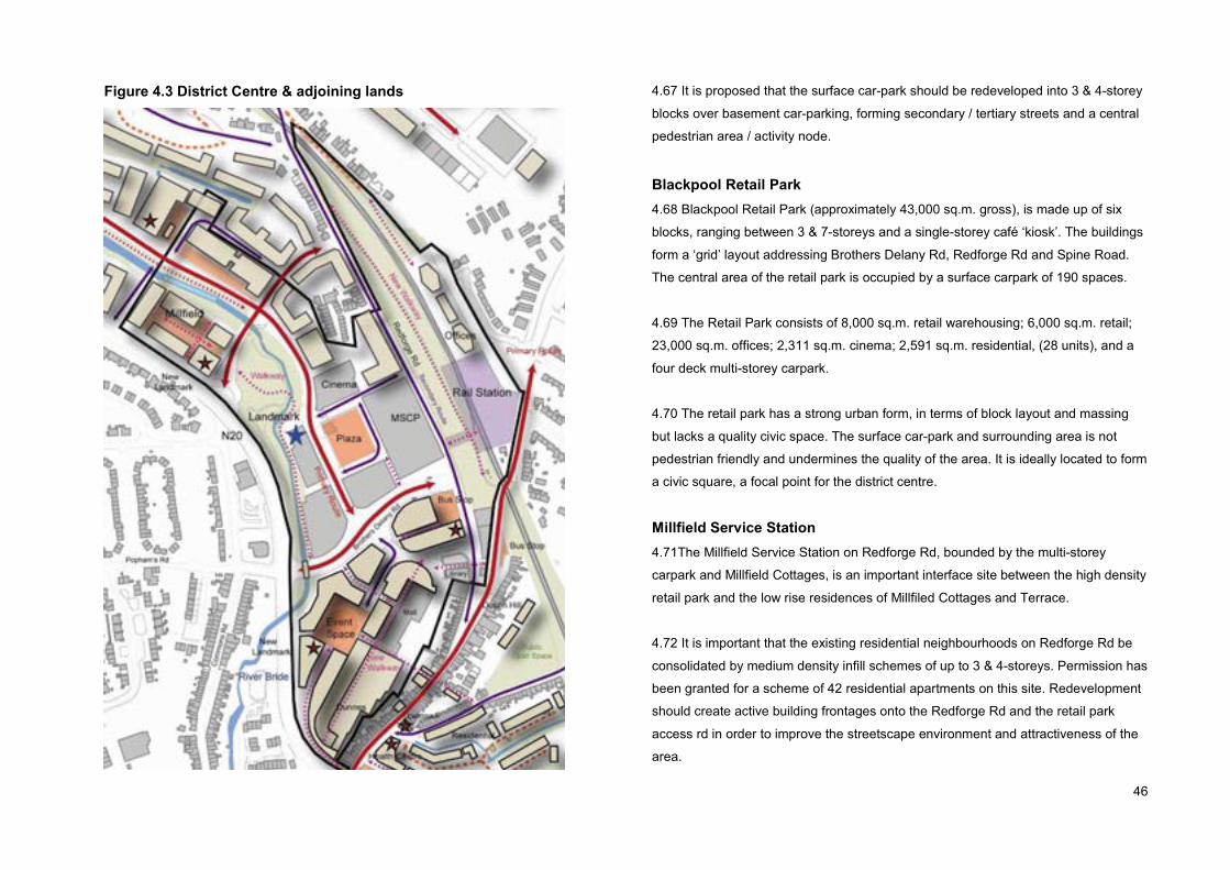
46
Figure 4.3 District Centre & adjoining lands 4.67 It is proposed that the surface car-park should be redeveloped into 3 & 4-storey
blocks over basement car-parking, forming secondary / tertiary streets and a central
pedestrian area / activity node.
Blackpool Retail Park4.68 Blackpool Retail Park (approximately 43,000 sq.m. gross), is made up of six
blocks, ranging between 3 & 7-storeys and a single-storey café ‘kiosk’. The buildings
form a ‘grid’ layout addressing Brothers Delany Rd, Redforge Rd and Spine Road.
The central area of the retail park is occupied by a surface carpark of 190 spaces.
4.69 The Retail Park consists of 8,000 sq.m. retail warehousing; 6,000 sq.m. retail;
23,000 sq.m. offices; 2,311 sq.m. cinema; 2,591 sq.m. residential, (28 units), and a
four deck multi-storey carpark.
4.70 The retail park has a strong urban form, in terms of block layout and massing
but lacks a quality civic space. The surface car-park and surrounding area is not
pedestrian friendly and undermines the quality of the area. It is ideally located to form
a civic square, a focal point for the district centre.
Millfield Service Station4.71The Millfield Service Station on Redforge Rd, bounded by the multi-storey
carpark and Millfield Cottages, is an important interface site between the high density
retail park and the low rise residences of Millfiled Cottages and Terrace.
4.72 It is important that the existing residential neighbourhoods on Redforge Rd be
consolidated by medium density infill schemes of up to 3 & 4-storeys. Permission has
been granted for a scheme of 42 residential apartments on this site. Redevelopment
should create active building frontages onto the Redforge Rd and the retail park
access rd in order to improve the streetscape environment and attractiveness of the
area.

47
Plate 4.5 Spine Road, Blackpool Retail Park
4.73 The primary use within the ‘district centre’ zoned lands will continue to be
comparison and convenience retailing. There is limited scope or need for additional
retail floorspace and as such residential and office based employment should be the
primary uses within new blocks, especially at upper floor levels. Commercial leisure
uses, (cafes, public houses, restaurants), retail offices, and local commercial and
community services will be encouraged at ground & first floor levels.
Former Sunbeam lands4.74 The former Sunbeam lands is dominated by large industrial buildings, vacant
sites and has limited access. The area consists of the Millfield Industrial Estate
adjoining the N20, a single-storey industrial block sub-divided into a number of
leisure and service units; the cleared site of the former Sunbeam factory, and the
Sunbeam Industrial Park / Business Park which includes a number of commercial
enterprises and a crèche, gym and community offices run by the Northside
Community Enterprises.
4.75 Planning permission has been recently granted for two major schemes,
including a 25,800 sq.m. mixed-use scheme including residential apartments on the
‘Millfield’ site and a 41,000sq.m. commercial scheme of retail warehouse and offices
on the former Sunbeam site. The layout of the two schemes accord with the planned
linear park and road network.
4.76 The remaining lands bound the Mallow Rd and the rear boundaries of Millfield
Terrace. This is an important interface between the (permitted) relatively high density
office / retail area and the low rise residential neighbourhood. Ground floor
commercial offices / services / retail would be appropriate.
4.77 It is proposed that the former Sunbeam lands be developed to include a mix of
residential and office based employment uses above a range of ground floor retail,
commercial uses and local services.
Residential, Local Services & Institutions zoned lands 4.78 The zoning objective of the Kilbarry station / embankment lands is to protect
and provide for residential uses, local services, institutional uses, and civic uses.
4.79 The rail embankment has little or no development potential due to engineering
constraints and its proximity to the rail-line and associated noise and vibration. The
embankment has great potential as a visual amenity and biodiversity value.
4.80 It is proposed to refurbish the existing embankment track for pedestrians and cyclists in order to improve station access.
4.81 The rail lands on the northern side of the track provides a development
opportunity to create a sense of place, a sense of arrival to the Gateway / District
Centre and is considered suitable for offices, (up to 3-storeys including a small
convenience retail unit. The residents of Kilbarry Cottages and The Grove would
benefit from new development screening / buffering the rail station.

48
4.82 Variation No. 5 of the City Development Plan facilitates the development of offices on the Rail lands, by rezoning the rail station lands to the north of the rail track from ‘Residential, Local Services & Institutions’ to ‘Business & Technology’.
Movement StrategyDescription4.83 The sub-area is well served by the road network, including Commons Rd / N20
and Redforge Rd, but there is no road access to the adjoining Dulux lands. The
Commons Rd, the rail embankment and the shopping centre are significant barriers
to cyclists and pedestrian. Redforge Rd is deficient in pavements and cycle lanes.
4.84 The key objective is to create a permeable, accessible urban centre and
coherent network of public streets, safe and attractive pedestrian / cycle routes and
integrated public transport services.
4.85 An integrated transport system will improve access and connectivity to the
employment, services, recreation and leisure facilities, providing choice to the local
community.
Rail4.86 It is Council policy to support an integrated transport system (CDP Policy 5.1),
to support sustainable modes of transport and ensure that land use and zonings are
integrated with transport, (CDP Policy 5.2).
4.87 The planned commuter rail service at Kilbarry provides a major opportunity to
develop an integrated transport system for the city, which will support sustainable
development, social inclusion and environmental protection.
4.88 The success of the planned rail service is dependent on achieving appropriate
higher densities and an efficient route network to and from residential and
employment intensive areas.
4.89 Pedestrian and cyclist friendly routes should be developed on Redforge Rd,
Dublin Hill, and within the Kilbarry IDA Park via the Old Whitechurch Rd. The former
track on the embankment should be reinstated as a pedestrian access. Taxis and
private cars should be served by a set-down area on Redforge Rd and a vehicle
access on Dublin Hill.
Bus 4.90 The sub-area is currently served by a number of radial and orbital city bus
services, and the regional service to Blarney. The bus routes run along Thomas
Davis St / Dublin St, and diverge onto Brothers Delany Rd, Redforge Rd or Dublin
Hill.
4.91 It is proposed that the lower end of Redforge Rd at the junction of Brothers
Delany Rd should be developed as a bus / rail interchange facility, with a dedicated
bus lane and set-down area along the roadside perimeter of a new public plaza, to
include high quality bus shelters, disabled access kerbing and improved pedestrian
crossings between the rail station and the retail centre.
Street network4.92 The hierarchical street network, illustrated in the City Development Plan Map 6,
including the Spine Rd connecting the Fitz’s Boreen to the Shopping Centre landsm,
and two Spur Roads off the Commons Rd and Redforge Rd, should be developed to
open-up and integrate the area with the surroundings.

49
4.93 Primary routes include the Spine Rd and Brothers Delany Rd. Secondary routes
include the Redforge Rd and the two Spur Roads. The new road network will be laid
out progressively if and when development occurs.
4.94 In order to protect the residential amenity of the upper Redforge Rd and the
Mallow Rd, through traffic should be directed onto the Commons Rd via Fitz’s
Boreen.
Car parking4.95 As the majority of the sub-area lies within car parking Zone 2A, defined by a
radius of 500 metres or 5minute walk from the Kilbary ‘rail station’, unnecessary car
use should be discouraged and public transport encouraged.
4.96 In accordance with the City Development Plan, car parking provision should be
restricted. The majority of new commercial car parking should be provided at
basement levels, and on-street parking should be restricted where possible in order
to create pedestrian and cycle friendly streets. Primary and secondary streets should
incorporate short-term, on-street parking for visitor convenience, vitality and
surveillance.
Walking/Cycling4.97 Walking and cycling should be encouraged by the development of a network of
safe, attractive and convenient access routes.
4.98 The River Bride linear park should form the primary walking / cycling route
through the sub area. Other key routes to include Redforge Rd, and Mallow Rd.
Plate 4.6 No pavement, Redforge Road
4.99 Pavements / cycle-ways should link existing and planned employment and
residential neigbourhoods to the district centre and public transport interchange.
4.100 New pavement should be constructed along the embankment side of Redforge
Rd, the southern side of Mallow Rd and around the entire perimeter of the Retail
Park surface carpark site, as part of the creation of a public plaza including improved
or widened pavements along the entire frontages of Blacks B & C.
Urban Design StrategyDescription4.101 The urban structure or morphology is relatively strong in the retail park, but is
very weak within the shopping centre. The low-rise shopping centre and surface
carpark, although occupying a prominent site, lacks a sense of place or identity and
is largely illegible.

50
4.102 On the other hand, the retail park has a strong built form of building-lined
streets, symmetry, and a sense of enclosure, with a largely coherent road hierarchy
including a primary north-south spine road intersecting the Brothers Delany Rd.
4.103 The primary objective is to create a distinct, vibrant, urban environment at a
scale or massing appropriate to a district centre and gateway in order to relay its
important position within the city’s structural plan, and that is sensitive to its location
and landscape assets. In order to create a legible and coherent spatial pattern, new
city spaces along the secondary green links focussed on tributary river corridors, in
accordance with CDP Policy 16.3.
4.104 New development should reinforce and enhance the existing urban structure of
the Retail Park, creating by a coherent movement network and hierarchy of streets
integrating new routes with the existing routes and the landscape assets. The urban
design function of streets and spaces should relate to the importance of streets and
spaces as foci for different activities including land uses.
Street hierarchy4.105 The primary and most important street of the sub-area is the Spine Road
connecting Fitz’s Boreen to the Shopping Centre lands. Important secondary streets
include the new Spur Roads off the Commons Rd, Redforge Rd and Mallow Rd.
4.106 The quality of the streetscape should reflect this in terms of scale and
proportion and detailing. The route should be tree lined in the interest of structure
and visual amenity.
Public spaces4.107 Three public squares should be incorporated into the Spine Road, giving focus
and definition to the retail park, the shopping centre and the lower Redforge Rd. The
surface car park within the retail park should be reinvented as a primary civic space
or public square, acting as a focal point for the area.
4.108 The Blackpool Shopping Centre should be extensively reconfigured and re-
orientated ‘outwards’ creating shopfronts onto a street along the west-facing
elevation. This west-facing elevation should increase up to three-storeys. The east-
facing elevation should not exceed two-storeys, in order to protect residential
amenity and character.
4.109 The shopping centre’s surface carpark should be redeveloped as 3 & 4-storey
blocks including residential apartments, retail, services and offices over basement
car-park, defining and overlooking a multi-purpose civic space capable of hosting
cultural and entertainment events. The Council recognises that the proposed
‘transformation’ of the surface carpark is dependent on the realignment of existing
watermain & foul sewer wayleaves.
Design principles4.110 In order to maximise street level activity and vitality, ground floor uses should
accommodate commercial leisure and retail offices; narrow frontage units should be
encouraged to maximize the number of access doors and street level activity.
Building height4.111 In general, the sub-area should be developed between 3 & 5-storeys, scale
and massing increasing with proximity to the planned rail station. Exceptions should
include local landmark buildings at important primary road junctions and civic spaces,
up to 6-storeys.
Public Open Space & Recreation Strategy

51
4.112 Well maintained and accessible public open spaces, plazas, sports and
recreational facilities have a key role to play in quality of life and well being of the
community.
4.113 Adjacent buildings will generate movement along the linear park increasing the
sense of security and attractiveness of the amenity for all users, including new
residents, visitors and employees. The topography of the sub-area is not suitable for
large scale formal sports facilities / pitches, such facilities should be located outside
the plan area.
Landscape Strategy4.114 The dominant landscape features of the sub-area are the River Bride and the
Railway embankment. A key objective is to protect and enhance the landscape and
natural heritage of the area, and to improve access to the landscape. The proposed
cycle / pedestrian routes will improve access to the river amenity and the
embankment.
Views and Prospects4.115 The views and prospects of special amenity value such as Farranferris College
as viewed from the northern / eastern side of the valley are important in terms of
local identity and orientation. Views of the Church of the Ressurrection, Fairhill and
the Commons Ridge are of local importance.
4.116 The continued protection and setting of the said views is a material
consideration regarding the scale and massing of development within the sub-area
and renders unacceptable the insertion of a tall building.

52
Sub-Area: Dulux & adjoining lands
Description4.117 The sub-area has an industrial character. It is bounded by the Mallow Rd,
Fitz’s Boreen, the N20 / Commons Rd and the Millfield Industrial estate. The sub-
area is relatively flat but the gradient rises northwards, forming part of the valley side.
The entire area is currently in commercial use including manufacturing, services and
leisure, (a fitness gym, bowling alley).
4.118 The defining land-use is the Dulux / ICI Paint complex, a dispersed collection
of low rise, warehouse stores, manufacturing plant and office/service buildings. In
terms of environmental quality and visual amenity, the Dulux site, in particular, the
Commons Rd frontage would benefit from full redevelopment in the long term.
Land-Use Strategy4.119 In the medium to long term, the majority of the area is zoned business &
technology with the objective to provide for high technology related office based
industry and general offices over 400 sq.m. The remainder of the area, namely, the
river corridor is zoned public open space with the objective to protect, retain and
provide for recreational uses, open space and amenity facilities.
4.120 The majority of the sub-area should be developed for high technology and
office based industry, whereas the riverside area should be developed as a public
open space. However, in order to create a vibrant urban centre, a residential core
(with complimentary local services) should be located in a central area, to enliven
and enrich the area and increase pedestrian activity and supervision over the
riverside and the amenity area. A resident community should engender a sense of
ownership and pride over the area, and inhibit anti-social behavior.
Figure 4.4 Dulux Complex & adjoining lands
Movement Strategy4.121 Much of the sub-area has poor access, as there are no public accesses along
this stretch of the Commons Rd and the Fitz’s Boreen. A key objective is to open up
the sub-area to facilitate development, forging new connections with the surrounding
catchment through a coherent network of public streets, spaces and routes, safe and
convenient access routes for cyclists and pedestrians.
4.122 The business & technology land use zoning supports high intensity
employment uses that would benefit from and would support the provision of high
quality public transport.
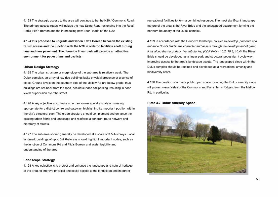
53
4.123 The strategic access to the area will continue to be the N20 / Commons Road.
The primary access roads will include the new Spine Road (extending into the Retail
Park), Fitz’s Boreen and the intersecting new Spur Roads off the N20.
4.124 It is proposed to upgrade and widen Fitz’s Boreen between the existing Dulux access and the junction with the N20 in order to facilitate a left turning lane and new pavement. The riverside linear park will provide an attractive environment for pedestrians and cyclists.
Urban Design Strategy4.125 The urban structure or morphology of the sub-area is relatively weak. The
Dulux complex, an array of low-rise buildings lacks physical presence or a sense of
place. Ground levels on the southern side of the Mallow Rd are below grade, thus
buildings are set-back from the road, behind surface car-parking, resulting in poor
levels supervision over the street.
4.126 A key objective is to create an urban townscape at a scale or massing
appropriate for a district centre and gateway, highlighting its important position within
the city’s structural plan. The urban structure should complement and enhance the
existing urban fabric and landscape and reinforce a coherent route network and
hierarchy of streets.
4.127 The sub-area should generally be developed at a scale of 3 & 4-storeys. Local
landmark buildings of up to 5 & 6-storeys should highlight important nodes, such as
the junction of Commons Rd and Fitz’s Boreen and assist legibility and
understanding of the area.
Landscape Strategy4.128 A key objective is to protect and enhance the landscape and natural heritage
of the area, to improve physical and social access to the landscape and integrate
recreational facilities to form a combined resource. The most significant landscape
feature of the area is the River Bride and the landscaped escarpment forming the
northern boundary of the Dulux complex.
4.129 In accordance with the Council’s landscape policies to develop, preserve and
enhance Cork’s landscape character and assets through the development of green
links along the secondary river tributaries, (CDP Policy 10.2, 10.3, 10.4), the River
Bride should be developed as a linear park and structural pedestrian / cycle way,
improving access to the area’s landscape assets. The landscaped slope within the
Dulux complex should be retained and developed as a recreational amenity and
biodiversity asset.
4.130 The creation of a major public open space including the Dulux amenity slope
will protect views/vistas of the Commons and Farranferris Ridges, from the Mallow
Rd, in particular.
Plate 4.7 Dulux Amenity Space
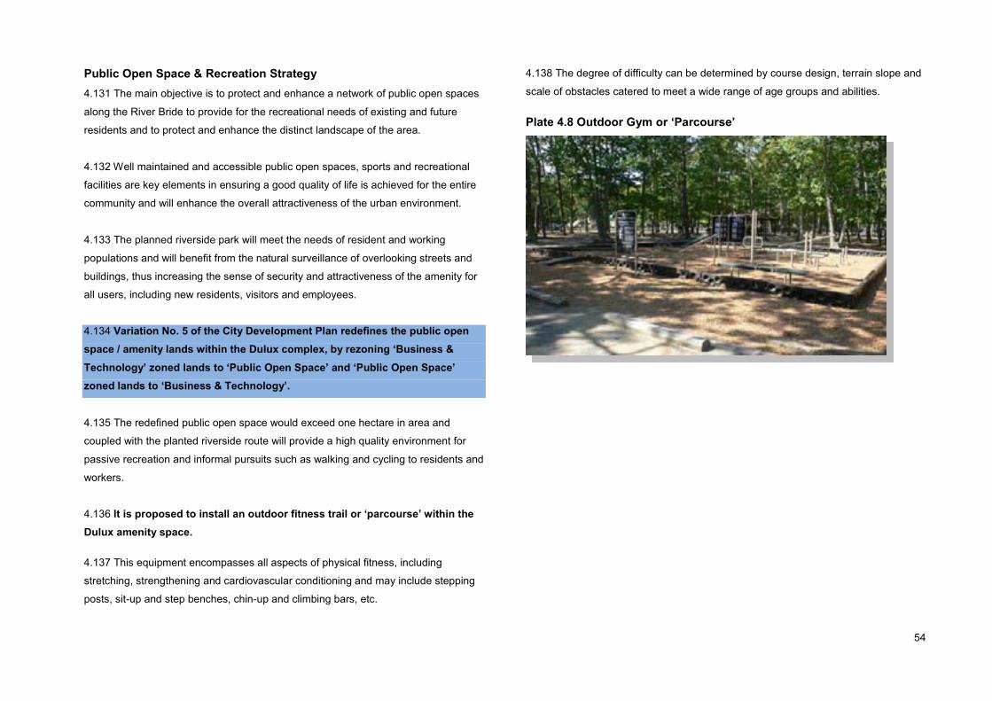
54
Public Open Space & Recreation Strategy4.131 The main objective is to protect and enhance a network of public open spaces
along the River Bride to provide for the recreational needs of existing and future
residents and to protect and enhance the distinct landscape of the area.
4.132 Well maintained and accessible public open spaces, sports and recreational
facilities are key elements in ensuring a good quality of life is achieved for the entire
community and will enhance the overall attractiveness of the urban environment.
4.133 The planned riverside park will meet the needs of resident and working
populations and will benefit from the natural surveillance of overlooking streets and
buildings, thus increasing the sense of security and attractiveness of the amenity for
all users, including new residents, visitors and employees.
4.134 Variation No. 5 of the City Development Plan redefines the public open space / amenity lands within the Dulux complex, by rezoning ‘Business & Technology’ zoned lands to ‘Public Open Space’ and ‘Public Open Space’zoned lands to ‘Business & Technology’.
4.135 The redefined public open space would exceed one hectare in area and
coupled with the planted riverside route will provide a high quality environment for
passive recreation and informal pursuits such as walking and cycling to residents and
workers.
4.136 It is proposed to install an outdoor fitness trail or ‘parcourse’ within the Dulux amenity space.
4.137 This equipment encompasses all aspects of physical fitness, including
stretching, strengthening and cardiovascular conditioning and may include stepping
posts, sit-up and step benches, chin-up and climbing bars, etc.
4.138 The degree of difficulty can be determined by course design, terrain slope and
scale of obstacles catered to meet a wide range of age groups and abilities.
Plate 4.8 Outdoor Gym or ‘Parcourse’

55
Sub-Area: Mallow Rd
Description4.139 This sub-area is centred on the junction of the Redforge Rd / Old Whitechurch
Rd and Mallow Rd, including Fr. Rodgers Park, Millfield Cottages & Millfield Terrace
on Redforge Rd, and the ESB lands on the southern side of the Old Whitechurch Rd,
and the northern side of the Mallow Rd, as far west as Fitz’s Boreen.
4.140 The ‘triangle’ of land set between the rail line and the Old Whitechurch Rd
hosts a multitude of ESB pylons and two electricity lines (38kV & 110kV) and a
telecommunications mast, adjoins the Kilbarry Transmission / Distribution station, (a
100kV station bulk supply point) and as such have no development potential.
Land-Use Strategy4.141 The sub-area is subject to two land-use zoning designations. The majority of
the sub-area is zoned ‘Residential, Local Services and Institutions’ with the objective
to protect and provide for residential uses, local services, institutional uses, and civic
uses.
4.142 The remainder of the site including frontage onto the Mallow Rd and to the rear
of Millfield Terrace is zoned District Centre with the objective to provide for and / or
improve district centres as mixed-use centres, with a primary retail function which
also act as a focus for a range of services.
4.143 The upper Redforge Rd is a long established residential neighbourhood,
including the 19th Century Millfield Cottages. Many of the Millfield Cottages are in
physical decline, awaiting redevelopment. Waterpark Construction Ltd (Shipton) has
permission to demolish 18 no. terraced dwellings and construct 18 no. dwellings
within Millfield Cottages.
4.144 In seeking to create a sustainable mixed-use environment, residential use will
be a key component. New residential development within this sub-area will
consolidate the dispersed residential neighbourhoods of Millfield Cottages, Millfield
Terrace and Fr Rodgers Park.
Figure 4.5 Mallow Rd Sub Area

56
Urban Design Strategy4.145 The existing residential neighbourhoods are 2-storeys in scale. New residential
development should generally be 2 & 3-storeys in order to protect existing residential
amenity.
4.146 New residential buildings should be laid out to form traditional ‘perimeter
blocks’ maximising active street frontage. This is of particular relevance in and
around Millfield Terrace and Millfield Cottages.
Plate 4.9 Fitz’s Boreen would benefit from road widening and footpath
Movement Strategy4.147 A key objective is to create a well connected residential neighborhood with
direct, safe and attractive pedestrian / cycle links to local services, amenities and
public transport. New pedestrian / cycle routes will increase choice and encourage
modal shift away from private car use.
� The existing Mallow Rd, Old Whitechurch Rd and Redforge Rd will continue to
support locally generated traffic.
� In-coming traffic via Kilnap should be directed onto Fitz’s Boreen and the N20 in
order to protect the residential amenity of the Mallow Rd / Redforge Rd
communities.
� The ‘Launteens’ lane connecting Old Whitechurch Rd and Mallow Rd should
form an important pedestrian / cycle way adjoining a one-way vehicular route
onto the Mallow Rd.
4.148 A pavement and dedicated cycle lane should be constructed along the entire
southern side of the Mallow Rd. A pedestrian / cycle route should be created
between the Mallow Rd and the riverside linear route.
Public Open Space & Recreation Strategy4.149 The sub-area includes part of the site of the former Flax Spinning and Weaving
Mill (CO074-115 RMP). The sluice / mill-race of the Mill should be protected and
incorporated into a passive park / amenity walkway / wildlife corridor connecting
eastwards to the ‘Dulux’ landscaped slope.
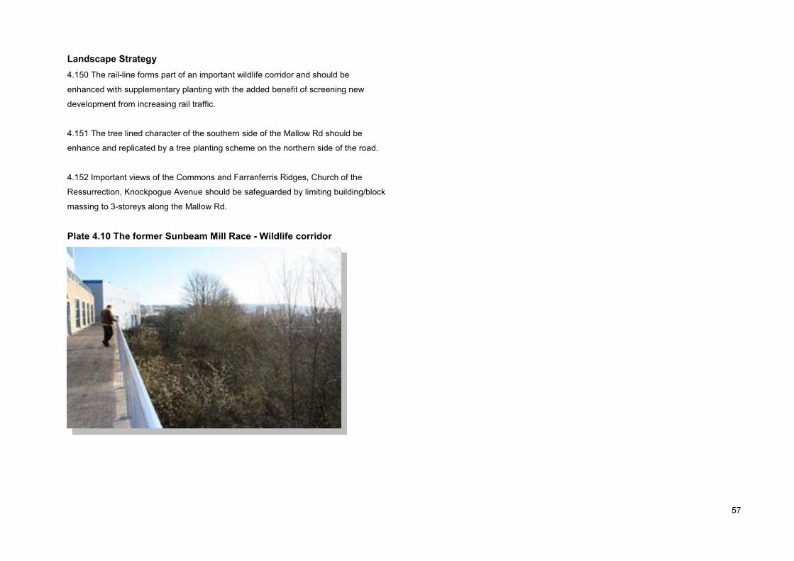
57
Landscape Strategy4.150 The rail-line forms part of an important wildlife corridor and should be
enhanced with supplementary planting with the added benefit of screening new
development from increasing rail traffic.
4.151 The tree lined character of the southern side of the Mallow Rd should be
enhance and replicated by a tree planting scheme on the northern side of the road.
4.152 Important views of the Commons and Farranferris Ridges, Church of the
Ressurrection, Knockpogue Avenue should be safeguarded by limiting building/block
massing to 3-storeys along the Mallow Rd.
Plate 4.10 The former Sunbeam Mill Race - Wildlife corridor

58
Sub-Area: Kilbarry
Description4.153 The Kilbarry sub-area bounds the City’s northern boundary and occupies the
most southern part of the Kilbarry IDA Business & Technology Park. The sub-area is
bounded by Dublin Hill to the east and the Old Whitechurch Rd to the south.
Residential development backs onto the sub-area to the east, west and south. The
area is relatively flat with a gentle slope at the northern end and steep gradient along
the southern boundary. The IDA Park is currently laid out as a low density, high
quality landscaped environment.
4.154 The IDA Park is located just 50metres ‘as the crow flies’ from the planned rail
station site, but is served by a vehicular access on the Dublin Hill, (outside the City
boundary) and an informal path from the Old Whitechurch Rd. An ‘open’ reservoir
and three 100kV electricity lines traverse the sub-area on an east-west axis.
Land-Use Strategy4.155 The entire sub-area is zoned business & technology with the objective to
provide for high technology related office based industry and general offices over 400
sq.m. The main purpose of the business & technology zoning is to promote and
encourage the provision of high technology and office based industry, such as
software development, information technology, telemarketing, data processing,
publishing and media associated activities. General Offices, (units in excess of 400
sq.m.) and light industrial uses are also permitted uses.
4.156 The IDA Park should be developed at a more intensive level with a
combination of office units lining the main access roads and light industrial units
along the southern perimeter.
Figure 4.6 Kilbarry
Movement Strategy4.157 The sub-area is a major employment area and is likely to generate significant
traffic movements, including commuting workers and distribution vehicles. To
increase permeability and encourage modal shift away from the private car, new
pedestrian / cycle ways should be created between the IDA Park, the adjoining
residential neighbourhoods and the planned rail station.
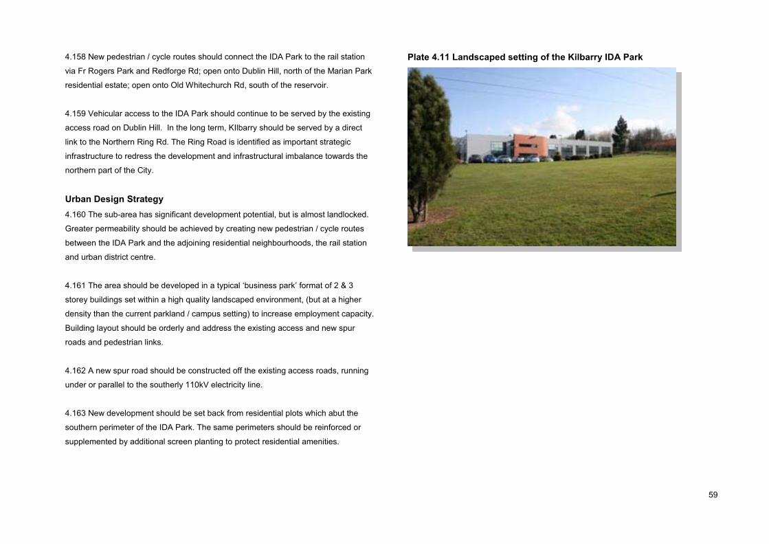
59
4.158 New pedestrian / cycle routes should connect the IDA Park to the rail station
via Fr Rogers Park and Redforge Rd; open onto Dublin Hill, north of the Marian Park
residential estate; open onto Old Whitechurch Rd, south of the reservoir.
4.159 Vehicular access to the IDA Park should continue to be served by the existing
access road on Dublin Hill. In the long term, KIlbarry should be served by a direct
link to the Northern Ring Rd. The Ring Road is identified as important strategic
infrastructure to redress the development and infrastructural imbalance towards the
northern part of the City.
Urban Design Strategy4.160 The sub-area has significant development potential, but is almost landlocked.
Greater permeability should be achieved by creating new pedestrian / cycle routes
between the IDA Park and the adjoining residential neighbourhoods, the rail station
and urban district centre.
4.161 The area should be developed in a typical ‘business park’ format of 2 & 3
storey buildings set within a high quality landscaped environment, (but at a higher
density than the current parkland / campus setting) to increase employment capacity.
Building layout should be orderly and address the existing access and new spur
roads and pedestrian links.
4.162 A new spur road should be constructed off the existing access roads, running
under or parallel to the southerly 110kV electricity line.
4.163 New development should be set back from residential plots which abut the
southern perimeter of the IDA Park. The same perimeters should be reinforced or
supplemented by additional screen planting to protect residential amenities.
Plate 4.11 Landscaped setting of the Kilbarry IDA Park

60
Sub-Area: Commons Ridge
Description4.164 This Commons Ridge sub-area forms part of the southern valley slope. It is a
‘greenfield’ remnant of the natural landscape, is currently grassland with scrub
vegetation and a densely planted roadside perimeter along the Commons Rd. There
is a severe gradient rising to 30metres above the Commons Rd level. The area is
bounded by suburban residential areas of Fairfield Rd, Glenwood Drive, and
Brideholm apartments.
4.165 The sub-area is visually prominent and dominates views from afar, but due to
its vast expanse and its spatial relationship with adjoining developments, it is poorly
supervised or overlooked by adjoining developments and experiences anti-social
behaviour. Two ESB electricity lines (10kV, 38kV) traverse the western end of the
site on a north-south axis
Land-Use Strategy4.166 The sub-area is subject to two land-use zoning designations. The vast majority
of the area is zoned Landscape Preservation Zone, (LPZ) with the objective to
preserve and enhance the special landscape and visual character of landscape
preservation zones, (with a presumption against development).
4.167 It is Council policy that development of the LPZ ridge lands will be considered
only where it protects the landscape assets, (rural character, topography, tree
canopy, (existing or potential), visual importance, gateway to the city), and achieves
the following objectives: to develop a woodland park on the southern valley slope; to
provide pedestrian linkages between residential areas and Fitz's Boreen and
Sunbeam.
4.168 In order to accord with the LPZ objective, the said lands should be developed
for amenity/recreational purposes, namely, a woodland park lining a pedestrian /
cycle way connecting the residential neighbourhoods at the top of the ridge to Fitz’s
Boreen / Dulux site, in accodance with the specific objectives set out in Table 10.2 of
the City Development Plan.
Plate 4.12 The Commons Ridge
4.169 The lands at the top of the ridge is zoned Residential, Local Services &
Institutions, with the objective to protect and provide for residential uses, local
services, institutional uses, and civic uses, having regard to employment policies.
This area is subject to the additional Objective of Area of High Landscape Value.
4.170 Policy 10.5 of the City Development Plan, seeks to conserve and enhance the
special landscape character and visual amenity through the control of development
to ensure that all development is landscape dominated and in keeping with the
character and appearance of the area.

61
4.171 The ‘Residential’ zoned lands should be developed for residential purposes,
benefiting the adjoining lands by increasing surveillance, security and attractiveness
of the ridge, forging important physical and visual linkages (walkway / cycleway)
between the ‘Fairhill’ residential communities and the Commons Rd area.
Movement Strategy4.172 The topography and scale of the sub-area, coupled with the heavily trafficked
Commons Rd is a significant barrier to pedestrian/cycle movements between the
‘Fairhill’ area and the remaining LAP lands.
4.173 A supervised walkway / cycle way connecting the ‘Fairhill’ communities to the
urban gateway and the city beyond will traverse the expansive barrier to promote
modal shift from the private car.
Public Open Space & Recreation Strategy4.174 The key objective of the sub-area is to protect the Landscape Preservation
Zone, and to develop a woodland park and provide pedestrian linkages between the
residential areas at the top of the ridge, Fitz's Boreen and the Dulux complex.
4.175 The steep nature of the ridge is not suitable for formal / organised recreational
activity but is ideal for relaxation, walking and cycling, and is potentially of significant
wildlife / biodiversity value as a woodland park and landscape feature.
Urban Design & Landscape StrategyLayout 4.176 Residential development at the upper ridge should make a positive
contribution to the area, in the form of a ‘perimeter block’ layout where active
frontages overlook and address the public realm i.e. public streets, and rear
elevations enclose private gardens. Terraced buildings would maximise enclosure
and supervision of the ridge lands. A scale of 2 & 3-storeys is appropriate given the
existing 2-storey character of the area.
Views4.177 The view of the Commons Ridge from the North Point Business Park looking
south-east to the Commons Ridge (NW12) a protected view under City Development
Plan Policy 10.6, is identified as a view of significant townscape and landscape
feature, as it contributes to the character and amenity of the visual envelope of the
city, the city skyline, built heritage and natural heritage.
4.178 The creation of a woodland park and walkway / cycle route is consistent with
the continued protection of this landscape view.
Figure 4.7 Commons Ridge

62
5. Implementation Strategy
Phasing 5.1 Given the current economic climate, the substantial capacity of the plan area is
unlikely to be redeveloped within the Plan period, and the CASP targets are unlikely
to be met within the short to medium term but remain valid in the longer term.
5.2 In accordance with sustainable development principles, the redevelopment of
‘greenfield’ and ‘brownfield’ lands within walking distance of existing or planned high
quality public transport services should be a priority. Therefore, the preferable or
desirable phasing / sequencing of the plan is two fold.
5.3 Sites within the 500metres radius of the planned rail station make up tranche 1 or
priority sites, these sites outside the 500metre radius make up tranche 2.
5.4 A key driver for rejuvenation of the area is the redevelopment of the Blackpool /
Kilbarry Rail Station. The schedule of significant projects is listed in Table 5.1.
Figure 5.1 Preferred Phasing Scenario

63
Table 5.1 Schedule of projectsProject Responsibility
Redevelop Blackpool / Kilbarry rail station
To open pedestrian access to the station along the Redforge Rd embankment
To open pedestrian access to the station from Fr. Rodger’s Park
To upgrade local bus services
To develop a quality bus corridor, (designated Farranree / Blackpool Green Route on the no. 3 & no.12 bus routes)
Provide bus lane on Redforge Rd, between Service Rd & Brothers Delany Rd, and on Brothers Delany Rd between Redforge Rd & Spine Rd.
Relocate the ‘northbound’ bus stop from Dublin St. (opposite the Spring Lane junction) to the vicinity of the N20 ‘flyover’ on Thomas Davis St.
Provide a future bus service to the planned residential development at Old Whitechurch Rd
Create a pocket park along the banks of the Glen River within the former Old Hammond Lane metals site.
Re-open the walkway to the rear of the Glen Hall Apartments to the North Ring Road, (Glen Boxing Club).
Construct the planned Spine Road between Fitz’s Boreen and Blackpool Retail Park
Construct the planned Spur / Link Roads off the N20
Upgrade and widen Fitz’s Boreen in order to facilitate a left turning lane.
Construct a pavement along the eastern side of Fitz’s Boreen.
Develop a linear park along the River Bride including walkway / cycleway
To ‘open-up’ the culverted stretch of the River Bride, to regrade and landscape the river channel.
Create a walkway through the cleared site of no.39 Dublin Street (or suitable alternative site on Dublin St) linking the Blackpool Shopping Centre
mall to Spring Lane via Cross Lane.
To install an outdoor fitness trail / gym (‘parcourse’) within the Dulux amenity space.
To install a walkway / cycleway through the Commons Ridge linking Fairfield Road to the N20 in association with housing development.
To carry out a tree planting programme / landscaping works within the Commons Ridge, in association with housing development.
Redevelop the retail park’s surface carpark as a quality public piazza.
Redevelop the Blackpool shopping centre’s surface carpark, to include a multi-functional public plaza / entertainment space.
Reconfigure the external facades of the Blackpool Shopping Centre
Irish Rail
Irish Rail
Irish Rail
Bus Eireann
City Council
City Council
Bus Eireann / City Council
Bus Eireann
Private Sector
City Council
Private Sector
Private Sector
Private Sector / City Council
Private Sector
Private Sector
Private Sector
Private Sector
Private Sector
Private Sector
Private Sector
Private Sector
Private Sector
Private Sector

64
6. Appendices
Appendix 1Proposed North Blackpool LAP Strategic Environmental Assessment (SEA) Screening Report
Draft North Blackpool LAP 2010, Strategic Environmental Assessment (SEA) Screening Report 11th June 2010
Cork City Council is preparing a local area plan for North Blackpool. As part of the preparation of the local area plan, the planning authority must consider whether the North Blackpool area requires a SEA. The assessment of this issue is based in the criteria set down in the SEA Guidelines and Annex II of the SEA Directive for determining the likely significance of environmental effects. The guidelines require SEA screening to be carried out for all Local Area Plans where the population of an LAP is 10,000 or less. Where the population is 10,000 or more, a SEA Environmental Report must be prepared. The existing population for North Blackpool is approx. 600 persons (based on the 2006 CSO figures of the number of existing households and number of persons per household).The estimated increase in population for the proposed Local Area Plan for North Blackpool is expected to be far below the threshold of 10,000 and therefore SEA is not mandatory in this instance.
1.0 Proposed Local Area PlanBlackpool has been identified as a Key Development Area under the City Development Plan 2009-2015. The Local Area Plan comprises an area of 60 hectares located just north of Blackpool Village. It includes the former Sunbeam site and adjoining lands, Blackpool Shopping Centre and Retail Park, the Kilbarry rail site and Kilbarry IDA industrial estate, extending northwards along Old Whitechurch Rd, southwards to the North City Link Rd ‘fly-over,’ eastwards to Ballyvolane Rd, and west/northwest to Commons Rd and Fitz’s Boreen.
The Blackpool Valley, Kilbarry and the Old Whitechurh Road area, have opportunities for both brownfield and green field development for a range of uses. There is potential for mixed use development in Blackpool itself and the Sunbeam Complex to the North, while there are opportunities for residential development at Old Whitechurch Road and technology/office based industry development at Kilbarry. The opening of the new Blackpool commuter rail station, as part of the Cork suburban rail network, will improve accessto the area and will offer an alternative mode to the private vehicle.
2.0 Schedule 2A Screening AssessmentThe LAP has been screened under Schedule 2A of the Planning and Development (Strategic Environmental Assessment) Regulations 2004.
The Local Area Plan has been assessed viz. the likely significant effects on the environment having regard to the following:i) The characteristics of the plan andii) The characteristics of the effects and of the area likely to be affected.
3.0 The degree to which the plan influences other plans, including those in a hierarchy.The Draft LAP provides a land use framework for the sustainable development of North Blackpool and will not affect other plans. In its making, it will also have regard to other relevant planning and environmental policy and legislation including European Union directives, Ministerial guidelines and other national, regional and county plans and policies.
4.0 The relevance of the plan for the integration of environmental considerations in particular with a view to promoting sustainable development.The proposed Local Area Plan is being prepared in the context of the Cork City Development Plan which has been prepared on the basis of promoting sustainable development. The Draft Local Area Plan by virtue of its compliance with the overarching policies and objectives of this plan promotes sustainable development.
65
5.0 Environmental problems relevant to the plan.There are no strategically significant environmental problems identified in relation to the Draft LAP. A brief overview of environmental issues pertaining to North Blackpool is detailed below.
5.1 Traffic VolumesTraffic volumes in the area will inevitably increase as a result of the proposed development. A series of main road access routes are proposed to facilitate the progressive creation of high quality interlinked spaces ad streets in any redevelopment of the area between the District Centre and Fitz’s Boreen. This new road network can be laid out progressively if and when development occurs on the land.
The traffic proposals for North Blackpool as adopted in the City Development Plan 2009-2015 are as follows:� The main strategic access shall be via the N20/Commons Road, providing connection to/from the City Centre and towards Mallow to the north. � A new north/south primary axis via a route to be extended through the middle of the site to Fitz’s Boreen, adjacent to the riverside amenity corridor – continuing the recently
completed north/south primary route through Blackpool Retail Park. � A new east/west axis via a route extending between the N20 and Redforge Road – to include provision of a new signal installation at a new junction on the N20.
Furthermore, any development should contribute to the creation of adequate, safe and convenient access to the site for all modes of transport and provide opportunities to connect to public transport services. The planned commuter rail service and the development of a cycle network will reduce the need to commute by private vehicle. It is therefore considered that the increase in traffic is not considered likely to result in significant environmental effects.
5.2 Water SupplyExisting and new populations under the City Development Plan shall be served with clean and wholesome drinking water. Cork City Council and Cork County Council plan their water supply infrastructure in an integrated way to provide for the long term water supply needs of each area by way of the Cork Strategic Water Study. This strategy outlines how the development of water supply infrastructure will meet anticipated water supply needs in the study area over the next 25 years. Furthermore, a major refurbishment and upgrade of the Lee Road Waterworks Treatment Plant, identified in the Water Services Investment Programme 2007-2014, has been commissioned to cater efficiently for the volumes required to satisfy current and predicted future demand. Cork City Council will achieve compliance as a minimum with the 48 parameters set out under the European Communities (Drinking water) Regulations (No. 2) 2007. All new proposals will be required to safeguard against high water consumption. This shall be achieved by:� Reducing water demand through management techniques� Reducing demand through water saving technologies i.e. flow limiters, pressure regulators, leak detection systems, proximity shut off valves and water meters. This is likely to improve the status of Strategic Environmental Objectives. It is therefore considered that increased water demand is not considered likely to result in significant environmental effects.
5.3 Foul DrainageThe unit numbers will increase demand on the foul drainage system. The Local Area Plan will include objectives for the necessary extensions to and upgrading of the existing network. As a result of the Cork Main Drainage Scheme which has been in operation since 2004, the City’s wastewater effluent is now achieving a level of treatment which is far in excess of what is required under the EU Wastewater Directive. The proposed increased demand for foul drainage is not considered likely to result in significant environmental effects.
5.4 GroundwaterMost of groundwater bodies underlying Cork City are currently classified as being “at significant risk” of failing the Water Framework Directive’s objectives by 2015. The LAP area is classified as being at ‘Significant Risk’. Notwithstanding same, the LAP will require that appropriate wastewater and surface water infrastructure shall accompany any proposed development.
66
5.5 FloodingCork City is very vulnerable to adverse effects from small changes in sea level combined with changes in the occurrence of severe rainfall events and associated flooding of the River Lee and a number of smaller urban streams such as the River Bride. Local conditions within the City including bridges and culverts which restrict high flows, debris which cause blockages, and land use changes can also increase the risk of flooding.
A catchment-based flood risk assessment and management study for the entire Lee Catchment, including the River Lee, its tributaries and Cork Harbour has been undertaken and the Draft Study has been published. This will assist proposals, decisions and mitigations measures to ensure that the risk of flooding from new developments is curtailed. The Local Area Plan will require applications to be accompanied by the appropriate storm-water and wastewater infrastructure. It is therefore considered that the North Blackpool LAP will not have significant effects on flooding in the area.
5.6 PopulationFrom 2002 to 2006, the Commons and Fairhill C Wards have experienced a -10% to -6% decrease in population. Blackpool A has seen an increase of between 3% to 6% and Blackpool B has experienced a population increase of 0% to 3%. It is considered that the area has the capacity to successfully accommodate an increase in population.
5.7 Human HealthHuman health has the potential to be impacted upon by environmental vectors including water, soil and air. Hazards or nuisances to human health can arise as a result of exposure to these vectors arising from incompatible adjacent landuses.
5.7.1 Potential Point Sources of EmissionsThe EPA has been licensing certain large-scale industrial and agriculture activities since 1994. The Environmental Protection Agency Act, 1992 was amended in 1993 by the Protection of the Environment Act, 2003 which gave effect to the Integrated Pollution Prevention Control (IPPC) Directive. IPPC licences aim to prevent of reduce emissions to air, water and land, reduce waste and use energy/resources efficiently. There is one IPPC licensed facility are located within North Blackpool LAP boundary. This is as follows:
Licence Holder Description Dulux Paints Ireland Ltd. The manufacture of paints, varnishes, resins, inks, dyes, pigments or
elastomers where the production capacity exceeds 1,000 litres per week.
While this industry currently operate within the proposed LAP boundary, the IPPC licence ensures that the process will not lead to adverse environmental impacts. It is therefore considered that existing and proposed uses will not have significant environmental effects.
5.8 Cultural HeritageCultural Heritage includes physical buildings, structures and objects complete or in part, which have been left on the landscape by previous and indeed current generations. Cork City’s archaeological heritage is protected under the National Monuments Acts (1930-2004), Natural Cultural Institutions Act 1997 and the Planning Acts. The Record of Monuments and Places (RMP) is an inventory, put on a statutory basis by amendment to the National Monuments Act 1994, of sites and areas of archaeological significance. Within the proposed Plan area, there is one Record of Monuments and Places sites listed. This is C0074-115 Flax Mills at Sunbeam. While there are the remnants of a water sluice at this location, the majority of the archaeology referenced is underground. There are no buildings which are included in the Record of Protected Structures within the plan area. The Plan will require any proposed applications which affect the Record of Monuments and Places site to address these issues to the satisfaction of the Council. It the therefore considered that the proposed Plan will not significantly impact on the cultural heritage within the Plan boundary.
5.9 Landscape and Visual AmenitiesAt the northern gateway to the city, there are prominent ridges on both sides of the Blackpool Valley, particularly in the Farranferris and Commons areas. These ridges are extremely important to the character of Cork. Blackpool Valley has been identified as a “Key Area” in Figure 10.3 “Functional Landscape Structure Plan” of the City Development Plan. The City Development Plan advocates the development of “Secondary Green Links”. These green links extend along Cork’s secondary river tributaries to provide the focus for the development of new parks and upgraded landscapes with improved public access. In some cases the link will form an organising element for major new development inBlackpool Valley for example. The prominent river corridors that influence the landscape on the Northside of Cork City are:
67
� The Bride River which flows from the north-west, and then south through the Blackpool Valley� The Glen River, flowing from east to west, joining the River Bride in the Blackpool Valley
5.9.1 New Urban woodlandsSeven areas, of which Blackpool/Ballyvolane area is one, have been identified has having very low tree canopy densities and requiring significant tree planting to improve theirlandscape quality and attractiveness. Any development proposals within the LAP will have to have cognisance of this.
5.9.2 North West Views & ProspectsThere are 3 no. views & prospects within the proposed LAP boundary designated in the current City Development Plan. These are listed as LT 21, LT 21a and LT 21c. These views are of Farranferris Ridge. These views are to be protected. Cork City Council will have a presumption against development that threatens to obstruct or compromise the quality or setting of views and prospects. The LAP will also aim to identify and protect views of local significance through its preparation.
5.9.3 Landscape Protection ZoneThere is one designated Landscape Preservation Zone within the designated area. This is annotated as NW 12 Blackpool Valley (west) Ridge Commons Road. The Site Specific Objectives include provision of pedestrian linkages between residential areas at the top of the slope and Fitz’s Boreen and the Sunbeam development area. Particular objectives in relation to building heights, design; incorporation of the existing river as an ecological corridor and asset etc. will be included in order to mitigate the visual impact of any proposed new development. Therefore, it is considered that proposed development will not result in any significant environmental effects in terms of landscape and visual amenities.
6.0 The relevance of the plan for implementation of European Union legislation on the environment (e.g. plans linked to waste management or water protection)This proposed Local Area Plan is considered under the overarching policies and objectives of the Cork City Development Plan 2009. The Draft Local Area Plan will have no effect on the implementation of the European Union legislation.
7.0 The probability, duration, frequency and reversibility of the effects.Development proposals on zoned lands must accord with the Cork City Development Plan 2009 and its environmental protection policies as well as the availability of adequate infrastructure to service any proposed development.
8.0 The cumulative nature of effectsIt is not anticipated that the amended Draft North Blackpool LAP will experience any unacceptable cumulative environmental effects as a result of the policies and objectives
contained within the LAP.
9.0 The trans-boundary nature of the effectsThe policies and objectives of the amended Draft North Blackpool LAP will have no national, regional or inter county trans-boundary effects.
10.0 The risks to human health of the environmentThe policies and objectives that the Draft Blackpool LAP will set out will seek to reduce any potential impact to human health of proposed development. As such, individual planning applications will be required to assess and highlight any possible risks to human health. Notwithstanding same, it is noted that there are no designated SEVESO sites within the proposed plan area.
11.0 The magnitude and spatial extent of the effects (geographical area and size of population likely to be affected)The Draft North Blackpool LAP covers a geographical area of some 60 hectares. The existing population for North Blackpool is approx. 600 persons (based on the 2006 CSO figures of the number of existing households and number of persons per household).The estimated increase in population is approximately 600 persons.
12.0 The value and vulnerability of the area likely to be affected due to:(a) Special natural characteristics or cultural heritage,(b) Exceeded environmental quality standards or limit values,(c) Intensive land-use.
68
(a) The North Blackpool LAP lands have some archaeological heritage as outlined above. It is considered appropriate that an objective will be provided within the LAP that will ensure any planning applications that may, due to its location, size and nature, and which may have implications for the archaeological heritage should be subject to archaeological testing and monitoring.(b) Environmental policies and objectives contained within the LAP will ensure that the impact of the proposed development on existing habitats, species and the value of the existing landscape are kept to a minimum.(c) The lands proposed for inclusion in the North Blackpool Local Area Plan are, in the main, contiguous with the existing built form of the City.
13.0 The effects on areas or landscapes which have a recognised national, European Union or international protection status.There are no designated landscapes, with National or International protection within the Plan area and therefore this aspect of the screening process does not apply.
14.0 Conclusion of screening document and rationaleThe planning authority considers that SEA is not required in this case on the basis of the assessments carried out having regard to the nature and character of the lands andoverall quantum of development proposed within the plan lands.
15.0 Statutory ConsultationThe Environmental Protection Agency (EPA) was consulted in relation to the screening report of the SEA as per Article 13 A (4) (a) of the Planning and Development (Strategic Environmental Assessment) Regulations 2004. Based on the screening assessment, as it does not appear to the planning authority that the plan might have significant effects in relation to the architectural or archaeological heritage or to the nature conservation, the screening was not issued to the DoEHLG in this instance. Based on the screening assessment, as it does not appear to the planning authority that the plan might have significant effects on fisheries or the marine environment, the screening was not issued to the Minister for Communication, Marine and Natural Resources in this instance.
The response from the EPA was received on the 03/06/’10 and is summarised as follows: “The Environmental Protection Agency (EPA) acknowledges you notice dated 12/05/2010, regarding the Draft Blackpool North Local Area. Your position with regard to the need for Strategic Environmental Assessment (SEA) is noted.
This submission also highlights a number of broad environmental issues that should be considered when preparing the plan and indicates a number of planning policy and guidance documents which should be taken into account.
16.0 DeterminationHaving regard to the reasoning and considerations as set out in the SEA Screening Document and noting that no objections have been raised by the submission received from the EPA, the Planning Authority is satisfied that the proposed North Blackpool Local Area Plan is not likely to have significant effects on the environment. It is therefore considered that a Strategic Environmental Assessment is not required in respect of the proposed North Blackpool Local Area Plan.
Under Article 14 A (6) of the Planning and Development (Strategic Environmental Assessment) Regulations 2004, Cork City Council hereby gives notice of its determination.

69
Appendix 2Appropriate Assessment Screening in line with the Requirements of Article 6(3) of the EU Habitats Directive
Appropriate Assessment Screening in line with the Requirements of Article 6(3) of the EU Habitats Directive
Proposed North Blackpool Local Area Plan 2010 22nd June 2010
Section 1 Introduction and Terms of Reference
1.1 IntroductionThis is an appropriate assessment screening of the proposed North Blackpool Local Area Plan 2010 in accordance wit the requirements of Articles 6 (3) of the EU Habitats Directive (Directive 92/43/EEC). The relevant provisions of the Directive are set out in Section 1.2 of this report. This report evaluates the proposed North Blackpool LAP to see if it needs to be subject to an appropriate assessment.
1.2 Terms of ReferenceAppropriate assessment is an assessment carried out under Articles 6(3) of the Habitats Directive. Article 6 (3) of the Habitats Directive states: ‘Any plan or project not directly connected with or necessary to the management of the site but likely to have a significant effect thereon, either individually or in combination with other plans or projects, shall be subject to appropriate assessment of its implications for the site in view of the site’s conservation objectives. In the light f the conclusions of the assessment of the implications of the site and subject to the provisions of paragraph 4, the competent national authorities shall agree to the plan or project only after having ascertained that it will not adversely affect the integrity of the site concerned and, if appropriate, after having obtained the opinion of the general public.
Article 6(4) of the Habitats Directive states:‘If, in spite of a negative assessment of the implications for the site and in the absence of alternative solutions a plan or project must nevertheless be carried out for imperative reasons of overriding public interest, including those of economic or social nature, the Member State shall take all compensatory measures necessary to ensure that the overall coherence of Natura 2000 is protected. It shall inform the Commission of the compensatory measures adopted. Where the site concerned hosts a priority natural habitat type and/or a priority species the only considerations which may be raised are those relating to human health or public safety, to beneficial consequences of primary importance for the environment or, further to an opinion from the Commission, to other imperative reasons of overriding public interest.
Section 2 Screening Matrix
2.1 Brief description of the Project or PlanThe proposed North Blackpool LAP is intended to provide for the proper planning and sustainable development of North Blackpool. It will consist of a written statement and maps which will give a graphic representation of the proposals of the Plan indicating land use and other development standards together with various local objectives.
Blackpool has been identified as a Key Development Area under the City Development Plan 2009-2015. The Local Area Plan comprises an area of 60 hectares located just north of Blackpool Village. It includes the former Sunbeam site and adjoining lands, Blackpool Shopping Centre and Retail Park, the Kilbarry rail site and Kilbarry IDA industrial estate, extending northwards along Old Whitechurch Rd, southwards to the North City Link Rd ‘fly-over,’ eastwards to Ballyvolane Rd, and west/northwest to Commons Rd and Fitz’s Boreen. The purpose of this LAP is to set out a strategy for the proper and sustainable development of North Blackpool. The Plan area consists of a designated District centre and zonings for Light Industry and Business and Technology taking into account existing uses and includes an objective for the development of a new local centre which aims to ‘protect, provide for and/or improve the retail function of the local centres and provide a focus for local services’. The proposed LAP shall set out a strategy for new residential, retail and office based employment land uses and set aside public open spaces for recreational and amenity purposes.

70
2.2 Brief Description of the Natura 2000 sitesThere are no designated Natura 2000 sites within the boundaries of the proposed North Blackpool LAP. The closest Natura 2000 site to the plan area is Cork Harbour which is a designated SPA (Site Code 040403). This is located to the Southwest of the plan area and is approximately 5 km away (as the crow flies) from the southernmost boundary of the plan.
2.3 Assessment CriteriaDescribe the individual elements of the project (either alone or in combination with other plans or projects) likely to give rise to the Natura 2000 sites.The plan will ensure that uses, developments and effects arising from permissions based upon this plan (either individually or in combination with other plans or projects) shall not give rise to significant adverse impacts on the integrity of any Natura 2000 sites.
Describe any likely direct, indirect or secondary impacts of the project (either alone or in combination with other plans or projects) on the Natura 2000 sites by virtue of:� Size and ScaleNo projects giving rise to significant adverse direct, indirect or secondary impacts on the integrity of any Natura 2000 sites arising from their size and scale shall be permitted on the basis of this Plan (either individually or in combination with other plans or projects).
� Land TakeNo projects giving rise to significant adverse direct, indirect or secondary impacts on the integrity of any Natura 2000 sites arising from their land take shall be permitted on the basis of this Plan (either individually or in combination with other plans or projects).
� Distance from the Natura 2000 site or key features of the siteNo projects giving rise to significant adverse direct, indirect or secondary impacts on the integrity of any Natura 2000 sites or their key features arising from their proximity shall be permitted on the basis of this Plan (either individually or in combination with other plans or projects).
� Emissions (Disposal to land, water or air)No projects giving rise to significant adverse direct, indirect or secondary impacts on the integrity of any Natura 2000 sites arising from their emissions (disposal to land, water or air) shall be permitted on the basis of this Plan (either individually or in combination with other plans or projects).
� Excavation RequirementsNo projects giving rise to significant adverse direct, indirect or secondary impacts on the integrity of any Natura 2000 sites arising from their excavation requirements shall be permitted on the basis of this Plan (either individually or in combination with other plans or projects).
� Transportation RequirementsNo projects giving rise to significant adverse direct, indirect or secondary impacts on the integrity of any Natura 2000 sites arising from their transportation requirements shall be permitted on the basis of the Plan (either individually or in combination with other plans or projects).
� Duration of construction, operation, decommissioning, etc.No projects giving rise to significant adverse direct, indirect or secondary impacts on the integrity of any Natura 2000 sites arising from their duration of construction, operation, decommissioning etc. shall be permitted on the basis of this Plan (either individually or in combination with other plans or projects).
� OtherNo projects giving rise to significant adverse direct, indirect or secondary impacts on the integrity of any Natura 2000 sites arising from any other effects shall be permitted on the basis of this Plan (either individually or in combination with other plans or projects).
Describe any likely changes to the sites arising as a result of:� Reduction of habitat area

71
No projects giving rise to reduction of habitat areas for Natura 2000 sites shall be permitted on the basis of this Plan (either individually or in combination with other plans or projects).
� Disturbance of key speciesNo projects giving rise to significant disturbance to key species in Natura 2000 sites shall be permitted on the basis of this Plan (either individually or in combination with other plans or projects).
� Habitat or species fragmentationNo projects giving rise to significant habitat or species fragmentation of Natura 2000 sites shall be permitted on the basis of this Plan (either individually or in combination with other plans or projects).
� Reduction in species densityNo projects giving rise to significant reduction of species on Natura 2000 sites shall be permitted on the basis of this Plan (either individually or in combination with other plans or projects).
� Changes in key indicators of conservation value (water quality etc.)No projects giving rise to significant changes in key indicators of conservation value for Natura 2000 sites shall be permitted on the basis of this Plan (either individually or in combination with other plans or projects).
� Climate ChangeNo projects giving rise to significant adverse changes in climatological conditions affecting Natura 2000 sites shall be permitted on the basis of this Plan (either individually or in combination with other plans or projects).
Describe any likely impacts on Natura 2000 sites as a whole in terms of:� Interference with the key relationships that define the structure of the site:No projects giving rise to significant, adverse interference with the key relationships that define the structure of Natura 2000 sites shall be permitted on the basis of this Plan (either individually or in combination with other plans or projects).
Provide indicators of significance as a result of the identification of effects set out above in terms of:� Loss: Not applicable� Fragmentation: Not applicable� Disruption: Not applicable� Change to key elements of the sites (e.g. water quality etc.): Not applicable
Describe from the above those elements of the project or plan, or combination of elements, where the above impacts are likely to be significant or where the scale or magnitude of impacts is not known: Not applicable.
Section 3 Finding of No Significant Effects Report Matrix
Name of project or plan Proposed North Blackpool Local Area Plan
Name and Location of Natura 2000 site Cork Harbour SPA. Site Code: 004030
72
Description of the project or planBlackpool has been identified as a Key Development Area under the City Development Plan 2009-2015. The Local Area Plan comprises an area of 60 hectares located just north of Blackpool Village. It includes the former Sunbeam site and adjoining lands, Blackpool Shopping Centre and Retail Park, the Kilbarry rail site and Kilbarry IDA industrial estate, ,extending northwards along Old Whitechurch Rd, southwards to the North City Link Rd ‘fly-over,’ eastwards to Ballyvolane Rd, and west/northwest to Commons Rd and Fitz’s Boreen.
The Blackpool Valley, Kilbarry and the Old Whitechurh Road area, have opportunities for both brownfield and green field development for a range of uses. There is potential for mixed use development in Blackpool itself and the Sunbeam Complex to the North, while there are opportunities for residential development at Old Whitechurch Road and technology/office based industry development at Kilbarry. The opening of the new Blackpool commuter rail station, as part of the Cork suburban rail network, will improve access to the area and will offer an alternative mode to the private vehicle.
Description of the nearest Natura 2000 site to proposed North Blackpool Plan area Cork Harbour SPA (Site Code 004030). Cork Harbour is a large, sheltered bay system, with several river estuaries – principally those of the Rivers Lee, Douglas and Owenacurra. The SPA site comprises most of the main intertidal areas of Cork Harbour, including all of the North Channel, the Douglas Estuary, inner Lough Mahon, Lough Beg, Whitegate Bay and the Rostellan inlet. This SPA is located approximately 5km as the crow flies from the nearest plan boundary line. Cork Harbour is an internationally important wetland site, regularly supporting in excess of 20,000 wintering waterfowl, for which it is amongst the top five sites in the country. Several of the species which occur regularly are listed on Annex I of the E.U. Birds Directive, i.e. Whooper Swan, Golden Plover, Bar-tailed Godwit, Ruff and Common Tern. The site provides both feeding and roosting sites for the various bird species that use it.
As Cork Harbour is adjacent to a major urban centre and a major industrial centre, water quality is variable, with the estuary of the River Lee and parts of the Inner Harbour being somewhat eutrophic. However, (as noted by the site synopsis from the National Parks and Wildlife Service), the polluted conditions may not be having significant impacts on the bird populations.
Describe how the project or plan (alone or in combination) is likely to affect the Natura 2000 siteThe Plan will be formulated to ensure that uses, developments and effects arising from permissions based upon the Plan (either individually or in combination with other plans orprojects) shall not give rise to significant adverse impacts on the integrity of the Natura 2000 site. The policies and provisions of the Plan will be devised to anticipate and avoid the need for developments that would likely to significantly and adversely affect the integrity of and Natura 2000 sites. Furthermore, such developments as will be permitted on foot of the provisions of this Plan shall be required to conform to the relevant regulatory provisions for the prevention of pollution, nuisance or other environmental effects likely to significantly and adversely affect the integrity of the any Natura 2000 sites.
SEA ScreeningThe proposed North Blackpool Local Area Plan has been screened in relation to Strategic Environmental Assessment (SEA). The recommendation of the Council was to deem that the Plan would not require an SEA in this instance. This decision and details of the SEA screening was forwarded on to the EPA for comment. A submission from the EPA was received which noted the decision of Cork City Council and also highlighted a number of broad environmental issues that should be considered when preparing the plan andindicates a number of planning policy and guidance documents which should be taken into account. Section 4 ConclusionsFollowing the review of the proposed plan in accordance with the ‘Methodological guidance on the provision of Article 6(3) and 6(4) of the Habitats Directive 92/43’ a Screening Matrix and Findings of No Significant Effects Matrix have been completed.
This screening process was carried out to ascertain if the Plan would be likely to have significant effects on a Natura 2000 site. The proposed Plan does not contain any Natura 2000 sites nor is located directly adjacent to a Natura 2000 site. The proposed Plan will be formulated to ensure that developments and effects arising from permission based on this proposed Plan (either individually or in combination with other plans or projects) shall not give rise to significant adverse impacts on the integrity of the nearest Natura 2000 site i.e. Cork Harbour SPA.
Decision:Based on the foregoing, this screening report finds that the proposed North Blackpool Local Area Plan does not require further appropriate assessment.
73
Appendix ISITE SYNOPSIS of CORK HARBOUR SPA Source: National Parks and Wildlife Service Ireland.
SITE CODE: 004030Cork Harbour is a large, sheltered bay system, with several river estuaries – principally those of the Rivers Lee, Douglas and Owenacurra. The SPA site comprises most of the main intertidal areas of Cork Harbour, including all of the North Channel, the Douglas Estuary, inner Lough Mahon, Lough Beg, Whitegate Bay and the Rostellan inlet.
Owing to the sheltered conditions, the intertidal flats are often muddy in character. These muds support a range of macro-invertebrates, notably Macoma balthica, Scrobicularia plana, Hydrobia ulvae, Nepthys hombergi, Nereis diversicolor and Corophium volutator. Green algae species occur on the flats, especially Ulva lactua and Enteromorpha spp. Cordgrass (Spartina spp.) has colonised the intertidal flats in places, especially where good shelter exists, such as at Rossleague and Belvelly in the North Channel. Salt marshes are scattered through the site and these provide high tide roosts for the birds. Salt marsh species present include Sea Purslane (Halimione portulacoides), Sea Aster (Aster tripolium), Thrift (Armeria maritima), Common Saltmarsh-grass (Puccinellia maritima), Sea Plantain (Plantago maritima), Laxflowered Sea-lavender (Limonium humile) and Sea Arrowgrass (Triglochin maritima). Some shallow bay water is included in the site. Cork Harbour is adjacent to a major urban centre and a major industrial centre. Rostellan lake is a small brackish lake that is used by swans throughout the winter. The site also includes some marginal wet grassland areas used by feeding and roosting birds.
Cork Harbour is an internationally important wetland site, regularly supporting in excess of 20,000 wintering waterfowl, for which it is amongst the top five sites in the country. The five-year average annual core count for the entire harbour complex was 34,661 for the period 1996/97-2000/01. Of particular note is that the site supports an internationally important population of Redshank (1,614) – all figures given are average winter means for the 5 winters 1995/96-1999/00. A further 15 species have populations of national importance, as follows: Great Crested Grebe (218), Cormorant (620), Shelduck (1,426), Wigeon (1,750), Gadwall (15), Teal (807), Pintail (84), Shoveler (135), Red-breasted Merganser (90), Oystercatcher (791), Lapwing (3,614), Dunlin (4,936), Black-tailed Godwit (412), Curlew (1,345) and Greenshank (36). The Shelduck population is the largest in the country (9.6% of national total), while those of Shoveler (4.5% of total) and Pintail (4.2% of total) are also very substantial. The site has regionally or locally important populations of a range of other species, including Whooper Swan (10), Pochard (145), Golden Plover (805), Grey Plover (66) and Turnstone (99). Other species using the site include Bat-tailed Godwit (45), Mallard (456), Tufted Duck (97), Goldeneye (15), Coot (77), Mute Swan (39), Ringed Plover (51), Knot (31), Little Grebe (68) and Grey Heron (47). Cork Harbour is an important site for gulls in winter and autumn, especially Common Gull (2,630) and Lesser Black-backed Gull (261); Black-headed Gull (948) also occurs. Arange of passage waders occur regularly in autumn, including Ruff (5-10), Spotted Redshank (1-5) and Green Sandpiper (1-5). Numbers vary between years and usually a few of each of these species over-winter. The wintering birds in Cork Harbour have been monitored since the 1970s and are counted annually as part of the I-WeBS scheme.
Cork Harbour has a nationally important breeding colony of Common Tern (3-year mean of 69 pairs for the period 1998-2000, with a maximum of 102 pairs in 1995). The birds have nested in Cork Harbour since about 1970, and since 1983 on various artificial structures, notably derelict steel barges and the roof of a Martello Tower. The birds are monitored annually and the chicks are ringed. Extensive areas of estuarine habitat have been reclaimed since about the 1950s for industrial, port-related and road projects, and further reclamation remains a threat. As Cork Harbour is adjacent to a major urban centre and a major industrial centre, water quality is variable, with the estuary of the River Lee and parts of the Inner Harbour being somewhat eutrophic. However, the polluted conditions may not be having significant impacts on the bird populations. Oil pollution from shipping in Cork Harbour is a general threat. Recreational activities are high in some areas of the harbour, including jet skiing which causes disturbance to roosting birds. Cork Harbour has is of major ornithological significance, being of international importance both for the total numbers of wintering birds (i.e. > 20,000) and also for its population of Redshank. In addition, there are at least 15 wintering species that have populations of national importance, as well as a nationally important breeding colony of Common Tern. Several of the species which occur regularly are listed on Annex I of the E.U. Birds Directive, i.e. Whooper Swan, Golden Plover, Bar-tailed Godwit, Ruff and Common Tern. The site provides both feeding and roosting sites for the various bird species that use it.

74
Appendix 3
The Planning System and Flood Risk Management Guidelines for Planning Authorities Nov. 2009
Assessment
(1) Identify flood zones and classify vulnerability
Flood zones:
Zone A high probability of flooding – most dev. inappropriate here – only consider if it is considered to be essential infrastructure and cannot be located elsewhere
Zone B moderate probability of flooding – highly vulnerable development including primary strategic transport and utilities infrastructure is generally inappropriate unless Justification test is met.
Zone C low probability of flooding – development is appropriate from flood risk perspective subject to flood hazard from sources other than rivers and coast meeting normal proper planning considerations.
The plan area is traversed by the River Bride and Glen River, tributaries of the River Lee. On examination of the LeeCFRAMS Maps, (attached) it is evident that the vast majority of the plan area is considered to be at low risk of flooding. The current flood extent of the River Bride is confined to localised areas at the ‘Millfield Ind Estate,’ Commons Rd and the Amenity Park adjoining the Blackpool Retail Park, and the flood extent of the Glen River is confined to a localised area within the ‘Hammond Lane Metals’ site off Spring Lane.
The majority of the land identified within the future flood scenario is categorised as having as ‘a 1 in 1000 chance’ of flooding is zoned public open space, lies on the route of the new spine road, (an objective of the City Development Plan) and includes the Blackpool shopping centre and surface carpark. Flood risk will be a factor in the redevelopment of the shopping centre carpark and will require a detailed flood risk assessment at application stage. Development in such areas of low probability is appropriate from a flood risk perspective, (Section 3.5 of Guidelines). The flooding experienced at the ‘Millfield’ and the ‘Hammond Lane Metals’ sites is related to the existing culverts which reduce the capacity of the waterway and require maintenance and regular clearing of debris. In the case of the Millfield site, the City Council has granted permission for development including the removal of the culvert and the regrading, widening and landscaping of the river channel which will reduce future flood risk.
(2) Classify the vulnerability of types of development
The development of a riverside park along the banks of the River Bride in particular and landscaped pocket park within the Hammond Lane metals site is considered to be water compatible development. The plan does not propose to zone any additional or new lands for water vulnerable development. The one area that has been identified as likely to flood in future scenarios is in the vicinity of the Millfield Site and upstream into the Dulux complex, due to the existing culvert. The removal of the culvert as part of recently permitted developments will reduce risk of same.
Justification Test
To consider development in areas of high or moderate risk of flooding, one must satisfy all of the following criteria:
1. The urban settlement is targeted for growth i.e. under the NSS
Yes, Cork is a designated Gateway under the National Spatial Strategy
75
2. The zoning of the land is required to achieve proper planning and sustainable development
Yes, The zoning of lands within walking distance to the planned commuter rail service at Blackpool / Kilbarry provides an opportunity to integrate land use and transport and develop an integrated transport system for the city, to support sustainable development, social inclusion and environmental protection.
(i) Is essential to facilitate regeneration and/or expansion of the centre of the urban settlement.
Is an important element of the region’s transport strategy. Park & Ride facilities result in environmental benefits, as listed above.
(ii) Comprises significant previously development and/or under utilised lands
The ‘flood prone’ lands are obsolete in their current form, disused or under utilised former industrial buildings
(iii) Is within or adjoining the core of an established urban settlement
The plan area is less than 1km due-north of the defined City Centre zoning (City Development Plan).
(iv) Will it be essential in achieving compact and sustainable urban growth.
The redevelopment of ‘brownfield’ lands within walking distance to planned high quality public transport corridors is a fundamental principle of sustainability.
(v) There are no suitable alternative lands for the use/development in areas of lower risk of flooding within or adjoining the core of the urban settlement.
The flood prone areas are either, obsolete in their current form, disused or under utilised industrial buildings and should be redeveloped in the interests of proper planing and sustainable development. The primary use for the said lands is public open space which is considered to be water compatible form of development. It is considered that there is no suitable alternative.
3. A flood risk assessment to an appropriate level of detail has been carried out as part of the SEA as part of the dev. plan preparation process, which demonstrates that flood risk to the development can be adequately managed and the use of the lands will not cause unacceptable adverse impacts elsewhere.
It is recognised that Cork City is vulnerable to the fluvial (river) and tidal flooding. The Environmental Report (SEA) of the Draft City Development Plan 2010-2016 identifies flood points, flood plains and areas subject to flooding, including a large stretch of the N22/Carrigrohane Rd.
The vast majority of the LAP lands are not prone to flooding. The areas that have experienced flooding is localised and is related to existing culverts which have a detrimental impact on the carrying capacity of the river. The removal of such culverts as permitted by recent planning permissions at Millfield / Sunbeam sites is supported by the local area plan. The areas that have recently experienced flooding are zoned for public open space which is considered to be a water compatible form of development.

76

77

78

79

80
Planning Policy SectionPlanning & Development Directorate
Cork City Council, Cork
Tel: 021-4924086Fax: 021-4924712
Email: planningpolicy @corkcity.ieWeb: www.corkcity.ie