
Sutton Floodplain Risk Management Study and Draft … – Floodplain Risk Management Study and Draft...
30
SUTTON FLOODPLAIN RISK MANAGEMENT STUDY AND PLAN YASS VALLEY COUNCIL FINAL REPORT DECEMBER 2016
Transcript of Sutton Floodplain Risk Management Study and Draft … – Floodplain Risk Management Study and Draft...

SUTTON FLOODPLAIN RISK
MANAGEMENT STUDY AND PLAN
YASS VALLEY COUNCIL
FINAL REPORT
DECEMBER 2016
Level 2, 160 Clarence Street Sydney, NSW, 2000
Tel: 02 9299 2855 Fax: 02 9262 6208 Email: [email protected] Web: www.wmawater.com.au
SUTTON – FLOODPLAIN RISK MANAGEMENT STUDY AND DRAFT PLAN
FINAL REPORT
DECEMBER 2016
Project Sutton – Floodplain Risk Management Study and Draft Plan
Project Number 114082
Client Yass Valley Council
Client’s Representative Asoka Sumanaratne / Liz Makin
Authors Zac Richards Beth Marson
Prepared by
Date 1 December 2016
Verified by
Stephen Gray
Revision Description Date
3 Floodplain Risk Management Study – Final Report December 2016
2 Floodplain Risk Management Study – Draft Final Report October 2016
1 Floodplain Risk Management Study – Draft Report September 2016

Sutton – Floodplain Risk Management Study and Draft Plan
WMAwater 114082:Sutton_FRMS&P_Final:1 December 2016 i
SUTTON – FLOODPLAIN RISK MANAGEMENT STUDY
AND DRAFT PLAN
TABLE OF CONTENTS PAGE
ACRONYMS .............................................................................................................................. iv
FOREWORD.............................................................................................................................. vi
EXECUTIVE SUMMARY .......................................................................................................... vii
1. INTRODUCTION AND BACKGROUND ............................................................................ 1
1.1. Study Objectives ........................................................................................................... 1
1.1.1. Floodplain Risk Management Study Objectives ........................................................ 1
1.1.2. Floodplain Risk Management Draft Plan Objectives.................................................. 2
1.2. The Study Area ............................................................................................................. 2
1.2.1. Flood Hotspots .......................................................................................................... 3
Hotspot 1: Sutton Road Crossing of McLaughlin’s Creek ................................................... 3
Hotspot 2: North Street Crossing of Yass River.................................................................. 4
Hotspot 3: Bywong Street near North Street ...................................................................... 4
Hotspot 4: Bywong Street between Middle Street and Victoria Street ................................ 5
Hotspot 5: Various Flood Susceptible Creek and River Road Crossing .............................. 5
1.3. Flood Mechanisms ........................................................................................................ 5
1.3.1. Mainstream Flooding ................................................................................................ 5
1.3.2. Major Overland Flow Flooding .................................................................................. 6
Proposed Development Areas ....................................................................................... 6
1.4. Overview of Existing Catchment .................................................................................... 7
1.4.1. Land Use and Demographic Overview ...................................................................... 7
1.4.2. Key Infrastructure on the Floodplain ......................................................................... 7
2. COMMUNITY CONSULTATION ........................................................................................ 9
2.1. Questionnaire Distribution ............................................................................................. 9
2.2. Community Information Session .................................................................................... 9
2.3. Flood Risk Management Committee ............................................................................ 10
2.4. Summary of Community Consultation Findings ........................................................... 10
2.5. Public Exhibition of the Draft Final Sutton FRMS&P .................................................... 10
3. FLOODPLAIN RISK MANAGEMENT STUDY................................................................. 11
3.1. Objectives of the Floodplain Risk Management Study ................................................. 11
3.2. Impacts of Flooding ..................................................................................................... 11
3.2.1. Flood Damages ...................................................................................................... 11
3.2.2. Public Infrastructure and Other Land Uses ............................................................. 12
3.3. Hydraulic Categorisation ............................................................................................. 13
3.4. True Flood Hazard Classification ................................................................................. 13
3.5. Road Inundation and Access ....................................................................................... 15
3.6. Evacuation Constraints ................................................................................................ 16
Sutton – Floodplain Risk Management Study and Draft Plan
WMAwater 114082:Sutton_FRMS&P_Final:1 December 2016 ii
3.7. Legislative and Planning Management ........................................................................ 17
3.7.1. State Legislative and Planning Context ................................................................... 17
3.7.2. Local Council Policy ................................................................................................ 24
4. FLOODPLAIN RISK MANAGEMENT MEASURES ........................................................ 27
4.1. Identifying Floodplain Risk Management Measures ..................................................... 27
4.2. Risk Management Measures Categories ..................................................................... 27
4.3. Flood Modification Measures ....................................................................................... 28
4.3.1. Levees and Bunds .................................................................................................. 28
4.3.2. Temporary Flood Barriers ....................................................................................... 29
4.3.3. Channel Modifications ............................................................................................. 30
4.3.4. Major Structure Modification ................................................................................... 33
4.3.5. Drainage Maintenance ............................................................................................ 36
4.3.6. Retarding Basins .................................................................................................... 37
4.4. Property Modification Measures .................................................................................. 39
4.4.1. House Raising ........................................................................................................ 39
4.4.2. Voluntary Purchase................................................................................................. 40
4.4.3. Flood Proofing ........................................................................................................ 41
4.4.4. Minor Property Adjustments .................................................................................... 42
4.5. Response Modification Measures ................................................................................ 43
4.5.1. Flood Warning and Emergency Response Strategies ............................................. 43
4.5.2. Flood Emergency Management Planning ............................................................... 49
4.5.3. Community Flood Education ................................................................................... 51
4.6. Planning and Future Development Control Measures .................................................. 54
4.6.1. Land Use Planning.................................................................................................. 54
4.6.2. Flood Planning Levels ............................................................................................. 55
4.6.3. Flood Planning Area ............................................................................................... 57
4.6.4. Update Flood Related Planning Policies and Development Controls....................... 58
4.6.5. Modification to the S149 Certificates ....................................................................... 62
5. DRAFT FLOODPLAIN RISK MANAGEMENT PLAN ...................................................... 65
5.1. Aims and Objectives .................................................................................................... 65
6. ACKNOWLEDGEMENTS ................................................................................................ 70
7. REFERENCES ................................................................................................................ 71
LIST OF APPENDICES
Appendix A: Glossary
Appendix B: Community Consultation Newsletter and Questionnaire
Appendix C: Draft Flood Management Development Control Plans & Policy
Appendix D: Flood Mitigation Options – Impact Mapping
Appendix E: Flood Mitigation Options – Preliminary Investigation and Concept Design
Appendix F: Public Exhibition Submissions

Sutton – Floodplain Risk Management Study and Draft Plan
WMAwater 114082:Sutton_FRMS&P_Final:1 December 2016 iii
LIST OF FIGURES
Figure 1: Sutton Study Area
Figure 2: Yass Valley Council LEP 2013 - Land Use
Figure 3: Key Locations and Flood Hot Spots
Figure 4: Hydraulic Categorisation – 1% AEP Event
Figure 5: Hydraulic Categorisation – 0.5% AEP Event
Figure 6: True Hydraulic Hazard – 1% AEP Event
Figure 7: True Hydraulic Hazard – 0.5% AEP Event
Figure 8: True Hydraulic Hazard – PMF Event
Figure 9: Flood Emergency Response Classifications – PMF Event
Figure 10: Flood Emergency Response Classifications – 1% AEP Event
Figure 11: Flood Emergency Response Classifications – 5% AEP Event
Figure 12: Sutton Flood Planning Area
Appendix D: Flood Mitigation Options – Impact Mapping
Figure D 1: Option C2 Impact – Modifying the Existing North/Quartz Street Drainage System Figure D 2: Option C3 Impact – Diversion of Northern Flow Path toward McLaughlin’s Creek Figure D 3: Option B1 Impact – Bywong Street Basin Figure D 4: Combined Option C2 / C3 Impact Map
Appendix E: Flood Mitigation Options – Preliminary Investigation and Concept De
Figure E 1: Option B1 – Preliminary Concept Design Figure E 2: Option C2 – Preliminary Concept Design Figure E 3: Option C3 – Preliminary Concept Design
LIST OF TABLES
Table 1: Sutton Road crossing of McLaughlin’s Creek - Flood Levels ......................................... 4
Table 2: North Street Crossing of the Yass River - Flood Levels ................................................. 4
Table 3: Key Infrastructure on the Floodplain .............................................................................. 8
Table 4: Number of Flood Prone Residential Properties ............................................................ 11
Table 5: Hazard Classification ................................................................................................... 14
Table 6: Flood Depths and Velocities at Road Crossings .......................................................... 16
Table 7: Emergency Response Planning Classification of Communities ................................... 17
Table 8: Flood Risk Management Measures ............................................................................. 27
Table 9: Flood Modification Measures Tested ........................................................................... 28
Table 10: Option B1 – Reduction in Property Flood Affectation and Flood Damages ................ 38
Table 11: Available Warning Time to Flood Peak at Sutton for Yass River Flooding ................. 45
Table 12: Available Warning Time to Flood Peak at Sutton for McLaughlin’s Creek Flooding ... 45
Table 13: Evacuation Timeline Model Calculation for McLaughlin’s Creek at Sutton ................. 47
Table 14: Methods to Increase Flood Awareness and Preparedness ........................................ 52
Table 15: Measures Recommended for Implementation – Risk Management Options Matrix ... 66

Sutton – Floodplain Risk Management Study and Draft Plan
WMAwater 114082:Sutton_FRMS&P_Final:1 December 2016 iv
ACRONYMS
AAD Annual Average Damages
ABCB Australian Building Codes Board
ABS Australian Bureau of Statistics
AEP Annual Exceedance Probability
AHD Australian Height Datum
ALS Airborne Laser Survey (also see LiDAR)
ARI Average Recurrence Interval
ARTC Australian Rail Track Corporation
AWE Average Weekly Earnings
B/C Benefit Cost Ratio
BCA Building Codes Australia
BoM Bureau of Meteorology
CFERP Community Flood Emergency Response Plan
CMA Catchment Management Authority
DA Development Application
DCP Development Control Plan
DEM Digital Elevation Model (A grid of terrain elevations usually obtained from ALS)
DRM Direct Rainfall Method
EP&A Act Environmental Planning and Assessment Act
EPA Environmental Protection Authority
ERP Emergency Response Planning
FPA Flood Planning Area
FPL Flood Planning Level
FRMC Flood Risk Management Committee
FRMP Floodplain Risk Management Plan
FRMS Floodplain Risk Management Study
IPCC Intergovernmental Panel for Climate Change
LEP Local Environment Plan
LFP Local Flood Plan
LGA Local Government Area
LiDAR Light Detection and Ranging (also see ALS)
mAHD Meters above Australian High Datum
MHL Manly Hydraulics Laboratory
NCC National Construction Code
OEH Office of Environment and Heritage
OSD On Site Detention

Sutton – Floodplain Risk Management Study and Draft Plan
WMAwater 114082:Sutton_FRMS&P_Final:1 December 2016 v
PMF Probable Maximum Flood
PMP Probable Maximum Precipitation
PWD Public Works Department
RMS Roads and Maritime Services (formerly RTA)
SEPP State Environmental Planning Policy
SES State Emergency Services
TUFLOW A one-dimensional (1D) and two-dimensional (2D) hydraulic computer model
WBNM Watershed Bounded Network Model (hydrologic computer model)
WSUD Water Sensitive Urban Design
In addition to the above listed Acronyms, a Glossary of terms is presented in Appendix A.
Sutton – Floodplain Risk Management Study and Draft Plan
WMAwater 114082:Sutton_FRMS&P_Final:1 December 2016 vi
FOREWORD
The NSW State Government’s Flood Policy provides a framework to ensure the sustainable use
of floodplain environments. The Policy is specifically structured to provide solutions to existing
flooding problems in rural and urban areas. In addition, the Policy provides a means of ensuring
that any new development is compatible with the flood hazard and does not create additional
flooding problems in other areas.
Under the Policy, the management of flood liable land remains the responsibility of local
government. The State Government subsidises flood mitigation works to alleviate existing
problems and provides specialist technical advice to assist councils in the discharge of their
floodplain management responsibilities. The Federal Government may also provide subsidies in
some circumstances.
The Policy provides for technical and financial support by the Government through four
sequential stages:
1. Data Collection
Data requirements for an ensuing flood study are assessed. Existing data sets
are assessed for usability and existing reports collected and summarised.
2. Flood Study
Determine the nature and extent of the flood problem.
3. Floodplain Risk Management
Evaluates management options for the floodplain in respect of both existing and
proposed development.
4. Floodplain Risk Management Plan
Involves formal adoption by Council of a plan of management for the floodplain.
5. Implementation of the Plan
Construction of flood mitigation works to protect existing development, use of
Local Environmental Plans to ensure new development is compatible with the
flood hazard.
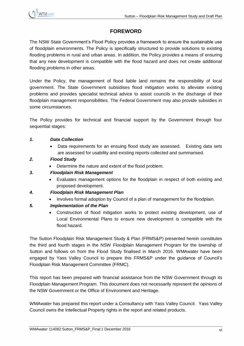
The Sutton Floodplain Risk Management Study & Plan (FRMS&P) presented herein constitutes
the third and fourth stages in the NSW Floodplain Management Program for the township of
Sutton and follows on from the Flood Study finalised in March 2016. WMAwater have been
engaged by Yass Valley Council to prepare this FRMS&P under the guidance of Council’s
Floodplain Risk Management Committee (FRMC).
This report has been prepared with financial assistance from the NSW Government through its
Floodplain Management Program. This document does not necessarily represent the opinions of
the NSW Government or the Office of Environment and Heritage.
WMAwater has prepared this report under a Consultancy with Yass Valley Council. Yass Valley
Council owns the Intellectual Property rights in the report and related products.
Sutton – Floodplain Risk Management Study and Draft Plan
WMAwater 114082:Sutton_FRMS&P_Final:1 December 2016 vii
EXECUTIVE SUMMARY
Introduction and Study Objective
This Study has been prepared by WMAwater on behalf of Yass Valley Council (Council). The
Study is composed of two phases:
1. The Sutton Floodplain Risk Management Study; and
2. The Sutton Floodplain Risk Management Draft Plan.
This document details; The Sutton Floodplain Risk Management Study; and The Sutton
Floodplain Risk Management Draft Plan (abbreviated to FRMS&P). This FRMS&P follows on
from the Sutton Flood Study (the Flood Study, Reference 2) which defined the design flood
behaviour in the township of Sutton under existing conditions to determine the nature and extent
of the existing flood problem.
The main objective of this FRMS&P is to identify floodplain risk, test amelioration strategies for
the management of risk and to put forward priorities and approximately costed
recommendations in regards to flood risk mitigation at Sutton.
The Study Area and Flood Affectation
Sutton is located within the Sydney-Canberra Corridor, approximately 230 km south-west of
Sydney and 20 km north of Canberra. The township is located within the upper reaches of the
Yass River Catchment, at the confluence of the Yass River and McLaughlin’s Creek.
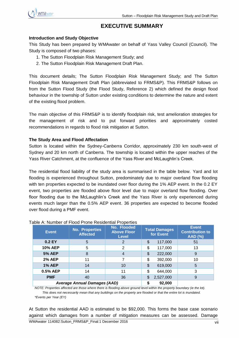
The residential flood liability of the study area is summarised in the table below. Yard and lot
flooding is experienced throughout Sutton, predominately due to major overland flow flooding
with ten properties expected to be inundated over floor during the 1% AEP event. In the 0.2 EY
event, two properties are flooded above floor level due to major overland flow flooding. Over
floor flooding due to the McLaughlin’s Creek and the Yass River is only experienced during
events much larger than the 0.5% AEP event. 36 properties are expected to become flooded
over flood during a PMF event.
Table A: Number of Flood Prone Residential Properties
Event No. Properties
Affected
No. Flooded Above Floor
Level
Total Damages for Event
Event Contribution to
AAD (%)
0.2 EY 5 2 $ 117,000 51
10% AEP 5 2 $ 117,000 13
5% AEP 8 4 $ 222,000 9
2% AEP 11 7 $ 392,000 10
1% AEP 14 10 $ 619,000 5
0.5% AEP 14 11 $ 644,000 3
PMF 40 36 $ 2,527,000 9
Average Annual Damages (AAD) $ 92,000 NOTE: Properties affected are those where there is flooding above ground level within the property boundary (ie the lot).
This does not necessarily mean that any buildings on the property are flooded or that the entire lot is inundated.
*Events per Year (EY)
At Sutton the residential AAD is estimated to be $92,000. This forms the base case scenario
against which damages from a number of mitigation measures can be assessed. Damage

Sutton – Floodplain Risk Management Study and Draft Plan
WMAwater 114082:Sutton_FRMS&P_Final:6 December 2016 viii
contributions due to non-residential properties are expected to be zero as limited development
of this type is present.
Recommendations
This FRMS&P identifies various flood risk management options and strategies to be considered
by Council and the Floodplain Management Committee. Section 4 discusses the various options
assessed in the process of coming up with the shortlisted recommendations presented in the
Plan. The Plan itself is presented in Section 5 and this includes their priority, time for
implementation and implementation strategy.
The structural flood risk management works, Option B1 basin at the corner of Victoria and
Bywong Streets and associated drainage works, is recommended for further investigation
alongside Option A4 pipe network. Investigation works as part of the detailed design is required
to determine which is the preferred option for mitigating flood affectation on the Sutton Central
Flow Path. Option B1 has an estimated implementation cost of $325,000 and provides a
$42,000 reduction in average annual flood damages. Option A4 has an estimated
implementation cost of $400,000 and also provides a $42,000 reduction in average annual flood
damages. Both options mitigate overland flow floods such as those experienced in 2010. With
implementation of either of these Options, the two properties previously flooded above floor in
the 2010 event would no longer be flooded.
The combined Option C2 / C3 drainage works are recommended for implementation. These
works are aimed to improve local drainage issues for areas in north Sutton and have an
estimated cost of $83,000.
Recommended high and medium priority flood risk management measures include:
Construction of the bridge at the location of the existing Sutton Road crossing of
McLaughlin’s Creek to provide flood free access;
Drainage maintenance;
Alarm existing NOW stream gauges at site 410851 and install a pluviometer;
Install manual gauge at Sutton;
Preparation for potential future floods to increase flood warning
Install warning signs and self-deploying boom gates on river and creek crossings;
Review and update the Yass Valley Local Flood Plan and create a FIC for Sutton;
Undertake a community flood education program;
Investigate and update Council’s LEP and DCP in line with the findings from this study;
Define the Flood Planning Level;
Include flood information on S149 certificates; and
Provide flood information on Council’s website.
The Sutton Floodplain Risk Management Study and Plan Draft Final report was placed on public
exhibition for a period of 4 weeks between 26th October and 24th November. Hard copies of the
report were available at Sutton Store, Sutton Public School and on Council’s website. Four
submissions including a group submission from the Sutton Community Association, are
presented in Appendix F along with a response from WMAwater engineers. The public exhibition
submissions results indicate that community acceptance of the study is generally good.

Sutton – Floodplain Risk Management Study and Draft Plan
WMAwater 114082 : Sutton_FRMS&P_Final : 1 December 2016 1
1. INTRODUCTION AND BACKGROUND
This Study has been prepared by WMAwater on behalf of Yass Valley Council (Council). The
Study is composed of two phases:
1. The Sutton Floodplain Risk Management Study; and
2. The Sutton Floodplain Risk Management Draft Plan.
This document details; The Sutton Floodplain Risk Management Study; and The Sutton
Floodplain Risk Management Draft Plan (abbreviated to FRMS&P). This FRMS&P follows on
from the Sutton Flood Study (the Flood Study, Reference 2) which defined the design flood
behaviour in the township of Sutton under existing conditions to determine the nature and extent
of the existing flood problem.
All levels provided in this report are to Australian Height Datum (AHD) or relate to the Yass
River gauge (m) at Macks Reef Road (site number: 410851) which will be referred to as the
Sutton Stream Gauge in this report for ease of reference. A glossary of terms is provided as
Appendix A.
1.1. Study Objectives
The main objective of this FRMS&P is to identify floodplain risk, test amelioration strategies for
the management of risk and to put forward priorities and approximately costed
recommendations in regards to flood risk mitigation at Sutton.
Council requires consideration of a range of management options to effectively manage existing,
future and continuing flood risks at Sutton. The outcomes from the Floodplain Risk Management
Study and draft Floodplain Risk Management Plan will also assist the SES in updating the Yass
Valley Local Flood Plan to include risk management advice for Sutton.
The Objectives are more specifically described in Section 1.1.1 and 1.1.2 below.
1.1.1. Floodplain Risk Management Study Objectives
The objective of the Floodplain Risk Management Study is to investigate a range of flood
mitigation works and measures to address the existing, future and continuing flood problems, in
accordance with the NSW Government's Flood Policy. This includes:
Review of Council’s existing environmental planning policies and instruments including
Council’s long term planning strategies for the Study Area;
Identification of works, measures and restrictions aimed to reduce the social,
environmental and economic impacts of flooding and the losses caused by flooding on
development and the community, both existing and future, over the full range of potential
flood events;
To assess the effectiveness of the works and measures for reducing the effect of flooding
on the community and development, both existing and future;

Sutton – Floodplain Risk Management Study and Draft Plan
WMAwater 114082 : Sutton_FRMS&P_Final : 1 December 2016 2
To consider whether the proposed works and measures might produce adverse effects
(environmental, social, economic, or flooding) in the floodplain and whether they can be
minimised;
Examination of any existing flood warning systems, community flood awareness and
emergency response measures in the context of the NSW State Emergency Service's
developments and disaster planning requirements.
Examine ways in which the rivers and floodplain environment may be enhanced by
preparing a strategy for vegetation planning that will create a valuable corridor of
vegetation without having a detrimental effect on flooding; and
Identification of modifications required to current policies in the light of investigations.
1.1.2. Floodplain Risk Management Draft Plan Objectives
The Floodplain Risk Management Draft Plan makes a range of recommendations relating to
flood mitigation works and measures that address the existing, future and continuing flood
problems, in accordance with the NSW Government's Flood Policy. The recommended works
and measures presented in the Plan are aimed to:
Reduce the flood hazard and risk to people and property in the community and to ensure
future development is controlled in a manner consistent with the flood hazard and risk;
Reduce private and public losses due to flooding;
Protect and, where possible, enhance watercourses/creeks and floodplain environment;
Be consistent with the objectives of relevant State policies, in particular, the Government’s
Flood Prone Lands and State Rivers and Estuaries Policies and satisfy the objectives and
requirements of the Environmental Planning and Assessment Act, 1979;
Ensure that the floodplain risk management plan is fully integrated with Council’s existing
corporate, business and strategic plans, existing and proposed planning proposals, meets
Council’s obligations under the Local Government Act, 1993 and has the support of the
local community;
Ensure actions arising out of the management plan are sustainable in social,
environmental, ecological and economic terms;
Ensure that the floodplain risk management plan is fully integrated with the local
emergency management plan (flood plan) and other relevant catchment management
plans;
Establish a program for implementation and a mechanism for the funding of the plan and
should include priorities, staging, funding, responsibilities, constraints, and monitoring; and
the
Preparation of concept design for recommended works with sufficient detail to enable
Council to apply for funding and progress to the investigation and design stage.
1.2. The Study Area
Sutton is located within the Sydney-Canberra Corridor, approximately 230 km south-west of
Sydney and 20 km north of Canberra. The township is located within the upper reaches of the
Yass River Catchment, at the confluence of the Yass River and McLaughlin’s Creek (see Figure
1).

Sutton – Floodplain Risk Management Study and Draft Plan
WMAwater 114082 : Sutton_FRMS&P_Final : 1 December 2016 3
Sutton has a population of approximately 229 (2011 census) with land use in the township
predominantly composed of low-density housing. There are large areas of open space along
the Yass River and McLaughlin’s Creek. In addition, Future Investigation Areas have been
identified in Council’s Town & Villages Study (YVC, 2010), whereby land to the west and south
of the village could be rezoned to accommodate for an increasing demand for land due to
Sutton’s close proximity to Canberra.
The study area (presented in Figure 1) covers the floodplain near Sutton for regions affected by
Yass River, McLaughlin’s Creek and major overland flow flooding. The upstream limits of the
Sutton Study Area is the Federal Highway. The downstream boundary is situated approximately
1.5 km north of town and 1 km north of the Yass River / McLaughlin’s Creek confluence. The
total study covers an area of approximately 12 km². It should be noted that the hydraulic model
extent extends further upstream and downstream of the study area extent to ensure model
accuracy within the area of interest.
1.2.1. Flood Hotspots
Flooding hotspots were identified as part of the Flood Study. A hotspot is identified as an area
of interest from a flooding perspective. For example, locations where many residences are liable
to flooding might be defined as hotspots as might other locations where key drainage assets are
not meeting design standards or where key infrastructure, such as a highway, is flood affected.
These Hotspots are often also SES points of interest that are useful for SES flood intelligence.
The locations of each of the Hotspots are presented in Figure 3.
The four flood Hotspots identified as part of the Flood Study are described below. Liaison with
the NSW SES also identified a number of additional hotspot not identified at the time of the
Flood Study. These hotspots are not contained within the study area and have been described
together as Hotspot #5.
Hotspot 1: Sutton Road Crossing of McLaughlin’s Creek
The Sutton Road crossing of McLaughlin’s Creek at Sutton provides an important access route
to the north of the town, including to both Yass and Gundaroo. Additionally, flooding of this
crossing has been identified as a major flood issue for Gundaroo residents as this the primary
access route from Gundaroo to Canberra. Flooding of this low-level crossing may also cause
isolation and reduced access which can impact on emergency services.
Analysis of design results indicates that the Sutton Road crossing of McLaughlin’s Creek is
overtopped during the 0.2 EY event, however it is likely also overtopped by more frequent
events which have not been modelled as part of the current study. Peak flood levels for various
design events are presented in Table 1 along with the culvert invert and roadway deck level.
The existing creek crossing structure is of concern to the local community and was identified as
such as part of the community consultation process (see Section 2.4). This study recommends
that the crossing be upgraded to provide flood free access in the 1% AEP flood to reduce
isolation and risk to motorists. Further details are presented in Section 4.3.4.1.
Sutton – Floodplain Risk Management Study and Draft Plan
WMAwater 114082 : Sutton_FRMS&P_Final : 1 December 2016 4
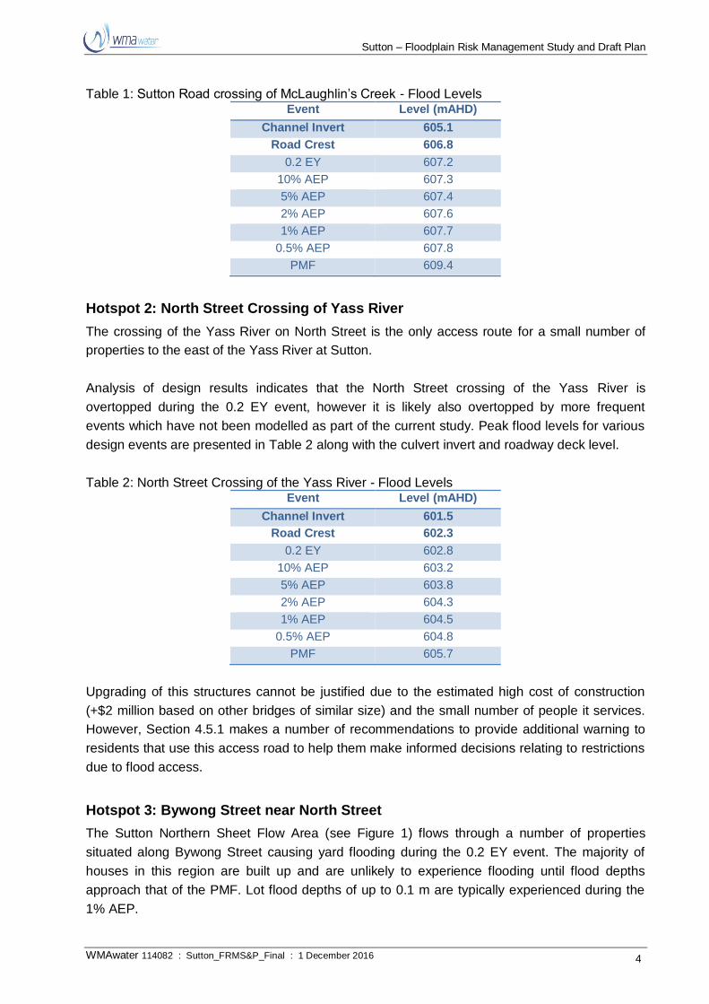
Table 1: Sutton Road crossing of McLaughlin’s Creek - Flood Levels Event Level (mAHD)
Channel Invert 605.1
Road Crest 606.8
0.2 EY 607.2
10% AEP 607.3
5% AEP 607.4
2% AEP 607.6
1% AEP 607.7
0.5% AEP 607.8
PMF 609.4
Hotspot 2: North Street Crossing of Yass River
The crossing of the Yass River on North Street is the only access route for a small number of
properties to the east of the Yass River at Sutton.
Analysis of design results indicates that the North Street crossing of the Yass River is
overtopped during the 0.2 EY event, however it is likely also overtopped by more frequent
events which have not been modelled as part of the current study. Peak flood levels for various
design events are presented in Table 2 along with the culvert invert and roadway deck level.
Table 2: North Street Crossing of the Yass River - Flood Levels Event Level (mAHD)
Channel Invert 601.5
Road Crest 602.3
0.2 EY 602.8
10% AEP 603.2
5% AEP 603.8
2% AEP 604.3
1% AEP 604.5
0.5% AEP 604.8
PMF 605.7
Upgrading of this structures cannot be justified due to the estimated high cost of construction
(+$2 million based on other bridges of similar size) and the small number of people it services.
However, Section 4.5.1 makes a number of recommendations to provide additional warning to
residents that use this access road to help them make informed decisions relating to restrictions
due to flood access.
Hotspot 3: Bywong Street near North Street
The Sutton Northern Sheet Flow Area (see Figure 1) flows through a number of properties
situated along Bywong Street causing yard flooding during the 0.2 EY event. The majority of
houses in this region are built up and are unlikely to experience flooding until flood depths
approach that of the PMF. Lot flood depths of up to 0.1 m are typically experienced during the
1% AEP.

Sutton – Floodplain Risk Management Study and Draft Plan
WMAwater 114082 : Sutton_FRMS&P_Final : 1 December 2016 5
The combined Option C2 / C3 (see Section 4.3.3.4) provides a number of modifications /
additions to the drainage system in this area which significantly reduce lot flood affectation.
Hotspot 4: Bywong Street between Middle Street and Victoria Street
The Central Flow Path (see Figure 1) flows through properties along Bywong Street and Camp
Street causing yard flooding in the 0.2 EY event. It was reported as a part of the Community
Consultation process that over flood flooding of primary residences has occurred on a number of
occasions in the last five years. In the 1% AEP event, flood depths up to 0.2 m are experienced
in this residential area.
The Option B1 basin (see Section 4.3.6.1) provides significantly reductions in peak flood levels
and flood affectation in this areas.
Hotspot 5: Various Flood Susceptible Creek and River Road Crossing
A discussion with the NSW SES Sutton Unit identified two creek and river crossings that are
susceptible to flooding in the surrounding area. These crossing are the:
Murrumbateman Road crossing of Back Creek; and
Shingle Hill Way crossing of Yass River.
It was noted that these are well used access routes that pose significant risk to any motorist
attempting to cross during flood.
Section 4.5.1 makes a number of recommendations to provide warning to motorists that use
these access roads to help them make informed decisions relating to road closures and
restrictions due to flooding.
1.3. Flood Mechanisms
Sutton is affected by two primary sources of flooding. These are:
Mainstream flooding, due to:
o The Yass River;
o McLaughlin’s creek.
Major Overland Flow (MOF) flooding.
Details of the above listed flood mechanisms are presented in the following sections.
1.3.1. Mainstream Flooding
Sutton is situated between the Yass River and McLaughlin’s Creek, immediately upstream of
their confluence. The Yass River flows approximately south-east to north-west and McLaughlin’s
Creek flows approximately south-west to north-east. The catchment areas of these two
watercourses upstream of the study area are 101 km² and 34 km² respectively. The combined
catchment area at their confluence is 137 km². Both watercourses have catchments which are
Sutton – Floodplain Risk Management Study and Draft Plan
WMAwater 114082 : Sutton_FRMS&P_Final : 1 December 2016 6
largely rural in nature with some areas of dense vegetation, particularly in the Goorooyarroo
National Park.
Flooding in both watercourses has been observed with inundation of the floodplain occurring.
However, above floor flooding of residential properties is not expected in either watercourse for
events up to and including the 0.5% AEP event. Residential flooding however, from overland
flow may be experienced with this flood mechanism discussed below.
1.3.2. Major Overland Flow Flooding
MOF is the primary source of flood affectation in Sutton with flooding in the town in recent years
due to this mechanism. Three flow paths that affect residential areas have been identified that
flow west through the town to McLaughlin’s Creek, namely the;
Sutton Northern Sheet Flow Area;
Sutton Central Flow Path; and
Sutton Southern Flow Path.
The locations of these flows paths are presented in Figure 1 with further details for each flow
path provided in the Flood Study.
Proposed Development Areas
As part of this study, land that has development potential has been included within the model
domain so that flood behaviour for these areas can be defined. The development potential areas
are presented in the Sutton Study Area map (Figure 1) and are numbered accordingly. Details
for these regions are provided below:
1. West Sutton Future Investigation Area – is situated to the west of McLaughlin’s Creek
and is 100 ha of currently zoned RU1 Primary Production. The region has the potential
for future development through a RU5 Village or R5 Large Lot Residential zone;
2. East Sutton Future Investigation Area – is situated east of Moorong Street and is 94 ha
of R5 Large Lot Residential zoned land which has limited sub-division potential, whereby
the minimum lot size is 2.5ha;
3. South Sutton Future Investigation Area – is situated to the south of the village, boarded
by the Federal Highway to the south, Yass River to the east, and an unformed Crown
Road to the west. This is 310ha of RU1 Primary Production zoned land with the
potential for future development.
4. Sutton McLaughlin’s Creek Future Investigation Area – is situated south-west of Sutton
on the east back on McLaughlin’s Creek. This is 192 ha of R5 Large Lot Residential
zoned land which has limited sub-division potential, whereby the minimum lot size is
10ha.
The proposed development areas are presented in the Sutton Study Area map (Figure 1) and
are numbered accordingly.
Sutton – Floodplain Risk Management Study and Draft Plan
WMAwater 114082 : Sutton_FRMS&P_Final : 1 December 2016 7
1.4. Overview of Existing Catchment
1.4.1. Land Use and Demographic Overview
Understanding the social characteristics of the area can help in ensuring that the right risk
management practices are adopted. The Census data can provide useful information on
categories including dwelling and tenure type, languages spoken, age of population and
movement of people into and from the area. Information has been extracted for the 2011
Census. The urban centre of the suburb of Sutton has a population of 229 living in 83 private
dwellings.
Of interest is the data on population movement in recent years. Generally residents who have
lived in an area for a longer time will have a better understanding of flooding issues in their area
than those who have recently moved to the area. Within the last five years 50% of the
population has moved to the Sutton area and in the year prior to the 2011 census 25% of the
population moved into the area, many coming from the ACT. This means that much of the
current population would not have experienced floods in 2010 to 2012 and therefore potentially
do not have a good awareness of flood risk in the region.
It is useful to consider the tenure of housing. Those living in properties which they own are more
likely to be aware of the flood risks and have measures in place to reduce them (where
possible). Rental properties are likely to have a higher turnover of people living in them
compared to privately owned properties and therefore those people in rental properties may be
less aware of the flood risk. In Sutton 26% of houses are rented which is relative high, again
indicating the generally the communities flood awareness is likely low.
The languages spoken by the population are also useful to consider as this can have
implications in regard to the provision of flood information to the public. In Sutton less than 1% of
the population speak a language other than English at home.
Land use from the LEP 2013 is shown in Figure 2. The majority of Sutton is comprised of lots
zoned RU5 Rural Village and R5 Large Lot Residential areas. The RU5 classification not only
allows for residential properties but also public/commercial/industrial uses of which there are
approximately five in Sutton. Land use outside of the township of Sutton is generally zoned RU1
Primary Production with usage primarily devoted to grazing and cropping endeavours.
Outside the town boundaries, the only structures on the floodplain are roads and rail, individual
farmhouses and other farm related infrastructure. Most roads are unsealed and creek and
stream crossings are generally formed by low level causeways.
1.4.2. Key Infrastructure on the Floodplain
Key infrastructure on the floodplain are those that impact on flood levels, for example upstream
backwatering (and retention of floodwater) and lower levels in the downstream (relative to the
case if the major structure was not there). Some of these may be deliberate flood management
measures to control flooding. Sutton’s key infrastructure is summarised in the Flood Study
(Reference 2) including location map and photographs.

Sutton – Floodplain Risk Management Study and Draft Plan
WMAwater 114082 : Sutton_FRMS&P_Final : 1 December 2016 8
Table 3 below summarises each feature with the locations displayed on Figure 3.
Table 3: Key Infrastructure on the Floodplain ID Structure Comment
1 Sutton Road crossing of
McLaughlin’s Creek
The Sutton Road crossing of McLaughlin’s Creek at Sutton provides
an important access route to the north of the town, including to both
Yass and Gundaroo. Analysis of design results indicates that the
Sutton Road crossing of McLaughlin’s Creek is overtopped during
the 0.2 EY event, however it is likely also overtopped by more
frequent events which have not been modelled as part of the
current study. This structure has been highlighted as an area of key
interested (Hotspot #1) and is recommended for upgrading to a
larger, flood free, access bridge (see Section 4.3.4.1).
2 North Street crossing of Yass
River
The crossing of the Yass River on North Street is the only access
route to properties to the east of the Yass River at Sutton. Analysis
of design results indicates that the North Street crossing of the Yass
River is overtopped during the 0.2 EY event, however it is likely also
overtopped by more frequent events which have not been modelled
as part of the current study.
Sutton – Floodplain Risk Management Study and Draft Plan
WMAwater 114082 : Sutton_FRMS&P_Final : 1 December 2016 9
2. COMMUNITY CONSULTATION
Community consultation is an important element of the floodplain risk management process
ultimately facilitating community engagement and acceptance of the overall project. During the
Flood Study (Reference 2), community consultation was undertaken to assess the flood
experience of the community and gather additional data. Further community consultation has
also been undertaken as part of the FRMS&P. To date this has included a questionnaire, a
community open day and a number of FMC meetings. Goals of ongoing community consultation
are to keep residents informed of progress and gain their feedback on potential mitigation and
management measures proposed. Final community consultation is in the form of public
exhibition of the Floodplain Risk Management Study and Draft Floodplain Risk Management
Plan.
2.1. Questionnaire Distribution
A community newsletter and questionnaire (presented in Appendix B) was hand delivered to
residents of Sutton by members of the NSW SES during March 2016. The newsletter aimed to
inform the community of the Sutton FRMS&P and the questionnaire provided the community
with an opportunity to highlight their flood affectation and to provide input into the current study.
In particular, the questionnaire was intended to obtain ideas for mitigation works or management
options to reduce flood affectation and risk.
A total of nine replies (out of 130 distributed) resulted in a return rate of 7% which higher than
the return rate typically experienced for other FRMS in rural NSW. It should be noted that
extensive community consultation was also undertaken as part of the Flood Study and the
FRMS Community Information Session (Section 2.2) also provided the community with an
opportunity to have their say.
When asked about potential flood mitigation options, nearly all respondents wished to see the
construction of a bridge or bypass to replace the current McLaughlin’s Creek crossing (as
described as Hotspot #1). This Option is examined in Section 4.3.4.1. Other options that
residents expressed interest in included increasing the capacity of local drainage networks and
culverts. A summary of suggestions provided by the community consultation process is
presented in Section 2.4.
2.2. Community Information Session
WMAwater engineers attended a Community Information Session at Sutton Hall on the 11th of
February 2016. The aim of the session was to discuss the findings of the Flood Study and to
obtain community ideas and knowledge for potential flood mitigation options to reduce flood
affectation in Sutton.
The meeting was attended by approximately 12 people with residents discussing a range of
topics. A summary of suggestions provided by the community consultation process is presented
in Section 2.4.
Sutton – Floodplain Risk Management Study and Draft Plan
WMAwater 114082 : Sutton_FRMS&P_Final : 1 December 2016 10
2.3. Flood Risk Management Committee
The Sutton Floodplain Risk Management Committee (FRMC) comprises a number of
representatives from the local community, including residents, members of Council, the SES
and OEH.
Regular meetings have been held (6 in total) in order to inform the FRMC of the study progress
regarding data collection and community consultation as well as the modelling of flood mitigation
measures. As an advisory committee to Council, the FRMC has provided oversight to the
objectives, inputs, outputs and recommendations contained in the draft Sutton floodplain risk
management study and plan. This includes a number of potential flood mitigation measures that
are presented in Section 2.4 in addition to those suggested by the broader community.
2.4. Summary of Community Consultation Findings
The community consultation process yielded various suggestions to ameliorate flood risk and
affectation. Many of these suggestions have been modelled and their viability has been
assessed in Section 4.
The questionnaire responses and comments made as part of the Community Information
Session included the following potential flood mitigation measures:
Increased channel and culvert conveyance on Victoria Street (see Section 4.3.3.1);
Additional culverts under North Street to the east of Quartz Street (see Section 4.3.3.2);
Replacing the existing Sutton Road crossing of McLaughlin’s Creek with a bridge (see
Section 4.3.4.1);
Additional culverts under Camp Street to allow flow through to McLaughlin’s Creek (see
Section 4.3.4.2);
Increase existing culvert capacity under North Street (see Section 4.3.4.3);
Drainage maintenance and clearing of culverts and bridges to increase flow conveyance
of existing structures (see Section 4.3.5); and
A diversion channel to transfer flow from the Sutton Central Flow Path along the existing
Quartz Street Road easement to Victoria Street (a modification to this measure is
presented in Section 4.3.6.1).
2.5. Public Exhibition of the Draft Final Sutton FRMS&P
The Sutton Floodplain Risk Management Study and Plan Draft Final report was placed on public
exhibition for a period of 4 weeks between 26th October and 24th November. Hard copies of the
report were available at the Sutton Store and Sutton Public School. The report was also
available online on Council’s website during this period.
Four submissions were made, which along with a response from WMAwater engineers are
presented in Appendix F.
Sutton – Floodplain Risk Management Study and Draft Plan
WMAwater 114082 : Sutton_FRMS&P_Final : 1 December 2016 11
3. FLOODPLAIN RISK MANAGEMENT STUDY
3.1. Objectives of the Floodplain Risk Management Study
The primary objective of the Floodplain Risk Management Study is to investigate a range of
flood mitigation works and measures to address the existing, future and continuing flood
problems, in accordance with the NSW Government's Flood Policy, as detailed in the Floodplain
Development Manual (Reference 1). A full list of objectives for the study area presented in
Section 1.1.
3.2. Impacts of Flooding
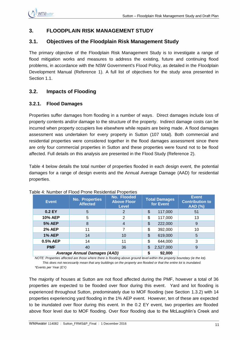
3.2.1. Flood Damages
Properties suffer damages from flooding in a number of ways. Direct damages include loss of
property contents and/or damage to the structure of the property. Indirect damage costs can be
incurred when property occupiers live elsewhere while repairs are being made. A flood damages
assessment was undertaken for every property in Sutton (107 total). Both commercial and
residential properties were considered together in the flood damages assessment since there
are only four commercial properties in Sutton and these properties were found not to be flood
affected. Full details on this analysis are presented in the Flood Study (Reference 2).
Table 4 below details the total number of properties flooded in each design event, the potential
damages for a range of design events and the Annual Average Damage (AAD) for residential
properties.
Table 4: Number of Flood Prone Residential Properties
Event No. Properties
Affected
No. Flooded Above Floor
Level
Total Damages for Event
Event Contribution to
AAD (%)
0.2 EY 5 2 $ 117,000 51
10% AEP 5 2 $ 117,000 13
5% AEP 8 4 $ 222,000 9
2% AEP 11 7 $ 392,000 10
1% AEP 14 10 $ 619,000 5
0.5% AEP 14 11 $ 644,000 3
PMF 40 36 $ 2,527,000 9
Average Annual Damages (AAD) $ 92,000 NOTE: Properties affected are those where there is flooding above ground level within the property boundary (ie the lot).
This does not necessarily mean that any buildings on the property are flooded or that the entire lot is inundated.
*Events per Year (EY)
The majority of houses at Sutton are not flood affected during the PMF, however a total of 36
properties are expected to be flooded over floor during this event. Yard and lot flooding is
experienced throughout Sutton, predominately due to MOF flooding (see Section 1.3.2) with 14
properties experiencing yard flooding in the 1% AEP event. However, ten of these are expected
to be inundated over floor during this event. In the 0.2 EY event, two properties are flooded
above floor level due to MOF flooding. Over floor flooding due to the McLaughlin’s Creek and
Sutton – Floodplain Risk Management Study and Draft Plan
WMAwater 114082 : Sutton_FRMS&P_Final : 1 December 2016 12
the Yass River is only experienced during events much larger than the 0.5% AEP event.
At Sutton the AAD is estimated to be $92,000. This forms the base case scenario against which
damages from a number of mitigation measures can be assessed. In assessing various
mitigation measures it is important to compare them using a suitable metric. By applying a
monetary value to property damages and then comparing damage estimates for the existing
situation with assumed mitigation work (approximately costed) a benefit/cost (B/C) ratio can be
calculated which is readily comparable.
3.2.2. Public Infrastructure and Other Land Uses
Public sector (non-building) damages include; recreational/tourist facilities; water and sewerage
supply; gas supply; telephone supply; electricity supply including transmission poles/lines, sub-
stations and underground cables; rail; roads and bridges including traffic lights/signs; and costs
to employ emergency services and assist in cleaning up. Public sector damages can contribute
a significant proportion to total flood costs but are difficult to accurately calculate or predict.
Costs to Councils from flooding typically comprise;
Clean-up costs;
Erosion and siltation;
Drain cleanout and maintenance;
Removing fallen trees;
Inundation of Council buildings;
Direct damage to roads, bridges and culverts;
Removing vehicles washed away;
Assistance to ratepayers;
Increases in insurance premiums;
Closures of Streets;
Loss of working life of road pavements; and
Operational costs in the lead up to and during flood events.
3.2.2.1. Electricity
Essential Energy was contacted about potential flood risk to electrical infrastructure, however no
electrical sub-stations are situated within the PMF extent at Sutton.
3.2.2.2. Sewerage
Sutton currently has no sewerage connection with the town using per lot septic tank systems.
Septic tanks are prone to causing contamination of the surrounding region as effluent can
overflow the storage tank. The community consultation process undertaken as part of the Flood
Study highlighted this as an issue during a number of recent MOF flood events.
3.2.2.3. Schools
Sutton Public School is situated on Victoria Street near its intersection with Bywong Street. The
school is situated next to the Sutton Southern Flow Path (see Section 1.3.2), however is not

Sutton – Floodplain Risk Management Study and Draft Plan
WMAwater 114082 : Sutton_FRMS&P_Final : 1 December 2016 13
flooded for events up to and including the 0.5% AEP. During a flood event Bywong Street is cut
adjacent to the school however Victoria Street remains accessible until the PMF event. During
the PMF, the grounds of the School are flooded to approximately 0.1 m depth, however the
School is not flooded over floor during such an event.
Flooding to the school, and to similar institutions, would have different impacts depending on the
time of day. During school hours response would be more critical due to the number of persons
on the site. Although flooding at the school is unlikely, it is important that schools have effective
flood plans.
3.2.2.4. Operations Centres
The Sutton NSW SES Unit, which opened in 2014, is responsible for servicing Sutton and the
surrounding area. It is important to note that this SES unit may have restricted access in and
out of Sutton during a large flood events due to road closures.
A number of SES Units in the surrounding areas including the Yass, Queanbeyan, Bungendore
and Collector Units have assisted Sutton Unit during recent flood events. Again it should be
noted that during large flood events there is potential for restricted access due to flood waters.
3.3. Hydraulic Categorisation
The 2005 NSW Government’s Floodplain Development Manual (Reference 1) defines three
hydraulic categories which can be applied to different areas of the floodplain; namely floodway,
flood storage or flood fringe. Floodway describes areas of significant discharge during floods,
which, if partially blocked, would cause a significant redistribution of flood flow. Flood storage
areas are used for temporary storage of floodwaters during a flood, while flood fringe is all other
flood prone land.
The Flood Study (Reference 2) determined hydraulic categories for the 1% and 0.5% AEP
events using the criteria proposed by Howells et. al. (2003). The hydraulic categories for these
events are presented in Figure 35 and Figure 36 of the Flood Study respectively, and are
reproduced herein as Figure 4 and Figure 5.
3.4. True Flood Hazard Classification
The Flood Study (Reference 2) defined the provisional hydraulic hazard while the FRMS&P is
required to consider the true flood hazard. The Flood Study (Reference 2) found that high
provisional hydraulic hazard tends to be limited to defined flow paths and also those areas
where water depths accumulate. Generally, areas of residential development in Sutton are
classified as low hazard.
To assess the true flood hazard all adverse effects of flooding have to be considered. As well as
considering the provisional (hydraulic) hazard it also incorporates other criteria such as threat to
life, danger and difficulty in evacuating people and possessions and the potential for damage,
social disruption and loss of production and those detailed in Table 5.

Sutton – Floodplain Risk Management Study and Draft Plan
WMAwater 114082 : Sutton_FRMS&P_Final : 1 December 2016 14
Table 5: Hazard Classification
Criteria Weight (1) Comment
Size of the
flood Medium
The size or magnitude of the flood can affect depths and velocities.
Relatively low flood hazard is associated with more frequent minor
floods while the less frequent major floods are more likely to present a
high hazard situation. The majority of flood affectation at Sutton is due
to MOF, which doesn’t scale greatly for events of varying magnitude.
The mainstream PMF, however, does scale significantly and much of
the Yass River and McLaughlin’s Creek floodplains would experience
depths and velocities that could pose a risk to the structural stability of
buildings.
Depth and
velocity of
floodwaters
High
The provisional hazard is the product of depths and velocity of flood
waters. These can be influenced by the magnitude of the flood event.
Generally at Sutton, high velocities and depths are confined to the river,
creeks during the 1% AEP event. However, the PMF event experiences
significant depths and velocities in populated areas of Sutton.
Rate of rise of
floodwaters Medium
Rate of rise of floodwaters is relative to catchment size, soil type, slope
and land use cover. It is also influenced by the spatial and temporal
pattern of rainfall during events. At Sutton, the rate of rise can be quite
rapid due to the relatively small catchment sizes. This adds to the level
of associated risk.
Duration of
flooding Low
The greater the duration of flooding the more disruption to the
community and potential flood damages. A short period of inundation
may allow some materials to dry and recover whereas a long duration
may cause damages beyond repair. At Sutton the flooding duration is
short.
Effective
warning and
evacuation
time
Medium
This is dependent on the rate at which waters rise, an effective flood
warning system and the awareness and readiness of the community to
act. Currently, no BoM flood warnings are issued for the Yass River at
Sutton and therefore specific warning is limited. In addition to this,
upstream stream gauges provide only limited warning (see Section
4.5.1).
Flood
awareness
and readiness
of the
community
Medium
The community of Sutton has a degree of flood awareness but it is
likely to be limited to those people aware of the more recent events.
Recent flooding events and community consultation undertaken as part
of the current flood risk management process (of which this report
forms part) has raised awareness of the flood problem. The awareness
of the community has a medium weight in considering flood hazard as
a more aware community will be able to better prepare and therefore
potentially evacuate before hazards become high. General community
awareness tends to reduce as the time between flood events lengthens
and people become less prepared for the next flood event. Even a flood
aware community is unlikely to be wise to the impacts of a larger, less
frequent event. In areas where flood warning is limited it is more
important for a community to be flood aware so that individual can
notice the signs of the onset of flooding and prepare themselves.
Effective flood
access High
Access is affected by the depths and velocities of flood waters, the
distance to higher ground, the number of people using and the capacity
of evacuation routes and good communication. A number of roads in
and out of Sutton frequently become hazardous and impassable during
flood.
Sutton – Floodplain Risk Management Study and Draft Plan
WMAwater 114082 : Sutton_FRMS&P_Final : 1 December 2016 15
Criteria Weight (1) Comment
Evacuation
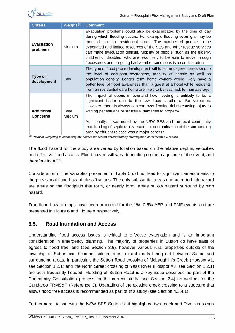
problems Medium
Evacuation problems could also be exacerbated by the time of day
during which flooding occurs. For example flooding overnight may be
more difficult for residential areas. The number of people to be
evacuated and limited resources of the SES and other rescue services
can make evacuation difficult. Mobility of people, such as the elderly,
children or disabled, who are less likely to be able to move through
floodwaters and on-going bad weather conditions is a consideration.
Type of
development Low
The type of flood prone development will to some degree correspond to
the level of occupant awareness, mobility of people as well as
population density. Longer term home owners would likely have a
better level of flood awareness than a guest at a hotel while residents
from an residential care home are likely to be less mobile than average.
Additional
Concerns
Low/
Medium
The impact of debris in overland flow flooding is unlikely to be a
significant factor due to the low flood depths and/or velocities.
However, there is always concern over floating debris causing injury to
wading pedestrians or structural damages to property.
Additionally, it was noted by the NSW SES and the local community
that flooding of septic tanks leading to contamination of the surrounding
area by effluent release was a major concern. (1) Relative weighting in assessing the hazard for Sutton determined by interrogation of Reference 2 results
The flood hazard for the study area varies by location based on the relative depths, velocities
and effective flood access. Flood hazard will vary depending on the magnitude of the event, and
therefore its AEP.
Consideration of the variables presented in Table 5 did not lead to significant amendments to
the provisional flood hazard classifications. The only substantial areas upgraded to high hazard
are areas on the floodplain that form, or nearly form, areas of low hazard surround by high
hazard.
True flood hazard maps have been produced for the 1%, 0.5% AEP and PMF events and are
presented in Figure 6 and Figure 8 respectively.
3.5. Road Inundation and Access
Understanding flood access issues is critical to effective evacuation and is an important
consideration in emergency planning. The majority of properties in Sutton do have ease of
egress to flood free land (see Section 3.6), however various rural properties outside of the
township of Sutton can become isolated due to rural roads being cut between Sutton and
surrounding areas. In particular, the Sutton Road crossing of McLaughlin’s Creek (Hotspot #1,
see Section 1.2.1) and the North Street crossing of Yass River (Hotspot #3, see Section 1.2.1)
are both frequently flooded. Flooding of Sutton Road is a key issue described as part of the
Community Consultation process for the current study (see Section 2.4) as well as for the
Gundaroo FRMS&P (Reference 3). Upgrading of the existing creek crossing to a structure that
allows flood free access is recommended as part of this study (see Section 4.3.4.1).
Furthermore, liaison with the NSW SES Sutton Unit highlighted two creek and River crossings
Sutton – Floodplain Risk Management Study and Draft Plan
WMAwater 114082 : Sutton_FRMS&P_Final : 1 December 2016 16
described in Hotspot #5 as high risk crossings during flood. The construction of large bridges
would be required to provide flood free access at these locations which may not be financially
feasible, however a number of measures such as early road closures and warning signage is
recommended as part of this study (see Section 4.5).
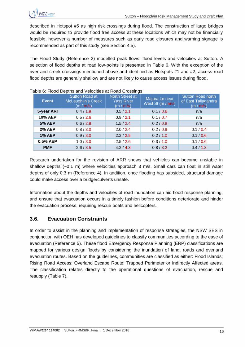
The Flood Study (Reference 2) modelled peak flows, flood levels and velocities at Sutton. A
selection of flood depths at road low-points is presented in Table 6. With the exception of the
river and creek crossings mentioned above and identified as Hotspots #1 and #2, access road
flood depths are generally shallow and are not likely to cause access issues during flood.
Table 6: Flood Depths and Velocities at Road Crossings
Event Sutton Road at
McLaughlin’s Creek (m / m/s)
North Street at Yass River (m / m/s)
Majura Ln near West St (m / m/s)
Sutton Road north of East Tallagandra
(m / m/s)
5-year ARI 0.4 / 1.9 0.5 / 2.1 0.1 / 0.6 n/a
10% AEP 0.5 / 2.6 0.9 / 2.1 0.1 / 0.7 n/a
5% AEP 0.6 / 2.9 1.5 / 2.4 0.2 / 0.8 n/a
2% AEP 0.8 / 3.0 2.0 / 2.4 0.2 / 0.9 0.1 / 0.4
1% AEP 0.9 / 3.0 2.2 / 2.5 0.2 / 1.0 0.1 / 0.6
0.5% AEP 1.0 / 3.0 2.5 / 2.6 0.3 / 1.0 0.1 / 0.6
PMF 2.6 / 3.5 4.2 / 4.3 0.8 / 3.2 0.4 / 1.3
Research undertaken for the revision of ARR shows that vehicles can become unstable in
shallow depths (~0.1 m) where velocities approach 3 m/s. Small cars can float in still water
depths of only 0.3 m (Reference 4). In addition, once flooding has subsided, structural damage
could make access over a bridge/culverts unsafe.
Information about the depths and velocities of road inundation can aid flood response planning,
and ensure that evacuation occurs in a timely fashion before conditions deteriorate and hinder
the evacuation process, requiring rescue boats and helicopters.
3.6. Evacuation Constraints
In order to assist in the planning and implementation of response strategies, the NSW SES in
conjunction with OEH has developed guidelines to classify communities according to the ease of
evacuation (Reference 5). These flood Emergency Response Planning (ERP) classifications are
mapped for various design floods by considering the inundation of land, roads and overland
evacuation routes. Based on the guidelines, communities are classified as either: Flood Islands;
Rising Road Access; Overland Escape Route; Trapped Perimeter or Indirectly Affected areas.
The classification relates directly to the operational questions of evacuation, rescue and
resupply (Table 7).

Sutton – Floodplain Risk Management Study and Draft Plan
WMAwater 114082 : Sutton_FRMS&P_Final : 1 December 2016 17
Table 7: Emergency Response Planning Classification of Communities EMERGENCY RESPONSE
Classification Resupply Rescue/Medivac Evacuation
High flood island Yes Possibly Possibly
Low flood island No Yes Yes
Area with rising road access No Possibly Yes
Area with overland escape routes No Possibly Yes
Low trapped perimeter No Yes Yes
High trapped perimeter Yes Possibly Possibly
Indirectly affected areas Possibly Possibly Possibly
ERP classification was undertaken as part of the Flood Study (Reference 2) for the PMF event.
The Sutton ERP classification map for the PMF has been reproduced herein as Figure 9. The
majority of the township of Sutton is classified as ‘High Trapped Perimeter Area’.
ERP classification maps have also been produced for the 1% and 5% AEP events. These maps
are presented in Figure 10 and Figure 11 respectively.
3.7. Legislative and Planning Management
3.7.1. State Legislative and Planning Context
It is important to understand the state legislation that overarches all local legislation to enable
appropriate floodplain risk management measures to be proposed that are in keeping with both
state and local statutory requirements. This section discusses the state legislation that
influences planning in relation to flood risk at the local government level.
The NSW Environmental Planning and Assessment Act 1979 (EP&A Act) provides the
framework for regulating and protecting the environment and controlling development.
Pursuant to Section 117(2) of the EP&A Act, the Minister has directed that Councils have the
responsibility to facilitate the implementation of the NSW Government's Flood Prone Land
Policy. Specifically, Direction 4.3 states:
Objectives
(1) The objectives of this direction are:
(a) to ensure that development of flood prone land is consistent with the NSW Government's
Flood Prone Land Policy and the principles of the Floodplain Development Manual 2005, and
(b) to ensure that the provisions of an LEP on flood prone land is commensurate with flood
hazard and includes consideration of the potential flood impacts both on and off the subject
land.
Clause (3) of Direction 4.3 states:
(3) This direction applies when a relevant planning authority prepares a planning proposal that
creates, removes or alters a zone or a provision that affects flood prone land.

Sutton – Floodplain Risk Management Study and Draft Plan
WMAwater 114082 : Sutton_FRMS&P_Final : 1 December 2016 18
Clauses (4)-(9) of Direction 4.3 state:
(4) A planning proposal must include provisions that give effect to and are consistent with the NSW
Flood Prone Land Policy and the principles of the Floodplain Development Manual 2005
(including the Guideline on Development Controls on Low Flood Risk Areas).
(5) A planning proposal must not rezone land within the flood planning areas from Special Use,
Special Purpose, Recreation, Rural or Environmental Protection Zones to a Residential,
Business, Industrial, Special Use or Special Purpose Zone.
(6) A planning proposal must not contain provisions that apply to the flood planning areas which:
(a) permit development in floodway areas,
(b) permit development that will result in significant flood impacts to other properties,
(c) permit a significant increase in the development of that land,
(d) are likely to result in a substantially increased requirement for government spending on flood
mitigation measures, infrastructure or services, or
(e) permit development to be carried out without development consent except for the purposes of
agriculture (not including dams, drainage canals, levees, buildings or structures in floodways
or high hazard areas), roads or exempt development.
(7) A planning proposal must not impose flood related development controls above the residential
flood planning level for residential development on land, unless a relevant planning authority
provides adequate justification for those controls to the satisfaction of the Director-General (or an
officer of the Department nominated by the Director-General).
(8) For the purposes of a planning proposal, a relevant planning authority must not determine a flood
planning level that is inconsistent with the Floodplain Development Manual 2005 (including the
Guideline on Development Controls on Low Flood Risk Areas) unless a relevant planning
authority provides adequate justification for the proposed departure from that Manual to the
satisfaction of the Director-General (or an officer of the Department nominated by the Director-
General).
(9) A planning proposal may be inconsistent with this direction only if the relevant planning authority
can satisfy the Director-General (or an officer of the Department nominated by the Director-
General) that:
(a) the planning proposal is in accordance with a floodplain risk management plan prepared in
accordance with the principles and guidelines of the Floodplain Development Manual 2005, or
(b) the provisions of the planning proposal that are inconsistent are of minor significance.
3.7.1.1. NSW Flood Prone Land Policy
The primary objectives of the NSW Government's Flood Prone Land Policy are:
Sutton – Floodplain Risk Management Study and Draft Plan
WMAwater 114082 : Sutton_FRMS&P_Final : 1 December 2016 19
to reduce the impact of flooding and flood liability on individual owners and occupiers of
flood prone land, and
to reduce public and private losses resulting from floods whilst utilising ecologically
positive methods wherever possible.
The NSW Floodplain Development Manual 2005 (the Manual), relates to the development of
flood prone land for the purposes of Section 733 of the Local Government Act 1993 and
incorporates the NSW Flood Prone Land Policy.
The Manual outlines a merit based approach based on floodplain management. At the strategic
level, this allows for the consideration of social, economic, cultural, ecological and flooding
issues to determine strategies for the management of flood risk.
The Manual recognises differences between urban and rural floodplain issues. Although it
maintains that the same overall floodplain management approach should apply to both, it
recognises that a different emphasis is required to address issues particular to a rural floodplain.
These issues include:
The large area of land under investigation;
The complexity of flood behaviour;
The impacts of protection works for valuable crops on flood behaviour;
The period of inundation;
The uncertainties associated with flood related data, and
The environmental values associated with flood dependent ecosystems on a rural
floodplain.
3.7.1.2. Section 149 Planning Certificates
Section 149 of the EP&A Act states:
(1) A person may, on payment of the prescribed fee, apply to a council for a certificate under this
section (a planning certificate) with respect to any land within the area of the council.
(2) On application made to it under subsection (1), the council shall, as soon as practicable, issue a
planning certificate specifying such matters relating to the land to which the certificate relates as
may be prescribed (whether arising under or connected with this or any other Act or otherwise).
(3) (Repealed)
(4) The regulations may provide that information to be furnished in a planning certificate shall be set
out in the prescribed form and manner.
The Environmental Planning and Assessment Regulation 2000 prescribes the matters which
must be included in a s.149 Planning Certificate, including whether a parcel of land is subject to
controls relating to flooding.
Sutton – Floodplain Risk Management Study and Draft Plan
WMAwater 114082 : Sutton_FRMS&P_Final : 1 December 2016 20
3.7.1.3. State Environmental Planning Policy (Exempt and Complying Development Codes (2008))
The aims of State Environmental Planning Policy (Exempt and Complying Development) 2008
are:
This Policy aims to provide streamlined assessment processes for development that complies with
specified development standards by:
(a) providing exempt and complying development codes that have State-wide application, and
(b) identifying, in the exempt development codes, types of development that are of minimal
environmental impact that may be carried out without the need for development consent, and
(c) identifying, in the complying development codes, types of complying development that may
be carried out in accordance with a complying development certificate as defined in the Act,
and
(d) enabling the progressive extension of the types of development in this Policy, and
(e) providing transitional arrangements for the introduction of the State-wide codes, including the
amendment of other environmental planning instruments.
3.7.1.4. General Housing Code
Part 3 of the SEPP relates to the "General Housing Code".
Division 1 of Part 3 of the SEPP, which comprises clauses 3.1-3.6 of the SEPP, relates to:
Development that is complying development under this code
Clause 3.1 states:
3.1 Land to which code applies
This code applies to development that is specified in clauses 3.2-3.5 on any lot in
Zone R1, R2, R3, R4 or RU5 that:
(a) has an area of at least 200 m2, and
(b) has a width, measured at the building line fronting a primary road, of at least
6m.
Clause 3.2 of the SEPP states:
3.2 New single storey and two storey dwelling houses
The erection of a new single storey or two storey dwelling house is development
specified for this code.


![California High-Speed Rail Authority - 3.8 …...Draft Stormwater Management Report (California High-Speed Rail Authority [Authority] 2016a) Draft Floodplain Impact Report (Authority](https://static.fdocuments.in/doc/165x107/5f0309017e708231d40736f1/california-high-speed-rail-authority-38-draft-stormwater-management-report.jpg)