Donnelly Flats Staff Ride - Bureau of Land Management Training Schedule and... · Donnelly Flats...
24
Donnelly Flats Staff Ride 1 Stand One: Orientation Location: (N 63° 48.213” x W 145°46.700”) From Delta Junction take Richardson Highway south approximately 16 miles Turn right on Donnelly Dome Rd, approximately 2 miles, gravel pit on the left Discussion Guide: The vantage from this stand is an impressive display of the Alaska Range and Upper Tanana Valley. However beautiful this geological and glacial landscape may be, it is responsible for a significant influence on the weather patterns that flow into this valley. The Granites, a spur ridge of the Alaska Range, are the prominent ridgeline running to the east, with Panoramic Peak 5,150’ dominating its end. Further east of Panoramic Peak is the widening of the vast Tanana Valley. Working our way back along the Granites, with Jarvis Creek flowing in the valley below, several domes protrude. Ober Dome is to the east and Donnelly Dome where Stand One is located. Figure 1 consists of Donnelly Dome looking east with the Granites in the background. Isabel Pass, (Figure 2) to the south, is the gap in this range where the Richardson Highway runs. This pass is notorious for funneling the famous Delta wind. These winds are predictable, however, if a fire is established prior to this wind event this can be a precarious situation for firefighters and land managers. To the south, usually blanketed in a layer of clouds, are some impressive rock formations (Figure 3). The largest, Mt. Hayes (13,832’), near the head of Hayes Glacier, and slightly smaller Mt. Moffit (13,020’) near the head of a glacier named Trident. Altogether, these are some of the dominating features that are the main culprits for the severe environmental factors affecting this area. These need to be pointed out prior to beginning our day for a couple reasons; to bring the geographical influences into perspective, and set some Figure 1 Donnelly Dome looking east with the Granites in the background, photo courtesy of the National Archives.
Transcript of Donnelly Flats Staff Ride - Bureau of Land Management Training Schedule and... · Donnelly Flats...

Donnelly Flats Staff Ride
1
Stand One: Orientation
Location: (N 63° 48.213” x W 145°46.700”)
From Delta Junction take Richardson Highway south approximately 16 miles
Turn right on Donnelly Dome Rd, approximately 2 miles, gravel pit on the left
Discussion Guide:
The vantage from this stand is an impressive display of the Alaska Range and
Upper Tanana Valley. However beautiful this geological and glacial landscape may
be, it is responsible for a significant influence on the weather patterns that flow into
this valley. The Granites, a spur ridge of the Alaska Range, are the prominent
ridgeline running to the east, with
Panoramic Peak 5,150’ dominating its end.
Further east of Panoramic Peak is the
widening of the vast Tanana Valley.
Working our way back along the Granites,
with Jarvis Creek flowing in the valley
below, several domes protrude. Ober Dome
is to the east and Donnelly Dome where
Stand One is located. Figure 1 consists of
Donnelly Dome looking east with the
Granites in the background. Isabel Pass,
(Figure 2) to the south, is the gap in this range where the Richardson Highway runs.
This pass is notorious for funneling the famous Delta wind. These winds are
predictable, however, if a fire is established prior to this wind event this can be a
precarious situation for firefighters and land managers. To the south, usually
blanketed in a layer of clouds, are some impressive rock formations (Figure 3). The
largest, Mt. Hayes (13,832’), near the head of Hayes Glacier, and slightly smaller Mt.
Moffit (13,020’) near the head of a glacier named Trident. Altogether, these are some
of the dominating features that are the main culprits for the severe environmental
factors affecting this area. These need to be pointed out prior to beginning our day for
a couple reasons; to bring the geographical influences into perspective, and set some
Figure 1 Donnelly Dome looking east with the Granites in the background, photo courtesy of the National Archives.

Donnelly Flats Staff Ride
2
landmarks in your mind. In the valley below is a long gravel airstrip that should stand
out against the vegetation. This is displayed on your map (Figure 4) as the assault
airstrip. To the north of this airstrip is where Stand Two will be. Just east of Stand
Two is Muskeg Hill and can be utilized as a reference point throughout the day as we
move throughout this large valley. Muskeg Hill will be referred to as the point of
origin for reference purposes from Stand Three.
Figure 2 Isabel Pass through the Alaska Range, courtesy of National Archives.
Figure 3 Alaska Range in background with Donnelly Dome in foreground, photo courtesy of Art Lenon.

Donnelly Flats Staff Ride
3
Figure 4 Map of Donnelly Flats Fire (B222), with geographical references and stand locations.
Donnelly Flats Staff Ride
4
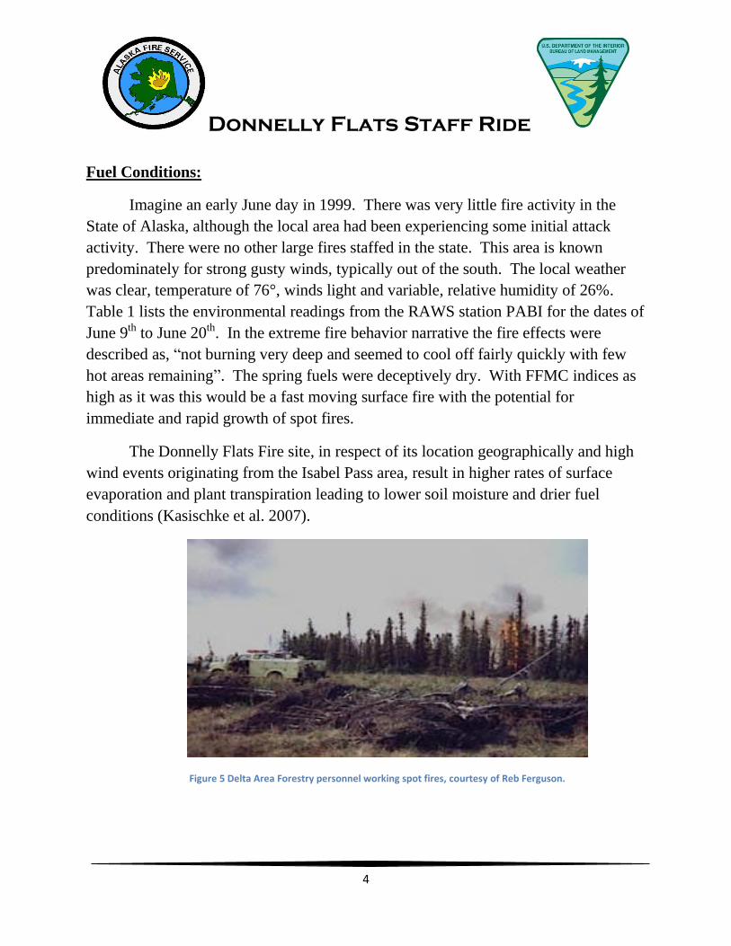
Fuel Conditions:
Imagine an early June day in 1999. There was very little fire activity in the
State of Alaska, although the local area had been experiencing some initial attack
activity. There were no other large fires staffed in the state. This area is known
predominately for strong gusty winds, typically out of the south. The local weather
was clear, temperature of 76°, winds light and variable, relative humidity of 26%.
Table 1 lists the environmental readings from the RAWS station PABI for the dates of
June 9th to June 20th. In the extreme fire behavior narrative the fire effects were
described as, “not burning very deep and seemed to cool off fairly quickly with few
hot areas remaining”. The spring fuels were deceptively dry. With FFMC indices as
high as it was this would be a fast moving surface fire with the potential for
immediate and rapid growth of spot fires.
The Donnelly Flats Fire site, in respect of its location geographically and high
wind events originating from the Isabel Pass area, result in higher rates of surface
evaporation and plant transpiration leading to lower soil moisture and drier fuel
conditions (Kasischke et al. 2007).
Figure 5 Delta Area Forestry personnel working spot fires, courtesy of Reb Ferguson.

Donnelly Flats Staff Ride
5
Table 1 Weather and indices from 6/9/1999 - 6/20/1999, with CFFDRS (Canadian Forest Fire Danger Rating System) information.
FFMC DMC DC ISI BUI
Low 0-80 0-70 <150 0-2 30-70Moderate 81-86 70-80 150-350 2-5 70-80High 87-90 80-90 350-400 5-10 80-90Extreme 90+ 90+ 400+ 10+ 90+
1. The Fine Fuel Moisture Code (FFMC) represents the moisture content of litter and cured fine fuels, 1-2 cm deep. It expresses the ease of ignition and fuel flammability. FFMC is sensitive to daily changes in
temperature, rainfall, relative humidity, and wind speed. Time lag is 2/3 day, which means that it takes
two thirds of a day for the fine fuels to react to a change in the weather. 2. The Duff Moisture Code (DMC) represents the moisture content of loosely compacted, decomposing
organic matter, 5-10 cm. deep, which determines resistance to control. DMC is sensitive to temperature,
rainfall, and relative humidity. Time Lag is 12 days. 3. The Drought Code (DC) represents the deep layer of compacted organic matter, 10-20 cm. deep,
which determines resistance to extinguishment. It indicates seasonal drought and smoldering fires in deep duff or large logs. DC is sensitive to temperature and rainfall. Time lag is 52 days.
4. The Initial Spread Index (ISI) represents a numerical rating of fire spread immediately after ignition
without the influence of variable fuel quantity (the fuel type isn't considered). It fluctuates with wind speed and time of day. ISI is a combination of FFMC and wind.
5. The Build Up Index (BUI) represents total fuel available for combustion. In the absence of rain, BUI
fluctuates little throughout the day. BUI is a combination of DMC and DC. 6. The Fire Weather Index (FWI) represents the intensity of a spreading fire. FWI is a combination of
ISI and BUI.
DATE TEMP RH WIND RAIN FFMC DMC DC ISI BUI FWI DSR06/09 71 37.8 4.6 0 91.3 37.8 282.6 7.5* 56.6 19.2 5.1
06/10 74 20.5 11.5 0 93.5 42.9 290.2 17.9 62.6 37 16.2
06/11 76 21.6 0 0 93.7 48.1 298. 7.2* 68.6 20.7 5.8
06/12 79 21.2 5.8 0 94 53.8 306.1 12.1 74.7 31.1 1206/13 81 30.4 15. 0 93.8 59.0 314.4 24.7 80.3 51 28.7
06/14 74 35.5 8.1 0 92.5 63.1 322 11.8 84.7 32.4 12.9
06/15 74 38.0 8.1 0 91.8 67.1 329.6 10.7 88.9 31.2 12.06/16 73 44.3 3.5 0.01 90.8 70.6 337.1 6.4 92.7 22.2 6.6
06/17 53 83.1 13.8 0.25 49.1 42.9 324.7 .4 64.5 .9 0
06/18 67 45.0 8.1 0.19 64.5 31.5 319.7 1.0 50.6 2.8 .2
06/19 66 46.6 9.2 0 82.1 34.3 326.5 3.0 54.4 9.3 1.406/20 55 96.4 3.5 0.06 63.1 33.5 332.2 .6 53.6 1.5 .1
Donnelly Flats Staff Ride
6
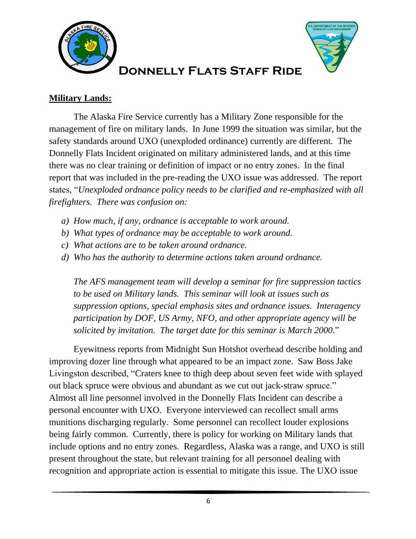
Military Lands:
The Alaska Fire Service currently has a Military Zone responsible for the
management of fire on military lands. In June 1999 the situation was similar, but the
safety standards around UXO (unexploded ordinance) currently are different. The
Donnelly Flats Incident originated on military administered lands, and at this time
there was no clear training or definition of impact or no entry zones. In the final
report that was included in the pre-reading the UXO issue was addressed. The report
states, “Unexploded ordnance policy needs to be clarified and re-emphasized with all
firefighters. There was confusion on:
a) How much, if any, ordnance is acceptable to work around.
b) What types of ordnance may be acceptable to work around.
c) What actions are to be taken around ordnance.
d) Who has the authority to determine actions taken around ordnance.
The AFS management team will develop a seminar for fire suppression tactics
to be used on Military lands. This seminar will look at issues such as
suppression options, special emphasis sites and ordnance issues. Interagency
participation by DOF, US Army, NFO, and other appropriate agency will be
solicited by invitation. The target date for this seminar is March 2000.”
Eyewitness reports from Midnight Sun Hotshot overhead describe holding and
improving dozer line through what appeared to be an impact zone. Saw Boss Jake
Livingston described, “Craters knee to thigh deep about seven feet wide with splayed
out black spruce were obvious and abundant as we cut out jack-straw spruce.”
Almost all line personnel involved in the Donnelly Flats Incident can describe a
personal encounter with UXO. Everyone interviewed can recollect small arms
munitions discharging regularly. Some personnel can recollect louder explosions
being fairly common. Currently, there is policy for working on Military lands that
include options and no entry zones. Regardless, Alaska was a range, and UXO is still
present throughout the state, but relevant training for all personnel dealing with
recognition and appropriate action is essential to mitigate this issue. The UXO issue

Donnelly Flats Staff Ride
7
began in 1998 on the Carla Lake Fire. Personnel knew there needed to be policy for
working around these lands, but addressing it formally in an open forum had yet to
happen. The email below begins to address this issue, note the date.
Figure 6 Memorandum discussing proposed policy to working around unexploded ordnance. Notice the date of 5/18/1999, almost one month prior to the Donnelly Flats Fire.

Donnelly Flats Staff Ride
8
Talking Points:
Terrain Influences
o Alaska Range
o Isabel Pass
o Donnelly Flats
o Wind
Fuel Conditions
o FFMC, ISI, FWI, DMC, DC
o Weather
o Complacency
o Topographical Influences
Military Lands
o UXO
o Current UXO Policy (reference IRPG) vs. 1999
o Personal Encounters

Donnelly Flats Staff Ride
9
Stand Two: Point of Origin
Location: (N 63° 50.862” x W 145°42.267”)
From Delta Junction take Richardson Hwy South approximately 16 miles
Turn left into assault strip, follow gravel road approximately 2.5 miles to large
open area at coordinates above.
Discussion Guide:
Initial Attack:
Alaska State Troopers reported a fire to Delta Forestry Dispatch on June 11th at
approximately 0930 in the area of Donnelly Dome. Delta Forestry Dispatch
Coordinator Mike Roos had just begun what was to be a busy day. He stated that,
“This was one of the most trying days in my career”. Roos continued, “that the fire
weather indices (FFMC) in Delta were showing extreme, and there had been a very
fast moving fire in town the day before. The location of this new start was one of the
worst places for a fire to become established in the Delta Area”. This was due to the
continuous black spruce fuels and potential for high winds from the adjacent mountain
pass. The fuel continuity (North/South) had the same alignment as the problem wind
(Southerly Chinook). Normal staffing for Delta IA started at 10:00 and phone calls to
employees’ homes went unanswered, as they had already left. Cell phone
communications were not as widely utilized during 1999 as they are today. As Delta
personnel reported to work they were immediately dispatched to the new start.
Figure 7 Ft. Greely water tender responding to B222, visible in the distance, photo courtesy of Tom Lucas.

Donnelly Flats Staff Ride
10
Initial Attack (IA) Incident Commander (IC) Mike Bobo responded with D-51,
D-21 with Reb Ferguson, Ft. Greely FD, and Delta helitack (398) as it became
available. He immediately ordered air tankers, crews (Type 1 & 2), smokejumpers,
additional helitack, and several dozers. The initial size up from helitack reported 5
acres, 100% active in black spruce. Winds were light, North-Northeast and the
column was standing almost straight up. IA forces, established an anchor point, and
began a flanking action working to the south. In the early afternoon, the winds
became shifty and variable. A shift from a North-Northeast to a Westerly and finally
a steady Southern flow established. This wind shift was predicted and known by all
resources. Since personnel were expecting this change, strategy and tactics were
adjusted accordingly. Everyone believed they had good safety zones with adequate
escape routes. It was reported that once an area burned it appeared that it was not
burning very deep and seemed to cool off fairly quick with few hot areas remaining.
Everyone felt confident in their actions and were making good progress in spite of
concerns about exploding ordnance encounters.
Differing reports gave the fire size between 5 and 75 acres. Some reports and
interviews state that retardant applications were marginally effective or miss utilized.
At least 12 loads of retardant were used during Initial Attack. Additional retardant
was ordered, however all tankers were on hold at Allen Army Airfield. Air Attack
McKnight and Military Zone FMO Gould, both airborne above the fire in fixed wing
aircraft, deemed retardant as ineffective and canceled any new orders for drops. The
Initial Attack IC disagreed with this decision and ordered more. The Incident
Commander requested through Air Attack air tankers loaded with water. This request
was also denied, again deemed as ineffective. There are differing reports from ground
personnel about the effectiveness of retardant. Some ground resources report that the
retardant was too far off the edge to be effective and/or too far ahead of line personnel
to be utilized appropriately.
Shortly after the air tankers were grounded, the fire began to come under the
effect of a Southerly flow. At approximately 1600, it was reported that one or
possibly two vortices developed at what was now the head of the fire.

Donnelly Flats Staff Ride
11
Figure 8 Donnelly Flats Fire affected by southern wind shift, photo courtesy Steve DuBois and Sue Miller.
The wind change, coupled with these vortices, began to create erratic burning
conditions that necessitated the preventative withdrawal of forces off the line. Air
Attack McKnight notified IC Bobo that the wind has shifted around the compass and
was out of the South. He in turn informed air attack that a tornado was hitting the
ground at the North side of the fire. The airplane turned toward the North and Air
Attack McKnight notices two distinct eddies on the East and West side of the column
which lasted approximately 5 minutes.
Strange sounds were heard,
described as a sort of “woofing”. The
sound was originally thought to be some
sort of munitions or possibly fuel
venting. Fire activity increased and
resources working on both flanks made
the decision to pull off the fire. Activity
increased as the vortex began to form
within the black portion of the fire. The Figure 9 Only known photo of the vortex in the area of the jump spot before vortex diminished.

Donnelly Flats Staff Ride
12
vortex rapidly increased in size as
the firefighters retreated to safety
zones. Eyewitnesses said the
funnel quickly built to a diameter
of 50-100’ at the base and had
very strong winds that picked up
trees, debris, even a Shindaiwa
pump kit still attached to a cargo
chute. Updrafts increased to the
point that hard hats were sucked
off firefighters’ heads, and a fire
shelter was sucked out of the
hands of the Delta crew boss.
The vortex rapid escalation and reduced visibility made personnel retreat to
pre-identified safety zones and within the black. During retreat, one smokejumper
was snagged on vegetation, unable to see where the remainder of the group continued.
Winds increased and burned vegetation began to glow as the vortex began to overrun
the individual. Utilizing a gloved hand to shield his face he moved to avoid inhaling
superheated air. The Extreme Fire Behavior Account narrative describes the account
into detail. The individual received first and second degree burns requiring medical
attention, but sustained no permanent damage.
Resources believed to be on scene at 1630: 24 smokejumpers, 3 helitack loads,
Delta Type 2 crew, Midnight Sun Hotshots, Denali Hotshots, 2 dozers, 2 medium
helicopters, and 4 water tenders.
Transition:
At approximately 1800, Operations Section Chief Chip Houde, Operations
trainee Kutzgar, and Situation Unit Leader Martin departed Fairbanks via fixed wing
for a recon of the fire. The remaining Type 2 Team members drove to the fire area.
Operations Houde immediately began to offer assistance to incident personnel.
According to the Incident Narrative there was not a defined transition. However, by
June 12th the Type 2 Management Team was officially in command of the incident.
Figure 10 Dust devils are a common occurrence in the Delta Junction area, photo courtesy of Fronty Parker.

Donnelly Flats Staff Ride
13
Talking Points:
Initial Attack
o Leaders Intent
o Fuels/Fire Behavior
o Tactics/Assignments/Objectives
o Communications
o Weather (observed and predicted)
o Attitude
o Utilization of Retardant
Multi-Agency Coordination
o Issues
o Command Presence
o Communications
o Command Structure
Briefings
o Adequate
o Known by All Personnel
Fire Whirl
o Safety Zones
o Accountability
o Air Attack
o Incident within an Incident
o Current Burn Protocol
o PPE/Fire Shelters
Transitions
o Type 3 to Type 2
Merge or Official Transition
Issues?

Donnelly Flats Staff Ride
14
Figure 11 Donnelly Flats Fire progression map from 6/11/99 - 6/18/99, minus the blowup to the west on 6/13.

Donnelly Flats Staff Ride
15
Stand Three: Shifty Winds
Location: (N 63° 55.399” x W 145°47.822”)
From Delta Junction take Richardson Highway South about 9 miles
Turn right onto Meadows Rd, 100 yards, and turn on first right, 200 feet
ridgeline is on the left, walk out ridgeline to coordinates.
Discussion Guide:
Reference the fire progression map (Figure 11), note the growth at the head of
the fire on 6/12. Crews worked with dozers throughout the evening to put line around
the slop over. The plan for 6/13 was to continue working and securing line on the
South and West flanks with particular attention on the northernmost slop over. At
1000, a 10mph east wind began to blow. Afternoon temperatures were near 80° and
relative humidity around 30% (refer to Table 1 for fuel conditions on 6/13) in
combination with the east wind caused a significant increase in fire behavior that
pushed the fire westward at approximately 30-40 chains per hour.
Wildland Urban and Industrial Interface:
June 13th at 1400, as east winds of at least 10 mph pushed spots near the head
in a westerly direction towards the
Richardson Highway. When the
fire jumped the Richardson
Highway structure protection
measures were taken on four
residences. The fire continued
moving towards Alyeska Pump
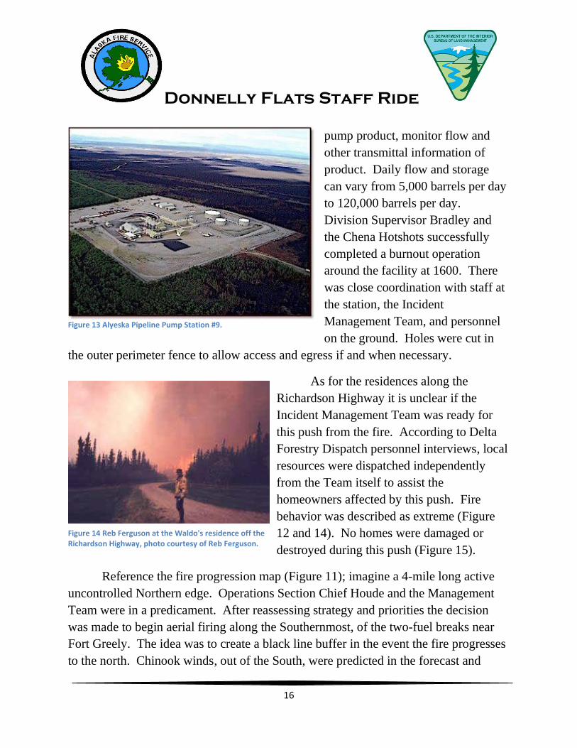
Station Nine. This facility is one of
eleven positioned throughout the
length of the Alaska Pipeline to
adjust the pressure, Figure 12 View of fire run to the west on 6/13/99 from Ft. Greely, photo courtesy of SPC Kerensa Hardy Ft. Greely Public Affairs.
Donnelly Flats Staff Ride
16
pump product, monitor flow and
other transmittal information of
product. Daily flow and storage
can vary from 5,000 barrels per day
to 120,000 barrels per day.
Division Supervisor Bradley and
the Chena Hotshots successfully
completed a burnout operation
around the facility at 1600. There
was close coordination with staff at
the station, the Incident
Management Team, and personnel
on the ground. Holes were cut in
the outer perimeter fence to allow access and egress if and when necessary.
As for the residences along the
Richardson Highway it is unclear if the
Incident Management Team was ready for
this push from the fire. According to Delta
Forestry Dispatch personnel interviews, local
resources were dispatched independently
from the Team itself to assist the
homeowners affected by this push. Fire
behavior was described as extreme (Figure
12 and 14). No homes were damaged or
destroyed during this push (Figure 15).
Reference the fire progression map (Figure 11); imagine a 4-mile long active
uncontrolled Northern edge. Operations Section Chief Houde and the Management
Team were in a predicament. After reassessing strategy and priorities the decision
was made to begin aerial firing along the Southernmost, of the two-fuel breaks near
Fort Greely. The idea was to create a black line buffer in the event the fire progresses
to the north. Chinook winds, out of the South, were predicted in the forecast and
Figure 13 Alyeska Pipeline Pump Station #9.
Figure 14 Reb Ferguson at the Waldo's residence off the Richardson Highway, photo courtesy of Reb Ferguson.

Donnelly Flats Staff Ride
17
occurred. The switch happened at
approximately 2100 fanning the fire
with winds of 50 mph out of the South.
The fire was now heading in the
direction of Fort Greely with a 4-mile
wide front. The Type 2 Team placed an
order for a Type 1 Team.
Simultaneously, the Chinook wind
knocked out power at Delta Forestry
Dispatch. The only communication
available was a handheld radio and a
single landline telephone. At approximately 2130 the fire crossed the southern most
fuel break. This was a predetermined trigger point for the evacuation of Fort Greely.
While on the topic of
evacuation, let’s discuss the Wildland
Urban Interface issue and successes
that were experienced during the
incident. The Type 2 Team received
a template evacuation plan from the
Carla Lake Fire (1998) that was
utilized on this incident. From
eyewitness observations, when the
fire jumped the pre-established
trigger point, the base siren was
sounded and the evacuation began
with the discipline and efficiency that
the military possesses. The military
had marshals arranging vehicles in an
orderly fashion. When accountability
was verified, there was an organized train leaving the station. Simultaneously, Delta
Forestry initiated the evacuation of areas South of Delta. At this time the fire was
pushed by 50+ mph winds and laid the smoke directly onto Fort Greely itself.
Visibility was zero as the fire approached. When the front hit, it split into two heads
that wrapped around the base itself.
Figure 15 Aerial view of Waldo residence post fire.
Figure 16 Fort Greely view to the north as head wrapped around base. Notice center left where hazard fuel reduction was complete, and center right with no fuels reduction.

Donnelly Flats Staff Ride
18
There had been
some fuels reduction
completed on the
Southern end of the
interface that was
obviously effective
(Figure 16). Figure 17
offers an excellent
representation of the
fuels available to the
fire front. Fort Greely
firefighters reported
that seven structures
were damaged. The
Fort Greely Rod and
Gun Club, an Environmental Protection Agency (EPA) monitoring station, and the
main gate guard shack burned to the ground.
The last topic we
will address is work to
rest policy. When the
fire hit and wrapped
around Fort Greely, spots
were thrown across
Jarvis Creek, threatening
areas of Southern Delta.
Crews and equipment
were needed to secure
these spots, however
none were available.
Most crews were bedded
down as fatigue from the
last three evenings has caught up with personnel.
Figure 17 Fort Greely view to the east. Notice spruce stringers wrapping around as the main fort resides in a stand of aspen and birch. Photo courtesy of the National Archives, 1972.
Figure 18 Fort Greely view to the southwest. Notice how fire progression halted at Jarvis Creek, the airfield, and large hardwood stand to the west. Photo courtesy of Michael Kingston, Army photographer.

Donnelly Flats Staff Ride
19
The following day, June 14th, the operational briefing consisted of;
Secure the following:
1. The areas around residences on the Richardson Highway
2. The areas residences at Fort Greely
3. Spot fires around Fort Greely
4. Spot fires on the east side of Jarvis Creek.
Crews and dozers worked to secure miles of active perimeter and contain spots
over Jarvis Creek. The Type 1 Incident Management Team assumed control of the
fire at 2000 on June 14th. When the new Team took command of the fire, the large
acreage gain was over. Favorable weather conditions moved into the region, bringing
higher humidity’s and wetting rain. These conditions allowed incident personnel to
gain ground mopping-up in all divisions. On June 22nd the Type 1 Management Team
transitioned to a local Type 3 organization at 1200.
Figure 19 Fort Greely Cantonment area looking west, at the head of the fire as the head split. Photo courtesy fire package.

Donnelly Flats Staff Ride
20
Additional Perspective:
Past fire history is another element that is worth valuing. Historic fires
surrounded the Donnelly Flats Fire in most directions (Figure 21). When studying
burn severity (Figure 20) old fire scars may have acted as additional buffers assisting
firefighters. These fire scars are separated by rivers and creeks along the perimeters,
but may have acted as additional buffers.
Figure 20 Donnelly Flats Fire burn severity classes (Williams and Kasischke, unpublished manuscript) with GLAS shot locations and canopy heights in meters. GLAS (Geoscience Laser Altimeter System) utilizes lasers to measure topography and vegetation characteristics, part of NASA’s Earth Observing System ICESat (Ice, Cloud, and land Elevation Satellite).

Donnelly Flats Staff Ride
21
Figure 21 Donnelly Flats Fire perimeter, stand locations, and adjacent fire history.

Donnelly Flats Staff Ride
22
Talking Points:
East Wind
o Geographical Influence
Wildland Industrial Interface
o HAZMAT
o Current Issues (H²S)
Chinook Wind
o Terrain Influence
o Delta Dispatch Communications
Evacuation
o Military Post verses Civilians
o Deficiency in Training
Wildland Urban Interface
o Fuels
o Planning
Work To Rest 2:1
o Then and Now
Transition
o Clean Transition or Merger
Fire History
o Effective Buffers?

Donnelly Flats Staff Ride
23
Conclusion:
The Donnelly Flats Fire was a dynamic, rapidly moving incident with
numerous transitions, and significant events. There are numerous aspects that may be
studied. The Donnelly Flats Fire was almost a repeat of the Carla Lake Fire from the
year prior. However, there were many successes and some failures that were learned
from and eventually changed policy affecting current fire suppression efforts.
Nevertheless, it is necessary to attempt to understand all aspects of history, from
human decisions to environmental aftermath, to be effective leaders in chaos.
References:
Kasischke, E. S., L. L. Bourgeau-Chavez, J. F. Johnstone. 2007. Assessing spatial
and temporal variations in surface soil moisture in fire-disturbed black spruce forests
in Interior Alaska using spaceborne synthetic aperture radar imagery – Implications
for post-fire tree recruitment. Science Direct. 108: 42-58.
Senkowsky, S. 2001. A burning interest in boreal forests: Researchers in Alaska link
fires with climate change. BioScience 51: 916-921.
Photo Credits:
Art Lenon
Final Fire Package
Fronty Parker
SPC Kerensa Hardy, Fort Greely Public
Affairs
Michael Kingston, Army Photographer
The National Archives
Reb Ferguson
Steve DuBois
Sue Miller
Tom Lucas

Donnelly Flats Staff Ride
24


![005014920 00105 - National Archives of Ireland · DONNELLY James [81] 8 August ... DONNELLY Jane [81] 31 May Administration of Jane Donnelly late of Cloonfree Strokes- ... 005014920_00105](https://static.fdocuments.in/doc/165x107/5b1e43b27f8b9a22028b54ee/005014920-00105-national-archives-of-donnelly-james-81-8-august-donnelly.jpg)