Disclaimer This report was compiled by an ADRC … This report was compiled by an ADRC visiting...
21
1 | Page Disclaimer This report was compiled by an ADRC visiting researcher (VR) from ADRC member countries. The views expressed in the report do not necessarily reflect the views of the ADRC. The boundaries and names shown and the designations used on the maps in the report also do not imply official endorsement or acceptance by the ADRC.
-
Upload
duongtuong -
Category
Documents
-
view
219 -
download
0
Transcript of Disclaimer This report was compiled by an ADRC … This report was compiled by an ADRC visiting...

1 | P a g e
Disclaimer
This report was compiled by an ADRC visiting researcher (VR) from ADRC member countries.
The views expressed in the report do not necessarily reflect the views of the ADRC. The boundaries and names shown and the designations used on the maps in the report also do not imply official endorsement or acceptance by the ADRC.
2 | P a g e
COUNTRY REPORT INDIA
General Information
Geography
India is one of the oldest civilizations in the world with a kaleidoscopic variety and rich cultural heritage. It covers an area of 3,287,590 sq. km extending from the snow-covered Himalayan heights to the tropical rain forests of the south. As the 7th largest country in the world, India stands apart from the rest of Asia, marked off as it is by mountains and the sea, which give the country a distinct geographical entity. Bounded by the Great Himalayas in the north, it stretches southwards and at the Tropic of Cancer, tapers off into the Indian Ocean between the Bay of Bengal on the east and the Arabian Sea on the west. Lying entirely in the northern hemisphere, the mainland extends between latitudes 8° 4' and 37° 6' north, longitudes 68° 7' and 97° 25' east and measures about 3,214 km from north to south between the extreme latitudes and about 2,933 km from east to west between the extreme longitudes. It has a land frontier of about 15,200 km. The total length of the coastline of the mainland, Lakshadweep Islands and Andaman & Nicobar Islands is 7,516.6 km. The Indian peninsula is separated from mainland Asia by the Himalayas. The Country is surrounded by the Bay of Bengal in the east, the Arabian Sea in the west, and the Indian Ocean to the south. Indian neighbours consist of Afghanistan and Pakistan to the north-west; China, Bhutan and Nepal to the north; Myanmar to the east; and Bangladesh to the east of West Bengal. Sri Lanka is separated from India by a narrow channel of sea, formed by Palk Strait and the Gulf of Mannar. Climate
The climate of India can broadly be classified as a tropical monsoon one. But, in spite of much of the northern part of India lying beyond the tropical zone, the entire country has a tropical climate marked by relatively high temperatures and dry winters. There are four seasons:
Winter (December-February) Summer (March-June) South-west monsoon season (June-September) Post monsoon season (October-November)

3 | P a g e
PEOPLE
India's population, as on 1 March 2011 stood at 1,210,193,422 (623.7 million males and 586.4 million females). India’s population consists of approximately 16.7% (1/6th) of the world population.
More than 50% of the population is below 25 years of age and more than 65% is below 35 years.
The average annual exponential growth rate stands at 1.64 per cent during 2001-2011. The Crude Birth and death rates were 18.3 and 7.3 respectively in 2009. Sex Ratio - 940 females per 1000 males according to 2011 census. Population density is 382 persons/sq. km. as per 2011 census.
Natural Hazards in India
General
India, due to its, physio-graphic and climatic conditions is one of the most disaster prone areas of the world. It is vulnerable to windstorms from both the Arabian Sea and Bay of Bengal. There are active crustal movements in the Himalaya leading to earthquakes. About 58.7 % of the toatal land mass is prone to earthquake of moderate to very high intensity. The region was hit by Uttarkashi Earthquake (1991), Killari Earthquake (1993), Koyana Earthquake (1997), Chamoli Earthquake (1999), and Bhuj earthquake (2001), Jammu & Kashmir Earthquake (2005). The Himalayas being a fairly young mountain range is undergoing constant geological changes resulting in landslides. Floods brought about by heavy rain and drought in arid and semi arid areas. About 12 % of the o f the total land mass is flood prone and 68 % of the arable land is vulnerable to drought. The Western region of the country is represented by the Thar Desert and the central India by the Deccan Plateau face recurring droughts due to acute shortage of rainfall. India has increasingly become vulnerable to tsunamis. India has a coastline running 7600 km long; as a result is repeatedly threatened by cyclones.
The map below prepared by the UNDP shows multi-hazards zones in India.
Some Basic Facts at a glance:-
Indian Subcontinent : amongst the world’s most disaster prone areas 58.6% of land vulnerable to earthquakes 68% of cultivable area is prone to drought 8.5% land vulnerable to cyclones – 5700 KMs out of 7516 KMs of coastline 12% land vulnerable to floods Around 15% area is prone to landslides (0.49 million Sq. KMs) – around 20 states are
affected by various degree • Himalayan states are prone to snow-avalanche, and flash floods

4 | P a g e
The table below shows major disasters in the known history of India:
Sr. No. Name of Event Year Fatalities/Damages
1. Maharashtra Earthquake 1618 2,000
2. Bengal Earthquake 1737 300,000
3. Bengal Cyclone 1864 60,000
4. The Great Famine of Southern India 1876-1878 5.5 million
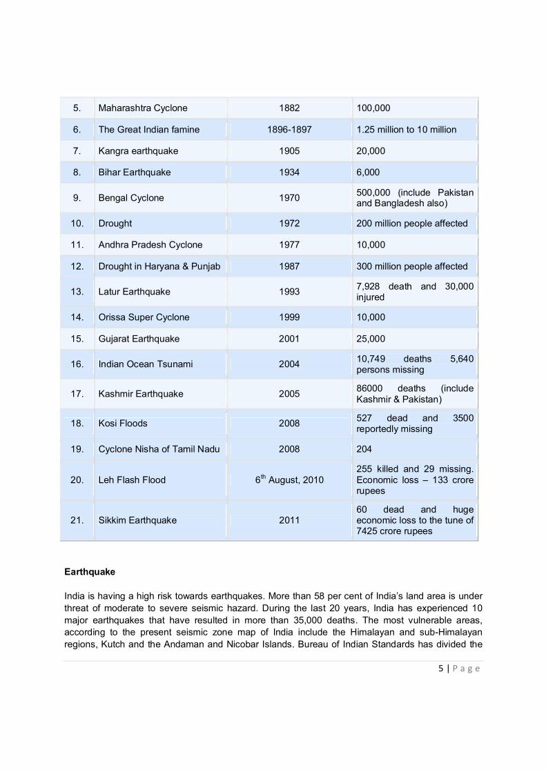
5 | P a g e
5. Maharashtra Cyclone 1882 100,000
6. The Great Indian famine 1896-1897 1.25 million to 10 million
7. Kangra earthquake 1905 20,000
8. Bihar Earthquake 1934 6,000
9. Bengal Cyclone 1970 500,000 (include Pakistan and Bangladesh also)
10. Drought 1972 200 million people affected
11. Andhra Pradesh Cyclone 1977 10,000
12. Drought in Haryana & Punjab 1987 300 million people affected
13. Latur Earthquake 1993 7,928 death and 30,000 injured
14. Orissa Super Cyclone 1999 10,000
15. Gujarat Earthquake 2001 25,000
16. Indian Ocean Tsunami 2004 10,749 deaths 5,640 persons missing
17. Kashmir Earthquake 2005 86000 deaths (include Kashmir & Pakistan)
18. Kosi Floods 2008 527 dead and 3500 reportedly missing
19. Cyclone Nisha of Tamil Nadu 2008 204
20. Leh Flash Flood 6th August, 2010 255 killed and 29 missing. Economic loss – 133 crore rupees
21. Sikkim Earthquake 2011 60 dead and huge economic loss to the tune of 7425 crore rupees
Earthquake India is having a high risk towards earthquakes. More than 58 per cent of India’s land area is under threat of moderate to severe seismic hazard. During the last 20 years, India has experienced 10 major earthquakes that have resulted in more than 35,000 deaths. The most vulnerable areas, according to the present seismic zone map of India include the Himalayan and sub-Himalayan regions, Kutch and the Andaman and Nicobar Islands. Bureau of Indian Standards has divided the

6 | P a g e
country into four seismic zone – Zone II to Zone V. Zone II represents the low risk zone and zone V represents the highest risk zone. Though the regions of the country away from the Himalayas and other inter-plate boundaries were considered to be relatively safe from damaging earthquakes, the presence of a large number of non- engineering structures and buildings with poor foundations in these areas make these regions also susceptible to earthquakes. In the recent past, even these areas also have experienced earthquake, of lower magnitude than the Himalayan earthquakes. The North-Eastern part of the country continues to experience moderate to strong earthquakes. On an average, this region experiences an earthquake with magnitude greater than 5.0 every year. The Andaman and Nicobar Islands are situated on an inter-plate boundary and therefore are likely to experience damaging earthquakes frequently. The increase in earthquake risk in India in recent times is caused due to a spurt in developmental activities driven by urbanization, economic development and the globalization of India’s economy. The increase in the use of high-technology equipment and tools in manufacturing and service industries have also made them susceptible to disruption due to relatively moderate ground shaking.
Earthquakes Facts 10.9% land is liable to severe earthquakes (intensity MSK IX or more) – Zone V 17.3%landis liable to MSKVIII(similar to Latur/ Uttarkashi) – Zone - IV 30.4% land is liable to MSK VII (similar to Jabalpur quake) – Zone II & III
Biggest quakes in: Andamans, Kuchchh, Himachal, Kashmir, N. Bihar and the North East

7 | P a g e
Flood and Drought The country receives an annual precipitation of 400 million - hectare meters. Of the annual rainfall, 75% is received during four months of monsoon (June- September) and, as a result, almost all the rivers carry heavy discharge during this period. The flood hazard is compounded by the problems of sediment deposition, drainage congestion and synchronization of river floods with sea tides in the coastal plains. The area vulnerable to floods is 40 million hectares and the average area affected by floods annually is about 8 million hectares. About 30 million people are affected by flood every year. Floods in the Indo–Gangetic–Brahmaputra plains are an annual feature. On an average, a few hundred lives are lost, millions are rendered homeless and several hectares of crops are damaged every year. The maps below show the flood hazard zonation and areas/states prone to flooding.
Around 68% arable land of the country is prone to drought in varying degrees. Drought prone areas comprise 108. 11 million hectares out of a total land area of 329 Million hectares. About 50 million
Floods
Floods in the Indo-Gangetic-Brahmaputra plains are an annual feature on an average, a few hundred lives are lost
millions are rendered homeless lakhs of hectares of crops are damaged every year

8 | P a g e
people are affected annually by drought. Of approximately 90 million hectares of rain-fed areas, about 40 million hectares are prone to scanty or no rain. From 1800 till date the country has experienced 10 severe drought years (> 39.5% area of the country was affected) and 5 years of phenomenal drought (> 49.5% of the area of the country was affected). Cyclone India’s long coastline of 7,516 kilometer is exposed to nearly 10 per cent of the world’s tropical cyclones. Of these, the majority has their initial genesis over the Bay of Bengal and strike the east coast of India. On an average, five to six tropical cyclones form every year, of which two or three could be severe visit the coastal areas. Cyclones occur frequently on both the coasts (The west coast - Arabian Sea; and the east coast - Bay of Bengal). More cyclones occur in the Bay of Bengal than in the Arabian Sea and the ratio is approximately 4:1. An analysis of the frequency of cyclones on the east and west coasts of India between 1891 and 1990 shows that nearly 262 cyclones occurred (92 severe) in a 50 km wide strip on the east coast. Less severe cyclonic activity has been noticed on the west coast, with 33 cyclones occurring in the same period, out of which 19 of these were severe.
In India, Tropical cyclones occur in the months of May-June and October-November. The cyclones of severe intensity and frequency in the north Indian Ocean are bi-modal in character, with their primary peak in November and secondary peak in May. The disaster potential is particularly high at the time of landfall in the north Indian Ocean (Bay of Bengal and the Arabian Sea) due to the accompanying destructive wind, storm surges and torrential rainfall. Of these, storm surges are the greatest killers of a cyclone, by which sea water inundates low lying areas of coastal regions and causes heavy floods, erodes beaches and embankments, destroys vegetation and reduces soil fertility.
Landslide
In the hilly terrain of India including the Himalayas, landslides have been a major and widely spread natural disasters that often strike life and property and occupy a position of major concern. One of the worst tragedies took place at Malpa Uttarkhand (UP) on 11th and 17th August 1998 when nearly 380 people were killed when massive landslides washed away the entire village. This included 60 pilgrims going to Lake Mansarovar in Tibet. In 2010 Cloudburst led flash mudslides and flash floods killed 196 people, including six foreigners and injured more than 400 and swept away number of houses, sweeping away buildings, bus stand and military installations in trans Himalaya Leh town of Jammu and Kashmir. Landslides occur in the hilly regions such as the Himalayas, North-East India,
Wind and Cyclones 1877-2005: 283 cyclones (106 severe) in a 50 km wide strip on the East Coast Less severe cyclonic activity on West Coast (35 cyclones in the same period) In 19 severe cyclonic storms, death toll> 10,000 lives In 21 cyclones in Bay of Bengal (lndia +Bangladesh) 1.25 million lives have been lost

9 | P a g e
the Nilgiris, and Eastern and Western Ghats. The maps below show the cyclone wind hazard and PMSS map and landslide hazard zones of the country.
Avalanche Avalanches constitute a major hazard in the higher reaches of the Himalayas. Heavy loss of life and property has been reported due to avalanches. Parts of the Himalayas receive snowfall round the year and adventure sports are in abundance in such locations. Severe snow avalanches are observed during and after snowfalls in Jammu & Kashmir, Himachal Pradesh and the Hills of Western Uttar Pradesh. Major causes of the avalanches are: Inclination of slope where avalanche occurs; scale of slope, shape of slope, location (ridge line or toe of slope); orientation of slope; depth of snow -cover, depth of snowfall, wind velocity, atmospheric and snow temperatures etc. In Himalayas, avalanches are common in Drass, Pir Panijat, Lahaul-Spiti and Badrinath areas. As per Snow and Avalanche Study Establishment (SASE), of Defence Research and Development Organisation (DRDO), on an average around 30 people are killed every year due to this disaster in various zones of the Himalayas. Beside killing people, avalanches also damage the roads and others properties and settlements falling in its way. Forest Fire
Forest or bush fire, though not causing much loss to human life, is a major hazard for forest cover in the country. As per Forest Survey of India report, 50 per cent of the forest cover of the country is fire

10 | P a g e
prone, out of which 6.17 per cent is prone to severe fire damage causing extensive loss to forest vegetation and environment. Average annual physical loss due to forest fire in the country is estimated to worth Rs. 440 crores. The major loss due to forest fire is caused to the environment which gets adversely affected by this calamity. The degradation of climate, soil and water quality, loss of wildlife and its habitat, deterioration of human health, depletion of ozone layer, etc. along with direct loss to timber are the major adverse impact of forest fires. The coniferous forests in the Himalayan region are very susceptible to fire and every year there are one or more major fire incidences in these areas. The other parts of the country dominated by deciduous forest are also damaged by fire up to an extent. It is worth mentioning that in India 90 per cent of the forest fires are man-made. In India, the hilly areas vulnerable to forest fires lie in the States Arunachal Pradesh, Assam, Himachal Pradesh, Jammu & Kashmir, Manipur, Meghalaya, Mizoram, Nagaland, Sikkim, Tripura and Uttranchal Pradesh. Forest fire incidents are not very uncommon. In the recent past, the fire in 1995 in the Uttranchal had destroyed more 375,000 hectares of forest wealth.
Pest Infestation
Food losses due to pests, disease, wild animals, insects and weeds are considerable. It is estimated that 35% of world crop production is lost in spite of pesticide and other control programs. The primary pests are insects, disease and weeds. Losses due to birds and wild animals are low compared to these. Causes of pest infestation include temperature, monoculture of crops, and introduction of plants new locations, weather pattern and migration of pest’s species.
In India the locust infestation prone States are: Rajasthan, Gujarat, Punjab, Haryana, Andhra Pradesh, Karnataka, and Maharshtra. A desert area of over 200,000 sq.km covers the States of Rajasthan, Gujarat, Punjab and Haryana. Locusts caused substantial damage in the past. In recent years Indian experienced large-scale locust invasion in 1978. Again during July 1993, the country experienced unprecedented level of locust invasion. The swarming activity continued till October1993 and a total of 172 swarms entered the country.
Recent Major Natural Disasters
Event
Losses and Damages
Sikkim Earthquake (Mw = 6.9)
18th September, 2011 97 dead Damages US & 18.2 billion approx.
Leh Flash Flood 6th August, 2010 255 killed 29 missing Property damages approx. 13.30 million INR
Kosi Flood, Bihar August, 2008 434 dead; 3 million people affected; 300,000 houses destroyed; 340,000 hectares of crop damaged
Disaster Management System
Administrative System in the Country Indian is a Sovereign Socialist Secular Democratic Republic with a Parliamentary system of Government. We have Central Government which looks after the affairs of the Union and State

11 | P a g e
Governments which looks after the affairs of the respective States. The States have districts and within districts we have Urban Local Bodies (ULBs) and Panchayati Raj Institutions (PRIs). Each State has its legislature too. The Indian Legislature comprises of the Lok Sabha (House of the People) and the Rajya Sabha (Council of States) forming both the Houses of the Parliament at the national level. India consists of 28 States and 7 Union Territories. The President of India is the Head of the State, while the Prime Minister is the Head of the Government, and runs office with the support of the Council of Ministers who form the Cabinet Ministry. Chief Minister is the political head of the State and UTs are governed by the Central Govt. Generally for each State we have one Governor appointed by the Union Government. The constitution provides for clear cut area of responsibility between the union and the states. Disaster management is basically the responsibility of States. At the State level most of the disasters are managed at the local level (L1). In cases where the local capacity for response is inadequate the State Government assists the district administration (L2). In disasters of bigger magnitude (L3) response from Centre and international community is needed. Disaster mitigation and preparedness is done at all levels – local, district, state and national. A Qualitative Shift in India's Strategy The Government recognized the need for a shift from a post disaster reactive approach to a pre-disaster pro-active approach of prevention, mitigation, preparedness, response, relief, recovery and rehabilitation and enacted the Disaster Management Act 2005 - enacted on 23rd December, 2005 which lays down institutional and coordination mechanism at all level and provides for establishment of Disaster Mitigation Fund and Disaster Response Fund at national, state and district level. Laws, Policies and Plans
Disaster Management Act 2005
The Disaster Management Act, 2005 (http://nidm.gov.in/DM_act2005.pdf) came into the statute book on 26 December 2005 by a Gazette notification, exactly on the first anniversary of the devastating tsunami of 2004, which killed nearly 13,000 people in India alone and affected 18 million people. The Act provides a legal and institutional framework for “the effective management of disasters and for matters connected therewith or incidental thereto.” It provides for establishment of National Disaster Management Authority (NDMA), State Disaster Management Authority (SDMA) and District Disaster Management Authorities (DDMA) at the National, State and District levels with adequate financial and administrative powers and creation of the National Institute of Disaster Management (NIDM) with the mandate of undertaking training and capacity building, Develop Training Modules on various aspects of Disaster management, Undertake Research and Documentation, Formulate and implement comprehensive HRD Plan covering all aspects of DM, Provide assistance in national level policy formulation and Provide assistance to state governments and State Training Institutions. The act also provides guidelines for creation of National Disaster Response Fund, National Mitigation Fund, Establishment of funds by State Government and Allocation of funds by Ministries and Departments for Emergency procurement. The act also provides for establishment of National Disaster Response Force (NDRF).

12 | P a g e
National Policy on Disaster Management 2009
The National Policy on Disaster Management (http://nidm.gov.in/PDF/policies/ndm_policy2009.pdf) was approved by the Government in November 2009. This comprehensive policy document lays down policies on every aspect of holistic management of disasters in the country. The main aim the policy espouses to achieve is to minimize the losses to lives, livelihoods and property, caused by natural or manmade disasters with a vision to build a safe and disaster resilient India by developing a holistic, proactive, integrated, multi-disaster oriented and technology driven strategy. With this national Policy in place in India, a holistic and integrated approach will be evolved towards disaster management with emphasis on building strategic partnerships at various levels. The themes underpinning the policy include community based disaster management, capacity development in all spheres, consolidation of past initiatives and best practices and cooperation with agencies at national and international levels with multi-sectoral synergy.
The Policy is also intended to promote a culture of prevention, preparedness and resilience at all levels through knowledge, innovation and education. It encourages mitigation measures based on environmental sustainability. It seeks to mainstream disaster management into the developmental planning process and provides for Institutional and Financial arrangements at national, State, and District-levels for Disaster Prevention, Mitigation, Preparedness and Response as it ensures adequate budgeting for disaster mitigation activities in all Ministries and Departments.
State Policies on Disaster Management
The States of Madhya Pradesh, Gujarat, Kerala, Himachal Pradesh have formulated State Disaster Management Policies. Tamil Nadu, Chattisgarh, Uttranchal, Meghalaya, Bihar, Rajasthan, Delhi, Orissa and West Bengal have prepared draft policies.
State Relief Codes/ DM Codes
Many States have manuals and codes for management of drought, floods and other disasters and relief measures to be taken, etc. Now many states are in the process of changing their State Relief codes into Disaster Management Manuals.
The Civil Defence (Amendment) Act, 2009 (2 of 2010) – enacted on 21 January, 2010
The Civil Defence Act 1968 has been amended in 2009 and disaster management has been added as one of the activities of Civil Defence organization. This amendment has been notified on 21st January, 2011.
Standard Operating Procedures (SOPs) or Responding to Natural Disasters, 2010
The Ministry of Home Affairs, Govt. of India has issued SOPs for responding to natural disasters 2010 (http://nidm.gov.in/PDF/manuals/sop_ndm_2010.pdf) which outlines procedures for various ministries, departments and organizations for responding to disasters. The SOPs covers entire phases of disasters.
13 | P a g e
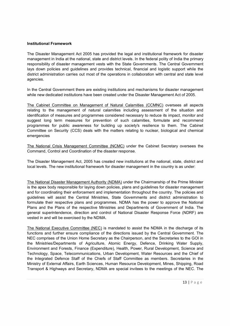
Institutional Framework The Disaster Management Act 2005 has provided the legal and institutional framework for disaster management in India at the national, state and district levels. In the federal polity of India the primary responsibility of disaster management vests with the State Governments. The Central Government lays down policies and guidelines and provides technical, financial and logistic support while the district administration carries out most of the operations in collaboration with central and state level agencies.
In the Central Government there are existing institutions and mechanisms for disaster management while new dedicated institutions have been created under the Disaster Management Act of 2005.
The Cabinet Committee on Management of Natural Calamities (CCMNC) oversees all aspects relating to the management of natural calamities including assessment of the situation and identification of measures and programmes considered necessary to reduce its impact, monitor and suggest long term measures for prevention of such calamities, formulate and recommend programmes for public awareness for building up society's resilience to them. The Cabinet Committee on Security (CCS) deals with the matters relating to nuclear, biological and chemical emergencies
The National Crisis Management Committee (NCMC) under the Cabinet Secretary oversees the Command, Control and Coordination of the disaster response.
The Disaster Management Act, 2005 has created new institutions at the national, state, district and local levels. The new institutional framework for disaster management in the country is as under:
The National Disaster Management Authority (NDMA) under the Chairmanship of the Prime Minister is the apex body responsible for laying down policies, plans and guidelines for disaster management and for coordinating their enforcement and implementation throughout the country. The policies and guidelines will assist the Central Ministries, State Governments and district administration to formulate their respective plans and programmes. NDMA has the power to approve the National Plans and the Plans of the respective Ministries and Departments of Government of India. The general superintendence, direction and control of National Disaster Response Force (NDRF) are vested in and will be exercised by the NDMA.
The National Executive Committee (NEC) is mandated to assist the NDMA in the discharge of its functions and further ensure compliance of the directions issued by the Central Government. The NEC comprises of the Union Home Secretary as the Chairperson, and the Secretaries to the GOI in the Ministries/Departments of Agriculture, Atomic Energy, Defence, Drinking Water Supply, Environment and Forests, Finance (Expenditure), Health, Power, Rural Development, Science and Technology, Space, Telecommunications, Urban Development, Water Resources and the Chief of the Integrated Defence Staff of the Chiefs of Staff Committee as members. Secretaries in the Ministry of External Affairs, Earth Sciences, Human Resource Development, Mines, Shipping, Road Transport & Highways and Secretary, NDMA are special invitees to the meetings of the NEC. The

14 | P a g e
National Executive Committee is responsible to prepare the National Plan and coordinate and monitor the implementation of the National Policy and the guidelines issued by NDMA.
Figure showing the Institutional Framework for DM in India
The Ministry of Home Affairs (MHA) in the Central Government has the overall responsibility for disaster management in the country. For a few specific types of disasters the concerned Ministries have the nodal responsibilities for management of the disasters, as under:
Drought Ministry of Agriculture
Epidemics & Biological Disasters Ministry of Health and Family Welfare
Chemical Disasters Ministry of Environment & Forests
Nuclear Disasters Ministry of Atomic Energy
Air Accidents Ministry of Civil Aviation
Railway Accidents Ministry of Railways

15 | P a g e
At the State Level the State Disaster Management Authority (SDMA), headed by the Chief Minister, lays down policies and plans for disaster management in the State. It is also responsible to coordinate the implementation of the State Plan, recommend provision of funds for mitigation and preparedness measures and review the developmental plans of the different departments of the State to ensure integration of prevention, preparedness and mitigation measures. The State Disaster Management Department (DMD) which is mostly positioned in the Revenue and relief Department is the nodal authority.
In the district level the District Disaster Management Authority (DDMA) is headed by the District Magistrate, with the elected representative of the local authority as the Co-Chairperson. DDMA is the planning, coordinating and implementing body for disaster management at district level. It will, inter alia prepare the District Disaster Management Plan and monitor the implementation of the National and State Policies and the National, State and the District Plans. DDMA will also ensure that the guidelines for prevention, mitigation, preparedness and response measures laid down by the NDMA and the SDMA are followed by all departments of the State Government at the district level and the local authorities in the district.
The Local Authorities both the rural local self governing institutions (Panchayati Raj Institutions) and urban local bodies (Municipalities, Cantonment Boards and Town Planning Authorities) These bodies will ensure capacity building of their officers and employees for managing disasters, carry out relief, rehabilitation and reconstruction activities in the affected areas and will prepare DM Plans in consonance with guidelines of the NDMA, SDMAs and DDMAs.
National Institute of Disaster Management The National Institute of Disaster Management (NIDM) functions as the nodal centre for Human Resource Development in the area of Disaster Mitigation and Response. It is a premier national organization working for human resource development at national level in the area of disaster mitigation and management. The NIDM came into existence since October 16, 2003 by a Government of India order upgrading the National Centre for Disaster Management (NCDM) located in New Delhi, and established by the Ministry of Agriculture, Department of Agriculture and Cooperation, Government of India, in March 1995. The DM Act, 2005 has brought the institute under the MHA and has assigned roles as per the Act.
The National Institute of Disaster Management (NIDM) has the mandate for human resource development and capacity building for disaster management within the broad policies and guidelines laid down by the NDMA. NIDM is required to design, develop and implement training programmes, undertake research, formulate and implement a comprehensive human resource development plan, provide assistance in national policy formulation, assist other research and training institutes, state governments and other organizations for successfully discharging their responsibilities, develop educational materials for dissemination and promote awareness among stakeholders in addition to undertake any other function as assigned to it by the Central Government
National Disaster Response Force (NDRF) The Disaster Management Act has mandated the constitution of a Specialist Response Force to a threatening disaster situation or a disaster. This Force functions under the National Disaster Management Authority which has been vested with its control, direction and general

16 | P a g e
superintendence. This is a multi-disciplinary, multi-skilled, high-tech force for all types of disasters capable of insertion by air, sea and land. All the eight battalions are equipped and trained for all natural disasters including four battalions in combating nuclear, biological and chemical disasters. Presently this Force is constituted of eight battalions, two each from the BSF, CRPF, CISF and ITBP. Each battalion will provide 18 self-contained specialist search and rescue teams of 45 personnel each including engineers, technicians, electricians, dog squads and medical/paramedics. The total strength of each battalion will be approximately 1,158. These NDRF battalions are located at nine different locations in the country based on the vulnerability profile to cut down the response time for their deployment. During the preparedness period/in a threatening disaster situation, proactive deployment of these forces is carried out by the NDMA in consultation with state authorities. India Disaster Resource Network (IDRN) IDRN portal initiated by the Ministry of Home Affairs, Government of India was launched in September 2003 in collaboration with UNDP under the Government of India-UNDP Disaster Risk Management (DRM) Programme (2002-09) to systematically build up the India Disaster Resource Network Inventory as an organized information system for specialist equipment and disaster expertise for disaster response, so that disaster managers can identify the location of the resources and will be able to access it for disaster response with the minimum loss of time. The on-line inventory clearly lists out sequential details on specific equipments, types, their functions performed, human expertise in search and rescue operations and contact details of expertise and suppliers for prompt mobilization. IDRN was designed as a web enabled information system to provided updated inventory of related items every quarter, entered at two levels i.e. at district and state level. The portal has been hosted to the central server at NIC National Information Centre, who is providing technical support to Ministry of Home Affairs. The portal has an on-line dual accessible interface system for users from state disaster management /relief & rehabilitation department officials (Relief Commissioners), district administrators (District Magistrate/Collectors) and other state and district nodal officers, corporate members and public who can browse the portal. The user can obtain catalogued information as well as query based data and list of resources available at district and state level. The on line inventory user manual and details can be accessed at http://www.idrn.gov.in. Technical support was extended by UNDP to systematically formulate the resource inventory through an organized information system designed to collate and assimilate information for authorities in 563 district and 35 state/union territories. Currently the portal is being maintained by the NIDM.
NDMA Guidelines/Reports on various issues of Disaster Management
The National Disaster Management Authority has issued guidelines/reports (http://ndma.gov.in/ndma/guidelines.html) on the 19 subjects – Earthquakes, floods, urban flooding, drought management, landslide, radiological emergencies, chemical disasters (industrial), chemical (terrorism) disasters, mass casualty management, biological disasters, psycho-social care, formulation of state disaster management plans, incident response system, disaster management information and communication system, revamping of civil defence and strengthening of fire services, strengthening of safety and security of transportation of POL tankers, management of dead in the aftermath of a disaster and role of NGOs in disaster management.

17 | P a g e
(Some of the National Guidelines issued by the NDMA)

18 | P a g e
National Platforms
First India Disaster Management Congress
In order to provide a national platform to various stakeholders of disaster management the National Institute of Disaster Management (NIDM) organized the First India Disaster Management Congress in Vigyan Bhavan New Delhi on 29-30 November 2006. Dr. Manmohan Singh Prime Minister of India inaugurated the Congress. More than 1200 hundred delegates from all over the country attended and 350 technical papers were presented in 18 Thematic Sessions organized around Thematic Clusters. This was the largest knowledge conference on disaster management ever held in this part of the world. MHA, NIDM, IMD, NRSA, ISRO, ICAR, Universities, IITs, ICMR, CII, ASSOCHAM partnered to organize this event.
Second India Disaster Management Congress
Second India Disaster Management Congress was held in New Delhi on 4-6 November, 2009 on an even larger scale. The Congress was held in Vigyan Bhavan, New Delhi and a total of 26 Technical Sessions were organized in around 13 Thematic Clusters. The Congress brought together 1500 scientists, scholars and practitioners working on different aspects of disaster risk reduction and management across the world. GOI, NDMA, UNDP, USAID, UNISDR, UNICEF, WHO, SDC, GFDRR, NIDM parterened together to organize this event.
Progress of the Implementation of Hyogo Framework of Action (2005-15)
Priority 1 – Make Disaster Risk Reduction a Priority
Government of India has established a policy framework for disaster management with a focus
on mainstreaming disaster risk reduction (DRR) into development planning and programmes. The present focus is to strengthen the implementation of various provisions of Disaster Management Act 2005.
The successive Five Year Plans emphasize on the need of mainstreaming of DRR into development planning process and programs.
The Civil Defense Act, 1968 has been amended to include disaster management in their domain.
Dedicated and adequate resources are available to implement disaster risk reduction plans and activities at all administrative level.
Community Participation and decentralization is ensured through the delegation of authority and resources to local levels.
National multi-sectoral platform for DRR is functioning in the shape of India Disaster Management Congress.

19 | P a g e
Priority 2 – Know the Risk and Take Action
National and local risk assessments based on hazard data and vulnerability information are available (Vulnerability Atlas of India) and include risk assessments for key sectors.
Disaster losses and hazards systematically reported, monitored and analyzed – EWS agencies identified.
Nodal agencies have been identified to provide and maintain key hazard data and information. Hazard Specific Mitigation Guidelines have been formulated, circulated and made available through web site (NDMA) for easy access.
Government of India has identified key departments and organizations to provide early warnings on different natural hazards.
Respective state governments have set up their emergency control rooms/ Operation Centers and early warning communication systems (audio, video and data communication facilities) to reach out to vulnerable districts and communities.
The country hosts the SAARC Disaster Management Centre which aims to put in place a regional disaster management system to reduce disaster risks.
Priority 3 – Build Understand and Awareness
India Disaster Knowledge Network is functioning for knowledge sharing and development
among various stakeholders. State specific web portal are being developed by the State Disaster Management Authorities for
information sharing and knowledge Management. Hazard Specific Centers for Excellence have been established to provide knowledge inputs and
training. DM introduced in Elementary and Higher Education by many educational boards across the
country. Many Universities have been conducting professional courses on DM. NIDM conducting courses in DM at the national level and ATI doing so at the state level. The level of awareness about disaster preparedness has increased considerable at all levels
and continuous efforts are being made to reach out to the vulnerable communities with disaster preparedness information through print and electronic media.
Priority 4 – Reduce Risk
National Action Plan for Climate Change has been formulated which recognizes inter-linkages between Climate change and DRR.
Many legislations are in place to protect the environment and natural resources. Many programmes and schemes such as MNREGS, pension schemes etc. to address the
vulnerable groups in the society. National Agricultural Insurance Scheme (NAIS) to provide insurance coverage and financial
support to the farmers in the event of a crop failure due to natural calamities, pest attacks and other crop diseases.
Watershed development projects in many sectors. There is an increasing emphasis to incorporate hazard safety measures at the settlement
planning level in Master Plans and City Development Plans.
20 | P a g e
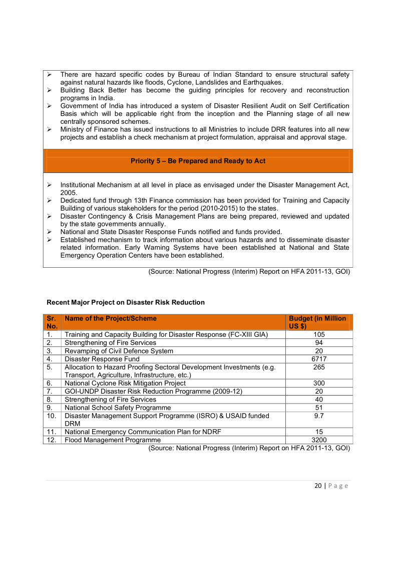
There are hazard specific codes by Bureau of Indian Standard to ensure structural safety against natural hazards like floods, Cyclone, Landslides and Earthquakes.
Building Back Better has become the guiding principles for recovery and reconstruction programs in India.
Government of India has introduced a system of Disaster Resilient Audit on Self Certification Basis which will be applicable right from the inception and the Planning stage of all new centrally sponsored schemes.
Ministry of Finance has issued instructions to all Ministries to include DRR features into all new projects and establish a check mechanism at project formulation, appraisal and approval stage.
Priority 5 – Be Prepared and Ready to Act
Institutional Mechanism at all level in place as envisaged under the Disaster Management Act,
2005. Dedicated fund through 13th Finance commission has been provided for Training and Capacity
Building of various stakeholders for the period (2010-2015) to the states. Disaster Contingency & Crisis Management Plans are being prepared, reviewed and updated
by the state governments annually. National and State Disaster Response Funds notified and funds provided. Established mechanism to track information about various hazards and to disseminate disaster
related information. Early Warning Systems have been established at National and State Emergency Operation Centers have been established.
(Source: National Progress (Interim) Report on HFA 2011-13, GOI)
Recent Major Project on Disaster Risk Reduction
Sr. No.
Name of the Project/Scheme Budget (in Million US $)
1. Training and Capacity Building for Disaster Response (FC-XIII GIA) 105 2. Strengthening of Fire Services 94 3. Revamping of Civil Defence System 20 4. Disaster Response Fund 6717 5. Allocation to Hazard Proofing Sectoral Development Investments (e.g.
Transport, Agriculture, Infrastructure, etc.) 265
6. National Cyclone Risk Mitigation Project 300 7. GOI-UNDP Disaster Risk Reduction Programme (2009-12) 20 8. Strengthening of Fire Services 40 9. National School Safety Programme 51 10. Disaster Management Support Programme (ISRO) & USAID funded
DRM 9.7
11. National Emergency Communication Plan for NDRF 15 12. Flood Management Programme 3200
(Source: National Progress (Interim) Report on HFA 2011-13, GOI)

21 | P a g e
ADRC Counterpart
Disaster Management Division Ministry of Home Affairs Government of India NDCC-II New Delhi Website: www.ndmindia.nic.in (Report compiled by: DC Rana, Joint Secretary to the Government of Himachal Pradesh, India, Visiting Researcher, ADRC, Kobe, Japan.)