DEVELOPMENT OF CLIMATE-RESPONSIVEfaspselib.denr.gov.ph/sites/default/files//Publication...
25
Transcript of DEVELOPMENT OF CLIMATE-RESPONSIVEfaspselib.denr.gov.ph/sites/default/files//Publication...


DEVELOPMENT OF CLIMATE-RESPONSIVE
INTEGRATED RIVER BASIN MASTER PLAN
FOR THE MINDANAO RIVER BASIN
Inception Report
October 2015
College of Forestry and Natural Resources
University of the Philippines Los Baños
Department of Environment and Natural Resources
River Basin Control Office

INCEPTION REPORT
ii DEVELOPMENT OF CLIMATE-RESPONSIVE INTEGRATED RIVER BASIN MASTER PLAN FOR THE MINDANAO RIVER BASIN
TABLE OF CONTENTS
Table of Contents ........................................................................................................................................................................ii
List of Figures ............................................................................................................................................................................. iii
List of Tables ............................................................................................................................................................................... iii
1 Rationale ...............................................................................................................................................................................1
2 Project Objective ...............................................................................................................................................................1
3 Project Duration ................................................................................................................................................................2
4 The Mindanao River Basin ............................................................................................................................................2
5 Methodology........................................................................................................................................................................5
5.1 Guiding Principles and Approaches ................................................................................................................6
5.1.1 Holistic Systems Approach........................................................................................................................6
5.1.2 Participatory Epistemology ......................................................................................................................6
5.1.3 Demand Driven...............................................................................................................................................7
5.1.4 Interdisciplinary ............................................................................................................................................7
5.1.5 Science and Technology Based................................................................................................................7
5.1.6 Cultural Sensitivity .......................................................................................................................................8
5.1.7 Subsidiarity ......................................................................................................................................................8
5.2 Coverage of the Engagement..............................................................................................................................8
5.3 Methods .......................................................................................................................................................................8
5.3.1 Phase I ................................................................................................................................................................9
5.3.2 Phase II............................................................................................................................................................ 14
5.4 Reporting Requirements .................................................................................................................................. 17
6 Project Team .................................................................................................................................................................... 18
6.1 Project Management Team .............................................................................................................................. 18
6.2 Project Staff............................................................................................................................................................. 18
7 Standards of Services ................................................................................................................................................... 19
8 Timeframe ......................................................................................................................................................................... 19
9 References ......................................................................................................................................................................... 21

INCEPTION REPORT
iii DEVELOPMENT OF CLIMATE-RESPONSIVE INTEGRATED RIVER BASIN MASTER PLAN FOR THE MINDANAO RIVER BASIN
LIST OF FIGURES
Figure 1. Location map of the Mindanao River Basin. ................................................................................................5
Figure 2. Framework for developing a climate-responsive integrated master plan. ...................................9
LIST OF TABLES
Table 1. List of specialists. ................................................................................................................................................... 18
Table 2. Timeframe of the project .................................................................................................................................... 20

INCEPTION REPORT
1 DEVELOPMENT OF CLIMATE-RESPONSIVE INTEGRATED RIVER BASIN MASTER PLAN FOR THE MINDANAO RIVER BASIN
1 RATIONALE
Pursuant to Executive Order (EO) Nos. 510, 816 and 50, a river basin control office was
created to develop, among others, a national master plan to address flooding and to
provide sustainable supply of water for the entire country.
In compliance with EO 510, an integrated river basin management and development
master plan was crafted in 2007 identifying eighteen (18) major river basins in the
Philippines. The Mindanao River Basin is part of these identified major river basins.
On May 2, 2012, the Cabinet Cluster on Climate Change Adaptation and Mitigation
passed Resolution No. 2012-001 adopting the eighteen (18) major river basins of the
country as priority areas of the government.
The importance of these river basins cannot be understated as they are considered as
one of the life blood and drivers of the Philippine economy. Hence, they have to be
managed sustainably. An integrated river basin management approach shall be applied
in the preparation of the master plan for each river basin in line with the Philippine
Development Plan. The master plan is intended to address several concerns related to
watershed conservation, river basin rehabilitation, flood control/mitigation, and water
security for domestic, irrigation and industrial use, livelihood and economic
opportunities in the area. The master plans for the Mindanao River Basin was
formulated/completed in the early 2000s and were approved by the respective Regional
Development Councils that have jurisdiction in the area.
With the passage of Republic Act (RA) No. 9729 or the Climate Change Act of2009 and
RA 10121 or the Disaster Risk Reduction Law of 2010, the importance of taking into
consideration the new climate normal in development planning was recognized.
The need to review and update the existing master plan is therefore, necessary. Climate
change perspectives should be incorporated and mainstreamed together with disaster
risk reduction issues and measures.
2 PROJECT OBJECTIVE
The objective of this project is to update the Integrated River Basin Master Plan for one
of the abovementioned river basins: the Mindanao River Basin, to incorporate the
implications of the new climate normals in addressing the concerns of the river basin
on:
1) Water Resources Management
2) Watershed Management
3) Flood Control/Mitigation, Disaster Risk Reduction and Hazards Management

INCEPTION REPORT
2 DEVELOPMENT OF CLIMATE-RESPONSIVE INTEGRATED RIVER BASIN MASTER PLAN FOR THE MINDANAO RIVER BASIN
4) Wetland Management (including rivers, river deltas, marshlands and coastal
areas)
5) Economic Development, and
6) Institutional Linkages and Organizational Structure for River Basin Management.
3 PROJECT DURATION
The project shall be implemented over a ten-month time period commencing from the
15th of September 2015 until the 15th of July 2016.
4 THE MINDANAO RIVER BASIN
The Mindanao River Basin (MRB) lies between the coordinates of 7⁰12’17.06" north
latitude and 124⁰47’35.71” east longitude. It represents four (4) regions, covering
the provinces of Bukidnon, Davao del Norte, Lanao del Sur, Maguindanao, Sultan
Kudarat, North Cotabato, South Cotabato, and a chartered city - Cotabato City. The
municipalities inside the MRB are shown in Figure 1. MRB is the second largest river
basin in the Philippines, having a total area of 21,503 square kilometers. It has 72
municipalities and 1,731 barangays. It has one source of hydroelectric power, the
Pulangi 4 Hydro-Power Dam located in Bukidnon and one source of geothermal
power and home to the endangered Philippine Eagle, the Mt. Apo. The forest land
and alienable and disposable lands are relatively divided into equal halves,
composing 50.08% and 49.92% of the whole Mindanao River Basin respectively
(RBCO, 2009).
Major rivers within the basin include the Ala River, traversing the Ala Valley in the
South; the Pulangi River with headwater from Bukidnon; the Ambal-Simuay River
System originating from Lanao del Sur, and; the Mindanao and Tamontaka Rivers in the
Lower Cotabato River Basin. Of these rivers, the Kulama River falls under the Class A
Category, the M-lang and Ala Rivers under Class C, and Pulangui and Libungan under
Class D (DAO 34 s. 1990).
The river basin encompasses 4 regions with seven provinces: Bukidnon, Davao del
Norte, Lanao del Sur, Maguindanao, Sultan Kudarat, North Cotabato, South Cotabato;
and one component city: Cotabato City. These provinces cover some of the
municipalities that compose the river systems of the basin.
Climate classification generally depends on the rainfall characteristics. Based on the
Modified Corona Climate Classification System of PAGASA, the Mindanao River Basin
is generally classified into two types: Type 3 and Type 4. Having these climatic types
indicate that the project area is being rain-fed fairly throughout the year, although
having higher amounts of precipitation during June to October.

INCEPTION REPORT
3 DEVELOPMENT OF CLIMATE-RESPONSIVE INTEGRATED RIVER BASIN MASTER PLAN FOR THE MINDANAO RIVER BASIN
Mindanao River Basin, consisting of 20 sub-basins, has elevation range of -0.46m to
2,903.22m. The sub-basins with lowest elevations are Cotabato, Lower Pulangi and
M’lang Sub-basins, Cotabato being the lowest with -0.46m elevation attributed by its
geographic location. Manupali Sub-basin has the highest mean elevation with
2,903.22m, located in the northernmost part of the river basin in Bukidnon. The
Cotabato, Lower Pulangi, Banga, Buluan, Damakling and M’lang sub-basins have
more than 45% of its catchment area within 0-3% slope category. Meanwhile, the
Ala Sub-basin has 167.41 km2 qualifying to slope category of 50% and more, which
is strongly hilly to mountainous.
The MRB has a total estimated population of 3,533,086 (NSO, 2007). Of the sub-
basins, Upper Pulangi Sub-basin has the highest number of inhabitants with
481,412, constituting about 13% of the total river basin population. It is then
followed by Ala Sub-basin with 408,374 or 11% of the total estimated river basin
population. The least inhabited sub-basin is the Damakling sub-basin having only
23,600 inhabitants. M’lang sub-basin, with estimated population of 212,395 and
area of 605.55 square kilometers, has the highest population density of 351 persons
per square kilometer (persons/km2). It is then followed by the Cotabato sub-basin
with 326 persons/km2. The Arakan sub-basin has the lowest population density with
only 68 persons/km2.
The regions and provinces lying inside the Mindanao River Basin have employment
rates all higher than the national employment rate. The Northern Mindanao Region
(Region X) has an employment rate of 95.3% in 2008, SOCCSKSARGEN (Region XII)
95.5% by 2008, while Davao Region (Region XI) remained at 94.2% for 2008 and
2009. The ARMM has the highest employment rate with 97.3% employment rate by
2008. Despite having the highest employment rate, ARMM has the lowest
employment rate of women, comprising only 29% of the work force. The highest
women employment rate is on Northern Mindanao with 41%. Of the regions covered
by the MRB, the workers are primarily engaged with agriculture, hunting and
forestry, both in the men and women workers’ sectors. With agriculture being the
primary income generating industry in the Mindanao region, the total irrigation
service area spans a total of 20,212.71 has. The second industry group that most
women are employed is in wholesale and retail trade, while it varies between
wholesale and retail trade, repair of motor vehicles, motorcycles and personal and
household goods and transport, storage and communications for men.
Despite the high employment rate in Mindanao, the 4 regions under MRB were not
able to meet the 2006 national average income amounting to Php 173,000.
Maguindanao, having the highest poverty incidence, has 53 out of its 100 residents
that have income that cannot provide for human’s basic needs.
However, the activities surrounding the river basin is critical to its physical
environment especially its rich natural resources as it shelters 5 watershed forest
reserves, a protected landscape, a national park and a game and bird sanctuary
(MinDa, 2012). Also, Cotabato City, Cotabato Province, Maguindanao, Sultan Kudarat
lie within MRB’s floodplain area, thus, highly susceptible to flooding. Furthermore,
these areas are also susceptible to landslides, earthquakes, liquefaction and volcanic

INCEPTION REPORT
4 DEVELOPMENT OF CLIMATE-RESPONSIVE INTEGRATED RIVER BASIN MASTER PLAN FOR THE MINDANAO RIVER BASIN
hazards. Bukidnon, on the other hand, is highly susceptible to landslides, among
other hazards. Mitigation and adaptation is essential to prevent further damages to
the inhabitants of the river basin.

INCEPTION REPORT
5 DEVELOPMENT OF CLIMATE-RESPONSIVE INTEGRATED RIVER BASIN MASTER PLAN FOR THE MINDANAO RIVER BASIN
5 FIGURE 1. LOCATION MAP OF THE MINDANAO RIVER
BASIN.METHODOLOGY
The project shall adopt the following principles, approaches, and methods to
accomplish the objectives and expected outputs of the project stated in the Terms of
Reference.

INCEPTION REPORT
6 DEVELOPMENT OF CLIMATE-RESPONSIVE INTEGRATED RIVER BASIN MASTER PLAN FOR THE MINDANAO RIVER BASIN
5.1 Guiding Principles and Approaches
These principles and approaches shall be employed throughout the implementation
of the project, and shall constitute the underlying fundamental concepts inherent in
the planning process for developing a climate change-responsive Integrated River
Basin Master Plan for the Mindanao River Basin.
5.1.1 Holistic Systems Approach
A holistic systems approach is a general approach that captures the
interactions of the various factors, processes and components of the river
basins as complex social and ecological systems. This ensures that concerns
spanning the bio-physical, social, economic, and institutional characteristics
the river basin shall be taken into consideration and integrated into the
strategy formulation and planning of the areas. Such an approach will
provide a multifaceted analysis and facilitate the surfacing of the
management and policy development issues common to the 6 areas of
concern mentioned in the project objectives.
5.1.2 Participatory Epistemology
A Participatory epistemology is necessary to ensure the sustainability and
inclusiveness of an integrated river basin management and development effort.
Considering that a specific river basin will have several groups of major
stakeholders, the participation of the different stakeholders will be imperative in
resolving conflicting interests that may affect the efficient, effective and
sustainable management and utilization of resources. An inclusive river basin
management and development management regime anchored on
stakeholder participation will be helpful in implementing multiple use
management strategies to ensure sustainable use of resources in a river
basin. A participatory approach will also ensure sensitivity to issues
otherwise hidden and/or taken for granted in development efforts; these
may include gender and other social sectoral concerns. The identification
and consideration of the stakeholders’ voices will facilitate the inclusion of
their needs and concerns at the local and community levels all the way up to
the national level. These concerns may vary from the short term and day to
day subsistence needs of the local communities, to long term, macro, and
societal needs for stable and healthy river basin that can sustainably provide
goods and services.
In as much as it is possible, given the period of time for the implementation
of this project, efforts shall be undertaken to provide opportunities for key
stakeholders to participate in the conduct of project activities, including but
not limited to data gathering and generation, and in the crafting of the river
basin master plan.
INCEPTION REPORT
7 DEVELOPMENT OF CLIMATE-RESPONSIVE INTEGRATED RIVER BASIN MASTER PLAN FOR THE MINDANAO RIVER BASIN
5.1.3 Demand Driven
The decisions on what and where to implement projects in a watershed
should be guided by the perceived as well as actual needs of the
stakeholders at the local level all the way up to the national level. These
demands vary from the short term day to day subsistence needs of the local
communities to long term macro societal needs for stable and healthy
environment that sustainably provides goods and services. In this project,
while DENR plays a major role in the management and development of the
river basins as part of its mandate, , it is imperative to engage the other
stakeholders as well to complete the frame of demands that this project must
respond to.
5.1.4 Interdisciplinary
An interdisciplinary approach shall be employed to ensure an integrated
analysis to back up the integrated development plan for the river basin. The
approach will be operationalized as experts and researchers coming from
different disciplines work together with a clear and shared goal of
generating a coherent and holistic assessment of the river basin. An
interdisciplinary team shall assess the river basin covered by the
engagement in terms of their bio-physical, human, social, and economic
vulnerabilities which are usually brought about by internal systems
processes that lead to the area’s weaknesses in the light of larger, often
external threats such as climate change and socio-political pressures. The
same approach shall be applied in assessing the capacities and opportunities
of the river basin for holistic development.
Central to this interdisciplinary approach is the generation of a common
conceptualization of a river basin as a socio-ecological system (SES) having
interrelated bio-physical, human, and social characteristics. This
necessitates the experts to initially come together into a leveling of terms,
concepts and methodologies, to conduct the successive phases of the
assessment using a combination of data generation and analytical methods
and tools.
5.1.5 Science and Technology Based
Science and technology based assessment shall be done using methods that
use state-of-the-art soft and hard technologies to assess the river basin. Not
only will the engagement be conducted using the scientific rigor useful to
advance a valid and reliable assessment; but it shall also use scientific
knowledge, both in method and literature, that has grown over the last
decade in the area of biodiversity, climate change, and watershed and
resources management.

INCEPTION REPORT
8 DEVELOPMENT OF CLIMATE-RESPONSIVE INTEGRATED RIVER BASIN MASTER PLAN FOR THE MINDANAO RIVER BASIN
5.1.6 Cultural Sensitivity
Cultural sensitivity shall be evident in all management and development
prescriptions. While a science-based approach is important, cultural
sensitivity has to be observed with the different stakeholders, especially for
the preservation and observance of local cultural institutions and belief
systems. The assessment, joint planning, and collective decision-making
towards the improvement of the river basin must manifest this principle.
5.1.7 Subsidiarity
Subsidiarity ensures that the response of the lowest decision-making group
or actor is valued. Given that the river basin is a configuration of actors from
a multi-level perspective with multiple thematic concerns and multi-sectoral
representation, the appropriate actor with the recognized institutional
mandate, resource, and influence shall be given due accountabilities.
5.2 Coverage of the Engagement
The project shall update the Integrated Management and Development Master Plan
of the Mindanao River Basin, taking into consideration climate change impacts for
sound investment decisions in the sustainable management of water resources
therein. As stipulated in the Terms of Reference, it shall consist of two phases which
include the following major activities:
A. Phase I
1. Coordination with Concerned Agencies
2. Updating of River Basin Profile
3. Setting of vision, missions, goals (VMG), and targets
4. Identification of strategies, programs and projects
B. Phase II
1. Evaluation of strategies, programs and projects
2. Investment and implementation planning
5.3 Methods
The following tasks, presented in Figure 2, shall be undertaken in order to achieve the
objectives of the project:

INCEPTION REPORT
9 DEVELOPMENT OF CLIMATE-RESPONSIVE INTEGRATED RIVER BASIN MASTER PLAN FOR THE MINDANAO RIVER BASIN
FIGURE 2. FRAMEWORK FOR DEVELOPING A CLIMATE-RESPONSIVE INTEGRATED
MASTER PLAN.
5.3.1 Phase I
5.3.1.1 Coordination with Concerned Agencies
Close coordination with the DENR field offices, LGUs, DA, Water
Districts, NWRB, and other main stakeholder agencies will be done
during the conduct of the study. The purpose of the study shall be
explained; the specific objectives, outputs and process shall also be
discussed. In the process of coordination, it is expected that the Team
PHASE I
PHASE 2
CO
OR
DIN
AT
ION
WIT
H C
ON
CE
RN
ED
AG
EN
CIE
S
KEY OUTPUTS
Comprehensive report
on climate vulnerability assessment conducted in the river basin
Comprehensive report on the findings from the studies conducted during the Phase I of the project
Revised Integrated
River Basin Management and Development Strategy
Proceedings of the
consultations and discussions with concerned government agencies
Integrated River Basin
Management and Development Master Plan
Volume I Executive Summary
Volume II Main Report
Volume III Formulation Process
Volume IV Map Atlas and Database

INCEPTION REPORT
10 DEVELOPMENT OF CLIMATE-RESPONSIVE INTEGRATED RIVER BASIN MASTER PLAN FOR THE MINDANAO RIVER BASIN
will be able to generate important comments and suggestions that
may be considered in the overall improvement of the conduct of the
project activities and delivery of outputs. It is important to establish
a good rapport at the onset for buy-in by the partners. Coordination
with these agencies shall be done during the whole period of
engagement because these shall be the key organizations who shall
be implementing the plans, programs and projects.
5.3.1.2 Updating of River Basin Profile
The Mindanao River Basin profile shall be updated based on the
watershed boundary provided by the River Basin Control Office. To
this end, an exhaustive collection, examination and analysis of
existing documents shall be conducted.
5.3.1.2.1 Updating of Physical and Hydrological Profiles
Geographic information systems (GIS) shall be used to update the
geophysical, morphometric, and hydrological characteristics of the
Mindanao River Basin. This includes the identification of physically
constrained areas (i.e., steep slope, saline, acidic, ultramafic and
waterlogged soil), and critical areas for restoration within the
Mindanao River Basin. GIS datasets and remotely sensed images of
the river basin areas shall be used to generate information
regarding the geographical location, administrative and political
boundaries, topographic characteristics, soil and geologic
characteristics, hydrology, and land use and land cover patterns of
the catchment area. Land cover change analysis using GIS cross
tabulation of land cover maps from different time periods shall also
be undertaken to evaluate the current and projected land area
allocated for various uses. Updating of hydrological characteristics
and water supply trends shall be done using datasets from water
level monitoring systems set up by previous projects, and outputs
of the National Water Quality Status Report of the Environmental
Management Bureau.
Meteorological and climatic information of the Mindanao River
Basin shall be validated using datasets from PAGASA; data on
climate projections, expected changes in rainfall, mean annual
temperature, extreme events and other parameters shall also be
collected. Land capability and land suitability assessment shall also
be done to identify non-negotiable protection areas and production
areas (e.g. areas suitable for agriculture, settlement, industrial,
commercial, and other intensive uses). The effects of these
generated characteristics shall be related to their implications to
watershed and river basin management, land use planning and
zoning, local and regional development planning, and disaster risk
reduction and management of the area.

INCEPTION REPORT
11 DEVELOPMENT OF CLIMATE-RESPONSIVE INTEGRATED RIVER BASIN MASTER PLAN FOR THE MINDANAO RIVER BASIN
In case pertinent data will not be available, selective primary data
collection shall be done, which may include water quality and
stream flow measurements for water and sediment yield
estimation, the geolocation of pollution point sources, and field
validation of GIS generated maps.
5.3.1.2.2 Updating of Bio-ecological Profile
Relevant data gaps shall be collected on the current biological
composition of the Mindanao River Basin. Possible sources may
include reports on recent inventory and assessment of flora and
fauna, biodiversity studies, environmental and ecological
assessments, and other related studies in order to understand the
interrelationships among the organisms in connection with the
present status of the river basin. This may also include studies on
protected areas, seascapes, landscapes, key biodiversity areas, and
conservation priority areas. Reviews of reports on the current
water status and ecological studies of the major lakes, rivers, and
wetlands which may be deemed necessary for the overall
assessment of the river basin shall also be included.
5.3.1.2.3 Updating of Demographic and Socio-economic Profiles
Demographic and socio-economic data gaps shall be collected from
the Philippine Statistical Authority, and concerned LGU’s and
Government agencies. These information shall be used in the
updating of the demographic profile and trends in the river basin,
and in the assessment of the socio-economic condition of basin
communities (e.g. delivery of basic services, poverty incidence,
education, livelihood and employment). The existing and planned
development programs for areas within the River Basin shall also
be examined. This includes evaluating information on relevant
infrastructures like irrigation projects, wells, water facility
constructions, energy, communications, and transport. Studies
focusing on environmental, structural, and developmental projects
shall also be accounted. Water resource use assessment shall also
be made to include the description of the key domestic,
agricultural, industrial and commercial uses and users of water,
and projected water demand. Moreover, assessment of water
supply and demand trend analysis and projection shall also be
undertaken.
It is pertinent to review the roles, strengths, weaknesses,
opportunities and threats of the institutions in the river basin.
Identification of various stakeholder groups, assessment of the
interests of the various stakeholders, the importance and influence
of these stakeholders in watershed and river basin management
shall be analyzed. Alliances and competition or conflicts amongst

INCEPTION REPORT
12 DEVELOPMENT OF CLIMATE-RESPONSIVE INTEGRATED RIVER BASIN MASTER PLAN FOR THE MINDANAO RIVER BASIN
the various stakeholder groups shall also be described, including
the issues that cement the cooperation and sources of conflicts.
5.3.1.2.4 Vulnerability Assessment
GIS generated basin-wide hazard maps shall be produced based on
the geophysical and climatic characteristics of the Mindanao River
Basin. Vulnerability and risk assessment on the implications of the
new climate normals, extremes and variability to water supply and
allocation for various uses, water resources management,
watershed management, vulnerability to fires, deforestation and
soil erosion, vulnerability of critical habitats, flood
control/mitigation, disaster risk reduction, hazards management,
wetland management, and economic development of the Mindanao
River Basin shall also be undertaken. Moreover, a spatial
assessment of climate change impacts (e.g. flooding, drought,
landslides, sea level rise, storm surge, etc.) on the River Basin for
the duration of the planning period shall also be carried out to
evaluate the degree and extent of climate change impacts to
various aspects of the Mindanao River Basin and how these may
affect current and future plans, programs, and projects.
Vulnerability assessment will be carried out following the IPCC
recommended procedure (IPCC 2007).
5.3.1.2.5 Policy Assessment
A review of existing national and local policies on river basin
management and development vis-à-vis climate change shall be
undertaken. It shall include the identification of policy gaps and an
assessment of the effectiveness of water related policies, laws,
decrees, regulations, and circulars that govern the allocation of
available water resources, water rights, and water pricing; their
applicability to the new climate normals in the area shall also be
determined.
5.3.1.2.6 Institutional Arrangements
A review of existing organizational set-up and arrangements in the
river basin shall be done, taking into account both their
advantages, and their constraints and limitations for river basin
planning and management.
5.3.1.3 Revision of Vision, Mission, Goals, and Targets
5.3.1.3.1 Review of the development goals, policies, plans and
programs
Existing policy frameworks and development directions at the
various governance levels shall be reviewed in climate-proofing the

INCEPTION REPORT
13 DEVELOPMENT OF CLIMATE-RESPONSIVE INTEGRATED RIVER BASIN MASTER PLAN FOR THE MINDANAO RIVER BASIN
river basin master plan. It is relevant to review the collective
decisions and other kinds of obligations agreed upon under the
global development goals, treaties and international agreements to
which the country is bound and responsibly adhere to. Essentially,
development policies and plans that were established at the
national and regional level shall be reviewed and considered. The
provincial, municipal and local level plans and programs
concerning the river basin shall be studied focusing on its
implication to the project. The common vision, missions and goals
that shall be determined by the stakeholders for the updating of
the master plan should be in line with all the development goals,
policies and plans from these governance levels.
5.3.1.3.2 Consultative workshop
Using participatory approaches, the climate-proofing of the master
plan shall be formulated along with stakeholders. A multi-
stakeholder meeting composed of stakeholders coming from
government agencies, peoples’ organization, indigenous groups,
non-government organizations, academe, regional and local
governments shall be conducted for this project. The participatory
workshop will become the venue to identify and prioritize key
problems and development opportunities in response to the
findings from vulnerability assessment based on the new climate
normal.
It is vital to conduct a consultation to set a river-basin wide outlook
and craft a common vision among the stakeholders. The updated
and improved master plan is endeavored to have meaningful
participation and ownership of the stakeholders, especially the key
decision-makers and vulnerable sectors in the river basin. Guided
by the unified vision and missions of the stakeholders, goals,
objectives and targets are also derived and would serve as the
foundational basis of the new or enhanced management strategies
and development interventions for the river basin.
5.3.1.4 Identification of Strategies, Programs and Projects
From the vision, mission and goals that are indicated in the master
plan, management strategies and development interventions that are
prescribed in the current master plan shall be listed and reviewed for
applicability and effectiveness in relation to the new climate normal.
Development strategies that are not indicated in the current master
plan but could further improve and enhance the adaptation and
mitigation capabilities of the stakeholders in the river basin shall be
identified. These strategies are crafted to provide steps in achieving
the desirable condition of the river basin and, more importantly,

INCEPTION REPORT
14 DEVELOPMENT OF CLIMATE-RESPONSIVE INTEGRATED RIVER BASIN MASTER PLAN FOR THE MINDANAO RIVER BASIN
respond to the perceived changes vis-à-vis climate variabilities in the
river basin.
5.3.2 Phase II
5.3.2.1 Evaluation of Strategies, Programs and Projects
The objective of this activity is to determine the extent the proposed
interventions were implemented and describe their impacts on the overall
goal/objectives of the plan. In this activity the assessment will be limited
to the key interventions specified in the master plan. This will include
key interventions in water resources management, watershed
management, flood control and mitigation, wetland management and
economic development.
Review of annual reports, master plan, implementation and investment
plans, and other related documents will be made. Key informant
interviews (KIIs) and FGDs will be conducted to identify and evaluate
the cost effectiveness and costs and benefits of the key interventions as
well as to identify the key factors (i.e., policies, institutional, natural,
cultural, social, economic) that limited and/or facilitated the
implementation process. Limited surveys will be used if needed. In some
cases trend analysis and before and after comparative analysis will be
performed. Brief details of the evaluation process for each of the key
interventions are presented below.
5.3.2.1.1 Water Resources Management Program
The overall impacts of the water resources management interventions
will be weighed by comparing the water supply and demand profiles
before and after the implementation of the master plan. Specifically,
the current water supply and demand will be estimated and compared
with water supply and demand profile prior to implementation of
master plan. The likely causes of any differences in water demand and
supply before and after master plan implementation will be identified
and explained. If secondary data on water quality are available, the
before and after master plan implementation will also be compared.
5.3.2.1.2 Watershed Management Program
Available secondary data on the area reforested, area of agroforestry
developed, PA protected, reduction in forest cover and biodiversity
loss, soil conservation structures built, nurseries established, etc., will
be used to evaluate the targets accomplished for each of the key
watershed management interventions. Limited ocular inspection and
KIIs could be done if needed. Departure of the accomplishments from
the targets will be evaluated and explained in terms of the key causal
factors that either constrained or facilitated the accomplishment of
targets.

INCEPTION REPORT
15 DEVELOPMENT OF CLIMATE-RESPONSIVE INTEGRATED RIVER BASIN MASTER PLAN FOR THE MINDANAO RIVER BASIN
The projects identified under this program shall be evaluated
based on the collected available secondary data on the extent of
damage on biodiversity, upland communities, protected areas/key
biodiversity areas and infrastructure due to extreme natural
disasters and hazards. Damages will be verified and measured
through consultations and records from respective local
government units (LGUs) and the National Disaster Risk Reduction
and Management Council (NDRRMC). Identifying control points for
easy monitoring and evaluation can also be done.
5.3.2.1.3 Climate Change Adaptation, Disaster Risk Reduction and
Hazards Management Program
This program seeks to address the need to formulate strategies to
increase the resilience of the river basin and the communities
within it against the effect of different natural hazard. Programs
shall be evaluated based on the specification of the Climate Change
Act and National Disaster Risk Reduction Management. Climate
change adaptation, disaster risk reduction and hazards
management measures that were not implemented and the reason
why those are not implemented shall be identified. Evaluation can
be done hand in hand with other implementing agencies such as
the LGUs, DPWH, PAGASA, DOH and NDRRMC.
5.3.2.1.4 Wetland Management Program
As per DENR guidelines/definitions, natural wetlands include
swamps, rivers, mangroves, estuaries and peatlands while man-
made wetlands are ponds, rice paddies, dams and reservoir.
Management of wetlands is essential as it serves as habitat for
biodiversity, provide stability on shorelines, and regulates water
flow and precipitation among others. Adequacy of wetland
management program shall be assessed by comparing the
accomplishment of each strategies/projects to the expected
outputs stated in the master plan such as improvement of water
quality and hydrology, and the increase on wetland areas.
5.3.2.1.5 Economic Development Program
The potential impacts of the new climate normal, extremes and
variability on the regional and local economies shall be assessed
considering the existing livelihood programs as well as current
situations and future trends in the agriculture, forestry, and fishery
sectors. Specifically, the costs of damages of climate variability and
climate change related extreme events on the various sectors will
be evaluated and to the extent feasible assess the degree of
increase or decrease in the costs of damages that could be
reasonably attributed to the implementation of the master plan.

INCEPTION REPORT
16 DEVELOPMENT OF CLIMATE-RESPONSIVE INTEGRATED RIVER BASIN MASTER PLAN FOR THE MINDANAO RIVER BASIN
5.3.2.1.6 Institutional Strengthening Program
The improvement in the capacity of the concerned stakeholders for
participation in better watershed management shall be assessed.
The capacity of the institutions for conflict resolution is another
index that shall be evaluated.
Direct indicators including number of trainings conducted and
number trainees trained along with the increase in the level of
awareness and skills of major stakeholders involved in the
implementation of the master plan will also be evaluated.
Allocation of more budget and the hiring of new personnel,
acquisition of new equipment and installation of new facilities to
enhance institutional capacity to implement the master plan will
also be determined and evaluated.
5.3.2.2 Investment and Implementation Planning
This stage involves the determination of the budgetary requirements,
schedule of activities as well as the assignment of tasks for the new
proposals designed to climate-proof the river basin.
For the budgetary requirements and schedule of activities, a work
and financial plan shall be submitted for each proposed
program/strategy. A table as well as narrative description shall
compose the work and financial plan. Each program must include a
detailed summary of all the activities needed to fulfill its goals and
objectives. Aside from that, the amount needed for the
implementation as well as the schedule of each activity should be
shown in tabular form. To integrate all of the programs/strategies
formulated for the river basin, a summarized work and financial plan
must be derived showing the overall budget for each year.
To facilitate the orderly involvement of the stakeholders in the
implementation of the various strategies and programs identified in
the master plan, roles and responsibilities of each stakeholder will be
clearly described and communicated and appropriate incentives will
be set in place. Contributions of the various stakeholder groups will
also be encouraged.
It is also important to gauge the project’s effectiveness and to do so, a
monitoring and evaluation system will be designed in close
coordination with the implementers and auditors of the master plan.
Monitoring system will be designed for deployment during project
implementation to collect information regarding the progress and
key issues and concerns related to the various strategies and
programs being implemented. Impact and benefit monitoring will
also be done to detect changes in the natural and human

INCEPTION REPORT
17 DEVELOPMENT OF CLIMATE-RESPONSIVE INTEGRATED RIVER BASIN MASTER PLAN FOR THE MINDANAO RIVER BASIN
environment as a result of climate proofing the programs and
strategies.
For the evaluation phase, several key indicators can be identified for
each activity to measure its effectiveness. A logical framework shall
be created showing the summary of the goals/objectives, objectively
verifiable indicators/success criteria, means of verification and
external factors/key assumptions. It is important for the
indicators/success criteria to be measurable and objective to
simplify the evaluation process. This can be done by identifying the
instruments of verification. The external factors/key assumptions
should also be noted to make evaluation credible and accurate.
5.4 Reporting Requirements
The project shall fulfill the following reporting requirements and shall submit them
to the River Basin Control Office in accordance to the schedule laid out in the
subsequent section, which is reiterated in the accompanying work plan.
Aside from this inception report, a mid-term report shall be submitted at the end of
the fifth month from the commencement of the project. It shall contain a
comprehensive report on the climate vulnerability assessment conducted in the
river basin; a comprehensive report on the findings from the studies conducted
during the first phase of the project; a revised Integrated River Basin Management
and Development Strategy, which shall identify potential management and
development strategies based on updated profiles and results of the vulnerability
assessment; and the proceedings of the consultations and discussions with
concerned government agencies.
A draft of the Revised Integrated River Basin Management and Development Master
Plan shall be submitted the end of the eighth month from the commencement of the
project. It shall contain the output of Phase I and all the components prescribed
under Phase II. Moreover, it shall be composed of four separate volumes namely:
the executive summary, which will contain the summary of key issues and
challenges within the basin and the interventions introduced by the plan; the main
report, which shall abide by the annotated outline attached to the terms of
reference; the formulation process, which shall contain a detailed description of the
methodologies that were used in coming up with the profile, analysis and plan,
including information on stakeholder participation in the planning process; and the
map atlas and database, which shall contain the raw and resulting maps and other
pertinent data used in plan formulation both in A3 and digital formats.
The final report shall be the Revised Integrated River Basin Management and
Development Master Plan incorporating the comments of the Technical Working
Group and Steering Committee on the draft plan. This shall be submitted at the end
of 10th month to DENR-RBCO for final acceptance.

INCEPTION REPORT
18 DEVELOPMENT OF CLIMATE-RESPONSIVE INTEGRATED RIVER BASIN MASTER PLAN FOR THE MINDANAO RIVER BASIN
6 PROJECT TEAM
6.1 Project Management Team
Project Leader: Rex Victor O. Cruz
Assistant Project Leader: Wilfredo M. Carandang
Team Leader for Mindanao River Basin: Enrique L. Tolentino, Jr.
6.2 Project Staff
The following personnel shall be employed to attain a comprehensive evaluation of the
sectoral programs and projects that were proposed in the master plan.
TABLE 1. LIST OF SPECIALISTS.
Personnel Field of specialization
Dr. Rex Victor O. Cruz Watershed Management/Climate
Change/Integrated River Basin/ Forest
Resources Management cum Overall
ProjectLeader
Dr. Wilfredo M. Carandang Watershed Rehabilitation cum Assistant Project
Leader
Dr. Enrique L. Tolentino, Jr. Forest Resources Management cum Team Leader
Dr. Marco A. Galang Hydrology
Engr. Aurelio A. de los Reyes,Jr. Hydraulic Structure
Engr. Roger A. Luyon Hydraulic Structure
Ms. Catherine C. de Luna Sociology
Dr. Dixon T. Gevaña Sociology
Dr. Canesio D. Predo Economic Modelling
Dr. Margaret M Calderon Economics
For. Marlo D. Mendoza Policy/Institutional
Dr. Nelson Querijero Policy/Institutional
Dr. Juan M. Pulhin Climate Change
Prof. Keshia N. Tingson Aquatic/Coastal Management
Dr. Vida Q. Carandang Environmental Management/Admin Officer
Nympha Espanto, George Puno, Grace
Bruno, Alexander Campaner
Local counterparts
Dr. Rogelio T. Andrada II Recreation, Parks and Tourism Resources
Dr. Cristino L. Tiburan Environmental Modelling
Dr. Nathaniel R. Alibuyog Modelling
For. Angela A. Limpiada GIS
On call consultants and on site
coordinators
Data base and geographic
information/watershed management/modelling

INCEPTION REPORT
19 DEVELOPMENT OF CLIMATE-RESPONSIVE INTEGRATED RIVER BASIN MASTER PLAN FOR THE MINDANAO RIVER BASIN
7 STANDARDS OF SERVICES
The proponents shall perform its services with the degree of skill and judgment
normally exercised by research institutions performing services of similar nature. It
shall exercise all reasonable skill, care and diligence in the discharge of its duties agreed
to be performed consistent with the best interest of the DENR-RBCO. To attain these
ends, it shall provide personnel with adequate qualifications and experience and of such
number as may be required to properly respond to its scope of work.
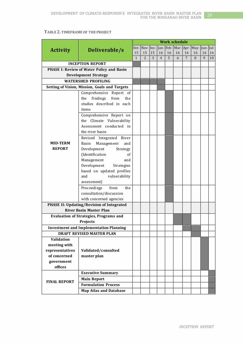
8 TIMEFRAME
The timeframe of the project is presented in Table 4 showing the key project activities
and deliverables and the corresponding work schedule.
INCEPTION REPORT
20 DEVELOPMENT OF CLIMATE-RESPONSIVE INTEGRATED RIVER BASIN MASTER PLAN FOR THE MINDANAO RIVER BASIN
TABLE 2. TIMEFRAME OF THE PROJECT
Activity Deliverable/s
Work schedule
Oct-
15
Nov-
15
Dec-
15
Jan-
16
Feb-
16
Mar-
16
Apr-
16
May-
16
Jun-
16
Jul-
16
1 2 3 4 5 6 7 8 9 10
INCEPTION REPORT
PHASE I: Review of Water Policy and Basin
Development Strategy
WATERSHED PROFILING
Setting of Vision, Mission, Goals and Targets
MID-TERM
REPORT
Comprehensive Report of
the findings from the
studies described in each
items
Comprehensive Report on
the Climate Vulnerability
Assessment conducted in
the river basin
Revised Integrated River
Basin Management and
Development Strategy
(Identification of
Management and
Development Strategies
based on updated profiles
and vulnerability
assessment)
Proceedings from the
consultation/discussion
with concerned agencies
PHASE II: Updating/Revision of Integrated
River Basin Master Plan
Evaluation of Strategies, Programs and
Projects
Investment and Implementation Planning
DRAFT REVISED MASTER PLAN
Validation
meeting with
representatives
of concerned
government
offices
Validated/consulted
master plan
FINAL REPORT
Executive Summary
Main Report
Formulation Process
Map Atlas and Database

INCEPTION REPORT
21 DEVELOPMENT OF CLIMATE-RESPONSIVE INTEGRATED RIVER BASIN MASTER PLAN FOR THE MINDANAO RIVER BASIN
9 REFERENCES
DENR-River Basin Control Office (RBCO). (2012). Mindanao River Basin Integrated
Management and Development Master Plan. Manila: Woodfields Consultants, Inc.
Mindanao Development Authority. (2012). Mindanao 2020 Peace and Development and
Framework Plan. Davao City: MinDa.
National Economic and Development Authority (NEDA). (2010). Mindanao Strategic
Development Framework 2010-2020. Pasig City: NEDA.