Design Thesis - Strengthening Community Through the Post-Industrial Landscape
70
-
Upload
matthew-greene -
Category
Documents
-
view
331 -
download
1
Transcript of Design Thesis - Strengthening Community Through the Post-Industrial Landscape
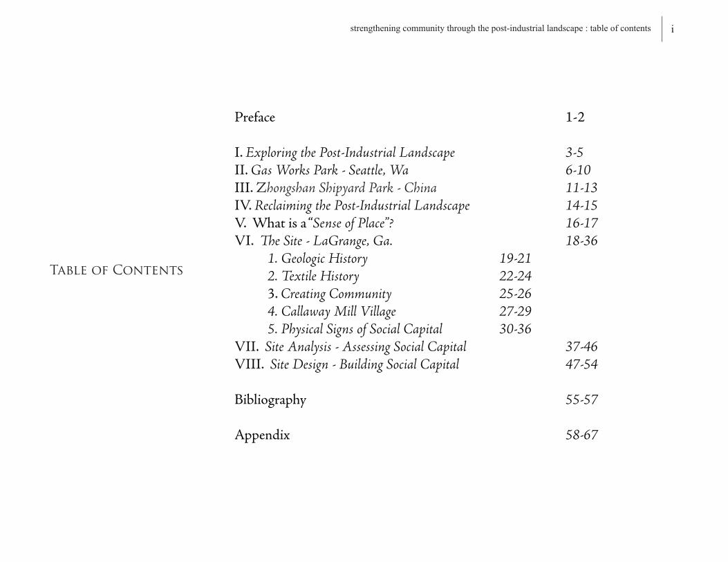
Preface 1-2
I.Exploring the Post-Industrial Landscape 3-5 II.Gas Works Park - Seattle, Wa 6-10III.Zhongshan Shipyard Park - China 11-13IV.Reclaiming the Post-Industrial Landscape 14-15V.Whatisa“Sense of Place”? 16-17VI.The Site - LaGrange, Ga. 18-36 1. Geologic History 19-21 2. Textile History 22-24 3.Creating Community 25-26 4. Callaway Mill Village 27-29 5. Physical Signs of Social Capital 30-36VII.Site Analysis - Assessing Social Capital 37-46VIII.Site Design - Building Social Capital 47-54
Bibliography 55-57
Appendix 58-67
Table of Contents
istrengthening community through the post-industrial landscape : table of contents

Inthismodernera,architectsandplanners
alikestrivetogeneratea“sustainablecommunity”-a
communitywhere“peopleworktogether,naturaland
historicresourcesarepreserved,jobsareavailable,sprawlis
contained,neighborhoodsaresecure,educationislifelong,
transportationandhealthcareareaccessible,andall
citizenshaveopportunitiestoimprovethequalityoftheir
lives”.1Thiscontemporaryinterestformoresustainable,
morelivable,communitiescontinuesanage-oldtradition
inthesearchforidealhumangroupings-adebatethat
haspersistedintheUnitedStatessinceitsestablishment.
Beginningwiththematterofdeterminationtoward
whichformofsettlementcontributedmosttodemocracy,
Americawasabruptlysuperimposedwithimmediate
competitionbetweenJefferson’sdispersedagrarianism,
Adam’sBoston,Franklin’sPhiladelphia,andHamilton’s
NewYorkCityideals.2Designmanifestation’softhis
naturehavesincebeenincludedinmanydebatesranging
fromFrankLloydWright’s“BroadacreCity”tohisprotege
PaoloSoleri’sradicallydifferent“organic”manifestation
ofArcosanti,and(morerecently)LewisMumford’s
decentralistregionalismincontrasttoJaneJacob’surban
villageconcept-allofwhicharehumanaspirationsin
searchofaplacethatfostersa“commonunity”amongits
peopleandtheland.
Derivedfromthelatinrootword,communis,
meaning“commoninthesenseofsharingequallyor
togetherwithothers”,“Community”isdefinedas“an
associationofinteractingpopulations,usuallydelimitedby
theirinteractionsorspatialoccurrence”.Theideaofthis
communitasassociationisrepresentedwithinaframework
ofsharedbeliefs,interests,andcommitmentsthatunitesa
setofvariedgroupsandactivities.3Thus,“Community”
isdependentupontheconnectionandformationofsocial
networks-networksgeneratedthroughthepresenceof
socialcapital.
Thisthesisseekstounderstandtheconceptof
socialcapitalanditsrelevancetothehealthofurban
communities.Withafocusdirectedtowardhistorictextile
millsandtheirrespective“millvillages”withinthecityof
LaGrange,Georgia,myinvestigationexploresstrategiesto
fostersocialcapitalandtheformationofsocialnetworksas
theenduringbackbonetotherevitalizationofthe“senseof
community”withinthearea.Whyisthefocusonthemill
1. “Sustainable Development : A New Consensus”. pg 12
2. Steiner. “Human Ecology”. pg 59
3. Selznick. “In Search of Community”. pg 195
1 strengthening community through the post-industrial landscape : preface

villages?Well,thetextilemillvillagesofLaGrangewere
onceverystrongsocialcommunities.Broughttogether
byasenseofinclusioninthetextileindustry,thelocal
millwasthesenseofidentityforthemillworkersand
theirfamilies.Thecharacteroftheirvillagesetthemapart
fromtherestandsotheytookgreatprideinpreserving
it.Togethertheymaintainedthestatusoftheirvillage,
whichcanbeseeninthenumerouscommunitygardens,
parks,festivalgrounds,andothercommunalvillagesites
presentinthehistoricSanbornFireInsurancemaps.Once
thetextileindustrydeclinedresultingintheclosureof
themills,avastamountofthepopulationhadtoleave
thevillageinsearchofwork.Astimepassed,thelackof
industryledtoarapiddeclineinpropertyvaluesaswell
asthedeteriorationofthemillsandpreviouslycommunal
villagesites.Thevillageswereeventuallyre-inhabited,but
weretargetedasacheapplacetolive,notasaplacewith
anoutstandingcommunitystatusordeepculturalhistory.
Thus,thecommunitylostits“roots”inplacewhich
fosteredthesocialvitalityofthevillages.4
TheprojectsitethatIhavechosenconsistsoffour
ofthesepost-industriallandscapes,allofwhicharelocated
intheSouthwestpartofthecity,wherethedereliction
ofthosesites’hasextendedbeyondtheirboundariesand
intothesurroundingcommunity.Howdoyoumanage
thesesitesastheinitialefforttowardtherevitalization
ofthecommunity?Willthecommunitybenefitifthese
sitesarepreservedorremoved?Howcanyoureclaima
“senseofplace”backintothislandscape?Thesearejust
afewofthemanyquestionsthathavearisenthroughout
thisthesisinvestigation.AsIseektoprovideanswersto
theseinquiries,Ibeginthisdocumentationwithaninitial
explorationintothecauses,meaning,andcurrentstateof
thepost-industriallandscapeitself.
Myestablishedgoalforthisinvestigationis
tounderstandtheuniquespatial,architectural,and
culturalqualitiesofanabandonedindustriallandscape
andhowthesequalitiescanbereclaimedintoavibrant
socialspacethatcanstrengthen“Community”withina
neighborhood.
2strengthening community through the post-industrial landscape : preface
4. Interview. Ricky Wolfe. Native of LaGrange, Georgia.
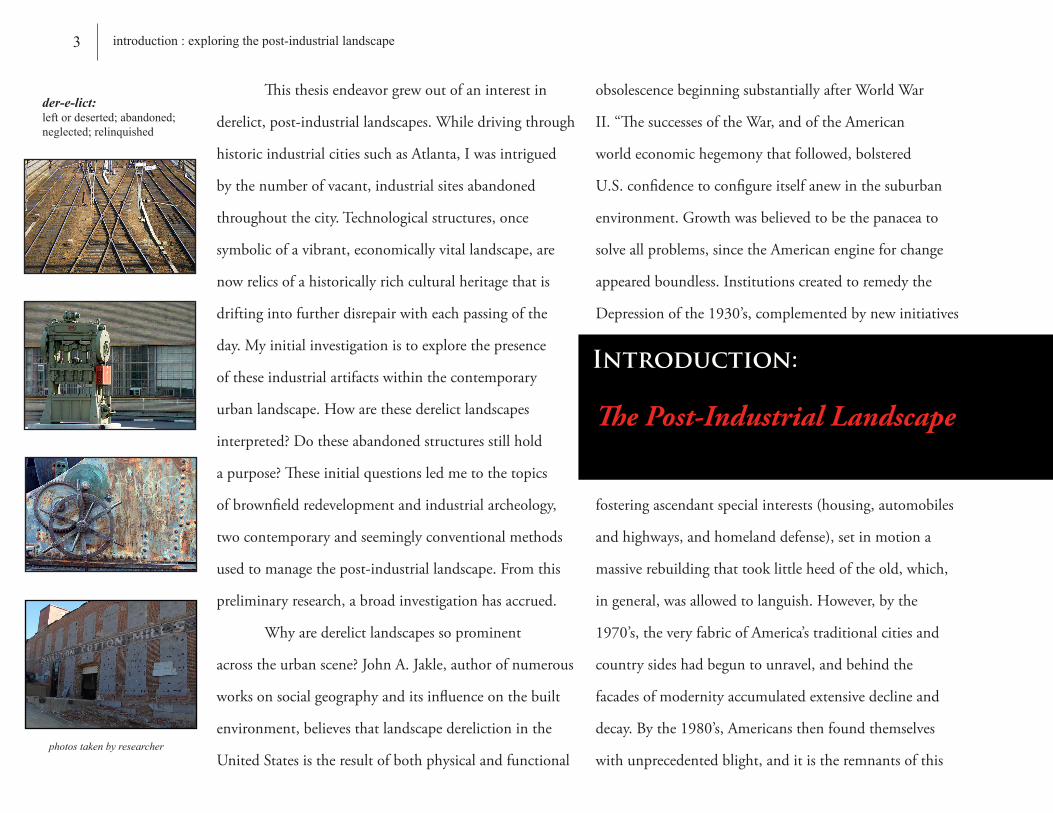
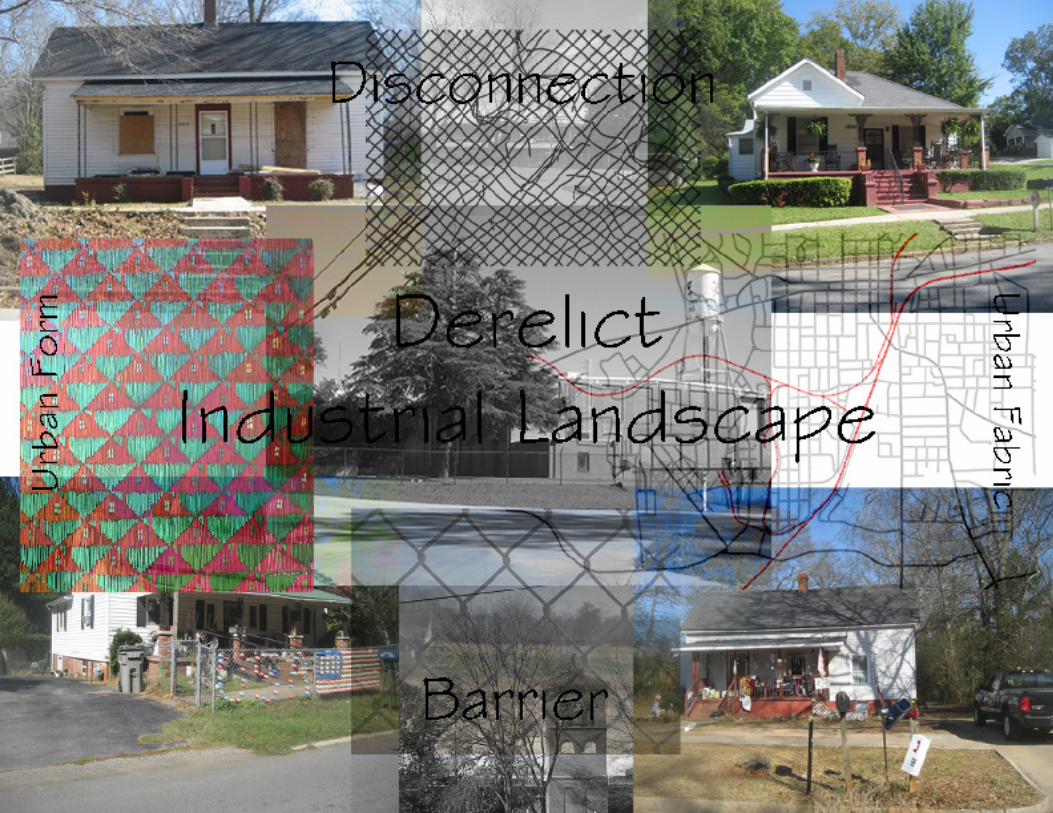
Thisthesisendeavorgrewoutofaninterestin
derelict,post-industriallandscapes.Whiledrivingthrough
historicindustrialcitiessuchasAtlanta,Iwasintrigued
bythenumberofvacant,industrialsitesabandoned
throughoutthecity.Technologicalstructures,once
symbolicofavibrant,economicallyvitallandscape,are
nowrelicsofahistoricallyrichculturalheritagethatis
driftingintofurtherdisrepairwitheachpassingofthe
day.Myinitialinvestigationistoexplorethepresence
oftheseindustrialartifactswithinthecontemporary
urbanlandscape.Howarethesederelictlandscapes
interpreted?Dotheseabandonedstructuresstillhold
apurpose?Theseinitialquestionsledmetothetopics
ofbrownfieldredevelopmentandindustrialarcheology,
twocontemporaryandseeminglyconventionalmethods
usedtomanagethepost-industriallandscape.Fromthis
preliminaryresearch,abroadinvestigationhasaccrued.
Whyarederelictlandscapessoprominent
acrosstheurbanscene?JohnA.Jakle,authorofnumerous
worksonsocialgeographyanditsinfluenceonthebuilt
environment,believesthatlandscapederelictioninthe
UnitedStatesistheresultofbothphysicalandfunctional
obsolescencebeginningsubstantiallyafterWorldWar
II.“ThesuccessesoftheWar,andoftheAmerican
worldeconomichegemonythatfollowed,bolstered
U.S.confidencetoconfigureitselfanewinthesuburban
environment.Growthwasbelievedtobethepanaceato
solveallproblems,sincetheAmericanengineforchange
appearedboundless.Institutionscreatedtoremedythe
Depressionofthe1930’s,complementedbynewinitiatives
fosteringascendantspecialinterests(housing,automobiles
andhighways,andhomelanddefense),setinmotiona
massiverebuildingthattooklittleheedoftheold,which,
ingeneral,wasallowedtolanguish.However,bythe
1970’s,theveryfabricofAmerica’straditionalcitiesand
countrysideshadbeguntounravel,andbehindthe
facadesofmodernityaccumulatedextensivedeclineand
decay.Bythe1980’s,Americansthenfoundthemselves
withunprecedentedblight,anditistheremnantsofthis
The Post-Industrial Landscape
Introduction:
photos taken by researcher
der-e-lict:left or deserted; abandoned; neglected; relinquished
3 introduction : exploring the post-industrial landscape

conditionthatstillpersiststhroughouttheurbanfabric
today”.1Thefactories,mills,powerplants,transport
terminals,railandhighwaygridsthatweseeallaround
ushavenowbecomerelicsthatremindusofthishistoryas
wellasourtransformationintothe“Post-IndustrialAge”.
Formallyconsummatingthewholeorderofoursociety
across
theUnitedStates,thespreadofAmericanIndustryhas
nowrunitscourse,andasocietalchangemustensuethat
recognizesanewandvastlydifferentsetofprinciples.Itis
preciselythoseprinciplesregardingtherelicsofthe
industriallandscapethatIammostinterestedin.
AccordingtoJ.B.Jackson,founderofLandscape
Journal,“weadmireandtrytocollectthingsnotsomuch
fortheirbeautyorvalueasfortheirassociationwitha
phaseofourpast,morespecifically,aprivatevernacular
past”.2However,asAmericans,weseemmostwillingto
appreciateandlearnfromwhathaslatelybeenlost.In
regardstotheindustriallandscapesthatlayderelictacross
thenation,theircontentshaveprogressedonwardleaving
behinddeterioratingstructurestocharacterizethefinal
remnantsofsymbolicvaluetoourindustrialheritage.
Well,whyisourindustrialheritageimportant?Whatisthe
significanceofitsremembrance?InthewordsofJackson,
“ruinsprovideanincentiveforrestorationandareturnto
origins”-(ie.Historyteachesustocherishthepresent,
lessonslearnedsowedon’tmakethesamemistakesover
again).3Inhisessay“ATouroftheMonumentsofPassaic,
NewJersey”,RobertSmithson,anAmericanminimalist
artistfamousforhislandart,noted“aplacewithoutrelics
seemsfullofholesthatinasensearethemonumental
vacanciesthatdefine,withouttrying,thememory-tracesof
anabandonedsetoffutures”.4
Whethertheselandscapesshouldbepreservedfor
QHow are these derelict landscapes interpreted?
Do these abandoned structures still hold a purpose?
4introduction : exploring the post-industrial landscape
photo taken by researcher
1. Jakle and Wilson. “Derelict Landscapes: The Wasting of America’s Built Environment”. pg 9
2. Jackson. “The Necessity for Ruins” .pg 89
3. Jackson. “The Necessity for Ruins”.pg 102
4. “Robert Smithson : The Collected Writings”. pg 72

purposesisuptothevernacularpastoftheobserver.
However,inthewakeofthiscurrentdemolitionand
ignorance,ournationcontinuestoregardthesesitesas
“utilitarianembarrassments,tobeignoredifpossible,
otherwisedespised”.5Thisobservationisheavily
influencedbythefactthatthemostpervasivelandscapes
ofthepost-industrialageareabusedandpolluted
“brownfield”sitesthatpresentnumerouschallenges.
Describedas“abandonedorunderusedindustrialand
commercialsiteswhereredevelopmentiscomplicatedby
realorperceivedcontamination”,6brownfieldobscurities
rangefromtheremediationoftoxicenvironmentsto
thetaskofdefiningnewprogramsforthesecurrently
inhospitableplaces.Mostfrequently,theseparticularsites
areonlynoticediftheirlocationhasthepotentialfor
immediateeconomicdevelopment.Therefore,duetothis
perspectivethatviewstheseparticularareasasaneconomic
incentiveatthecostofenvironmentalremediation,
rarelyistheremuchenticementtocapandconceal
thecontaminatedsoiloradaptivelyre-usetheexisting
buildings.Thebrownfieldremediationprocessbecomes
simplisticandtimeefficientiftheexistingcontentsare
completelyremoved,butconversely,throughthistabula
rasaapproach,thepreservationofthesite’shistoriccontent
becomesobsolete.So,whyinvestthetime?Whatarethe
benefitstotheadaptivere-useofthesehistoricstructures?
Whatcanthesestructuresprovide?tabula rasa (latin) : tablet + erased - to start over; to return to the beginning; re-establish origins
photos taken by researcher
5 introduction : exploring the post-industrial landscape
5. Sande.“Industrial Archeology : A New Look at the American Heritage”. pg 3
6. “Manufactured Sites : Rethinking the Post-Industrial Landscape”. pg 4

Gas Works Park - Seattle, Wa
Case Study: “terra firma giveswaytoterra incognita;thatwhichisvisibleischallengedbytheinvisible.” -RichardHaag-DesignerofGasWorksPark
6 case study : gas works park
Photo courtesy of the cityofseattle.net/gasworkspark

GasWorksParkisatwenty-acrecityparklocated
twomilesNorthofdowntownSeattlealongthenorth
shoreofLakeUnionandthesouthendoftheWallingford
neighborhood.Comprisedofanassemblageofindustrial
ruinsfromthelastremainingcoalgasificationplantinthe
UnitedStates,thesiteisananomaly,anidiosyncratic
momentinabroaderexpanseofcontrastingfabric.
TheSeattleGasLightCompanygasificationplant,
whichoperatedfrom1906to1956,waspurchasedby
theCityofSeattlein1962anddesignedasaparkby
LandscapeArchitectRichardHaagin1975.Interpreting
theindustrialremnants-theturbinesandcompressors,the
scrubbersandgenerators,thesheds,thetowers,andthe
sixty-foothighmoundofcontaminatedsoil-aselements
inan“unself-consciousassemblage”1,Haag’sre-
incorporationoftheoldplantsiteinvolvedbotha
preservationandanadaptivere-useapproach.
Complimentingthestructuresthatheleftasruins,Haag
creativelyre-condtionedafewoftheindustrialremnants
tobecomeutilizedforrecreationalpurposes(ie.what
wastheplant’sexhauster-compressorbuildinghasbeen
convertedintoachildren’s“playbarn”structure).When
theparkwascompleted,RichardHaag’sprojectwas
viewedandprimarilydefinedaseitheranactofindustrial
heritagepreservationandaestheticconsciousraising,or
justanotherreclamationproject.Haagagreedthatallof
Gas Works Site in 1960
Photo courtesy of Seattle Municipal Archives www.seattle.gov/gasworkspark
“Asworksthatmoveaswellasintrigue,thattouchaswellasmean,RichardHaag’sGasWorksParkismorethanaprecursortoacurrentinterestinrevealingnaturalphenomenaandfindingformthroughnaturalprocesses.Rather,thisprojectopensupconnectionsbetweenbothenvironmentalandculturalhistoriesofaparticularplace.GasWorksavoidsaestheticizingnaturalprocessesorreducingnaturalphenomenatopurespectacleasmuchbyomissionasbyaction.Thelandscapeproducesanexcessofformthroughminimalinterventions,andinsodoingprovidesspacesforflightsofimaginationandperiodsofwondermentandrevelation.Haag’sworkexemplifiesapostmodernsublimeinthequestioningofthenondemonstrableandanattempttorepresenttheunpresentable,theinvisibleofthesite.”
-ElizabethK.Meyer,AssociateProfesser,UniversityofVirginiaDepartmentofLandscapeArchitecture
Inside the “Play Barn”
Photo courtesy of seattlephotographs.com
1. Meyer. “Seized by Sublime Sentiments - Bloedel Reserve and Gas Works Park”. pg 8
7 case study : gas works park
thoseassumptionsdodepictthesurfaceoftheproject,
butthattheindustrialruinscontainmuchmorethan
examplesofpreservedhistorictechnology.Byconserving
theindustrialruins,Haagbelievedthattheseremnants
wouldbecome“mnemonicdevicesthatbringtomind
changesinitiatedbyhumans’needtoharnessnaturefor
powerproductionandbuildingmaterials-devicesthat
canexhibitarelationshipbetweentheforcesofhuman
settlementandtechnologicalprogressandtheirimpact
onnaturaldailyprocesses.”2Throughinterventionson
thedisturbedsite,hehopedtocreateaplacewithagreat
formalandvisualpresencethatwouldnotonlyevokethis
relationshiptovisitors,butwouldalsopushthem
throughthebordersofbeautyintoanexcessofformand
experiencethatwasnotagreeablebutpleasurablypainful.
Thus,bydoingthis,hebelievedthatvisitorswouldinduce
apresenceofsublimitywiththesite-astateofmind
inoverwhelmingawe,grandeur,reverence,oremotion
thatwouldevokeeachindividualtoestablishtheirown
personalmeaningtothesite,structure,ormomentin
time.“Mydesignintentionisthattheruinswillhelp
visitorsto“see”thelandscapebyundertandingthesites
initialhumaninterventionanditstransformationthrough
theevolutionofnatural,cultural,andtechnological
processesovertime”.3
WhenRichardHaagencounteredtheGasWorks
site,apreservationistattitudewasnotpre-determined
inthereclamationprocess.Infact,itwasunknown
whetherthestructurecouldbepreservedatall.However,
hisaffectiontowardanemotionalinfluencehefound
residingbehindtheindustrialremnantsaswellasthe
site’ssignificancetothecityofSeattleinspiredhimtodo
somethingwiththeplaceratherthanjustdosomethingto
theplace.TheGasWorkssitenowtellsastoryofprogress
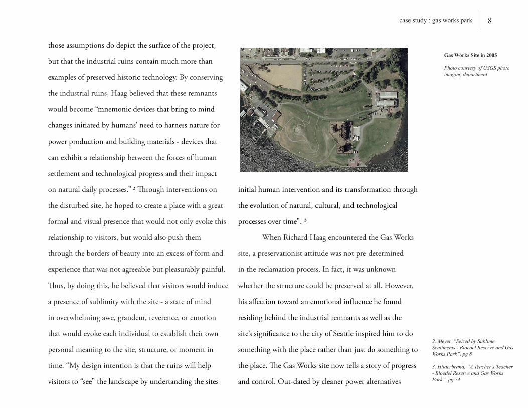
andcontrol.Out-datedbycleanerpoweralternatives
2. Meyer. “Seized by Sublime Sentiments - Bloedel Reserve and Gas Works Park”. pg 8
3. Hilderbrand. “A Teacher’s Teacher - Bloedel Reserve and Gas Works Park”. pg 74
Gas Works Site in 2005
Photo courtesy of USGS photo imaging department
8 case study : gas works park
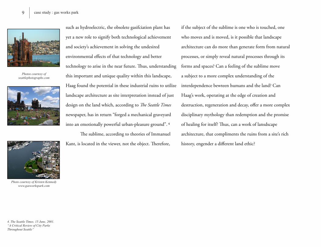
suchashydroelectric,theobsoletegasifciationplanthas
yetanewroletosignifybothtechnologicalachievement
andsociety’sachievementinsolvingtheundesired
environmentaleffectsofthattechnologyandbetter
technologytoariseinthenearfuture.Thus,understanding
thisimportantanduniquequalitywithinthislandscape,
Haagfoundthepotentialintheseindustrialruinstoutilize
landscapearchitectureassiteinterpretationinsteadofjust
designonthelandwhich,accordingtoThe Seattle Times
newspaper,hasinreturn“forgedamechanicalgraveyard
intoanemotionallypowerfulurban-pleasureground”.4
Thesublime,accordingtotheoriesofImmanuel
Kant,islocatedintheviewer,nottheobject.Therefore,
ifthesubjectofthesublimeisonewhoistouched,one
whomovesandismoved,isitpossiblethatlandscape
architecturecandomorethangenerateformfromnatural
processes,orsimplyrevealnaturalprocessesthroughits
formsandspaces?Canafeelingofthesublimemove
asubjecttoamorecomplexunderstandingofthe
interdependencebewteenhumansandtheland?Can
Haag’swork,operatingattheedgeofcreationand
destruction,regenerationanddecay,offeramorecomplex
disciplinarymythologythanredemptionandthepromise
ofhealingforitself?Thus,canaworkoflansdscape
architecture,thatcomplimentstheruinsfromasite’srich
history,engenderadifferentlandethic?
Photo courtesy of Kristen Kennedy www.gasworkspark.com
Photos courtesy of seattlephotographs.com
4. The Seattle Times. 15 June, 2001. “A Critical Review of City Parks Throughout Seattle”
9 case study : gas works park

Photo courtesy of seattlephotographs.com
Photo courtesy of seattlephotographs.com
10 case study : gas works park

ZhongshanShipyardPark,locatedon11hectares
(25acres)oflandalongatributaryofthePearlRiver,
combineshistorical,contemporary,andecological
elementstobothincorporateandacknowledgeChina’s
recentpast.Occupyingthesiteofadesertedshipyardthat
formerlyconsumatedthelargestemployerinZhongshan,
theparkisatributetotheshipyardworkersandmillions
ofotherswhohelpedtobuildmodernChinesesociety.
SituatedintheheartofthePearlRiverDelta,
Zhongshan’sYuezhongShipyardbecamethecoreofthe
city’seconomyfollowingthetransitionfromtraditional
agriculturetoheavyindustryshortlyaftertheturnif
the20thcentury.Operatingfornearlyfiftyyears,the
shipyardbecamemuchmorethanjustanemployerto
thelocalresidents.Yuezhongwasoneofthefoundations
ofthecommunistsocietyenvisionedbyMaoZedong,
formerleaderofthePeople’sRepublicofChina,inwhich
theworkplacewastransitionedintoamonolithicsocial
institutionthatencompassedallaspectsofthelivesoftheir
employees.Inadditiontomonetarycompensation,1,300
workersandtheirfamilieswereprovideddormitories,
cafeterias,schools,andmedicalcareclinics,allofwhich
weremanagedonsite.YuezhongShipyardflourisheduntil
thelate1990’swhenthecity’seconomyshiftedyetagain
fromheavyindustrytoelectronicproductionresultingin
itsclosure.1
KongjianYu,professoroflandscapearchitecture
atBeijingUniversity,incollaborationwithTurenscape,
oneofthelargestlandscapearchitecturefirmsinChina,
reclaimedthisindustriallandscapelessthanadecade
Zhongshan Shipyard Park City of Zhongshan, Guangdong Province, China
Case Study:
Photos courtesy of turenscape.com
11 case study : zhongshan shipyard park
1. Padua, Mary G. “Industrial Strength”. Landscape Architecture Magazine. June. 2003

afteritbecameobsolete.Incorporatingdesignelements
unknownintraditionalChineseparks,Yuandhisteam
“brokefromprevailingpracticebyrecyclingindustrial
buildingsandotherremnantsfromtheoldshipyard”.2
Yuvaluedtheindustrialremnantstoreflectaremarkable
fiftyyearhistoryofsocialistChinathatincludedthe
CulturalRevolutionofthe1960’sand70’s.Hefeltthat
theruinswould“buildaspiritualconnectionbetweenthe
peopleandtheirland”.3
KongjianYu’sdesignhasinfusedtheparkwith
anawarenessofthehardshipsandlaborthatwentinto
buildingthemodernChinesesociety.Throughamixture
ofconservedandrecycledfeaturesthroughoutthepark,Yu
hascombinedrecreationaluseswithsymbolicreferencesto
thehistoryofthesiteandmodernChina.Forexample,
therailroadpathisamajororganizingaxisoftheparkas
wellasareferencetothepathusedtomovevesselsinand
outofthewaterintheshipyard.However,notallofthe
symbolismintheparkemphasizesprogressinChina.The
“RedBox”,designedasaroomforcontemplationofthe
CulturalRevolution-oneofthegrimmestperiodsof
recentChinesehistory-hasbeenknownto“leavethe
strongestimpressiononmostvisitors”.4Constructedof
recycledsteelplatesthatenclosereflectingpools,thespace
callstoattentiontheprofoundpoliticalimplicationsof
thecolorredinChinaandremindsvisitorsofsomeofthe
“Asmallparkthattellsabigstory;astoryoffiftyyearsofcollectivestruggletobuildanewChinesesociety;astoryofoverwhelmingprogressandchange.” -KongjianYu,designerofZhongshanShipyardPark
12 case study : zhongshan shipyard park
Rendered Perspective of Zhongshan Shipyard Park
Photo courtesy turenscape.com
2. Padua, Mary G. “Industrial Strength”. Landscape Architecture Magazine. June. 2003
3. Kongjian, Yu. “The Art of Survival”. pg 41
4. Padua, Mary G. “Industrial Strength”. Landscape Architecture Magazine. June. 2003
Photo courtesy of turenscape.com

famousquotesofVladimirLeninandMaoZedong.Also,
the“GreenRooms”mimicmorethantwodozensixteen
squarefeetareasenclosedineight-footverticalhedgesto
offerastrikingglimpseoftheformerconcreteroomsthat
usedtohousethedormitoriesofclosetoadozenworkers
fortwentyyears.Complimentingallofthesedidatic
features,YuhasalsomadesignificantadvancesinChinese
ecologicaldesign.Byusingnativeplants,Yunotonly
preservedtheoriginalvegetation,soil,andnaturalhabitats,
buthealsoincreasedlocalawarenessoftheregion’srich
agriculturalheritageandmanagedthesiteforfrequent
floodingbytheadjacentriveraswell.
Theaward-winningZhongshanShipyardPark
hasbecomeagroundbreakingprojectforcontemporary
Chineselandscapearchitecture.Constructedinthemidst
ofadramaticriseinurbanization,globalization,
andmaterialism,Yuhasutilizedhisprojecttoraisean
awarenessabouttheprotectionandrebuildingofthe
spiritualhomelandasthemaintanencetoconservecultural
identity.“MaterialismistakingoverChina,asitistherest
oftheWorld.Theland,whichusedtobeinhabitedby
variousspiritsthatmadethelandscapemeaningfuland
poetic,isbecomingcommericalized.Gradually,weare
losingourspiritualconnectionstoourlandtosuperficial,
exchangable,andinternationalimagesoftheworldbeyond
theearthyone”.5Constitutinga“dramaticmeldingof
localhistoryandthenaturalenvironment”,Yu’sparkis
avisiontothepotentialestablishmentofthat“spiritual
connection”forformershipyardworkersaswellaslocal
residentstorelivememoriesofChina’sprogressivepast.6Photos courtesy of turenscape.com
5. Yu, Kongjian. “The Art of Survival”. pg 24
6. McGuire, Leslie. “Connection, Protection, Fusion, and Ethics - The Global Influence of Landscape Architects” LASN. September. 2006
13 case study : zhongshan shipyard park
Photos courtesy of turenscape.com
14 reclaiming the post-industrial landscape : the influences of smithson and eisenmen
The Influences of Smithson and Eisenman
Reclaiming The Post-Industrial Landscape:
1. Berger. “Representation and Reclamation”. pg 6-8
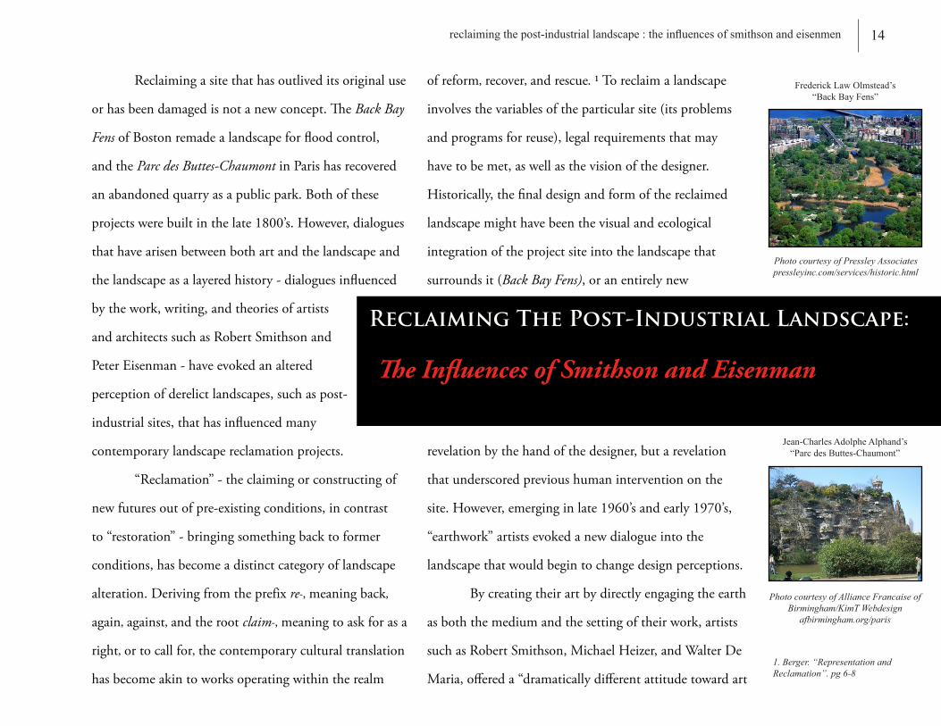
Reclaimingasitethathasoutliveditsoriginaluse
orhasbeendamagedisnotanewconcept.TheBack Bay
FensofBostonremadealandscapeforfloodcontrol,
andtheParc des Buttes-ChaumontinParishasrecovered
anabandonedquarryasapublicpark.Bothofthese
projectswerebuiltinthelate1800’s.However,dialogues
thathavearisenbetweenbothartandthelandscapeand
thelandscapeasalayeredhistory-dialoguesinfluenced
bythework,writing,andtheoriesofartists
andarchitectssuchasRobertSmithsonand
PeterEisenman-haveevokedanaltered
perceptionofderelictlandscapes,suchaspost-
industrialsites,thathasinfluencedmany
contemporarylandscapereclamationprojects.
“Reclamation”-theclaimingorconstructingof
newfuturesoutofpre-existingconditions,incontrast
to“restoration”-bringingsomethingbacktoformer
conditions,hasbecomeadistinctcategoryoflandscape
alteration.Derivingfromtheprefixre-,meaningback,
again,against,andtherootclaim-,meaningtoaskforasa
right,ortocallfor,thecontemporaryculturaltranslation
hasbecomeakintoworksoperatingwithintherealm
ofreform,recover,andrescue.1Toreclaimalandscape
involvesthevariablesoftheparticularsite(itsproblems
andprogramsforreuse),legalrequirementsthatmay
havetobemet,aswellasthevisionofthedesigner.
Historically,thefinaldesignandformofthereclaimed
landscapemighthavebeenthevisualandecological
integrationoftheprojectsiteintothelandscapethat
surroundsit(Back Bay Fens),oranentirelynew
revelationbythehandofthedesigner,butarevelation
thatunderscoredprevioushumaninterventiononthe
site.However,emerginginlate1960’sandearly1970’s,
“earthwork”artistsevokedanewdialogueintothe
landscapethatwouldbegintochangedesignperceptions.
Bycreatingtheirartbydirectlyengagingtheearth
asboththemediumandthesettingoftheirwork,artists
suchasRobertSmithson,MichaelHeizer,andWalterDe
Maria,offereda“dramaticallydifferentattitudetowardart
Photo courtesy of Pressley Associatespressleyinc.com/services/historic.html
Photo courtesy of Alliance Francaise of Birmingham/KimT Webdesign
afbirmingham.org/paris
Frederick Law Olmstead’s “Back Bay Fens”
Jean-Charles Adolphe Alphand’s “Parc des Buttes-Chaumont”

andthelandscapethanthatwhichprevailedatthetime”.2
Smithson,inparticular,becameaveryinfluentialfigure
whenhisworkbeganto“challengethenotionthatculture
andnaturewereopposites”.Heexclaimed“human
interventionontheearthisasmuchapartofnatural
processesasanearthquake.Itisinappropriatetodisguise
asite’shistory.Therelationshipsbetweenhumanand
naturalprocessesshouldbeacknowledgedthroughthe
engagementoftime,change,growth,anddecay”.3
Projects,suchasAsphalt Rundown andPartially Buried
Woodshed,reflectSmithson’saspirationstoevokethat
differentlandethictowardnaturalandimposedprocesses
uponthelandscape.
Complimentingthenotionsofthe“earthwork”
artists,architectPeterEisenmanemergedhisdesignidea
ofthesitecontaininga“palimpsest”intheearly1980’s.A
palimpsestisamanuscriptortabletthathasbeenwritten
uponseveraltimes,oftenwithearlier,imperfectlyerased
writingstillvisible.AccordingtoEisenman,“thinking
ofthesiteasapalimpsestallowsdesignerstoutilize
thesite’slayersofhistorytorevealaspectsofthesite.
Usingprinciplesofcollageandjuxtaposition,history
canbe“seen”notasalinearphenomena,butaslayers
ordiscrepanciesbetweenapastevent(history)thatcan
createanemotionalpresentrecall(memory)”.4
Tomanycontemporarydesigners,urban
wastelandsandotherderelictordamagedsiteshavea
uniquebeautyorcharacter.However,Smithson’sand
Eisenman’sworkhasinspiredcountlessartistsand
designerstoengagenatureasaprocess,ratherthanasa
scenery-designerssuchasRichardHaagandKongjian
Yu,whombyexploitingthatstrongdialoguebetween
alandscapeshistoryanditsrelinquished“art”,have
establishedanemotionalconnectionwiththelandscape
observerandgivenanewmeaningtoplace.5Well,what
doesthisimply?Whatdoestheestablishmentofa“sense
ofplace”offertothelargercontext-beyondtheborders
ofsitespecifity?Placedinthecontextofitspotential
implicationstocommunity,canthisspiritualconnection
orsublimeemotionthatfosterssuchauniquerelationship
betweenhumanandtheland,fosterasimilarrelationship
betweenhumanandhumanaswell?Relationshipsthat
couldadvancethestrengthofsocialcapitalwithinthe
community?
2. “Manufactured Sites : Rethinking the Post-Industrial Landscape”. pg127
3. “The Writings of Robert Smithson”. Edited by Nancy Holt
4. Fisher. “Eisenman Builds”. Progressive Architecture Magazine. October. 1989
5. Steiner. “Human Ecology”. pg 80
Photo courtesy of the Robert Smithson / James Cohan Gallery robertsmithson.com
15 reclaiming the post-industrial landscape : the influences of smihson and eisenman
“Partially Buried Woodshed” Before and After
“Asphalt Rundown”

AccordingtoJ.B.Jackson,a“senseofplace”is
anambigousmoderntranslationofthelatintermgenius
loci.Inclassicaltimesitmeantnotsomuchtheplace
itselfastheguardiandivinityofthatplace.Itwasbelieved
thatalocality-aspace,structure,orwholecommunity
-derivedmuchofitsuniquequalityfromthepresenceor
guardianshipofasupernaturalspirit.Thevisitorandthe
inhabitantswerealwaysawareofthatbenignpresenceand
paidreverencetoitonmanyoccasions.Thephrase
thusimpliedcelebrationorritual,andthelocationitself
acquiredaspecialstatus.1
Wenowusethecurrentversiontodescribe
the“atmosphere”toaplaceorthequalityofits
“environment”.A“senseofplace”nowdescribesplaces
thatare“cherishedbecausetheyareembeddedinthe
everydayworldaroundusandeasilyaccessible,butat
thesametimearedistinctfromthatworld.Placesin
whichavisitisasmallbutsignificantevent,andweare
refreshedandelatedeachtimewearethere.Placesthat
moveusbychangingourmood,inabriefbutvividevent.
Nevertheless,werecognizethatcertainlocalitieshavean
attractionwhichgivesusacertainunidentifiablesenseof
well-beingwhichwewanttoreturnto,timeandagain.
Thus,itisnotatemporaryresponse,foritpersistsand
bringsusback,remindingusofpreviousvisits”.2
Somebelievethata“senseofplace”occurs
onlywiththeestablishmentofa“senseoftime”,such
asaritualorre-occuringevent.Othersbelievethatthe
feeling“comesfromaresponsetofeaturespresentinthe
landscape-eitherabeautifulornaturalsettingorwell-
designedarchitecture.Theybelievethata“senseofplace”
comesfrombeinginanunusualcompositionofspaces
andforms-naturalorman-made”.3Ifthisbeliefholds
true,thenlandscapessuchasGasWorksParkor
16 reclaiming the post-industrial landscape : its attribute to social capital?
QWhat is a “Sense of Place”? What does it mean to social capital?
How do these case studies attribute to the generation of this capital?
genius loci (latin) : spirit + place - the distinctive character or atmosphere of a place; the guardian spirit of a place.
1. Jackson. “A Sense of Place, A Sense of Time”. pg 157
2. Jackson. “A Sense of Place, A Sense of Time”. pg 158
3. Jackson. “A Sense of Place, A Sense of Time”. pg 151

ZhongshanShipyardParkcanbevalidatedtohavingtruly
evokedthatfeelingfromtheobserver.Theintriguing
anddebatablepartthenlieswithJ.B.Jackson’scomments
whichstatethat“fromthisfeelingandexperienceensuesa
senseoffellowhipwiththosewhosharetheexperience,a
fellowshipthatinvolvestheinstinctivedesiretoreturn,to
establishacustomofrepeatedritual”.4Thus,canthe
reclaimedlandscapesdevelopedbyRichardHaagand
KongjianYu,landscapesthatexploitthesite’sgenius loci
throughtheessenceoftimeandchange,attibutetothe
generationofsocialcapitalaswell?Ifso,doesthe
preservationofasite’sremaininghistoryinthe
reclamationprocessofapost-industriallandscapeproveto
benotonlyanaesthetic,butalsoasocialbenefittothe
surroundingcommunity?
Asmythesisendeavorfocusestore-establisha
“senseofcommunity”withinthehistorictextilemill
villageinSouthwestLaGrange,thesecasestudiesreveal
thatthosepost-industriallandscapescanstillpossess
meaningtothatventure.
4. Jackson. “A Sense of Place, A Sense of Time”. pg 159
17 reclaiming the post-industrial landscape : the influences of smihson and eisenman

“terra firma giveswaytoterra incognita;thatwhichisvisibleischallengedbytheinvisible.” -RichardHaag-DesignerofGasWorksPark
18 the site : lagrange, georgia - callaway mills
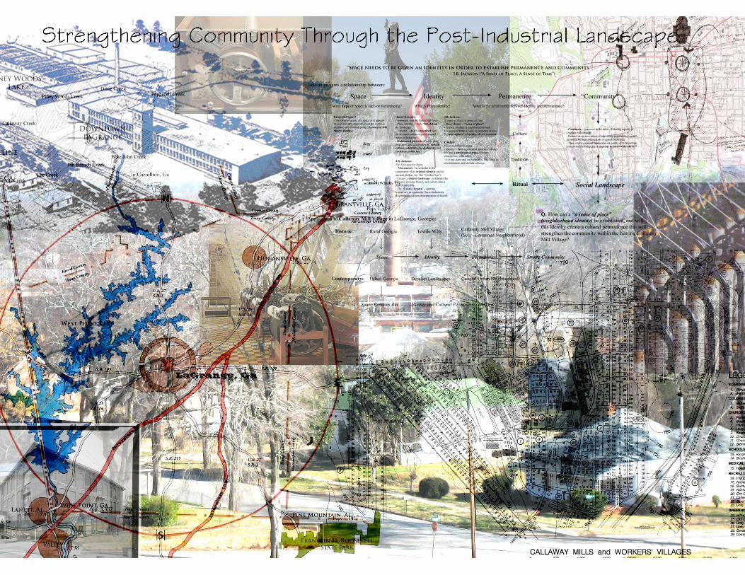
LaGrange, Georgia - CallawayMills
The Site:
Photo taken by researcher
19 the site : geologic history
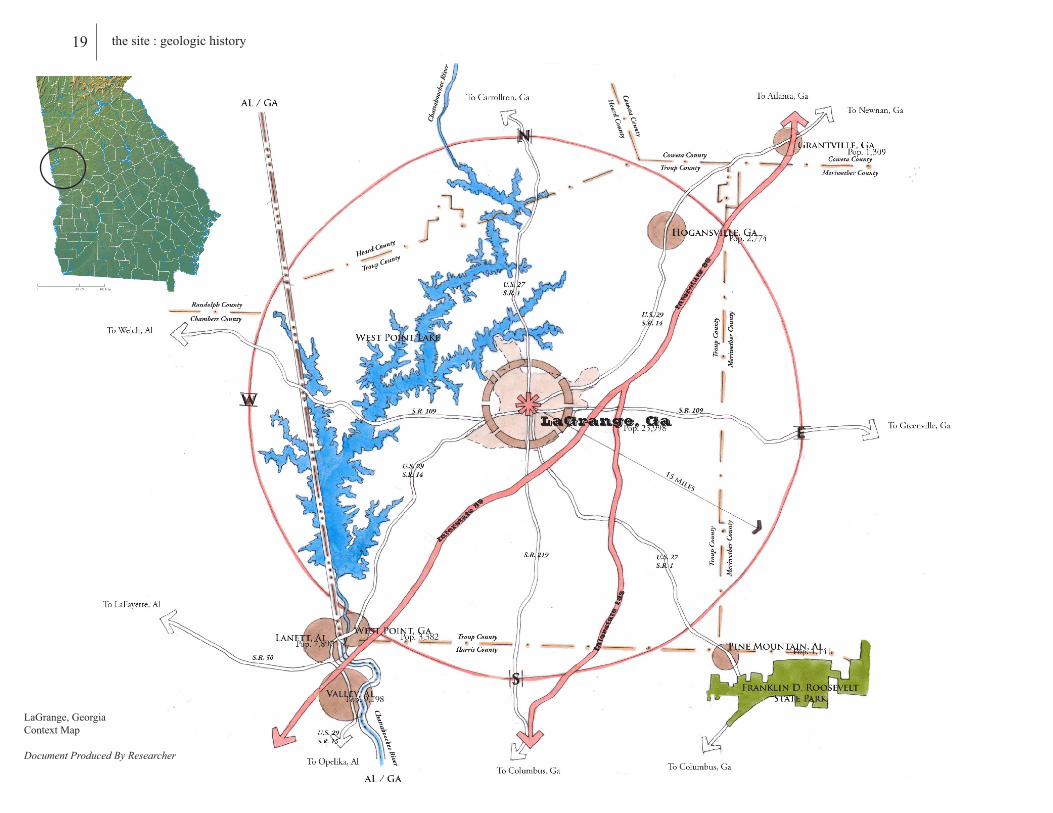
LaGrange, GeorgiaContext Map
Document Produced By Researcher

LaGrange,GeorgiaislocatedintheChattahoochee
Valley,lessthan15milesacrossthestatelinefrom
Alabama.NamedafterthecountryestatenearParisof
theMarquisdeLaFayette,aFrenchmilitaryofficerinthe
AmericanRevolutionaryWarwhomfoundedthearea
in1825,LaGrangehasbeentheCountySeatofTroup
Countysince1828.Thecitycurrentlymaintainsits
positionasatransportationhubofInterstates85and185
whichfosterssatelliteindustriessuchastheKIAMotors
assemblyplantandWal-Marttosupportitspopulationof
nearly26,000citizens.However,LaGrangeisaproductof
thetextileindustry.Aformerindustrialcenterfortextiles
fornearlyacentury,theindustrycompletelytransfomed
thecityasitdidwithmanycitiesintheSouth.Thus,
thehistoryofLaGrangemustfirstbeginwiththehistory
ofthetextileindustry,anindustrythatmaturedalonga
geologicalformationknownasthe“FallLine”.
TheFallLineisaphysiographicbordermarking
anareawhereanuplandregionofhardmetamorphosed
terrain(continentalbedrock)-theproductoftheTaconic
Orogeny,andthesandy,relativelyflatoutwashplainofthe
UpperContinentalShelf(coastalalluvialsediment)meet.
ThisisalsotheoriginalAtlanticOceancoastlineduring
theCretaceousandTertiaryGeologicalPeriods.TheFall
Lineisvisuallyprominentwhencrossedbyariver,for
therewilloftenberapidsorwaterfalls.Manytimesafall
linewillrecedeupstreamastherivercutsouttheuphill
densematerial,ofternforming“c”shapedwaterfalls.
Duetotheseobstructions,riverboatstypicallycannot
travelanyfartherinlandwithoutportaging,unlesslocks
arepresent.Ontheotherhand,therapidchangeinthe
elevationofwater,andtheresultingenergyrelease,made
falllinesagoodlocationforinitalgristandsawmills,etc.
Thus,throughtheutilizationofthiswaterpowerresource
20 the site : geologic history
Columbus, GeorgiaChattahoochee River
Photo Taken By Researcher

Piedmont-Coastal Plain Fall Line
Base Map Courtesy of USGS.comDocument Produced By Researcher
21 the site : geologic history

22 the site : textile history
inconjunctionwithadirectriverportforinlandtrade
totheeasterncontinentalcoast,settlementsknownas
“portage”townsoccupiedriverintersectionsthroughout
theentiretyofthisgeologicformation.
ThenorthernedgeoftheFallLinecontainsthe
“roots”oftheAmericantextileindustry.Occupyingthe
siteofaformergristmill,industrialistSamuelSlater
openedAmerica’sfirstsuccessfulwaterpoweredtextile
millinPawtucket,RhodeIslandin1793.Withthepatent
ofEliWhitney’scottonginshortlyafterwardsin1794,
Slater’sformerlyBristishindustrygrewtremendously
throughoutNewEngland.IntheantebellumSouth,
however,thetextileindustrydevelopedslowly.The
inventionofthecottonginturnedrawcottonintoa
highlyprofittablecrop.Aslongasthepriceremained
high,“Southernerslookedfornootherinvestment”.
Thus,duringtheearly19thcentury,theSouth’seconomy
remainedfirmlyentrenchedinagriculturedominated
bythecottonplantation.However,theSouthwasnot
completelydevoidofearlycottonmills.In1808,the
firsttextilemillwasfoundedbyDr.JohnShecutwhom
establishedtheSouthCarolinaHomespunCompany
inCharlestonutilizinganoldgristmill.Muchlike
thecurrentSoutherngristandsawmills,tanneries,
andblacksmithshopsthatappearedwiththeearliest
settlements,thistextilemillalongwithmanyother
Southernmillsbefore1830,remainedlocalizedwith
small-scaleproduction.
Ascottonpricesbegantofall,plantersbeganto
investincottonmanufacturing.Accordingtohistorian
RandallMiller,“theconcernfortextilemanufacturers
grewoutoftheplanters’dissatisfactionwiththefrequent
andannoyingfluctuationsinthepriceofrawcotton,crop
failures,thedramaticdeclineofcottonpricesinthe1840’s
duetotheincreasedavailabilityofthecottongin,andout
ofthis,thegrowingirritationandembarrassmentoverthe
South’sslavishdependenceuponahostileNorthforbasic
goodsandservices”.1OftheSouthernstates,Georgiain
particularexperiencedthefirstdramaticincreaseinthe
developmentofcottonmillsfrom(19)in1840to(35)by
1850.However,from1880to1920,textilemanufacturing
wouldspreadrapidlythroughouttheSouthasthreestates
-NorthCarolina,SouthCarolina,andGeorgia-would
eventuallydominatethesoutherntextileindustryandhelp
1. Turner, Julie. “Historic American Enginneering Southern Textile Industry”. Randall Miller Interview.

23 the site : textile history
theSouthclaimafull60%ofU.S.mills.Althoughthe
northernstateslayclaimtothe“roots”oftheAmerican
textileindustry,theSouthwouldutilizecheaplaborand
alocally-grownproducttogenerateover600millsduring
thatfour-decadespan(increasingfrom161tomorethan
700)anddevelopintothefoundationoftheindustry
throughoutthe20thcentury.
TheestablishmentoftextileindustryinTroup
County,Ga.canbeattributedtoRobertRobertson,a
Scottishimmigrantwhom,in1847,convertedanold
gristmillonTurkeyCreekintheSouthwestpartofthe
countyintoatextilemill.Hisentrepreneurshipledtothe
conversionofTroupFactoryandmanyothertextilemills
fromoldgristmillsitesthroughoutthecounty.However,
itwasn’tuntil1895beforethefirsttextilemillwould
becomeestablishedinLaGrange,Georgia.Following
the1895CottonStatesandInternationalExpositionin
thecityofAtlanta,Georgia,J.H.LaneandCompany
-aninvestmentcompanyinBoston,Massachusetts-in
partnershipwithlocalresidentsofLaGrangesuchas
BenjaminH.HillandFullerE.CallawayestablishedDixie
Millthatsameyear.UndertheleadershipofMr.FulllerE.
Callaway,thecityofLaGrangewouldestablishsevenmore
millsbetween1900and1930,andtransformfroman
agriculturalcommunityintoanindustrialcenter.
Ranging1500kmalongtheeasterncoastofthe
UnitedStates,thesectionoftheFallLineknownasthe
“Piedmont-CoastalPlainFallLine”(wherethePiedmont
oftheAppalachiansdescendssteeplytotheCoastal
Plain)encompassedthe“cottonbelt”andtheheartofthe
textilemanufacturinginthe21stCentury.Freedfrom
thedependenceonapowerfulriversourceduetothe
inventionofthe“WattsEngine”in1788-asteamengine
developedbyJamesWattwhichincludedacentrifugal
governortocontrolthespeedoftheengine-citiesnow
needonlyacreektoprovidethewatersourcetopower
thetextilefactories.Thus,citiessuchasLaGrangebegan
toflourishoutsideofthis“FallLine”andcontinuously
growthroughoutthistextileboom.Accompanyinglarger
groupsofnewemployeesmigratingtothesepreviously
ruralestablishmentsdaily,theconceptofthe“millvillage”
begantoaccompanythistextileindustrialboom.

The “Fall Line”
Base Map Courtesy of USGS.comDocument Produced By Researcher
24 the site : textile history
1. Courtesy of “Building Social Capital Through Community Development”. Journal of the American Planning Association.
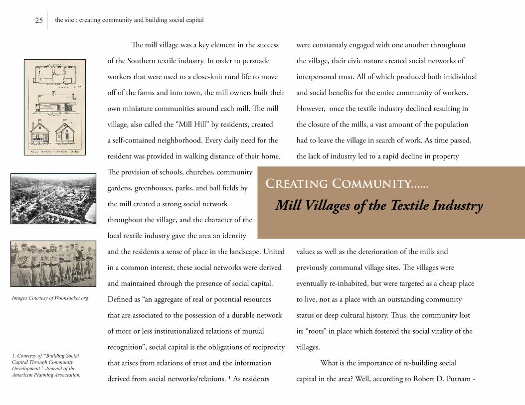
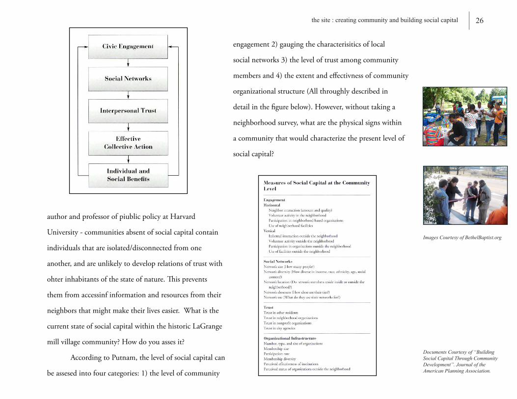
Themillvillagewasakeyelementinthesuccess
oftheSoutherntextileindustry.Inordertopersuade
workersthatwereusedtoaclose-knitrurallifetomove
offofthefarmsandintotown,themillownersbuilttheir
ownminiaturecommunitiesaroundeachmill.Themill
village,alsocalledthe“MillHill”byresidents,created
aself-cotnainedneighborhood.Everydailyneedforthe
residentwasprovidedinwalkingdistanceoftheirhome.
Theprovisionofschools,churches,community
gardens,greenhouses,parks,andballfieldsby
themillcreatedastrongsocialnetwork
throughoutthevillage,andthecharacterofthe
localtextileindustrygavetheareaanidentity
andtheresidentsasenseofplaceinthelandscape.United
inacommoninterest,thesesocialnetworkswerederived
andmaintainedthroughthepresenceofsocialcapital.
Definedas“anaggregateofrealorpotentialresources
thatareassociatedtothepossessionofadurablenetwork
ofmoreorlessinstitutionalizedrelationsofmutual
recognition”,socialcapitalistheobligationsofreciprocity
thatarisesfromrelationsoftrustandtheinformation
derivedfromsocialnetworks/relations.1Asresidents
wereconstantalyengagedwithoneanotherthroughout
thevillage,theircivicnaturecreatedsocialnetworksof
interpersonaltrust.Allofwhichproducedbothinidividual
andsocialbenefitsfortheentirecommunityofworkers.
However,oncethetextileindustrydeclinedresultingin
theclosureofthemills,avastamountofthepopulation
hadtoleavethevillageinsearchofwork.Astimepassed,
thelackofindustryledtoarapiddeclineinproperty
valuesaswellasthedeteriorationofthemillsand
previouslycommunalvillagesites.Thevillageswere
eventuallyre-inhabited,butweretargetedasacheapplace
tolive,notasaplacewithanoutstandingcommunity
statusordeepculturalhistory.Thus,thecommunitylost
its“roots”inplacewhichfosteredthesocialvitalityofthe
villages.
Whatistheimportanceofre-buildingsocial
capitalinthearea?Well,accordingtoRobertD.Putnam-
Mill Villages of the Textile Industry
Creating Community......
25 the site : creating community and building social capital
Images Courtesy of Woonsocket.org
authorandprofessorofpiublicpolicyatHarvard
University-communitiesabsentofsocialcapitalcontain
individualsthatareisolated/disconnectedfromone
another,andareunlikelytodeveloprelationsoftrustwith
ohterinhabitantsofthestateofnature.Thisprevents
themfromaccessinfinformationandresourcesfromtheir
neighborsthatmightmaketheirliveseasier.Whatisthe
currentstateofsocialcapitalwithinthehistoricLaGrange
millvillagecommunity?Howdoyouassesit?
AccordingtoPutnam,thelevelofsocialcapitalcan
beassesedintofourcategories:1)thelevelofcommunity
engagement2)gaugingthecharacterisiticsoflocal
socialnetworks3)theleveloftrustamongcommunity
membersand4)theextentandeffectivnessofcommunity
organizationalstructure(Allthroughlydescribedin
detailinthefigurebelow).However,withouttakinga
neighborhoodsurvey,whatarethephysicalsignswithin
acommunitythatwouldcharacterizethepresentlevelof
socialcapital?
26 the site : creating community and building social capital
Documents Courtesy of “Building Social Capital Through Community Development”. Journal of the American Planning Association.
Images Courtesy of BethelBaptist.org
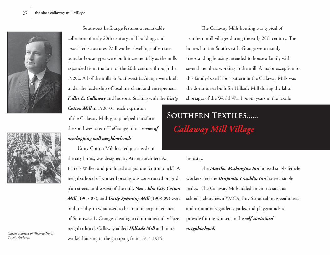
SouthwestLaGrangefeaturesaremarkable
collectionofearly20thcenturymillbuildingsand
associatedstructures.Millworkerdwellingsofvarious
popularhousetypeswerebuiltincrementallyasthemills
expandedfromtheturnofthe20thcenturythroughthe
1920’s.AllofthemillsinSouthwestLaGrangewerebuilt
undertheleadershipoflocalmerchantandentrepreneur
Fuller E. Callawayandhissons.StartingwiththeUnity
Cotton Millin1900-01,eachexpansion
oftheCallawayMillsgrouphelpedtransform
thesouthwestareaofLaGrangeintoaseries of
overlapping mill neighborhoods.
UnityCottonMilllocatedjustinsideof
thecitylimits,wasdesignedbyAtlantaarchitectA.
FrancisWalkerandproducedasignature“cottonduck”.A
neighborhoodofworkerhousingwasconstructedongrid
planstreetstothewestofthemill.Next,Elm City Cotton
Mill(1905-07),andUnity Spinning Mill (1908-09)were
builtnearby,inwhatusedtobeanunincorporatedarea
ofSouthwestLaGrange,creatingacontinuousmillvillage
neighborhood.CallawayaddedHillside Millandmore
workerhousingtothegroupingfrom1914-1915.
TheCallawayMillshousingwastypicalof
southernmillvillagesduringtheearly20thcentury.The
homesbuiltinSouthwestLaGrangeweremainly
free-standinghousingintendedtohouseafamilywith
severalmembersworkinginthemill.Amajorexceptionto
thisfamily-basedlaborpatternintheCallawayMillswas
thedormitoriesbuiltforHillsideMillduringthelabor
shortagesoftheWorldWarIboomyearsinthetextile
industry.
TheMartha Washington Innhousedsinglefemale
workersandtheBenjamin Franklin Innhousedsingle
males.TheCallawayMillsaddedamenitiessuchas
schools,churches,aYMCA,BoyScoutcabin,greenhouses
andcommunitygardens,parks,andplaygroundsto
providefortheworkersintheself-contained
neighborhood.
27 the site : callaway mill village
Images courtesy of Historic Troup County Archives.
Callaway Mill Village
Southern Textiles......

ThedevelopmentofthetextileindustryinLaGrange,GeorgiareflectstheindustrialgrowthoftheentirePiedmontRegionoftheSoutheasternUnitedStatesinthelate19thCenturyandearly20thCenturies.Withthegrowingprevalenceofsteam-engineinsteadofwater-poweredmills,thetextileindustrydevelopmentmovedawayfromtheriverbanksandclosertorailroadlinesforeasierdeliveryofrawmaterialsandshipmentofproducts.LaGrange,amercantilecenterandcountyseat,wasthelargesttowninTroupCountyandofferedgoodrailroadaccess.ThemillsinLaGrangewerelocatednexttoastreamorcreektoprovideasteadywatersourceforthesteam-poweredengines,andartificialpondswerelaterconstructedascoolinganddischargeareasforthemills.
LaGrange/Calumet Mill
Hillside Mill
Unity Spinning Mill Elm City Mill
Unity Cotton Mill
Dunson MillDixie Mill
Image Courtesy of Sanborn Fire Insurance Map Set, ca. 1930
Photos Courtesy of H.A.E.R.
28 the site : callaway mill village
Downtown LaGrange
The SiteCallaway Mill Village
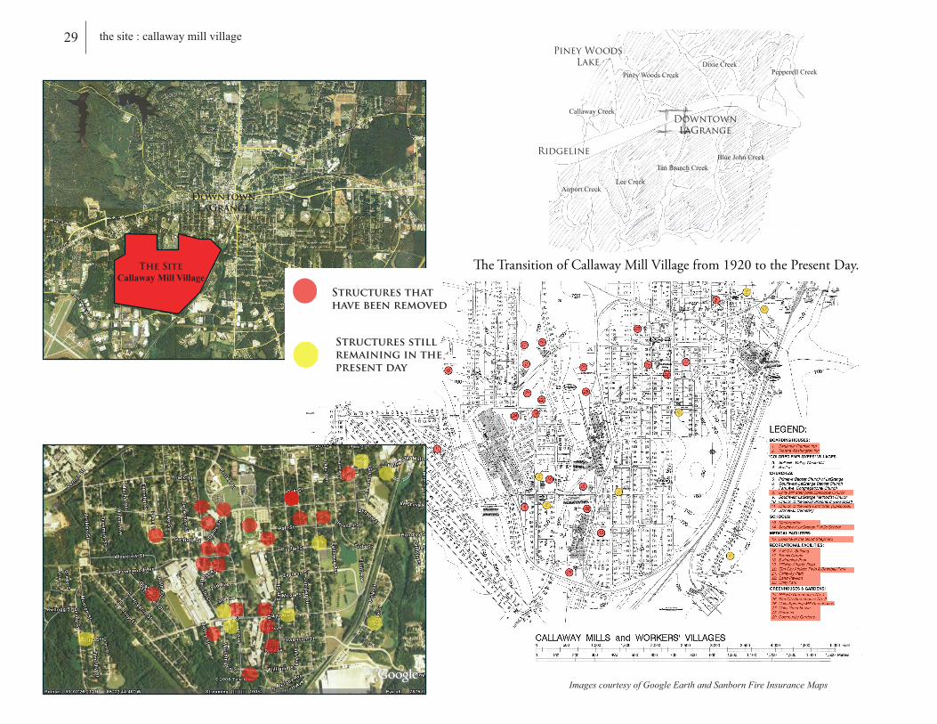
Structures that have been removed
Structures still remaining in the present day
Images courtesy of Google Earth and Sanborn Fire Insurance Maps
29 the site : callaway mill villagePiney Woods
Lake
Downtown LaGrange
Ridgeline
Callaway Creek
Piney Woods CreekDixie Creek
Airport Creek
Pepperell Creek
Lee Creek
Tan Branch CreekBlue John Creek
TheTransitionofCallawayMillVillagefrom1920tothePresentDay.

30 the site : physical signs of social capital
1. Courtesy of “Building Social Capital Through Community Development”. Journal of the American Planning Association.
Images Courtesy of BethelBaptist.org
1)Places for Organizational Meetings
-Parks
-Churches
-Schools
-CommunityCenters
2)Location of Goods and Services
-Thelocationofgoodsandservicesfosterplaces
forsocialinteraction.
-Dotheresidentsgettheirgoodsandserviceslocally,
oraretheirneedslocatedoutsideofthecommunity?
3)Home Ownership vs. Rental Property
Rentersarelesslikelyto:
A)liveintheneighbiorhoodlongenoughto
developstrongneighborlyrelationships
B)beactiveincommunityinterests
(ie.maintainingproperty,joiningassocations,or
gettinginvolvedincommunityclean-upprojectsetc.)
Accordingtothe“JournaloftheAmericanPlanningAssociation”,whengaugingthelevelofsocialcapitalwithina
community,thereare3 physical signsonecanlookfor:

31 the site : physical signs of social capital
Images and Photos Produced by Researcher
1) Places for Organizational Meetings
Schools
SiteAnalysisoftheHistoricCallawayMillVillageofLaGrange,Ga.

Places for Organizational Meetings.............
Parks
32 the site : physical signs of social capital
Images and Photos Produced By Researcher
SiteAnalysisoftheHistoricCallawayMillVillageofLaGrange,Ga.

Places for Organizational Meetings............
Images and Photos Produced By Researcher
Churches&CommunityCenters
SiteAnalysisoftheHistoricCallawayMillVillageofLaGrange,Ga.
33 the site : physical signs of social capital

34 the site : physical signs of social capital
Images and Photos Produced by Researcher
2) Location of Goods and Services
AnalysisofPotentialSocialNetworkDensity/“Daily Rituals”
HistoricZoningMap PresentDayZoningMap
DowntownLaGrange
1/4MileRadius
1/4MileRadius
1/2MileRadius
1/2MileRadius
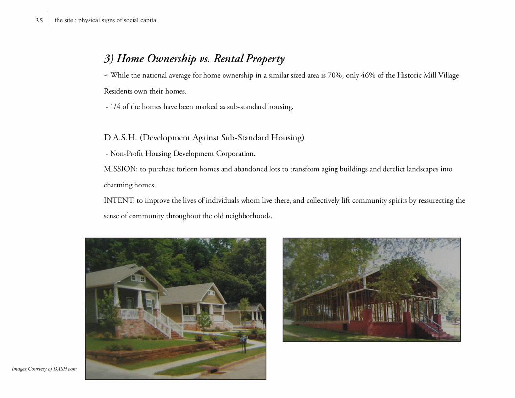
3) Home Ownership vs. Rental Property- Whilethenationalaverageforhomeownershipinasimilarsizedareais70%,only46%oftheHistoricMillVillage
Residentsowntheirhomes.
-1/4ofthehomeshavebeenmarkedassub-standardhousing.
D.A.S.H.(DevelopmentAgainstSub-StandardHousing)
-Non-ProfitHousingDevelopmentCorporation.
MISSION:topurchaseforlornhomesandabandonedlotstotransformagingbuildingsandderelictlandscapesinto
charminghomes.
INTENT:toimprovethelivesofindividualswhomlivethere,andcollectivelyliftcommunityspiritsbyressurectingthe
senseofcommunitythroughouttheoldneighborhoods.
Images Courtesy of DASH.com
35 the site : physical signs of social capital
36 the site : physical signs social capital
Photos Produced by Researcher
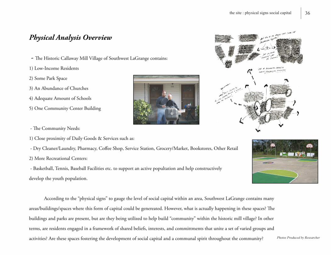
Physical Analysis Overview
- TheHistoricCallawayMillVillageofSouthwestLaGrangecontains:
1)Low-IncomeResidents
2)SomeParkSpace
3)AnAbundanceofChurches
4)AdequateAmountofSchools
5)OneCommunityCenterBuilding
-TheCommunityNeeds:
1)CloseproximityofDailyGoods&Servicessuchas:
-DryCleaner/Laundry,Pharmacy,CoffeeShop,ServiceStation,Grocery/Market,Bookstores,OtherRetail
2)MoreRecreationalCenters:
-Basketball,Tennis,BaseballFacilitiesetc.tosupportanactivepopultationandhelpconstructively
developtheyouthpopulation.
Accordingtothe“physicalsigns”togaugethelevelofsocialcapitalwithinanarea,SouthwestLaGrangecontainsmany
areas/buildings/spaceswherethisformofcapitalcouldbegenereated.However,whatisactuallyhappeninginthesespaces?The
buildingsandparksarepresent,butaretheybeingutilizedtohelpbuild“community”withinthehistoricmillvillage?Inother
terms,areresidentsengagedinaframeworkofsharedbeliefs,interests,andcommittmentsthatuniteasetofvariedgroupsand
activities?Arethesespacesfosteringthedevelopmentofsocialcapitalandacommunalspiritthroughoutthecommunity?

Theideaofcommunitasisrepresentedina
frameworkofsharedbeliefs,interests,andcommitments
thatunitesasetofvariedgroupsandactivities.Thus,
Communityisdependentupontheconnectionand
formationofsocialnetworks-thebackboneofSocial
Capital.
TheestablishmentofCommunityisfirst
dependentonthepresenceofaneighborhood structure.
TheNeighborhoodisthebackboneof
Community.Itshouldaccomodategrowth
for a diverse array of lifestyles, incomes,
and needs to provide marketable and viable
choices thatretain a sense of belonging and
identity. Anappropriatemixofuses,housingtypes,and
astrongdesignareessentialtodevelopinglivable and
sustainableneighborhoods.Aneighborhoodcanbemade
upofmanyqualities,amenities,andcharacteristics,and
theyvarydependingonage,geography,anddevelopment
pattern.However,therearebasicstructuralareasthat
shouldbeimplementedtodevelopastrongneighborhood
layout:
1)NeighborhoodCenter - Aneighborhoodshouldhavea
“heart”-aplacethatitsresidentscanidentifyasthefocal
or gathering point.
-TheNeighborhoodCenterservesacommonpurposeto
provideaplace for daily interaction-aplacethat
includesretail,food,anddailyservices,alltypicallywithin
afive-minutewalkofmostpartsoftheneighborhood.
-Thesecentersaremadeupofmanytypesofbuildings
andusesthatworktogethertoform a dynamic,
pedestrian-friendly environment.
-Varioustypesofresidentialunitsarenearlyalways
present,anddependingonthesetting,maybe
incorporatedinmixed-usebuildings.
2)NeighborhoodGeneral-Single-familyattachedor
detachedhomesonsmallerlots.Thismayinclude
townhomesorcottagespreferrablyhavinggarageaccess
fromalleyways.
3)Neighborhood Edge - Theleastintenseareaofthe
Assessing Social Capital
Site Analysis
37 site analysis : assessing social capital
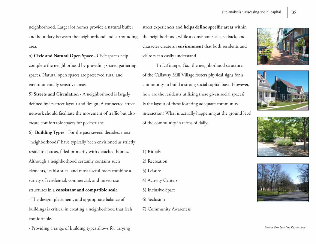
neighborhood.Largerlothomesprovideanaturalbuffer
andboundarybetweentheneighborhoodandsurrounding
area.
4)Civic and Natural Open Space - Civicspaceshelp
completetheneighborhoodbyprovidingsharedgathering
spaces.Naturalopenspacesarepreservedruraland
environmentallysensitiveareas.
5)Streets and Circulation - Aneighborhoodislargely
definedbyitsstreetlayoutanddesign.Aconnectedstreet
networkshouldfacilitatethemovementoftrafficbutalso
createcomfortablespacesforpedestrians.
6) Building Types - Forthepastseveraldecades,most
“neighborhoods”havetypicallybeenenvisionedasstrictly
residentialareas,filledprimarilywithdetachedhomes.
Althoughaneighborhoodcertainlycontainssuch
elements,itshistoricalandmostusefulrootscombinea
varietyofresidential,commercial,andmixeduse
structuresinaconsistant and compatible scale.
-Thedesign,placement,andappropriatebalanceof
buildingsiscriticalincreatinganeighborhoodthatfeels
comfortable.
-Providingarangeofbuildingtypesallowsforvarying
streetexperiencesandhelps define specific areaswithin
theneighborhood,whileaconsistantscale,setback,and
charactercreateanenvironmentthatbothresidentsand
visitorscaneasilyunderstand.
InLaGrange,Ga.,theneighborhoodstructure
oftheCallawayMillVillagefostersphysicalsignsfora
communitytobuildastrongsocialcapitalbase.However,
howaretheresidentsutilizingthesegivensocialspaces?
Isthelayoutofthesefosteringadequatecommunity
interaction?Whatisactuallyhappeningatthegroundlevel
ofthecommunityintermsofdaily:
1)Rituals
2)Recreation
3)Leisure
4)ActivityCenters
5)InclusiveSpace
6)Seclusion
7)CommunityAwareness
38 site analysis : assessing social capital
Photos Produced by Researcher

39 site analysis : assessing social capital
Hospital
1/4 Mile Radius
1/2 Mile Radius
LaGrange College Campus
S.R. 209
U.S. 27U.S. 29
Downtown LaGrange
Industrial Park
ElementarySchool
K-12 Private School
Middle-School
Industrial Park
ElementarySchool
ElementarySchool
CallawayMemorial
Park
HighwayPrimary Route Through Site
Textile MillSites
Image and Photos Produced by Researcher
40 site analysis : assessing social capital
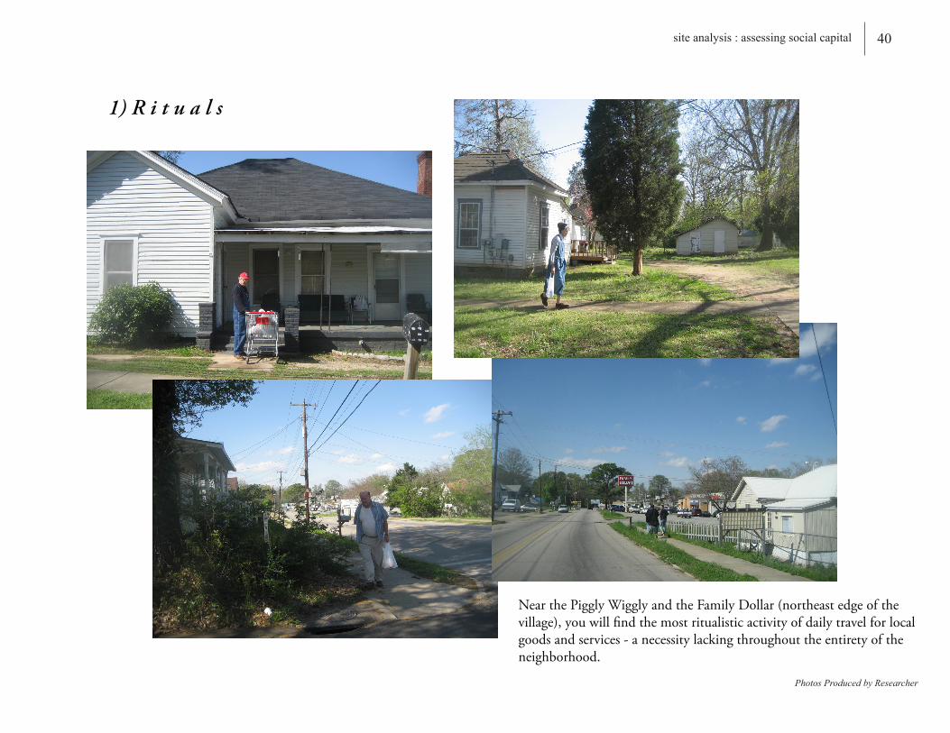
1) R i t u a l s
NearthePigglyWigglyandtheFamilyDollar(northeastedgeofthevillage),youwillfindthemostritualisticactivityofdailytravelforlocalgoodsandservices-anecessitylackingthroughouttheentiretyoftheneighborhood.
Photos Produced by Researcher

41 site analysis : assessing social capital
2) R e c r e a t i o n
Duetothelackofformalrecreationalareas,youwillfindmanyresidentsutilizingabandonedfields,yards,oremptystreetstofulfillrecreationalneeds.
Photos Produced by Researcher

42site analysis : assesing social capital
3) L e i s u r e
Nearlyeveryhomeinthevillagewasbuiltwithafrontporch.Theseporcheshavebecomethefocalpointfordailyleisureintheneighborhood.
Photos Produced by Researcher

43 site analysis : assessing social capital
4) A c t i v i t y C e n t e r
Onceagainwefindthefrontporchservingastheprimaryareaofactivitywithmostofthesespacesbeingusedasalaundromat,storagespace,oroutdoorroom.
Photos Produced by Researcher

44 site : assesing social capital
5) I n c l u s i v e S p a c e
Therearehardlyanyfencesseparatinghousinglots.Thus,manyactivitiesflowovertotheneighboringyard.Thefrontporch,notthepropertylineseemstobetheboundarythatdistinguisheseachhome.
Photos Produced by Researcher
45 site analysis : assessing social capital
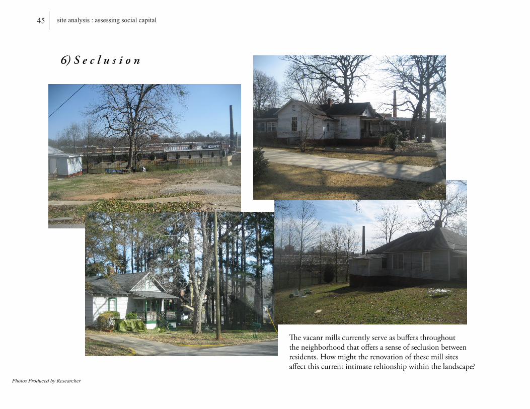
6) S e c l u s i o n
Thevacanrmillscurrentlyserveasbuffersthroughouttheneighborhoodthatoffersasenseofseclusionbetweenresidents.Howmighttherenovationofthesemillsitesaffectthiscurrentintimatereltionshipwithinthelandscape?
Photos Produced by Researcher
46 site analysis : assessing social capital
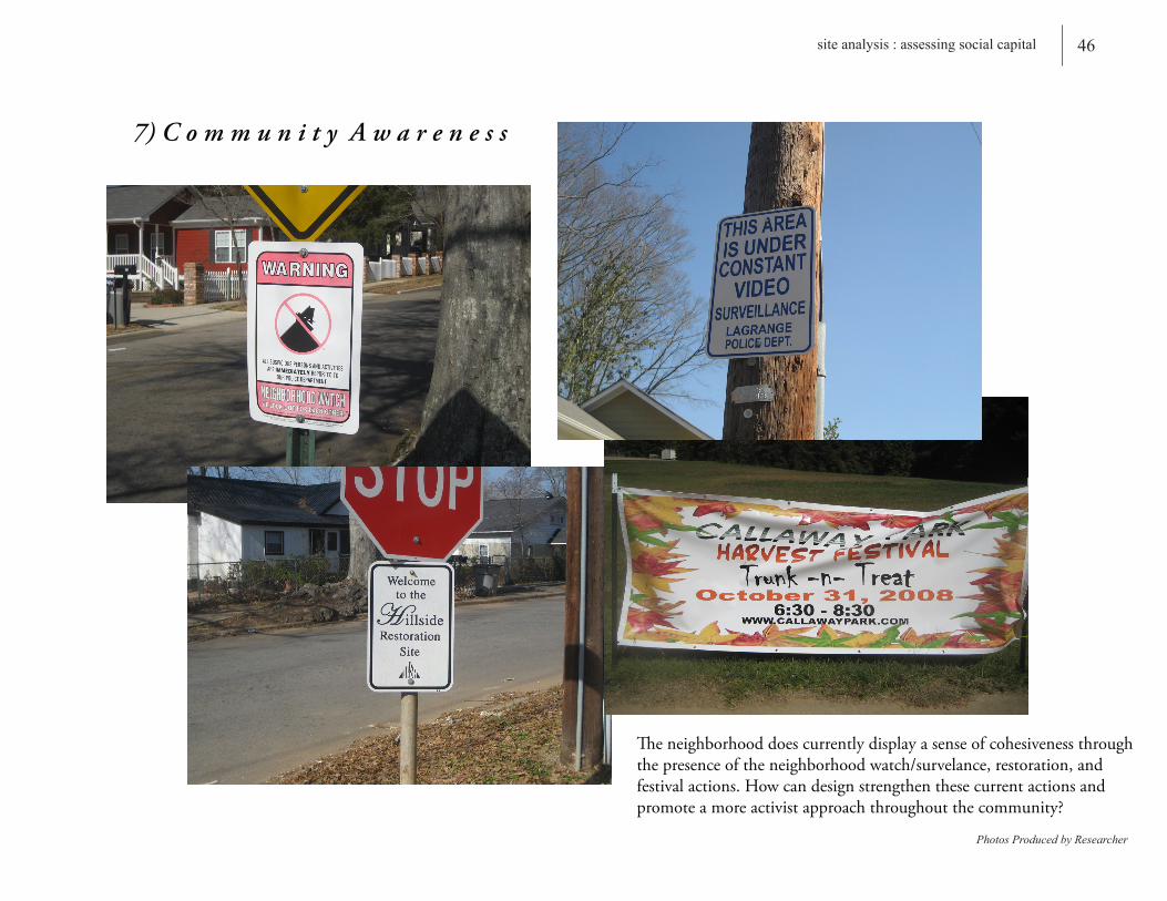
7) C o m m u n i t y A w a r e n e s s
Theneighborhooddoescurrentlydisplayasenseofcohesivenessthroughthepresenceoftheneighborhoodwatch/survelance,restoration,andfestivalactions.Howcandesignstrengthenthesecurrentactionsandpromoteamoreactivistapproachthroughoutthecommunity?
Photos Produced by Researcher
47 site design : building social capital
Document Produced by Researcher
Hospital
1/4 Mile Radius
1/2 Mile Radius
LaGrange College Campus
S.R. 209
U.S. 27
U.S. 29
(Single-Family Residential)Area incorporated before Southwest LaGrange Mill
Construction in 1900
(Mill Village)Single-Family Residential
constructed for Unity Mill between
1900-1907
(Mill Village)Single-Family Residential constructed for Elm City and Unity Spinning Mill
between 1905-1909
(Mill Village)Single-Family Residential
constructed for Hillside Mill between
1905-1909
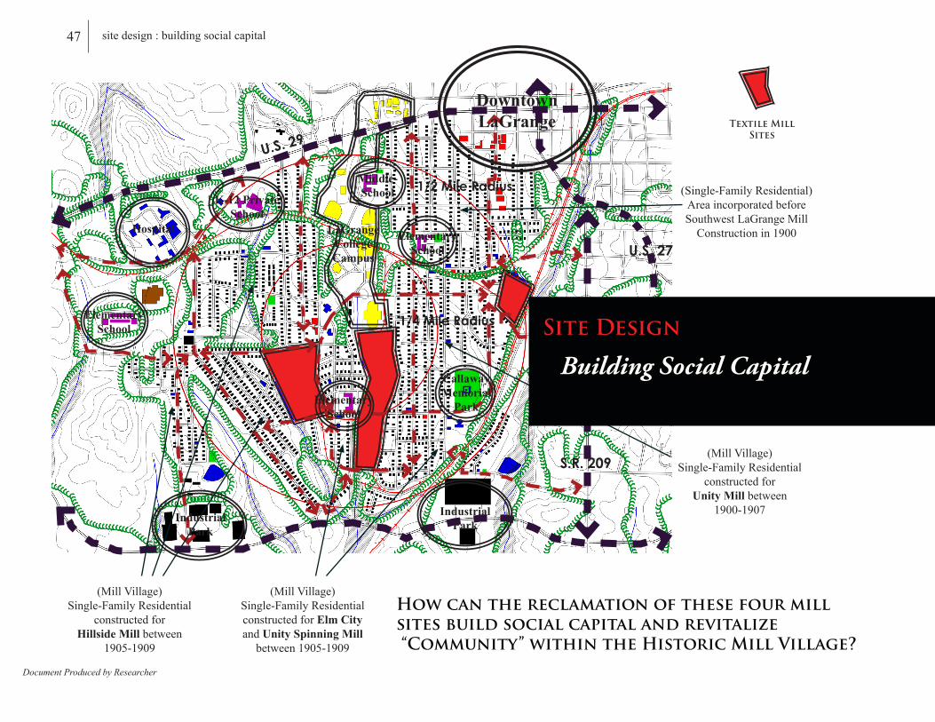
How can the reclamation of these four mill sites build social capital and revitalize “Community” within the Historic Mill Village?
Downtown LaGrange Textile Mill
Sites
Industrial Park
ElementarySchool
K-12 Private School
Middle-School
Industrial Park
ElementarySchool
ElementarySchool
CallawayMemorial
Park
Building Social Capital
Site Design
Building Social Capital
48 site design : building social capital
Image Courtesy of Sanborn Fire Insurance Maps, ca.1930
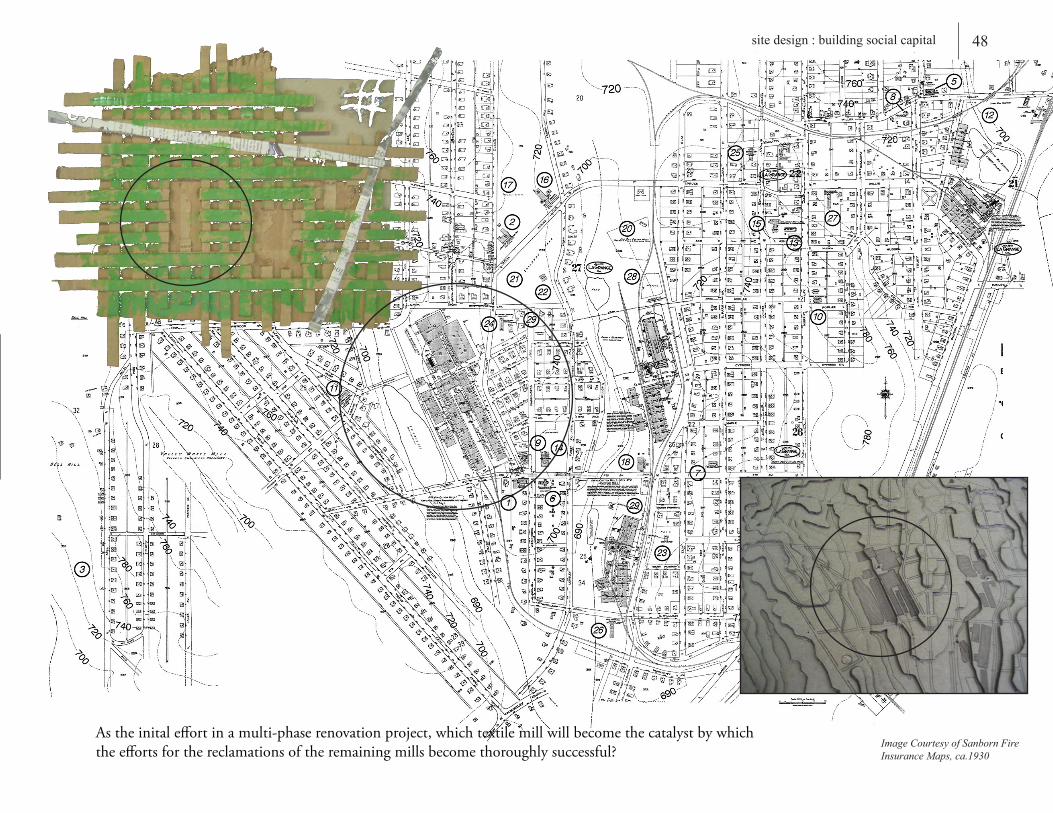
Astheinitaleffortinamulti-phaserenovationproject,whichtextilemillwillbecomethecatalystbywhichtheeffortsforthereclamationsoftheremainingmillsbecomethoroughlysuccessful?

49 the site : measuring social capital
Document Produced by ResearcherPhotos Courtesy of H.A.E.R.
1921 - Figure Grounds
Red-Structuresthathavebeenremoved Grey-Parking Green-BallFieldsandGardens
1
1
55
33
4
4
2
2

50 the site : building social capital
Image Produced by ResearcherPhotoes Courtesy of H.A.E.R.
1973 - Figure Grounds
Red-Structuresthathavebeenadded Grey-Parking
1
5
34
2
3
1
2
44
55
6
6

51 the site : measuring social capital
Document and Model Produced by Researcher
1973 - Figure Grounds
1921 - Figure Grounds
Void Space Model from Present Day Figure Grounds
How can this currently derelict landscape be reclaimed into a vibrant social space that unites a set of varied groups and activities through shared beliefs, interests, and commitments within the neighborhhod?
Mill
Mill
Mill
How can “community” be strengthened between residents?
52 the site : building social capital
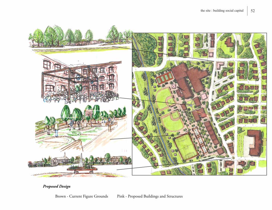
Proposed Design
Brown-CurrentFigureGrounds Pink-ProposedBuildingsandStructures
A
B
C
D
A
B
C
D
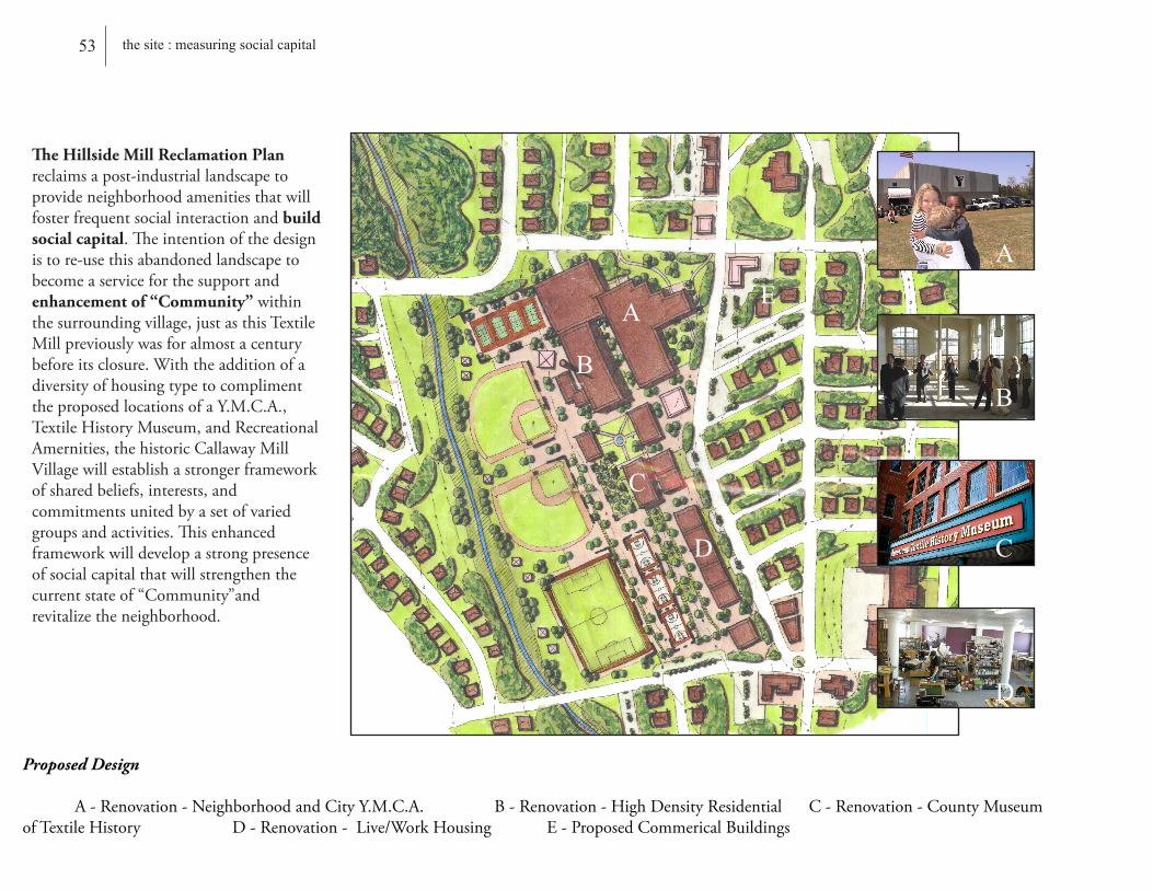
The Hillside Mill Reclamation Plan reclaimsapost-industriallandscapetoprovideneighborhoodamenitiesthatwillfosterfrequentsocialinteractionandbuild social capital.Theintentionofthedesignistore-usethisabandonedlandscapetobecomeaserviceforthesupportandenhancement of “Community”withinthesurroundingvillage,justasthisTextileMillpreviouslywasforalmostacenturybeforeitsclosure.WiththeadditionofadiversityofhousingtypetocomplimenttheproposedlocationsofaY.M.C.A.,TextileHistoryMuseum,andRecreationalAmernities,thehistoricCallawayMillVillagewillestablishastrongerframeworkofsharedbeliefs,interests,andcommitmentsunitedbyasetofvariedgroupsandactivities.Thisenhancedframeworkwilldevelopastrongpresenceofsocialcapitalthatwillstrengthenthecurrentstateof“Community”andrevitalizetheneighborhood.
53 the site : measuring social capital
Proposed Design
A-Renovation-NeighborhoodandCityY.M.C.A. B-Renovation-HighDensityResidential C-Renovation-CountyMuseumofTextileHistory D-Renovation-Live/WorkHousing E-ProposedCommericalBuildings
E

54 the site : building social capital
Recreational Park- Serves as a much needed recreational amenity and daily gathering space for a neighborhood lacking public recreational facilities. This will provide an area to locally support recreational leagues from the neighboring schools, churches, and residences.- Compliments the city’s current recreational complex (2.5 miles away) to provide additional space when hosting sporting tournaments.- Sporting tournaments will attract visitors to the area and help generate revenue for neighborhood commercial buidlings.- Provides amenities previously removed from original mill village layout such as band pavillion and park for events as well as a neighborhood Y.M.C.A.
Neighborhood Center- Creates a distinct focal point and helps to establish an identity for the neighborhood.- Provides a place for daily interaction through the accessibility of local goods and services within a conve-nient walk.- Helps to establishes a daily “Ritual” within the landscape.
High-Density Residential- Renovated Mill Buidlings can increase diversity in the neighborhood by promot-ing a different housing type, income, and resident to the prodominately single-family residential area.
Neighborhood’s Need For.....
1) Recreational Space
2) Diversity -Daily Goods and Services (Est. rituals within the Community)- Housing Typology
3) Shared Gathering Space

55 bibliography
Berger,Alan.“Drosscape:WastingLandinUrbanAmerica”.PrincetonArchitecturalPress.NewYork,NewYork.2006.
“GeneratingSocialCapital:CivilSocietyandInstitutionsinComparitivePerspective”.EditedbyMarcHoogheandDietlindStolle.PalgraveMacmillan.NewYork,NewYork.2003.
Herrerros,Francisco.“TheProblemWithFormingSocialCapital:WhyTrust?”.PalgraveMacmillan.NewYork,NewYork.2004.
Jackson,JohnBrinckerhoff.“ASenseofPlace,ASenseofTime”.YaleUniversityPress.NewHaven.1994.
Jackson,JohnBrinckerhoff.“DiscoveringtheVernacularLandscape”.YaleUniversityPress.NewHaven.1984.
Jackson,JohnBrinckerhoff.“TheNecessityforRuins”.UniversityofMassachusettsPress.Amherst.1980.
Jakle,JohnA.“DerelictLandscapes:WastingofAmerica’sEnvironment”.Rowman&Littlefield.Savage,Maryland.1992.
Jakle,John,A.“TheVisualElementsofLandscape”.UniversityofMassachusettsPress.Amherst.1987.
JournaloftheAmericanPlanningAssociation.“BuildingSocialCapitalThroughCommunityDevelopment”.Spring2004.Vol.70.
Kemmis,Daniel.“CommunityandThePoliticsofPlace”.UniversityofOklahomaPress.Norman.1990.
Marx,Leo.“TheMachineintheGarden-TechnologyandThePastoralIdeainAmerica”.OxfordUniversityPress.NewYork.2000PhilipSelznick,“InSearchofCommunity”,Rooted in the Land: Essays on Community and Place,editedbyWilliamVitekandWesJackson.NewHaven,N.J.YaleUniversityPress.1996.
Reed,Peter.“Groundswell:ConstructingtheContemporaryLandscape”.MuseumofModernArt.NewYork.2005.

Sande,Theodore.“IndustrialArcheology:ANewLookAtTheAmericanHeritage”.S.GreenePress.Brattleboro,Vermont.2002.
“SocialCapital:CriticalPerspectives”.EditedbyTomSchuller,JohnField,andStephenBaron.OxfordUniversityPress.NewYork.2000.
Steiner,Frederick.“HumanEcology:FollowingNature’sLead”.Washington,D.C.IslandPress.2002.
ThePresident’sCouncilonSustainableDevelopment.“SustainableDevelopment:ANewConsensus”.Washington,D.C.UnitedStatesGovernmentPrintingOffice.1996.
Vance,James,E.“TheContinuingCity-UrbanMorphologyinWesternCivilization”.JohnHopkinsUniversityPress.Baltimore,Maryland.1990.
Williams,Jack.“East40Degress-AnInterpretiveAtlas”.UniversityofVirginiaPress.Charlottesville,Virginia.2006.
Yu,Kongjian.“TheArtofSurvival”.
56 the site : building social capital


58appendix A1 - alternative design solution
The Callaway Mill Village Master Plan reclaimsfourpost-industriallandscapestoprovideneighborhoodamenitiesthatwillfosterfrequentsocialinteractionandbuild social capital.Theintentionofthedesignistore-usetheseabandonedlandscapestobecomeaserviceforthesupportandenhancement of “Community”withinthesurroundingvillage,justastheTextileMillspreviouslywereforalmostacenturybeforetheirclosure.Withtheadditionofcommunitygardensandotherinformalparkspacesthroughoutthesitetocomplimenttheproposedneighborhoodcenter,highdensityresidential,andtherecreationalparkandtrails,thehistoricCallawayMillVillagewillestablishastrongerframeworkofsharedbeliefs,interests,andcommitmentsunitedbyasetofvariedgroupsandactivities.Thisenhancedframeworkwilldevelopastrongpresenceofsocialcapitalthatwillstrengthenthecurrentstateof“Community”throughouttheneighborhood.

59 appendix A2 - alternative design solution detail
Smoke Stack- Provides an identifiable landmark for the area.- Not only celebrates the site through a new interpretation of history, but provides a dominant focal point in the landscape.- Acknowlegdes a daily identity to place (an original identity that has been lost)
Opportunities for Mixed UseBuilding Types
- Residential or Office Space on the second floor with neighborhood scale commercial on the ground floor.Neighborhood Commercial Needs: - Dry Cleaner/Laundry, Pharmacy, Coffee Shop, Hardware Store, Small Grocery/Market, Book Store etc......(Intended not to compete, but to compliment and add any additional services not located in Downtown LaGrange)
Single-Family Attached Housing- Provides another diverse housing type in the area- Alley way continues the continuity of the current neighborhood layout(Garages and Parking behind buildings minimizes the impact of the automobile and creates a more pedestrian friendly environment.)

60appendix A3 - recreational trail design
Connections Via “Rail with Trail”
Connections Via “Rail to Trail”
Downtown LaGrange
1/4 Mile Radius
Trail Hub
Industrial Park
Neighborhood Park
School
School
1/2 Mile Radius
Hospital
LaGrange College
School
Grocery
Neighborhood Park,Church, and
Industrial Park
School
High DensityResidential
Churches
High DensityResidential
Trail Connections
,Church
Community GardenCallaway Park
Neighborhood Center
Recreational Park
School
Gateway to Piney Woods Lake
SensitiveArea 25’-40’
BufferZone
3’-5’GroomedZone
10’-12’Multi-Use
Trail
3’-5’GroomedZone
15’VisualBuffer
61 appendix B - troup county textile timeline
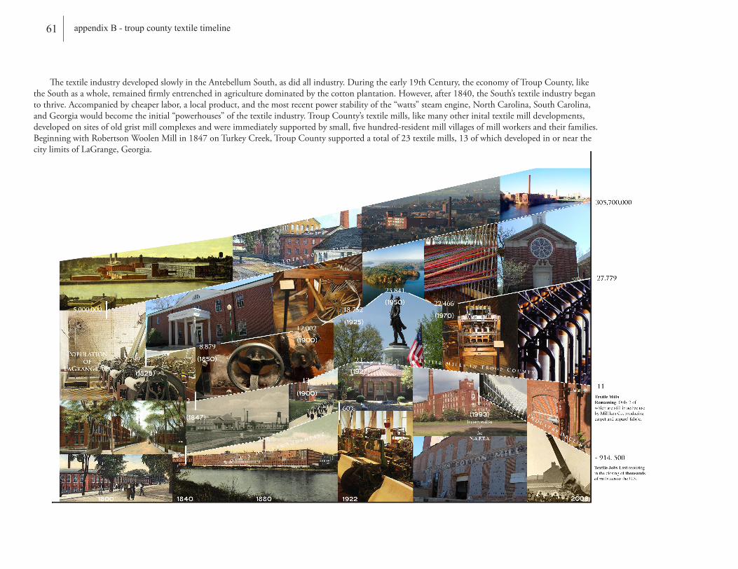
ThetextileindustrydevelopedslowlyintheAntebellumSouth,asdidallindustry.Duringtheearly19thCentury,theeconomyofTroupCounty,liketheSouthasawhole,remainedfirmlyentrenchedinagriculturedominatedbythecottonplantation.However,after1840,theSouth’stextileindustrybegantothrive.Accompaniedbycheaperlabor,alocalproduct,andthemostrecentpowerstabilityofthe“watts”steamengine,NorthCarolina,SouthCarolina,andGeorgiawouldbecometheinitial“powerhouses”ofthetextileindustry.TroupCounty’stextilemills,likemanyotherinitaltextilemilldevelopments,developedonsitesofoldgristmillcomplexesandwereimmediatelysupportedbysmall,fivehundred-residentmillvillagesofmillworkersandtheirfamilies.BeginningwithRobertsonWoolenMillin1847onTurkeyCreek,TroupCountysupportedatotalof23textilemills,13ofwhichdevelopedinornearthecitylimitsofLaGrange,Georgia.
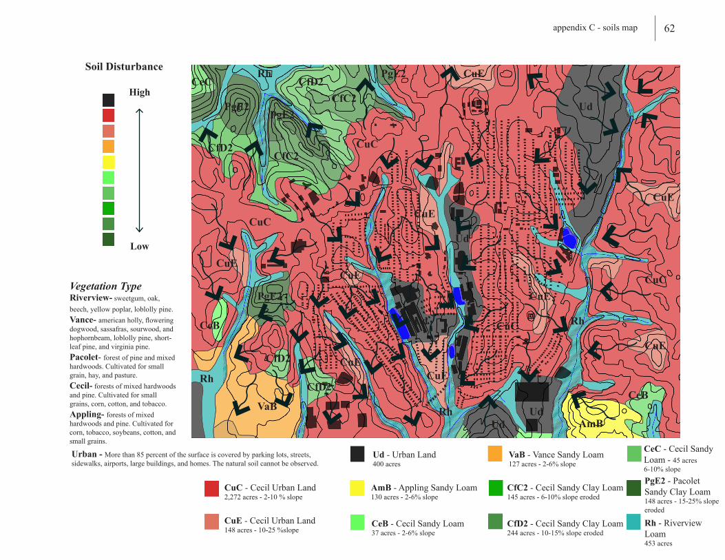
62appendix C - soils map
VaB
VaB - Vance Sandy Loam127 acres - 2-6% slope
CuC - Cecil Urban Land2,272 acres - 2-10 % slope
CuE - Cecil Urban Land148 acres - 10-25 %slope
AmB - Appling Sandy Loam130 acres - 2-6% slope
CeB - Cecil Sandy Loam37 acres - 2-6% slope
Ud - Urban Land400 acres
CeC - Cecil Sandy Loam - 45 acres6-10% slope
CfC2 - Cecil Sandy Clay Loam145 acres - 6-10% slope eroded
CfD2 - Cecil Sandy Clay Loam244 acres - 10-15% slope eroded
PgE2 - Pacolet Sandy Clay Loam148 acres - 15-25% slope eroded
Rh - Riverview Loam453 acres
CuC
CuCPgE2
PgE2 Ud
Ud
Ud
AmB
Rh
Rh
CuE
CuE
CfD2
CfD2CfC2
CeC
CfD2
PgE2
CfC2
CeB
CeB
CfD2
Ud
Ud
CuE
CuE
CuE
CuE
PgE2
CuECuE
CuE
Rh
Rh
Soil Disturbance
Low
High
CuC
CuC
Vegetation TypeRiverview- sweetgum, oak, beech, yellow poplar, loblolly pine.Vance- american holly, flowering dogwood, sassafras, sourwood, and hophornbeam, loblolly pine, short-leaf pine, and virginia pine.Pacolet- forest of pine and mixed hardwoods. Cultivated for small grain, hay, and pasture.Cecil- forests of mixed hardwoods and pine. Cultivated for small grains, corn, cotton, and tobacco.Appling- forests of mixed hardwoods and pine. Cultivated for corn, tobacco, soybeans, cotton, and small grains.
Urban - More than 85 percent of the surface is covered by parking lots, streets, sidewalks, airports, large buildings, and homes. The natural soil cannot be observed.
Mill Village Revitalization
Case Studies:
mooresville,n.c.Background:Developed in connection with the Mooresville Cotton Mills around 1867, Mooresville Mill Village was a self-supporting community consisting of churches, company stores, parks, community gardens and ball fields. Emerging from the wreckage of the Civil War, the Cotton Mills were the source of growth and prosperity for the young town until their final closing in 1975. Like many other mill villages, the abandonment of the mills, and thus the historic local economy, led the area to a state of disrepair for many years. Sponsored by the Cherokee Investment Partners and Rigers & Associates, long and short-term plans are underway to guide the historic Mooresville Mill Village through the revitalization process.
“For generations, the Mooresville Mills were at the center of the town’s work and social activity. We hope to produce a project that will preserve, enhance, protect, and celebrate the architectural and social history that the Mills represent to the town of Mooresville.”
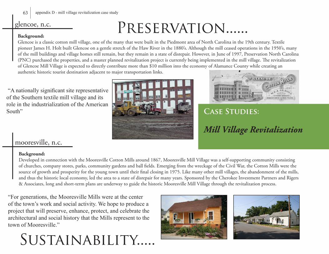
Background:Glencoe is a classic cotton mill village, one of the many that were built in the Piedmont area of North Carolina in the 19th century. Textile pioneer James H. Holt built Glencoe on a gentle stretch of the Haw River in the 1880’s. Although the mill ceased operations in the 1950’s, many of the mill buildings and village homes still remain, but they remain in a state of disrepair. However, in June of 1997, Preservation North Carolina (PNC) purchased the properties, and a master planned revitalization project is currently being implemented in the mill village. The revitalization of Glencoe Mill Village is expected to directly contribute more than $10 million into the economy of Alamance County while creating an authentic historic tourist destination adjacent to major transportation links.
glencoe,n.c.
“A nationally significant site representative of the Southern textile mill village and its role in the industrialization of the American South”
Preservation......
Sustainability.....
63 appendix D - mill village revitalization case study

Long-Term:- establish permanent organizations for mill village residents- address the appearance and condition of remaining rental properties- increase the percentage of home ownership
Short-Term:- create a zoning overlay district for historic and aesthetic preservation- address neighborhood infrastructural needs- improve community safety and clean-up
Project:- preserve the extant historic structures- permanently conserve open space along the Haw River- develop compatible new infill as a model to continue the uniformity of the historic architecture- renovate the 85,000 sq.ft of historic industrial space into residential and commercial use- gradually increase the percentage of owner-occupied homes
AvitalpartofAmericanindustryformorethan200years,textilemillsservedastheeconomicfoundationforhundredsofemergingtownsandcitiesduringtheearly1800’sandtheindustrialrevolution.U.S.textileoperationsremainedstronguntilthe1970’swhensocial,economic,andenvironmentalchangescausedmanyofthemtoclose.Astheindustrydeclined,sodidtheirrespectivecommunities.Withamassexodusofformeremployeesinsearchofnewjobsaccompaniedbythepresenceofabandonedmillsites,hundredsofdesolatelandscapesensued.Today,thepopulationhasrecovered,butthecommunityandthelandscapehasnot.Adis-connectionexistingamongtheresidentscurrentlyoccupyingthesehistoricneighborhoodscanbeseeninthedilapidatedhousing,lackofcommunalspace,andcontinuedneglecttonotonlytheabandonedmillsites,buttheirneighborhoodaswell.
Community Development....
64appendix D - mill village revitalization case study

6 Room Second Style, ca. 1924-28Thishouseisanotherversiontothemulti-storycottage.Thefrontporchislengthenedtospantheentirefascadeofthehouse.Athree-windowdormeraddsanattractivetouchtothefrontwhileprovidinglotsoflighttotheupstairsmansard.Thesehomesprovidealargeamountofsquare-footage(1450squarefeet).Theornamentaladditionofthedormers,thesehomesareusuallyfoundonthemainstreetsasashowcaseofthemillandthegoodlifetheyprovidedfortheirworkers.
4 Room Style, ca. 1900-07Thesehomeswereoriginally3-room,square-shaped,andarelocatedonthetightlotsthroughouttheVillage.Likethe3-roomstylesofthepreviousdecade,thesehomesalsohaveshedroofporches.Thelowerpitchoftheroofmakestheincorporationofamansarddifficult.
4 Room Style, ca. 1924-28Withthesmallestamountofsquare-footageofallthestyles,this4roomcottageallowedamaximumamountofsingle-familyhousesintightareasofthemill’sland.Thehigh-pitchedroofwouldpermitamansard,althoughthemilldidnotfinishanyatticsinthisfloorplan.
3 Room Style, ca. 1900-07Thisistheearliestformofmillhouseconstruction.Thesehomeswereoriginallybuiltasa3roomhousewithafrontandbackporch.Theampleporchspansoverthefrontwindows.Theyarefoundpredominatelyclosesttotheworksitewhichreflectstheirstatusastheinitialmillconstructedhousing.
5 Room Style, ca. 1924-28Thesignaturefeatureofthislargemillhouseisitsoff-centerfrontdoor.Theobviousadvantageofthisstyleisthatthehouseprovidesamaximumofsquare-footageonaminimallot.Thisefficient,multi-storystyleofconstructionemergedwhenthepriceoflandbegantoincrease.
5 Room Style, ca. 1908-17Thishouseaddedaroomwhichalmostsquaredupthebackellandcreateda5-roomhouse.ThisisthemostspaciouysfloorplanintheMillVillage,providingover1500squarefeetoflivingspace.
4 Room Style, ca. 1908-17ThishousehasanL-shaped4roomfloorplan.Boththefrontandbackporcheshaveshedroofsandruntheentirelengthofthebackell(2rooms,36feet).Theconstructiontechniquesandmaterialsareverysimilartothoseofthe1900-07homes:woodlapsidingexterior,interiorpinesinglebeadboard,21/2”pinetongue-in-grooveflooring.Thereareonlytwosmallclosetsoneachsideofthedouble-sidedfireplacethatseparatesonefrontroomfromthebackell.
3 Room Style, ca. 1908-17Thishousebreaksfromthecontinuousroof-lineofitscontemporaries.Infact,itismuchlikethe3room1907stylehouse,butrotated90degreessothatthegablenowfacesthestreet.Also,contrastingwiththeother1908-1917constructions,theporchfeaturesahiproof,againmatchingthe1907stylehomes.
65 appendix E - mill village housing style detail
66appendix F - mill renovation case study
taunton, m.a.
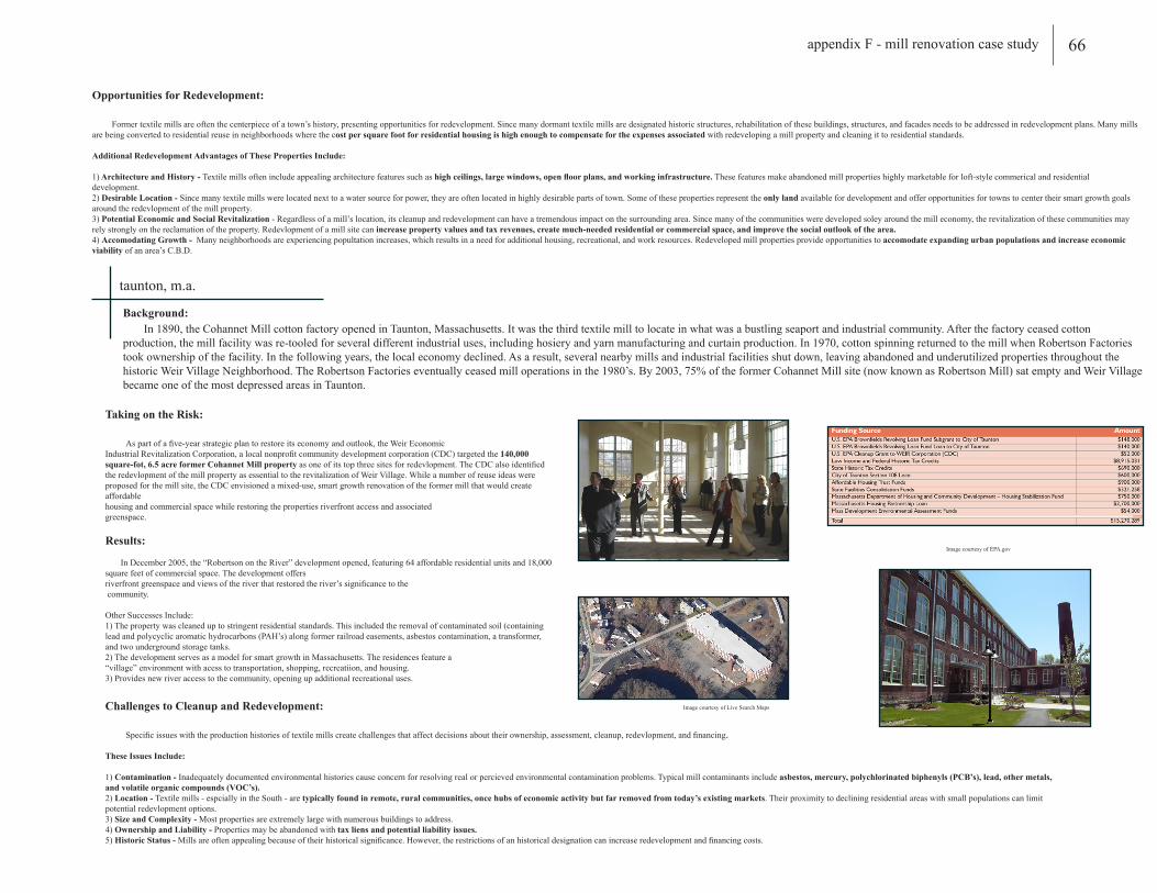
Background: In 1890, the Cohannet Mill cotton factory opened in Taunton, Massachusetts. It was the third textile mill to locate in what was a bustling seaport and industrial community. After the factory ceased cotton production, the mill facility was re-tooled for several different industrial uses, including hosiery and yarn manufacturing and curtain production. In 1970, cotton spinning returned to the mill when Robertson Factories took ownership of the facility. In the following years, the local economy declined. As a result, several nearby mills and industrial facilities shut down, leaving abandoned and underutilized properties throughout the historic Weir Village Neighborhood. The Robertson Factories eventually ceased mill operations in the 1980’s. By 2003, 75% of the former Cohannet Mill site (now known as Robertson Mill) sat empty and Weir Village became one of the most depressed areas in Taunton.
Opportunities for Redevelopment:
Former textile mills are often the centerpiece of a town’s history, presenting opportunities for redevelopment. Since many dormant textile mills are designated historic structures, rehabilitation of these buildings, structures, and facades needs to be addressed in redevelopment plans. Many mills are being converted to residential reuse in neighborhoods where the cost per square foot for residential housing is high enough to compensate for the expenses associated with redeveloping a mill property and cleaning it to residential standards.
Additional Redevelopment Advantages of These Properties Include:
1) Architecture and History - Textile mills often include appealing architecture features such as high ceilings, large windows, open floor plans, and working infrastructure. These features make abandoned mill properties highly marketable for loft-style commerical and residential development.2) Desirable Location - Since many textile mills were located next to a water source for power, they are often located in highly desirable parts of town. Some of these properties represent the only land available for development and offer opportunities for towns to center their smart growth goals around the redevlopment of the mill property.3) Potential Economic and Social Revitalization - Regardless of a mill’s location, its cleanup and redevelopment can have a tremendous impact on the surrounding area. Since many of the communities were developed soley around the mill economy, the revitalization of these communities may rely strongly on the reclamation of the property. Redevlopment of a mill site can increase property values and tax revenues, create much-needed residential or commercial space, and improve the social outlook of the area.4) Accomodating Growth - Many neighborhoods are experiencing popultation increases, which results in a need for additional housing, recreational, and work resources. Redeveloped mill properties provide opportunities to accomodate expanding urban populations and increase economic viability of an area’s C.B.D.
Challenges to Cleanup and Redevelopment:
Specific issues with the production histories of textile mills create challenges that affect decisions about their ownership, assessment, cleanup, redevlopment, and financing.
These Issues Include:
1) Contamination - Inadequately documented environmental histories cause concern for resolving real or percieved environmental contamination problems. Typical mill contaminants include asbestos, mercury, polychlorinated biphenyls (PCB’s), lead, other metals, and volatile organic compounds (VOC’s).2) Location - Textile mills - espcially in the South - are typically found in remote, rural communities, once hubs of economic activity but far removed from today’s existing markets. Their proximity to declining residential areas with small populations can limit potential redevlopment options.3) Size and Complexity - Most properties are extremely large with numerous buildings to address.4) Ownership and Liability - Properties may be abandoned with tax liens and potential liability issues.5) Historic Status - Mills are often appealing because of their historical significance. However, the restrictions of an historical designation can increase redevelopment and financing costs.
Taking on the Risk:
As part of a five-year strategic plan to restore its economy and outlook, the Weir Economic Industrial Revitalization Corporation, a local nonprofit community development corporation (CDC) targeted the 140,000 square-fot, 6.5 acre former Cohannet Mill property as one of its top three sites for redevlopment. The CDC also identified the redevlopment of the mill property as essential to the revitalization of Weir Village. While a number of reuse ideas were proposed for the mill site, the CDC envisioned a mixed-use, smart growth renovation of the former mill that would create affordable housing and commercial space while restoring the properties riverfront access and associated greenspace.
Results:
In December 2005, the “Robertson on the River” development opened, featuring 64 affordable residential units and 18,000 square feet of commercial space. The development offers riverfront greenspace and views of the river that restored the river’s significance to the community.
Other Successes Include:1) The property was cleaned up to stringent residential standards. This included the removal of contaminated soil (containing lead and polycyclic aromatic hydrocarbons (PAH’s) along former railroad easements, asbestos contamination, a transformer, and two underground storage tanks.2) The development serves as a model for smart growth in Massachusetts. The residences feature a “village” environment with acess to transportation, shopping, recreatiion, and housing.3) Provides new river access to the community, opening up additional recreational uses.
Image courtesy of EPA.gov
Image courtesy of Live Search Maps
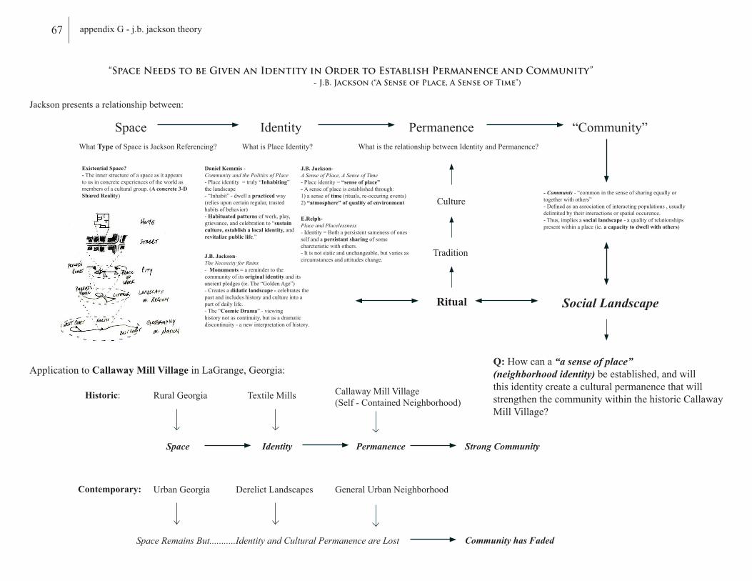
“Space Needs to be Given an Identity in Order to Establish Permanence and Community” - J.B. Jackson (“A Sense of Place, A Sense of Time”)
Space Identity Permanence “Community”
Jackson presents a relationship between:
Daniel Kemmis -Community and the Politics of Place- Place identity = truly “Inhabiting” the landscape- “Inhabit” - dwell a practiced way (relies upon certain regular, trusted habits of behavior)- Habituated patterns of work, play, grievance, and celebration to “sustain culture, establish a local identity, and revitalize public life.”
What is Place Identity?
J.B. Jackson- A Sense of Place, A Sense of Time- Place identity = “sense of place” - A sense of place is established through:1) a sense of time (rituals, re-occuring events)2) “atmosphere” of quality of environment
E.Relph-Place and Placelessness- Identity = Both a persistent sameness of ones self and a persistant sharing of some charcteristic with others.- It is not static and unchangeable, but varies as circumstances and attitudes change.
What is the relationship between Identity and Permanence?
Ritual
Tradition
Culture- Communis - “common in the sense of sharing equally or together with others”- Defined as an association of interacting populations , usually delimited by their interactions or spatial occurence. - Thus, implies a social landscape - a quality of relationships present within a place (ie. a capacity to dwell with others)
J.B. Jackson- The Necessity for Ruins- Monuments = a reminder to the community of its original identity and its ancient pledges (ie. The “Golden Age”)- Creates a didatic landscape - celebrates the past and includes history and culture into a part of daily life.- The “Cosmic Drama” - viewing history not as continuity, but as a dramatic discontinuity - a new interpretation of history.
Social Landscape
Application to Callaway Mill Village in LaGrange, Georgia:
Historic:
Space Identity Permanence Strong Community
Rural Georgia Textile Mills Callaway Mill Village(Self - Contained Neighborhood)
Contemporary:
Space Remains But...........Identity and Cultural Permanence are Lost Community has Faded
Urban Georgia Derelict Landscapes General Urban Neighborhood
Q: How can a “a sense of place” (neighborhood identity) be established, and will this identity create a cultural permanence that will strengthen the community within the historic Callaway Mill Village?
What Type of Space is Jackson Referencing?
Existential Space?- The inner structure of a space as it appears to us in concrete experiences of the world as members of a cultural group. (A concrete 3-D Shared Reality)
67 appendix G - j.b. jackson theory